mapinfo pro evolution - · pdf fileenjoy improved support for sql server geography data type...
TRANSCRIPT

MapInfo Pro™ evolution Latest release adds to a long line of enhanced capabilities
Location IntelligenceGeographic Information Systems

2
As the need for spatial analytics grows, so do the challenges. Data sets are bigger, hardware keeps changing, and everyone wants faster results.
The latest MapInfo Pro release adds even greater value, thanks to insights from users like you.
Upgrading from an older version of the MapInfo Pro application offers years of advancement.
With MapInfo™ Pro, everyone gains insight.• Improve decision making• Share information-rich maps
and graphs• Discover more opportunities• Pinpoint risk
Something for everyoneMapInfo Pro is now available with new options, so you can choose what’s right for you.
MapInfo Pro v15.2 Advanced 64-bitOur most progressive edition designed to meet the needs of highly focused GIS power users.
MapInfo Pro v15.2 64-bitThe most popular edition of MapInfo Pro, all the capability needed by most GIS professionals.
MapInfo Pro v15.0 32-bitFor those on older desktop operating systems, this edition includes the powerful features you’ve used in v12.5 with some exciting new improvements.
All versions have the option to add Premium Services for easy access to on-line base maps from Bing.
Step up to our latest GIS.
3
With MapInfo Pro v15.2, the world’s most accessible GIS is now available with a highly advanced raster grid analysis solution.
The 64-bit version also saves users considerable time as they can now run multiple processes simultaneously and get more done in less time with improved performance of object processing operations.
MapInfo Pro v15.2 brings many exciting enhancements to improve the quality of cartographic map output faster than ever before. In addition, support for touch screens enables mobile working, and enhanced integration with the Pitney Bowes Location Intelligence suite provides access to enterprise scale global geocoding.
This latest release introduces an innovative grid format called Multi-Resolution Raster (MRR). The format provides incredibly fast processing, visualisation and analysis of high resolution grid data, even when working at a global scale.
A new edition, MapInfo Pro Advanced, takes full advantage of this new format and provides a powerful set of grid analysis capabilities. Through its integration within our Location Intelligence Suite, the resulting analysis can be shared across the organisation via map visualisation powered by Spectrum® Spatial or OEM partner technology using MapInfo Pro Advanced.
MapInfo Pro v15.2 offers a step change in performance and usability, particularly when working with high resolution raster grid data.
The new Layout Designer makes it a snap to create professional quality output quickly with interactive maps in the layout and true WYSIWYG functionality.
Work smarter, not harder.
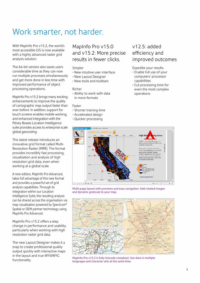
Multi-page layout with previews and easy navigation. Add rotated images and dynamic graticule to your map.
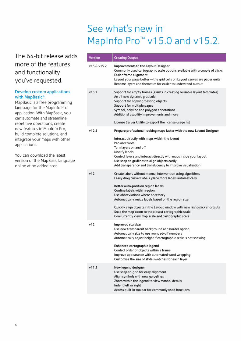
MapInfo Pro v15.2 is fully Unicode compliant. Use data in multiple languages and character sets at the same time.
MapInfo Pro v15.0 and v15.2: More precise results in fewer clicks.
Simpler • New intuitive user interface • New Layout Designer • New tools and toolbars
Richer • Ability to work with data
in more formats
Faster • Shorter training time • Accelerated design • Quicker processing
v12.5: added efficiency and improved outcomes
Expedite your results. • Enable full use of your
computers’ processor capabilities
• Cut processing time for even the most complex operations
The 64-bit release adds more of the features and functionality you’ve requested.
Develop custom applications with MapBasic®.MapBasic is a free programming language for the MapInfo Pro application. With MapBasic, you can automate and streamline repetitive operations, create new features in MapInfo Pro, build complete solutions, and integrate your maps with other applications.
You can download the latest version of the MapBasic language online at no added cost.
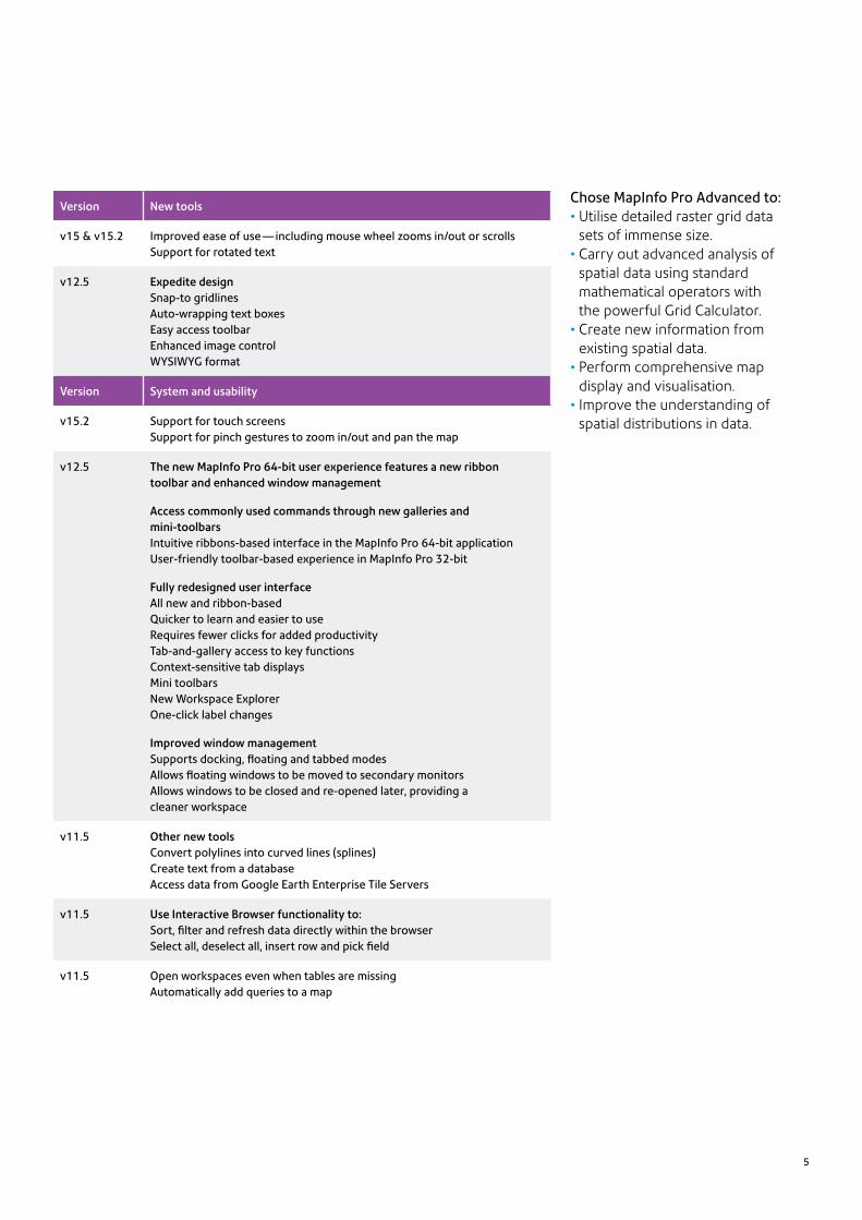
See what’s new in MapInfo Pro™ v15.0 and v15.2.
Version Creating Output
v15 & v15.2 Improvements to the Layout DesignerCommonly used cartographic scale options available with a couple of clicksEasier frame alignmentLayout your page better — the grid cells on Layout canvas are paper unitsRename layers and thematics for easier to understand output
v15.2 Support for empty frames (assists in creating reusable layout templates)An all new dynamic graticule.Support for copying/pasting objectsSupport for multiple pagesSymbol, polyline and polygon annotations Additional usability improvements and more
License Server Utility to export the license usage list
v12.5 Prepare professional-looking maps faster with the new Layout Designer
Interact directly with maps within the layoutPan and zoomTurn layers on and offModify labelsControl layers and interact directly with maps inside your layoutUse snap-to gridlines to align objects easilyAdd transparency and translucency to improve visualisation
v12 Create labels without manual intervention using algorithmsEasily drag curved labels, place more labels automatically
Better auto-position region labels: Confine labels within regionUse abbreviations where necessaryAutomatically resize labels based on the region size
Quickly align objects in the Layout window with new right-click shortcutsSnap the map zoom to the closest cartographic scaleConcurrently view map scale and cartographic scale
v12 Improved scalebarUse new transparent background and border optionAutomatically size to use rounded-off numbersAutomatically adjust height if cartographic scale is not showing
Enhanced cartographic legend Control order of objects within a frameImprove appearance with automated word wrappingCustomise the size of style swatches for each layer
v11.5 New legend designerUse snap-to-grid for easy alignmentAlign symbols with new guidelines Zoom within the legend to view symbol detailsIndent left or rightAccess built-in toolbar for commonly used functions
4
5
Chose MapInfo Pro Advanced to:• Utilise detailed raster grid data
sets of immense size.• Carry out advanced analysis of
spatial data using standard mathematical operators with the powerful Grid Calculator.
• Create new information from existing spatial data.
• Perform comprehensive map display and visualisation.
• Improve the understanding of spatial distributions in data.
Version New tools
v15 & v15.2 Improved ease of use — including mouse wheel zooms in/out or scrollsSupport for rotated text
v12.5 Expedite designSnap-to gridlinesAuto-wrapping text boxesEasy access toolbarEnhanced image controlWYSIWYG format
Version System and usability
v15.2 Support for touch screensSupport for pinch gestures to zoom in/out and pan the map
v12.5 The new MapInfo Pro 64-bit user experience features a new ribbon toolbar and enhanced window management
Access commonly used commands through new galleries and mini-toolbarsIntuitive ribbons-based interface in the MapInfo Pro 64-bit application User-friendly toolbar-based experience in MapInfo Pro 32-bit
Fully redesigned user interfaceAll new and ribbon-basedQuicker to learn and easier to useRequires fewer clicks for added productivityTab-and-gallery access to key functionsContext-sensitive tab displaysMini toolbarsNew Workspace ExplorerOne-click label changes
Improved window managementSupports docking, floating and tabbed modesAllows floating windows to be moved to secondary monitorsAllows windows to be closed and re-opened later, providing a cleaner workspace
v11.5 Other new toolsConvert polylines into curved lines (splines)Create text from a databaseAccess data from Google Earth Enterprise Tile Servers
v11.5 Use Interactive Browser functionality to: Sort, filter and refresh data directly within the browserSelect all, deselect all, insert row and pick field
v11.5 Open workspaces even when tables are missingAutomatically add queries to a map
6
MapInfo Pro™: Get added value year after year.
If you’re using an earlier version of MapInfo Pro, you may be missing out on a lot. In addition to the new features and capabilities now available in v15.0 and v15.2, we responded to user requests with a long line of enhancements in earlier releases.
Version Data Access
v15.2 Faster updating and editing of dataWhen working with large datasets, a new smart indexing feature allows for faster updating and editing of indexed data.Improved map rendering performance, especially with point data.Significantly faster filter queries and map based selecting with large datasets.
Unicode supportAn extended TAB file with support for file sizes larger than 2 GBGeoPackage support (an OGC standard), share data more easily with MapInfo Pro users and othersSupport for Spectrum geocoding capabilities
v12.5 Work with data in many different formats, including:Esri GeoDatabase (open/import and export) Geography Markup Language (GML) versions 2.1.2, 3.1.1 and 3.2.1 (open/import) Geography Markup Language (GML) Simple Features Level SF-0 Profile (export)
v12 Data access improvementsImport and export more easily with the new Quick Translator Gain support for SQLite, PostGIS v2.0, WFS v1.1Enjoy improved support for SQL Server Geography data typeExercise option to connect to Oracle using Operating System authenticationIncrease size of an individual record in a native MapInfo table to 63,500 bytesOpen multiple DBMS tables with an improved interface
v11.5 Benefit from enhanced support for ECW format raster imagesImproved Help section on keyboard shortcuts and commands
Version Interoperability
v15.2 Support for Spectrum geocoding capabilities
v11.5 Improved MapInfo Manager integrationUpdate metadata automatically when data is changed in MapInfo ProEdit metadata records directly from MapInfo Pro
Operating systems
Version 15.0 (32-bit)• Windows 7 Ultimate 32-bit SP1• Windows 7 Ultimate 64-bit SP1
(with 32-bit compatibility mode)• Windows 8.1 32-bit• Windows 8.1 64-bit• Windows 2008 Server R2
64-bit SP1• Windows 2008 Server R2
64-bit SP1 with XenApp 6.0• Windows 2012 Server R2
64-bit with XenApp 7.5
Version 15.2 (64-bit)• Windows 7 Ultimate 64-bit SP1 • Windows 8.1 Professional
for 64-bit• Windows 2008 Server R2
64-bit SP1• Windows 2008 Server R2
64-bit SP1 with XenApp 6.0• Windows 2012 Server R2
only 64-bit• Windows 2012 Server R2
64-bit with XenApp 7.5• Windows 10 Enterprise for
64-bit
Database servers
Spatial• Microsoft SQL Server 2008
(also called SQL Server Spatial)• Microsoft SQL Server 2012
(also called SQL Server Spatial)• Oracle® Spatial 11Gr2, 12cR1• PostgreSQL 9.0.3 with PostGIS 1.5• PostgreSQL 9.x with PostGIS 2.1.x• SQLite 3.7.13
XY• Microsoft Access 2007, 2010• Microsoft Office 2013
Database connectivity
FDO Tool Kit
ODBC drivers• Microsoft SQL Server 2012
Native Client v11 (32-and 64-bit)• Microsoft Access ODBC
(32- and 64-bit)• PostgreSQL ANSI ODBC driver
9.01.02 (32- and 64-bit)
Oracle® OCI client• Oracle Instant Client v12.1.0.1.0
(32- and 64-bit)
Do even more.
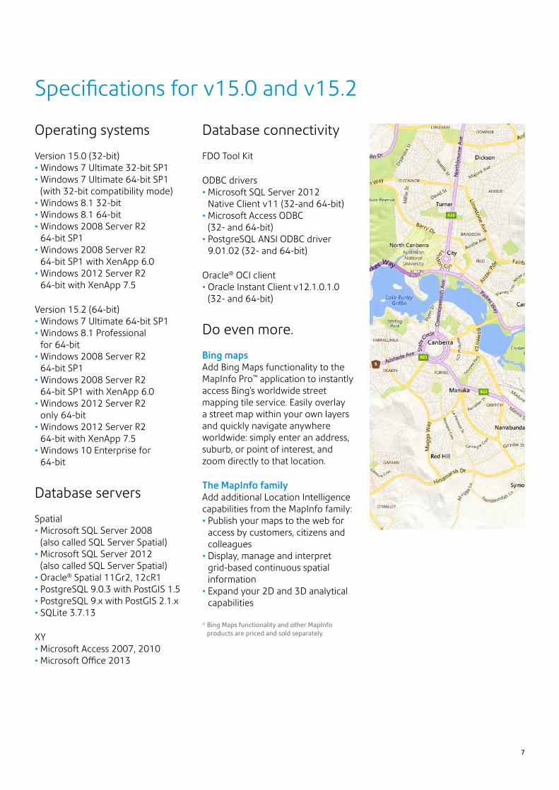
Bing maps Add Bing Maps functionality to the MapInfo Pro™ application to instantly access Bing’s worldwide street mapping tile service. Easily overlay a street map within your own layers and quickly navigate anywhere worldwide: simply enter an address, suburb, or point of interest, and zoom directly to that location.
The MapInfo familyAdd additional Location Intelligence capabilities from the MapInfo family:• Publish your maps to the web for
access by customers, citizens and colleagues
• Display, manage and interpret grid-based continuous spatial information
• Expand your 2D and 3D analytical capabilities
* Bing Maps functionality and other MapInfo products are priced and sold separately.
Specifications for v15.0 and v15.2
7

Pitney Bowes, the Corporate logo, MapInfo, MapInfo Pro, MapBasic and MapInfo Manager are trademarks of Pitney Bowes Inc. or a subsidiary. All other trademarks are the property of their respective owners.© 2014-2015 Pitney Bowes Inc. All rights reserved.
15DCS00041_ANZ
For more information, call +61 2 9475 3500 or email: [email protected] us online: pitneybowes.com/au
Australia/Asia PacificLevel 1, 68 Waterloo RoadMacquarie Park NSW 2113+61 2 9475 [email protected]
United States3001 Summer StreetStamford, CT 06926-0700800 327 [email protected]
Europe/United KingdomThe Smith CentreThe Fairmile Henley-on-Thames Oxfordshire RG9 6AB0800 840 [email protected]
Canada5500 Explorer DriveMississauga, ON L4W5C7800 268 [email protected]