mapping archaeological site of keraton pleret using aerial
TRANSCRIPT
JOURNAL OF APPLIED
GEOSPATIAL INFORMATION
Vol 4 No 1 2020 http://jurnal.polibatam.ac.id/index.php/JAGI
ISSN Online: 2579-3608
Handayani et al.,/ JAGI Vol 4 No 1/2020 320
Mapping Archaeological Site of Keraton Pleret Using Aerial
Photograph
Warsini Handayani1,*, Bagus Arif Setiawan2, Bayu Argadyanto Prabawa3, Taufik Hery Purwanto1, Fredi Satya Candra Rosaji4, Hendy Fatchurohman1
1 Study Program of Remote Sensing and GIS, Department of Geoinformatics, Vocational College, Universitas Gadjah Mada,
Indonesia. 2CV. Systemaptic, Yogyakarta, Indonesia
3Study Program of Urban Regional Planning, Faculty of Sains and Technology, Universitas Teknologi Yogyakarta, Indonesia 4PT. Mitra Geotama Indonesia, Yogyakarta, Indonesia
*Corresponding author e-mail: [email protected]
Received: March 08, 2020
Accepted: May 22, 2020
Published: May 25, 2020
Copyright © 2020 by author(s) and
Scientific Research Publishing Inc.
Abstract As a cultural heritage, Site of Keraton (Palace) Pleret becomes an essential
relic in Javanese history and culture to preserve and deliver ancient information for the next generation sustainably. On the other hand, this preservation is dealing with quite rapid built-up area development. Mapping can be a significant effort as primary data in cultural preservation management. Previous document shows Keraton Pleret blueprints in different shape and unprojected whereas it is significantly crucial related to precission position in real world. This study aims to make a detailed site map of the Keraton Pleret and identify the existing land use in each site component using updated aerial photograph. The aerial photograph was obtained from data acquisition using Unmanned Aerial vehicle (UAV) that processed to orthophoto. It was combined with previous archaeological documents, ancient blueprints, topographic map, and field observation data to execute interpretation and analysis process. Site components were identified based on artificial infrastructure and existing natural features. Data analysis shows the compatibility between spatial data used in this research and previous documents to identify components and result in Keraton Pleret site map. According to several interpretation keys to the aerial photographs, some components are showing obvious trace, such as Great Mosque, fortress, road network, hydrographic network, town square, the balekambang, the Segarayasa, the dam, and other building inside the keraton complex. At present, most of the Keraton Pleret site area has been converted to buildings and paddy fields, strengthen the need for archaeological sites management which alongside community activities.
Keywords: Archaeological site, Keraton Pleret, Orthophoto, Mapping, Land-use
1. Introduction
1.1 Background
Pleret Pleret Sub District becomes an important place for Javanese culture and prehistory because of the existence of the Palace (Palace) Pleret site, the third Islamic Mataram Kingdom capital in the 17th century after Kotagede and Kerto site. Islamic Mataram Kingdom is one of the greatest Islamic kingdoms that had become the ancestor of Yogyakarta and Surakarta (Solo) kingdom. Since the kingdom sifted from the north coast of Java, the hinterland of Central Java has managed to become the center of geopolitics and Javanese culture.
Keraton Pleret site plays a strategic role as a military fortress of the kingdom (Graaf, 1987; de Graff and Pigeaud, 1986 in Wardani et al., 2013; Alfah & Priswanto, 2012). Because of its great historical value, preservation - including research and excavation - is fundamental work should be taken in the Keraton Pleret site. This effort is supported by the local government of the Bantul Regency by establishing the palace site as a cultural preservation area in the Regional Spatial Planning (Spatials Plan) document year 2010-2030.
Open Access
brought to you by COREView metadata, citation and similar papers at core.ac.uk
provided by Jurnal Politeknik Negeri Batam (PoliBatam)
Handayani et al.,/ JAGI Vol 4 No 1/2020 321
Preservation of archaeological sites is important in order to preserve the culture and sustain historical information to the next generation. Thus far, the archaeologist team from the Cultural Agency of Yogyakarta and the Archaeological Heritage Preservation Center (Balai Pelestarian Peninggalan Purbakala, BP3) are still actively conducting various preservation efforts such as research and excavation. At some of the archeological site excavations, it takes
quite a long time to find out the whole form in both its shape and area because it was found to be partially or completely buried underground as if found in Keraton Pleret site and Keraton Kerto site. At the same time, the preservation in Keraton Pleret site is dealing with the rapid development of the built-up area because of relatively easy access and relatively close distance to the city of Yogyakarta (Kompas, 2010).
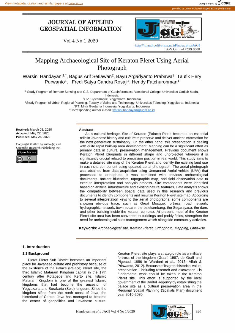
Fig. 1. (a) Ancient blueprint of Keraton Pleret (Document of Cultural Agency of Yogyakarta and Keraton Ngayogyakarta’s
Library) and (b) Aerial Photo showing the site existing condition covered by quite dense settlement
Remote sensing data has been broadly and extensively used for the purpose of thematic mapping including archaeological site mapping. Remote sensing data interpretation as part of the geographical method become popular in archaeological study because of its capacity in information extraction indirectly (Hadjimitsis et al., 2013). Using remote sensing data, especially aerial photographs as high-resolution data, identification of archaeological sites can be done through visual interpretation on aerial photos (orthophoto) and digital topography (Digital Elevation Model) then matching it with the ancient documents and information and existing land use. Components of the site can be detected from land-use patterns visible in orthophoto and height difference between location through digital surface model (Handayani, 2017). Aerial photographs interpretation can provide information on the location, shape, and size of each component site (Nayati, 1982 in Alfah & Priswanto, 2012). Toponyms, geographic place names, also support in site component identification in Keraton Pleret site (Rosidi et al., 2013).
The mapping of the Keraton Pleret site is urgently needed along with the urban growth rate in Yogyakarta. At present, cultural agency and researcher have provided Keraton Pleret site maps however large scale maps have not been accommodated. In addition to more detailed thematic information, this large scale map is also related to the geometric object and location accuracy therefore it needs the support of detailed spatial data. Aerial photo mosaics (orthophoto) resulting from data acquisition with an Unmanned Aerial Vehicle (UAV) having sub-meter (centimeter) accuracy can be a suitable data source for these purposes. This data has advantages such as relatively low cost (compared to the high-quality data produced), flexible data acquisition where it can be done according to the needs and objectives, and high data novelty (Rosaji,
2013). As well as the part and shape of the site that can be identified from land-use patterns (Handayani, 2017; Traviglia & Torsello, 2017), it can be seen the existing conditions of land-use in each site component through orthophoto. This is important in relation to preservation efforts and policy-making on archeological site management that cohabiting with community activities.
1.2 Aims of the Project
The overall scope of this study is to make a detailed map of the Keraton Pleret site and identify existing land use in each site component. This research is the continuation of the previous project by Handayani et al. (2017) on Keraton Pleret site identification. One of the detailed online imagery, Google Earth, is very convenient to access and has periodic data updates, but its accuracy does not meet the large scale mapping purposes.
1.3 Project Location
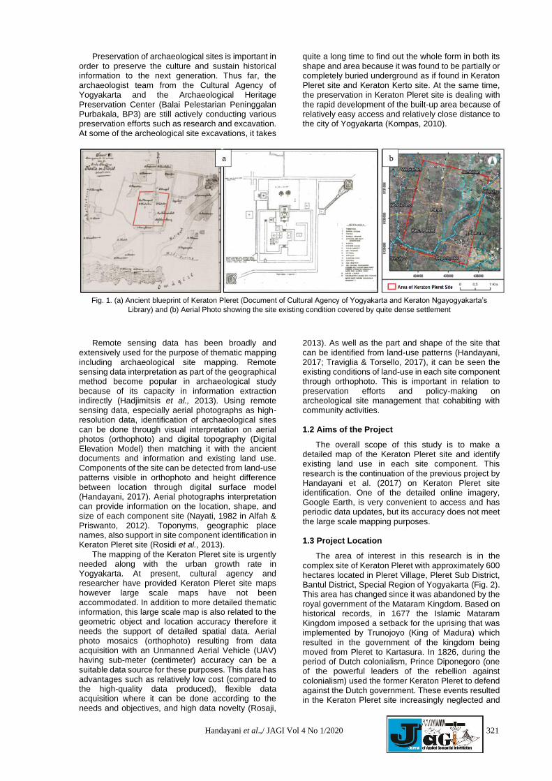
The area of interest in this research is in the complex site of Keraton Pleret with approximately 600 hectares located in Pleret Village, Pleret Sub District, Bantul District, Special Region of Yogyakarta (Fig. 2). This area has changed since it was abandoned by the royal government of the Mataram Kingdom. Based on historical records, in 1677 the Islamic Mataram Kingdom imposed a setback for the uprising that was implemented by Trunojoyo (King of Madura) which resulted in the government of the kingdom being moved from Pleret to Kartasura. In 1826, during the period of Dutch colonialism, Prince Diponegoro (one of the powerful leaders of the rebellion against colonialism) used the former Keraton Pleret to defend against the Dutch government. These events resulted in the Keraton Pleret site increasingly neglected and
322 Handayani et al.,/ JAGI Vol 4 No 1/2020
damaged. The damage was also triggered by the construction of new communities to build settlements around the Kereret Pleret making it difficult for archaeologists to excavate the legacy of the Keraton Pleret.
Fig. 2. The study area located in Pleret Village, Special Region of Yogyakarta, Indonesia
2. Method
This study is disposed for mapping Keraton Pleret and the components in large scale map that is not been done in previous study. It also used detailed spatial data, orthophoto, to make better visual interpretation on object in the site and for higher precission of object mapping. The orthophoto combined with ancient blueprints, topographic map, and information from previous studies are used for comprehensive identification of components inside the keraton and result detailed map.
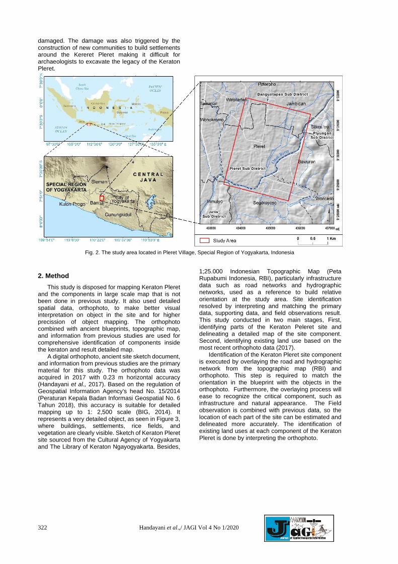
A digital orthophoto, ancient site sketch document, and information from previous studies are the primary material for this study. The orthophoto data was acquired in 2017 with 0.23 m horizontal accuracy (Handayani et al., 2017). Based on the regulation of Geospatial Information Agency's head No. 15/2014 (Peraturan Kepala Badan Informasi Geospatial No. 6 Tahun 2018), this accuracy is suitable for detailed mapping up to 1: 2,500 scale (BIG, 2014). It represents a very detailed object, as seen in Figure 3, where buildings, settlements, rice fields, and vegetation are clearly visible. Sketch of Keraton Pleret site sourced from the Cultural Agency of Yogyakarta and The Library of Keraton Ngayogyakarta. Besides,
1;25.000 Indonesian Topographic Map (Peta Rupabumi Indonesia, RBI), particularly infrastructure data such as road networks and hydrographic networks, used as a reference to build relative orientation at the study area. Site identification resolved by interpreting and matching the primary data, supporting data, and field observations result. This study conducted in two main stages, First, identifying parts of the Keraton Peleret site and delineating a detailed map of the site component. Second, identifying existing land use based on the most recent orthophoto data (2017).
Identification of the Keraton Pleret site component is executed by overlaying the road and hydrographic network from the topographic map (RBI) and orthophoto. This step is required to match the orientation in the blueprint with the objects in the orthophoto. Furthermore, the overlaying process will ease to recognize the critical component, such as infrastructure and natural appearance. The Field observation is combined with previous data, so the location of each part of the site can be estimated and delineated more accurately. The identification of existing land uses at each component of the Keraton Pleret is done by interpreting the orthophoto.
Handayani et al.,/ JAGI Vol 4 No 1/2020 323
Fig. 3. Orthophoto at study area and detail of the object represented where buildings, settlements, rice fields, and vegetation are
clearly visible
3. Result and Discussions
3.1 Mapping Component of Keraton Pleret Site
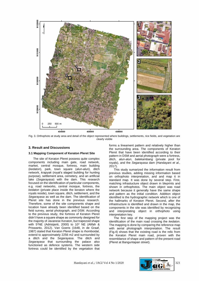
The site of Keraton Pleret possess quite complex components including main gate, road network, market, central mosque, fortress, main building (kedaton), park, town square (alun-alun), ditch network, krapyak (royal’s staged building for hunting purpose), settlement area, cemetery, and an artificial lake (Segarayasa) with the dam. This research focused on the identification of particular components, e.g. road networks, central mosque, fortress, the kedaton (private place inside the keraton where the royals reside), town square, ditch, settlement, and the Segarayasa as well as the dam. The identification of Pleret site has done in the previous research. Therefore, some of the site components shape and location have already been identified based on the field survey, aerial photograph, and DSM. According to the previous study, the fortress of Keraton Pleret didn’t have a square shape as commonly designed for the majority of Javanese Keraton, but trapezoid shape with 5oNE (Adrisijanti, 2000) to 10o NE (Alifah & Priswanto, 2012). Van Goens (1648, in de Graaf, 1987) stated that Keraton Pleret shape is rhomboidal, extend to approximately 2256 m2 and surrounded by a ditch and the Segarayasa. The ditch and Segarayasa that surrounding the palace also functioned as defence systems. The western side fortress could be identified by the vegetation that
forms a lineament pattern and relatively higher than the surrounding area. The components of Keraton Pleret that have been identified according to their pattern in DSM and aerial photograph were a fortress, ditch, alun-alun, balekambang (private pool for royals), and the Segarayasa dam (Handayani et al., 2017).
This study sumarized the information result from previous studies, adding missing information based on orthophoto interpretation, and and map it in standard map. It was done by several step. First, matching infrastucture object drawn in bleprints and shown in orthophotos. The main object was road network because it generally have the same shape and pattern as the initial condition. Addition object identified is the hydrographic network which is one of the hallmarks of Keraton Pleret. Second, after the infrastructure is identified and drawn in the map, the components in the site was identified by recognizing and interpretating object in orthophoto using interpretation key.
The first step of the mapping project was the identification of the main road crossing the kedaton. The mapping is done by comparing the reference map with aerial photograph interpretation. The result (Fig.4) shows that the existing road is the relic from the Keraton Pleret main road, proven with the resemblance of shape and pattern of the present road (Pleret at Banguntapan street).
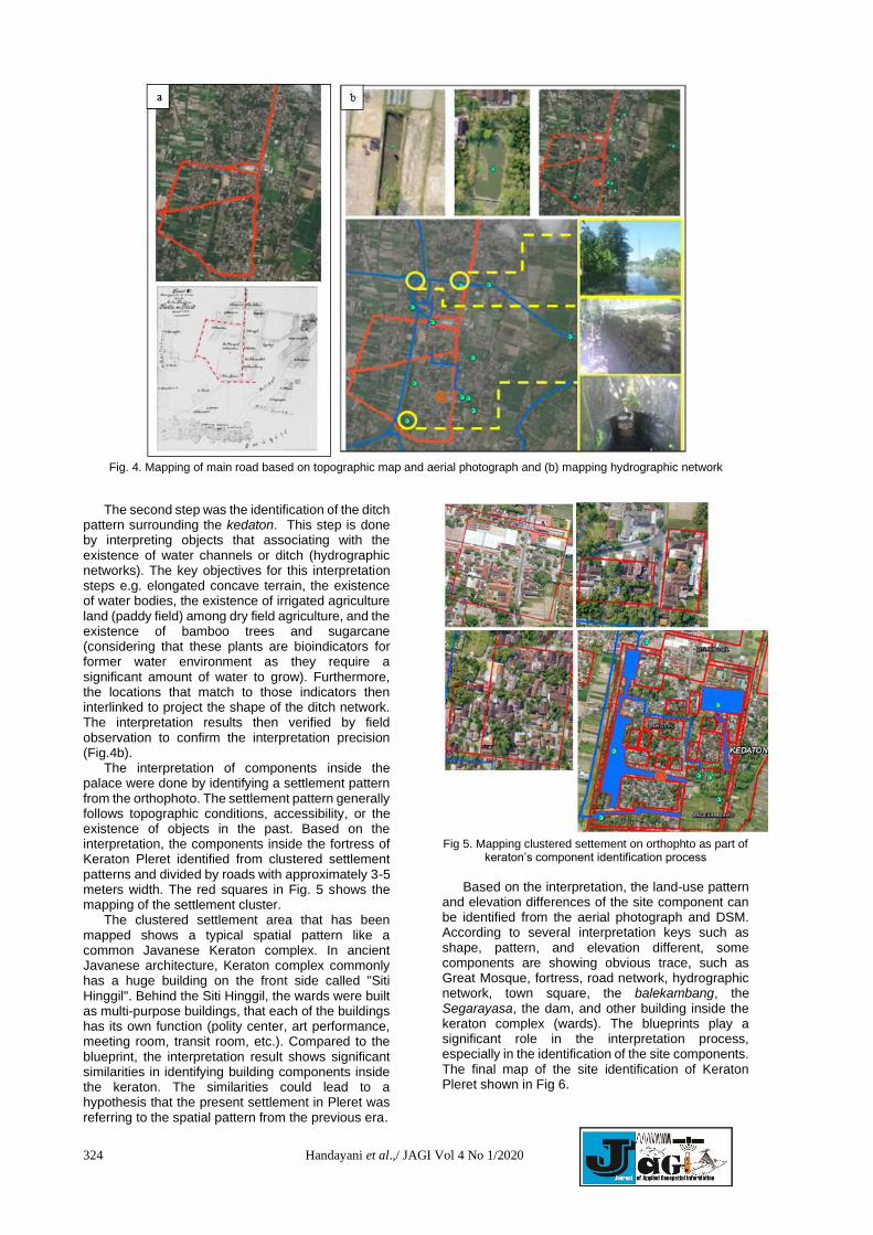
324 Handayani et al.,/ JAGI Vol 4 No 1/2020
Fig. 4. Mapping of main road based on topographic map and aerial photograph and (b) mapping hydrographic network
The second step was the identification of the ditch pattern surrounding the kedaton. This step is done by interpreting objects that associating with the existence of water channels or ditch (hydrographic networks). The key objectives for this interpretation steps e.g. elongated concave terrain, the existence of water bodies, the existence of irrigated agriculture land (paddy field) among dry field agriculture, and the existence of bamboo trees and sugarcane (considering that these plants are bioindicators for former water environment as they require a significant amount of water to grow). Furthermore, the locations that match to those indicators then interlinked to project the shape of the ditch network. The interpretation results then verified by field observation to confirm the interpretation precision (Fig.4b).
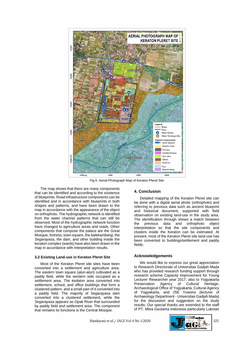
The interpretation of components inside the palace were done by identifying a settlement pattern from the orthophoto. The settlement pattern generally follows topographic conditions, accessibility, or the existence of objects in the past. Based on the interpretation, the components inside the fortress of Keraton Pleret identified from clustered settlement patterns and divided by roads with approximately 3-5 meters width. The red squares in Fig. 5 shows the mapping of the settlement cluster.
The clustered settlement area that has been mapped shows a typical spatial pattern like a common Javanese Keraton complex. In ancient Javanese architecture, Keraton complex commonly has a huge building on the front side called "Siti Hinggil". Behind the Siti Hinggil, the wards were built as multi-purpose buildings, that each of the buildings has its own function (polity center, art performance, meeting room, transit room, etc.). Compared to the blueprint, the interpretation result shows significant similarities in identifying building components inside the keraton. The similarities could lead to a hypothesis that the present settlement in Pleret was referring to the spatial pattern from the previous era.
Fig 5. Mapping clustered settement on orthophto as part of
keraton’s component identification process
Based on the interpretation, the land-use pattern
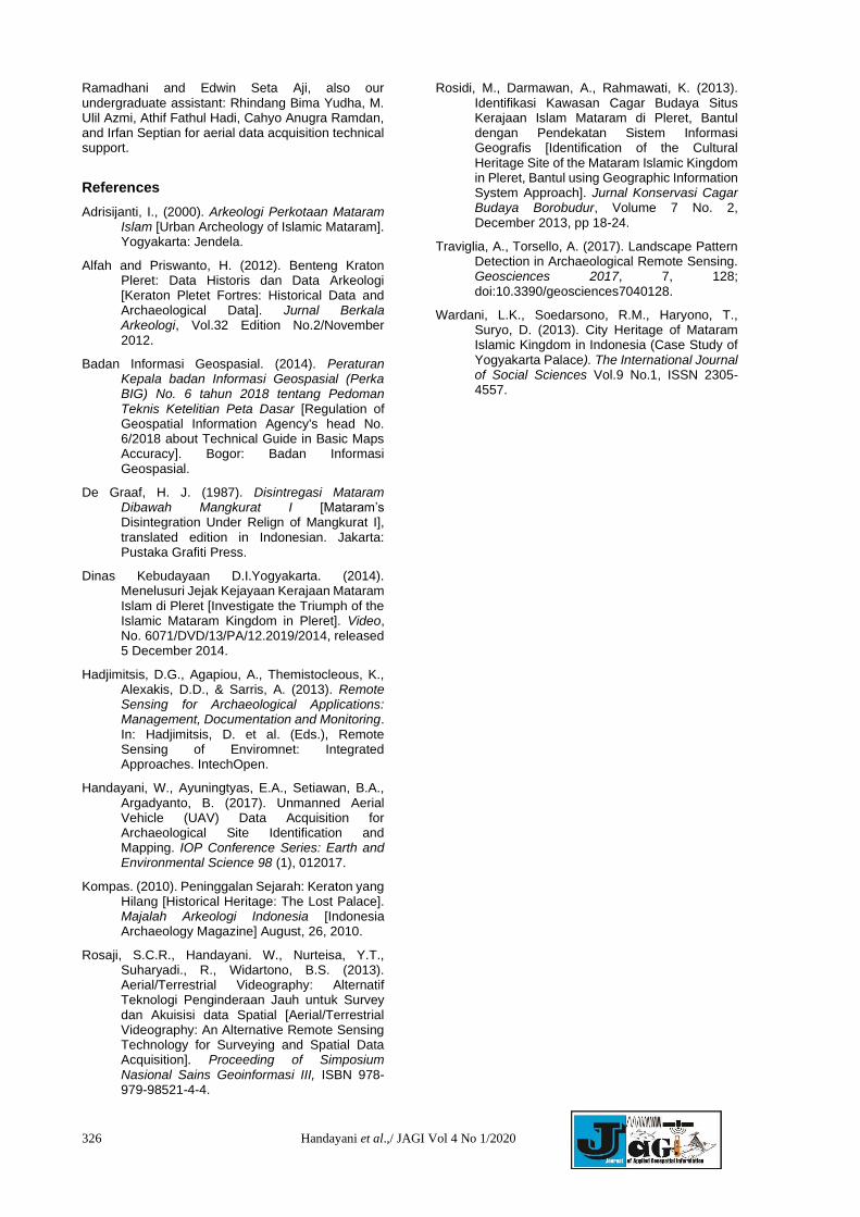
and elevation differences of the site component can be identified from the aerial photograph and DSM. According to several interpretation keys such as shape, pattern, and elevation different, some components are showing obvious trace, such as Great Mosque, fortress, road network, hydrographic network, town square, the balekambang, the Segarayasa, the dam, and other building inside the keraton complex (wards). The blueprints play a significant role in the interpretation process, especially in the identification of the site components. The final map of the site identification of Keraton Pleret shown in Fig 6.
Handayani et al.,/ JAGI Vol 4 No 1/2020 325
Fig 6. Aerial Photograph Map of Keraton Pleret Site
The map shows that there are many components
that can be identified and according to the existence of blueprints. Road infrastructure components can be identified and in accordance with blueprints in both shapes and patterns, and have been drawn to the map in accordance with the appearance of the object on orthophoto. The hydrographic network is identified from the water channel patterns that can still be observed. Most of the hydrographic network function have changed to agriculture areas and roads. Other components that compose the palace are the Great Mosque, fortress, town square, the balekambang, the Segarayasa, the dam, and other building inside the keraton complex (wards) have also been drawn in the map in accordance with interpretation results.
3.2 Existing Land-use in Keraton Pleret Site
Most of the Keraton Pleret site sites have been converted into a settlement and agriculture area. The eastern town square (alun-alun) cultivated as a paddy field, while the western side occupied as a settlement area. The kedaton area converted into settlement, school, and office buildings that form a clustered pattern, and a small part of it converted into a paddy field. The majority of Segarayasa dam converted into a clustered settlement, while the Segarayasa appears as Opak River that surrounded by paddy field and settlement area. The component that remains its functions is the Central Mosque.
4. Conclusion
Detailed mapping of the Keraton Pleret site can be done with a digital aerial photo (orthophoto) and referring to previous data such as ancient blueprint and historical document, supported with field observation on existing land-use in the study area. The identification through shows a match between the previous data and orthophoto object interpretation so that the site components and clusters inside the Keraton can be estimated. At present, most of the Keraton Pleret site land-use has been converted to buildings/settlement and paddy fields.
Acknowledgements
We would like to express our great appreciation to Research Directorate of Universitas Gadjah Mada who has provided research funding support through research scheme Capacity Improvement for Young Lecturer Researcher year 2017; also to Yogyakarta Preservation Agency of Cultural Heritage, Archaeological Office of Yogyakarta, Cultural Agency of Yogyakarta, and JSE Yuwono (lecturer of Archaeology Department - Universitas Gadjah Mada) for the discussion and suggestion on the study results. Our special thanks are extended to the staff of PT. Mitra Geotama Indonesia particularly Lukman
326 Handayani et al.,/ JAGI Vol 4 No 1/2020
Ramadhani and Edwin Seta Aji, also our undergraduate assistant: Rhindang Bima Yudha, M. Ulil Azmi, Athif Fathul Hadi, Cahyo Anugra Ramdan, and Irfan Septian for aerial data acquisition technical support.
References
Adrisijanti, I., (2000). Arkeologi Perkotaan Mataram Islam [Urban Archeology of Islamic Mataram]. Yogyakarta: Jendela.
Alfah and Priswanto, H. (2012). Benteng Kraton Pleret: Data Historis dan Data Arkeologi [Keraton Pletet Fortres: Historical Data and Archaeological Data]. Jurnal Berkala Arkeologi, Vol.32 Edition No.2/November 2012.
Badan Informasi Geospasial. (2014). Peraturan Kepala badan Informasi Geospasial (Perka BIG) No. 6 tahun 2018 tentang Pedoman Teknis Ketelitian Peta Dasar [Regulation of Geospatial Information Agency's head No. 6/2018 about Technical Guide in Basic Maps Accuracy]. Bogor: Badan Informasi Geospasial.
De Graaf, H. J. (1987). Disintregasi Mataram Dibawah Mangkurat I [Mataram’s Disintegration Under Relign of Mangkurat I], translated edition in Indonesian. Jakarta: Pustaka Grafiti Press.
Dinas Kebudayaan D.I.Yogyakarta. (2014). Menelusuri Jejak Kejayaan Kerajaan Mataram Islam di Pleret [Investigate the Triumph of the Islamic Mataram Kingdom in Pleret]. Video, No. 6071/DVD/13/PA/12.2019/2014, released 5 December 2014.
Hadjimitsis, D.G., Agapiou, A., Themistocleous, K., Alexakis, D.D., & Sarris, A. (2013). Remote Sensing for Archaeological Applications: Management, Documentation and Monitoring. In: Hadjimitsis, D. et al. (Eds.), Remote Sensing of Enviromnet: Integrated Approaches. IntechOpen.
Handayani, W., Ayuningtyas, E.A., Setiawan, B.A., Argadyanto, B. (2017). Unmanned Aerial Vehicle (UAV) Data Acquisition for Archaeological Site Identification and Mapping. IOP Conference Series: Earth and Environmental Science 98 (1), 012017.
Kompas. (2010). Peninggalan Sejarah: Keraton yang Hilang [Historical Heritage: The Lost Palace]. Majalah Arkeologi Indonesia [Indonesia Archaeology Magazine] August, 26, 2010.
Rosaji, S.C.R., Handayani. W., Nurteisa, Y.T., Suharyadi., R., Widartono, B.S. (2013). Aerial/Terrestrial Videography: Alternatif Teknologi Penginderaan Jauh untuk Survey dan Akuisisi data Spatial [Aerial/Terrestrial Videography: An Alternative Remote Sensing Technology for Surveying and Spatial Data Acquisition]. Proceeding of Simposium Nasional Sains Geoinformasi III, ISBN 978-979-98521-4-4.
Rosidi, M., Darmawan, A., Rahmawati, K. (2013). Identifikasi Kawasan Cagar Budaya Situs Kerajaan Islam Mataram di Pleret, Bantul dengan Pendekatan Sistem Informasi Geografis [Identification of the Cultural Heritage Site of the Mataram Islamic Kingdom in Pleret, Bantul using Geographic Information System Approach]. Jurnal Konservasi Cagar Budaya Borobudur, Volume 7 No. 2, December 2013, pp 18-24.
Traviglia, A., Torsello, A. (2017). Landscape Pattern Detection in Archaeological Remote Sensing. Geosciences 2017, 7, 128; doi:10.3390/geosciences7040128.
Wardani, L.K., Soedarsono, R.M., Haryono, T., Suryo, D. (2013). City Heritage of Mataram Islamic Kingdom in Indonesia (Case Study of Yogyakarta Palace). The International Journal of Social Sciences Vol.9 No.1, ISSN 2305-4557.