mapping cuba’s twentieth-century architecture · mapping cuba’s twentieth-century architecture...
TRANSCRIPT
110
MAPPING CUBA’S TWENTIETH-CENTURY ARCHITECTURE
Josef Asteinza1
A place without a past has no future.
That Cuba is frozen in time is a commonplace thatthe casual visitor often expresses. Of course, what weobserve and respond to is not stillness but the differ-ence in movement—the vector and velocity ofchange—between worlds separated for a half centu-ry. Everything changes, even Cuba, and whatever il-lusion of frozenness there may have been is alreadymelting away with the recent thaw in US-Cuban re-lations.
The functioning relics that predate the Cold Warembargo, like the automobiles and appliances, readi-ly capture the visitor’s attention, but the greatestsource of this seemingly timeless panorama is Cuba’sextraordinary architecture, five centuries of buildingthat constitute some of the earliest post-Columbiansettlements in the Americas as well as an exceptionalModernist legacy comparable to parallel achieve-ments in Brazil, Mexico and Venezuela.
The present essay provides a brief overview of the im-portance of twentieth-century architecture in Cubaand its current conditions. It follows with a brief out-line of the mapping project: its origin, existing sourc-es, recent mapping efforts by others, and its potentialapplications. The exercise focuses specifically on theneighborhood of El Vedado in Havana, rather thanthe entire island.
TWENTIETH-CENTURY ARCHITECTURE IN CUBAThe greatest expansion of Cuban cities, Havana inparticular, occurred in the early 20th century, duringa period of intense experimentation in the arts thatalso occurred in architecture. From the mid 1920sthrough the mid 1960s, this search, attuned to inter-national movements and drawing from the essentialelements of Cuban architecture, resulted in highlyoriginal buildings. Eduardo Luis Rodríguez, in theintroduction to his architectural guide to this period,writes, “For the first time in its history, Cuba’s na-tional architecture was viewed in terms of richnessand quality as good as or better to that being prac-ticed in other, more developed countries.”2 A few ofthe architectural leaders include Eugenio Batista,Mario Romañach, Aquiles Capablanca, Max Borges,Emilio del Junco, Manuel Gutiérrez, Ricardo Porro,Frank Martínez, and Nicolás Quintana. They werepart of a creative generation in the 1940s and 1950s.Their work embodied an international progressivespirit, which represents some of the most iconic im-ages of Cuba—landmarks of the built environment.They define the place.
Nicolás Quintana is also the subject of a documenta-ry film which the author is producing. A distin-guished architect, Quintana was also an urban plan-ner who thought about the design of citiesthroughout his career. He lectured extensively on thehistory of the physical development of Havana. This
1. The present paper was jointly presented by Josef Asteinza and Vivian Garcia. Vivian Garcia produced the maps in the presentationand provided an overview on mapping methods.2. Rodriguez, Havana Guide, p vii.
Mapping Cuba’s Twentieth-Century Architecture
111
history is documented in the historic master plans forthe city (Table 1), the product of a restless attemptby the city to redefine itself—to assess the past andlook ahead—and make itself contemporary. In the1950s Quintana participated in the InternationalCongresses on Modern Architecture (CIAM IX andCIAM X), and served as director of planning for Va-radero and Trinidad. Afterward he worked on urbandevelopment projects in Puerto Rico and Venezuela.His last major project, Havana and its Landscapes, acollaboration with landscape architect Juan AntonioBueno, engaged students, professionals and the pub-lic to think about Cuban cities, particularly Havana,as living, contemporary places, which is to say placeswith a past and with a future.
In order to bring the architectural history of Havanaand Quintana’s works to life in film, the productionteam began considering digital technologies to repro-duce and interpret buildings and urban plans. Thesetechnologies comprise geographical information sys-tems (GIS), three-dimensional modeling and otherdigital tools. Thus began the collaboration betweenthe author and Vivian García, a GIS specialist andco-presenter at the 2016 ASCE Conference on July28, 2016. From the outset it became evident that theeffort required for the narrow scope of the film proj-ect has broader applications for documenting andconserving the historic fabric of the twentieth-centu-ry city.
THE MAPPING PROJECT
Maps in the broadest sense are the spatialization ofknowledge. They vary in type and form for every-thing that can be graphically represented. In the lastfew decades, the rise of digital cartography has revo-lutionized mapmaking.
GIS is a computer system capable of assembling,storing, manipulating and displaying data accordingto their location.3 Dynamic mapping allows differentsets of information to be gathered, updated and dis-played for specific purpose. Cross-analyses can revealpowerful, insightful connections and inform deci-sion-making. A GIS map can include points, lines,shapes, and images as well as spatial and non-spatialdata. The spatial elements can represent site loca-tions, streets, city blocks, and satellite images. Thenon-spatial data can include in the case of architec-tural conservation, for example: name of the archi-tect, engineers and contractors; year of constructionand construction type; original and current use; andexisting condition and conservation cost.
Two common GIS platforms are QGIS, a free andopen-source software of the Open Source GeospatialFoundation, and ArcGIS, a suite of proprietary GISsoftware products produced by Environmental Sys-tems Research Institute (ESRI), a private company.Specific to the international conservation field isArches, an open source web- and geospatially-basedinformation system to inventory and manage heri-tage sites. Launched in 2010, the project is a collabo-ration between the Getty Conservation Institute andthe World Monuments Fund.
Although a model is not a map in the strictest sense,it is important to note that the Group for the Com-prehensive Planning of the Capital in Havana devel-oped a model of the entire city at the scale of 1:1000,which was housed in a building in the suburb of Mi-ramar. This model, begun in 1987 and opened to thepublic in 1995, was an inspiration for a digital modelfor the film project. Made of cedar cigar boxes andother materials, it shows the entire 144 km2 city in144 m2, and is considered the third largest urban
Table 1. List of Master Plans for the City of Havana
YEAR PLAN1850 Carillo de Albornoz1922 Montoulieu1925 Martínez Inclán1926 Forestier1944 San Martín1951 Cañas Abril1958 Sert et al.1963 M. González et al.1971 Baquero et al.1984 Rey et al.1990 A. García et al.
3. Wilford, Mapmakers, p 418.
Cuba in Transition • ASCE 2016
112
scale model, after the ones in New York and Shang-hai. With its color-coding system to represent the
historic period in which each building wasconstructed—reddish-brown for Colonial build-
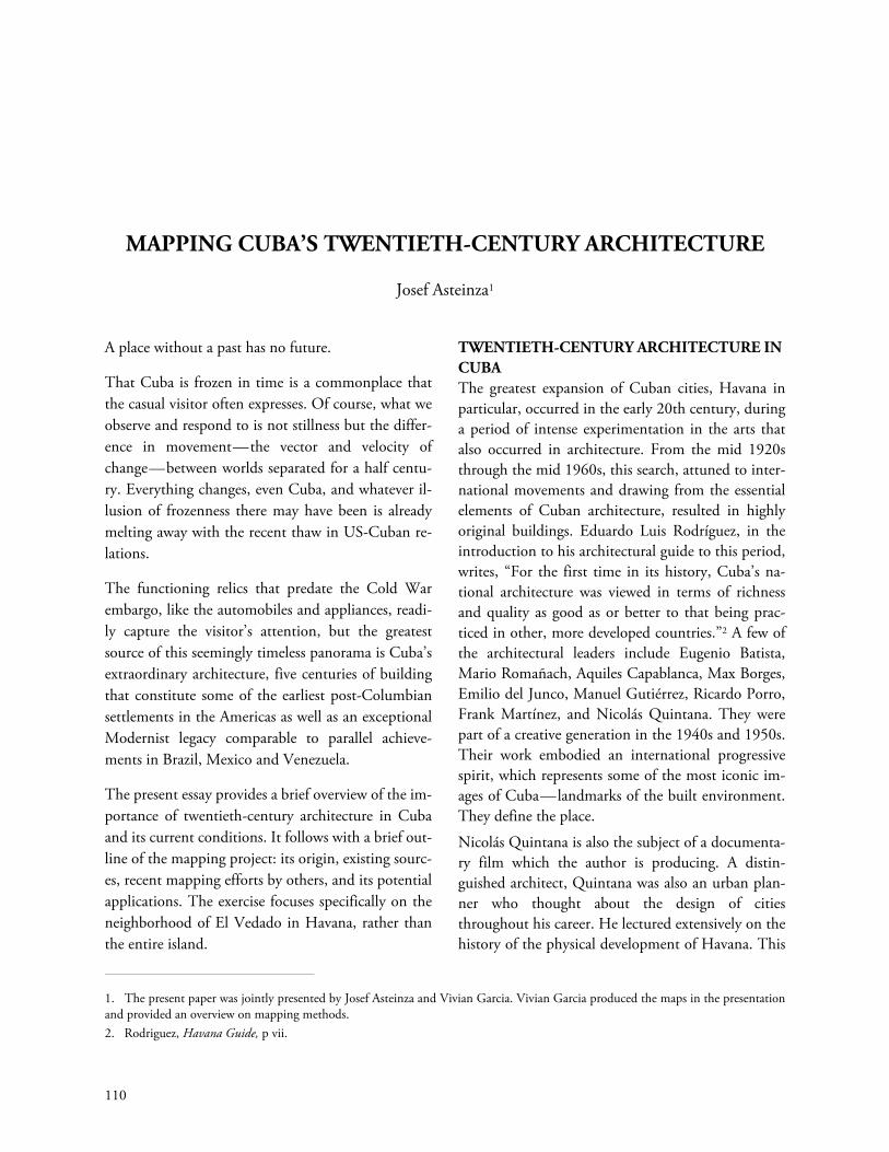
Map 1. Havana, Location of Select Buildings of the Modern Movement in the National Register, by Architect
Source: Docomomo Cuba. Produced by Vivian Garcia.
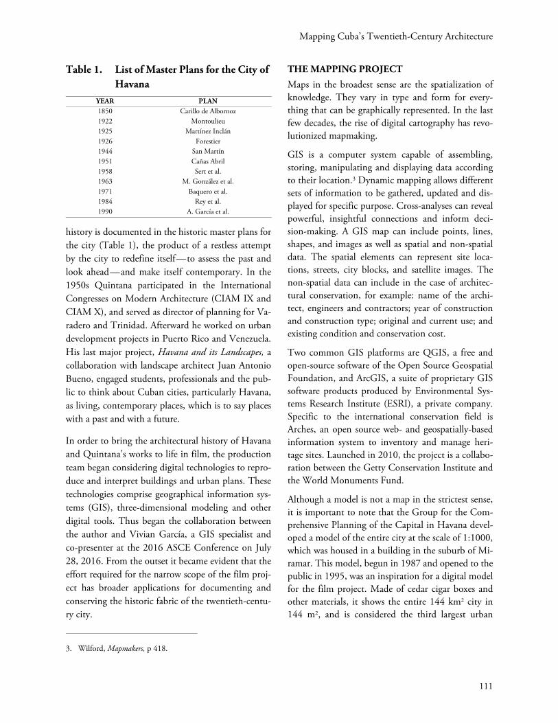
Map 2. Havana, Location of Select Buildings of the Modern Movement in the National Register, by Year
Source: Docomomo Cuba. Produced by Vivian Garcia.
Mapping Cuba’s Twentieth-Century Architecture
113
ings, ochre for those built between Independenceand the Revolution, and ivory for those built after1959— it functions like a thematic map.
Some of the spatial data used in this project derive inpart from digitized plans used in Quintana’s Havanaand its Landscapes. In Cuba, there are governmentsources in agencies and departments such as the of-fice of the city historian, the department of physicalplanning and Docomomo Cuba. Docomomo is anon-profit organization founded in 1988 at theTechnical University in the Netherlands. With 69chapters and 3,000 members in Africa, America,Asia, Europe and the Pacific, it is dedicated to pro-moting awareness and protection of the architecturalheritage of the Modern Movement. DocomomoCuba has been especially active in documenting andconserving the Cuban Modern Movement, a periodthat includes some of the finest works built in Cuba.By definition Docomomo material is limited to theModern Movement. Docomomo Cuba maintains anational register of Modern Movement buildingswhich provided much of the source material in thepresent map, including the selection of buildings andtheir locations. Architectural guides, such as MaríaElena Martín’s Havana, Cuba, an architectural guideor the aforementioned guide by Eduardo Luis Rodrí-guez, provide a broader selection of sites than thosepublished in the Docomomo National Register4. An-other study, Arquitectura en la ciudad de La Habana:primera modernidad published in 2000 by Juan En-rique de Balbín Behrmann and Carlos Sambricio, as-sesses the conditions and usage of buildings of inter-est including some of unacknowledged, and probablyunknown, authorship.
An initial mapping of Docomomo Cuba sites in Ha-vana shows architects of each site (Map 1) and thedecade in which each building was constructed (Map2). Although the site distribution is widespread, thelocations of the commissions realized by the rankingarchitects of the Modern Movement are clearly dis-
cernible, along a few neighborhoods, mostly in thewestern part of the city, within El Vedado.
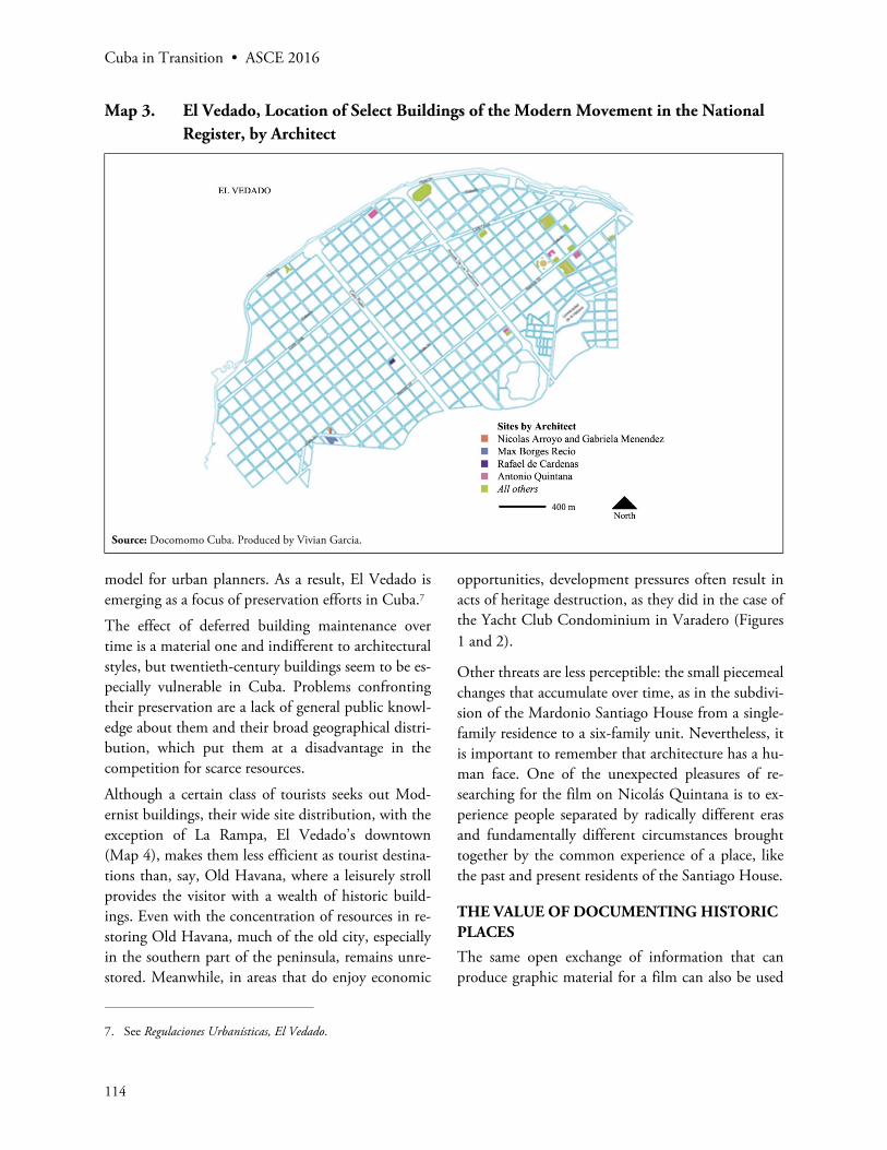
MAPPING OF HISTORIC BUILDINGS IN EL VEDADO
The author decided to concentrate on El Vedado forseveral reasons. El Vedado is more than a menagerieof buildings; the urban ensemble that is El Vedado ismore than the sum of its parts. It has a rich selectionof twentieth-century buildings representing not onlythe Modern Movement but also other movementsthat preceded it. A neighborhood west of Old Hava-na, El Vedado consists of around 150 hectares of or-thogonally arranged blocks each one hundred meterssquare (Map 3). It was laid out in 1859, contempo-rary with similar extramural urban developments inBarcelona, Vienna and Paris. By the 1950s, it had be-come the de facto center of the city, with La Rampa(23rd Street) as its main thoroughfare connecting theuniversity at the top of the hill, at nearby L and SanLázaro Streets, to hotels and commercial establish-ments frequented by tourists and locals alike. Its lo-cation on the convex sweep of the Malecón, its com-fortable, generous layout of broad streets, parks andlandscaped medians, and its architectural heritagecontribute to its appeal. El Vedado also served as themodel and site for many projects in Havana and itsLandscapes; Nicolás Quintana called it “an urban par-adigm applicable, with adaptations, to modern dayurban approaches5.” Mario Coyula observed that inits 140-year history, El Vedado’s model of urban de-velopment has proven to be flexible, resilient and ef-fective, with a balance of unity and variety.6
However, the area has also been used as asite for de-velopment in the post-Cold War order. The effect ofthat pressure is already evident in hasty alterationsexecuted with urgency, expedient construction mate-rials and methods, and little, if any, regulatory over-sight. They threatened to undermine the qualitiesthat make the neighborhood attractive, and an ideal
4. Selección de Obras del Registro Nacional, ed. E. L .Rodríguez.5. Quintana, Havana and its Landscapes. p 41.6. Coyula, “En Defensa del Vedado,” pp 24–25.
Cuba in Transition • ASCE 2016
114
model for urban planners. As a result, El Vedado isemerging as a focus of preservation efforts in Cuba.7
The effect of deferred building maintenance overtime is a material one and indifferent to architecturalstyles, but twentieth-century buildings seem to be es-pecially vulnerable in Cuba. Problems confrontingtheir preservation are a lack of general public knowl-edge about them and their broad geographical distri-bution, which put them at a disadvantage in thecompetition for scarce resources.
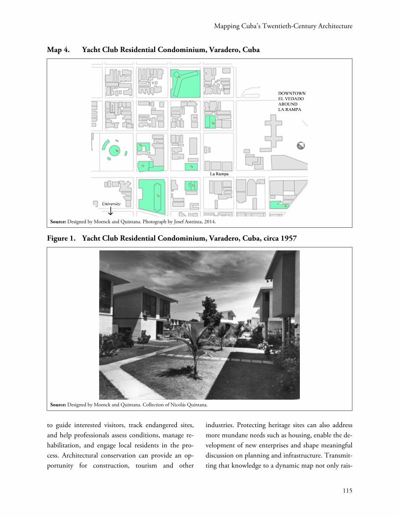
Although a certain class of tourists seeks out Mod-ernist buildings, their wide site distribution, with theexception of La Rampa, El Vedado’s downtown(Map 4), makes them less efficient as tourist destina-tions than, say, Old Havana, where a leisurely strollprovides the visitor with a wealth of historic build-ings. Even with the concentration of resources in re-storing Old Havana, much of the old city, especiallyin the southern part of the peninsula, remains unre-stored. Meanwhile, in areas that do enjoy economic
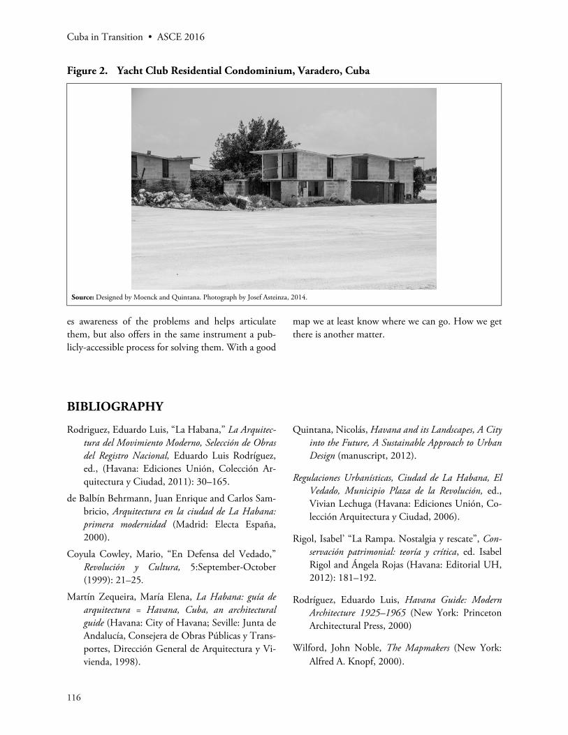
opportunities, development pressures often result inacts of heritage destruction, as they did in the case ofthe Yacht Club Condominium in Varadero (Figures1 and 2).
Other threats are less perceptible: the small piecemealchanges that accumulate over time, as in the subdivi-sion of the Mardonio Santiago House from a single-family residence to a six-family unit. Nevertheless, itis important to remember that architecture has a hu-man face. One of the unexpected pleasures of re-searching for the film on Nicolás Quintana is to ex-perience people separated by radically different erasand fundamentally different circumstances broughttogether by the common experience of a place, likethe past and present residents of the Santiago House.
THE VALUE OF DOCUMENTING HISTORIC PLACES
The same open exchange of information that canproduce graphic material for a film can also be used
Map 3. El Vedado, Location of Select Buildings of the Modern Movement in the National Register, by Architect
Source: Docomomo Cuba. Produced by Vivian Garcia.
7. See Regulaciones Urbanísticas, El Vedado.
Mapping Cuba’s Twentieth-Century Architecture
115
to guide interested visitors, track endangered sites,and help professionals assess conditions, manage re-habilitation, and engage local residents in the pro-cess. Architectural conservation can provide an op-portunity for construction, tourism and other
industries. Protecting heritage sites can also addressmore mundane needs such as housing, enable the de-velopment of new enterprises and shape meaningfuldiscussion on planning and infrastructure. Transmit-ting that knowledge to a dynamic map not only rais-
Map 4. Yacht Club Residential Condominium, Varadero, Cuba
Source: Designed by Moenck and Quintana. Photograph by Josef Asteinza, 2014.
Figure 1. Yacht Club Residential Condominium, Varadero, Cuba, circa 1957
Source: Designed by Moenck and Quintana. Collection of Nicolás Quintana.
Cuba in Transition • ASCE 2016
116
es awareness of the problems and helps articulatethem, but also offers in the same instrument a pub-licly-accessible process for solving them. With a good
map we at least know where we can go. How we getthere is another matter.
BIBLIOGRAPHY
Rodriguez, Eduardo Luis, “La Habana,” La Arquitec-tura del Movimiento Moderno, Selección de Obrasdel Registro Nacional, Eduardo Luis Rodríguez,ed., (Havana: Ediciones Unión, Colección Ar-quitectura y Ciudad, 2011): 30–165.
de Balbín Behrmann, Juan Enrique and Carlos Sam-bricio, Arquitectura en la ciudad de La Habana:primera modernidad (Madrid: Electa España,2000).
Coyula Cowley, Mario, “En Defensa del Vedado,”Revolución y Cultura, 5:September-October(1999): 21–25.
Martín Zequeira, María Elena, La Habana: guía dearquitectura = Havana, Cuba, an architecturalguide (Havana: City of Havana; Seville: Junta deAndalucía, Consejera de Obras Públicas y Trans-portes, Dirección General de Arquitectura y Vi-vienda, 1998).
Quintana, Nicolás, Havana and its Landscapes, A Cityinto the Future, A Sustainable Approach to UrbanDesign (manuscript, 2012).
Regulaciones Urbanísticas, Ciudad de La Habana, ElVedado, Municipio Plaza de la Revolución, ed.,Vivian Lechuga (Havana: Ediciones Unión, Co-lección Arquitectura y Ciudad, 2006).
Rigol, Isabel’ “La Rampa. Nostalgia y rescate”, Con-servación patrimonial: teoría y crítica, ed. IsabelRigol and Ángela Rojas (Havana: Editorial UH,2012): 181–192.
Rodríguez, Eduardo Luis, Havana Guide: ModernArchitecture 1925–1965 (New York: PrincetonArchitectural Press, 2000)
Wilford, John Noble, The Mapmakers (New York:Alfred A. Knopf, 2000).
Figure 2. Yacht Club Residential Condominium, Varadero, Cuba
Source: Designed by Moenck and Quintana. Photograph by Josef Asteinza, 2014.