mapping our world: terra incognita to australia changed markedly over the centuries, and mapping our...
TRANSCRIPT
XIV
XV
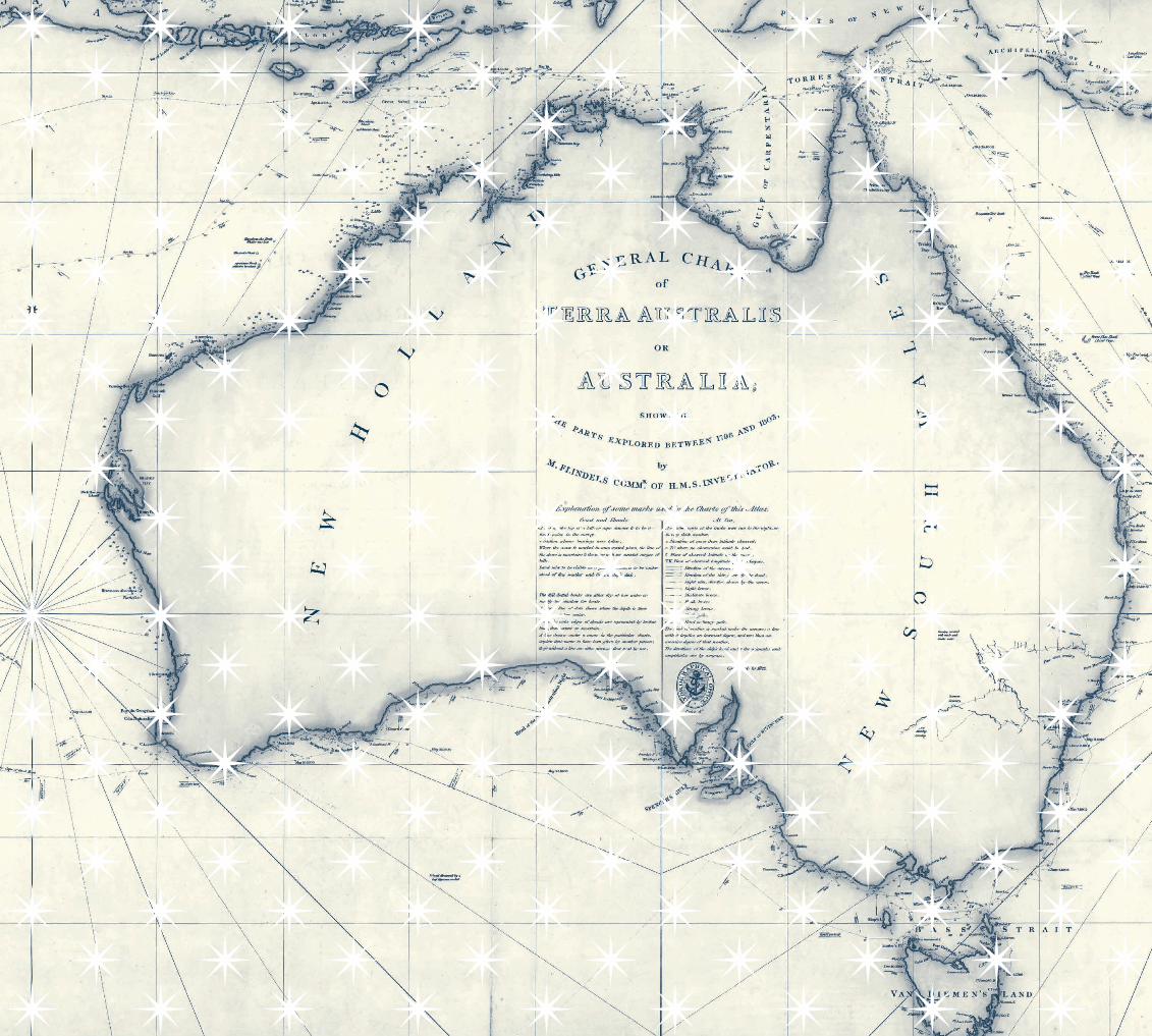
Matthew Flinders, General Chart of Terra Australis or Australia: showing the parts explored between 1798 and 1803 by M. Flinders Commr. of H.M.S. Investigator (detail), London, 1814 (corrected to 1822)NATIONAL LIBRARY OF AUSTRALIA, CANBERRA, TOOLE Y COLLECTION, MAP T 1494
Mapping our world
Maps are perhaps the most intriguing and revealing of visual documents. Their presence is felt from the first experience of a school atlas or globe to Google maps of our backyards and streets. The form and content of maps have changed markedly over the centuries, and Mapping Our World: Terra Incognita to Australia takes as one of its starting points this fascinating story of transformation: the development of cartography since the first speculative maps emerged from the ancient world. Piece by piece, through imagination and exploration, the world has been charted, often at great cost, and now in the early twenty-first century, when the digital age dominates, we can review this history in a major exhibition, and for the first time from an antipodean perspective. The story that unfolds in this exhibition takes us from the ancient world, through the age of exploration and the Enlightenment, to the modern era.
People seem to need to place themselves in a greater world and to integrate their world view with larger notions of it. Wandering through the British Library’s acclaimed Magnificent Maps: Power, Propaganda and Art exhibition in 2010, I was fascinated to observe the intense public response to the maps that filled the space. The crowds that flocked to this hugely popular exhibition scrutinised the remarkable maps on view, often engaging deeply in conversation while doing so. The maps which seemed to attract most attention and discussion were those in which people could see themselves, or at least their part of the world. Pointing animatedly, they identified places they knew, whether they were in Oxfordshire, Sussex, or contemporary London.
Similarly, the crowds visiting the unprecedented Bibliothèque nationale de France exhibition L’Âge d’or des cartes marines, assembled in Paris late last year, intently interrogated the many map treasures. The sheer beauty of some of these maps was astounding and affecting—the significance of others stopped visitors in their tracks.
The maps seemed to have a life which was essentially paradoxical, being both ancient and contemporary in the same moment. They showed recognisable worlds which had been changed by more recent knowledge and cartographic handiwork, and yet preserved the past in the immediacy and colour of the present.
The thoughtful gaze of viewers was generously reciprocated by the rich, storied surfaces of the encyclopaedic array of charts, globes and atlases. Whether they visited because they loved maps, were map collectors, or just wanted to experience the rarity and splendour of a memorable cartographic exhibition was hard to determine. The maps in these exhibitions seemed to make viewers slow down, and perhaps travel a little way with the mapmaker, beyond aspects of cartography and history and into the realm of the imagination. Whatever the nature of the dialogue people have with maps, they want to experience them at first hand. Fragile, and light-sensitive, the very significant manuscript maps included in Mapping Our World are rarely seen internationally, and almost never in Australia.
Given the undoubted popularity of maps, and the dramatic stories which attach to maps and mapmakers, it seems strange that Australian audiences have not yet seen such a comprehensive exhibition of early world maps. Apart from tracing the European discovery and charting of the Australian continent, Mapping Our World also examines our cartographic heritage from before the time of Ptolemy, until Matthew Flinders’ achievements in the early nineteenth century. The last major exhibition featuring mapping and the exploration of Australia was Terra Australis: The Furthest Shore, shown in Sydney for the Bicentennial in 1988. Mapping Our World significantly extends this narrative, seeking to explain the detailed history leading up to the completed charting of this continent, which culminated in the work of James Cook and then Matthew Flinders, whose masterpiece, the General Chart of Terra Australis or Australia, was published in 1814/1822.
When most people think of maps, they may have in mind notions of fixity and an ordered sense of place—or an authoritative view of the world in which they live.

XVI In reality, as soon as a map is drawn or printed it quickly becomes out of date as circumstances, politics or geography change. Even new technology like Google Maps can become out of date although the images downloaded may only be a few years or months old. This form of instant mapping leaves little to the imagination, instead substituting facts, or mundane images of the modern world. The glorious maps of the past were replete with imagination, speculation, perhaps even trepidation: once there were sea dragons, one-eyed monsters dwelling in a southern inferno, or beguilingly imagined natives. What we have lost in more recent maps is the sense of excitement, the notion that the world could be further explored, documented and, regrettably, exploited, sometimes at a dreadful cost to the first peoples encountered.
Many Australians still believe Captain Cook ‘discovered’ Australia in 1770. The history of earlier encounters is still not widely known. In reality, the first historically documented European contact occurred more than 160 years before Cook when Willem Janszoon in the Duyfken charted more than 300 kilometres of the Australian coastline. Numerous Dutch encounters, intentional and unintentional, followed, leading to the completed mapping of most of the Western Australian and northern coastlines. William Dampier, the English buccaneer, also visited the Western Australian coastline twice, in 1688 and 1699, famously offering unfavourable observations about the landscape and the Indigenous people he encountered—‘the miserablest People in the World’.
While contemporary cartographers have developed new and powerful geospatial applications, such as OpenStreetMap and other ‘crowdsourcing’ software for making and viewing maps, there are few such tools for understanding early maps. Certain knowledge is required to better comprehend or decipher such maps. Old maps are often debated or vigorously challenged, and sometimes their beauty, mystery and illustrative complexity compete with the facts they purport to represent, further compounding their impenetrability. The maps in this exhibition may be appreciated simply as beautiful, venerable and historic objects redolent with
the past. However, even a rudimentary understanding of cartographic history and the forms of map projection will enable viewers to gain a better sense of a map’s place in the world and its contribution to the evolution of mapping. A knowledge of the sometimes arcane lexicon of mapping—astrolabe, latitude and longitude, the Mercator projection, graticule, cartouche, rhumb line, portolan chart—is essential in interpreting these antique items, and so a glossary is included in this volume.
The stories reflected in Mapping Our World, along with the speculative earlier ideas of Terra Australis Incognita, Tierra Austral del Espíritu Santo or Terre Australe—the unknown southern land—depended on who was doing the speculating. Through the exhibition, visitors will be able to see how the minds of Europeans voyaged, sometimes ahead of their explorers (Fra Mauro’s map is a good example), as they attempted to describe and establish the limits of the world and to prove ideas which had arisen through the application of reason and science. How the notion of a great south land emerged from the mists of confusion and speculation is a fascinating story, and it is one which this exhibition can only display through the generosity of numerous European collecting institutions, to whom we are profoundly grateful for the loan of their treasures.
In presenting Mapping Our World, the National Library of Australia has joined a handful of fellow institutions, such as the British Library, the Bibliothèque nationale de France and the Field Museum in Chicago, in mounting an historic cartographic exhibition which assembles some of the most revered maps in history while reflecting on the significant strengths of its own remarkable maps collection. Mapping Our World, however, seeks to capture not only the evolution of mapping over more than a millennium, but also the manner in which this process and the history of voyaging have effectively put Australia on the map.
NAT WILLIAMS
Fra Mauro, Map of the world (detail), 1448–1453BIBLIOTECA NAZIONALE MARCIANA, VENICE, INV. N. 106173

XX Alongside these early treasures are maps which directly address the progressive mapping of our continent, from the earliest known European contacts and sketches in the 1600s onwards. In an age of discovery, those first visitors and their maps were part of an already ancient mapmaking tradition that was driven to fill the southern void on the world maps. Ancient Greek ideas about the physical make-up of the globe, and philosophical notions of the antipodes, provided mapmakers with opportunities to create a southern ideal, then a continent, even before they had the means to reach it.
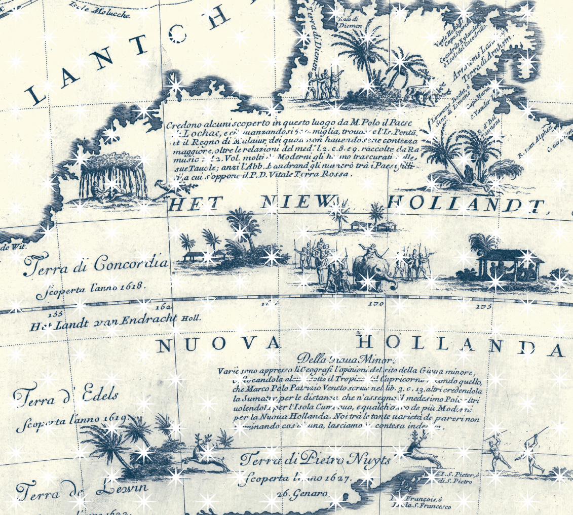
As a science, cartography is an attempt to fill geographic spaces with knowledge, in a graphical form that we can communally understand. It is inevitably rule-bound. Standards are critical to comprehension. Maps are in one sense a form of demystification, replacing an ideal or myth with measurable knowledge. There are moments, such as the appearance of the Southern Cross on celestial maps, or the Australian landmass for the first time on the charts by the Dutch cartographer Hessel Gerritsz, which bring an instant realisation, even a sense of revelation.
Yet the same maps can just as readily obscure or replace one ideal with another. Having replaced the greater southern continent with new boundaries, Gerritsz needed to satisfy expectations about a ‘New Holland’, and the wealth that potentially lay beyond his freshly drawn Australian coast.
In a similar way, the term ‘discovery’ is used to obscure the colonising purpose contained within the maps. The various interventions in Asia and the Pacific by a succession of Western trading empires focused in large measure on the spices and other resources of the East Indies, as the region to Australia’s north came to be called. Cartographers ultimately served the commercial and strategic interests of European powers, as grand schemes culminated in the arrival of new settlers on these shores. Thus began the process of mapping a continent, seeking to replace one set of ideals with another. In the context of Australian Aboriginal cosmography, the ‘discovery’ of the continent by Europeans was irrelevant, yet irrefutable.
The science that allowed Europeans to reach Australia is simple enough when reduced to a few words—navigation, seamanship, cartography, surveying—yet behind each lies centuries of gradual accumulation, accidents and epiphany. The inspiration and painstaking effort communicated by maps is delivered to us by a cast of characters of outstanding quality and vision. Few of us today are acquainted with the names Ptolemy, Roselli, Mercator, or Gerritsz, yet these and many other characters were as critical to the change in this continent’s status from ‘incognita’ to Australia as were Cook or Flinders. And such geographic advances would have been impossible without artists, engravers and printmakers of the calibre of Albrecht Dürer, Romeyn de Hooghe, Frans Post or Antonio Francesco Lucini.
Within the wider history of maps, many counterfactual stories jostle and compete for our attention. What if Tasman had completed the job of mapping Australia, or what if French settlement had followed Freycinet’s mapping of the continent. What would then have followed? The possibilities are tantalising. Popular ideas conjecturing other possible worlds are not new, though it is arguable that maps and mapmakers inspire more than their fair share. In the early 1900s, some writers put forward the case for a Spanish landing in Queensland 300 years earlier, attributing the feat to the Portuguese seaman and explorer Pedro Fernandes de Queirós, also known in English as Quiros. The reasoning was based on accounts of Don Juan Arias, the chaplain aboard Queirós’ Spanish fleet, and topographic descriptions by Queirós himself. Claims were made suggesting Spanish discovery, even specifying Port Curtis as fitting the description perfectly.
Though none of Queirós’ mapping survives, the possibility of Spanish discovery had much to do with the name he attached to his south land. The devoutly religious Queirós, having obtained the support of Pope Clement VIII, went to Peru in 1603 with the intention of finding Terra Australis Incognita, and claiming it for Spain and the Church. The expedition established a short-lived colony, ‘Austrialia del Espiritu Santo’ (the southern land of the Holy Spirit), on what is today Espíritu Santo in Vanuatu, claiming it as a beachhead for a much larger continent. His second-
in-command, Luís Vaz de Torres, charted the southern coastline of New Guinea, in the course of which he sailed through the strait that now bears his name. Queirós made much of his discoveries, and tried on numerous occasions to persuade King Philip III to fund a new voyage, greatly exaggerating claims regarding the size and richness of his discovery, claiming it to be ‘the fifth part of the world’. Though Queirós died without achieving his aims, the story has long had a presence in the Australian mentalité, at times finding its way into the educational curriculum as an alternative discovery story.
Similarly, in the late 1700s the English hydrographer Alexander Dalrymple, also something of an evangelist, declared his belief in the existence of a great southern continent, extending into low latitudes in the Pacific. Before the voyage of James Cook dispelled the notion of a great south land, Dalrymple, having found de Torres’ testimony proving a passage south of New Guinea, sought to lead an expedition into the Pacific.
Though his bid failed (he was replaced by Cook and the rest is history), Dalrymple’s advocacy for a group of maps which emanated from the French port of Dieppe, and which suggested French or Portuguese contact and mapping of Australia, has generated ongoing interest in them. The Dieppe maps were commissioned for wealthy and royal patrons during the 1500s, and several depict a landmass in the region of Australia. The contention that these maps of ‘Jave la Grande’, rediscovered by Dalrymple, represent the first mapping of Australia has had many proponents since, and will doubtless continue as an intriguing possibility.
The exhibition is conceived in five parts, which show in turn how, over almost three thousand years, Europeans gradually unravelled the secrets of the south land. The opening section, Ancient Conceptions of the World, anchors the exhibition in antiquity, in the early philosophical traditions and cartography that first suggested a world beyond the Mediterranean. Deliberately, it juxtaposes these and Indigenous Australian mapping to create a dialogue between these parallel traditions.
Harleian or Dauphin map (detail), c. 1547BRITISH LIBRARY, LONDON, CARTOGRAPHIC ITEMS ADDITIONAL 5413
XVIII

XIXTerra Incognita to Australia
Most large libraries and archives have rich collections of cartographic material, and continue to develop these, yet opportunities for large-scale exhibitions of maps such as Mapping Our World are few and far between. For generations of Australian map curators and librarians, as well as map lovers, and the many involved in putting together this exhibition, the sense of excitement is unsurpassed. It’s a feeling we are pleased to share.
The exhibition is deliberately ambitious in scope, bringing together diverse and extraordinary works from many generous overseas and Australian lenders, as well as the Library’s own remarkable collections. When the decision was made to tell the story of the south land, from ‘Terra Incognita to Australia’, that is, from its imagined beginnings in the ancient world to the first ‘complete’ map by Flinders, the maps that would best tell the story were soon identified. Even so, economic and logistical limitations played a part in shaping the final content of the exhibition, and thereby this catalogue. While we as curators have aimed to be as representative as possible, the availability of some works, other commitments or preservation issues have determined some of the content. The limitations of exhibition space were also a factor in curbing our enthusiasm. Uppermost in our minds, however, was the need to curate a cogent, coherent and visually exciting exhibition that would do justice to the story of the mapping of Australia.
This would be a once-in-a-lifetime opportunity. Accordingly, it was decided to bring together a panel of writers with close knowledge of the maps and their context, in order to produce an exhibition catalogue of enduring value. Many of the listed contributors are world experts on particular maps, and their efforts are greatly appreciated. It is often the nature of historical cartography that certain maps are studied intensively but by a relatively few individuals. Conversations may span years, decades, even centuries, with a relatively few participants. The same
may be said for some of the cartographic mysteries that inform and colour the history of any country or civilisation.
For Australia, the narrative most often repeated is the south land legend. It is the great enduring myth (or truth, depending on your point of view) of Australia’s genesis. How the notion of a great south land emerged from the human imagination, to be reshaped by feats of exploration and discovery and eventually come face to face with its real counterpart, Australia, and thereby vanish, is among the most compelling of stories, and one which remains little understood by most Australians. There is no space here to do justice to the many sub-plots, but before outlining the exhibition content, it is worth supplying a little of the flavour of this journey from Terra Incognita to Australia, and how it has percolated from cartographic endeavour to popular understanding.
Ancient knowledge of the world’s sphericity carried with it belief in the possibility of lands and peoples opposite the known world. In this sense, the earliest world mapping holds great significance for those of us who occupy the southern antipodes. Our very existence was envisaged, and then refined over centuries to allow for new ideas and discoveries. In the process, various fictional places were created: ‘Terra Australis, Nondum Cognita’, ‘Incognita’, ‘Regio Patalis,’ ‘Beach,’ ‘Lucach,’ ‘Jave la Grande,’ ‘South Land’—these are just some of the appellations given the land finally recognised as an island continent by Dutch, British and French cartographers in the early 1800s.
Many of the maps created before Europeans reached Australian waters are known in northern hemisphere circles, where they have particular resonances. These enduring works of religious and humanist traditions have both transmitted fundamental ideas about space and explored sacred spaces. Until now, the great maps that underpin modern cartography have been unavailable to those of us who live under southern skies. The bringing together of these maps, some for the first time, in a southern context is a rare opportunity to reorient our understanding of them, and to look more closely at the unexplored regions whose existence European mapmakers could only imagine.
Vincenzo Coronelli, Globe gore (detail), Venice, 1692–1693 versionNATIONAL LIBRARY OF AUSTRALIA, CANBERRA, REX NAN KIVELL COLLECTION, NK 10244 B

XXIIIThe exhibition begins in ancient Babylon with a facsimile of the clay tablet considered the oldest surviving world map. Ancient Greece and Rome are represented by the zonal maps of Macrobius, while a Ptolemy codex copied in c. 1454 reflects second-century Alexandrine knowledge and foreshadows the effect his greatest work, the Geography, had over European thought for centuries. On the Indigenous side are early twentieth-century collaborations between Australian ethnographer Daisy Bates and Indigenous peoples of Western Australia, two bark paintings commissioned from Groote Eylandt community members in 1948, Michael Nelson Jakamarra and Marjorie Napaltjarri’s monumental canvas Five Dreamings (1984), and Jon Rhodes’s The maps to Marruwa, recalling a poignant encounter with the makers of sand maps in remote Western Australia in 1990.
The second section, Medieval Religious Mapping, comprises six medieval maps produced in religious contexts. World maps became integral to the cycle of illustrations accompanying particular manuscript works—often histories or commentaries—during the medieval period in Europe, copied and evolving over the centuries in scriptoria. These maps often encapsulated ancient knowledge or belief in the southern antipodes, filtered through religious frameworks. Collectively, they show a progression from depicting the three continents of the ancient known world to maps speculating about further lands beyond: from the simple world map of Isidore of Seville, to the appearance of a fourth part of the world in the Beatus map, to three world maps illustrating the English world view; the section is completed by an Arabic astrolabe representing the ingenuity of the Arab and Islamic world at this time.
The third section, The Age of Discovery, focuses on Europe’s great ocean-going voyages and examines how the wider rediscovery of Ptolemy’s work around 1300 had a profound effect on mapmaking, leading to experimentations with the map projections and conventions. The Mercator projection, developed by the Flemish cartographer Gerard Mercator in 1569, was of prime importance to navigators breaking free of the Mediterranean and passing into
the Indian and Pacific Oceans. The section also looks at how long-distance voyaging and exploration of the East in search of spices and other commodities inspired the creation of more accurate cartography and encouraged a growing curiosity about the now-glimpsed south land. It addresses the rediscovery of Ptolemy in Europe and the appearance of his maps in print in the late 1400s, the great transitional world maps of the mid-fifteenth century of Fra Mauro and Andreas Walsperger, the Portuguese–Spanish rivalry for the world’s oceans through the magnificent Vatican planisphere of Diogo Ribeiro, and the cartographic mystery of the Dieppe Maps through the Rotz Atlas and the Harleian (or Dauphin) chart; finally, the Antwerp mapmakers Abraham Ortelius and Gerard de Jode are considered before the section ends with the map that first uses the name ‘Australia’.
The fourth section, The Dutch Golden Age, begins in the late sixteenth-century, when Amsterdam became the great trading powerhouse of Europe. The seventeenth century saw the rise of the Vereenigde Oost-Indische Compagnie (United East India Company, or VOC), and this section illustrates the power of the VOC through charts used on voyages, sumptuously produced decorative printed maps and atlases and haunting shipwreck relics. The Duyfken’s 1606 landing is represented in the mapping of Hessel Gerritsz, while the mapping of Tasman in the 1640s is represented through the Bonaparte Map and the Huydecoper Journal. Together these objects illustrate how the expansion of trade not only created great wealth, but also allowed Dutch cartographers to piece together the map of New Holland.
The last section, Europe and the South Pacific, begins in the seventeenth century with the first English atlas to cover part of Australia, the speculative east coast of French royal geographer Robert de Vaugondy, and William Dampier’s account of his voyage to Australia. It then explores the rivalry over the South Pacific between the two major European powers of the late eighteenth and early nineteenth centuries, Great Britain and France. Replicas of John Harrison’s first and fourth landmark timekeepers speak to the longitude problem that had
perplexed navigators for centuries. The charts, journals and instruments of the great English and French navigators Cook, La Pérouse, Flinders, Baudin and Freycinet are remnants of this great rivalry, leading finally to the first completed coastal map and naming of Australia in 1814 (updated in 1822).
This catalogue mirrors the structure of the exhibition. All works in the exhibition are the subject of a short essay, either treated individually or grouped with similar items. A panel of expert writers drawn from many and varied fields was assembled to write these essays. We are extremely grateful for their assistance, and also to the institutions that have so generously lent their expertise.
MARTIN WOODS
SUSANNAH HELMAN
Petrus Plancius, A new world map, updated in many places (detail), 1594KERRY STOKES COLLECTION, PERTH, 2010.044