mapping perceptions of safety in parks€¦ · know for sure where people feel unsafe in parks...
TRANSCRIPT

MAPPING PERCEPTIONS OF SAFETY IN PARKS
1
Mapping Perceptions of Safety in Parks
John D. Morgan, University of West Florida Jamie A. Snyder, University of West Florida
Sara Z. Evans, University of West Florida Jocelyn Evans, University of West Florida
Rachael Greller, Florida Atlantic University
Introduction
Public parks within urban areas are ideal spaces for recreation and human-environment activity that can foster physical health and mental wellbeing (Chiesura, 2004; Frumkin et al. 2017; Gascon et al. 2015; Sturm & Cohen 2014). Natural and built features available within a given park either facilitate or restrict these benefits for visitors. For instance, a park that provides a designated dog walk area with associated fencing, open grass and canine watering stations, facilitates that specific activity. Alternately, a park environment with no pleasant places to sit (e.g., no tree shade) restricts the likelihood of visitors spreading out a picnic blanket and dining al fresco.
Perceptions of safety within parks can take a specific form with regards to fear of crime (Painter 1996; Sreetheran & Van Den Bosch 2014). Fear of crime, regardless of the actual crime, may influence utilization of parks and influence overall visitation (Foster et al., 2010, 2014; Kneeshaw-Price et al. 2015). How visitors perceive park environments influences explicitly park success within the communities they serve. If people see specific areas within parks as unsafe, they may frequent those areas less, or not visit at all. The primary research question addressed in this paper is how to go about mapping specific areas of concern for safety within a bounded public space, such a city park. Parks officials often find themselves under budgetary constraints and must deal with competing demands for services and infrastructure (Ibes 2015; City of Pensacola 2011). It is a challenge for park managers to know for sure where people feel unsafe in parks (National Recreation and Parks Association 2017). Therefore, park managers need practical information about perceptions of parks to direct resources toward mitigating safety concerns.
Participatory mapping methods, as presented in our paper, offer park managers a way to know precisely where problem areas may be. This paper presents the design, implementation, and results of a participatory mapping survey conducted in five parks within the city of Pensacola, FL. To our knowledge, no project has specifically used sketch maps to capture the spatial nuances of perceived levels of safety within parks, which makes our study unique and highlights a primary contribution to the larger body of literature on the fear of crime. Practically, the methods described in our paper offer a method for park managers to utilize when directing future resources toward changes that should lead to increased perceptions of safety in parks.
Background
Fear of Crime Models
Fear is an unpleasant emotional state triggered by the perception of threating stimuli (Ruiter et al. 2001). Since the 1960s the fear of crime in public spaces has been extensively researched. Early research on the fear of crime focused on a victimization risk hypothesis that posits actual crime is

MAPPING PERCEPTIONS OF SAFETY IN PARKS
2
discernable by perceived crime (Balkin, 1979; Foster et al. 2014; Lee 2013; Skogan & Maxfeld, 1981). This hypothesis was eventually disproven with empirical studies finding a paradox; those with more fear of crime (e.g., elderly and female), have lower levels of reported victimization (Box et al. 1988; Smith, Steadman, Minton, & Townsend, 1999). Another focus for fear of parks research has been “sensitivity to risk,” which is defined by (Warr 1987) as the “relation between fear of a particular offense… and the perceived risk of that offense” (p. 30). Empirical evidence on perceived risk has concluded that changes in risk perceptions are dependent on the crime type (Ferraro 1995; Gabriel & Greve 2003; Jackson, 2011; Ryder et al. 2016; Warr, 1984, 1987). Most relevant to our project, has been a focus on neighborhood structure as it relates to fear of crime.
Early studies on the fear of crime have also provided a conceptual framework to address
dynamic ways in which perceptions of crime are related to the environment. Specifically, Garofalo
(1981) situated individual perceptions of crime within a social space (e.g., gender and age) that is
related to the image of the crime. Each person interprets information through a filter of attitudes and
beliefs to form an "image" of crime (Figure 1). Most notable in this model is that perceptions of crime
(risk assessment) are informed directly from an image, more so than objective measures such as
information about crime (Westover 1985).
Figure 1 – Fear of Crime Model. Adapted from Garofalo (1981)
Contemporary studies have extended the fear of crime model to account explicitly for
environmental attributes (Sreetheran & Van Den Bosch 2014). This accounting for the two-way
interaction between physical environment and social factors accommodates theories such as Shaw &
McKay’s (1942) social disorganization theory and Wilson & Kelling’s (1982) broken windows theory,
both of which situate perceptions as influenced by the environment. Recently, Chataway & Hart (2016)
adopted a model proposed by Jackson (2005) for their fear of crime survey that included a measure of
perceptions of incivilities (e.g., impolite/unsocial behavior) and community cohesion as explicitly drawn

MAPPING PERCEPTIONS OF SAFETY IN PARKS
3
from individual observations about their environment. Finally, Lynch’s (1960) often cited the quote
that “Environmental images are the result of a two-way process between the observer and his
environment.” (p. 6) are relevant to contemporary fear of crime models.
Surveying the Fear of Crime
Recording people’s activities/behaviors within a park as William Whyte did in New York City can
be informative for planning purposes (Whyte, 1980). However, observational methods alone can only
go so far in capturing the internal thoughts of those under study. To gather the perceived risk and fear
of crime for an area requires researchers to survey with the users of specific environments directly. A
few different approaches to surveying perceptions of safety and crime have been taken.
Westover (1985) conducted a study focusing on visitors to Midwestern parks, where she
conducted an in-person and on-site (at the parks) survey on perceived fear of crime. Westover (1985)
utilized Garofalo’s (1981) fear of crime model specifically to link fear of crime and particular park-
specific types of behavior (e.g., avoidance of specific park areas and past park experience with incivility
or crime). Nasar (1982) and Nasar & Fisher (1993) interviewed students in a residential neighborhood
and on a university campus by in-person questionnaire and showed them 35mm color photographs of
the area under study. Their survey methods, undoubtedly innovative for their time, offered the unique
opportunity to associate participant’s responses to specific features of the environment.
Most recently, Jackson (2005) followed by Chataway & Hart (2016) carried out their surveys on
the fear of crime using mail-in survey methods. Since these projects were focused on the geographic
scale of the neighborhood, they were able to target recruitment to those residents located in the area
of study. The mail-in questionnaire approach could be theoretically facilitated by internet-based
communication markets such as Amazon site called Mechanical Turk, which provides a way to crowd
source survey responses.
An important observation is that there are significant social differences in how the perception of safety is experienced. These social distinctions, which include distinctions in age, race, and gender, illustrate the situated ways in which people perceive environments. Pain (2001) in her review of literature highlighting many dualisms (e.g., women have more fear than men). She also highlights the recent shift of focus on older people as having more fear, to empirical findings supporting that younger people have more likelihood of being victimized and being afraid. Later, Pain (2003) carried direct investigation into geographical coincidence of reported incidents of victimization with parents and children’s fears. In her survey of x parents and children, a high level of coincidence with a place that parents were concerned with and places where actual victimization was reported.
Participatory Mapping
The term public participatory geographic information systems (PPGIS) was first introduced in 1996 at meetings of the National Center for Geographic Information and Analysis to describe how GIS technology could support public participation for a variety of applications (NCGIA, 1996). Since then PPGIS has been utilized in several contexts ranging from involving users in planning greenways

MAPPING PERCEPTIONS OF SAFETY IN PARKS
4
(Gobster & Westphal, 2004; Kahila-Tani et al. 2016; Laatikainen et al. 2017) to more mapping landscape characteristics contribution to human well-being (Brown & Raymond 2014).
Survey modes for collecting spatial perceptions range from the crowdsourced volunteered GIS as described by Goodchild (2007) to the more tactile approaches of Brown & Raymond (2007) and Sanschagrin (2011) that have participants put pen to paper, or more specifically to map, to indicate spatial preferences or perceptions. Boschmann & Cubbon (2014) recruited and interviewed six LGBT individuals in St. Louis, MS to examine their spatial experiences of feeling safe or unsafe in public spaces throughout the city. During semi-structured interviews, they utilized a technique of sketch maps. Specifically, they asked participants to identify where they felt safe or unsafe in public places using an ordinal colored marker coding scheme (e.g., yellow = very safe, blue = neutral, red = very unsafe).
By attempting to measure spatial perceptions of park visitors researchers have a chance at uncovering what Downs & Stea (1973) call a cognitive map of “…process composed of a series of psychological transformations by which an individual acquires, codes, stores, recalls, and decodes information about the relative locations and attributes of phenomena in his everyday spatial environment” (p. 9). Further, an understanding of the cognitive mapping of a park could be used in practical ways to inform landscape design plans as has been illustrated by Lynch (1960), Whyte (1980) and more recently others (Foster et al. 2013; White et al. 2014).
Park Image and Features
Urban parks were developed following the industrial revolution in the 19th century to address increasing alienation between people and nature (Deane 1979). The urban park movement, as it is often called, started in England and continued today (Thompson 2011). People still look to parks to provide environmental, aesthetic, recreational, psychological, and even economic benefits to the communities in which they are situated (Irvine et al. 2013; Lin et al. 2017; Loures et al. 2007). Arguably, a park success as a public space in service of its intended purpose, only when visitors see a park as safe and subsequently more usable for that purpose.
Visitors carry with them an image of a park, and that image directly influences how they perceive their surroundings while visiting the park, is of relevance to our project. Following Harrison & Sarre, P. (1975) we agree that the measurement of an environmental image is but a step towards the explanation of behavior. Nonetheless, environment attributes can go a long way towards influencing a person’s image of a place. The enduring importance of spatial context taken from Lynch’s (1960) focus on the influence of (environmental) form and cognition on human activity. People’s perceptions of space, and in turn, their behavior therein, are strongly influenced by their mental images of what different localities mean to them (Buttimer 1980; Lynch 1960; Stylidis et al. 2014, 2016; Vroman & Lagrange 2017). However, perceptions of safety, may or may not reflect actual safety.
Projects that have considered how people perceive safety in their environments (e.g., victimology and fear of crime studies) have examined a wide range of environmental factors that may influence these perceptions. Environmental crime theories have been utilized to examine some of these factors. One such theory, crime pattern theory, may be particularly useful for understanding the link between fear of crime, crime commission, and place. Brantingham & Brantingham (1993) posit

MAPPING PERCEPTIONS OF SAFETY IN PARKS
5
that nodes, paths, and edges could explain crime in places. Specifically, that crime tends to cluster at nodes (places that attract many people including parks), paths (how people travel between nodes, which includes things like roads, sidewalks, and even trails or walking paths) and along edge spaces. These edge spaces are particularly important when considering the environmental influence on behavior and perceptions (Doeksen, 1997; Jorgensen et al., 2013; Nasar et al., 1993; Troy et al., 2012; Song et al. 2017) within park environments.
Edge spaces become areas where “…strangers are more easily accepted because they are frequently and legitimately present.” (Brantingham & Brantingham, 1993, p. 18). In other words, it becomes difficult to identify people that are in edge spaces for legitimate purposes versus potentially criminal purposes. Examples of edge spaces include boundaries where one area ends and other begins, such as a tree line or a parking lot. Parking lots are often focused on as edge spaces where opportunities for a crime may exist and are also seen as areas where fear is higher (McConnell, 1997; Smith, 1996; Nasar, Fisher, & Grannis, 1993). These spaces could foster crime for several reasons. Cars and people in parking lots are not likely to be identified as suspicious or out of place since these areas are open to the public. Additionally, many parking lots lack adequate lighting (Smith, 1996). Tree lines or areas of heavy brush may also be fear-evoking due to reduced sightlines or lower levels of lighting. Nasar et al., (1993) sought to test these ideas on a college campus, finding support for the notion that fear of crime is related to perceptions of space. Most relevant to the current study is the comparison they make between campuses and parks. They assert that both parks and campuses are easily accessible to the public, have lower levels of formal guardianship, and provide places where legitimate and illegitimate users interact and are hard to distinguish between (Nasar et al., 1993).
Like the cities and neighborhoods that they are in, urban parks contain specific environmental structure (e.g., built and natural features). Earlier work by Jeffery (1971) on crime prevention through environmental design is informative here as park amenities consists of both natural and built features that may contribute to, or detract from a sense of safety for visitors to parks. While natural features as discussed above are important to identify as potential contributors to crime and fear, built features and the context of the area is also important. City parks are situated in neighborhoods, which provide a spatial focus on the influence of (environmental) form and cognition on human activity (French et al. 2014).
Starting with Shaw & McKay’s (1942) social disorganization theory and extending through Wilson & Kelling’s (1982) broken windows theories, “features” of the environment have become a focus for understanding how environments are perceived. Social disorganization theory proposes that crime is influenced by organized behavior, such as the idea that delinquency that is, “allowed” in a community allows for more delinquency within the same area. This signaling then is communicated through environmental conditions, such as broken windows that remain unrepaired. However, the extent to which minor incivilities and signs of disorder influence larger patterns of crime have been contested (Vedantam 2016). Specifically, Sampson & Raudenbush (2004) in their survey of 500 block groups in Chicago showed that while observed disorder predicts perceived disorder, racial and economic context matters more. This extent to which this holds true for parks would require a larger-scale study than the one we carried out in our project. But, the importance of Sampson & Raudenbush’s (2004) findings on the importance of social context as an influencing factor on perceptions of environment cannot be disregarded (Davey-Rothwell et al. 2014; Massey & Brodmann 2014).

MAPPING PERCEPTIONS OF SAFETY IN PARKS
6
Schroeder & Anderson (1984) classified both natural and built features for their park study. Their list of features included items such as average viewing distance, tree density, people, streets, playground equipment and the identification of maintenance problems. Through their survey of seventeen recreational areas in Chicago and Atlanta, they found that highly visible and developed park features enhanced perceptions of security. Using photographs of park features (e.g., grassy areas and picnic facilities), they created a correlation score for each park feature with reported concerns for safety. In our study of perceptions of safety in parks, we solicited spatial feedback about specific areas of parks. In some responses, it was apparent where features were instrumental in influencing perceptions, whereas in others it was implied.
Methods
Study Sites
Pensacola is a mid-sized city located in the southeastern United States and the westernmost city in Florida’s panhandle. According to the most recent estimates, Pensacola has a population of approximately 53,000, which is up 4.7% since 2000 (US Census Bureau 2017). Pensacola is representative of a mid-sized city by Florida standards. The downtown core of the city is revitalizing (Averhart & Harper, 2017), while the outskirts of the county remain largely rural and economically disadvantaged.
The City of Pensacola operates and maintains 93 parks & open spaces, throughout its jurisdiction. An awareness of the importance of park and their public perceptions is evident in Pensacola local news (Escobedo 2017). For instance, in 2016 Escambia County park officials attempted to address a growing safety perception issue in Brentwood Park (central Pensacola) by removing picnic tables as a short-term solution to discourage homeless people from congregating next to nearby playground equipment (Norton 2016).
To our knowledge, no previous academic work studying the perceptions of safety within Pensacola parks has been conducted. For our project, we selected a subset of five Pensacola city parks: Bayview Park, Sanders Beach Park, Community Maritime Park, Legion Field and Roger Scott Park. These parks are situated within residential areas, except for Maritime Park which is more proximal to a central business district undergoing significant revitalization in recent years (see Appendix A for a map of the five parks survey).
Map Survey Design
While creating the park maps to be used in the surveys, we considered explicitly two map uses. First, we considered the ease of interpretation for the participants (likely someone with no common knowledge of GIS and our analytical endeavors). Secondly, we considered the facility with which the research team would be able to compile and analyze the results. To create the park maps, we used Esri’s ArcGIS software (Esri, 2017) and digitized the parks and their corresponding features. For each park map, we started with digitizing from available aerial imagery from the Florida Department of Environmental Protection (2016).
We also discovered that physically visiting each park was necessary. For instance, the satellite imagery available for Legion Field showed the parcel under construction. However, after conducting

MAPPING PERCEPTIONS OF SAFETY IN PARKS
7
our onsite verification, we validated the more recently developed features of the park. Tree cover at parks is another limiting factor to relying solely on satellite imagery.
Early in our project, we considered using a digital version of the park maps on a mobile device. This approach follows Pocewicz et al. (2012) who carried out an assessment of paper-based versus internet-based survey methods and found that paper-based surveys resulted in significantly higher response rates than those that were internet based. By directly including park visitor’s spatial perceptions of the environment, we are adopting a fear of crime model where individual users reported a map of that same place directly mediates perceptions of perceptions of safety. In our conceptual model, we address park features (environment) inform that image and that a provided survey map of the park (Figure 2) represents those features.
Figure 2 – Conceptual Model for Mapping Perceptions of Safety within Parks
Data Collection
In the spring of 2016, the authors of this paper led an honors section of undergraduate students through the design and implementation of a park perception survey for five parks in Pensacola, FL. Graduate team leaders led These students, and all completed the appropriate human subjects training required by the university-sponsored research office. UWF students conducted the park surveys between March 13th and 19th, 2016. The number of survey participants ranged from eighteen at the least frequented park to forty-nine for the more frequented park. Like Boschmann & Cubbon (2014) and Dunn (2007), our map survey instrument were sketched maps paired with a semi-structured interview.
The authors employed student researchers to administer these surveys to city park users. Students were Institutional Review Board (IRB) certified and received training in survey design and administration. Students were broken into groups of two to three people and were spread out across the four parks. Students approached potential participants, identified themselves as college students, and asked the potential participant if they wanted to take the survey. All participants signed informed consent, and no incentives were offered. Surveys were administered during the weekdays and weekends and also at multiple times of day to include a more diverse range of visitors.
MAPPING PERCEPTIONS OF SAFETY IN PARKS
8
The survey consisted of a series of questions on perceptions of fear and safety about city parks and included a sketch-mapping component (see Appendix B for complete survey questionnaire). During the surveys, interviewers asked participants a series of questions that focused on park use, park experiences, and perceptions of safety. These questions included demographic information (e.g., age and gender) but also include previous park experiences (e.g., crime incidents). At the end of each questionnaire survey, participants used three colored highlighters to specify on a provided park map where they felt strongly one of three specific emotions: safe, neutral or less safe. Participants were asked only to indicate areas where they felt strongly regarding safety, otherwise not to respond. Each participant signed an informed consent approved by UWF’s IRB (see Appendix C for a script used to administer the map survey). The authors provided no incentives for participation and maintained participant anonymity.
Sample Characteristics
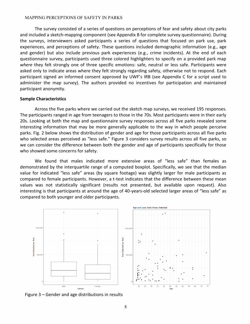
Across the five parks where we carried out the sketch map surveys, we received 195 responses. The participants ranged in age from teenagers to those in the 70s. Most participants were in their early 20s. Looking at both the map and questionnaire survey responses across all five parks revealed some interesting information that may be more generally applicable to the way in which people perceive parks. Fig. 2 below shows the distribution of gender and age for those participants across all five parks who selected areas perceived as “less safe.” Figure 3 considers survey results across all five parks, so we can consider the difference between both the gender and age of participants specifically for those who showed some concerns for safety.
We found that males indicated more extensive areas of “less safe” than females as demonstrated by the interquartile range of a computed boxplot. Specifically, we see that the median value for indicated “less safe” areas (by square footage) was slightly larger for male participants as compared to female participants. However, a t-test indicates that the difference between these mean values was not statistically significant (results not presented, but available upon request). Also interesting is that participants at around the age of 40-years-old selected larger areas of “less safe” as compared to both younger and older participants.
Figure 3 – Gender and age distributions in results

MAPPING PERCEPTIONS OF SAFETY IN PARKS
9
Independent variables included age, gender, fear of crime, and victimization experience. Age was coded in years ranging from 18-74 with an average of 34.9. Gender was coded dichotomously and is named “female” where 1 = female and 0 = male. Victimization is a summative measure indicating the number of victimizations the respondent has experienced in the past while in a park. Respondents were asked about seven different types of victimization: theft, physical assault, theft of items in the car, motor vehicle theft, robbery, harassed or pestered by other park visitors, and sexual assault. The variable indicates the total number of victimizations the respondent has experienced in the past while in a park (mean = .92). 108 respondents (55% of the sample) reported no victimization.
Table 1 contains results from the multinomial logistic regression predicting membership in either the “safe,” “neutral,” or “less safe” category. We include relative rate ratios for ease of interpretation. Fear of crime did significantly predict two of the contrasts, as seen in the table. Respondents who reported higher levels of fear were about 73% more likely to be in the “less safe” group as compared to the “safe” group. Additionally, respondents who reported higher levels of fear were about 86% more likely to be in the “less safe” group vs. the “neutral” group. Other variables predicted group membership in the expected direction but failed to reach statistical significance1.
Table 1 - Multinomial Logistic Regression results
Findings
Perceptual Consensus
The perceptual consensus that an area of the park is “safe” or “less safe” most varied amongst survey participants. This consensus is not surprising and to quote Lynch (1960) directly again “…the image of a given reality may vary significantly between different observers” (p. 6). Inter-rater reliability
1 We found that males generally indicated more substantial areas of “less safe” than females as demonstrated by the interquartile range of
the boxplot. Specifically, we see that the median value for indicated “less safe” areas (by square footage) was slightly larger for male
respondents as compared to female participants. However, a t-test indicates that the difference between these mean values was not
statistically significant (results not presented but available upon request). Also interesting is that participants at around the age of 40-years-
old selected larger areas of “less safe” as compared to both younger and older participants. (The three categories in this analysis were ages
18-35, 36-50, and 51-74.) Like the gender difference, a one-way ANOVA indicated that there are no statistically significant differences
across age groups in the mean size of the area marked as “less safe.”

MAPPING PERCEPTIONS OF SAFETY IN PARKS
10
(IRR), or chance-adjusted agreement as proposed by Cohen (1960; 1968) provides a method for determining the coefficient of agreement between raters. This notion of removing the change agreement by the raters is directed towards a measure of the reproducibility of the results. A useful enhancement to Cohen’s (1960) approach to inter-rater reliability came from Fleiss (1971) as a method for considering more than two raters.
We computed a measure of the inter-rater reliability across all five parks in our study area. To accomplish this, we first created a grid for each park survey area. The square footage area of the grid size was informed in our study by the smallest area of perceptual response indicated on the map by participants for a given park. By intersecting each grid with the perceptual response from the survey, we considered each grid space as an area of potential agreement among the raters (park visitors in this case). With the resulting intersection between the grid and the perceptual response, we were then able to bring these results into the statistical software package of R (R Core Team, 2017) and compute the IRR using available functionality in IRR package provided by Gamer et al., (2012) for each park. Table 2 summarizes the spatially explicit inter-rater agreement calculated across each park in our study area.
Bayview Park (n=49)
Sanders Beach (n=44)
Maritime Park (n=43)
Legion Field (n=18)
Roger Scott Park (n=41)
Park Sq. Feet 1,500,000 292,400 1,440,000 600,000 2,700,000
Grid Sq. Feet 40 40 100 60 80
Safe Kappa .263 .469 .539 .518 .418
Less Safe Kappa
.273 .510 .563 .423 .553
Table 2: Inter-rater across parks/emotions by Fleiss (1971) method
While there is no universally accepted agreement on what constitutes an appropriate kappa
value, Landis & Koch (1977) provide interpretation. Their interpretation provides the following scale for reference:
Kappa Statistic/Strength of Agreement
< 0.00 Poor
0.00-0.20 Slight
0.21-0.40 Fair
0.41-0.60 Moderate
0.61-0.80 Substantial
0.81-1.00 Almost Perfect

MAPPING PERCEPTIONS OF SAFETY IN PARKS
11
Following Landis & Koch’s (1977) benchmark Bayview Park’s kappa results indicated a moderate strength of agreement amongst participants as to where they felt safe or less safe. Whereas Legion Field’s inter-rater reliability scores where higher being in the moderate. The disparity in the number of participants between these two parks is also indicative of the specific difference in park use and implicit of the image distinction between these two parks. Specifically, Bayview Park was much more frequented by park visitors than Legion Field during the period that the survey was conducted. Those few survey in Legion Field felt more strongly regarding the areas of concern for safety. Finally, none of our park survey results fell into the categories described by Landis & Koch’s (1977) as substantial or almost perfect. Maritime Park came the closest to a substantial strength of agreement at .563 for the perceptual response of less safe selected areas.
Feature/Perceptual Concurrence
Although the percentage of agreement is limited to an exploratory method (Dooley 2001), it does allow us to isolate which areas of the park participants felt the strongest emotion concerning safety. Therefore, by analyzing the results of our survey we were able to determine the percentage of agreement for each perceptual response at each park across all the survey participants. To accomplish this a raster surface of each park and emotion was summarized using Esri’s (2017) Cell Statistics tool. Next, dividing the resulting response surface pixel values by the number of responses for a given emotion allowed us to produce maps showing the percentage of agreement unique to each park. From this simple measure of the percentage of agreement, we could see could produce maps using standard raster pixel math, more commonly referred to as map algebra (Bolstad 2005).
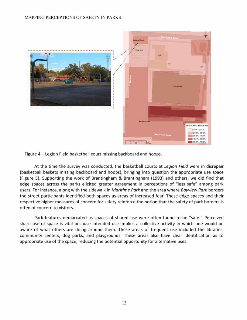
The percentage of agreement results revealed common areas of concern for safety across the survey parks. For instance, parking lots showed up as an area of concern in at least three of the parks surveyed. One potential explanation for parking lots being such a concern for safety is that they can be classified as edge spaces. It may be more difficult to identify those who are in the parking lot for legitimate versus illegitimate purposes. Maintenance/condition of park features more likely played a role in perceptions of safety in Legion Field. The small rectangular area of the basketball court in Legion Field increases by 8% in agreement as “less safe” compared to the surrounding area (Figure 4). These unmaintained facilities being correlated with concern for safety is indicative of social disorganization as described by Shaw & MacKay (1942) and others.
MAPPING PERCEPTIONS OF SAFETY IN PARKS
12
Figure 4 – Legion Field basketball court missing backboard and hoops.
At the time the survey was conducted, the basketball courts at Legion Field were in disrepair (basketball baskets missing backboard and hoops), bringing into question the appropriate use space (Figure 5). Supporting the work of Brantingham & Brantingham (1993) and others, we did find that edge spaces across the parks elicited greater agreement in perceptions of “less safe” among park users. For instance, along with the sidewalk in Maritime Park and the area where Bayview Park borders the street participants identified both spaces as areas of increased fear. These edge spaces and their respective higher measures of concern for safety reinforce the notion that the safety of park borders is often of concern to visitors.
Park features demarcated as spaces of shared use were often found to be “safe.” Perceived share use of space is vital because intended use implies a collective activity in which one would be aware of what others are doing around them. These areas of frequent use included the libraries, community centers, dog parks, and playgrounds. These areas also have clear identification as to appropriate use of the space, reducing the potential opportunity for alternative uses.

MAPPING PERCEPTIONS OF SAFETY IN PARKS
13
Figure 5 - Percentage agreement for safe map – Bayview Park
One interesting outcome of the Bayview Park survey involved one of the parks’ prominent built features, a 25-foot tall Christian cross. This controversial religious symbol is currently embroiled in an ongoing lawsuit against the City of Pensacola were some are calling for the removal of a cross (Frenette, 2016). Whether the cross serves as an exclusionary feature of the park remains is debatable, but the location of the cross was one of the safest areas identified by park users (measured by percent agreement in “safe” areas) (~30%) in the park (Figure 5). This island of perceived safety is apparent on the map in the top-right of Figure 5. This agreement as “safe” stands alone, as an island, in an area that has approximately 20% agreement as being “less safe,” again highlight the importance of both the social and image concept described by fear of crime models (Garofalo 1981; Jackson 2005).
Conclusion
Parks are a part of the complex urban ecosystem. People carry with them an image of the environment, and that image directly affects amenity value they get from parks. The measurement of the environmental image is not an end itself, but rather a step toward the explanation of behavior through the study of images, motivation, learning, and decision (Harrison & Sarre 1975). Existing landscape design, however, can go a long way towards influencing a person’s image of a place. People’s perceptions of space, and in turn, their behavior is strongly influenced by their mental images of what different localities mean to them (Lynch, 1960; Buttimer, 1980; Stylidis et al. 2014, 2016; Vroman & Lagrange 2017).
This study involved leading a team of students through the design and implementation of a study of perceptions of parks in Pensacola, FL. Unique to project was the inclusion of a sketch-mapping component to capture spatial variations in the perceived safety of participants. By combining questionnaire and sketch mapping techniques, we gathered a rich dataset on individual perceptions of fear and safety about space within Pensacola’s parks. A significant contribution of our project is in

MAPPING PERCEPTIONS OF SAFETY IN PARKS
14
capturing a spatially nuanced agreement of perceptions of park safety for park visitors. This measure of agreement is informed first by a measure of the percentage of agreement and then by a more robust measure considering the inter-rater reliability of survey responses within a given park.
Overall, our findings provide empirical support for environmental theories of crime. Specifically, crime pattern theory and the concept of edge spaces was supported. Environmental crime theories have asserted that these spaces are very important in the understanding of fear and opportunities for crime. In the current study, edge spaces (e.g., parking lots and tree lines) across the parks were identified as areas of higher fear. Nasar and colleagues (1993) argue that modifying these edge spaces could work to reduce both opportunities for crime and fear of crime in these areas. Future studies could examine these spaces and consider modifications that could influence potential opportunities. Smith (1996) suggests adding more lighting to parking lots and possible formal surveillance in the form of cameras. Another suggestion is to consider cutting back heavy brush or trimming trees to increase sightlines and reduce hiding spaces.
Parks provide an important space for recreation, community development, and are often considered vital to a community. Considering this, reducing fear and opportunities for crime should be at the forefront of those involved in the design, funding, and maintenance of these spaces. Further research utilizing environmental and neighborhood theories and characteristics (e.g. proximal crime rates) could be undertaken to understand better factors that influence the safety of parks and ultimately used as a guide for recommendations and potential changes to these areas.
Acknowledgements
The authors would like to thank Dr. Barney Warf and Dr. Joan Nassauer for their valuable feedback on earlier drafts of this paper. Also, we are grateful to the students without which we could not have carried out this study.

MAPPING PERCEPTIONS OF SAFETY IN PARKS
15
References
Averhart, S. & Harper, R. (2017). Harper: Development Surging In Downtown Pensacola. WUWF Public Media. Retrieved from wuwf.org/post/harper-development-surging-downtown-pensacola
Balkin, S. (1979). Victimization rates, safety, and fear of crime. Social Problems, 26, 343–358 Box, S., Hale, C., & Andrews, G. (1988). Explaining fear of crime. The British Journal of Criminology,
28(3), 340-356. Bolstad, P. (2005). GIS Fundamentals: A First Text on Geographic Information Systems. Eider Press. Boschmann, E. E., & Cubbon, E. (2014). Sketch maps and qualitative GIS: Using cartographies of
individual spatial narratives in geographic research. The Professional Geographer, 66(2), 236-248.
Brantingham, P. L., & Brantingham, P. J. (1993). Nodes, emipaths and edges: Considerations on the complexity of crime and the physical environment. Journal of Environmental Psychology, 13(1), 3-28.
Buttimer, A. (1980). Social space and the planning of residential areas. The human experience of space and place, 21-54.
Brown, G., & Raymond, C. M. (2014). Methods for identifying land use conflict potential using participatory mapping. Landscape and Urban Planning, 122, 196-208.
Chataway, M. L., & Hart, T. C. (2016). (Re) Assessing contemporary “fear of crime” measures within an Australian context. Journal of Environmental Psychology, 47, 195-203.
Chiesura, A. (2004). The role of urban parks for the sustainable city. Landscape and urban planning, 68(1), 129-138.
City of Pensacola. (2011). Fiscal Year 2011 Annual Budget. Retrieved from http://www.ci.pensacola.fl.us/ArchiveCenter/ViewFile/Item/58
Davey-Rothwell, M. A., Siconolfi, D. E., Tobin, K. E., & Latkin, C. A. (2015). The role of neighborhoods in shaping perceived norms: an exploration of neighborhood disorder and norms among injection drug users in Baltimore, MD. Health & Place, 33, 181-186.
Dunn, C. E. (2007). Participatory GIS—a people's GIS?. Progress in human geography, 31(5), 616-637. Ferraro, K. F. (1995). Fear of crime: Interpreting victimization risk. New York, NY: SUNY Press.12 T. C.
Hart Foster, S., Giles-Corti, B., & Knuiman, M. (2010). Neighbourhood design and fear of crime: a social-
ecological examination of the correlates of residents’ fear in new suburban housing developments. Health & place, 16(6), 1156-1165.
Foster, S., Wood, L., Christian, H., Knuiman, M., & Giles-Corti, B. (2013). Planning safer suburbs: Do changes in the built environment influence residents' perceptions of crime risk?. Social science & medicine, 97, 87-94.
Foster, S., Knuiman, M., Hooper, P., Christian, H., & Giles-Corti, B. (2014). Do changes in residents' fear of crime impact their walking? Longitudinal results from reside. Preventive medicine, 62, 161-166.
French, S., Wood, L., Foster, S. A., Giles-Corti, B., Frank, L., & Learnihan, V. (2014). Sense of community and its association with the neighborhood built environment. Environment and Behavior, 46(6), 677-697.
Frumkin, H., Bratman, G. N., Breslow, S. J., Cochran, B., Kahn Jr, P. H., Lawler, J. J. & Wood, S. A. (2017). Nature contact and human health: A research agenda. Environmental Health Perspectives, 125(7), 075001-1.

MAPPING PERCEPTIONS OF SAFETY IN PARKS
16
Kahila-Tani, M., Broberg, A., Kyttä, M., & Tyger, T. (2016). Let the citizens map—public participation GIS as a planning support system in the Helsinki master plan process. Planning Practice & Research, 31(2), 195-214.
Gascon, M., Triguero-Mas, M., Martínez, D., Dadvand, P., Forns, J., Plasència, A., & Nieuwenhuijsen, M. J. (2015). Mental health benefits of long-term exposure to residential green and blue spaces: a systematic review. International journal of environmental research and public health, 12(4), 4354-4379.
Garofalo, J. (1979). Victimization and the fear of crime. Journal of Research in Crime and Delinquency, 16, 80–97.
Gobster, P. H., & Westphal, L. M. (2004). The human dimensions of urban greenways: planning for recreation and related experiences. Landscape and Urban Planning, 68(2), 147-165.
Ibes, D. C. (2015). A multi-dimensional classification and equity analysis of an urban park system: A novel methodology and case study application. Landscape and Urban Planning, 137, 122-137.
Irvine, K. N., Warber, S. L., Devine-Wright, P., & Gaston, K. J. (2013). Understanding urban green space as a health resource: A qualitative comparison of visit motivation and derived effects among park users in Sheffield, UK. International journal of environmental research and public health, 10(1), 417-442.
Kneeshaw-Price, S. H., Saelens, B. E., Sallis, J. F., Frank, L. D., Grembowski, D. E., Hannon, P. A., ... & Chan, K. G. (2015). Neighborhood crime-related safety and its relation to children’s physical activity. Journal of Urban Health, 92(3), 472-489.
Jackson, J. (2005). Validating new measures of the fear of crime. International Journal of Social Research Methodology, 8, 297–315.
Jeffery, C.R. (1971). Crime Prevention through Environmental Design. Beverly Hills, California: Sage. Jorgensen, L. J., Ellis, G. D., & Ruddell, E. (2013). Fear Perceptions in Public Parks Interactions of
Environmental Concealment, the Presence of People Recreating, and Gender. Environment and Behavior, 45(7), 803-820.
Laatikainen, T. E., Piiroinen, R., Lehtinen, E., & Kyttä, M. (2017). PPGIS approach for defining multimodal travel thresholds: Accessibility of popular recreation environments by the water. Applied Geography, 79, 93-102.
Lee, M. (2013). Inventing fear of crime. Routledge. Lin, B. B., Gaston, K. J., Fuller, R. A., Wu, D., Bush, R., & Shanahan, D. F. (2017). How green is your
garden?: Urban form and socio-demographic factors influence yard vegetation, visitation, and ecosystem service benefits. Landscape and Urban Planning, 157, 239-246.
Loures, L., Santos, R., & Panagopoulos, T. (2007). Urban parks and sustainable city planning-The case of Portimão, Portugal. Population, 15, 23.
Lynch, K. (1960). The image of the city (Vol. 11). MIT press. Massey, D. S., & Brodmann, S. (2014). Spheres of influence: The social ecology of racial and class
inequality. Russell Sage Foundation. McConnell, E. H. (1997). Fear of crime on campus: A study of a southern university. Journal of Security
Administration, 20(2), 22. National Recreation and Parks Association. (2017). Creating Safe Park Environments to Enhance
Community Wellness. Retrieved from https://www.nrpa.org/contentassets/f768428a39aa4035ae55b2aaff372617/park-safety.pdf
Nasar, J. L. (1982). A model relating visual attributes in the residential environment to fear of crime. Journal of Environmental Systems, 11(3), 247-255.

MAPPING PERCEPTIONS OF SAFETY IN PARKS
17
Nasar, J. L., Fisher, B., & Grannis, M. (1993). Proximate physical cues to fear of crime. Landscape and Urban planning, 26(1-4), 161-178.
Nasar, J. L., & Fisher, B. (1993). ‘Hot spots’ of fear and crime: A multi-method investigation. Journal of environmental psychology, 13(3), 187-206.
Norton, A. (2016). Brentwood Park homeless issues. ABC Weartv.com. Retrieved from weartv.com/news/local/brentwood-park-homeless-issues
Pain, R. (2001). Gender, race, age and fear in the city. Urban studies, 38(5-6), 899-913. Pain, R. (2003). Youth, age and the representation of fear. Capital & Class, 27(2), 151-171. Painter, K. (1996). The influence of street lighting improvements on crime, fear and pedestrian street
use, after dark. Landscape and Urban Planning, 35(2), 193-201. Pocewicz, A., Nielsen‐Pincus, M., Brown, G., & Schnitzer, R. (2012). An Evaluation of Internet versus
Paper‐based Methods for Public Participation Geographic Information Systems (PPGIS). Transactions in GIS, 16(1), 39-53.
Ryder, H., Maltby, J., Rai, L., Jones, P., & Flowe, H. D. (2016). Women's fear of crime and preference for formidable mates: how specific are the underlying psychological mechanisms?. Evolution and Human Behavior, 37(4), 293-302.
Sallis, J. F., McKenzie, T. L., Elder, J. P., Broyles, S. L., & Nader, P. R. (1997). Factors parents use in selecting play spaces for young children. Archives of pediatrics & adolescent medicine, 151(4), 414-417.
Sampson, R. J., & Raudenbush, S. W. (2004). Seeing disorder: Neighborhood stigma and the social construction of “broken windows”. Social psychology quarterly, 67(4), 319-342.
Sanschagrin, E. 2011. The LGBT community and public space: A mixed methods approach. Master’s thesis, University of Denver, Denver, CO.
Skogan, W. G., & Maxfield, M. G. (1981). Coping with crime: Individual and neighborhood reactions. Retrieved from ncjrs.gov
Shaw, C.R. & McKay, H.D., (1942). Juvenile delinquency in urban areas. University of Chicago Press, Chicago.
Smith, S. K., Steadman, G. W., Minton, T. D., & Townsend, M. (1999). Criminal victimization and perceptions of community safety in 12 cities, 1998. Washington, DC: USGPO.
Smith, M. S. (1996). Crime prevention through environmental design in parking facilities. US Department of Justice, Office of Justice Programs, National Institute of Justice.
Song, J., Andresen, M. A., Brantingham, P. L., & Spicer, V. (2017). Crime on the edges: patterns of crime and land use change. Cartography and Geographic Information Science, 44(1), 51-61.
Sturm, R., & Cohen, D. (2014). Proximity to urban parks and mental health. The journal of mental health policy and economics, 17(1), 19.
Stylidis, D., Sit, J., & Biran, A. (2016). An exploratory study of residents’ perception of place image: The case of Kavala. Journal of Travel Research, 55(5), 659-674.
Stylidis, D., Biran, A., Sit, J., & Szivas, E. M. (2014). Residents' support for tourism development: The role of residents' place image and perceived tourism impacts. Tourism Management, 45, 260-274.
Troy, A., Grove, J. M., & O’Neil-Dunne, J. (2012). The relationship between tree canopy and crime rates across an urban–rural gradient in the greater Baltimore region. Landscape and Urban Planning, 106(3), 262-270
United States Census Bureau. (2017). QuickFacts Pensacola city, Florida. Retrieved from https://www.census.gov/quickfacts/fact/table/pensacolacityflorida/PST045216

MAPPING PERCEPTIONS OF SAFETY IN PARKS
18
Vedantam, S. (2016). How A Theory of Crime And Policing Was Born, And Went Terribly Wrong. Hidden Brain on NPR. Retrieved from https://www.npr.org/2016/11/01/500104506/broken-windows-policing-and-the-origins-of-stop-and-frisk-and-how-it-went-wrong
Vroman, L., & Lagrange, T. (2017). Human movement in Public spaces: The use and development of motion-oriented design strategies. The Design Journal, 20(sup1), S3252-S3261.
Warr, M. (1984). Fear of victimization: Why are women and the elderly more afraid? Social Science Quarterly, 65, 681–702.
Warr, M. (1987). Fear of victimization and sensitivity to risk. Journal of Quantitative Criminology, 3, 29–46.
Westover, T. N. (1985). Perceptions of crime and safety in three Midwestern parks. The Professional Geographer, 37(4), 410-420.
White, S., Yehle, T., Barbosa Filho, H. S., Oliveira, M. A., & Menezes, R. (2014, November). The Spatial Structure of Crime in Urban Environments. In SocInfo Workshops (pp. 102-111).
Whyte, W.H. (1980). The Social Life of Small Urban Spaces. Washington, D.C.: Conservation Foundation. Wilson, J. Q., & Kelling, G. L. (1982). Broken windows. Atlantic Monthly, 249(3), 29-38.

MAPPING PERCEPTIONS OF SAFETY IN PARKS
19
Appendices
Appendix A
Map of Parks Surveyed in Pensacola

MAPPING PERCEPTIONS OF SAFETY IN PARKS
20
Appendix B
Questionnaire
The following questions refer to your past and present experiences while spending time in
community parks and playgrounds. Please answer to the best of your ability by checking the
appropriate box.
1. About how often do you visit parks?
Less than once per year
About once per year
2 – 5 times per year
6 – 12 times per year
More than 12 times per year
Weekly
Daily
2. Do you live within a mile of this park?
Yes No
3. How did you travel to this park?
By car
By bus
By bicycle
By foot
Other
Explain:
4. Why did you choose this park?
Check all that apply.
In my neighborhood/Is convenient

MAPPING PERCEPTIONS OF SAFETY IN PARKS
21
Offers particular activities
Is clean
Is safe
Is open
Is attractive
Other
Explain:
5. Do you have public access to water at this park?
Yes No
6. If you do, would you drink water from that available source?
Yes No
7. If no, why not?
Explain
8. Do you have access to a public restroom at this park?
Yes No
9. If you do, would you use these facilities?
Yes No
10. If no, why not?
Explain
11. What would you like to see done to improve the park?

MAPPING PERCEPTIONS OF SAFETY IN PARKS
22
12. For each of the following statements, consider both past and present park experiences. Please
tell me whether you strongly agree, agree, disagree, or strongly disagree.
Strongly Agree Disagree Strongly Agree Disagree
a. If there is a problem at a park, 1
the other visitors would get
together to deal with it
2 3 4
b. I generally feel that visitors at parks are
1 2 3 4 close-knit
4
4
4
c. When you get right down to it, no
one in a park much cares about
what happens to me
1 2 3
d. Park visitors are willing to
help their neighbors
1 2 3
e. Park visitors generally don’t get
along with each other
1 2 3 4
f. You can count on adults in
parks to watch out that
children are safe and don’t
get in trouble
1 2 3 4
g. If I had to borrow $30 in an
emergency, I could borrow it
from someone at a park
1 2 3 4
h. When I’m away from my spot at
a park, I know that others will
keep their eyes open for possible
trouble
1 2 3 4
i. In parks people mostly go their
own way
1 2 3
j. People in parks generally do not
share the same values
1 2 3 4
k. People in parks generally can be
trusted
1 2 3 4
.
.

MAPPING PERCEPTIONS OF SAFETY IN PARKS
23
l. Parks are generally safe places
for children to play
1 2 3 4
m. Parks are generally safe at night 1 2 3 4

MAPPING PERCEPTIONS OF SAFETY IN PARKS
24
12. Consider both your past and present park experiences for the following questions. For each, please
tell me whether it is a big problem, somewhat of a problem, or not a problem.
A problem Somewhat
of a
problem
Not a
big problem
a. Litter, broken glass, or trash on
the sidewalks or streets
1 2 3
b. Graffiti on buildings or walls 1 2 3
c. Vacant or deserted buildings 1 2 3
d. Drinking in public 1 2 3
e. People selling or using drugs 1 2 3
f. Groups of teenagers or adults
hanging out in the park and causing
trouble
1 2 3
13. How afraid are you of the following occurring while you are at a park?
Not Afraid Somewh
at
Afraid
Very
Afrai
d a. Having items stolen away from
your spot while you are away?
1 2 3
b. Having your car stolen? 1 2 3
c. Being physically attacked? 1 2 3
d. Having your spot vandalized while you
are away?
1 2 3
e. Being pestered by other park visitors? 1 2 3
f. Having items stolen from your car? 1 2 3
g. Overall, how afraid are you of being a
victim of a crime during the day while at
a park?
1 2 3
h. Overall, how afraid are you of being a
victim of a crime at night while at a
park?
1 2 3

25
14. What do you think is the likelihood that you will be a victim of the following while at a park?
Not Likely Somewh
at Likely
Very
Likely
a. Having items stolen away from
your spot while you are away?
1 2 3
b. Having your car stolen? 1 2 3
c. Being physically attacked? 1 2 3
d. Having your spot vandalized while you
are away?
1 2 3
e. Being pestered by other park visitors? 1 2 3
f. Having items stolen from your car? 1 2 3
g. Overall, how likely do you think it is that
you could be a victim of a crime during
the day while at a park?
1 2 3
h. Overall, how likely do you think it is that
you could be a victim of a crime at night
while at a park?
1 2 3
15. Have you ever been a victim of any of the following while at a park?
a. Theft from your spot Yes No
b. Physical assault Yes No c. Theft from your vehicle Yes No d. Motor vehicle theft Yes No e. Robbery Yes No f. Harassment or been pestered by other park visitors Yes No g. Sexual assault/rape Yes No
16. Have you been a victim of the following while visiting a park in the last 12 months?
a. Theft from your spot Yes No
b. Physical assault Yes No c. Theft from your vehicle Yes No d. Motor vehicle theft Yes No e. Robbery Yes No f. Harassment or been pestered by other park visitors Yes No g. Sexual assault/rape
Yes No

26
17. Do you typically take any of the following precautions while visiting a park?
a. Ask someone to watch over your spot while you are away? Yes No
b. Put away valuables before leaving your spot to do Yes No other activities?
c. Alert someone if you are going to be at the park alone? Yes No d. Lock or otherwise secure your valuables when you are away
from your spot? Yes No
e. Only go to the park during the daytime? Yes No f. Carry a gun? Yes No g. Carry a knife or other weapon other than a gun for
protection? Yes No
h. Carry your valuables with you instead of leaving them at your Yes No spot?
i. Bring a pet for protection (e.g. dog)? Yes No
18. How does the presence of parks employees/surveillance cameras impact your perception of safety?
Very much provides a sense of safety
Provides some sense of safety
Doesn’t affect my feeling of safety
Makes me feel unsafe
19. Overall, how afraid are you of being a victim of a crime while in your neighborhood during the day?
a. Not afraid
b. Somewhat afraid
c. Very afraid
20. Overall, how afraid are you of being a victim of a crime while in your neighborhood at night?
a. Not afraid
b. Somewhat afraid
c. Very afraid
21. Overall, how likely do you think it is that you could be a victim of a crime while in your
neighborhood during the day?
a. Not likely
b. Somewhat likely
c. Very likely

27
22. Overall, how likely do you think it is that you could be a victim of a crime while in your neighborhood at night?
a. Not likely
b. Somewhat likely
c. Very likely
23. Have you ever been a victim of any of the following?
a. Theft Yes No
b. Physical assault Yes No c. Theft from your vehicle Yes No d. Motor vehicle theft Yes No e. Robbery Yes No f. Sexual assault/rape Yes No
24. Have you been a victim of any of the following in the last 12 months?
a. Theft Yes No
b. Physical assault Yes No c. Theft from your vehicle Yes No d. Motor vehicle theft Yes No e. Robbery Yes No f. Sexual assault/rape Yes No
25. What is your age?
26. What is your gender?
Male
Female
27. What is the highest level of education you have completed?
Less than high school
High school
Some college
Bachelor’s degree
Master’s degree
Doctorate or professional degree

28
28. What ethnic or racial group do you identify with?
Asian
Pacific Islander
African American/Black
Latino/Hispanic
Caucasian/White
Other
29. What is your present marital status?
Single
Married
Separated
Divorced
Other:
30. What is your present work situation?
(Check all that apply):
Employed; part-time
Employed; full-time
Part-time student
Full-time student
Retired
Other:

29
31. What is your approximate household income?
No income
$0 - $10,000
$10,001 - $30,000
$30,001 - $50,000
$50,001 - $75,000
$75,001 – $100,000
____ over $100,00

1
Appendix C
Script for Map Survey Administration
The map survey includes a map of the park area. Please circle the areas on the map where you
feel not safe, neutral/indifferent or safe within the park area. You do not have to cover all of the
map space and should only indicate places where you have feelings in regard to one of the three
listed emotions: not safe, neutral, or safe.