mapping vegetation on the copper river delta placer river
TRANSCRIPT
Mapping Vegetation on the Copper River Delta
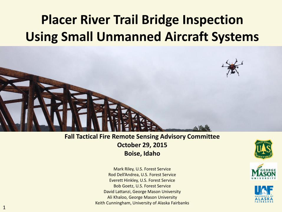
Placer River Trail Bridge Inspection Using Small Unmanned Aircraft Systems
Fall Tactical Fire Remote Sensing Advisory Committee October 29, 2015
Boise, Idaho
Mark Riley, U.S. Forest Service Rod Dell’Andrea, U.S. Forest Service Everett Hinkley, U.S. Forest Service
Bob Goetz, U.S. Forest Service David Lattanzi, George Mason University
Ali Khaloo, George Mason University Keith Cunningham, University of Alaska Fairbanks
1

Mapping Vegetation on the Copper River Delta
2
1) Use a UAS to collect high resolution natural color stereo pair and video imagery of the Placer River Trail Bridge to evaluate as an alternative or supplemental tool to traditional structure inspection techniques
2) Evaluate dense Structure from Motion (dSfM) image processing techniques to produce a measurable 3D wireframe bridge model
3) Compare dSfM point cloud to laser scanner point cloud
G O A L S
UAS image data collection: June 9 and 10, 2015

Mapping Vegetation on the Copper River Delta
3
C O O P E R A T I O N
Forest Service Region 10, Washington Office, and Glacier Ranger District, Chugach National Forest: implementation, planning, coordination University of Alaska Fairbanks: UAS, pilots, lead researcher George Mason University: data collection, processing, analysis
Mapping Vegetation on the Copper River Delta
4
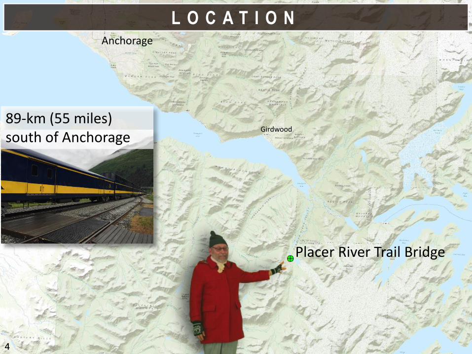
L O C A T I O N Anchorage
Placer River Trail Bridge
Girdwood 89-km (55 miles) south of Anchorage

Mapping Vegetation on the Copper River Delta
5
• Longest clear span, glued-laminated, timber truss pedestrian bridge in North America at 280 feet
• Anticipated operational service life of 75-years
• Completed in July 2013
• Managed for pedestrian use (Glacier Ranger District)
• Remote site; accessible via Alaska Railroad
A B O U T T H E B R I D G E

Mapping Vegetation on the Copper River Delta
6
U A S P L A T F O R M
Purpose built hexacopter “Ptarmigan” Based on DJI S800 airframe
Gyrostabilized Sony Nex7 and GoPro ~20 min/flight (LiPo batteries)
A higher order data collection tool.
Mapping Vegetation on the Copper River Delta
7
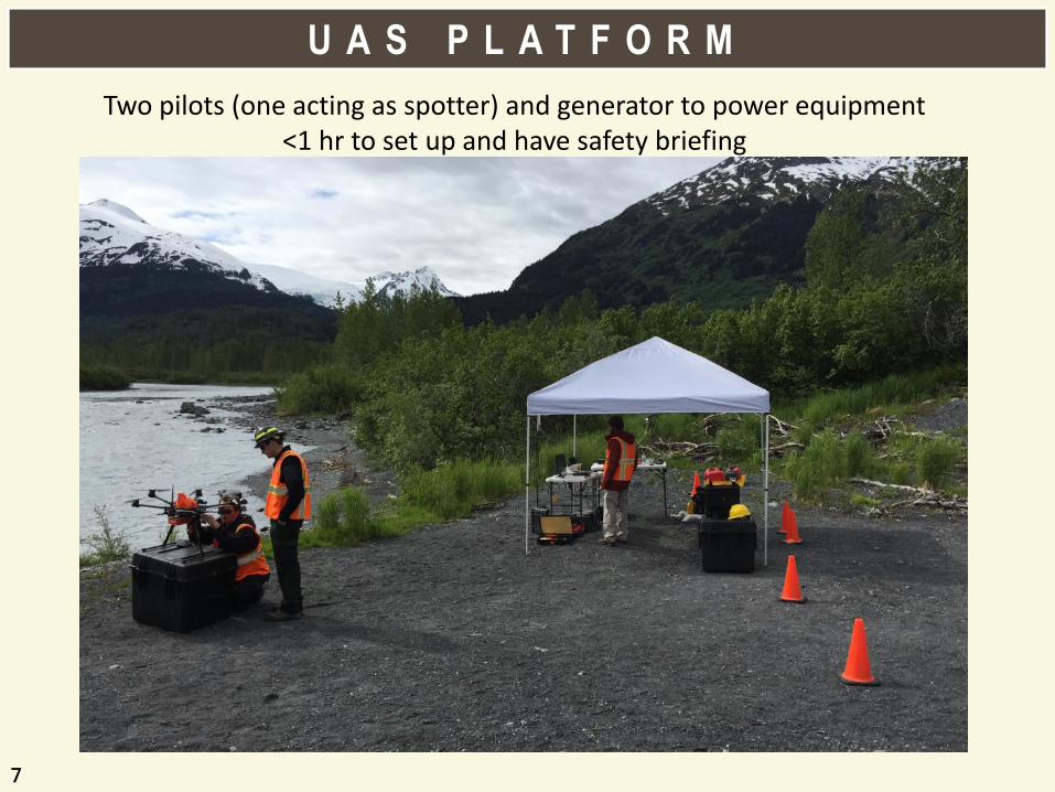
U A S P L A T F O R M
Two pilots (one acting as spotter) and generator to power equipment <1 hr to set up and have safety briefing
Mapping Vegetation on the Copper River Delta
8
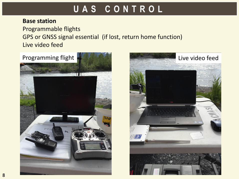
U A S C O N T R O L Base station Programmable flights GPS or GNSS signal essential (if lost, return home function) Live video feed
Programming flight Live video feed

Mapping Vegetation on the Copper River Delta
9
D A T A C O L L E C T I O N
FARO Focus laser scanner set up in 12 locations

Mapping Vegetation on the Copper River Delta
10
D A T A C O L L E C T I O N
Imaging sides of structure
win
d
Vortex shedding was a UAV stability concern, but not an issue
Wind current most challenging
Mapping Vegetation on the Copper River Delta
11
D A T A C O L L E C T I O N
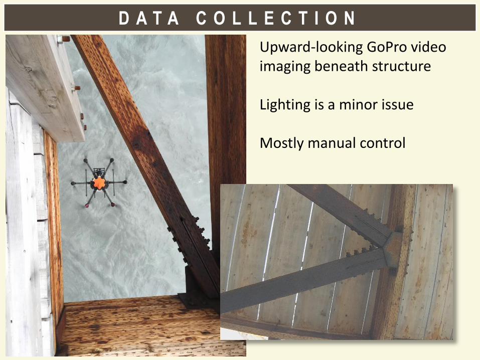
Upward-looking GoPro video imaging beneath structure Lighting is a minor issue Mostly manual control

Mapping Vegetation on the Copper River Delta
12
D A T A C O L L E C T I O N
Imaging top of structure

Mapping Vegetation on the Copper River Delta
13
D A T A C O L L E C T I O N
• Still frames collected with nominal 90% overlap • >90% imagery useable for SfM (Photoscan Pro) • ~4 hrs total flight time
90GB and 5000 images, video, and laser scans

Mapping Vegetation on the Copper River Delta
14
D A T A C O L L E C T I O N
Bridge plans used for point of reference and to assist with autopilot navigation

Mapping Vegetation on the Copper River Delta
15
Data Analysis

Mapping Vegetation on the Copper River Delta
Goals • Recreate flaws
• View underside of deck
• Track long-term camber/motion
Challenges • Massive data set
• Confusing data
• Image degradation
• High contrast scene
16
D A T A A N A L Y S I S

Mapping Vegetation on the Copper River Delta
17
Gap between end of kerf plate and sawn kerf in brace
R E C R E A T I N G F L A W S
Mapping Vegetation on the Copper River Delta
18
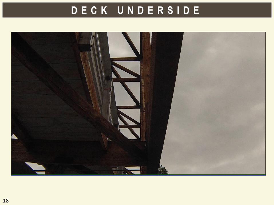
D E C K U N D E R S I D E
Mapping Vegetation on the Copper River Delta
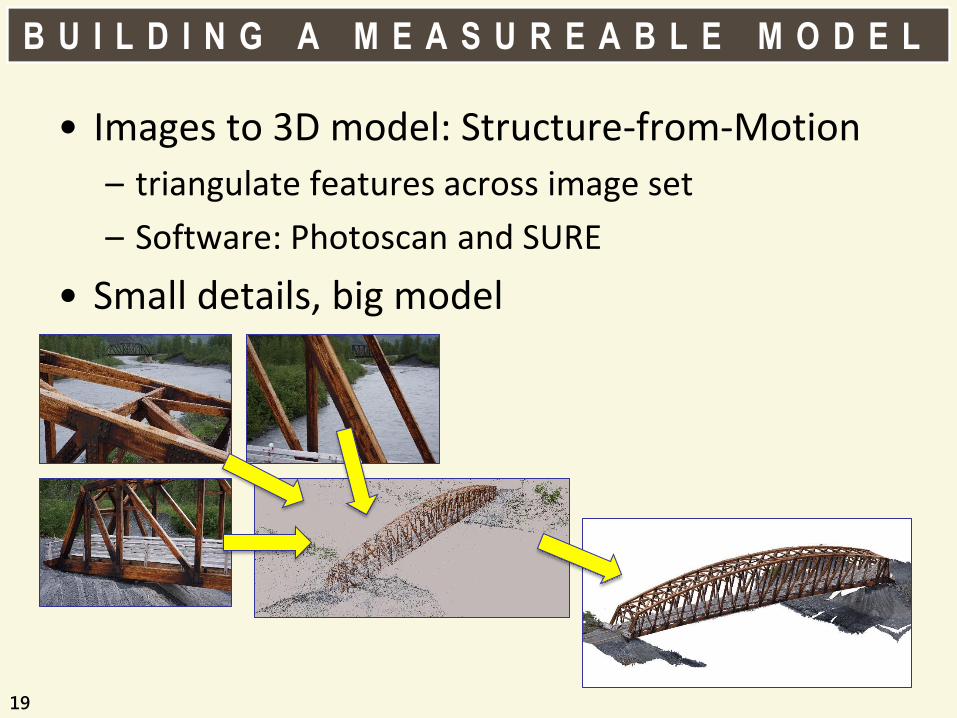
• Images to 3D model: Structure-from-Motion
– triangulate features across image set
– Software: Photoscan and SURE
• Small details, big model
19
B U I L D I N G A M E A S U R E A B L E M O D E L

Mapping Vegetation on the Copper River Delta
1. Separate clouds for big and small details
– Image capture plan is critical!
2. Merge the sparse models
3. Generate dense reconstruction
– SURE vs Photoscan
20
H P C G M O D E L G E N E R A T I O N
Mapping Vegetation on the Copper River Delta
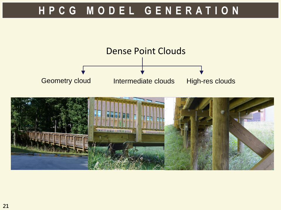
Dense Point Clouds
Geometry cloud
Intermediate clouds
High-res clouds
21
H P C G M O D E L G E N E R A T I O N

Mapping Vegetation on the Copper River Delta
• 500 hours of computation time
• 14 billion points
• Need good rendering support!
22
R E S U L T S
Mapping Vegetation on the Copper River Delta
23
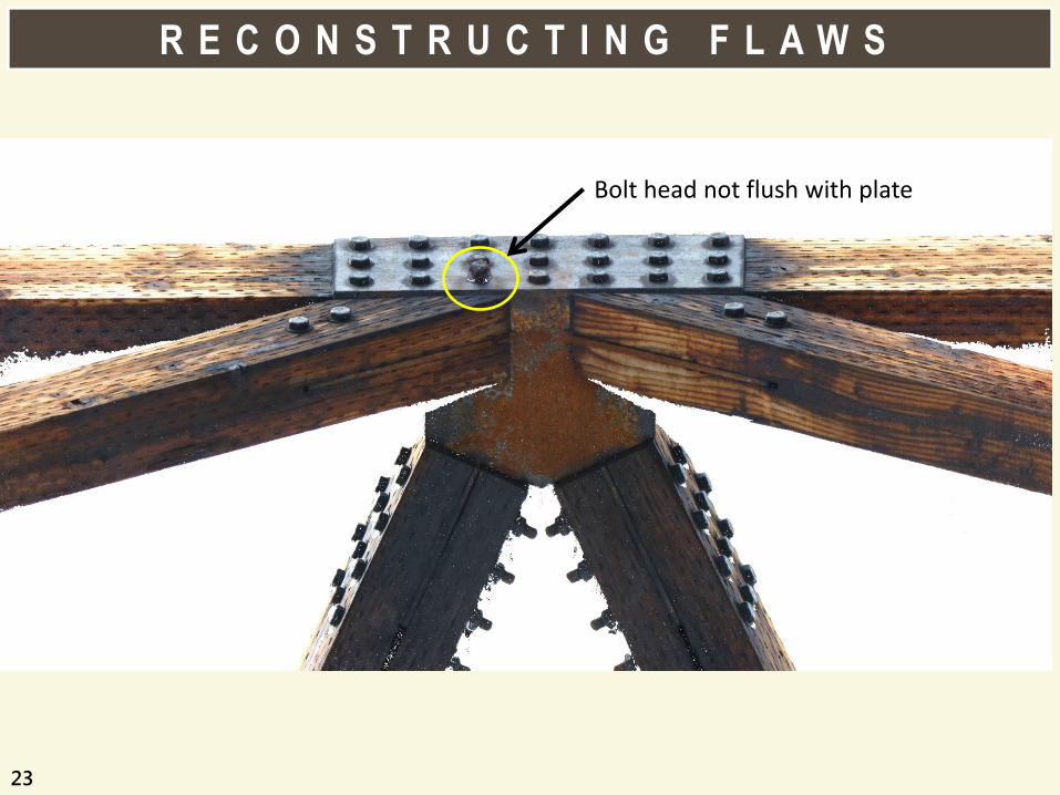
R E C O N S T R U C T I N G F L A W S
Bolt head not flush with plate

Mapping Vegetation on the Copper River Delta
24
P O I N T C L O U D R E C O N S T R U C T I O N

Mapping Vegetation on the Copper River Delta
25
P O I N T C L O U D R E C O N S T R U C T I O N

Mapping Vegetation on the Copper River Delta
26
P O I N T C L O U D R E C O N S T R U C T I O N

Mapping Vegetation on the Copper River Delta
• As bridge ages, it sags
– does it age gracefully?
• Rate of sag is a health indicator
• Required level of accuracy ≤ 10mm
27
C A M B E R T R A C K I N G

Mapping Vegetation on the Copper River Delta
• Point cloud deviation analysis
• Models from repeated inspections
• Accuracy based on cloud resolution
• Sub-millimeter measurement is possible
28
C A M B E R T R A C K I N G
Mapping Vegetation on the Copper River Delta
29
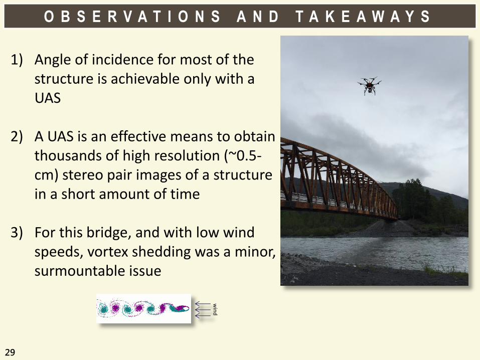
1) Angle of incidence for most of the structure is achievable only with a UAS
2) A UAS is an effective means to obtain thousands of high resolution (~0.5-cm) stereo pair images of a structure in a short amount of time
3) For this bridge, and with low wind speeds, vortex shedding was a minor, surmountable issue
O B S E R V A T I O N S A N D T A K E A W A Y S
win
d

Mapping Vegetation on the Copper River Delta
30
4) Dense Structure from Motion (dSfM) image processing techniques are [currently] the most effective way to produce highly detailed and accurate measureable multispectral 3D models in a short period. Depending on collection parameters, dSfM can produce a denser point cloud than lidar.
5) For this remote location, privacy was not a concern
6) Proposed FAA rules are sufficient for this type operation
O B S E R V A T I O N S A N D T A K E A W A Y S

Mapping Vegetation on the Copper River Delta
31
7) Proof-of-concept costs are not reflective of future costs; costs will decrease for subsequent projects
8) The mission was successful and is replicable for other similar projects
O B S E R V A T I O N S A N D T A K E A W A Y S

Mapping Vegetation on the Copper River Delta
32
9) Could not get interior of bridge with UAS as it was too bulky to operate safely; a hand-held Nikon D800E was used to collect stereo imagery for dSfM processing
10) Takes a powerful computer and several weeks of processing to produce accurate and detailed dSfM models
O B S E R V A T I O N S A N D T A K E A W A Y S

Mapping Vegetation on the Copper River Delta
33
A sUAS minimizes the time spent on site and increases safety by removing potential points of failure - such as suspended platforms, ladders, and harnesses - and potentially dangerous situations from the conventional inspection equation Proposed FAA rules will be sufficient for 90% of Forest Service sUAS operations across multiple disciplines Cost of using sUAS for project work, such as structure inspections, will decrease as Forest Service sUAS policy evolves and methods mature A sUAS is a higher order data collection tool that needs to be more effectively utilized by the Forest Service
C O N C L U S I O N S

Mapping Vegetation on the Copper River Delta
34
N E X T S T E P S
1) Science: processing, analysis, reporting, technology development
2) Policy Development: Forest Service and FAA
3) Effective Implementation: Guidelines and new projects
Mapping Vegetation on the Copper River Delta
35