maps and database of quaternary faults in bolivia … · maps and database of quaternary faults in...
TRANSCRIPT
1
U.S. Department of the InteriorU.S. Geological Survey
Maps and Database of Quaternary Faultsin Bolivia and Chile
By
Alain Lavenu, Ricardo Thiele, Michael N. Machette,
Richard L. Dart, Lee-Ann Bradley and Kathleen M.
Haller
Open-File Report 00-283
This report is preliminary and has not been reviewed for conformity with U.S. Geological Survey editorialstandards nor with the North American Stratigraphic Code. Any use of trade names in this publication is fordescriptive purposes only and does not imply endorsement by the U.S. Geological Survey.
2 0 0 0

i
Map and Database of Quaternary Faults inBolivia and Chile
A project of the International Lithosphere Program Task GroupII-2, Major Active Faults of the World
Proyecto Internacional de la Litósfera, Grupo de Trabajo II-2, Principales Fallas Activas del Mundo
Data and map compiled byDatos y mapa compilado por
1 ALAIN LAVENU, 2RICARDO THIELE, 3 MICHAEL N. MACHETTE,3 RICHARD L. DART, 3LEE-ANN BRADLEY, AND 3 KATHLEEN M. HALLER
1 IRD (Institut de Recherche pour le Développement)213 rue La Fayette
75480 Paris, cedex 10, France
2 Departamento de Geología 3 U.S. Geological SurveyUniversidad de Chile Central Geologic Hazards TeamCasilla 13518, Correo 21 MS 966, P.O. Box 25046Santiago, Chile Denver, Colorado, USA
Regional Coordinator for South AmericaCoordinador Regionale por Sur America
CARLOS COSTAUniversidad Nacional de San Luis
Departamento de GeologíaCasilla de Correo 320San Luis, Argentina
ILP Task Group II-2 Co-Chairman, Western HemisphereILP Grupo de Trabajo II-2 Co-Chairman, Hemisferio Occidental
MICHAEL MACHETTEU.S. Geological Survey
Central Geologic Hazards TeamMS 966, P.O. Box 25046Denver, Colorado, USA
May 2000 Version International LithosphereProgram
ii
TABLE OF CONTENTS
PAGE
TABLE OF CONTENTS ......................................................................................................................iiINTRODUCTION ................................................................................................................................ 1STRATEGY AND PURPOSE................................................................................................................ 1TECTONIC SETTING OF BOLIVIA...................................................................................................... 2TECTONIC SETTING OF CHILE ......................................................................................................... 3PREPARATION OF THE DATABASE AND MAP.................................................................................. 4
MAP................................................................................................................................................ 5DATABASE........................................................................................................................................ 5
DEFINITION OF DATABASE TERMS.................................................................................................. 5ACKNOWLEDGEMENTS .................................................................................................................... 7REFERENCES CITED ABOVE............................................................................................................. 7FAULT DATABASE FOR BOLIVIA...................................................................................................... 9BO-01, FAULT EAST OF ACHACACHI................................................................................................ 9BO-02, FAULT EAST OF PEÑAS......................................................................................................... 9BO-03, KENKO FAULT ZONE............................................................................................................ 10BO-04, LLOJETA FAULT .................................................................................................................. 12BO-05, AMACHUMA FAULT............................................................................................................. 13BO-06, QUEBRADA MINASA FAULT ................................................................................................ 14BO-07, ESCOMA FAULT................................................................................................................... 14BO-08, VIACHA FAULT ZONE .......................................................................................................... 15BO-09, AYO AYO FAULT.................................................................................................................. 16BO-10, CUENCA DE CHARAÑA FAULT ............................................................................................ 16BO-11, TUNARI FAULT.................................................................................................................... 17BO-12, TARIJA FAULT..................................................................................................................... 17BO-13, BENI RIVER FAULT.............................................................................................................. 19BO-14, MANDEYAPECUA FAULT..................................................................................................... 19FAULT DATABASE FOR CHILE ....................................................................................................... 21CH-01, ATACAMA FAULT ZONE...................................................................................................... 21
CH-01A, SALAR GRANDE FAULT, SECTION OF ATACAMA FAULT............................................................... 22CH-01B, PUNTA DE LOBOS FAULT, SECTION OF ATACAMA FAULT ............................................................. 22CH-01C, NORTHERN PART OF CARMEN SALAR FAULT, SECTION OF ATACAMA FAULT .................................... 23CH-01D, SOUTHERN PART OF CARMEN SALAR FAULT, SECTION OF ATACAMA FAULT.................................... 24CH-01E, SIERRA DE REMIENDOS FAULT, SECTION OF ATACAMA FAULT...................................................... 25
CH-02, MORRO MEJILLONES FAULT ............................................................................................... 26CH-03, CERRO GORDO FAULT, ATACAMA FAULT ZONE................................................................ 27CH-04, CERRO MORENO FAULT, ATACAMA FAULT ZONE ............................................................. 27CH-05, CERRO FORTUNA FAULT .................................................................................................... 28CH-06, WESTERN BACK THRUST FAULT OF CERRO DE PURILACTIS............................................ 29CH-07, FRONTAL DOMEYKO THRUST FAULT OF LLANO DE LA PACIENCIA.................................. 30CH-08, IGNIMBRITE BACK THRUST FAULT OF LLANO DE LA PACIENCIA ..................................... 30CH-09, EASTERN FRONTAL THRUST FAULT OF LLANO DE LA PACIENCIA ................................... 31CH-10, FRONTAL THRUST FAULT OF CORDILLERA DE LA SAL..................................................... 32CH-11, TUCUCARO FAULT.............................................................................................................. 32
iii
CH-12, FAULTS SOUTH OF CALDERA ............................................................................................. 33CH-13, FAULTS EAST OF BAHIA INGLESA ...................................................................................... 34CH-14, FAULTS OF ALTO DEL FRAILE ............................................................................................ 34CH-15, FAULT OF SAN JOSE DE MAIPO........................................................................................... 35CH-16, FAULT OF ESPERANZA........................................................................................................ 36CH-17, FAULT OF VICTORIA ........................................................................................................... 36CH-18, LIQUIÑE-OFQUI FAULT ZONE............................................................................................... 37
CH-18A, RELONCAVÍ FAULT, SECTION OF LIQUIÑE-OFQUI FAULT............................................................. 38CH-18B, HORNOPIRÉN FAULT, SECTION OF LIQUIÑE-OFQUI FAULT............................................................ 39CH-18C, PUYUHUAPI FAULT, SECTION OF LIQUIÑE-OFQUI FAULT ............................................................. 39CH-18D, SAN RAFAEL FAULT, SECTION OF LIQUIÑE-OFQUI FAULT............................................................ 40
CH-19, RIO SAN JUAN FAULT.......................................................................................................... 41CH-20, LAGO FAGNANO FAULT....................................................................................................... 42
CH-20A, WESTERN SECTION OF LAGO FAGNANO FAULT ......................................................................... 42CH-20B, EASTERN SECTION OF LAGO FAGNANO FAULT........................................................................... 43
TABLESPage
TABLE 1. QUATERNARY FAULTS OF BOLIVIA (FALLAS CUATERNARIAS DE BOLIVIA) ....................................... 20TABLE 2. QUATERNARY FAULTS OF CHILE (FALLAS CUATERNARIAS DE CHILE) .............................................. 45
1
INTRODUCTION
As part of the International Lithosphere Program’s “World Map of Major Active Faults,” the U.S.Geological Survey (USGS) is assisting in the compilation of a series of digital maps of Quaternary faults andfolds in Western Hemisphere countries. The maps show the locations, ages, and activity rates of majorearthquake-related features, such as faults and fault-related folds. They are accompanied by databasesthat describe these features and document current information on their activity in the Quaternary. Theproject is a contribution to the International Decade for Natural Hazard Disaster Reduction.
The project is sponsored by the International Lithosphere Program and funded by the USGS’sNational Earthquake Hazards Reduction Program. The primary elements of the project are generalsupervision and interpretation of geologic/tectonic information (Michael N. Machette, Project Chief), datacompilation and entry for fault catalog (all personnel), database design and management (Kathleen M.Haller), and digitization and manipulation of fault data (Richard L. Dart) in †ARCINFO. For the compilation ofdata, we engaged experts in Quaternary faulting, neotectonics, paleoseismology, and seismology. Theseexperts are the primary authors of this report, and questions about individual faults should be directed tothem. Questions about the project, its status, and the GIS map should be directed to the USGS authors.
Prior to initiating this project, no modern or digital map of active or Quaternary faults existed for Boliviaand Chile or any other country within South America, even though understanding the extent andcharacter of active and older Quaternary faults are critical elements of seismic-hazards analysis. Creation ofthis map and the accompanying database of 34 faults and faults zones will help extend the relatively shortrecord of instrumental and felt seismicity in Bolivia and Chile by creating a paleoseismic record of surfacedeformation associated with large (typically M>6.5) earthquakes.
Although some basic fault data are available for most of Bolivia and Chile, the degree of completenessvaries greatly and often is a function of the degree of remoteness and vegetation cover. A few faults havebeen the subject of recent or more detailed investigations, but none appear to have been trenched forpaleoseismologic data. Other regions and faults have been studied in some detail, usually in associationwith concerns about hazards to urban areas or the safety of critical facilities such as transportation routes,oil-and-gas pipelines, or power-generating facilities. Thus, considerable effort was required from theprimary authors in order to compile information from a wide variety of sources and insure that the nationalproduct is up to date and provides fairly uniform coverage for the entire country. Nevertheless, thegeneral state of knowledge for faulting in Bolivia and Chile is probably best described as being of areconnaissance nature. Little is known in a collective sense about the overall rates of fault activity and faultchronology—information that is difficult to acquire but critical to seismic hazard assessments. Hopefully,additional paleoseismic studies will help augment this map and database.
STRATEGY AND PURPOSE
For the maps of Bolivia and Chile, we relied on Alain Lavenu and Ricardo Thiele, well-informed expertswith strong local or regional knowledge of both Bolivia and Chile who were gratious to participate in thisinternational project. Given the limited time to produce the map, the project was restricted to compilation ofjust those elements needed for ILP's Global Seismic Hazards Assessment Program (see database). Nofield studies were conducted specifically for this project. However, we anticipate that the project will pointout the shortcomings of past and current research on Quaternary faulting in Bolivia and Chile in terms ofquantity, quality, scope, and regional coverage and should help promote new efforts to collectpaleoseismological data in previously neglected or critical areas.
Many times, seismicity is used to define some potentially active faults, especially along active platemargins. However, several recent faulting events in the Western Hemisphere have shown that much ofthe faulting away from active plate margins occurs along faults with no significant level of seismicity and thatonly a fraction of active faults are characterized by ongoing seismicity. Thus, the information on Quaternaryfaulting included within this database should help extend the modern (past several hundred years) record
† Any use of trade names (such as this and others in the report) does not imply endorsement by the U.S.Geological Survey.
2
of seismicity into prehistoric time, and allow better assessments of active and potentially active faults inBolivia and Chile and other Western Hemisphere countries.
TECTONIC SETTING OF BOLIVIA
The Bolivian Andes are located above a 30° east-dipping portion of the subducting Nazca plate. The maincharacteristics of the Bolivian Andes are 1) the presence of a wide and very subsident (6 to 15 km deep;Meyer and Murillo, 1961; Martinez, 1980; Lavenu and Marocco, 1984) Tertiary sedimentary basin thatforms a high plateau, the Altiplano, at an average elevation of 3,800 meters; 2) the elbow shape of themountain range, which is referred to as the Bolivian Orocline; 3) the Cenozoic and Quaternary volcanic arc,which is still active; 4) a thick crust (55-75 km); and 5) a high amount of topographic relief within and acrossthe range. The high Central Andes of Bolivia, 300 to 600 km wide, are the wider part of the Andean chainand consist of four morpho-tectonic zones: the Western Cordillera, the Altiplano, the Eastern Cordillera,and the sub-Andean zone.
• The Western Cordillera, which has summits over 6,000 m in elevation, is in part due to the regionaluplift, but essentially results from big volcanoes in the cordillera. The base of these volcanoes is nearly3,800-4,000 m in elevation. During the Oligocene and Miocene, this region was a subsident basin (1500m deep; Lavenu, 1986) coeval with a calc-alkaline volcanism.
• The Altiplano is between the Western and the Eastern Cordilleras. On this high flat plateau, somefeatures, such as the Serranias, can reach 4,500 m in elevation. The Altiplano is presently a wide endoreicbasin occupied by a lacustrine system (Lakes Titicaca and Poopo) in the northern part, and by salt lakes(“salares") in the central and southern part (e.g., Coipasa and Uyuni Salares). The Western Altiplano,which forms the eastern piedmont of the Western Cordillera, is occuped by Cenozoic volcanic and detrital-volcanic deposits as much as 2,000 m thick. The Central Altiplano, the more subsident Cenozoic zone, ischaracterized by important continental sedimentation. Faults and folds, resulting from Neogene andQuaternary compressive Andean tectonics, affect this entire region. The Eastern Altiplano, which is thewestern piedmont of the Eastern Cordillera, is bounded on the east by the important fault-scarp relief ofthis Cordillera. Only Pliocene deposits outcrop here and the older deposits are masked by widespreadQuaternary deposits. During Pliocene time , this region was less deformed than the Central Altiplano, butduring Quaternary time the piedmont was affected by collapse along normal faults with significant throw(meter to tens of meters).
• The Eastern Cordillera, comprised essentially of Paleozoic deposits, has been a positive (uplifted)region since the Early Cretaceous. This region, intensely deformed during the Hercynian orogeny, wasalso affected by Neogene and Quaternary deformation (e.g., Cochabamba and Tarija basins).
• The sub-Andean zone is the eastern piedmont of the Andean Chain (Eastern Cordillera) andconsists of a fold-thrust belt. Deformation started here during Oligocene time and continued throughoutthe Neogene (Baby and others, 1989, 1992) and Quaternary (Dumont, 1996) times. In the foreland, latePliocene to Quaternary sedimentary units overlie a Pliocene unit with an erosional unconformity (Padula,1959). A volcanic tuff is dated at 3.3 ± 0.4 Ma (Moretti and others, 199 ) from the Emborozu Formation, inthe lower part of this Plio-Quaternary section. At the front of the Subandean front, the Ñuapua Formation,biostratigraphically dated at 0.8 Ma (McFadden and Wolff, 1981) to 0.73 Ma (Marshall and Sempéré, 1991)could correspond to the upper part of the Emborozu Formation. The Ñuapua Formation could correspondalso to the "intensely deformed and thrusted deposits" (Baby, unpublished report) outcropping along theMandeyapecua fault [BO-14], which could confirm recent deformation along the orogenic front.
• The Beni basin is located NE and E of the Bolivian Andean segment, in the front of the Subandeanthrust and fold belt of the Bolivian Andes: The Bolivian Beni basin, as well the Peruvian Marañon basin, is aflexural basin that is subsiding at present. This elongated basin, as well the Madre de Díos Basin, collectsthe drainage from the eastern slopes of the Andes. The western boundary of the Beni basin with theAndean foothills is a "sharp piedmont line" according to Dumont (1996). Morphological and neotectonicdata suggest that the Beni River is forced to the north by a north-striking, more than 65 km long, faultbetween the Pando block and the Beni River floodplain. Dumont (1996) observed two N-striking faults[BO-13] cutting the conglomerate and sand layers of an upper terrace of the Beni River. The upthrownside of these faults is on the west.
3
During the uppermost Pliocene and after a period of E-W trending extension and syntectonicsedimentation, the Bolivian Andean Chain underwent E-W compressional deformation. During the earlyQuaternary, a short-lived N-S compressional event affected the entire chain. According to Mercier andothers (1992), this deformation could correspond to a rotation of the σ1 and the σ2 principal axes duringlate Pliocene time. During the Quaternary, the entire mountain chain was affected by N-S extensionaltectonics that can be related to the effect of high topography (Sébrier and others, 1985). This deformationis responsible for important normal faults, the cumulative throw of which reaches more than 400 m near thetown of La Paz. The tectonic basin occupied by Lake Titicaca is normal fault controlled [BO-1, BO-2, BO-7], and is one of the consequences of this N-S Quaternary deformation (Lavenu, 1992).
TECTONIC SETTING OF CHILE
West and mainly south of Bolivia, the Central and Southern Andes of Chile are the result to obliqueconvergence between the subducting oceanic Nazca Plate and the overriding continental South AmericaPlate. The average direction of convergence is about N78°E with an absolute speed of 9-10 cm/yr. Westto east, the Chilean Andes are herein divided into two distinct but parallel orogenic belts: 1) a fore arc zoneincluding the Coastal Cordillera and the Central Depression, 2) the Main Cordillera with the active magmaticarc zone. In the southern part of the Chilean Andes, a foreland or back arc zone takes place around theMagellan Strait.
In Chile, the width of the Andes is about 150 to 200 km on average and some 4,000 km long. Thehighest peaks of the Main Cordillera are more than 5,000 m in the north to 2,000 m in the south. Thedifferent mountain belts trend roughly N-S to N 10°E, parallel to the active margin of the subduction zone.The North Chilean Andes, between 18° and 27° S, lie above the southernmost part of the normallydipping portion of the subducting Nazca Plate (Jordan and others, 1983). Between 27 and 33°S, theBenioff Zone dips only 5° and as such are not associated with an active volcanic arc in the Cordillera.Conversely, the South Chilean Andes, between 33° and 47° S, lie above a steeper east-dipping portion ofthe subducting Nazca Plate, which corresponds to the southern active volcanic arc. Southward, theAntarctic Plate subducts beneath the Andes with a convergence rate of 2 cm/yr, much lower than in thenorthern part of Chilean Andes.
North-south-trending minor ranges are cored by Paleozoic, Mesozoic and Cenozoic rocks thatconstitute the Coastal Cordillera, which is 30-50 km wide and 2,000-2,500 m high. The central batholith ofthe Cordillera is composed of metamorphic rocks and granites that intrude the sedimentary Paleozoicrocks. Surfaces eroded across these rocks form the Coastal Plain.
In the northern part of the Chilean Andes, the Pampa de Tamarugal represents a young tectonicdepression (also known as the northern Central Depression or Longitudinal Valley) that morphologicallyseparates the Coastal Range from the Precordillera. Extensional tectonics do not seem to have played arole in the formation of the Central Depression (Reutter and others, 1988), in contrast with coastal marineterraces that are affected by E-W extensional deformation.
From Santiago to the south, the southern Central Depression corresponds to a morphotectonicgraben-like depression that developed during Miocene to Pliocene time. This depression is bounded bylongitudinal faults, presently inactive. The thickness of the continental sedimentary fill in the depression(Pliocene and Quaternary deposits reach 500 m to 2,000 m) increase progressively toward the southwhere marine deposits are noted.
The Main Cordillera is comprised essentially of sedimentary deposits with interbedded volcanic layers(eastern part of the Chilean Andean slope) and by volcanogenic and continental Cenozoic rocks (westernpart of the Chilean Andean slope). The Pliocene-Pleistocene volcanic belt runs between these twozones.
Between 26° and 33° S, where the “Cordilleras transversales” corresponds to the flat-subductingplate portion, the relief is continuous from the main Cordillera to the Coastal Cordillera and the depressionlakes.
Chilean Andean subduction is characterized by a general oblique convergence vector with respect tothe plate boundary and the different modes of this oblique accomodation are problematic, specially therelations between the overriding plate deformation and the subduction. Uplift of the Andean chain isshown by elevated Quaternary marine terraces. In those coastal areas closest to the trench (located about
4
80-100 km to the west), the state of stress during the upper Pleistocene was extensional in an E-Wdirection, generating normal faulting (e.g., the Atacama fault [CH-01]). The great (M8) July 30, 1995Antofagasta thrust earthquakes along the interplate Wadati-Benioff (subduction) zone (which is theimmediate consequence of convergence between the plates) generate morphological changes, such ascoastal uplift, subsidence of the outer forearc, and an elongation of the coast toward the west. At thesurface, the result of such deformation is a roughly extensional E-W state of stress. Generally, the E-Wextensional deformation affects marine oxygen-isotopic stage 5c marine deposits (80 to 105 ka), butkinematic studies of neotectonic faults associated with the uplifted terraces do not show many activecrustal structures directly linked to earthquakes (as noted by Armijo and Thiele, 1990; Delouis 1996,1998).
During the Quaternary, deformation was partitioned into two states of stress south of 32°S. In theforearc sliver (Costal Cordillera, Central Depression and part of the Main Cordillera), compressionaldeformation ocurred with the σ1 axis trending N-S and the σ3 axis in the vertical direction. In the intra-arc,compressional strike-slip deformation (transpression) occurred with the σ1 axis trending NE-SW and theσ3 axis trending NW-SE, parallel to the Liquiñe-Ofqui fault zone (Lavenu and Cembrano, 1999).
This N-S compressional state of stress could be related to the effect of the partitioning of thedeformation that generates the northward displacement of the fore arc sliver. According to Lavenu andCembrano (1999), this N-S Quaternary compression is linked to a slow convergence regime with a weakercoupling. Different factors such as the geometry of the plate margin and/or abrupt changes in subductiongeometry (e.g. buttress accomodation) can also explain this N-S compresional tectonic regime. North ofSantiago, the Quaternary state of stress of the Transversal Cordillera (between 18°S and 22°S) and theCentral Depression (between 25°S and 32°S) is still unknown.
PREPARATION OF THE DATABASE AND MAP
This compilation shows evidence for activity on Quaternary faults in Bolivia and Chile and its offshoreregions using guidelines modified from Haller and others (1993). The fault data for Bolivia were compiledby Alain Lavenu during 1996 using unpublished reports (gray literature), published literature, and recentgeological investigations to describe 14 faults. The fault data for Chile were compiled by Alain Lavenu andRicardo Thiele during 1997 using unpublished reports (gray literature), published literature, and recentgeological investigations for 20 faults, which includes two complicated fault zones (the Atacama [CH–01]and the Liquiñe-Ofqui [CH-06]). No separate descriptions of Quaternary folds were made for Bolivia andChile. Alain and Ricardo also interpreted aerial photographs and conducted limited field studies of some ofthese structures. Michael Machette edited the text and map data and provided guidance for the projectunder the International Lithosphere Program's Task Group II-2 "Major Active Faults and Folds of theWorld," for which he is Co-chairman (Western Hemisphere). The surface traces of the Quaternary faults inBolivia were digitized from Alain’s compiliation, which was on a planimetric base map. The surface traces ofthe Quaternary faults in Chile were digitized from Alain and Ricardo’s compiliation, also on a planimetricbase map. Offshore traces (Pacific Ocean) are based primarily on marine geophysical studies andbathymetric maps; these traces are inherently less well defined and located, and should be consideredapproximate.
Richard Dart used GIS (Geographic Information System) technology to produce the fault map. Thetraces of Quaternary faults were digitized, attributed for age, sense of slip, and line type (continuous,discontinuous, and concealed or inferred). These data were reprojected using a Labmert Conformal ConicProjection for Bolivia and a Polyconic Projection for Chile. The maps were prepared with ARC/INFOversion 7.2.1 running under Solaris version 2.6 on a Unix workstation. The GIS data is scale independent,but should not be used at more than twice (more detailed) the digitized scale. Data for the fault length andaverage strike were generated from the ARC/INFO files.
The base-map information for the enclosed maps was taken from the Digital Chart of the World, whichwas created for use with ARC/INFO (copyright 1993 by the Environmental Systems Research Institute,Inc.). The Digital Chart of the World was compiled at a scale of 1:1,000,000, which is more detailed thanthe printed scales of the map. The Digital Chart of the World was originally developed for the United StatesDefense Mapping Agency (DMA) and is primarily derived from the DMA Operational Navigation Chart(ONC) Series.
5
M A P
The traces of Quaternary faults and folds of Bolivia and Chile were digitized from Lavenu and Thiele’scompilations at 1:1,000,000 scale. This scale allows output as single-country maps at 1:1,750,000 forBolivia and 1:4,000,000 scale for Chile using a standard a 36-inch (0.9-m) wide printer. Additionally, moredetailed maps for portions of the countries can be printed at other scales (1:250,000 to 1:500,000) whileretaining all significant digital information (see both map plates).
The fault maps show the location and style of Quaternary faults, time of most recent movement, andestimates of slip rate (as a proxy for fault activity). Although as many as five time categories of Quaternaryfaults can be depicted on the Western Hemisphere maps, only three categories were used in Bolivia andChile:
Historic (generally <450 years),Holocene and latest Pleistocene (<15,000 years or <15 ka),Quaternary (<1,600,000 years or <1.6 Ma).
Categories for the late Quaternary (<130 ka) and late and middle Quaternary (<750 ka) were not usedowing to the general lack of stratigraphic and chronological control needed to make these agedifferentiations. This categorical time scheme allows some flexibility in reporting between countries owingto the differing levels of investigation and abilities to date prehistoric faulting.
Three ranges of slip rates depicted by differing lines are shown on the map in order to differentiateknown rates of fault activity:
>5 mm/yr—Plate-boundary faults and subduction zones,1-5 mm/yr—Lesser strike-slip and major extensional faults, <1 mm/yr—Most extensional and intraplate faults.
Most faults in Bolivia and Chile with "unknown slip rates" are drawn with the <1-mm/yr line thickness.
DATABASE
The purpose of the database is to provide large quantities of fault data that can be readily accessedusing a variety of search parameters. For this database, we anticipate that the user would want search-and-retrieve capabilities from a personal computer. The user may want to sort the data by such parameters asfault name, time of most recent movement (one of three categories), slip rate (one of three categories),sense of movement, or by multiple parameters.
The process of data compilation starts with data acquisition and synthesis. In the case of faults, thecompiler must determine if the structure is a simple one, or if it qualifies as having sections (increasingcomplexity of geometry or fault history). Then using the appropriate form, the compiler tabulatesinformation on the fault’s parameters. The forms were built in Microsoft Word for the Macintosh.
After this report is released, we will incorporate suggested changes and additions; then import thedata to the computer database. Each of the fields is a potential search object. The use of a computerdatabase program allows us to custom format the reporting of data and to collapse unused fields or notes.The basic fields are restricted to 256 characters, but we use the note option for more explanatoryinformation (shown under comments in this report).
The fault data will be released in several forms. This open-file report constitutes a traditional hard-copycatalog (database and map) for Bolivia and Chile. The Bolivian and Chilean data will eventually be part of alarger relational computer database for the Western Hemisphere that should be available on the WorldWide Web (WWW). This interactive WWW product allows the user to browse, sort, and print the data.However, we do not anticipate allowing the database to be altered using only the run-time WWW versionof the database program.
DEFINITION OF DATABASE TERMS
The following terms and descriptions, which are shown in English and Spanish (when considerablydifferent), provide data for specialized fields, most of which will be searchable when the computerdatabase is released. In additional specialized fields, more detailed information is provided in the"Comments" section that follows some fields. If a field is empty, marked unknown, or has been deleted, nopertinent information was found in the published literature. The following description provides definitions
6
of fields (in alphabetic order) and indicates where various information, if known, can be found. Englishlanguage citations for references are in a traditional (USGS) format, although foreign language citations areas provided by the compilers.Average dip General down-dip direction of the structure, where known.Average strike The length-weighted average strike of the fault trace is reported in the northwest and
northeast quadrants of the compass (i.e., -30° is N. 30° W., versus 30° which is S. 30° E. The values (i.e.,±30°) that follow the strike describe the range for all vectors contained with the trace of that particularfault or collection of faults. These values are included only to provide a general impression of thesinuosity or variability in strike of the mapped structures. Some fault zones include faults with a widevariety of strikes, and thus ±values are large.
Compiler, affiliation and date of compilation The name and affiliation of the person(s) primarilyresponsible for compilation or update of data presented for the structure. Also shown is the date whendata were compiled for this project (e.g., January 1997).
Fault geometry This heading includes geographic information pertinent to the fault being described.The data include length, average strike, average dip, and sense of movement.
Geomorphic expression General description of the structure’s geomorphic expression includinginformation on the the presence or absence of fault scarps, offset streams, monoclines, shutter ridges,associated landslides, etc.
Historical surface faulting When the timing of most recent movement on a fault is historic, then thisfield(s) describes evidence for surface faulting associated with historical earthquakes. Also included isseismological information for the historical earthquake.
Length This field specifies the end-to-end length of the Quaternary-age fault (or fault section) asmeasured from the most distal ends of the trace. The ends of overlapping or echelon traces areprojected to a line defined by the average strike and the length is then determined from thoseprojected end points. Also shown (in parentheses) is the cumulative length of all surface tracesincluded in the fault, fault zone, or collection of faults.
Name (Fault name or Section name) The earliest referenced name for a structure or fault section(where appropriate) generally is given preference, except in cases where a more commonly acceptedname is widely used in the recent literature. "Comments" may also contain other names and referencesin which they are used, the geographic limits of the structure, north to south or west to east, as shown inthis compilation; various geographic limits that are different than in other studies are also included.Minor changes in original name may have been made for reasons of clarity or consistency (such assegment to section) where appropriate. We have found no faults in Bolivia and Chile that justify usingthe term “segment”, owing to a lack of precise timing information.
NumberFault number The structure (fault) is assigned a number that is preceded by a two characterabbreviation (Bolivia fault number 1 is BO-01) that is unique to each of the countries in the WesternHemisphere. References to the same structure shown in other compilations, such as CH-01 areincluded in "Comments".Fault Section number An alpha character is assigned to the northernmost or westernmost sectionof a fault (for example, fault CH-01 has five sections: CH-01a through CH-01e).
Number of sections (only used for faults with sections) Numeric value for number of sections (e.g., 2)defined in studies that do not meet the minimum requirements for segments established for thiscompilation. "Comments" include reference in which sections are discussed; if the term "segment" isused in the literature, an explanation of why "section" is used in the database is provided.
Recurrence interval Time interval in yr (based on historic data, calendric or calibrated radiocarbondates), in 14C yr (based on uncalibrated radiocarbon dates), or in k.y. (thousand years, based on lessprecise dating methods, stratigraphy, or geomorphology). Unknown is shown if there is no publishedrecurrence interval value. Alternative published recurrence intervals, starting with that which applies tothe most recent time interval, are included in "Comments." No faults in Bolivia and Chile haveestablished recurrence intervals.
References A bibliographic citation is included for all references pertinent to each structure. Paperspublished in Spanish are cited in Spanish, and may not conform to USGS style.
7
Section A geographic, geometric, structural portion of a fault or collection of faults that appear(s) to havea different character than adjacent portions of the fault. Typically, not enough information exists to showthat this portion of the fault acts independently of adjacent portions, and thus does not qualify as a bonafide "segment" of a fault in a paleoseismic sense. There are no known faults with proven segments inBolivia and Chile, although two faults within Chile are described as having sections. Further research isneeded to document additional faults with sections or those with sections that may in fact be segments.
Section name (see Name)Section number (see Number)Sense of movement Includes thrust, less than 45° dip; reverse, greater than 45° dip; right-lateral strike
slip (dextral); left-lateral strike slip (sinistral); or normal faults. For oblique slip, the principle sense ofmovement is followed by secondary sense (i.e., dextral, normal).
Slip rate The primary field shows an actual value or one of several slip-rate categories used for the mappart of this compilation: <1 mm/yr, 1-5 mm/yr, or >5 mm/yr. Very few faults in Bolivia and Chile haveestablished slip rates. “Unknown" precedes the suspected slip-rate or slip rate category if no publishedslip rate is known. "Comments" may include a synopsis of published slip rates and pertinentdocumentation. Generally speaking, there are two types of slip rates. The first type is termed a“Geologic slip rate” and is derived from the age and amount of offset of surficial geologic deposits.These rates are not precise, but allow one to place broad limits on possible slip rates, and hencecharacterize the fault in one of the above-mentioned categories. Most slip rates from Bolivia and Chileare geologically determined. The second type of slip rate is termed a “Paleoseismic slip rate” and isderived from times of faulting events and amounts of offset of geologic datums or piercing point. Thistype of slip rate is more precise, but are rare owing to the extensive amount of work involved (i.e.,detailed paleoseismologic studies involving trenching and numeric dating).
Fault name (see Name)Fault number (see Number)Synopsis and geologic setting This field provides a short summary that describes the level of study,
provides a snapshot of the scope of data that follows in the database and provides a generalizedperspective of the fault in terms of its regional geologic setting, amount of total offset, and general ageof offset strata. Not all faults in the database have a synopsis and discussion of geologic setting.
Timing of most recent event (faulting event) The primary field shows one of the two prehistoric timecategories: latest Quaternary (Holocene and latest Pleistocene, <15 ka) or Quaternary (<1.6 Ma). Thisfield may document historic surface faulting, although details of the earthquake related to the faultingwill follow.
Type of studies: This field briefly summarizes the types of studies conducted on the fault.
ACKNOWLEDGEMENTS
This project was supported by the USGS’s National Earthquake Hazards Reduction Program (NEHRP)and by the International Lithosphere Program (ILP) under Task Group II-2. Alain Lavenu’s time wasgraciously supplied by IRD (Institut de Recherche pour le Développement, formerly ORSTOM) as part oftheir cooperative research program in intratropical countries. Most of IRD’s investigations have beenconducted at the bequest of the Bolivian and Chilean Universities; we greatly appreciate their support andcontinuing interest in paleoseismology and seismic-hazard assessments. Ricardo Thiele’s time wasgraciously supplied by the Department of Geology at the University of Chile, Santiago.
REFERENCES CITED ABOVE
Armijo, R., and Thiele, R., 1990, Active faulting in Northern Chile—Ramp stacking and lateral decoupling along asubduction plate boundary?: Earth and Planetary Science Letters, v. 98, p. 40-61.
Baby, P., Hérail, G., López, J.M., López, O., Oller, J., Pareja, J., Sempéré, T., Tufiño, D., 1989. Structure de la Zonesubandine de Bolivie : Influence de la géométrie des séries sédimentaires antéorogéniques sur la propagationdes chevauchements. C. R. Acad. Sci., sér. 2, 309, 1717-1722.
Baby, P., Hérail, G., Salinas, R., Sempéré, T., 1992, Geometry and kinematic evolution of passive roof duplexesdeduced from cross section balancing—Example from the foreland thrust system of the Southern BolivianSubandean Zone: Tectonics, v. 11, no. 3, p. 23-536.
8
Delouis, B., 1996, Subduction et déformation continentale au nord-Chili. Unpub. Doctorat thesis, Univ. LouisPasteur, Strasbourg, France, 262 p.
Delouis B., Philip H., Dorbath L., and Cisternas A., 1998, Recent crustal deformation in the Antofagasta region(Northern Chile) and the subduction process: Geophysical Journal International, v. 132, p. 302-338.
Dumont, J.F., 1996, Neotectonics of the Subandes-Brazilian craton boundary using geomorphological data—TheMarañon and Beni basins: Tectonophysics, v. 257, p. 137-151.
Haller, K.M., Machette, M.N., and Dart, R.L., 1993, Maps of Major Active Faults, Western Hemisphere; InternationalLithosphere Program (ILP) Project II-2: Guidelines for U.S. Database and Map: U.S. Geological Survey Open-File Report 93-338, 45 p.
Jordan, T.E., Isacks, B.L., Allmendinger, R.W., Brewer, J.A., Ramos, V., and Ando, C.J., 1983, Andean tectonicsrelated to geometry of subducted Nazca plate: Geological Society of America Bulletin, v. 94, p. 341-361.
Lavenu, A., 1988, Etude tectonique et néotectonique de l'Altiplano et de la Cordillère orientale des Andesboliviennes: Travaux et Documents microfichés, v. 28, 420 pp., ORSTOM, Paris.
Lavenu, A., and Marocco, R., 1984, Continental sedimentation and tectonics in a fold belt related to a subductionzone—The Central Andes (Perú-Bolivia) during the Tertiary: Bulletin du centre de Recherche et d'Exploration-Production, Elf-Aquitaine, v. 8, no. 1, p. 57-70.
Lavenu, A., 1992, Formation and geological evolution, in Dejoux C. and Iltis A., eds, Lake Titicaca: The Netherlands,Kliwer Academic Publisher, p. 1-13.
Lavenu, A., and Cembrano, J., 1999, Compressional- and transpressional-stress pattern for Pliocene andQuaternary brittle deformation in fore arc and intra-arc zones (Andes of Central and Southern Chile): Journal ofStructural Geology, v. 21, p. 1669-1691.
Martinez, C., 1980, Structure et évolution de la chaîne andine dans le nord de la Cordillère des Andes de Bolivie:Travaux et Documents, ORSTOM, no. 119, 352 pp.
Mercier, J.L., Sébrier, M., Lavenu, A., Cabrera J., Bellier, O., Dumont, J.F., and Macharé, J., 1992, Changes in thetectonic regime above a subduction zone of Andean type—The Andes of Peru and Bolivia during the Pliocene-Pleistocene: Journal of Geophysical Research, v. 97, no. B8, p. 11,945-11,982.
Meyer, H., and Murillo, J., 1961, Sobre la geología en las provincias Aroma-Pacajes y Carangas: DepartamentoNacional de Geología de Bolivia, no. 1, 47 pp.
Reutter, K.J., Giese P., Gotze H.J., Scheuber, E., Schwab, K., Schwarz G., and Wigger, P., 1988, Structures andcrustal development of the Central Andes between 21° and 25° S., in H. Bahlburg, Ch., and Breitkreuz, P. Giese(eds.), The Southern Central Andes: Lecture notes in Earth Sciences, p. 231-261, Springer Verlag, Berlin.
Rodrigo, L.A., and Castaños, A., 1975, Estudio sedimentológico de las formaciones "Tiwanaku, Coniri y Kollu Kollu"del Altiplano septentrional boliviano: Sociedad Geológica Boliviana, v. 22, p. 85-126.
Sébrier, M., Mercier, J.L., Mégard, F., Laubacher, G., and Carey-Gailhardis, E., 1985, Quaternary normal andreverse faulting and the state of stress in central Andes of Southern Peru: Tectonics, v. 4, no. 7, p. 739-780.
9
FAULT DATABASE FOR BOLIVIA
BO-01, FAULT EAST OF ACHACACHI
FAULT NUMBER/NUMERO DE LA FALLA: BO-01FAULT NAME/NOMBRE DE LA FALLA: East of Achacachi (informal name)/Este de Achacachi (sin
nombre)SYNOPSIS AND GEOLOGIC SETTING/SINOPSIS Y AMBIENTE GEOLOGICO: Quaternary activity
described in 1981. General neotectonic field studies. This fault is more than 50 km long and affectsglacial sediments (Quaternary moraines). Located in the piedmont of the Eastern Cordillera, on limit withthe Altiplano. It is part of a Quaternary fault system that formed Lake Titicaca.Actividad cuaternaria descrita en 1981. Estudios neotectónicos de campo generales. La falla de más de50 km de largo afecta sedimentos glaciales (morenas cuaternarias). Se ubica en el piedemonte de laCordillera Oriental, en limite con el Altiplano. Hace parte de un sistema de fallas cuaternarias que originóel Lago Titicaca.
COMPILER, AFFILIATION, & DATE OF COMPILATION/COMPILADOR, AFILIACION Y FECHA DECOMPILACION: Alain Lavenu, IRD, France; 06-1996
TYPE OF STUDIES/TIPOS DE ESTUDIOS: Interpretation of aerial photographs and fieldwork.Fotointerpretación y trabajos de campo.
FAULT GEOMETRY/GEOMETRIA DE LA FALLA:LENGTH/LONGITUD: 29.9 km (29.5 km cumulative)AVERAGE STRIKE/RUMBO PROMEDIO: -57.4°±11° (N57.4°W±11°)AVERAGE DIP/INCLINACION PROMEDIO: Unknown angle to NE/Desconocida al NESENSE OF MOVEMENT/SENTIDO DE MOVIMIENTO: NormalComments/Comentarios: Other faults dipping SW are associated with this fault/A esta falla estan asociadas otras fallas con buzamiento al SW.
GEOMORPHIC EXPRESSION/EXPRESION GEOMORFOLOGICA: The scarp faces towards the NE, iseroded and not very obvious.El escarpe, hacia el NE, es erosionado, poco marcado.
SLIP RATE/TASA DE MOVIMIENTO: Unknown/desconocidaTIME OF MOST RECENT OF MOVEMENT/EDAD DEL ULTIMO MOVIMIENTO: Quaternary/Cuaternario
(<1.6 Ma)Comments/Comentarios: The fault affects Sorata moraines (younger than Purapurani Fm., 1.6 Ma) butdoes not affect Choqueyapu moraines (between 16 ka and more than 40 ka).La falla afecta a morenas Sorata (post Fm. Purapurani, 1.6 Ma) y no afecta a morenas Choqueyapu(entre 16 ka y más de 40 ka).
REFERENCES/REFERENCIASLavenu, A., 1981, Origine et évolution néotectonique du lac Titicaca: Revue d'Hydrobiologie Tropicale, v. 14, no. 4,
p. 289-297.Lavenu, A., 1988, Etude tectonique et néotectonique de l'Altiplano et de la Cordillère orientale des Andes
boliviennes: Travaux et Documents microfichés, 28, 420 p., ORSTOM, Paris.Lavenu, A., Bonhomme, M., Vatin-Pérignon, N., De Pachtère, P., 1989, Neogene magmatism in the Bolivian Andes
between 16° and 18°S.—Stratigraphy and K-Ar geochronology: Journal of South American Earth Sciences, v. 2,p. 35-45.
Lavenu, A., Mercier, J.L., 1991, Evolution du régime tectonique de l'Altiplano et de la Cordillère orientale des Andesde Bolivie du Miocène supérieur à l'Actuel: Géodynamique, v. 6, no. 1, p. 21-55.
BO-02, FAULT EAST OF PEÑAS
FAULT NUMBER/NUMERO DE LA FALLA: BO-02FAULT NAME/NOMBRE DE LA FALLA: East of Peñas (informal name)/Este de Peñas (sin nombre)SYNOPSIS AND GEOLOGIC SETTING/SINOPSIS Y AMBIENTE GEOLOGICO: Quaternary activity
described in 1981. General neotectonic field studies. This fault puts in contact Quaternary sedimentswith Meso-Cenozoic basement. Located in the piedmont of the Eastern Cordillera, on margin of theAltiplano.
10
Actividad cuaternaria descrita en 1981. Estudios neotectónicos de campo generales. Pone encontacto sedimentos cuaternarios fluvio-glaciales con substrato meso-cenozoico. Se ubica en elpiedemonte de la Cordillera Oriental, en limite con el Altiplano
COMPILER, AFFILIATION, & DATE OF COMPILATION/COMPILADOR, AFILIACION Y FECHA DECOMPILACION: Alain Lavenu, IRD, France; 06-1996
TYPE OF STUDIES/TIPOS DE ESTUDIOS: Fieldwork. Interpretation of aerial photographs.Trabajos de campo. Fotointerpretación
FAULT GEOMETRY/GEOMETRIA DE LA FALLA:LENGTH/LONGITUD: 53.6 km (60.7 km cumulative)AVERAGE STRIKE/RUMBO PROMEDIO: -46.3°±11° (N46.3°W±11°)AVERAGE DIP/INCLINACION PROMEDIO: 70°NESENSE OF MOVEMENT/SENTIDO DE MOVIMIENTO: NormalComments/Comentarios: This fault is parallel to the border of the Eastern Cordillera and can befollowed, although discontinuously, over some 40 km.La falla está paralela al borde de la Cordillera Oriental y aunque discontínua, se sigue sobre unos 40 km.
GEOMORPHIC EXPRESSION/EXPRESION GEOMORFOLOGICA: Eroded scarp. In old rocks, a throw ofapproximately 200 m is distinguished. This fault displaces an erosion surface (S5) that is post 1.6 Ma. Insome sectors throw is smaller, the fault affecting more recent deposits, such as the Choqueyapumoraines, dated between 16 ka and more than 40 ka. Smaller antithetic faults of the same age exist,with dip towards the SW.Escarpe erosionado. Un rechazo de ∼200 m se nota en rocas antiguas. Desplaza una superficie deerosión (S5) post 1.6 Ma. En algunos sectores el rechazo es menor, la falla afectando terrenos másrecientes, como morenas Choqueyapu datadas entre 16 ka y mas de 40 ka. Existen fallas antitéticas demisma edad, más pequeñas, con buzamiento hacia el SW.
SLIP RATE/TASA DE MOVIMIENTO: Unknown/desconocidaComments/Comentarios: About 0.125 mm/yr according to profile./Ca. 0.125 mm/año según perfil.
TIME OF MOST RECENT OF MOVEMENT/EDAD DEL ULTIMO MOVIMIENTO: (<15 ka)Comments/Comentarios: This fault, like the Kenko fault zone [BO-03] in La Paz, presents successiveand different magnitude movements. A vertical apparent displacement of hectometric magnitude andpost 1.6 Ma exists (lower Pleistocene-middle Pleistocene?), as well as a recent (latePleistocene—Holocene) apparent displacement of decimeters to meters magnitude.Esta falla, como el sistema de Falla Kenko [BO-03] de La Paz, tiene movimientos sucesivos y demagnitud diferente. Existe un desplazamiento vertical aparente post 1.6 Ma (Pleistoceno inferior-Pleistoceno medio ?) de magnitud hectométrica, y un desplazamiento aparente reciente (Pleistocenosuperior—Holoceno) decimétrico a métrico.
REFERENCES/REFERENCIASLavenu, A., 1981, Origine et évolution néotectonique du lac Titicaca: Revue d'Hydrobiologie Tropicale, v. 14, no. 4,
p. 289-297.Lavenu, A., 1988, Etude tectonique et néotectonique de l'Altiplano et de la Cordillère orientale des Andes
boliviennes: Travaux et Documents microfichés, v. 28, 420 pp., ORSTOM, Paris.Lavenu, A., Mercier, J.L., 1991, Evolution du régime tectonique de l'Altiplano et de la Cordillère orientale des Andes
de Bolivie du Miocène supérieur à l'Actuel: Géodynamique, v. 6, no. 1, p. 21-55.
BO-03, KENKO FAULT ZONE
FAULT NUMBER/NUMERO DE LA FALLA: BO-03FAULT NAME/NOMBRE DE LA FALLA: Kenko zone/zona de KenkoSYNOPSIS AND GEOLOGIC SETTING/SINOPSIS Y AMBIENTE GEOLOGICO: First described in 1962;
Quaternary activity described in 1978. General neotectonic field studies. This fault puts in contactQuaternary fluvio-glacial sediments with Pliocene fluvio-lacustrine ones. This fault displaces thetopographic surface of the Altiplano between La Paz and the airport. The fault belongs to a complexnormal fault system. The Kenko fault zone comprises the main trace, approximately trending N130°E.Associated with branches trending N110°E, N150° E and N40-70°E. These correspond to the
11
reactivation of deep strike-slip faults resulting from a Riedel-type shear system developed during thecompressive terminal-Pliocene event (σ 1 approx. E-W about 2 Ma). The main fault, trending N130°E,corresponds to the main shear. The N110°E direction strands correspond to Riedel’s R fractures, theN50°E ones to the R’ ones and the N150°E strands to Skampton’s P fractures.Primera descripción en 1962; actividad cuaternaria descrita en 1978. Estudios neotectónicos de campogenerales. Pone en contacto sedimentos cuaternarios fluvio-glaciales con sedimentos pliocenos fluvio-lacustres. Desplaza la superficie topográfica del Altiplano entre La Paz y el aeropuerto. Pertenece a unsistema de fallas normales complejo. El sistema de falla Kenko conforma la traza principal de direcciónN130°E. Esta traza está asociada a ramas de direcciones N110°E, N150°E, y N40-70°E. Correspondenen profundidad a la reactivación de fallas de rumbo resultantes de un sistema de cizalle de tipo Riedelque se desarrolló durante el evento compresivo del Plioceno terminal ( σ1 E-W about 2 Ma). La fallaprincipal de dirección N130°E corresponde al cizallamiento principal. Las ramas de dirección N110°Ecorresponden a las fracturas R de Riedel, las ramas de dirección N50°E a R’ y las ramas N150°E a lasfracturas P de Skampton.
COMPILER, AFFILIATION, & DATE OF COMPILATION/COMPILADOR, AFILIACION Y FECHA DECOMPILACION: Alain Lavenu, IRD, France; 06-1996
TYPE OF STUDIES/TIPOS DE ESTUDIOS: Field work, microtectonic analysis, and interpretation of aerialphotographs.Trabajos de campo, análisis microtectónico, y fotointerpretación.
FAULT GEOMETRY/GEOMETRIA DE LA FALLA:LENGTH/LONGITUD: 11.4 km (17.2 km cumulative)AVERAGE STRIKE/RUMBO PROMEDIO: -35.7°±8° (N35.7°W±8°)AVERAGE DIP/INCLINACION PROMEDIO: 75°SESENSE OF MOVEMENT/SENTIDO DE MOVIMIENTO: Normal-sinistralComments/Comentarios: Even though there are no fault striae on the actual fault plane, the Kenko faultzone belongs to system of normal faults formed by N-S extension (cf. Kenko and Amachuma [BO-05]faults).Aunque no se nota la existencia de estrias en el plano mismo, la falla Kenko pertenece a un sistema defallas normales debido a una extensión de dirección N-S (cf. fallas Kenko y Amachuma [BO-05]).
GEOMORPHIC EXPRESSION/EXPRESION GEOMORFOLOGICA: Scarp well preserved in Quaternaryfluvio-glacial sediments (post 1.6 Ma). The topographic surface throw is meter size. The fault plane thatdisplaces this topographic surface has less vegetation than other parts of the area, indicating relativelyrecent movements.Escarpe bien conservado en sedimentos cuaternarios fluvio-glaciales (post 1.6 Ma). El rechazo de lasuperficie topográfica es métrico. El plano de falla que desplaza esta superficie topográfica presentamenor vegetación que otras partes de la zona, indicando movimientos relativamente recientes.
SLIP RATE/TASA DE MOVIMIENTO: <0.2 mm/yr (<0.2 mm/año)Comments/Comentarios: Rate estimated according to throw from geological profile.Estimada según rechazo en perfil geológico
TIME OF MOST RECENT OF MOVEMENT/EDAD DEL ULTIMO MOVIMIENTO: Quaternary/Cuaternario(<1.6 Ma)
REFERENCES/REFERENCIASDobrovolny, E., 1962, Geología del Valle de La Paz: Depto. Nac. Geol. Minist. Min. Petr. Bol. No. 3, esp. 153 p., La
Paz.Lavenu, A., 1978, Néotectonique des sédiments plio-quaternaires de l'Altiplano bolivien (région de La Paz, Ayo Ayo,
Umala): Cah. ORSTOM, sér. Géol., v. X, no. 1, p. 115-126.Lavenu, A., 1981, Origine et évolution néotectonique du lac Titicaca: Revue d'Hydrobiologie Tropicale, v. 14, no. 4,
p. 289-297.Lavenu, A., 1988, Etude tectonique et néotectonique de l'Altiplano et de la Cordillère orientale des Andes
boliviennes: Travaux et Documents microfichés, v. 28, 420 pp., ORSTOM, Paris.Lavenu, A., Mercier, J.L., 1991, Evolution du régime tectonique de l'Altiplano et de la Cordillère orientale des Andes
de Bolivie du Miocène supérieur à l'Actuel: Géodynamique, v. 6, no. 1, p. 21-55.
12
BO-04, LLOJETA FAULT
FAULT NUMBER/NUMERO DE LA FALLA: BO-04FAULT NAME/NOMBRE DE LA FALLA: LlojetaSYNOPSIS AND GEOLOGIC SETTING/SINOPSIS Y AMBIENTE GEOLOGICO: First described in 1962;
Quaternay activity described in 1978. General neotectonic field studies. Puts Quaternary fluvio-glacialsediment in contact with Pliocene fluvio-lacustral sediment. Fault displaces the present surface of theAltiplano. It belongs to the Kenko fault zone [BO-03] and corresponds to a N110°E trending branch.The direction of the Llojeta fault is parallel to the direction of strike-slip faults resulting from a shearsystem. It corresponds to the reactivation of an R segment in a Riedel type system developed duringthe terminal-Pliocene compressive event (σ 1 approx. E-W about 2 Ma).Primera descripción en 1962; actividad cuaternaria descrita en 1978. Estudios neotectónicos de campogenerales. Pone en contacto sedimentos cuaternarios fluvio-glaciales con sedimentos pliocenos fluvio-lacustres. Desplaza la superficie actual del Altiplano. Pertenece al sistema de la falla Kenko ycorresponde a una rama de dirección N110°E. La dirección de la falla Llojeta se superpone a la direcciónde las fallas de rumbo resultantes de un sistema de cizalle. Corresponde a la reactivación de las fracturasR en sistema de tipo Riedel que se desarrollaron durante el evento compresivo del Plioceno terminal (2Ma; σ1 E-W).
COMPILER, AFFILIATION, & DATE OF COMPILATION/COMPILADOR, AFILIACION Y FECHA DECOMPILACION: Alain Lavenu, IRD, France; 06-1996
TYPE OF STUDIES/TIPOS DE ESTUDIOS: Field work, microtectonic analysis, and interpretation of aerialphotographs.Trabajos de campo, análisis microtectónico, y fotointerpretación.
FAULT GEOMETRY/GEOMETRIA DE LA FALLA:LENGTH/LONGITUD: 12.7 km (23.0 km cumulative)AVERAGE STRIKE/RUMBO PROMEDIO: -50.2°±16° (N50.2°W±16°)AVERAGE DIP/INCLINACION PROMEDIO: 75° NESENSE OF MOVEMENT/SENTIDO DE MOVIMIENTO: Normal-dextralComments/Comentarios: Tension gashes have been observed in slope debris. A natural perpendicularsection permits the observation of normal fault deformation, repeated during all the Quaternary. Thethrow diminishes from 80 m in lower Quaternary sediment to only some decimeters (displacement ofpresent topographic surface). Presence of some striae on fault plane or on pebbles. Microtectonicanalysis allows computation a NNE-SSW extensional direction, with σ3 N14°E.En escombros de pendiente se encuentran grietas de extensión. Un corte perpendicular naturalpermite observar una deformación en falla normal repetida durante todo el Cuaternario. El rechazodiminuye desde unos 80 m en el Cuaternario antiguo hasta unos decimetros (desplazamiento de lasuperficie topográfica). Presencia de unas escasas estrias en plano de falla o sobre guijarros. El análisismicrotectónico permite calcular una dirección de extensión NNE-SSW con σ3 de dirección N14°E.
GEOMORPHIC EXPRESSION/EXPRESION GEOMORFOLOGICA: Scarp well preserved on Quaternaryfluvio-glacial sediment.Escarpe bien conservado en sedimento cuaternarios fluvio-glaciales.
SLIP RATE/TASA DE MOVIMIENTO: <0.2 mm/yr (<0.2 mm/año)Comments/Comentarios: Rate of 0.06 mm/yr estimated from the geological section.Tasa de 0.06 mm/año estimado a partir del perfil geológico.
TIME OF MOST RECENT OF MOVEMENT/EDAD DEL ULTIMO MOVIMIENTO: Quaternary/Cuaternario(<1.6 Ma)Comments/Comentarios: The activity could be more recent, possibly postglacial.El movimiento podría ser mas reciente, de edad post-glacial.
REFERENCES/REFERENCIASDobrovolny, E., 1962, Geología del Valle de La Paz: Depto. Nac. Geol. Minist. Min. Petr. Bol. n°3, esp. 153 p., La
Paz.Lavenu, A., 1978, Néotectonique des sédiments plio-quaternaires de l'Altiplano bolivien (région de La Paz, Ayo Ayo,
Umala): Cah. ORSTOM, sér. Géol., v. X, no. 1, p. 115-126.
13
Lavenu, A., 1981, Origine et évolution néotectonique du lac Titicaca: Revue d'Hydrobiologie Tropicale, v. 14, no. 4,p. 289-297.
Lavenu, A., 1988, Etude tectonique et néotectonique de l'Altiplano et de la Cordillère orientale des Andesboliviennes: Travaux et Documents microfichés, v. 28, 420 pp., ORSTOM, Paris.
Lavenu, A., Mercier, J.L., 1991, Evolution du régime tectonique de l'Altiplano et de la Cordillère orientale des Andesde Bolivie du Miocène supérieur à l'Actuel: Géodynamique, v. 6, no. 1, p. 21-55.
BO-05, AMACHUMA FAULT
FAULT NUMBER/NUMERO DE LA FALLA: BO-05FAULT NAME/NOMBRE DE LA FALLA: AmachumaSYNOPSIS AND GEOLOGIC SETTING/SINOPSIS Y AMBIENTE GEOLOGICO: Quaternary activity
described in 1978. General neotectonic field studies. This fault puts Quaternary fluvio-glacial sedimentin contact with Pliocene fluvio-lacustrine sediment. It has a N125-135°E direction, just as Kenko fault[BO-03], it is a complex normal-fault zone. The main trace has a N125°E direction. Branches of variousdirections are associated: N110°E, N150°E and N50°E. In depth, they correspond to the reactivation ofstrike-slip faults resulting of a Riedel-type shear system, developed during the uppermost-Pliocenecompressive event (σ1 approx. E-W about 2 ma). The main fault, trending N125°E, corresponds to themain shear. The N110°E strands correspond to Riedel’s R fractures, the N50°E strands to R’ fracturesand the N150°E strands to Skampton’s P fractures.Actividad cuaternaria descrita en 1978. Estudios neotectónicos de campo generales. Esta falla pone encontacto sedimentos cuaternarios fluvio-glaciales con sedimentos fluviolacustres del Plioceno. Tieneuna dirección N125-135°E. Como para la falla Kenko [BO-03], se trata de un sistema complejo de fallasnormales. La traza principal es de dirección N125°E. Están asociadas ramas de varias direcciones:N110°E, N150°E y N50°E. Corresponden en profundidad a la reactivación de fallas de rumboresultantes de un sistema de cizalle de tipo Riedel que se desarrolló durante el evento compresivo delPlioceno terminal (2 Ma; σ1 E-W). La falla principal de dirección N125°E corresponde al cizallamientoprincipal. Los segmentos de dirección N110°E corresponden a las fracturas R’ de Riedel, lossegmentos de dirección N50°E a R’ y los segmentos N150°E a las fracturas P de Skampton.
COMPILER, AFFILIATION, & DATE OF COMPILATION/COMPILADOR, AFILIACION Y FECHA DECOMPILACION: Alain Lavenu, IRD, France; 06-1996
TYPE OF STUDIES/TIPOS DE ESTUDIOS: Field work, microtectonic analysis, and interpretation of aerialphotographs.Trabajos de campo, análisis microtectónico, y fotointerpretación.
FAULT GEOMETRY/GEOMETRIA DE LA FALLA:LENGTH/LONGITUD: 40.0 km (66.5 km cumulative)AVERAGE STRIKE/RUMBO PROMEDIO: -45.6°±15° (N45.6°W±15°)AVERAGE DIP/INCLINACION PROMEDIO: 70°ESENSE OF MOVEMENT/SENTIDO DE MOVIMIENTO: Normal-sinistralComments/Comentarios: Presence of striae. A microtectonic analysis permits computation of a N-Sextension with σ3 trending N175°E.Presencia de estrias. El análisis microtectónico permite calcular una extensión N-S con σ3 de direcciónN175°E.
GEOMORPHIC EXPRESSION/EXPRESION GEOMORFOLOGICA: Scarp/escarpeSLIP RATE/TASA DE MOVIMIENTO: Unknown/desconocidaTIME OF MOST RECENT OF MOVEMENT/EDAD DEL ULTIMO MOVIMIENTO: Quaternary/Cuaternario
(<1.6 Ma)REFERENCES/REFERENCIASLavenu, A., 1978, Néotectonique des sédiments plio-quaternaires de l'Altiplano bolivien (région de La Paz, Ayo Ayo,
Umala): Cah. ORSTOM, sér. Géol., v. X, no. 1, p. 115-126.Lavenu, A., 1988, Etude tectonique et néotectonique de l'Altiplano et de la Cordillère orientale des Andes
boliviennes: Travaux et Documents microfichés, v. 28, 420 pp., ORSTOM, Paris.
14
BO-06, QUEBRADA MINASA FAULT
FAULT NUMBER/NUMERO DE LA FALLA: BO-06FAULT NAME/NOMBRE DE LA FALLA: Quebrada MinasaSYNOPSIS AND GEOLOGIC SETTING/SINOPSIS Y AMBIENTE GEOLOGICO: Quaternary activity
described in 1977. General neotectonic field studies. It corresponds to a zone of several parallel faults,most of them dipping towards the south, and antithetic ones dipping towards the NE. The main Minasafault affects Quaternary glacial (Sorata moraines, post 1.6 Ma) and interglacial (Purapurani Fm., 1.6 Ma)sediment. Deformation before deposition of the Sorata Formation is more important (hectometric throw)than deformation post Sorata Formation.Actividad cuaternaria descrita en 1977. Estudios neotectónicos de campo generales. Se trata de unsistema de varias fallas paralelas, la mayoria con buzamiento al sur y otras antitéticas con buzamiento alNE. La falla principal Minasa afecta sedimentos glaciales cuaternarios (morena Sorata post 1.6 Ma) yinterglaciales (Formación Purapurani, 1.6 Ma). La deformación ante Fm. Sorata es más importante(rechazo hectométrico) que la deformación post Fm. Sorata (rechazo métrico).
COMPILER, AFFILIATION, & DATE OF COMPILATION/COMPILADOR, AFILIACION Y FECHA DECOMPILACION: Alain Lavenu, IRD, France; 06-1996
TYPE OF STUDIES/TIPOS DE ESTUDIOS: Fieldwork, microtectonic analysis, interpretation of aerialphotographs.Trabajos de campo, análisis microtectónico, y fotointerpretación.
FAULT GEOMETRY/GEOMETRIA DE LA FALLA:LENGTH/LONGITUD: 7.7 km (12.9 km cumulative)AVERAGE STRIKE/RUMBO PROMEDIO: -70.2°±14° (N70.2°W±14°)AVERAGE DIP/INCLINACION PROMEDIO: 85°SSENSE OF MOVEMENT/SENTIDO DE MOVIMIENTO: Normal-dextralComments/Comentarios: The antithetic faults dipping toward the N present a normal-sinistral sense ofmovement. The whole set of faults corresponds to NNE-SSW extension. The presence of striaepermits computation of a σ3 stress tensor trending N201°E.Las fallas antitéticas con inclinación hacia el norte tienen un sentitido de movimiento normal sinestral. Elconjunto corresponde a una extensión NNE-SSW. La presencia de estrias permite calcular un tensorde esfuerzo σ3 de dirección N201°E.
GEOMORPHIC EXPRESSION/EXPRESION GEOMORFOLOGICA: Eroded scarp. Escarpe erosionadoSLIP RATE/TASA DE MOVIMIENTO: Unknown, probably <0.2 mm/yr. Desconocida, probablemente
<0.2 mm/añoComments/Comentarios: Rate could be as much as 0.15 mm/yr (dextral), as determined from the faultthrow.Podria alcanzar 0.15 mm/año (dextral) medido a partir del rechazo de la falla.
TIME OF MOST RECENT OF MOVEMENT/EDAD DEL ULTIMO MOVIMIENTO: Quaternary/Cuaternario(<1.6 Ma)
REFERENCES/REFERENCIASLavenu, A., 1977, Neotectónica de los sedimentos plio-cuaternarios de la cuenca de La Paz (Bolivia): Rev. Geoci.,
v. 1, no. 1, p. 31-56, La Paz.Lavenu, A., 1988, Etude tectonique et néotectonique de l'Altiplano et de la Cordillère orientale des Andes
boliviennes: Travaux et Documents microfichés, v. 28, 420 pp., ORSTOM, Paris.Lavenu, A., Mercier, J.L., 1991, Evolution du régime tectonique de l'Altiplano et de la Cordillère orientale des Andes
de Bolivie du Miocène supérieur à l'Actuel: Géodynamique, v. 6, no. 1, p. 21-55.
BO-07, ESCOMA FAULT
FAULT NUMBER/NUMERO DE LA FALLA: BO-07FAULT NAME/NOMBRE DE LA FALLA: Escoma (informal name)/(sin nombre)SYNOPSIS AND GEOLOGIC SETTING/SINOPSIS Y AMBIENTE GEOLOGICO: Quaternary activity not
described. General neotectonic field studies. The fault affects Quaternary topographic surface oflacustrine terraces.
15
Actividad cuaternaria no descrita. Estudios neotectónicos de campo generales. La falla afecta lasuperficie topográficade terrazas lacustres cuaternarias.
COMPILER, AFFILIATION, & DATE OF COMPILATION/COMPILADOR, AFILIACION Y FECHA DECOMPILACION: Alain Lavenu, IRD, France; 06-1996
TYPE OF STUDIES/TIPOS DE ESTUDIOS: Fieldwork and interpretation of aerial photographs.Trabajos de campo y fotointerpretación.
FAULT GEOMETRY/GEOMETRIA DE LA FALLA:LENGTH/LONGITUD: 26.6 km (26.8 km cumulative)AVERAGE STRIKE/RUMBO PROMEDIO: -43.2°±7° (N43.2°W±7°)AVERAGE DIP/INCLINACION PROMEDIO: Unknown angle to the W/Desconocida al WSENSE OF MOVEMENT/SENTIDO DE MOVIMIENTO: NormalComments/Comentarios:
GEOMORPHIC EXPRESSION/EXPRESION GEOMORFOLOGICA: Eroded scarpEscape erodado.
SLIP RATE/TASA DE MOVIMIENTO: Unknown/desconocida.TIME OF MOST RECENT OF MOVEMENT/EDAD DEL ULTIMO MOVIMIENTO: Quaternary/Cuaternario
(<1.6 Ma)REFERENCES/REFERENCIASLavenu, A., 1988, Etude tectonique et néotectonique de l'Altiplano et de la Cordillère orientale des Andes
boliviennes: Travaux et Documents microfichés, v. 28, 420 pp., ORSTOM, Paris.Lavenu, A., 1992, Formation and geological evolution, in Dejoux C. and Iltis A., eds, Lake Titicaca: The Netherlands,
Kliwer Academic Publisher, p. 1-13.
BO-08, VIACHA FAULT ZONE
FAULT NUMBER/NUMERO DE LA FALLA: BO-08FAULT NAME/NOMBRE DE LA FALLA: Viacha zone (informal name)/zona de Viacha (sin nombre)SYNOPSIS AND GEOLOGIC SETTING/SINOPSIS Y AMBIENTE GEOLOGICO: Quaternary activity
described in 1977. General neotectonic field studies. The faults affect Quaternary sediment.Actividad cuaternaria descrita en 1977. Estudios neotectónicos de campo generales. Las fallas afectansedimento cuaternarios.
COMPILER, AFFILIATION, & DATE OF COMPILATION/COMPILADOR, AFILIACION Y FECHA DECOMPILACION: Alain Lavenu, IRD, France; 06-1996
TYPE OF STUDIES/TIPOS DE ESTUDIOS: Fieldwork and interpretation of aerial photographs.Trabajos de campo y fotointerpretación.
FAULT GEOMETRY/GEOMETRIA DE LA FALLA:LENGTH/LONGITUD: 16.7 km (14.7 km cumulative)AVERAGE STRIKE/RUMBO PROMEDIO: 31.5±32° (N31.5°E±32°)AVERAGE DIP/INCLINACION PROMEDIO: Unknown angle to the SE/desconocida al SESENSE OF MOVEMENT/SENTIDO DE MOVIMIENTO: NormalComments/Comentarios: Other faults dipping towards NW are associated with this fault.A esta falla estan asociadas otras fallas con buzamiento al NW.
GEOMORPHIC EXPRESSION/EXPRESION GEOMORFOLOGICA: No apparent morphologicalexpression on the last Quaternary deposits of the Altiplano surface. Fault emplacements determinedusing surface electrical geophysical methods.Sin expresión morfológica aparente en los últimos depositos Cuaternarios de la superficie del Altiplano.Fallas determinadas con métodos geofísicos eléctricos de superficie.
SLIP RATE/TASA DE MOVIMIENTO: Unknown/desconocida.TIME OF MOST RECENT OF MOVEMENT/EDAD DEL ULTIMO MOVIMIENTO: Quaternary/Cuaternario
(<1.6 Ma)REFERENCES/REFERENCIASBles, J.L., 1977, Plan de desarrollo de la Ciudad de La Paz: HAM La Paz. Consultoras, BRGM-BCEOM-Prudencio
Claros y Asociados, Inf. Geol. n° 7, 34 p.Lavenu, A., 1988, Etude tectonique et néotectonique de l'Altiplano et de la Cordillère orientale des Andes
boliviennes: Travaux et Documents microfichés, v. 28, 420 pp., ORSTOM, Paris.

16
BO-09, AYO AYO FAULT
FAULT NUMBER/NUMERO DE LA FALLA: BO-09FAULT NAME/NOMBRE DE LA FALLA: Ayo Ayo (informal name/sin nombre)SYNOPSIS AND GEOLOGIC SETTING/SINOPSIS Y AMBIENTE GEOLOGICO: Quaternary activity
described in 1971. General neotectonic field studies. It corresponds to an antithetic fault zone.Actividad cuaternaria descrita en 1971. Estudios neotectónicos de campo generales. Se trata de unsistema de fallas antitéticas.
COMPILER, AFFILIATION, & DATE OF COMPILATION/COMPILADOR, AFILIACION Y FECHA DECOMPILACION: Alain Lavenu, IRD, France, 06-1996
TYPE OF STUDIES/TIPOS DE ESTUDIOS: Fieldwork, microtectonic analysis, and interpretation of aerialphotographs.Trabajos de campo, análisis microtectónico, y fotointerpretación.
FAULT GEOMETRY/GEOMETRIA DE LA FALLA:LENGTH/LONGITUD: 14.6 km (19.4 km cumulative)AVERAGE STRIKE/RUMBO PROMEDIO: -53.6°±5° (N53.6°W±5°)AVERAGE DIP/INCLINACION PROMEDIO: 70° NSENSE OF MOVEMENT/SENTIDO DE MOVIMIENTO: Normal-dextralComments/Comentarios: Several parallel and minor Quaternary antithetic faults adjoin (dip 60°S). Theycorrespond to NNW-SSE extension. A stress tensor with σ3 N348°E was determined throughmicrotectonic analysis of the striae.Se adjuntan varias fallas antitéticas cuaternarias paralelas y menores (buzamiento 60°S). Correspondena una extensión NNW-SSE. El análisis microtectónico de las estrias permite calcular un tensor deesfuerzo σ3 N348°E.
GEOMORPHIC EXPRESSION/EXPRESION GEOMORFOLOGICA: These faults don’t have morphologicalexpression. An erosion surface, posterior to the extensive tectonic movement, does not record anyscarps.Estas fallas no tienen expresión morfológica. Una superficie de erosión, posterior al moviemientotectónico en falla normal, no deja testimonios de escarpes.
SLIP RATE/TASA DE MOVIMIENTO: Unknown/desconocida.TIME OF MOST RECENT OF MOVEMENT/EDAD DEL ULTIMO MOVIMIENTO: Quaternary/Cuaternario
(<1.6 Ma)REFERENCES/REFERENCIASHoffstetter, R., Martinez, C., Munoz-Reyes, J., et Tomasi P., 1971, Le gisement d'Ayo Ayo (Bolivie), une succession
stratigraphique Pliocène-Pléistocène datée par des mammifères: Comptes Rendus de l'Académie des Sciences,Paris, t. 273, p. 2472-2475.
Lavenu, A., 1988, Etude tectonique et néotectonique de l'Altiplano et de la Cordillère orientale des Andesboliviennes: Travaux et Documents microfichés, v. 28, 420 pp., ORSTOM, Paris.
Lavenu, A., Mercier, J.L., 1991, Evolution du régime tectonique de l'Altiplano et de la Cordillère orientale des Andesde Bolivie du Miocène supérieur à l'Actuel: Géodynamique, v. 6, no. 1, p. 21-55.
BO-10, CUENCA DE CHARAÑA FAULT
FAULT NUMBER/NUMERO DE LA FALLA: BO-10FAULT NAME/NOMBRE DE LA FALLA: Cuenca de Charaña (informal name/sin nombre)SYNOPSIS AND GEOLOGIC SETTING/SINOPSIS Y AMBIENTE GEOLOGICO: Quaternary activity
described in 1988. General neotectonic field studies.Actividad cuaternaria descrita en 1988. Estudios neotectónicos de campo generales.
COMPILER, AFFILIATION, & DATE OF COMPILATION/COMPILADOR, AFILIACION Y FECHA DECOMPILACION: Alain Lavenu, IRD, France; 06-1996
TYPE OF STUDIES/TIPOS DE ESTUDIOS: Fieldwork/trabajos de campo.FAULT GEOMETRY/GEOMETRIA DE LA FALLA:
LENGTH/LONGITUD: 26.7 km (26.9 km cumulative)AVERAGE STRIKE/RUMBO PROMEDIO: -37.3°±14° (N37.3°W±14°)
17
AVERAGE DIP/INCLINACION PROMEDIO: Unknown angle to the E/Desconocida, al E.SENSE OF MOVEMENT/SENTIDO DE MOVIMIENTO: Normal
GEOMORPHIC EXPRESSION/EXPRESION GEOMORFOLOGICA: Eroded scarp, the topographicsurface throw is meter size in some places. The fault’s throw is of several tens of meters.Escarpe erosionado, con rechazo de la superficie topográfica a veces métrico. El rechazo de la falla esde varias decenas de metros.
SLIP RATE/TASA DE MOVIMIENTO: Unknown/desconocidaTIME OF MOST RECENT OF MOVEMENT/EDAD DEL ULTIMO MOVIMIENTO: Quaternary/Cuaternario
(<1.6 Ma)REFERENCES/REFERENCIASLavenu, A., 1988, Etude tectonique et néotectonique de l'Altiplano et de la Cordillère orientale des Andes
boliviennes: Travaux et Documents microfichés, v. 28, 420 pp., ORSTOM, Paris.
BO-11, TUNARI FAULT
FAULT NUMBER/NUMERO DE LA FALLA: BO-11FAULT NAME/NOMBRE DE LA FALLA: Tunari (informal name/sin nombre)SYNOPSIS AND GEOLOGIC SETTING/SINOPSIS Y AMBIENTE GEOLOGICO: Quaternary activity
described in 1988. General neotectonic field studies.Actividad cuaternaria descrita en 1988. Estudios neotectónicos de campo generales.
COMPILER, AFFILIATION, & DATE OF COMPILATION/COMPILADOR, AFILIACION Y FECHA DECOMPILACION: Alain Lavenu, IRD, France; 06-1996
TYPE OF STUDIES/TIPOS DE ESTUDIOS: Fieldwork and microstructural analysis.Trabajos de campo y análisis microestructural.
FAULT GEOMETRY/GEOMETRIA DE LA FALLA:LENGTH/LONGITUD: 81.0 km (84.3 km cumulative)AVERAGE STRIKE/RUMBO PROMEDIO: -72.0°±10° (N72.0°W±10°)AVERAGE DIP/INCLINACION PROMEDIO: 60°SSENSE OF MOVEMENT/SENTIDO DE MOVIMIENTO: Normal dextralComments/Comentarios: Presence of striae. They correspond to a NE-SW extension direction with σ3N41°E.Presencia de estrias. Corresponden a una dirección de extensión NE-SW con σ3 N41°E.
GEOMORPHIC EXPRESSION/EXPRESION GEOMORFOLOGICA: Scarp of nearly 1000 m height. It limitsthe Sacaba basin to the north, and the scarp presents 6 ablation levels. In comparison, the southernborder of the basin has only 3 erosional levels. This fault border probably presents reduced or noactivity.Escarpe de casi 1000 m. Limita al norte la cuenca de Sacaba con presencia de 6 pisos de ablación a lolargo de relieve en vez de solamente 3 pisos de erosión en el borde sur de la cuenca, borde conactivada reducida o sin actividad.
SLIP RATE/TASA DE MOVIMIENTO: Unknown/desconocida.TIME OF MOST RECENT OF MOVEMENT/EDAD DEL ULTIMO MOVIMIENTO: Quaternary/Cuaternario
(<1.6 Ma)REFERENCES/REFERENCIASLavenu, A., 1988, Etude tectonique et néotectonique de l'Altiplano et de la Cordillère orientale des Andes
boliviennes: Travaux et Documents microfichés, v. 28, 420 pp., ORSTOM, Paris.Lavenu, A., Mercier, J.L., 1991, Evolution du régime tectonique de l'Altiplano et de la Cordillère orientale des Andes
de Bolivie du Miocène supérieur à l'Actuel: Géodynamique, v. 6, no. 1, p. 21-55.
BO-12, TARIJA FAULT
FAULT NUMBER/NUMERO DE LA FALLA: BO-12FAULT NAME/NOMBRE DE LA FALLA: Tarija (informal name/sin nombre)SYNOPSIS AND GEOLOGIC SETTING/SINOPSIS Y AMBIENTE GEOLOGICO: Quaternary activity
described in 1988. General neotectonic field studies.Actividad cuaternaria descrita en 1988. Estudios neotectónicos de campo generales.
18
COMPILER, AFFILIATION, & DATE OF COMPILATION/COMPILADOR, AFILIACION Y FECHA DECOMPILACION: Alain Lavenu, IRD, France; 06-1996
TYPE OF STUDIES/TIPOS DE ESTUDIOS: Fieldwork and microstructural analysis.Trabajos de campo y análisis microestructural.
FAULT GEOMETRY/GEOMETRIA DE LA FALLA:LENGTH/LONGITUD: 54.4 km (56.1 km cumulative)AVERAGE STRIKE/RUMBO PROMEDIO: 22.6°±22° (N22.6°E±22°)AVERAGE DIP/INCLINACION PROMEDIO: 70°WSENSE OF MOVEMENT/SENTIDO DE MOVIMIENTO: NormalComments/Comentarios: Presence of striae. They correspond to a NNE-SSW extension direction withσ3 N201°E. More than 100 measured faults affect the Pleistocene deposits. The numericalmicrotectonic analysis, across all the basin, allows a specific "revolution" deformation, with σ3 and σ2horizontal and very similar. It is difficult to distinguish the NNE-SSW extensional direction of σ3 from theESE-WNW extensional direction of σ2. These Pleistocene deposits are also affected by a E-Wcompressional faulting deformation (strike-slip faults), with σ1 N85°E. It was not possible to distinguishthe chronology between the extensional and compressional deformations. The N-S extensional stateof stress observed in the Altiplano can be explained as the result of body force related to the effect ofhigh compensated topography (Sébrier and others, 1985, 1988; Mercier and others, 1987, 1991;Froidevaux and Isacks, 1984) versus the E-W maximum horizontal stress due to the convergence. Inthe high Andes, the vertical stress increases with the weight of the cordillera and becomes σ1; σ3 is N-S. In the Subandean lowlands, tectonics is compressional [BO-14] and σ1 is E-W. In zones such asTarija, 1900 m in alt., the strike-slip deformation could correspond to an intermediate zone betweensubandean lowlands and high range. Nevertheless, it is dificult to explain the axial stress extension in aregional context (Lavenu and Mercier, 1991).Presencia de estrias. Corresponden a una dirección de extensión NNE-SSW con σ3 N201°E. Más de100 fallas normales medidas en la cuenca de Tarija afectan a los depositos pleistocenos. El análisisnumérico de las fallas en toda la cuenca muestra una deformación particular, de revolución, con σ3 y σ2horizontales y muy cercanos. Estos depositos se encuentran afectados también por una deformaciónen compresión de dirección E-W (σ1 N85°E) (fallas de rumbo). No se pudo determinar la cronologíaentre tectónica extensiva y tectónica compresiva. El estado de esfuerzo en extensión de dirección N-Sobservado en el Altiplano se explica como el resultado de la fuerzas de volumen debidas a la altatopografía compensada (Sébrier and others, 1985, 1988; Mercier and others, 1987, 1992; Froidevauxand Isacks, 1984) versus el esfuerzo horizontal máximo ≈ E-W debido a la convergencia. En las zonasaltas de los Andes, el esfuerzo vertical aumenta por el peso de la cordillera y se vuelve σ1; σ3 es N-S.En las zonas bajas, como la zona subandina por ejemplo, la tectónica es compresiva [BO-14] y σ1 es E-W. En zona como Tarija, 1900 m snm, la deformación en falla de rumbo podría corresponder a una zonaintermedia entre tierras bajas subandinas y alta cordillera. Sin embargo queda dificil explicar y interpretarla extensión de revolución en un contexto regional (Lavenu and Mercier, 1991).
GEOMORPHIC EXPRESSION/EXPRESION GEOMORFOLOGICA: Eroded scarp/Escarpe erodadoSLIP RATE/TASA DE MOVIMIENTO: Unknown/desconocida.TIME OF MOST RECENT OF MOVEMENT/EDAD DEL ULTIMO MOVIMIENTO: Quaternary/Cuaternario
(<1.6 Ma)REFERENCES/REFERENCIASFroidevaux, C. and Isacks, B.L., 1984, The mechanical state of the Altiplano-Puna segment of the Andes: Earth
Plenatry Science Letters, v. 71, p. 305-314.Lavenu, A., 1988, Etude tectonique et néotectonique de l'Altiplano et de la Cordillère orientale des Andes
boliviennes: Travaux et Documents microfichés, v. 28, 420 pp., ORSTOM, Paris.Lavenu, A., Mercier, J.L., 1991, Evolution du régime tectonique de l'Altiplano et de la Cordillère orientale des Andes
de Bolivie du Miocène supérieur à l'Actuel: Géodynamique, v. 6, no. 1, p. 21-55.Mercier, J.L., Sorel, D., Simeakis, K., 1987, Changes in the state of stress in the overriding plate of a subduction
zone—The Aegean arc from the Pliocene to the Present: Annales tectonicae, v. 1, no. 1, p. 20-39.Mercier, J.L., Sébrier, M., Lavenu, A., Cabrera J., Bellier, O., Dumont, J.F., and Macharé, J., 1992, Changes in the
tectonic regime above a subduction zone of Andean type—The Andes of Peru and Bolivia during the Pliocene-Pleistocene: Journal of Geophysical Research, v. 97, no. B8, p. 11,945-11,982.
19
Sébrier, M., Mercier, J.L., Macharé, J., Bonnot, D., Cabrera, J., and Blanc, J.L., 1988, The state of stress in anoverriding plate situated above a flat slab—The Andes of Central Peru: Tectonics, v. 7, no. 4, p. 895-928.
Sébrier, M., Mercier, J.L., Mégard, F., Laubacher, G., and Carey-Gailhardis, E., 1985, Quaternary normal andreverse faulting and the state of stress in central Andes of Southern Peru: Tectonics, v. 4, no. 7, p. 739-780.
BO-13, BENI RIVER FAULT
FAULT NUMBER/NUMERO DE LA FALLA: BO-13FAULT NAME/NOMBRE DE LA FALLA: Beni River (informal name)/ Rio Beni (sin nombre)SYNOPSIS AND GEOLOGIC SETTING/SINOPSIS Y AMBIENTE GEOLOGICO: Quaternary activity
described in 1996. General neotectonic field and fluvial traces studies.Actividad cuaternaria descrita en 1996. Estudios neotectónicos de campo generales y de trazas deríos.
COMPILER, AFFILIATION, & DATE OF COMPILATION/COMPILADOR, AFILIACION Y FECHA DECOMPILACION: Alain Lavenu, IRD, France; 06-1996
TYPE OF STUDIES/TIPOS DE ESTUDIOS: Fieldwork/Trabajos de campo.FAULT GEOMETRY/GEOMETRIA DE LA FALLA:
LENGTH/LONGITUD: 91.1 km (67.5 km cumulative)AVERAGE STRIKE/RUMBO PROMEDIO: 4.5°±17° (N4.5°E±17°)AVERAGE DIP/INCLINACION PROMEDIO: Unknown, eastward dip/Desconocido, hacia el esteSENSE OF MOVEMENT/SENTIDO DE MOVIMIENTO: Normal
GEOMORPHIC EXPRESSION/EXPRESION GEOMORFOLOGICA: Two N-S faults cut an upper terrace ofthe Beni River./Dos fallas N-S cortan una terraza alta del Río Beni.
SLIP RATE/TASA DE MOVIMIENTO: Unknown/desconocida.TIME OF MOST RECENT OF MOVEMENT/EDAD DEL ULTIMO MOVIMIENTO: Quaternary/Cuaternario
(<1.6 Ma)REFERENCES/REFERENCIASDumont, J.F., 1996, Neotectonics of the Subandes-Brazilian craton boundary using geomorphological data—The
Marañon and Beni basins: Tectonophysics, v. 257, p. 137-151.
BO-14, MANDEYAPECUA FAULT
FAULT NUMBER/NUMERO DE LA FALLA: BO-14FAULT NAME/NOMBRE DE LA FALLA: MandeyapecuaSYNOPSIS AND GEOLOGIC SETTING/SINOPSIS Y AMBIENTE GEOLOGICO: Quaternary activity
described in 1996. General tectonic field.Actividad cuaternaria descrita en 1996. Estudios tectónicos de campo generales.
COMPILER, AFFILIATION, & DATE OF COMPILATION/COMPILADOR, AFILIACION Y FECHA DECOMPILACION: Alain Lavenu, IRD, France; 06-1996
TYPE OF STUDIES/TIPOS DE ESTUDIOS: Fieldwork, seismic reflection.Trabajos de campo, sísmica de reflexión.
FAULT GEOMETRY/GEOMETRIA DE LA FALLA:LENGTH/LONGITUD: 486.6 km (507.8 km cumulative)AVERAGE STRIKE/RUMBO PROMEDIO: -6.7°±16° (N6.7°W±16°)AVERAGE DIP/INCLINACION PROMEDIO: 60°W, in cross-section/60°W en corte.SENSE OF MOVEMENT/SENTIDO DE MOVIMIENTO: Reverse/inversa
GEOMORPHIC EXPRESSION/EXPRESION GEOMORFOLOGICA: undescribed/no descritaSLIP RATE/TASA DE MOVIMIENTO: Unknown/desconocida.TIME OF MOST RECENT OF MOVEMENT/EDAD DEL ULTIMO MOVIMIENTO: Quaternary/Cuaternario
(<1.6 Ma)REFERENCES/REFERENCIASMarshall, L.G., and Sempéré, T., 1991, The Eocene to Pleistocene vertebrates of Bolivia and their stratigraphic
context—A review, in Fósiles y Facies de Bolivia, 1: Revista Técnica de YPFB, p. 631-652.Moretti, I., Baby, P., Mendez, E., and Zubieta, D., 1996, Hydrocarbon generation in relation to thrusting in the Sub
Andean Zone from 18 to 22°S – Bolivia: Petroleum Geoscience, v. 2, p. 17-28.
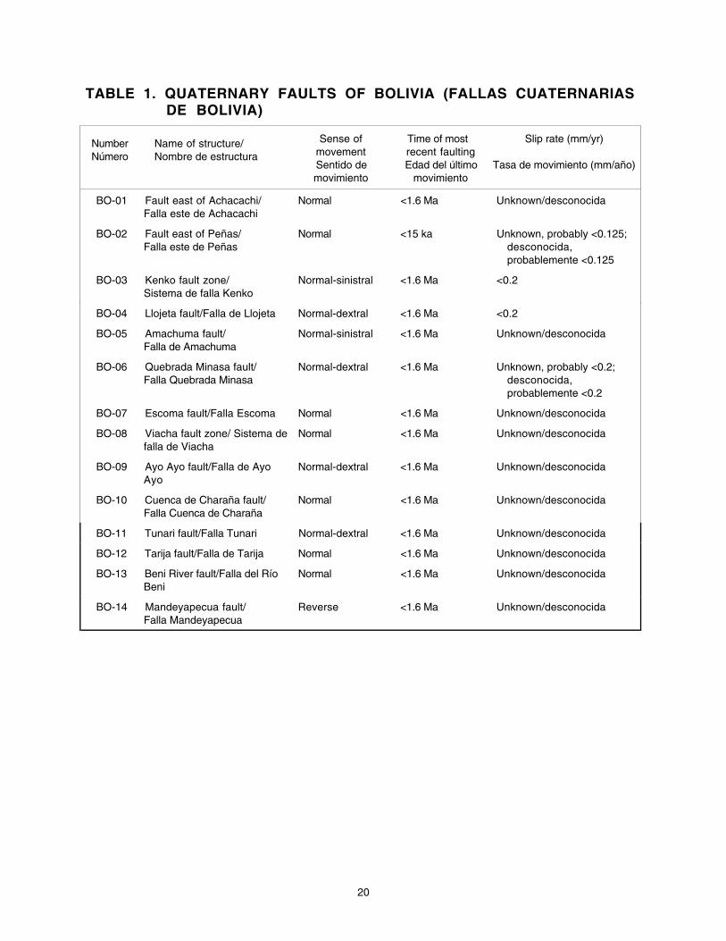
20
TABLE 1. QUATERNARY FAULTS OF BOLIVIA (FALLAS CUATERNARIASDE BOLIVIA)
NumberNúmero
Name of structure/Nombre de estructura
Sense ofmovementSentido demovimiento
Time of mostrecent faultingEdad del último
movimiento
Slip rate (mm/yr)
Tasa de movimiento (mm/año)
BO-01 Fault east of Achacachi/Falla este de Achacachi
Normal <1.6 Ma Unknown/desconocida
BO-02 Fault east of Peñas/Falla este de Peñas
Normal <15 ka Unknown, probably <0.125;desconocida,probablemente <0.125
BO-03 Kenko fault zone/Sistema de falla Kenko
Normal-sinistral <1.6 Ma <0.2
BO-04 Llojeta fault/Falla de Llojeta Normal-dextral <1.6 Ma <0.2
BO-05 Amachuma fault/Falla de Amachuma
Normal-sinistral <1.6 Ma Unknown/desconocida
BO-06 Quebrada Minasa fault/Falla Quebrada Minasa
Normal-dextral <1.6 Ma Unknown, probably <0.2;desconocida,probablemente <0.2
BO-07 Escoma fault/Falla Escoma Normal <1.6 Ma Unknown/desconocida
BO-08 Viacha fault zone/ Sistema defalla de Viacha
Normal <1.6 Ma Unknown/desconocida
BO-09 Ayo Ayo fault/Falla de AyoAyo
Normal-dextral <1.6 Ma Unknown/desconocida
BO-10 Cuenca de Charaña fault/Falla Cuenca de Charaña
Normal <1.6 Ma Unknown/desconocida
BO-11 Tunari fault/Falla Tunari Normal-dextral <1.6 Ma Unknown/desconocida
BO-12 Tarija fault/Falla de Tarija Normal <1.6 Ma Unknown/desconocida
BO-13 Beni River fault/Falla del RíoBeni
Normal <1.6 Ma Unknown/desconocida
BO-14 Mandeyapecua fault/Falla Mandeyapecua
Reverse <1.6 Ma Unknown/desconocida
21
FAULT DATABASE FOR CHILE
CH-01, ATACAMA FAULT ZONE
FAULT NUMBER/NUMERO DE LA FALLA: CH-01FAULT NAME/NOMBRE DE LA FALLA: Atacama (AFZ)SYNOPSIS AND GEOLOGIC SETTING/SINOPSIS Y AMBIENTE GEOLOGICO:
The Atacama Fault Zone (AFZ) is a continuous fault zone extending over 1000 km in the Coastal Rangeof northern Chile, between Iquique (20°S) and La Serena (30°S). During the 60’s and the 70’s, authorsconsidered that dextral motion along the AFZ occured during the early history of the fault (e.g., SaintAmand and Allen, 1960; Arabasz, 1971). More recent works agree in placing the origin of the AFZ in theJurassic-early Cretaceous times showing ductile sinistral shear across the zone (Naranjo and others,1984; Hervé, 1987; Scheuber and Andriessen, 1990). The existence of a sinistral ductile to brittletranstensional region would have been produced by the highly oblique convergence between thePhoenix and South American Plates and the AFZ (Scheuber and Reuter, 1992; Brown and others,1993). Some authors proposed a predominantly vertical motion during late Cenozoic time (Arabasz,1971; Okada, 1971). However, controversial interpretations also exist for this fault zone. According toDelouis and others (1998), “the formerly continuous ridge and valleys cut by the east-facing fault scarp arenot horizontally offset, precluding any significant component of lateral displacement during the recenthistory of the fault”. Conversely, Armijo and Thiele (1980) reported a predominant left-lateral componentof motion along one of the main branches of the AFZ (e.g., Carmen Salar faults [CH-01c/d], northeast ofAntofagasta), whereas Dewey and Lamb (1992) considered a small dextral component of displacementalong the same section of the Carmen Salar fault. According to Delouis and others (1998), along the mainbranches of the AFZ, in the area of Salar del Carmen, Mejillones Peninsula and east and southeast ofAntofagasta, no large scale horizontal block motions are taking place. Deformation is essentiallycharacterized by vertical uplift, accompanied by horizontal extension produced by normal faulting.
La Zona de Falla de Atacama (ZFA) es una zona de falla contínua sobre más de 1000 km, en laCordillera de la Costa del norte de Chile, entre Iquique (20°S) y La Serena (30°S). Durante los años 60 y70, autores consideraron que un movimiento dextral a lo largo de la ZFA ocurrió a principio de la historia dela falla (Saint Amand and Allen, 1960; Arabasz, 1971). Trabajos más recientes logran situar el origen de laZFA en el Jurásico-Cretacico inferior, mostrando zona de cizalle dúctil sinestral (Naranjo and others, 1984;Hervé, 1987; Scheuber y Andriessen, 1990). La existencia de una región en transtensión, sinestral dúctila frágil, se debería a la alta oblicuidad de la convergencia entre las placas Phoenix, America del sur y la ZFA(Scheuber y Reuter, 1992; Brown and others, 1993). Otros autores proponen un movimientoessencialmente vertical durante el Cenozoico superior (Arabasz, 1971; Okada, 1971). Pero,interpretaciones diferentes existen a proposito de esta zona. Según Delouis and others (1998), “valles ycrestas antiguamente continuos, cortados por el escarpe de falla con buzamiento al este, no sondesplazados horizontalmente, excluyendo cualquier desplazamiento lateral con componente signicativodurante la historia reciente de la falla”. Armijo y Thiele (1980) reportan un movimiento con componentelateral predominantemente sinestral a lo largo de una de las principales ramas de la ZFA (e.g., fallaa Salardel Carmen [CH-01c/d], nor-este de Antofagasta), mientras Dewey y Lamb (1992) consideraban unapequeña componente dextral a lo largo del mismo seccion de la Falla del Salar del Carmen. Según Delouiset al (1998), a lo largo de las ramas principales de la ZFA, en el area del Salar del Carmen, en la Peninsulade Mejillones y al este y sur-este de Antofagasta, no existen movimientos horizontales de bloques a granescala. La deformación es esencialmente caracterizada por un levantamiento vertical, junto con unaextensión horizontal producida por un fallamiento normal.COMPILER, AFFILIATION, & DATE OF COMPILATION/COMPILADOR, AFILIACION Y FECHA DE
COMPILACION: Alain Lavenu, IRD, France, and RicardoThiele, Univ. de Chile; Chile, 08-1997.TYPE OF STUDIES/TIPOS DE ESTUDIOS: See discussion under separate fault sections/Ver discusión
abajo en cada sección de falla.FAULT GEOMETRY/GEOMETRIA DE LA FALLA:
LENGTH/LONGITUD: 508.3 km (858.3 km cumulative)AVERAGE STRIKE/RUMBO PROMEDIO: 0.9°±23° (N0.9°E±23°)
22
AVERAGE DIP/INCLINACION PROMEDIO: SubverticalSENSE OF MOVEMENT/SENTIDO DE MOVIMIENTO: Normal
NUMBER OF SECTIONS/NOMBRE DE LA SECCIONES: 5Comments/Comentarios: For this compilation, five sections were defined for the Atacama fault zone.Para esta compilación, cinco secciones se definieron para la Zona de Falla de Atacama.
CH-01A, SALAR GRANDE FAULT, SECTION OF ATACAMA FAULT
SECTION NUMBER/NUMERO DE LA SECCION: CH-01aSECTION NAME/NOMBRE DE LA SECCION: Salar Grande fault (section of Atacama fault)/Falla Salar
Grande (seccion de falla de Atacama)SYNOPSIS AND GEOLOGIC SETTING/SINOPSIS Y AMBIENTE GEOLOGICO: Quaternary activity.
General neotectonic field studies. Coastal Cordillera. This fault cuts sediment of the Salar Grande(playa), probably Quaternary in age. This fault is compatible with a N-S right-lateral transpressionaltectonic regime, according to González and others (1997). This fault corresponds to the northern part ofthe Salar Grande fault, more than 400 km long.Actividad cuaternaria. Estudios neotectónicos de campo generales. Cordillera de la Costa. Cortasedimentos del Salar Grande (playa) de edad cuaternaria. Esta falla es compatible con un régimentectónico en transpresión dextral N-S según Gonzalez and others (1997). Esta falla corresponde a laparte norte de la falla del Salar Grande, de más de 400 km de largo.
TYPE OF STUDIES/TIPOS DE ESTUDIOS: Fieldwork and interpretation of satellite images.Trabajos de campo y interpretación de imagenes satelital.
SECTION GEOMETRY/GEOMETRIA DE SECCION:LENGTH/LONGITUD: 27.5 km (88.7 km cumulative)AVERAGE STRIKE/RUMBO PROMEDIO: -29.8°±19° (N29.8°W±19°)AVERAGE DIP/INCLINACION PROMEDIO: Subvertical, towards East/subvertical, hacia el EsteSENSE OF MOVEMENT/SENTIDO DE MOVIMIENTO: Dextral-reverse/dextral-inversaComments/Comentarios: Fault more than 40 km long; average direction is NW-SE. Displacements yet tobe quantified.Falla de más de 40 kilómetros de largo, de dirección promedio NW-SE. Los desplazamientos no sontodavia cuantificados.
GEOMORPHIC EXPRESSION/EXPRESION GEOMORFOLOGICA: This fault section has a 3-m-high scarpwith uplift of the NW block.Este seccion de la falla presenta un escarpe de 3 metros de altura con ascenso del bloque nor-occidental.
SLIP RATE/TASA DE MOVIMIENTO: Unknown/desconocidaTIME OF MOST RECENT OF MOVEMENT/EDAD DEL ULTIMO MOVIMIENTO: Quaternary/Cuaternario (<1.6
Ma)REFERENCES/REFERENCIASGonzalez, G., Jensen, A., Schneider H., 1997, Deformaciones recientes en la terminación norte de la zona de Falla
de Atacama; Salar Grande, norte de Chile—Partición de la deformación por efecto de bloqueamiento del oroclinalandino: VIII°Cong. Geol. Chileno, I, 1, p. 80-84.
CH-01B, PUNTA DE LOBOS FAULT, SECTION OF ATACAMA FAULT
SECTION NUMBER/NUMERO DE LA SECCION: CH-01bSECTION NAME/NOMBRE DE LA SECCION: Punta de Lobos fault (section of Atacama fault)/Falla de
Punta de Lobos (seccionde falla de Atacama)SYNOPSIS AND GEOLOGIC SETTING/SINOPSIS Y AMBIENTE GEOLOGICO: General neotectonic field
studies. Coastal Cordillera. Quaternary activity. This fault cuts Quaternary sediments. The direction ofthe fault is NW-SE, and it is compatible with a N-S right-lateral transpressional tectonic regime, accordingto González and others (1997). This fault corresponds to the northern part of the Salar Grande fault,more than 400 km long.Actividad cuaternaria. Estudios neotectónicos de campo generales. Cordillera de la Costa. Cortasedimentos de edad cuaternaria. Esta falla, NW-SE, es compatible con un régimen tectónico en
23
transpresión dextral N-S según Gonzalez and others (1997). Esta falla corresponde a la parte norte de lafalla del Salar Grande, de más de 400 km de largo.
TYPE OF STUDIES/TIPOS DE ESTUDIOS: Fieldwork and interpretation of satellite images.Trabajos de campo y interpretación de imagenes satelital.
SECTION GEOMETRY/GEOMETRIA DE SECCION:LENGTH/LONGITUD: 41.8 km (41.9 km cumulative)AVERAGE STRIKE/RUMBO PROMEDIO: -38.4°±12° (N38.4°W±12°)AVERAGE DIP/INCLINACION PROMEDIO: Subvertical, toward the East/Subvertical, hacia el ESENSE OF MOVEMENT/SENTIDO DE MOVIMIENTO: Dextral-reverse/Dextral-inversoComments/Comentarios: Fault more than 25 km long, trending N-S.Falla de más de 25 km de largo, de dirección promedio N-S.
GEOMORPHIC EXPRESSION/EXPRESION GEOMORFOLOGICA: Streams subperpendicular to the faultzone are displaced between 3 and 5 m in a right lateral sense.Drenajes subperpendiculares a la zona de falla se encuentran desplazados entre 3 y 5 metros en unsentido dextral.
SLIP RATE/TASA DE MOVIMIENTO: Unknown/desconocidaTIME OF MOST RECENT OF MOVEMENT/EDAD DEL ULTIMO MOVIMIENTO: Quaternary/Cuaternario
(<1.6 Ma)REFERENCES/REFERENCIASGonzalez, G., Jensen, A., Schneider H., 1997, Deformaciones recientes en la terminación norte de la zona de Falla
de Atacama; Salar Grande, norte de Chile—Partición de la deformación por efecto de bloqueamiento del oroclinalandino: VIII° Cong. Geol. Chileno, I, 1, p. 80-84.
CH-01C, NORTHERN PART OF CARMEN SALAR FAULT, SECTION OF ATACAMAFAULT
SECTION NUMBER/NUMERO DE LA SECCION: CH-01cSECTION NAME/NOMBRE DE LA SECCION: Northern part of Carmen Salar fault (section of Atacama
fault)/Parte norte de la Falla del Salar del Carmen (seccion de falla de Atacama)SYNOPSIS AND GEOLOGIC SETTING/SINOPSIS Y AMBIENTE GEOLOGICO: Quaternary activity.
General neotectonic field studies. Coastal Cordillera. This fault cuts sediment of probable Quaternaryage. The fault is compatible with a tectonic regime of N-S right-lateral transpression, according toGonzalez and others (1997).Actividad cuaternaria. Estudios neotectónicos de campo generales. Cordillera de la Costa. Cortasedimentos de edad cuaternaria. Esta falla es compatible con un régimen tectónico en transpresióndextral N-S según Gonzalez and others (1997).
COMPILER, AFFILIATION, & DATE OF COMPILATION/COMPILADOR, AFILIACION Y FECHA DECOMPILACION: Alain Lavenu, IRD, France, and RicardoThiele, Univ. de Chile; Chile, 08-1997.
TYPE OF STUDIES/TIPOS DE ESTUDIOS: Fieldwork and interpretation of satellite images.Trabajos de campo y interpretación de imagenes satelital.
SECTION GEOMETRY/GEOMETRIA DE SECCION:LENGTH/LONGITUD: 230.9 km (321.6 km cumulative)AVERAGE STRIKE/RUMBO PROMEDIO: 12.5°±18° (N12.5°E±18°)AVERAGE DIP/INCLINACION PROMEDIO: 70-80°ESENSE OF MOVEMENT/SENTIDO DE MOVIMIENTO: Dextral-reverse/Dextral-inversoComments/Comentarios: This fault is more than 50 km long with N-S average direction. Displacementshave not been quantified yet.Falla de más de 50 km de largo con dirección promedio N-S. Los desplazamientos no son todaviacuantificados.
GEOMORPHIC EXPRESSION/EXPRESION GEOMORFOLOGICA: This fault section has a 5-m high scarpwith uplift of the eastern block.Este seccion de la falla presenta un escarpe de 5 metros de altura con ascenso del bloque oriental.
SLIP RATE/TASA DE MOVIMIENTO: Unknown/desconocida
24
TIME OF MOST RECENT OF MOVEMENT/EDAD DEL ULTIMO MOVIMIENTO: Quaternary/Cuaternario(<1.6 Ma)
REFERENCES/REFERENCIASGonzalez, G., Jensen, A., Schneider H., 1997, Deformaciones recientes en la terminación norte de la zona de Falla
de Atacama; Salar Grande, norte de Chile—Partición de la deformación por efecto de bloqueamiento del oroclinalandino: VIII° Cong. Geol. Chileno, I, 1, p. 80-84.
CH-01D, SOUTHERN PART OF CARMEN SALAR FAULT, SECTION OF ATACAMAFAULT
SECTION NUMBER/NUMERO DE LA SECCION: CH-01dSECTION NAME/NOMBRE DE LA SECCION: Southern part of Carmen Salar fault (section of Atacama
fault)/Parte sur de la falla de Salar deCarmen (seccion de falla de Atacama)SYNOPSIS AND GEOLOGIC SETTING/SINOPSIS Y AMBIENTE GEOLOGICO: Very recent activity (late
Quaternary). New ruptures formed during the July 1995 earthquake (Monfret and others, 1995) inEstación Uribe, Salar del Carmen. General neotectonic field studies. Coastal Cordillera. This fault cutssediment of probable Neogene to Quaternary age. The large (composite) scarp faces eastward and isbetween 200 and 400 m high. Young scarps represent 8 to 10 m of throw. Fresh ruptures form a 70 cmscarp. There is an antithetic fault strand with dip towards the W. Compatible with an E-W extensionaltectonic regime.Actividad muy reciente (Cuaternario inferior). Rupturas nuevas debidas al sismo de julio 1995, enEstación Uribe, Salar del Carmen. Estudios neotectónicos de campo generales. Cordillera de la Costa.Corta sedimentos de edad probable neógena a cuaternaria. El escarpe resultante, con buzamiento aleste, tiene entre 200 y 400 m. Escarpes frescos presentan rechazo de 8 a 10 m. Las rupturas recientespresentan un escarpe de 70 cm. Presencia de falla antitéticas con buzamiento al W. Esta falla escompatible con un régimen tectónico en extensión E-W.
TYPE OF STUDIES/TIPOS DE ESTUDIOS: Fieldwork and interpretation of aerial photographs.Trabajos de campo y fotointerpretación.
SECTION GEOMETRY/GEOMETRIA DE SECCION:LENGTH/LONGITUD: 100.5 km (102.1 km cumulative)AVERAGE STRIKE/RUMBO PROMEDIO: 10.3°±16° (N10.3°E±16°)AVERAGE DIP/INCLINACION PROMEDIO: East, dip angle unknown/Este, inclinación del plano de falladesconocida.SENSE OF MOVEMENT/SENTIDO DE MOVIMIENTO: NormalComments/Comentarios: This fault section is more than 60 km long, trending N20-30°E; no notablelateral displacement. Delouis and others (1998) pointed out the appearance of normal faulting.Nevertheless, Armijo and Thiele (1990) indicate a left-lateral 100-m displacement component, that wasnot confirmed by Delouis and others.Este seccion de falla de más de 60 km de largo, de dirección promedio N20-30°E sin desplazamientoslaterales notables. Delouis and others (1998) señalan la aparencia de un fallamiento normal. Sinembargo, Armijo y Thiele (1990) notaban un desplazamiento de 100 metros en componente sinestral,que no fue confirmado por Delouis and others
GEOMORPHIC EXPRESSION/EXPRESION GEOMORFOLOGICA: Cumulative scarp is 200-400 m high.Fresh scarps with throw of between 8 and 10 m. Recent ruptures form 70 cm high scarps. Historicruptures (from 1995) are a few cm high.Escarpe acumulativo de 200 a 400 m. Escarpes frescos con rechazo de 8 a 10 m. Rupturas historicas (ode 1995) de algunos cm de alto.
RECURRENCE INTERVAL/INTERVALO DE RECURRENCIA: Unknown/desconocidoComments/Comentarios: Ruptures look very young.Las rupturas presentan un aspecto muy joven.
SLIP RATE/TASA DE MOVIMIENTO: Unknown/desconocidaTIME OF MOST RECENT OF MOVEMENT/EDAD DEL ULTIMO MOVIMIENTO: Historic (1995)/Histórico
(1995)Comments/Comentarios: New ruptures formed during the July 1995 earthquake in Estación Uribe,
25
Salar del Carmen. Other fresh scarps suggest post glacial or Holocene movement (<15 ka).Rupturas nuevas debidas al sismo de julio 1995, en Estación Uribe, Salar del Carmen. Otro escarpesfrescos indican movimiento post glacial o Holoceno (<15 ka).
REFERENCES/REFERENCIASArmijo, R., and Thiele, R., 1990, Active faulting in Northern Chile—Ramp stacking and lateral decoupling along a
subduction plate boundary?: Earth and Planetary Science Letters, v. 98, p. 40-61.Delouis B., 1996, Subduction et déformation continentale au Nord-Chili: France, Univ. Louis Pasteur, Thèse de
Doctorat, 262 p.Delouis B., Philip H., Dorbath L., and Cisternas A., 1998, Recent crustal deformation in the Antofagasta region
(Northern Chile) and the subduction process: Geophysical Journal International, v. 132, p. 302-338.Monfret T., Dorbath L., Caminade, J.P., Pardo, M., Comte, D., Ponce, L. , Cisternas, A., Delouis, B., Rivera, L.,
1995, The July 30, 1995 Antofagasta earthquake—A “hypocritical” seismic event: EOS, Abstracts of the FallMeeting of the Amer. Geophys. Union, v. 76, no. 46, p. F427.
CH-01E, SIERRA DE REMIENDOS FAULT, SECTION OF ATACAMA FAULT
SECTION NUMBER/NUMERO DE LA SECCION: CH-01eSECTION NAME/NOMBRE DE LA SECCION: Sierra de Remiendos fault (section of Atacama fault)/Falla
Sierra de Remiendos (seccion de falla de Atacama)SYNOPSIS AND GEOLOGIC SETTING/SINOPSIS Y AMBIENTE GEOLOGICO: General neotectonic field
studies. Coastal Cordillera. Very recent activity (Quaternary). Both old and new ruptures exist, the latterdue to the July 30, 1995 Antofagasta earthquake (Monfret and others, 1995), between Paposo andAntofagasta. According to Delouis and others (1997), the most recent ruptures formed a 20-cm highvertical scarp. This fault is compatible with an E-W extensional tectonic regime.Estudios neotectónicos de campo generales. Cordillera de la Costa. Actividad (Cuaternaria) muyreciente. Existen rupturas antiguea y rupturas nuevas debidas al Sierra de Remiendos sismo del 30 dejulio de 1995, entre Paposo y Antofagasta según Delouis and others (1997). La falla corta sedimentosde edad probable neógena a cuaternaria. Las rupturas más recientes presentan un escarpe vertical de20 cm. Esta falla es compatible con un régimen tectónico en extensión E-W.
TYPE OF STUDIES/TIPOS DE ESTUDIOS: Fieldwork and interpretation of aerial photographs.Trabajos de campo y fotointerpretación.
SECTION GEOMETRY/GEOMETRIA DE SECCION:LENGTH/LONGITUD: 157.9 km (304.0 km cumulative)AVERAGE STRIKE/RUMBO PROMEDIO: -0.1°±14° (N0.1°W±14°)AVERAGE DIP/INCLINACION PROMEDIO: Dip subvertical to east/Buzamiento subvertical a esteSENSE OF MOVEMENT/SENTIDO DE MOVIMIENTO: Normal
GEOMORPHIC EXPRESSION/EXPRESION GEOMORFOLOGICA: Vertical scarp 20 cm high.Escarpe vertical de 20 cm.
RECURRENCE INTERVAL/INTERVALO DE RECURRENCIA: Unknown/desconocidaComments/Comentarios: The rupture can be followed for several hundred meters. Recent rupturesform a vertical scarp 20 cm high.La ruptura se sigue sobre varios centenares de metros. Las rupturas las más recientes presentan unescarpe vertical de 20 cm.
SLIP RATE/TASA DE MOVIMIENTO: Unknown/desconocidaTIME OF MOST RECENT OF MOVEMENT/EDAD DEL ULTIMO MOVIMIENTO: Historic/Historico (1995)
Comments/Comentarios: Ruptures from the July 30, 1995 Sierra de Remiendos earthquake, betweenPaposo and Antofagasta according to Delouis and others (1997). Other fresh scarps suggest postglacial or Holocene movement (<15 ka).Exiten rupturas nuevas debidas al sismo de Antofagasta del 30 de julio de 1995, entre Paposo yAntofagasta según Delouis and others (1997). Otro escarpes frescos indican movimiento post glacial oHoloceno (<15 ka).
NAME OF EARTHQUAKE/NOMBRE DEL TERREMOTO: AntofagastaDATE/FECHA MAGNITUDE OR INTENSITY/MAGNITUD O INTENSIDAD: July 30,1995, Ms 7.3MOMENT MAGNITUDE Mw 8.0
26
LENGTH OF SURFACE RUPTURE/LONGITUD DE RUPTURA: The rupture can be followed for severalhundred meters./La ruptura se sigue sobre varios centenares de metros.
MAXIMUM SLIP AT SURFACE/DESPLAZAMIENTO MAXIMO EN SUPERFICIE: Vertical displacement of20 cm./Desplazamiento vertical de 20 cm.
SENSE OF MOVEMENT/SENTIDO DE MOVIMIENTO: Normal fault, vertical movement./Falla normal,movimiento vertical.
REFERENCES/REFERENCIASDelouis, B., Monfret, T., Dorbath, L., Pardo, M., Rivera, L., Comte, D., Haessler, H., Caminade, J.P., Ponce, L.,
Kausel, E., Cisternas, A., 1997, The Mw = 8.0 Antofagasta (Northern Chile) earthquake of July 30, 1995—Aprecursor to the end of the large 1877 gap: Bull. Seis. Soc. Amer., v. 87, no. 2, p. 427-445.
Monfret T., Dorbath L., Caminade, J.P., Pardo, M., Comte, D., Ponce, L. , Cisternas, A., Delouis, B., Rivera, L.,1995, The July 30, 1995 Antofagasta earthquake—A hypocritical seismic event: EOS, Abstracts of the FallMeeting of the Amer. Geophys. Union, v. 76, no. 46, p. F427.
CH-02, MORRO MEJILLONES FAULT
FAULT NUMBER/NUMERO DE LA FALLA: CH-02FAULT NAME/NOMBRE DE LA FALLA: Morro MejillonesSYNOPSIS AND GEOLOGIC SETTING/SINOPSIS Y AMBIENTE GEOLOGICO: Very recent activity
(Quaternary). General neotectonic field studies. Coastal Cordillera. This fault cuts sediment of probableNeogene to Quaternary age. The cumulative scarp faces eastward, and it is as much as 400-500 m high;it shows a complex pattern of faceted spurs and uplifted wave-cut abrasion surfaces. The most recentruptures from scarps are between 30 cm and 1.5 m high. This fault is compatible with an E-Wextensional tectonic regime.Actividad (Cuaternaria) muy reciente. Estudios neotectónicos de campo generales. Cordillera de laCosta. La falla corta sedimentos de edad probable neógena a cuaternaria. El escarpe total, conbuzamiento al este, tiene hasta 400-500 m con un conjunto complejo de facetas triangulares ysuperficies de abrasion marinas levantadas. Las rupturas más recientes presentan un escarpe de 30 cma 1.5 m. Esta falla es compatible con un régimen tectónico en extensión E-W.
COMPILER, AFFILIATION, & DATE OF COMPILATION/COMPILADOR, AFILIACION Y FECHA DECOMPILACION: Alain Lavenu, IRD, France, and RicardoThiele, Univ. de Chile; Chile, 08-1997.
TYPE OF STUDIES/TIPOS DE ESTUDIOS: Fieldwork and interpretation of aerial photographs.Trabajos de campo y fotointerpretación.
FAULT GEOMETRY/GEOMETRIA DE LA FALLA:LENGTH/LONGITUD: 25.0 km (25.4 km cumulative)AVERAGE STRIKE/RUMBO PROMEDIO: 4.6°±11° (N4.6°E±11°)AVERAGE DIP/INCLINACION PROMEDIO: Unknown, eastward dip/Desconocida, hacia el esteSENSE OF MOVEMENT/SENTIDO DE MOVIMIENTO: NormalComments/Comentarios: No evidence of lateral movement. Purely normal movement proved by theexistence of tension gashes parallel to the fault.No hay evidencias de movimiento lateral. Movimiento puramente normal comprobado por la presensiade tension gashes paralelas a la falla.
GEOMORPHIC EXPRESSION/EXPRESION GEOMORFOLOGICA: The main fault scarp is between 8 and10 m high on old alluvial fans and is between 5 and 6 m on intermediate age fans. The most recent fansdo not have scarps.El escarpe de la falla principal tiene 8 a 10 m de alto en los abanicos aluviales antiguos y 5 a 6 m en losabanicos aluviales de edad intermedia. Los abanicos más recientes no presentan escarpes.
COMMENTS/COMENTARIOS: An open gash on the trace of the main fault in the most recent alluvial fanmay be the manifestation of a recent seismic (shaking) event.Una grieta abierta en la traza de la falla principal en uno de los abanicos alluviales más recientes podríaser la manifestación de un evento sísmico reciente.
SLIP RATE/TASA DE MOVIMIENTO: Unknown/desconocidaTIME OF MOST RECENT OF MOVEMENT/EDAD DEL ULTIMO MOVIMIENTO: Quaternary/Cuaternario
(<1.6 Ma)

27
REFERENCES/REFERENCIASArmijo, R., Thiele, R., 1990, Active faulting in northern Chile: Ramp stacking and lateral decoupling along a
subduction plate boundary? Earth and Planetary Science Letters, v. 98, p. 40-61.Delouis, B., 1996, Subduction et déformation continentale au Nord-Chili: France, Ph. D.,Univ. Louis Pasteur, 262 p.Delouis, B., Philip, H., Dorbath, L., Cisternas, A., 1998, Recent crustal deformation in the Antofagasta region
(Northern Chile) and the subduction process: Geophysical Journal International, 132, p. 302-338.Ortlieb, L., Goy, J.L., Zazo, C., Hillaire-Marcel, C., Ghaleb, B., Guzman, N., Thiele, R., 1996, Quaternary
morphostratigraphy and vertical deformation in Mejillones Peninsula, Northern Chile: St. Malo, France, ThirdISAG, p. 211-214.
CH-03, CERRO GORDO FAULT, ATACAMA FAULT ZONE
FAULT NUMBER/NUMERO DE LA FALLA: CH-03FAULT NAME/NOMBRE DE LA FALLA: Cerro Gordo (Atacama fault zone/sistema falla de Atacama)SYNOPSIS AND GEOLOGIC SETTING/SINOPSIS Y AMBIENTE GEOLOGICO: Very recent activity
(Quaternary). General neotectonic field studies. Coastal Cordillera. This fault cuts sediment of probableNeogene to Quaternary age. Scarp of nearly 2 m height. The average direction of this fault is N25°E,and it is compatible with an E-W extensional tectonic regime.Actividad (Cuaternaria) muy reciente. Estudios neotectónicos de campo generales. Cordillera de laCosta. Corta sedimentos de edad probable neógena a cuaternaria. Escarpe de 2 m. Esta falle dedirección promedio N25°E es compatible con un régimen tectónico en extension E-W.
COMPILER, AFFILIATION, & DATE OF COMPILATION/COMPILADOR, AFILIACION Y FECHA DECOMPILACION: Alain Lavenu, IRD, France, and RicardoThiele, Univ. de Chile; Chile, 08-1997.
TYPE OF STUDIES/TIPOS DE ESTUDIOS: Fieldwork and interpretation of aerial photographsTrabajos de campo y fotointerpretación.
FAULT GEOMETRY/GEOMETRIA DE LA FALLA:LENGTH/LONGITUD: 18.5 km (18.5 km cumulative)AVERAGE STRIKE/RUMBO PROMEDIO: 15.7°±7° (N15.7°E±7°)AVERAGE DIP/INCLINACION PROMEDIO: East; dip angle unknown/Este; buzamiento de falladesconocida.SENSE OF MOVEMENT/SENTIDO DE MOVIMIENTO: Normal-sinistral.Comments/Comentarios: Fault has 3 m left-lateral and 2 m vertical displacement.Desplazamiento de 3 m en sentido sinestral y 2 m en sentido vertical.
GEOMORPHIC EXPRESSION/EXPRESION GEOMORFOLOGICA: The scarp is as much as 2 m high.Sediment is trapped in small playa lakes along the fault.El escarpe puede alcanzar 2 m de alto. Sedimentos se entrampan en pequeños salares a lo largo de lafalla.
RECURRENCE INTERVAL/INTERVALO DE RECURRENCIA: Unknown/desconocidoSLIP RATE/TASA DE MOVIMIENTO: Unknown/desconocidaTIME OF MOST RECENT OF MOVEMENT/EDAD DEL ULTIMO MOVIMIENTO: Quaternary/Cuaternario
(<1.6 Ma)Comments/Comentarios: The activity could be more recent, possibly post glacial (<15 ka)El movimiento podría ser mas recientes, de edad post-glacial (<15 ka).
REFERENCES/REFERENCIASDelouis B., 1996, Subduction et déformation continentale au Nord-Chili: France, Ph. D., Univ. Louis Pasteur, 262 p.Delouis B., Philip H., Dorbath L., and Cisternas A., 1998, Recent crustal deformation in the Antofagasta region
(Northern Chile) and the subduction process: Geophysical Journal International, v. 132, p. 302-338.
CH-04, CERRO MORENO FAULT, ATACAMA FAULT ZONE
FAULT NUMBER/NUMERO DE LA FALLA: CH-04FAULT NAME/NOMBRE DE LA FALLA: Cerro Moreno (Atacama fault zone/sistema falla de Atacama)SYNOPSIS AND GEOLOGIC SETTING/SINOPSIS Y AMBIENTE GEOLOGICO: Very recent activity
(Quaternary). General neotectonic field studies. Coastal Cordillera. This fault cuts sediment of probableNeogene to Quaternary age. The scarps face eastward and are as much as 60 cm high, with a 5 m left-
28
lateral displacement according to Armijo and Thiele, 1990 (primarily a left-lateral fault with small normalcomponent). The ratio between horizontal and vertical displacement increases in a NE direction. Thefault has an average trend of N25°E, and is compatible with an E-W extensional tectonic regime (Delouisand others, 1998).Actividad (Cuaternaria) muy reciente. Estudios neotectónicos de campo generales. Cordillera de laCosta.Corta sedimentos de edad probable neógena a cuaternaria. El escarpe, con buzamiento al este,tiene hasta 60 cm con un desplazamiento lateral sinestral de 5 m según Armijo y Thiele 1990 (fallasinestral con componente normal debil). La relación desplazamiento horizontal vs desplazamientovertical aumenta cuando la falla tiene una dirección hacia el NE. Esta falla de dirección promedio N25°Ees compatible con un regimén tectónico en extensión E-W (Delouis and others, 1998).
COMPILER, AFFILIATION, & DATE OF COMPILATION/COMPILADOR, AFILIACION Y FECHA DECOMPILACION: Alain Lavenu, IRD, France, and RicardoThiele, Univ. de Chile; Chile, 08-1997.
TYPE OF STUDIES/TIPOS DE ESTUDIOS: Fieldwork and interpretation of aerial photographs.Trabajos de campo y fotointerpretación.
FAULT GEOMETRY/GEOMETRIA DE LA FALLA:LENGTH/LONGITUD: 47.4 km (45.6 km cumulative)AVERAGE STRIKE/RUMBO PROMEDIO: 14.8°±9° (N14.8°E±9°)AVERAGE DIP/INCLINACION PROMEDIO: East; dip angle unknown/Este; buzamiento del plano defalla desconocidaSENSE OF MOVEMENT/SENTIDO DE MOVIMIENTO: Sinistral-normal
GEOMORPHIC EXPRESSION/EXPRESION GEOMORFOLOGICA: According to Delouis and others(1998), this scarp is 1.8 m high./ Según Delouis and others (1998), este escarpe tiene 1.8 m de alto.
RECURRENCE INTERVAL/INTERVALO DE RECURRENCIA: Unknown/desconocidoSLIP RATE/TASA DE MOVIMIENTO: Unknown/desconocidaTIME OF MOST RECENT OF MOVEMENT/EDAD DEL ULTIMO MOVIMIENTO: Quaternary/Cuaternario
(<1.6 Ma)REFERENCES/REFERENCIASArmijo, R., Thiele, R., 1990, Active faulting in northern Chile: ramp stacking and lateral decoupling along a subduction
plate boundary? Earth and Planetary Science Letters, v. 98, p. 40-61.Delouis, B., 1996, Subduction et déformation continentale au Nord-Chili: France, Univ. Louis Pasteur, Thèse de
Doctorat, 262 p.Delouis, B., Philip, H., Dorbath, L., Cisternas, A., 1998, Recent crustal deformation in the Antofagasta region
(Northern Chile) and the subduction process: Geophysical Journal International, 132, p. 302-338.
CH-05, CERRO FORTUNA FAULT
FAULT NUMBER/NUMERO DE LA FALLA: CH-05FAULT NAME/NOMBRE DE LA FALLA: Cerro Fortuna (Atacama fault zone/sistema falla de Atacama)SYNOPSIS AND GEOLOGIC SETTING/SINOPSIS Y AMBIENTE GEOLOGICO: Very recent activity
(Quaternary). General neotectonic field studies. Limits several westward tilted blocks, 1 km wide and 6km long in the northernmost part of the Coastal Cordillera. This fault cuts sediments of probableNeogene to Quaternary age. The cumulative scarp, dipping eastward, is as much as 60 m high. Themost recent faults form scarps ranging from 30 cm to 1.5 m in height. This fault is compatible with an E-Wextensional tectonic regime.Actividad (Cuaternaria) muy reciente. Estudios neotectónicos de campo generales. Limita variosbloques basculados hacia el oeste de 1 km de ancho con 6 km de largo en el parte norte de la Cordillerade la Costa. Corta sedimentos de edad probable neógena a cuaternaria. El escarpe total, conbuzamiento al este, tiene hasta 60 m. Las rupturas más recientes presentan un escarpe de 30 cm a 1.5m. Esta falla es compatible con un régimen tectónico en extensión E-W.
COMPILER, AFFILIATION, & DATE OF COMPILATION/COMPILADOR, AFILIACION Y FECHA DECOMPILACION: Alain Lavenu, IRD, France, and RicardoThiele, Univ. de Chile; Chile, 08-1997.
TYPE OF STUDIES/TIPOS DE ESTUDIOS: Fieldwork and interpretation of aerial photographs.Trabajos de campo y fotointerpretación.
29
FAULT GEOMETRY/GEOMETRIA DE LA FALLA:LENGTH/LONGITUD: 94.7 km (115.0 km cumulative)AVERAGE STRIKE/RUMBO PROMEDIO: 11.1°±16° (N11.1°E±16°)AVERAGE DIP/INCLINACION PROMEDIO: 60° ESENSE OF MOVEMENT/SENTIDO DE MOVIMIENTO: NormalComments/Comentarios: This fault is more than 80 km long, trending N5-15°E. Armijo and Thiele (1990)observed a left-lateral component of movement.Falla de más de 80 km de largo, de dirección promedio N5-15°E. Armijo y Thiele (1990) observaron unacomponente sinestral.
GEOMORPHIC EXPRESSION/EXPRESION GEOMORFOLOGICA: Forms 60-m high cumulative scarp,fresh scarps from 30 cm to 1.5 m high. Tension gashes appear parallel to the scarp.Escarpe total de 60 m, con escarpe frescos de 30 cm a 1.5 m. Existencia de grietas de tensión paralelasal escarpe.
RECURRENCE INTERVAL/INTERVALO DE RECURRENCIA: Unknown/desconocidaComments/Comentarios: The fault remained inactive for a long period, but the presence of a freshrupture on an old eroded scarp indicates that it has been reactivated two times recently.La falla quedó inactiva durante un largo periodo, pero la presencia de una ruptura fresca y de un antiguoescarpe erodado indica que fue reactivada dos veces recientemente.
SLIP RATE/TASA DE MOVIMIENTO: Unknown/desconocidaTIME OF MOST RECENT OF MOVEMENT/EDAD DEL ULTIMO MOVIMIENTO: Quaternary/Cuaternario
(<1.6 Ma)REFERENCES/REFERENCIASArmijo, R., Thiele, R., 1990, Active faulting in northern Chile: ramp stacking and lateral decoupling along a subduction
plate boundary?: Earth and Planetary Science Letters, v. 98, p. 40-61.Delouis, B., 1996, Subduction et déformation continentale au Nord-Chili: France, Ph.D., Univ. Louis Pasteur, 262 p.Delouis, B., Philip, H., Dorbath, L., Cisternas, A., 1998, Recent crustal deformation in the Antofagasta region
(Northern Chile) and the subduction process: Geophysical Journal International, 132, p. 302-338.
CH-06, WESTERN BACK THRUST FAULT OF CERRO DE PURILACTIS
FAULT NUMBER/NUMERO DE LA FALLA: CH-06FAULT NAME/NOMBRE DE LA FALLA: Western Back Thrust of Cerro de PurilactisSYNOPSIS AND GEOLOGIC SETTING/SINOPSIS Y AMBIENTE GEOLOGICO: Quaternary activity
described in 1990 (Jolley and others, 1990). General tectonic field studies. The fault trace is continuousand has placed the Upper Cretaceous Purilactis Formation over a Tertiary and Pleistocene sequence,west of the Cerros de Purilactis.Actividad Cuaternaria descrita en 1990 (Jolley and others, 1990). Estudios tectónicos de campogenerales. La traza de la falla es contínua y hace cabalgar la formación Purilactis del Cretácico superiorsobre una secuencia terciaria y pleistocena, al oeste de los Cerros Purilactis.
COMPILER, AFFILIATION, & DATE OF COMPILATION/COMPILADOR, AFILIACION Y FECHA DECOMPILACION: Alain Lavenu, IRD, France, and RicardoThiele, Univ. de Chile; Chile, 08-1997.
TYPE OF STUDIES/TIPOS DE ESTUDIOS: Fieldwork/Trabajos de campoFAULT GEOMETRY/GEOMETRIA DE LA FALLA:
LENGTH/LONGITUD: 15.6 km (15.6 km cumulative)AVERAGE STRIKE/RUMBO PROMEDIO: 27.0°±18° (N27.0°E±18°)AVERAGE DIP/INCLINACION PROMEDIO: 45°E in cross section/45°E en perfilSENSE OF MOVEMENT/SENTIDO DE MOVIMIENTO: Thrust/InversoComments/Comentarios: This fault is more than 20 km long, trending NNE to NEFalla de más de 20 km de largo, de dirección promedio NNE a NE
GEOMORPHIC EXPRESSION/EXPRESION GEOMORFOLOGICA: Unknown/desconocidaSLIP RATE/TASA DE MOVIMIENTO: Unknown/desconocidaTIME OF MOST RECENT OF MOVEMENT/EDAD DEL ULTIMO MOVIMIENTO: Quaternary/Cuaternario
(<1.6 Ma)
30
REFERENCES/REFERENCIASJolley, E.J., Turner, P., Williams, G.D., Hartley, A.J., Flint, S., 1990, Sedimentological response of an alluvial system
to Neogene thrust tectonics, Atacama Desert, northern Chile: Journal of the Geological Society, London, 147, p.769-784.
CH-07, FRONTAL DOMEYKO THRUST FAULT OF LLANO DE LAPACIENCIA
FAULT NUMBER/NUMERO DE LA FALLA: CH-07FAULT NAME/NOMBRE DE LA FALLA: Frontal Domeyko Thrust of Llano de la PacienciaSYNOPSIS AND GEOLOGIC SETTING/SINOPSIS Y AMBIENTE GEOLOGICO: Quaternary activity
described in 1990 (Jolley and others, 1990). General tectonic field studies. The fault trace defines thewestern margin of the Llano de la Paciencia, and it places the Oligocene Paciencia Group overQuaternary-Recent gravels.Actividad cuaternaria descrita en 1990 (Jolley and others, 1990). Estudios tectónicos de campogenerales. La traza de la falla limita al oeste el Llano de la Paciencia y hace cabalgar el Grupo Paciencia,de edad oligocena, sobre gravas del Cuaternario.
COMPILER, AFFILIATION, & DATE OF COMPILATION/COMPILADOR, AFILIACION Y FECHA DECOMPILACION: Alain Lavenu, IRD, France, and RicardoThiele, Univ. de Chile; Chile, 08-1997.
TYPE OF STUDIES/TIPOS DE ESTUDIOS: Fieldwork/Trabajos de campoFAULT GEOMETRY/GEOMETRIA DE LA FALLA:
LENGTH/LONGITUD: 19.6 km (20.2 km cumulative)AVERAGE STRIKE/RUMBO PROMEDIO: 39.2°±19° (N39.2°E±19°)AVERAGE DIP/INCLINACION PROMEDIO: 45°W in cross section/45°W en perfilSENSE OF MOVEMENT/SENTIDO DE MOVIMIENTO: Reverse/InversoComments/Comentarios: This fault is more than 35 km long, trending NEFalla de más de 35 km de largo, de dirección promedio NE
GEOMORPHIC EXPRESSION/EXPRESION GEOMORFOLOGICA: Unknown/desconocidaSLIP RATE/TASA DE MOVIMIENTO: Unknown/desconocidaTIME OF MOST RECENT OF MOVEMENT/EDAD DEL ULTIMO MOVIMIENTO: Quaternary/Cuaternario
(<1.6 Ma)REFERENCES/REFERENCIASJolley, E.J., Turner, P., Williams, G.D., Hartley, A.J., Flint, S., 1990, Sedimentological response of an alluvial system
to Neogene thrust tectonics, Atacama Desert, northern Chile: Journal of the Geological Society, London, 147, p.769-784.
CH-08, IGNIMBRITE BACK THRUST FAULT OF LLANO DE LA PACIENCIA
FAULT NUMBER/NUMERO DE LA FALLA: CH-08FAULT NAME/NOMBRE DE LA FALLA: Ignimbrite Back Thrust of Llano de la PacienciaSYNOPSIS AND GEOLOGIC SETTING/SINOPSIS Y AMBIENTE GEOLOGICO: Quaternary activity
described in 1990 (Jolley and others, 1990). General tectonic field studies. The morphologicalcontinuity of the fan alluvial lobe surface is disrupted and uplifted by the synsedimentary effects of theIgnimbrite Back Thrust (IBT) (Jolley and others, 1990).Actividad cuaternaria descrita en 1990 (Jolley and others, 1990). Estudios tectónicos de campogenerales. La continuidad morfológica de los lóbulos de los abanicos aluviales se encuentra cortada ylevantada por los efectos sinsedimentarios del IBT (Jolley and others, 1990).
COMPILER, AFFILIATION, & DATE OF COMPILATION/COMPILADOR, AFILIACION Y FECHA DECOMPILACION: Alain Lavenu, IRD, France, and RicardoThiele, Univ. de Chile; Chile, 08-1997.
TYPE OF STUDIES/TIPOS DE ESTUDIOS: Fieldwork and interpretation of aerial photographs.Trabajos de campo y fotointerpretación.
31
FAULT GEOMETRY/GEOMETRIA DE LA FALLA:LENGTH/LONGITUD: 6.9 km (6.9 km cumulative)AVERAGE STRIKE/RUMBO PROMEDIO: 35.2°±18° (N35.2°E±18°)AVERAGE DIP/INCLINACION PROMEDIO: ESENSE OF MOVEMENT/SENTIDO DE MOVIMIENTO: Reverse/InversoComments/Comentarios: This active structure is more than 4 km long, trending NNE.Este estructura activo tiene más de 4 km de largo, de dirección promedio NNE.
GEOMORPHIC EXPRESSION/EXPRESION GEOMORFOLOGICA: Presence of gullies and ponds alongthe structural strike of the IBT due to its continued uplift.Presencia de depresiones y charcos a lo largo de la dirección estructural del IBT debidos allevantamiento contínuo.
SLIP RATE/TASA DE MOVIMIENTO: Unknown/desconocidaTIME OF MOST RECENT OF MOVEMENT/EDAD DEL ULTIMO MOVIMIENTO: Quaternary/Cuaternario
(<1.6 Ma)REFERENCES/REFERENCIASJolley, E.J., Turner, P., Williams, G.D., Hartley, A.J., Flint, S., 1990, Sedimentological response of an alluvial system
to Neogene thrust tectonics, Atacama Desert, northern Chile: Journal of the Geological Society, London, 147, p.769-784.
CH-09, EASTERN FRONTAL THRUST FAULT OF LLANO DE LAPACIENCIA
FAULT NUMBER/NUMERO DE LA FALLA: CH-09FAULT NAME/NOMBRE DE LA FALLA: Eastern Frontal Thrust Fault of Llano de la PacienciaSYNOPSIS AND GEOLOGIC SETTING/SINOPSIS Y AMBIENTE GEOLOGICO: Quaternary activity
described in 1990 (Jolley and others, 1990). General tectonic field studies. The morphologicalcontinuity of the fan alluvial lobe surface is uplifted by the synsedimentary effects of the Eastern FrontalThrust (EFT) (Jolley and others, 1990).Actividad cuaternaria descrita en 1990 (Jolley and others, 1990). Estudios tectónicos de campogenerales. La continuidad morfológica de los lóbulos de los abanicos aluviales se encuentra levantadapor los efectos sinsedimentarios del EFT (Jolley and others, 1990).
COMPILER, AFFILIATION, & DATE OF COMPILATION/COMPILADOR, AFILIACION Y FECHA DECOMPILACION: Alain Lavenu, IRD, France, and RicardoThiele, Univ. de Chile; Chile, 08-1997.
TYPE OF STUDIES/TIPOS DE ESTUDIOS: Fieldwork and interpretation of aerial photographs.Trabajos de campo y fotointerpretación.
FAULT GEOMETRY/GEOMETRIA DE LA FALLA:LENGTH/LONGITUD: 14.9 km (15.3 km cumulative)AVERAGE STRIKE/RUMBO PROMEDIO: 4.9°±23° (N4.9°E±23°)AVERAGE DIP/INCLINACION PROMEDIO: Unknown angle to W/Desconocida al WSENSE OF MOVEMENT/SENTIDO DE MOVIMIENTO: Reverse/InversoComments/Comentarios: This active structure is more than 15 km long, trending N-S.El estructura activo de la falla tiene más de 15 km de largo, de dirección promedio N-S.
GEOMORPHIC EXPRESSION/EXPRESION GEOMORFOLOGICA:.SLIP RATE/TASA DE MOVIMIENTO: Unknown/desconocidaTIME OF MOST RECENT OF MOVEMENT/EDAD DEL ULTIMO MOVIMIENTO: Quaternary/Cuaternario
(<1.6 Ma)REFERENCES/REFERENCIASJolley, E.J., Turner, P., Williams, G.D., Hartley, A.J., Flint, S., 1990, Sedimentological response of an alluvial system
to Neogene thrust tectonics, Atacama Desert, northern Chile: Journal of the Geological Society, London, 147, p.769-784.
32
CH-10, FRONTAL THRUST FAULT OF CORDILLERA DE LA SAL
FAULT NUMBER/NUMERO DE LA FALLA: CH-10FAULT NAME/NOMBRE DE LA FALLA: Frontal Thrust of Cordillera de la SalSYNOPSIS AND GEOLOGIC SETTING/SINOPSIS Y AMBIENTE GEOLOGICO: Quaternary activity
described in 1990 (Jolley and others, 1990). General tectonic field studies. The morphologicalcontinuity of the alluvial plain of the Salar de Atacama has been progressively deformed by thesynsedimentary effects of the Cordillera de la Sal Frontal Thrust (CDSFT) (Jolley and others, 1990).Actividad cuaternaria descrita en 1990 (Jolley and others, 1990). Estudios tectónicos de campogenerales. La continuidad morfológica de la planicie aluvial del Salar de Atacama ha sido deformada porlos efectos sinsedimentarios del CDSFT (Jolley and others, 1990).
COMPILER, AFFILIATION, & DATE OF COMPILATION/COMPILADOR, AFILIACION Y FECHA DECOMPILACION: Alain Lavenu, IRD, France, and RicardoThiele, Univ. de Chile; Chile, 08-1997.
TYPE OF STUDIES/TIPOS DE ESTUDIOS: Fieldwork and interpretation of aerial photographs.Trabajos de campo y fotointerpretación.
FAULT GEOMETRY/GEOMETRIA DE LA FALLA:LENGTH/LONGITUD: 34.7 km (36.5 km cumulative)AVERAGE STRIKE/RUMBO PROMEDIO: 42.3°±19° (N42.3°E±19°)AVERAGE DIP/INCLINACION PROMEDIO: Unknown angle to W/Desconocida al WSENSE OF MOVEMENT/SENTIDO DE MOVIMIENTO: Reverse/InversoComments/Comentarios: This fault is more than 30 km long, trending NE.La falla tiene más de 30 km de largo, de dirección promedio NE.
GEOMORPHIC EXPRESSION/EXPRESION GEOMORFOLOGICA: Unknown/desconocidaSLIP RATE/TASA DE MOVIMIENTO: Unknown/desconocidaTIME OF MOST RECENT OF MOVEMENT/EDAD DEL ULTIMO MOVIMIENTO: Quaternary/Cuaternario
(<1.6 Ma)REFERENCES/REFERENCIASJolley, E.J., Turner, P., Williams, G.D., Hartley, A.J., Flint, S., 1990, Sedimentological response of an alluvial system
to Neogene thrust tectonics, Atacama Desert, northern Chile: Journal of the Geological Society, London, 147, p.769-784.
CH-11, TUCUCARO FAULT
FAULT NUMBER/NUMERO DE LA FALLA: CH-11FAULT NAME/NOMBRE DE LA FALLA: TucúcaroSYNOPSIS AND GEOLOGIC SETTING/SINOPSIS Y AMBIENTE GEOLOGICO: Quaternary activity
described in 1984 (Niemeyer, 1984). General tectonic field studies. This fault defines the easternmargin of the Cordon de Lila and the western margins of the Pampas de los Perdidos and El Jilguero,south of the Salar de Atacama. The last motion of the fault affects the Ignimbrite Tucúcaro (3.2 ± 0.3 Ma,Ramirez y Gardeweg, 1982) and Quaternary aluvial deposits, but not younger aluvial fans.Actividad Cuaternaria descrita en 1990 (Jolley and others, 1990). Estudios tectónicos de campogenerales. Esta falla limita al este el Cordon de Lila y al oeste las Pampas de los Perdidos y El Jilguero, alsur del Salar de Atacama. El último movimiento de la falla afecta a la Ignimbrita Tucúcaro (3.2 ± 0.3 Ma,Ramirez y Gardeweg, 1982) y depósitos aluviales cuaternarios pero no a abanicos aluviales másrecientes.
COMPILER, AFFILIATION, & DATE OF COMPILATION/COMPILADOR, AFILIACION Y FECHA DECOMPILACION: Alain Lavenu, IRD, France, and RicardoThiele, Univ. de Chile; Chile, 08-1997.
TYPE OF STUDIES/TIPOS DE ESTUDIOS: Fieldwork and interpretation of aerial photographs.Trabajos de campo y fotointerpretación.
33
FAULT GEOMETRY/GEOMETRIA DE LA FALLA:LENGTH/LONGITUD: 30.2 km (28.7 km cumulative)AVERAGE STRIKE/RUMBO PROMEDIO: 8.2°±20° (N8.2°E±20°)AVERAGE DIP/INCLINACION PROMEDIO: 50°WSENSE OF MOVEMENT/SENTIDO DE MOVIMIENTO: Reverse/InversoComments/Comentarios: This fault is more than 25 km long, trending N-S to NNE.El falla tiene más de 25 km de largo, de dirección promedio N-S a NNE.
GEOMORPHIC EXPRESSION/EXPRESION GEOMORFOLOGICA: The scarp faces toward the east andthe throw is of approx. 3 m.El escarpe de falla es hacia el este y el rechazo es de unos 3 metros.
SLIP RATE/TASA DE MOVIMIENTO: Unknown/desconocidaTIME OF MOST RECENT OF MOVEMENT/EDAD DEL ULTIMO MOVIMIENTO: Quaternary/Cuaternario
(<1.6 Ma)REFERENCES/REFERENCIASNiemeyer, H., 1984, La mega falla Tucúcaro en el extremo sur del Salar de Atacama: una antigua zona de cizalle
reactivada en el Cenozoico: Comunicaciones, 34, p. 37-45, Univ. de Chile, Santiago.
CH-12, FAULTS SOUTH OF CALDERA
FAULT NUMBER/NUMERO DE LA FALLA: CH-12FAULT NAME/NOMBRE DE LA FALLA: South of Caldera (informal name)/Sur de Caldera (sin nombre)SYNOPSIS AND GEOLOGIC SETTING/SINOPSIS Y AMBIENTE GEOLOGICO: Quaternary activity
described in 1999 (Marquardt, 1999). General neotectonic field studies. The main fault is 7 km long andaffects marine deposits (Quaternary terrace assigned to the 220 ka marine high stand, i.e. the isotopicstage 7 and Quaternary terrace assigned to the 125 ka marine high stand, i.e., the isotopic stage 5).Southward, two other normal faults are parallel to the main fault. A NNE-trending secondary antitheticsplay, 1.5 km long, linked with the main fault, suggests a small graben related to a NW-SE extension.Actividad Cuaternaria descrita en 1999 (Marquardt, 1999). Estudios neotectónicos de campogenerales. La falla principal tiene una longitud de 7 km y afecta a depósitos marinos (terraza cuaternariaasignada al alto nivel marino de 225 ka, i.e., el estado isotópico 7 y terraza cuaternaria asignada al altonivel marino de 125 ka, i.e. el estado isotópico 5). Hacia el sur, dos otras fallas normales son parallelas aesta falla principal. Una falla segundaria antitética de dirección NNE, de 1.5 km de largo, sugiere unpequeño graben ligado a una extensión NW-SE.
COMPILER, AFFILIATION, & DATE OF COMPILATION/COMPILADOR, AFILIACION Y FECHA DECOMPILACION: Alain Lavenu, IRD, France, and RicardoThiele, Univ. de Chile; Chile, 08-1997.
TYPE OF STUDIES/TIPOS DE ESTUDIOS: Fieldwork and interpretation of aerial photographs.Trabajos de campo y fotointerpretación.
FAULT GEOMETRY/GEOMETRIA DE LA FALLA:LENGTH/LONGITUD: 6.4 km (11.6 km cumulative)AVERAGE STRIKE/RUMBO PROMEDIO: 52.0°±14° (N52.0°E±14°)AVERAGE DIP/INCLINACION PROMEDIO: 65°NWSENSE OF MOVEMENT/SENTIDO DE MOVIMIENTO: NormalComments/Comentarios: The principal fault is more than 7 km long, trending NNE.La falla principal tiene más de 7 km de largo, de dirección promedio NNE.
GEOMORPHIC EXPRESSION/EXPRESION GEOMORFOLOGICA: The scarp faces toward the northwestand the throw is approximately 3 m.El escarpe de falla es hacia el nor-oeste y el rechazo es de unos 3 metros.
RECURRENCE INTERVAL/INTERVALO DE RECURRENCIA: Unknown/desconocidoSLIP RATE/TASA DE MOVIMIENTO: 0.30 mm/yr (0.30 mm/año)TIME OF MOST RECENT OF MOVEMENT/EDAD DEL ULTIMO MOVIMIENTO: Quaternary (<1.6 Ma)
Comments/Comentarios: Classified as Quatenary, but most recent movement is 125 ka.Cuaternairo, pero edad del ultimo movimiento es 125 ka.
34
REFERENCES/REFERENCIASMarquardt, C., 1999, Neotectónica de la franja costera y aportes a la geología regional entre Caldera y Caleta Pajonal
(27°00' - 27°45'), III Región de Atacama: Unpublished thesis, University of Chile, Santiago, 297 p.
CH-13, FAULTS EAST OF BAHIA INGLESA
FAULT NUMBER/NUMERO DE LA FALLA: CH-13FAULT NAME/NOMBRE DE LA FALLA: East of Bahía Inglesa (informal name)/ Est de Bahía Inglesa (sin
nombre)SYNOPSIS AND GEOLOGIC SETTING/SINOPSIS Y AMBIENTE GEOLOGICO: Quaternary activity
described in 1999 (Marquardt, 1999). General neotectonic field studies. The fault is 2.5 km long andaffects marine deposits younger than 125 ka (Quaternary terraces assigned to the isotopic stage 5).This normal fault is compatible with a WNW-ESE extension.Actividad Cuaternaria descrita en 1999 (Marquardt, 1999). Estudios neotectónicos de campogenerales. La falla tiene una longitud de 2.5 km y afecta a depósitos marinos más recientes que 125 ka(terraza Cuaternaria asignada al estado isotópico 5). Esta falla normal es compatible con una extensiónWNW-ESE.
COMPILER, AFFILIATION, & DATE OF COMPILATION/COMPILADOR, AFILIACION Y FECHA DECOMPILACION: Alain Lavenu, IRD, France, and RicardoThiele, Univ. de Chile; Chile, 08-1997.
TYPE OF STUDIES/TIPOS DE ESTUDIOS: Fieldwork and interpretation of aerial photographs.Trabajos de campo y fotointerpretación.
FAULT GEOMETRY/GEOMETRIA DE LA FALLA:LENGTH/LONGITUD: 2.7 km (2.5 km cumulative)AVERAGE STRIKE/RUMBO PROMEDIO: 21.0°±21° (N21.0°E±21°)AVERAGE DIP/INCLINACION PROMEDIO: 80°W in the northern part and 80°E in the southernpart/80°W en el parte norte y 80°E en el parte sur.SENSE OF MOVEMENT/SENTIDO DE MOVIMIENTO: NormalComments/Comentarios: The fault is 2.5 km long, trending NNE.La falla tiene 2.5 km de largo, de dirección promedio NNE.
GEOMORPHIC EXPRESSION/EXPRESION GEOMORFOLOGICA: The scarp faces westward in itsnorthern half and eastward in the southern half, corresponding to a scissors fault. Maximum verticaloffset is up to 4 m.El escarpe de falla es hacia el oeste en el mo norte y hacia el este en la parte sur, lo que corresponde auna falla en tijera. El rechazo máximo es de 4 m.
RECURRENCE INTERVAL/INTERVALO DE RECURRENCIA: Unknown/desconocidoSLIP RATE/TASA DE MOVIMIENTO: 0.27 m/ka (0.27 mm/yr)TIME OF MOST RECENT OF MOVEMENT/EDAD DEL ULTIMO MOVIMIENTO: Quaternary (<1.6 Ma)
Comments/Comentarios: Classified as Quatenary, but most recent movement is 125 ka.Cuaternairo, pero edad del ultimo movimiento es 125 ka.
REFERENCES/REFERENCIASMarquardt, C., 1999, Neotectónica de la franja costera y aportes a la geología regional entre Caldera y Caleta Pajonal
(27°00' - 27°45'), III Región de Atacama: Unpublished thesis, University of Chile, Santiago, 297 p.
CH-14, FAULTS OF ALTO DEL FRAILE
FAULT NUMBER/NUMERO DE LA FALLA: CH-14FAULT NAME/NOMBRE DE LA FALLA: Alto del Fraile (informal name)/ Alto del Fraile (sin nombre)SYNOPSIS AND GEOLOGIC SETTING/SINOPSIS Y AMBIENTE GEOLOGICO: Quaternary activity
described in 1999 (Marquardt, 1999). General neotectonic field studies. Morphological scarps arelinked to two groups of normal faults, trending NW-SE and NE-SW. The scarps affect Quaternary marinedeposits, but the fault planes are not observed.Actividad Cuaternaria descrita en 1999 (Marquardt, 1999). Estudios neotectónicos de campogenerales. Escarpes morfológicos se relacionan a dos grupos de fallas normales de dirección NW-SE yNE-SW. Los escarpes afectan depositos marinos cuaternarios pero no se observan los planos de falla.

35
COMPILER, AFFILIATION, & DATE OF COMPILATION/COMPILADOR, AFILIACION Y FECHA DECOMPILACION: Alain Lavenu, IRD, France, and RicardoThiele, Univ. de Chile; Chile, 08-1997.
TYPE OF STUDIES/TIPOS DE ESTUDIOS: Fieldwork and interpretation of aerial photographs.Trabajos de campo y fotointerpretación.
FAULT GEOMETRY/GEOMETRIA DE LA FALLA:LENGTH/LONGITUD: 9.5 km (24.0 km cumulative)AVERAGE STRIKE/RUMBO PROMEDIO: -4.2°±55° (N4.2°W±55°)AVERAGE DIP/INCLINACION PROMEDIO: Unknown/DesconocidaSENSE OF MOVEMENT/SENTIDO DE MOVIMIENTO: Normal
GEOMORPHIC EXPRESSION/EXPRESION GEOMORFOLOGICA: Morphological scarps only areobserved./Solamente se observan escarpes morfológicos.
RECURRENCE INTERVAL/INTERVALO DE RECURRENCIA: Unknown/desconocidoSLIP RATE/TASA DE MOVIMIENTO: Unknown/desconocidaTIME OF MOST RECENT OF MOVEMENT/EDAD DEL ULTIMO MOVIMIENTO: Quaternary/Cuaternario
(<1.6 Ma)REFERENCES/REFERENCIASMarquardt, C., 1999, Neotectónica de la franja costera y aportes a la geología regional entre Caldera y Caleta Pajonal
(27°00' - 27°45'), III Región de Atacama: Unpublished thesis, University of Chile, Santiago, 297 p.
CH-15, FAULT OF SAN JOSE DE MAIPO
FAULT NUMBER/NUMERO DE LA FALLA: CH-15FAULT NAME/NOMBRE DE LA FALLA: San Jose de Maipo (informal name)/ San Jose de Maipo (sin
nombre)SYNOPSIS AND GEOLOGIC SETTING/SINOPSIS Y AMBIENTE GEOLOGICO: Quaternary activity. Not
described in detail. General neotectonic field studies. Reverse fault affects a high terrace (t5) of theMaipo River, 30 km south-east of Santiago. The age of these fluvial deposits are unknown and could beof middle Pleistocene. The fault does not cut the topographic surface of the terrace. Several smallreverse faults are parallel to the main fault plane. The reverse faults are compatible with a N-S-trendingcompressional deformation.Actividad Cuaternaria. No descrita en detalle. Estudios neotectónicos de campo generales. Una fallainversa afecta una alta terraza (t5) del Rió Maipo, 30 km al sur-este de Santiago. La edad de estosdepositos fluviatiles no se conoce y podría ser del Pleistoceno medio. La falla no cortan la superficietopográfica de la terraza. Otras pequeñas fallas inversas son paralelas a la traza de la falla principal. Lasfallas inversas son compatibles con una compresión de dirección N-S.
COMPILER, AFFILIATION, & DATE OF COMPILATION/COMPILADOR, AFILIACION Y FECHA DECOMPILACION: Alain Lavenu, IRD, France, and RicardoThiele, Univ. de Chile; Chile, 08-1997.
TYPE OF STUDIES/TIPOS DE ESTUDIOS: Fieldwork, interpretation of aerial photographs, numericalanalysis of the faults.Trabajos de campo, fotointerpretación, análisis numérico de las fallas.
FAULT GEOMETRY/GEOMETRIA DE LA FALLA:LENGTH/LONGITUD: 1.7 km (1.7 km cumulative)AVERAGE STRIKE/RUMBO PROMEDIO: 83.0°±0° (N83.0°E±0°)AVERAGE DIP/INCLINACION PROMEDIO: 65°NSENSE OF MOVEMENT/SENTIDO DE MOVIMIENTO: Reverse/Inverso
GEOMORPHIC EXPRESSION/EXPRESION GEOMORFOLOGICA: Unknown/desconocidaSLIP RATE/TASA DE MOVIMIENTO: Unknown/desconocidaTIME OF MOST RECENT OF MOVEMENT/EDAD DEL ULTIMO MOVIMIENTO: Quaternary/Cuaternario
(<1.6 Ma)REFERENCES/REFERENCIASLavenu, A., and Cembrano, J., 1999, Compressional- and transpressional-stress pattern for Pliocene and
Quaternary brittle deformation in fore arc and intra-arc zones (Andes of Central and Southern Chile): Journal ofStructural Geology, v. 21, p. 1669-1691.
36
CH-16, FAULT OF ESPERANZA
FAULT NUMBER/NUMERO DE LA FALLA: CH-16FAULT NAME/NOMBRE DE LA FALLA: Esperanza (informal name)/ Esperanza (sin nombre)SYNOPSIS AND GEOLOGIC SETTING/SINOPSIS Y AMBIENTE GEOLOGICO: Quaternary activity
described in 1999 (Lavenu and Cembrano, 1999). General neotectonic field studies. A reverse faultaffects a high terrace of the Renaico River, 40 km south of Los Angeles. Varela and Moreno (1982)considered the age of the fluvial deposits in this region of the Central Depression as Middle Pleistocene(0.7 Ma) (Unidad del Cono de Quilleco after Thiele and others, 1998). The fault does not cut thetopographic surface of the terrace. Several small reverse faults are parallel or antithetic to the main faultplane. These reverse faults are compatible with a N-S compressional deformation.Actividad Cuaternaria. No descrita. Estudios neotectónicos de campo generales. Una falla inversaafecta una alta terraza del Rió Renaico, 40 km al sur de Los Angeles. Varela y Moreno (1982) estiman laedad de estos depositos fluviatiles, en esta zona de la Depresión Central, como del Pleistoceno medio(0.7 Ma) (Unidad del Cono de Quilleco según Thiele and others, 1998). La falla no corta la superficietopográfica de la terraza. Otras pequeñas fallas inversas son paralelas o antitéticas a la traza de la fallaprincipal. Estas fallas inversas son compatibles con una compresión de dirección N-S.
COMPILER, AFFILIATION, & DATE OF COMPILATION/COMPILADOR, AFILIACION Y FECHA DECOMPILACION: Alain Lavenu, IRD, France, and RicardoThiele, Univ. de Chile; Chile, 08-1997.
TYPE OF STUDIES/TIPOS DE ESTUDIOS: Fieldwork, interpretation of aerial photographs, numericalanalysis of the faults.Trabajos de campo, fotointerpretación, análisis numérico de las fallas.
FAULT GEOMETRY/GEOMETRIA DE LA FALLA:LENGTH/LONGITUD: 2.7 km (2.7 km cumulative)AVERAGE STRIKE/RUMBO PROMEDIO: 64.9°±8° (N64.9°E±9°)AVERAGE DIP/INCLINACION PROMEDIO: 65°SSENSE OF MOVEMENT/SENTIDO DE MOVIMIENTO: Reverse/Inverso
GEOMORPHIC EXPRESSION/EXPRESION GEOMORFOLOGICA: Unknown/desconocidaSLIP RATE/TASA DE MOVIMIENTO: Unknown/desconocidaTIME OF MOST RECENT OF MOVEMENT/EDAD DEL ULTIMO MOVIMIENTO: Quaternary/Cuaternario
(<1.6 Ma)REFERENCES/REFERENCIASLavenu, A., and Cembrano, J., 1999, Compressional- and transpressional-stress pattern for Pliocene and
Quaternary brittle deformation in fore arc and intra-arc zones (Andes of Central and Southern Chile): Journal ofStructural Geology, v. 21, p. 1669-1691.
Lavenu, A., Cembrano, J, 1999, Estados de esfuerzo compresivo plioceno y compresivo-transpresivo pleistoceno,Andes del sur, Chile (38-42°30'S): Revista Geológica de Chile, 26, 1, p. 67-87.
CH-17, FAULT OF VICTORIA
FAULT NUMBER/NUMERO DE LA FALLA: CH-17FAULT NAME/NOMBRE DE LA FALLA: Victoria (informal name)/ Victoria (sin nombre)SYNOPSIS AND GEOLOGIC SETTING/SINOPSIS Y AMBIENTE GEOLOGICO: Quaternary activity
described in 1999 (Lavenu and Cembrano, 1999). General neotectonic field studies. A reverse faultaffects a high terrace of the Traiguen River, 2 km north of Victoria. Varela and Moreno (1982)considered the age of the fluvial deposits in this region of the Central Depression as Middle Pleistocene(0.7 Ma) (Unidad del Cono aluvial de Malleco, equivalent to the "Rodados Multicolores" after Hauser,1986). The fault does not cut the topographic surface of the terrace. Other small reverse faults areparallel to the main fault plane. These reverse faults are compatible with a N-S compressionaldeformation.Actividad Cuaternaria. No descrita. Estudios neotectónicos de campo generales. Una falla inversaafecta una alta terraza del Rió Traiguen, 2 km al norte de Victoria. Varela y Moreno (1982) estiman laedad de estos depositos fluviatiles, en esta zona de la Depresión Central, como del Pleistoceno medio(0.7 Ma) (Unidad del Cono aluvial de Malleco, equivalente de los "Rodados Multicolores" de Hauser,1986).). La falla no cortan la superficie topográfica de la terraza. Otras pequeñas fallas inversas son
37
paralelas a la traza de la falla principal. Estas fallas inversas son compatibles con una compresión dedirección N-S.
COMPILER, AFFILIATION, & DATE OF COMPILATION/COMPILADOR, AFILIACION Y FECHA DECOMPILACION: Alain Lavenu, IRD, France, and RicardoThiele, Univ. de Chile; Chile, 08-1997.
TYPE OF STUDIES/TIPOS DE ESTUDIOS: Fieldwork, interpretation of aerial photographs, numericalanalysis of the faults.Trabajos de campo, fotointerpretación, análisis numérico de las fallas.
FAULT GEOMETRY/GEOMETRIA DE LA FALLA:LENGTH/LONGITUD: 11.4 km (11.4 km cumulative)AVERAGE STRIKE/RUMBO PROMEDIO: -27.5°±6° (N27.5°W±6°)AVERAGE DIP/INCLINACION PROMEDIO: 50°NESENSE OF MOVEMENT/SENTIDO DE MOVIMIENTO: Reverse/Inverso
GEOMORPHIC EXPRESSION/EXPRESION GEOMORFOLOGICA: Unknown/desconocidaSLIP RATE/TASA DE MOVIMIENTO: Unknown/desconocidaTIME OF MOST RECENT OF MOVEMENT/EDAD DEL ULTIMO MOVIMIENTO: Quaternary/Cuaternario
(<1.6 Ma)REFERENCES/REFERENCIASLavenu, A., and Cembrano, J., 1999, Compressional- and transpressional-stress pattern for Pliocene and
Quaternary brittle deformation in fore arc and intra-arc zones (Andes of Central and Southern Chile): Journal ofStructural Geology, v. 21, p. 1669-1691.
Lavenu, A., Cembrano, J, 1999, Estados de esfuerzo compresivo plioceno y compresivo-transpresivo pleistoceno,Andes del sur, Chile (38-42°30'S): Revista Geológica de Chile, 26, 1, p. 67-87.
CH-18, LIQUIÑE-OFQUI FAULT ZONE
FAULT NUMBER/NUMERO DE LA FALLA: CH-18FAULT NAME/NOMBRE DE LA FALLA: Liquiñe-OfquiSYNOPSIS AND GEOLOGIC SETTING/SINOPSIS Y AMBIENTE GEOLOGICO: The regional-scale
geometry of the N-S Liquiñe-Ofqui fault zone (LOFZ), more than 950 km long, is characterized by twomajor NNE-trending sections (the eastern section is the only one obvious, the western being along theMoraleda Channel), joined by a series of an échelon NE-trending lineaments at a right step (Hervé andThiele, 1987; Hervé, 1994). The resulting arrangement has been interpreted as a strike-slip duplex(Cembrano and others, 1996). Along the LOFZ, high strain zones show penetrative foliation in theNorth Patagonian batholith and metamorphic wall rocks (late Miocene and early Pliocene right lateral toreverse right lateral motions). Superposed on the ductile fabric, an anastomosing network of fracturesand faults occurs along conspicuous N-trending lineaments (Pliocene to Quaternary transpressionalright lateral motion, Cembrano, 1998; Lavenu and Cembrano, 1999). Quaternary volcanoes are alignedalong the faults as well as in northeast- and northwest-trending groups oblique to the fault zone. In theextreme northern part of the LOFZ, near the Lonquimay Volcano (38°22.5'S/71°35.5'W) earthquakeswere recorded following the December 25, 1988 eruption. Their focal mechanism is compatible with aN-S trending dextral strike-slip fault, the motion resulting of a NNE-trending maximum compressionalstress. In the extreme southern part of the LOFZ, near the Hudson Volcano, 25 km east of the principalfault trace, a shallow crustal earthquake was recorded on November 28, 1965. The focal mechanismsolution is a dextral-reverse fault trending NNE-SSW, compatible to Quaternary paleostress.La geometría a escala regional de la Zona de Falla Liquiñe-Ofqui (ZFLO) de dirección N-S, y de más de950 kmde largo, se caracteriza por dos seccionos mayores de dirección NNE (el secciono oriental es elmás visible, el occidental siendo en el Canal de Moraleda), que se juntan con unas serie delineamientos en échelon dextrales de dirección NE (Hervé and Thiele, 1987; Hervé, 1994). El arregloresultante fue interpretado como un duplex de rumbo dextral (Cembrano and others, 1996). A lo largode la ZFLO, zonas de alta deformación muestran una foliación penetrativa en las rocas del Batolito Nor-Patagónico y las rocas encajonantes metamórficas (movimientos de rumbo dextral a inverso dextral delMioceno superior y Plioceno inferior). Superpuesta a la fábrica dúctil, una red anastomosada defracturas y fallas ocurre a lo largo de conspicuos lineamientos de dirección N-S (movimiento de rumbotranspresional dextral Plioceno a Cuaternario, Cembrano, 1998; Lavenu y Cembrano, 1999). Volcanes
38
cuaternarios se alignan a lo largo de fallas tanto en grupos de dirección NE como NW, oblicuos a ladirección de la zona de falla. En el extremo norte de la ZFLO, cerca del volcán Lonquimay(38°22.5'S/71°35.5'W) terremotos fueron registrados después de la erupción del 25 de diciembre de1988: El mecanismo focal es compatible con una falla N-S de rumbo dextral, el movimiento resultandode un esfuerzo principal compresivo de dirección NNE-SSW. En el extremo sur de la ZFLO, cerca delvolcán Hudson, 25 km al este de la traza principal de la falla, un terremoto cortical superficial fueregistrado el 28 de noviembre de 1965. La solución del mecanismo focal indica una falla NNE-SSWdextral inversa, compatible con el paleoesfuerzo Cuaternario.
COMPILER, AFFILIATION, & DATE OF COMPILATION/COMPILADOR, AFILIACION Y FECHA DECOMPILACION: Alain Lavenu, IRD, France, and RicardoThiele, Univ. de Chile; Chile, 08-1997.
TYPE OF STUDIES/TIPOS DE ESTUDIOS: See discussion under separate fault sections/Ver discusiónabajo en las secciones de cada falla
FAULT GEOMETRY/GEOMETRIA DE LA FALLA:LENGTH/LONGITUD: 696.6 km (412.5 km cumulative)AVERAGE STRIKE/RUMBO PROMEDIO: 11.9°±13° (N11.9°E±13°)AVERAGE DIP/INCLINACION PROMEDIO: SubverticalSENSE OF MOVEMENT/SENTIDO DE MOVIMIENTO: Dextral
NUMBER OF SECTIONS/NOMBRE DE LA SECCIONES: 4 [CH-18a, CH-18b, CH-18c, CH-18d],Comments/Comentarios: For this compilation, four sections were defined for the Liquiñe-Ofqui faultZone./Para esta compilación, cuatro secciones fueron definidas para la Zona de Falla Liquiñe-Ofqui.
CH-18A, RELONCAVÍ FAULT, SECTION OF LIQUIÑE-OFQUI FAULT
SECTION NUMBER/NUMERO DE LA SECCION: CH-18aSECTION NAME/NOMBRE DE LA SECCION: Reloncaví fault (section of Liquiñe-Ofqui fault/seccion de
falla Liquiñe-Ofqui)SYNOPSIS AND GEOLOGIC SETTING/SINOPSIS Y AMBIENTE GEOLOGICO: Quaternary activity.
General neotectonic field studies. Main Cordillera. This fault cuts sediment of Mesozoic toNeogene/Quaternary age. This fault is compatible with an NE-SW transpressional tectonic regime.Actividad Cuaternaria. Estudios neotectónicos de campo generales. Cordillera Principal. Cortasedimentos de edad mesozoica a neógena/cuaternaria. Esta falla es compatible con un régimentectónico en transpresión NE-SW.
COMPILER, AFFILIATION, & DATE OF COMPILATION/COMPILADOR, AFILIACION Y FECHA DECOMPILACION: Alain Lavenu, IRD, France, and RicardoThiele, Univ. de Chile; Chile, 08-1997.
TYPE OF STUDIES/TIPOS DE ESTUDIOS: Fieldwork and interpretation of aerial photographs.Trabajos de campo y fotointerpretación.
SECTION GEOMETRY/GEOMETRIA DE LA SECCION:LENGTH/LONGITUD: 90.2 km (60.0 km cumulative)AVERAGE STRIKE/RUMBO PROMEDIO: 3.1°±5° (N3.1°E±5°)AVERAGE DIP/INCLINACION PROMEDIO: VerticalSENSE OF MOVEMENT/SENTIDO DE MOVIMIENTO: DextralComments/Comentarios: This fault section is more than 30 km long, of average trend N10°E. Lateraland vertical displacements have yet to be quantified.Falla de más de 30 km, de dirección promedio N10°E. Los desplazamientos laterales y verticales no sontodavia cuantificados.
GEOMORPHIC EXPRESSION/EXPRESION GEOMORFOLOGICA: This fault section is located in a veryrainy region, impeding good observation of the fault’s morphology. Uplift of the coast along this part ofthe fault zone was observed after the 1960 Valdivia earthquake.Este seccion de la falla se encuentra en una zona muy lluviosa lo que impide una buena obsevación dela morfología de la falla. Se observó levantamiento de la costa en la zona de la falla posteriormente alsismo de Valdivia de 1960
RECURRENCE INTERVAL/INTERVALO DE RECURRENCIA: Unknown/desconocidoSLIP RATE/TASA DE MOVIMIENTO: Unknown/desconocida
39
TIME OF MOST RECENT OF MOVEMENT/EDAD DEL ULTIMO MOVIMIENTO: Quaternary/Cuaternario(<1.6 Ma)
CH-18B, HORNOPIRÉN FAULT, SECTION OF LIQUIÑE-OFQUI FAULT
SECTION NUMBER/NUMERO DE LA SECCION: CH-18bSECTION NAME/NOMBRE DE LA SECCION: Hornopirén fault (section of Liquiñe-Ofqui fault/seccion de
falla Liquiñe-Ofqui)SYNOPSIS AND GEOLOGIC SETTING/SINOPSIS Y AMBIENTE GEOLOGICO: Quaternary activity.
General neotectonic field studies. Main Cordillera. This fault cuts sediment of Mesozoic toNeogene/Quaternary age. Compatible with an NE-SW transpressional tectonic regime.Actividad Cuaternaria. Estudios neotectónicos de campo generales. Cordillera Principal. Cortasedimentos de edad mesozoica a neógena/cuaternaria. Esta falla es compatible con un régimentectónico en transpresión NE-SW
COMPILER, AFFILIATION, & DATE OF COMPILATION/COMPILADOR, AFILIACION Y FECHA DECOMPILACION: Alain Lavenu, IRD, France, and RicardoThiele, Univ. de Chile; Chile, 08-1997.
TYPE OF STUDIES/TIPOS DE ESTUDIOS: Fieldwork and interpretation of aerial photographs.Trabajos de campo y fotointerpretación.
SECTION GEOMETRY/GEOMETRIA DE LA SECCIONLENGTH/LONGITUD: 68.2 km (66.1 km cumulative)AVERAGE STRIKE/RUMBO PROMEDIO: 11.1°±8° (N11.1°E±8°)AVERAGE DIP/INCLINACION PROMEDIO: VerticalSENSE OF MOVEMENT/SENTIDO DE MOVIMIENTO: DextralComments/Comentarios: This fault section is more than 20 km long, trending N10°E. Lateral and verticaldisplacements yet to be quantified.Falla de más de 20 km de largo, de dirección promedio N10°E. Los desplazamientos laterales yverticales no son todavia cuantificados.
GEOMORPHIC EXPRESSION/EXPRESION GEOMORFOLOGICA: This fault section is located in a veryrainy region, impeding a good observation of the fault’s morphology. Uplift of the coast along this part ofthe fault zone was observed after the 1960 earthquake.Este seccion de la falla se encuentra en una zona muy lluviosa lo que impide una buena observación dela morfología de la falla. Se observó levantamiento de la costa en la zona de la falla posteriormente alsismo de 1960
RECURRENCE INTERVAL/INTERVALO DE RECURRENCIA: Unknown/desconocidoSLIP RATE/TASA DE MOVIMIENTO: Unknown/desconocidaTIME OF MOST RECENT OF MOVEMENT/EDAD DEL ULTIMO MOVIMIENTO: Quaternary/Cuaternario
(<1.6 Ma)
CH-18C, PUYUHUAPI FAULT, SECTION OF LIQUIÑE-OFQUI FAULT
SECTION NUMBER/NUMERO DE LA SECCION: CH-18cSECTION NAME/NOMBRE DE LA SECCION: Puyuhuapi fault (section of Liquiñe-Ofqui fault/seccion de
falla Liquiñe-Ofqui)SYNOPSIS AND GEOLOGIC SETTING/SINOPSIS Y AMBIENTE GEOLOGICO: Quaternary activity.
General neotectonic field studies. Main Cordillera. This fault cuts sediment of probable Neogene toQuaternary age. The fault also cuts 1.6 Ma old intrusive rock. This fault is compatible with an NE-SWtranspressional tectonic regime.Actividad cuaternaria. Estudios neotectónicos de campo generales. Cordillera Principal. Cortasedimentos de edad neógena a cuaternaria. Una roca intrusiva de 1.6 Ma está cortada por la falla. Estafalla es compatible con un régimen tectónico en transpresión NE-SW.
COMPILER, AFFILIATION, & DATE OF COMPILATION/COMPILADOR, AFILIACION Y FECHA DECOMPILACION: Alain Lavenu, IRD, France, and RicardoThiele, Univ. de Chile; Chile, 08-1997.
TYPE OF STUDIES/TIPOS DE ESTUDIOS: Fieldwork and interpretation of aerial photographs.Trabajos de campo y fotointerpretación.
40
SECTION GEOMETRY/GEOMETRIA DE LA SECCIONLENGTH/LONGITUD: 163.4 km (174.7 km cumulative)AVERAGE STRIKE/RUMBO PROMEDIO: 6.9°±14° (N6.9°E±14°)AVERAGE DIP/INCLINACION PROMEDIO: VerticalSENSE OF MOVEMENT/SENTIDO DE MOVIMIENTO: DextralComments/Comentarios: This fault section is more than 15 km long, trending N10°E. Lateral and verticaldisplacements yet to be quantified.Este seccion de la falla de más de 15 km de largo, de dirección promedio N10°E. Los desplazamientoslaterales y verticales no son todavia cuantificados.
GEOMORPHIC EXPRESSION/EXPRESION GEOMORFOLOGICA: This fault section is located in a veryrainy region, impeding a good observation of the fault’s morphology.Esta sección de falla se encuentra en una zona muy lluviosa lo que impide una buena observación de lamorfología de la falla.
RECURRENCE INTERVAL/INTERVALO DE RECURRENCIA: Unknown/desconocidoSLIP RATE/TASA DE MOVIMIENTO: Unknown/desconocidaTIME OF MOST RECENT OF MOVEMENT/EDAD DEL ULTIMO MOVIMIENTO: Quaternary/Cuaternario
(<1.6 Ma)
CH-18D, SAN RAFAEL FAULT, SECTION OF LIQUIÑE-OFQUI FAULT
SECTION NUMBER/NUMERO DE LA SECCION: CH-18dSECTION NAME/NOMBRE DE LA SECCION: San Rafael fault (section of Liquiñe-Ofqui fault/seccion de
falla Liquiñe-Ofqui)SYNOPSIS AND GEOLOGIC SETTING/SINOPSIS Y AMBIENTE GEOLOGICO: Quaternary activity,
described in 1989 (Wood, 1989). General neotectonic field studies. Patagonian Batholith. This faultcuts sediment Neogene to Quaternary in age.Actividad cuaternaria, descrita en 1989 (Wood, 1989). Estudios neotectónicos de campo generales.Batólito Patagónico. Corta sedimentos de edad neógena a cuaternaria.
COMPILER, AFFILIATION, & DATE OF COMPILATION/COMPILADOR, AFILIACION Y FECHA DECOMPILACION: Alain Lavenu, IRD, France, and RicardoThiele, Univ. de Chile; Chile, 08-1997.
TYPE OF STUDIES/TIPOS DE ESTUDIOS: Fieldwork and interpretation of aerial photographs.Trabajos de campo y fotointerpretación.
SECTION GEOMETRY/GEOMETRIA DE LA SECCIONLENGTH/LONGITUD: 116.0 km (111.7 km cumulative)AVERAGE STRIKE/RUMBO PROMEDIO: 25.2°±9° (N25.2°E±9°)AVERAGE DIP/INCLINACION PROMEDIO: VerticalSENSE OF MOVEMENT/SENTIDO DE MOVIMIENTO: DextralComments/Comentarios: This fault section is more than 25 km long, trending N10°E. Lateral and verticaldisplacements yet to be quantified.Falla de más de 15 km de largo, de dirección promedio N10°E. Los desplazamientos laterales yverticales no son todavia cantificados.
GEOMORPHIC EXPRESSION/EXPRESION GEOMORFOLOGICA: Forms 3 m high scarp. There are sagponds and swamps along the scarp. Scarp’s length exceeds 25 km on aerial photographs and Landsatimages.Escarpe de 3 m de alto. Presencia de lagunas y pantanos a lo largo del escarpe. La longitud del escarpeen fotos aereas y imagenes Landsat pasa los 25 km.
RECURRENCE INTERVAL/INTERVALO DE RECURRENCIA: Unknown/desconocidoComments/Comentarios: Vertical movements produce flooding of woodlands in southern end of blockto the west of the fault.Movimientos verticales provocan anegamiento de bosque en el bloque oeste de la falla en su extremosur.
SLIP RATE/TASA DE MOVIMIENTO: Unknown/desconocidaTIME OF MOST RECENT OF MOVEMENT/EDAD DEL ULTIMO MOVIMIENTO: Quaternary/Cuaternario
(<1.6 Ma)
41
REFERENCES/REFERENCIASBruggen, J., 1950, Fundamento de la Geología de Chile: Santiago, Chile, Instituto Geografico Militar, 374 p.Cembrano, J., 1998, Kinematics and timing of intra-arc deformation at the southern Andes plate boundary zone:
Ph.D. Thesis, University of Dalhousie, 231 pp.Cembrano, J., Hervé, F., Lavenu, A., 1996, The Liquiñe-Ofqui fault zone: a long lived intra-arc fault system in
southern Chile: Tectonophysics, v. 259, p. 55-66.Forsythe, R., Nelson, E., 1985, Geological manifestations of ridge collision: evidence from the Golfo de Penas-
Taitao basin: Tectonics, v. 4, no. 5, p. 477-495.Hervé, F., 1994, The southern Andes between 39° and 44°S latitude: the geological signature of a transpressure
tectonic regime related to a magmatic arc, in K.J. Reutter, E. Scheuber and P.J. Wigger (eds), Tectonics of theSouthern central Andes, p. 243-248.
Herve, F., Araya, E., Fuenzalida, J., Solano, A., 1979, Edades radiométricas y tectónica neógena en el sectorcostero de Chiloé continental, Xa Región: Actas 2° Cong. Geol. Chileno, v. I, p. F1-F18.
Herve, F., Moreno, H., Parada, M.A., 1974, Granitoids of the Andean Range of Valdivia Province, Chile: PacificGeology, v. 8, p. 39-45.
Hervé, F., Thiele, R., 1987, Estado de conocimiento de las megafallas en Chile y su significado tectónico.Comunicaciones, v. 38, p. 67-91.
Lavenu, A., and Cembrano, J., 1999, Compressional- and transpressional-stress pattern for Pliocene andQuaternary brittle deformation in fore arc and intra-arc zones (Andes of Central and Southern Chile): Journal ofStructural Geology, v. 21, p. 1669-1691.
Lavenu, A., Cembrano, J., 1994, Neotectónica de rumbo dextral en la zona de falla Liquiñe-Ofqui—Geometría,cinemática y tensor de esfuerzo: 7° Cong. Geol. Chileno, v. 1, p. 81-85, Concepción.
Solano, A., 1979, Geología del sector costero de Chiloé continental entre los 41°50’ y 42°10’ de latitud sur: Santiago,Universidad de Chile, Dpto. de Geología, Memoria de Titulo, 122 pp.
Steifel, J., 1970, Das andesprofil im Bereich des 45°südlichen Breitengrades: Geol. Rundchau, v. 59, no. 3, p. 961-979.
Thiele, R., Herve, F., Parada, M.A., Godoy, E., 1986, La Megafalla Liquiñe-Ofqui en el fiordo de Reloncaví (41°30’),Chile: Comunicaciones, v. 37, p. 31-47.
Wood, R.M., 1989, Fallamiento normal reciente en la Laguna de San Rafael, Provincia de Aysen, Chile: Austral.Comunicaciones, Depto. de Geología, Univ. de Chile, v. 40, p. 57-68.
CH-19, RIO SAN JUAN FAULT
FAULT NUMBER/NUMERO DE LA FALLA: CH-19FAULT NAME/NOMBRE DE LA FALLA: Rio San JuanSYNOPSIS AND GEOLOGIC SETTING/SINOPSIS Y AMBIENTE GEOLOGICO: Quaternary activity.
According to Cunningham (1993), the fault is 30 km long. Patagonian Orocline.Actividad cuaternaria. Según Cunningham (1993) la falla tiene una longitud de 30 km. OroclinoPatogoniano.
COMPILER, AFFILIATION, & DATE OF COMPILATION/COMPILADOR, AFILIACION Y FECHA DECOMPILACION: Alain Lavenu, IRD, France, and RicardoThiele, Univ. de Chile; Chile, 08-1997.
TYPE OF STUDIES/TIPOS DE ESTUDIOS: Fieldwork and interpretation of aerial photographs.Trabajos de campo y fotointerpretación.
FAULT GEOMETRY/GEOMETRIA DE LA FALLALENGTH/LONGITUD: 33.0 km (33.1 km cumulative)AVERAGE STRIKE/RUMBO PROMEDIO: 39.6°±6° (N39.6°E±6°)AVERAGE DIP/INCLINACION PROMEDIO: VerticalSENSE OF MOVEMENT/SENTIDO DE MOVIMIENTO: SinistralComments/Comentarios: This fault section is more than 30 km long, with an average NW-SE direction.Este seccion de la falla de más de 30 km de largo, de dirección promedio NW-SE.
GEOMORPHIC EXPRESSION/EXPRESION GEOMORFOLOGICA: Forms linear truncation of rivermeanders.Truncamiento lineal de meandros de ríos.
RECURRENCE INTERVAL/INTERVALO DE RECURRENCIA: Unknown/desconocidoSLIP RATE/TASA DE MOVIMIENTO: Unknown/desconocida
42
TIME OF MOST RECENT OF MOVEMENT/EDAD DEL ULTIMO MOVIMIENTO: Quaternary/Cuaternario(<1.6 Ma)
REFERENCES/REFERENCIASCunningham, W., 1993, Strike-slip faults in the Southernmost Andes and the development of the Patagonian
Orocline: Tectonics, v. 12, no. 1, p. 169-186.Katz, H., 1964, Some new concepts on geosynclinal development and mountain building at the southern end of South
America: Proceeding of the 22nd. International Geological Congress, New Dehli, v. 4, p. 241-255.
CH-20, LAGO FAGNANO FAULT
FAULT NUMBER/NUMERO DE LA FALLA: CH-20Comments/Comentarios: In Argentina, this is also the Lago Fagnano fault [AR-56]. En Argentina, estees la falla Lago Fagnano [AR-56].
FAULT NAME/NOMBRE DE LA FALLA: Lago FagnanoSYNOPSIS AND GEOLOGIC SETTING/SINOPSIS Y AMBIENTE GEOLOGICO: Quaternary activity.
Klepeis (1994), deduced this activity from seismic activity in the southern tip of South America.Cunningham (1993) indicates a left-lateral displacement for this fault.Actividad cuaternaria. Para Klepeis esta actividad se deduce de la actividad sismica en el extremo sur deAmerica del sur (Klepeis, 1994). Para Cunningham (1993) esta falla presenta un desplazamientosenestral.
COMPILER, AFFILIATION, & DATE OF COMPILATION/COMPILADOR, AFILIACION Y FECHA DECOMPILACION: Alain Lavenu, IRD, France, and RicardoThiele, Univ. de Chile; Chile, 08-1997.
TYPE OF STUDIES/TIPOS DE ESTUDIOS: Fieldwork/Trabajos de campo.FAULT GEOMETRY/GEOMETRIA DE LA FALLA:
LENGTH/LONGITUD: 377.5 km (392.4 km cumulative)Comments/Comentarios: Does not include 96 km of fault AR-56 in Argentina/No incluir 96 km de fallaAR-56 en Argentina.AVERAGE STRIKE/RUMBO PROMEDIO: -57.3°±7° (N57.3°W±7°)Comments/Comentarios: Does not include fault AR-56 in Argentina/No incluir falla AR-56 en Argentina.AVERAGE DIP/INCLINACION PROMEDIO: SubverticalSENSE OF MOVEMENT/SENTIDO DE MOVIMIENTO: Sinistral and sinistral-normal
NUMBER OF SECTIONS/NOMBRE DE LA SECCIONES: 2 [CH-20a, CH-20b],Comments/Comentarios: For this compilation, two sections were defined for the Lago Fagnano fault inChile.Para esta compilación, dos secciones fueron definidas para la Falla Fagnano en Chile.
CH-20A, WESTERN SECTION OF LAGO FAGNANO FAULT
SECTION NUMBER/NUMERO DE LA SECCION: CH-20aSECTION NAME/NOMBRE DE LA SECCION: Western section of Lago Fagnano fault/seccion occidental
de falla Lago Fagnano.SYNOPSIS AND GEOLOGIC SETTING/SINOPSIS Y AMBIENTE GEOLOGICO: Quaternary activity.Klepeis (1994), deduced this activity from seismic activity in the southern tip of South America.Cunningham (1993) indicates a left-lateral displacement for this fault.Actividad cuaternaria. Para Klepeis esta actividad se deduce de la actividad sismica en el extremo sur deAmerica del sur (Klepeis, 1994). Para Cunningham (1993) esta falla presenta un desplazamientosinestral.
COMPILER, AFFILIATION, & DATE OF COMPILATION/COMPILADOR, AFILIACION Y FECHA DECOMPILACION: Alain Lavenu, IRD, France, and RicardoThiele, Univ. de Chile; Chile, 08-1997.
TYPE OF STUDIES/TIPOS DE ESTUDIOS: Interpretation of aerial photographs/Fotointerpretación.
43
SECTION GEOMETRY/GEOMETRIA DE LA SECCIONLENGTH/LONGITUD: 282.3 km (280.1 km cumulative)AVERAGE STRIKE/RUMBO PROMEDIO: -55.6°±5° (N55.6°W±5°)AVERAGE DIP/INCLINACION PROMEDIO: VerticalSENSE OF MOVEMENT/SENTIDO DE MOVIMIENTO: Sinistral and sinistral-normalComments/Comentarios: The Chilean part of the fault is more than 20 km long, trending N100°E.La parte chilena de la falla mide más de 20 km, con una dirección promedio N100°E.
GEOMORPHIC EXPRESSION/EXPRESION GEOMORFOLOGICA: According to Cunningham (1993), thefault displaces lithological contacts, cuts meanders of the Rio Cortados, and displaces glacial forms, aswell as forms landslides and scarps.Según Cunningham (1993) se nota la presencia de contactos litológicos desplazados, deslizamientosde terreno, escarpes, meandros de Rio Cortados, formas glaciales desplazadas.
RECURRENCE INTERVAL/INTERVALO DE RECURRENCIA: Unknown/desconocidoSLIP RATE/TASA DE MOVIMIENTO: Unknown/desconocidaTIME OF MOST RECENT OF MOVEMENT/EDAD DEL ULTIMO MOVIMIENTO: Quaternary/Cuaternario
(<1.6 Ma)Comments/Comentarios: The activity could be more recent, possibly post glacial (<15 ka) based onCunningham’s observations.El movimiento podría ser más reciente, de edad post-glacial (<15 ka) según observaciones deCunningham (1993).
CH-20B, EASTERN SECTION OF LAGO FAGNANO FAULT
SECTION NUMBER/NUMERO DE LA SECCION: CH-20bSECTION NAME/NOMBRE DE LA SECCION: Eastern section of Lago Fagnano fault/seccion oriental de
falla Lago Fagnano.Comments/Comentarios: In Argentina, this is the Lago Fagnano fault [AR-56]. En Argentina, este es lafalla Lago Fagnano [AR-56].
SYNOPSIS AND GEOLOGIC SETTING/SINOPSIS Y AMBIENTE GEOLOGICO: Quaternary activity.Klepeis (1994), deduced this activity from seismic activity in the southern tip of South America.Cunningham (1993) indicates a left-lateral displacement for this fault.Actividad cuaternaria. Para Klepeis esta actividad se deduce de la actividad sismica en el extremo sur deAmerica del sur (Klepeis, 1994). Para Cunningham (1993) esta falla presenta un desplazamientosinestral.
COMPILER, AFFILIATION, & DATE OF COMPILATION/COMPILADOR, AFILIACION Y FECHA DECOMPILACION: Alain Lavenu, IRD, France, and RicardoThiele, Univ. de Chile; Chile, 08-1997.
TYPE OF STUDIES/TIPOS DE ESTUDIOS: Fieldwork and interpretation of aerial photographs.Trabajos de campo y fotointerpretación.
SECTION GEOMETRY/GEOMETRIA DE LA SECCIONLENGTH/LONGITUD: 112.3 km (112.4 km cumulative)AVERAGE STRIKE/RUMBO PROMEDIO: -61.5°±6° (N61.5°W±6°)Comments/Comentarios: The Chilean part of the fault trends N100°E./La parte chilena es una direcciónpromedio N100°E.AVERAGE DIP/INCLINACION PROMEDIO: VerticalSENSE OF MOVEMENT/SENTIDO DE MOVIMIENTO: Sinistral and sinistral-normalComments/Comentarios: The Chilean part of the fault is more than 20 km long and trends N100°E.La parte chilena de la falla mide más de 20 km, con una dirección promedio N100°E.
GEOMORPHIC EXPRESSION/EXPRESION GEOMORFOLOGICA: West part of fault is under water.La falla al oeste es submarine.
RECURRENCE INTERVAL/INTERVALO DE RECURRENCIA: Unknown/desconocidoSLIP RATE/TASA DE MOVIMIENTO: Unknown/desconocida
44
TIME OF MOST RECENT OF MOVEMENT/EDAD DEL ULTIMO MOVIMIENTO: Quaternary/Cuaternario(<1.6 Ma)Comments/Comentarios: The activity could be more recent, possibly post glacial (<15 ka) based onCunningham’s observations.El movimiento podría ser más reciente, de edad post-glacial (<15 ka) según observaciones deCunningham (1993).
REFERENCES/REFERENCIASCunningham, W., 1993, Strike-slip faults in the Southernmost Andes and the development of the Patagonian
orocline: Tectonics, v. 12, no. 1, p. 169-186.Katz, H., 1964, Some new concepts on geosynclinal development and mountain building at the southern end of South
America: Proceeding of the 22nd. International Geological Congress, New Dehli, v. 4, p. 241-255.Klepeis, K.A., 1994, The Magallanes and Deseado fault zones: Major segments of the South American-Scotia
transform plate boundary in southermost South America, Tierra de Fuego: Journal of Geophysical Research, v.99, no. B11, p. 22001-22014.

45
TABLE 2. QUATERNARY FAULTS OF CHILE (FALLAS CUATERNARIASDE CHILE)
Number
Número
Name of structure
Nombre de estructura
Sense ofmovementSentido demovimiento
Time of mostrecent faultingEdad del último
movimiento
Slip rate (mm/yr)/
Tasa de movimiento(mm/año)
CH-01 Atacama fault (falla de Atacama)
CH-01a Salar Grande fault (falla del SalarGrande )
Dextral-reverse <1.6 Ma Unknown/desconocida
CH-01b Punta de Lobos fault (falla de Puntade Lobos)
Dextral-reverse <1.6 Ma Unknown/desconocida
CH-01c Fault north of Carmen Salar (fallanorte del Salar del Carmen)
Dextral-reverse <1.6 Ma Unknown/desconocida
CH-01d Fault south of Carmen Salar (falla surdel Salar del Carmen)
Normal Historic (1995) Unknown/desconocida
CH-01e Sierra de Remiendos fault (falla deSierra de Remiendos)
Normal Historic (1995) Unknown/desconocida
CH-02 Morro Mejillones fault (falla del MorroMejillones)
Normal <1.6 Ma Unknown/desconocida
CH-03 Cerro Gordo fault, Atacama fault zone(falla del Cerro Gordo, sistema falla deAtacama)
Normal-sinistral <1.6 Ma(<15 ka?)
Unknown/desconocida
CH-04 Cerro Moreno fault, Atacama fault zone(falla del Cerro Moreno, sistema fallade Atacama)
Normal-sinistral <1.6 Ma(<15 ka?)
Unknown/desconocida
CH-05 Cerro Fortuna fault, Atacama fault zone(falla Cerro Fortuna, sistema falla deAtacama)
Normal <1.6 Ma Unknown/desconocida
CH-06 Western Back Thrust of Cerro dePurilactis (Falla Western Back Thrustdel Cerro de Purilactis
Reverse <1.6 Ma Unknown/desconocida
CH-07 Frontal Domeyko Thrust of Llano de laPaciencia (Falla Frontal DomeykoThrust del Llano de la Paciencia
Reverse <1.6 Ma Unknown/desconocida
CH-08 Ignimbrite Back Thrust of Llano de laPaciencia (Falla Ignimbrite BackThrust del Llano de la Paciencia
Reverse <1.6 Ma Unknown/desconocida
CH-09 Eastern Frontal Thrust of Llano de laPaciencia (Falla Eastern FrontalThrust del Llano de la Paciencia
Reverse <1.6 Ma Unknown/desconocida
CH-10 Cordillera of the Sal Frontal Thrust fault(Falla Frontal Thrust de la Cordillera dela Sal)
Reverse <1.6 Ma Unknown/desconocida
CH-11 Tucúcaro fault (falla Tucúcaro) Reverse <1.6 Ma Unknown/desconocida
CH-12 Faults south of Caldera (fallas al sur deCaldera)
Normal <1.6 Ma(<125 ka)
0.30

46
TABLE 2—CONTINUED
Number
Número
Name of structure
Nombre de estructura
Sense ofmovementSentido demovimiento
Time of mostrecent faultingEdad del último
movimiento
Slip rate (mm/yr)/
Tasa de movimiento(mm/año)
CH-13 Faults East of Bahía Inglesa (fallas estede Bahía Inglesa)
Normal <1.6 Ma(<125 ka)
0.27
CH-14 Faults of Alto del Fraile (fallas de Alto delFraile)
Normal <1.6 Ma Unknown/desconocida
CH-15 Fault of San Jose de Maipo (falla de SanJosé de Maipo)
Reverse <1.6 Ma Unknown/desconocida
CH-16 Fault of Esperanza (falla de Esperanza) Reverse <1.6 Ma Unknown/desconocida
CH-17 Fault of Victoria (falla de Victoria) Reverse <1.6 Ma Unknown/desconocida
CH-18 Liquiñe-Ofqui fault (falla de Liquiñe-Ofqui)
CH-18a Reloncaví fault (falla de Reloncaví) Dextral <1.6 Ma Unknown/desconocida
CH-18b Hornopirén fault (falla de Hornopirén) Dextral <1.6 Ma Unknown/desconocida
CH-18c Puyuhuapi fault (falla de Puyuhuapi) Dextral <1.6 Ma Unknown/desconocida
CH-18d San Rafael fault (falla de San Rafael) Dextral <1.6 Ma Unknown/desconocida
CH-19 Rio San Juan fault (falla Rio San Juan) Sinistral <1.6 Ma Unknown/desconocida
CH-20 Lago Fagnano fault (falla Lago Fagnano)
CH-20a Western section (seccion occidental) Sinistral andsinistral-normal
<1.6 Ma(<15 ka?)
Unknown/desconocida
CH-20b Eastern section (seccion oriental) Sinistral andsinistral-normal
<1.6 Ma(<15 ka?)
Unknown/desconocida