maps api for javascriptdocumentation.developer.here.com/pdf/maps_js_nlp/2... · maps api for...
TRANSCRIPT
Maps API for JavaScriptDeveloper's Guide
Enterprise Version 2.5.3
Maps API for JavaScript Developer's Guide 2► Contents
Contents
Legal Notices..........................................................................................................................................................4
Document Information.................................................................................................................................... 5
Chapter 1: Overview................................................................................................................................. 6What Is the Maps API for JavaScript?........................................................................................................7
Feature List...................................................................................................................................................... 7
Packages and Detection............................................................................................................................... 8
Browser Support............................................................................................................................................. 9
HTML5 Support............................................................................................................................................... 9
Performance.................................................................................................................................................. 10
Chapter 2: Quick Start........................................................................................................................11Basic Scenario............................................................................................................................................... 12
Loading the API Code Library....................................................................................................................12
Customer Integration Testing...................................................................................................................13
URLs to Use.......................................................................................................................................14
Implementing the Application................................................................................................................... 14
Setting Credentials.......................................................................................................................... 15
Displaying a Map.............................................................................................................................. 15
Chapter 3: User Guide......................................................................................................................... 17Acquiring Credentials...................................................................................................................................18
Beyond the Basic Map Application...........................................................................................................18
Map Types......................................................................................................................................................20
Components and User Interaction...........................................................................................................23
Markers........................................................................................................................................................... 25
Geo Objects................................................................................................................................................... 28
Map Overlays.................................................................................................................................................29

Maps API for JavaScript Developer's Guide 3► Contents
A Map of Berlin from 1789............................................................................................................30
Routing............................................................................................................................................................33
Traffic.............................................................................................................................................................. 37
KML Support.................................................................................................................................................. 38
Heat Maps...................................................................................................................................................... 39
Marker Clustering......................................................................................................................................... 41
Positioning......................................................................................................................................................43
Event System.................................................................................................................................................45
Observers and Mutable Objects............................................................................................................... 49
Multi-language Support.............................................................................................................................. 50
Chapter 4: API reference.................................................................................................................. 52nokia................................................................................................................................................................ 53
Features..............................................................................................................................................53
Settings...............................................................................................................................................58
maps....................................................................................................................................................62
Maps API for JavaScript Developer's Guide 4► Legal Notices
Legal Notices© 2013 HERE. All rights reserved.
This material, including documentation and any related computer programs, is protected by
copyright controlled by HERE. All rights are reserved. Copying, including reproducing, storing,
adapting or translating, any or all of this material requires the prior written consent of HERE. This
material also contains confidential information, which may not be disclosed to others without the
prior written consent of HERE.
Trademark Acknowledgements
HERE and Nokia are trademarks or registered trademarks of Nokia Corporation in the United States
and other countries.
Other trade names are trademarks or registered trademarks of their owners.
Disclaimer
This content is provided "as-is" and without warranties of any kind, either express or implied,
including, but not limited to, the implied warranties of merchantability, fitness for a particular
purpose, satisfactory quality and non-infringement. Nokia does not warrant that the content is error
free and Nokia does not warrant or make any representations regarding the quality, correctness,
accuracy, or reliability of the content. you should therefore verify any information contained in the
content before acting on it.
To the furthest extent permitted by law, under no circumstances, including without limitation Nokia's
negligence, shall Nokia be liable for any damages, including, without limitation, direct, special,
indirect, punitive, consequential, exemplary and/ or incidental damages that result from the use or
application of this content, even if Nokia or an authorized representative has been advised of the
possibility of such damages.
Maps API for JavaScript Developer's Guide 5► Document Information
Document Information
Product
Name: Maps API for JavaScript
Version: Enterprise Version 2.5.3
Document
Name: Maps API for JavaScript Developer's Guide
Id: a9bd3dd-1385500279
Status: FINAL
Date: 2013-Nov-26, 21:15 (GMT)
Maps API for JavaScript Developer's Guide 6► Overview
Chapter
1
OverviewTopics:
• What Is the Maps API forJavaScript?
• Feature List
• Packages and Detection
• Browser Support
• HTML5 Support
• Performance
This article defines the HERE Maps API for JavaScript, explains its
purpose, summarizes its features and outlines how it supports
third-party application development.
Maps API for JavaScript Developer's Guide 7► Overview
What Is the Maps API for JavaScript?The HERE Maps API for JavaScript (the Maps API) is a set of programming interfaces that enable
developers to build Web applications with feature rich, interactive HERE Maps at their center. The
API consists of libraries of classes and methods with which to implement the functionality of an
interactive application.
The associated API Explorer offers ready-made working examples, whose code the developer can
modify and view the effect immediately.
Feature ListThe main features offered by the Maps API are summarized in the table below:
Table 1: Main features of the HERE Maps API for JavaScript
Feature Description
HERE Maps map data The API provides full access to world-leading map data in three different modes: satellite,
terrain and hybrid.
Points of interest The map data to which the API offers access, include millions of different places,
landmarks, places and addresses located on maps. Their visibility on the map can be
controlled via the API.
Searches The API allows you to build search functionality into you application. Users can searches for
places, using keywords, addresses, or geographic coordinates.
Geocoding The API provides full access to geocoding and reverse geocoding services.
Routing The API allows you to define and render routes between a start and a destination point. It
supports many navigation options such as toll road preference and transport type.
W3C positioning The API includes built-in functionality that takes advantage of the W3C Geolocation API
supported by many browsers.
Custom items The API allows you to modify existing markers or create custom ones, using SVG or
bitmap images. You can also add geo shapes based on coordinates to the map: polygons,
polylines, circles or rectangles, and make these custom map object interactive by assigning
UI events to them.
Maps API for JavaScript Developer's Guide 8► Overview
Packages and DetectionThe HERE Maps API for JavaScript is modular and contains separate packages for maps, places,
positioning, directions (routing) and data rendering. If an application does not require certain
packages, you can reduce the footprint and load time by excluding them.
The entry point to the API is the JavaScript file "jsl.js" (see also Quick Start on page 11). It contains
a package loader and an environment detection mechanism. To load the API, set the "src" attribute
of a <script> element to the base URL followed by the name of this file. You can alter the packages
loaded by the <script> element by appending the parameter with, followed by the equals sign (=),
followed by a comma-spearated list of packages. If you do not specify any packages (that is if you
use the URL only without the with parameter), the Maps library package is loaded by default.
The table below shows the packages you can select, using the query parameter with and the default
loading behavior.
Table 2: Selectable packages in the HEREMaps API for JavaScript
URL Parameter Allowed Values [1] Default
with maps, positioning, directions, datarendering, all [2] maps
The following notes relate to this table:
[1] values can be combined in a comma-separated sequence; all must not be used if any other
package is specified
[2] all loads all the available libraries
The example below shows an HTML page that loads the following library packages: Maps, Places
(complete), Rouging and Positioning.
<!DOCTYPE html PUBLIC "-//W3C//DTD XHTML 1.0 Transitional//EN""http://www.w3.org/TR/xhtml1/DTD/xhtml1-transitional.dtd"><html xmlns="http://www.w3.org/1999/xhtml"> <head> <meta http-equiv="Content-Type" content="text/html; charset=UTF-8" /> <meta http-equiv="X-UA-Compatible" content="IE=7; IE=EmulateIE9; IE=10" /> <script type="text/javascript" src="http://js.api.here.com/ee/2.5.3/jsl.js?
Maps API for JavaScript Developer's Guide 9► Overview
with=maps,positioning"> </script> </head> <body> ... </body></html>
Please note that the last part of the URL before the name of the JavaScript file is the release version
number for the Maps API, which means that the URL changes, depending on which version you wish to
use.
Browser SupportThe Maps API is a multi-purpose and cross-platform API, targeting all JavaScript-enabled Web
browsers, whether desktop or mobile, as well as all HTML5 environments (see the next section for
information about HTML5 support).
Because the number of possible browser and platform combinations is too large, we limit our support
to the following list of browsers:
Table 3: Browser support in HERE Maps API for JavaScript
Browser Support
Internet Explorer 7+ desktop, Windows Phone with Mango update or later on mobile*
Firefox 3.6+ desktop
Google Chrome 12+ desktop, Android 2.2+ on mobile/tablet*
Apple Safari 5+ desktop, iOS 4+ on mobile/tablet
* support does not extend to all multi-touch gestures
HTML5 SupportAlthough HTML5 is a new emerging HTML standard, and as such it is still undergoing continual
improvement, the HERE Maps API for JavaScript is committed to supporting it.
For information regarding the latest features of HTML5 please visit the official HTML5 Specification
page of the W3C. Details on HTML5 compliance in different Web browsers, are available on THE
HTML5 TEST.
Maps API for JavaScript Developer's Guide 10► Overview
The built-in support for HTML5 in the Maps API enhances the user experience in browsers that
implement the following aspects of the HTML5 specification:
SVG The HTML5 specification allows for embedding of Scalable Vector Graphics
(SVG) in HTML pages. The use of SVG increases the rendering speed of cus-
tom shapes and forms. The Maps API supports the use of SVG icons as cus-
tom markers.
Geolocation Browsers that offer HTML5 geolocation support are able to share their po-
sition on the globe and this means that the Maps API can request the loca-
tion details from the browser. On most mobile devices, geolocation detects
a user’s position to within a few meters. It is also possible to obtain an ac-
curate current position on desktop environments connected to the Inter-
net via Wi-Fi, but note that there may be some delay in response, as the Wi-
Fi positioning look-up is based on a server request. Positioning look-up and
response time vary from browser to browser. The security policy on most
browsers does not automatically allow immediate access and a confirmation
dialog is shown instead. Please bear this in mind when using the geolocation
feature.
PerformanceThe HERE Maps API for JavaScript has been designed to meet the demands of modern Web
application development. The common development patterns it implements help improve efficiency
and shorten the development cycle.
Fast start-up The Maps API for JavaScript is outstanding in terms of memory consump-
tion due to the small size of the underlying JavaScript framework. The map
starts fast and the content loads smoothly.
Fast loading The Maps API for JavaScript provides packaged and lazy loading of features
such as route and search – and even of the map data itself. The content is
downloaded from the server only when needed.
Fast browsing The Maps API for JavaScript supports in-built browser caching. Once the
content has been downloaded from the server, it is reused as much as pos-
sible to minimize bandwidth usage.
Maps API for JavaScript Developer's Guide 11► Quick Start
Chapter
2
Quick StartTopics:
• Basic Scenario
• Loading the API Code Library
• Customer Integration Testing
• Implementing the Application
This article describes the simplest scenario using the Maps API for
JavaScript and illustrates it with a working example.
Note that the example uses demo credentials. These are suitable
for testing, but must be replaced with application-specific
credentials in your own applications.(please see also Acquiring
Credentials on page 18)
Maps API for JavaScript Developer's Guide 12► Quick Start
Basic ScenarioThe most basic scenario is to create an application that displays a non-interactive map. To do that:
1. Load the Maps API for JavaScript library from the HTML page – the "src" attribute of a <script>element within the <head> must point to the Maps package.
2. Set authentication and authorization credentials – this is needed for unlimited access to theHERE Maps API for JavaScript.
3. Implement the application – write the code that implements the behavior of the applicationinside a <script> element in the <body> of the page; it takes only a few lines of JavaScript tocreate a fully functioning application with an interactive map.
Loading the API Code LibraryTo load the Maps library of the HERE Maps API for JavaScript, add the following <script> element to
the <head> of the HTML document:
<script src="http://js.api.here.com/ee/2.5.3/jsl.js" type="text/javascript" charset="utf-8"></script>
The URL in the "src" attribute contains the version number, which is specific to the API release. In
other words, that part of the URL changes with each release of the Maps API.
If you use Microsoft Internet Explorer, you can ensure compatibility by placing this line with a meta
tag before any <script> elements in the <head>:
<meta http-equiv="X-UA-Compatible" content="IE=7; IE=EmulateIE9; IE=10"/>
And here is the complete <head> element that loads the default maps library package of HERE Maps
API for JavaScript and makes sure there is no conflict with IE:
<!DOCTYPE html PUBLIC "-//W3C//DTD XHTML 1.0 Transitional//EN""http://www.w3.org/TR/xhtml1/DTD/xhtml1-transitional.dtd"><html xmlns="http://www.w3.org/1999/xhtml"> <head> ... <meta http-equiv="X-UA-Compatible" content="IE=7; IE=EmulateIE9; IE=10" /> <script src="http://js.api.here.com/ee/2.5.3/jsl.js" type="text/javascript" charset="utf-8"> </script> ...
Maps API for JavaScript Developer's Guide 13► Quick Start
</head>
The file jsl.js contains:
• common classes that are always needed, regardless of the module combination
• a package loader which enables the loading of specific module combinations
• environment detection code that enables the API to determine an optimal set of packages forthe environment
For more information about loading the library and the available options, please see Packages and
Detection on page 8.
Note that if you wish the map to fill the entire window in Internet Explorer 7 or 8, you must set the
CSS attributes that control the position and dimensions of the body element as shown in the example
below, otherwise map will flicker during panning.
<!DOCTYPE html PUBLIC "-//W3C//DTD XHTML 1.0 Transitional//EN""http://www.w3.org/TR/xhtml1/DTD/xhtml1-transitional.dtd"><html xmlns="http://www.w3.org/1999/xhtml"><head> ... <meta http-equiv="X-UA-Compatible" content="IE=7; IE=EmulateIE9; IE=10" /> <style type="text/css"> html { overflow:hidden; }
body { margin: 0; padding: 0; position: absolute; overflow:hidden; width: 100%; height: 100%; }
#mapContainer { width: 100%; height: 100%; left: 0; top: 0; position: absolute; } </style>...</head><body> <div id="mapContainer"></div> ...</body>
Customer Integration TestingHERE is committed to maintain the best possible production service for all customers. Given that the
production environment is live and common to all API users, we request that you use the alternative
Maps API for JavaScript Developer's Guide 14► Quick Start
Customer Integration Testing (CIT) environment when evaluating our products, running tests, making
changes in your code and altering the way you access our APIs.
The CIT environment also allows you to test your software against a newer version of the service
before HERE brings that version into production. CIT offers a fully functional environment for
customers to use for development and testing, but it does not support high loads or performance
testing in general.
Note that the same application id can be used in both environments, but CIT may require a dedicated
application code. If this is the case, please contact us as described under Service Support.
The CIT environment is not intended for general production use.
URLs to UseFor the purposes of testing and evaluation, include the following line in the <head> element of the
HTML page to load the API.
<script src="http://js.cit.api.here.com/ee/2.5.3/jsl.js" type="text/javascript" charset="utf-8"></script>
In addition, place the following line, which selects the staging mode, in the <script> element within
the <body> of the HTML page (see also Implementing the Application on page 14) before you
initiate the map:
nokia.Settings.set("serviceMode", "cit");
To use the production environment, include this line.
<script src="http://js.api.here.com/ee/2.5.3/jsl.js" type="text/javascript" charset="utf-8"></script>
Implementing the ApplicationAt this point, two steps from the Basic Scenario on page 12 remain to be completed to ensure
that the application is complete and functional: we need to provide access credentials and the code
that defines what the application does. To do this, we need to place a <script> element within the
<body> of the HTML page and write the implementation code there.
Maps API for JavaScript Developer's Guide 15► Quick Start
Setting CredentialsAn essential part of creating a working application with the HERE Maps API for JavaScript is to provide
the application credentials. To do that, use the method nokia.Settings() – note that you need
to use the actual app_id and app_code you have received on registration (please see Acquiring
Credentials on page 18 ):
nokia.Settings.set("app_id", "YOUR_APPID");nokia.Settings.set("app_code", "YOUR_TOKEN");
Displaying a MapThe simplest application using the HERE Maps API for JavaScript is one that displays a non-interactive
map centered on a predefined location at a fixed zoom level. To implement it:
1. Define a target HTML element in which the map is to be rendered, setting the "id" attribute on it.
2. Instantiate nokia.maps.map.Display, passing to the constructor the id of the target
element, the desired map zoom level and the coordinates of the location on which you want to
center of the map
Below, you can see the outcome of implementing this simple scenario as a map image and also
(further down the page) the code showing how it has been achieved.
Figure 1: A basic non-interactive map
var map = new nokia.maps.map.Display(
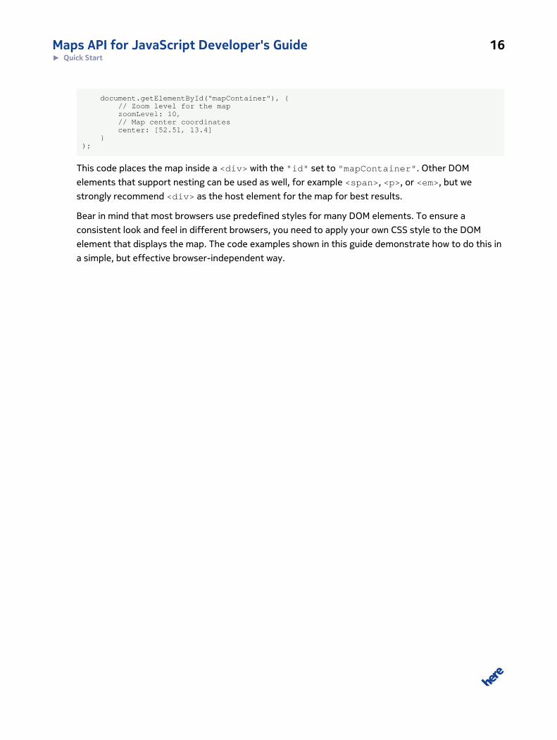
Maps API for JavaScript Developer's Guide 16► Quick Start
document.getElementById("mapContainer"), { // Zoom level for the map zoomLevel: 10, // Map center coordinates center: [52.51, 13.4] });
This code places the map inside a <div> with the "id" set to "mapContainer". Other DOM
elements that support nesting can be used as well, for example <span>, <p>, or <em>, but we
strongly recommend <div> as the host element for the map for best results.
Bear in mind that most browsers use predefined styles for many DOM elements. To ensure a
consistent look and feel in different browsers, you need to apply your own CSS style to the DOM
element that displays the map. The code examples shown in this guide demonstrate how to do this in
a simple, but effective browser-independent way.
Maps API for JavaScript Developer's Guide 17► User Guide
Chapter
3
User GuideTopics:
• Acquiring Credentials
• Beyond the Basic Map Application
• Map Types
• Components and User Interaction
• Markers
• Geo Objects
• Map Overlays
• Routing
• Traffic
• KML Support
• Heat Maps
• Marker Clustering
• Positioning
• Event System
• Observers and Mutable Objects
• Multi-language Support
This part of the guide explains essential concepts and shows how
to use the Maps API for JavaScript. It is a companion to the API
Reference.
The text includes examples that show the API in operation. Note
that where credentials are required, the examples use demo ones.
These are acceptable for testing purposes, but must be replaced
by application-specific credentials in real-life applications (please
see also Acquiring Credentials on page 18).
The HERE Maps API for JavaScript has been designed to help
developers meet the challenges of modern Web application
development. The articles that follow describe various aspects
of the API, including a number of state-of-the-art development
patterns it supports.
Maps API for JavaScript Developer's Guide 18► User Guide
Acquiring CredentialsAll users of HERE APIs must obtain authentication and authorization credentials and provide them as
values for the parameters app_id and app_code. The credentials are assigned per application.
To obtain the credentials for an application, please visit http://developer.here.com/get-started for
more details.
Beyond the Basic Map ApplicationQuick Start on page 11 describes an elementary scenario confined to displaying a non-interactive
map is shown on the screen. Real-life applications are likely to go further, using the Maps API to
deliver interactive functionality, animations, etc. For example, an application may start by showing
a street/physical map and allow the user to select a different map type such as satellite. The
application may also zoom in on a particular location on the map in response to the user double-
clicking on the map.
In the first of these examples, the application user is able to effect a change to the "base map
type", while switching to a different map zoom level involves animation. As a developer, you need to
consider that to display the map when the application starts and then subsequent changes to the
map type or map view and any animations are asynchronous. If another operation occurs before
an asynchronous changes has completed, the results may be unpredictable, with your application
becoming unstable. To prevent this, your code must be listen for certain events and act on them:
• displayready – fired when the map is initially ready; no code related to map view manipulation,such as calls to setZoomLevel() , setCenter(), setBaseMapType(), etc. must be allowedto run (although you can add components or markers to the map and perform other operationsthat do not affect the map view).
• basemapchangestart , basemapchangeend – fired to mark the start and end of achange to the base map type; no code that must be allowed to modify the map view untilbasemapchangeend has been received, otherwise the map may display an unexpected locationor it may become unstable.
• transitionstart , transitionend – fired to mark the beginning and end of a map animation(transition) and also between the events basemapchangestart and basemapchangeend,because base map changes include animation effects (if transition parameter is set to ‘default’);no code that must be allowed to modify the map view until transitionend has been received,otherwise the map may display an unexpected location or it may become unstable.
Maps API for JavaScript Developer's Guide 19► User Guide
The following sections show examples of program code detecting displayready and
transitionend. Examples involving basemapchangeend are included in the article Map Types on
page 20.
For information about support for other types of events in the Maps API, please see Event System on
page 45.
Waiting for Display to Be Ready
The example below is very similar to the code you have seen in Quick Start on page 11, but it uses
the method addListener() defined on the Display class to register a handler for the event
displayready. The handler has an empty body, but in real life its code is the entry point to the
implementation of the functionality of the application – functionality which requires the map to be
shown as the first enabling step.
var map = new nokia.maps.map.Display( document.getElementById("mapContainer"), { // Zoom level for the map zoomLevel: 10, // Map center coordinates center: [52.51, 13.4] });
map.addListener("displayready" function () { // Place code implementing the functionality of app // here, for example to manipulate the map view. });
Changing the Map View and Animation
As we have mentioned earlier, several methods defined on the Maps API class Display can be called
to change the map view, for example setZoomLevel() , setCenter(), setView(). If the second
argument is specified as 'default' and the target map view is not too far from the current one,
the map moves to the target view, using a transition (animation). The beginning of the transition is
signaled by the event transitionstart and its end by transitionend. In the code that follows,
the handler for displayready, changes the map zoom level from the initial 18 to 15 after a time-
out of one second. It also defines a listener for the event transitionend. This listener is invoked
when the map zoom level change has completed, merely to log that this is the case.
map = new nokia.map.Display(document.getElementById("mapContainer"), { center: [42.35086, -71.07149], zoomLevel: 18});map.addListener("displayready", function () { //animate zoom level change during the application run setTimeout(function () {
function onTransitionFinished() { map.removeListener("transitionend", onTransitionFinished); console.log("transition finished"); }
Maps API for JavaScript Developer's Guide 20► User Guide
map.addListener("transitionend", onTransitionFinished);
map.setZoomLevel(15, 'default'); }, 1000);});
Map TypesThe Map API allows you to choose a map type to display. For example, your application can use an
ordinary road/street map, or a satellite map (based on satellite imaging), or a terrain map. The class
Display defines constants that represent the available base map types:
Table 4: Map types supported by the HERE Maps API for JavaScript
Map type Description
NORMAL This is the default base type showing a conventional map
SATELLITE This is a type that offers a view of the map based on satellite imagery
TERRAIN This is a type that shows a map based on elevation profile imagery (a topographical map,
with shading indicating the shape of the terrain)
TRAFFIC This is a type that shows a map with traffic information
To set or change the base map type, use the method setBaseMapType() on an instance of the
Display class:
// Activate satellite imagery on the display:map.setBaseMapType(nokia.maps.map.Display.SATELLITE);
Maps API for JavaScript Developer's Guide 21► User Guide
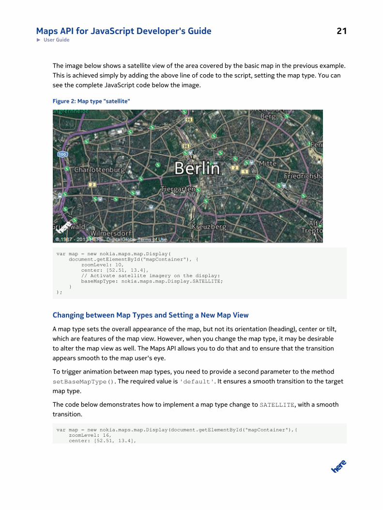
The image below shows a satellite view of the area covered by the basic map in the previous example.
This is achieved simply by adding the above line of code to the script, setting the map type. You can
see the complete JavaScript code below the image.
Figure 2: Map type "satellite"
var map = new nokia.maps.map.Display( document.getElementById("mapContainer"), { zoomLevel: 10, center: [52.51, 13.4], // Activate satellite imagery on the display: baseMapType: nokia.maps.map.Display.SATELLITE; });
Changing between Map Types and Setting a New Map View
A map type sets the overall appearance of the map, but not its orientation (heading), center or tilt,
which are features of the map view. However, when you change the map type, it may be desirable
to alter the map view as well. The Maps API allows you to do that and to ensure that the transition
appears smooth to the map user's eye.
To trigger animation between map types, you need to provide a second parameter to the method
setBaseMapType(). The required value is 'default'. It ensures a smooth transition to the target
map type.
The code below demonstrates how to implement a map type change to SATELLITE, with a smooth
transition.
var map = new nokia.maps.map.Display(document.getElementById("mapContainer"),{ zoomLevel: 16, center: [52.51, 13.4],
Maps API for JavaScript Developer's Guide 22► User Guide
baseMapType: nokia.maps.map.Display.NORMAL});
map.addListener("displayready", function () { // Async transition to a new map type (after 3 seconds) setTimeout(function(){ map.setBaseMapType(map.SATELLITE, 'default'); },3000);});
The alternative is to forgo animation and allow the map to change type immediately. This requires the
second argument to setBaseMapType() to have the value 'none'.
If you would like to specify a new map view when changing the map type, you need to provide a
further argument to setBaseMapType(). This third argument is an object whose properties define
the details of the target map view, including the geographic coordinates of the map center, zoom
level, tilt and heading. The following example shows a call to setBaseMapType() that sets a new
map type, ensures a smooth transition effect, and defines the details of the new the map view to
which to transition:
map.setBaseMapType(map.SATELLITE, 'default', { latitude: 52.51, longitude: 13.4, zoom: 16});
Map type changes are asynchronous. To avoid unpredictable results, it is important that no other
interaction affects the map view while the rendering engine processes the map type change: in other
words, there must be no attempt to alter the map center or zoom level or trigger (and process) any
other asynchronous operations, when a map type switch is in progress. To ensure that is the case,
listen for two events, the first fired when the transition has started (basemapchangestart) and the
second when it has finished (basemapchangeend). They are fired by the map Display instance.
Your handlers for these events need to eliminate unwanted map interaction, ensuring a smooth and
consistent transition to the target view.
The code below shows the skeleton for the handler functions. Note that we do not attempt to
process the events transitionstart and transitionend, because these are fired between
basemapchangestart and basemapchangeend.
map.addListener("basemapchangestart", function () { // Map type change has started -- add // relevant handling here.});
// Add listener so we know when map type change is complete:map.addListener("basemapchangeend", function () { // Map type change has finished -- add // relevant processing here.});
Maps API for JavaScript Developer's Guide 23► User Guide
Components and User InteractionThe HERE Maps API for JavaScript ships with a basic set of User Interface (UI) components with
which you can enhance an application built around an interactive map. The UI components allow the
application user to zoom in or out, pan the map or change its scale, change the map type, etc.
The following UI components are available with the HERE Maps API for JavaScript:
Table 5: UI components in HERE Maps API for JavaScript
Component Description
Behavior A collection of components that enable general user interaction with the map via the
mouse or touch (the interaction types include zoom, panning, etc.)
Zoombar A component that provides a slider control on the map, allowing the user to zoom in/out –
clicking on the plus sign increases the zoom level and causes the map to show more detail,
while the clicking on the minus sign has the opposite effect.
Scalebar A component that displays a scale bar at the bottom of the map. The user can expand
it to see a ruler reflecting linear distance on the map. The user can change the units of
measurement between metric and imperial.
TypeSelector A component that displays a map type switcher in the top right corner of the map.
Overview A component that allows the map user to see what lies beyond the current map view. The
overview expands from the bottom right when the user clicks or taps on the Overview
icon.
ZoomRectangle A component that allows the map user to zoom the map to a specific rectangle (area) by
dragging.
Positioning A component that provides a button with which the map user can trigger a positioning
request. On success, the map is centered on the obtained location. The size of a circle
drawn around the location indicates the accuracy of the positioning data. The component
is part of the positioning package.
ContextMenu A component that shows a customized context menu on a right-click (or a longpress on
touch devices).
InfoBubbles A component that allows a developer to show information bubbles containing HTML
content and to manipulate them.
PublicTransport A component that provides a map overlay to display public transport lines. The map
user can toggle the overlay, but note that the display of public transport information is
confined to a range of zoom levels specific to the location/city.
Maps API for JavaScript Developer's Guide 24► User Guide
Component Description
Traffic A component that displays traffic information on the map as an overlay. The map user can
toggle the overlay, but note that the display of traffic information is confined to a range
of zoom levels specific to the location/city.
TrafficIncidents A component that displays traffic incidents on the map as markers. Note that the display
of traffic information is confined to a range of zoom levels specific to the location/city.
To add the UI components in an application, you need to add them to the Display instance:
var map = new nokia.maps.map.Display( document.getElementById("mapContainer"), { components: [ // Behavior collection new nokia.maps.map.component.Behavior(), new nokia.maps.map.component.ZoomBar(), new nokia.maps.map.component.Overview(), new nokia.maps.map.component.TypeSelector(), new nokia.maps.map.component.ScaleBar() ], zoomLevel: 10, center: [52.51, 13.4] });
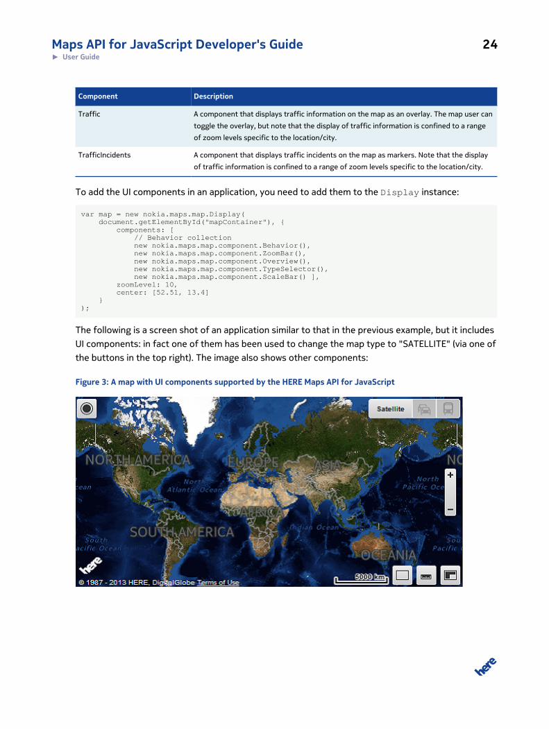
The following is a screen shot of an application similar to that in the previous example, but it includes
UI components: in fact one of them has been used to change the map type to "SATELLITE" (via one of
the buttons in the top right). The image also shows other components:
Figure 3: A map with UI components supported by the HERE Maps API for JavaScript
Maps API for JavaScript Developer's Guide 25► User Guide
Note that the Behavior component added at Display instantiation in the code above includes a
number of other components. If you find that you do not need all of them, you can remove them by
adding a statement such as the following after you have created an instance of Display:
var map = new nokia.maps.map.Display( document.getElementById("mapContainer"), { components: [ // Behavior collection new nokia.maps.map.component.Behavior(), new nokia.maps.map.component.ZoomBar(), new nokia.maps.map.component.Overview(), new nokia.maps.map.component.TypeSelector(), new nokia.maps.map.component.ScaleBar() ], zoomLevel: 10, center: [52.51, 13.4] });
map.removeComponent(map.getComponentById("zoom.MouseWheel"));
This piece of code above removes zooming with the mouse wheel. This makes sense when the map
application is part of a long page and you want the user to be able to scroll the page by turning the
wheel, without causing the map zoom to change at the same time.
As an alternative to adding a group of components and then removing some of them, consider
creating an instance of Display, and then adding only those subcomponents of Behavior that you
need. The following code sample demonstrates this:
var map = new nokia.maps.map.Display( document.getElementById("mapContainer"), { // Zoom level for the map 'zoomLevel': 10, // Map center coordinates 'center': [52.51, 13.4] });
map.addComponent( new nokia.maps.map.component.zoom.DoubleClick());map.addComponent( new nokia.maps.map.component.panning.Drag());map.addComponent( new nokia.maps.map.component.panning.Kinetic());
See also the code example in the article Markers on page 25, where only the DoubleClick zoom
and the DragMarker behavior components are enabled during instantiation of the map Display
class.
MarkersOne of the most common use cases is to show points of interest (POIs) at and near a location. With
the HERE Maps API for JavaScript you can use markers to do just that. The API offers two sorts of
markers:
Maps API for JavaScript Developer's Guide 26► User Guide
Table 6: Marker Types in HEREMaps API for JavaScript
Marker type Description
StandardMarker A marker that uses standard platform icons and a predefined set of properties whose
values can be controlled via the API
Marker A marker that allows you to use a custom icon image to indicate a point on the map
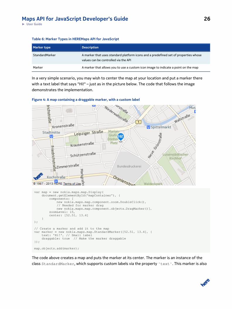
In a very simple scenario, you may wish to center the map at your location and put a marker there
with a text label that says "Hi!" – just as in the picture below. The code that follows the image
demonstrates the implementation.
Figure 4: A map containing a draggable marker, with a custom label
var map = new nokia.maps.map.Display( document.getElementById("mapContainer"), { components: [ new nokia.maps.map.component.zoom.DoubleClick(), // Needed for marker drag new nokia.maps.map.component.objects.DragMarker()], zoomLevel: 15, center: [52.51, 13.4] });
// Create a marker and add it to the mapvar marker = new nokia.maps.map.StandardMarker([52.51, 13.4], { text: "Hi!", // Small label draggable: true // Make the marker draggable});
map.objects.add(marker);
The code above creates a map and puts the marker at its center. The marker is an instance of the
class StandardMarker, which supports custom labels via the property 'text'. This marker is also
Maps API for JavaScript Developer's Guide 27► User Guide
draggable, which means you can move it around the map by clicking on it, holding the mouse button
down and moving the mouse: the marker follows the mouse pointer and when you release the mouse
button, it drops onto the map at a new location. This works on touch devices as well.
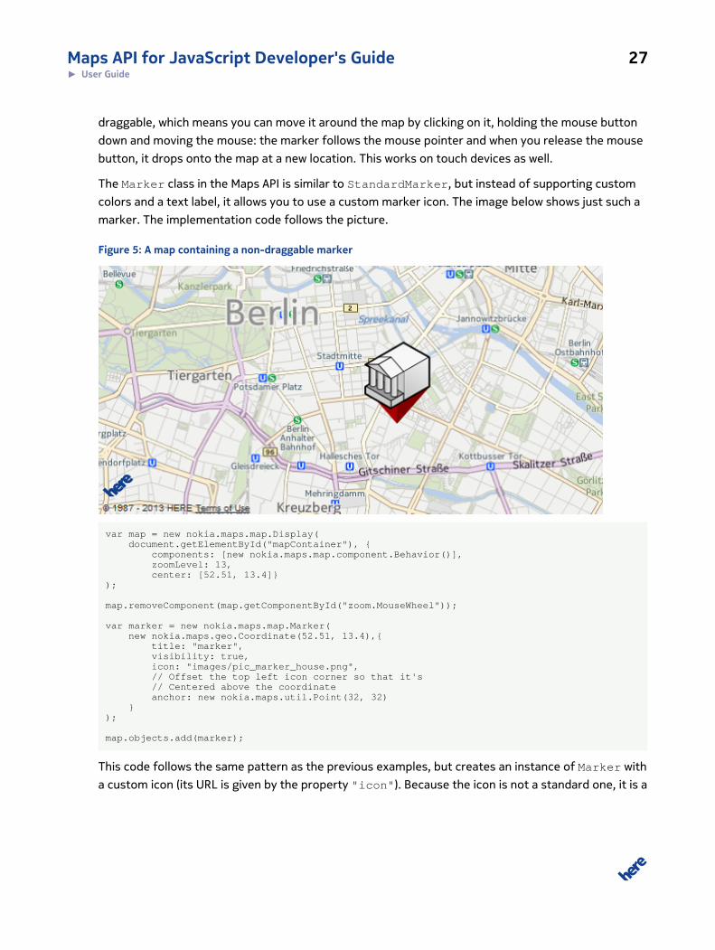
The Marker class in the Maps API is similar to StandardMarker, but instead of supporting custom
colors and a text label, it allows you to use a custom marker icon. The image below shows just such a
marker. The implementation code follows the picture.
Figure 5: A map containing a non-draggable marker
var map = new nokia.maps.map.Display( document.getElementById("mapContainer"), { components: [new nokia.maps.map.component.Behavior()], zoomLevel: 13, center: [52.51, 13.4]});
map.removeComponent(map.getComponentById("zoom.MouseWheel"));
var marker = new nokia.maps.map.Marker( new nokia.maps.geo.Coordinate(52.51, 13.4),{ title: "marker", visibility: true, icon: "images/pic_marker_house.png", // Offset the top left icon corner so that it's // Centered above the coordinate anchor: new nokia.maps.util.Point(32, 32) });
map.objects.add(marker);
This code follows the same pattern as the previous examples, but creates an instance of Marker with
a custom icon (its URL is given by the property "icon"). Because the icon is not a standard one, it is a
Maps API for JavaScript Developer's Guide 28► User Guide
good idea to specify which point in the icon image should "touch" the map at the point defined by the
marker's geographical coordinates. This is done via the property "anchor".
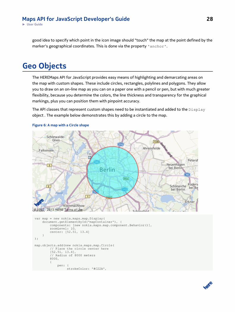
Geo ObjectsThe HEREMaps API for JavaScript provides easy means of highlighting and demarcating areas on
the map with custom shapes. These include circles, rectangles, polylines and polygons. They allow
you to draw on an on-line map as you can on a paper one with a pencil or pen, but with much greater
flexibility, because you determine the colors, the line thickness and transparency for the graphical
markings, plus you can position them with pinpoint accuracy.
The API classes that represent custom shapes need to be instantiated and added to the Display
object . The example below demonstrates this by adding a circle to the map.
Figure 6: A map with a Circle shape
var map = new nokia.maps.map.Display( document.getElementById("mapContainer"), { components: [new nokia.maps.map.component.Behavior()], zoomLevel: 10, center: [52.51, 13.4] });
map.objects.add(new nokia.maps.map.Circle( // Place the circle center here [52.51, 13.4], // Radius of 8000 meters 8000, { pen: { strokeColor: "#C22A",
Maps API for JavaScript Developer's Guide 29► User Guide
lineWidth: 2 }, brush: { color: "#0FF6" } }));
As you can see, a circle is an instance of the class named Circle. Its properties include the
coordinates of the center, the radius, line color (defined by the property "color"), fill color and line
width (given by the property "width"). All the properties of the circle can be set by passing an object
(defined in JSON) to the class constructor.
Map OverlaysThe Maps API allows you to display overlays on top of the map. In the simplest scenarios, the overlays
are static tiles (images) that are requested by the client application from the map tile server and
superimposed on the map in the client-side display. Such tiles may be images that present an
alternative view of an area of the map or highlight certain features of the terrain, etc.
Other scenarios may require the use of dynamic overlays in order to improve efficiency by reducing
the processing requirements on the client. For example, if an application needs to display 100,000
markers in a specific region, the designers can consider a custom map tile service to create map
tiles "populated" on the fly with the required markers and deliver them to the client application on
request. In another example, where a custom map tile service is likely to offer significant efficiency
benefits, a transport company may wish to mark the several hundred routes it operates across the
continent, using custom lines (thickness, color, etc.) Instead of requesting each route and adding it to
the map, the client application can simply download the semi-transparent overlay tiles from the back-
end map tile server.
Naturally, a map tile service must be designed and implemented to specific requirements, therefore
it is beyond the scope of both the Maps API and this documentation. However, we illustrate below a
simple scenario in which an overlay showing a historical map of Berlin from 1789 is displayed on top
of the standard modern map of the city delivered using the API.

Maps API for JavaScript Developer's Guide 30► User Guide
A Map of Berlin from 1789The 18th century map of Berlin in this example is based on a public domain image from Wikimedia
Commons. We have divided the image into tiles, which the application below retrieves from our
custom map tile server and displays over a contemporary street map of the city.
Figure 7: Berlin 1789 and today
The client-side implementation, consists of the following steps:
1. Define a DOM element in which the map is to be displayed.
2. Instantiate an object representing the viewable map (nokia.maps.map.Display).
3. Instantiate a tile provider object (nokia.maps.map.provider.ImgTileProvider).
4. Add the tile provider to the array of map overlays (nokia.maps.map.Display.overlays).
The section below expands on each of these points.
Maps API for JavaScript Developer's Guide 31► User Guide
Base Map
The DOM element, where the map is to appear, is defined in the body of the HTML page as follows:
<div id="mapContainer"></div>
To access the API library, provide a <script> element that references it:
<script src="http://js.api.here.com/ee/2.5.3/jsl.js" type="text/javascript" charset="utf-8"></script>
Set the application id and code – please see Acquiring Credentials on page 18 for details.
To display the basic street map of Berlin, get a reference to the DOM element that is to display it and
instantiate the map Display:
// Get the DOM node to which to append the mapvar mapContainer = document.getElementById("mapContainer");
// Create a map inside the map container DOM nodevar map = new nokia.maps.map.Display(mapContainer, { components: [ new nokia.maps.map.component.ZoomBar(), new nokia.maps.map.component.Behavior(), new nokia.maps.map.component.TypeSelector()], zoomLevel: 14, center: [52.515, 13.405]});
Tile Provider
To create a tile provider, it is necessary to instantiate the base class
nokia.maps.map.provider.ImgTileProvider. In fact, this is the most complex part of the
process. The constructor for ImgTileProvider requires an object described in the API Reference
as nokia.maps.map.provider.TileProvider.Options. Only one element in Options is
obligatory, a function that retrieves the overlay tiles (getUrl), but the code below specifies also non-
mandatory properties, including the minimum and maximum zoom levels for the overlay, opacity
(which makes the overlay semi-transparent) and a function that displays copyright and attribution
information:
var tileProviderOptions = { getUrl: getTileURL, // obligatory max: 15, // max zoom level for overlay min: 12, // min zoom level for overlay opacity: 0.5, // 0 = transparent overlay, 1 = opaque alpha: true, // renderer to read alpha channel getCopyrights : showCopyright // display copyright};
Maps API for JavaScript Developer's Guide 32► User Guide
It is necessary to provide a value for the property getUrl, otherwise the Maps API library generates
an error message and terminates execution of the code. In our case, the value is the function
getTileURL(), which retrieves the tiles from the map tile server. The following principles apply:
1. At the minimum zoom level, the world is contained in a single 256x256 pixel tile.
2. At the next higher zoom level, the world is two tiles wide and two tiles high.
3. Every higher zoom level splits the tiles in two, doubling the number of tiles across the width andheight. This produces the tile grids of 4x4, 8x8, 16x16, etc.
4. Typically, each map is based on the Normalized Mercator projection.
Central Berlin is displayed in tile 1343,2200 at Zoom 12. The range of available tiles doubles at each
zoom level thereafter.
Here is the implementation of getTileURL():
function getTileURL (zoom, row, column) { // If Berlin is not displayed, return a blank // tile. if (((zoom == 12) && ( row != 1343 || column != 2200))|| ((zoom ==13) && (row < 2686 || column < 4400 || row > 2687 || column > 4401 ))|| ((zoom == 14) && ( row < 5372 || column < 8800 || row > 5375 || column > 8803))|| ((zoom == 15) && ( row < 10744 || column < 17601 || row > 10750 || column > 17607))){ return "."+ "/oldberlin/blank.png"; }
// The Old Berlin Map Tiler follows the TMS URL // specification. According to the specification, // map tiles should be accessible in the following // format: // // http://server_address/zoom_level/x/y.png // // In our case, the URL is something like // "oldberlin/13/1343/2200.png" return "." + "/oldberlin/"+ zoom+ "/"+ row + "/" + column + ".png";};
Unless you own the map tile source, you need to comply with the licensing agreement of the map tile
provider. Often, this means giving an attribution text or acknowledgement of the copyright of the
original owner, even if the image tiles are offered free of charge. The function showCopyright()
function helps display this acknowledgement in the bottom left corner of the map.
function showCopyright (area, zoom) { // If the zoom is too low or too high, do not display any // copyright information: if (zoom < 12 || zoom > 15) { return []; }
// Otherwise, add the attribution to the map: return [{ label: "Overlay derived from <a href=
Maps API for JavaScript Developer's Guide 33► User Guide
'http://commons.wikimedia.org/wiki/File:Map_de_berlin_1789_%28georeferenced%29.jpg'> WikiMedia Commons</a>", alt: "Overlay Based on a WikiMedia Commons Image in the Public Domain" }];}
Displaying the Overlay
With the code above in place, we can now create an instance of the tile provider:
var oldBerlinOverlay = new nokia.maps.map.provider.ImgTileProvider ( tileProviderOptions);
Finally, we can add the overlay to the map (and so display it):
map.overlays.add(oldBerlinOverlay);
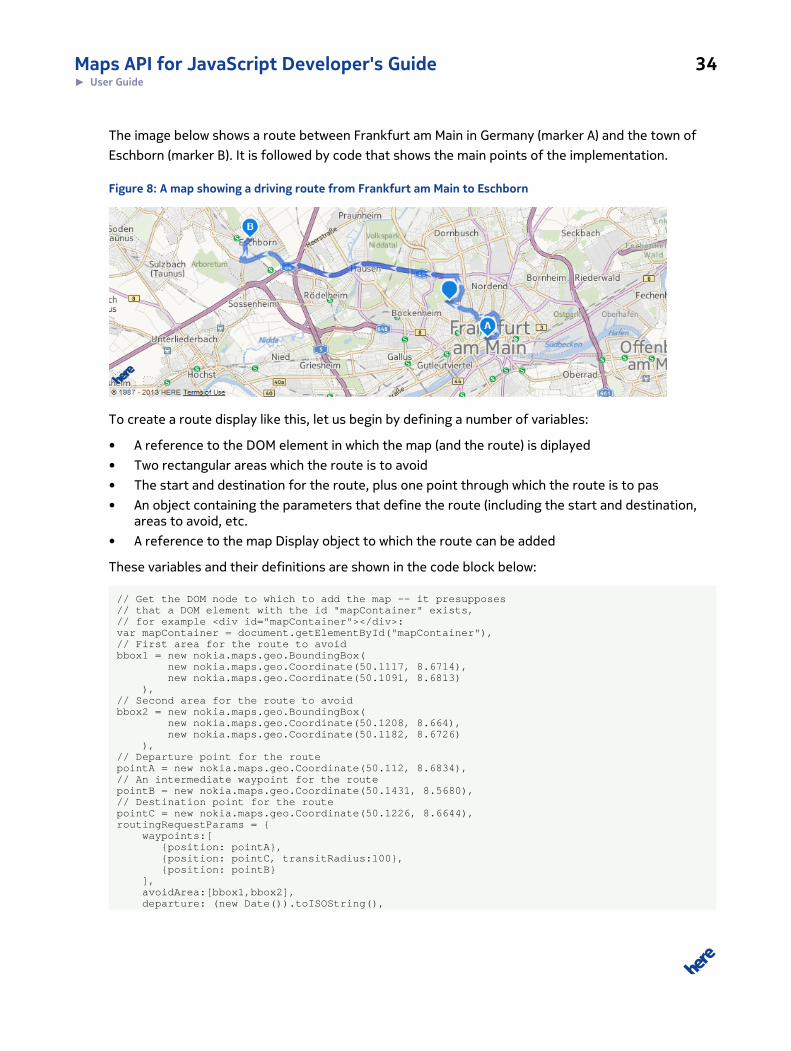
RoutingRoute planning and navigation are the most commonly used applications of location-based services.
With the Maps API, you can calculate optimal routes that match your own calculation criteria, are
based on up-to-date map data, and take into account real-time traffic information.
The API offers global coverage of streets and highways, allowing you to create routes reflecting
customizable modes such as fastest, shortest, avoiding toll roads or ferries, etc. There is also
support for utilizing historical speed patterns as an optimization for routes depending on the time of
day.
Maps API for JavaScript Developer's Guide 34► User Guide
The image below shows a route between Frankfurt am Main in Germany (marker A) and the town of
Eschborn (marker B). It is followed by code that shows the main points of the implementation.
Figure 8: A map showing a driving route from Frankfurt am Main to Eschborn
To create a route display like this, let us begin by defining a number of variables:
• A reference to the DOM element in which the map (and the route) is diplayed
• Two rectangular areas which the route is to avoid
• The start and destination for the route, plus one point through which the route is to pas
• An object containing the parameters that define the route (including the start and destination,areas to avoid, etc.
• A reference to the map Display object to which the route can be added
These variables and their definitions are shown in the code block below:
// Get the DOM node to which to add the map -- it presupposes// that a DOM element with the id "mapContainer" exists,// for example <div id="mapContainer"></div>:var mapContainer = document.getElementById("mapContainer"),// First area for the route to avoidbbox1 = new nokia.maps.geo.BoundingBox( new nokia.maps.geo.Coordinate(50.1117, 8.6714), new nokia.maps.geo.Coordinate(50.1091, 8.6813) ),// Second area for the route to avoidbbox2 = new nokia.maps.geo.BoundingBox( new nokia.maps.geo.Coordinate(50.1208, 8.664), new nokia.maps.geo.Coordinate(50.1182, 8.6726) ),// Departure point for the routepointA = new nokia.maps.geo.Coordinate(50.112, 8.6834),// An intermediate waypoint for the routepointB = new nokia.maps.geo.Coordinate(50.1431, 8.5680),// Destination point for the routepointC = new nokia.maps.geo.Coordinate(50.1226, 8.6644),routingRequestParams = { waypoints:[ {position: pointA}, {position: pointC, transitRadius:100}, {position: pointB} ], avoidArea:[bbox1,bbox2], departure: (new Date()).toISOString(),
Maps API for JavaScript Developer's Guide 35► User Guide
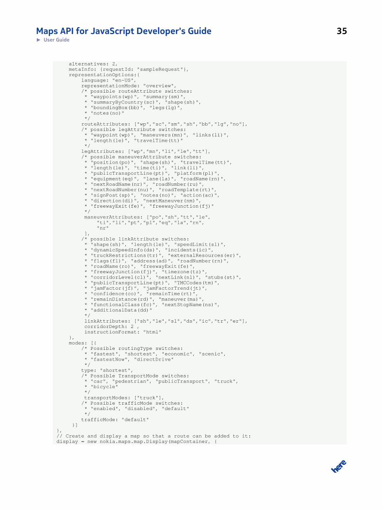
alternatives: 2, metaInfo: {requestId: "sampleRequest"}, representationOptions:{ language: "en-US", representationMode: "overview", /* possible routeAttribute switches: * "waypoints(wp)", "summary(sm)", * "summaryByCountry(sc)", "shape(sh)", * "boundingBox(bb)", "legs(lg)", * "notes(no)" */ routeAttributes: ["wp","sc","sm","sh","bb","lg","no"], /* possible legAttribute switches: * "waypoint(wp)", "maneuvers(mn)", "links(li)", * "length(le)", "travelTime(tt)" */ legAttributes: ["wp","mn","li","le","tt"], /* possible maneuverAttribute switches: * "position(po)", "shape(sh)", "travelTime(tt)", * "length(le)", "time(ti)", "link(li)", * "publicTransportLine(pt)", "platform(pl)", * "equipment(eq)", "lane(la)", "roadName(rn)", * "nextRoadName(nr)", "roadNumber(ru)", * "nextRoadNumber(nu)", "roadTemplate(rt)", * "signPost(sp)", "notes(no)", "action(ac)", * "direction(di)", "nextManeuver(nm)", * "freewayExit(fe)", "freewayJunction(fj)" */ maneuverAttributes: ["po","sh","tt","le", "ti","li","pt","pl","eq","la","rn", "nr" ], /* possible linkAttribute switches: * "shape(sh)", "length(le)", "speedLimit(sl)", * "dynamicSpeedInfo(ds)", "incidents(ic)", * "truckRestrictions(tr)", "externalResources(er)", * "flags(fl)", "address(ad)", "roadNumber(rn)", * "roadName(ro)", "freewayExit(fe)", * "freewayJunction(fj)", "timezone(tz)", * "corridorLevel(cl)", "nextLink(nl)", "stubs(st)", * "publicTransportLine(pt)", "TMCCodes(tm)", * "jamFactor(jf)", "jamFactorTrend(jt)", * "confidence(co)", "remainTime(rt)", * "remainDistance(rd)", "maneuver(ma)", * "functionalClass(fc)", "nextStopName(ns)", * "additionalData(dd)" */ linkAttributes: ["sh","le","sl","ds","ic","tr","er"], corridorDepth: 2 , instructionFormat: "html" }, modes: [{ /* Possible routingType switches: * "fastest", "shortest", "economic", "scenic", * "fastestNow", "directDrive" */ type: "shortest", /* Possible TransportMode switches: * "car", "pedestrian", "publicTransport", "truck", * "bicycle" */ transportModes: ["truck"], /* Possible trafficMode switches: * "enabled", "disabled", "default" */ trafficMode: "default" }]},// Create and display a map so that a route can be added to it:display = new nokia.maps.map.Display(mapContainer, {
Maps API for JavaScript Developer's Guide 36► User Guide
center: [53, 13], zoomLevel: 3, components: [new nokia.maps.map.component.Behavior()]});
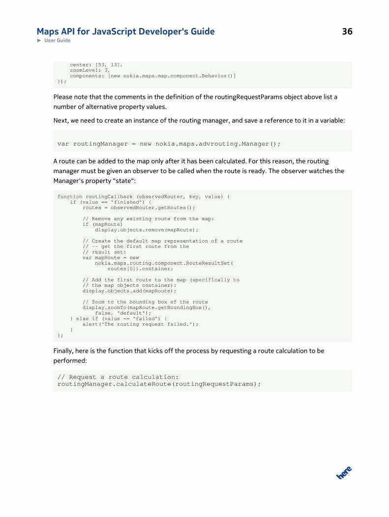
Please note that the comments in the definition of the routingRequestParams object above list a
number of alternative property values.
Next, we need to create an instance of the routing manager, and save a reference to it in a variable:
var routingManager = new nokia.maps.advrouting.Manager();
A route can be added to the map only after it has been calculated. For this reason, the routing
manager must be given an observer to be called when the route is ready. The observer watches the
Manager's property "state":
function routingCallback (observedRouter, key, value) { if (value == "finished") { routes = observedRouter.getRoutes();
// Remove any existing route from the map: if (mapRoute) display.objects.remove(mapRoute);
// Create the default map representation of a route // -- get the first route from the // result set: var mapRoute = new nokia.maps.routing.component.RouteResultSet( routes[0]).container;
// Add the first route to the map (specifically to // the map objects container): display.objects.add(mapRoute);
// Zoom to the bounding box of the route display.zoomTo(mapRoute.getBoundingBox(), false, "default"); } else if (value == "failed") { alert("The routing request failed."); }};
Finally, here is the function that kicks off the process by requesting a route calculation to be
performed:
// Request a route calculation:routingManager.calculateRoute(routingRequestParams);
Maps API for JavaScript Developer's Guide 37► User Guide
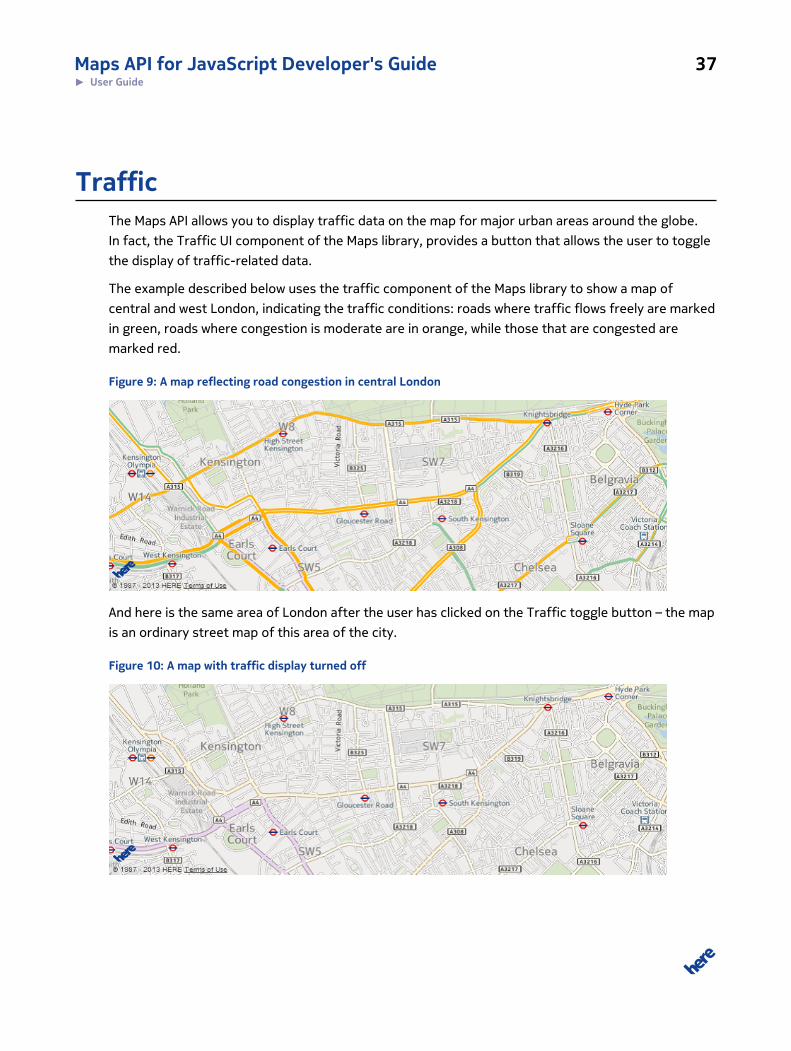
TrafficThe Maps API allows you to display traffic data on the map for major urban areas around the globe.
In fact, the Traffic UI component of the Maps library, provides a button that allows the user to toggle
the display of traffic-related data.
The example described below uses the traffic component of the Maps library to show a map of
central and west London, indicating the traffic conditions: roads where traffic flows freely are marked
in green, roads where congestion is moderate are in orange, while those that are congested are
marked red.
Figure 9: A map reflecting road congestion in central London
And here is the same area of London after the user has clicked on the Traffic toggle button – the map
is an ordinary street map of this area of the city.
Figure 10: A map with traffic display turned off
Maps API for JavaScript Developer's Guide 38► User Guide
The implementation is very simple. The Display constructor's initialization object includes the
properties that set the map center and zoom level and, in addition, a property named components
to ensure that the Traffic UI component is initialized. The last line of code ensures that the initial map
type is set to "traffic".
// Get the DOM node to which we will append the mapvar mapContainer = document.getElementById("mapContainer");
// Create a map inside the map container DOM nodevar map = new nokia.maps.map.Display(mapContainer, { // initial center and zoom level of the map center: [51.49, -0.12], zoomLevel: 13, components: [ // Create a button to togglee traffic information on the map new nokia.maps.map.component.Traffic() ]});
map.set("baseMapType", nokia.maps.map.Display.TRAFFIC);
KML SupportBecause creating content on top of a map is time consuming, most developers look to standards to
help them transfer content between platforms seamlessly, and typically use KML, which captures
data in XML. For further information, please visit the KML page of the Open Geospatial Consortium.
The KML specification supports a variety of objects, such as place marks, images and polygons.
Many of them have their counterparts in the HERE Maps API for JavaScript landscape. To translate
KML objects to HERE Maps API objects, use the component KMLResultSet, which is part of the kml
package. It uses a dedicated Manager class to handle asynchronous loading of KML data either from
a text source or from a KML file.
The HERE Maps API supports the import of KML files and data sets compliant with versions 2.1 and
2.2 of the KML standard. There are only a small number of features that the API does not as yet
Maps API for JavaScript Developer's Guide 39► User Guide
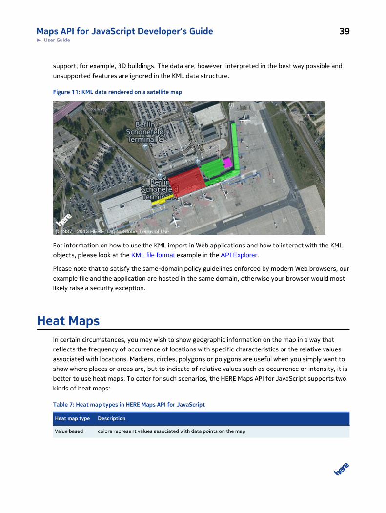
support, for example, 3D buildings. The data are, however, interpreted in the best way possible and
unsupported features are ignored in the KML data structure.
Figure 11: KML data rendered on a satellite map
For information on how to use the KML import in Web applications and how to interact with the KML
objects, please look at the KML file format example in the API Explorer.
Please note that to satisfy the same-domain policy guidelines enforced by modern Web browsers, our
example file and the application are hosted in the same domain, otherwise your browser would most
likely raise a security exception.
Heat MapsIn certain circumstances, you may wish to show geographic information on the map in a way that
reflects the frequency of occurrence of locations with specific characteristics or the relative values
associated with locations. Markers, circles, polygons or polygons are useful when you simply want to
show where places or areas are, but to indicate of relative values such as occurrence or intensity, it is
better to use heat maps. To cater for such scenarios, the HERE Maps API for JavaScript supports two
kinds of heat maps:
Table 7: Heat map types in HERE Maps API for JavaScript
Heat map type Description
Value based colors represent values associated with data points on the map
Maps API for JavaScript Developer's Guide 40► User Guide
Heat map type Description
Density based colors represent the density of data points on the map
The Maps API allows you to display heat maps as map overlays.
Data for the heat map are defined as a simple array of DataPoint objects:
var heatmapData = [ {"value":6.1,"longitude":173.0219, "latitude":53.1380}, {"value":5.8,"longitude":-171.8583, "latitude":52.0415}, {"value":5.4,"longitude":-169.9851, "latitude":53.3657}, {"value":4.6,"longitude":-169.5266, "latitude":51.2915}, {"value":4.4,"longitude":-176.4482, "latitude":51.5722}, {"value":4.3,"longitude":-171.5867, "latitude":51.8108}, {"value":4.1,"longitude":-151.8272, "latitude":59.8977}, {"value":3.6,"longitude":-171.7213, "latitude":51.6348}, {"value":3.8,"longitude":-156.0880, "latitude":56.1681}];
Note that the property "value" is optional in a density-based heat map.
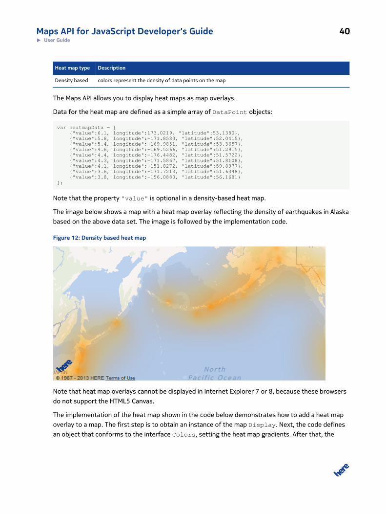
The image below shows a map with a heat map overlay reflecting the density of earthquakes in Alaska
based on the above data set. The image is followed by the implementation code.
Figure 12: Density based heat map
Note that heat map overlays cannot be displayed in Internet Explorer 7 or 8, because these browsers
do not support the HTML5 Canvas.
The implementation of the heat map shown in the code below demonstrates how to add a heat map
overlay to a map. The first step is to obtain an instance of the map Display. Next, the code defines
an object that conforms to the interface Colors, setting the heat map gradients. After that, the

Maps API for JavaScript Developer's Guide 41► User Guide
code constructs a heat map overlay object, adds data to the overlay, and finally, adds the overlay to
the map.
var map = new nokia.maps.map.Display(document.getElementById("mapContainer"), { zoomLevel: 3, center: [57.0415, -170.8583] });
// Definition of color gradient to be used in the Heatmapvar colorizeAPI = { stops: { "0": "#E8680C", "0.25": "#F5A400", "0.5": "#FF9000", "0.75": "#FF4600", "1": "#F51F00" }, interpolate: true};
var hmProvider = new nokia.maps.heatmap.Overlay({ colors: colorizeAPI, opacity: 0.8, type: "density"});
// Assuming that data have been loaded previously:hmProvider.addData(heatmapData);map.overlays.add(hmProvider);
Marker ClusteringWhen the map needs to show a very large number of marked locations, for example, to indicate
stores that belong to a popular supermarket chain with thousands of branches in a particular region,
it is easy to imagine that at certain zoom levels, the icons indicating the locations can appear so close
together that they overlap and even hide a whole area of the map. If the locations were indicated,
using individual markers, the map could become difficult to read, unless the map user zooms in to
(or near) street level. To assist in managing such scenarios, the Maps Enterprise API for JavaScript
includes the namespace nokia.maps.clustering. It offers a means of displaying a dense cluster
of markers as a single marker, which is replaced by individual markers as the map user zooms in.
The key classes in the namespace are Cluster, Noise, ClusterProvider, and MarkerTheme.
As the name suggests, Cluster represents a cluster of markers and contains references to its
members. Noise encapsulates individual markers that are not clustered. ClusterProvider is
a cluster manager that uses an instance of MarkerTheme to display clusters and single markers
(instances of Noise). You can view the detailed documentation of each of these classes in the API
Reference. It is worth noting, however, that ClusterProvider can work both with the default
display theme (an instance of MarkerTheme) and with a custom theme that can use marker images
of your choice.
Maps API for JavaScript Developer's Guide 42► User Guide
The default display theme shows a cluster on the map as a circular marker with a number in its center
to indicate the size of the cluster. The color, size and shadow of the cluster marker depend on the
size of the cluster. It displays Noise points as small blue dots, with white stroke color. In a custom
theme, the markers, their appearance and behavior depend on the implementation.
The remainder of this article describes a simple example of a clustering application that uses the
default display theme. The application displays the location of 6978 airports on the map, their
locations held in an array formatted as follows:
/** * Orginal source: http://openflights.org/data.html */var data = [ { latitude: -6.081689, longitude: 145.391881 }, { latitude: -5.207083, longitude: 145.7887 }, { latitude: -5.826789, longitude: 144.295861 }, ...];
To implement clustering based on this data, the example application:
1. Creates an instance of nokia.maps.map.Display
2. Creates an instance of ClusterProvider – its constructor requires a reference to themap.Display object as well as an object holding initialization properties for the default instanceof MarkerTheme
3. Loads the script file containing the airport location data
4. Invokes the method cluster() on the ClusterProvider object
Below, you can see the complete contents of a <script> tag implementing the application. The code
comments explain the details at each step:
// Get the DOM node in which to display the map. (This code// assumes the presence of an HTML <div> element with// the id "mapContainer".var mapContainer = document.getElementById("mapContainer");
// Display a map inside the DOM node to which mapContainer// refers:var map = new nokia.maps.map.Display(mapContainer, { // initial center and zoom level of the map center: [52.51, 13.4], zoomLevel: 4, components: [ // ZoomBar provides a UI to zoom the map // in/out new nokia.maps.map.component.ZoomBar(), // Add the component that allows user to // pan and zoom new nokia.maps.map.component.Behavior() ]});
/* * Create an instance of ClusterProvider. It uses the default * display theme (an instance of * nokia.maps.clustering.MarkerTheme). * The code sets the epsilon distance (the radius within
Maps API for JavaScript Developer's Guide 43► User Guide
* which data points are considered for clustering, measured * in pixels), the smallest number of points within the * epsilon radius required to form a cluster, and an empty * array representing the data points (the actual data points * are loaded dynamically). */var ClusterProvider = nokia.maps.clustering.ClusterProvider, clusterProvider = new ClusterProvider(map, { eps: 16, minPts: 1, dataPoints: [] });
/* Load the data point definitions from the file airport.js * and provide a callback that adds the airport location * data to the instance of ClusterProvider and then creates * the markers and clusters. */loadScript( "../resource/clustering/airports.js", function () { clusterProvider.addAll(data); clusterProvider.cluster(); });
PositioningThe user's location is one of the key pieces of information in building a Web map application. The
HERE Maps API for JavaScript supports the use of W3C browser positioning, making it easy for an
application to use positioning information.
Precision depends on the positioning technology and ranges from rough IP Positioning (only
supported in a few browsers such as Mozilla Firefox), cell positioning (usually available on tablets and
notebooks) up to very precise WiFi detection (all WiFi-enabled modern browsers, among them mobile
browsers). In addition, The API supports GPS or A-GPS on tablets and smart phones, which delivers
very accurate positioning.
Visual presentation of positioning data on the map includes proximity rendering.
Example
The example below demonstrates the use of W3C geolocation API to obtain positioning information
(location) and to display it as a marker on the map. A positioning request is submitted if the
application user's mouse hover over the map. On success, a message confirms this and, in addition,
the map displays a marker in a circle that reflects the accuracy of the positioning information. On
Maps API for JavaScript Developer's Guide 44► User Guide
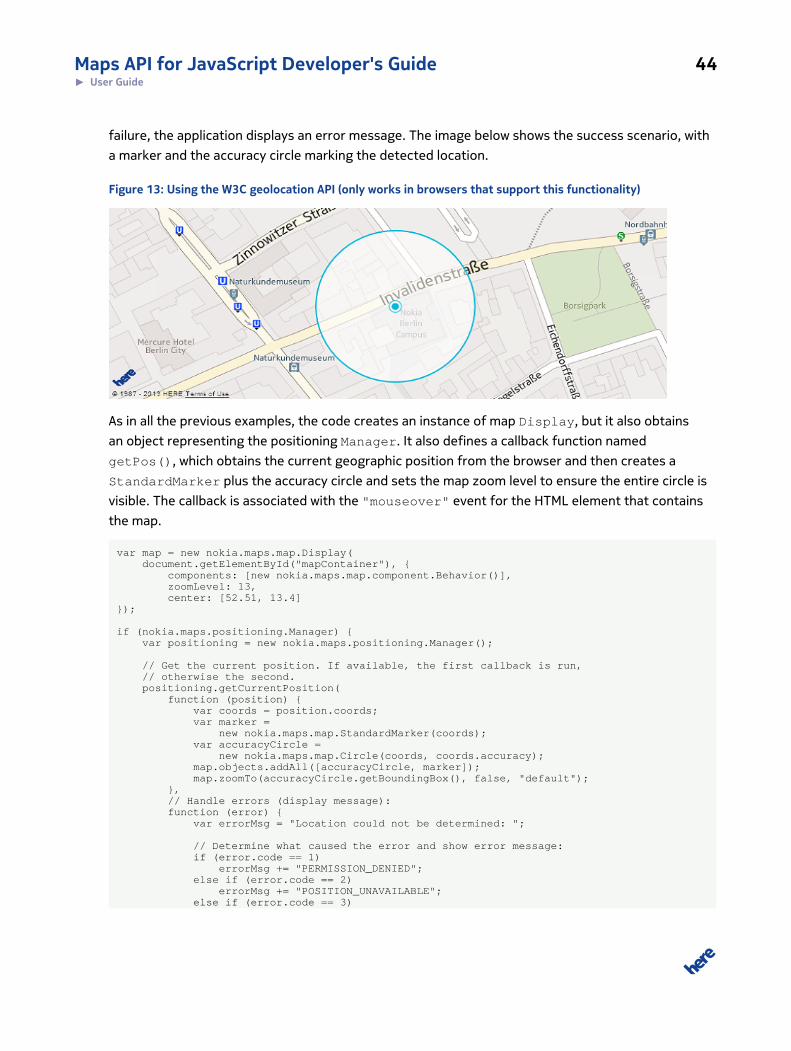
failure, the application displays an error message. The image below shows the success scenario, with
a marker and the accuracy circle marking the detected location.
Figure 13: Using the W3C geolocation API (only works in browsers that support this functionality)
As in all the previous examples, the code creates an instance of map Display, but it also obtains
an object representing the positioning Manager. It also defines a callback function named
getPos(), which obtains the current geographic position from the browser and then creates a
StandardMarker plus the accuracy circle and sets the map zoom level to ensure the entire circle is
visible. The callback is associated with the "mouseover" event for the HTML element that contains
the map.
var map = new nokia.maps.map.Display( document.getElementById("mapContainer"), { components: [new nokia.maps.map.component.Behavior()], zoomLevel: 13, center: [52.51, 13.4]});
if (nokia.maps.positioning.Manager) { var positioning = new nokia.maps.positioning.Manager();
// Get the current position. If available, the first callback is run, // otherwise the second. positioning.getCurrentPosition( function (position) { var coords = position.coords; var marker = new nokia.maps.map.StandardMarker(coords); var accuracyCircle = new nokia.maps.map.Circle(coords, coords.accuracy); map.objects.addAll([accuracyCircle, marker]); map.zoomTo(accuracyCircle.getBoundingBox(), false, "default"); }, // Handle errors (display message): function (error) { var errorMsg = "Location could not be determined: ";
// Determine what caused the error and show error message: if (error.code == 1) errorMsg += "PERMISSION_DENIED"; else if (error.code == 2) errorMsg += "POSITION_UNAVAILABLE"; else if (error.code == 3)
Maps API for JavaScript Developer's Guide 45► User Guide
errorMsg += "TIMEOUT"; else errorMsg += "UNKNOWN_ERROR";
alert(errorMsg); }; )}
Event SystemThe HERE Maps API for JavaScript offers its own standardized event framework to handle user
interactions such as mouse clicks and dragging. Because different browsers handle events
differently, the framework harmonizes those differences in a way that is compliant with W3C
standards and gives the developer an effective tool to process events on native DOM nodes. The
framework also offers support for de facto standard events such as touch and gestures in the
environments that support them, and it can be extended to apply to native DOM nodes.
All the classes related to the event framework are defined within the dom namespace. This includes
the Page class, which defines an abstraction level for native browser events and is, in fact, the entry
point to the functionality offered by the package. The namespace dom also includes the helper
classes Event, EventTarget and DataTransfer.
The signatures for the event functions, for example those that allow you to add listeners, do not
comply strictly to the W3C specifications, but are compatible with other JavaScript frameworks.
The supported events are listed and described in the table below:
Table 8: Events in HERE Maps API for JavaScript
Event Description
focus Fired if an element receives focus.
blur Fired if an element loses focus.
mousedown Fired if a mouse button has been pressed.
mouseup Fired if a mouse button has been released.
mousemove Fired if the mouse is moved.
mousewheel Fired if the mousewheel is moved.
click Fired after a mousedown/mouseup or a touchstart/touchend has occurred without a drag operation
having been started. For touchstart and touchend, the click event is simulated if no tap listener is
registered or if the tap listener has not prevented the default by using the preventClick() method.
dblclick Fired after two click events have been fired within a certain time period.
mouseover Fired if the mouse is moved above a new target.
Maps API for JavaScript Developer's Guide 46► User Guide
Event Description
mouseout Fired if the mouse left a target.
mouseenter Fired if the mouse is moved above a new target.
mouseleave Fired if the mouse leaves the outer bounding box of a target for which a mouseenter has been fired.
dragstart Fired at an event target that has the property "draggable" set to true and after a mousedown/touch has
occurred and the mouse/finger has been moved by at least three pixels. If the event is not canceled, then
the drag operation is permitted. The property "dataTransfer" can be used to keep track of information
while dragging.
drag Fired at the target node of the dragstart event while a drag operation is ongoing. The "relatedTarget"
property contains a reference to the target that is currently under the mouse point or the user's finger tip
(only for simulated drag events, not for the native ones).
dragenter Fired at a node if the mouse/finger is moved into the visible area of the element, d uring a drag operation. If
the event is canceled, a drop at the target is allowed, otherwise a drop is denied. If the drop is allowed, the
target becomes the current drop target.
dragover Fired at the current drop target while the mouse/finger is above the drop target, but only after the
dragenter event has been canceled. If this event is not canceled, the drop effect is set to "none", which
disallows a drop into the drop target.
dragleave Fired at a node, when the mouse/finger has been moved away from it.
drop Fired if the mouse button or finger is released above a valid drop target. It means that the dragenter event
and the dragover event have been canceled and the allowed effect matches the drop effect. If the event
is not canceled and the drop target is a text field (for example a text area or an input element), then the
content of the "text/plain" format is inserted into this area (either at the cursor position or at the end).
Otherwise, the drop effect is set to "none".
dragend Fired at the end of a drag operation at the original dragstart target, both if the drop is aborted or failed, or
if the drop was successful. The event signalizes the end of a drag operation. The state of the drop operation
can be read from the drop effect, which can be "none", "move", "copy" or "link".
touchstart Fired as soon as a finger is pushed on a touch screen.
touchmove Fired as soon as a finger is moved above a touch screen.
touchend Fired as soon as a finger is released from a touch screen.
gesturestartFired as soon as two or more fingers touch the touch screen (high-level event).
gesturechangeFired whenever either of two fingers is moved, changing the properties of the gesture (high-level event).
gestureend Fired as soon as only one finger is left touching the touch screen and as soon as all fingers have been
removed from the touch screen. (high-level event).
tap Fired after a touchstart and touchend have occurred at the same target and only if neither the
touchstart nor the touchend event has been canceled.
dbltap Fired after two tap events have been fired in a certain amount of time.
Maps API for JavaScript Developer's Guide 47► User Guide
Event Description
longpress Fired after a mouse button or finger has been pressed for a certain amount of time without starting a drag
or gesture.
To add support for Page events to a DOM node, the EventTarget interface must be attached to the
DOM node. This can be done by simply casting the node to EventTarget. The code implements a
simple scenario in which a static map is displayed in one DOM node and a green rectangle underneath
it in another. When the user clicks on the green area, the code changes the color to gray and shows
an alert to indicate that it has received (and processed) the "click" event.
<div id="mapContainer" style="width:785px; height:460px;"></div><div id="eventElt" style="background-color: green; width:785px; height:20px;"></div><script type="text/javascript"> var map = new nokia.maps.map.Display( document.getElementById("mapContainer"), { zoomLevel: 10, center: [52.51, 13.4] });
// Create a few shortcuts. var Page = nokia.maps.dom.Page, EventTarget = nokia.maps.dom.EventTarget, eventElt = document.getElementById("eventElt"); // green rect
// Query Page support for the node. Page(eventElt);
// Attach EventTarget interface to the document node to allow // normalized events at the node. EventTarget(eventElt);
// Add a listener for the click event to the node. It changes // the background color and shows an alert. eventElt.addListener("click", function (evt) { eventElt.style.backgroundColor = "#D3D3D3"; alert( "Event triggered: " + evt.type );
// Unregister the listener, so that the alert is shown only // once. eventElt.removeListener("click", arguments.callee, false); }, false);</script>
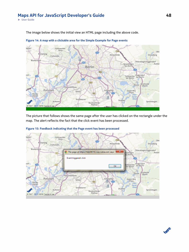
Maps API for JavaScript Developer's Guide 48► User Guide
The image below shows the initial view an HTML page including the above code.
Figure 14: A map with a clickable area for the Simple Example for Page events
The picture that follows shows the same page after the user has clicked on the rectangle under the
map. The alert reflects the fact that the click event has been processed.
Figure 15: Feedback indicating that the Page event has been processed
Maps API for JavaScript Developer's Guide 49► User Guide
Observers and Mutable ObjectsTracking state changes is a common use case and the Maps API provides an implementation of the
Observer pattern to address it. It allows you to observe:
• changes of state – for objects derived from OObject
• actions – for instances of OList
In both cases, you need to call the method addObserver() on the object in which you are
interested, passing to it a callback function to be invoked when an observable change to the object
occurs. In addition, you need to indicate the property or properties to observe on an instance of
OObject. By contrast, an OList observer (callback) is invoked on all and any actions that affect the
state of the object, so when adding an OList observer, there is no option to specify the actions or
properties in which you are interested.
The example below shows how to add an observer on an instance of map.Display represented by
a variable named map. map.Display extends OObject, therefore the callback receives information
about the object's state changes, and specifically about the property named "state" – the callback
receives it via the argument value.
var zoomObserver = function (obj, key, newValue, oldValue) { if (newValue > 14) { map.set("zoomLevel", oldValue); }};
map.addObserver("zoomLevel", zoomObserver);
In this case, the observer is invoked whenever the Display property "zoomLevel" changes. It checks
if the new value of the property is higher than 14, and if it is, it makes sure "zoomLevel" reverts to
the last known value before the change. In short: it is used to ensure that "zoomLevel" can never be
higher than 14.
Mutable Objects
The classes defined in the Maps API distinguish between two types of objects:
• immutable – objects whose state should never change once they have been created
• mutable – objects that are designed to hold data which may be altered
All mutable objects are derived either from OList or OObject and therefore offer the Observer
pattern described in (see Observers and Mutable Objects on page 49).

Maps API for JavaScript Developer's Guide 50► User Guide
An example of an object that is designed to be immutable is an instance of the class Coordinate
from the namespace geo. The class is not designed to support state changes and therefore it does
not offer the Observer pattern. Although technically JavaScript permits you to alter the internal state
of an immutable object, bear in mind that this could lead to problems, as there is no mechanism to
propagate the state change information to other objects that may depend on it.
Please check the inheritance chain in the documentation to be sure if a class is observable or not.
Multi-language SupportThe HEREMaps API for JavaScript supports localization in the following languages:
Table 9: Localization Languages in HEREMaps API for JavaScript
Locale ID Description Comment
en-GB English as spoken in Great
Britain
en-US English as spoken in the USA default language
de-DE German as spoken in
Germany
fr-FR French as spoken in France
es-ES Spanish as spoken in Spain
it-IT Italian as spoken in Italy
ru-RU Russian as spoken in Russia
zh-CN Simplified Chinese
Please note that the list of supported languages is under constant revision and HERE reserves the
right to alter the list without notice.
By default, the language of the maps displayed using this API is defined by the browser's language
preferences. You can override this behavior to meet specific requirements by calling the method
set() on the static class Settings before you initialize the map (otherwise the attempt to set
the language has no effect). The first argument to set() is the name of the property you wish to
change, in this case "defaultLanguage". The second argument is the value of the property. The
following example sets the default language to German spoken in Germany by calling the method
set() on the class Settings:
nokia.Settings.set("defaultLanguage", "de-DE");
var map = new nokia.maps.map.Display(
Maps API for JavaScript Developer's Guide 51► User Guide
document.getElementById("mapContainer"), { components: [ new nokia.maps.map.component.ZoomBar(), new nokia.maps.map.component.TypeSelector()], zoomLevel: 2, center: [40.83, 28.98] });
Note that if you set the locale to an unsupported language, the API automatically attempts to use the
closest supported alternative or the default language for the API ("en-US"). For example, if you set
"language" to "fr-BE" (French as spoken in Belgium), the map text is automatically displayed in French
as spoken in France ("fr-FR").
Maps API for JavaScript Developer's Guide 52► API reference
Chapter
4
API referenceTopics:
• Namespace:
The following pages offer a complete detailed reference to the
namespaces, classes and methods in the Maps API for JavaScript.

Maps API for JavaScript Developer's Guide 53► API reference
Namespace:
Namespace Summary
Class: FeaturesThis class is a member of nokia.
Class Summary
This class provides facilities that allow you to register and load individual functional components
(features) of the API.
[ For full details, see nokia.Features ]
Table 10: Method Summary
Methods
static add (featureName, featureImplName, loadPath, detector, dependencies, overrides,charset)
This method adds a new feature implementation definition to the feature registry.
static get (featureName, featureImplName)
This method retrieves a feature implementation definition object for the feature specified by the caller.
static getFeatureMap ()
This method retrieves a map object containing the names of available implementations for each registered feature.
static getLoadedMap ()
This method retrieves a map of the names of fully loaded implementations for each registered feature.
static isLoaded (featureName, featureImplName) : {Boolean}
This method checks whether a certain feature implementation has been successfully loaded.
static load (requested, onSuccess, onError, doc=document, sync)
This method loads a set of features specified by the caller.
Maps API for JavaScript Developer's Guide 54► API reference
Class Description
This class provides facilities that allow you to register and load individual functional components
(features) of the API. It automatically resolves dependencies between features and provides
mechanisms to detect the best feature implementation for the current environment. A feature may
exist in different implementations for different target environments. A feature implementation is
a set of classes that provide certain functionality and can be loaded to enrich the functionality set
accessible through the API. The features that can be loaded individually with the help of the methods
on this class include such components as "routing" and "search".
By default, the API loads package named "all" (see section "Packages and Detection" in User Guide)
which contains features in optimal implementation for the environment in which it runs. However, the
loading of packages may be deferred at page-load time. This may reduce the initial page load time by
limiting the amount of API code that is transferred and executed before the page contents are fully
displayed. To do that loader file jsl.js must be called with blank=true GET parameter (ex. <script
src="http://api.maps.nokia.com/2.2.3/jsl.js?blank=true" type="text/javascript"></script>).
Features is a static object that cannot be instantiated, therefore to call one of its methods, you
must precede the method name with the namespace and the name of the class, using the dot
notation. For example, in case of deferred loading you can call the load() method as follows:
var featureMap = nokia.Features.getFeaturesFromMatrix(["maps"]); //that will return all features that are included in "maps" packagenokia.Features.load(featureMap, successCallback, errorCallback, document, false); //loads asynchronously all necessary files and //invokes successCallback where map instantiation etc. can take place
Method Details
static add(featureName, featureImplName, loadPath, detector, dependencies,
overrides, charset)
This method adds a new feature implementation definition to the feature registry. If the feature
does not yet exist in the registry, an entry for it is created, including the feature name and the
implementation and the implementation object.
Parameters:
featureName: {string}
A canonical name of the feature which the implementation provides
featureImplName: {string}
A canonical the name of the implementation
Maps API for JavaScript Developer's Guide 55► API reference
loadPath: {string}
The load path of the implementation file
detector: {function ()} [optional]
The detector function that determines whether this feature can be loaded
in the current environment; if a detector is not provided, a default function
that always returns true is used
dependencies: {Array} [optional, default: null]
An optional array of the names of the features on which the named imple-
mentation depends
overrides: {Array} [optional, default: null]
An optional array of implementation names (within the same feature) this
implementation overrides.
charset: {string} [optional, default: 'utf-8']
An optional identifier of the character set for the script
static get(featureName, featureImplName)
This method retrieves a feature implementation definition object for the feature specified by the
caller.
Parameters:
featureName: {string}
The name of the feature to be retrieved
featureImplName: {string} [optional, default: 'auto']
Either the name of the specific implementation or 'auto', which allows the
method automatically to detect the optimal implementation for the current
environment
Returns:
Maps API for JavaScript Developer's Guide 56► API reference
A feature implementation object, or null if the feature is not supported by
the current environment
static getFeatureMap()
This method retrieves a map object containing the names of available implementations for each
registered feature. The map has the following structure:
{ featureA: [featureImplNameA1, featureImplNameA2, ...], featureB: [featureImplNameB1, ...] ...}
Returns:
A map object listing registered feature implmentations
static getLoadedMap()
This method retrieves a map of the names of fully loaded implementations for each registered
feature. The returned map has the following structure:
{ featureA: [featureImplNameA1, featureImplNameA2, ...], featureB: [featureImplNameB1, ...] ... }
Returns:
A map object listing loaded implementations of registered features
static isLoaded(featureName, featureImplName): {Boolean}
This method checks whether a certain feature implementation has been successfully loaded. The
method returns true if the queried implementation has been successfully loaded (i.e. transmitted
AND evaluated). The method throws an exception when either the feature or the implementation is
unknown.
Parameters:
featureName: {Object}
Maps API for JavaScript Developer's Guide 57► API reference
The name of the feature to check
featureImplName: {Object}
- the name of the implementation of the feature to check
Returns:
{Boolean} true if the feature has been fully loaded, false otherwise
static load(requested, onSuccess, onError, doc=document, sync)
This method loads a set of features specified by the caller. The caller can provide optional callbacks
to be invoked on success and on error and also a target document to which the respective script
tags should be appended. The caller specifies the features to load in a hash object, where the keys
represent the feature names and the values provide the implementation parameters, for example:
nokia.Features.load({ "map": "auto", "search": "auto"});
Parameters:
requested: {Object}
A hash containing the names of the features to load (as keys) and feature
implementation parameters (as values)
onSuccess: {function ()}
A function to be called on success
onError: {function (e)}
A function to be called on error
doc=document: {Document}
The host document
sync: {Boolean}
Maps API for JavaScript Developer's Guide 58► API reference
A Booleand indicating whether synchronous loading via document.write is to
be enforced (true) or not (false)
Class: SettingsThis class is a member of nokia.
Class Summary
This is an observable static class that encapsulates API settings.
[ For full details, see nokia.Settings ]
Table 11: Property Summary
Properties
static app_code: {String}
This property holds a string token which authenticates the requested application or Web page.
static app_id: {String}
This property holds an id which authenticates the requested application or Web page.
static appId: {String}
This property holds an id which authenticates the requested application or Web page.
static authenticationToken: {String}
This property holds a string token which authenticates the requested application or Web page.
static defaultLanguage: {String}
This property holds the default language used by all service managers.
static secureConnection: {String}
This property holds a value indicating whether the API must use HTTPS connections to communicate with a back-end service.
static serviceMode: {String}
This property defines whether the API should send service requests to production URLs or URLs for demo purposes,customer integration testing, etc.
Table 12: Method Summary
Methods
static addObserver (name, callback, context)
This method registers an observer for the property named by the caller.
static removeObserver (name, callback, context)
Maps API for JavaScript Developer's Guide 59► API reference
Methods
This method unregisters a previously registered observer for the property named by the caller.
static set (name, value, force)
This method sets properties, using the property names and values supplied by the caller.
Class Description
This is an observable static class that encapsulates API settings. It stores API-wide data such as
defaultLanguage, appId, and authenticationToken. Properties of the class must be set via
the method set(), rather than directly.
Example:
nokia.Settings.set("defaultLanguage", "en-GB");nokia.Settings.set("app_id", "YOUR_APPID");nokia.Settings.set("app_code", "YOUR_APPCODE");
Property Details
static app_code: {String}
This property holds a string token which authenticates the requested application or Web page. The
third-party offering comes with an in-built token, limited to a certain amount of requests per day.
The property must be set via the method set().
static app_id: {String}
This property holds an id which authenticates the requested application or Web page. The third-party
offering comes with an inbuilt id, limited to a certain amount of requests per day. The property must
be set via the method set().
static appId: {String}
This property holds an id which authenticates the requested application or Web page. The third-party
offering comes with an inbuilt id, limited to a certain amount of requests per day. The property must
be set via the method set().
Deprecated: This property is deprecated, please use app_id.
static authenticationToken: {String}
Maps API for JavaScript Developer's Guide 60► API reference
This property holds a string token which authenticates the requested application or Web page. The
third-party offering comes with an in-built token, limited to a certain amount of requests per day.
The property must be set via the method set().
Deprecated: This property is deprecated, please use app_code.
static defaultLanguage: {String}
This property holds the default language used by all service managers. The value must be a string
combining an ISO639-1 language code and the appropriate ISO3166-1 alpha-2 country code, for
example, "en-US". The property must be set via the method set().
static secureConnection: {String}
This property holds a value indicating whether the API must use HTTPS connections to communicate
with a back-end service. To enable HTTPS communication, set the value to "force".
Default Value: undefined
static serviceMode: {String}
This property defines whether the API should send service requests to production URLs or URLs for
demo purposes, customer integration testing, etc. The following values are possible:
• undefined - Indicates that the API will send requests to default production URLs. This is the
default value.
• "cit" - Indicates that the API will send requests to URLs for customer integration testing
Default Value: undefined
Method Details
static addObserver(name, callback, context)
This method registers an observer for the property named by the caller.
Parameters:
name: {String}
The name of the property to observe
Maps API for JavaScript Developer's Guide 61► API reference
callback: {Function}
The function to be called if the observed property is modified; the function
must be able to receive the following arguments:
• (Variant) value - the new value that the property should be set to
context: {Object} [optional]
The context in which the given function should be called (default null)
static removeObserver(name, callback, context)
This method unregisters a previously registered observer for the property named by the caller.
Parameters:
name: {Object}
The name of the property that is no longer to be observers (the observer for
this property is to be removed)
callback: {Object}
The observer function to remove
context: {Object} [optional]
The context objects that was received along with the observer function
when the observer was registered or none if the observer was registered
without a context
static set(name, value, force)
This method sets properties, using the property names and values supplied by the caller.
Parameters:
name: {String}
The name of the property to be set
value: {Variant}
Maps API for JavaScript Developer's Guide 62► API reference
The value that should be applied to the property
force: {Boolean}
this will force notifying observers even if value is the same
Namespace: mapsThis namespace is a member of nokia.
Namespace Summary
This namespace contains the implementation classes of Nokia's Maps API.
Namespace Description
This namespace contains the implementation classes of Nokia's Maps API.
Namespace: advroutingThis namespace is a member of nokia.maps.
Namespace Summary
This namespace defines classes that are required for extended routing use cases.
Namespace Description
This namespace defines classes that are required for extended routing use cases.
Interface: CalculateIsolineRequestThis interface is a member of nokia.maps.advrouting.
Interface Summary
This interface defines an isoline request.
[ For full details, see nokia.maps.advrouting.CalculateIsolineRequest ]

Maps API for JavaScript Developer's Guide 63► API reference
Table 13: Property Summary
Properties
avoidArea: {nokia.maps.geo.BoundingBox[]}
This property holds an array of BoundingBox objects that define areas which the routes must not cross.
avoidLinks: {String[]}
This property holds a list of links the route must avoid.
departure: {Number}
This property specifies the start time to be used in route calculations, allowing the routing engine to take into considerationtime-dependent traffic patterns and incidents when calculating the route.
distances: {Number[]}
Total travel distance, must be less than 10 km.
metaInfo: {nokia.maps.advrouting.CalculateIsolineRequestMetaInfo}
This property holds a reference to an optional nokia.maps.advrouting.CalculateIsolineRequestMetaInfo object.
mode: {nokia.maps.advrouting.Mode}
This property specifies the transport mode to be used when calculating the routes.
start: {nokia.maps.advrouting.WaypointParameter}
This property defines the starting point for the isoline route calculations.
travelTimes: {Number}
Total travel time, must be less than 10 minutes.
truckProfile: {nokia.maps.advrouting.TruckProfile}
This property holds a reference to an optional nokia.maps.advrouting.TruckProfile object.
Interface Description
In the routing context, an isoline is a polyline that connects the end points of all routes leaving from a
common point of origin and have the same journey length either in terms of the distance covered or
travel time. The interface defines the request parameters to retrieve multiple isolines.
Property Details
avoidArea: {nokia.maps.geo.BoundingBox[]}
This property holds an array of BoundingBox objects that define areas which the routes must not
cross.
avoidLinks: {String[]}
Maps API for JavaScript Developer's Guide 64► API reference
This property holds a list of links the route must avoid.
departure: {Number}
This property specifies the start time to be used in route calculations, allowing the routing engine to
take into consideration time-dependent traffic patterns and incidents when calculating the route.
distances: {Number[]}
Total travel distance, must be less than 10 km. Specify either distance or time, not both.
metaInfo: {nokia.maps.advrouting.CalculateIsolineRequestMetaInfo}
This property holds a reference to an optional
nokia.maps.advrouting.CalculateIsolineRequestMetaInfo object.
mode: {nokia.maps.advrouting.Mode}
This property specifies the transport mode to be used when calculating the routes. The transport
mode has an impact on the speed information provided at link level.
start: {nokia.maps.advrouting.WaypointParameter}
This property defines the starting point for the isoline route calculations.
travelTimes: {Number}
Total travel time, must be less than 10 minutes. Specify either distance or time, not both.
truckProfile: {nokia.maps.advrouting.TruckProfile}
This property holds a reference to an optional nokia.maps.advrouting.TruckProfile object.
Interface: CalculateIsolineRequestMetaInfoThis interface is a member of nokia.maps.advrouting.
Maps API for JavaScript Developer's Guide 65► API reference
Interface Summary
This interface defines meta information for isoline routing calculation requests.
[ For full details, see nokia.maps.advrouting.CalculateIsolineRequestMetaInfo ]
Table 14: Property Summary
Properties
requestId: {String}
This property holds an arbitrary value to be echoed in the response to the route calculation request.
verboseMode: {Number}
This property holds a numeric value indicating the required verbosity level in the response structure.
Interface Description
This interface describes the structure of an object that can be passed as meta information to
an instance of nokia.maps.advrouting.CalculateIsolineRequest. The meta information represents
additional information that is not specific to route retrieval.
Property Details
requestId: {String}
This property holds an arbitrary value to be echoed in the response to the route calculation request.
The value can be used to trace back request.
verboseMode: {Number}
This property holds a numeric value indicating the required verbosity level in the response structure.
The permitted values are in the range between 0 and 5.
Interface: CalculateIsolineResponseThis interface is a member of nokia.maps.advrouting.
Interface Summary
This interface defines a response to a request for an isoline route calculation represented by
nokia.maps.advrouting.CalculateIsolineRequest.
[ For full details, see nokia.maps.advrouting.CalculateIsolineResponse ]
Maps API for JavaScript Developer's Guide 66► API reference
Table 15: Property Summary
Properties
center: {nokia.maps.geo.Coordinate}
This property holds the coordinates of the start point defined in the isoline calculation request and is the point of origin of allthe routes included in the isolines resulting from the calculation.
isolines: {nokia.maps.geo.Shape[]}
This property holds a list of lines that connect the end points of routes with the specified length/duration from the center.
metaInfo: {nokia.maps.advrouting.RouteResponseMetaInfo}
This property holds a reference to an optional nokia.maps.advrouting.RouteResponseMetaInfo object.
Interface Description
This interface defines a response to a request for an isoline route calculation represented by
nokia.maps.advrouting.CalculateIsolineRequest.
Property Details
center: {nokia.maps.geo.Coordinate}
This property holds the coordinates of the start point defined in the isoline calculation request and is
the point of origin of all the routes included in the isolines resulting from the calculation. request.
isolines: {nokia.maps.geo.Shape[]}
This property holds a list of lines that connect the end points of routes with the specified length/
duration from the center. Each length/duration entry in the request corresponds to one isoline in the
response (with maintained order).
metaInfo: {nokia.maps.advrouting.RouteResponseMetaInfo}
This property holds a reference to an optional nokia.maps.advrouting.RouteResponseMetaInfo object.
Class: CalculateRouteRequestThis class is a member of nokia.maps.advrouting.
Extends: nokia.maps.util.OObject
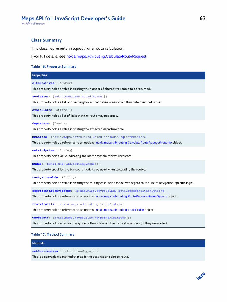
Maps API for JavaScript Developer's Guide 67► API reference
Class Summary
This class represents a request for a route calculation.
[ For full details, see nokia.maps.advrouting.CalculateRouteRequest ]
Table 16: Property Summary
Properties
alternatives: {Number}
This property holds a value indicating the number of alternative routes to be returned.
avoidArea: {nokia.maps.geo.BoundingBox[]}
This property holds a list of bounding boxes that define areas which the route must not cross.
avoidLinks: {String[]}
This property holds a list of links that the route may not cross.
departure: {Number}
This property holds a value indicating the expected departure time.
metaInfo: {nokia.maps.advrouting.CalculateRouteRequestMetaInfo}
This property holds a reference to an optional nokia.maps.advrouting.CalculateRouteRequestMetaInfo object.
metricSystem: {String}
This property holds value indicating the metric system for returned data.
modes: {nokia.maps.advrouting.Mode[]}
This property specifies the transport mode to be used when calculating the routes.
navigationMode: {String}
This property holds a value indicating the routing calculation mode with regard to the use of navigation-specific logic.
representationOptions: {nokia.maps.advrouting.RouteRepresentationOptions}
This property holds a reference to an optional nokia.maps.advrouting.RouteRepresentationOptions object.
truckProfile: {nokia.maps.advrouting.TruckProfile}
This property holds a reference to an optional nokia.maps.advrouting.TruckProfile object.
waypoints: {nokia.maps.advrouting.WaypointParameter[]}
This property holds an array of waypoints through which the route should pass (in the given order).
Table 17: Method Summary
Methods
setDestination (destinationWaypoint)
This is a convenience method that adds the destination point to route.
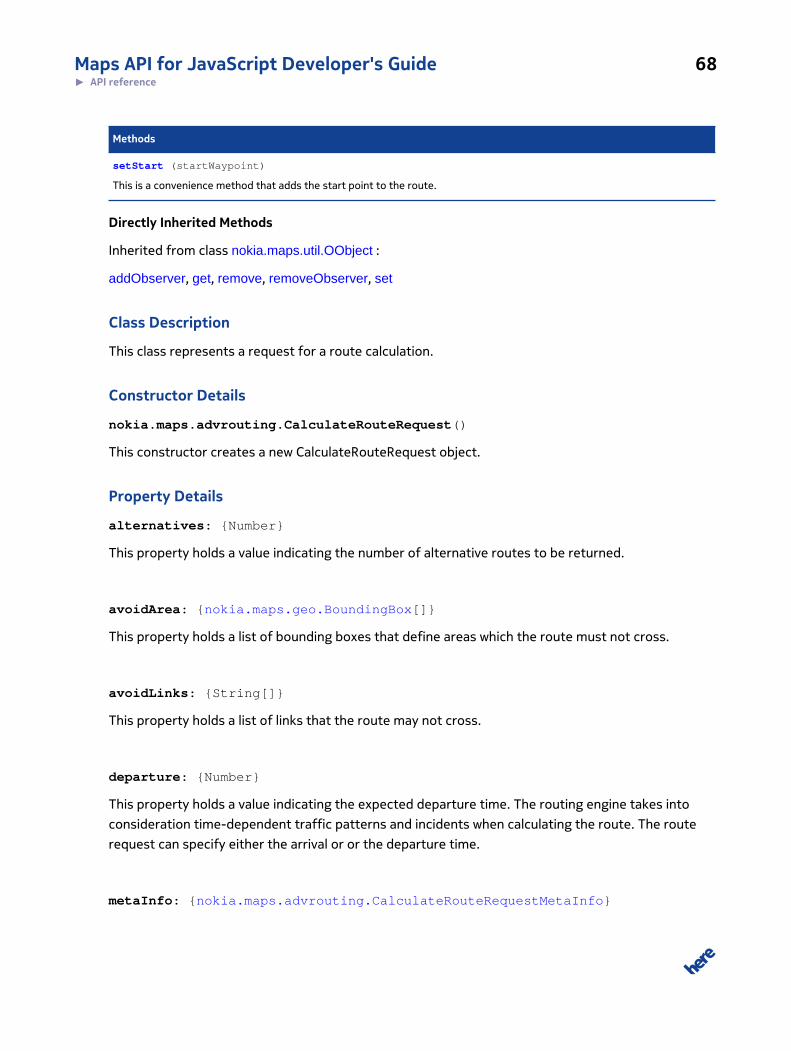
Maps API for JavaScript Developer's Guide 68► API reference
Methods
setStart (startWaypoint)
This is a convenience method that adds the start point to the route.
Directly Inherited Methods
Inherited from class nokia.maps.util.OObject :
addObserver, get, remove, removeObserver, set
Class Description
This class represents a request for a route calculation.
Constructor Details
nokia.maps.advrouting.CalculateRouteRequest()
This constructor creates a new CalculateRouteRequest object.
Property Details
alternatives: {Number}
This property holds a value indicating the number of alternative routes to be returned.
avoidArea: {nokia.maps.geo.BoundingBox[]}
This property holds a list of bounding boxes that define areas which the route must not cross.
avoidLinks: {String[]}
This property holds a list of links that the route may not cross.
departure: {Number}
This property holds a value indicating the expected departure time. The routing engine takes into
consideration time-dependent traffic patterns and incidents when calculating the route. The route
request can specify either the arrival or or the departure time.
metaInfo: {nokia.maps.advrouting.CalculateRouteRequestMetaInfo}

Maps API for JavaScript Developer's Guide 69► API reference
This property holds a reference to an optional nokia.maps.advrouting.CalculateRouteRequestMetaInfo
object.
metricSystem: {String}
This property holds value indicating the metric system for returned data. It can be specified by two
values 'metric' or 'imperial'.
modes: {nokia.maps.advrouting.Mode[]}
This property specifies the transport mode to be used when calculating the routes. The transport
mode has an impact on the speed information provided at link level.
navigationMode: {String}
This property holds a value indicating the routing calculation mode with regard to the use of
navigation-specific logic. The default value is "none", which means that the navigation-specific logic
is excluded from the route calculation by default (and therefore corridor guidance is not available).
The possible values are:
• "none" - the default mode for route calculations; no navigation logic is considered in the
calculation, which means that a normal route calculation suitable, for example, for displaying the
route, is carried out
• "default" - the default navigation mode; this mode uses navigation logic for route calculations
and the resulting route includes corridor guidance according to the corridor options
• "preroute" - a mode that generates minimum information needed to start navigation, thereby
allowing a quick user response; note that by submitting a request specifying the "preroute"
mode and a parallel request with the "default" navigation mode, the client can obtain the
complete route content
• "baseroute" - a mode that generates only the base route even though the calculation is carried
out using navigation logic
representationOptions: {nokia.maps.advrouting.RouteRepresentationOptions}
This property holds a reference to an optional nokia.maps.advrouting.RouteRepresentationOptions
object.
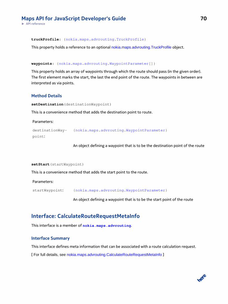
Maps API for JavaScript Developer's Guide 70► API reference
truckProfile: {nokia.maps.advrouting.TruckProfile}
This property holds a reference to an optional nokia.maps.advrouting.TruckProfile object.
waypoints: {nokia.maps.advrouting.WaypointParameter[]}
This property holds an array of waypoints through which the route should pass (in the given order).
The first element marks the start, the last the end point of the route. The waypoints in between are
interpreted as via points.
Method Details
setDestination(destinationWaypoint)
This is a convenience method that adds the destination point to route.
Parameters:
destinationWay-
point:
{nokia.maps.advrouting.WaypointParameter}
An object defining a waypoint that is to be the destination point of the route
setStart(startWaypoint)
This is a convenience method that adds the start point to the route.
Parameters:
startWaypoint: {nokia.maps.advrouting.WaypointParameter}
An object defining a waypoint that is to be the start point of the route
Interface: CalculateRouteRequestMetaInfoThis interface is a member of nokia.maps.advrouting.
Interface Summary
This interface defines meta information that can be associated with a route calculation request.
[ For full details, see nokia.maps.advrouting.CalculateRouteRequestMetaInfo ]
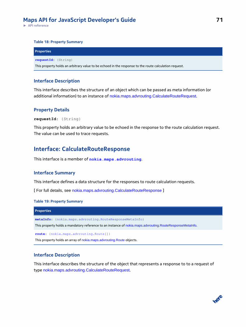
Maps API for JavaScript Developer's Guide 71► API reference
Table 18: Property Summary
Properties
requestId: {String}
This property holds an arbitrary value to be echoed in the response to the route calculation request.
Interface Description
This interface describes the structure of an object which can be passed as meta information (or
additional information) to an instance of nokia.maps.advrouting.CalculateRouteRequest.
Property Details
requestId: {String}
This property holds an arbitrary value to be echoed in the response to the route calculation request.
The value can be used to trace requests.
Interface: CalculateRouteResponseThis interface is a member of nokia.maps.advrouting.
Interface Summary
This interface defines a data structure for the responses to route calculation requests.
[ For full details, see nokia.maps.advrouting.CalculateRouteResponse ]
Table 19: Property Summary
Properties
metaInfo: {nokia.maps.advrouting.RouteResponseMetaInfo}
This property holds a mandatory reference to an instance of nokia.maps.advrouting.RouteResponseMetaInfo.
route: {nokia.maps.advrouting.Route[]}
This property holds an array of nokia.maps.advrouting.Route objects.
Interface Description
This interface describes the structure of the object that represents a response to to a request of
type nokia.maps.advrouting.CalculateRouteRequest.
Maps API for JavaScript Developer's Guide 72► API reference
Property Details
metaInfo: {nokia.maps.advrouting.RouteResponseMetaInfo}
This property holds a mandatory reference to an instance of
nokia.maps.advrouting.RouteResponseMetaInfo.
route: {nokia.maps.advrouting.Route[]}
This property holds an array of nokia.maps.advrouting.Route objects. Note that the array can be
empty.
Interface: GeoWaypointParameterThis interface is a member of nokia.maps.advrouting.
Interface Summary
This interface represents a waypoint based on an instance of nokia.maps.geo.GeoCoordinate.
[ For full details, see nokia.maps.advrouting.GeoWaypointParameter ]
Table 20: Property Summary
Properties
position: {nokia.maps.geo.Coordinate}
This property holds an object containing the geographic coordinates as a center around which to locate route links.
transitRadius: {Number}
This property holds a value indicating the radius within which to locate/select matching links.
Interface Description
This interface represents a waypoint based on an instance of nokia.maps.geo.GeoCoordinate. In a
common use case, a use can specify a waypoint by clicking on the map.
Property Details
position: {nokia.maps.geo.Coordinate}
This property holds an object containing the geographic coordinates as a center around which to
locate route links.
Maps API for JavaScript Developer's Guide 73► API reference
transitRadius: {Number}
This property holds a value indicating the radius within which to locate/select matching links.
Interface: GetRouteRequestThis interface is a member of nokia.maps.advrouting.
Interface Summary
This interface defines a data structure that contains the details of route calculation request to the
GetRoute service.
[ For full details, see nokia.maps.advrouting.GetRouteRequest ]
Table 21: Property Summary
Properties
avoidArea: {nokia.maps.geo.BoundingBox[]}
This property holds an aray of objects that represent areas which the route must not cross.
avoidLinks: {String[]}
This property holds an array of id's of route link the route must avoid.
currentPosition: {nokia.maps.advrouting.WaypointParameter}
This property holds the current position as an instance of nokia.maps.advrouting.WaypointParameter.
departure: {Number}
This property holds the time when the journey is expected to start.
metaInfo: {nokia.maps.advrouting.GetRouteRequestMetaInfo}
This property holds a reference to an instance of nokia.maps.advrouting.GetRouteRequestMetaInfo.
metricSystem: {String}
The default is the metric system associated with the language settings.
mode: {nokia.maps.advrouting.Mode[]}
This property holds an array of objects specifying modes that has been used when calculating the route.
representationOptions: {nokia.maps.advrouting.RouteRepresentationOptions}
This property holds a reference to an instance of nokia.maps.advrouting.RouteRepresentationOptions.
routeId: {String}
This property holds the id of the route object that represents a previously calculated route.
truckProfile: {nokia.maps.advrouting.TruckProfile}
This property holds a reference to an instance of nokia.maps.advrouting.TruckProfile.

Maps API for JavaScript Developer's Guide 74► API reference
Interface Description
This interface defines a data structure that contains the details of route calculation request
to the GetRoute service. The main input parameter for the service is routeId returned by a
previous route calculation and represents the entire route. In a corridor routing scenario, additional
information besides routeId is needed to reconstruct the corridor around the base type.
Property Details
avoidArea: {nokia.maps.geo.BoundingBox[]}
This property holds an aray of objects that represent areas which the route must not cross.
avoidLinks: {String[]}
This property holds an array of id's of route link the route must avoid.
currentPosition: {nokia.maps.advrouting.WaypointParameter}
This property holds the current position as an instance of nokia.maps.advrouting.WaypointParameter.
If the current position is provided, the request response includes information about the travel
progress with updated remaining travel times.
departure: {Number}
This property holds the time when the journey is expected to start. The routing engine considers
time-dependent traffic patterns and incidents when calculating the route.
metaInfo: {nokia.maps.advrouting.GetRouteRequestMetaInfo}
This property holds a reference to an instance of nokia.maps.advrouting.GetRouteRequestMetaInfo.
The use of this property is optional.
metricSystem: {String}
The default is the metric system associated with the language settings..
• imperial
• metric

Maps API for JavaScript Developer's Guide 75► API reference
mode: {nokia.maps.advrouting.Mode[]}
This property holds an array of objects specifying modes that has been used when calculating the
route. The transport mode has an impact on the speed information provided at link level.
representationOptions: {nokia.maps.advrouting.RouteRepresentationOptions}
This property holds a reference to an instance of
nokia.maps.advrouting.RouteRepresentationOptions. The use of this property is optional.
routeId: {String}
This property holds the id of the route object that represents a previously calculated route. It is
required to reconstruct exactly the same route.
truckProfile: {nokia.maps.advrouting.TruckProfile}
This property holds a reference to an instance of nokia.maps.advrouting.TruckProfile. The use of this
property is optional.
Interface: GetRouteRequestMetaInfoThis interface is a member of nokia.maps.advrouting.
Interface Summary
This interface defines a set of route request parameters which are not specific to route retrieval.
[ For full details, see nokia.maps.advrouting.GetRouteRequestMetaInfo ]
Table 22: Property Summary
Properties
RequestId: {String}
This property holds an arbitrary value to be mirrored in the response structure.
Interface Description
This interface defines a set of route request parameters which are not specific to route retrieval.
Maps API for JavaScript Developer's Guide 76► API reference
Property Details
RequestId: {String}
This property holds an arbitrary value to be mirrored in the response structure. The value can be used
to trace back requests.
Interface: GetRouteResponseThis interface is a member of nokia.maps.advrouting.
Interface Summary
This interface defines a response to a route calculation request.
[ For full details, see nokia.maps.advrouting.GetRouteResponse ]
Table 23: Property Summary
Properties
metaInfo: {nokia.maps.advrouting.RouteResponseMetaInfo}
This property holds a mandatory reference to an instance of RouteResponseMetaInfo.
progress: {nokia.maps.advrouting.TravelProgress}
This property holds a reference to an instance of TravelProgress (optional).
route: {nokia.maps.advrouting.Route}
This porperty holds a reference to an Route object (optional).
Interface Description
This interface defines a response to a route calculation request.
Property Details
metaInfo: {nokia.maps.advrouting.RouteResponseMetaInfo}
This property holds a mandatory reference to an instance of RouteResponseMetaInfo.
progress: {nokia.maps.advrouting.TravelProgress}
This property holds a reference to an instance of TravelProgress (optional).
Maps API for JavaScript Developer's Guide 77► API reference
route: {nokia.maps.advrouting.Route}
This porperty holds a reference to an Route object (optional).
Interface: LinkPositionThis interface is a member of nokia.maps.advrouting.
Interface Summary
This interface defines an accurate position of a route link.
[ For full details, see nokia.maps.advrouting.LinkPosition ]
Table 24: Property Summary
Properties
linkId: {String}
This property holds the id of the given link position.
sideOfStreet: {String}
This property indicates whether the waypoint is on the left or right side of the link (if heading from the reference node to thenon-reference node).
spot: {Number}
This property holds the relative position of a link location defined as the fractional distance from the link's reference-node tothe non-reference node, i.e.
Interface Description
This interface defines an accurate position of a route link.
Property Details
linkId: {String}
This property holds the id of the given link position.
sideOfStreet: {String}
This property indicates whether the waypoint is on the left or right side of the link (if heading from
the reference node to the non-reference node). The possible values are:
• "left"
• "right"
Maps API for JavaScript Developer's Guide 78► API reference
• "neither"
spot: {Number}
This property holds the relative position of a link location defined as the fractional distance from
the link's reference-node to the non-reference node, i.e. the value range is between 0 and 1. This
attribute is only relevant if a link is referenced.
Class: ManagerThis class is a member of nokia.maps.advrouting.
Extends: nokia.maps.routing.Manager
Class Summary
This class represents the client-side interface to routing functionality.
[ For full details, see nokia.maps.advrouting.Manager ]
Table 25: Property Summary
Properties
calculateIsolineResponse: {nokia.maps.advrouting.CalculateIsolineResponse}
This property holds an instance of a response to a request for an isoline route calculation.
calculateRouteResponse: {nokia.maps.advrouting.CalculateRouteResponse}
This property holds an instance of a response to a request for a route calculation.
getRouteResponse: {nokia.maps.advrouting.GetRouteResponse}
This property holds a reference to a routing request response.
Directly Inherited Properties
Inherited from class nokia.maps.routing.Manager :
state
Table 26: Method Summary
Methods
calculateIsoline (request)
This method submits a request for an isoline route calculation.
calculateRoute (request)
Maps API for JavaScript Developer's Guide 79► API reference
Methods
This method submits a request for a route calculation.
getErrorCause () : {nokia.maps.routing.ServiceError}
This method retrieves an object describing the cause of an error that occurred when a request was being processed.
getIsolines () : {nokia.maps.geo.Shape[]}
This method retrieves the isoline routes calculated by the server.
getRoute (request)
This method requests existing routes from the server.
Directly Inherited Methods
Inherited from class nokia.maps.routing.Manager :
calculateRoute, clear, destroy, getErrorCause, getRoutes
Inherited from class nokia.maps.util.OObject :
addObserver, get, remove, removeObserver, set
Class Description
This class represents the client-side interface to routing functionality. We assume that only one
routing response is kept at a time. If a new request is triggered the old response is replaced.
Constructor Details
nokia.maps.advrouting.Manager()
This constructor creates a new empty Manager object.
Property Details
calculateIsolineResponse: {nokia.maps.advrouting.CalculateIsolineResponse}
This property holds an instance of a response to a request for an isoline route calculation. Property is
populated after successful calculateIsoline call.
calculateRouteResponse: {nokia.maps.advrouting.CalculateRouteResponse}
This property holds an instance of a response to a request for a route calculation. Property is
populated after successful calculateRoute call.
Maps API for JavaScript Developer's Guide 80► API reference
getRouteResponse: {nokia.maps.advrouting.GetRouteResponse}
This property holds a reference to a routing request response. Property is populated after successful
getRoute call.
Method Details
calculateIsoline(request)
This method submits a request for an isoline route calculation.
Parameters:
request: {nokia.maps.advrouting.CalculateIsolineRequest}
An object that specifies the details of the request.
calculateRoute(request)
This method submits a request for a route calculation.
Parameters:
request: {nokia.maps.advrouting.CalculateRouteRequest}
A request object that specifies the details of the request.
getErrorCause(): {nokia.maps.routing.ServiceError}
This method retrieves an object describing the cause of an error that occurred when a request was
being processed.
Returns:
{nokia.maps.routing.ServiceError}
The error object containing the error type}
getIsolines(): {nokia.maps.geo.Shape[]}
This method retrieves the isoline routes calculated by the server.
Returns:
Maps API for JavaScript Developer's Guide 81► API reference
{nokia.maps.geo.Shape[]}
getRoute(request)
This method requests existing routes from the server.
Parameters:
request: {nokia.maps.advrouting.GetRouteRequest}
An object that specifies the details of the request.
Interface: ManeuverThis interface is a member of nokia.maps.advrouting.
Interface Summary
This interface defines a maneuver, which describes actions the person following the route must carry
out to enter the next link or segment of the route.
[ For full details, see nokia.maps.advrouting.Maneuver ]
Table 27: Property Summary
Properties
boundingBox: {nokia.maps.geo.BoundingBox}
Coordinates defining the bounding box of the entire maneuver.
equipment: {String[]}
This property holds an array of identifiers of equipment and features available at the location of the maneuver.
firstPoint: {Number}
Index into the global geometry array, pointing to the first point of the shape subsegment associated with this Maneuver.
instruction: {String}
This property holds the maneuver instructions, for example "Turn left onto Minna St.
lastPoint: {Number}
Index into the global geometry array, pointing to the last point of the shape subsegment associated with this Maneuver.
length: {Number}
This property holds the length of the segment following the given maneuver until the next maneuver.
nextManeuver: {nokia.maps.advrouting.Maneuver}
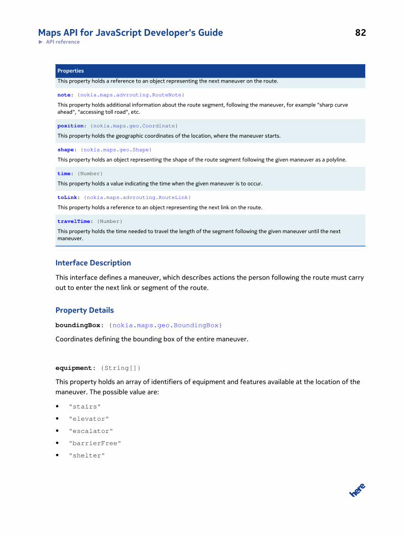
Maps API for JavaScript Developer's Guide 82► API reference
Properties
This property holds a reference to an object representing the next maneuver on the route.
note: {nokia.maps.advrouting.RouteNote}
This property holds additional information about the route segment, following the maneuver, for example "sharp curveahead", "accessing toll road", etc.
position: {nokia.maps.geo.Coordinate}
This property holds the geographic coordinates of the location, where the maneuver starts.
shape: {nokia.maps.geo.Shape}
This property holds an object representing the shape of the route segment following the given maneuver as a polyline.
time: {Number}
This property holds a value indicating the time when the given maneuver is to occur.
toLink: {nokia.maps.advrouting.RouteLink}
This property holds a reference to an object representing the next link on the route.
travelTime: {Number}
This property holds the time needed to travel the length of the segment following the given maneuver until the nextmaneuver.
Interface Description
This interface defines a maneuver, which describes actions the person following the route must carry
out to enter the next link or segment of the route.
Property Details
boundingBox: {nokia.maps.geo.BoundingBox}
Coordinates defining the bounding box of the entire maneuver.
equipment: {String[]}
This property holds an array of identifiers of equipment and features available at the location of the
maneuver. The possible value are:
• "stairs"
• "elevator"
• "escalator"
• "barrierFree"
• "shelter"

Maps API for JavaScript Developer's Guide 83► API reference
• "restroom"
• "shopping"
• "restaurant"
• "baggageRoom"
• "bikeDepot"
• "bikeAccepted"
• "parking"
• "unknown"
firstPoint: {Number}
Index into the global geometry array, pointing to the first point of the shape subsegment associated
with this Maneuver. Must be followed by lastPoint.
instruction: {String}
This property holds the maneuver instructions, for example "Turn left onto Minna St."
lastPoint: {Number}
Index into the global geometry array, pointing to the last point of the shape subsegment associated
with this Maneuver. Must be preceded by firstPoint
length: {Number}
This property holds the length of the segment following the given maneuver until the next maneuver.
nextManeuver: {nokia.maps.advrouting.Maneuver}
This property holds a reference to an object representing the next maneuver on the route.
note: {nokia.maps.advrouting.RouteNote}
This property holds additional information about the route segment, following the maneuver, for
example "sharp curve ahead", "accessing toll road", etc.
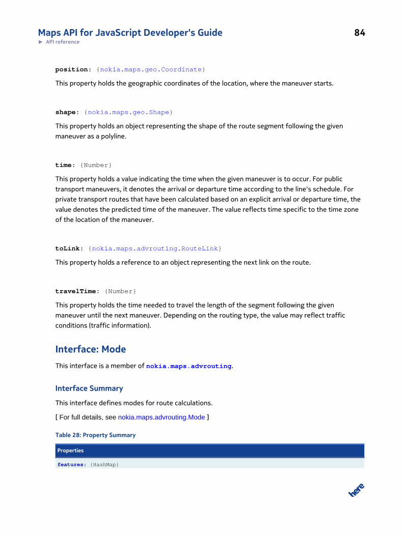
Maps API for JavaScript Developer's Guide 84► API reference
position: {nokia.maps.geo.Coordinate}
This property holds the geographic coordinates of the location, where the maneuver starts.
shape: {nokia.maps.geo.Shape}
This property holds an object representing the shape of the route segment following the given
maneuver as a polyline.
time: {Number}
This property holds a value indicating the time when the given maneuver is to occur. For public
transport maneuvers, it denotes the arrival or departure time according to the line's schedule. For
private transport routes that have been calculated based on an explicit arrival or departure time, the
value denotes the predicted time of the maneuver. The value reflects time specific to the time zone
of the location of the maneuver.
toLink: {nokia.maps.advrouting.RouteLink}
This property holds a reference to an object representing the next link on the route.
travelTime: {Number}
This property holds the time needed to travel the length of the segment following the given
maneuver until the next maneuver. Depending on the routing type, the value may reflect traffic
conditions (traffic information).
Interface: ModeThis interface is a member of nokia.maps.advrouting.
Interface Summary
This interface defines modes for route calculations.
[ For full details, see nokia.maps.advrouting.Mode ]
Table 28: Property Summary
Properties
features: {HashMap}
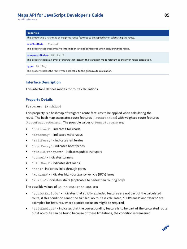
Maps API for JavaScript Developer's Guide 85► API reference
Properties
This property is a hashmap of weighted route features to be applied when calculating the route.
trafficMode: {String}
This property specifies if traffic information is to be considered when calculating the route.
transportModes: {String[]}
This property holds an array of strings that identify the transport mode relevant to the given route calculation.
type: {String}
This property holds the route type applicable to the given route calculation.
Interface Description
This interface defines modes for route calculations.
Property Details
features: {HashMap}
This property is a hashmap of weighted route features to be applied when calculating the
route. The hash map associates route features (RouteFeature) with weighted route features
(RouteFeatureWeight). The possible values of RouteFeature are:
• "tollroad" - indicates toll roads
• "motorway" - indicates motorways
• "railFerry" - indicates rail ferries
• "boatFerry"- indicates boat ferries
• "publicTransport"- indicates public transport
• "tunnel"- indicates tunnels
• "dirtRoad"- indicates dirt roads
• "park"- indicates links through parks
• "HOVLane"- indicates high-occupancy vehicle (HOV) lanes
• "stairs"- indicates stairs (applicable to pedestrian routing only)
The possible values of RouteFeatureWeight are:
• "strictExclude" - indicates that strictly excluded features are not part of the calculated
route; if this condition cannot be fulfilled, no route is calculated; "HOVLanes" and "stairs" are
examples for features, where a strict exclusion might be required
• "softExclude" - indicates that the corresponding feature is to be part of the calculated route,
but if no route can be found because of these limitations, the condition is weakened

Maps API for JavaScript Developer's Guide 86► API reference
• "avoid" - indicates that the corresponding feature is to be avoided (the route is to avoid areas,
road links, etc. with this feature)
• "normal" - indicates that the corresponding feature is neither preferred nor avoided in the
route calculation
• "prefer" - indicates that the corresponding feature is to be preferred (included where possible)
in the calculated route
trafficMode: {String}
This property specifies if traffic information is to be considered when calculating the route. The
possible values are:
• "enabled" - indicates that dynamic traffic conditions are to be taken into account (current
traffic traffic patterns, short term closures, long term closures)
• "disabled" - indicates that dynamic traffic conditions are not to be taken into account (only
apply time restrictions and seasonal closures)
• "default" - indicates that traffic-related constraints applicable for the selected route type,
transport mode, departure time and entitlements are automatically taken into consideration
transportModes: {String[]}
This property holds an array of strings that identify the transport mode relevant to the given route
calculation. The possible values are:
• "car" - indicates the route is to be suitable for cars
• "pedestrian" - indicates that the route is to be suitable for pedestrians
• "truck" - indicates that the route is to be suitable for trucks
type: {String}
This property holds the route type applicable to the given route calculation. The possible values are:
• "shortest" - indicates the shortest possible route in terms of distance traveled between start
and destination, disregarding any traffic conditions
• "fastest" - indicates the shortest possible route in terms of travel time between the start and
destination; the selected traffic mode determines whether the estimated travel time reflects
traffic conditions
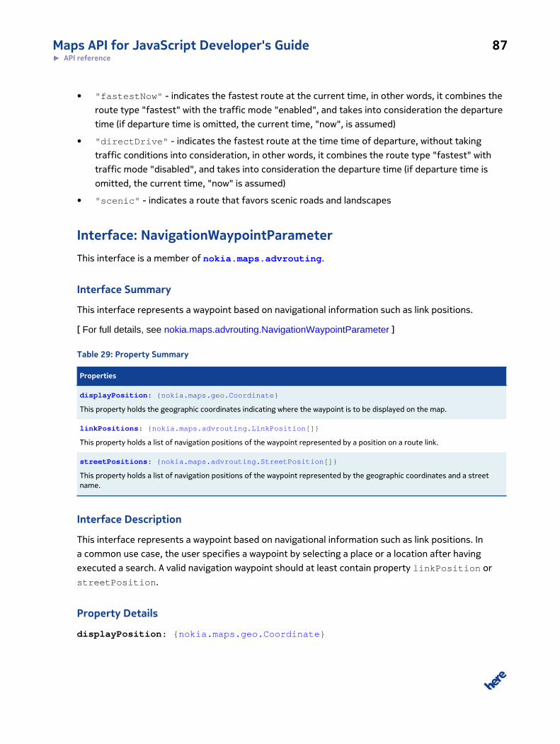
Maps API for JavaScript Developer's Guide 87► API reference
• "fastestNow" - indicates the fastest route at the current time, in other words, it combines the
route type "fastest" with the traffic mode "enabled", and takes into consideration the departure
time (if departure time is omitted, the current time, "now", is assumed)
• "directDrive" - indicates the fastest route at the time time of departure, without taking
traffic conditions into consideration, in other words, it combines the route type "fastest" with
traffic mode "disabled", and takes into consideration the departure time (if departure time is
omitted, the current time, "now" is assumed)
• "scenic" - indicates a route that favors scenic roads and landscapes
Interface: NavigationWaypointParameterThis interface is a member of nokia.maps.advrouting.
Interface Summary
This interface represents a waypoint based on navigational information such as link positions.
[ For full details, see nokia.maps.advrouting.NavigationWaypointParameter ]
Table 29: Property Summary
Properties
displayPosition: {nokia.maps.geo.Coordinate}
This property holds the geographic coordinates indicating where the waypoint is to be displayed on the map.
linkPositions: {nokia.maps.advrouting.LinkPosition[]}
This property holds a list of navigation positions of the waypoint represented by a position on a route link.
streetPositions: {nokia.maps.advrouting.StreetPosition[]}
This property holds a list of navigation positions of the waypoint represented by the geographic coordinates and a streetname.
Interface Description
This interface represents a waypoint based on navigational information such as link positions. In
a common use case, the user specifies a waypoint by selecting a place or a location after having
executed a search. A valid navigation waypoint should at least contain property linkPosition or
streetPosition.
Property Details
displayPosition: {nokia.maps.geo.Coordinate}

Maps API for JavaScript Developer's Guide 88► API reference
This property holds the geographic coordinates indicating where the waypoint is to be displayed on
the map. It usually denotes the center of the location and is not navigable, that is it is not located on
a link in the routing network in contrast to the navigation positions of a location.
linkPositions: {nokia.maps.advrouting.LinkPosition[]}
This property holds a list of navigation positions of the waypoint represented by a position on a
route link. As there might be multiple ways to reach a waypoint (for example an airport with different
entries and exits) the user can provide a list of navigation positions. Compared to street positions,
link positions are the preferred way to identify navigation positions as they are more more precise.
Mixing mix street positions and link positions in one waypoint parameter is not supported.
streetPositions: {nokia.maps.advrouting.StreetPosition[]}
This property holds a list of navigation positions of the waypoint represented by the geographic
coordinates and a street name. As there might be multiple ways to reach a waypoint (for example
an airport with different entries and exits) the user can provide a list of navigation positions. This
property should only be used if no link information is available; LinkPositions are the preferred
way to identify navigation positions, because they are more precise. Mixing street positions and link
positions in one waypoint parameter is not supported.
Interface: RouteThis interface is a member of nokia.maps.advrouting.
Interface Summary
This interface defines a route.
[ For full details, see nokia.maps.advrouting.Route ]
Table 30: Property Summary
Properties
boundingBox: {nokia.maps.geo.BoundingBox}
This property holds a bounding box object that enclosed the route.
legs: {nokia.maps.routing.RouteLeg[]}
This property holds an array of route legs (section of the route between any two consecutive waypoints).
mode: {nokia.maps.advrouting.Mode}
This property holds the identifier of the mode used in the route calculation.
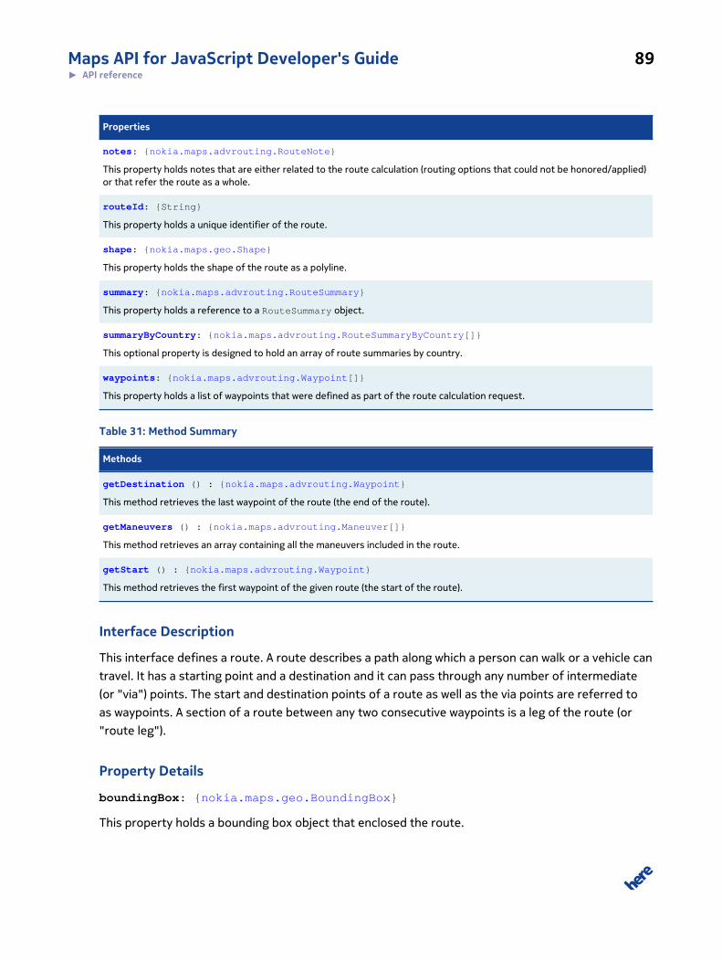
Maps API for JavaScript Developer's Guide 89► API reference
Properties
notes: {nokia.maps.advrouting.RouteNote}
This property holds notes that are either related to the route calculation (routing options that could not be honored/applied)or that refer the route as a whole.
routeId: {String}
This property holds a unique identifier of the route.
shape: {nokia.maps.geo.Shape}
This property holds the shape of the route as a polyline.
summary: {nokia.maps.advrouting.RouteSummary}
This property holds a reference to a RouteSummary object.
summaryByCountry: {nokia.maps.advrouting.RouteSummaryByCountry[]}
This optional property is designed to hold an array of route summaries by country.
waypoints: {nokia.maps.advrouting.Waypoint[]}
This property holds a list of waypoints that were defined as part of the route calculation request.
Table 31: Method Summary
Methods
getDestination () : {nokia.maps.advrouting.Waypoint}
This method retrieves the last waypoint of the route (the end of the route).
getManeuvers () : {nokia.maps.advrouting.Maneuver[]}
This method retrieves an array containing all the maneuvers included in the route.
getStart () : {nokia.maps.advrouting.Waypoint}
This method retrieves the first waypoint of the given route (the start of the route).
Interface Description
This interface defines a route. A route describes a path along which a person can walk or a vehicle can
travel. It has a starting point and a destination and it can pass through any number of intermediate
(or "via") points. The start and destination points of a route as well as the via points are referred to
as waypoints. A section of a route between any two consecutive waypoints is a leg of the route (or
"route leg").
Property Details
boundingBox: {nokia.maps.geo.BoundingBox}
This property holds a bounding box object that enclosed the route.
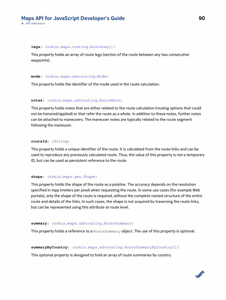
Maps API for JavaScript Developer's Guide 90► API reference
legs: {nokia.maps.routing.RouteLeg[]}
This property holds an array of route legs (section of the route between any two consecutive
waypoints).
mode: {nokia.maps.advrouting.Mode}
This property holds the identifier of the mode used in the route calculation.
notes: {nokia.maps.advrouting.RouteNote}
This property holds notes that are either related to the route calculation (routing options that could
not be honored/applied) or that refer the route as a whole. In addition to these notes, further notes
can be attached to maneuvers. The maneuver notes are typically related to the route segment
following the maneuver.
routeId: {String}
This property holds a unique identifier of the route. It is calculated from the route links and can be
used to reproduce any previously calculated route. Thus, the value of this property is not a temporary
ID, but can be used as persistent reference to the route.
shape: {nokia.maps.geo.Shape}
This property holds the shape of the route as a polyline. The accuracy depends on the resolution
specified in mpp (meters per pixel) when requesting the route. In some use cases (for example Web
portals), only the shape of the route is required, without the complete nested structure of the entire
route and details of the links. In such cases, the shape is not acquired by traversing the route links,
but can be represented using this attribute at route level.
summary: {nokia.maps.advrouting.RouteSummary}
This property holds a reference to a RouteSummary object. The use of this property is optional.
summaryByCountry: {nokia.maps.advrouting.RouteSummaryByCountry[]}
This optional property is designed to hold an array of route summaries by country.
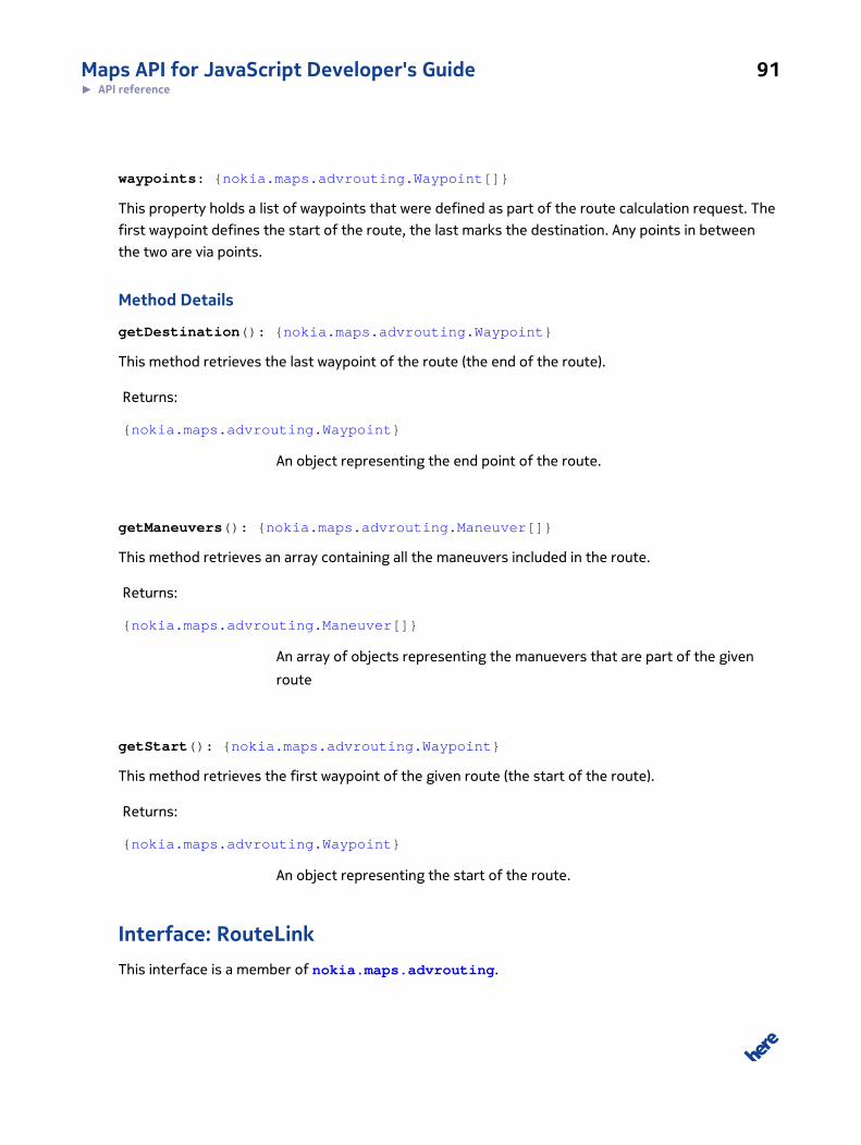
Maps API for JavaScript Developer's Guide 91► API reference
waypoints: {nokia.maps.advrouting.Waypoint[]}
This property holds a list of waypoints that were defined as part of the route calculation request. The
first waypoint defines the start of the route, the last marks the destination. Any points in between
the two are via points.
Method Details
getDestination(): {nokia.maps.advrouting.Waypoint}
This method retrieves the last waypoint of the route (the end of the route).
Returns:
{nokia.maps.advrouting.Waypoint}
An object representing the end point of the route.
getManeuvers(): {nokia.maps.advrouting.Maneuver[]}
This method retrieves an array containing all the maneuvers included in the route.
Returns:
{nokia.maps.advrouting.Maneuver[]}
An array of objects representing the manuevers that are part of the given
route
getStart(): {nokia.maps.advrouting.Waypoint}
This method retrieves the first waypoint of the given route (the start of the route).
Returns:
{nokia.maps.advrouting.Waypoint}
An object representing the start of the route.
Interface: RouteLinkThis interface is a member of nokia.maps.advrouting.
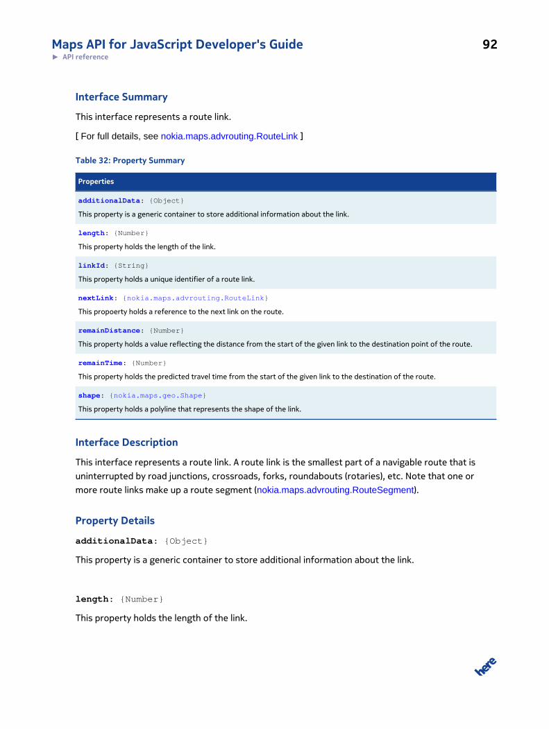
Maps API for JavaScript Developer's Guide 92► API reference
Interface Summary
This interface represents a route link.
[ For full details, see nokia.maps.advrouting.RouteLink ]
Table 32: Property Summary
Properties
additionalData: {Object}
This property is a generic container to store additional information about the link.
length: {Number}
This property holds the length of the link.
linkId: {String}
This property holds a unique identifier of a route link.
nextLink: {nokia.maps.advrouting.RouteLink}
This propoerty holds a reference to the next link on the route.
remainDistance: {Number}
This property holds a value reflecting the distance from the start of the given link to the destination point of the route.
remainTime: {Number}
This property holds the predicted travel time from the start of the given link to the destination of the route.
shape: {nokia.maps.geo.Shape}
This property holds a polyline that represents the shape of the link.
Interface Description
This interface represents a route link. A route link is the smallest part of a navigable route that is
uninterrupted by road junctions, crossroads, forks, roundabouts (rotaries), etc. Note that one or
more route links make up a route segment (nokia.maps.advrouting.RouteSegment).
Property Details
additionalData: {Object}
This property is a generic container to store additional information about the link.
length: {Number}
This property holds the length of the link.
Maps API for JavaScript Developer's Guide 93► API reference
linkId: {String}
This property holds a unique identifier of a route link. A minus ("-") at the beginning of the identifier
indicates that the link is traversed from node to reference node. An unsigned identifier means that
the link is traversed from reference node to node.
nextLink: {nokia.maps.advrouting.RouteLink}
This propoerty holds a reference to the next link on the route.
remainDistance: {Number}
This property holds a value reflecting the distance from the start of the given link to the destination
point of the route.
remainTime: {Number}
This property holds the predicted travel time from the start of the given link to the destination of
the route. Note that traffic information is taken into account if the user is authorized to use traffic
information.
shape: {nokia.maps.geo.Shape}
This property holds a polyline that represents the shape of the link.
Interface: RouteNoteThis interface is a member of nokia.maps.advrouting.
Interface Summary
This interface represents route notes, which provide additional information about a route.
[ For full details, see nokia.maps.advrouting.RouteNote ]
Table 33: Property Summary
Properties
additionalData: {Object}
Maps API for JavaScript Developer's Guide 94► API reference
Properties
This property holds a container object for additional data to be stored along with the note.
linkIds: {String[]}
This property holds an array of ids of route links to which the note applies.
position: {nokia.maps.geo.Coordinate}
This property holds the geographic coordinates of the position along the route to which the note applies.
text: {String}
This property holds a short piece of text describing the note.
validityPeriod: {String}
This property holds a string value indicating the validity period of the note.
Interface Description
This interface represents route notes, which provide additional information about a route. The notes
can either relate to the calculation itself (such as unused routing options) or to the characteristics of
the route (for example, entering a toll road, passing a border, etc.)
Property Details
additionalData: {Object}
This property holds a container object for additional data to be stored along with the note.
linkIds: {String[]}
This property holds an array of ids of route links to which the note applies.
position: {nokia.maps.geo.Coordinate}
This property holds the geographic coordinates of the position along the route to which the note
applies.
text: {String}
This property holds a short piece of text describing the note. Please note that the property is not
subject to internationalization and should therefore not be used in user displays.
Maps API for JavaScript Developer's Guide 95► API reference
validityPeriod: {String}
This property holds a string value indicating the validity period of the note. This attribute is used to
specify time-dependent restrictions (for example "road is closed during winter").
Interface: RouteRepresentationOptionsThis interface is a member of nokia.maps.advrouting.
Interface Summary
This interface defines options that can be used to fine-tune the scope and granularity of a route
representation in the response.
[ For full details, see nokia.maps.advrouting.RouteRepresentationOptions ]
Table 34: Property Summary
Properties
instructionFormat: {String}
This property holds the text formatting specification for instructions associated with a maneuver.
language: {String}
This property holds the identifier of the language to be used for all textual information.
legAttributes: {String[]}
This property holds a list of strings in the format "[-]attribute", where "attribute" denotes an identifier of a route legattribute.
linkAttributes: {String[]}
This property holds a list of strings that identify which attributes are to be included in route links.
maneuverAttributes: {String[]}
This property holds a list of strings that identify which attributes are to be included in route maneuvers.
representationMode: {String}
This property holds a value indicating the representation mode for the route.
routeAttributes: {String[]}
This property holds a list of route attribute names in the format "[-]attribute" that are included in or excluded from thereturned routes.
viewBounds: {nokia.maps.geo.BoundingBox}
This property holds an object defining the route view bounds.
viewResolution: {Number}

Maps API for JavaScript Developer's Guide 96► API reference
Properties
This property holds a value indicating the resolution of the route view in meters per pixel (mpp), allowing for the route shapein the response to reflect the resolution of the client.
Interface Description
This interface defines options that can be used to fine-tune the scope and granularity of a route
representation in the response.
Property Details
instructionFormat: {String}
This property holds the text formatting specification for instructions associated with a maneuver.
• "txt" - returns the instruction as a plain text string
• "native" - based on the message templates used in the routing engine with the different
parameter values being tagged with corresponding xml tags.
• "html" - instruction format is based on span tags with different CSS classes to assign semantics
to the tagged part of the instruction
language: {String}
This property holds the identifier of the language to be used for all textual information. The value is
a string holding a two-letter language identifier (ISO 639-1), followed by a dash, followed by a two-
letter country code (where appropriate), for example "en-us". The supported languages are:
• en-uk
• en-us
• fr-fr
• de-de
• es-es
• it-it
legAttributes: {String[]}
This property holds a list of strings in the format "[-]attribute", where
"attribute" denotes an identifier of a route leg attribute. If the list is
combined with the value "all", "none" or a representation mode value (see
nokia.maps.advrouting.RouteRepresentationOptions#representationMode), the listed attributes are
Maps API for JavaScript Developer's Guide 97► API reference
interpreted as delta requests and a "-" before an attribute identifier indicates the attribute is to be
removed, while no prefix indicates that the attribute is to be added.
If the property is not specified, the assumed defaults are "maneuvers", "waypoint" and "length".
The list can include the following strings:
• "waypoint" - indicates whether waypoints are to be included in the route leg
• "maneuvers" - indicates whether the maneuvers of the route leg are to be included
• "links" - indicates whether the links along the route leg are to be included; if "links" is not
specified, only route segments are included
• "length" - indicates whether the route leg should include its length
• "travelTime" - indicates whether the route leg should include its duration
linkAttributes: {String[]}
This property holds a list of strings that identify which attributes are to be included in route links. If
the property is not specified, the default list includes "shape", "speedLimit", "dynamicSpeedInfo",
"address". The list can include the following strings:
• "shape" - indicates whether the link should include its geometry
• "length" - indicates whether the link should include its length
• "speedLimit" - indicates whether the link should include the applicable speed limit
• "dynamicSpeedInfo" - indicates whether the link should include dynamic speed information
• "incidents" - indicates whether the link should include incidents
• "truckRestrictions" - indicates whether the link should include truck restrictions
• "externalResources" - indicates whether the link should include external resources
• "flags" - indicates whether the link should include link flags
• "corridorLevel" - indicates whether the link should include the corridor level
• "nextLink" - indicates whether the link should include the next link along the route
• "stubs" - indicates whether the link should include the corridor stubs
• "publicTransportLine" - indicates whether the link should include information about public
transport line(s)
• "TMCCodes" - indicates whether the link should include information about the covered TMC
Codes
• "jamFactor" - indicates whether the link's dynamic speed info should include information
about the jam factor

Maps API for JavaScript Developer's Guide 98► API reference
• "jamFactorTrend" - indicates whether the link's dynamic speed info should include
information about the jam factor trend
• "confidence" - indicates whether the link's dynamic speed info should include information
about the level of confidence regarding traffic information
• "address" - indicates whether the link should include the link's address
• "roadNumber" - indicates whether the link should include the link's road number
• "roadName" - indicates whether the link should include the link's road number
• "freewayJunction" - indicates whether the link should include the name of the freeway
junction
• "timezone" - indicates whether the link should include the timezone
• "remainTime" - indicates whether the link should include information about the remainingtime
until the destination is reached.
• "remainDistance" - indicates whether the link should include information about the remaining
distance until the destination is reached.
• "maneuver" - indicates whether the link should include information about the associated
maneuver.
• "functionalClass" - indicates whether the link should include information about the
functional class.
• "nextStopName" - indicates whether the link should include information about the next stop.
• "additionalData" - indicates whether the link should include the container for additional
data.
• "speedCategory" - indicates whether the link should include speed category information.
• "predecessors" - indicates whether the link should include predecessor link ID information.
• "successors" - indicates whether the link should include predecessor link ID information.
• "indices" - indicates whether shape index information (FirstPoint, LastPoint) should be
included in links instead of copying shape points.
maneuverAttributes: {String[]}
This property holds a list of strings that identify which attributes are to be included in route
maneuvers. If the property is not specified, the default list includes "position" and "link". The list can
include the following strings:
• "position" - indicates whether the position should be included in each maneuvers
• "shape" - indicates whether the shape of the segment to the next maneuver should be included
in the maneuvers
Maps API for JavaScript Developer's Guide 99► API reference
• "travelTime" - indicates whether the time needed to the next maneuver should be included in
the maneuvers
• "length" - indicates whether the distance to the next maneuver should be included in the
maneuvers
• "time" - indicates whether the point in time when the maneuver will take place should be
included in the maneuvers
• "link" - indicates whether the link, where the maneuver takes place is to be included
• "publicTransportLine" - indicates whether the information about the public transport line(s)
should be included
• "platform" - indicates whether the platform information about platform related to a public
transport line should be included
• "equipment" - indicates whether equipment at the maneuver should be included in the
maneuvers
• "lane" - indicates whether lane information should be included
• "roadName" - indicates whether the road name should be included in the maneuvers
• "nextRoadName" - indicates whether the name of the next road shall be included in the
maneuvers
• "roadNumber" - indicates whether the road number should be included in the maneuvers
• "nextRoadNumber" - indicates whether the number of the next road should be included in the
maneuvers
• "roadTemplate" - indicates whether the template for route display should be included in the
maneuvers
• "signPost" - indicates whether sign post information should be included
• "notes" - indicates whether additional notes should be included in the maneuvers
• "action" - indicates whether actions should be included in the maneuvers
• "direction" - indicates whether directions should be included in the maneuvers
• "nextManeuver" - indicates whether a reference to the next maneuver should be included in
the maneuvers
• "freewayExit" - indicates whether the freeway exit should be included in the maneuvers
• "freewayJunction" - indicates whether the freeway junction should be included in the
maneuvers
• "baseTime" - indicates whether the BaseTime information should be included in the maneuvers.
By default, BaseTime information is not included in the maneuvers
• "trafficTime" - indicates whether the TrafficTime information should be included in the
maneuvers. By default, TrafficTime information is not included in the maneuvers
Maps API for JavaScript Developer's Guide 100► API reference
• "indices" - indicates whether shape index information (FirstPoint, LastPoint) should be
included in the maneuvers instead of copying shape points to the maneuver
• "waitTime" - indicates whether wait time information should be included in public transport
maneuvers
representationMode: {String}
This property holds a value indicating the representation mode for the route. It applies to the use
cases, where not all objects and attributes in the route object model are required at once, and allows
the API user to specify which part of the route is to be returned. The possible values are:
• "overview" - indicates the overview mode only, the returned data include the
nokia.maps.advrouting.Route and nokia.maps.advrouting.RouteSummary objects
• "dragNDrop" - indicates the drag-and-drop mode to be used during drag and drop (re-routing)
operations. The response contain only the shape of the route restricted to the view bounds
provided in the representation options
• "navigation" - indicates the navigation mode to provide all information necessary to support
a navigation device. This mode activates the most extensive data response that includes all links
to allow detailed display, while navigating
• "turnByTurn" - indicates the turn-by-turn mode to provide all the information necessary to
support turn-by-turn navigation. This mode activates all data needed for navigation, excluding
any redundancies
REST routing API also supports following options:
• "display" - allows to show the route with all maneuvers. Links won't be included in the
response
• "linkPaging" - is used when incrementally loading links while navigating along the route. The
response will be limited to link information.
routeAttributes: {String[]}
This property holds a list of route attribute names in the format "[-]attribute" that are included in
or excluded from the returned routes. If the property is not specified, the default attributes are
"waypoints", "summary", "maneuvers" and "links".
Note that a list of attributes in combination with "all", "none" or items from
nokia.maps.advrouting.RouteRepresentationOptions#representationMode is treated as a delta
specification, where a minus sign ("-") preceding an attribute name indicates the attribute is to be
removed/excluded, while an attribute without a minus sign is included/added.
Maps API for JavaScript Developer's Guide 101► API reference
The list of attributes can include the following strings:
• "maneuvers" - indicates whether maneuvers are to be included in the route
• "links" - indicates whether route links are to be included in the route
• "segments" - indicates whether are to be included in the route
• "waypoints" - indicates whether via points are to be included in the route
• "summary" - indicates whether a route summary is to be provided for the route
• "summaryByCountry" - indicates whether a country-based route summary is to be provided
for the route
• "shape" - indicates whether the shape of the route is to be provided for the route
• "boundingBox" - indicates whether the bounding box of the route is to be provided for the
route
• "notes" - indicates whether route route notes are to be included in the route
• "none" - indicates that no attributes are to be provided for the route; "none" can be used in
combination with a list of attributes to be added, first to clear all attributes (including the default
ones) and then to add only those required, thus creating a customized list of attributes to be
acted upon
• "all" - indicates that all attributes are to be provided for the route; "all" can be combined
with a list of attribute names preceded by the minus sign ("-") to indicate the attributes to be
excluded, which in effect means "add all, then remove those preceded by a minus sign (for
example, ["all", "-summary"])
• members of nokia.maps.advrouting.RouteRepresentationOptions#representationMode, followed
by a list of zero or more attributes to include/exclude
viewBounds: {nokia.maps.geo.BoundingBox}
This property holds an object defining the route view bounds. If view bounds are specified in the
request, only shapes and links which fit into these bounds are returned. A typical use case for the use
of this property is a drag-and-drop scenario, where the client requires only a rough visual update of
the route within the currently visible bounds.
viewResolution: {Number}
This property holds a value indicating the resolution of the route view in meters per pixel (mpp),
allowing for the route shape in the response to reflect the resolution of the client.
Maps API for JavaScript Developer's Guide 102► API reference
Interface: RouteResponseMetaInfoThis interface is a member of nokia.maps.advrouting.
Interface Summary
This interface represents meta information which is not directly related to the route calculation.
[ For full details, see nokia.maps.advrouting.RouteResponseMetaInfo ]
Table 35: Property Summary
Properties
additionalData: {Object}
This property holds a container for additional data to be stored along with the response meta info.
requestId: {String}
This property holds the request id mirrored from the route calculation request structure and can be used to trace backrequests.
timestamp: {Number}
This property holds the time at which the route calculation was performed.
Interface Description
This interface represents meta information which is not directly related to the route calculation.
Property Details
additionalData: {Object}
This property holds a container for additional data to be stored along with the response meta info.
requestId: {String}
This property holds the request id mirrored from the route calculation request structure and can be
used to trace back requests.
timestamp: {Number}
This property holds the time at which the route calculation was performed.
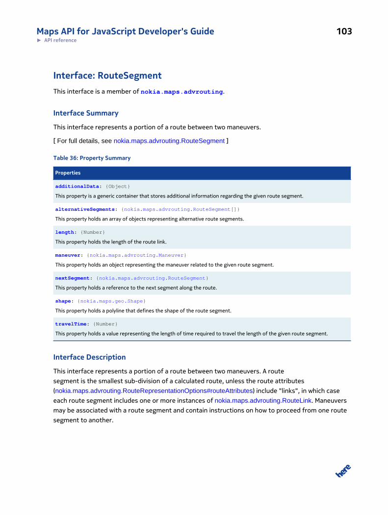
Maps API for JavaScript Developer's Guide 103► API reference
Interface: RouteSegmentThis interface is a member of nokia.maps.advrouting.
Interface Summary
This interface represents a portion of a route between two maneuvers.
[ For full details, see nokia.maps.advrouting.RouteSegment ]
Table 36: Property Summary
Properties
additionalData: {Object}
This property is a generic container that stores additional information regarding the given route segment.
alternativeSegments: {nokia.maps.advrouting.RouteSegment[]}
This property holds an array of objects representing alternative route segments.
length: {Number}
This property holds the length of the route link.
maneuver: {nokia.maps.advrouting.Maneuver}
This property holds an object representing the maneuver related to the given route segment.
nextSegment: {nokia.maps.advrouting.RouteSegment}
This property holds a reference to the next segment along the route.
shape: {nokia.maps.geo.Shape}
This property holds a polyline that defines the shape of the route segment.
travelTime: {Number}
This property holds a value representing the length of time required to travel the length of the given route segment.
Interface Description
This interface represents a portion of a route between two maneuvers. A route
segment is the smallest sub-division of a calculated route, unless the route attributes
(nokia.maps.advrouting.RouteRepresentationOptions#routeAttributes) include "links", in which case
each route segment includes one or more instances of nokia.maps.advrouting.RouteLink. Maneuvers
may be associated with a route segment and contain instructions on how to proceed from one route
segment to another.
Maps API for JavaScript Developer's Guide 104► API reference
Property Details
additionalData: {Object}
This property is a generic container that stores additional information regarding the given route
segment.
alternativeSegments: {nokia.maps.advrouting.RouteSegment[]}
This property holds an array of objects representing alternative route segments.
length: {Number}
This property holds the length of the route link.
maneuver: {nokia.maps.advrouting.Maneuver}
This property holds an object representing the maneuver related to the given route segment.
nextSegment: {nokia.maps.advrouting.RouteSegment}
This property holds a reference to the next segment along the route.
shape: {nokia.maps.geo.Shape}
This property holds a polyline that defines the shape of the route segment.
travelTime: {Number}
This property holds a value representing the length of time required to travel the length of the given
route segment. Depending on the routing type, traffic information is taken into consideration when
calculating this value.
Interface: RouteSummaryThis interface is a member of nokia.maps.advrouting.
Interface Summary
This interface represents a route summary.
Maps API for JavaScript Developer's Guide 105► API reference
[ For full details, see nokia.maps.advrouting.RouteSummary ]
Table 37: Property Summary
Properties
baseTime: {Number}
This property holds the total route travel time, taking into account the mode of transport, but not traffic information.
distance: {Number}
This property holds the total travel distance (the length of the route).
entries: {nokia.maps.advrouting.RouteSummaryEntry}
This property hols an array of route summary entries.
flags: {String[]}
This property holds an array of text strings that identify special link characteristics (such as ferry or motorway usage)covered by the route.
trafficTime: {Number}
This property holds the total route travel time, taking into account traffic information.
Interface Description
This interface represents a route summary.
Property Details
baseTime: {Number}
This property holds the total route travel time, taking into account the mode of transport, but not
traffic information.
distance: {Number}
This property holds the total travel distance (the length of the route).
entries: {nokia.maps.advrouting.RouteSummaryEntry}
This property hols an array of route summary entries.
flags: {String[]}
Maps API for JavaScript Developer's Guide 106► API reference
This property holds an array of text strings that identify special link characteristics (such as ferry or
motorway usage) covered by the route. The possible values are:
• "motorway" - indicates that the link is a motorway
• "boatFerry" - indicates that the link can only be traversed by using a boat ferry
• "railFerry" - indicates that the link can only be traversed by using a rail ferry
• "publicTransport" - indicates that the link can only be traversed by using public transport
• "gatedArea" - indicates that the link is part of a gated area
• "privateRoad" - indicates that the link is part of a private road
• "tollroad" - indicates that the link is part of a toll road
• "station" - indicates a station
trafficTime: {Number}
This property holds the total route travel time, taking into account traffic information.
Interface: RouteSummaryByCountryThis interface is a member of nokia.maps.advrouting.
Interface Summary
This interface represents a summary of a route for a specific country.
[ For full details, see nokia.maps.advrouting.RouteSummaryByCountry ]
Table 38: Property Summary
Properties
country: {String}
This property holds the country code.The value is a string holding a two-letter language identifier (ISO 639-1), followed by adash, followed by a two-letter country code (where appropriate), for example "en-us".
Directly Inherited Properties
Inherited from class nokia.maps.advrouting.RouteSummary :
baseTime, distance, entries, flags, trafficTime
Interface Description
This interface represents a summary of a route for a specific country.
Maps API for JavaScript Developer's Guide 107► API reference
Property Details
country: {String}
This property holds the country code.The value is a string holding a two-letter language identifier
(ISO 639-1), followed by a dash, followed by a two-letter country code (where appropriate), for
example "en-us".
Interface: RouteSummaryEntryThis interface is a member of nokia.maps.advrouting.
Interface Summary
This interface defines an entry in a route summary.
[ For full details, see nokia.maps.advrouting.RouteSummaryEntry ]
Table 39: Property Summary
Properties
distance: {Number}
This property holds the travel distance covered by the part of the route to which the summary entry relates.
label: {String}
This property holds a textual description of the summary entry.
Interface Description
This interface defines an entry in a route summary. A route summary contains a description of the
route limited to the essential streets and maneuvers. Each of these maneuvers/routes is described in
a route summary entry.
Property Details
distance: {Number}
This property holds the travel distance covered by the part of the route to which the summary entry
relates.
label: {String}
This property holds a textual description of the summary entry.
Maps API for JavaScript Developer's Guide 108► API reference
Interface: StreetPositionThis interface is a member of nokia.maps.advrouting.
Interface Summary
This interface defines a navigation position on the basis of geographic coordinates and a street
name.
[ For full details, see nokia.maps.advrouting.StreetPosition ]
Table 40: Property Summary
Properties
position: {nokia.maps.geo.Coordinate}
This property holds an object containing the geographic coordinates of the location.
streetName: {String}
This property holds the name of the street.
Interface Description
This interface defines a navigation position on the basis of geographic coordinates and a street
name. The property containing the geographic coordinates is mandatory, while the property that
holds the street name is optional, but when set, helps select the correct street/road in complex
intersection scenarios (for example, a bridge crossing another road).
Property Details
position: {nokia.maps.geo.Coordinate}
This property holds an object containing the geographic coordinates of the location.
streetName: {String}
This property holds the name of the street. This name allows to distinguish two streets crossing a the
location given by position, potentially separated by a bridge/tunnel. The property can contain the
street/road name or the road number (if no name is available).
Interface: TravelProgressThis interface is a member of nokia.maps.advrouting.
Maps API for JavaScript Developer's Guide 109► API reference
Interface Summary
This interface encapsulates information reflecting progress along the route in a navigation scenario.
[ For full details, see nokia.maps.advrouting.TravelProgress ]
Table 41: Property Summary
Properties
mappedPosition: {nokia.maps.routing.Waypoint}
This property holds the current position, potentially evaluated after map matching a sequence of positions provided in therequest.
remainDistance: {Number}
This property holds the remaining distance from the current position to the destination.
remainTime: {Number}
This property holds the remaining journey time, the time needed to travel from the current position to the destination.
Interface Description
This interface encapsulates information reflecting progress along the route in a navigation scenario.
Property Details
mappedPosition: {nokia.maps.routing.Waypoint}
This property holds the current position, potentially evaluated after map matching a sequence of
positions provided in the request.
remainDistance: {Number}
This property holds the remaining distance from the current position to the destination.
remainTime: {Number}
This property holds the remaining journey time, the time needed to travel from the current position
to the destination. The value takes into consideration traffic information.
Interface: TruckProfileThis interface is a member of nokia.maps.advrouting.
Maps API for JavaScript Developer's Guide 110► API reference
Interface Summary
This interface represents a truck profile for use in route calculations.
[ For full details, see nokia.maps.advrouting.TruckProfile ]
Table 42: Property Summary
Properties
hasTrailer: {Boolean}
This property holds a Boolean value indicating whether the truck has a trailer (true) or not (false).
height: {Number}
This property holds a value that indicates the height of the truck in meters.
length: {Number}
This property holds a value that indicates the length of the truck in meters.
limitedWeight: {Number}
This property holds a value that indicates the maximum allowed weight of the vehicle in tons.
permittedGrossWeight: {Number}
This property holds a value that indicates the permitted gross weight of the vehicle.
shippedHazardousGoods: {string[]}
This property holds a list of hazardous goods that carried by the truck.
trailerWeight: {Number}
This property holds a value that indicates the weight of the trailer attached to the vehicle.
weightPerAxle: {Number}
This property holds a value that indicates the weight of the vehicle per axle.
width: {Number}
This property holds a value that indicates the width of the truck in meters.
Interface Description
This interface represents a truck profile for use in route calculations.
Property Details
hasTrailer: {Boolean}
This property holds a Boolean value indicating whether the truck has a trailer (true) or not (false).
Maps API for JavaScript Developer's Guide 111► API reference
height: {Number}
This property holds a value that indicates the height of the truck in meters.
length: {Number}
This property holds a value that indicates the length of the truck in meters.
limitedWeight: {Number}
This property holds a value that indicates the maximum allowed weight of the vehicle in tons.
permittedGrossWeight: {Number}
This property holds a value that indicates the permitted gross weight of the vehicle.
shippedHazardousGoods: {string[]}
This property holds a list of hazardous goods that carried by the truck. The possible values are:
• "all" - indicates all recognized types of hazardous goods
• "explosive" - indicates explosive materials
• "gas" - indicates gas
• "flammable" - indicates flammable materials
• "combustible" - indicates combustible materials
• "organic" - indicates organic materials
• "poison" - indicates poisonous materials
• "radioActive" - indicates radioactive materials
• "corrosive" - indicates corrosive materials
• "poisonousInhalation" - indicates goods which are poisonous upon inhalation
• "harmfulToWater" - indicates goods which are harmful to water
• "other" - indicates other types of hazardous goods
trailerWeight: {Number}
This property holds a value that indicates the weight of the trailer attached to the vehicle.
Maps API for JavaScript Developer's Guide 112► API reference
weightPerAxle: {Number}
This property holds a value that indicates the weight of the vehicle per axle.
width: {Number}
This property holds a value that indicates the width of the truck in meters.
Interface: WaypointThis interface is a member of nokia.maps.advrouting.
Interface Summary
This interface defines a waypoint, which is a point along a route explicitly specified as part of route
definition as a location through which the route must pass.
[ For full details, see nokia.maps.advrouting.Waypoint ]
Table 43: Property Summary
Properties
linkId: {String}
This property holds the id of the link to which the waypoint belongs.
mappedPosition: {nokia.maps.geo.Coordinate}
This property holds an object containing the geographical coordinates of the nearest point on the link (route) to the originalposition specified as part of the route calculation request (the position of the waypoint on the calculated route).
matchQuality: {Number}
Defines the quality of the map matching results, between 0.0 and 1.0, where 1.0 represents a 100% match.
originalPosition: {nokia.maps.geo.Coordinate}
This property holds an object containing the geographical coordinates of the position of the waypoint as it was originallyspecified in the route calculation request.
spot: {Number}
Contains the relative position of the mapped location along the link, as the fractional distance between the link's referencenode and the non-reference node.
type: {String}
Defines the type of the waypoint, either stopOver or passThrough.
Maps API for JavaScript Developer's Guide 113► API reference
Interface Description
This interface defines a waypoint, which is a point along a route explicitly specified as part of route
definition as a location through which the route must pass. A waypoint can correspond to a route
link position (nokia.maps.advrouting.LinkPosition) or it can be the result of map matching. In the first
case, the attribute mappedPosition is not filled.
Property Details
linkId: {String}
This property holds the id of the link to which the waypoint belongs.
mappedPosition: {nokia.maps.geo.Coordinate}
This property holds an object containing the geographical coordinates of the nearest point on the link
(route) to the original position specified as part of the route calculation request (the position of the
waypoint on the calculated route).
matchQuality: {Number}
Defines the quality of the map matching results, between 0.0 and 1.0, where 1.0 represents a 100%
match.
originalPosition: {nokia.maps.geo.Coordinate}
This property holds an object containing the geographical coordinates of the position of the waypoint
as it was originally specified in the route calculation request.
spot: {Number}
Contains the relative position of the mapped location along the link, as the fractional distance
between the link's reference node and the non-reference node. Ranges in value from 0 to 1.
type: {String}
Defines the type of the waypoint, either stopOver or passThrough.
Maps API for JavaScript Developer's Guide 114► API reference
Interface: WaypointParameterThis interface is a member of nokia.maps.advrouting.
Interface Summary
This interface represents a route waypoint parameter.
[ For full details, see nokia.maps.advrouting.WaypointParameter ]
Interface Description
This interface represents a route waypoint parameter. Waypoints of a route can be defined by
specifying a rough position (nokia.maps.advrouting.GeoWaypointParameter), an exact reference to a
link (nokia.maps.advrouting.NavigationWaypointParameter with nokia.maps.advrouting.LinkPositions),
a reference to a street (nokia.maps.advrouting.NavigationWaypointParameter with
nokia.maps.advrouting.StreetPositions). The routing service tries to find the best matching link to be
used based on the routing network. Each waypoint may be specified in either mode.
Namespace: advsearchThis namespace is a member of nokia.maps.
Namespace Summary
This namespace defines classes that are required for extended search use cases.
Namespace Description
This namespace defines classes that are required for extended search use cases.
Interface: AddressThis interface is a member of nokia.maps.advsearch.
Interface Summary
This interface defines an address of a location.
[ For full details, see nokia.maps.advsearch.Address ]
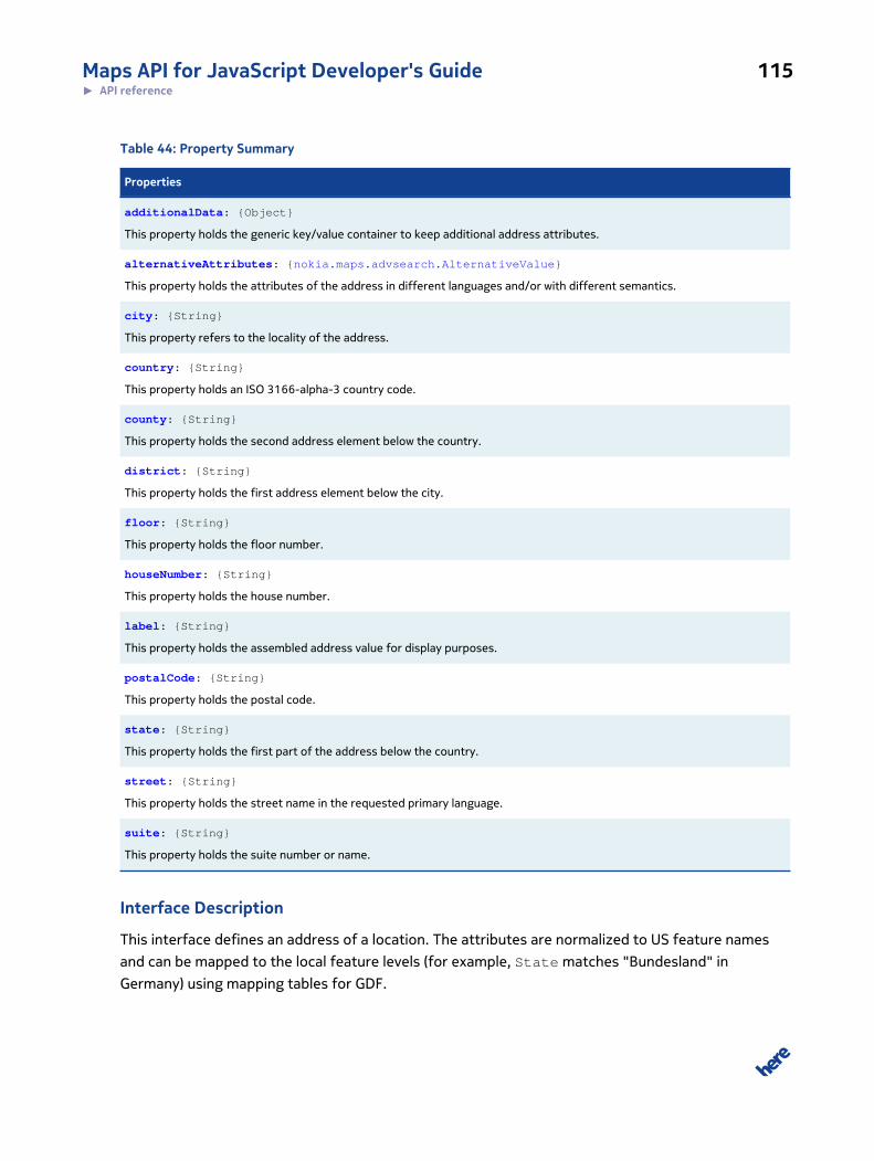
Maps API for JavaScript Developer's Guide 115► API reference
Table 44: Property Summary
Properties
additionalData: {Object}
This property holds the generic key/value container to keep additional address attributes.
alternativeAttributes: {nokia.maps.advsearch.AlternativeValue}
This property holds the attributes of the address in different languages and/or with different semantics.
city: {String}
This property refers to the locality of the address.
country: {String}
This property holds an ISO 3166-alpha-3 country code.
county: {String}
This property holds the second address element below the country.
district: {String}
This property holds the first address element below the city.
floor: {String}
This property holds the floor number.
houseNumber: {String}
This property holds the house number.
label: {String}
This property holds the assembled address value for display purposes.
postalCode: {String}
This property holds the postal code.
state: {String}
This property holds the first part of the address below the country.
street: {String}
This property holds the street name in the requested primary language.
suite: {String}
This property holds the suite number or name.
Interface Description
This interface defines an address of a location. The attributes are normalized to US feature names
and can be mapped to the local feature levels (for example, State matches "Bundesland" in
Germany) using mapping tables for GDF.

Maps API for JavaScript Developer's Guide 116► API reference
Property Details
additionalData: {Object}
This property holds the generic key/value container to keep additional address attributes.
alternativeAttributes: {nokia.maps.advsearch.AlternativeValue}
This property holds the attributes of the address in different languages and/or with different
semantics.
city: {String}
This property refers to the locality of the address. Some products map "city" directly to
Address.city. For GDF, a country-specific mapping is required.
country: {String}
This property holds an ISO 3166-alpha-3 country code.
county: {String}
This property holds the second address element below the country. The use of this field is optional if
the corresponding information is not available.
district: {String}
This property holds the first address element below the city. The use of this field is optional if the
corresponding information is not available.
floor: {String}
This property holds the floor number.
houseNumber: {String}
This property holds the house number. Depending on regional requirements, it can hold house name.
For API implementations which do not support separate street and house number fields, this field can
be omitted.
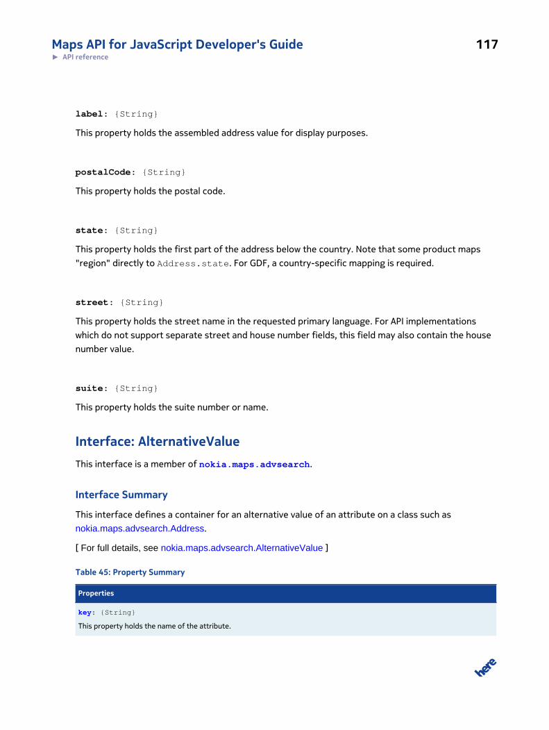
Maps API for JavaScript Developer's Guide 117► API reference
label: {String}
This property holds the assembled address value for display purposes.
postalCode: {String}
This property holds the postal code.
state: {String}
This property holds the first part of the address below the country. Note that some product maps
"region" directly to Address.state. For GDF, a country-specific mapping is required.
street: {String}
This property holds the street name in the requested primary language. For API implementations
which do not support separate street and house number fields, this field may also contain the house
number value.
suite: {String}
This property holds the suite number or name.
Interface: AlternativeValueThis interface is a member of nokia.maps.advsearch.
Interface Summary
This interface defines a container for an alternative value of an attribute on a class such as
nokia.maps.advsearch.Address.
[ For full details, see nokia.maps.advsearch.AlternativeValue ]
Table 45: Property Summary
Properties
key: {String}
This property holds the name of the attribute.

Maps API for JavaScript Developer's Guide 118► API reference
Properties
language: {String}
This property identifies the language of the alternative text (via an RFC 5646 Lanuage Tag).
semantics: {String}
This property identifies the semantics of the alternative value.
type: {String}
This property holds an identifier of the type of the alternative value.
value: {String}
This property holds the text value in the selected language and with the selected semantics
Interface Description
This interface defines a container for an alternative value of an attribute on a class such as
nokia.maps.advsearch.Address. The container is generic and designed to hold textual values for any
attribute in different languages and/or with different semantics.
Property Details
key: {String}
This property holds the name of the attribute.
language: {String}
This property identifies the language of the alternative text (via an RFC 5646 Lanuage Tag).
semantics: {String}
This property identifies the semantics of the alternative value. The possible values are:
• "synonym"
• "exonym"
• "unclassified"
type: {String}
This property holds an identifier of the type of the alternative value. The possible values are:
• "baseName"
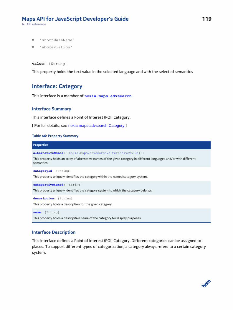
Maps API for JavaScript Developer's Guide 119► API reference
• "shortBaseName"
• "abbreviation"
value: {String}
This property holds the text value in the selected language and with the selected semantics
Interface: CategoryThis interface is a member of nokia.maps.advsearch.
Interface Summary
This interface defines a Point of Interest (POI) Category.
[ For full details, see nokia.maps.advsearch.Category ]
Table 46: Property Summary
Properties
alternativeNames: {nokia.maps.advsearch.AlternativeValue[]}
This property holds an array of alternative names of the given category in different languages and/or with differentsemantics.
categoryId: {String}
This property uniquely identifies the category within the named category system.
categorySystemId: {String}
This property uniquely identifies the category system to which the category belongs.
description: {String}
This property holds a description for the given category.
name: {String}
This property holds a descripitive name of the category for display purposes.
Interface Description
This interface defines a Point of Interest (POI) Category. Different categories can be assigned to
places. To support different types of categorization, a category always refers to a certain category
system.
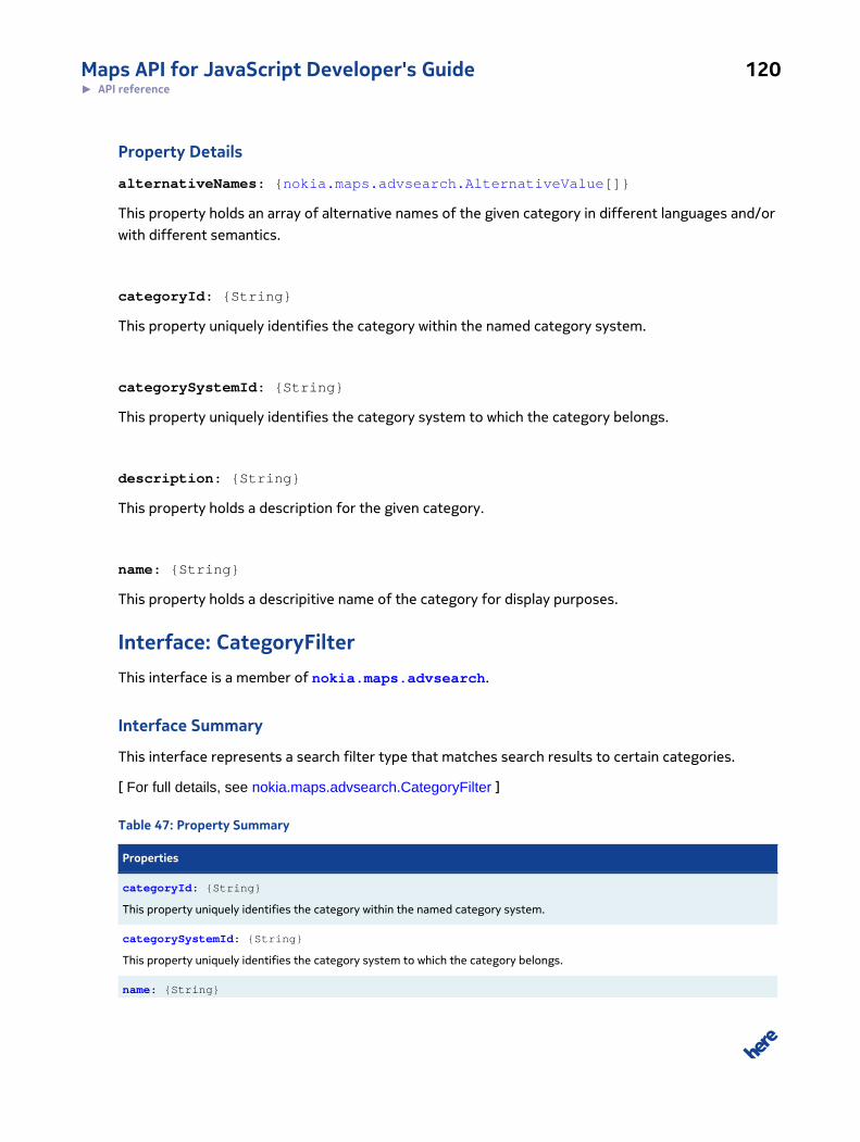
Maps API for JavaScript Developer's Guide 120► API reference
Property Details
alternativeNames: {nokia.maps.advsearch.AlternativeValue[]}
This property holds an array of alternative names of the given category in different languages and/or
with different semantics.
categoryId: {String}
This property uniquely identifies the category within the named category system.
categorySystemId: {String}
This property uniquely identifies the category system to which the category belongs.
description: {String}
This property holds a description for the given category.
name: {String}
This property holds a descripitive name of the category for display purposes.
Interface: CategoryFilterThis interface is a member of nokia.maps.advsearch.
Interface Summary
This interface represents a search filter type that matches search results to certain categories.
[ For full details, see nokia.maps.advsearch.CategoryFilter ]
Table 47: Property Summary
Properties
categoryId: {String}
This property uniquely identifies the category within the named category system.
categorySystemId: {String}
This property uniquely identifies the category system to which the category belongs.
name: {String}
Maps API for JavaScript Developer's Guide 121► API reference
Properties
This property holds the name of the given category filter.
Interface Description
This interface represents a search filter type that matches search results to certain categories.
Property Details
categoryId: {String}
This property uniquely identifies the category within the named category system.
categorySystemId: {String}
This property uniquely identifies the category system to which the category belongs.
name: {String}
This property holds the name of the given category filter.
Interface: ContactThis interface is a member of nokia.maps.advsearch.
Interface Summary
This interface encapsulates contact information associated with a Place.
[ For full details, see nokia.maps.advsearch.Contact ]
Table 48: Property Summary
Properties
description: {String}
This property holds a description of the communication channel (for example: "company's website", "phone number to beused in emergency").
type: {String}
This property holds a communication channel type identifier.
value: {String}
This property holds the phone/fax number, e-mail/IM address or URL as appropriate to the contact type.

Maps API for JavaScript Developer's Guide 122► API reference
Interface Description
This interface encapsulates contact information associated with a Place.
Property Details
description: {String}
This property holds a description of the communication channel (for example: "company's website",
"phone number to be used in emergency").
type: {String}
This property holds a communication channel type identifier. The possible values are:
• "phone"
• "email"
• "URL"
• "fax"
• "IM"
value: {String}
This property holds the phone/fax number, e-mail/IM address or URL as appropriate to the contact
type.
Interface: ContactFilterThis interface is a member of nokia.maps.advsearch.
Interface Summary
This interface defines a filter type to narrow down the search scope with contact information.
[ For full details, see nokia.maps.advsearch.ContactFilter ]
Table 49: Property Summary
Properties
email: {String}
This property holds an email address.
Maps API for JavaScript Developer's Guide 123► API reference
Properties
fax: {String}
This property holds a fax number.
IM: {String}
This property holds an instant messaging account address.
phone: {String}
This property holds a phone number.
URL: {String}
This property holds the URL of the Web site that belongs to a place.
Interface Description
This interface defines a filter type to narrow down the search scope with contact information.
Property Details
email: {String}
This property holds an email address.
fax: {String}
This property holds a fax number.
IM: {String}
This property holds an instant messaging account address.
phone: {String}
This property holds a phone number.
URL: {String}
This property holds the URL of the Web site that belongs to a place.
Maps API for JavaScript Developer's Guide 124► API reference
Interface: LocationThis interface is a member of nokia.maps.advsearch.
Interface Summary
This interface defines a location.
[ For full details, see nokia.maps.advsearch.Location ]
Table 50: Property Summary
Properties
additionalData: {Object}
This property is a generic key/value container for additional attributes:
address: {nokia.maps.advsearch.Address}
This property holds a reference to an optional instance of nokia.maps.advsearch.Address.
alternativeLabels: {nokia.maps.advsearch.AlternativeValue[]}
This property holds an array of instances of nokia.maps.advsearch.AlternativeValue.
displayPosition: {nokia.maps.geo.Coordinate}
This property holds a latitude-longitude object indicating where map markers should be placed to indicate the location onthe map.
label: {String}
This property holds a descriptive display label for the location in the specified primary language.
locationId: {String}
This property holds a key uniquely identifying a physical location.
locationScore: {Number}
This property holds a value between 0 and 1 which indicates the quality of the underlying location data.
locationType: {String}
This property indicates whether the location is an area or point address.
mapReference: {nokia.maps.advsearch.MapReference}
This property holds a reference to an optional map reference object.
mapView: {nokia.maps.geo.BoundingBox}
This property holds a bounding box which completely encloses the physical extent of the location.
navigationPositions: {nokia.maps.geo.Coordinate[]}
This property holds a latitude-longitude object to be used when defining routing waypoints.
Maps API for JavaScript Developer's Guide 125► API reference
Interface Description
This interface defines a location. The location type refers to a physical location including the physical
extent. A location can be referenced either by LRO ID or by specifying the address.
Property Details
additionalData: {Object}
This property is a generic key/value container for additional attributes:
address: {nokia.maps.advsearch.Address}
This property holds a reference to an optional instance of nokia.maps.advsearch.Address.
alternativeLabels: {nokia.maps.advsearch.AlternativeValue[]}
This property holds an array of instances of nokia.maps.advsearch.AlternativeValue. Note that the
array may be empty.
displayPosition: {nokia.maps.geo.Coordinate}
This property holds a latitude-longitude object indicating where map markers should be placed to
indicate the location on the map.
label: {String}
This property holds a descriptive display label for the location in the specified primary language.
locationId: {String}
This property holds a key uniquely identifying a physical location.
locationScore: {Number}
This property holds a value between 0 and 1 which indicates the quality of the underlying location
data.
Maps API for JavaScript Developer's Guide 126► API reference
locationType: {String}
This property indicates whether the location is an area or point address. The possible values are:
• "area"
• "point"
• "line"
mapReference: {nokia.maps.advsearch.MapReference}
This property holds a reference to an optional map reference object.
mapView: {nokia.maps.geo.BoundingBox}
This property holds a bounding box which completely encloses the physical extent of the location.
navigationPositions: {nokia.maps.geo.Coordinate[]}
This property holds a latitude-longitude object to be used when defining routing waypoints.
Interface: LocationFilterThis interface is a member of nokia.maps.advsearch.
Interface Summary
This interface defines a location search results filter type that matches certain address field values or
the exact location specified via Location Rerference Object id (LRO ID).
[ For full details, see nokia.maps.advsearch.LocationFilter ]
Table 51: Property Summary
Properties
city: {String}
This property holds the identifier of the administration area at GDF Order8 level (for example US: City, DE: Gemeinde).
country: {String}
This property holds the country code (3 bytes, ISO 3166-1-alpha-3).
county: {String}
This property holds the identifier of the administration area at GDF Order2 level (for example US: County, DE: Kreis).
Maps API for JavaScript Developer's Guide 127► API reference
Properties
district: {String}
This property holds the identifier of the administration area at GDF Builtup level (US: n/a, DE: Ortsteil).
houseNumber: {String}
This property holds the house number.
locationId: {String}
This property holds the Location Reference Object ID, which uniquely identifies a physical location within the LRO system.
postalCode: {String}
This property holds the post code (zip in the US).
state: {String}
This property holds the identifier of the administration area at GDF Order1 level (for example US: State, DE: Bundesland).
street: {String[]}
This property holds the name of the street.
Interface Description
This interface defines a location search results filter type that matches certain address field values or
the exact location specified via Location Rerference Object id (LRO ID).
Property Details
city: {String}
This property holds the identifier of the administration area at GDF Order8 level (for example US:
City, DE: Gemeinde). It can also contain an alternative administrative name (for example, "Paris" for
Charles-de-Gaulle airport, which is actually located in Roissy-en-France).
country: {String}
This property holds the country code (3 bytes, ISO 3166-1-alpha-3).
county: {String}
This property holds the identifier of the administration area at GDF Order2 level (for example US:
County, DE: Kreis).
district: {String}
Maps API for JavaScript Developer's Guide 128► API reference
This property holds the identifier of the administration area at GDF Builtup level (US: n/a, DE:
Ortsteil).
houseNumber: {String}
This property holds the house number. Depending on regional characteristics, the property can
alternatively contain the house name.
locationId: {String}
This property holds the Location Reference Object ID, which uniquely identifies a physical location
within the LRO system.
postalCode: {String}
This property holds the post code (zip in the US).
state: {String}
This property holds the identifier of the administration area at GDF Order1 level (for example US:
State, DE: Bundesland).
street: {String[]}
This property holds the name of the street. A second street name can be included to search for
street intersections.
Interface: LocationMatchQualityThis interface is a member of nokia.maps.advsearch.
Interface Summary
This interface defines a type that provides detailed information about the match quality of a result at
attribute level.
[ For full details, see nokia.maps.advsearch.LocationMatchQuality ]
Maps API for JavaScript Developer's Guide 129► API reference
Table 52: Property Summary
Properties
city: {Number}
This property indicates the match quality of the result with respect to nokia.maps.advsearch.LocationFilter#city.
country: {Number}
This property indicates the match quality of the result with respect to nokia.maps.advsearch.LocationFilter#country.
county: {Number}
This property indicates the match quality of the result with respect to nokia.maps.advsearch.LocationFilter#county.
district: {Number}
This property indicates the match quality of the result with respect to nokia.maps.advsearch.LocationFilter#district.
houseNumber: {Number}
This property indicates the match quality of the result with respect to nokia.maps.advsearch.LocationFilter#houseNumber.
postalCode: {Number}
This property indicates the match quality of the result with respect to nokia.maps.advsearch.LocationFilter#postalCode.
state: {Number}
This property indicates the match quality of the result with respect to nokia.maps.advsearch.LocationFilter#state.
street: {Number}
This property indicates the match quality of the result with respect to nokia.maps.advsearch.LocationFilter#street.
Interface Description
This interface defines a type that provides detailed information about the match quality of a result at
attribute level.
Property Details
city: {Number}
This property indicates the match quality of the result with respect to
nokia.maps.advsearch.LocationFilter#city. The match quality is a value between 0.0 and 1.0, 1.0
representing a 100% match.
country: {Number}
This property indicates the match quality of the result with respect to
nokia.maps.advsearch.LocationFilter#country. The match quality is a value between 0.0 and 1.0, 1.0
representing a 100% match.
Maps API for JavaScript Developer's Guide 130► API reference
county: {Number}
This property indicates the match quality of the result with respect to
nokia.maps.advsearch.LocationFilter#county. The match quality is a value between 0.0 and 1.0, 1.0
representing a 100% match.
district: {Number}
This property indicates the match quality of the result with respect to
nokia.maps.advsearch.LocationFilter#district. The match quality is a value between 0.0 and 1.0, 1.0
representing a 100% match.
houseNumber: {Number}
This property indicates the match quality of the result with respect to
nokia.maps.advsearch.LocationFilter#houseNumber. The match quality is a value between 0.0 and
1.0, 1.0 representing a 100% match.
postalCode: {Number}
This property indicates the match quality of the result with respect to
nokia.maps.advsearch.LocationFilter#postalCode. The match quality is a value between 0.0 and 1.0,
1.0 representing a 100% match.
state: {Number}
This property indicates the match quality of the result with respect to
nokia.maps.advsearch.LocationFilter#state. The match quality is a value between 0.0 and 1.0, 1.0
representing a 100% match.
street: {Number}
This property indicates the match quality of the result with respect to
nokia.maps.advsearch.LocationFilter#street. The match quality is a value between 0.0 and 1.0, 1.0
representing a 100% match.
Maps API for JavaScript Developer's Guide 131► API reference
Class: ManagerThis class is a member of nokia.maps.advsearch.
Extends: nokia.maps.search.Manager
Class Summary
This class provides a client-side interface to search functionality and storage for previous search
requests and responses.
[ For full details, see nokia.maps.advsearch.Manager ]
Property Summary
Directly Inherited Properties
Inherited from class nokia.maps.search.Manager :
gen, locations, maxResults, places, state
Table 53: Method Summary
Methods
clear ()
This method resets the stored search requests and responses.
geocode (SearchRequest)
This method peforms geocoding by submitting a request to the back-end Search Service.
reverseGeocode (SearchRequest)
This method performs a reverse geocoding request based on the given position.
Directly Inherited Methods
Inherited from class nokia.maps.search.Manager :
clear, geocode, getErrorCause, reverseGeocode
Inherited from class nokia.maps.util.OObject :
addObserver, get, remove, removeObserver, set
Maps API for JavaScript Developer's Guide 132► API reference
Class Description
This class provides a client-side interface to search functionality and storage for previous search
requests and responses. Old search requests and responses can be deleted using the method
nokia.maps.advsearch.Manager#clear.
Constructor Details
nokia.maps.advsearch.Manager()
This constructor initializes a new empty Manager instance.
Method Details
clear()
This method resets the stored search requests and responses.
geocode(SearchRequest)
This method peforms geocoding by submitting a request to the back-end Search Service.
Parameters:
SearchRequest: {nokia.maps.advsearch.SearchRequest}
A set of parameters for the geocoding request
reverseGeocode(SearchRequest)
This method performs a reverse geocoding request based on the given position. A default radius is
applied.
Parameters:
SearchRequest: {nokia.maps.advsearch.SearchRequest}
A set of parameters for the reverse-geocoding request
Interface: MapReferenceThis interface is a member of nokia.maps.advsearch.

Maps API for JavaScript Developer's Guide 133► API reference
Interface Summary
This interface defines a map reference to a network link of the location object.
[ For full details, see nokia.maps.advsearch.MapReference ]
Table 54: Property Summary
Properties
mapId: {String}
This property holds a reference to a specific map.
mapVersion: {String}
This property holds the full version identifier of the map.
referenceId: {String}
This property holds the id of the given instance of map reference.
sideOfStreet: {String}
This property indicates whether the referenced location is on the left or right of the link (if heading from the reference nodeto the non-reference node).
spot: {Number}
This property holds the relative position of the location along the link expressed as the fractional distance from the link'sreference-node to the non-reference node.
Interface Description
This interface defines a map reference to a network link of the location object.
Property Details
mapId: {String}
This property holds a reference to a specific map.
mapVersion: {String}
This property holds the full version identifier of the map.
referenceId: {String}
This property holds the id of the given instance of map reference.
Maps API for JavaScript Developer's Guide 134► API reference
sideOfStreet: {String}
This property indicates whether the referenced location is on the left or right of the link (if heading
from the reference node to the non-reference node). The possible values are:
• "left"
• "right"
• "neither"
spot: {Number}
This property holds the relative position of the location along the link expressed as the fractional
distance from the link's reference-node to the non-reference node. The value of the property is in
the range between 0 and 1. This property is relevant only if a link is referenced.
Interface: PlaceThis interface is a member of nokia.maps.advsearch.
Interface Summary
This interface represents a place and its properties.
[ For full details, see nokia.maps.advsearch.Place ]
Table 55: Property Summary
Properties
additionalData: {Object}
This property is a generic key/value container to keep additional attributes.
alternativeNames: {nokia.maps.advsearch.AlternativeValue[]}
This property holds an array of AlternativeValue objects.
categories: {nokia.maps.advsearch.Category[]}
This property holds an array of Category objects.
contacts: {nokia.maps.advsearch.Contact}
This property holds a reference to an optional Contact object.
locations: {nokia.maps.advsearch.Location[]}
This property holds an array of Location objects.
name: {String}
This property holds a descriptive name of the place in the specified primary language for display purposes.
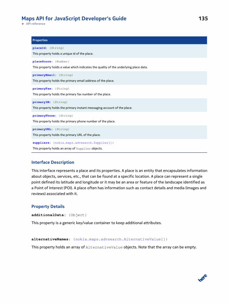
Maps API for JavaScript Developer's Guide 135► API reference
Properties
placeId: {String}
This property holds a unique id of the place.
placeScore: {Number}
This property holds a value which indicates the quality of the underlying place data.
primaryEmail: {String}
This property holds the primary email address of the place.
primaryFax: {String}
This property holds the primary fax number of the place.
primaryIM: {String}
This property holds the primary instant messaging account of the place.
primaryPhone: {String}
This property holds the primary phone number of the place.
primaryURL: {String}
This property holds the primary URL of the place.
suppliers: {nokia.maps.advsearch.Supplier[]}
This property holds an array of Supplier objects.
Interface Description
This interface represents a place and its properties. A place is an entity that encapsulates information
about objects, services, etc., that can be found at a specific location. A place can represent a single
point defined its latitude and longitude or it may be an area or feature of the landscape identified as
a Point of Interest (POI). A place often has information such as contact details and media (images and
reviews) associated with it.
Property Details
additionalData: {Object}
This property is a generic key/value container to keep additional attributes.
alternativeNames: {nokia.maps.advsearch.AlternativeValue[]}
This property holds an array of AlternativeValue objects. Note that the array can be empty.

Maps API for JavaScript Developer's Guide 136► API reference
categories: {nokia.maps.advsearch.Category[]}
This property holds an array of Category objects. Note that the array can be empty.
contacts: {nokia.maps.advsearch.Contact}
This property holds a reference to an optional Contact object.
locations: {nokia.maps.advsearch.Location[]}
This property holds an array of Location objects. It contains at least one element.
name: {String}
This property holds a descriptive name of the place in the specified primary language for display
purposes.
placeId: {String}
This property holds a unique id of the place.
placeScore: {Number}
This property holds a value which indicates the quality of the underlying place data.
primaryEmail: {String}
This property holds the primary email address of the place.
primaryFax: {String}
This property holds the primary fax number of the place.
primaryIM: {String}
This property holds the primary instant messaging account of the place.
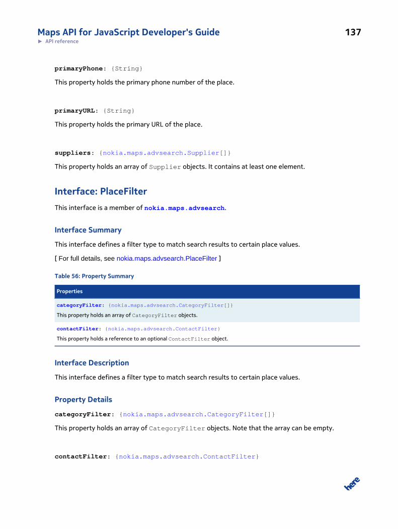
Maps API for JavaScript Developer's Guide 137► API reference
primaryPhone: {String}
This property holds the primary phone number of the place.
primaryURL: {String}
This property holds the primary URL of the place.
suppliers: {nokia.maps.advsearch.Supplier[]}
This property holds an array of Supplier objects. It contains at least one element.
Interface: PlaceFilterThis interface is a member of nokia.maps.advsearch.
Interface Summary
This interface defines a filter type to match search results to certain place values.
[ For full details, see nokia.maps.advsearch.PlaceFilter ]
Table 56: Property Summary
Properties
categoryFilter: {nokia.maps.advsearch.CategoryFilter[]}
This property holds an array of CategoryFilter objects.
contactFilter: {nokia.maps.advsearch.ContactFilter}
This property holds a reference to an optional ContactFilter object.
Interface Description
This interface defines a filter type to match search results to certain place values.
Property Details
categoryFilter: {nokia.maps.advsearch.CategoryFilter[]}
This property holds an array of CategoryFilter objects. Note that the array can be empty.
contactFilter: {nokia.maps.advsearch.ContactFilter}
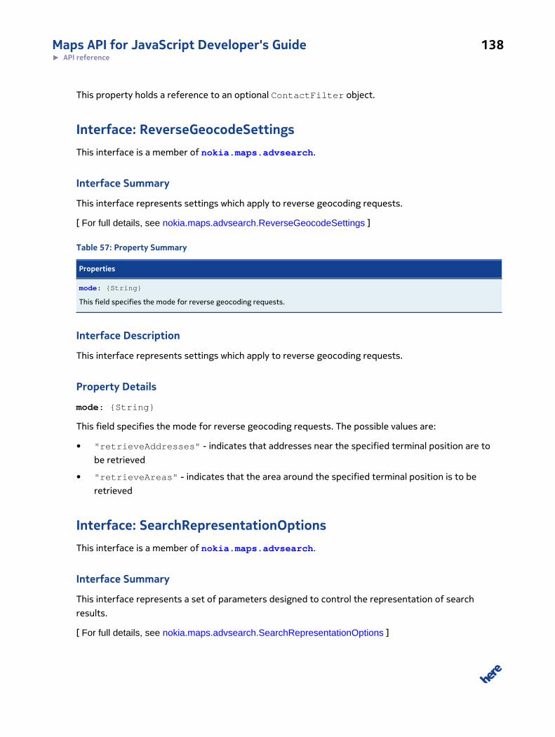
Maps API for JavaScript Developer's Guide 138► API reference
This property holds a reference to an optional ContactFilter object.
Interface: ReverseGeocodeSettingsThis interface is a member of nokia.maps.advsearch.
Interface Summary
This interface represents settings which apply to reverse geocoding requests.
[ For full details, see nokia.maps.advsearch.ReverseGeocodeSettings ]
Table 57: Property Summary
Properties
mode: {String}
This field specifies the mode for reverse geocoding requests.
Interface Description
This interface represents settings which apply to reverse geocoding requests.
Property Details
mode: {String}
This field specifies the mode for reverse geocoding requests. The possible values are:
• "retrieveAddresses" - indicates that addresses near the specified terminal position are to
be retrieved
• "retrieveAreas" - indicates that the area around the specified terminal position is to be
retrieved
Interface: SearchRepresentationOptionsThis interface is a member of nokia.maps.advsearch.
Interface Summary
This interface represents a set of parameters designed to control the representation of search
results.
[ For full details, see nokia.maps.advsearch.SearchRepresentationOptions ]
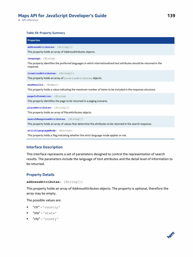
Maps API for JavaScript Developer's Guide 139► API reference
Table 58: Property Summary
Properties
addressAttributes: {String[]}
This property holds an array of AddressAttributes objects.
language: {String}
This property identifies the preferred languages in which internationalized text attributes should be returned in theresponse.
locationAttributes: {String[]}
This property holds an array of LocationAttributes objects.
maxResults: {Number}
This property holds a value indicating the maximum number of items to be included in the response structure.
pageInformation: {String}
This property identifies the page to be returned in a paging scenario.
placeAttributes: {String[]}
This property holds an array of PlaceAttributes objects.
searchResponseAttributes: {String[]}
This property holds an array of values that determine the attributes to be returned in the search response.
strictLanguageMode: {Boolean}
This property holds a flag indciating whether the strict language mode applies or not.
Interface Description
This interface represents a set of parameters designed to control the representation of search
results. The parameters include the language of text attributes and the detail level of information to
be returned.
Property Details
addressAttributes: {String[]}
This property holds an array of AddressAttributes objects. The property is optional, therefore the
array may be empty.
The possible values are:
• "ctr" - "country"
• "sta" - "state"
• "cty" - "county"
Maps API for JavaScript Developer's Guide 140► API reference
• "cit" - "city"
• "dis" - "district"
• "str" - "street"
• "hnr" - "houseNumber"
• "pst" - "postalCode"
• "sui" - "suite"
• "flr" - "floor"
• "add" - "additionalAttributes"
• "alt" - "alternativeAttributes"
• "none" - ("none"), indicates that none of the optional attributes are to be provided in the
response; "none" clears the default set of attributes and allows the user to add exactly those
attributes he/she requires
• "all" - ("all"), indicates that all attributes configured by this enumeration type are to be
provided in the response; this value can be used when the user wishes to remove specific
attributes from a predefined list (the reference set is the list of all attributes)
language: {String}
This property identifies the preferred languages in which internationalized text attributes should
be returned in the response. The list is assumed to be in descending order. The filter is specified
according to RFC 4647.
locationAttributes: {String[]}
This property holds an array of LocationAttributes objects. The property is optional and
therefore the array may be empty.
The possible values are:
• "ar" - "address"
• "mr" - "mapReference"
• "mv" - "mapView"
• "ad" - "additionalData"
• "al" - "alternativeLabels"
• "none" - ("none"), indicates that none of the optional attributes are to be provided in the
response; "none" clears the default set of attributes and allows the user to add exactly those
attributes he/she requires
Maps API for JavaScript Developer's Guide 141► API reference
• "all" ("all"), indicates that all attributes configured by this enumeration type are to be provided
in the response; this value can be used when the user wishes to remove specific attributes from a
predefined list (the reference set is the list of all attributes)
maxResults: {Number}
This property holds a value indicating the maximum number of items to be included in the response
structure. If this property is specified, paging is activated and the results are returned in separate
pages. Each response contains a handle to the next page.
pageInformation: {String}
This property identifies the page to be returned in a paging scenario. The property is taken into
account only if MaxResults has been specified in a previous request.
placeAttributes: {String[]}
This property holds an array of PlaceAttributes objects. The property is optional and therefore the
array may be empty.
The possible values are:
• "ca" - "categories"
• "lo" - "location"
• "sp" - "supplier"
• "co" - "contact"
• "ad" - "additionalData"
• "an" - "alternativeNames"
• "none" - ("none"), indicates that none of the optional attributes are to be provided in the
response; "none" clears the default set of attributes and allows the user to add exactly those
attributes he/she requires
• "all" ("all"), indicates that all attributes configured by this enumeration type are to be provided
in the response; this value can be used when the user wishes to remove specific attributes from a
predefined list (the reference set is the list of all attributes)
searchResponseAttributes: {String[]}
Maps API for JavaScript Developer's Guide 142► API reference
This property holds an array of values that determine the attributes to be returned in the search
response. The property is optional. If it is not specified, all search response attributes aprt from the
performed search association are included by default (the response contains all values besides apart
from PerformedSearch and MatchQuality).
The possible values are:
• "ps" ("perfomedSearch") - indicates if the performed search information should be returned
• "la" ("label") - indicates if a label for the SearchResponseView is to be returned
• "dm" ("didYouMeanSuggestion") - indicates if didYouMeanSuggestions is to be returned
• "mq" ("matchQuality") - indicates if the match quality on attribute level is to be returned
• "mt" ("matchType") - indicates whether the location could be determined exactly or if an
interpolation was applied
• "none" ("none") - indicates that none of the optional attributes are to be provided in the
response; "none" clears the default set of attributes and allows the user to add exactly those
attributes he/she requires
• "all" ("all") - indicates that all attributes configured by this enumeration type are to be
provided in the response; this value can be used when the user wishes to remove specific
attributes from a predefined list (the reference set is the list of all attributes)
strictLanguageMode: {Boolean}
This property holds a flag indciating whether the strict language mode applies or not.
If its value is false, the back end chooses the best available attribute value reflecting
the language preferences and returns them directly in Address, Place, Location, and
Category. In this case, the language information is lost. If the value of the property is
true, the service includes only the attribute value directly in Address, Place, Location,
and Category if a value is available in the first language specified by the property
nokia.maps.advsearch.SearchRepresentationOptions#language. Values in alternative languages are
returned in the associated instances of nokia.maps.advsearch.AlternativeValue.
Interface: SearchRequestThis interface is a member of nokia.maps.advsearch.
Interface Summary
This interface defines a search request with parameters supported by all search types.
[ For full details, see nokia.maps.advsearch.SearchRequest ]
Maps API for JavaScript Developer's Guide 143► API reference
Table 59: Property Summary
Properties
additionalData: {Object}
This property is a generic container for additional information to be attached to the request.
locationFilter: {nokia.maps.search.LocationFilter}
This property holds a reference to an optional LocationFilter object.
metaInfo: {nokia.maps.advsearch.SearchRequestMetaInfo}
This property holds a reference to an optional RequestMetaInfo object.
placeFilter: {nokia.maps.advsearch.PlaceFilter}
This property holds a reference to an optional PlaceFilter object.
representationOptions: {nokia.maps.advsearch.SearchRepresentationOptions}
This property holds a reference to an optional RepresentationOptions object.
reverseGeocodeSettings: {nokia.maps.advsearch.ReverseGeocodeSettings}
This property holds a reference to an optional ReverseGeocodeSettings object.
searchText: {String}
This property holds free text input which is dynamically matched against different fields.
spatialFilter: {nokia.maps.geo.BoundingBox | nokia.maps.geo.Corridor |nokia.maps.geo.Proximity}
This property holds a reference to an optional object representing a spatial filter, which restricts search results to places/locations that are included within a certain geospatial area.
Interface Description
This interface defines a search request with parameters supported by all search types.
Property Details
additionalData: {Object}
This property is a generic container for additional information to be attached to the request.
locationFilter: {nokia.maps.search.LocationFilter}
This property holds a reference to an optional LocationFilter object. The response contains only
those locations that match the attributes of this object.
metaInfo: {nokia.maps.advsearch.SearchRequestMetaInfo}
Maps API for JavaScript Developer's Guide 144► API reference
This property holds a reference to an optional RequestMetaInfo object.
placeFilter: {nokia.maps.advsearch.PlaceFilter}
This property holds a reference to an optional PlaceFilter object. The response contains only
those places that have match the attributes of this object.
representationOptions: {nokia.maps.advsearch.SearchRepresentationOptions}
This property holds a reference to an optional RepresentationOptions object.
reverseGeocodeSettings: {nokia.maps.advsearch.ReverseGeocodeSettings}
This property holds a reference to an optional ReverseGeocodeSettings object.
searchText: {String}
This property holds free text input which is dynamically matched against different fields.
spatialFilter: {nokia.maps.geo.BoundingBox | nokia.maps.geo.Corridor |
nokia.maps.geo.Proximity}
This property holds a reference to an optional object representing a spatial filter, which restricts
search results to places/locations that are included within a certain geospatial area. Instances of
lslocation.geo.BoundingBox, nokia.maps.geo.Corridor, and nokia.maps.geo.Proximity are allowed as
spatial filters.
Interface: SearchRequestMetaInfoThis interface is a member of nokia.maps.advsearch.
Interface Summary
This interface defines parameters not directly related to search functionality.
[ For full details, see nokia.maps.advsearch.SearchRequestMetaInfo ]
Maps API for JavaScript Developer's Guide 145► API reference
Table 60: Property Summary
Properties
requestId: {String}
This property holds an arbitrary value to be mirrored in the response structure.
verboseMode: {Number}
This property holds a numeric value indicating the required verbosity level in the response structure.
Interface Description
This interface defines parameters not directly related to search functionality.
Property Details
requestId: {String}
This property holds an arbitrary value to be mirrored in the response structure. The value can be used
to trace back requests.
verboseMode: {Number}
This property holds a numeric value indicating the required verbosity level in the response structure.
The permitted values are in the range between 0 and 5.
Interface: SearchResponseThis interface is a member of nokia.maps.advsearch.
Interface Summary
This interface represents the top-level element returned by the search service.
[ For full details, see nokia.maps.advsearch.SearchResponse ]
Table 61: Property Summary
Properties
metaInfo: {nokia.maps.advsearch.SearchResponseMetaInfo}
This property holds a reference to an optional response meta info object.
view: {nokia.maps.advsearch.SearchResponseView[]}
This property holds an array of search response view objects.
Maps API for JavaScript Developer's Guide 146► API reference
Interface Description
This interface represents the top-level element returned by the search service. It contains the search
results along with meta information, search paths, and scores.
Property Details
metaInfo: {nokia.maps.advsearch.SearchResponseMetaInfo}
This property holds a reference to an optional response meta info object.
view: {nokia.maps.advsearch.SearchResponseView[]}
This property holds an array of search response view objects. It contains at least one element.
Interface: SearchResponseMetaInfoThis interface is a member of nokia.maps.advsearch.
Interface Summary
This interface encapsulates information not related to a search type.
[ For full details, see nokia.maps.advsearch.SearchResponseMetaInfo ]
Table 62: Property Summary
Properties
additionalData: {Object}
This property holds an object containing additional data.
nextPageInformation: {String}
This property holds a key that can be used in subsequent requests to acquire the next n results.
previousPageInformation: {String}
This property holds a key that can be used in subsequent requests to acquire the previous n results.
requestId: {String}
This property holds the mirrored request id, which is a value from the request structure.
timestamp: {String}
This property holds the time stamp indicating when the search was performed.
Maps API for JavaScript Developer's Guide 147► API reference
Interface Description
This interface encapsulates information not related to a search type.
Property Details
additionalData: {Object}
This property holds an object containing additional data. The contents depend on the user's
requirements.
nextPageInformation: {String}
This property holds a key that can be used in subsequent requests to acquire the next n results. This
element is only provided if paging has been activated in the request.
previousPageInformation: {String}
This property holds a key that can be used in subsequent requests to acquire the previous n results.
This element is only provided if paging has been activated in the request.
requestId: {String}
This property holds the mirrored request id, which is a value from the request structure. The property
can be used to trace back requests.
timestamp: {String}
This property holds the time stamp indicating when the search was performed.
Interface: SearchResponseViewThis interface is a member of nokia.maps.advsearch.
Interface Summary
This interface represents a specialized view of the search response to be returned to the requesting
application.
[ For full details, see nokia.maps.advsearch.SearchResponseView ]

Maps API for JavaScript Developer's Guide 148► API reference
Table 63: Property Summary
Properties
label: {String}
This property holds a descriptive label of the view for display purposes.
viewId: {Number}
This property holds the identifier of the given view.
Interface Description
This interface represents a specialized view of the search response to be returned to the requesting
application. It reflects (attempts to match) the assumed intention behind the user's free-text search.
Property Details
label: {String}
This property holds a descriptive label of the view for display purposes. The label is in the configured
primary language.
viewId: {Number}
This property holds the identifier of the given view.
Interface: SearchResultThis interface is a member of nokia.maps.advsearch.
Interface Summary
This interface represents a search result item.
[ For full details, see nokia.maps.advsearch.SearchResult ]
Table 64: Property Summary
Properties
additionalData: {Object}
This property holds an object containing additional data.
direction: {Number}
Maps API for JavaScript Developer's Guide 149► API reference
Properties
This property holds the direction of the location object as seen from the specified client position measured clockwise indegrees starting from 0 (North).
distance: {Number}
This property holds the distance between the identified location object and the specified client position in meters (onlyprovided if a nokia.maps.geo.Proximity is used as a spatial filter in nokia.maps.advsearch.SearchRequest).
location: {nokia.maps.advsearch.Location}
This property holds a mandatory reference to an instance of nokia.maps.advsearch.Location.
matchLevel: {String}
This property holds the name of the most detailed address field which could be matched (only relevant for geocodingresults).
matchQuality: {nokia.maps.advsearch.LocationMatchQuality}
This property holds detailed information about the match quality on attribute level.
matchType: {String}
This property holds a value indicating whether the result was matched to a point address or whether the match isinterpolated.
place: {nokia.maps.advsearch.Place}
This property holds a mandatory reference to an instance of nokia.maps.advsearch.Place.
relevance: {Number}
This property indicates the relevance of the results found; the higher the score the more relevant the alternative.
Interface Description
This interface represents a search result item.
Property Details
additionalData: {Object}
This property holds an object containing additional data. The contents depend on the user's
requirements.
direction: {Number}
This property holds the direction of the location object as seen from the specified client position
measured clockwise in degrees starting from 0 (North).
distance: {Number}
Maps API for JavaScript Developer's Guide 150► API reference
This property holds the distance between the identified location object and the specified client
position in meters (only provided if a nokia.maps.geo.Proximity is used as a spatial filter in
nokia.maps.advsearch.SearchRequest).
location: {nokia.maps.advsearch.Location}
This property holds a mandatory reference to an instance of nokia.maps.advsearch.Location.
matchLevel: {String}
This property holds the name of the most detailed address field which could be matched (only
relevant for geocoding results).
The possible values are:
• "ctr" - "country"
• "sta" - "state"
• "cty" - "county"
• "cit" - "city"
• "dis" - "district"
• "str" - "street"
• "hnr" - "houseNumber"
• "pst" - "postalCode"
• "sui" - "suite"
• "flr" - "floor"
• "add" - "additionalAttributes"
• "alt" - "alternativeAttributes"
• "none" - ("none"), indicates that none of the optional attributes are to be provided in the
response; "none" clears the default set of attributes and allows the user to add exactly those
attributes he/she requires
• "all" - ("all") indicates that all attributes configured by this enumeration type are to be
provided in the response; this value can be used when the user wishes to remove specific
attributes from a predefined list (the reference set is the list of all attributes)
matchQuality: {nokia.maps.advsearch.LocationMatchQuality}
This property holds detailed information about the match quality on attribute level.
Maps API for JavaScript Developer's Guide 151► API reference
matchType: {String}
This property holds a value indicating whether the result was matched to a point address or whether
the match is interpolated. The possible values are:
• "pointAddress"
• "interpolated"
place: {nokia.maps.advsearch.Place}
This property holds a mandatory reference to an instance of nokia.maps.advsearch.Place.
relevance: {Number}
This property indicates the relevance of the results found; the higher the score the more relevant the
alternative.
Interface: SearchResultsViewThis interface is a member of nokia.maps.advsearch.
Interface Summary
This interface defines a specialized view of the search results to be returned to the requesting
application.
[ For full details, see nokia.maps.advsearch.SearchResultsView ]
Table 65: Property Summary
Properties
didYouMeanSuggestion: {String[]}
This property holds a list of strings that contain "did you mean" suggestions.
performedSearch: {nokia.maps.advsearch.SearchRequest}
This property holds a reference to an instance of nokia.maps.advsearch.SearchRequest.
results: {nokia.maps.advsearch.SearchResult[]}
This property holds an array of instances of nokia.maps.advsearch.SearchResult.
Maps API for JavaScript Developer's Guide 152► API reference
Interface Description
This interface defines a specialized view of the search results to be returned to the requesting
application.
Property Details
didYouMeanSuggestion: {String[]}
This property holds a list of strings that contain "did you mean" suggestions.
performedSearch: {nokia.maps.advsearch.SearchRequest}
This property holds a reference to an instance of nokia.maps.advsearch.SearchRequest. The use of
the property is optional.
results: {nokia.maps.advsearch.SearchResult[]}
This property holds an array of instances of nokia.maps.advsearch.SearchResult. The use of the
property is optional, therefore the array can be empty.
Interface: SearchSuggestionsViewThis interface is a member of nokia.maps.advsearch.
Interface Summary
This interface defines a specialized view of input search suggestions to be returned to the
application.
[ For full details, see nokia.maps.advsearch.SearchSuggestionsView ]
Table 66: Property Summary
Properties
typeSuggestion: {String}
This property holds the suggestion text that can be used to autocomplete the text the user is currently typing.
Interface Description
This interface defines a specialized view of input search suggestions to be returned to the
application.
Maps API for JavaScript Developer's Guide 153► API reference
Property Details
typeSuggestion: {String}
This property holds the suggestion text that can be used to autocomplete the text the user is
currently typing.
Interface: SupplierThis interface is a member of nokia.maps.advsearch.
Interface Summary
This interface defines a supplier of place information.
[ For full details, see nokia.maps.advsearch.Supplier ]
Table 67: Property Summary
Properties
name: {String}
This proprety holds a descriptive name of the data provider for display purposes.
supplierId: {String}
This proprety holds a unique identifier of the place data provider.
Interface Description
This interface defines a supplier of place information. Provider identification for place information.
Property Details
name: {String}
This proprety holds a descriptive name of the data provider for display purposes.
supplierId: {String}
This proprety holds a unique identifier of the place data provider.
Namespace: clusteringThis namespace is a member of nokia.maps.
Maps API for JavaScript Developer's Guide 154► API reference
Namespace Summary
This namespace contains resources that allow the API user to cluster markers.
Namespace Description
This namespace contains resources that allow the API user to cluster markers. So areas with high
density of markers can be easily displayed on the map. As a result objects are grouped into "islands",
aka clusters From that cluster only one single spacial object is shown as a presentation of that
cluster. Namespace also provides some useful classes by using which it's very easy to customize
presentation of the cluster.
Class: ClusterThis class is a member of nokia.maps.clustering.
Class Summary
This class represents a cluster of markers on the map.
[ For full details, see nokia.maps.clustering.Cluster ]
Table 68: Method Summary
Methods
getBounds (dataPoints) : {nokia.maps.geo.BoundingBox}
This method retrieves an instance of nokia.maps.geo.BoundingBox representing the smallest bounding box that encloses allthe data points in the cluster.
getIcon (theme, resetTheMarker)
This method retrieves the icon that represents the given cluster.
getPoints () : {nokia.maps.clustering.IClusterPoint[]}
This method retrieves the data points that make up the given cluster.
getSize () : {Number}
This method retrieves the count of the data points in the given cluster.
Class Description
This class represents a marker cluster on the map. It contains references to all the data points that
make up the cluster and provides methods to manage them.
Maps API for JavaScript Developer's Guide 155► API reference
Constructor Details
nokia.maps.clustering.Cluster(point, opt)
This method creates an instance of Cluster.
Parameters:
point: {nokia.maps.clustering.IClusterPoint} [optional]
Seed (or the first data point) of the cluster; further data points can be added
to the cluster.
opt: {nokia.maps.clustering.IGridOptions} [optional]
Configuration options for cluster in case if grid based clustering is used
Method Details
getBounds(dataPoints): {nokia.maps.geo.BoundingBox}
This method retrieves an instance of nokia.maps.geo.BoundingBox representing the smallest
bounding box that encloses all the data points in the cluster.
Parameters:
dataPoints: {nokia.maps.clustering.IClusterPoint[]}
A collection of objects representing the data points in the cluster
Returns:
{nokia.maps.geo.BoundingBox}
The smallest bounding box that encloses all the data points inside the clus-
ter
getIcon(theme, resetTheMarker)
This method retrieves the icon that represents the given cluster.
Parameters:
theme: {nokia.maps.clustering.ITheme}
The theme to use to representing the cluster on the map
Maps API for JavaScript Developer's Guide 156► API reference
resetTheMarker: {Boolean} [optional]
A flag indicating whether the marker icon is to be updated (true) or whether
the cached icon is to be retrieved (false; this argument can be used, for
example, when modifying theme of existing clusters
getPoints(): {nokia.maps.clustering.IClusterPoint[]}
This method retrieves the data points that make up the given cluster.
Returns:
{nokia.maps.clustering.IClusterPoint[]}
An array of data points that make up the given cluster
getSize(): {Number}
This method retrieves the count of the data points in the given cluster.
Returns:
{Number} The number of data points in the given cluster
Class: ClusterProviderThis class is a member of nokia.maps.clustering.
Extends: nokia.maps.map.provider.Provider, nokia.maps.util.OObject
Class Summary
This class works on a set of data points (locations) and organizes them into clusters to optimize their
display on the map.
[ For full details, see nokia.maps.clustering.ClusterProvider ]
Table 69: Property Summary
Properties
static STATE_CLUSTERED: {String}
This constant indicates a state which an instance of ClusterProvider enters when it has completed clustering andrendering of the markers on the map can begin (is about to begin).
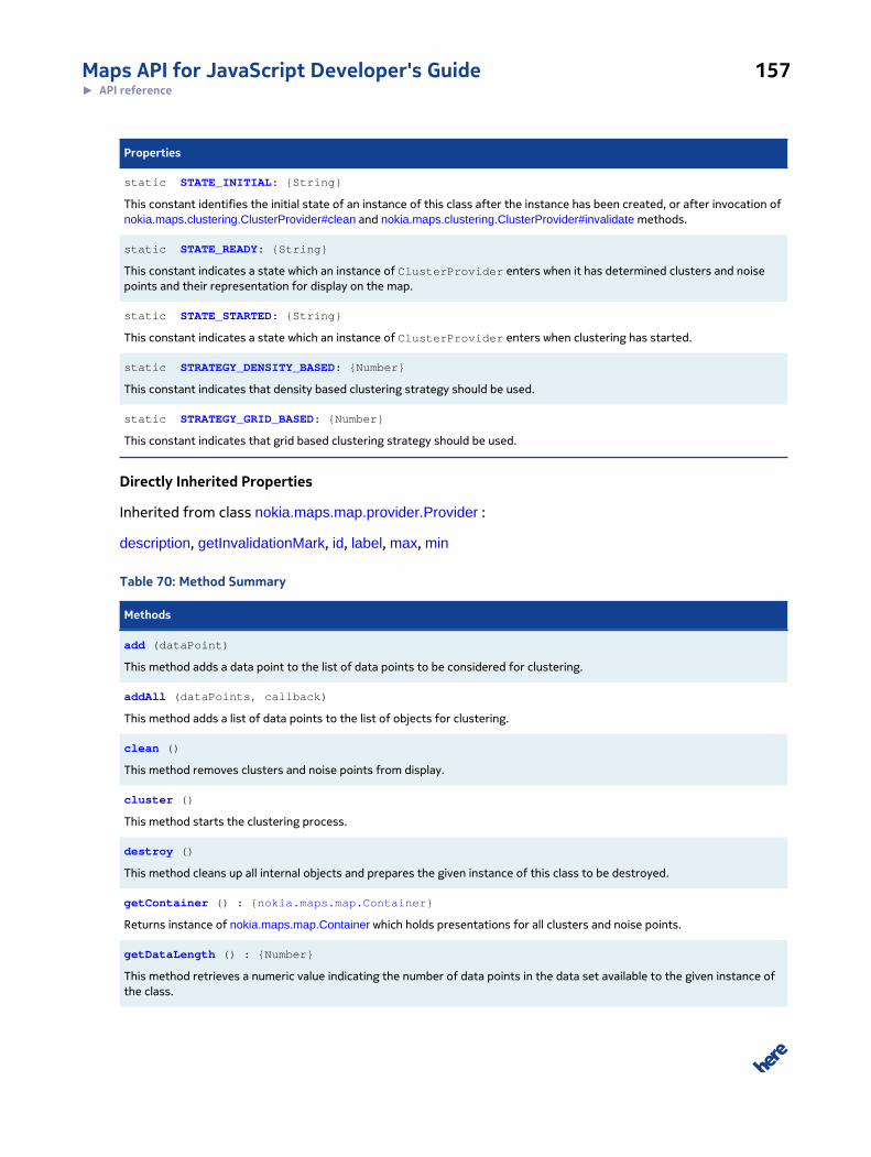
Maps API for JavaScript Developer's Guide 157► API reference
Properties
static STATE_INITIAL: {String}
This constant identifies the initial state of an instance of this class after the instance has been created, or after invocation ofnokia.maps.clustering.ClusterProvider#clean and nokia.maps.clustering.ClusterProvider#invalidate methods.
static STATE_READY: {String}
This constant indicates a state which an instance of ClusterProvider enters when it has determined clusters and noisepoints and their representation for display on the map.
static STATE_STARTED: {String}
This constant indicates a state which an instance of ClusterProvider enters when clustering has started.
static STRATEGY_DENSITY_BASED: {Number}
This constant indicates that density based clustering strategy should be used.
static STRATEGY_GRID_BASED: {Number}
This constant indicates that grid based clustering strategy should be used.
Directly Inherited Properties
Inherited from class nokia.maps.map.provider.Provider :
description, getInvalidationMark, id, label, max, min
Table 70: Method Summary
Methods
add (dataPoint)
This method adds a data point to the list of data points to be considered for clustering.
addAll (dataPoints, callback)
This method adds a list of data points to the list of objects for clustering.
clean ()
This method removes clusters and noise points from display.
cluster ()
This method starts the clustering process.
destroy ()
This method cleans up all internal objects and prepares the given instance of this class to be destroyed.
getContainer () : {nokia.maps.map.Container}
Returns instance of nokia.maps.map.Container which holds presentations for all clusters and noise points.
getDataLength () : {Number}
This method retrieves a numeric value indicating the number of data points in the data set available to the given instance ofthe class.
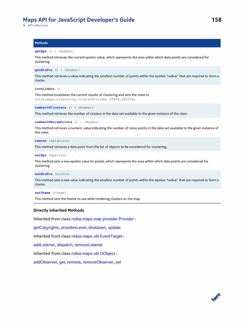
Maps API for JavaScript Developer's Guide 158► API reference
Methods
getEps () : {Number}
This method retrieves the current epsilon value, which represents the area within which data points are considered forclustering.
getMinPts () : {Number}
This method retrieves a value indicating the smallest number of points within the epsilon "radius" that are required to form acluster.
invalidate ()
This method invalidates the current results of clustering and sets the state tonokia.maps.clustering.ClusterProvider.STATE_INITIAL.
numberOfClusters () : {Number}
This method retrieves the number of clusters in the data set available to the given instance of the class.
numberOfNoisePoints () : {Number}
This method retrieves a numeric value indicating the number of noise points in the data set available to the given instance ofthis class.
remove (dataPoint)
This method removes a data point from the list of objects to be considered for clustering.
setEps (epsilon)
This method sets a new epsilon value (in pixels), which represents the area within which data points are considered forclustering.
setMinPts (minPts)
This method sets a new value indicating the smallest number of points within the epsilon "radius" that are required to form acluster.
setTheme (theme)
This method sets the theme to use while rendering clusters on the map.
Directly Inherited Methods
Inherited from class nokia.maps.map.provider.Provider :
getCopyrights, providesLevel, shutdown, update
Inherited from class nokia.maps.util.EventTarget :
addListener, dispatch, removeListener
Inherited from class nokia.maps.util.OObject :
addObserver, get, remove, removeObserver, set

Maps API for JavaScript Developer's Guide 159► API reference
Event Summary
Directly Inherited Events
Inherited from class nokia.maps.map.provider.Provider :
response, update
Class Description
Class is a implementation of map Provider and visualize a given data as cluster.
Constructor Details
nokia.maps.clustering.ClusterProvider(display, options)
This method creates new instance of ClusterProvider.
Parameters:
display: {nokia.maps.map.Display}
Display The object on which markers are to be drawn
options: {nokia.maps.clustering.ClusterProvider.Options} [optional]
An object specifying the configuration settings for the clustering provider
instance
Property Details
static STATE_CLUSTERED: {String}
This constant indicates a state which an instance of ClusterProvider enters when it has
completed clustering and rendering of the markers on the map can begin (is about to begin). Please
note that, because clustering may be repeated on every zoom level change, this state might be set
multiple times.
static STATE_INITIAL: {String}
This constant identifies the initial state of an instance of this class after the instance
has been created, or after invocation of nokia.maps.clustering.ClusterProvider#clean and
nokia.maps.clustering.ClusterProvider#invalidate methods.
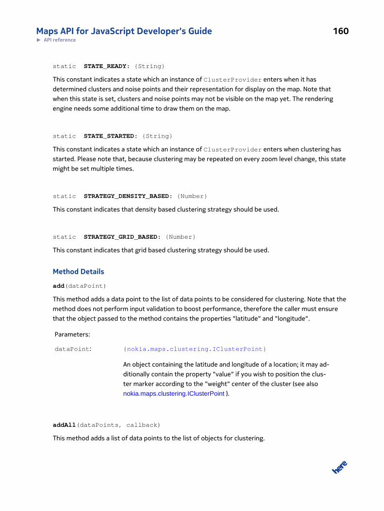
Maps API for JavaScript Developer's Guide 160► API reference
static STATE_READY: {String}
This constant indicates a state which an instance of ClusterProvider enters when it has
determined clusters and noise points and their representation for display on the map. Note that
when this state is set, clusters and noise points may not be visible on the map yet. The rendering
engine needs some additional time to draw them on the map.
static STATE_STARTED: {String}
This constant indicates a state which an instance of ClusterProvider enters when clustering has
started. Please note that, because clustering may be repeated on every zoom level change, this state
might be set multiple times.
static STRATEGY_DENSITY_BASED: {Number}
This constant indicates that density based clustering strategy should be used.
static STRATEGY_GRID_BASED: {Number}
This constant indicates that grid based clustering strategy should be used.
Method Details
add(dataPoint)
This method adds a data point to the list of data points to be considered for clustering. Note that the
method does not perform input validation to boost performance, therefore the caller must ensure
that the object passed to the method contains the properties "latitude" and "longitude".
Parameters:
dataPoint: {nokia.maps.clustering.IClusterPoint}
An object containing the latitude and longitude of a location; it may ad-
ditionally contain the property "value" if you wish to position the clus-
ter marker according to the "weight" center of the cluster (see also
nokia.maps.clustering.IClusterPoint ).
addAll(dataPoints, callback)
This method adds a list of data points to the list of objects for clustering.
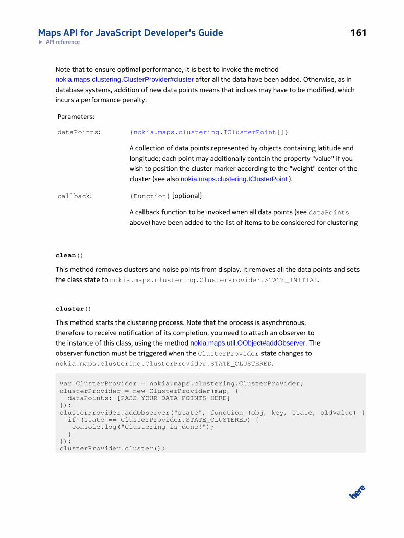
Maps API for JavaScript Developer's Guide 161► API reference
Note that to ensure optimal performance, it is best to invoke the method
nokia.maps.clustering.ClusterProvider#cluster after all the data have been added. Otherwise, as in
database systems, addition of new data points means that indices may have to be modified, which
incurs a performance penalty.
Parameters:
dataPoints: {nokia.maps.clustering.IClusterPoint[]}
A collection of data points represented by objects containing latitude and
longitude; each point may additionally contain the property "value" if you
wish to position the cluster marker according to the "weight" center of the
cluster (see also nokia.maps.clustering.IClusterPoint ).
callback: {Function} [optional]
A callback function to be invoked when all data points (see dataPoints
above) have been added to the list of items to be considered for clustering
clean()
This method removes clusters and noise points from display. It removes all the data points and sets
the class state to nokia.maps.clustering.ClusterProvider.STATE_INITIAL.
cluster()
This method starts the clustering process. Note that the process is asynchronous,
therefore to receive notification of its completion, you need to attach an observer to
the instance of this class, using the method nokia.maps.util.OObject#addObserver. The
observer function must be triggered when the ClusterProvider state changes to
nokia.maps.clustering.ClusterProvider.STATE_CLUSTERED.
var ClusterProvider = nokia.maps.clustering.ClusterProvider; clusterProvider = new ClusterProvider(map, { dataPoints: [PASS YOUR DATA POINTS HERE] }); clusterProvider.addObserver("state", function (obj, key, state, oldValue) { if (state == ClusterProvider.STATE_CLUSTERED) { console.log("Clustering is done!"); } }); clusterProvider.cluster();
Maps API for JavaScript Developer's Guide 162► API reference
destroy()
This method cleans up all internal objects and prepares the given instance of this class to be
destroyed.
getContainer(): {nokia.maps.map.Container}
Returns instance of nokia.maps.map.Container which holds presentations for all clusters and
noise points. You can use this method when planning to do for example an event delegation or for
attaching common event handlers.
Returns:
{nokia.maps.map.Container}
A value representing the number of data points
getDataLength(): {Number}
This method retrieves a numeric value indicating the number of data points in the data set available
to the given instance of the class.
Returns:
{Number} A value representing the number of data points
getEps(): {Number}
This method retrieves the current epsilon value, which represents the area within which data points
are considered for clustering.
Returns:
{Number} The current epsilon value
getMinPts(): {Number}
This method retrieves a value indicating the smallest number of points within the epsilon "radius"
that are required to form a cluster.
Maps API for JavaScript Developer's Guide 163► API reference
Returns:
{Number} The current value of minimum points
invalidate()
This method invalidates the current results of clustering and sets the state to
nokia.maps.clustering.ClusterProvider.STATE_INITIAL. Note that the
method does not remove objects from the display: in order to do that, please use the
nokia.maps.clustering.ClusterProvider#clean.
numberOfClusters(): {Number}
This method retrieves the number of clusters in the data set available to the given instance of the
class.
Returns:
{Number} A value representing the number of clusters
Throws:
A run-time error if nokia.maps.clustering.ClusterProvider#cluster method has
not been called (no clusters have been determined).
numberOfNoisePoints(): {Number}
This method retrieves a numeric value indicating the number of noise points in the data set available
to the given instance of this class.
Returns:
{Number} A value indicating the number of noise points
Throws:
A run-time error if nokia.maps.clustering.ClusterProvider#cluster method has
not been called (no noise points have been determined)
remove(dataPoint)
Maps API for JavaScript Developer's Guide 164► API reference
This method removes a data point from the list of objects to be considered for clustering.
Parameters:
dataPoint: {nokia.maps.clustering.IClusterProvider}
An object containing latitude and longitude (a data point) to be removed
from the list of objects to be considered for clustering
Throws:
If indexing is enabled, the method throws a run-time error exception as de-
scribed for nokia.maps.clustering.Index#remove
setEps(epsilon)
This method sets a new epsilon value (in pixels), which represents the area within which data points
are considered for clustering.
Note that clusters should be recalculated when the epsilon value changes. Please call the method
nokia.maps.clustering.ClusterProvider#cluster explicitly to force a recalculation.
Parameters:
epsilon: {Number}
A new epsilon value; it should be a value no smaller than 10
setMinPts(minPts)
This method sets a new value indicating the smallest number of points within the epsilon "radius"
that are required to form a cluster. Note that clusters should be recalculated whenever this method
has been called. Please call the method nokia.maps.clustering.ClusterProvider#cluster explicitly to
force a recalculation.
Parameters:
minPts: {Number}
A value indicating the largest number of data points within the epsilon "ra-
dius" that can exist as individual noise points (that are not subject to clus-
tering); the value must be no smaller than 1
Maps API for JavaScript Developer's Guide 165► API reference
setTheme(theme)
This method sets the theme to use while rendering clusters on the map. Please note, that theme
modification triggers the cluster() method.
Parameters:
theme: {nokia.maps.clustering.ITheme}
An object representing the new theme to use
Throws:
A run-time error if the theme object does not conform to the interface
nokia.maps.clustering.ITheme
Interface: Options
This interface is a member of nokia.maps.clustering.ClusterProvider.
Interface Summary
This interface defines the configuration options for nokia.maps.clustering.ClusterProvider
[ For full details, see nokia.maps.clustering.ClusterProvider.Options ]
Table 71: Property Summary
Properties
dataPoints: {nokia.maps.clustering.IClusterPoint[]}
This property holds a collection of objects representing data points.
eps: {Number}
This property holds the "radius" (in pixels) within which data points are considered for clustering.
index: {nokia.maps.clustering.Index}
This property holds an indexing data structure to use along with the clustering data.
max: {Number}
This property holds a value of the maximum zoom level at which to perform clustering.
min: {Number}
This property holds a value of the minimum zoom level at which to perform clustering.
minPts: {Number}
Maps API for JavaScript Developer's Guide 166► API reference
Properties
This property holds the smallest number of points that must be present within the eps distance of an arbitrary point to forma cluster.
strategy: {Number}
This property specifies strategy to use during clustering.
theme: {nokia.maps.clustering.ITheme}
This property holds an object that represents the display theme for clusters and noise points.
Interface Description
This interface defines the configuration options for nokia.maps.clustering.ClusterProvider
Property Details
dataPoints: {nokia.maps.clustering.IClusterPoint[]}
This property holds a collection of objects representing data points. Each object contains the latitude
and longitude of a location, but may also include the property value for weight-based positioning of
the cluster markers - see also nokia.maps.clustering.IClusterPoint for further information.
eps: {Number}
This property holds the "radius" (in pixels) within which data points are considered for clustering. If a
sufficient number of data points are found within this "radius" from an arbitrary point, a new cluster
is created, otherwise any data points within this "radius" become noise points (individual, unclustered
markers).
Note that setting this property to a very low value may result in too many points classified as noise
points instead of being aggregated in a cluster. Larger values can help resolve this problem, however,
they may also produce bigger clusters than desired/expected.
Please note, that due to certain technical details, eps "radius" is approximate and is not pixel precise.
In all classes inside nokia.maps.clustering package where we refer to eps or eps neighborhood
of the given point, we assume a rectangular area with 2*eps sides and with that given point as a
center.
Default Value: 50
index: {nokia.maps.clustering.Index}
Maps API for JavaScript Developer's Guide 167► API reference
This property holds an indexing data structure to use along with the clustering data. It can lead
to a significant improvement in the speed of marker data retrieval operations. If this property
is not set, ClusterProvider uses an instance of nokia.maps.clustering.Index with the default
nokia.maps.clustering.RTreeConfiguration.
Default Value: nokia.maps.clustering.Index
max: {Number}
This property holds a value of the maximum zoom level at which to perform clustering.
Default Value: 20
min: {Number}
This property holds a value of the minimum zoom level at which to perform clustering.
Default Value: 0
minPts: {Number}
This property holds the smallest number of points that must be present within the eps distance of
an arbitrary point to form a cluster. In other words every cluster should contain minimum minPts+1
points.
Default Value: 1
strategy: {Number}
This property specifies strategy to use during clustering. Possible values are:
• nokia.maps.clustering.ClusterProvider.STRATEGY_DENSITY_BASED
• nokia.maps.clustering.ClusterProvider.STRATEGY_GRID_BASED
Default Value: nokia.maps.clustering.ClusterProvider.STRATEGY_DENSITY_BASED
theme: {nokia.maps.clustering.ITheme}
Maps API for JavaScript Developer's Guide 168► API reference
This property holds an object that represents the display theme for clusters and noise points. By
default, ClusterProvider uses an instance of nokia.maps.clustering.MarkerTheme. It creates an
SVG marker for each cluster. The marker displays a number reflecting the number of data points in
the cluster. The size and color of the marker depends on that number as well.
Default Value: nokia.maps.clustering.MarkerTheme
Class: ColorizerThemeThis class is a member of nokia.maps.clustering.
Class Summary
An instance of this class provides a colored representation for cluster and noise point markers on the
map
[ For full details, see nokia.maps.clustering.ColorizerTheme ]
Table 72: Method Summary
Methods
getClusterPresentation (data) : {nokia.maps.map.Container}
This method retrieves a container with markers corresponding to all the data points in a cluster (all the markers are set tohave the same color).
getNoisePresentation (dataPoint) : {nokia.maps.map.StandardMarker}
This method retrieves a standard marker representing a noise point.
Class Description
Class provides a colored representation of cluster and noise points. This means that all markers in a
cluster have the same color, but the color is different from cluster to cluster, all the data points share
the same color, which is different from the cluster marker color. Note that noise points on the map
are presented in the same way as standard markers, with light gray color. The class conforms to the
interface nokia.maps.clustering.ITheme.
Constructor Details
nokia.maps.clustering.ColorizerTheme()
This method creates an instance of ColorizerTheme.
Maps API for JavaScript Developer's Guide 169► API reference
Method Details
getClusterPresentation(data): {nokia.maps.map.Container}
This method retrieves a container with markers corresponding to all the data points in a cluster (all
the markers are set to have the same color).
Parameters:
data: {nokia.maps.clustering.IClusterPoint[] |
nokia.maps.clustering.Cluster}
A collection of objects representing data points or an instance of
nokia.maps.clustering.Cluster class
Returns:
{nokia.maps.map.Container}
A container holding markers corresponding to all the data points in a cluster
getNoisePresentation(dataPoint): {nokia.maps.map.StandardMarker}
This method retrieves a standard marker representing a noise point.
Parameters:
dataPoint: {nokia.maps.clustering.IClusterPoint}
An object representing a data point (contains latitude, longitude and option-
ally weight)
Returns:
{nokia.maps.map.StandardMarker}
A standard marker positioned at the coordinates of the data point provided
by the caller
Interface: IClusterPointThis interface is a member of nokia.maps.clustering.
Maps API for JavaScript Developer's Guide 170► API reference
Interface Summary
This interface defines properties for a data point that can be used in clustering.
[ For full details, see nokia.maps.clustering.IClusterPoint ]
Table 73: Property Summary
Properties
value: {Number}
This property holds a numeric value that indicates the "weight" of the the data point within the cluster.
Directly Inherited Properties
Inherited from class nokia.maps.geo.ICoordinate :
altitude, altMode, latitude, longitude
Interface Description
This interface defines properties for a data point that can be used in clustering. Each data point used
for clustering purposes must conform to this interface.
Property Details
value: {Number}
This property holds a numeric value that indicates the "weight" of the the data point within the
cluster. Weight is used to determine the position of the marker that represents the cluster in relation
to the data points (markers) included in the cluster. Positioning the cluster marker by weight means
that it is placed closer to the data points (markers) with the highest value (this property) than to
any others. It is the default way to position the cluster marker, the other options being "center" and
"first". "Center" ensures that the cluster marker is placed in the center of the cluster, while "first"
means that the position of the cluster marker coincides with the first data point (marker) in the
cluster.
You can determine the position of the cluster marker explicitly when initializing
nokia.maps.clustering.MarkerTheme. To do that, set the property "position" on an instance
of nokia.maps.clustering.MarkerTheme.Options#position - the object is the argument to the
MarkerTheme constructor. The example below demonstrates how to set weight-based positioning,
using a constant defined on the class nokia.maps.clustering.MarkerTheme:
var map = new nokia.maps.map.Display(...); clusterProvider = new nokia.maps.clustering.ClusterProvider(map, {
Maps API for JavaScript Developer's Guide 171► API reference
theme : new nokia.maps.clustering.MarkerTheme({ position: nokia.maps.clustering.MarkerTheme.POSITION_WEIGHT_CENTER }) });
Note that if value is not set on any of the data points in the cluster, you can improve clustering
performance by specifying "center" as the configuration setting for MarkerTheme, while achieving a
similar visual effect as that created by "weight".
Default Value: 1
Interface: IThemeThis interface is a member of nokia.maps.clustering.
Interface Summary
This interface defines how a cluster is to be shown on the map.
[ For full details, see nokia.maps.clustering.ITheme ]
Table 74: Method Summary
Methods
getClusterPresentation (dataPoints) : {nokia.maps.map.Object}
This method retrieves an object that can be displayed on the map to represent a cluster.
getNoisePresentation (dataPoint) : {nokia.maps.map.Object}
This method retrieves an object that can be displayed on the map to represent a single noise point.
Interface Description
A variety of representations of marker cluster are possible. For example, a cluster can be shown as a
rectangle with an outline boundary, or it can be displayed as a marker, etc. All cluster display themes
must conform this interface to allow instances of ClusteringProvider to communicate with
them.
Method Details
getClusterPresentation(dataPoints): {nokia.maps.map.Object}
This method retrieves an object that can be displayed on the map to represent a cluster.
Parameters:
Maps API for JavaScript Developer's Guide 172► API reference
dataPoints: {nokia.maps.clustering.IClusterPoint[] |
nokia.maps.clustering.Cluster}
A collection of objects representing data points (each object contains
latitude, longitude and optionally a value attribute to indicate the
weight of the point); alternatively, the argument can be an instance of
nokia.maps.clustering.Cluster
Returns:
{nokia.maps.map.Object}
An object that can be displayed on the map to represent a cluster
getNoisePresentation(dataPoint): {nokia.maps.map.Object}
This method retrieves an object that can be displayed on the map to represent a single noise point.
Parameters:
dataPoint: {nokia.maps.clustering.IClusterPoint}
An object representing a data point (contains latitude, longitude and option-
ally weight)
Returns:
{nokia.maps.map.Object}
An object that can be displayed on the map to represent a noise point
Class: IndexThis class is a member of nokia.maps.clustering.
Class Summary
This class holds clustering index based on R-Tree.
[ For full details, see nokia.maps.clustering.Index ]
Maps API for JavaScript Developer's Guide 173► API reference
Table 75: Method Summary
Methods
add (coordinate)
This method adds a data point to the index.
clean ()
This method removes all the references to the data points from the index.
destroy ()
This method cleans up all internal objects and prepares the given instance of this class to be destroyed.
getNeighborhood (point, eps, seacrhAreaSize)
This method finds all the data points which are in the rectangular area center of which is the given point, and both width andheight are 2 * eps in size.
remove (coordinate)
This method removes the data point specified by the caller from the index.
Class Description
Clustering index based on R-Tree.
Constructor Details
nokia.maps.clustering.Index(config)
This method creates new clustering index. It builds an RTree data structure on top of the clustering
data, which can offer a significant improvement in the speed of data retrieval operations related to
spatial objects.
Parameters:
config: {nokia.maps.clustering.RTreeConfiguration} [optional]
Configuration settings for RTree
Method Details
add(coordinate)
This method adds a data point to the index.
Parameters:
coordinate: {nokia.maps.clustering.IClusterPoint}
Maps API for JavaScript Developer's Guide 174► API reference
An object representing a data point (contains latitude and longitude)
clean()
This method removes all the references to the data points from the index. The effect is as if the
index were created with an empty list of data points.
destroy()
This method cleans up all internal objects and prepares the given instance of this class to be
destroyed.
getNeighborhood(point, eps, seacrhAreaSize)
This method finds all the data points which are in the rectangular area center of which is the given
point, and both width and height are 2 * eps in size.
Parameters:
point: {nokia.maps.clustering.IClusterPoint}
A data point object whose neighborhood is to be established
eps: {Number}
Size of the neighborhood to find
seacrhAreaSize: {Number} [optional]
Size of the "world" in pixels; used in cases when there is a need to specify
that the "world is round" and it is desirable to allow the search to continue
on the opposite side of the map or the search area.
Returns:
nokia.maps.util.RTreeRecord[] An array of data points retrieved from
the square area with 2 * eps sides and with the supplied point as
a center; each point has the property $coordinate which holds a
reference to the actual data point provided when calling the method
nokia.maps.clustering.Index#add
Maps API for JavaScript Developer's Guide 175► API reference
remove(coordinate)
This method removes the data point specified by the caller from the index.
Parameters:
coordinate: {nokia.maps.clustering.IClusterPoint}
An object representing a data point (contains latitude and longitude)
Throws:
run-time error if no data point object is provided, or if it the supplied object
does not conform to the interface nokia.maps.clustering.IClusterPoint
Class: MarkerThemeThis class is a member of nokia.maps.clustering.
Class Summary
An instance of this class represents each cluster and noise point on the map as a marker.
[ For full details, see nokia.maps.clustering.MarkerTheme ]
Table 76: Property Summary
Properties
static POSITION_CENTER: {String}
This constant provides a value for nokia.maps.clustering.MarkerTheme.Options#position.
static POSITION_FIRST: {String}
This constant provides a value for nokia.maps.clustering.MarkerTheme.Options#position.
static POSITION_WEIGHT_CENTER: {String}
This constant provides a value for nokia.maps.clustering.MarkerTheme.Options#position.
Table 77: Method Summary
Methods
getClusterCoordinate (data) : {nokia.maps.geo.ICoordinate}
This method retrieves an object containing the geographic coordinates of the marker that represents a cluster.
getClusterPresentation (data) : {nokia.maps.map.Marker}
Maps API for JavaScript Developer's Guide 176► API reference
Methods
This method retrieves a marker representing a cluster.
static getColor (clusterSize) : {String}
This method retrieves a color definition as a hex string in the format #RRGGBB.
getNoisePresentation (dataPoint) : {nokia.maps.map.StandardMarker}
This method retrieves a standard marker representing a noise point.
Class Description
This class conforms to the interface nokia.maps.clustering.ITheme. Each cluster appears on the map
as a circle showing a number indicating the size of the cluster. The color of the circle, its size and
shadow depend on the size of the cluster. By contrast, noise points are presented as small blue dots,
with white stroke color.
Constructor Details
nokia.maps.clustering.MarkerTheme(position)
This method creates an instance of MarkerTheme. It accepts configuration settings as an argument.
Parameters:
position: {String} [optional]
A value indicating the position of the cluster presenter marker; it should
be one of the static variables POSITION_CENTER, POSITION_FIRST and
POSITION_WEIGHT_CENTER defined in this class; if the method receives an
unsupported position identifier, it uses POSITION_WEIGHT_CENTER by de-
fault
Property Details
static POSITION_CENTER: {String}
This constant provides a value for nokia.maps.clustering.MarkerTheme.Options#position. It ensures
that the cluster marker is drawn in the center of the minimum rectangle containing all data points in
the cluster.
static POSITION_FIRST: {String}
Maps API for JavaScript Developer's Guide 177► API reference
This constant provides a value for nokia.maps.clustering.MarkerTheme.Options#position. It ensures
that the cluster marker is placed at the same location as the first data point in the cluster.
static POSITION_WEIGHT_CENTER: {String}
This constant provides a value for nokia.maps.clustering.MarkerTheme.Options#position. It
ensures that the cluster marker is placed closer to the data points (markers) with the highest value
("weight") than to any others.
Method Details
getClusterCoordinate(data): {nokia.maps.geo.ICoordinate}
This method retrieves an object containing the geographic coordinates of the marker that represents
a cluster.
Parameters:
data: {nokia.maps.clustering.IClusterPoint[] |
nokia.maps.clustering.Cluster}
A collection of objects representing data points (contain latitude and
longitude) or an instance of nokia.maps.clustering.Cluster; in addition,
each point may contain a "value" attribute if you wish to position the
cluster marker according to the "weight" center of the cluster (see also
nokia.maps.clustering.IClusterPoint)
Returns:
{nokia.maps.geo.ICoordinate}
An object containing the geographic coordinates of the position of cluster
marker
getClusterPresentation(data): {nokia.maps.map.Marker}
This method retrieves a marker representing a cluster.
Parameters:
data: {nokia.maps.clustering.IClusterPoint[] |
nokia.maps.clustering.Cluster}
Maps API for JavaScript Developer's Guide 178► API reference
A collection of objects representing data points (contain latitude and
longitude) or an instance of nokia.maps.clustering.Cluster; in addition,
each point may contain a "value" attribute if you wish to position the
cluster marker according to the "weight" center of the cluster (see also
nokia.maps.clustering.IClusterPoint)
Returns:
{nokia.maps.map.Marker}
An instance of nokia.maps.map.StandardMarker showing a numeric value in-
dicating the number of elements inside the cluster. The color of the marker
also depends on the size of the cluster
static getColor(clusterSize): {String}
This method retrieves a color definition as a hex string in the format #RRGGBB. The retrieved color
definition, depends on the cluster size.
• #76D100 - if cluster size is smaller than 10
• #FF6900 - if cluster size is bigger than 10, but less than 25
• #F03C00 - if cluster size is bigger than 25, but less than 50
• #B50015 - if cluster size is bigger than 100
Parameters:
clusterSize: {Number}
A value indicating the size of the cluster
Returns:
{String} An string containing the color definition in the format #RRGGBB
getNoisePresentation(dataPoint): {nokia.maps.map.StandardMarker}
This method retrieves a standard marker representing a noise point.
Parameters:
dataPoint: {nokia.maps.clustering.IClusterPoint}
Maps API for JavaScript Developer's Guide 179► API reference
An object representing a noise point, containing latitude, longitude and op-
tionally weight
Returns:
{nokia.maps.map.StandardMarker}
A standard marker positioned at the location supplied by the argument
Class: NoiseThis class is a member of nokia.maps.clustering.
Class Summary
This class represents noise point on the map.
[ For full details, see nokia.maps.clustering.Noise ]
Table 78: Method Summary
Methods
getCoordinate () : {nokia.maps.geo.Coordinate}
This method retrieves an object containing the geographic coordinates of the given noise point.
getIcon (theme, resetTheMarker)
This method retrieves the icon representing of the noise point on the map.
Class Description
This class represents a noise point - a point that is not part of a cluster and is indicated by
an individual marker. Note that at the highest zoom level at which clustering applies (see also
nokia.maps.clustering.ClusterProvider), it is possible that all or most data points are presented as
noise points.
Constructor Details
nokia.maps.clustering.Noise(point)
This method creates an instance of Noise.
Parameters:
point: {nokia.maps.clustering.IClusterPoint} [optional]
Maps API for JavaScript Developer's Guide 180► API reference
A data point object that provides the coordinates for a noise point
Method Details
getCoordinate(): {nokia.maps.geo.Coordinate}
This method retrieves an object containing the geographic coordinates of the given noise point.
Returns:
{nokia.maps.geo.Coordinate}
An object containing the geographic coordinates of the noise point
getIcon(theme, resetTheMarker)
This method retrieves the icon representing of the noise point on the map.
Parameters:
theme: {nokia.maps.clustering.ITheme}
A theme object to use when presenting cluster on the map
resetTheMarker: {Boolean} [optional]
A flag indicating whether the internal marker is to be updated (true) or
whether the cached marker is to be retrieved (false; this optional argu-
ment can be used when the theme for existing clusters has been modified
Interface: RTreeConfigurationThis interface is a member of nokia.maps.clustering.
Interface Summary
This interface defines configuration options for R-Tree.
[ For full details, see nokia.maps.clustering.RTreeConfiguration ]
Table 79: Property Summary
Properties
algorithm: {Number}
Maps API for JavaScript Developer's Guide 181► API reference
Properties
This property specifies the partitioning algorithm for RTree.
max: {Number}
This property holds the maximum number of objects per node.
min: {Number}
This property holds the minimum number of objects per node.
Interface Description
This interface defines configuration options for RTree. It is used as a template for configuration
settings used when creating an instance of nokia.maps.clustering.Index.
Property Details
algorithm: {Number}
This property specifies the partitioning algorithm for RTree.
The possible values are:
• 0 or nokia.maps.util.RTree.QUADRATIC_PARTITIONING
• 1 or nokia.maps.util.RTree.LINEAR_PARTITIONING
• 2 or nokia.maps.util.RTree.LINEAR_MOD_PARTITIONING
• 3 or nokia.maps.util.RTree.DUMMY_PARTITIONING
Default Value: 0
max: {Number}
This property holds the maximum number of objects per node. Its value must not be less than 2.
Default Value: 32
min: {Number}
This property holds the minimum number of objects per node. Its value must not be less than 1 or
greater than max/2. The time needed for querying the index dependent on this property. A large
min value reduces the height of the tree and improves space utilization. Too large a min, however,
reduces the tree to a linear index, which has the same effect as having index at all. A small value of
min on the other hand, causes a higher tree, partitioning the objects more. When choosing min too
Maps API for JavaScript Developer's Guide 182► API reference
small, too many nodes have to be examined when searching the tree, increasing the required search
time. A trade-off between a wide tree and a high tree has to be made. Therefore, the parameters min
and max can be tuned as part of performance tuning.
Default Value: 12
Class: RectangleThemeThis class is a member of nokia.maps.clustering.
Class Summary
This class creates a representation of each cluster on the map as a rectangle which contains all the
data points that belong to the cluster.
Deprecated: Since 2.5.0
[ For full details, see nokia.maps.clustering.RectangleTheme ]
Table 80: Method Summary
Methods
getClusterPresentation (data) : {nokia.maps.map.Rectangle}
This method retrieves the smallest rectangle that encloses all the data points in the cluster provided by the caller.
getNoisePresentation (dataPoint) : {nokia.maps.map.StandardMarker}
This method retrieves a standard marker representing a noise point.
Class Description
The class creates a representation of a cluster on the map, presenting all noise points as standard
markers, while clusters are shown as instances of nokia.maps.map.Rectangle. The class conforms to
the interface nokia.maps.clustering.ITheme.
Constructor Details
nokia.maps.clustering.RectangleTheme()
This method creates an instance of RectangleTheme.
Deprecated: Since 2.5.0
Maps API for JavaScript Developer's Guide 183► API reference
Method Details
getClusterPresentation(data): {nokia.maps.map.Rectangle}
This method retrieves the smallest rectangle that encloses all the data points in the cluster provided
by the caller.
Parameters:
data: {nokia.maps.clustering.IClusterPoint[] |
nokia.maps.clustering.Cluster}
A collection of data point objects containing latitude and longitude, or an in-
stance of nokia.maps.clustering.Cluster class
Returns:
{nokia.maps.map.Rectangle}
An object representing a rectangle that encloses all the data points in the
cluster
getNoisePresentation(dataPoint): {nokia.maps.map.StandardMarker}
This method retrieves a standard marker representing a noise point.
Parameters:
dataPoint: {nokia.maps.clustering.IClusterPoint}
An object that represents the noise point for which to retrieve the marker
(contains latitude, longitude and optionally weight)
Returns:
{nokia.maps.map.StandardMarker}
A standard marker positioned at the coordinates of the data point supplied
by the caller
Namespace: domThis namespace is a member of nokia.maps.
Maps API for JavaScript Developer's Guide 184► API reference
Namespace Summary
This namespace implements support for managing HTML documents, including DOM-related events,
and for HTML 5.
Namespace Description
This namespace implements support for managing HTML documents, including DOM-related events,
and for HTML 5.
Class: DataTransferThis class is a member of nokia.maps.dom.
Class Summary
This class is a implementation of the HTML 5 DataTransfer interface.
[ For full details, see nokia.maps.dom.DataTransfer ]
Table 81: Property Summary
Properties
cursor: {String}
This property defines the CSS cursor to be shown during non-lift dragging; the default value is "pointer".
dropEffect: {String}
This property names the currently selected operation type.
effectAllowed: {String}
This property names allowed operations.
files: {Object[]}
This property contains references to the files that are being dragged, if any.
lift: {Boolean}
This property can only be modified within a dragstart event, it indicates if a drag operation lifts the target or not.
readonly ndt: {Object}
This property holds a reference to a native data transfer object, if available.
realTime: {Boolean}
This property determines if all the drag-events are to be processed in real time or if thresholds are to be applied to preventtoo many events and therefore an overall performance drop.
readonly types: {String[]}
Maps API for JavaScript Developer's Guide 185► API reference
Properties
This property holds an array of strings with the formats that were set in the dragstart event.
Table 82: Method Summary
Methods
addElement (element)
This method offers an alternative way of specifying how the user agent is to render the drag feedback.
allows (dropEffect) : {Boolean}
This method checks if the supplied drop effect is allowed or not.
clearData (format) : {nokia.maps.dom.DataTransfer}
This method removes the data of the specified format.
getData (format)
This method retrieves the data specified by the caller.
hasData (format)
This method checks if data matching the format specified by the caller exists.
setData (format, data)
This method adds the data specified by the caller.
setDragImage (image, left, top)
This method sets the element to be used to generate the drag feedback.
Class Description
This class is a browser-independent implementation of the HTML 5 interface DataTransfer. The class
extends the capabilities stipulated in the HTML 5 specification by allowing native JavaScript objects
as values. If there is native support and the value is a string, then the data is copied into the native
data transfer object.
Constructor Details
nokia.maps.dom.DataTransfer(nativeDataTransfer)
This method initializes a new instance of DataTransfer
Parameters:
nativeDataTrans-
fer:
{Object} [optional]
Maps API for JavaScript Developer's Guide 186► API reference
The reference to a native data transfer object (requires browser support for
native drag and drop)
Property Details
cursor: {String}
This property defines the CSS cursor to be shown during non-lift dragging; the default value is
"pointer".
dropEffect: {String}
This property names the currently selected operation type. To succeed, the operation must be
allowed by the attribute effectAllowed.
The value of the property can be set to change the selected operation. The possible values are none,
copy, link, and move.
effectAllowed: {String}
This property names allowed operations.
The value of the property can be set to modify the list of allowed operations. The possible values are
none, copy, copyLink, copyMove, link, linkMove, move, all, and uninitialized.
files: {Object[]}
This property contains references to the files that are being dragged, if any.
lift: {Boolean}
This property can only be modified within a dragstart event, it indicates if a drag operation lifts the
target or not.
If an object is dragged, but not lifted, no dragenter, dragover, dragleave or drop events are
dispatched. Dragging without lift occurs, for example, when the slider or the scale bar is moved, or
when the map is panned. It means that something is dragged within a limited area and cannot leave
that area -- for example, the thumb shift of a zoom slider cannot leave the zoom slider, therefore the
zoom slider handles the movement of the thumb shift, and consequently updates the slider within
the drag event, without notifying any other element in the Web site or outside the browser window.
Maps API for JavaScript Developer's Guide 187► API reference
In dragging without lift, the cursor is not defined by the dropEffect, but by the cursor property.
readonly ndt: {Object}
This property holds a reference to a native data transfer object, if available.
realTime: {Boolean}
This property determines if all the drag-events are to be processed in real time or if thresholds are to
be applied to prevent too many events and therefore an overall performance drop. The property has
the best effect if set directly within the dragstart event, otherwise it will only be partially "near-
time".
Note that this property has no effect in native drag and drop and we recommended that you avoid
real-time drag and drop operations if possible.
readonly types: {String[]}
This property holds an array of strings with the formats that were set in the dragstart event. In
addition, if any files are being dragged, one of the types is the string "Files".
Method Details
addElement(element)
This method offers an alternative way of specifying how the user agent is to render the drag
feedback. It adds an element to the DataTransfer object.
Parameters:
element: {Node}
The element to add as drag feedback for the user
allows(dropEffect): {Boolean}
This method checks if the supplied drop effect is allowed or not.
This is a proprietary member and not part of the implementation of W3C interface specifications.
Parameters:
Maps API for JavaScript Developer's Guide 188► API reference
dropEffect: {String}
The drop effect to check: copy, move or link
Returns:
{Boolean} A value is true if the effect is allowed, false otherwise
clearData(format): {nokia.maps.dom.DataTransfer}
This method removes the data of the specified format. It removes all data if the argument is omitted.
Parameters:
format: {String}
The format for which the data should be removed.
Returns:
{nokia.maps.dom.DataTransfer}
The data transfer object itself (this).
getData(format)
This method retrieves the data specified by the caller. If there is no matching data, an empty string is
returned.
Parameters:
format: {String}
The format of the data to return
Returns:
An {Object} containing the data
hasData(format)
This method checks if data matching the format specified by the caller exists.
Maps API for JavaScript Developer's Guide 189► API reference
Parameters:
format: {String}
The format of the data to check for
Returns:
A {Boolean} value, true if the data in the given format is available; false
otherwise.
setData(format, data)
This method adds the data specified by the caller.
Parameters:
format: {String}
The format of the data
data: {Object}
The data
Returns:
An instance of {nokia.maps.dom.DataTransfer} representing the data trans-
fer object itself (this)
setDragImage(image, left, top)
This method sets the element to be used to generate the drag feedback. The element can be any
element; if it is an img, then the user agent should use the element's image (at its intrinsic size) to
generate the feedback, otherwise the user agent should base the feedback on the given element (but
the exact mechanism for doing so is not specified).
Parameters:
image: {node}
The feedback element to be used as drag feedback
Maps API for JavaScript Developer's Guide 190► API reference
left: {Object} [optional, default: 0]
The horizontal pixel offset of the left border of the image relative to the
cursor, a positive number moves the image to the right of the cursor, a neg-
ative number moves the image left to the cursor
top: {Object} [optional, default: 0]
The vertical pixel offset of the top border of the image relative to the cur-
sor, a positive number moves the image to the bottom of the cursor, a neg-
ative number moves the image top to the cursor
Example:
// If "imageNode" is a DOM image with a size of 50 pixel, // then this would attach this image to the cursor, // align it 25 pixel to top-left event.dataTransfer.setDragImage( imageNode, -25, -25 );
Interface: DragEventThis interface is a member of nokia.maps.dom.
Extends: nokia.maps.dom.Event
Interface Summary
This event is fired for all kind of drag operations.
[ For full details, see nokia.maps.dom.DragEvent ]
Table 83: Property Summary
Properties
dataTransfer: {Number}
The property dataTransfer contains context information maintained during the entire dragging operation, fromdragstart until the dragend event.
Directly Inherited Properties
Inherited from class nokia.maps.dom.Event :
AT_TARGET, bubbles, BUBBLING_PHASE, canBubble, cancelable, canSicker, CAPTURING_PHASE,
currentTarget, defaultPrevented, eventPhase, namespaceURI, nativeEvent, page, propagation,
Maps API for JavaScript Developer's Guide 191► API reference
PROPAGATION_OK, PROPAGATION_STOP, PROPAGATION_STOP_IMMEDIATE, target,
timeStamp, type
Method Summary
Directly Inherited Methods
Inherited from class nokia.maps.dom.Event :
cancel, clone, preventDefault, preventUnload, stopImmediatePropagation, stopPropagation
Interface Description
This interface represents events fired for all kind of drag operations. For more information about
drag events please refer to the nokia.maps.dom.DragEventTarget class.
Note that this class represents an unimplemented interface. It is included here to document its
properties. The class is derived from nokia.maps.dom.Event, but, in addition to the properties of the
parent class, it has the properties described here.
Property Details
dataTransfer: {Number}
The property dataTransfer contains context information maintained during the entire dragging
operation, from dragstart until the dragend event. It can be used to store data while the drag
operation is ongoing. The object always has the same reference, therefore it is possible to modify its
contents (see nokia.maps.dom.DataTransfer), but not to replace it with a new one.
Note that although according to the W3C specification, it is only possible to store binary safe strings
in the data transfer object, this is not the case in this implementation. However, only strings may be
passed from one window to another, and therefore adding a JavaScript object to the data transfer
object prevents strings from being transfered into another window.
Interface: DragEventTargetThis interface is a member of nokia.maps.dom.
Interface Summary
This class is a virtual interface described here for reference only.
[ For full details, see nokia.maps.dom.DragEventTarget ]
Maps API for JavaScript Developer's Guide 192► API reference
Table 84: Event Summary
Events
drag
This event is fired at the target object of the dragstart event while a drag operation is in propgress.
dragend
This event is fired at the end of a drag operation at the object that was dragged (the target of the dragstart event).
dragenter
This event is fired at an object if the mouse/finger is moved into the visible area of the object during a drag operation.
dragleave
This event is fired at the current drop target if the the mouse/finger leaves the visible area of the target.
dragover
This event is fired at the current drop target while the mouse/finger is on/above the drop target.
dragstart
This event is fired at an object that has the property draggable set to true and after a mousedown/touch has occurredand the mouse/finger was moved at least three pixels.
drop
This event is fired at the current drop target if the mouse button or finger is released on/above it, which means that thedragenter event and the dragover events were canceled, so their preventDefault methods were called and theallowedEffect property matches the dropEffect property.
Interface Description
Each class implementing this interface delcares that it can act as the target for certain events. Each
event in this interface (and therefore also within the classes implementing the interface) represents
an event of a specific type.
The following example shows event handling for events of the type "click":
// Note that "obj" can be either a DOM node or any other JavaScript object.var obj = nokia.maps.dom.EventTarget( {} );obj.addListener("click", function (evt) { console.log("This is the '"+evt.type+"' event!");});
obj.dispatch( new nokia.maps.dom.Event({ type: "click"});
The example creates an instant of nokia.maps.dom.EventTarget, adds a listener for "click"
events to it, and dispatches a "click" event to all registered listeners (in this case one) - the listeners
receive the object that represents the target of the event.
Maps API for JavaScript Developer's Guide 193► API reference
For more information about dispatching events, please refer to the documentation of the
nokia.maps.dom.EventTarget.
Drag and drop in a nutshell
The following description discusses event handling for drag and drop events. These are likely to be
the most complex events, although once you have understood them, you should find them quite
straightforward to process. The W3C homepage offers a very detailed explanation of drag and drop
- please see http://dev.w3.org/html5/spec/dnd.html. Our text attempts to capture the information you
need in a nutshell, plus it covers some information about the non-standard not lifted dragging, which
is an arbitrary extension to the W3C specification and should help you use drag and drop events for
certain special cases (such as implementing sliders).
Drag and drop concerns seven events, three of them (dragstart, drag and dragend) are fired at
the DOM node that is dragged and four (dragenter, dragover, dragleave and drop) are fired at
the DOM node over which the source node is dragged or onto which the source node is dropped (this
does not occur in not lifted dragging, but more about that later).
Before we start
First, however, please note that the following code is always expected to be executed before the
small code examples we provide below:
// Create a few shortcuts. var Page = nokia.maps.dom.Page, EventTarget = nokia.maps.dom.EventTarget;
// Query page support for the document. This is very // important, but needs only to be done once. Page(document);
Dragging Basics
The first step is to ensure that the DOM node to be dragged is draggable. The class
nokia.maps.dom.EventTarget offers support in this respect through a method that takes care of all
browser-specific details:
// Make a DOM node an event target and draggable. EventTarget(node).enableDrag();
This simple code guarantess that the browser fires a dragstart event as soon as the user tries
to drag node or any of its children. What is more, this is valid for touch screens (for example the
iPhone). If the event is canceled, then dragging is disallowed, otherwise it is allowed (by default). While
a drag operation is in progress, no other mouse, touch or keyboard events are fired.
Note that the above applies also to the mouseup and click events. You can get a mousedown event,
but no mouseup or click event follow it if the mousedown event started a drag operation and
Maps API for JavaScript Developer's Guide 194► API reference
dragstart event is not canceled with a call to preventDefault(). Therefore, it is best not only to
register a listener for mousedown and mouseup (assuming you want to track these two events), but
also for dragend in the capture phase. A mousedown followed by a dragend indicates the mouse
button has been released - a mouseup is not generated. This means you can simply use the dragend
as a mouseup event. If you recieved a mousedown at a node, you can be sure that you will receive a
dragend at the same node at least within the capture phase.
Each of the seven drag events has a special property called dataTransfer, which holds an
instance of nokia.maps.dom.DataTransfer. This object contains information about the drag
operation and is used to control it. In addition, the object can be used to transfer data between
the different drag listeners, as it is guaranteed that the object itself is attached to all drag events
from dragstart to dragend. However, the next drag sequence has a new dataTransfer object
associated with it (so you cannot transfer data between to separate drag sequences).
Dragging from the point of view of drag target
The event dragstart has a property named effectAllowed. It determines what kind of operation
can be performed on the dragged object, for example, whether the object can be copied, linked
and/or moved. The value of this property is set by the event handler to one of the following strings:
"uninitialized", "none", "copy", "copyLink", "copyMove", "all", "link", "linkMove" or "move". The
default value is "uninitialized" and has the same meaning as "all".
The dragstart event allows you to define the visual feedback of the drag as well. There are two
methods available on the data transfer object for this purpose: setDragImage(node, offsetX,
offsetY) and addElement(node). You can only have one drag image (a picture visible while
dragging is in progress), so a second call to setDragImage() overwrites the previously set image
node. addElement() adds an unlimited number of additional elements to the visual feedback. The
visual feedback (all added elements and/or the drag image) is rendered relative to the hot spot of
the mouse cursor or the touch point of the finger on a touch screen and is shown stretching to the
right and down from the mouse pointer or the dragging finger. You can fine-tune where the drag
image appears via its offset coordinates. The offset has no effect for the elements added using the
addElement(), but their style property position can be set to "absolute" and then they can be
offset using the CSS properties style.left and style.top.
While dragging is in progress, the brower fires a "drag" event every few milliseconds at the source
node that is being dragged. If the event is canceled (preventDefault is called), dragging is aborted,
otherwise it continues. In most cases, the drag event can be ignored, except, for example, for not
lifted dragging to which we return shortly.
When dragging is finished, the source node (the drag target) receives a dragend event with
information reflecting the action that was performed when the dragged object reached the drop
zone. The information is stored in the property dropEffect of the data transfer object and is
"none", "copy", "move" or "link". If the drop was aborted or failed, the effect is none. This is
Maps API for JavaScript Developer's Guide 195► API reference
important information in the example that follows, because if the dragged element was not moved,
the node must be re-inserted into the document at the position it occupied before draggin began:
// This function makes an image node draggable. var makeImageDraggable = function ( node ) { // Create a closure so that every call to this method // can handle it's own node. (function (node) { // Make the image draggable. EventTarget(node).enableDrag(); // These variables are used later to put the image // back where it was should dragging fail. var sourceNodeParent; var sourceNodeNextSibling;
// Register a dragstart listener. node.addListener("dragstart", function (evt) { // Remember the parent node and next sibling of the image. sourceNodeParent = node.parentNode; sourceNodeNextSilbing = sourceNode.nextSilbing; // Detach the image from the document. sourceNodeParent.removeChild (node); // Attach the image to the cursor so that it is dragged around. evt.dataTransfer.setDragImage( sourceNode, -evt.targetX || 0, -evt.targetY || 0); // Allow all kinds of drag operations. evt.dataTransfer.effectAllowed = "all"; // Prevent any other drag handlers from receiving this event, // but do not cancel the event, because that would abort // dragging. evt.stopImmediatePropagation(); }, false); // Register a dragend listener. node.addListener("dragend", function (evt) { // If the image was not moved somewhere else if (evt.dataTransfer.dropEffect!=="move") { // we have to move the image back to where it was. if (sourceNodeNextSilbing) sourceNodeParent.insertBefore(node, sourceNodeNextSilbing); else sourceNodeParent.appendChild(node); } // Note: If the image was moved, we don't need to do anything!
// Let's cancel the event now that we have processed it. The event // must not be processed by the browser or any other listener. event.cancel(); }, false);
Maps API for JavaScript Developer's Guide 196► API reference
})(node); };
So far we have explained one aspect of drag and drop: what you need to do if you want to make a
DOM node draggable. Next, we consider how to create a drop zone, where the dragged object can be
dropped. Our next example extends the previous one by allowing the image to be dropped anywhere
within the document.
The drag from the drop target perspective
A dropzone can be any DOM node or JavaScript object that is an instance of
nokia.maps.dom.EventTarget. Whenever the mouse is moved onto such a node, the browser
fires a dragenter event at that node. If the event is not canceled (by calling preventDefault), the
browser estimates that a drop is not handled by the node and disallows a drop to it. If the event is
canceled (preventDefault has been called), the listener must set the property dropEffect on
the data transfer object to indicate the operation that the node wants to perform with the dragged
element. If an image is dragged, dropEffect must be said to "move".
The next event to be fired is dragover. It is fired regularly like the drag event, but it is fired at the
current drop target. This event must be canceled (by calling preventDefault) and the property
dropEffect on the data transfer object must be updated to indicate the desired operation ("none",
"copy", "link" or "move". If the event is not canceled, the drop is denied and the dropEffect is set
to "none".
Finally if the user releases the mouse button or finger (touch screen) above a drop target that has
set the dropEffect to "copy", "link" or "move", a drop event is fired at the drop target. The drop
handler executes the required drop effect and cancels the event (by calling preventDefault). If the
event is not canceled, the browser automatically executes the drop action (which only works for very
specific nodes).
The following code shows a complete drag and drop example for the image:
<html><head> <!-- please load the API here --> <script language="JavaScript"> // NOTE: This is very important, otherwise no event handling at all // is possible! var page = nokia.maps.dom.Page(document);
// Create a shortcut to the event target class. var EventTarget = nokia.maps.dom.EventTarget;
// This function makes an image node draggable. var makeImageDraggable = function ( node ) { // Create a closure so that every call to this method // can handle its own node. (function (node) {
Maps API for JavaScript Developer's Guide 197► API reference
// Make the image draggable. EventTarget(node).enableDrag(); // These variables are used later to put the image // back to where it was originally, if dragging fails. var sourceNodeParent; var sourceNodeNextSibling;
// Register a dragstart listener. node.addListener("dragstart", function (evt) { // Remember the parent node and next sibling of the image. sourceNodeParent = node.parentNode; sourceNodeNextSilbing = node.nextSilbing; // Detach the image from the document sourceNodeParent.removeChild (node); // Attach the image to the cursor so that it is dragged around. evt.dataTransfer.setDragImage( node, -evt.targetX || 0, -evt.targetY || 0); // Allow all drag operations. evt.dataTransfer.effectAllowed = "all";
// Add the image node into the data transfer for the drop zone. evt.dataTransfer.setData("image/gif", node);
// Prevent that any other drag handler to receive this event, // but we must not cancel the event, otherwise the // dragging is aborted. evt.stopImmediatePropagation(); }, false); // Register a dragend listener. node.addListener("dragend", function (evt) { // If the image was not moved somewhere else if (evt.dataTransfer.dropEffect!=="move") { // we have to move the image back to where it was. if (sourceNodeNextSilbing) sourceNodeParent.insertBefore(node, sourceNodeNextSilbing); else sourceNodeParent.appendChild(node); } // Note: If the image was moved, we don't need to do anything!
// Let's cancel the event now that we have processed it. The event // must not be processed by the browser or any other listener. evt.cancel(); }, false); })(node); }; function initDnD() { // First of all make the image draggable. makeImageDraggable (document.getElementById("draggableImage") );
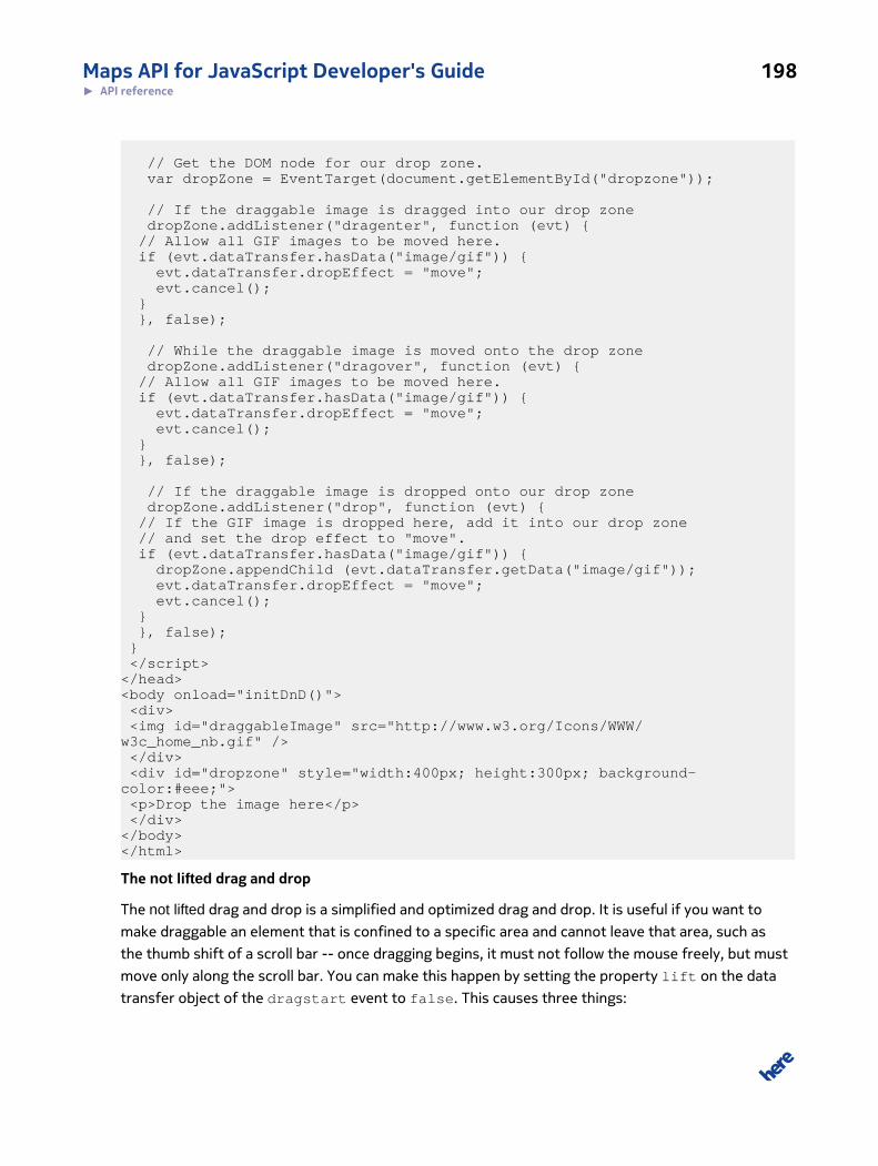
Maps API for JavaScript Developer's Guide 198► API reference
// Get the DOM node for our drop zone. var dropZone = EventTarget(document.getElementById("dropzone")); // If the draggable image is dragged into our drop zone dropZone.addListener("dragenter", function (evt) { // Allow all GIF images to be moved here. if (evt.dataTransfer.hasData("image/gif")) { evt.dataTransfer.dropEffect = "move"; evt.cancel(); } }, false);
// While the draggable image is moved onto the drop zone dropZone.addListener("dragover", function (evt) { // Allow all GIF images to be moved here. if (evt.dataTransfer.hasData("image/gif")) { evt.dataTransfer.dropEffect = "move"; evt.cancel(); } }, false); // If the draggable image is dropped onto our drop zone dropZone.addListener("drop", function (evt) { // If the GIF image is dropped here, add it into our drop zone // and set the drop effect to "move". if (evt.dataTransfer.hasData("image/gif")) { dropZone.appendChild (evt.dataTransfer.getData("image/gif")); evt.dataTransfer.dropEffect = "move"; evt.cancel(); } }, false); } </script></head><body onload="initDnD()"> <div> <img id="draggableImage" src="http://www.w3.org/Icons/WWW/w3c_home_nb.gif" /> </div> <div id="dropzone" style="width:400px; height:300px; background-color:#eee;"> <p>Drop the image here</p> </div></body></html>
The not lifted drag and drop
The not lifted drag and drop is a simplified and optimized drag and drop. It is useful if you want to
make draggable an element that is confined to a specific area and cannot leave that area, such as
the thumb shift of a scroll bar -- once dragging begins, it must not follow the mouse freely, but must
move only along the scroll bar. You can make this happen by setting the property lift on the data
transfer object of the dragstart event to false. This causes three things:
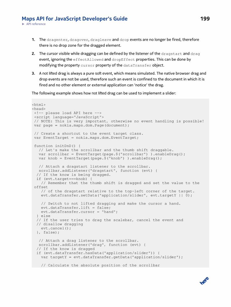
Maps API for JavaScript Developer's Guide 199► API reference
1. The dragenter, dragover, dragleave and drop events are no longer be fired, therefore
there is no drop zone for the dragged element.
2. The cursor visible while dragging can be defined by the listener of the dragstart and drag
event, ignoring the effectAllowed and dropEffect properties. This can be done by
modifying the property cursor property of the dataTransfer object.
3. A not lifted drag is always a pure soft event, which means simulated. The native browser drag and
drop events are not be used, therefore such an event is confined to the document in which it is
fired and no other element or external application can 'notice' the drag.
The following example shows how not lifted drag can be used to implement a slider:
<html><head> <!-- please load API here --> <script language="JavaScript"> // NOTE: This is very important, otherwise no event handling is possible! var page = nokia.maps.dom.Page(document);
// Create a shortcut to the event target class. var EventTarget = nokia.maps.dom.EventTarget; function initDnD() { // Let's make the scrollbar and the thumb shift draggable. var scrollbar = EventTarget(page.$("scrollbar") ).enableDrag(); var knob = EventTarget(page.$("knob") ).enableDrag();
// Attach a dragstart listener to the scrollbar. scrollbar.addListener("dragstart", function (evt) { // If the know is being dragged. if (evt.target===knob) { // Remember that the thumb shift is dragged and set the value to the offset // of the dragstart relative to the top-left corner of the target. evt.dataTransfer.setData("application/slider", evt.targetY || 0); // Switch to not lifted dragging and make the cursor a hand. evt.dataTransfer.lift = false; evt.dataTransfer.cursor = "hand"; } else // If the user tries to drag the scalebar, cancel the event and // disallow dragging evt.cancel(); }, false);
// Attach a drag listener to the scrollbar. scrollbar.addListener("drag", function (evt) { // If the know is dragged if (evt.dataTransfer.hasData("application/slider")) { var targetY = evt.dataTransfer.getData("application/slider");
// Calculate the absolute position of the scrollbar
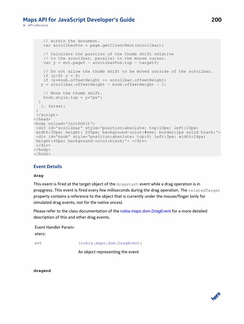
Maps API for JavaScript Developer's Guide 200► API reference
// within the document. var scrollbarPos = page.getClientRect(scrollbar); // Calculate the position of the thumb shift relative // to the scrollbar, parallel to the mouse cursor. var y = evt.pageY - scrollbarPos.top - targetY; // Do not allow the thumb shift to be moved outside of the scrollbar. if (y<0) y = 0; if (y+knob.offsetHeight >= scrollbar.offsetHeight) y = scrollbar.offsetHeight - knob.offsetHeight - 1; // Move the thumb shift. knob.style.top = y+"px"; } }, false); } </script></head><body onload="initDnD()"> <div id="scrollbar" style="position:absolute; top:10px; left:10px; width:30px; height: 200px; background-color:#eee; border:1px solid black;"> <div id="knob" style="position:absolute; top:0; left:3px; width:24px; height:40px; background-color:black;"> </div> </div></body></html>
Event Details
drag
This event is fired at the target object of the dragstart event while a drag operation is in
propgress. This event is fired every few milliseconds during the drag operation. The relatedTarget
property contains a reference to the object that is currently under the mouse/finger (only for
simulated drag events, not for the native onces).
Please refer to the class documentation of the nokia.maps.dom.DragEvent for a more detailed
description of this and other drag events.
Event Handler Param-
eters:
evt {nokia.maps.dom.DragEvent}
An object representing the event
dragend
Maps API for JavaScript Developer's Guide 201► API reference
This event is fired at the end of a drag operation at the object that was dragged (the target of the
dragstart event). The event is fired if the drop was aborted, failed or successful. The event signals
the end of a drag operation. The state of the drop operation can be read from the dropEffect
which can be "none", "move", "copy" or "link" and reflects the action performed at the drop target.
This information can be used either to remove the dragged object (for "move") or to do nothing (for
the other drop effects).
Please refer to the class documentation of the nokia.maps.dom.DragEvent for a more detailed
description of this and other drag events.
Event Handler Param-
eters:
evt {nokia.maps.dom.DragEvent}
An object representing the event
dragenter
This event is fired at an object if the mouse/finger is moved into the visible area of the object during
a drag operation. If the event is canceled (preventDefault method was called at the event object),
a drop at the target is allowed, otherwise a drop is cannot occur. If the drop is allowed, the target
becomes the current drop target.
Note that despite the event name, its behavior is more similar to that of mouseover than
mouseenter.
Please refer to the class documentation of the nokia.maps.dom.DragEvent for a more detailed
description of this and other drag events.
Event Handler Param-
eters:
evt {nokia.maps.dom.DragEvent}
An object representing the event
dragleave
This event is fired at the current drop target if the the mouse/finger leaves the visible area of the
target. Note that despite the name of the event, its behavior is more like that one of mouseout than
mouseleave.

Maps API for JavaScript Developer's Guide 202► API reference
Please refer to the class documentation of the nokia.maps.dom.DragEvent for a more detailed
description of this and other drag events.
Event Handler Param-
eters:
evt {nokia.maps.dom.DragEvent}
An object representing the event
dragover
This event is fired at the current drop target while the mouse/finger is on/above the drop target.
Note that the dragenter event must be canceled (preventDefault must be called) to make the
object the current drop target. So if the dragenter event is not canceled, then no dragover events
are fired at all. This is event is fired every few milliseconds as long as the mouse cursor is on/above
the drop target. If this event is not canceled (via preventDefault) the dropEffect property is set
to "none", which disallows a drop into the drop target. If the event is canceled and the dropEffect
is not "none", then a drop into this drop target is allowed.
Note that in spite of the name of this event, its behavior is very different from the behavior of the
mouseover event.
Please refer to the class documentation of the nokia.maps.dom.DragEvent for a more detailed
description of this and other drag events.
Event Handler Param-
eters:
evt {nokia.maps.dom.DragEvent}
An object representing the event
dragstart
This event is fired at an object that has the property draggable set to true and after a
mousedown/touch has occurred and the mouse/finger was moved at least three pixels. If the event
is not canceled (preventDefault of the event was not called), the drag operation is permitted.
The property dataTransfer can be used to keep track of information while a drag operation is in
progress.
Please refer to the class documentation of the nokia.maps.dom.DragEvent for a more detailed
description of this and other drag events.
Maps API for JavaScript Developer's Guide 203► API reference
Event Handler Param-
eters:
evt {nokia.maps.dom.DragEvent}
An object representing the event
drop
This event is fired at the current drop target if the mouse button or finger is released on/
above it, which means that the dragenter event and the dragover events were canceled, so
their preventDefault methods were called and the allowedEffect property matches the
dropEffect property.
If the event is not canceled (preventDefault is called) and the drop target is a text field (for
example, a textarea or input element), then the content of the "text/plain" format is inserted
into the area to which the mouse point is pointing or added to the end of that area. Otherwise,
the dropEffect is set to "none" and no action takes place. If preventDefault was called, the
sequence described above does not take place.
Please refer to the class documentation of the nokia.maps.dom.DragEvent for a more detailed
description of this and other drag events.
Event Handler Param-
eters:
evt {nokia.maps.dom.DragEvent}
An object representing the event
Class: EventThis class is a member of nokia.maps.dom.
Class Summary
This class implements the W3C Event interface.
[ For full details, see nokia.maps.dom.Event ]
Table 85: Property Summary
Properties
readonly AT_TARGET: {Number}
Maps API for JavaScript Developer's Guide 204► API reference
Properties
This field is an event phase identifier, indicating the target phase, which means it is being evaluated at the event target.
bubbles: {Boolean}
This property indicates whether the event is a bubbling event (true) or not (false).
readonly BUBBLING_PHASE: {Number}
This field is an event phase identifier, indicating the bubbling phase.
canBubble: {Boolean}
This property indicates whether the event can bubble (true) or not (false).
cancelable: {Boolean}
This property indicates whether or not an event can have its default action canceled (prevented).
canSicker: {Boolean}
This property indicates whether the event can sicker (whether in the capture phase, listeners can be iterated from the topdown) or not.
readonly CAPTURING_PHASE: {Number}
This field is an event phase identifier, indicating the capture phase.
currentTarget: {nokia.maps.dom.EventTarget}
This property indicates the object whose eventListeners are currently being processed.
readonly defaultPrevented: {Boolean}
This property indicates whether preventDefault() has been called for this event.
eventPhase: {Number}
This property indicates the phase in the event flow the given event has reached.
namespaceURI: {String}
This property holds the namespace URI associated with the event or null if it is unspecified.
nativeEvent: {Event}
This property holds a reference to the native DOM event on which the given normalized event object is based.
page: {nokia.maps.dom.Page}
This property holds a reference to the page to which the given event relates.
propagation: {Number}
This property indicates the status of event propagation.
PROPAGATION_OK: {Number}
This field is an identifier, indicating that the propagation of the event has not been stopped.
PROPAGATION_STOP: {Number}
This field is an identifier, indicating that the propagation of the event has been stopped.
PROPAGATION_STOP_IMMEDIATE: {Number}
Maps API for JavaScript Developer's Guide 205► API reference
Properties
This field is an identifier, indicating that the propagation of the event has been stopped with immediate effect.
target: {nokia.maps.dom.EventTarget}
This property holds the target object of the event.
timeStamp: {Number}
This property specifies the time at which the event was created in milliseconds relative to 1970-01-01T00:00:00Z.
type: {String}
This property holds the local name of the event type.
Table 86: Method Summary
Methods
cancel () : {nokia.maps.dom.Event}
This method cancels the given event.
clone () : {nokia.maps.dom.Event}
This method clones the given event without cloning the properties (non-recursive cloning only).
preventDefault () : {nokia.maps.dom.Event}
This method cancels the default action for the given event.
preventUnload (msg) : {nokia.maps.dom.Event}
This method can be used only when the given event is of the type "beforeunload" to ask the user to confirm whether hewants to leave the page.
stopImmediatePropagation () : {nokia.maps.dom.Event}
This method prevents other event listeners from being triggered and, in contrast to Event.stopPropagation(), itseffect is immediate.
stopPropagation () : {nokia.maps.dom.Event}
This method prevents other event listeners from being triggered, but its effect is deferred until all event listeners attachedon the Event.currentTarget have been triggered.
Class Description
This class implements the W3C interface Event.
For more details about event dispatch please refer to the documentation of the class
nokia.maps.dom.EventTarget.
Constructor Details
nokia.maps.dom.Event(defaults)
Maps API for JavaScript Developer's Guide 206► API reference
Creates a Event instance.
Parameters:
defaults: {Object} [optional]
If this argument is provided, all properties from it are copied into the given
event object.
Property Details
readonly AT_TARGET: {Number}
This field is an event phase identifier, indicating the target phase, which means it is being evaluated
at the event target.
bubbles: {Boolean}
This property indicates whether the event is a bubbling event (true) or not (false).
readonly BUBBLING_PHASE: {Number}
This field is an event phase identifier, indicating the bubbling phase.
canBubble: {Boolean}
This property indicates whether the event can bubble (true) or not (false).
This is a proprietary member and not part of the W3C interface specification this class implements.
cancelable: {Boolean}
This property indicates whether or not an event can have its default action canceled (prevented). If
the default action can be canceled, the value is true, otherwise it is false.
canSicker: {Boolean}
This property indicates whether the event can sicker (whether in the capture phase, listeners can be
iterated from the top down) or not.
This is a proprietary member and not part of the W3C interface specification this class implements.
Maps API for JavaScript Developer's Guide 207► API reference
readonly CAPTURING_PHASE: {Number}
This field is an event phase identifier, indicating the capture phase.
currentTarget: {nokia.maps.dom.EventTarget}
This property indicates the object whose eventListeners are currently being processed. This
is particularly useful during the capture and bubbling phases to identify where the event is in the
propagation path.
readonly defaultPrevented: {Boolean}
This property indicates whether preventDefault() has been called for this event.
eventPhase: {Number}
This property indicates the phase in the event flow the given event has reached. The value is one of:
CAPTURING_PHASE, AT_TARGET, or BUBBLING_PHASE.
namespaceURI: {String}
This property holds the namespace URI associated with the event or null if it is unspecified.
nativeEvent: {Event}
This property holds a reference to the native DOM event on which the given normalized event
object is based. The property is not W3C-conform and is not part of the W3C specification this class
implements. It contains either null or a reference to the native event as sent by the browser.
page: {nokia.maps.dom.Page}
This property holds a reference to the page to which the given event relates.
Note that this property is not part of the W3C interface specifications this class implements.
propagation: {Number}
Maps API for JavaScript Developer's Guide 208► API reference
This property indicates the status of event propagation. Its possible values are PROPAGATION_OK,
PROPAGATION_STOP or PROPAGATION_STOP_IMMEDIATE.
This is a proprietary member and not part of the W3C interface specification this class implements.
PROPAGATION_OK: {Number}
This field is an identifier, indicating that the propagation of the event has not been stopped.
This is a proprietary member and not part of the W3C interface specification this class implements.
PROPAGATION_STOP: {Number}
This field is an identifier, indicating that the propagation of the event has been stopped.
This is a proprietary member and not part of the W3C interface specification this class implements.
PROPAGATION_STOP_IMMEDIATE: {Number}
This field is an identifier, indicating that the propagation of the event has been stopped with
immediate effect.
This is a proprietary member and not part of the W3C interface specification this class implements.
target: {nokia.maps.dom.EventTarget}
This property holds the target object of the event.
timeStamp: {Number}
This property specifies the time at which the event was created in milliseconds relative to
1970-01-01T00:00:00Z.
type: {String}
This property holds the local name of the event type.
Method Details
cancel(): {nokia.maps.dom.Event}
Maps API for JavaScript Developer's Guide 209► API reference
This method cancels the given event. It stops the event propagation immediately and prevents the
default action.
This is a proprietary member and not part of the W3C interface specification this class implements.
Returns:
{nokia.maps.dom.Event}
A reference to this event
clone(): {nokia.maps.dom.Event}
This method clones the given event without cloning the properties (non-recursive cloning only).
This is a proprietary member and not part of the W3C interface specification this class implements.
Returns:
{nokia.maps.dom.Event}
A reference to the cloned event
preventDefault(): {nokia.maps.dom.Event}
This method cancels the default action for the given event. Calling this method for a non-cancelable
event has no effect.
Returns:
{nokia.maps.dom.Event}
A reference to this event
preventUnload(msg): {nokia.maps.dom.Event}
This method can be used only when the given event is of the type "beforeunload" to ask the user to
confirm whether he wants to leave the page.
Note that this method can be useful in debugging to ensure that everything is cleared up when the
user has left the page. However, bear in mind that the method cannot be used to prevent the user
from leaving the page.
This is a proprietary member and not part of the W3C interface specification this class implements.
Maps API for JavaScript Developer's Guide 210► API reference
Parameters:
msg: {String}
The message the browser should display in the confirmation dialog
Returns:
{nokia.maps.dom.Event}
A reference to the current event
stopImmediatePropagation(): {nokia.maps.dom.Event}
This method prevents other event listeners from being triggered and, in contrast to
Event.stopPropagation(), its effect is immediate. Once it has been called, further calls to this
method have no effect.
Returns:
{nokia.maps.dom.Event}
A reference to this event
stopPropagation(): {nokia.maps.dom.Event}
This method prevents other event listeners from being triggered, but its effect is deferred until all
event listeners attached on the Event.currentTarget have been triggered. Once it has been
called, further calls to this method have no effect.
Returns:
{nokia.maps.dom.Event}
A reference to this event
Class: EventTargetThis class is a member of nokia.maps.dom.
Maps API for JavaScript Developer's Guide 211► API reference
Class Summary
This class implements the W3C DOM Level 3 interface EventTarget and extends it with a number of
features.
[ For full details, see nokia.maps.dom.EventTarget ]
Table 87: Property Summary
Properties
readonly draggable: {Boolean}
This property indicates if the given event target is draggable and may receive a dragstart, drag and dragend events(true); false otherwise.
readonly isEventTarget: {Boolean}
This property indicates whether an object implements the nokia.maps.dom.EventTarget interface (true) or not (false).
parentNode: {nokia.maps.dom.EventTarget}
This property holds a reference to the parent node of the event target (if set).
parentNodes: {Object}
This property is designed to hold a hash table that contains the "namespaceURI" as key and the corresponding value is theparent node of the given event target.
Table 88: Method Summary
Methods
addListener (type, callback, useCapture) : {Object}
This method registers an event listener.
addListenerNS (namespaceURI, type, callback, useCapture) : {nokia.maps.dom.EventTarget}
This method registers an event listener for events originating from a specific namespace.
addListeners (obj)
This method provides a means of registering multiple event listeners.
static catchException (enable)
This method enables exception catching in the event dispatcher to make it possible to ignore errors in event handlers or itdisables exception catching in the event dispatcher for debugging purposes.
disableDrag () : {nokia.maps.dom.EventTarget}
This method disables dragging of this event target, causing this event target not to receive dragstart, drag and dragendevents.
disableUserSelect () : {nokia.maps.dom.EventTarget}
This method prevents user selection of text and elements within the event target and prevents the magnifier on the iPhoneor other similar mobile devices.
Maps API for JavaScript Developer's Guide 212► API reference
Methods
dispatch (evt) : {Boolean}
This method dispatches an event.
static dispatchEvent (target, event, dispatchPath) : {Boolean}
This method dispatches an event to the given event target.
enableDrag () : {nokia.maps.dom.EventTarget}
This method enables dragging of this event target and disables the user selection, allowing this event target to receivedragstart, drag and dragend events.
enableUserSelect () : {nokia.maps.dom.EventTarget}
This method allows the user to select text and elements within the event target and allows the magnifier on the iPhone orother similar mobile devices.
hitTest (pageX, pageY) : {Boolean}
This method tests if the given x/y position relative to the document lies within the outer bounding box of the nodecorresponding to the given EventTarget object.
insertListener (type, callback, useCapture) : {Object}
This method registers an event listener as the first listener in the listener chain.
insertListenerNS (namespaceURI, type, callback, useCapture) : {nokia.maps.dom.EventTarget}
This method registers an event listener for events originating from a specific namespace as the first in the listener chain.
removeAllListeners ()
This method remove all registered listeners from current EventTarget
removeListener (type, listener, useCapture) : {nokia.maps.dom.EventTarget}
This method removes an event listener.
removeListenerNS (namespaceURI, type, listener, useCapture) : {nokia.maps.dom.EventTarget}
This method removes an event listener for events originating from a specific namespace.
Class Description
This class implements the W3C DOM Level 3 interface EventTarget and extends it with a number of
features. It can be used as a mixin for any JavaScript class or it can be applied at runtime to any DOM
node or JavaScript object by simply casting the node/object to EventTarget. Note that for the sake
of compatibility the W3C, some methods have been renamed. For example, addEventListener()
becomes addListener().
Usage example:
// Shortcut for easier code. var EventTarget = nokia.maps.dom.EventTarget;
Maps API for JavaScript Developer's Guide 213► API reference
// Cast a DOM node into an valid nokia.maps.dom.EventTarget // Note: The DOM node is modified by the EventTarget interface, // therefore a second cast is not necessary. var node = document.getElementById("whatever"); EventTarget(node);
// You can also cast normal JavaScript objects including bubbling // and capture phases and all that DOM supports: var myObject = {}, myParentObject = {}; EventTarget(myObject).parentNode = EventTarget(myParentObject); // Now you can fire an event at "myObject" that will // bubble to "myParentObject": myParentObject.addListener("customEvent", function (evt) { alert( evt.type ); }); myObject.dispatch( new nokia.maps.dom.Event({ type: "customEvent" }) ); // Note: It is also possible to set the parentNode property of // a JavaScript object to a DOM node. Events then flow // into the DOM tree, although not at native level.
EventTarget offers access to the nokia.maps DOM helpers and normalizes browser event handling
for this target. By default an event target is not draggable, but selectable. If this interface is
implemented as a mixin, it the property isEventTarget must be added and set to true.
MooTools compatibility notes
If you have problems with MooTools then a possible fix is to include MooTools after this API
is fully loaded and to replace every occurrence of "addListener" in the MooTools library with,
for example, "mooAddListener", and every occurrence of "removeListener" with, for example,
"mooRemoveListener". You need to do this also in all libraries that are based on MooTools. The
reason is that MooTools modifies the prototypes of some native JavaScript and DOM objects and
therefore causes a collision with extensions used by this API.
Note that the name clash arises, because MooTools modifies not only those DOM nodes that it uses,
but patches all instances of all objects, including native browser objects. To avoid the name clashes,
you must rename the MooTools methods "addListener" and "removeListener", and load MooTools
after this API so that this API can keep references to the original native browser methods instead of
referring to the methods modified by MooTools.
The listener queue
The listeners to events are called in reverse registration order, which means that the listener
registered last is the first to be notified of an event. Therefore, if you want a listener to be notified
Maps API for JavaScript Developer's Guide 214► API reference
last in an existing queue, you must register it as the first listener in the chain. This can be done by
using the arbitrary non-standard method insertListener() or insertListenerNS() defined on
this interface (EventTarget).
Note that applying this interface to a DOM node, causes methods and properties to be copied to
the DOM node that might cause collisions with other frameworks. Therefore before combining
nokia.maps.dom.EventTarget with any other framework, check carefully that name conflicts do
not arise.
Event flow in a nutshell
Events normally trickle and bubble through the hierarchy in a DOM tree, where each node can only
have one parent node (referenced by the property parentNode). For example, if the user clicks on
a DOM node, then the browser builds a propagation path by going from the node that was the target
of the click via the parentNode up to the root node (the HTML tag), which does not have a parent
node assigned to propagation path. The browser uses the propagation path to dispatch the event to
each of the nodes in it. First, in the capture phase, the chain is iterated from the root node (the HTML
node) down to the target node (which the user has hit with it's click). Subsequently, in the bubbling
phase, the event is dispatched to each node again, this time starting from the target node, working
back up to the root node. Thus, each node receives the event twice, once within the capture phase
and once within the bubbling phase. Normally events are processed within the bubbling phase, but
there might been reasons to process them in the capture phase, for example to stop the events from
reaching other listeners, because all events can be stopped by any listener at any node within the
propagation path.
The registered event listeners must be limited to specific event types either in the capture
phase or the bubbling phase. Additionally, they can be registered for all events of a certain
type or limited to events of a certain type that originate from a specific namespace (see
nokia.maps.dom.EventTarget#addListenerNS). In the latter case, the listener is notified only
if the namespaceURI of the event is set to the desired namespace. This can be used to separate
arbitrary application events from other events, such as standard W3C events.
For a more comprehensive description of how events are dispatched, please the W3C documentation
DOM level 3 event flow.
Constructor Details
nokia.maps.dom.EventTarget(obj)
The class constructor mixes the functionality of EventTarget into the argument object.
Parameters:
obj: {Object}
Maps API for JavaScript Developer's Guide 215► API reference
The object to be extended with EventTarget functionality
Property Details
readonly draggable: {Boolean}
This property indicates if the given event target is draggable and may receive a dragstart, drag
and dragend events (true); false otherwise.
See: nokia.maps.dom.EventTarget#enableDrag
nokia.maps.dom.EventTarget#disableDrag
readonly isEventTarget: {Boolean}
This property indicates whether an object implements the nokia.maps.dom.EventTarget interface
(true) or not (false).
parentNode: {nokia.maps.dom.EventTarget}
This property holds a reference to the parent node of the event target (if set).
parentNodes: {Object}
This property is designed to hold a hash table that contains the "namespaceURI" as key and the
corresponding value is the parent node of the given event target. The use of the property is optional.
Method Details
addListener(type, callback, useCapture): {Object}
This method registers an event listener. The caller can specify whether the listener is to be invoked in
the capture phase only or only in the target and bubbling phases.
Parameters:
type: {String}
A string providing the event type for which the listener is to be registered
callback: {Function}
Maps API for JavaScript Developer's Guide 216► API reference
The function to be called if the event occurs; the function receives the fol-
lowing argument:
• (Event) evt - a reference to the fired event. See nokia.maps.dom.Event
useCapture: {Boolean}
A flag that indicates if the event listener is to be used for the capture phase
only (true - the listerener is not invoked during the target and bubbling
phases), or for target and bubbling phases (false)
Returns:
{Object} A reference to the given nokia.maps.dom.EventTarget object
addListenerNS(namespaceURI, type, callback, useCapture):
{nokia.maps.dom.EventTarget}
This method registers an event listener for events originating from a specific namespace. The caller
can specify whether the listener is to be invoked in the capture phase only or only in the target and
bubbling phases.
Parameters:
namespaceURI: {String}
A string specifying the Event.namespaceURI associated with the event for
which the user is registering
type: {String}
A string specifying the event type for which the listener is to be registered
callback: {Function}
The function to be called if the event occurs; the function receives the fol-
lowing argument:
• (Event) evt - a reference to the fired event. See nokia.maps.dom.Event
useCapture: {Boolean}
Maps API for JavaScript Developer's Guide 217► API reference
A flag indicating if the event listener is to be used for the capture phase only
(true - the listerener is not invoked during the target and bubbling phases),
or for target and bubbling phases (false)
Returns:
{nokia.maps.dom.EventTarget}
A reference to the given event target object
addListeners(obj)
This method provides a means of registering multiple event listeners.
Parameters:
obj: {Object}
A hash map object where key is name of event and value is an array that
contains callback function which should be called if the event occurs and
boolean value that indicates if the event listener have to be used only for
the capture phase
{ "eventName": [callback, useCapture], "eventName2": [callback, useCapture] }
static catchException(enable)
This method enables exception catching in the event dispatcher to make it possible to ignore errors
in event handlers or it disables exception catching in the event dispatcher for debugging purposes.
By default, exceptions are caught and written to the debug console.
Parameters:
enable: {Boolean}
true to enable exception catching; false otherwise
Maps API for JavaScript Developer's Guide 218► API reference
disableDrag(): {nokia.maps.dom.EventTarget}
This method disables dragging of this event target, causing this event target not to receive
dragstart, drag and dragend events.
Note that although enableDrag disables user selection, this method does not enable it.
Returns:
{nokia.maps.dom.EventTarget}
The event target itself
disableUserSelect(): {nokia.maps.dom.EventTarget}
This method prevents user selection of text and elements within the event target and prevents the
magnifier on the iPhone or other similar mobile devices.
Note that if you wish to listen to the longpress event, you should disable the user selection,
because otherwise the iPhone and other mobile devices may show a magnifier, making it harder for
you to interpret the longpress event.
Returns:
{nokia.maps.dom.EventTarget}
The event target itself
dispatch(evt): {Boolean}
This method dispatches an event.
The default implementation depends on whether the event has a namespaceURI property set or not.
If this property is not set, the default implementation searches for a parent object using the property
parentNode.
If the event has namespaceURI set, then the property parentNodes is checked, which contains
a hash table with "namespaceURI" as key and the parent object for this namespace as value. If no
match is found using the "namespaceURI" mechanism, then the parentNode property is checked as
an alternative parent.
Parameters:
evt: {nokia.maps.dom.Event | Object}
Maps API for JavaScript Developer's Guide 219► API reference
An object representing the event to be dispatched; it is either an instance of
nokia.maps.dom.Event or a native browser event.
Returns:
{Boolean} A flag indicating whether any of the listeners which handled the event called
Event.preventDefault(). If Event.preventDefault() was called,
the return value is false, otherwise it is true
static dispatchEvent(target, event, dispatchPath): {Boolean}
This method dispatches an event to the given event target.
The default implementation depends on whether the event has a namespaceURI property set or not.
If this property is not set, then the default implementation searches for a parent object using the
property parentNode.
If the event has namespaceURI set, then the property parentNodes is checked, which contains
a hash table with "namespaceURI" as key and the parent object for this namespace as value. If no
match is found using the "namespaceURI" mechanism, then the parentNode property is checked as
an alternative parent.
Parameters:
target: {nokia.maps.dom.EventTarget}
The event target to which the event is to be dispatched
event: {nokia.maps.dom.Event | Object}
The event to be dispatched; it is either a nokia.maps.dom.Event object
or a native browser event
dispatchPath: {Node[]} [optional]
List of elements like from
nokia.maps.dom.EventTarget#getDispatchPath method
Returns:
{Boolean} A value indicating whether any of the listeners which have handled the event
called preventDefault; if preventDefault was called false is re-
turned, otherwise true
Maps API for JavaScript Developer's Guide 220► API reference
enableDrag(): {nokia.maps.dom.EventTarget}
This method enables dragging of this event target and disables the user selection, allowing this event
target to receive dragstart, drag and dragend events.
Returns:
{nokia.maps.dom.EventTarget}
The event target itself
enableUserSelect(): {nokia.maps.dom.EventTarget}
This method allows the user to select text and elements within the event target and allows the
magnifier on the iPhone or other similar mobile devices.
Returns:
{nokia.maps.dom.EventTarget}
The event target itself
hitTest(pageX, pageY): {Boolean}
This method tests if the given x/y position relative to the document lies within the outer bounding
box of the node corresponding to the given EventTarget object.
If this object is not a DOM node, the method must be overloaded to ensure that mouseleave events
are fired correctly.
Parameters:
pageX: {Number}
The horizontal position of the CSS pixel relative to the document to test.
pageY: {Number}
The vertical position of the CSS pixel relative to the document to test.
Returns:
{Boolean} true if the pixel lies within the node; false otherwise.
Maps API for JavaScript Developer's Guide 221► API reference
insertListener(type, callback, useCapture): {Object}
This method registers an event listener as the first listener in the listener chain. The caller can
specified whether the listener is to be registered for the capture phase only, or for target and
bubbling phases.
Parameters:
type: {String}
Specifies the event type for which the listener is to be registered
callback: {Function}
The function to be called if the event occurs; the function receives the fol-
lowing argument:
• (Event) evt - a reference to the fired event. See nokia.maps.dom.Event
useCapture: {Boolean}
Indicates if the event listener is to be used for the capture phase only (true
- the listerener is not invoked during the target and bubbling phases), or for
target and bubbling phases (false)
Returns:
{Object} A reference to the given nokia.maps.dom.EventTarget object
insertListenerNS(namespaceURI, type, callback, useCapture):
{nokia.maps.dom.EventTarget}
This method registers an event listener for events originating from a specific namespace as the first
in the listener chain. The caller can specify whether the listener is to be invoked in the capture phase
only or only in the target and bubbling phases.
Parameters:
namespaceURI: {String}
A string specifying the Event.namespaceURI associated with the event for
which the listener is to be registered
Maps API for JavaScript Developer's Guide 222► API reference
type: {String}
A string specifying the event type for which the listener is to be registered
callback: {Function}
The function to be called if the event occurs; the function receives the fol-
lowing argument:
• (Event) evt - a reference to the fired event. See nokia.maps.dom.Event
useCapture: {Boolean}
A flag indicating if the event listener is to be used for the capture phase only
(true - the listerener is not invoked during the target and bubbling phases),
or for target and bubbling phases (false)
Returns:
{nokia.maps.dom.EventTarget}
A reference to the given event target object
removeAllListeners()
This method remove all registered listeners from current EventTarget
removeListener(type, listener, useCapture): {nokia.maps.dom.EventTarget}
This method removes an event listener.
Parameters:
type: {String}
A string specifying the event type for which the listener was registered
listener: {Function}
The function to be removed
useCapture: {Boolean}
Maps API for JavaScript Developer's Guide 223► API reference
A flag indicating if the event listener was to be used for the capture phase
only (true - the listener is not invoked during the target and bubbling phas-
es), or for target and bubbling phases (false)
Returns:
{nokia.maps.dom.EventTarget}
A reference to the given event target object
removeListenerNS(namespaceURI, type, listener, useCapture):
{nokia.maps.dom.EventTarget}
This method removes an event listener for events originating from a specific namespace.
Parameters:
namespaceURI: {String}
A string specifying the Event.namespaceURI associated with the event for
which the listener was registered
type: {String}
A string specifying the event type for which the listener was registered
listener: {Function}
The function to be removed
useCapture: {Boolean}
A flag indicating if the event listener was to be used for the capture phase
only (true - the listerener is not invoked during the target and bubbling
phases), or for target and bubbling phases (false)
Returns:
{nokia.maps.dom.EventTarget}
A reference to the given event target object
Maps API for JavaScript Developer's Guide 224► API reference
Interface: FocusEventThis interface is a member of nokia.maps.dom.
Extends: nokia.maps.dom.Event
Interface Summary
This event is fired if a target receives or loses the focus.
[ For full details, see nokia.maps.dom.FocusEvent ]
Property Summary
Directly Inherited Properties
Inherited from class nokia.maps.dom.Event :
AT_TARGET, bubbles, BUBBLING_PHASE, canBubble, cancelable, canSicker, CAPTURING_PHASE,
currentTarget, defaultPrevented, eventPhase, namespaceURI, nativeEvent, page, propagation,
PROPAGATION_OK, PROPAGATION_STOP, PROPAGATION_STOP_IMMEDIATE, target,
timeStamp, type
Method Summary
Directly Inherited Methods
Inherited from class nokia.maps.dom.Event :
cancel, clone, preventDefault, preventUnload, stopImmediatePropagation, stopPropagation
Interface Description
Event is fired when a target receives or loses the focus.
Note that this class represents an unimplemented interface. It is included here to document its
properties. The class is derived from nokia.maps.dom.Event, but, in addition to the properties of the
parent class, it has the properties described here.
Interface: FocusEventTargetThis interface is a member of nokia.maps.dom.
Maps API for JavaScript Developer's Guide 225► API reference
Interface Summary
This class is a virtual interface that exists only for documentation purposes.
[ For full details, see nokia.maps.dom.FocusEventTarget ]
Table 89: Event Summary
Events
blur
This event is fired if a target has lost the focus.
focus
This event is fired when an event target has received the focus.
focusin
This event is fired before a target receives the focus.
focusout
This event is fired before a target is about to lose the focus.
Interface Description
Each class implementing this interface delcares that it can act as the target for certain events. Each
event in this interface (and therefore also within the classes implementing the interface) represents
an event of a specific type.
The following example shows event handling for events of the type "click":
// Note that "obj" can be either a DOM node or any other JavaScript object.var obj = nokia.maps.dom.EventTarget( {} );obj.addListener("click", function (evt) { console.log("This is the '"+evt.type+"' event!");});
obj.dispatch( new nokia.maps.dom.Event({ type: "click"});
The example creates an instant of nokia.maps.dom.EventTarget, adds a listener for "click"
events to it, and dispatches a "click" event to all registered listeners (in this case one) - the listeners
receive the object that represents the target of the event.
For more information about dispatching events, please refer to the documentation of the
nokia.maps.dom.EventTarget.
Maps API for JavaScript Developer's Guide 226► API reference
Event Details
blur
This event is fired if a target has lost the focus. The event is dispatched after the target has lost the
focus.
Event Handler Param-
eters:
evt {nokia.maps.dom.FocusEvent}
An object representing the event
focus
This event is fired when an event target has received the focus. The event is dispatched after the
target has received the focus.
Event Handler Param-
eters:
evt {nokia.maps.dom.FocusEvent}
An object representing the event
focusin
This event is fired before a target receives the focus. The event is dispatched before the target
receives the focus.
Event Handler Param-
eters:
evt {nokia.maps.dom.FocusEvent}
An object representing the event
focusout
This event is fired before a target is about to lose the focus. The event is dispatched before the
target loses the focus.
Maps API for JavaScript Developer's Guide 227► API reference
Event Handler Param-
eters:
evt {nokia.maps.dom.FocusEvent}
An object representing the event
Interface: KeyboardEventThis interface is a member of nokia.maps.dom.
Extends: nokia.maps.dom.Event
Interface Summary
This event is fired when a keyboard key is pressed or released.
[ For full details, see nokia.maps.dom.KeyboardEvent ]
Table 90: Property Summary
Properties
altKey: {Boolean}
This property indicates if the Alt key modifier is activated (true) or not (false).
ctrlKey: {Boolean}
This property indicates if the control (Ctrl) was used as a key modifier (true) or not (false).
readonly DOM_KEY_LOCATION_JOYSTICK: {Number}
This field is an identifier indicating that the key activation originated on a game controller or a joystick on a mobile device.
readonly DOM_KEY_LOCATION_LEFT: {Number}
This field is an identifier indicating that the activated key was a left-hand-side key (there is more than one possible locationfor this key).
readonly DOM_KEY_LOCATION_MOBILE: {Number}
This field is an identifier indicating that the key activation originated on a mobile device, either on a physical keypad or avirtual keyboard.
readonly DOM_KEY_LOCATION_NUMPAD: {Number}
This field is an identifier indicating that the key activation originated on the numeric keypad or with a virtual keycorresponding to the numeric keypad.
readonly DOM_KEY_LOCATION_RIGHT: {Number}
This field is an identifier indicating that the the activated key was a right-hand-side key (there is more than one possiblelocation for this key).
readonly DOM_KEY_LOCATION_STANDARD: {Number}
Maps API for JavaScript Developer's Guide 228► API reference
Properties
This field is an identifier indicating that a standard key was pressed, no distinction is made between the left or right versionof the key, and the key did not originate from the numeric keypad (or did not originate from a virtual key corresponding tothe numeric keypad).
getModifierState: {Boolean}
This method queries the state of a key modifier.
keyIdentifier: {String}
This property holds the identifier of the activated (pressed) key.
keyLocation: {Number}
This property indicates the location of the key that was pressed on the device, as described in Keyboard event types.
metaKey: {Boolean}
This property indicates if the Meta key modifier is activated (true) or not (false).
repeat: {Boolean}
This property indicates if a key has been pressed repeatedly or has been held down to generate repeated key strokes (true).
shiftKey: {Boolean}
This property indicates if the shift (Shift) key modifier is activated (true) or not (false).
Directly Inherited Properties
Inherited from class nokia.maps.dom.Event :
AT_TARGET, bubbles, BUBBLING_PHASE, canBubble, cancelable, canSicker, CAPTURING_PHASE,
currentTarget, defaultPrevented, eventPhase, namespaceURI, nativeEvent, page, propagation,
PROPAGATION_OK, PROPAGATION_STOP, PROPAGATION_STOP_IMMEDIATE, target,
timeStamp, type
Method Summary
Directly Inherited Methods
Inherited from class nokia.maps.dom.Event :
cancel, clone, preventDefault, preventUnload, stopImmediatePropagation, stopPropagation
Interface Description
This event is fired if a key on the keyboard is pressed or released.
Note that this class represents an unimplemented interface. It is included here to document its
properties. The class is derived from nokia.maps.dom.Event, but, in addition to the properties of the
parent class, it has the properties described here.
Maps API for JavaScript Developer's Guide 229► API reference
Property Details
altKey: {Boolean}
This property indicates if the Alt key modifier is activated (true) or not (false).
ctrlKey: {Boolean}
This property indicates if the control (Ctrl) was used as a key modifier (true) or not (false).
readonly DOM_KEY_LOCATION_JOYSTICK: {Number}
This field is an identifier indicating that the key activation originated on a game controller or a
joystick on a mobile device. Example: the 'DownLeft' key on a game controller.
readonly DOM_KEY_LOCATION_LEFT: {Number}
This field is an identifier indicating that the activated key was a left-hand-side key (there is more than
one possible location for this key). Example: the left 'Control' key on a PC 101 Key US keyboard.
readonly DOM_KEY_LOCATION_MOBILE: {Number}
This field is an identifier indicating that the key activation originated on a mobile device, either on a
physical keypad or a virtual keyboard. Example: the '#' key or softkey on a mobile device.
readonly DOM_KEY_LOCATION_NUMPAD: {Number}
This field is an identifier indicating that the key activation originated on the numeric keypad or with a
virtual key corresponding to the numeric keypad. Example: the '1' key on a PC 101 Key US keyboard
located on the numeric pad.
readonly DOM_KEY_LOCATION_RIGHT: {Number}
This field is an identifier indicating that the the activated key was a right-hand-side key (there is more
than one possible location for this key). Example: the right 'Shift' key on a PC 101 Key US keyboard.
readonly DOM_KEY_LOCATION_STANDARD: {Number}
Maps API for JavaScript Developer's Guide 230► API reference
This field is an identifier indicating that a standard key was pressed, no distinction is made between
the left or right version of the key, and the key did not originate from the numeric keypad (or did not
originate from a virtual key corresponding to the numeric keypad). Example: the 'Q' key on a PC 101
Key US keyboard.
getModifierState: {Boolean}
This method queries the state of a key modifier.
keyIdentifier: {String}
This property holds the identifier of the activated (pressed) key. The key identifiers are defined in
the Key identifiers set. Implementations that are unable to identify a key must use the key identifier
'Unidentified'.
keyLocation: {Number}
This property indicates the location of the key that was pressed on the device, as described in
Keyboard event types.
metaKey: {Boolean}
This property indicates if the Meta key modifier is activated (true) or not (false).
repeat: {Boolean}
This property indicates if a key has been pressed repeatedly or has been held down to generate
repeated key strokes (true). Depending on the system configuration, holding down a key may result
in multiple consecutive keydown events, keypress events, and textInput events, for appropriate keys.
For mobile devices which have long-key-press behavior, the first key event with a repeat attribute
value of true indicates a long-key-press. The length of time that the key must be pressed in order to
begin repeating is configuration dependent.
shiftKey: {Boolean}
This property indicates if the shift (Shift) key modifier is activated (true) or not (false).

Maps API for JavaScript Developer's Guide 231► API reference
Interface: KeyboardEventTargetThis interface is a member of nokia.maps.dom.
Interface Summary
This class is a virtual interface that does exist for documentation purposes.
[ For full details, see nokia.maps.dom.KeyboardEventTarget ]
Table 91: Event Summary
Events
keydown
This event is fired if a key is pressed and delivered to the node that currently has the focus.
keyup
This event is fired if a key is released and delivered to the node that currently has the focus.
Interface Description
Each class implementing this interface delcares that it can act as the target for certain events. Each
event in this interface (and therefore also within the classes implementing the interface) represents
an event of a specific type.
The following example shows event handling for events of the type "click":
// Note that "obj" can be either a DOM node or any other JavaScript object.var obj = nokia.maps.dom.EventTarget( {} );obj.addListener("click", function (evt) { console.log("This is the '"+evt.type+"' event!");});
obj.dispatch( new nokia.maps.dom.Event({ type: "click"});
The example creates an instant of nokia.maps.dom.EventTarget, adds a listener for "click"
events to it, and dispatches a "click" event to all registered listeners (in this case one) - the listeners
receive the object that represents the target of the event.
For more information about dispatching events, please refer to the documentation of the
nokia.maps.dom.EventTarget.
Maps API for JavaScript Developer's Guide 232► API reference
Event Details
keydown
This event is fired if a key is pressed and delivered to the node that currently has the focus.
Event Handler Param-
eters:
evt {nokia.maps.dom.KeyboardEvent}
An object representing the event
keyup
This event is fired if a key is released and delivered to the node that currently has the focus.
Event Handler Param-
eters:
evt {nokia.maps.dom.KeyboardEvent}
An object representing the event
Interface: MouseEventThis interface is a member of nokia.maps.dom.
Extends: nokia.maps.dom.Event
Interface Summary
This event is fired for all mouse related events like moves, clicks, etc.
[ For full details, see nokia.maps.dom.MouseEvent ]
Table 92: Property Summary
Properties
altKey: {Boolean}
This field indicates the activation state of the modifier key Alt.
button: {Number}
This property holds the numeric id of a mouse button that has changed state, because it was pressed or released.
buttonState: {Number}
Maps API for JavaScript Developer's Guide 233► API reference
Properties
This property holds the current state of all mouse buttons.
clientX: {Number}
The horizontal coordinate at which the event occurred relative to the viewport associated with the event.
clientY: {Number}
The vertical coordinate at which the event occurred relative to the viewport associated with the event.
ctrlKey: {Boolean}
This field indicates the activation state of the modifier key Ctrl.
getModifierState: {Boolean}
This method queries the state of a modifier on the basis of the key identifier supplied by the caller.
metaKey: {Boolean}
This field indicates the activation state of the modifier key Meta.
pageX: {Number}
The horizontal coordinate at which the event occurred relative to the document associated with the event.
pageY: {Number}
The vertical coordinate at which the event occurred relative to the document associated with the event.
relatedTarget: {nokia.maps.dom.EventTarget}
This property identifies a secondary event target related to a UI event, depending on the type of event:
• mouseover event - the property refers to the target over which the mouse pointer or finger is has begun to pass orhas passed, if available
• mouseout event - the property contains the reference to the target which the mouse is leaving, if available
• drag event - the property refers to the target that located below the mouse pointer or finger, if available
• dragenter, dragleave or drop event - the property contains the reference to the event target that is currentlybeing dragged (in other words, the target of the dragstart event)
• dragend event - the property refers to the event target on which the dragged object has been dropped successfully; ifthe drop failed for any reason the property is null
Therefore, this property only holds information relevant for mouseover, mouseout, drag, dragenter, dragleave, dropor dragend events; otherwise it is null.
screenX: {Number}
The horizontal coordinate at which the event occurred relative to the origin of the screen coordinate system.
screenY: {Number}
The vertical coordinate at which the event occurred relative to the origin of the screen coordinate system.
shiftKey: {Boolean}
This field indicates the activation state of the modifier key Shift.
targetX: {Number}
The x-position of the cursor relative to the target.
Maps API for JavaScript Developer's Guide 234► API reference
Properties
targetY: {Number}
The y-position of the cursor relative to the target.
Directly Inherited Properties
Inherited from class nokia.maps.dom.Event :
AT_TARGET, bubbles, BUBBLING_PHASE, canBubble, cancelable, canSicker, CAPTURING_PHASE,
currentTarget, defaultPrevented, eventPhase, namespaceURI, nativeEvent, page, propagation,
PROPAGATION_OK, PROPAGATION_STOP, PROPAGATION_STOP_IMMEDIATE, target,
timeStamp, type
Method Summary
Directly Inherited Methods
Inherited from class nokia.maps.dom.Event :
cancel, clone, preventDefault, preventUnload, stopImmediatePropagation, stopPropagation
Interface Description
This class represents all mouse-related events.
Note that this class represents an unimplemented interface. It is included here to document its
properties. The class is derived from nokia.maps.dom.Event, but, in addition to the properties of the
parent class, it has the properties described here.
Property Details
altKey: {Boolean}
This field indicates the activation state of the modifier key Alt. It is set to true if the modifier is
activated.
button: {Number}
This property holds the numeric id of a mouse button that has changed state, because it was pressed
or released.
• 0 - indicates the normal button of the mouse that is used to click on user interface buttons and
menu items or to select text (in general this is the left mouse button or the one button on a
Macintosh mouse)
Maps API for JavaScript Developer's Guide 235► API reference
• 2 - indicates the contextual property button of the mouse if present (normally, this means the
right mouse button that is used to display a context menu)
• 1 - indicates the extra button (typically, the middle button, which is often combined with the
mouse wheel)
• values higher than 2 - indicate other mouse buttons that may be present or simulated on some
mouse devices
buttonState: {Number}
This property holds the current state of all mouse buttons.
This property is a bitmask where bit zero represents the state of the left mouse button, bit one the
state of the middle mouse button, bit two the state of the right mouse button and bit three and
higher the state of any further mouse buttons that may be present or simulated. This state is set for
all events. You can detect if a specific button has been pressed, like this: if (event.buttonState
& (1 << button)) ..., where button is the identifier as defined by the W3C (zero for the left
button, one for the middle button, two for the right button and three, etc. for further buttons).
Note that within a "mouseup" event, the value of this property is up-to-date. For example, while the
button property may be set to 1 to indicate that the middle button has been released, bit one in the
buttonState property is already cleared as the button has already been released.
This is a proprietary member and not part of the W3C interface specification this class implements.
clientX: {Number}
The horizontal coordinate at which the event occurred relative to the viewport associated with the
event.
clientY: {Number}
The vertical coordinate at which the event occurred relative to the viewport associated with the
event.
ctrlKey: {Boolean}
This field indicates the activation state of the modifier key Ctrl. It is set to true if the modifier is
activated.

Maps API for JavaScript Developer's Guide 236► API reference
getModifierState: {Boolean}
This method queries the state of a modifier on the basis of the key identifier supplied by the caller.
metaKey: {Boolean}
This field indicates the activation state of the modifier key Meta. It is set to true if the modifier is
activated.
pageX: {Number}
The horizontal coordinate at which the event occurred relative to the document associated with the
event.
This is a proprietary member and not part of the W3C interface specification this class implements.
pageY: {Number}
The vertical coordinate at which the event occurred relative to the document associated with the
event.
This is a proprietary member and not part of the W3C interface specification this class implements.
relatedTarget: {nokia.maps.dom.EventTarget}
This property identifies a secondary event target related to a UI event, depending on the type of
event:
• mouseover event - the property refers to the target over which the mouse pointer or finger is
has begun to pass or has passed, if available
• mouseout event - the property contains the reference to the target which the mouse is leaving,
if available
• drag event - the property refers to the target that located below the mouse pointer or finger, if
available
• dragenter, dragleave or drop event - the property contains the reference to the event
target that is currently being dragged (in other words, the target of the dragstart event)
• dragend event - the property refers to the event target on which the dragged object has been
dropped successfully; if the drop failed for any reason the property is null
Therefore, this property only holds information relevant for mouseover, mouseout, drag,
dragenter, dragleave, drop or dragend events; otherwise it is null.
Maps API for JavaScript Developer's Guide 237► API reference
Note that in a drag operation the property reltatedTarget always contains the necessary
counterpart of the event, but only for simulated events, not for native drag events.
screenX: {Number}
The horizontal coordinate at which the event occurred relative to the origin of the screen coordinate
system.
screenY: {Number}
The vertical coordinate at which the event occurred relative to the origin of the screen coordinate
system.
shiftKey: {Boolean}
This field indicates the activation state of the modifier key Shift. It is set to true if the modifier is
activated.
targetX: {Number}
The x-position of the cursor relative to the target.
This is a proprietary member and not part of the W3C interface specification this class implements.
targetY: {Number}
The y-position of the cursor relative to the target.
This is a proprietary member and not part of the W3C interface specification this class implements.
Interface: MouseEventTargetThis interface is a member of nokia.maps.dom.
Interface Summary
This class is a virtual interface that does exist for documentation purposes.
[ For full details, see nokia.maps.dom.MouseEventTarget ]
Maps API for JavaScript Developer's Guide 238► API reference
Table 93: Event Summary
Events
click
This event is fired after a mousedown/mouseup sequence at the same target has occurred.
dblclick
This event is fired after two click events have been fired within a certain time period.
longpress
This event is fired after a mouse button has been pressed for a certain amount of time without starting a drag.
mousedown
This event is fired if a mouse button has been pressed.
mouseenter
This event is fired if the mouse cursor enters the visible area of a node -- it is fired at the node that the mouse has entered.
mouseleave
This event is fired when the mouse cursor leaves the physical area of a node -- it is fired at the node the mouse has left.
mousemove
This event is fired if the mouse is moved.
mouseout
This event is fired if the mouse cursor leaves the visible area of a node -- the event is fired at the node that the mouse hasleft.
mouseover
This event is fired when the mouse cursor enters the visible area of a node -- the event is fired at the node that is entered.
mouseup
This event is fired if a mouse button has been released.
mousewheel
This event is fired if the mousewheel is moved.
Interface Description
Each class implementing this interface delcares that it can act as the target for certain events. Each
event in this interface (and therefore also within the classes implementing the interface) represents
an event of a specific type.
The following example shows event handling for events of the type "click":
// Note that "obj" can be either a DOM node or any other JavaScript object.var obj = nokia.maps.dom.EventTarget( {} );obj.addListener("click", function (evt) {
Maps API for JavaScript Developer's Guide 239► API reference
console.log("This is the '"+evt.type+"' event!");});
obj.dispatch( new nokia.maps.dom.Event({ type: "click"});
The example creates an instant of nokia.maps.dom.EventTarget, adds a listener for "click"
events to it, and dispatches a "click" event to all registered listeners (in this case one) - the listeners
receive the object that represents the target of the event.
For more information about dispatching events, please refer to the documentation of the
nokia.maps.dom.EventTarget.
Event Details
click
This event is fired after a mousedown/mouseup sequence at the same target has occurred.
Event Handler Param-
eters:
evt {nokia.maps.dom.MouseEvent}
An object representing the event
dblclick
This event is fired after two click events have been fired within a certain time period.
Event Handler Param-
eters:
evt {nokia.maps.dom.MouseEvent}
An object representing the event
longpress
This event is fired after a mouse button has been pressed for a certain amount of time without
starting a drag.
Event Handler Param-
eters:
Maps API for JavaScript Developer's Guide 240► API reference
evt {nokia.maps.dom.MouseEvent}
An object representing the event
mousedown
This event is fired if a mouse button has been pressed.
Event Handler Param-
eters:
evt {nokia.maps.dom.MouseEvent}
An object representing the event
mouseenter
This event is fired if the mouse cursor enters the visible area of a node -- it is fired at the node that
the mouse has entered.
The difference between the mouseenter and mouseleave events compared to the mouseover and
mouseout events is that there can be multiple mouseenter events without even one mouseleave
event. This happens, for example, if you have a <div> with the size of 100 x 100 pixels that contains
a centered image measuring 50 x 50 pixels. When the mouse cursor enters the outer <div>, the
<div> receives a mouseover and a mouseenter event (note that the order is not guaranteed).
However, if the mouse cursor now moves over the image, the outer <div> receives a mouseout
event, because the mouse is no longer within its visual area, and now the image gets a mouseover
event. Additionally, the image receives a mouseenter event, but the outer <div> does not get a
mouseleave event, because the mouse has not left the physical area of the outer <div>.
The mouseenter and mouseleave events are very useful, for example, when building tooltips that
are to apear below the mouse cursor or when showing overlay information as long as the mouse
cursor is above a specific area that contains child nodes.
Event Handler Param-
eters:
evt {nokia.maps.dom.MouseEvent}
An object representing the event
mouseleave
Maps API for JavaScript Developer's Guide 241► API reference
This event is fired when the mouse cursor leaves the physical area of a node -- it is fired at the node
the mouse has left.
The difference between the mouseenter and mouseleave events compared to the mouseover and
mouseout events is that there can be multiple mouseenter events without even one mouseleave
event. This happens, for example, if you have a <div> with the size of 100 x 100 pixels that contains
a centered image measuring 50 x 50 pixels. When the mouse cursor enters the outer <div>, the
<div> receives a mouseover and a mouseenter event (note that the order is not guaranteed).
However, if the mouse cursor now moves over the image, the outer <div> receives a mouseout
event, because the mouse is no longer within its visual area, and now the image gets a mouseover
event. Additionally, the image receives a mouseenter event, but the outer <div> does not get a
mouseleave event, because the mouse has not left the physical area of the outer <div>.
The mouseenter and mouseleave events are very useful, for example, when building tooltips that
are to apear below the mouse cursor or when showing overlay information as long as the mouse
cursor is above a specific area that contains child nodes.
Event Handler Param-
eters:
evt {nokia.maps.dom.MouseEvent}
An object representing the event
mousemove
This event is fired if the mouse is moved.
Event Handler Param-
eters:
evt {nokia.maps.dom.MouseEvent}
An object representing the event
mouseout
This event is fired if the mouse cursor leaves the visible area of a node -- the event is fired at the
node that the mouse has left.
Event Handler Param-
eters:
Maps API for JavaScript Developer's Guide 242► API reference
evt {nokia.maps.dom.MouseEvent}
An object representing the event
mouseover
This event is fired when the mouse cursor enters the visible area of a node -- the event is fired at the
node that is entered.
Event Handler Param-
eters:
evt {nokia.maps.dom.MouseEvent}
An object representing the event
mouseup
This event is fired if a mouse button has been released.
Event Handler Param-
eters:
evt {nokia.maps.dom.MouseEvent}
An object representing the event
mousewheel
This event is fired if the mousewheel is moved.
Event Handler Param-
eters:
evt {nokia.maps.dom.WheelEvent}
An object representing the event
Class: PageThis class is a member of nokia.maps.dom.
Maps API for JavaScript Developer's Guide 243► API reference
Class Summary
This class defines a mixin which extends given DOM node.
[ For full details, see nokia.maps.dom.Page ]
Table 94: Property Summary
Properties
readonly body: {Element}
This property holds a reference to the body element of the document of this page.
static browser:
This static object reflects details of the current browser and user interface.
readonly document: {document}
This property holds a reference to the document that is rendered into the window refernced by window and to which thegiven instance of the page class is bound.
readonly documentMode: {Number}
This property is undefined unless the current browser is Microsoft Internet Explorer.
static DOUBLE_CLICK_TIME: {Number}
The time in milliseconds between two "click" events that raises a "dblclick" event.
static DOUBLE_TAP_TIME: {Number}
The time in milliseconds between two "tap" events that raises a "dbltap" event.
readonly head: {Element}
This property holds a reference to the head element of the document of this page.
readonly height: {Number}
This property indicates the height of the document in CSS pixels.
readonly html: {Element}
This property holds a reference to the HTML element of the document of this page.
readonly layoutHeight: {Number}
This property indicates the layout height, which is space measured in CSS pixels into which the document is rendered,without scrollbars.
readonly layoutWidth: {Number}
This property indicates the layout width as space measured in CSS pixels into which the document is rendered, withoutscrollbars.
static LONGPRESS_INTERVAL: {Number}
The interval in milliseconds after which a "longpress" event is fired if a button is pressed down.
static MOUSEMOVE_THRESHOLD: {Number}
Maps API for JavaScript Developer's Guide 244► API reference
Properties
The minimum delay (in milliseconds) after a mousemove event has been fired during which no further mousemove events arefired.
readonly orientation: {Number}
This property holds the current orientation of the layout viewport (not of the document).
static platform:
This static object holds information about the current platform (operating system, mobile device, etc.
readonly quirksMode: {Boolean}
This property is set to true if the document is rendered in quirks mode; false if rendered in CSS compatibility mode.
static RESIZE_IDL_TIME: {Number}
A number of milliseconds that a node must be not resized before the "resizeend" event is fired.
static RESIZE_SLEEP_MAX_TIME: {Number}
The maximum time in milliseconds to wait until the watched DOM nodes are checked again for a resize.
static RESIZE_SLEEP_MIN_TIME: {Number}
The minimum time in milliseconds to wait after a "resizestart" event before the watched DOM nodes are re-checked (todetermine whether the resize has been completed and the "resizeend" event can be fired).
readonly scrollbarsHeight: {Number}
This property indicates the height of a vertical scrollbar in device pixels.
readonly scrollbarsWidth: {Number}
This property indicates the width of a vertical scrollbar in device pixels.
readonly viewportHeight: {Number}
This property indicates the viewport height, which is space available to render the layout measured in device pixels.
readonly viewportWidth: {Number}
This property indicates the viewport width, which is space available to render the layout measured in device pixels.
readonly width: {Number}
This property indicates the width of the document in CSS pixels.
readonly window: {window}
This property holds a reference to the window in which the document is rendered.
Table 95: Method Summary
Methods
altKeyDown () : {Boolean}
This method checks if the Alt key is currently pressed.
createElement (tagName, style) : {Node}
Maps API for JavaScript Developer's Guide 245► API reference
Methods
This method creates a new DOM node and sets the style properties to use the values supplied by the caller.
ctrlKeyDown () : {Boolean}
This method checks if the Ctrl key is currently pressed.
getClientRect (node) : {Object}
This method calculates the absolute position of a node relative to the document.
metaKeyDown () : {Boolean}
This method checks if the Meta key is currently pressed.
static parseEvent (e) : {nokia.maps.dom.Event}
This method parses the given native event and returns a corresponding normalized event object.
setStyle (node, style) : {Node}
This method copies style properties into the style of the given DOM node.
shiftKeyDown () : {Boolean}
This method checks if the Shift key is currently pressed.
update () : {nokia.maps.dom.Page}
This method updates all volatile properties of the page (e.g.
Class Description
This class defines a mixin that provides a common API for documents. To get an object that
implements the page behavior, simply pass a document or a DOM node to the constructor as shown
in the examples below:
// Query page support for the document.var page = nokia.maps.dom.Page(document); // Query page support for the document of a DOM node.var node = document.getElementById("foo");page = nokia.maps.dom.Page(node);
The mixin defines a large number of helper methods and enables nokia.maps.dom-aligned
event handling for all DOM nodes attached to the document. Therefore, we recommend
that you get a Page object for any document whose nodes are to be event targets
(nokia.maps.dom.EventTarget) at least once.
Note that unlike nokia.maps.dom.EventTarget, Page does not modify DOM nodes to which it is
applied and attaches only one property to the document ($jslPage). This is why you must obtain an
object implementing Page at least once for every document or DOM node.
Maps API for JavaScript Developer's Guide 246► API reference
Obtaining a Page object is very fast, except the first time, when the object must be created and
bound to the document, which means that certain listeners must be registered with the document
and some methods are created internally.
Details
The DOM package facilitates cross-browser event handling, simplifies the creation of custom events,
offers access to information about the browser and the operating system, and provides a set of
helper methods.
The package consists of the four main classes nokia.maps.dom.Page, nokia.maps.dom.Event,
nokia.maps.dom.EventTarget and nokia.maps.dom.DataTransfer. nokia.maps.dom.Page can be
considered an entry-point class here. It offers an abstraction of native browser events and most of
the functionality in the package. The other classes are chiefly helper classes. The package offers
cross-browser W3C-standards-compliant event handling and support for de facto standards for
touch and gesture events.
The supported events and their meaning are documented within the different abstract pseudo event
target classes:
• nokia.maps.dom.TouchEventTarget
• nokia.maps.dom.DragEventTarget
• nokia.maps.dom.MouseEventTarget
• nokia.maps.dom.KeyboardEventTarget
• nokia.maps.dom.FocusEventTarget
Note that these interfaces are defined here for documentation purposes only. They are referred
to in the documentation for specific classes to show which events instances of those classes
support. However, the design of event handling makes it possible for an object to receive additional
undocumented events.
Event handling
Event handling itself is very simple and mostly W3C compatible, but it must be activated for native
DOM nodes before it can be used. The reason is to prevent collisions with other frameworks that
may be used together with this API. To add support for aligned events to a DOM node the interface
nokia.maps.dom.EventTarget must be applied to the DOM node. This can be done simply by
casting the DOM node into an nokia.maps.dom.EventTarget as the following example shows:
// Create a few shortcuts.var Page = nokia.maps.dom.Page,EventTarget = nokia.maps.dom.EventTarget;
// Query page support for the document. This is very important, but needs only
Maps API for JavaScript Developer's Guide 247► API reference
// to be done once. Page(document);
// Attach EventTarget interface to the document to allow aligned events in the // document.EventTarget(document);
// Add a listener for the click event to the document and show an alert, // if the document is clicked.document.addListener("click", function (evt) {alert(evt.type); // Remove the listener so that an alert is shown only once.document.removeListener("click", arguments.callee, false); }, false);
Most of the events are quite selfexplanatory and the syntax to register or unregister listeners
is simlar to the W3C standard methods addEventListener, removeEventListener and
dispatchEvent, except that the aligned methods are named addListener, removeListener and
dispatch (these names do not contain the word "event").
Constructor Details
nokia.maps.dom.Page(element)
The constructor mixes the functionality of Page into the argument element.
Parameters:
element: {HtmlElement}
- the document or element to be extended with Page functionality
Property Details
readonly body: {Element}
This property holds a reference to the body element of the document of this page.
static browser:
This static object reflects details of the current browser and user interface. The object includes
the following fields -- if one of these fields is set, the corresponding browser/interface has been
detected:
• {String} version - this property holds the version number of the current browser as a string
convertible into a number (e.g. "4.0")
Maps API for JavaScript Developer's Guide 248► API reference
• {Number} realVersion - this property holds the real major version of the browser; for IE this
property may hold a different value from version, because when, for example, IE 9 simulates
IE 8, realVersion contains "9", while version is "8.0"; realVersion can be used to work
around a bug in the VML implementation of IE 8 which is not present in IE 9 (even if it runs in IE 8
compatibility mode)
• {String} fullVersion - this property holds the full version number of the current browser as a
string which is not convertible to a number (e.g. "4.0.1")
• {String} engineVersion - this property holds the version number of the rendering engine of the
browser as a string
• {Boolean} chrome - this property indicates if the current browser is Chrome
• {Boolean} safari - this property indicates if the current browser is Safari
• {Boolean} opera - this property indicates if the current browser is Opera
• {Boolean} msie - this property indicates if the current browser is Internet Explorer
• {Boolean} mozilla - this property indicates if the current browser is a Mozilla browser
• {Boolean} konqueror - this property indicates if the current browser is a Konqueror browser
• {Boolean} camino - this property indicates if the current browser is a Camino browser
• {Boolean} webkit - this property indicates if the current browser uses the WebKit rendering
engine
• {Boolean} gecko - this property indicates if the current browser uses the Gecko rendering engine
• {Boolean} dnd - this property indicates if the browser supports native HTML 5 drag and drop
• {Boolean} touch - this property indicates if the touch interface is in use
• {Boolean} mobile - this property indicates if a mobile web browser is in use
• {Boolean} web - this property indicates if a desktop web browser is in use
• {String} language - this property holds the language of the browser as a string, for example "en-
GB"
For example, to check if the current browser is from the Mozilla family, you can use the following
code:
if (nokia.maps.dom.Page.browser.mozilla) { // code applicable to Mozilla here} else { // Code for non-Mozilla browsers here}
readonly document: {document}
Maps API for JavaScript Developer's Guide 249► API reference
This property holds a reference to the document that is rendered into the window refernced by
window and to which the given instance of the page class is bound.
readonly documentMode: {Number}
This property is undefined unless the current browser is Microsoft Internet Explorer. In that case
it contains the document mode in which the document of this page is rendered, with the possible
values of 5 (quirks mode, IE 5 compatible), 7 (IE 6/7 standard compliant mode), 8 (IE 8 standard
compliant mode) or 9 (IE 9 HTML 5 mode).
static DOUBLE_CLICK_TIME: {Number}
The time in milliseconds between two "click" events that raises a "dblclick" event. This property
is used only for browsers that do not fire native double click events or where there are no double
click events under specific circumstances (browser bugs). For example, Chrome does not fire a right
mouse button double-click event at all.
static DOUBLE_TAP_TIME: {Number}
The time in milliseconds between two "tap" events that raises a "dbltap" event.
readonly head: {Element}
This property holds a reference to the head element of the document of this page.
readonly height: {Number}
This property indicates the height of the document in CSS pixels. It is available in all browsers.
readonly html: {Element}
This property holds a reference to the HTML element of the document of this page.
readonly layoutHeight: {Number}
This property indicates the layout height, which is space measured in CSS pixels into which the
document is rendered, without scrollbars.
Maps API for JavaScript Developer's Guide 250► API reference
readonly layoutWidth: {Number}
This property indicates the layout width as space measured in CSS pixels into which the document is
rendered, without scrollbars.
static LONGPRESS_INTERVAL: {Number}
The interval in milliseconds after which a "longpress" event is fired if a button is pressed down.
static MOUSEMOVE_THRESHOLD: {Number}
The minimum delay (in milliseconds) after a mousemove event has been fired during which no further
mousemove events are fired. If set to zero or less mousemove event will be fired in near time (so as
soon as possible after they occurred, but asynchronously).
readonly orientation: {Number}
This property holds the current orientation of the layout viewport (not of the document).
The rotation is in degrees clockwise: a value of 0 indicates portrait mode with a normal device screen;
90 indicates landscape mode, with the device screen rotated 90 degrees clockwise; 180 is portrait
mode, with the device screen rotated 180 degrees clockwise; and finally 270 degrees means the
device screen is in landscape mode with the screen rotated 270 degrees clockwise.
Note that these values differ from those reported natively (for example by the iPhone), but they are
easier to handle for developers as they refer simply the clockwise rotation.
static platform:
This static object holds information about the current platform (operating system, mobile device,
etc.) The object includes the following properties:
• {Boolean} windows - this property indicates if the current operating system is Windows
• {Boolean} mac - this property indicates if the current platform/operating system is Mac OS X
• {Boolean} linux - this property indicates if the current operating system is Linux (but not Maemo)
• {Boolean} maemo - this property indicates if the current operating system is Maemo
• {Boolean} meego - this property indicates if the current platform is Meego
• {Boolean} android - this property indicates if the current platform is Android
Maps API for JavaScript Developer's Guide 251► API reference
• {Boolean} iphone - this property indicates if the current platform is iPhone touch device
• {Boolean} ipad - this property indicates if the current platform is iPad touch device
• {Boolean} windowsphone - this property indicates if the current platform is Windows Phone
device
For example, to check if the operating system is Linux, you can use the following code:
if (nokia.maps.dom.Page.platform.linux) { // code applicable to Linux here} else { // non-Linux code here}
readonly quirksMode: {Boolean}
This property is set to true if the document is rendered in quirks mode; false if rendered in CSS
compatibility mode.
static RESIZE_IDL_TIME: {Number}
A number of milliseconds that a node must be not resized before the "resizeend" event is fired.
static RESIZE_SLEEP_MAX_TIME: {Number}
The maximum time in milliseconds to wait until the watched DOM nodes are checked again for a
resize.
static RESIZE_SLEEP_MIN_TIME: {Number}
The minimum time in milliseconds to wait after a "resizestart" event before the watched DOM nodes
are re-checked (to determine whether the resize has been completed and the "resizeend" event can
be fired).
readonly scrollbarsHeight: {Number}
This property indicates the height of a vertical scrollbar in device pixels.
readonly scrollbarsWidth: {Number}
This property indicates the width of a vertical scrollbar in device pixels.
Maps API for JavaScript Developer's Guide 252► API reference
readonly viewportHeight: {Number}
This property indicates the viewport height, which is space available to render the layout measured in
device pixels.
readonly viewportWidth: {Number}
This property indicates the viewport width, which is space available to render the layout measured in
device pixels.
readonly width: {Number}
This property indicates the width of the document in CSS pixels. The property is valid only for WebKit-
based browsers like Safari and Chrome. If the width of the document cannot be detected the value is
null.
readonly window: {window}
This property holds a reference to the window in which the document is rendered.
Method Details
altKeyDown(): {Boolean}
This method checks if the Alt key is currently pressed.
Note that the information returned by this method may be inaccurate, because key-presses cannot
be detected if the user changes the focus into a different window or browser tab.
Returns:
{Boolean} true if the Alt key is currently pressed; false otherwise
createElement(tagName, style): {Node}
This method creates a new DOM node and sets the style properties to use the values supplied by the
caller.
var page = nokia.maps.dom.Page(document);var node = page.createElement("DIV", { backgroundColor: "rgb(255,0,0)",

Maps API for JavaScript Developer's Guide 253► API reference
width: "200px", height: "200px"});
It is also possible to create a node with specific attributes and style:
var page = nokia.maps.dom.Page(document);var node = page.createElement({tagName: "CANVAS",width: 200,height: 200,style: { position: "absolute", top: 0, left: 0, width: "200px", height: "200px"}});
Parameters:
tagName: {String | Object}
The tag name of the DOM node to be created or an object, where the key
tagName contains the tag name of the DOM node to be created and oth-
er keys reflect other properties of the node; the property style is used to
declare the style sheet, however, if the style argument (see below) is sup-
plied as well, it overwrites the style defined in tagName
style: {Object} [optional]
The style properties to be set in the node
Returns:
{Node} The newly create node
ctrlKeyDown(): {Boolean}
This method checks if the Ctrl key is currently pressed.
Note that the information returned by this method may be inaccurate, because key-presses cannot
be detected if the user changes the focus into a different window or browser tab.
Returns:
{Boolean} true if the control key is currently pressed; false otherwise
Maps API for JavaScript Developer's Guide 254► API reference
getClientRect(node): {Object}
This method calculates the absolute position of a node relative to the document. The returned value
can be compared with the pageX and pageY properties of mouse events.
Parameters:
node: {Node}
The DOM node for which the document page position is to be obtained
Returns:
{Object} The position of the node within the document as an object containing the
properties left, top, right, bottom, width and height, or null if de-
tection fails or the given node is not a valid DOM node
metaKeyDown(): {Boolean}
This method checks if the Meta key is currently pressed.
Note that the information returned by this method may be inaccurate, because key-presses cannot
be detected if the user changes the focus into a different window or browser tab.
Returns:
{Boolean} true if the Meta key is currently pressed; false otherwise
static parseEvent(e): {nokia.maps.dom.Event}
This method parses the given native event and returns a corresponding normalized event object.
Parameters:
e: {Object}
The browser's native event object
Returns:
{nokia.maps.dom.Event}
A normalized DOM level 3 event object
Maps API for JavaScript Developer's Guide 255► API reference
Example:
// If this is the listener to a native click event. (function (nativeEvent) { // Fix the native event so that evt.button will complies to W3C standard. var evt = nokia.maps.dom.Page.parseEvent(nativeEvent); alert(evt.button === 0 ? "left" : (evt.button == 1 ? "middle" : "right")); });
setStyle(node, style): {Node}
This method copies style properties into the style of the given DOM node.
var page = nokia.maps.dom.Page(document);var node = document.createElement("DIV");page.setStyle(node, { backgroundColor: "rgb(255,0,0)", width: "200px", height: "200px" });
Note that the above example could have been done more efficient by directly using the
createElement method from the page interface.
Parameters:
node: {Node}
The DOM node for which the style properties should be set.
style: {Object}
The style properties to be set in the node.
Returns:
{Node} The node.
shiftKeyDown(): {Boolean}
This method checks if the Shift key is currently pressed.
Note that the information returned by this method may be inaccurate, because key-presses cannot
be detected if the user changes the focus into a different window or browser tab.
Maps API for JavaScript Developer's Guide 256► API reference
Returns:
{Boolean} true if the left or right Shift key is currently pressed; false otherwise
update(): {nokia.maps.dom.Page}
This method updates all volatile properties of the page (e.g., the document size).
Returns:
{nokia.maps.dom.Page}
Returns the page object itself (this).
Interface: TextEventThis interface is a member of nokia.maps.dom.
Extends: nokia.maps.dom.Event
Interface Summary
This event is fired when text is entered.
[ For full details, see nokia.maps.dom.TextEvent ]
Table 96: Property Summary
Properties
data: {String}
This property holds the data associated with the text event.
readonly DOM_INPUT_METHOD_DROP: {Number}
This field is an identifier indicating that text was inserted as part of a drag-and-drop operation.
readonly DOM_INPUT_METHOD_HANDWRITING: {Number}
This field is an identifier indicating that text was entered through a pen/tablet device and processed by handwritingrecognition software.
readonly DOM_INPUT_METHOD_IME: {Number}
This field is an identifier indicating that text was entered through an Input Method Editor.
readonly DOM_INPUT_METHOD_KEYBOARD: {Number}
This field is an identifier indicating that text was entered, using through the keyboard.
readonly DOM_INPUT_METHOD_MULTIMODAL: {Number}
Maps API for JavaScript Developer's Guide 257► API reference
Properties
This field is an identifier indicating that text was inserted as part of an operation involving multiple input modalities incombination, such as pointer-enhanced speech.
readonly DOM_INPUT_METHOD_OPTION: {Number}
This field is an identifier indicating that text was selected from a set of options presented to the user, such as from a form.
readonly DOM_INPUT_METHOD_PASTE: {Number}
This field is an identifier indicating that text was pasted in from a clipboard.
readonly DOM_INPUT_METHOD_SCRIPT: {Number}
This field is an identifier indicating that text was inserted via a script operation on the DOM.
readonly DOM_INPUT_METHOD_UNKNOWN: {Number}
This field is an identifier indicating that text was entered by an unknown method.
readonly DOM_INPUT_METHOD_VOICE: {Number}
This field is an identifier indicating that text was input by a voice device and interpreted by speech recognition software.
inputMode: {Number}
This property indicates the origin of the text input.
Directly Inherited Properties
Inherited from class nokia.maps.dom.Event :
AT_TARGET, bubbles, BUBBLING_PHASE, canBubble, cancelable, canSicker, CAPTURING_PHASE,
currentTarget, defaultPrevented, eventPhase, namespaceURI, nativeEvent, page, propagation,
PROPAGATION_OK, PROPAGATION_STOP, PROPAGATION_STOP_IMMEDIATE, target,
timeStamp, type
Method Summary
Directly Inherited Methods
Inherited from class nokia.maps.dom.Event :
cancel, clone, preventDefault, preventUnload, stopImmediatePropagation, stopPropagation
Interface Description
This event is fired if some text is entered from the keyboard, clipboard or from some other source.
Note that this class represents an unimplemented interface. It is included here to document its
properties. The class is derived from nokia.maps.dom.Event, but, in addition to the properties of the
parent class, it has the properties described here.
Maps API for JavaScript Developer's Guide 258► API reference
Property Details
data: {String}
This property holds the data associated with the text event. Its value are the characters generated
by the character device. This may be a single Unicode character or a non-empty sequence of Unicode
characters [Unicode]. Characters should be normalized as defined by the Unicode normalization form
NFC. The property cannot be null or contain an empty string.
readonly DOM_INPUT_METHOD_DROP: {Number}
This field is an identifier indicating that text was inserted as part of a drag-and-drop operation. This
may be associated with a drop event (described elsewhere).
readonly DOM_INPUT_METHOD_HANDWRITING: {Number}
This field is an identifier indicating that text was entered through a pen/tablet device and processed
by handwriting recognition software. This may be associated with a specific event defined elsewhere.
readonly DOM_INPUT_METHOD_IME: {Number}
This field is an identifier indicating that text was entered through an Input Method Editor. This may be
associated with a composition end event.
readonly DOM_INPUT_METHOD_KEYBOARD: {Number}
This field is an identifier indicating that text was entered, using through the keyboard. This may be
associated with one or more of keypress, keydown, or keyup events.
readonly DOM_INPUT_METHOD_MULTIMODAL: {Number}
This field is an identifier indicating that text was inserted as part of an operation involving multiple
input modalities in combination, such as pointer-enhanced speech. This may be associated with
various other events (described elsewhere).
readonly DOM_INPUT_METHOD_OPTION: {Number}
This field is an identifier indicating that text was selected from a set of options presented to the user,
such as from a form. This may be associated with various other events (described elsewhere).
Maps API for JavaScript Developer's Guide 259► API reference
readonly DOM_INPUT_METHOD_PASTE: {Number}
This field is an identifier indicating that text was pasted in from a clipboard. This may be associated
with a paste event (described elsewhere).
readonly DOM_INPUT_METHOD_SCRIPT: {Number}
This field is an identifier indicating that text was inserted via a script operation on the DOM. This may
be associated with one or more mutation events.
readonly DOM_INPUT_METHOD_UNKNOWN: {Number}
This field is an identifier indicating that text was entered by an unknown method.
readonly DOM_INPUT_METHOD_VOICE: {Number}
This field is an identifier indicating that text was input by a voice device and interpreted by speech
recognition software. This may be associated with a specific event defined elsewhere.
inputMode: {Number}
This property indicates the origin of the text input. Its value is one of the input method
identifiers defined on this class, for example, DOM_INPUT_METHOD_UNKNOWN,
DOM_INPUT_METHOD_KEYBOARD, DOM_INPUT_METHOD_PASTE, etc.
Interface: TouchThis interface is a member of nokia.maps.dom.
Interface Summary
The Touch class represents a single touch on the surface of the screen.
[ For full details, see nokia.maps.dom.Touch ]
Table 97: Property Summary
Properties
clientX: {Number}
Maps API for JavaScript Developer's Guide 260► API reference
Properties
This property holds the x-coordinate of the touch location relative to the window viewport.
clientY: {Number}
This property holds the y-coordinate of the touch location relative to the window viewport.
identifier: {Number}
This property holds a unique identifier for this touch object.
pageX: {Number}
This property holds the x-coordinate of the touch location in page coordinates.
pageY: {Number}
This property holds the y-coordinate of the touch location in page coordinates.
screenX: {Number}
This property holds the x-coordinate of the touch location in screen coordinates.
screenY: {Number}
This property holds the y-coordinate of the touch location in screen coordinates.
target: {Number}
This property holds the target of the given touch object.
Interface Description
A touch is the presence or movement of a finger that is part of a unique multi-touch sequence. Use
the property nokia.maps.dom.Event#changedTouches to get all the touch objects that have
changed in a touch event.
Property Details
clientX: {Number}
This property holds the x-coordinate of the touch location relative to the window viewport.
clientY: {Number}
This property holds the y-coordinate of the touch location relative to the window viewport.
identifier: {Number}
This property holds a unique identifier for this touch object.
Maps API for JavaScript Developer's Guide 261► API reference
pageX: {Number}
This property holds the x-coordinate of the touch location in page coordinates.
pageY: {Number}
This property holds the y-coordinate of the touch location in page coordinates.
screenX: {Number}
This property holds the x-coordinate of the touch location in screen coordinates.
screenY: {Number}
This property holds the y-coordinate of the touch location in screen coordinates.
target: {Number}
This property holds the target of the given touch object.
Interface: TouchEventThis interface is a member of nokia.maps.dom.
Extends: nokia.maps.dom.Event
Interface Summary
This event represents touches on touch screens.
[ For full details, see nokia.maps.dom.TouchEvent ]
Table 98: Property Summary
Properties
changedTouches: {nokia.maps.dom.Touch[]}
This property holds a collection of nokia.maps.dom.Touch objects representing all touches that changed in this event.
rotation: {Number}
This property holds the delta rotation since the start of an event in degrees, where clockwise is positive and counter-clockwise is negative.
scale: {Number}
Maps API for JavaScript Developer's Guide 262► API reference
Properties
This property holds the distance between two fingers since the start of an event, as a multiplier of the initial distance.
targetTouches: {nokia.maps.dom.Touch[]}
This property holds a collection of nokia.maps.dom.Touch objects representing all touches that have the same target asthe original target of the first touch on the screen.
touches: {nokia.maps.dom.Touch[]}
This property is an array holding all current instances of nokia.maps.dom.Touch that represent user's touches on thescreen surface.
Directly Inherited Properties
Inherited from class nokia.maps.dom.Event :
AT_TARGET, bubbles, BUBBLING_PHASE, canBubble, cancelable, canSicker, CAPTURING_PHASE,
currentTarget, defaultPrevented, eventPhase, namespaceURI, nativeEvent, page, propagation,
PROPAGATION_OK, PROPAGATION_STOP, PROPAGATION_STOP_IMMEDIATE, target,
timeStamp, type
Method Summary
Directly Inherited Methods
Inherited from class nokia.maps.dom.Event :
cancel, clone, preventDefault, preventUnload, stopImmediatePropagation, stopPropagation
Interface Description
This interface represents events relating to the user's touching, tapping or dragging on a touch
screen, for example, on mobile phones or some computers (such as laptops) that support touch
screens.
Note that this class represents an unimplemented interface. It is included here to document its
properties. The class is derived from nokia.maps.dom.Event, but, in addition to the properties of the
parent class, it has the properties described here.
Property Details
changedTouches: {nokia.maps.dom.Touch[]}
This property holds a collection of nokia.maps.dom.Touch objects representing all touches that
changed in this event.
Maps API for JavaScript Developer's Guide 263► API reference
rotation: {Number}
This property holds the delta rotation since the start of an event in degrees, where clockwise is
positive and counter-clockwise is negative. The initial value is 0.0.
scale: {Number}
This property holds the distance between two fingers since the start of an event, as a multiplier of
the initial distance. The initial value is 1.0. If the value is less than 1.0, the gesture is pinch close (to
zoom out). If the value is greater than 1.0, the gesture is pinch open (to zoom in).
targetTouches: {nokia.maps.dom.Touch[]}
This property holds a collection of nokia.maps.dom.Touch objects representing all touches that
have the same target as the original target of the first touch on the screen.
touches: {nokia.maps.dom.Touch[]}
This property is an array holding all current instances of nokia.maps.dom.Touch that represent
user's touches on the screen surface.
Interface: TouchEventTargetThis interface is a member of nokia.maps.dom.
Interface Summary
This class is a virtual interface that exists only for documentation purposes.
[ For full details, see nokia.maps.dom.TouchEventTarget ]
Table 99: Event Summary
Events
dbltap
This event is fired after a two tap events have been fired in a certain amount of time.
gesturechange
This high-level event is fired whenever either of the two finger making a gesture is moved, changing the properties of thegesture.
gestureend
Maps API for JavaScript Developer's Guide 264► API reference
Events
This high-level event is fired as soon as the gesture ends, for example because one of the two fingers touching the touchscreen are lifted.
gesturestart
This high-level event is fired when two or more fingers touch the touch screen and are used to make a "gesture".
longpress
This event is fired after a finger has been pressed against the screen for a certain amount of time without starting a drag orgesture.
tap
This event is fired after a touchstart and touchend has occurred at the same target and only if neither of thetouchstart nor the touchend event has been canceled and no gesture was started in between.
touchend
This event is fired when a finger is lifted from a touch screen.
touchmove
This event is fired when a finger touches and moves on a touch screen.
touchstart
This event is fired when a finger is touches a touch screen.
Interface Description
Each class implementing this interface delcares that it can act as the target for certain events. Each
event in this interface (and therefore also within the classes implementing the interface) represents
an event of a specific type.
The following example shows event handling for events of the type "click":
// Note that "obj" can be either a DOM node or any other JavaScript object.var obj = nokia.maps.dom.EventTarget( {} );obj.addListener("click", function (evt) { console.log("This is the '"+evt.type+"' event!");});
obj.dispatch( new nokia.maps.dom.Event({ type: "click"});
The example creates an instant of nokia.maps.dom.EventTarget, adds a listener for "click"
events to it, and dispatches a "click" event to all registered listeners (in this case one) - the listeners
receive the object that represents the target of the event.
For more information about dispatching events, please refer to the documentation of the
nokia.maps.dom.EventTarget.
Maps API for JavaScript Developer's Guide 265► API reference
Event Details
dbltap
This event is fired after a two tap events have been fired in a certain amount of time.
Event Handler Param-
eters:
evt {nokia.maps.dom.TouchEvent}
An object representing the event
gesturechange
This high-level event is fired whenever either of the two finger making a gesture is moved, changing
the properties of the gesture.
Event Handler Param-
eters:
evt {nokia.maps.dom.TouchEvent}
An object representing the event
gestureend
This high-level event is fired as soon as the gesture ends, for example because one of the two fingers
touching the touch screen are lifted.
Event Handler Param-
eters:
evt {nokia.maps.dom.TouchEvent}
An object representing the event
gesturestart
This high-level event is fired when two or more fingers touch the touch screen and are used to make
a "gesture".

Maps API for JavaScript Developer's Guide 266► API reference
Event Handler Param-
eters:
evt {nokia.maps.dom.TouchEvent}
An object representing the event
longpress
This event is fired after a finger has been pressed against the screen for a certain amount of time
without starting a drag or gesture.
Event Handler Param-
eters:
evt {nokia.maps.dom.TouchEvent}
An object representing the event
tap
This event is fired after a touchstart and touchend has occurred at the same target and only if
neither of the touchstart nor the touchend event has been canceled and no gesture was started
in between.
Event Handler Param-
eters:
evt {nokia.maps.dom.TouchEvent}
An object representing the event
touchend
This event is fired when a finger is lifted from a touch screen.
Event Handler Param-
eters:
evt {nokia.maps.dom.TouchEvent}
An object representing the event
Maps API for JavaScript Developer's Guide 267► API reference
touchmove
This event is fired when a finger touches and moves on a touch screen. This event is different from
a mousemove event, because the user can touch the screen with more than one finger at the same
time.
Event Handler Param-
eters:
evt {nokia.maps.dom.TouchEvent}
An object representing the event
touchstart
This event is fired when a finger is touches a touch screen.
Event Handler Param-
eters:
evt {nokia.maps.dom.TouchEvent}
An object representing the event
Interface: WheelEventThis interface is a member of nokia.maps.dom.
Extends: nokia.maps.dom.Event
Interface Summary
This event is fired when mouse wheel is used.
[ For full details, see nokia.maps.dom.WheelEvent ]
Table 100: Property Summary
Properties
altKey: {Boolean}
This field indicates the activation state of the modifier key Alt.
clientX: {Number}
Maps API for JavaScript Developer's Guide 268► API reference
Properties
This property holds the horizontal coordinate at which the event occurred relative to the viewport associated with the event,if the wheel is associated with a pointing device.
clientY: {Number}
This property holds the vertical coordinate at which the event occurred relative to the viewport associated with the event, ifthe wheel is associated with a pointing device.
ctrlKey: {Boolean}
This field indicates the activation state of the modifier key Ctrl.
readonly deltaMode: {Number}
This property indicates the units of measurement for the delta values (rotation distance).
readonly deltaX: {Number}
This property indicates the distance the wheel has rotated around the x-axis for a mouse-/wheel event or the number ofpixels the mouse was moved since the last drag or dragover event within a drag operation.
readonly deltaY: {Number}
This property indicates the distance the wheel has rotated around the y-axis for a mouse-/wheel event or the amount ofpixel the mouse was moved since the last drag or dragover event within a drag operation.
readonly deltaZ: {Number}
This property indicates the distance the wheel has rotated around the z-axis.
readonly DOM_DELTA_LINE: {Number}
This field is an identifier specifying the units of measurement for the delta (rotation distance) as individual lines of text.
readonly DOM_DELTA_PAGE: {Number}
This field is an identifier specifying the units of measurement for the delta (rotation distance) as pages, either defined as asingle screen or as a demarcated page.
readonly DOM_DELTA_PIXEL: {Number}
This field is an identifier specifying the units of measurement for the delta (rotation distance) as pixels.
metaKey: {Boolean}
This field indicates the activation state of the modifier key Meta.
pageX: {Number}
This property holds the horizontal coordinate at which the event occurred relative to the document associated with theevent, if the wheel is associated with a pointing device.
pageY: {Number}
This property holds the vertical coordinate at which the event occurred relative to the document associated with the event, ifthe wheel is associated with a pointing device.
screenX: {Number}
This property holds the horizontal coordinate at which the event occurred relative to the origin of the screen coordinatesystem, if the wheel is associated with a pointing device.
screenY: {Number}

Maps API for JavaScript Developer's Guide 269► API reference
Properties
This property holds the vertical coordinate at which the event occurred relative to the origin of the screen coordinatesystem, if the wheel is associated with a pointing device.
shiftKey: {Boolean}
This field indicates the activation state of the modifier key Shift.
targetX: {Number}
This property holds the x-position of the cursor relative to the target, if the wheel is associated with a pointing device.
targetY: {Number}
This property holds the y-position of the cursor relative to the target, if the wheel is associated with a pointing device.
Directly Inherited Properties
Inherited from class nokia.maps.dom.Event :
AT_TARGET, bubbles, BUBBLING_PHASE, canBubble, cancelable, canSicker, CAPTURING_PHASE,
currentTarget, defaultPrevented, eventPhase, namespaceURI, nativeEvent, page, propagation,
PROPAGATION_OK, PROPAGATION_STOP, PROPAGATION_STOP_IMMEDIATE, target,
timeStamp, type
Method Summary
Directly Inherited Methods
Inherited from class nokia.maps.dom.Event :
cancel, clone, preventDefault, preventUnload, stopImmediatePropagation, stopPropagation
Interface Description
This event indicates that a wheel on a pointing device has been rotated. It typically reflects the fact
that the user has scrolled the mouse wheel, but it may also refer to scrollable elements of other
pointing devices, for example trackballs.
Note that this class represents an unimplemented interface. It is included here to document its
properties. The class is derived from nokia.maps.dom.Event, but, in addition to the properties of the
parent class, it has the properties described here.
Property Details
altKey: {Boolean}
This field indicates the activation state of the modifier key Alt. It is set to true if the modifier is
activated.
Maps API for JavaScript Developer's Guide 270► API reference
clientX: {Number}
This property holds the horizontal coordinate at which the event occurred relative to the viewport
associated with the event, if the wheel is associated with a pointing device.
clientY: {Number}
This property holds the vertical coordinate at which the event occurred relative to the viewport
associated with the event, if the wheel is associated with a pointing device.
ctrlKey: {Boolean}
This field indicates the activation state of the modifier key Ctrl. It is set to true if the modifier is
activated.
readonly deltaMode: {Number}
This property indicates the units of measurement for the delta values (rotation distance). The default
value is DOM_DELTA_PIXEL (pixels). The value of this property may be different for each of deltaX,
deltaY, and deltaZ, based on system configuration.
readonly deltaX: {Number}
This property indicates the distance the wheel has rotated around the x-axis for a mouse-/wheel
event or the number of pixels the mouse was moved since the last drag or dragover event within a
drag operation.
readonly deltaY: {Number}
This property indicates the distance the wheel has rotated around the y-axis for a mouse-/wheel
event or the amount of pixel the mouse was moved since the last drag or dragover event within a
drag operation.
readonly deltaZ: {Number}
This property indicates the distance the wheel has rotated around the z-axis.
Maps API for JavaScript Developer's Guide 271► API reference
readonly DOM_DELTA_LINE: {Number}
This field is an identifier specifying the units of measurement for the delta (rotation distance) as
individual lines of text. This is the case for many form controls.
readonly DOM_DELTA_PAGE: {Number}
This field is an identifier specifying the units of measurement for the delta (rotation distance) as
pages, either defined as a single screen or as a demarcated page.
readonly DOM_DELTA_PIXEL: {Number}
This field is an identifier specifying the units of measurement for the delta (rotation distance) as
pixels. This is the most typical case in most operating system and implementation configurations.
metaKey: {Boolean}
This field indicates the activation state of the modifier key Meta. It is set to true if the modifier is
activated.
pageX: {Number}
This property holds the horizontal coordinate at which the event occurred relative to the document
associated with the event, if the wheel is associated with a pointing device.
This is a proprietary member and not part of the W3C interface specification this class implements.
pageY: {Number}
This property holds the vertical coordinate at which the event occurred relative to the document
associated with the event, if the wheel is associated with a pointing device.
This is a proprietary member and not part of the W3C interface specification this class implements.
screenX: {Number}
This property holds the horizontal coordinate at which the event occurred relative to the origin of the
screen coordinate system, if the wheel is associated with a pointing device.
Maps API for JavaScript Developer's Guide 272► API reference
screenY: {Number}
This property holds the vertical coordinate at which the event occurred relative to the origin of the
screen coordinate system, if the wheel is associated with a pointing device.
shiftKey: {Boolean}
This field indicates the activation state of the modifier key Shift. It is set to true if the modifier is
activated.
targetX: {Number}
This property holds the x-position of the cursor relative to the target, if the wheel is associated with a
pointing device.
This is a proprietary member and not part of the W3C interface specification this class implements.
targetY: {Number}
This property holds the y-position of the cursor relative to the target, if the wheel is associated with a
pointing device.
This is a proprietary member and not part of the W3C interface specification this class implements.
Namespace: geoThis namespace is a member of nokia.maps.
Namespace Summary
This namespace offers facilities that allow you to create and manage objects and entities within the
geographic coordinate system.
Namespace Description
This namespace offers facilities that allow you to create and manage objects and entities within the
geographic coordinate system.
Class: BoundingBoxThis class is a member of nokia.maps.geo.
Maps API for JavaScript Developer's Guide 273► API reference
Class Summary
This class represents a rectangular area specified by two geographic coordinates.
[ For full details, see nokia.maps.geo.BoundingBox ]
Table 101: Property Summary
Properties
readonly bottomRight: {nokia.maps.geo.Coordinate}
This property holds an object containing geographic coordinates of the bottom right of the bounding box.
readonly isCDB: {Boolean}
This property holds a flag indicating whether the bounding box crosses the date border (true>) or not (false).
readonly topLeft: {nokia.maps.geo.Coordinate}
This property holds an object containing geographic coordinates of the top left of the bounding box.
Table 102: Method Summary
Methods
contains (bbox) : {Boolean}
This method checks if the object supplied by the caller lies within the area of the given bounding box.
static coverAll (coordinates) : {nokia.maps.geo.BoundingBox}
This constructs a bounding box from an array of point objects (instances of Coordinate).
static fromObject (obj, skipValidation) : {nokia.maps.geo.BoundingBox}
This method constructs an instance of BoundingBox from a set of parameters supplied by the caller.
static fromPath (path, skipValidation) : {nokia.maps.geo.BoundingBox}
This method constructs a bounding box from a Strip object that represents a path.
getCenter () : {nokia.maps.geo.Coordinate}
This method returns an object containing the coordinates of the center of the given bounding box.
getHeight () : {Number}
This method returns the height of the bounding box in decimal degrees.
getWidth () : {Number}
This method returns the width of the bounding box in decimal degrees.
intersects (bbox)
This method checks if the intersection of two bounding boxes is non-empty.
isEmpty ()
The method checks if the area enclosed by the given bounding box is 0.
Maps API for JavaScript Developer's Guide 274► API reference
Methods
static merge (boxes) : {nokia.maps.geo.BoundingBox}
This method returns the smallest bounding box that covers all given boxes.
merge (boxes)
This method returns the smallest bounding box that covers the given bounding box and those supplied by the caller.
resizeToCenter (center) : {nokia.maps.geo.BoundingBox}
This method clones the given bounding box and resizes the clone if necessary until the location supplied by the caller is at itscenter.
Class Description
This class represents a rectangular area defined in terms of the geographic coordinates its top-
left and bottom-right corners. A bounding box is not necessarily the smallest rectangle spanned by
the two points. A bounding box wider than 180° or higher than 90° can be defined by setting the
longitude of the top-left corner to a larger value than the longitude of the bottom-right corner. An
instance of BoundingBox is immutable.
Constructor Details
nokia.maps.geo.BoundingBox(topLeft, bottomRight, skipValidation)
This method initializes a new instance of BoundingBox.
Parameters:
topLeft: {nokia.maps.geo.Coordinate}
An object containing the geographical coordinates of the top left corner; lat-
itude must be greater or at least the same as the latitude of bottomRight;
longitude should be smaller than the longitude of bottomRight
bottomRight: {nokia.maps.geo.Coordinate} [optional]
An object containing the geographical coordinates of the bottom right cor-
ner; latitude must be lower or at least the same as the latitude of the top
left corner; longitude should be greater than the longitude of the top left
corner
skipValidation: {Boolean} [optional]
Maps API for JavaScript Developer's Guide 275► API reference
A flag indicating if the validation of the latitude is to be omitted; true
means that no validation occurs, in which case the caller must ensure that
the latitude of the bottom right corner is greater than that of the top left
Property Details
readonly bottomRight: {nokia.maps.geo.Coordinate}
This property holds an object containing geographic coordinates of the bottom right of the bounding
box.
readonly isCDB: {Boolean}
This property holds a flag indicating whether the bounding box crosses the date border (true>) or
not (false).
Note that a bounding box that spans the globe from -180° (West, on the left) to +180° (East, on
the right) is not considered to cross the International Date Line (which roughly follows the 180°
longitude).
Default Value: false
readonly topLeft: {nokia.maps.geo.Coordinate}
This property holds an object containing geographic coordinates of the top left of the bounding box.
Method Details
contains(bbox): {Boolean}
This method checks if the object supplied by the caller lies within the area of the given bounding box.
The object to check may either represent a point on the map or a bounding box.
Parameters:
bbox: {nokia.maps.geo.Coordinate | nokia.maps.geo.BoundingBox}
An object representing a point on the map or a bounding box
Returns:
Maps API for JavaScript Developer's Guide 276► API reference
{Boolean} A boolean value, true indicates that the object supplied by the caller is con-
tained within the given bounding box, while false indicates that the re-
ceived object is not contained within the bounding box
static coverAll(coordinates): {nokia.maps.geo.BoundingBox}
This constructs a bounding box from an array of point objects (instances of Coordinate). If the
method is successful, the caller receives the smallest bounding box that which contains all the points.
Parameters:
coordinates: {nokia.maps.geo.ICoordinate[]}
An array of point objects (instances of Coordinate
Returns:
{nokia.maps.geo.BoundingBox}
The calculated bounding box
static fromObject(obj, skipValidation): {nokia.maps.geo.BoundingBox}
This method constructs an instance of BoundingBox from a set of parameters supplied by the
caller. The method accepts one parameter, which must be an array with four values top, left, bottom,
right (lat, lng, lat,lng), or an array with two elements, each an instance of geo Coordinate. All
latitude/longitude values must be given in decimal degrees (WGS84). The parameter can also be and
innstance of BoundingBox.
Parameters:
obj: {nokia.maps.geo.BoundingBox | Array}
An array containing two point objects (instances of Coordinate), or an ar-
ray of four coordinates (lat, lng, lat, lng), or a bounding box
skipValidation: {Boolean} [optional, default: false]
If true, then validation of latitude values is omitted when creating the
bounding box; see also the constructor
Returns:
Maps API for JavaScript Developer's Guide 277► API reference
{nokia.maps.geo.BoundingBox}
The new geo bounding box or null if no bounding box could be created
from the given parameter
static fromPath(path, skipValidation): {nokia.maps.geo.BoundingBox}
This method constructs a bounding box from a Strip object that represents a path. The caller
receives a bounding box object which contains the path.
Parameters:
path: {nokia.maps.geo.Strip}
A Strip from which to create a bounding box object
skipValidation: {Boolean} [optional]
A Boolean, if true, validation of latitude is omitted
Returns:
{nokia.maps.geo.BoundingBox}
The calculated geo bounding box
getCenter(): {nokia.maps.geo.Coordinate}
This method returns an object containing the coordinates of the center of the given bounding box.
Returns:
{nokia.maps.geo.Coordinate}
An instance of Coordinate representing the center of the bounding box on
which the method has been called
getHeight(): {Number}
This method returns the height of the bounding box in decimal degrees.
Returns:

Maps API for JavaScript Developer's Guide 278► API reference
{Number} The height of the bounding box in decimal degrees.
getWidth(): {Number}
This method returns the width of the bounding box in decimal degrees.
Returns:
{Number} The width of the bounding box in decimal degrees.
intersects(bbox)
This method checks if the intersection of two bounding boxes is non-empty.
Parameters:
bbox: {nokia.maps.geo.BoundingBox}
A BoundingBox object to be tested for intersection with the bounding box
on which the method is called
Returns:
A {Boolean} indicating if the two bounding boxes intersect (true) or not
(false)
isEmpty()
The method checks if the area enclosed by the given bounding box is 0.
Returns:
A {Boolean} indicating if the dimension of the bounding box is 0 (true) or
not (false)
static merge(boxes): {nokia.maps.geo.BoundingBox}
This method returns the smallest bounding box that covers all given boxes.
Parameters:
Maps API for JavaScript Developer's Guide 279► API reference
boxes: {nokia.maps.geo.BoundingBox[]}
An array of BoundingBox instances to include in the new bounding box
Returns:
{nokia.maps.geo.BoundingBox}
A new instance of BoundingBox that contains the array of bounding boxes
supplied by the caller
merge(boxes)
This method returns the smallest bounding box that covers the given bounding box and those
supplied by the caller.
Parameters:
boxes: {nokia.maps.geo.BoundingBox |
nokia.maps.geo.BoundingBox[]}
An array of instance of BoundingBox
Returns:
An instance of {nokia.maps.geo.BoundingBox} representing the smallest
rectangular area that includes the bounding box on which the method was
called as well as the bounding boxes provided by the caller
resizeToCenter(center): {nokia.maps.geo.BoundingBox}
This method clones the given bounding box and resizes the clone if necessary until the location
supplied by the caller is at its center.
Parameters:
center: {nokia.maps.geo.Coordinate}
A point which is to be the center of the resized bounding box.
Returns:
{nokia.maps.geo.BoundingBox}
Maps API for JavaScript Developer's Guide 280► API reference
The resized bounding box
Class: CoordinateThis class is a member of nokia.maps.geo.
Class Summary
This class represents a geographical location in WGS84 coordinate system.
[ For full details, see nokia.maps.geo.Coordinate ]
Table 103: Property Summary
Properties
static altModes: {String[]}
Array of possible altitude modes defined in nokia.maps.geo.ICoordinate#altMode
Directly Inherited Properties
Inherited from class nokia.maps.geo.ICoordinate :
altitude, altMode, latitude, longitude
Table 104: Method Summary
Methods
distance (coord, straight) : {Number}
This method calculates the distance between the location represented by the given instance of Coordinate and thatsupplied by the caller.
equals (other) : {Boolean}
This method checks if the location supplied by the caller is the same as the location represented by the given instance ofCoordinate.
static fromObject ()
This method attempts to create an instance of Coordinate from the supplied arguments.
static isValid (lat, lng, alt, altMode) : {Boolean}
This method checks if the received arguments are numbers and in valid ranges.
toString () : {String}
This method creates a string representation of the given instance of Coordinate.
walk (bearing, distance, overGreatCircle) : {nokia.maps.geo.Coordinate}
Maps API for JavaScript Developer's Guide 281► API reference
Methods
This method calculates the geographic coordinates of a destination point using the distance and bearing specified by thecaller.
Class Description
This class represents a geographical location, a point on the map, defined in terms of its geographical
coordinates latitude, longitude and (optionally) altitude. If a corresponding type is already provided
by the platform, the product must not implement this class.
Constructor Details
nokia.maps.geo.Coordinate(lat, lng, alt, skipValidation, altMode)
This method initializes a new instance of Coordinate
Parameters:
lat: {Number}
Latitude in degrees; values must be in the range [-90, 90], otherwise the er-
ror IllegalArgument is thrown
lng: {Number}
Longitude in degrees; values must be in the range [-180, 180], otherwise
the error IllegalArgument is thrown
alt: {Number} [optional, default: undefined]
Altitude in meters
skipValidation: {Boolean} [optional, default: false]
If true, validation of the latitude, longitude and altitude is not per-
formed
altMode: {String} [optional]
Altitude mode as string. If ommited "relative to ground level" is used. See
nokia.maps.geo.ICoordinate#altMode for valid values.
Property Details
static altModes: {String[]}
Array of possible altitude modes defined in nokia.maps.geo.ICoordinate#altMode
Maps API for JavaScript Developer's Guide 282► API reference
Method Details
distance(coord, straight): {Number}
This method calculates the distance between the location represented by the given instance of
Coordinate and that supplied by the caller. The method uses the Haversine formula. Altitude is not
considered.
Parameters:
coord: {nokia.maps.geo.ICoordinate}
An object representing the location to which the distance is to be calculated
straight: {Boolean} [optional]
An flag to compute distance in 3D space, not shortest distance on sphere.
Returns:
{Number} The distance between the given location and the location supplied by the
caller in meters
equals(other): {Boolean}
This method checks if the location supplied by the caller is the same as the location represented by
the given instance of Coordinate. Only latitude and longitude are compared.
Parameters:
other: {nokia.maps.geo.Coordinate}
The location whose coordinates are to be compared against those in the giv-
en location object
Returns:
{Boolean} true if equal, otherwise false
static fromObject()
This method attempts to create an instance of Coordinate from the supplied arguments. Valid
arguments are:
Maps API for JavaScript Developer's Guide 283► API reference
• an instance of nokia.maps.geo.Coordinate - if provided, no other arguments should be
present
• two number values representing latitude and longitude (in this order)
• three number values representing latitude, longitude and altitude (in this order)
• an array of two numbers, where the first element is latitude and the second longitude
• an array of three numbers, where the first element is latitude, the second longitude and the third
altitude
• an object containing the properties latitude and longitude - for example, {latitude:
50.1299, longitude: 8.568}
• an object containing the properties lat and lng - for example, {lat: 50.1299, lng:
8.568}
Returns:
A newly created instance of {nokia.maps.geo.Coordinate} or null
static isValid(lat, lng, alt, altMode): {Boolean}
This method checks if the received arguments are numbers and in valid ranges. Altitude should not
be passed. If it is passed it must be a number not Infinity. Strings are not supported.
Parameters:
lat: {Number}
The latitude in decimal degrees to validate
lng: {Number}
The longitude in decimal degrees to validate
alt: {Number} [optional]
If supplied, the altitude in meters to validate
altMode: {String} [optional]
If supplied, the altitude mode to validate
Returns:
{Boolean} true if the given values are valid; false otherwise
Maps API for JavaScript Developer's Guide 284► API reference
toString(): {String}
This method creates a string representation of the given instance of Coordinate.
Returns:
{String} The resulting string representation of the given location point object
walk(bearing, distance, overGreatCircle): {nokia.maps.geo.Coordinate}
This method calculates the geographic coordinates of a destination point using the distance and
bearing specified by the caller.
Parameters:
bearing: {Number}
The bearing to use in the calculation in degrees
distance: {Number}
The distance to the destination in meters
overGreatCircle: {Boolean} [optional, default: false]
If true the computation uses the "Great Circle" otherwise "Rhumb Line".
Returns:
{nokia.maps.geo.Coordinate}
The calculated target as a location object containing geo coordinates
Interface: CorridorThis interface is a member of nokia.maps.geo.
Interface Summary
This interface represents a belt that follows the path sweeping equal areas either side of this path.
[ For full details, see nokia.maps.geo.Corridor ]
Maps API for JavaScript Developer's Guide 285► API reference
Table 105: Property Summary
Properties
line: {nokia.maps.geo.Shape}
This property holds a list of point objects (each defined in terms of its latitude and longitude).
radius: {Number}
This property specifies the width of the corridor in meters.
Interface Description
This interface represents a belt that follows the path of a polyline, sweeping equal areas either side
of the polyline. In routing, a corridor defines and area within which additional navigation can be
provided to help the driver/pedestrian return to the calculated route after one or more wrong turns.
Property Details
line: {nokia.maps.geo.Shape}
This property holds a list of point objects (each defined in terms of its latitude and longitude). The
polyline connecting those points marks the path of the corridor.
radius: {Number}
This property specifies the width of the corridor in meters.
Interface: ICoordinateThis interface is a member of nokia.maps.geo.
Interface Summary
This interface defines the properties of an instance of Coordinate.
[ For full details, see nokia.maps.geo.ICoordinate ]
Table 106: Property Summary
Properties
readonly altitude: {Number | undefined}
This property holds the value of altitude in meters.
readonly altMode: {String | undefined}
Maps API for JavaScript Developer's Guide 286► API reference
Properties
This property holds a string indicating the altitude mode for the given instance of ICoordinate.
readonly latitude: {Number}
This property holds the value of latitude as a numeric value in the range from -90 (south) to +90 (north) degrees.
readonly longitude: {Number}
This property holds the value of longitude as a numeric value in the range from -180 (west) to +180 (east) degrees.
Interface Description
This interface defines the properties of an instance of Coordinate.
Property Details
readonly altitude: {Number | undefined}
This property holds the value of altitude in meters. An undefined altitude is treated as 0.
readonly altMode: {String | undefined}
This property holds a string indicating the altitude mode for the given instance of ICoordinate.
Note that if the property is not set, it is assumed that altitude is relative to ground level. When set,
the value of the property must be one of:
• "GL" - indicates that altitude is relative to ground level
• "OL" - indicates that altitude is relative to obstruction level
• "SL" - indicates that altitude is relative to mean sea level
• "SB" - indicates that altitude is relative to sea bed
• "WE" - indicates that altitude is relative to WGS84 ellipsoid
• "WG" - indicates that altitude is relative to WGS84 geoid
readonly latitude: {Number}
This property holds the value of latitude as a numeric value in the range from -90 (south) to +90
(north) degrees.
readonly longitude: {Number}
Maps API for JavaScript Developer's Guide 287► API reference
This property holds the value of longitude as a numeric value in the range from -180 (west) to +180
(east) degrees.
Interface: ProximityThis interface is a member of nokia.maps.geo.
Interface Summary
This interface defines an area of proximity as a geographic area in the shape of a circle.
[ For full details, see nokia.maps.geo.Proximity ]
Table 107: Property Summary
Properties
center: {nokia.maps.geo.Coordinate}
This property holds a mandatory reference to an instance of nokia.maps.geo.Coordinate that marks the center of thearea of proximity.
radius: {Number}
This property holds the radius in meters.
Interface Description
This interface defines an area of proximity as a geographic area in the shape of a circle.
Property Details
center: {nokia.maps.geo.Coordinate}
This property holds a mandatory reference to an instance of nokia.maps.geo.Coordinate that
marks the center of the area of proximity.
radius: {Number}
This property holds the radius in meters.
Class: ShapeThis class is a member of nokia.maps.geo.
Extends: nokia.maps.geo.Strip
Maps API for JavaScript Developer's Guide 288► API reference
Class Summary
This class represents geographic shape.
[ For full details, see nokia.maps.geo.Shape ]
Table 108: Method Summary
Methods
destroy ()
This method clean up itself and stopping all asynchronous code.
static fromLatLngArray (arr, closed, callback, ctx) : {nokia.maps.geo.Shape}
This method creates a shape from an array containing latitude and longitude (in decimal degrees) for all the points that areto define the shape.
Directly Inherited Methods
Inherited from class nokia.maps.geo.Strip :
add, addAll, addAllAsync, addObserver, asArray, get, getLatLng, getLength, remove, removeObserver,
set, splice
Class Description
This class represents an observable geographic shape (derived from nokia.maps.geo.Strip) with
a geometry contained in a geographic quadtree and allows testing for containment, square-based
clipping and near-by analysis.
Constructor Details
nokia.maps.geo.Shape(closed, depth)
This method initializes a new instance of Shape.
Parameters:
closed: {Boolean} [optional, default: false]
Indicates if the shape is a polygon (true) or a polyline (false).
depth: {Number} [optional, default: 10]
Specifies the depth of the underlying quad tree.
Maps API for JavaScript Developer's Guide 289► API reference
Method Details
destroy()
This method clean up itself and stopping all asynchronous code. It is allways better to call this
method when instance is not needed instead of throwing away instance reference only.
static fromLatLngArray(arr, closed, callback, ctx): {nokia.maps.geo.Shape}
This method creates a shape from an array containing latitude and longitude (in decimal degrees) for
all the points that are to define the shape. The method executes synchronously or asynchronously,
depending on whether the caller provides a callback function as one of the arguments.
Parameters:
arr: {Number[]}
An array with latitude/longitude coordinates in decimal degrees
closed: {Boolean}
A flag indicating if the shape is closed (true) or not (false)
callback: {Function} [optional]
A caller-defined callback function; if provided, the method runs asyn-
chronously and calls the callback as soon as it is finished; this is done for
large coordinate arrays; The callback receives the generated shape instance
and the supplied context as parameters
ctx: {Object} [optional]
The context in which the callback function is to be called; if not provided, the
callback is called in the context of the window
Returns:
{nokia.maps.geo.Shape}
If the method is called synchronously (without a callback function) it returns
the generated shape, otherwise it will returns null
Class: StripThis class is a member of nokia.maps.geo.
Maps API for JavaScript Developer's Guide 290► API reference
Class Summary
This class represents an observable array that stores geographic coordinates in an optimized way
and allows specialized operations on them.
[ For full details, see nokia.maps.geo.Strip ]
Table 109: Method Summary
Methods
add (coord, idx)
This method adds a single element to the given Strip object.
addAll (coords, idx, mode)
This method adds a collection of coordinates to the given Strip instance.
addAllAsync (coords, idx, mode, callback)
This method adds a collection of coordinates to the given Strip instance asynchronously.
addObserver (callback, context)
This mehtod register a new observer.
asArray () : {Array[Number]}
This method retrieves all elements of the given strip object as an array of latitude, longitude, altitude.
static convertToArray (coords, mode) : {Array[Number]}
This method converts an array of objects or numbers to an array containing latitude, longitude and altitude, depending onthe specified conversion mode.
static fromObject (value) : {nokia.maps.geo.Strip}
This method creates a new Strip instance on the basis of the received value.
get (idx) : {nokia.maps.geo.Coordinate}
This method retrieves an strip element at the specified index.
getLatLng (idx, count) : {Number[]}
This method retrieves latitudes and longitudes from strip elements, starting at the caller-specified index.
getLength () : {Number}
This method retrieves the number of elements held in the given strip object.
remove (idx)
This method removes a single element at a specified index in the strip.
removeObserver (callback, context) : {nokia.maps.util.OObject}
This mehtod unregisters an observer.
set (idx, coord)
Maps API for JavaScript Developer's Guide 291► API reference
Methods
This method sets a single object containing geo coordinates of a location at the specified index in the given strip object.
splice (idx, remove, coords, mode)
This method splices a collection of coordinates into the given Strip instance.
Class Description
This class represents an observable array that stores geographic coordinates in an optimized way
and allows specialized operations on them.
Constructor Details
nokia.maps.geo.Strip(coords, mode)
The constructor for this class initializes a new instance of Strip.
Parameters:
coords: {Number[] | nokia.maps.geo.Coordinate[]}
Either an array of geographic coordinates following the pattern [lat,
lng, alt, ..., lat, lng, alt] or an array of instances of
nokia.maps.geo.Coordinate
mode: {String}
A string indicating how the array is to be interpreted, for details, please see
nokia.maps.geo.Strip.convertToArray().
Method Details
add(coord, idx)
This method adds a single element to the given Strip object.
Parameters:
coord: {nokia.maps.geo.Coordinate}
An object representing an element to be added to the Strip
idx: {Number} [optional]
An optional index at which the element is to be inserted
Maps API for JavaScript Developer's Guide 292► API reference
addAll(coords, idx, mode)
This method adds a collection of coordinates to the given Strip instance.
Parameters:
coords: {Array}
A collection containing coordinates to be added to the Strip; it can be ei-
ther an array of latitude and longitude values or an array of objects that can
be converted to instances of nokia.maps.geo.Coordinate.
idx: {Number} [optional]
The optional index at which the collection is to be inserted
mode: {String} [optional]
The optional mode of how the given coordinate array should be interpreted
(for details, please see nokia.maps.geo.Strip.convertToArray())
addAllAsync(coords, idx, mode, callback)
This method adds a collection of coordinates to the given Strip instance asynchronously.
Parameters:
coords: {Array}
The collection of coordinates to be added to the Strip; it can be either an
array of latitude and longitude values or an array of objects that can be con-
verted to instances of nokia.maps.geo.Coordinate
idx: {Number} [optional]
The optional index at which the collection is to be inserted
mode: {String} [optional]
The optional mode of how the given coordinate array should be interpreted
(for details please see nokia.maps.geo.Strip.convertToArray())
callback: {Function} [optional]
Maps API for JavaScript Developer's Guide 293► API reference
The optional callback function to be called after when the operation is com-
plete
addObserver(callback, context)
This mehtod register a new observer.
Parameters:
callback: {Function}
A callback to be invoked (after the list has been modified) with following ar-
guments:
• (Strip) strip - the Strip instance itself
• (String) idx - the start index of the change
• (Number) inserted - the number of elements that have been inserted
• (Array[Number]) removed - the coordinates that have been removed as
an array of the form [lat, lng, alt, ..., lat, lng, alt]
context: {Object} [optional, default: null]
The context to use when the callback is invoked
asArray(): {Array[Number]}
This method retrieves all elements of the given strip object as an array of latitude, longitude, altitude.
The array has the form [lat, lng, alt, ..., lat, lng, alt].
Returns:
{Array[Number]} An array of coordinate values (a copy of the given stip object's internal ar-
ray)
static convertToArray(coords, mode): {Array[Number]}
This method converts an array of objects or numbers to an array containing latitude, longitude
and altitude, depending on the specified conversion mode. The array has the form [lat, lng,
alt, ..., lat, lng, alt].

Maps API for JavaScript Developer's Guide 294► API reference
Parameters:
coords: {Array} [optional]
An optional collection of geographic coordinates to be inserted into the
Strip after the start index; this argument can be either an array of lati-
tude and longitude values or an array of objects that can be converted to in-
stances of nokia.maps.geo.Coordinate
mode: {String} [optional]
An optional string indicating how the received array should be interpreted.
The default value is "auto". The possible values are:
• "auto" - if the array consists of numbers, it is interpreted as an array
of the form [lat, lng, ..., lat, lng]; if the caller passes in an
instance of Strip, the object's internal array of geographic points is
used; otherwise, the method attempts to convert each element of the
received array to instances of nokia.maps.geo.Coordinate, using
the method nokia.maps.geo.Coordinate() Coord objects
• "coords" - the method attempts to convert each element of the re-
ceived array to instances of nokia.maps.geo.Coordinate, using the
method nokia.maps.geo.Coordinate() Coord objects
• "values lat lng alt" - the method interprets the received array as
a array of values, where latitude, longitude and altitude are given in the
order in which "lat", "lng" and "alt" appear in the mode string; "alt" is
optional in the mode string; for example, "values lat lng alt" is interpret-
ed to mean that the array has the format [lat, lng, alt, ...,
lat, lng, alt]
• "arrays lat lng alt" - the method interprets the received array as
containing sub-arrays, one with latitude values, one with longitude val-
ues and one with altitude values; these sub-arrays are ordered to mirror
the order in which "lat", "lng" and "alt" appear in the mode string; "alt"
is optional; for example, "arrays lat lng alt" is interpreted to mean that
the array has the format [[lat, lat, ...], [lng, lng, ...],
[alt, alt, ...]]
Additionally, mode can be prefixed with the keyword "unsafe" to help avoids
some time-consuming sanity checks that are not needed if the given set of
coordinates comes a trusted source. If "unsafe" prefixes "auto" or "coords",
Maps API for JavaScript Developer's Guide 295► API reference
nokia.maps.geo.Coordinate.fromObject() is not called. The objects
are then directly interpreted as objects with the properties latitude, lon-
gitude and altitude (as in nokia.maps.geo.Coordinate). The fastest
mode to use is "unsafe values lat lng alt".
Returns:
{Array[Number]} An array in the form [lat, lng, alt, ..., lat, lng, alt].
static fromObject(value): {nokia.maps.geo.Strip}
This method creates a new Strip instance on the basis of the received value. If the caller provides
an existing instance Strip, the same object is returned. If the caller provides an array, the array
is converted to a Strip -- mode must be the first item in array (for details of mode, please see
nokia.maps.geo.Strip.convertToArray()). When it receives any other type of value/object, it
returns an empty Strip.
Parameters:
value: {Object}
An object or a value from which to create a Strip instance if possible
Returns:
{nokia.maps.geo.Strip}
An instance of this class created on the basis of the object supplied by the
caller
get(idx): {nokia.maps.geo.Coordinate}
This method retrieves an strip element at the specified index.
Parameters:
idx: {Number}
The index from which the element should be retrieved
Returns:
{nokia.maps.geo.Coordinate}
Maps API for JavaScript Developer's Guide 296► API reference
An object containing the geographic coordinates of a location
getLatLng(idx, count): {Number[]}
This method retrieves latitudes and longitudes from strip elements, starting at the caller-specified
index.
Parameters:
idx: {Number}
The index from which the coordinates should be retrieved.
count: {Number} [optional, default: 1]
The number of elements whose coordinates are to be retrieved; if the value
is negative, the returned coordinates are presented in reverse order
Returns:
{Number[]} An array of coordinates in the form [lat, lng, lat, lng, ...]
getLength(): {Number}
This method retrieves the number of elements held in the given strip object.
Returns:
{Number} The length of the stripi as a number of elements
remove(idx)
This method removes a single element at a specified index in the strip.
Parameters:
idx: {Number}
The index at which the element is to be removed
removeObserver(callback, context): {nokia.maps.util.OObject}
Maps API for JavaScript Developer's Guide 297► API reference
This mehtod unregisters an observer.
Parameters:
callback: {Function}
The observer callback function to be removed
context: {Object}
The context for the callback
Returns:
{nokia.maps.util.OObject}
A reference to this OObject instance
set(idx, coord)
This method sets a single object containing geo coordinates of a location at the specified index in
the given strip object. A pre-existing element at the specified index is replaced. To extend the strip,
the insertion index must be equal to the index of the last element plus one - assuming a strip of n
elements, the index must be n+1. An attempt use an index greater than n+1 causes an an exception
to be thrown.
Parameters:
idx: {Number}
The index at which the element is to be inserted; if a strip element already
exists at that index, it is replaced
coord: {nokia.maps.geo.Coordinate}
An object representing a location defined in terms of latitude and longitude
to be added to the strip
splice(idx, remove, coords, mode)
This method splices a collection of coordinates into the given Strip instance.
Parameters:
Maps API for JavaScript Developer's Guide 298► API reference
idx: {Number}
The start index after which elements should be removed and/or the collec-
tion is to be inserted
remove: {Number}
A value indicating how many elements should be removed after the start in-
dex
coords: {Array} [optional]
An optional collection of coordinates to be inserted into the Strip; it can be
either be an array of latitude and longitude values or an array of objects that
can be converted to instances of nokia.maps.geo.Coordinate
mode: {String} [optional]
An optional string indicating how the received array should be interpreted;
for details, please see nokia.maps.geo.Strip.convertToArray() re-
garding further details.
Namespace: gfxThis namespace is a member of nokia.maps.
Namespace Summary
This namespace defines classes and methods that provide facilities to create and manipulate
graphics resources (images).
Namespace Description
This namespace defines classes and methods that provide facilities to create and manipulate
graphics resources (images). The namespace provides support for bitmas, SVGs and IDL (Image
Description Lanugauge).
Class: BitmapImageThis class is a member of nokia.maps.gfx.
Extends: nokia.maps.gfx.Image
Maps API for JavaScript Developer's Guide 299► API reference
Class Summary
This class loads a bitmap image from a Web server and makes it available as a GFX image.
[ For full details, see nokia.maps.gfx.BitmapImage ]
Table 110: Property Summary
Properties
readonly height: {Number}
This property holds the target height of the image in pixels.
readonly isBitmap: {Boolean}
This bitfield property indicates that the given image is a bitmap.
readonly naturalHeight: {Number}
This property holds the natural height of the image in pixels.
readonly naturalWidth: {Number}
This property holds the natural width of the image in pixels.
readonly offsetX: {Number}
This property holds the x-offset (in pixels) within the image to create a sprite or undefined, if the image is not to be used tocreate a sprite.
readonly offsetY: {Number}
This property holds the y-offset (in pixels) within the image to create a sprite or undefined, if the image is not to be used tocreate a sprite.
src: {String}
This property holds the URL of the image.
readonly width: {Number}
This property holds the target width of the image in pixels.
Directly Inherited Properties
Inherited from class nokia.maps.gfx.Image :
height, opacity, state, width
Table 111: Method Summary
Methods
clone (doc, width, height, offsetX, offsetY) : {nokia.maps.gfx.BitmapImage}
This method clones the given image and clips it to the size specified by the caller (creating a sprite).
Directly Inherited Methods
Maps API for JavaScript Developer's Guide 300► API reference
Inherited from class nokia.maps.gfx.Image :
clone, createElement, getDocument, prepare, setOpacity
Class Description
The class BitmapImage loads a bitmap (PNG, GIF, JPEG and others) from a Web server and makes it
available as a GFX image. The difference between a GFX image and a native DOM image is that a GFX
image is not loaded unless it is necessary or forced by calling prepare(). Additionally, a GFX image
can be clipped (sprite creation).
The main purpose of sprite images is to save server requests by adding multiple images into one
image and then clip this single image to produce multiple images from one. GFX images are also
used if it is unclear exactly when an image should be loaded. This applies for example to instances of
nokia.maps.map.Marker and their icons. For example, you may add a thousand markers with different
icon images to the map, but you only need to load those for the markers that are within the visible
viewport.
// Create a reference to the document body.var body = document.body || document._documentElement;
// Create a new bitmap.var bitmap = new nokia.maps.gfx.BitmapImage("http://www.w3.org/Icons/WWW/w3c_home_nb.png");
// Add the bitmap in original size into the body. body.appendChild(bitmap.createElement());
// Clone the bitmap, pick out the center of the image (from pixel 16,16 a square of 32 pixel) // and add that to the document body.var sprite = bitmap.clone(document, 32,32, 16,16);body.appendChild(sprite.createElement());
// Display the size of the image as soon as it is known.sprite.prepare(function (img) { alert("natural image size: " + img.naturalWidth + "x" + img.naturalHeight); alert("current sprite offset-x/y: " + img.offsetX + ", " + img.offsetY + " with " + img.width + "x" + img.height + "px size");});
Constructor Details
nokia.maps.gfx.BitmapImage(image, doc, width, height, offsetX, offsetY)
This method creates a new image from an image URL or an already loaded HTML image.
The method accepts four optional parameters for width, height, x- and y-offset to define a viewport
for an image and to allow for spriting. If only the width and height are supplied, but no x- and y-

Maps API for JavaScript Developer's Guide 301► API reference
offset, then the image is scaled to match these dimensions. If no width or height are provided by the
caller at all, the image size remains unchanged.
Parameters:
image: {String | Image}
Either a URL of an image or an already loaded HTML image
doc: {Document} [optional]
The document to which the instance of BitmapImage is to be bound; if this
argument is omitted, the current document is used
width: {Number} [optional]
The target width of the image in pixels
height: {Number} [optional]
The target height of the image in pixels
offsetX: {Number} [optional]
The x-offset within the image to create a sprite (in pixels)
offsetY: {Number} [optional]
The y-offset within the image to create a sprite (in pixels)
Property Details
readonly height: {Number}
This property holds the target height of the image in pixels.
readonly isBitmap: {Boolean}
This bitfield property indicates that the given image is a bitmap.
Default Value: true
readonly naturalHeight: {Number}
This property holds the natural height of the image in pixels. The value of the property may be
undefined until the image has been prepared successfully.
Maps API for JavaScript Developer's Guide 302► API reference
readonly naturalWidth: {Number}
This property holds the natural width of the image in pixels. The value of the property may be
undefined until the image has been prepared successfully.
readonly offsetX: {Number}
This property holds the x-offset (in pixels) within the image to create a sprite or undefined, if the
image is not to be used to create a sprite.
readonly offsetY: {Number}
This property holds the y-offset (in pixels) within the image to create a sprite or undefined, if the
image is not to be used to create a sprite.
src: {String}
This property holds the URL of the image.
readonly width: {Number}
This property holds the target width of the image in pixels.
Method Details
clone(doc, width, height, offsetX, offsetY): {nokia.maps.gfx.BitmapImage}
This method clones the given image and clips it to the size specified by the caller (creating a sprite).
The clone is attached either to the same document as the original image, or to another document if
provided by the caller.
Parameters:
doc: {Document} [optional]
A reference to a document to which the image should be attached
width: {Number} [optional]
Maps API for JavaScript Developer's Guide 303► API reference
The target width of the image in pixels; if not provided, the current value is
used
height: {Number} [optional]
The target height of the image in pixels; if not provided, the current value is
used
offsetX: {Number} [optional]
The x-offset within the image to create a sprite (in pixels); if not provided,
the current value is used
offsetY: {Number} [optional]
The y-offset within the image to create a sprite (in pixels); if not provided,
the current value is used
Returns:
{nokia.maps.gfx.BitmapImage}
An object representing the cloned image
Class: CanvasPainterThis class is a member of nokia.maps.gfx.
Extends: nokia.maps.gfx.Painter
Class Summary
This class render IDL into HTML5 Canvas tag.
[ For full details, see nokia.maps.gfx.CanvasPainter ]
Method Summary
Directly Inherited Methods
Inherited from class nokia.maps.gfx.Painter :
createElement, setOpacity, setScale, updateElement
Maps API for JavaScript Developer's Guide 304► API reference
Class Description
An instance of CanvasPainter renders a nokia.maps.gfx.IDL object into a DOM node using
a CANVAS tag. Stable environments for the the canvas painter Nokia has tested include Firefox,
Chrome and Safari (on Mac, PC and iOS 4.x). Recognized known issues in certain versions are, as a
rule, fixed by the browser vendors at short notice.
To instantiate this class, use the default constructor without arguments:
var myCanvasPainter= new nokia.maps.gfx.CanvasPainter();
Constructor Details
nokia.maps.gfx.CanvasPainter()
This method creates a new instance of a CanvasPainter.
Namespace: ColorThis namespace is a member of nokia.maps.gfx.
Namespace Summary
The static Color class offers methods to handle 32-bit integer color values.
Table 112: Method Summary
Methods
static alpha (color) : {Number}
This method retrieves the alpha byte of a compressed color.
static blue (color) : {Number}
This method retrieves the blue byte of a compressed color.
static byteOf (percent) : {Number}
This method converts a percentage value (given as a decimal fraction between 0 and 1 into a byte value (0 to 255).
static compress (red, green, blue, alpha) : {Number}
This method compresses the red, green, blue an alpha bytes of a color into a 32-bit integer.
static getCssHex (color, addAlpha, prefix) : {String}
This method converts a compressed color into a hexadecimal CSS string notation, for example "#ff0000".
static getCssRGB (color, addAlpha) : {String}
This method converts a compressed color into a CSS rgb string, for example "rgb(255,0,0)".
Maps API for JavaScript Developer's Guide 305► API reference
Methods
static getCssRGBA (color) : {String}
This method converts a compressed color into a CSS rgba string, for example, "rgba(255,0,0,0.5)".
static green (color) : {Number}
This method retrieves the green byte of a compressed color.
static parseCss (cssColor, defaultOpacity) : {Number}
This method parses a CSS color definition into a compressed color (a 32-bit integer).
static percentOf (byteValue) : {Number}
This method converts a byte value (0 to 255) into a percentage value expressed as a decimal fraction between 0 and 1.
static red (color) : {Number}
This method retrieves the red byte of a compressed color.
Namespace Description
This class offers methods to handle 32-bit integer color values. A 32-bit integer offers the most
efficient way to store a color and is used, for example, in nokia.maps.gfx.IDL.
The methods on this class compress an RGBA (red, green, blue, alpha) color value into a 32-bit
integer, extract values from a 32-bit integer, parse CSS strings into 32-bit integer color values or to
create CSS strings from a 32-bit integer color value.
Method Details
static alpha(color): {Number}
This method retrieves the alpha byte of a compressed color.
Parameters:
color: {Number}
A color as a 32-bit integer
Returns:
{Number} The alpha part of the compressed color as a a value between 0 and 255
static blue(color): {Number}
This method retrieves the blue byte of a compressed color.
Maps API for JavaScript Developer's Guide 306► API reference
Parameters:
color: {Number}
A color as a 32-bit integer
Returns:
{Number} The blue part of the compressed color as a value between 0 and 255
static byteOf(percent): {Number}
This method converts a percentage value (given as a decimal fraction between 0 and 1 into a byte
value (0 to 255).
Parameters:
percent: {Number}
A decimal fraction between 0 and 1, representing a percentage value
Returns:
{Number} A number between 0 and 255, representing a byte value
static compress(red, green, blue, alpha): {Number}
This method compresses the red, green, blue an alpha bytes of a color into a 32-bit integer.
Parameters:
red: {Number}
The red byte of the color as a value between 0 and 255
green: {Number}
The green byte of the color as a value between 0 and 255
blue: {Number}
The blue byte of the color as a value between 0 and 255
alpha: {Number}

Maps API for JavaScript Developer's Guide 307► API reference
The alpha byte of the color as a value between 0 and 255
Returns:
{Number} The compressed 32-bit integer representing the color
Example:
// Compress a semi-transparent red color var color = nokia.maps.gfx.Color.compress(255, 0, 0, 127);
static getCssHex(color, addAlpha, prefix): {String}
This method converts a compressed color into a hexadecimal CSS string notation, for example
"#ff0000".
Parameters:
color: {Number}
A 32-bit integer representing a compressed color value
addAlpha: {Boolean} [optional]
A flag indicating whether to add the alpha byte (true) and thus an eight-
character hex string instead or return a six-character RGB string
prefix: {String} [optional]
The prefix to add in front of the returned hex string, the default is "#"
Returns:
{String} A CSS hex string representing the given compressed color, for example
"#ff0000"
static getCssRGB(color, addAlpha): {String}
This method converts a compressed color into a CSS rgb string, for example "rgb(255,0,0)".
Parameters:
color: {Number}
Maps API for JavaScript Developer's Guide 308► API reference
A 32-bit integer containing a compressed color value
addAlpha: {Boolean} [optional]
A flag idicating whether to return an rgba string (true) or an rgb string
(false)
Returns:
{String} A valid CSS rgb color value, for example "rgb(255,0,0)"
static getCssRGBA(color): {String}
This method converts a compressed color into a CSS rgba string, for example,
"rgba(255,0,0,0.5)".
Parameters:
color: {Number}
A 32-bit integer containing a compressed color value
Returns:
{String} A valid CSS rgba color value, for example "rgba(255,0,0,0.5)"
static green(color): {Number}
This method retrieves the green byte of a compressed color.
Parameters:
color: {Number}
A color as a 32-bit integer
Returns:
{Number} The green part of the compressed color as a value between 0 and 255
static parseCss(cssColor, defaultOpacity): {Number}

Maps API for JavaScript Developer's Guide 309► API reference
This method parses a CSS color definition into a compressed color (a 32-bit integer).
Parameters:
cssColor: {String}
The CSS color definition as a hexadecimal string, for example "#ff00ff".
defaultOpacity: {Number} [optional]
The default opacity of the color as a percentage (given as a decimal fraction
between 0 and 1); the default is 1 (opaque); if no opacity is specified in the
cssColor, then defaultOpacity is used
Returns:
{Number} The compressed color representation of the received hexadecimal string or
null if the parsing failed
static percentOf(byteValue): {Number}
This method converts a byte value (0 to 255) into a percentage value expressed as a decimal fraction
between 0 and 1.
Parameters:
byteValue: {Number}
A byte value between 0 and 255
Returns:
{Number} The corresponding percentage value as a double (a decimal fraction be-
tween 0 and 1)
static red(color): {Number}
This method retrieves the red byte of a compressed color.
Parameters:
color: {Number}
Maps API for JavaScript Developer's Guide 310► API reference
A color as a 32-bit integer
Returns:
{Number} The red part of the compressed color as a value between 0 and 255
Class: GraphicsThis class is a member of nokia.maps.gfx.
Class Summary
This class represents a two-dimensional graphics context.
[ For full details, see nokia.maps.gfx.Graphics ]
Table 113: Method Summary
Methods
beginImage (width, height, description) : {nokia.maps.gfx.Graphics}
This method resets the state of the graphics context and starts a new 2D image.
beginPath () : {nokia.maps.gfx.Graphics}
This method clears all sub-paths and starts a new path.
bezierCurveTo (cp1x, cp1y, cp2x, cp2y, x, y) : {nokia.maps.gfx.Graphics}
This method draws a Bezier curve from the current cursor position to a new position.
closePath () : {nokia.maps.gfx.Graphics}
This method closes the current sub-path.
drawEllipse (x, y, w, h) : {nokia.maps.gfx.Graphics}
This method creates a new ellipse path.
drawRect (x, y, w, h, rx, ry) : {nokia.maps.gfx.Graphics}
This method creates a new rectangle sub-path and closes it.
fill () : {nokia.maps.gfx.Graphics}
This method fills the current path.
fillText (text, x, y, nx, ny) : {nokia.maps.gfx.Graphics}
This method creates text path at the given position, oriented by a direction vector provided by the caller, closes it and thenfills it with the fill color.
getDescription () : {String}
This method retrieves the description of the image.
Maps API for JavaScript Developer's Guide 311► API reference
Methods
getHeight () : {Number}
This method retrieves the height of the currently rendered image.
getIDL () : {nokia.maps.gfx.IDL}
This method retrieves the IDL of the given graphics context.
getWidth () : {Number}
This method retrieves the width of the currently rendered image.
lineTo (x, y) : {nokia.maps.gfx.Graphics}
This method draws a line from the current position to the pen position specified by the caller.
moveTo (x, y) : {nokia.maps.gfx.Graphics}
This method moves the cursor to the given position and starts a new sub-path.
polylineTo (coords) : {nokia.maps.gfx.Graphics}
This method draws a polyline from the current position along all the path specified by the caller as an aray of locations.
quadraticCurveTo (cpx, cpy, x, y) : {nokia.maps.gfx.Graphics}
This method draws a quadratic curve from the current cursor position to a new position.
restore () : {nokia.maps.gfx.Graphics}
This method restores a previously saved state of the graphic context or, if the state has not been saved, replaces the currentstate with the default state.
rotate (angle) : {nokia.maps.gfx.Graphics}
This method rotates the current projection matrix (z axis rotation).
save () : {nokia.maps.gfx.Graphics}
This method saves the current state of the graphics context on the internal stack.
scale (sx, sy) : {nokia.maps.gfx.Graphics}
This method scales the current projection matrix.
set (key, value) : {nokia.maps.gfx.Graphics}
This method changes an IDL state property named by the caller.
setIDL (idl) : {nokia.maps.gfx.Graphics}
This method replaces the current IDL with the object supplied by the caller.
stroke () : {nokia.maps.gfx.Graphics}
This method strokes the current path.
strokeText (text, x, y, nx, ny) : {nokia.maps.gfx.Graphics}
This method creates text path at the given position, oriented by a direction vector provided by the caller, closes it and thenstrokes it with the stroke color.
translate (dx, dy) : {nokia.maps.gfx.Graphics}
Maps API for JavaScript Developer's Guide 312► API reference
Methods
This method translates the current projection matrix.
Class Description
The class represents a two-dimensional graphic context which produces an IDL (Image Description
Language) object that can be rendered into a real image, using an instance of nokia.maps.gfx.Painter.
The graphics context itself controls an IDL state and uses it to generate and IDL object.
Note that after creating a graphics context, the method beginImage() must be called, except when
the graphics context has been initialized with a previously created IDL, for example:
// Initialize local variables. var Color = nokia.maps.gfx.Color, parseCss = Color.parseCss, body = document.body || document.documentElement, graphics, painter, image, imageNode;
// Create a new image with a size of 64x64 pixels. graphics = new nokia.maps.gfx.Graphics(); graphics.beginImage(64, 64, "This is my image"); graphics.drawRect(16,16, 31,31); graphics.set("fillColor", parseCss("red",0.5)); graphics.set("strokeColor", parseCss("black")); graphics.set("lineWidth", 1); graphics.fill(); graphics.stroke(); image = graphics.getIDL();
// Create a DOM element from the image using the default painter. painter = new nokia.maps.gfx.Painter.defaultPainter(); imageNode = painter.createElement(image, document);
// Add this image node to the document. body.appendChild(imageNode);
The above example creates a square box with the dimensions 32 x 32 pixels an a 1 pixel wide black
border, filled with semi-transparent red color. Each side of the box measures 32 pixels and the
inner square (inside the border) is 30 x 30 pixels. The graphics context uses the same coordinate
projection as the IDL itself. A path consists of points and each point is infinitely small. The default
origin of the coordinate system is the center of the top-left pixel of the destination surface
(image). This means that, by default, the coordinate (0,0) is projected to the center of the top-left
pixel at the position (0,0) of the image being created. Therefore if lineWidth is set to 1 and a
moveTo(1,1).lineTo(200,1) is executed, all the pixels from the position (1,1) to (200,1) are
Maps API for JavaScript Developer's Guide 313► API reference
stroked with a one-pixel-wide brush. Because the line is infinitely small and runs through the center
of each pixel, all the pixels under the pen are colored, resulting in a line that is 201 pixels long.
Repeating the same exercise, but with lineWidth of two pixels, results in a 203 pixel long and 3
pixel high line, where the pixels from (1,1) to (200,1) are fully filled with black color. In the pixel row
from (0,0) to (202,1) and from (0,2) to (202,2) only half of each pixel is filled. This is because we use
a two-pixel-wide brush through the center of each pixel from (1,1) to (200,1), which means that we
have to stroke one pixel above and one pixel below the center of those pixels. Therefore from the
center of the pixel (1,1) we stroke one pixel up, filling the top half of the pixel (1,1) and the bottom
half of the pixel (1,0). We then stroke one pixel down, filling the bottom half of the pixel (1,1) and the
top half of the pixel (1,2). This results in a completely filled pixel (1,1), while the pixel (1,0) and (1,2)
are only half filled. As it is impossible in reality to fill half a pixel, the rendering engine simulates this
effect by not making the pixel fully black, but by calculating a color value that takes half the current
color and half the new color taking opacity into account. This can lead to unwanted effects, therefore
we advice cuation with lineWidth values that are multiples of 2.
Hint: For a box with a specific outer or inner size, subtract the line width from or add it to the length
of the side of the box. So if you want a box with an outer size of exactly 200 pixels and a border width
of 3 pixels, reduce the width and height in the call to drawRect() by three, which means you need to
call the method, specifying 197 as width and height. This results in a rectangle with an outer size of
200 x 200 pixels and an inner size of 194 x 194 pixels, with a border that is three pixels wide.
Constructor Details
nokia.maps.gfx.Graphics(idl)
This method creates a new graphics context, either initialized with an IDL or an empty context.
Parameters:
idl: {nokia.maps.gfx.IDL} [optional]
An instance of IDL with which to initialize the new graphics context
Method Details
beginImage(width, height, description): {nokia.maps.gfx.Graphics}
This method resets the state of the graphics context and starts a new 2D image. The method must
be called after the graphics context has been created.
Parameters:
width: {Number}
Maps API for JavaScript Developer's Guide 314► API reference
The width of the image to be created
height: {Number}
The height of the image
description: {String} [optional]
A description of the image, if omitted "undefined" is used
Returns:
{nokia.maps.gfx.Graphics}
The reference to the graphics context (this)
beginPath(): {nokia.maps.gfx.Graphics}
This method clears all sub-paths and starts a new path. The pen position is lost and a 'moveTo'
operation has to be executed to ensure that there is a sub-path with cursor position (x,y) to continue
drawing. Therefore the user agent must check if the context has any sub-path. In the absence of a
sub-path, the user agent must create a one with the coordinates (x,y) as its first (and only) point, as if
the 'moveTo' method had been called.
Returns:
{nokia.maps.gfx.Graphics}
A reference to the given graphics context (this)
bezierCurveTo(cp1x, cp1y, cp2x, cp2y, x, y): {nokia.maps.gfx.Graphics}
This method draws a Bezier curve from the current cursor position to a new position.
Note that the method does not stroke or fill the path.
Parameters:
cp1x: {Number}
The x component of the Bezier curve's first control point
cp1y: {Number}
Maps API for JavaScript Developer's Guide 315► API reference
The y component of the Bezier curve's first control point
cp2x: {Number}
The x component of the Bezier curve's second control point
cp2y: {Number}
The y component of the Bezier curve's second control point
x: {Number}
The x component of the new pixel position
y: {Number}
The y component of the new pixel position
Returns:
{nokia.maps.gfx.Graphics}
A reference to the given graphics context (this)
closePath(): {nokia.maps.gfx.Graphics}
This method closes the current sub-path.
Returns:
{nokia.maps.gfx.Graphics}
A reference to the given graphics context (this)
drawEllipse(x, y, w, h): {nokia.maps.gfx.Graphics}
This method creates a new ellipse path.
Note that the method does not stroke or fill the path.
Parameters:
x: {Number}
The left edge of the ellipse
Maps API for JavaScript Developer's Guide 316► API reference
y: {Number}
The top edge of the ellipse
w: {Number}
The width of the ellipse
h: {Number}
The height of the ellipse
Returns:
{nokia.maps.gfx.Graphics}
A reference to the given graphics context (this)
drawRect(x, y, w, h, rx, ry): {nokia.maps.gfx.Graphics}
This method creates a new rectangle sub-path and closes it.
Note that the operation does not cause the path to be stroked or filled. If you want to stroke the
path, you should be aware that the path itself does not have a width or height, therefore a rectangle
with the top-left corner at 0,0 and a size of 100 x 100 units becomes a 101 pixels wide rectangle
if stroked with a lineWidth of 1. Stroking of the same original rectangle with a lineWidth of 3
produces a rectangle whose width is 103 pixels.
Parameters:
x: {Number}
The left edge of the rectangle
y: {Number}
The top edge of the rectangle
w: {Number}
The width of the rectangle
h: {Number}
The height of the rectangle

Maps API for JavaScript Developer's Guide 317► API reference
rx: {Number} [optional]
The horizontal radius of rounded corners. If omitted it will indicate no border
rounding
ry: {Number} [optional]
The vertical radius of rounded corners. If not specified it will be the same as
rx
Returns:
{nokia.maps.gfx.Graphics}
A reference to the given graphics context (this)
fill(): {nokia.maps.gfx.Graphics}
This method fills the current path.
Returns:
{nokia.maps.gfx.Graphics}
A reference to the given graphics context (this)
fillText(text, x, y, nx, ny): {nokia.maps.gfx.Graphics}
This method creates text path at the given position, oriented by a direction vector provided by the
caller, closes it and then fills it with the fill color. Use nokia.maps.gfx.Graphics#strokeText method to
add glow to text.
Parameters:
text: {String}
T he text to draw.
x: {Number}
The x component of the text anchor point
y: {Number}
Maps API for JavaScript Developer's Guide 318► API reference
The y component of the text anchor point
nx: {Number} [optional]
The x component of the absolute direction vector endpoint; if not provided,
x + 1 is used
ny: {Number} [optional]
The y component of the absolute direction vector endpoint; if not provided,
y is used
Returns:
{nokia.maps.gfx.Graphics}
A reference to the given graphics context (this)
getDescription(): {String}
This method retrieves the description of the image.
Returns:
{String} The description of the image
getHeight(): {Number}
This method retrieves the height of the currently rendered image.
Returns:
{Number} The height of the currently rendered image
getIDL(): {nokia.maps.gfx.IDL}
This method retrieves the IDL of the given graphics context.
Returns:
{nokia.maps.gfx.IDL}
The IDL of the given graphics context
Maps API for JavaScript Developer's Guide 319► API reference
getWidth(): {Number}
This method retrieves the width of the currently rendered image.
Returns:
{Number} The width of the currently rendered image
lineTo(x, y): {nokia.maps.gfx.Graphics}
This method draws a line from the current position to the pen position specified by the caller.
Note that the method does not stroke or fill the path.
Parameters:
x: {Number}
The x-offset for the final pen position
y: {Number}
The y-offset for the final pen position
Returns:
{nokia.maps.gfx.Graphics}
A reference to the given graphics context (this)
moveTo(x, y): {nokia.maps.gfx.Graphics}
This method moves the cursor to the given position and starts a new sub-path.
Parameters:
x: {Number}
The x-offset for the cursor position
y: {Number}
The y-offset for the cursor position

Maps API for JavaScript Developer's Guide 320► API reference
Returns:
{nokia.maps.gfx.Graphics}
A reference to the given graphics context (this)
polylineTo(coords): {nokia.maps.gfx.Graphics}
This method draws a polyline from the current position along all the path specified by the caller as an
aray of locations.
Note that the method does not stroke or fill the path.
Parameters:
coords: {Number[]}
An array of alternating x- and y-components of coordinates relative to the
current position.
Returns:
{nokia.maps.gfx.Graphics}
A reference to the given graphics context (this)
quadraticCurveTo(cpx, cpy, x, y): {nokia.maps.gfx.Graphics}
This method draws a quadratic curve from the current cursor position to a new position.
Note that the method does not stroke or fill the path.
Parameters:
cpx: {Number}
The x component of the quadratic curve's control point
cpy: {Number}
The y component of the quadratic curve's control point
x: {Number}
The x component of the new pixel position
Maps API for JavaScript Developer's Guide 321► API reference
y: {Number}
The y component of the new pixel position
Returns:
{nokia.maps.gfx.Graphics}
A reference to the given graphics context (this)
restore(): {nokia.maps.gfx.Graphics}
This method restores a previously saved state of the graphic context or, if the state has not been
saved, replaces the current state with the default state.
If the internal stack is empty, the method restores the default state.
Returns:
{nokia.maps.gfx.Graphics}
A reference to the given graphics context (this)
rotate(angle): {nokia.maps.gfx.Graphics}
This method rotates the current projection matrix (z axis rotation).
Note that this does rotates the matrix of the context, rather than the image itself, which causes any
subsequently created paths to be rotated, without affecting existing paths.
Parameters:
angle: {Number}
The rotation angle in degrees
Returns:
{nokia.maps.gfx.Graphics}
A reference to the given graphics context (this)
save(): {nokia.maps.gfx.Graphics}
Maps API for JavaScript Developer's Guide 322► API reference
This method saves the current state of the graphics context on the internal stack.
Returns:
{nokia.maps.gfx.Graphics}
The reference to the given graphics context (this)
scale(sx, sy): {nokia.maps.gfx.Graphics}
This method scales the current projection matrix.
Note that the operation scales the matrix of the context, rather than the image itself, which causes
any subsequently created paths to be scaled, without affecting existing paths.
Parameters:
sx: {Number}
The scale factor along the x axis
sy: {Number}
The scale factor along the y axis
Returns:
{nokia.maps.gfx.Graphics}
A reference to the given graphics context (this)
set(key, value): {nokia.maps.gfx.Graphics}
This method changes an IDL state property named by the caller. The properties that can be changed
are: width, height, description, strokeColor, fillColor, lineWidth, lineCap, lineJoin,
miterLimit, font and textAlign.
Note that changing the width or height properties results in a complete reset of the graphics state
and clearing of the image buffer, therefore changing the size clears and resets the graphics context.
Parameters:
key: {String}
The name of the property to modify

Maps API for JavaScript Developer's Guide 323► API reference
value: {Object}
The value to which to set the property
Returns:
{nokia.maps.gfx.Graphics}
A reference to the given graphics context (this)
See: nokia.maps.gfx.IDL
setIDL(idl): {nokia.maps.gfx.Graphics}
This method replaces the current IDL with the object supplied by the caller. The change of IDL affects
the image size and description, but has no effect on the saved states.
Parameters:
idl: {nokia.maps.gfx.IDL}
An object representing the IDL to load
Returns:
{nokia.maps.gfx.Graphics}
A reference to the given graphics context (this)
Throws:
{String} An exception is thrown if the caller provides an illegal argument that does
not represent a valid instance of nokia.maps.gfx.IDL
stroke(): {nokia.maps.gfx.Graphics}
This method strokes the current path.
Returns:
{nokia.maps.gfx.Graphics}
A reference to the given graphics context (this)
Maps API for JavaScript Developer's Guide 324► API reference
strokeText(text, x, y, nx, ny): {nokia.maps.gfx.Graphics}
This method creates text path at the given position, oriented by a direction vector provided by the
caller, closes it and then strokes it with the stroke color.
Parameters:
text: {String}
The text to draw
x: {Number}
The x component of the text anchor point
y: {Number}
The y component of the text anchor point
nx: {Number} [optional]
The x component of the absolute direction vector endpoint; if not provided,
x + 1 is used
ny: {Number} [optional]
The y component of the absolute direction vector endpoint; if not provided,
y is used
Returns:
{nokia.maps.gfx.Graphics}
A reference to the given graphics context (this)
translate(dx, dy): {nokia.maps.gfx.Graphics}
This method translates the current projection matrix.
Note that this does translates the matrix of the context, rather than the image itself, which causes
any subsequently created paths to be translated, without affecting existing paths.
Parameters:
Maps API for JavaScript Developer's Guide 325► API reference
dx: {Number}
The translation distance along the x axis
dy: {Number}
The translation distance along the y axis
Returns:
{nokia.maps.gfx.Graphics}
A reference to the given graphics context (this)
Class: GraphicsImageThis class is a member of nokia.maps.gfx.
Extends: nokia.maps.gfx.Image
Class Summary
The class GraphicsImage is designed to render images within the client application at run time.
[ For full details, see nokia.maps.gfx.GraphicsImage ]
Table 114: Property Summary
Properties
readonly isGraphics: {Boolean}
This property indicates if an image is an instance of GraphicsImage (true) or not (false).
Directly Inherited Properties
Inherited from class nokia.maps.gfx.Image :
height, opacity, state, width
Table 115: Method Summary
Methods
getIDL () : {nokia.maps.gfx.IDL}
This method retrieves the IDL object created by the given instance of graphics context.
Directly Inherited Methods

Maps API for JavaScript Developer's Guide 326► API reference
Inherited from class nokia.maps.gfx.Image :
clone, createElement, getDocument, prepare, setOpacity
Class Description
This class renders images within the client application at run time. The graphics image is not rendered
at construction time for the same reason that a bitmap image is not loaded at construction time:
rendering occurs when it is really necessary. Imagine there are 1000 map objects and the image for
each object must be rendered depending on the properties of the object, for example, because the
object contains traffic information. It would cost large amounts of CPU time to render all the images
and consume a lot of memory to keep the image data in memory while perhaps only a few of the
objects may be visible in the current view.
The rendering of a graphics image is done by a function that is not called as soon as the image is
needed. The same function can be used for multiple graphics images, therefore it is possible to
implement a multi-painter, so a function that renders all markers and uses the marker properties as a
source of information about how to render the markers.
It is also possible to create an instance of GraphicsImage without a rendering function, but using a
pre-created nokia.maps.gfx.IDL or nokia.maps.gfx.Graphics context.
// Create a few shortcuts.var GraphicsImage = nokia.maps.gfx.GraphicsImage, Color = nokia.maps.gfx.Color, parseCss = Color.parseCss;
// Create a reference to the document body.var body = document.body || document.documentElement;
// Create a new graphics image.var image = new GraphicsImage(function (graphics, graphicsImage) { // This will clear the canvas and set it's size to 64 x 64 pixel graphics.beginImage(64, 64, "MyImage");
// Let's draw a circle with a 2 pixel black border and fill it with semi // transparent red color graphics.set("lineWidth", 2 ); graphics.set("strokeColor", parseCss("black")); graphics.set("fillColor", parseCss("red", 0.5));
// Create the path using a helper function. graphics.drawEllipse(16,16, 32,32); // Stroke and fill the path. graphics.stroke(); graphics.fill();});
Maps API for JavaScript Developer's Guide 327► API reference
// Add the graphics image to the body. body.appendChild(image.createElement());
Constructor Details
nokia.maps.gfx.GraphicsImage(render_fn, context, doc, painter, args)
This method creates a new graphics image instance.
Parameters:
render_fn: {Function | nokia.maps.gfx.IDL | nokia.maps.gfx.Graphics}
A function to be called as soon as the image is required; the func-
tion gets as its first argument the graphics context (an instance of
nokia.maps.gfx.Graphics) that it uses to render the image, and as a
second parameter an instance of nokia.maps.gfx.GraphicsImage,
which represents the image to render; if the constructor is called with ad-
ditional arguments, these are forwarded as additional arguments to the
rendering function; optionally, an instance of nokia.maps.gfx.IDL or
nokia.maps.gfx.Graphics context can be supplied to create a new
graphics image instantly
context: {Object} [optional]
The context in which the rendering function is to be executed; if
not specified the context (this) is bound to the given instance of
nokia.maps.gfx.GraphicsImage
doc: {Document} [optional]
The document to which the given graphics image is bound; if omitted, the
image is bound to the current document
painter: {nokia.maps.gfx.Painter} [optional]
The painter to be used to paint; if not supplied, the painter current-
ly assigned to the static property defaultPainter of the class
nokia.maps.gfx.Painter is used; if this argument has an invalid value, it is ig-
nored and the defaultPainter is used
args ...: {Object} [optional]
An arbitrary number of additional arguments to be forwarded to the render-
ing function
Maps API for JavaScript Developer's Guide 328► API reference
Property Details
readonly isGraphics: {Boolean}
This property indicates if an image is an instance of GraphicsImage (true) or not (false).
Default Value: true
Method Details
getIDL(): {nokia.maps.gfx.IDL}
This method retrieves the IDL object created by the given instance of graphics context.
Returns:
{nokia.maps.gfx.IDL}
The IDL generated by the given instance of graphics context
Class: IDLThis class is a member of nokia.maps.gfx.
Class Summary
This class represents an image described in intermediate language.
[ For full details, see nokia.maps.gfx.IDL ]
Table 116: Property Summary
Properties
static attributeToIdentifier: {Object}
This hashmap allows a fast translation from an attribute name (key) to the attribute identifier (value).
data: {Object[]}
This property holds an array of objects, each containing an IDL opcodes and associated parameters; the opcodes and theirparameters describe the image.
readonly description: {String}
This property holds the description text of the image described by the given IDL instance.
readonly fillColor: {Number}
This property holds the current fill color as a 32-bit integer, default is 255 (black, transparent).
readonly font: {String}
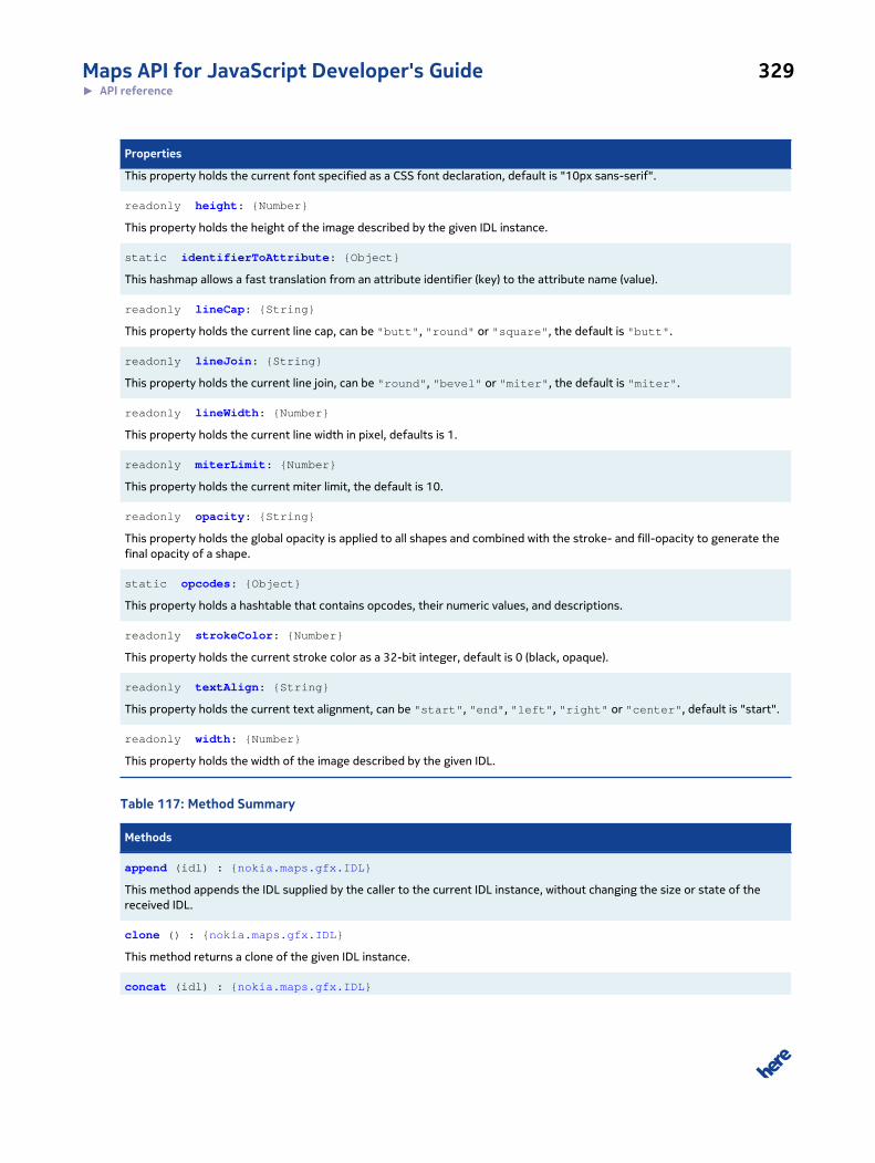
Maps API for JavaScript Developer's Guide 329► API reference
Properties
This property holds the current font specified as a CSS font declaration, default is "10px sans-serif".
readonly height: {Number}
This property holds the height of the image described by the given IDL instance.
static identifierToAttribute: {Object}
This hashmap allows a fast translation from an attribute identifier (key) to the attribute name (value).
readonly lineCap: {String}
This property holds the current line cap, can be "butt", "round" or "square", the default is "butt".
readonly lineJoin: {String}
This property holds the current line join, can be "round", "bevel" or "miter", the default is "miter".
readonly lineWidth: {Number}
This property holds the current line width in pixel, defaults is 1.
readonly miterLimit: {Number}
This property holds the current miter limit, the default is 10.
readonly opacity: {String}
This property holds the global opacity is applied to all shapes and combined with the stroke- and fill-opacity to generate thefinal opacity of a shape.
static opcodes: {Object}
This property holds a hashtable that contains opcodes, their numeric values, and descriptions.
readonly strokeColor: {Number}
This property holds the current stroke color as a 32-bit integer, default is 0 (black, opaque).
readonly textAlign: {String}
This property holds the current text alignment, can be "start", "end", "left", "right" or "center", default is "start".
readonly width: {Number}
This property holds the width of the image described by the given IDL.
Table 117: Method Summary
Methods
append (idl) : {nokia.maps.gfx.IDL}
This method appends the IDL supplied by the caller to the current IDL instance, without changing the size or state of thereceived IDL.
clone () : {nokia.maps.gfx.IDL}
This method returns a clone of the given IDL instance.
concat (idl) : {nokia.maps.gfx.IDL}
Maps API for JavaScript Developer's Guide 330► API reference
Methods
This method combines the given IDL instance with the one supplied by the caller and returns a merged IDL.
push (args)
This method pushes the given IDL commands to the data array and it applies the matrix to all coordinates provided asparameters of opcodes.
resetState ()
This method resets the state of the given IDL instance object, and therefore sets all the properties to their defaults, clearsthe stack, but does not modify the width, height, description and data properties.
restoreState () : {Object}
This method restores all attributes, except for width, height, description and data, from an internal stack.
saveState (additionalData)
This method saves all attributes, except for width, height, description and data, to an internal stack.
Class Description
This class represents an image described in terms of a set of IDL (Image Description Language)
instructions known as opcodes. The opcodes are interpreted to render the image based on a virtual
rendering context that supports, in addition to opcodes, a set of state attributes. The opcodes either
modify the state attributes or they cause drawing operations to be performed, using the current
rendering context state.
The coordinate system
A point in IDL is infinitely small and a line or a Bezier curve are therefore infinitely thin as well. An IDL
point with the coordinates 0,0 is projected onto the center of the screen pixel with the coordinates
0,0. This projection model differs from that used in SVG and the Canvas implementation, but it fits
in with the model used by VML. We settled on this model simply because it makes rendering easier to
understand and to handle.
The following example creates a 2D image, 64 x 64 pixels, showing a semi-transparent red rectangle,
centered within the image and with a 1 pixel black opaque border:
// Create a new IDL object.var IDL = nokia.maps.gfx.IDL, parseCss = nokia.maps.gfx.Color.parseCss, top = IDL.opcodes, attr = IDL.attributeToIdentifier, idlImage = new IDL( [ // Create a new image with a size of 64x64 pixel op.BEGIN_2D_IMAGE, 64, 64, "MyImage",
// Create a new path that follows a rectangular shape with the top-left // corner of the bounding box at 16, 16 and a width and height of 32 x 32
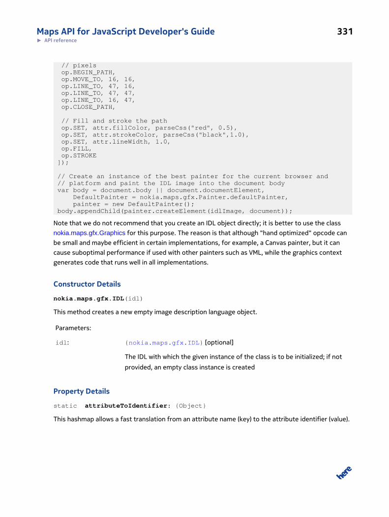
Maps API for JavaScript Developer's Guide 331► API reference
// pixels op.BEGIN_PATH, op.MOVE_TO, 16, 16, op.LINE_TO, 47, 16, op.LINE_TO, 47, 47, op.LINE_TO, 16, 47, op.CLOSE_PATH,
// Fill and stroke the path op.SET, attr.fillColor, parseCss("red", 0.5), op.SET, attr.strokeColor, parseCss("black",1.0), op.SET, attr.lineWidth, 1.0, op.FILL, op.STROKE ]);
// Create an instance of the best painter for the current browser and // platform and paint the IDL image into the document body var body = document.body || document.documentElement, DefaultPainter = nokia.maps.gfx.Painter.defaultPainter, painter = new DefaultPainter(); body.appendChild(painter.createElement(idlImage, document));
Note that we do not recommend that you create an IDL object directly; it is better to use the class
nokia.maps.gfx.Graphics for this purpose. The reason is that although "hand optimized" opcode can
be small and maybe efficient in certain implementations, for example, a Canvas painter, but it can
cause suboptimal performance if used with other painters such as VML, while the graphics context
generates code that runs well in all implementations.
Constructor Details
nokia.maps.gfx.IDL(idl)
This method creates a new empty image description language object.
Parameters:
idl: {nokia.maps.gfx.IDL} [optional]
The IDL with which the given instance of the class is to be initialized; if not
provided, an empty class instance is created
Property Details
static attributeToIdentifier: {Object}
This hashmap allows a fast translation from an attribute name (key) to the attribute identifier (value).
Maps API for JavaScript Developer's Guide 332► API reference
data: {Object[]}
This property holds an array of objects, each containing an IDL opcodes and associated parameters;
the opcodes and their parameters describe the image.
The data always consists of one opcode, followed by fixed number of parameters for that opcode.
readonly description: {String}
This property holds the description text of the image described by the given IDL instance.
readonly fillColor: {Number}
This property holds the current fill color as a 32-bit integer, default is 255 (black, transparent).
See: nokia.maps.gfx.Color
readonly font: {String}
This property holds the current font specified as a CSS font declaration, default is "10px sans-serif".
readonly height: {Number}
This property holds the height of the image described by the given IDL instance.
static identifierToAttribute: {Object}
This hashmap allows a fast translation from an attribute identifier (key) to the attribute name (value).
readonly lineCap: {String}
This property holds the current line cap, can be "butt", "round" or "square", the default is
"butt".
The lineCap attribute defines the type of endings of lines. The butt value means that the end of each
line has a flat edge. The round value means that a semi-circle is added to the end of the line. The
square value means that a rectangle shall be added at the end of each line.
readonly lineJoin: {String}
Maps API for JavaScript Developer's Guide 333► API reference
This property holds the current line join, can be "round", "bevel" or "miter", the default is
"miter".
The lineJoin defines the type of corners that will be places where two lines meet. If the lineJoin
is "bevel", a filled triangle connecting the two opposite corners of the straight line, with the third
point of the triangle being the join point.
The "round" value means that a filled arc connecting the two aforementioned corners of the join
must be rendered at joins.
The "miter" value means that a second filled triangle must be rendered at the join, with one line
being the line between the two aforementioned corners, abutting the first triangle, and the other
two being continuations of the outside edges of the two joining lines, as long as required to intersect
without going over the miter length.
The miter length is the distance from the point where the join occurs to the intersection of the line
edges on the outside of the join. The miter limit ratio is the maximum allowed ratio of the miter
length to half the line width. If the miter length would cause the miter limit ratio to be exceeded, this
second triangle must not be rendered.
readonly lineWidth: {Number}
This property holds the current line width in pixel, defaults is 1.
readonly miterLimit: {Number}
This property holds the current miter limit, the default is 10.
See: nokia.maps.gfx.IDL#lineCap
readonly opacity: {String}
This property holds the global opacity is applied to all shapes and combined with the stroke- and
fill-opacity to generate the final opacity of a shape. The value must be in the range from 0.0 (fully
transparent) to 1.0 (opaque).
static opcodes: {Object}
This property holds a hashtable that contains opcodes, their numeric values, and descriptions.
The contents are represented as list of opcode aliases, where each of the aliases is followed by a
further list showing the opcode value, the parameters and a description. The opcode aliases serve

Maps API for JavaScript Developer's Guide 334► API reference
as hashtable keys (for example BEGIN_PATH), while the values are the numeric values of opcodes.
Please use this reference when adding your own opcodes to the data property of the IDL.
• BEGIN_2D_IMAGE
◦ Opcode: 45 (-)
◦ Parameters: {Number} width, {Number} height, {String} description
◦ Description: This is the first opcode (0x2D) that must apear in any 2D image description. It
defines a new image with the given size of the canvas and sets the cursor to the position 0,0.
• BEGIN_PATH
◦ Opcode: 64 (@)
◦ Parameters: -
◦ Description: Clear all sub-paths.
• MOVE_TO
◦ Opcode: 77 (M)
◦ Parameters: {Number} x, {Number} y
◦ Description: Start a new subpath and move the cursor to the given pixel position within the
canvas.
• LINE_TO
◦ Opcode: 76 (L)
◦ Parameters: {Number} x, {Number}
◦ Description: Draw a line from the current cursor position to the given canvas position.
• BEZIER_CURVE_TO
◦ Opcode: 67 (C)
◦ Parameters: {Number} cp1_x, {Number} cp1_y, {Number} cp2_x, {Number} cp2_y, {Number}
x, {Number} y
◦ Description: Draw a Bezier curve of the 3rd degree from the current cursor position to the
given x / y position using the two given control points.
• CLOSE_PATH
◦ Opcode: 120 (x)
◦ Parameters: -
◦ Description: Close the last sub-path and connect the last point of the path with the first one,
so that a fill operation can be performed.
• FILL
Maps API for JavaScript Developer's Guide 335► API reference
◦ Opcode: 102 (f)
◦ Parameters: -
◦ Description: Close the last sub-path and fill all sub-paths with the current fill color.
• STROKE
◦ Opcode: 115 (s)
◦ Parameters: -
◦ Description: Stroke all sub-paths with the current stroke style.
• DRAW_IMAGE
◦ Opcode: 73 (I)
◦ Parameters: {Image} image, {Number} srcX, {Number} srcY, {Number} srcWidth, {Number}
srcHeight, {Number} destX, {Number} destY, {Number} destWidth, {Number} destHeight
◦ Description: Slice part of a source image and draws it into the destination.
• DRAW_IDL
◦ Opcode: 105 (i)
◦ Parameters: {nokia.maps.gfx.IDL} idl, {Number} srcX, {Number} srcY, {Number} srcWidth,
{Number} srcHeight, {Number} destX, {Number} destY, {Number} destWidth, {Number}
destHeight
◦ Description: Slice part of a source IDL and draws it into the destination.
• SAVE
◦ Opcode: 62 (>)
◦ Parameters: -
◦ Description: Save the state of the rendering context at the stack (push).
• RESTORE
◦ Opcode: 60 (<)
◦ Parameters: -
◦ Description: Restore the state of the rendering context from the stack (pop).
• SET
◦ Opcode: 35 (#)
◦ Parameters: {Number} attributeIdentifier, {Object} value
◦ Description: Set the state attribute with the given identifier to the given value. The name of
an attribute can be translated into its identifier using the static attributeToIdentifier
Maps API for JavaScript Developer's Guide 336► API reference
property and from its identifier to its name using the static identifierToAttribute
property.
readonly strokeColor: {Number}
This property holds the current stroke color as a 32-bit integer, default is 0 (black, opaque).
See: nokia.maps.gfx.Color
readonly textAlign: {String}
This property holds the current text alignment, can be "start", "end", "left", "right" or
"center", default is "start".
readonly width: {Number}
This property holds the width of the image described by the given IDL.
Method Details
append(idl): {nokia.maps.gfx.IDL}
This method appends the IDL supplied by the caller to the current IDL instance, without changing the
size or state of the received IDL.
Parameters:
idl: {nokia.maps.gfx.IDL}
The IDL to be appended to the given IDL instance
Returns:
{nokia.maps.gfx.IDL}
The reference to the given IDL instance
clone(): {nokia.maps.gfx.IDL}
This method returns a clone of the given IDL instance.
Maps API for JavaScript Developer's Guide 337► API reference
Note that the only property that is deep-cloned is data. As a result, the clone contains a copied
instruction set, but all other properties refer to the same values. The internal stack is cloned as well.
Returns:
{nokia.maps.gfx.IDL}
A clone of the given IDL instance
concat(idl): {nokia.maps.gfx.IDL}
This method combines the given IDL instance with the one supplied by the caller and returns a
merged IDL.
Parameters:
idl: {nokia.maps.gfx.IDL}
The IDL to be appended to the given IDL instance
Returns:
{nokia.maps.gfx.IDL}
The new combined IDL, the image size of the current IDL is retained
push(args)
This method pushes the given IDL commands to the data array and it applies the matrix to all
coordinates provided as parameters of opcodes.
Example:
var IDL = nokia.maps.gfx.IDL, Color = nokia.maps.gfx.Color, idl = new IDL(), opcodes = IDL.opcodes, attr = attributeToIdentifier; idl.push( opcodes.BEGIN_2D_IMAGE, 40, 40, "ExampleImage", opcodes.BEGIN_PATH, opcodes.MOVE_TO, 10, 10, opcodes.LINE_TO, 20, 10, opcodes.LINE_TO, 20, 20, opcodes.LINE_TO, 10, 20, opcodes.CLOSE_PATH, opcodes.SET, attr.fillColor, Color.parseCss("#ff0000",0.5),
Maps API for JavaScript Developer's Guide 338► API reference
opcodes.FILL );
Parameters:
args ...: {Object}
An arbitrary number of parameters that contain the IDL code to be pushed
resetState()
This method resets the state of the given IDL instance object, and therefore sets all the properties
to their defaults, clears the stack, but does not modify the width, height, description and data
properties.
restoreState(): {Object}
This method restores all attributes, except for width, height, description and data, from an
internal stack.
If the internal stack is empty, the method restores the default state and therefore it has the same
effect as reset().
Returns:
{Object} Additional data that has been pushed to the internal stack, if any
saveState(additionalData)
This method saves all attributes, except for width, height, description and data, to an internal
stack.
Parameters:
additionalData: {Object} [optional]
If provided, this object containing additional data is saved together with the
rest of the state
Class: ImageThis class is a member of nokia.maps.gfx.
Maps API for JavaScript Developer's Guide 339► API reference
Class Summary
This class is an base class for all image implementations like graphic or bitmap image.
[ For full details, see nokia.maps.gfx.Image ]
Table 118: Property Summary
Properties
readonly height: {Number}
This property holds the height of the image in pixels.
opacity: {Number}
This property holds the default opacity for the image.
readonly state: {Number}
This property holds the state of the image.
readonly width: {Number}
This property holds the width of the image in pixels.
Table 119: Method Summary
Methods
clone (doc) : {nokia.maps.gfx.Image}
This method clones the given image and optionally binds it to a different document.
createElement (opacity) : {Node}
This method creates a DOM node containing the given image.
static fromObject (obj, doc) : {nokia.maps.gfx.Image}
This method attempts to create an appropriate nokia.maps.gfx.Image object from the object supplied by the caller.
getDocument () : {Document}
This method retrieves the document to which the given image is bound.
prepare (callback, context, args) : {nokia.maps.gfx.Image}
This method prepares the given image and calls a callback on completion or failure.
setOpacity (element, opacity) : {nokia.maps.gfx.Image}
This method changes the global opacity of an element returned by the createElement().
Class Description
This class is an abstract base class for all kinds of image implementations. An image is immutable:
after an image instance has been created, it is prepared for painting, and once it has been prepared,
Maps API for JavaScript Developer's Guide 340► API reference
it can no longer be modified. If the prepare() method is not called explicitly after an image has
been created, the method createElement() invokes prepare() implicitly. Preparation depends
on the image type, for example, the BitmapImage class loads the binary data of the image from a
Web server, while the class GraphicsImage generates an IDL object that makes it possible to render
the final image directly within the client, resulting in a VML, SVG or a Canvas element.
Further implementation are possible, each implementation must add a listener to the static array
fromObjectListener to convert arbitrary objects into instances of the Image class automatically.
Note that each image is bound to a document and can only be used with that document. The
binding must be set at image construction time and can not be changed later. The reason is that
the prepare() method call is optional and can be explicit after the construction of the image and
before the image is used or it is called implicitly by createElement(), which can be invoked on
demand. If the document were passed as an argument to createElement(), problems might arise
for explicitly prepared images as preparation may require knowledge about the document to which
the image is to be added.
The following code extract shows how an image can be used in different frames:
var someFunction = function (gfxImage) { // Ensure that the given image is valid for our // current document and if not, import it. if (gfxImage.getDocument() !== document) gfxImage = gfxImage.clone(document); }
Property Details
readonly height: {Number}
This property holds the height of the image in pixels. The value may be zero until the image has been
successfully prepared.
Note that the default value is zero, because a calculation with undefined would lead to an NaN
result
opacity: {Number}
This property holds the default opacity for the image. The value is used when createElement() is
called without a parameter. The value must be between 0 and 1 (default).
readonly state: {Number}
This property holds the state of the image.
Maps API for JavaScript Developer's Guide 341► API reference
The list below shows the possible values and explains their meaning:
• undefined - the image preparation has not been started yet
• -2 - the image preparation failed and calling the prepare again won't solve the problem
• -1 - the image preparation failed, but calling the prepare again might solve the problem
• 0 - the image preparation is currently ongoing
• 1 - the image preparation is finished successfully
Creating DOM nodes for an unprepared image or an image whose preparation failed results in an
empty image with a size of 0 x 0 pixels.
readonly width: {Number}
This property holds the width of the image in pixels. The value may be zero until the image has been
successfully prepared.
Note that the default value is zero, because a calculation with undefined would lead to an NaN
result
Method Details
clone(doc): {nokia.maps.gfx.Image}
This method clones the given image and optionally binds it to a different document.
Parameters:
doc: {Document} [optional]
A reference to the document to which to bind the image clone; if provided
and different from the document to which the image is currently bound, the
clone is bound to the document to which this argument refers
Returns:
{nokia.maps.gfx.Image}
A reference to the image clone
createElement(opacity): {Node}
This method creates a DOM node containing the given image.
Maps API for JavaScript Developer's Guide 342► API reference
This method is synchronous and returns a rendered DOM node that represents the image. If the
image is not yet successfully prepared, the preparation has failed or is ongoing, the returned image
may be a blank image, with a size of 0 x 0 pixels. If the image is not yet prepared and no preparation
is currently ongoing, this method calls the prepare() method.
Note that if an image is being prepared and the returned DOM node has the size of 0 x 0 pixels, the
size may be updated automatically as soon as the preparation has finished successfully. Therefore,
it is fail-safe to create, for example, a BitmapImage and to call the method createElement()
directly, because if the image has not yet been loaded, it will then be loaded asynchronously and the
returned DOM node will be extended as soon as the image is available.
Parameters:
opacity: {Number} [optional]
If provided, the value of this argument represents the opacity of the image
being created; valid values lie between 0 (transparent) and 1 (opaque); if the
argument is not provided, the value of the image property opacity is used
Returns:
{Node} A reference to the DOM node that can be added to the document containing
the given image
Example:
// Create a bitmap image.var myImage = new nokia.maps.gfx.BitmapImage( "http://www.w3.org/Icons/WWW/w3c_home_nb.png"); // Add the image to the document, prepare() is called // by the method createElement().var body = document.body || document.documentElement;body.appendChild(myImage.createElement());
static fromObject(obj, doc): {nokia.maps.gfx.Image}
This method attempts to create an appropriate nokia.maps.gfx.Image object from the object supplied
by the caller.
Parameters:
obj: {Object}
An object to be converted into an Image instance
Maps API for JavaScript Developer's Guide 343► API reference
doc: {Document} [optional]
The document to which the new Image instance is to be bound; if not pro-
vided, the current document is used
Returns:
{nokia.maps.gfx.Image}
An instance of the Image class created from the received object or null if
no Image object can be created
Example:
// If GraphicsImage is included in the gfx // package, it returns a graphics image on // execution of the following code:var myImage = nokia.maps.gfx.Image.fromObject( '<svg xmlns="http://www.w3.org/2000/svg" width="1000" height="600" viewBox="0 0 5 3">'+ '<rect id="black_stripe" width="5" height="3" y="0" x="0" fill="#000"/>'+ '<rect id="red_stripe" width="5" height="2" y="1" x="0" fill="#D00"/>'+ '<rect id="gold_stripe" width="5" height="1" y="2" x="0" fill="#FFCE00"/>' '</svg>');
getDocument(): {Document}
This method retrieves the document to which the given image is bound.
Returns:
{Document} The document to which the given image is bound (set by the constructor and
cannot be modified)
prepare(callback, context, args): {nokia.maps.gfx.Image}
This method prepares the given image and calls a callback on completion or failure. The callback and
the context in which the callback is called are both provided by the caller.
Maps API for JavaScript Developer's Guide 344► API reference
Calling this method on an image that is already prepared leads to the callback being invoked
immediately. If the method is called multiple times, all the supplied callback handlers are called in the
order in which the method has been called.
Parameters:
callback: {Function}
A function to call as soon as the preparation is finished, whether successful-
ly or not. The function must be able to receives as its first argument a refer-
ence to the GFX image, followed by all the additional parameters passed to
this method
context: {Object} [optional]
An object representing the context in which to call the callback; if not sup-
plied, the context (this) is bound to the given image object.
args ...: {Object} [optional]
An arbitrary number of additional arguments to be passed to the callback
Returns:
{nokia.maps.gfx.Image}
An instance of gfx.Image representing the given image (this)
Example:
// Create a new bitmap image.var myImage = new nokia.maps.gfx.BitmapImage("http://www.w3.org/Icons/WWW/w3c_home_nb.png");
// Create a callback handler that shall be called as // soon as the image is loaded.var myCallback = function (image, msg) { // If preparing the image failed, show an error // message and return. if (image.state<1) return alert ("Failed to load image!"); // Show the message supplied to the prepare method, // if any. if (msg) alert (msg); // Paint the image into the document. var body = image.doc.body || image.doc.documentElement; body.appendChild(image.createElement());};
Maps API for JavaScript Developer's Guide 345► API reference
// Start the image preparation which (in this case) // loads the bitmap from the Web server and then calls// the callback. If the image is within the browser's // cache, it may happen that the callback method is // called immediately.myImage.prepare(myCallback, null, "Hello World!");
setOpacity(element, opacity): {nokia.maps.gfx.Image}
This method changes the global opacity of an element returned by the createElement().
Parameters:
element: {Node}
The DOM node that was returned by the createElement()
opacity: {Number}
The global opacity for the node as a number between 0 and 1
Returns:
{nokia.maps.gfx.Image}
The reference to the given image object (this)
Class: PainterThis class is a member of nokia.maps.gfx.
Class Summary
This class is an abstract base class for all painter implementations.
[ For full details, see nokia.maps.gfx.Painter ]
Table 120: Property Summary
Properties
static defaultPainter: {Function}
This property holds a reference to the constructor of the default painter that can be used with the current browser/platform.
Maps API for JavaScript Developer's Guide 346► API reference
Table 121: Method Summary
Methods
createElement (idl, doc, opacity) : {Node}
This method renders the supplied IDL object and returns a DOM node that can be added to the supplied document.
setOpacity (element, opacity)
This method changes the global opacity of an element returned by the method createElement().
setScale (element, scale)
This method changes the scaling of an element returned by the method createElement().
updateElement (idl, node, opacity)
This method updates a DOM node that was previously returned by the method createElement() to the caller-supplied IDLobject.
Class Description
This class is an abstract base class for all painter implementations. A painter renders
a nokia.maps.gfx.IDL object using a specific method, for example via a CANVAS tag
(nokia.maps.gfx.CanvasPainter), an SVG DOM node (nokia.maps.gfx.SvgPainter) or a VML DOM node
(nokia.maps.gfx.VmlPainter).
Property Details
static defaultPainter: {Function}
This property holds a reference to the constructor of the default painter that can be used with the
current browser/platform.
Note that the default painter need not to be the best painter, but it must be a painter that is fully
supported by the current browser/platform. It may happen that there is no default painter, so this
property may be set to null.
Method Details
createElement(idl, doc, opacity): {Node}
This method renders the supplied IDL object and returns a DOM node that can be added to the
supplied document. The node must contain "something" (VML, SVG, Canvas tag or whatever is
suitable) that can hold the image described by the IDL.
Parameters:
idl: {nokia.maps.gfx.IDL}
Maps API for JavaScript Developer's Guide 347► API reference
An IDL object describing the image to be rendered
doc: {Document} [optional, default: document]
A reference to the document for which the painter is to create an element; if
omitted the current document is used
opacity: {Number} [optional, default: 1]
A value representing the opacity with which the element is to be created; if
omitted or invalid, 1.0 (opaque) is used; must be a number between 0 (trans-
parent) and 1 (opaque)
Returns:
{Node} A reference to the DOM node that can be added into the given DOM node
and represents the image described by the supplied IDL
setOpacity(element, opacity)
This method changes the global opacity of an element returned by the method createElement().
Parameters:
element: {Node}
A reference to the DOM node that was returned by createElement()
opacity: {Number}
A value representing global opacity for the node as a number between 0 and
1
setScale(element, scale)
This method changes the scaling of an element returned by the method createElement().
Parameters:
element: {Node}
A reference to the DOM node that was returned by createElement()
Maps API for JavaScript Developer's Guide 348► API reference
scale: {nokia.maps.util.Point}
A value representing scale factor for x and y axes
updateElement(idl, node, opacity)
This method updates a DOM node that was previously returned by the method createElement()
to the caller-supplied IDL object. This can result in a complete re-rendering of the node's content or
in a partial update, depending on the painter implementation and the number of changes made to the
IDL.
Parameters:
idl: {nokia.maps.gfx.IDL}
An IDL object describing the image to be rendered
node: {Node}
A reference to the DOM node that was previously returned by the method
createElement() and which is to be updated
opacity: {Number} [optional, default: 1]
A numeric value representing the opacity with which the element is to be up-
dated; if omitted, or an invalid value, 1.0 (opaque) is used; the value must be
a number between 0 (transparent) and 1 (opaque)
Class: SvgPainterThis class is a member of nokia.maps.gfx.
Extends: nokia.maps.gfx.Painter
Class Summary
This class renders IDL into SVG tags.
[ For full details, see nokia.maps.gfx.SvgPainter ]
Table 122: Method Summary
Methods
createMarkup (idl) : {String}
Maps API for JavaScript Developer's Guide 349► API reference
Methods
This method creates an SVG mark-up string from the received instance of nokia.maps.gfx.IDL.
Directly Inherited Methods
Inherited from class nokia.maps.gfx.Painter :
createElement, setOpacity, setScale, updateElement
Class Description
The class SvgPainter renders a nokia.maps.gfx.IDL into a DOM node with an SVG tag.
This painter works with all browsers that support SVG. To instantiate this class, use the default
constructor without arguments:
var mySvgPainter= new nokia.maps.gfx.SvgPainter();
Constructor Details
nokia.maps.gfx.SvgPainter()
This method creates a new SvgPainter instance.
Method Details
createMarkup(idl): {String}
This method creates an SVG mark-up string from the received instance of nokia.maps.gfx.IDL.
Parameters:
idl: {nokia.maps.gfx.IDL}
An image description language object that is to be converted into a mark-up
string.
Returns:
{String} The SVG mark-up string
Class: SvgParserThis class is a member of nokia.maps.gfx.
Maps API for JavaScript Developer's Guide 350► API reference
Class Summary
This class converts a SVG string into IDL language.
[ For full details, see nokia.maps.gfx.SvgParser ]
Table 123: Method Summary
Methods
parseSvg (svgMarkup) : {nokia.maps.gfx.IDL}
This method parses the supplied SVG string into an IDL object.
parseSvgInfo (svgMarkup) : {nokia.maps.gfx.SvgParser.SvgMarkupInfo}
This method returns information about the SVG mark-up.
parseSvgToGraphics (svgMarkup, graphics) : {nokia.maps.gfx.Graphics}
This method parses an SVG string and renders it using a graphics context.
Class Description
This class provides a facility to convert an SVG string into an instance of nokia.maps.gfx.IDL.
Example:
// Parse an SVG mark-up string.var svgParser = new nokia.maps.gfx.SvgParser(), svgText = '<svg xmlns="http://www.w3.org/2000/svg" version="1.1" width="28" height="36" viewBox="0 0 28 36">' + '<path stroke="none" fill-opacity="0.40000003799999995" fill="#000000" d="M 18.9 33.4 C 18.9 34.8 16.7 36 13.899999999999999 36 C 11.099999999999998 36 8.899999999999999 34.8 8.899999999999999 33.4 C 8.899999999999999 32 11.099999999999998 30.799999999999997 13.899999999999999 30.799999999999997 C 16.7 30.799999999999997 18.9 31.9 18.9 33.4 Z">' + '</path><path stroke="none" fill-opacity="1" fill="#666666" d="M 14 0 C 6.3 0 0 6.3 0 14.1 C 0 16.2 0.4 18.2 1.3 20.1 L 1.8 21.1 C 3 23.1 12.3 32.2 13.3 33.2 L 14 33.9 L 14.7 33.2 C 15.7 32.2 25 23.1 26.1 21.2 L 26.7 20.2 C 27.5 18.2 28 16.2 28 14.1 C 28 6.3 21.7 0 14 0 Z">' + '</path><path stroke="none" fill-opacity="1" fill="#666666" d="M 14 0.9 C 21.2 0.9 27 6.8 27 14 C 27 16 26.6 17.9 25.8 19.6 L 25.3 20.5 C 24.2 22.4 14 32.4 14 32.4 C 14 32.4 3.8 22.4 2.7 20.5 L 2.2 19.6 C 1.4 17.9 1 16 1 14 C 1 6.8 6.8 0.9 14 0.9 Z">' + '</path><path stroke="none" fill-opacity="1" fill="#ffffff" d="M 14 0.9 C 6.8 0.9 1 6.8 1 14 C 1 16 1.4 17.9 2.2 19.6 L 2.7 20.5 C 3.8 22.4 14 32.4 14 32.4 C 14 32.4 24.2 22.4 25.3 20.5 L 25.8 19.6 C 26.6 17.9 27 16 27 14 C 27 6.8 21.2 0.9 14 0.9 Z">' + '</path><path stroke="none" fill-opacity="1" fill="#ffffff" d="M 14 1.9 C 20.6 1.9 26 7.3 26 14 C 25.9 16.1 25.5 18.2 24.4 20 C 23.8 21.2 17.9 27.1 14 30.9 C 10.1 27.1 4.2 21.2 3.6 20.1 C 2.6 18.2 1.9 16.2 2 14 C 2 7.3 7.4 1.9 14 1.9 Z">' +
Maps API for JavaScript Developer's Guide 351► API reference
'</path><path stroke="none" fill-opacity="1" fill="#43a51b" d="M 14 1.9 C 7.4 1.9 2 7.300000000000001 2 14 C 1.9 16.2 2.6 18.2 3.6 20.1 C 4.2 21.3 10.1 27.1 14 31 C 17.9 27.1 23.8 21.3 24.4 20.1 C 25.5 18.3 25.9 16.200000000000003 26 14.100000000000001 C 26 7.400000000000001 20.6 2.0000000000000018 14 2.0000000000000018 L 14 2.0000000000000018 Z">' + '</path><path stroke="none" fill-opacity="0.7019608509999999" fill="#ffffff" d="M 21 6.1 C 17.8 3.5 13.7 2.5 11.9 3.9 C 11.4 4.3 11.2 4.8 11.1 5.4 C 15.2 6 18.2 8.100000000000001 19.6 9.9 C 22 13 21.6 13.9 21.6 13.9 C 22.400000000000002 13.9 23 13.700000000000001 23.5 13.3 C 25.3 11.9 24.2 8.8 21 6.200000000000001 L 21 6.200000000000001 Z">' + '</path><text font-family="arial" font-size="13px" font-weight="bold" alignment-baseline="middle" text-anchor="middle" fill="#ffffff" opacity="0.866666749" y="0" x="0" transform="matrix(1, 0, 0, 1, 14, 15)">X</text></svg>', idlImage = svgParser.parseSvg(svgText);
// And show it within the page.var image = new nokia.maps.gfx.GraphicsImage(idlImage), body = document.body || document.documentElement;body.appendChild(image.createElement());
Note that this parser does not support the full SVG standard but SVG Tiny 1.1 standard.
Constructor Details
nokia.maps.gfx.SvgParser()
This method creates a new instance of SvgParser
Method Details
parseSvg(svgMarkup): {nokia.maps.gfx.IDL}
This method parses the supplied SVG string into an IDL object.
Parameters:
svgMarkup: {String | Document}
An SVG mark-up string or an XML document
Returns:
{nokia.maps.gfx.IDL}
An IDL generated from the SVG mark-up
parseSvgInfo(svgMarkup): {nokia.maps.gfx.SvgParser.SvgMarkupInfo}
Maps API for JavaScript Developer's Guide 352► API reference
This method returns information about the SVG mark-up.
Parameters:
svgMarkup: {String | Document}
An SVG mark-up string or an XML document
Returns:
{nokia.maps.gfx.SvgParser.SvgMarkupInfo}
Information about the SVG mark-up or null if the SVG parsing failed
parseSvgToGraphics(svgMarkup, graphics): {nokia.maps.gfx.Graphics}
This method parses an SVG string and renders it using a graphics context. The method can be used to
scale SVGs, as shown in the example below:
// Create the SVG parser, a graphics context and the SVG string// that defines a 100 x 100 pixels SVG, with a circle in the // middle that has a radius of 40 pixels.var gfx = nokia.maps.gfx, svgParser = new gfx.SvgParser(), svgString = '<svg width="100" height="100" xmlns:xlink="http://www.w3.org/1999/xlink" xmlns="http://www.w3.org/2000/svg"><g><title>Layer 1</title><circle stroke-width="5" fill="#FF0000" id="svg_1" r="40" cy="50" cx="50"/></g></svg>', originalImage, scaledImage, body = document.getElementsByTagName("BODY")[0];
// First let's create a graphics image in original size.originalImage = new gfx.GraphicsImage( // This function is called when the image is to be rendered. function (graphics) { // Parse the SVG string into an IDL. var idl = svgParser.parseSvg(svgString); // Create an image from the IDL. graphics.setIDL(idl); } ); // And now one with the size doubled.scaledImage = new gfx.GraphicsImage( // This method is called when the image is to be rendered. function (graphics) { // Parse the SVG and query information about it. var svgInfo = svgParser.parseSvgInfo(svgString);
Maps API for JavaScript Developer's Guide 353► API reference
// Create a new image of the double size. graphics.beginImage(svgInfo.width*2,svgInfo.height*2,"scaled image"); // Scale x- and y-axis by 2. graphics.scale(2,2); // Render the SVG string into the existing graphics context using // the already parsed SVG document (this is faster than // parsing the XML twice). svgParser.parseSvgToGraphics(svgInfo.document, graphics); } ); // Render the images into the document.body.appendChild(originalImage.createElement());body.appendChild(scaledImage.createElement());
Parameters:
svgMarkup: {String | Document}
An SVG mark-up string or an XML document.
graphics: {nokia.maps.gfx.Graphics} [optional]
The graphics context that is to be used for rendering; if omitted, a new con-
text is created and then returned
Returns:
{nokia.maps.gfx.Graphics}
The graphics context that was used to render this SVG
Interface: SvgMarkupInfo
This interface is a member of nokia.maps.gfx.SvgParser.
Interface Summary
This is an abstract interface for documentation purpose only.
[ For full details, see nokia.maps.gfx.SvgParser.SvgMarkupInfo ]
Maps API for JavaScript Developer's Guide 354► API reference
Table 124: Property Summary
Properties
document: {Document}
This property hols the XML document containing the definition of the SVG image.
height: {Number}
This property hols the height of the SVG image in pixels.
width: {Number}
This property hols the width of the SVG image in pixels.
Interface Description
This is an abstract interface for documentation purpose only. The class provides the information
returned by the method nokia.maps.gfx.SvgParser#parseSvgInfo().
Property Details
document: {Document}
This property hols the XML document containing the definition of the SVG image.
height: {Number}
This property hols the height of the SVG image in pixels.
width: {Number}
This property hols the width of the SVG image in pixels.
Class: VmlPainterThis class is a member of nokia.maps.gfx.
Extends: nokia.maps.gfx.Painter
Class Summary
This class renders a IDL into VML tags.
[ For full details, see nokia.maps.gfx.VmlPainter ]
Maps API for JavaScript Developer's Guide 355► API reference
Method Summary
Directly Inherited Methods
Inherited from class nokia.maps.gfx.Painter :
createElement, setOpacity, setScale, updateElement
Class Description
The class VmlPainter renders an instance of nokia.maps.gfx.IDL into a VML tag to be used with
Internet Explorer. To instantiate this class, use the default constructor without arguments:
var myVmlPainter= new nokia.maps.gfx.VmlPainter();
Constructor Details
nokia.maps.gfx.VmlPainter()
This method creates a new CanvasPainter instance
Namespace: heatmapThis namespace is a member of nokia.maps.
Namespace Summary
This namespace contains resources that allow the API user to create and manage heat maps.
Namespace Description
This namespace contains resources that allow the API user to create and manage heat maps.
Class: OverlayThis class is a member of nokia.maps.heatmap.
Extends: nokia.maps.map.provider.Provider
Class Summary
This class creates heat map overlay attachable to nokia.maps.map.Display.
[ For full details, see nokia.maps.heatmap.Overlay ]
Maps API for JavaScript Developer's Guide 356► API reference
Table 125: Property Summary
Properties
readonly assumeValues: {Boolean}
This property holds a boolean value defining whether to paint assumed values in regions where no data is available.
readonly coarseness: {Number}
This property holds a numeric value defining the resolution reduction when producing tiles.
readonly colors: {nokia.maps.heatmap.Overlay.Colors}
This property holds a nokia.maps.heatmap.Overlay.Colors object that defines the colors of the heat map.
readonly opacity: {Number}
This property holds the opacity of the heat map overlay.
readonly sampleDepth: {Number}
This property holds a numeric value defining the number of sampling iterations the heat map renderer will perform on thedata set.
readonly type: {String}
This property holds the type of the heat map to be generated.
Directly Inherited Properties
Inherited from class nokia.maps.map.provider.Provider :
description, getInvalidationMark, id, label, max, min
Table 126: Method Summary
Methods
addData (data)
This method adds an array of nokia.maps.heatmap.Overlay.DataPoints to the given heat map.
clear ()
This method removes all data from the given heat map provider.
Directly Inherited Methods
Inherited from class nokia.maps.map.provider.Provider :
getCopyrights, providesLevel, shutdown, update
Inherited from class nokia.maps.util.EventTarget :
addListener, dispatch, removeListener
Maps API for JavaScript Developer's Guide 357► API reference
Event Summary
Directly Inherited Events
Inherited from class nokia.maps.map.provider.Provider :
response, update
Class Description
This class creates tiles to visualize value-based or density-based heat maps. User can choose
between density and value based heat map.
Constructor Details
nokia.maps.heatmap.Overlay(options)
This method creates an empty heat map overlay.
Parameters:
options: {nokia.maps.heatmap.Overlay.Options} [optional]
An object specifying settings for the new heat map overlay instance
Property Details
readonly assumeValues: {Boolean}
This property holds a boolean value defining whether to paint assumed values in regions where no
data is available. This is especially useful for value maps which are generated from a small data sets
as tiles with no available data will be filled with the next available average value in the data set.
The property is read only and can be set at construction time as part of the
nokia.maps.heatmap.Overlay.Options initialization properties.
Default Value: false
readonly coarseness: {Number}
This property holds a numeric value defining the resolution reduction when producing tiles.
If the coarseness is set to 0 tiles will be produced in the original resolution. A coarseness of 1
allows the renderer to render tiles at half the size and then scale the output, a coarseness of 2
allows the renderer to create tiles at a size of a quarter of the original tile size. Increasing the
Maps API for JavaScript Developer's Guide 358► API reference
number dramatically increases performance but also reduces visual quality, especially when using
posterization (non-interpolated colors). Values may range between 0 and 3.
The property is read only and can be set at construction time as part of the
nokia.maps.heatmap.Overlay.Options initialization properties.
Default Value: 1
readonly colors: {nokia.maps.heatmap.Overlay.Colors}
This property holds a nokia.maps.heatmap.Overlay.Colors object that defines the colors of the heat
map.
The property is read only and can be set at construction time as part of the
nokia.maps.heatmap.Overlay.Options initialization properties.
readonly opacity: {Number}
This property holds the opacity of the heat map overlay. Values may range from 0+ to 1, inclusive.
The property is read only and can be set at construction time as part of the
nokia.maps.heatmap.Overlay.Options initialization properties.
Default Value: 0.8
readonly sampleDepth: {Number}
This property holds a numeric value defining the number of sampling iterations the heat map
renderer will perform on the data set. Each iteration will sample the data more finely. Higher values
will create more detailed maps but also cost performance. Values may range between 1 and 8.
The property is read only and can be set at construction time as part of the
nokia.maps.heatmap.Overlay.Options initialization properties.
Default Value: 4
readonly type: {String}
This property holds the type of the heat map to be generated.
The property is read only and can be set at construction time as part of the
nokia.maps.heatmap.Overlay.Options initialization properties.
Maps API for JavaScript Developer's Guide 359► API reference
The possible values are:
• "density"
• "value"
Default Value: "density"
Method Details
addData(data)
This method adds an array of nokia.maps.heatmap.Overlay.DataPoints to the given heat map. The
heat map provides a visual representation of these data.
Note that there is a significant performance cost to adding and removing data, once an overlay has
been created. This is related to the rendering engine and tile caching. If you wish to add data after
tiles have been created, the cache must be cleared and all tiles need to be recreated. For this reason,
heat maps should not be used to create fast animations.
Parameters:
data: {nokia.maps.heatmap.Overlay.DataPoint[]}
The array of data points to be added to the overlay.
Example:
// Create a density heat map overlay: var myHeatMapOverlay = new nokia.maps.heatmap.Overlay();
// Add DataPoints:myHeatMapOverlay.addData([ {latitude: 50, longitude: 13}, {latitude: 50, longitude: 13.1}, {latitude: 51, longitude: 13.2}, {latitude: 49.9, longitude: 13.15}, ... {latitude: 50, longitude: 13.4}]);
// Add the overlay to the map display to make // the heat map visible:myDisplay.overlays.add(myHeatMapOverlay);
clear()
Maps API for JavaScript Developer's Guide 360► API reference
This method removes all data from the given heat map provider. New data can be provided using the
nokia.maps.heatmap.Overlay#addData method.
Interface: Colors
This interface is a member of nokia.maps.heatmap.Overlay.
Interface Summary
This interface defines a standard way to customize the colors displayed in a heat map by associating
custom colors with normalized "heat" values.
[ For full details, see nokia.maps.heatmap.Overlay.Colors ]
Table 127: Property Summary
Properties
interpolate: {Boolean}
This property is a flag indicating whether interpolation is to be used to display smooth color transitions in the heat map(true) or whether the heat map is to be posterized (false).
stops: {Object}
This property holds a map, where the keys are numbers ranging from 0 to 1, inclusive, and the corresponding values are thecolors defined in the hexadecimal Web color notation, including opacity.
Interface Description
This interface defines a standard way to customize the colors displayed in a heat map by associating
custom colors with normalized "heat" values.
The interface associates colors with "heat" values via the "stops" property. This property is a map,
where the keys are numbers ranging from 0 to 1, inclusive, and the values are colors associated
with these numeric values. The colors are represented using CSS colors, i.e. hexadecimal notation
("#RGB" or "#RRGGBB") or rgb(a) notation ("rgba(R, G, B, A)"), etc. The range (0 .. 1) stands for the
normalized "heat" value. Points on the heat map are colorized using the color-stops information
from the Colors object.
Property Details
interpolate: {Boolean}
This property is a flag indicating whether interpolation is to be used to display smooth color
transitions in the heat map (true) or whether the heat map is to be posterized (false).
Maps API for JavaScript Developer's Guide 361► API reference
stops: {Object}
This property holds a map, where the keys are numbers ranging from 0 to 1, inclusive, and the
corresponding values are the colors defined in the hexadecimal Web color notation, including opacity.
Interface: DataPoint
This interface is a member of nokia.maps.heatmap.Overlay.
Interface Summary
This interface represents a single data point that can be visualized in a heat map.
[ For full details, see nokia.maps.heatmap.Overlay.DataPoint ]
Table 128: Property Summary
Properties
latitude: {Number}
This property defines the latitude of this data point.
longitude: {Number}
This property defines the longitude of this data point.
value: {Number}
This property defines a numeric "heat" value associated with the given data point.
Interface Description
This interface represents a single data point that can be visualized in a heat map. It consists of the
geographic coordinates defining its position and an optional value to be associated with this position.
Property Details
latitude: {Number}
This property defines the latitude of this data point.
longitude: {Number}
This property defines the longitude of this data point.
value: {Number}
Maps API for JavaScript Developer's Guide 362► API reference
This property defines a numeric "heat" value associated with the given data point. If no value is
defined, the default is 1.
Default Value: 1
Interface: Options
This interface is a member of nokia.maps.heatmap.Overlay.
Interface Summary
This interface defines options that can be passed to the nokia.maps.heatmap.Overlay constructor.
[ For full details, see nokia.maps.heatmap.Overlay.Options ]
Table 129: Property Summary
Properties
assumeValues: {Boolean}
This property holds a boolean value defining whether to paint assumed values in regions where no data is available.
coarseness: {Number}
This property holds a numeric value defining the resolution reduction when producing tiles.
colors: {nokia.maps.heatmap.Overlay.Colors}
This property holds an object that conforms to the interface nokia.maps.heatmap.Overlay.Colors and is used to define thecolors of the heat map.
opacity: {Number}
This property holds the opacity of the heat map overlay.
sampleDepth: {Number}
This property holds a numeric value defining the number of sampling iterations the heat map renderer will perform on thedata set.
type: {String}
This property specifies the type of the heat map to be generated.
Directly Inherited Properties
Inherited from class nokia.maps.map.provider.Provider.Options :
description, getCopyrights, label, max, min, updateCycle
Interface Description
This interface defines options that can be passed to the nokia.maps.heatmap.Overlay constructor.
Maps API for JavaScript Developer's Guide 363► API reference
Property Details
assumeValues: {Boolean}
This property holds a boolean value defining whether to paint assumed values in regions where no
data is available. This is especially useful for value maps which are generated from a small data sets
as tiles with no available data will be filled with the next available average value in the data set.
Default Value: false
coarseness: {Number}
This property holds a numeric value defining the resolution reduction when producing tiles.
If the coarseness is set to 0 tiles will be produced in the original resolution. A coarseness of 1
allows the renderer to render tiles at half the size and then scale the output, a coarseness of 2
allows the renderer to create tiles at a size of a quarter of the original tile size. Increasing the
number dramatically increases performance but also reduces visual quality, especially when using
posterization (non-interpolated colors). Values may range between 0 and 3.
Default Value: 1
colors: {nokia.maps.heatmap.Overlay.Colors}
This property holds an object that conforms to the interface nokia.maps.heatmap.Overlay.Colors
and is used to define the colors of the heat map. The property is optional. If it is not provided, the
following default color definition is used:
{ stops: { "0": "#008", // dark blue "0.2": "#0b0", // medium green "0.5": "#ff0", // yellow "0.7": "#f00" // red }, interpolate: true}
This means that the highest "heat" value is displayed in opaque red, the lowest as opaque blue, while
values in between are shown in opaque green and yellow and interpolation is used to determine them.
opacity: {Number}
This property holds the opacity of the heat map overlay. Values may range from 0+ to 1, inclusive.
The property is optional.

Maps API for JavaScript Developer's Guide 364► API reference
Default Value: 0.8
sampleDepth: {Number}
This property holds a numeric value defining the number of sampling iterations the heat map
renderer will perform on the data set. Each iteration will sample the data more finely. Higher values
will create more detailed maps but also cost performance. Values may range between 1 and 8.
Default Value: 4
type: {String}
This property specifies the type of the heat map to be generated. The property is optional.
The possible values are:
• "density"
• "value"
Default Value: "density"
Namespace: kmlThis namespace is a member of nokia.maps.
Namespace Summary
This namespace defines classes and methods that implement support for KML, including import of
KML files.
Namespace Description
This namespace defines classes and methods that implement support for KML, including import of
KML files.
Class: BalloonStyleThis class is a member of nokia.maps.kml.
Maps API for JavaScript Developer's Guide 365► API reference
Class Summary
This class represents the tag <BalloonStyle> defined in the KML specification.
[ For full details, see nokia.maps.kml.BalloonStyle ]
Table 130: Property Summary
Properties
readonly displayMode: {String}
This property holds the default value for the balloon display mode.
readonly text: {String}
This property holds the default value for text displayed in the balloon.
Directly Inherited Properties
Inherited from class nokia.maps.kml.ColorStyle :
color, colorMode
Class Description
This class represents the tag <BalloonStyle> defined in the KML specification. Class specifies how the
balloon containing text, etc. is drawn.
Constructor Details
nokia.maps.kml.BalloonStyle(node)
The class constructor initializes a new instance of the class, using the arguments supplied by the
caller.
Parameters:
node: {Node}
An XML node from the KML document that is being parsed
Property Details
readonly displayMode: {String}
This property holds the default value for the balloon display mode. If the property is set to "default",
the balloon displays text. If displayMode is "hide", the balloon remains hidden.
Maps API for JavaScript Developer's Guide 366► API reference
readonly text: {String}
This property holds the default value for text displayed in the balloon. You can add entities
to the text tag using the following format to refer to a child element of Feature: $[name],
$[description].
For example, in the following KML excerpt, the fields $[name] and $[description] are replaced by
the fields name and description found in the Feature elements that use the given BalloonStyle:
<text>This is $[name], whose description is:<br />$[description]</text>
Class: ColorStyleThis class is a member of nokia.maps.kml.
Class Summary
This class represents the abstract <ColorStyle> tag from the KML specification.
[ For full details, see nokia.maps.kml.ColorStyle ]
Table 131: Property Summary
Properties
readonly color: {String}
This property holds the color and opacity (alpha) values expressed in hexadecimal notation.
readonly colorMode: {String}
This property holds the value of color mode, which can be "normal" (no effect) or "random".
Class Description
This class represents the abstract <ColorStyle> tag from the KML specification.
Constructor Details
nokia.maps.kml.ColorStyle(node)
The constructor for this class initializes a new instance of the class, using the arguments supplied by
the caller.
Parameters:
node: {Node}
Maps API for JavaScript Developer's Guide 367► API reference
XML A node from the KML document that is being parsed
Property Details
readonly color: {String}
This property holds the color and opacity (alpha) values expressed in hexadecimal notation. The
range of values for any one color is 0 to 255 (00 to ff). The order of expression is #rrggbbaa, where
aa=alpha (00 to ff); bb=blue (00 to ff); gg=green (00 to ff); rr=red (00 to ff). For alpha, 00 is fully
transparent and ff is fully opaque.
readonly colorMode: {String}
This property holds the value of color mode, which can be "normal" (no effect) or "random". A value
of "random" applies a random linear scale to the base color as follows:
• To achieve a truly random selection of colors, specify white as the base color, #ffffffff.
• If you specify a single color component (for example, a value of #ff0000ff for red), random color
values for that one component (red) are subsequently selected, ranging from 00 (black) to ff (full
red).
• If you specify values for two or for all three color components, a random linear scale is applied to
each color component, with results ranging from black to the maximum values specified for each
component.
• The opacity of a color comes from the alpha component and is never randomized.
Class: ContainerThis class is a member of nokia.maps.kml.
Class Summary
This class represents the abstract <Container> tag from the KML specification.
[ For full details, see nokia.maps.kml.Container ]
Table 132: Property Summary
Properties
readonly features: {Array}
This property holds an array of nokia.maps.kml.Feature elements
Maps API for JavaScript Developer's Guide 368► API reference
Method Summary
Directly Inherited Methods
Inherited from class nokia.maps.kml.ObservableNode :
load
Inherited from class nokia.maps.util.OObject :
addObserver, get, remove, removeObserver, set
Class Description
This class represents the abstract <Container> tag from the KML specification. It is designed to hold
other objects and allows for creation of nested hierarchies. Properties are filled asynchronously after
call from ObservableNode class during XML tree parse.
Constructor Details
nokia.maps.kml.Container(node, styleContainer, featureStyle)
The constructor initializes a new instance of the class with the arguments supplied by the caller.
Parameters:
node: {Node}
An XML node from the KML document which is being parsed
styleContainer: {nokia.maps.kml.StyleContainer}
A container holding a list of StyleSelector objects, which is a list of all
global styles that can be referenced by id
featureStyle: {nokia.maps.kml.FeatureStyle}
A container holding locally defined styles that can be applied to the given
object
Property Details
readonly features: {Array}
This property holds an array of nokia.maps.kml.Feature elements
Maps API for JavaScript Developer's Guide 369► API reference
Namespace: DOMThis namespace is a member of nokia.maps.kml.
Namespace Summary
This is a static class that provides helper methods for the KML-specific classes.
Table 133: Method Summary
Methods
static getAltitudeMode (node) : {String}
This method parses the value of an XML DOM node into a string.
static getBoolean (node) : {Boolean}
This method parses the value of an XML DOM node to a Boolean value.
static getColor (node) : {String}
This method parses the value of an XML DOM node to a string that represents a color in RGBA format, reversing the order,because the KML specification uses the ABGR format.
static getFloat (node) : {Float}
This method parses the value of an XML DOM node to a Floating point number.
static getInteger (node) : {Integer}
This method parses the value of an XML DOM node to integer.
static getNodeAttribute (node, attributeName) : {String}
This method parses the attribute attributeName from an XML DOM node and returns it as a string.
static getNodeId (node) : {String}
This method parses the attribute id from an XML DOM node and returns it as a string.
static getString (node) : {String}
This method parses the value of a DOM node into string.
static parseCoord (coordStr) : {nokia.maps.geo.Coordinate}
This method parses a object containing geographical coordinates from a string.
static parseCoords (coordsString) : {nokia.maps.geo.Coordinate[]}
This method parses a string containing coordinates to an array of objects, each containing the properties "lat", "lng" and"alt".
static parseFromString (node) : {Document}
This method parses an XML string into browser-independent XML Document object.
Maps API for JavaScript Developer's Guide 370► API reference
Namespace Description
This is a static class that provides helper methods for the KML-specific classes.
Method Details
static getAltitudeMode(node): {String}
This method parses the value of an XML DOM node into a string. The resulting string contains only
predefined values as specified in KML documentation
Parameters:
node: {Node}
Any XML DOM node to parse
Returns:
{String} One of the predefined string values
static getBoolean(node): {Boolean}
This method parses the value of an XML DOM node to a Boolean value.
Parameters:
node: {Node}
An XML DOM node to parse
Returns:
{Boolean} A Boolean representation of the node value
static getColor(node): {String}
This method parses the value of an XML DOM node to a string that represents a color in RGBA
format, reversing the order, because the KML specification uses the ABGR format. If parsing fails, the
method returns the default hard-coded color.
Parameters:
node: {Node}
Maps API for JavaScript Developer's Guide 371► API reference
An XML DOM node to parse
Returns:
{String} A string representing a color in #RGBA format
static getFloat(node): {Float}
This method parses the value of an XML DOM node to a Floating point number.
Parameters:
node: {Node}
An XML DOM node to parse
Returns:
{Float} The value of the node as a float
static getInteger(node): {Integer}
This method parses the value of an XML DOM node to integer.
Parameters:
node: {Node}
An XML DOM node to parse
Returns:
{Integer} The node value as an integer
static getNodeAttribute(node, attributeName): {String}
This method parses the attribute attributeName from an XML DOM node and returns it as a string.
Parameters:
node: {Node}
Maps API for JavaScript Developer's Guide 372► API reference
An XML DOM node
attributeName: {String}
Name of the attribute
Returns:
{String} A string containing the nod id
static getNodeId(node): {String}
This method parses the attribute id from an XML DOM node and returns it as a string.
Parameters:
node: {Node}
An XML DOM node
Returns:
{String} A string containing the node id
static getString(node): {String}
This method parses the value of a DOM node into string.
Parameters:
node: {Node}
A DOM node to parse
Returns:
{String} The value of the DOM node as a stripped string value
static parseCoord(coordStr): {nokia.maps.geo.Coordinate}
This method parses a object containing geographical coordinates from a string. If the input does not
contain valid coordinates, the return value is undefined.
Maps API for JavaScript Developer's Guide 373► API reference
Parameters:
coordStr: {String | String[]}
A string containing the values of geographical coordinate as specified in KML
specification, for example: "13,53.5,0" or "13,53.5" Or an Array of strings
like ["13","53.5","0"] or ["13","53.5"]
Returns:
{nokia.maps.geo.Coordinate}
An object containing an object containing geographical coordinates (the
properties are "lat", "lng", and "alt"
static parseCoords(coordsString): {nokia.maps.geo.Coordinate[]}
This method parses a string containing coordinates to an array of objects, each containing the
properties "lat", "lng" and "alt". The return value contains only valid coordinates.
Parameters:
coordsString: {String}
A string containing a list of coordinates as specified in KML specification, for
example: "13,53.5,0 14,53,0 13,52.5,0 14,52.5,0" or non standard comma
separated list of coordinates like "13,53.5,0,14,53,0,13,52.5,0,14,52.5,0".
In this case specifying altitude(3rd component in each tuple) is required.
Please do not use spaces in case if you provide coordinates in 2nd format.
Returns:
{nokia.maps.geo.Coordinate[]}
A list of objects containing parsed geographical coordinates
static parseFromString(node): {Document}
This method parses an XML string into browser-independent XML Document object.
Parameters:
node: {String}
Maps API for JavaScript Developer's Guide 374► API reference
An XML string to parse
Returns:
{Document} An XML DOM document
Class: DocumentThis class is a member of nokia.maps.kml.
Class Summary
This class represents the <Document> tag from the KML specification.
[ For full details, see nokia.maps.kml.Document ]
Property Summary
Directly Inherited Properties
Inherited from class nokia.maps.kml.Container :
features
Method Summary
Directly Inherited Methods
Inherited from class nokia.maps.kml.ObservableNode :
load
Inherited from class nokia.maps.util.OObject :
addObserver, get, remove, removeObserver, set
Class Description
This class represents the <Document> tag from the KML specification.
Constructor Details
nokia.maps.kml.Document(node, styleContainer, featureStyle)
The constructor initializes a new instance of the class with the arguments supplied by the caller.
Maps API for JavaScript Developer's Guide 375► API reference
Parameters:
node: {Node}
An XML node from the KML document which is currently being parsed
styleContainer: {nokia.maps.kml.StyleContainer}
A list of StyleSelector objects containing all global styles which can be
referenced by id
featureStyle: {nokia.maps.kml.FeatureStyle}
A list of locally defined styles which can be applied to the given object
Class: FeatureThis class is a member of nokia.maps.kml.
Extends: nokia.maps.kml.ObservableNode
Class Summary
This class represents the abstract <Feature> tag from KML specification.
[ For full details, see nokia.maps.kml.Feature ]
Method Summary
Directly Inherited Methods
Inherited from class nokia.maps.kml.ObservableNode :
load
Inherited from class nokia.maps.util.OObject :
addObserver, get, remove, removeObserver, set
Class Description
This class represents the abstract <Feature> tag from KML specification. Properties are filled
asynchronously after call from ObservableNode class during XML tree parse.
Constructor Details
nokia.maps.kml.Feature(node, styleContainer, featureStyle)
Maps API for JavaScript Developer's Guide 376► API reference
The constructor initializes a new instance of the class with the arguments supplied by the caller.
Parameters:
node: {Node}
An XML node from a KML document that is being parsed.
styleContainer: {nokia.maps.kml.StyleContainer}
A list of StyleSelector objects, contains all global styles which can be ref-
erenced by id
featureStyle: {nokia.maps.kml.FeatureStyle}
An object containing locally defined styles that can be applied to the given
object
Class: FeatureStyleThis class is a member of nokia.maps.kml.
Class Summary
This class represents a style applicable to the class Feature.
[ For full details, see nokia.maps.kml.FeatureStyle ]
Table 134: Method Summary
Methods
mergeStyle (style, highlighted, reverse)
This method merges the styles from the received arguments to the current instance.
Class Description
This class represents a style applicable to the class Feature.
Constructor Details
nokia.maps.kml.FeatureStyle(style, highlighted)
Initialize a new instance of the class with the following parameters.
Parameters:
Maps API for JavaScript Developer's Guide 377► API reference
style: {nokia.maps.kml.Style | nokia.maps.kml.FeatureStyle}
This is the set of styles with to initialize the given instance of the class
highlighted: {Boolean} [optional]
A value indicating if the style is for highlighted shapes (true) or not
(false); if the value is true, the argument style should be an instance of
nokia.maps.kml.Style
Method Details
mergeStyle(style, highlighted, reverse)
This method merges the styles from the received arguments to the current instance.
Parameters:
style: {nokia.maps.kml.Style | nokia.maps.kml.FeatureStyle}
An object containing the style to be merged with the given instance of this
class.
highlighted: {Boolean} [optional]
A value indicating if the style is for highlighted shapes (true) or not
(false); if the value is true, the argument style should be an instance of
nokia.maps.kml.Style
reverse: {Boolean}
Specifies priority of the merging operation.
Class: FolderThis class is a member of nokia.maps.kml.
Class Summary
This class represents the <Folder> tag from the KML specification.
[ For full details, see nokia.maps.kml.Folder ]
Maps API for JavaScript Developer's Guide 378► API reference
Property Summary
Directly Inherited Properties
Inherited from class nokia.maps.kml.Container :
features
Method Summary
Directly Inherited Methods
Inherited from class nokia.maps.kml.ObservableNode :
load
Inherited from class nokia.maps.util.OObject :
addObserver, get, remove, removeObserver, set
Class Description
This class represents the <Folder> tag from the KML specification.
Constructor Details
nokia.maps.kml.Folder(node, styleContainer, featureStyle)
The constructor initializes a new instance of the class, using the arguments provided by the caller.
Parameters:
node: {Node}
An XML node from KML document, which is currently parsed.
styleContainer: {nokia.maps.kml.StyleContainer}
A list of StyleSelector objects, contains all global styles that can be ref-
erenced by id
featureStyle: {nokia.maps.kml.FeatureStyle}
Contains locally defined styles which can be applied to the given object
Class: GeometryThis class is a member of nokia.maps.kml.
Maps API for JavaScript Developer's Guide 379► API reference
Extends: nokia.maps.kml.ObservableNode
Class Summary
This class represents the abstract <Geometry> tag from the KML specification.
[ For full details, see nokia.maps.kml.Geometry ]
Table 135: Property Summary
Properties
readonly weight: {Number}
"Weight" of the geometry.
Table 136: Method Summary
Methods
getCenterCoordinate () : {nokia.maps.geo.Coordinate}
This method calculates the arithmetic average of all coordinates.
getStyle () : {nokia.maps.kml.Style}
Returns the style of the Geometry as a set of properties which can be used while creating equivalent map object
Directly Inherited Methods
Inherited from class nokia.maps.kml.ObservableNode :
load
Inherited from class nokia.maps.util.OObject :
addObserver, get, remove, removeObserver, set
Class Description
This class represents the abstract <Geometry> tag from the KML specification.
Constructor Details
nokia.maps.kml.Geometry(node)
The constructor initializes a new instance of the class, using the arguments provided by the caller.
Parameters:
node: {Node}
Maps API for JavaScript Developer's Guide 380► API reference
An XML node from KML document, which is currently parsed.
Property Details
readonly weight: {Number}
"Weight" of the geometry. This attribute is used to measure how heavy geometries are. For example
if it is a polyline with 100 connection points, its weight is 100, and if it is a simple point object, than it
has a weight of 1.
Default Value: 0
Method Details
getCenterCoordinate(): {nokia.maps.geo.Coordinate}
This method calculates the arithmetic average of all coordinates.
Returns:
{nokia.maps.geo.Coordinate}
An instance of nokia.maps.geo.Coordinate representing the calculated
average
Throws:
{NotImplement-
edException}
When trying to create object of this class and call this method.
getStyle(): {nokia.maps.kml.Style}
Returns the style of the Geometry as a set of properties which can be used while creating equivalent
map object
Returns:
{nokia.maps.kml.Style}
An object containing style properties to draw the given object on map
Throws:
Maps API for JavaScript Developer's Guide 381► API reference
{NotImplement-
edException}
When trying to create object of this class and call this method.
Class: IconThis class is a member of nokia.maps.kml.
Class Summary
This class represents the <Icon> tag from the KML specification.
[ For full details, see nokia.maps.kml.Icon ]
Property Summary
Directly Inherited Properties
Inherited from class nokia.maps.kml.Link :
href
Class Description
This class represents the <Icon> tag from the KML specification.
Constructor Details
nokia.maps.kml.Icon(node)
The constructor initializes a new instance of the class, using the arguments provided by the caller.
Parameters:
node: {Node}
An XML node from the KML document that is being parsed
Class: IconStyleThis class is a member of nokia.maps.kml.
Class Summary
This class represents the <IconStyle> tag from the KML specification.

Maps API for JavaScript Developer's Guide 382► API reference
[ For full details, see nokia.maps.kml.IconStyle ]
Property Summary
Directly Inherited Properties
Inherited from class nokia.maps.kml.ColorStyle :
color, colorMode
Class Description
This class represents the <IconStyle> tag from the KML specification.
Constructor Details
nokia.maps.kml.IconStyle(node)
The constructor initializes a new instance of the class, using the arguments provided by the caller.
Parameters:
node: {Node}
An XML node from the KML document which is currently being parsed.
Class: LabelStyleThis class is a member of nokia.maps.kml.
Class Summary
This class represents the <LabelStyle> tag from the KML specification.
[ For full details, see nokia.maps.kml.LabelStyle ]
Property Summary
Directly Inherited Properties
Inherited from class nokia.maps.kml.ColorStyle :
color, colorMode

Maps API for JavaScript Developer's Guide 383► API reference
Class Description
This class represents the <LabelStyle> tag from the KML specification.
Constructor Details
nokia.maps.kml.LabelStyle(node)
The constructor initializes a new instance of the class, using the arguments provided by the caller.
Parameters:
node: {Node}
An XML node from the KML document which is currently being parsed
Class: LineStringThis class is a member of nokia.maps.kml.
Extends: nokia.maps.kml.Geometry
Class Summary
This class represents the <LineString> tag from the KML specification.
[ For full details, see nokia.maps.kml.LineString ]
Table 137: Property Summary
Properties
readonly coordinates: {nokia.maps.geo.Coordinate[]}
An array containing nokia.maps.geo.Coordinate objects.
Directly Inherited Properties
Inherited from class nokia.maps.kml.Geometry :
weight
Table 138: Method Summary
Methods
getCenterCoordinate () : {nokia.maps.geo.Coordinate | null}
This method calculates the arithmetic average of all coordinates.
getStyle () : {Object}
Maps API for JavaScript Developer's Guide 384► API reference
Methods
This method gets the styles for the given object.
Directly Inherited Methods
Inherited from class nokia.maps.kml.Geometry :
getCenterCoordinate, getStyle
Inherited from class nokia.maps.kml.ObservableNode :
load
Inherited from class nokia.maps.util.OObject :
addObserver, get, remove, removeObserver, set
Class Description
This class represents the <LineString> tag from the KML specification.
Constructor Details
nokia.maps.kml.LineString(node, lineStyle, balloonStyle)
The constructor initializes a new instance of the class, using the arguments provided by the caller.
Parameters:
node: {Node}
An XML node from the KML document, which is currently being parsed
lineStyle: {nokia.maps.kml.LineStyle}
An object representing the line style to use during conversion to a map ob-
ject
balloonStyle: {nokia.maps.kml.BalloonStyle}
An object representing the balloon style to use during conversion to a map
object
Property Details
readonly coordinates: {nokia.maps.geo.Coordinate[]}
An array containing nokia.maps.geo.Coordinate objects.
Maps API for JavaScript Developer's Guide 385► API reference
A KML file must include four or more tuples, each consisting of floating point values for longitude,
latitude, and altitude. The altitude component is optional. Do not include spaces within a tuple. The
last coordinate must be the same as the first coordinate. Coordinates are expressed in decimal
degrees only.
It is important to bear in mind that when parsing of coordinates from a KML file has failed, or fewer
than 4 points were specified, this array remains empty.
Method Details
getCenterCoordinate(): {nokia.maps.geo.Coordinate | null}
This method calculates the arithmetic average of all coordinates. This method contains an
implementation of nokia.maps.kml.Geometry#getCenterCoordinate.
Returns:
{nokia.maps.geo.Coordinate
| null}
An instance of nokia.maps.geo.Coordinate representing the calculated
average, or null if nokia.maps.kml.LineString#coordinates was empty
getStyle(): {Object}
This method gets the styles for the given object. This method contains an implementation of
nokia.maps.kml.Geometry#getStyle.
Returns:
{Object} An object with properties "color" and "width".
Class: LineStyleThis class is a member of nokia.maps.kml.
Class Summary
This class represents the <LineStyle> tag from the KML specification.
[ For full details, see nokia.maps.kml.LineStyle ]
Maps API for JavaScript Developer's Guide 386► API reference
Table 139: Property Summary
Properties
static DEFAULT_STROKE_COLOR: {String}
Default stroke color for KML line object
static DEFAULT_STROKE_WIDTH: {Number}
Default stroke width for KML line object
Directly Inherited Properties
Inherited from class nokia.maps.kml.ColorStyle :
color, colorMode
Class Description
This class represents the <LineStyle> tag from the KML specification.
Constructor Details
nokia.maps.kml.LineStyle(node)
The constructor initializes a new instance of the class, using the arguments provided by the caller.
Parameters:
node: {Node}
An XML node from KML document which is currently being parsed
Property Details
static DEFAULT_STROKE_COLOR: {String}
Default stroke color for KML line object
Default Value: #000000ff
static DEFAULT_STROKE_WIDTH: {Number}
Default stroke width for KML line object
Default Value: 1
Maps API for JavaScript Developer's Guide 387► API reference
Class: LinearRingThis class is a member of nokia.maps.kml.
Extends: nokia.maps.kml.Geometry
Class Summary
This class represents the <LinearRing> tag from the KML specification.
[ For full details, see nokia.maps.kml.LinearRing ]
Table 140: Property Summary
Properties
readonly coordinates: {nokia.maps.geo.Coordinate[]}
An array containing nokia.maps.geo.Coordinates.
Directly Inherited Properties
Inherited from class nokia.maps.kml.Geometry :
weight
Table 141: Method Summary
Methods
getCenterCoordinate () : {nokia.maps.geo.Coordinate | null}
This method calculates the arithmetic average of all coordinates.
getStyle () : {Object}
This method gets the styles for the given object.
Directly Inherited Methods
Inherited from class nokia.maps.kml.Geometry :
getCenterCoordinate, getStyle
Inherited from class nokia.maps.kml.ObservableNode :
load
Inherited from class nokia.maps.util.OObject :
addObserver, get, remove, removeObserver, set
Maps API for JavaScript Developer's Guide 388► API reference
Class Description
This class represents the <LinearRing> tag from the KML specification.
Constructor Details
nokia.maps.kml.LinearRing(node, lineStyle, balloonStyle)
The constructor initializes a new instance of the class, using the arguments provided by the caller.
Parameters:
node: {Node}
An XML node from the KML document which is currently being parsed
lineStyle: {nokia.maps.kml.LineStyle}
An object representing the line style to use during conversion to a map ob-
ject
balloonStyle: {nokia.maps.kml.BalloonStyle}
An object representing the balloon style to use during conversion to a map
object
Property Details
readonly coordinates: {nokia.maps.geo.Coordinate[]}
An array containing nokia.maps.geo.Coordinates.
A KML file is required to have four or more tuples, each consisting of floating point values for
longitude, latitude, and altitude. The altitude component is optional. Do not include spaces within a
tuple. The last coordinate must be the same as the first coordinate. Coordinates are expressed in
decimal degrees only.
It is important to bear in mind that when parsing of coordinates from a KML file has failed, or fewer
than 4 points were specified, this array remains empty.
Method Details
getCenterCoordinate(): {nokia.maps.geo.Coordinate | null}
This method calculates the arithmetic average of all coordinates. This method contains an
implementation of nokia.maps.kml.Geometry#getCenterCoordinate.
Maps API for JavaScript Developer's Guide 389► API reference
Returns:
{nokia.maps.geo.Coordinate
| null}
An instance of nokia.maps.geo.Coordinate representing the calculated
average, or null if nokia.maps.kml.LinearRing#coordinates was empty
getStyle(): {Object}
This method gets the styles for the given object. This method contains an implementation of
nokia.maps.kml.Geometry#getStyle.
Returns:
{Object} An object with properties "color" and "width".
Class: LinkThis class is a member of nokia.maps.kml.
Class Summary
This class represents the <Link> tag from the KML specification.
[ For full details, see nokia.maps.kml.Link ]
Table 142: Property Summary
Properties
readonly href: {String}
A URL (either an HTTP address or a local file specification).
Class Description
This class represents the <Link> tag from the KML specification.
Constructor Details
nokia.maps.kml.Link(node)
The constructor initializes a new instance of the class, using the arguments provided by the caller.
Maps API for JavaScript Developer's Guide 390► API reference
Parameters:
node: {Node}
An XML node from the KML document that is currently being parsed
Property Details
readonly href: {String}
A URL (either an HTTP address or a local file specification). Relative URLs can be used in this tag and
are evaluated relative to the enclosing KML file.
Class: ManagerThis class is a member of nokia.maps.kml.
Extends: nokia.maps.util.OObject
Class Summary
This class submits XHR requests for KML files and parses a KML document.
[ For full details, see nokia.maps.kml.Manager ]
Table 143: Property Summary
Properties
kmlDocument: {nokia.maps.kml.Document}
This property holds the parsed KML document.
path: {String}
This property holds the path from which kml documented have been fetched
state: {String}
This property holds the state of the request sent by the given manager instance.
Table 144: Method Summary
Methods
parse (doc)
This method parses a KML document, using the styles, style maps and placemarks defined in the document to creategeometries.
parseKML (String)
Maps API for JavaScript Developer's Guide 391► API reference
Methods
This method submits an XMLHTTPRequest and parses the KML document received in response.
Directly Inherited Methods
Inherited from class nokia.maps.util.OObject :
addObserver, get, remove, removeObserver, set
Class Description
This class submits XHR requests for KML files and parses a KML document.
Constructor Details
nokia.maps.kml.Manager()
This method initializes a new instance of the class, setting its state property to "initial" and resetting
the KML document property to null.
Property Details
kmlDocument: {nokia.maps.kml.Document}
This property holds the parsed KML document. You can observe the property
nokia.maps.kml.Manager#state: if its value is "finished", then kmlDocument can be accessed,
otherwise kmlDocument is undefined.
path: {String}
This property holds the path from which kml documented have been fetched
state: {String}
This property holds the state of the request sent by the given manager instance. The possible values
are: "initial", "started", "loaded" "finished", "failed".
Method Details
parse(doc)
This method parses a KML document, using the styles, style maps and placemarks defined in the
document to create geometries.
Maps API for JavaScript Developer's Guide 392► API reference
Parameters:
doc: {Document}
A KML document that to be parsed
parseKML(String)
This method submits an XMLHTTPRequest and parses the KML document received in response.
Parameters:
String:
path A URL link to the KML file
Class: MultiGeometryThis class is a member of nokia.maps.kml.
Extends: nokia.maps.kml.Geometry
Class Summary
This class represents the <MultiGeometry> tag from KML specification.
[ For full details, see nokia.maps.kml.MultiGeometry ]
Property Summary
Directly Inherited Properties
Inherited from class nokia.maps.kml.Geometry :
weight
Method Summary
Directly Inherited Methods
Inherited from class nokia.maps.kml.Geometry :
getCenterCoordinate, getStyle
Inherited from class nokia.maps.kml.ObservableNode :
Maps API for JavaScript Developer's Guide 393► API reference
load
Inherited from class nokia.maps.util.OObject :
addObserver, get, remove, removeObserver, set
Class Description
The class is a container for zero or more geometry primitives associated with the same feature.
Constructor Details
nokia.maps.kml.MultiGeometry(node, featureStyle, balloonStyle, placemark)
Initialize a new instance of the class with the following parameters.
Parameters:
node: {Node}
An XML node from KML document, which is currently parsed
featureStyle: {nokia.maps.kml.FeatureStyle}
A container with locally defined styles which can be applied to the given ob-
ject
balloonStyle: {nokia.maps.kml.BalloonStyle}
Specifies how the description balloon for placemark is drawn.
placemark: {nokia.maps.kml.Placemark}
Placemark object containing this multigeometry
Class: ObjectThis class is a member of nokia.maps.kml.
Class Summary
This class represents the abstract <Object> tag from KML specification.
[ For full details, see nokia.maps.kml.Object ]
Class Description
This class represents the abstract <Object> tag from KML specification.

Maps API for JavaScript Developer's Guide 394► API reference
Constructor Details
nokia.maps.kml.Object(node)
Initialize a new instance of the class with the following parameters.
Parameters:
node: {Node}
An XML node from KML document, which is currently parsed.
Class: ObservableNodeThis class is a member of nokia.maps.kml.
Extends: nokia.maps.util.OObject
Class Summary
This mixin is used for asynchronous parsing of XML elements in nokia.maps.kml.Feature and
nokia.maps.kml.Geometry.
[ For full details, see nokia.maps.kml.ObservableNode ]
Table 145: Method Summary
Methods
load (onReadyCallback, parentNode)
This method recursively parses a node and all its child nodes.
Directly Inherited Methods
Inherited from class nokia.maps.util.OObject :
addObserver, get, remove, removeObserver, set
Class Description
This class is used as a mixin in nokia.maps.kml.Feature and nokia.maps.kml.Geometry, and for
asynchronous parsing of the XML document containing KML data. Sometimes KML nodes can be very
large (for example, a folder node may contain 2000 placemarks). Synchronous parsing of such nodes
can cause the "Script running slow..." alert to appear. Thus, nodes that by their nature and according
to the KML OGC specification cannot contain too many child nodes are parsed synchronously (those
Maps API for JavaScript Developer's Guide 395► API reference
nodes are called "leaf" nodes, for example <Point> in KML). All other intermediate nodes starting
from the <kml> tag in an XML document are parsed asynchronously.
During parsing, for each KML node supported by the Maps API, its equivalent is created. For example,
each Folder tag is found in a document, results in an instance of the nokia.maps.kml.Folder
class, which is derived from this class, thus it has the ability to parse and create its child tags
asynchronously. The parsing procedure starts by calling the load() method. Each instance of this
class has state, whose value at instantiation is set to initial. When load() is called for a "leaf"
node, its state is set to ready. The state of the parent node is set to ready when all its child nodes
are ready. Thus, when the nokia.maps.kml.Document class instance representing the <kml> tag from
XML has the state "ready", the entire XML document parsing has been completed.
Constructor Details
nokia.maps.kml.ObservableNode(node)
The constructor initializes a new instance of the class using the arguments provided by the caller.
Parameters:
node: {Node}
An XML node from the KML document to parse
Method Details
load(onReadyCallback, parentNode)
This method recursively parses a node and all its child nodes. Parsing uses nokia.maps.util.Coroutine.
Parameters:
onReadyCallback: {Function}
A callback function which is called as soon as the node state is "ready"
parentNode: {Node}
Reference to the parent node
Class: PairThis class is a member of nokia.maps.kml.

Maps API for JavaScript Developer's Guide 396► API reference
Class Summary
This class represents the <Pair> tag from the KML specification.
[ For full details, see nokia.maps.kml.Pair ]
Table 146: Method Summary
Methods
getStyle () : {nokia.maps.kml.Style}
This method retrieves the styles for the given object.
Class Description
This class represents the <Pair> tag from the KML specification.
Constructor Details
nokia.maps.kml.Pair(node, styleContainer)
The constructor initializes a new instance of the class, using the arguments provided by the caller.
Parameters:
node: {Node}
An XML node from the KML document that is currently being parsed
styleContainer: {nokia.maps.kml.StyleContainer}
A list of StyleSelector objects, this is a list of all global styles which can
be referenced by id
Method Details
getStyle(): {nokia.maps.kml.Style}
This method retrieves the styles for the given object.
Returns:
{nokia.maps.kml.Style}
A style object, or null if no style is defined
Maps API for JavaScript Developer's Guide 397► API reference
Class: PlacemarkThis class is a member of nokia.maps.kml.
Class Summary
This class represents the <Placemark> tag from the KML specification.
[ For full details, see nokia.maps.kml.Placemark ]
Method Summary
Directly Inherited Methods
Inherited from class nokia.maps.kml.ObservableNode :
load
Inherited from class nokia.maps.util.OObject :
addObserver, get, remove, removeObserver, set
Class Description
This class represents the <Placemark> tag from the KML specification.
Constructor Details
nokia.maps.kml.Placemark(node, styleContainer, featureStyle)
The constructor initializes a new instance of the class, using the arguments provided by the caller.
Parameters:
node: {Node}
An XML node from the KML document that is currently being parsed
styleContainer: {nokia.maps.kml.StyleContainer}
A list of StyleSelector objects, which is a list of all global styles which can
be referenced by id
featureStyle: {nokia.maps.kml.FeatureStyle}
A container with locally defined styles which can be applied to the given ob-
ject
Maps API for JavaScript Developer's Guide 398► API reference
Class: PointThis class is a member of nokia.maps.kml.
Extends: nokia.maps.kml.Geometry
Class Summary
This class represents the <Point> tag from the KML specification.
[ For full details, see nokia.maps.kml.Point ]
Table 147: Property Summary
Properties
readonly coordinate: {nokia.maps.geo.Coordinate}
This property holds position of the point.
readonly weight: {Number}
Weight of the point geometry is 1, because it represents 1 single coordinate on the map
Directly Inherited Properties
Inherited from class nokia.maps.kml.Geometry :
weight
Table 148: Method Summary
Methods
getCenterCoordinate () : {nokia.maps.geo.Coordinate}
This method returns an object containing the geographical coordinates of a point.
getStyle () : {Object}
This method retrieves the styles for the given object.
Directly Inherited Methods
Inherited from class nokia.maps.kml.Geometry :
getCenterCoordinate, getStyle
Inherited from class nokia.maps.kml.ObservableNode :
load
Inherited from class nokia.maps.util.OObject :
Maps API for JavaScript Developer's Guide 399► API reference
addObserver, get, remove, removeObserver, set
Class Description
This class represents the <Point> tag from the KML specification.
Constructor Details
nokia.maps.kml.Point(node, iconStyle, iconStyle, balloonStyle)
The constructor initializes a new instance of the class, using the arguments provided by the caller.
Parameters:
node: {Node}
An XML node from the KML document that is currently being parsed
iconStyle: {nokia.maps.kml.IconStyle}
An object representing the icon style to be used during conversion to a map
object
iconStyle: {nokia.maps.kml.IconStyle}
An object representing the style for a highlighted icon; to be used to high-
light the object when we mouse over them
balloonStyle: {nokia.maps.kml.BalloonStyle}
An object representing the balloon style to use during conversion to a map
object
Property Details
readonly coordinate: {nokia.maps.geo.Coordinate}
This property holds position of the point.
In a KML file, please specify only a single tuple consisting of floating point values for longitude,
latitude, and altitude (in that order). Longitude and latitude values are in degrees, where:
• longitude >= -180 and <= 180
• latitude >= -90 and <= 90
• altitude values (optional) are in meters above sea level
Maps API for JavaScript Developer's Guide 400► API reference
Note that you should not include spaces between the property name-value pairs when defining an
instance of nokia.maps.geo.Coordinate.
readonly weight: {Number}
Weight of the point geometry is 1, because it represents 1 single coordinate on the map
Method Details
getCenterCoordinate(): {nokia.maps.geo.Coordinate}
This method returns an object containing the geographical coordinates of a point. If the KML file
contains more than one coordinate tuple, then first one is returned. This method implements
nokia.maps.kml.Geometry#getCenterCoordinate.
Returns:
{nokia.maps.geo.Coordinate}
returns An object containing the geographical coordinates of a point con-
verted from the received string or undefined if the conversion finishes un-
successfully
getStyle(): {Object}
This method retrieves the styles for the given object. This method implements
nokia.maps.kml.Geometry#getStyle.
Returns:
{Object} An object whose properties reflect the style attributes set on the given ob-
ject; the properties may include "scale", "offsetX", "offsetY", "offsetXUnits"
"offsetYUnits", "icon", "offsetXHighlighted", "offsetYHighlighted", "off-
setXHighlightedUnits", "offsetYHighlightedUnits", "iconHighlighted"
Class: PolyStyleThis class is a member of nokia.maps.kml.
Class Summary
This class represents the <PolyStyle> tag from KML specification.
Maps API for JavaScript Developer's Guide 401► API reference
[ For full details, see nokia.maps.kml.PolyStyle ]
Table 149: Property Summary
Properties
readonly fill: {Boolean}
This property holds a Boolean value which specifies whether to fill the polygon.
readonly outline: {Boolean}
This property holds a Boolean value which specifies whether to draw the outline of the polygon.
Directly Inherited Properties
Inherited from class nokia.maps.kml.ColorStyle :
color, colorMode
Class Description
This class represents the <PolyStyle> tag from KML specification.
Constructor Details
nokia.maps.kml.PolyStyle(node)
The constructor initializes a new instance of the class, using the arguments provided by the caller.
Parameters:
node: {Node}
An XML node from the KML document that is currently being parsed.
Property Details
readonly fill: {Boolean}
This property holds a Boolean value which specifies whether to fill the polygon. By default it is true.
readonly outline: {Boolean}
This property holds a Boolean value which specifies whether to draw the outline of the polygon. By
default it is true.
Maps API for JavaScript Developer's Guide 402► API reference
Class: PolygonThis class is a member of nokia.maps.kml.
Extends: nokia.maps.kml.Geometry
Class Summary
This class represents the <Polygon> tag from the KML specification.
[ For full details, see nokia.maps.kml.Polygon ]
Property Summary
Directly Inherited Properties
Inherited from class nokia.maps.kml.Geometry :
weight
Table 150: Method Summary
Methods
getCenterCoordinate () : {nokia.maps.geo.Coordinate}
This method calculates an arithmetic average of all coordinates.This method contains an implementation ofnokia.maps.kml.Geometry#getCenterCoordinate.
getPathOuter () : {nokia.maps.geo.Coordinate[]}
This method converts the KML property "outerBoundaryIs" to an array of nokia.maps.geo.Coordinate objects.
getStyle () : {Object}
This method retrieves the styles for the given object.
Directly Inherited Methods
Inherited from class nokia.maps.kml.Geometry :
getCenterCoordinate, getStyle
Inherited from class nokia.maps.kml.ObservableNode :
load
Inherited from class nokia.maps.util.OObject :
addObserver, get, remove, removeObserver, set

Maps API for JavaScript Developer's Guide 403► API reference
Class Description
This class represents the <Polygon> tag from the KML specification.
Constructor Details
nokia.maps.kml.Polygon(node, polyStyle, balloonStyle)
The constructor initializes a new instance of the class, using the arguments provided by the caller.
Parameters:
node: {Node}
An XML node from the KML document that is currently being parsed
polyStyle: {nokia.maps.kml.PolyStyle}
An object representing the style to use during conversion to a map object
balloonStyle: {nokia.maps.kml.BalloonStyle}
An object representing the balloon style to be used during conversion to a
map object
Method Details
getCenterCoordinate(): {nokia.maps.geo.Coordinate}
This method calculates an arithmetic average of all coordinates.This method contains an
implementation of nokia.maps.kml.Geometry#getCenterCoordinate.
Returns:
{nokia.maps.geo.Coordinate}
An instance of nokia.maps.geo.Coordinate containing the averaged
coordinates
getPathOuter(): {nokia.maps.geo.Coordinate[]}
This method converts the KML property "outerBoundaryIs" to an array of
nokia.maps.geo.Coordinate objects.
Returns:
Maps API for JavaScript Developer's Guide 404► API reference
{nokia.maps.geo.Coordinate[]}
Returns an array of nokia.maps.geo.Coordinate objects or null if the
property "outerBoundaryIs" is absent
getStyle(): {Object}
This method retrieves the styles for the given object. The color and width are not set in the KML file.
This method contains an implementation of nokia.maps.kml.Geometry#getStyle.
Returns:
{Object} An object with properties "color", "width", "fillColor" and "strokeColor".
Class: StyleThis class is a member of nokia.maps.kml.
Class Summary
This class represents the <Style> tag from KML specification.
[ For full details, see nokia.maps.kml.Style ]
Table 151: Method Summary
Methods
getStyle () : {nokia.maps.kml.Style}
This method gets the style represented by the given object.
Class Description
This class represents the <Style> tag from KML specification.
Constructor Details
nokia.maps.kml.Style(node)
Initialize a new instance of the class with the following parameters.
Parameters:
node: {Node}
Maps API for JavaScript Developer's Guide 405► API reference
An XML node from KML document, which is currently parsed.
Method Details
getStyle(): {nokia.maps.kml.Style}
This method gets the style represented by the given object..
Returns:
{nokia.maps.kml.Style}
A reference to the given instance of the class (this)
Class: StyleContainerThis class is a member of nokia.maps.kml.
Class Summary
This class contains an array of nokia.maps.kml.StyleSelector objects.
[ For full details, see nokia.maps.kml.StyleContainer ]
Table 152: Method Summary
Methods
getStyleById (id, highlighted) : {nokia.maps.kml.Style}
This method gets the concrete nokia.maps.kml.Style for the nokia.maps.kml.StyleSelector matching the idprovided by the caller
getStyles () : {nokia.maps.kml.StyleSelector[]}
This method gets the internal array of nokia.maps.kml.StyleSelector
push (style) : {Object}
This method adds new element to the internal array.
Class Description
This class contains an array of nokia.maps.kml.StyleSelector objects. It is mainly used for
holding the global styles on which the attribute id is set. If a style does not have the id attribute, it is
not added to the array neither in the constructor nor in the push() method.
Maps API for JavaScript Developer's Guide 406► API reference
Constructor Details
nokia.maps.kml.StyleContainer(style)
Initialize a new instance of the class with the following parameters.
Parameters:
style: {nokia.maps.kml.StyleSelector} [optional]
An instance of nokia.maps.kml.StyleSelector that provides the ini-
tial style definition; it must contain the attribute id; if this argument is not
specified, or does not contain id attribute, then this initial array is empty
Method Details
getStyleById(id, highlighted): {nokia.maps.kml.Style}
This method gets the concrete nokia.maps.kml.Style for the
nokia.maps.kml.StyleSelector matching the id provided by the caller
Parameters:
id: {String}
A unique identifier for the StyleSelector
highlighted: {Boolean} [optional]
A Boolean value that indicates if the method is to return the style for a high-
lighted case (true); if the value is true and if the particular style is not a
StyleMap, then the method returns null, because there is no highlighted
style for the nokia.maps.kml.Style object
Returns:
{nokia.maps.kml.Style}
style matching the id specified by the caller
getStyles(): {nokia.maps.kml.StyleSelector[]}
This method gets the internal array of nokia.maps.kml.StyleSelector
Returns:
Maps API for JavaScript Developer's Guide 407► API reference
{nokia.maps.kml.StyleSelector[]}
An array of instances of nokia.maps.kml.StyleSelector
push(style): {Object}
This method adds new element to the internal array.
Parameters:
style: {nokia.maps.kml.StyleSelector}
An instance of nokia.maps.kml.StyleSelector that provides the style
definition; it must contain the attribute id
Returns:
{Object} An array of instances of nokia.maps.kml.StyleSelectors
Class: StyleMapThis class is a member of nokia.maps.kml.
Class Summary
This class represents the <StyleMap> element, which provides separate normal and highlighted styles
for a placemark so that the highlighted version appears when the user's mouse pointer moves over
an icon.
[ For full details, see nokia.maps.kml.StyleMap ]
Table 153: Method Summary
Methods
getStyle (highlighted) : {nokia.maps.kml.Style}
This method retrieves the style for the given object.
Class Description
This class represents the <StyleMap> element, which provides separate normal and highlighted styles
for a placemark so that the highlighted version appears when the user's mouse pointer moves over
an icon.
Maps API for JavaScript Developer's Guide 408► API reference
Constructor Details
nokia.maps.kml.StyleMap(node, styleContainer)
The constructor initializes a new instance of the class, using the arguments provided by the caller.
Parameters:
node: {Node}
An XML node from the KML document that is being parsed
styleContainer: {nokia.maps.kml.StyleContainer}
A container with an array of global styles on which the attribute id is set to
be used by the given StyleMap
Method Details
getStyle(highlighted): {nokia.maps.kml.Style}
This method retrieves the style for the given object.
Parameters:
highlighted: {Boolean} [optional]
A Boolean value that indicates if the method is to return the style for a high-
lighted case (true)
Returns:
{nokia.maps.kml.Style}
An object encapsulating the style for the given class instance
Class: StyleSelectorThis class is a member of nokia.maps.kml.
Class Summary
This class represents the abstract <StyleSelector> tag from the KML specification.
[ For full details, see nokia.maps.kml.StyleSelector ]
Maps API for JavaScript Developer's Guide 409► API reference
Class Description
This class represents the abstract <StyleSelector> tag from the KML specification.
Constructor Details
nokia.maps.kml.StyleSelector(node)
The constructor initializes a new instance of the class, using the arguments provided by the caller.
Parameters:
node: {Node}
An XML node from the KML document that is being parsed
Class: Vector2This class is a member of nokia.maps.kml.
Class Summary
This class represents the <kml:vec2> data type from KML specification.
[ For full details, see nokia.maps.kml.Vector2 ]
Class Description
This class represents the <kml:vec2> data type from KML specification.
Constructor Details
nokia.maps.kml.Vector2(node)
Initialize a new instance of the class with the following parameters.
Parameters:
node: {Node}
A DOM note from which to extract the attributes "x", "y", "xunits" and "yu-
nits".
Namespace: componentThis namespace is a member of nokia.maps.kml.
Maps API for JavaScript Developer's Guide 410► API reference
Namespace Summary
This namespace defines the KML result set.
Namespace Description
This namespace defines the KML result set.
Class: KMLResultSet
This class is a member of nokia.maps.kml.component.
Extends: nokia.maps.util.OObject
Class Summary
This class represents a result set that can be initiated with a response from a KML file request.
[ For full details, see nokia.maps.kml.component.KMLResultSet ]
Table 154: Property Summary
Properties
container: {nokia.maps.map.Container}
This property is a container of markers, representing the results.
state: {String}
This property holds the state of the container creation.
Table 155: Method Summary
Methods
create () : {nokia.maps.map.Container}
This method asynchronously converts kmlDocument provided in the constructor to an instance ofnokia.maps.map.Container.
getLineObject (geometry) : {nokia.maps.map.Polyline}
This method converts an instance of LinearRing or LineString (a geometry) to a displayable mapnokia.maps.map.Polyline.
getPointObject (geometry) : {nokia.maps.map.Marker | nokia.maps.map.StandardMarker}
This method converts the point geometry to a displayable map object.
getPolygonObject (geometry) : {nokia.maps.map.Polygon}
This method converts a polygon geometry to a nokia.maps.map.Polygon that can be displayed on the map.
Maps API for JavaScript Developer's Guide 411► API reference
Directly Inherited Methods
Inherited from class nokia.maps.util.OObject :
addObserver, get, remove, removeObserver, set
Class Description
This class represents a result set that can be initiated with a response from a KML file request. If
there is an content for particular KML element than nokia.maps.map.component.InfoBubbles.Bubble
is attached to visual representation of this element when user clicks on the element. This can happen
only if nokia.maps.map.component.InfoBubbles component is added to the map:
var infoBubbles = new nokia.maps.map.component.InfoBubbles(); //map is an
instance of nokia.maps.map.Display map.components.add(infoBubbles);
Constructor Details
nokia.maps.kml.component.KMLResultSet(kmlManager, display)
This method initializes a new instance of the class, using the arguments supplied by the caller.
Parameters:
kmlManager: {nokia.maps.kml.Manager | nokia.maps.kml.Document}
An instance of kml.Manager that was used in parsing a KML file (deprecat-
ed: An instance of kml.Document that results from parsing a KML file)
display: {nokia.maps.map.Display} [optional]
An instance of map.Display so that a map object listener can be added to
ensure support for highlighted styles; if this argument is not provided by the
caller, highlighted styles are not supported
Example:
var kmlManager = new nokia.maps.kml.Manager(), resultSet, container;
kmlManager.addObserver("state", function(kmlManager) { if (kmlManager.state == KMLManager.State.FINISHED) { resultSet = new nokia.maps.kml.component.KMLResultSet(kmlManager); mapDisplay.objects.add(resultSet.create()); }}, that);
Maps API for JavaScript Developer's Guide 412► API reference
kmlManager.parseKML("sampleFile.kml");
Property Details
container: {nokia.maps.map.Container}
This property is a container of markers, representing the results.
state: {String}
This property holds the state of the container creation. The possible values are: "initial", "started",
"finished".
Method Details
create(): {nokia.maps.map.Container}
This method asynchronously converts kmlDocument provided in the constructor to an instance of
nokia.maps.map.Container.
When dealing with heavy KML files, please add the object returned by this method to the map
display immediately. This method returns an empty nokia.maps.map.Container object and
starts a nokia.maps.util.Coroutine which asynchronously fills it with objects held provided by the
kmlDocument object. As a result, some of the kmlDocument objects may be rendered before others
are added. When an entire kmlDocument is parsed and all the required containers and objects are
created, the state of the KMLResultSet object is set to "finished". To receive notification of the
state change, attach an observer as shown in the example below:
var kmlManager = new nokia.maps.kml.Manager(), resultSet;
kmlManager.addObserver("state", function (kmlManager) { // KML file was successfully loaded if (kmlManager.state == "finished") { // KML file was successfully parsed resultSet = new nokia.maps.kml.component.KMLResultSet(kmlManager.kmlDocument, map); resultSet.addObserver("state", function (resultSet) { if (resultSet.state == "finished") { // KML object tree was successfully converted into map objects // Get the bounding box of container boundingBox = resultSet.container.getBoundingBox(); // Switch the viewport of the map do show all KML map objects within the container if (boundingBox) { map.zoomTo(boundingBox); } }
Maps API for JavaScript Developer's Guide 413► API reference
}); map.objects.add(resultSet.create()); } }); kmlManager.parseKML("sampleFile.kml");
The method uses a modified Breadth-first search algorithm to traverse the tree.
Returns:
{nokia.maps.map.Container}
Returns map container which will hold map equivalents of KML objects
getLineObject(geometry): {nokia.maps.map.Polyline}
This method converts an instance of LinearRing or LineString (a geometry) to a displayable map
nokia.maps.map.Polyline.
Parameters:
geometry: {nokia.maps.kml.Point}
A KML line object or nokia.maps.kml.LineString object
Returns:
{nokia.maps.map.Polyline}
A displayable map object that can be added directly to an instance of
nokia.maps.map.Display
getPointObject(geometry): {nokia.maps.map.Marker |
nokia.maps.map.StandardMarker}
This method converts the point geometry to a displayable map object. Depending on the
style properties, the resulting object can be an instance of nokia.maps.map.Marker or
nokia.maps.map.StandardMarker
Parameters:
geometry: {nokia.maps.kml.Point}
A KML point object
Maps API for JavaScript Developer's Guide 414► API reference
Returns:
{nokia.maps.map.Marker
|
nokia.maps.map.StandardMarker}
An object that can be displayed on the map by adding it to an instance of
nokia.maps.map.Display
getPolygonObject(geometry): {nokia.maps.map.Polygon}
This method converts a polygon geometry to a nokia.maps.map.Polygon that can be displayed on
the map.
Parameters:
geometry: {nokia.maps.kml.Polygon}
A KML polygon object
Returns:
{nokia.maps.map.Polygon}
A displayable polygon that can be added directly to an instance of
nokia.maps.map.Display
Namespace: mapThis namespace is a member of nokia.maps.
Namespace Summary
This namespace defines classes that display the map and support management of map objects such
as markers, geometric shapes, etc.
Namespace Description
This namespace defines classes that display the map and support management of map objects such
as markers, geometric shapes, etc.
Maps API for JavaScript Developer's Guide 415► API reference
Class: CircleThis class is a member of nokia.maps.map.
Class Summary
This class defines a map object with a circular shape.
[ For full details, see nokia.maps.map.Circle ]
Table 156: Property Summary
Properties
center: {nokia.maps.geo.Coordinate}
An object holding the coordinates of the center of the circle.
precision: {Number}
This property holds the precision of the circle as a number of segments to be used when drawing the circle.
radius: {Number}
The radius of the circle in meters.
Directly Inherited Properties
Inherited from class nokia.maps.map.Polygon :
brush
Inherited from class nokia.maps.map.Polyline :
arrows, path, pen
Inherited from class nokia.maps.map.Spatial :
simplify
Inherited from class nokia.maps.map.Object :
CHANGE_SPATIAL, CHANGE_VISUAL, CHANGE_ZINDEX, visibility, zIndex
Inherited from class nokia.maps.dom.EventTarget :
draggable, isEventTarget, parentNode, parentNodes
Inherited from class nokia.maps.map.provider.IData :
id
Maps API for JavaScript Developer's Guide 416► API reference
Method Summary
Directly Inherited Methods
Inherited from class nokia.maps.map.Polyline :
getNearest, getNearestIndex
Inherited from class nokia.maps.map.Object :
destroy, getBoundingBox, getDisplay, getParent, getProvider, getRoot, isVisible
Inherited from class nokia.maps.util.OObject :
addObserver, get, remove, removeObserver, set
Inherited from class nokia.maps.dom.EventTarget :
addListener, addListenerNS, addListeners, disableDrag, disableUserSelect, dispatch, enableDrag,
enableUserSelect, hitTest, insertListener, insertListenerNS, removeAllListeners, removeListener,
removeListenerNS
Inherited from class nokia.maps.map.provider.IData :
getInvalidations
Event Summary
Directly Inherited Events
Inherited from class nokia.maps.dom.MouseEventTarget :
click, dblclick, longpress, mousedown, mouseenter, mouseleave, mousemove, mouseout, mouseover,
mouseup, mousewheel
Inherited from class nokia.maps.dom.DragEventTarget :
drag, dragend, dragenter, dragleave, dragover, dragstart, drop
Inherited from class nokia.maps.dom.TouchEventTarget :
dbltap, gesturechange, gestureend, gesturestart, longpress, tap, touchend, touchmove, touchstart
Class Description
This class defines a map object with a circular shape.
Constructor Details
nokia.maps.map.Circle(center, radius, props)
Maps API for JavaScript Developer's Guide 417► API reference
This method initializes an instance of nokia.maps.map.Circle.
Parameters:
center: {nokia.maps.geo.Coordinate}
An object providing the geographical coordinates of the center of the circle
radius: {Number}
A value that provides the length of the radius of the circle in meters
props: {nokia.maps.map.Circle.Properties}
An object that specifies object properties and their initial values (among
these, precision has a significant impact on the shape of the circle -
please see nokia.maps.map.Circle.Properties
Property Details
center: {nokia.maps.geo.Coordinate}
An object holding the coordinates of the center of the circle.
precision: {Number}
This property holds the precision of the circle as a number of segments to be used when drawing the
circle. The value must be in the range between [4 ... 360], where 60 is the default. Note that the lower
the value the more angular and the less circle-like the shape appears and, conversely, the higher
the value the smoother and more rounded the result. Thus, starting at the extreme low end of the
possible values, 4 produces a square, 6 a hexagon, while 30 results in a circle-like shape, although it
appears increasingly angular as the zoom level increases (as you zoom in), and finally 360 produces a
smooth circle.
Default Value: 60
radius: {Number}
The radius of the circle in meters. Negative values are not allowed.
Interface: Properties
This interface is a member of nokia.maps.map.Circle.
Maps API for JavaScript Developer's Guide 418► API reference
Interface Summary
This interface defines the properties (keys) that can be passed to the constructor of
nokia.maps.map.Circle.
[ For full details, see nokia.maps.map.Circle.Properties ]
Table 157: Property Summary
Properties
precision: {Number}
This property provides the value for nokia.maps.map.Circle#precision.
Directly Inherited Properties
Inherited from class nokia.maps.map.Polygon.Properties :
brush
Inherited from class nokia.maps.map.Polyline.Properties :
pen
Inherited from class nokia.maps.map.Spatial.Properties :
simplify
Inherited from class nokia.maps.map.Object.Properties :
visibility, zIndex
Interface Description
This interface defines the properties (keys) that can be passed to the constructor of
nokia.maps.map.Circle.
Property Details
precision: {Number}
This property provides the value for nokia.maps.map.Circle#precision.
Class: ContainerThis class is a member of nokia.maps.map.
Extends: nokia.maps.map.Object
Maps API for JavaScript Developer's Guide 419► API reference
Class Summary
This class defines a container for objects that can be displayed on the map.
[ For full details, see nokia.maps.map.Container ]
Table 158: Property Summary
Properties
objects: {nokia.maps.util.OList}
This property holds the objects that have been added to the given container.
Directly Inherited Properties
Inherited from class nokia.maps.map.Object :
CHANGE_SPATIAL, CHANGE_VISUAL, CHANGE_ZINDEX, visibility, zIndex
Inherited from class nokia.maps.dom.EventTarget :
draggable, isEventTarget, parentNode, parentNodes
Inherited from class nokia.maps.map.provider.IData :
id
Table 159: Method Summary
Methods
contains (object) : {Boolean}
This method checks if the container contains the map object provided by the caller.
getBoundingBox () : {nokia.maps.geo.BoundingBox}
This method calculates the outer bounding box of the given container.
Directly Inherited Methods
Inherited from class nokia.maps.map.Object :
destroy, getBoundingBox, getDisplay, getParent, getProvider, getRoot, isVisible
Inherited from class nokia.maps.util.OObject :
addObserver, get, remove, removeObserver, set
Inherited from class nokia.maps.dom.EventTarget :
Maps API for JavaScript Developer's Guide 420► API reference
addListener, addListenerNS, addListeners, disableDrag, disableUserSelect, dispatch, enableDrag,
enableUserSelect, hitTest, insertListener, insertListenerNS, removeAllListeners, removeListener,
removeListenerNS
Inherited from class nokia.maps.map.provider.IData :
getInvalidations
Event Summary
Directly Inherited Events
Inherited from class nokia.maps.dom.MouseEventTarget :
click, dblclick, longpress, mousedown, mouseenter, mouseleave, mousemove, mouseout, mouseover,
mouseup, mousewheel
Inherited from class nokia.maps.dom.DragEventTarget :
drag, dragend, dragenter, dragleave, dragover, dragstart, drop
Inherited from class nokia.maps.dom.TouchEventTarget :
dbltap, gesturechange, gestureend, gesturestart, longpress, tap, touchend, touchmove, touchstart
Class Description
The class Container groups objects (instances of nokia.maps.map.Object), allowing operations
to be performed on them as a unit. For example, you can set the visibility of the container and
thus show or hide all the objects it includes, without having to change the visibility of each object
individually. An instance of Container can include other containers as well as objects such as
markers, polylines, polygones, etc.
Constructor Details
nokia.maps.map.Container(props)
This method creates an instance of Container. The caller provides the object to be added to the
container, as well as container initialization properties.
Parameters:
props: {nokia.maps.map.Container.Properties}
The initialization properties for the container
Maps API for JavaScript Developer's Guide 421► API reference
Property Details
objects: {nokia.maps.util.OList}
This property holds the objects that have been added to the given container. The property can be
managed, using methods defined on nokia.maps.util.Olist.
Method Details
contains(object): {Boolean}
This method checks if the container contains the map object provided by the caller.
Parameters:
object: {nokia.maps.map.Object}
An object whose presence in the given instance of Container is to be veri-
fied.
Since: 2.5
Returns:
{Boolean} true if the container contains the object or they are identical, otherwise
false.
getBoundingBox(): {nokia.maps.geo.BoundingBox}
This method calculates the outer bounding box of the given container. This means a bounding box
encompassing all the map objects in the container, including all child containers. If the container does
not contain any objects or child containers, the method returns null. If the container contains only
one object that has no geographical dimensions, for example an instance of nokia.maps.map.Marker
or nokia.maps.map.StandardMarker, then the returned bounding box may have the size of zero.
Returns:
{nokia.maps.geo.BoundingBox}
The calculated geographic outer bounding box of the given container or
null, if the container has no geographic dimensions.
Maps API for JavaScript Developer's Guide 422► API reference
Interface: Properties
This interface is a member of nokia.maps.map.Container.
Interface Summary
This interface defines the properties (keys) that can be passed to the constructor of
nokia.maps.map.Container.
[ For full details, see nokia.maps.map.Container.Properties ]
Table 160: Property Summary
Properties
objects: {nokia.maps.util.OList}
This property holds the initial set of map objects that have been added to the container.
Directly Inherited Properties
Inherited from class nokia.maps.map.Object.Properties :
visibility, zIndex
Interface Description
This interface defines the properties (keys) that can be passed to the constructor of
nokia.maps.map.Container.
Property Details
objects: {nokia.maps.util.OList}
This property holds the initial set of map objects that have been added to the container. The
property can be managed, using methods defined on nokia.maps.util.Olist.
Class: DisplayThis class is a member of nokia.maps.map.
Extends: nokia.maps.map.Container
Class Summary
This class displays a map and map objects such as markers, polylines, polygons, etc.
Maps API for JavaScript Developer's Guide 423► API reference
[ For full details, see nokia.maps.map.Display ]
Table 161: Property Summary
Properties
animation: {nokia.maps.util.OList}
This property specifies the currently supported map animation types.
availableBaseMapTypes: {nokia.maps.util.OList}
This property holds a list of all available nokia.maps.map.provider.Providers for base map types.
availableOverlays: {nokia.maps.util.OList}
This property holds a list of all available nokia.maps.map.provider.Providers for map overlays.
baseMapType: {nokia.maps.map.provider.Provider}
This property holds the current base map type to be used for display (such as satellite, terrain, hybrid).
bounceEnabled: {Boolean}
This property keeps a flag to signal if the bouncing effect is activated or not
center: {nokia.maps.geo.Coordinate}
This property contains the coordinates of the map center.
components: {nokia.maps.util.OList}
This property holds a list of all components that have been added to the map (to the given instance ofnokia.maps.map.Display).
copyrightAlignment: {String}
This property specifies the position of the copyright information relative to the display.
readonly copyrightHeight: {Number}
This property holds the height in pixels of the frame containing the text "Copyright by .
readonly copyrightPosition: {nokia.maps.util.IPoint}
This property holds the position of the frame containing the label "Copyright by ".
readonly copyrightWidth: {Number}
This property holds the width in pixels of the frame containing the text "Copyright by .
fixedCenter: {Boolean}
This property is a flag indicating if the center of the map should remain unchanged if the display is resized or paddingchanges.
heading: {Number}
This property holds the heading (bearing) of the map in degrees.
readonly height: {Number}
This property holds the height of the map area in pixels.
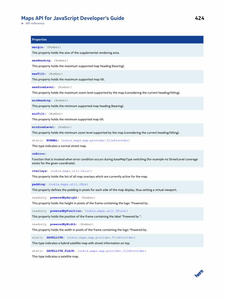
Maps API for JavaScript Developer's Guide 424► API reference
Properties
margin: {Number}
This property holds the size of the supplemental rendering area.
maxHeading: {Number}
This property holds the maximum supported map heading (bearing).
maxTilt: {Number}
This property holds the maximum supported map tilt.
maxZoomLevel: {Number}
This property holds the maximum zoom level supported by the map (considering the current heading/tilting).
minHeading: {Number}
This property holds the minimum supported map heading (bearing).
minTilt: {Number}
This property holds the minimum supported map tilt.
minZoomLevel: {Number}
This property holds the minimum zoom level supported by the map (considering the current heading/tilting).
static NORMAL: {nokia.maps.map.provider.TileProvider}
This type indicates a normal street map.
onError:
Function that is invoked when error condition occurs during baseMapType switching (for example no StreetLevel coverageexists for the given coordinate).
overlays: {nokia.maps.util.OList}
This property holds the list of all map overlays which are currently active for the map.
padding: {nokia.maps.util.IBox}
This property defines the padding in pixels for each side of the map display, thus setting a virtual viewport.
readonly poweredByHeight: {Number}
This property holds the height in pixels of the frame containing the logo "Powered by .
readonly poweredByPosition: {nokia.maps.util.IPoint}
This property holds the position of the frame containing the label "Powered by ".
readonly poweredByWidth: {Number}
This property holds the width in pixels of the frame containing the logo "Powered by .
static SATELLITE: {nokia.maps.map.provider.TileProvider}
This type indicates a hybrid satellite map with street information on top.
static SATELLITE_PLAIN: {nokia.maps.map.provider.TileProvider}
This type indicates a satellite map.
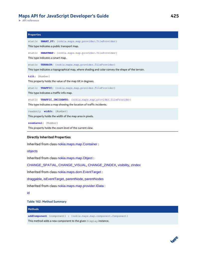
Maps API for JavaScript Developer's Guide 425► API reference
Properties
static SMART_PT: {nokia.maps.map.provider.TileProvider}
This type indicates a public transport map.
static SMARTMAP: {nokia.maps.map.provider.TileProvider}
This type indicates a smart map.
static TERRAIN: {nokia.maps.map.provider.TileProvider}
This type indicates a topographical map, where shading and color convey the shape of the terrain.
tilt: {Number}
This property holds the value of the map tilt in degrees.
static TRAFFIC: {nokia.maps.map.provider.TileProvider}
This type indicates a traffic info map.
static TRAFFIC_INCIDENTS: {nokia.maps.map.provider.TileProvider}
This type indicates a map showing the location of traffic incidents.
readonly width: {Number}
This property holds the width of the map area in pixels.
zoomLevel: {Number}
This property holds the zoom level of the current view.
Directly Inherited Properties
Inherited from class nokia.maps.map.Container :
objects
Inherited from class nokia.maps.map.Object :
CHANGE_SPATIAL, CHANGE_VISUAL, CHANGE_ZINDEX, visibility, zIndex
Inherited from class nokia.maps.dom.EventTarget :
draggable, isEventTarget, parentNode, parentNodes
Inherited from class nokia.maps.map.provider.IData :
id
Table 162: Method Summary
Methods
addComponent (component) : {nokia.maps.map.component.Component}
This method adds a new component to the given Display instance.
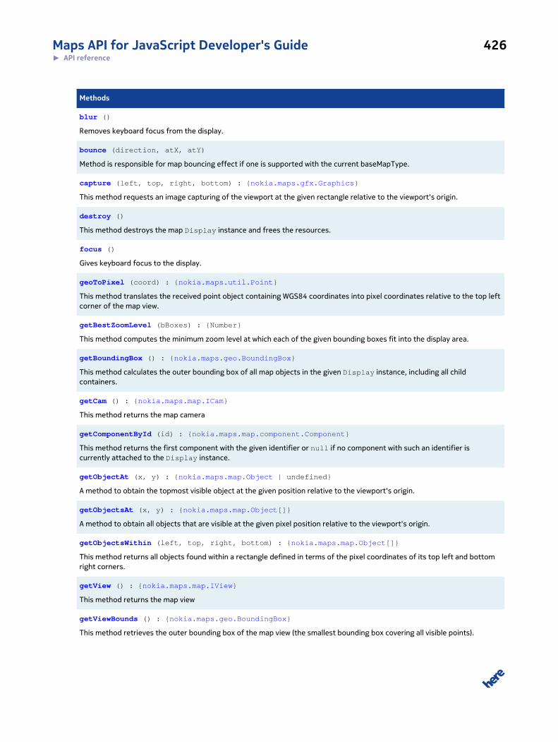
Maps API for JavaScript Developer's Guide 426► API reference
Methods
blur ()
Removes keyboard focus from the display.
bounce (direction, atX, atY)
Method is responsible for map bouncing effect if one is supported with the current baseMapType.
capture (left, top, right, bottom) : {nokia.maps.gfx.Graphics}
This method requests an image capturing of the viewport at the given rectangle relative to the viewport's origin.
destroy ()
This method destroys the map Display instance and frees the resources.
focus ()
Gives keyboard focus to the display.
geoToPixel (coord) : {nokia.maps.util.Point}
This method translates the received point object containing WGS84 coordinates into pixel coordinates relative to the top leftcorner of the map view.
getBestZoomLevel (bBoxes) : {Number}
This method computes the minimum zoom level at which each of the given bounding boxes fit into the display area.
getBoundingBox () : {nokia.maps.geo.BoundingBox}
This method calculates the outer bounding box of all map objects in the given Display instance, including all childcontainers.
getCam () : {nokia.maps.map.ICam}
This method returns the map camera
getComponentById (id) : {nokia.maps.map.component.Component}
This method returns the first component with the given identifier or null if no component with such an identifier iscurrently attached to the Display instance.
getObjectAt (x, y) : {nokia.maps.map.Object | undefined}
A method to obtain the topmost visible object at the given position relative to the viewport's origin.
getObjectsAt (x, y) : {nokia.maps.map.Object[]}
A method to obtain all objects that are visible at the given pixel position relative to the viewport's origin.
getObjectsWithin (left, top, right, bottom) : {nokia.maps.map.Object[]}
This method returns all objects found within a rectangle defined in terms of the pixel coordinates of its top left and bottomright corners.
getView () : {nokia.maps.map.IView}
This method returns the map view
getViewBounds () : {nokia.maps.geo.BoundingBox}
This method retrieves the outer bounding box of the map view (the smallest bounding box covering all visible points).
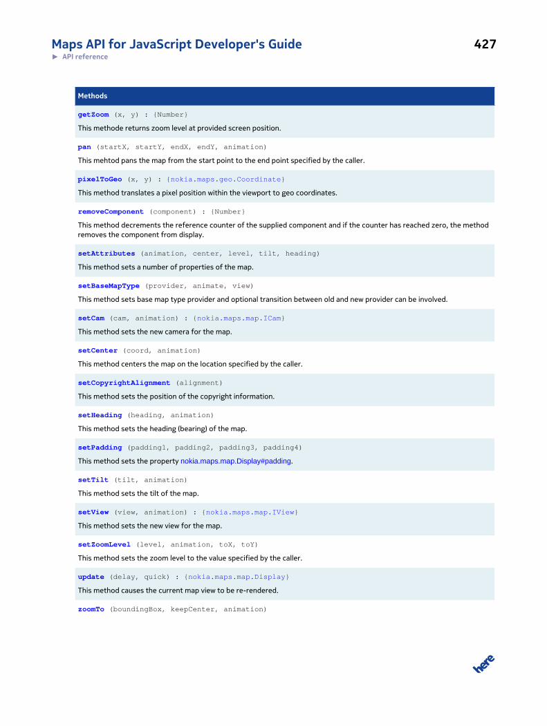
Maps API for JavaScript Developer's Guide 427► API reference
Methods
getZoom (x, y) : {Number}
This methode returns zoom level at provided screen position.
pan (startX, startY, endX, endY, animation)
This mehtod pans the map from the start point to the end point specified by the caller.
pixelToGeo (x, y) : {nokia.maps.geo.Coordinate}
This method translates a pixel position within the viewport to geo coordinates.
removeComponent (component) : {Number}
This method decrements the reference counter of the supplied component and if the counter has reached zero, the methodremoves the component from display.
setAttributes (animation, center, level, tilt, heading)
This method sets a number of properties of the map.
setBaseMapType (provider, animate, view)
This method sets base map type provider and optional transition between old and new provider can be involved.
setCam (cam, animation) : {nokia.maps.map.ICam}
This method sets the new camera for the map.
setCenter (coord, animation)
This method centers the map on the location specified by the caller.
setCopyrightAlignment (alignment)
This method sets the position of the copyright information.
setHeading (heading, animation)
This method sets the heading (bearing) of the map.
setPadding (padding1, padding2, padding3, padding4)
This method sets the property nokia.maps.map.Display#padding.
setTilt (tilt, animation)
This method sets the tilt of the map.
setView (view, animation) : {nokia.maps.map.IView}
This method sets the new view for the map.
setZoomLevel (level, animation, toX, toY)
This method sets the zoom level to the value specified by the caller.
update (delay, quick) : {nokia.maps.map.Display}
This method causes the current map view to be re-rendered.
zoomTo (boundingBox, keepCenter, animation)
Maps API for JavaScript Developer's Guide 428► API reference
Methods
This method zooms the map to ensure that the bounding box provided by the caller is visible in its entirety in the mapviewport.
Directly Inherited Methods
Inherited from class nokia.maps.map.Container :
contains, getBoundingBox
Inherited from class nokia.maps.map.Object :
destroy, getBoundingBox, getDisplay, getParent, getProvider, getRoot, isVisible
Inherited from class nokia.maps.util.OObject :
addObserver, get, remove, removeObserver, set
Inherited from class nokia.maps.dom.EventTarget :
addListener, addListenerNS, addListeners, disableDrag, disableUserSelect, dispatch, enableDrag,
enableUserSelect, hitTest, insertListener, insertListenerNS, removeAllListeners, removeListener,
removeListenerNS
Inherited from class nokia.maps.map.provider.IData :
getInvalidations
Table 163: Event Summary
Events
basemapchangeend
This event is fired to mark the end of a change from one base map type to another (for example NORMAL to SATELLITE).
basemapchangestart
This event is fired to mark the start of a change from one base map type to another (for example NORMAL to SATELLITE).
displayready
This event is fired when the map ha been initialized and is ready to support interactive events, transitions and animations.
mapvalueexceeded
This event is fired if a received value exceeds the permitted range.
mapviewchange
This event is fired each time after the map has been rendered in response to a mapviewchange event (seenokia.maps.map.Display.MapViewChangeEvent).
mapviewchangeend
This event is fired when the map display has been rendered and all map view changes have been processed (see alsonokia.maps.map.Display.MapViewChangeEvent).

Maps API for JavaScript Developer's Guide 429► API reference
Events
mapviewchangestart
This event is fired immediately after the map view has been changed (see nokia.maps.map.Display.MapViewChangeEvent).
resize
This event is fired each time a change of the size of the display is detected.
resizeend
This event is fired when a resizing operation has finished (when no more changes to the size of the display have beendetected for a certain amount of time).
resizestart
This event is fired immediately after the process of resizing the display has begun and then periodically until the process hascompleted, when resizeend is fired.
transitionend
This event is fired immediately after a map animation has finished or a transition from one base map type to another (in thelatter case the event precedes nokia.maps.map.Display#basemapchangeend).
transitionstart
This event is fired immediately after a map animation starts or a transition from one base map type to another (in the lattercase the event follows nokia.maps.map.Display#basemapchangestart).
Directly Inherited Events
Inherited from class nokia.maps.dom.MouseEventTarget :
click, dblclick, longpress, mousedown, mouseenter, mouseleave, mousemove, mouseout, mouseover,
mouseup, mousewheel
Inherited from class nokia.maps.dom.DragEventTarget :
drag, dragend, dragenter, dragleave, dragover, dragstart, drop
Inherited from class nokia.maps.dom.TouchEventTarget :
dbltap, gesturechange, gestureend, gesturestart, longpress, tap, touchend, touchmove, touchstart
Class Description
This class displays a map, allowing multiple optional layers (containers) and objects such as markers,
polylines, polygons, cirles, etc., to be added to it.
Constructor Details
nokia.maps.map.Display(container, props)
This method displays a map, allowing multiple containers and objects to be added to it.
Maps API for JavaScript Developer's Guide 430► API reference
Parameters:
container: {HTMLElement}
The DOM node where the map should be displayed
props: {nokia.maps.map.Display.Properties} [optional]
An object containing initialization properties
Property Details
animation: {nokia.maps.util.OList}
This property specifies the currently supported map animation types.
Animations depend on the platform and the rendering engine used, therefore this property must be
checked at run-time to see if a specific animation is supported by the current rendering engine on
the current platform.
In all cases, the following values for this property are supported:
• "none" - no animation
• "default" - default animation
Note 1: The default animation may be set to "none", which means that the rendering engine on the
current platform does not support animation.
Note 2: If you specify an incorrect animation name, the animation type automatically reverts to
"default".
availableBaseMapTypes: {nokia.maps.util.OList}
This property holds a list of all available nokia.maps.map.provider.Providers for base map types.
availableOverlays: {nokia.maps.util.OList}
This property holds a list of all available nokia.maps.map.provider.Providers for map overlays.
baseMapType: {nokia.maps.map.provider.Provider}
This property holds the current base map type to be used for display (such as
satellite, terrain, hybrid). The given type must be one of the supported types. See
nokia.maps.map.Display#availableBaseMapTypes
Maps API for JavaScript Developer's Guide 431► API reference
bounceEnabled: {Boolean}
This property keeps a flag to signal if the bouncing effect is activated or not
Default Value: true
center: {nokia.maps.geo.Coordinate}
This property contains the coordinates of the map center.
components: {nokia.maps.util.OList}
This property holds a list of all components that have been added to the map (to the given instance
of nokia.maps.map.Display).
copyrightAlignment: {String}
This property specifies the position of the copyright information relative to the display. The allowed
values are:
• topleft
• topcenter
• topright
• middleleft
• middlecenter
• middleright
• bottomleft
• bottomcenter
• bottomright
Default Value: "bottomleft"
readonly copyrightHeight: {Number}
This property holds the height in pixels of the frame containing the text "Copyright by ...".
Maps API for JavaScript Developer's Guide 432► API reference
readonly copyrightPosition: {nokia.maps.util.IPoint}
This property holds the position of the frame containing the label "Copyright by ".
readonly copyrightWidth: {Number}
This property holds the width in pixels of the frame containing the text "Copyright by ...".
fixedCenter: {Boolean}
This property is a flag indicating if the center of the map should remain unchanged if the display is
resized or padding changes.
Default Value: true
heading: {Number}
This property holds the heading (bearing) of the map in degrees. The property depends on the
platform used and is only available if maxHeading is greater than 0.
readonly height: {Number}
This property holds the height of the map area in pixels.
margin: {Number}
This property holds the size of the supplemental rendering area. The renderer must be prepared to
allow rapid mouse panning within the displayed area extended on each side by the given margin (in
pixels).
Default Value: 0
maxHeading: {Number}
This property holds the maximum supported map heading (bearing). You can obtain the maximum
supported heading by invoking the method get() on an instance of Display, with the name of this
property as the only argument. For example, if "myMap" is an instance of map.Display, then the
code myMap.get("maxHeading") obtains the current value of maxHeading.
Maps API for JavaScript Developer's Guide 433► API reference
maxTilt: {Number}
This property holds the maximum supported map tilt. You can obtain the maximum supported
tilt by invoking the method get() on an instance of Display, with the name of this property
as the only argument. For example, if "myMap" is an instance of map.Display, then the code
myMap.get("maxTilt") obtains the current value of maxTilt.
maxZoomLevel: {Number}
This property holds the maximum zoom level supported by the map (considering the current
heading/tilting). You can obtain the maximum supported zoom level by invoking the method get()
on an instance of Display, with the name of this property as the only argument. For example, if
"myMap" is an instance of map.Display, then the code myMap.get("maxZoomLevel") obtains
the current value of maxZoomLevel.
minHeading: {Number}
This property holds the minimum supported map heading (bearing). You can obtain the minimum
supported heading by invoking the method get() on an instance of Display, with the name of this
property as the only argument. For example, if "myMap" is an instance of map.Display, then the
code myMap.get("minHeading") obtains the current value of minHeading.
minTilt: {Number}
This property holds the minimum supported map tilt. You can obtain the minimum supported
tilt by invoking the method get() on an instance of Display, with the name of this property
as the only argument. For example, if "myMap" is an instance of map.Display, then the code
myMap.get("minTilt") obtains the current value of minTilt.
minZoomLevel: {Number}
This property holds the minimum zoom level supported by the map (considering the current heading/
tilting). You can obtain the minimum supported zoom level by invoking the method get() on an
instance of Display, with the name of this property as the only argument. For example, if "myMap"
is an instance of map.Display, then the code myMap.get("minZoomLevel") obtains the current
value of minZoomLevel.
Maps API for JavaScript Developer's Guide 434► API reference
static NORMAL: {nokia.maps.map.provider.TileProvider}
This type indicates a normal street map.
onError:
Function that is invoked when error condition occurs during baseMapType switching (for example no
StreetLevel coverage exists for the given coordinate). By default does nothing.
overlays: {nokia.maps.util.OList}
This property holds the list of all map overlays which are currently active for the map.
padding: {nokia.maps.util.IBox}
This property defines the padding in pixels for each side of the map display, thus setting a virtual
viewport. The virtual viewport does not affect the placing or the size of the visible map in the DOM
node, but defines an area which excludes strips along the edges of the map that contain the UI
elements zoom bar, copyright and map-type selector (if these elements are displayed). The virtual
viewport is taken into consideration when setting the map center, when obtaining the map view
bounds and when zooming to a bounding box. Its other purpose is to help prevent objects from
overlapping very close to the edges of the visible map.
The map viewport determined by padding is taken into account when setting the map center, which
is the center of the virtual viewport, not of the visible map. Furthermore, the viewport is used by the
following methods:
• nokia.maps.map.Display#setCenter - the map is centered in the virtual viewport, not in the visible
area of the map
• nokia.maps.map.Display#getViewBounds - the method calculates and returns the bounding box
of the virtual view port
• nokia.maps.map.Display#zoomTo - the method sets the zoom level to ensure that the entire
bounding box passed to it is visible in the virtual viewport
padding cannot be changed directly. Please use the methods nokia.maps.map.Display#setPadding
or the inherited nokia.maps.util.OObject#set instead. For example, you can call the method set() as
follows:
set("padding", aPadding);
Maps API for JavaScript Developer's Guide 435► API reference
readonly poweredByHeight: {Number}
This property holds the height in pixels of the frame containing the logo "Powered by ...".
readonly poweredByPosition: {nokia.maps.util.IPoint}
This property holds the position of the frame containing the label "Powered by ".
readonly poweredByWidth: {Number}
This property holds the width in pixels of the frame containing the logo "Powered by ...".
static SATELLITE: {nokia.maps.map.provider.TileProvider}
This type indicates a hybrid satellite map with street information on top.
static SATELLITE_PLAIN: {nokia.maps.map.provider.TileProvider}
This type indicates a satellite map.
static SMART_PT: {nokia.maps.map.provider.TileProvider}
This type indicates a public transport map. It is uses the smart map color scheme with additional
public transport route lines on top. Availability of public transport information may vary.
static SMARTMAP: {nokia.maps.map.provider.TileProvider}
This type indicates a smart map. It is similar to normal street map, but uses an optimized color set
ready to show additional overlay information.
static TERRAIN: {nokia.maps.map.provider.TileProvider}
This type indicates a topographical map, where shading and color convey the shape of the terrain.
tilt: {Number}
This property holds the value of the map tilt in degrees. The property is platform dependent and is
available only if maxTilt is greater than 0.
Maps API for JavaScript Developer's Guide 436► API reference
static TRAFFIC: {nokia.maps.map.provider.TileProvider}
This type indicates a traffic info map. Since version 2.5.3 it can be used as a base map. Availability of
traffic information may vary.
static TRAFFIC_INCIDENTS: {nokia.maps.map.provider.TileProvider}
This type indicates a map showing the location of traffic incidents. It is an overlay which can be added
on top of other base map types. Availability of traffic information may vary.
readonly width: {Number}
This property holds the width of the map area in pixels.
zoomLevel: {Number}
This property holds the zoom level of the current view.
Method Details
addComponent(component): {nokia.maps.map.component.Component}
This method adds a new component to the given Display instance. If a component with the same id
already exists (has been added previously), the method returns that component after incrementing
its reference counter (the method does not create/add multiple instances of the same component).
Parameters:
component: {nokia.maps.map.component.Component}
A reference to the component to be added
Returns:
{nokia.maps.map.component.Component}
A reference to the newly added component or to the existing component
with the same identifier
Maps API for JavaScript Developer's Guide 437► API reference
Example:
var component = display.addComponent(new nokia.maps.map.component.zoom.DoubleClick());
blur()
Removes keyboard focus from the display.
Since: 2.5
bounce(direction, atX, atY)
Method is responsible for map bouncing effect if one is supported with the current baseMapType.
Parameters:
direction: {Boolean} [optional]
if value is true map bounces in opposite direction
atX: {Number} [optional]
screen X coordinate at which bounce effect takes place (defaults to screen
center)
atY: {Number} [optional]
screen Y coordinate at which bounce effect takes place (defaults to screen
center)
capture(left, top, right, bottom): {nokia.maps.gfx.Graphics}
This method requests an image capturing of the viewport at the given rectangle relative to the
viewport's origin.
Parameters:
left: {Number} [optional, default: 0]
The X coordinate of the left edge of the rectangle.
top: {Number} [optional, default: 0]
Maps API for JavaScript Developer's Guide 438► API reference
The Y coordinate of the top edge of the rectangle
right: {Number} [optional, default: width]
The X coordinate of the right edge of the rectangle
bottom: {Number} [optional, default: height]
The Y coordinate of the bottom edge of the rectangle
Returns:
{nokia.maps.gfx.Graphics}
destroy()
This method destroys the map Display instance and frees the resources. The method may take up
to a minute to complete, but afterwards, all of Display's properties are set to null and its methods
are bound to an empty function.
focus()
Gives keyboard focus to the display.
Since: 2.5
geoToPixel(coord): {nokia.maps.util.Point}
This method translates the received point object containing WGS84 coordinates into pixel
coordinates relative to the top left corner of the map view. The coordinates of the top left corner of
the map are (0,0).
Note that the result values outside the visible map area are likely to be very unreliable.
Parameters:
coord: {nokia.maps.geo.Coordinate}
A point object containing WGS84 coordinates to be translated into a pixel
position
Returns:
Maps API for JavaScript Developer's Guide 439► API reference
{nokia.maps.util.Point}
An object containing the x and y pixel coordinates relative to the top left
corner of the current viewport
getBestZoomLevel(bBoxes): {Number}
This method computes the minimum zoom level at which each of the given bounding boxes fit into
the display area.
Parameters:
bBoxes: {nokia.maps.geo.BoundingBox[]}
A list of bounding boxes.
Returns:
{Number} the computed zoom level
getBoundingBox(): {nokia.maps.geo.BoundingBox}
This method calculates the outer bounding box of all map objects in the given Display instance,
including all child containers. If the display does not contain any objects or child containers, the
method returns null. If the display contains only one object that has no geographical dimensions
such as a nokia.maps.map.Marker or nokia.maps.map.StandardMarker, then the returned bounding
box may have the size of zero.
Note that the method does not return the bounding box of the current viewport. For this purpose,
please use the method nokia.maps.map.Display#getViewBounds.
Returns:
{nokia.maps.geo.BoundingBox}
The calculated geographic outer bounding box of all map objects in the dis-
play or null, if the display does not contain any map objects
See: nokia.maps.map.Display#getViewBounds
getCam(): {nokia.maps.map.ICam}
Maps API for JavaScript Developer's Guide 440► API reference
This method returns the map camera
Returns:
{nokia.maps.map.ICam}
getComponentById(id): {nokia.maps.map.component.Component}
This method returns the first component with the given identifier or null if no component with such
an identifier is currently attached to the Display instance.
Parameters:
id: {String}
The identifier of the component to retrieve
Returns:
{nokia.maps.map.component.Component}
The first component from the list of components with the given identifier
or null if no component with such an identifier is currently attached to the
Display instance
getObjectAt(x, y): {nokia.maps.map.Object | undefined}
A method to obtain the topmost visible object at the given position relative to the viewport's origin.
Parameters:
x: {Number}
The X coordinate of the pixel position
y: {Number}
The Y coordinate of the pixel position
Returns:
{nokia.maps.map.Object
| undefined}
Maps API for JavaScript Developer's Guide 441► API reference
the top most object found at the given position or undefined if no object
has been found
getObjectsAt(x, y): {nokia.maps.map.Object[]}
A method to obtain all objects that are visible at the given pixel position relative to the viewport's
origin. The list is sorted according to the drawing order of the objects. The top most object has an
index of 0 in returned array.
Parameters:
x: {Number}
The X-coordinate of the pixel position
y: {Number}
The Y-coordinate of the pixel position
Returns:
{nokia.maps.map.Object[]}
the list of map objects found at the given pixel position
getObjectsWithin(left, top, right, bottom): {nokia.maps.map.Object[]}
This method returns all objects found within a rectangle defined in terms of the pixel coordinates of
its top left and bottom right corners.
Parameters:
left: {Number}
The left edge of the rectangle as a number of pixels relative to viewport ori-
gin
top: {Number}
The top edge of the rectangle as a number of pixels relative to viewport ori-
gin
right: {Number}
Maps API for JavaScript Developer's Guide 442► API reference
The right edge of the rectangle as a number of pixels relative to viewport
origin
bottom: {Number}
The bottom edge of the rectangle as a number of pixels relative to viewport
origin
Returns:
{nokia.maps.map.Object[]}
A list of map objects found within the given rectangle
getView(): {nokia.maps.map.IView}
This method returns the map view
Returns:
{nokia.maps.map.IView}
getViewBounds(): {nokia.maps.geo.BoundingBox}
This method retrieves the outer bounding box of the map view (the smallest bounding box covering
all visible points).
Returns:
{nokia.maps.geo.BoundingBox}
The outer bounding box of the map view.
getZoom(x, y): {Number}
This methode returns zoom level at provided screen position.
Parameters:
x: {Number} [optional]
The x-component of the screen coordinate.
Maps API for JavaScript Developer's Guide 443► API reference
y: {Number} [optional]
The y-component of the screen coordinate.
Returns:
{Number} a zoom level at the given screen position
pan(startX, startY, endX, endY, animation)
This mehtod pans the map from the start point to the end point specified by the caller. Both points
are defined in terms of screen coordinates. The effect is that the location under the end point
moves to the screen coordinates given by the start point. This operation may use a platform specific
animation if indicated by the corresponding optional animation string.
Parameters:
startX: {Number}
The x-position of the pixel relative to the top-left corner of the current view,
indicating the x-coordinate of the point from which to to start panning
startY: {Number}
The y-position of the pixel relative to the top-left corner of the current view,
indicating the y-coordinate of the point from which to start panning
endX: {Number}
The x-position of the pixel relative to the top-left corner of the current view,
indicating the x-coordinate of the point to which to pan
endY: {Number}
The y-position of the pixel relative to the top-left corner of the current view,
indicating the y-coordinates of the point to which to pan
animation: {String} [optional]
The animation to be used while modifying the view, must be a value from the
list of animation types nokia.maps.map.Display#animation
Maps API for JavaScript Developer's Guide 444► API reference
pixelToGeo(x, y): {nokia.maps.geo.Coordinate}
This method translates a pixel position within the viewport to geo coordinates. The pixel position
is relative to the top left corner of the viewport, (0,0), which is also the top left corner of the visible
map. Note: Result values outside the visible map area are likely to be very unreliable.
Parameters:
x: {Number}
The x-coordinate of the pixel position to be translated into longitude.
y: {Number}
The y-coordinate of the pixel position to be translated into latitude.
Returns:
{nokia.maps.geo.Coordinate}
A point object containing the WGS84 coordinates of the caller-supplied pixel
position.
removeComponent(component): {Number}
This method decrements the reference counter of the supplied component and if the counter has
reached zero, the method removes the component from display.
Parameters:
component: {nokia.maps.map.component.Component}
A reference to the component to be removed.
Returns:
{Number} The value of the reference counter of the component after the remove call
(the element is not removed if this value is greater than zero)
Example:
display.removeComponent(display.getComponentById("zoom.DoubleClick"));
Maps API for JavaScript Developer's Guide 445► API reference
setAttributes(animation, center, level, tilt, heading)
This method sets a number of properties of the map. The properties include animation, map center,
zoom level, map tilt, and map bearing. You must provide actual values only for those properties you
wish to change, and undefined for those that should not be altered.
Parameters:
animation: {String}
The animation to be used while modifying the map attributes; must be a val-
ue from the list of animation types nokia.maps.map.Display#animation
center: {nokia.maps.geo.Coordinate}
The new map center given as an object containing geographical coordinates
level: {Number}
The new zoom level given as a value between
nokia.maps.map.Display#minZoomLevel and
nokia.maps.map.Display#maxZoomLevel
tilt: {Number}
The new value of map tilt in degrees given as a value between
nokia.maps.map.Display#minTilt and nokia.maps.map.Display#maxTilt
heading: {Number}
The new map heading (bearing) given as a value be-
tween nokia.maps.map.Display#minHeading and
nokia.maps.map.Display#maxHeading
setBaseMapType(provider, animate, view)
This method sets base map type provider and optional transition between old and new provider can
be involved. There should be also defined view or camera for new base map type so together with
animation there should be smooth transition between old base map type and old view/camera and
new ones.
Parameters:
provider: {nokia.maps.map.provider.Provider}
Maps API for JavaScript Developer's Guide 446► API reference
One of the available providers at
nokia.maps.map.Display.availableBaseMapTypes
animate: {String} [optional]
the animation to be used while modifying the view; must be a value from the
list of animation types nokia.maps.map.Display#animation
view: {nokia.maps.map.IView} [optional]
New view for new base map type
setCam(cam, animation): {nokia.maps.map.ICam}
This method sets the new camera for the map.
Parameters:
cam: {nokia.maps.map.ICam}
New camera
animation: {String} [optional]
The animation to be used while modifying the camera; must be a value from
the list of animation types nokia.maps.map.Display#animation
Returns:
{nokia.maps.map.ICam}
Returns adjusted camera to closest available camera.
setCenter(coord, animation)
This method centers the map on the location specified by the caller. The method may use a platform
specific animation if indicated by the corresponding optional animation string.
Parameters:
coord: {nokia.maps.geo.Coordinate}
Maps API for JavaScript Developer's Guide 447► API reference
The location on which to center the map specified in terms of WGS84 coor-
dinates
animation: {String} [optional]
The animation to be used while modifying the map center; must be a value
from the list of animation types nokia.maps.map.Display#animation
setCopyrightAlignment(alignment)
This method sets the position of the copyright information.
Parameters:
alignment: {String}
The alignment relative to the map viewport, where the copyright is to be
placed.
See: nokia.maps.map.Display#copyrightAlignment
setHeading(heading, animation)
This method sets the heading (bearing) of the map. The method may use a platform-specific
animation if this is indicated by the corresponding optional animation string.
Parameters:
heading: {Number}
The new value of map heading (bearing) as a number of de-
grees; a value between nokia.maps.map.Display#minHeading and
nokia.maps.map.Display#maxHeading
animation: {String} [optional]
The animation to be used while modifying the heading; must be a value from
the list of animation types nokia.maps.map.Display#animation.
setPadding(padding1, padding2, padding3, padding4)
Maps API for JavaScript Developer's Guide 448► API reference
This method sets the property nokia.maps.map.Display#padding. The method accepts up to four
arguments which provide padding values in the following order: top, right, bottom, left.
The caller must supply at least one argument and optionally up to four as shown in these examples:
• setPadding(topRightBottomLeft); - one argument/value, indicates identical padding all
round
• setPadding(topAndBottom, rightAndLeft); - the fist argument sets top and bottom
padding, the second right and left padding
• setPadding(top, rightAndLeft, bottom); - the second argument sets right and left
padding, the first and third arguments set top and bottom padding, respectively
• setPadding(top, right, bottom, left); - the first argument sets top padding, the
second right padding, the third bottom padding, and the fourth left padding
Parameters:
padding1: {Number}
Top padding in pixels; if this is the only argument provided, it is used also to
set right, bottom and left padding (padding is identical all round); if the caller
provides only two arguments, padding1 sets both top and bottom padding
padding2: {Number} [optional]
Right padding in pixels; if padding4 (left padding) is not specified by the
caller, this argument determines both right and left padding
padding3: {Number} [optional]
Bottom padding in pixels; if not provided, its value is the same as that of
padding1 (top padding)
padding4: {Number} [optional]
Left padding in pixels; if not provided, its value is supplied by padding2
(right padding) or padding1 (top padding) if padding2 is not provided
setTilt(tilt, animation)
This method sets the tilt of the map. It may use a platform-specific animation if indicated by the
corresponding optional animation string.
Parameters:
Maps API for JavaScript Developer's Guide 449► API reference
tilt: {Number}
The new value of map tilt in degrees, a value between
nokia.maps.map.Display#minTilt and nokia.maps.map.Display#maxTilt.
animation: {String} [optional]
The animation to be used while modifying the tilt; must be a value from the
list of animation types nokia.maps.map.Display#animation.
setView(view, animation): {nokia.maps.map.IView}
This method sets the new view for the map.
Parameters:
view: {nokia.maps.map.IView}
New view
animation: {String} [optional]
The animation to be used while modifying the view; must be a value from the
list of animation types nokia.maps.map.Display#animation
Returns:
{nokia.maps.map.IView}
Returns adjusted view to closest available view.
setZoomLevel(level, animation, toX, toY)
This method sets the zoom level to the value specified by the caller. The caller must provide the
zoom level and can also supply the animation type and the screen coordinates of a point on which
to zoom in (via the arguments toX and toY). This point may correspond, for example, to the mouse
position at the time when the user scrolls the mouse wheel to zoom in or out.
Parameters:
level: {Number}
Maps API for JavaScript Developer's Guide 450► API reference
The new zoom level to be set, a value between
nokia.maps.map.Display#minZoomLevel and
nokia.maps.map.Display#maxZoomLevel
animation: {String} [optional]
The animation to be used while modifying the zoom level; must be a value
from the list of animation types nokia.maps.map.Display#animation
toX: {Number} [optional]
The x-position of the pixel relative to the top-left corner of the current view
to stay fixed
toY: {Number} [optional]
The y-position of the pixel relative to the top-left corner of the current view
to stay fixed
update(delay, quick): {nokia.maps.map.Display}
This method causes the current map view to be re-rendered.
Parameters:
delay: {Number} [optional]
The maximum acceptable delay before the next frame is rendered as a
number of milliseconds; if the value is zero or less, rendering occurs syn-
chronously or at the earliest opportunity; if the argument is omitted or un-
defined, the system determines when to carry out re-rendering
quick: {Boolean} [optional, default: false]
A Boolean to indicate whether full rendering (false) or only quick render-
ing (true is to be performed; quick rendering uses only cached data, while
full rendering may request new data and cause new or modified objects to
be rendered; the argument is ignored if delay is omitted or undefined
Returns:
{nokia.maps.map.Display}
Maps API for JavaScript Developer's Guide 451► API reference
A reference to the given instance of Display (this).
zoomTo(boundingBox, keepCenter, animation)
This method zooms the map to ensure that the bounding box provided by the caller is visible in
its entirety in the map viewport. The caller has the option of retaining the current map center,
which may cause the zoom to be adjusted so that the bounding box is visible while the map center
remains unchanged. The method may use a platform specific animation if this is indicated by the
corresponding optional animation string.
Parameters:
boundingBox: {nokia.maps.geo.BoundingBox}
The bounding box that is to be visible in its entirety in the map viewport
keepCenter: {Boolean}
A Boolean indicating whether to keep the map center unchanged (true) or if
the view center may change (false);
animation: {String} [optional]
The animation to be used; must be a value from the list of animation types
nokia.maps.map.Display#animation.
Event Details
basemapchangeend
This event is fired to mark the end of a change from one base map type to another (for example
NORMAL to SATELLITE). Until this event has been detected, the map should ignore calls to methods
that alter the map view. See also nokia.maps.map.Display.TransitionEvent.
Event Handler Param-
eters:
event {nokia.maps.map.Display.TransitionEvent}
basemapchangestart
Maps API for JavaScript Developer's Guide 452► API reference
This event is fired to mark the start of a change from one base map type to another
(for example NORMAL to SATELLITE). After this event has been fired and until
nokia.maps.map.Display#basemapchangeend has been detected, the map should ignore calls to
methods that alter the map view. See also nokia.maps.map.Display.TransitionEvent.
Event Handler Param-
eters:
event {nokia.maps.map.Display.TransitionEvent}
displayready
This event is fired when the map ha been initialized and is ready to support interactive
events, transitions and animations. No code related to map view manipulation, such as
calls to nokia.maps.map.Display#setZoomLevel, nokia.maps.map.Display#setCenter,
nokia.maps.map.Display#setBaseMapType, etc., must be allowed to run (although components
or markers can be added to the map and other operations that do not affect the map view can be
performed). See also nokia.maps.map.Display.TransitionEvent.
Event Handler Param-
eters:
event {nokia.maps.map.Display.TransitionEvent}
mapvalueexceeded
This event is fired if a received value exceeds the permitted range. (see
nokia.maps.map.Display.MapValueExceededEvent).
Event Handler Param-
eters:
event {nokia.maps.map.Display.MapValueExceededEvent}
mapviewchange
This event is fired each time after the map has been rendered in response to a mapviewchange
event (see nokia.maps.map.Display.MapViewChangeEvent).
The data property of the event object provides information on all the changes that have been
effected. (see nokia.maps.map.Display.MapViewChangeEvent#data).
Maps API for JavaScript Developer's Guide 453► API reference
Note that a large number of mapviewchange events can be fired within the space of a second,
therefore it is advisable to avoid time-consuming operations within mapviewchange listeners.
Event Handler Param-
eters:
event {nokia.maps.map.Display.MapViewChangeEvent}
mapviewchangeend
This event is fired when the map display has been rendered and all map view changes have been
processed (see also nokia.maps.map.Display.MapViewChangeEvent). It indicates that you can safely
execute more expensive operations to respond to a map view change (for example UI updates).
Event Handler Param-
eters:
event {nokia.maps.map.Display.MapViewChangeEvent}
mapviewchangestart
This event is fired immediately after the map view has been changed (see
nokia.maps.map.Display.MapViewChangeEvent). It is fired only for the first change of the map view
after the rendering of the map display has been completed.
Event Handler Param-
eters:
event {nokia.maps.map.Display.MapViewChangeEvent}
resize
This event is fired each time a change of the size of the display is detected. It is fired multiple times
during a continuos resize operation (for example, if the display is being resized due to user input).
Note that resizing a map also triggers mapviewchange events.
Event Handler Param-
eters:
event {nokia.maps.dom.Event}
Maps API for JavaScript Developer's Guide 454► API reference
resizeend
This event is fired when a resizing operation has finished (when no more changes to the size of the
display have been detected for a certain amount of time).
Note that resizing a map also triggers mapviewchange events.
Event Handler Param-
eters:
event {nokia.maps.dom.Event}
resizestart
This event is fired immediately after the process of resizing the display has begun and then
periodically until the process has completed, when resizeend is fired.
Note that resizing a map also triggers mapviewchange events.
Event Handler Param-
eters:
event {nokia.maps.dom.Event}
transitionend
This event is fired immediately after a map animation has finished or a transition from one base map
type to another (in the latter case the event precedes nokia.maps.map.Display#basemapchangeend).
Until this event has been detected, the map should ignore calls to methods that alter the map view.
See also nokia.maps.map.Display.TransitionEvent.
Event Handler Param-
eters:
event {nokia.maps.map.Display.TransitionEvent}
transitionstart
This event is fired immediately after a map animation starts or a transition from one base map type
to another (in the latter case the event follows nokia.maps.map.Display#basemapchangestart).
After this event was fired and until nokia.maps.map.Display#transitionend has been
Maps API for JavaScript Developer's Guide 455► API reference
detected, the map should ignore calls to methods that alter the map view. See also
nokia.maps.map.Display.TransitionEvent.
Event Handler Param-
eters:
event {nokia.maps.map.Display.TransitionEvent}
Class: BaseMapChangeEvent
This class is a member of nokia.maps.map.Display.
Class Summary
This class represents an event used to signal state of switching between base map types.
[ For full details, see nokia.maps.map.Display.BaseMapChangeEvent ]
Table 164: Property Summary
Properties
baseMapData: {Object}
This property represents an object which contains additional data about event:
• old - old base map type
• current - newly set base map type
Directly Inherited Properties
Inherited from class nokia.maps.map.Object.Event :
display, displayObjects, displayX, displayY
Inherited from class nokia.maps.dom.Event :
AT_TARGET, bubbles, BUBBLING_PHASE, canBubble, cancelable, canSicker, CAPTURING_PHASE,
currentTarget, defaultPrevented, eventPhase, namespaceURI, nativeEvent, page, propagation,
PROPAGATION_OK, PROPAGATION_STOP, PROPAGATION_STOP_IMMEDIATE, target,
timeStamp, type
Method Summary
Directly Inherited Methods
Inherited from class nokia.maps.dom.Event :
Maps API for JavaScript Developer's Guide 456► API reference
cancel, clone, preventDefault, preventUnload, stopImmediatePropagation, stopPropagation
Class Description
This class represents an event used to signal state of switching between base map types.
Constructor Details
nokia.maps.map.Display.BaseMapChangeEvent(defaults)
This method initializes a new instance of BaseMapChangeEvent.
Parameters:
defaults: {Object} [optional]
see constructor parameter of nokia.maps.dom.Event
Property Details
baseMapData: {Object}
This property represents an object which contains additional data about event:
• old - old base map type
• current - newly set base map type
Class: DisplayReadyEvent
This class is a member of nokia.maps.map.Display.
Class Summary
This class represents an event used to signal the moment in which map is fully functional and ready
to use after initialization
[ For full details, see nokia.maps.map.Display.DisplayReadyEvent ]
Property Summary
Directly Inherited Properties
Inherited from class nokia.maps.map.Object.Event :
display, displayObjects, displayX, displayY
Inherited from class nokia.maps.dom.Event :
Maps API for JavaScript Developer's Guide 457► API reference
AT_TARGET, bubbles, BUBBLING_PHASE, canBubble, cancelable, canSicker, CAPTURING_PHASE,
currentTarget, defaultPrevented, eventPhase, namespaceURI, nativeEvent, page, propagation,
PROPAGATION_OK, PROPAGATION_STOP, PROPAGATION_STOP_IMMEDIATE, target,
timeStamp, type
Method Summary
Directly Inherited Methods
Inherited from class nokia.maps.dom.Event :
cancel, clone, preventDefault, preventUnload, stopImmediatePropagation, stopPropagation
Class Description
This class represents an event used to signal the moment in which map is fully functional and ready
to use after initialization
Constructor Details
nokia.maps.map.Display.DisplayReadyEvent(defaults)
This method initializes a new instance of DisplayReadyEvent.
Parameters:
defaults: {Object} [optional]
see constructor parameter of nokia.maps.dom.Event
Class: MapValueExceededEvent
This class is a member of nokia.maps.map.Display.
Class Summary
This class represents an event used to signal that value assigned to the property is out of supported
range Setting the following values can trigger this event:
• nokia.maps.map.Display#zoomLevel
• nokia.maps.map.IView#zoom
• nokia.maps.map.ICam#fov
[ For full details, see nokia.maps.map.Display.MapValueExceededEvent ]
Maps API for JavaScript Developer's Guide 458► API reference
Property Summary
Directly Inherited Properties
Inherited from class nokia.maps.map.Object.Event :
display, displayObjects, displayX, displayY
Inherited from class nokia.maps.dom.Event :
AT_TARGET, bubbles, BUBBLING_PHASE, canBubble, cancelable, canSicker, CAPTURING_PHASE,
currentTarget, defaultPrevented, eventPhase, namespaceURI, nativeEvent, page, propagation,
PROPAGATION_OK, PROPAGATION_STOP, PROPAGATION_STOP_IMMEDIATE, target,
timeStamp, type
Method Summary
Directly Inherited Methods
Inherited from class nokia.maps.dom.Event :
cancel, clone, preventDefault, preventUnload, stopImmediatePropagation, stopPropagation
Class Description
This class represents an event used to signal that value assigned to the property is out of supported
range Setting the following values can trigger this event:
• nokia.maps.map.Display#zoomLevel
• nokia.maps.map.IView#zoom
• nokia.maps.map.ICam#fov
Constructor Details
nokia.maps.map.Display.MapValueExceededEvent(defaults)
This method initializes a new instance of MapValueExceededEvent.
Parameters:
defaults: {Object} [optional]
see constructor parameter of nokia.maps.dom.Event
Class: MapViewChangeEvent
This class is a member of nokia.maps.map.Display.
Maps API for JavaScript Developer's Guide 459► API reference
Class Summary
This class represents an event that signals changes to the map view.
[ For full details, see nokia.maps.map.Display.MapViewChangeEvent ]
Table 165: Property Summary
Properties
data: {Number}
This bitmask property contains cumulative information about the map view properties which were altered during displayrendering.
static MAPVIEWCHANGE_CENTER: {Number}
This constant represents a bit flag that indicates a change in coordinates of the map center.
static MAPVIEWCHANGE_HEADING: {Number}
This constant represents a bit flag that indicates a change in the heading (bearing) of the map.
static MAPVIEWCHANGE_INCLINE: {Number}
This constant represents a bit flag that indicates a change of the incline.
static MAPVIEWCHANGE_SIZE: {Number}
This constant represents a bit flag that indicates a change in the size of the display.
static MAPVIEWCHANGE_TILT: {Number}
This constant represents a bit flag that indicates a change in the tilt of the map.
static MAPVIEWCHANGE_ZOOM: {Number}
This constant represents a bit flag that indicates a change in the map zoom level.
valueData: {Object}
This property represents an object which contains additional data about event:
• propertyName - name of the property that have been modified,
• value - value passed to the property,
• min - minimal allowed value for the property,
• max -maximum value of the property
Directly Inherited Properties
Inherited from class nokia.maps.map.Object.Event :
display, displayObjects, displayX, displayY
Inherited from class nokia.maps.dom.Event :
Maps API for JavaScript Developer's Guide 460► API reference
AT_TARGET, bubbles, BUBBLING_PHASE, canBubble, cancelable, canSicker, CAPTURING_PHASE,
currentTarget, defaultPrevented, eventPhase, namespaceURI, nativeEvent, page, propagation,
PROPAGATION_OK, PROPAGATION_STOP, PROPAGATION_STOP_IMMEDIATE, target,
timeStamp, type
Method Summary
Directly Inherited Methods
Inherited from class nokia.maps.dom.Event :
cancel, clone, preventDefault, preventUnload, stopImmediatePropagation, stopPropagation
Class Description
This class represents an event used to signal changes of the map view. A map view is defined by the
following display properties:
• nokia.maps.map.Display.Properties#center
• nokia.maps.map.Display.Properties#zoomLevel
• nokia.maps.map.Display.Properties#heading
• nokia.maps.map.Display.Properties#tilt
• nokia.maps.map.Display#width
• nokia.maps.map.Display#height
Constructor Details
nokia.maps.map.Display.MapViewChangeEvent(defaults)
This method initializes a new instance of MapViewChangeEvent.
Parameters:
defaults: {Object} [optional]
see constructor parameter of nokia.maps.dom.Event
Property Details
data: {Number}
This bitmask property contains cumulative information about the map view properties which
were altered during display rendering. It is only set for nokia.maps.map.Display#mapviewchange,
otherwise it is always 0.
Maps API for JavaScript Developer's Guide 461► API reference
Example:
// Use bitwise "&" operator, to check for specific map view property changes:map.addListener("mapviewchange", function (event) { if (event.data & event.MAPVIEWCHANGE_CENTER) { console.log("map view changed: center"); }});
static MAPVIEWCHANGE_CENTER: {Number}
This constant represents a bit flag that indicates a change in coordinates of the map center.
See: nokia.maps.map.Display.MapViewChangeEvent#data
static MAPVIEWCHANGE_HEADING: {Number}
This constant represents a bit flag that indicates a change in the heading (bearing) of the map.
See: nokia.maps.map.Display.MapViewChangeEvent#data
static MAPVIEWCHANGE_INCLINE: {Number}
This constant represents a bit flag that indicates a change of the incline.
See: nokia.maps.map.Display.MapViewChangeEvent#data
static MAPVIEWCHANGE_SIZE: {Number}
This constant represents a bit flag that indicates a change in the size of the display.
The size of the display is defined by the properties nokia.maps.map.Display#width and
nokia.maps.map.Display#height
See: nokia.maps.map.Display.MapViewChangeEvent#data
static MAPVIEWCHANGE_TILT: {Number}
This constant represents a bit flag that indicates a change in the tilt of the map.
See: nokia.maps.map.Display.MapViewChangeEvent#data
Maps API for JavaScript Developer's Guide 462► API reference
static MAPVIEWCHANGE_ZOOM: {Number}
This constant represents a bit flag that indicates a change in the map zoom level.
See: nokia.maps.map.Display.MapViewChangeEvent#data
valueData: {Object}
This property represents an object which contains additional data about event:
• propertyName - name of the property that have been modified,
• value - value passed to the property,
• min - minimal allowed value for the property,
• max -maximum value of the property
Interface: Properties
This interface is a member of nokia.maps.map.Display.
Interface Summary
This interface defines the properties (keys) that can be passed to the map nokia.maps.map.Display
constructor.
[ For full details, see nokia.maps.map.Display.Properties ]
Table 166: Property Summary
Properties
baseMapType: {nokia.maps.map.provider.Provider}
This property holds the initial base map type which is used to display the map.
center: {nokia.maps.geo.Coordinate}
This property contains the initial coordinates of the map center.
components: {nokia.maps.map.component.Component[]}
The array of all components that should be added to the map (to the given instance of nokia.maps.map.Display).
fading: {Number}
This property contains the initial value indicating the length of time (in milliseconds) over which new asynchronously providedtiles are faded into the display.
fixedCenter: {Boolean}
Maps API for JavaScript Developer's Guide 463► API reference
Properties
This property contains the initial value for flag indicating if the center of the map should remain unchanged if the display isresized or if padding changes.
heading: {Number}
This property holds initial heading of the current view.
margin: {Number}
This property contains the initial size of the supplemental rendering area.
tilt: {Number}
This property holds initial tilt of the current view.
view: {nokia.maps.map.IView}
This property holds initial view.
viewBounds: {nokia.maps.geo.BoundingBox}
This property contains the initial boundingBox to which map should zoom to.
zoomLevel: {Number}
This property holds initial zoom level of the current view.
Directly Inherited Properties
Inherited from class nokia.maps.map.Container.Properties :
objects
Inherited from class nokia.maps.map.Object.Properties :
visibility, zIndex
Interface Description
This interface defines the properties (keys) that can be passed to the map nokia.maps.map.Display
constructor.
Property Details
baseMapType: {nokia.maps.map.provider.Provider}
This property holds the initial base map type which is used to display the map. The value must be one
of the display base map type constants.
center: {nokia.maps.geo.Coordinate}
Maps API for JavaScript Developer's Guide 464► API reference
This property contains the initial coordinates of the map center. There should be used one of these
properties: center, view or initialBoundingBox
components: {nokia.maps.map.component.Component[]}
The array of all components that should be added to the map (to the given instance of
nokia.maps.map.Display).
fading: {Number}
This property contains the initial value indicating the length of time (in milliseconds) over which new
asynchronously provided tiles are faded into the display. The value must be zero or a positive integer,
with zero indicating no fade-in.
fixedCenter: {Boolean}
This property contains the initial value for flag indicating if the center of the map should remain
unchanged if the display is resized or if padding changes.
heading: {Number}
This property holds initial heading of the current view.
margin: {Number}
This property contains the initial size of the supplemental rendering area. The renderer must be
prepared to allow rapid mouse panning within the displayed area extended on each side by the given
margin (in pixels).
tilt: {Number}
This property holds initial tilt of the current view.
view: {nokia.maps.map.IView}
This property holds initial view.
Maps API for JavaScript Developer's Guide 465► API reference
viewBounds: {nokia.maps.geo.BoundingBox}
This property contains the initial boundingBox to which map should zoom to. If this property is set,
than center and zoomLevel properties are overwriten by it.
zoomLevel: {Number}
This property holds initial zoom level of the current view.
Class: TransitionEvent
This class is a member of nokia.maps.map.Display.
Class Summary
This class represents an event used to signal state of animation.
[ For full details, see nokia.maps.map.Display.TransitionEvent ]
Property Summary
Directly Inherited Properties
Inherited from class nokia.maps.map.Object.Event :
display, displayObjects, displayX, displayY
Inherited from class nokia.maps.dom.Event :
AT_TARGET, bubbles, BUBBLING_PHASE, canBubble, cancelable, canSicker, CAPTURING_PHASE,
currentTarget, defaultPrevented, eventPhase, namespaceURI, nativeEvent, page, propagation,
PROPAGATION_OK, PROPAGATION_STOP, PROPAGATION_STOP_IMMEDIATE, target,
timeStamp, type
Method Summary
Directly Inherited Methods
Inherited from class nokia.maps.dom.Event :
cancel, clone, preventDefault, preventUnload, stopImmediatePropagation, stopPropagation
Class Description
This class represents an event used to signal state of animation.
Maps API for JavaScript Developer's Guide 466► API reference
Constructor Details
nokia.maps.map.Display.TransitionEvent(defaults)
This method initializes a new instance of TransitionEvent.
Parameters:
defaults: {Object} [optional]
see constructor parameter of nokia.maps.dom.Event
Interface: ICamThis interface is a member of nokia.maps.map.
Interface Summary
This interface describes a map camera view.
[ For full details, see nokia.maps.map.ICam ]
Table 167: Property Summary
Properties
fov: {Number}
The field of view (also field of vision, abbreviated FOV) of the camera in degrees in degrees ranging from 0° to +360°.
pitch: {Number | undefined}
The vertical orientation of the camera (equivalent to rotation around its right axis) in degrees ranging from 0° (straightdownwards) to +180° (straight upwards).
roll: {Number | undefined}
The rotation of the camera around its forward direction in degrees, 0° is upright, positive angle means an inclination to theright, negative to the left.
yaw: {Number | undefined}
The horizontal orientation of the camera in degrees, where 0° is northwards, 90° eastwards, 180° southwards and 270°westwards.
Directly Inherited Properties
Inherited from class nokia.maps.geo.ICoordinate :
altitude, altMode, latitude, longitude
Maps API for JavaScript Developer's Guide 467► API reference
Interface Description
This interface describes a map camera view.
Property Details
fov: {Number}
The field of view (also field of vision, abbreviated FOV) of the camera in degrees in degrees ranging
from 0° to +360°.
pitch: {Number | undefined}
The vertical orientation of the camera (equivalent to rotation around its right axis) in degrees
ranging from 0° (straight downwards) to +180° (straight upwards). It's also known as tilt. A value of
undefined is treated as 0.
roll: {Number | undefined}
The rotation of the camera around its forward direction in degrees, 0° is upright, positive angle
means an inclination to the right, negative to the left. It's also known as "Dutch tilt" A value of
undefined is treated as 0.
yaw: {Number | undefined}
The horizontal orientation of the camera in degrees, where 0° is northwards, 90° eastwards, 180°
southwards and 270° westwards. It's also known as heading. A value of undefined is treated as 0.
Interface: IHitAreaThis interface is a member of nokia.maps.map.
Interface Summary
This interface defines the properties of a hit area.
[ For full details, see nokia.maps.map.IHitArea ]
Table 168: Property Summary
Properties
readonly type: {String}
Maps API for JavaScript Developer's Guide 468► API reference
Properties
The type of the area.
readonly values: {Number[]}
The type-dependent values to define the shape of the hit area.
Interface Description
This interface defines the properties of a hit area.
Property Details
readonly type: {String}
The type of the area. It has to be one of the strings "rect", "circle" or "poly". See also http://
www.w3.org/TR/REC-html40/struct/objects.html#adef-shape.
readonly values: {Number[]}
The type-dependent values to define the shape of the hit area. The format for the different types
are:
• "rect": [left, top, right, bottom]
• "circle": [centerX, centerY, radius]
• "poly": [x1, y1, x2, y2 … xN,yN]
See also http://www.w3.org/TR/REC-html40/struct/objects.html#adef-coords
Interface: IViewThis interface is a member of nokia.maps.map.
Interface Summary
This interface describes a map view.
[ For full details, see nokia.maps.map.IView ]
Table 169: Property Summary
Properties
distance: {Number}
The distance from where the view point is seen in meters.
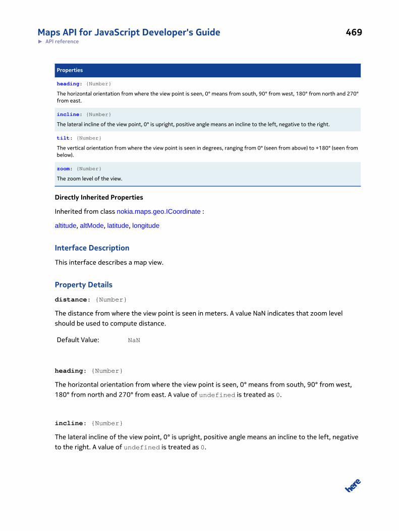
Maps API for JavaScript Developer's Guide 469► API reference
Properties
heading: {Number}
The horizontal orientation from where the view point is seen, 0° means from south, 90° from west, 180° from north and 270°from east.
incline: {Number}
The lateral incline of the view point, 0° is upright, positive angle means an incline to the left, negative to the right.
tilt: {Number}
The vertical orientation from where the view point is seen in degrees, ranging from 0° (seen from above) to +180° (seen frombelow).
zoom: {Number}
The zoom level of the view.
Directly Inherited Properties
Inherited from class nokia.maps.geo.ICoordinate :
altitude, altMode, latitude, longitude
Interface Description
This interface describes a map view.
Property Details
distance: {Number}
The distance from where the view point is seen in meters. A value NaN indicates that zoom level
should be used to compute distance.
Default Value: NaN
heading: {Number}
The horizontal orientation from where the view point is seen, 0° means from south, 90° from west,
180° from north and 270° from east. A value of undefined is treated as 0.
incline: {Number}
The lateral incline of the view point, 0° is upright, positive angle means an incline to the left, negative
to the right. A value of undefined is treated as 0.
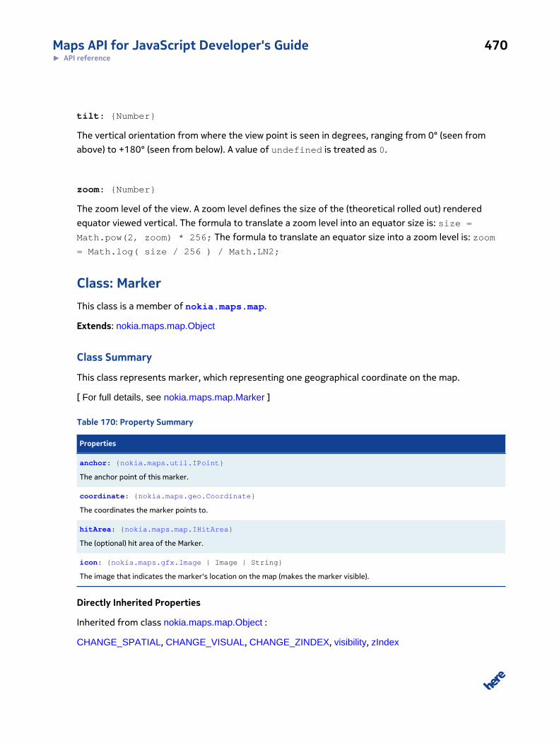
Maps API for JavaScript Developer's Guide 470► API reference
tilt: {Number}
The vertical orientation from where the view point is seen in degrees, ranging from 0° (seen from
above) to +180° (seen from below). A value of undefined is treated as 0.
zoom: {Number}
The zoom level of the view. A zoom level defines the size of the (theoretical rolled out) rendered
equator viewed vertical. The formula to translate a zoom level into an equator size is: size =
Math.pow(2, zoom) * 256; The formula to translate an equator size into a zoom level is: zoom
= Math.log( size / 256 ) / Math.LN2;
Class: MarkerThis class is a member of nokia.maps.map.
Extends: nokia.maps.map.Object
Class Summary
This class represents marker, which representing one geographical coordinate on the map.
[ For full details, see nokia.maps.map.Marker ]
Table 170: Property Summary
Properties
anchor: {nokia.maps.util.IPoint}
The anchor point of this marker.
coordinate: {nokia.maps.geo.Coordinate}
The coordinates the marker points to.
hitArea: {nokia.maps.map.IHitArea}
The (optional) hit area of the Marker.
icon: {nokia.maps.gfx.Image | Image | String}
The image that indicates the marker's location on the map (makes the marker visible).
Directly Inherited Properties
Inherited from class nokia.maps.map.Object :
CHANGE_SPATIAL, CHANGE_VISUAL, CHANGE_ZINDEX, visibility, zIndex
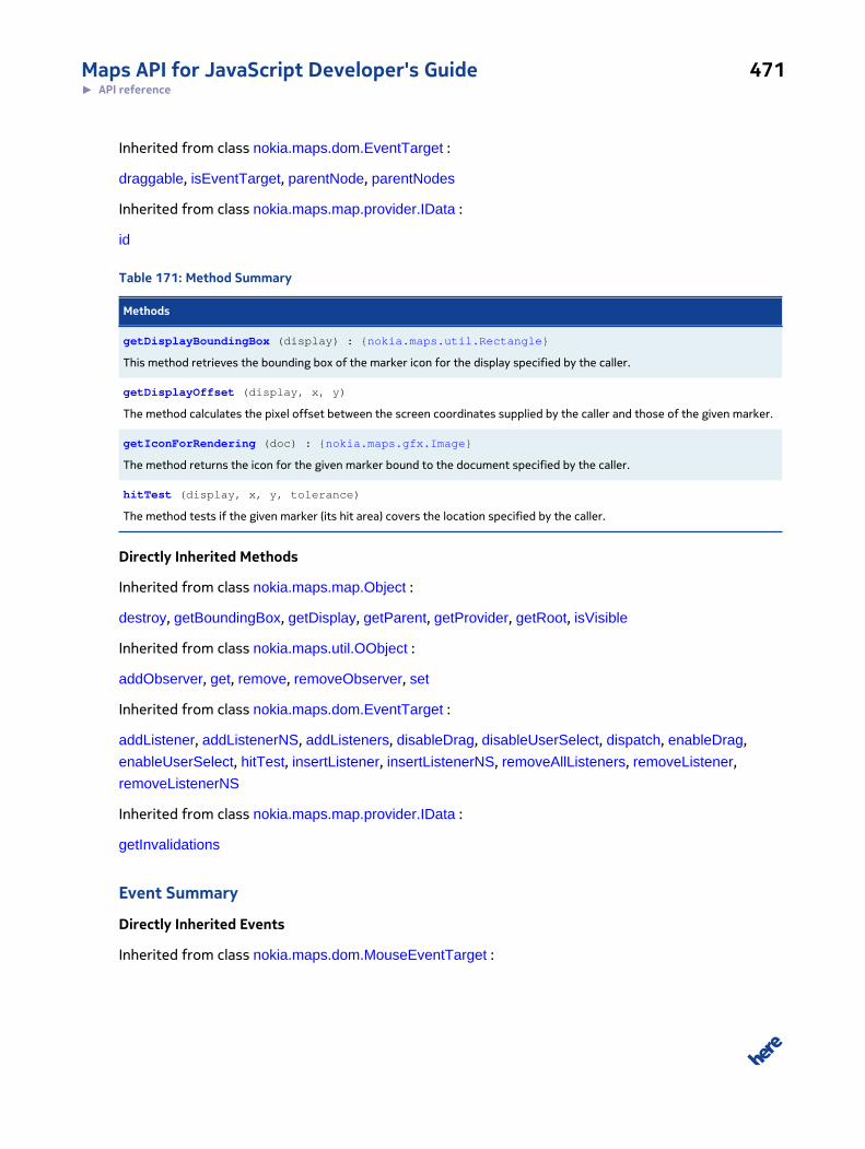
Maps API for JavaScript Developer's Guide 471► API reference
Inherited from class nokia.maps.dom.EventTarget :
draggable, isEventTarget, parentNode, parentNodes
Inherited from class nokia.maps.map.provider.IData :
id
Table 171: Method Summary
Methods
getDisplayBoundingBox (display) : {nokia.maps.util.Rectangle}
This method retrieves the bounding box of the marker icon for the display specified by the caller.
getDisplayOffset (display, x, y)
The method calculates the pixel offset between the screen coordinates supplied by the caller and those of the given marker.
getIconForRendering (doc) : {nokia.maps.gfx.Image}
The method returns the icon for the given marker bound to the document specified by the caller.
hitTest (display, x, y, tolerance)
The method tests if the given marker (its hit area) covers the location specified by the caller.
Directly Inherited Methods
Inherited from class nokia.maps.map.Object :
destroy, getBoundingBox, getDisplay, getParent, getProvider, getRoot, isVisible
Inherited from class nokia.maps.util.OObject :
addObserver, get, remove, removeObserver, set
Inherited from class nokia.maps.dom.EventTarget :
addListener, addListenerNS, addListeners, disableDrag, disableUserSelect, dispatch, enableDrag,
enableUserSelect, hitTest, insertListener, insertListenerNS, removeAllListeners, removeListener,
removeListenerNS
Inherited from class nokia.maps.map.provider.IData :
getInvalidations
Event Summary
Directly Inherited Events
Inherited from class nokia.maps.dom.MouseEventTarget :
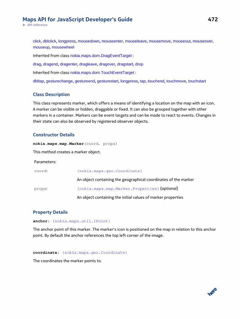
Maps API for JavaScript Developer's Guide 472► API reference
click, dblclick, longpress, mousedown, mouseenter, mouseleave, mousemove, mouseout, mouseover,
mouseup, mousewheel
Inherited from class nokia.maps.dom.DragEventTarget :
drag, dragend, dragenter, dragleave, dragover, dragstart, drop
Inherited from class nokia.maps.dom.TouchEventTarget :
dbltap, gesturechange, gestureend, gesturestart, longpress, tap, touchend, touchmove, touchstart
Class Description
This class represents marker, which offers a means of identifying a location on the map with an icon.
A marker can be visible or hidden, draggable or fixed. It can also be grouped together with other
markers in a container. Markers can be event targets and can be made to react to events. Changes in
their state can also be observed by registered observer objects.
Constructor Details
nokia.maps.map.Marker(coord, props)
This method creates a marker object.
Parameters:
coord: {nokia.maps.geo.Coordinate}
An object containing the geographical coordinates of the marker
props: {nokia.maps.map.Marker.Properties} [optional]
An object containing the initial values of marker properties
Property Details
anchor: {nokia.maps.util.IPoint}
The anchor point of this marker. The marker's icon is positioned on the map in relation to this anchor
point. By default the anchor references the top left corner of the image.
coordinate: {nokia.maps.geo.Coordinate}
The coordinates the marker points to.
Maps API for JavaScript Developer's Guide 473► API reference
hitArea: {nokia.maps.map.IHitArea}
The (optional) hit area of the Marker.
Default Value: undefined
icon: {nokia.maps.gfx.Image | Image | String}
The image that indicates the marker's location on the map (makes the marker visible). NOTE: Either a
URL of a bitmap image or an SVG mark-up string can be used when passing a {String} as the value of
this property.
Method Details
getDisplayBoundingBox(display): {nokia.maps.util.Rectangle}
This method retrieves the bounding box of the marker icon for the display specified by the caller.
Parameters:
display: {nokia.maps.map.Display}
The display for which the bounding box of the marker should be determined
Returns:
{nokia.maps.util.Rectangle}
A rectangle object containing the pixel dimensions on the marker or null if
the marker is not part of the display specified by the caller or if the marker
has no icon
getDisplayOffset(display, x, y)
The method calculates the pixel offset between the screen coordinates supplied by the caller and
those of the given marker.
Parameters:
display: {nokia.maps.map.Display}
The display for which the offset should be calculated
x: {Object}
Maps API for JavaScript Developer's Guide 474► API reference
The x position as a number of pixels from the top-left corner of the display
y: {Object}
The y position as a number of pixels from the top-left corner of the display
Returns:
An object (nokia.maps.util.Point) that represents the difference be-
tween the screen coordinates supplied by the caller and the screen coordi-
nates of the given marker, or null if the marker is not visible in the speci-
fied display
getIconForRendering(doc): {nokia.maps.gfx.Image}
The method returns the icon for the given marker bound to the document specified by the caller.
Parameters:
doc: {Document} [optional, default: document]
The document to which the given marker is attached
Returns:
{nokia.maps.gfx.Image}
The icon image for the marker bound to the given document
hitTest(display, x, y, tolerance)
The method tests if the given marker (its hit area) covers the location specified by the caller. If no hit
area (map.Marker.hitArea) is defined, the entire screen bounding box within which of the marker
appears is taken into account.
Parameters:
display: {nokia.maps.map.Display}
The display within which to carry out the check
x: {Number}
Maps API for JavaScript Developer's Guide 475► API reference
The X component of the screen coordinate in pixels
y: {Number}
The Y component of the screen coordinate in pixels
tolerance: {Number} [optional, default: 0]
The tolerance to use for hit testing as a number of pixels
Returns:
A {Boolean} whose value indicates if the given marker covers the specified
location (true) or not (false)
Interface: Properties
This interface is a member of nokia.maps.map.Marker.
Interface Summary
This interface defines the properties (keys) that can be passed to the constructor of all classes
derived from nokia.maps.map.Marker.
[ For full details, see nokia.maps.map.Marker.Properties ]
Table 172: Property Summary
Properties
anchor: {nokia.maps.util.IPoint}
The initial anchor point of this marker.
draggable: {Boolean}
This flag indicates if Marker will be draggable or not.
hitArea: {nokia.maps.map.IHitArea}
The initial hit area of the created Marker.
icon: {nokia.maps.gfx.Image | Image | String}
The image that indicates the marker's location on the map (makes the marker visible).
Directly Inherited Properties
Inherited from class nokia.maps.map.Object.Properties :
visibility, zIndex
Maps API for JavaScript Developer's Guide 476► API reference
Interface Description
This interface defines the properties (keys) that can be passed to the constructor of all classes
derived from nokia.maps.map.Marker.
Property Details
anchor: {nokia.maps.util.IPoint}
The initial anchor point of this marker. The marker's icon is positioned on the map in relation to this
anchor point. By default the anchor references the top left corner of the image.
draggable: {Boolean}
This flag indicates if Marker will be draggable or not.
hitArea: {nokia.maps.map.IHitArea}
The initial hit area of the created Marker.
icon: {nokia.maps.gfx.Image | Image | String}
The image that indicates the marker's location on the map (makes the marker visible). NOTE: Either a
URL of a bitmap image or an SVG mark-up string can be used when passing a {String} as the value of
this property.
Class: ObjectThis class is a member of nokia.maps.map.
Extends: nokia.maps.dom.EventTarget, nokia.maps.map.provider.IData, nokia.maps.util.OObject
Class Summary
Object is the abstract base class for the map itself and for all visual objects that can be displayed in
the map.
[ For full details, see nokia.maps.map.Object ]
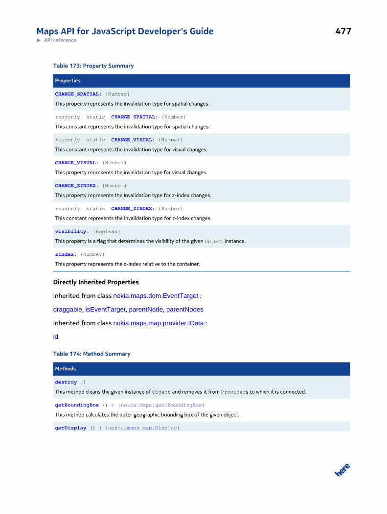
Maps API for JavaScript Developer's Guide 477► API reference
Table 173: Property Summary
Properties
CHANGE_SPATIAL: {Number}
This property represents the invalidation type for spatial changes.
readonly static CHANGE_SPATIAL: {Number}
This constant represents the invalidation type for spatial changes.
readonly static CHANGE_VISUAL: {Number}
This constant represents the invalidation type for visual changes.
CHANGE_VISUAL: {Number}
This property represents the invalidation type for visual changes.
CHANGE_ZINDEX: {Number}
This property represents the invalidation type for z-index changes.
readonly static CHANGE_ZINDEX: {Number}
This constant represents the invalidation type for z-index changes.
visibility: {Boolean}
This property is a flag that determines the visibility of the given Object instance.
zIndex: {Number}
This property represents the z-index relative to the container.
Directly Inherited Properties
Inherited from class nokia.maps.dom.EventTarget :
draggable, isEventTarget, parentNode, parentNodes
Inherited from class nokia.maps.map.provider.IData :
id
Table 174: Method Summary
Methods
destroy ()
This method cleans the given instance of Object and removes it from Providers to which it is connected.
getBoundingBox () : {nokia.maps.geo.BoundingBox}
This method calculates the outer geographic bounding box of the given object.
getDisplay () : {nokia.maps.map.Display}
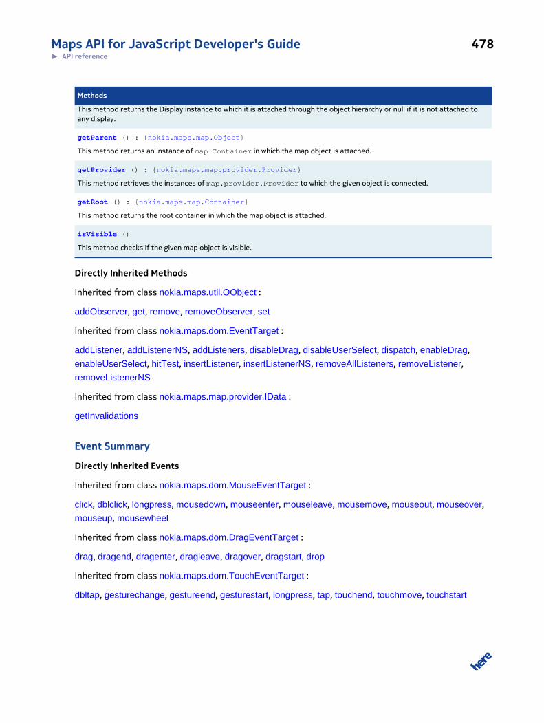
Maps API for JavaScript Developer's Guide 478► API reference
Methods
This method returns the Display instance to which it is attached through the object hierarchy or null if it is not attached toany display.
getParent () : {nokia.maps.map.Object}
This method returns an instance of map.Container in which the map object is attached.
getProvider () : {nokia.maps.map.provider.Provider}
This method retrieves the instances of map.provider.Provider to which the given object is connected.
getRoot () : {nokia.maps.map.Container}
This method returns the root container in which the map object is attached.
isVisible ()
This method checks if the given map object is visible.
Directly Inherited Methods
Inherited from class nokia.maps.util.OObject :
addObserver, get, remove, removeObserver, set
Inherited from class nokia.maps.dom.EventTarget :
addListener, addListenerNS, addListeners, disableDrag, disableUserSelect, dispatch, enableDrag,
enableUserSelect, hitTest, insertListener, insertListenerNS, removeAllListeners, removeListener,
removeListenerNS
Inherited from class nokia.maps.map.provider.IData :
getInvalidations
Event Summary
Directly Inherited Events
Inherited from class nokia.maps.dom.MouseEventTarget :
click, dblclick, longpress, mousedown, mouseenter, mouseleave, mousemove, mouseout, mouseover,
mouseup, mousewheel
Inherited from class nokia.maps.dom.DragEventTarget :
drag, dragend, dragenter, dragleave, dragover, dragstart, drop
Inherited from class nokia.maps.dom.TouchEventTarget :
dbltap, gesturechange, gestureend, gesturestart, longpress, tap, touchend, touchmove, touchstart
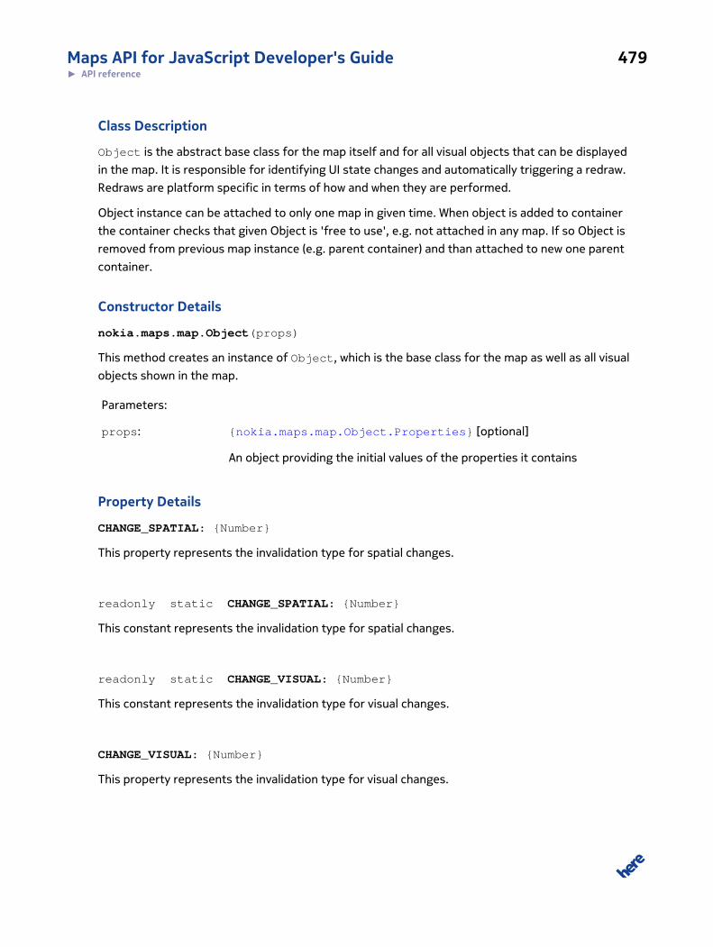
Maps API for JavaScript Developer's Guide 479► API reference
Class Description
Object is the abstract base class for the map itself and for all visual objects that can be displayed
in the map. It is responsible for identifying UI state changes and automatically triggering a redraw.
Redraws are platform specific in terms of how and when they are performed.
Object instance can be attached to only one map in given time. When object is added to container
the container checks that given Object is 'free to use', e.g. not attached in any map. If so Object is
removed from previous map instance (e.g. parent container) and than attached to new one parent
container.
Constructor Details
nokia.maps.map.Object(props)
This method creates an instance of Object, which is the base class for the map as well as all visual
objects shown in the map.
Parameters:
props: {nokia.maps.map.Object.Properties} [optional]
An object providing the initial values of the properties it contains
Property Details
CHANGE_SPATIAL: {Number}
This property represents the invalidation type for spatial changes.
readonly static CHANGE_SPATIAL: {Number}
This constant represents the invalidation type for spatial changes.
readonly static CHANGE_VISUAL: {Number}
This constant represents the invalidation type for visual changes.
CHANGE_VISUAL: {Number}
This property represents the invalidation type for visual changes.
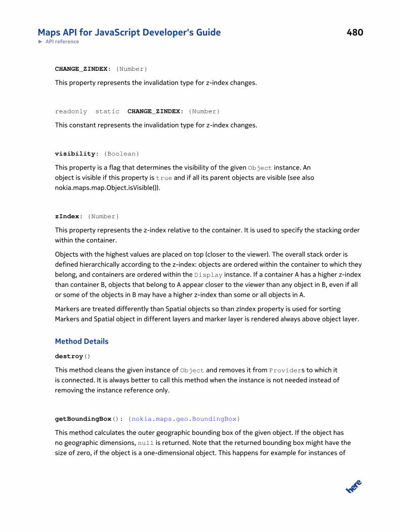
Maps API for JavaScript Developer's Guide 480► API reference
CHANGE_ZINDEX: {Number}
This property represents the invalidation type for z-index changes.
readonly static CHANGE_ZINDEX: {Number}
This constant represents the invalidation type for z-index changes.
visibility: {Boolean}
This property is a flag that determines the visibility of the given Object instance. An
object is visible if this property is true and if all its parent objects are visible (see also
nokia.maps.map.Object.isVisible()).
zIndex: {Number}
This property represents the z-index relative to the container. It is used to specify the stacking order
within the container.
Objects with the highest values are placed on top (closer to the viewer). The overall stack order is
defined hierarchically according to the z-index: objects are ordered within the container to which they
belong, and containers are ordered within the Display instance. If a container A has a higher z-index
than container B, objects that belong to A appear closer to the viewer than any object in B, even if all
or some of the objects in B may have a higher z-index than some or all objects in A.
Markers are treated differently than Spatial objects so than zIndex property is used for sorting
Markers and Spatial object in different layers and marker layer is rendered always above object layer.
Method Details
destroy()
This method cleans the given instance of Object and removes it from Providers to which it
is connected. It is always better to call this method when the instance is not needed instead of
removing the instance reference only.
getBoundingBox(): {nokia.maps.geo.BoundingBox}
This method calculates the outer geographic bounding box of the given object. If the object has
no geographic dimensions, null is returned. Note that the returned bounding box might have the
size of zero, if the object is a one-dimensional object. This happens for example for instances of
Maps API for JavaScript Developer's Guide 481► API reference
nokia.maps.map.Marker and nokia.maps.map.StandardMarker, because they are point objects with a
pure visual (pixel base) representation.
Returns:
{nokia.maps.geo.BoundingBox}
The calculated geographic outer bounding box object or null, if the object
has no geographic dimensions
getDisplay(): {nokia.maps.map.Display}
This method returns the Display instance to which it is attached through the object hierarchy or null if
it is not attached to any display.
Returns:
{nokia.maps.map.Display}
The Display instance or null if the map object is not attached to any display
getParent(): {nokia.maps.map.Object}
This method returns an instance of map.Container in which the map object is attached.
Returns:
{nokia.maps.map.Object}
The parent object or undefined if the map object has no parent (not added
to any Provider)
getProvider(): {nokia.maps.map.provider.Provider}
This method retrieves the instances of map.provider.Provider to which the given object is
connected.
Returns:
{nokia.maps.map.provider.Provider}
An provider instance to which object is connected
Maps API for JavaScript Developer's Guide 482► API reference
getRoot(): {nokia.maps.map.Container}
This method returns the root container in which the map object is attached.
Since: 2.5
Returns:
{nokia.maps.map.Container}
The root container or null if the map object has no parent (not added to
any container)
isVisible()
This method checks if the given map object is visible. The method returns true provided that
the object itself is visible, all its parent objects are visible, and if the object is attached to a
map (parent chain ends with a map). The returned value is valid for the attached instance of
nokia.maps.map.provider.Provider.
Returns:
A {Boolean} value, true if the given map object is currently visible.
Interface: Event
This interface is a member of nokia.maps.map.Object.
Extends: nokia.maps.dom.Event
Interface Summary
This class defines the interface that must be supported by all events fired by a
nokia.maps.map.Object or its derived classes, including the nokia.maps.map.Display class.
[ For full details, see nokia.maps.map.Object.Event ]
Table 175: Property Summary
Properties
display: {nokia.maps.map.Display}
This property contains the reference to the display within which the event occurred, if applicable.
displayObjects: {nokia.maps.map.Object[]}
Maps API for JavaScript Developer's Guide 483► API reference
Properties
This property holds an array of all map objects under the event position reflecting the z-index order of the objects (the firstelement in the array is the topmost visible object, and the last one is the object with the highest z-index).
displayX: {Number}
This property holds the horizontal pixel position where the event occurred relative to the top-left corner of the displayassociated with the event.
displayY: {Number}
This property holds the vertical pixel position where the event occurred relative to the to the top-left corner of the displayassociated with the event.
Directly Inherited Properties
Inherited from class nokia.maps.dom.Event :
AT_TARGET, bubbles, BUBBLING_PHASE, canBubble, cancelable, canSicker, CAPTURING_PHASE,
currentTarget, defaultPrevented, eventPhase, namespaceURI, nativeEvent, page, propagation,
PROPAGATION_OK, PROPAGATION_STOP, PROPAGATION_STOP_IMMEDIATE, target,
timeStamp, type
Method Summary
Directly Inherited Methods
Inherited from class nokia.maps.dom.Event :
cancel, clone, preventDefault, preventUnload, stopImmediatePropagation, stopPropagation
Interface Description
This class defines the interface that must be supported by all events fired by a
nokia.maps.map.Object or its derived classes, including the nokia.maps.map.Display class.
These classes therefore implement this interface.
This class does not exist, but is documented here to record the event properties. All events are
ultimately instances of the class nokia.maps.dom.Event and have the properties described here.
Before you continue reading, please ensure that you are familiar with the normal DOM event behavior
as explained, for example, in the documentation for the class nokia.maps.dom.EventTarget or in
the corresponding W3C DOM Event Level 3 specification
Dispatch
A nokia.maps.map.Object.Event has the property display to identify the
nokia.maps.map.Display instance in which the event occurred to help establish the correct
propagation path. For example, if the user clicks on a marker, a DOM click event with the
Maps API for JavaScript Developer's Guide 484► API reference
map.Display instance as target is generated by the browser, but because the browser does not
know about the markers (at least in some rendering engines), the display itself must find the map
objects under the mouse cursor and modify the propagation path. Furthermore, it needs to apply
the nokia.maps.map.Object.Event interface to that DOM event with the special properties display,
displayX, displayY and displayObjects.
The nokia.maps.dom.EventTarget#dispatch() method does not generate the propagation
path simply by following the property parentNode. Instead, it intercepts the dispatched events,
allows the class nokia.maps.map.Display to find the target and build the propagation path so that map
objects under the cursor are treated like normal DOM nodes.
Separate the data model from the view tree
The modified event dispatch model permits dispatch of visual events that are separate from the
data model events. In addition to the hierarchy of map objects within instances of map.Display, a
further document hierarchy for all map objects may be present and these objects can act as event
targets. Therefore, a single data model can be maintained alongside different display-related view
models. This is a strength of the event model. While remaining compatible with the DOM event
system, it allows you to maintain a document data model alongside the visual representation, using
the same objects for the view trees as well as for the data model.
In addition, events can flow over into the normal DOM tree so that you can capture events fired by
the display as well as those fired within the normal DOM tree. For example, if a div element holds
both the map and the UI components, you can use the same listeners to process map events and UI
events.
Listener notes
Registering listeners on map objects is similar to registering listeners on DOM nodes, using the class
nokia.maps.dom.EventTarget. Note that the listeners are called for all events that reach the map
objects. Therefore you must check the property display to see if an event is related to a display or
a DOM event, and to which map.Display instance it belongs.
Property Details
display: {nokia.maps.map.Display}
This property contains the reference to the display within which the event occurred, if applicable.
displayObjects: {nokia.maps.map.Object[]}
This property holds an array of all map objects under the event position reflecting the z-index order
of the objects (the first element in the array is the topmost visible object, and the last one is the
object with the highest z-index). Note that the event position can be, for example the mouse cursor
Maps API for JavaScript Developer's Guide 485► API reference
position, the user's finger touch position of a touch screen, or any other position related to the event
(see nokia.maps.map.Object.Event#displayX and nokia.maps.map.Object.Event#displayY).
This property may be undefined, if the event is not related to a display or a specific position, which
is the case, for example, for keyboard events, map view change events or some customer defined
events.
displayX: {Number}
This property holds the horizontal pixel position where the event occurred relative to the top-left
corner of the display associated with the event.
This property may be undefined, if the event is not related to a display or a specific position, which
is the case, for example, for keyboard events, map view change events or some customer defined
events.
displayY: {Number}
This property holds the vertical pixel position where the event occurred relative to the to the top-left
corner of the display associated with the event.
This property may be undefined, if the event is not related to a display or a specific position, which
is the case, for example, for keyboard events, map view change events or some customer defined
events.
Interface: Properties
This interface is a member of nokia.maps.map.Object.
Interface Summary
This interface defines the properties (keys) that can be passed to the constructor of all classes
derived from nokia.maps.map.Object.
[ For full details, see nokia.maps.map.Object.Properties ]
Table 176: Property Summary
Properties
visibility: {Boolean}
This property is a flag that determines the initial visibility of the created Object instance.
zIndex: {Number}
Maps API for JavaScript Developer's Guide 486► API reference
Properties
This property holds the initial value of the z-index relative to the siblings in parent container.
Interface Description
This interface defines the properties (keys) that can be passed to the constructor of all classes
derived from nokia.maps.map.Object.
Property Details
visibility: {Boolean}
This property is a flag that determines the initial visibility of the created Object instance.
An object are visible if this property is true and if all its parent objects are visible (see also
nokia.maps.map.Object.isVisible()).
zIndex: {Number}
This property holds the initial value of the z-index relative to the siblings in parent container. The
z-index is used to specify the stacking order within a container. Objects with the highest values are
placed on top (closer to the viewer). The overall stack order is defined hierarchically according to the
z-index: objects are ordered within the container to which they belong, and containers are ordered
within the Display instance. If a container A has a higher z-index than container B, objects that
belong to A appear closer to the viewer than any object in B, even if all or some of the objects in B
may have a higher z-index than some or all objects in A.
Class: PolygonThis class is a member of nokia.maps.map.
Extends: nokia.maps.map.Polyline
Class Summary
This class represent visible polygon on map.
[ For full details, see nokia.maps.map.Polygon ]
Table 177: Property Summary
Properties
brush: {nokia.maps.util.Brush}
Maps API for JavaScript Developer's Guide 487► API reference
Properties
This property specifies the brush used to fill the shape of the polygon.
Directly Inherited Properties
Inherited from class nokia.maps.map.Polyline :
arrows, path, pen
Inherited from class nokia.maps.map.Spatial :
simplify
Inherited from class nokia.maps.map.Object :
CHANGE_SPATIAL, CHANGE_VISUAL, CHANGE_ZINDEX, visibility, zIndex
Inherited from class nokia.maps.dom.EventTarget :
draggable, isEventTarget, parentNode, parentNodes
Inherited from class nokia.maps.map.provider.IData :
id
Method Summary
Directly Inherited Methods
Inherited from class nokia.maps.map.Polyline :
getNearest, getNearestIndex
Inherited from class nokia.maps.map.Object :
destroy, getBoundingBox, getDisplay, getParent, getProvider, getRoot, isVisible
Inherited from class nokia.maps.util.OObject :
addObserver, get, remove, removeObserver, set
Inherited from class nokia.maps.dom.EventTarget :
addListener, addListenerNS, addListeners, disableDrag, disableUserSelect, dispatch, enableDrag,
enableUserSelect, hitTest, insertListener, insertListenerNS, removeAllListeners, removeListener,
removeListenerNS
Inherited from class nokia.maps.map.provider.IData :
getInvalidations
Maps API for JavaScript Developer's Guide 488► API reference
Event Summary
Directly Inherited Events
Inherited from class nokia.maps.dom.MouseEventTarget :
click, dblclick, longpress, mousedown, mouseenter, mouseleave, mousemove, mouseout, mouseover,
mouseup, mousewheel
Inherited from class nokia.maps.dom.DragEventTarget :
drag, dragend, dragenter, dragleave, dragover, dragstart, drop
Inherited from class nokia.maps.dom.TouchEventTarget :
dbltap, gesturechange, gestureend, gesturestart, longpress, tap, touchend, touchmove, touchstart
Class Description
This class represents map object that is, in effect, a closed polyline (nokia.maps.map.Polyline).
In other words, the last point in the array of points that define the line is connected with the first
point.
Constructor Details
nokia.maps.map.Polygon(path, props)
This method initializes an instance of Polygon. You can use it to set the points that define the
polygon and set the brush.
Parameters:
path: {nokia.maps.geo.Strip | nokia.maps.geo.Coordinate[]}
An object containing the points (geographical locations) that define the poly-
gon; the object can be an instance of nokia.maps.geo.Strip or an array
of objects, each containing the latitude and longitude of a geographical lo-
cation
props: {nokia.maps.map.Polygon.Properties} [optional]
An object that names polygon properties to initialize and provides their val-
ues
Property Details
brush: {nokia.maps.util.Brush}
Maps API for JavaScript Developer's Guide 489► API reference
This property specifies the brush used to fill the shape of the polygon. See nokia.maps.util.Brush for
default values.
Interface: Properties
This interface is a member of nokia.maps.map.Polygon.
Interface Summary
This interface defines the properties (keys) that can be passed to the constructor of
nokia.maps.map.Polygon.
[ For full details, see nokia.maps.map.Polygon.Properties ]
Table 178: Property Summary
Properties
brush: {nokia.maps.util.IBrush}
This property specifies the brush used to fill the shape of the polygon.
Directly Inherited Properties
Inherited from class nokia.maps.map.Polyline.Properties :
pen
Inherited from class nokia.maps.map.Spatial.Properties :
simplify
Inherited from class nokia.maps.map.Object.Properties :
visibility, zIndex
Interface Description
This interface defines the properties (keys) that can be passed to the constructor of
nokia.maps.map.Polygon.
Property Details
brush: {nokia.maps.util.IBrush}
This property specifies the brush used to fill the shape of the polygon.
Maps API for JavaScript Developer's Guide 490► API reference
Class: PolylineThis class is a member of nokia.maps.map.
Class Summary
This class represents visible line on map.
[ For full details, see nokia.maps.map.Polyline ]
Table 179: Property Summary
Properties
arrows: {nokia.maps.util.Arrows}
Gives properties for arrows drawn recurrently on top of the polyline to visualize the direction (e.g.
path: {nokia.maps.geo.Shape}
The path to define the shape.
pen: {nokia.maps.util.Pen}
Gives properties e.g.
Directly Inherited Properties
Inherited from class nokia.maps.map.Spatial :
simplify
Inherited from class nokia.maps.map.Object :
CHANGE_SPATIAL, CHANGE_VISUAL, CHANGE_ZINDEX, visibility, zIndex
Inherited from class nokia.maps.dom.EventTarget :
draggable, isEventTarget, parentNode, parentNodes
Inherited from class nokia.maps.map.provider.IData :
id
Table 180: Method Summary
Methods
getNearest (coord)
This method retrieves the point that belongs to the given instance of Polyline and lies closest to the location specified bythe caller.
getNearestIndex (coord) : {Number}

Maps API for JavaScript Developer's Guide 491► API reference
Methods
This method obtains the index of a point that belongs to the given instance of Polyline and lies closest to the locationspecified by the caller.
Directly Inherited Methods
Inherited from class nokia.maps.map.Object :
destroy, getBoundingBox, getDisplay, getParent, getProvider, getRoot, isVisible
Inherited from class nokia.maps.util.OObject :
addObserver, get, remove, removeObserver, set
Inherited from class nokia.maps.dom.EventTarget :
addListener, addListenerNS, addListeners, disableDrag, disableUserSelect, dispatch, enableDrag,
enableUserSelect, hitTest, insertListener, insertListenerNS, removeAllListeners, removeListener,
removeListenerNS
Inherited from class nokia.maps.map.provider.IData :
getInvalidations
Event Summary
Directly Inherited Events
Inherited from class nokia.maps.dom.MouseEventTarget :
click, dblclick, longpress, mousedown, mouseenter, mouseleave, mousemove, mouseout, mouseover,
mouseup, mousewheel
Inherited from class nokia.maps.dom.DragEventTarget :
drag, dragend, dragenter, dragleave, dragover, dragstart, drop
Inherited from class nokia.maps.dom.TouchEventTarget :
dbltap, gesturechange, gestureend, gesturestart, longpress, tap, touchend, touchmove, touchstart
Class Description
Polyline represents a visible line on the screen that connects two or more points. The section that
connects any two consecutive points is always straight and therefore indicates the shortest distance
between them.
Maps API for JavaScript Developer's Guide 492► API reference
Constructor Details
nokia.maps.map.Polyline(coords, props)
This method creates and initializes an instance of Polyline.
Parameters:
coords: {nokia.maps.geo.Strip | nokia.maps.geo.Shape |
nokia.maps.geo.Coordinate[]}
An object containing the points (geographical locations) that define the
polyline; the object can be an instance of nokia.maps.geo.Strip, a
nokia.maps.geo.Shape or an array of objects, each containing the lati-
tude and longitude of a geographical location
props: {nokia.maps.map.Polyline.Properties} [optional]
An object that names Polyline properties and their initial values
Property Details
arrows: {nokia.maps.util.Arrows}
Gives properties for arrows drawn recurrently on top of the polyline to visualize the direction (e.g. for
routes). If not specified or set to a falsy value, no arrows are drawn.
path: {nokia.maps.geo.Shape}
The path to define the shape.
pen: {nokia.maps.util.Pen}
Gives properties e.g. strokeColor, lineWidth for the stroke of the shape. See nokia.maps.util.Pen for
default values.
Method Details
getNearest(coord)
This method retrieves the point that belongs to the given instance of Polyline and lies closest to
the location specified by the caller.
Parameters:
Maps API for JavaScript Developer's Guide 493► API reference
coord: {nokia.maps.geo.Coordinate}
An object containing the coordinates of a location
Returns:
An instance of {nokia.maps.geo.Coordinate} containing the latitude
and longitude of a point on the polyline
getNearestIndex(coord): {Number}
This method obtains the index of a point that belongs to the given instance of Polyline and lies
closest to the location specified by the caller.
Parameters:
coord: {nokia.maps.geo.Coordinate}
An object containing the coordinates of a location
Returns:
{Number} A number representing the index of the point on the polyline that is closest
to the location provided by the caller
Interface: Properties
This interface is a member of nokia.maps.map.Polyline.
Interface Summary
This interface defines the properties (keys) that can be passed to the constructor of
nokia.maps.map.Polyline.
[ For full details, see nokia.maps.map.Polyline.Properties ]
Table 181: Property Summary
Properties
pen: {nokia.maps.util.IPen}
Gives properties e.g.
Directly Inherited Properties

Maps API for JavaScript Developer's Guide 494► API reference
Inherited from class nokia.maps.map.Spatial.Properties :
simplify
Inherited from class nokia.maps.map.Object.Properties :
visibility, zIndex
Interface Description
This interface defines the properties (keys) that can be passed to the constructor of
nokia.maps.map.Polyline.
Property Details
pen: {nokia.maps.util.IPen}
Gives properties e.g. strokeColor, lineWidth for the stroke of the shape.
Class: RectangleThis class is a member of nokia.maps.map.
Class Summary
This class represents visible rectangular area on map.
[ For full details, see nokia.maps.map.Rectangle ]
Table 182: Property Summary
Properties
boundingBox: {nokia.maps.geo.BoundingBox}
The bounds of the rectangle.
simplify: {Number}
This property overrides nokia.maps.map.Spatial#simplify.
Directly Inherited Properties
Inherited from class nokia.maps.map.Polygon :
brush
Inherited from class nokia.maps.map.Polyline :
arrows, path, pen
Maps API for JavaScript Developer's Guide 495► API reference
Inherited from class nokia.maps.map.Spatial :
simplify
Inherited from class nokia.maps.map.Object :
CHANGE_SPATIAL, CHANGE_VISUAL, CHANGE_ZINDEX, visibility, zIndex
Inherited from class nokia.maps.dom.EventTarget :
draggable, isEventTarget, parentNode, parentNodes
Inherited from class nokia.maps.map.provider.IData :
id
Method Summary
Directly Inherited Methods
Inherited from class nokia.maps.map.Polyline :
getNearest, getNearestIndex
Inherited from class nokia.maps.map.Object :
destroy, getBoundingBox, getDisplay, getParent, getProvider, getRoot, isVisible
Inherited from class nokia.maps.util.OObject :
addObserver, get, remove, removeObserver, set
Inherited from class nokia.maps.dom.EventTarget :
addListener, addListenerNS, addListeners, disableDrag, disableUserSelect, dispatch, enableDrag,
enableUserSelect, hitTest, insertListener, insertListenerNS, removeAllListeners, removeListener,
removeListenerNS
Inherited from class nokia.maps.map.provider.IData :
getInvalidations
Event Summary
Directly Inherited Events
Inherited from class nokia.maps.dom.MouseEventTarget :
click, dblclick, longpress, mousedown, mouseenter, mouseleave, mousemove, mouseout, mouseover,
mouseup, mousewheel
Inherited from class nokia.maps.dom.DragEventTarget :
Maps API for JavaScript Developer's Guide 496► API reference
drag, dragend, dragenter, dragleave, dragover, dragstart, drop
Inherited from class nokia.maps.dom.TouchEventTarget :
dbltap, gesturechange, gestureend, gesturestart, longpress, tap, touchend, touchmove, touchstart
Class Description
The class defines a map object with a rectangular shape.
Constructor Details
nokia.maps.map.Rectangle(bounds, props)
This method initializes an instance of nokia.maps.map.Rectangle setting the bounding box for
the object and other properties specified by the caller.
Parameters:
bounds: {nokia.maps.geo.BoundingBox}
A bounding box object that determines the location of the rectangle and its
size
props: {nokia.maps.map.Rectangle.Properties} [optional]
An object that names the properties of the rectangle to initialize and pro-
vides their values
Property Details
boundingBox: {nokia.maps.geo.BoundingBox}
The bounds of the rectangle.
simplify: {Number}
This property overrides nokia.maps.map.Spatial#simplify. The value of this property is 0 by default,
because it is not visually nice to simplify rectangles. It is also not necessary, because Rectangle
always consists of 4 points.
Default Value: 0
Maps API for JavaScript Developer's Guide 497► API reference
Interface: Properties
This interface is a member of nokia.maps.map.Rectangle.
Interface Summary
This interface defines the properties (keys) that can be passed to the constructor for
nokia.maps.map.Rectangle.
[ For full details, see nokia.maps.map.Rectangle.Properties ]
Property Summary
Directly Inherited Properties
Inherited from class nokia.maps.map.Polygon.Properties :
brush
Inherited from class nokia.maps.map.Polyline.Properties :
pen
Inherited from class nokia.maps.map.Spatial.Properties :
simplify
Inherited from class nokia.maps.map.Object.Properties :
visibility, zIndex
Interface Description
This interface defines the properties (keys) that can be passed to the constructor for
nokia.maps.map.Rectangle.
Class: SpatialThis class is a member of nokia.maps.map.
Extends: nokia.maps.map.Object
Class Summary
This class is a base class for all geo spatial map objects.
[ For full details, see nokia.maps.map.Spatial ]

Maps API for JavaScript Developer's Guide 498► API reference
Table 183: Property Summary
Properties
simplify: {Number}
The value of this property is specified as a number of pixels and indicates if and how much the rendering result is to besimplified.
Directly Inherited Properties
Inherited from class nokia.maps.map.Object :
CHANGE_SPATIAL, CHANGE_VISUAL, CHANGE_ZINDEX, visibility, zIndex
Inherited from class nokia.maps.dom.EventTarget :
draggable, isEventTarget, parentNode, parentNodes
Inherited from class nokia.maps.map.provider.IData :
id
Method Summary
Directly Inherited Methods
Inherited from class nokia.maps.map.Object :
destroy, getBoundingBox, getDisplay, getParent, getProvider, getRoot, isVisible
Inherited from class nokia.maps.util.OObject :
addObserver, get, remove, removeObserver, set
Inherited from class nokia.maps.dom.EventTarget :
addListener, addListenerNS, addListeners, disableDrag, disableUserSelect, dispatch, enableDrag,
enableUserSelect, hitTest, insertListener, insertListenerNS, removeAllListeners, removeListener,
removeListenerNS
Inherited from class nokia.maps.map.provider.IData :
getInvalidations
Event Summary
Directly Inherited Events
Inherited from class nokia.maps.dom.MouseEventTarget :
Maps API for JavaScript Developer's Guide 499► API reference
click, dblclick, longpress, mousedown, mouseenter, mouseleave, mousemove, mouseout, mouseover,
mouseup, mousewheel
Inherited from class nokia.maps.dom.DragEventTarget :
drag, dragend, dragenter, dragleave, dragover, dragstart, drop
Inherited from class nokia.maps.dom.TouchEventTarget :
dbltap, gesturechange, gestureend, gesturestart, longpress, tap, touchend, touchmove, touchstart
Class Description
This is an abstract base class for all objects that have a geo-spatial dimension.
Constructor Details
nokia.maps.map.Spatial(props)
This method initializes an object based on this class.
Parameters:
props: {nokia.maps.map.Object.Properties}
An object specifying the initial values of the properties defined on this class
Property Details
simplify: {Number}
The value of this property is specified as a number of pixels and indicates if and how much the
rendering result is to be simplified. If the value is 0, no simplification is applied. Otherwise, the
complexity of the rendering result is reduced so that points within a distance smaller than the
number of pixels indicated by this property are ignored.
Default Value: 3
Interface: Properties
This interface is a member of nokia.maps.map.Spatial.
Interface Summary
This interface defines the properties (keys) that can be passed to the constructor of all classes
derived from nokia.maps.map.Spatial.
Maps API for JavaScript Developer's Guide 500► API reference
[ For full details, see nokia.maps.map.Spatial.Properties ]
Table 184: Property Summary
Properties
simplify: {Number}
The value of this property is specified as a number of pixels and indicates if and how much the rendering result is to besimplified.
Directly Inherited Properties
Inherited from class nokia.maps.map.Object.Properties :
visibility, zIndex
Interface Description
This interface defines the properties (keys) that can be passed to the constructor of all classes
derived from nokia.maps.map.Spatial.
Property Details
simplify: {Number}
The value of this property is specified as a number of pixels and indicates if and how much the
rendering result is to be simplified. If the value is 0, no simplification is applied. Otherwise, the
complexity of the rendering result is reduced so that points within a distance smaller than the
number of pixels indicated by this property are ignored.
Class: StandardMarkerThis class is a member of nokia.maps.map.
Extends: nokia.maps.map.Marker
Class Summary
This class represents a marker with standardized icon.
[ For full details, see nokia.maps.map.StandardMarker ]
Table 185: Property Summary
Properties
brush: {nokia.maps.util.Brush}
Maps API for JavaScript Developer's Guide 501► API reference
Properties
This property holds the nokia.maps.util.Brush object which defines color of the interior of the shape in which the marker'stext label is rendered.
pen: {nokia.maps.util.Pen}
This property holds the nokia.maps.util.Pen object which defines color of the outline of the shape in which the marker's textlabel is rendered.
shape: {String}
This property specifies the shape that is used to display the marker label.
text: {String}
This property holds the text (label) rendered in the center of the shape.
textPen: {nokia.maps.util.Pen}
This property holds the nokia.maps.util.Pen object which defines color of the text in the marker's label.
Directly Inherited Properties
Inherited from class nokia.maps.map.Marker :
anchor, coordinate, hitArea, icon
Inherited from class nokia.maps.map.Object :
CHANGE_SPATIAL, CHANGE_VISUAL, CHANGE_ZINDEX, visibility, zIndex
Inherited from class nokia.maps.dom.EventTarget :
draggable, isEventTarget, parentNode, parentNodes
Inherited from class nokia.maps.map.provider.IData :
id
Method Summary
Directly Inherited Methods
Inherited from class nokia.maps.map.Marker :
getDisplayBoundingBox, getDisplayOffset, getIconForRendering, hitTest
Inherited from class nokia.maps.map.Object :
destroy, getBoundingBox, getDisplay, getParent, getProvider, getRoot, isVisible
Inherited from class nokia.maps.util.OObject :
addObserver, get, remove, removeObserver, set
Inherited from class nokia.maps.dom.EventTarget :
Maps API for JavaScript Developer's Guide 502► API reference
addListener, addListenerNS, addListeners, disableDrag, disableUserSelect, dispatch, enableDrag,
enableUserSelect, hitTest, insertListener, insertListenerNS, removeAllListeners, removeListener,
removeListenerNS
Inherited from class nokia.maps.map.provider.IData :
getInvalidations
Event Summary
Directly Inherited Events
Inherited from class nokia.maps.dom.MouseEventTarget :
click, dblclick, longpress, mousedown, mouseenter, mouseleave, mousemove, mouseout, mouseover,
mouseup, mousewheel
Inherited from class nokia.maps.dom.DragEventTarget :
drag, dragend, dragenter, dragleave, dragover, dragstart, drop
Inherited from class nokia.maps.dom.TouchEventTarget :
dbltap, gesturechange, gestureend, gesturestart, longpress, tap, touchend, touchmove, touchstart
Class Description
A StandardMarker represents a location on the map and visibly identifies that location with an icon.
It is very similar in terms of properties and supported functionality to nokia.maps.map.Marker, but in
addition, it supports a text label and various text properties for it.
Constructor Details
nokia.maps.map.StandardMarker(coord, props)
This method creates an instance of StandardMarker.
Parameters:
coord: {nokia.maps.geo.Coordinate}
An object containing the geographical coordinates of the marker
props: {nokia.maps.map.StandardMarker.Properties} [optional]
The initial values of marker properties

Maps API for JavaScript Developer's Guide 503► API reference
Property Details
brush: {nokia.maps.util.Brush}
This property holds the nokia.maps.util.Brush object which defines color of the interior of the shape
in which the marker's text label is rendered. If the property is not set, the original color defined in the
specific shape type is used. The default color for "ballon" is #1080DD.
pen: {nokia.maps.util.Pen}
This property holds the nokia.maps.util.Pen object which defines color of the outline of the shape in
which the marker's text label is rendered. Default stroke color is set to #FFF.
shape: {String}
This property specifies the shape that is used to display the marker label. The following strings can
be used right now to set its value:
• "balloon"
There will be more coming soon.
Default Value: "balloon"
text: {String}
This property holds the text (label) rendered in the center of the shape. If the rendered text is longer
than the screen bounding box of the shape, the text is cropped.
Default Value: ""
textPen: {nokia.maps.util.Pen}
This property holds the nokia.maps.util.Pen object which defines color of the text in the marker's
label. Default stroke color is #FFF.
Interface: Properties
This interface is a member of nokia.maps.map.StandardMarker.
Maps API for JavaScript Developer's Guide 504► API reference
Interface Summary
This interface defines the properties (keys) that can be passed to the
nokia.maps.map.StandardMarker constructor.
[ For full details, see nokia.maps.map.StandardMarker.Properties ]
Table 186: Property Summary
Properties
brush: {nokia.maps.util.IBrush}
This property define the nokia.maps.util.IBrush object which color property is used for the interior of the shape in which themarker's text label is rendered.
pen: {nokia.maps.util.IPen}
This property define the nokia.maps.util.IPen object which stroke color is used for the outline of the shape in which themarker's text label is rendered.
shape: {String}
This property specifies the shape that is used to display the marker label.
style: {Object}
The property specifies the css style which will be applied to zoom rectangle.
text: {String}
This property define the text (label) rendered in the center of the shape.
textPen: {nokia.maps.util.IPen}
This property define the nokia.maps.util.IPen object which stroke color is used for the text in the marker's label.
Directly Inherited Properties
Inherited from class nokia.maps.map.Marker.Properties :
anchor, draggable, hitArea, icon
Inherited from class nokia.maps.map.Object.Properties :
visibility, zIndex
Interface Description
This interface defines the properties (keys) that can be passed to the
nokia.maps.map.StandardMarker constructor.
Property Details
brush: {nokia.maps.util.IBrush}
Maps API for JavaScript Developer's Guide 505► API reference
This property define the nokia.maps.util.IBrush object which color property is used for the interior
of the shape in which the marker's text label is rendered. If the property is not set, the original color
defined in the specific shape type is used. The default color for "ballon" is #1080DD.
pen: {nokia.maps.util.IPen}
This property define the nokia.maps.util.IPen object which stroke color is used for the outline of the
shape in which the marker's text label is rendered. Default stroke color is set to #FFF.
shape: {String}
This property specifies the shape that is used to display the marker label. The following strings can
be used right now to set its value:
• "balloon"
There will be more coming soon.
style: {Object}
The property specifies the css style which will be applied to zoom rectangle. Allowed style properties
are:
• border
• background
• opacity
Example:
border: "1px solid #F00", background: "#0F0", opacity: 0.5 }
text: {String}
This property define the text (label) rendered in the center of the shape. If the rendered text is longer
than the screen bounding box of the shape, the text is cropped.
textPen: {nokia.maps.util.IPen}
Maps API for JavaScript Developer's Guide 506► API reference
This property define the nokia.maps.util.IPen object which stroke color is used for the text in the
marker's label. Default stroke color is #FFF.
Namespace: componentThis namespace is a member of nokia.maps.map.
Namespace Summary
This namespace provides UI components that can be added to a map display and others that support
various types of interactive behavior such as right-mouse click, draggability, mouse gestures, etc.
Namespace Description
This namespace provides UI components that can be added to a map display and others that support
various types of interactive behavior such as right-mouse click, draggability, mouse gestures, etc.
Class: Behavior
This class is a member of nokia.maps.map.component.
Extends: nokia.maps.map.component.Component
Class Summary
This is a meta component that adds common user interface elements to the map.
[ For full details, see nokia.maps.map.component.Behavior ]
Property Summary
Directly Inherited Properties
Inherited from class nokia.maps.map.component.Component :
mapDisplay
Method Summary
Directly Inherited Methods
Inherited from class nokia.maps.map.component.Component :
attach, destroy, detach, getId
Inherited from class nokia.maps.util.OObject :
Maps API for JavaScript Developer's Guide 507► API reference
addObserver, get, remove, removeObserver, set
Class Description
Behavior is a collection of user interface elements cumulatively responsible for supporting
direct user-interaction with the map. Behavior adds or removes the following map user interface
components:
• nokia.maps.map.component.zoom.MouseWheel
• nokia.maps.map.component.zoom.DoubleClick
• nokia.maps.map.component.zoom.DoubleTap
• nokia.maps.map.component.zoom.Gesture
• nokia.maps.map.component.panning.Drag
• nokia.maps.map.component.panning.Kinetic
• nokia.maps.map.component.objects.DragMarker
Constructor Details
nokia.maps.map.component.Behavior()
This method initializes an instance of Behavior.
Class: Component
This class is a member of nokia.maps.map.component.
Extends: nokia.maps.util.OObject
Class Summary
This class is a base class for all map components.
[ For full details, see nokia.maps.map.component.Component ]
Table 187: Property Summary
Properties
mapDisplay: {nokia.maps.map.Display}
This property holds a reference to the map.Display instance to which the given component belongs.
Maps API for JavaScript Developer's Guide 508► API reference
Table 188: Method Summary
Methods
attach (mapDisplay)
This method will be invoked when the component is attached to a map and is not meant to be called directly.
destroy ()
This method is called from Display when Display is destroyed.
detach (mapDisplay)
This method will be invoked when the component is detached from a map and is not meant to be called directly
getId () : {String}
This method retrieves the unique identifier of the component.
Directly Inherited Methods
Inherited from class nokia.maps.util.OObject :
addObserver, get, remove, removeObserver, set
Class Description
Component is an abstract class that serves as basis for defining replaceable software modules that
extend the basic map with additional functionality. Components allow API users to:
• include new functionality
• replace existing functionality with a different implementation
• deactivate existing functionality.
A component may fire custom events.
The Component class is implemented in several packages outside the map package, for example in
routing and search.
Reference counting
The fact that components are replaceable and that they can add or remove other components,
creating and potentially disrupting inter-component dependencies, makes a reference counting
mechanism necessary. The basic principle is that whenever a component is created its reference
count is incremented to indicate that the creator requires it (and holds a reference to it). The count is
also incremented when a component already exists, but a new attempt to create it is made - thus, the
count goes up, but duplicate components with the same id are not created. An attempt to deleted/
remove a component, causes its reference count to be decremented.
This mechanism prevents not only component duplication, but also the removal of components while
other components dependent on them for as long as the dependencies exist. Caution when physically
Maps API for JavaScript Developer's Guide 509► API reference
removing components is necessary, because on removal, a component's detach callback is called to
delete its reference to the map Display. As a result, the component becomes unusable in an invalid
state.
However, this mechanism remains transparent and you, as the API user simply need to call the
methods addComponent() and removeComponent of the map Display class to add and remove
components, respectively. Here is an example:
// If a Kinetic component already exists, addComponent() // returns it instead of creating a duplicate.var component = display.addComponent(new nokia.maps.map.component.panning.Kinetic());
// If any other component or application part holds a reference // to the component, this call does not remove the component, but // decrements the reference counter by one, otherwise it removes// the component (if the reference counter reached zero).display.removeComponent(component);
// Another possibility to remove a component is:display.removeComponent( display.getComponentById("panning.Kinetic") );
Property Details
mapDisplay: {nokia.maps.map.Display}
This property holds a reference to the map.Display instance to which the given component
belongs.
Method Details
attach(mapDisplay)
This method will be invoked when the component is attached to a map and is not meant to be called
directly.
Note that a component must not be bound to two instances of map.Display at the same time!
Parameters:
mapDisplay: {nokia.maps.map.Display}
A reference to the map.Display instance to which the given component is
bound.
destroy()
Maps API for JavaScript Developer's Guide 510► API reference
This method is called from Display when Display is destroyed. It is also intended that you call it when
you detach component from Display and do not want to use component instance anymore. It will free
all allocated resources.
detach(mapDisplay)
This method will be invoked when the component is detached from a map and is not meant to be
called directly
Parameters:
mapDisplay: {nokia.maps.map.Display}
A reference to the map.Display instance from which this component is to
be removed.
getId(): {String}
This method retrieves the unique identifier of the component. The id is guaranteed to be unique,
because it is not possible to add two components with the same id to the map.
Returns:
{String} The component identifier
Class: ContextMenu
This class is a member of nokia.maps.map.component.
Extends: nokia.maps.map.component.Component
Class Summary
This class represents a context menu that is displayed on right-click with the mouse or long-tap in
the map.
[ For full details, see nokia.maps.map.component.ContextMenu ]
Table 189: Property Summary
Properties
static captureHandler:
This static method is the default implementation for "Capture" context menu entry.
Maps API for JavaScript Developer's Guide 511► API reference
Properties
static mapFeedbackHandler:
This static method is the default implementation for "Report a problem" context menu entry.
static routingHandler:
This static method is the default implementation of "Routing" context menu section.
static zoomHandler:
This static method is the default implementation that provides access to map zoom functionality from the context menu.
Directly Inherited Properties
Inherited from class nokia.maps.map.component.Component :
mapDisplay
Table 190: Method Summary
Methods
addHandler (handler)
This method adds a user-defined handler to the context menu.
removeHandler (handler)
This method removes a previously added handler from the context menu.
Directly Inherited Methods
Inherited from class nokia.maps.map.component.Component :
attach, destroy, detach, getId
Inherited from class nokia.maps.util.OObject :
addObserver, get, remove, removeObserver, set
Class Description
This class represents a context menu that is displayed on right-click with the mouse or long-tap in
the map. @class The context menu displays a context menu on the map. By default the context menu
contains two entries that support zooming the map in and out one level at a time.
The context menu may be extended via handlers. A handler is responsible for a group of menu
entries and you can add new entries to the group as required. Each entry consists of a label and an
associated callback that implements an action (functionality) specific to the menu entry.
Maps API for JavaScript Developer's Guide 512► API reference
Constructor Details
nokia.maps.map.component.ContextMenu()
This method initializes a new instance of ContextMenu
Example:
var myHandler = function(contextMenuEvent, group) { group.addEntry( "pan left", function(activationEvent) { this.mapDisplay.pan(0, 0, -200, 0); });}
var contextMenu = new nokia.maps.map.component.ContextMenu();contextMenu.addHandler(myHandler);
display.components.add(contextMenu);
Property Details
static captureHandler:
This static method is the default implementation for "Capture" context menu entry.
It is NOT added to the ContextMenu by default and can be manually added by calling
nokia.maps.map.component.ContextMenu#addHandler with this handler as a parameter. This handler
is only supported in certain browsers (Mozilla Firefox and Internet Explorer 9 and 10). In other
environments, adding this handler will not have any effect.
static mapFeedbackHandler:
This static method is the default implementation for "Report a problem" context menu entry. It is
added to the ContextMenu at construction time and lazy loads widget when menu is shown for the
first time.
static routingHandler:
This static method is the default implementation of "Routing" context menu section. It is added to
the ContextMenu at construction time IF routing was loaded.
static zoomHandler:
Maps API for JavaScript Developer's Guide 513► API reference
This static method is the default implementation that provides access to map zoom functionality
from the context menu. (nokia.maps.map.component.ContextMenu.Group#addEntry) The method
can be added as a handler (using nokia.maps.map.component.ContextMenu#addHandler) in order to
activate the functionality in the context menu.
Method Details
addHandler(handler)
This method adds a user-defined handler to the context menu. The handler callback
is called with the event that activated the context menu and a group that is unique
to the handler function. To add group entries, invoke the method addEntry()
(nokia.maps.map.component.ContextMenu.Group#addEntry).
Parameters:
handler: {Function}
removeHandler(handler)
This method removes a previously added handler from the context menu.
Parameters:
handler: {Function}
A reference to the handler to remove
Class: Group
This class is a member of nokia.maps.map.component.ContextMenu.
Class Summary
This class represents group of entries within the context menu.
[ For full details, see nokia.maps.map.component.ContextMenu.Group ]
Table 191: Method Summary
Methods
addEntry (label, callback)
This method adds an entry to the group.
Maps API for JavaScript Developer's Guide 514► API reference
Class Description
The class ContextMenu.Group represents an abstract group of entries within the context menu.
Each handler function that is registered on the context menu is associated with a specific group
object to which it can add entries.
If a handler does not to add entries to its group, it is not included in the context menu.
Constructor Details
nokia.maps.map.component.ContextMenu.Group()
This method initializes a new instance of ContextMenu.Group. This constructor is invoked by the
context menu and a fully initialized Group instance is passed to each handler registered on the
context menu.
Method Details
addEntry(label, callback)
This method adds an entry to the group. An entry consists of a label and an optional callback function
to be invoked upon activation of the entry. The label can be a String (for a static label) or a callback
function which receives the corresponding DOM node.
Parameters:
label: {String | Function}
The label of the entry, or a callback function to be invoked when the node
for this entry is created
callback: {Function} [optional]
A callback function to be invoked when the entry is activated
Example:
//adding an entry with a static text label and an activation callbackgroup.addEntry("my label", function(activationEvent) { //activation call back code});//adding an entry with a label callback and an activation callbackgroup.addEntry( function(domNode) { //add label dynamically }, function(activationEvent) { //activation call back code
Maps API for JavaScript Developer's Guide 515► API reference
});
Class: DistanceMeasurement
This class is a member of nokia.maps.map.component.
Extends: nokia.maps.map.component.Component
Class Summary
This component helps calculate distances between geographical locations indicated by user clicks.
[ For full details, see nokia.maps.map.component.DistanceMeasurement ]
Property Summary
Directly Inherited Properties
Inherited from class nokia.maps.map.component.Component :
mapDisplay
Table 192: Method Summary
Methods
formatLength (length) : {Number | String}
This method obtains the formated distance that can be use in distance labels.
Directly Inherited Methods
Inherited from class nokia.maps.map.component.Component :
attach, destroy, detach, getId
Inherited from class nokia.maps.util.OObject :
addObserver, get, remove, removeObserver, set
Class Description
DistanceMeasurement adds direct user-interaction to the map. The user can click on the map to
specify locations and build a path whose length is measured. The locations are indicated by markers
and the path by lines connecting the markers.
Maps API for JavaScript Developer's Guide 516► API reference
A marker that has been added to the map in this way can be removed by holding down the CTRL key
and clicking on the marker. The user can also split the line connecting two markers and create a new
marker by dragging the line or clicking on the line between markers
Constructor Details
nokia.maps.map.component.DistanceMeasurement(props)
This method creates a DistanceMeasurement tool component which can be added to a map
display.
Parameters:
props: {nokia.maps.map.component.DistanceMeasurement.Properties}
[optional]
An object which can contain properties and/or methods which should be ap-
pended to instances of this class; the object can be used to extend the com-
ponent.
Method Details
formatLength(length): {Number | String}
This method obtains the formated distance that can be use in distance labels. (The method is called
to format distance labels). This method should be rewritten in derived classes, for example, if there is
a requirement to round numbers and to use different system of measurement.
Parameters:
length: {Number}
A value indicating the distance in meters
Returns:
{Number |
String}
A numeric value or string representing the formated distance
Interface: Properties
This interface is a member of nokia.maps.map.component.DistanceMeasurement.
Maps API for JavaScript Developer's Guide 517► API reference
Interface Summary
This interface defines the properties (keys) that can be passed to the map
nokia.maps.map.component.DistanceMeasurement constructor.
[ For full details, see nokia.maps.map.component.DistanceMeasurement.Properties ]
Table 193: Property Summary
Properties
endMarkerOptions: {nokia.maps.map.Marker.Properties}
This property holds options like icon or anchor for last marker.
hoverPen: {nokia.maps.util.IPen}
This property holds pen for polyline connecting two markers which is highlighted when mouse pointer is above this line.
middleMarkerOptions: {nokia.maps.map.Marker.Properties}
This property holds options like icon or anchor for middle markers.
normalPen: {nokia.maps.util.IPen}
This property holds pen for polyline connecting two markers.
startMarkerOptions: {nokia.maps.map.Marker.Properties}
This property holds options like icon or anchor for first marker.
textLabelOnFirstMarker: {Boolean}
This property defines if text label is also displayed for first marker (true) or not (false).
Interface Description
This interface defines the properties (keys) that can be passed to the map
nokia.maps.map.component.DistanceMeasurement constructor.
Property Details
endMarkerOptions: {nokia.maps.map.Marker.Properties}
This property holds options like icon or anchor for last marker.
hoverPen: {nokia.maps.util.IPen}
This property holds pen for polyline connecting two markers which is highlighted when mouse pointer
is above this line.
Maps API for JavaScript Developer's Guide 518► API reference
middleMarkerOptions: {nokia.maps.map.Marker.Properties}
This property holds options like icon or anchor for middle markers.
normalPen: {nokia.maps.util.IPen}
This property holds pen for polyline connecting two markers.
startMarkerOptions: {nokia.maps.map.Marker.Properties}
This property holds options like icon or anchor for first marker.
textLabelOnFirstMarker: {Boolean}
This property defines if text label is also displayed for first marker (true) or not (false).
Class: InfoBubbles
This class is a member of nokia.maps.map.component.
Extends: nokia.maps.map.component.Component
Class Summary
This component manages visibility of info bubbles on the map.
[ For full details, see nokia.maps.map.component.InfoBubbles ]
Table 194: Property Summary
Properties
readonly ALIGNMENT_ABOVE: {String}
This identifier specifies a vertical alignment above the bubble's anchor.
readonly ALIGNMENT_BELOW: {String}
This identifier specifies a vertical alignment below the bubble's anchor.
readonly ALIGNMENT_LEFT: {String}
This identifier specifies a horizontal alignment to the left of the bubble's anchor.
readonly ALIGNMENT_RIGHT: {String}
This identifier specifies a horizontal alignment to the right of the bubble's anchor.
readonly DIMENSION_AUTO: {String}

Maps API for JavaScript Developer's Guide 519► API reference
Properties
This identifier specifies a width or height which is automatically determined.
readonly openBubbleHandles: {nokia.maps.util.OList}
This property holds an observable list of handles to open bubbles.
options: {nokia.maps.map.component.InfoBubbles.Options}
This property holds an observable object that allows for modification of the presentation options on all newly createdbubbles that are displayed via the given component.
Directly Inherited Properties
Inherited from class nokia.maps.map.component.Component :
mapDisplay
Table 195: Method Summary
Methods
closeBubble (bubble)
This method closes the bubble that is passed as a parameter.
initBubble (onUserClose, hideCloseButton) : {nokia.maps.map.component.InfoBubbles.Bubble}
This method creates a new empty info bubble.
openBubble (content, coordinate, onUserClose, hideCloseButton) :{nokia.maps.map.component.InfoBubbles.Bubble}
This method creates a new info bubble, updates it with content and shows it on the map.
Directly Inherited Methods
Inherited from class nokia.maps.map.component.Component :
attach, destroy, detach, getId
Inherited from class nokia.maps.util.OObject :
addObserver, get, remove, removeObserver, set
Class Description
If added to the map, this component manages info bubbles. The component is responsible for adding
and removing info bubbles. Each info bubble must have an instance of nokia.maps.geo.Coordinate
and its contents is a string object.
This info bubbles components supports single or multiple info bubbles (see
nokia.maps.map.component.InfoBubbles#options).
Maps API for JavaScript Developer's Guide 520► API reference
Constructor Details
nokia.maps.map.component.InfoBubbles()
This method initializes an instance of nokia.maps.map.component.InfoBubbles which can be
added to a map Display.
Property Details
readonly ALIGNMENT_ABOVE: {String}
This identifier specifies a vertical alignment above the bubble's anchor.
readonly ALIGNMENT_BELOW: {String}
This identifier specifies a vertical alignment below the bubble's anchor.
readonly ALIGNMENT_LEFT: {String}
This identifier specifies a horizontal alignment to the left of the bubble's anchor.
readonly ALIGNMENT_RIGHT: {String}
This identifier specifies a horizontal alignment to the right of the bubble's anchor.
readonly DIMENSION_AUTO: {String}
This identifier specifies a width or height which is automatically determined.
readonly openBubbleHandles: {nokia.maps.util.OList}
This property holds an observable list of handles to open bubbles. When a bubble is shown, the
respective handle is added to this list. When a bubble is closed, its handle is removed from this list.
options: {nokia.maps.map.component.InfoBubbles.Options}
This property holds an observable object that allows for modification of the presentation options on
all newly created bubbles that are displayed via the given component.
Maps API for JavaScript Developer's Guide 521► API reference
Use nokia.maps.util.OObject.set() to set properties on this object to make sure changes are
propagated correctly to the system.
Example:
var infoBubbles = new nokia.maps.map.component.InfoBubbles();//map is an instance of nokia.maps.map.Displaymap.components.add(infoBubbles);
// causes all subsequently created bubbles to open left of their anchor// (unless there's not enough space on that side)infoBubbles.options.set("defaultXAlignment", infoBubbles.ALIGNMENT_LEFT);infoBubbles.openBubble("myInfoBubble", map.center);
Method Details
closeBubble(bubble)
This method closes the bubble that is passed as a parameter.
Parameters:
bubble: {nokia.maps.map.component.InfoBubbles.Bubble}
A handle to the info bubble
initBubble(onUserClose, hideCloseButton):
{nokia.maps.map.component.InfoBubbles.Bubble}
This method creates a new empty info bubble.
Note that you should use nokia.maps.map.component.InfoBubbles#openBubble if
you do not want to nokia.maps.map.component.InfoBubbles.Bubble#update and
nokia.maps.map.component.InfoBubbles.Bubble#open it by manually. This method is useful if you
want to preload some content into bubble before showing it.
Parameters:
onUserClose: {Function} [optional]
A callback method which is called when user closes the bubble (by clicking on
close button) to be placed.
hideCloseButton: {Boolean} [optional]
Hides close button if set to true.
Maps API for JavaScript Developer's Guide 522► API reference
Returns:
{nokia.maps.map.component.InfoBubbles.Bubble}
The handle of this bubble
openBubble(content, coordinate, onUserClose, hideCloseButton):
{nokia.maps.map.component.InfoBubbles.Bubble}
This method creates a new info bubble, updates it with content and shows it on the map.
Parameters:
content: {String | DomElement}
The content to be shown in the info bubble; it can be an HTML string, please
note that Flash content in the bubble overlap other elements in the docu-
ment
coordinate: {nokia.maps.geo.Coordinate}
An object containing the geographic coordinates of the location, where the
bubble's anchor is to be placed.
onUserClose: {Function} [optional]
A callback method which is called when user closes the bubble (by clicking on
close button) to be placed.
hideCloseButton: {Boolean} [optional]
Hides close button if set to true.
Returns:
{nokia.maps.map.component.InfoBubbles.Bubble}
The handle of this bubble
Interface: Bubble
This interface is a member of nokia.maps.map.component.InfoBubbles.
Maps API for JavaScript Developer's Guide 523► API reference
Interface Summary
This interface defines a bubble which is shown on the map by an instance of
nokia.maps.map.component.InfoBubbles.
[ For full details, see nokia.maps.map.component.InfoBubbles.Bubble ]
Table 196: Property Summary
Properties
contentNode: {DomElement}
This property holds the reference to the DOM node with the content of the bubble.
coordinate: {nokia.maps.geo.Coordinate}
This property holds the object containing the geographic coordinates of the given info bubble.
node: {DomElement}
This property holds the reference to the DOM node that of the bubble itself and all its contents.
xAlignment: {String}
This property defines the actual current horizontal alignment of the info bubble.
yAlignment: {String}
This property defines the actual current vertical alignment of the info bubble.
Table 197: Method Summary
Methods
close ()
This method closes a bubble and removes it from the map.
getState () : {String}
This method returns current state of the bubble:
• "initialized" for the bubble that is initialized (by nokia.maps.map.component.InfoBubbles#initBubble), but not opened yet
• "opened" for the bubble that is opened (by nokia.maps.map.component.InfoBubbles#openBubble ornokia.maps.map.component.InfoBubbles.Bubble#open)
• "closed" for the bubble that is closed (by nokia.maps.map.component.InfoBubbles#closeBubble ornokia.maps.map.component.InfoBubbles.Bubble#close)
isVisible () : {Boolean}
This method returns true if the bubble is fully or partially visible on the screen, and false if the bubble is fully hidden.
open (coordinate)
This method opens a previously initialized bubble on the map.
update (content, coordinate)
This method updates a bubble with new content and/or coordinates.
Maps API for JavaScript Developer's Guide 524► API reference
Interface Description
This interface defines a bubble which is shown on the map by an instance of
nokia.maps.map.component.InfoBubbles.
Property Details
contentNode: {DomElement}
This property holds the reference to the DOM node with the content of the bubble.
coordinate: {nokia.maps.geo.Coordinate}
This property holds the object containing the geographic coordinates of the given info bubble.
node: {DomElement}
This property holds the reference to the DOM node that of the bubble itself and all its contents. It is
possible to check this node offsetWidth or offsetHeight properties to get size of bubble.
xAlignment: {String}
This property defines the actual current horizontal alignment of the info bubble.
yAlignment: {String}
This property defines the actual current vertical alignment of the info bubble.
Method Details
close()
This method closes a bubble and removes it from the map.
getState(): {String}
This method returns current state of the bubble:
• "initialized" for the bubble that is initialized (by
nokia.maps.map.component.InfoBubbles#initBubble), but not opened yet
Maps API for JavaScript Developer's Guide 525► API reference
• "opened" for the bubble that is opened (by nokia.maps.map.component.InfoBubbles#openBubble
or nokia.maps.map.component.InfoBubbles.Bubble#open)
• "closed" for the bubble that is closed (by nokia.maps.map.component.InfoBubbles#closeBubble
or nokia.maps.map.component.InfoBubbles.Bubble#close)
Returns:
{String} One of the three possible states of the bubble: "initialized", "opened" or
"closed"
isVisible(): {Boolean}
This method returns true if the bubble is fully or partially visible on the screen, and false if the bubble
is fully hidden.
Returns:
{Boolean} A flag indicating whether the bubble is visible or fully hidden.
open(coordinate)
This method opens a previously initialized bubble on the map.
Parameters:
coordinate: {nokia.maps.geo.Coordinate} [optional]
An object containing the geographic coordinates of the location, where the
bubble's anchor is to be placed. It is not necessary specify coordinate if co-
ordinatate was set by update method.
update(content, coordinate)
This method updates a bubble with new content and/or coordinates. Both of parameters are
optional, call without them can be used for forced update of bubble's size and alignment.
Parameters:
content: {String | DomElement} [optional]
Maps API for JavaScript Developer's Guide 526► API reference
The content to be shown in the info bubble provided as an HTML string; note
that flash content in the bubble can lead to the effect that the flash content
overlaps other elements in the document
coordinate: {nokia.maps.geo.Coordinate} [optional]
An object containing the geographic coordinates of the location, where the
anchor is to be placed
Interface: Options
This interface is a member of nokia.maps.map.component.InfoBubbles.
Extends: nokia.maps.util.OObject
Interface Summary
This interface defines the properties (options or keys) for
nokia.maps.map.component.InfoBubbles#options property.
[ For full details, see nokia.maps.map.component.InfoBubbles.Options ]
Table 198: Property Summary
Properties
autoClose: {Boolean}
This property specifies whether the info bubbles component allows to have only one or multiple bubbles open at the sametime.
backgroundColor: {String}
This property specifies the background color of info bubbles.
color: {String}
This property specifies the foreground color (text color) of info bubbles.
defaultHeight: {String | Number}
This property holds the preferred height of bubbles.
defaultWidth: {String | Number}
This property holds the preferred width of bubbles.
defaultXAlignment: {String}
This property holds the preferred horizontal alignment of bubbles.
defaultYAlignment: {String}
This property holds the preferred vertical alignment of bubbles.
Maps API for JavaScript Developer's Guide 527► API reference
Method Summary
Directly Inherited Methods
Inherited from class nokia.maps.util.OObject :
addObserver, get, remove, removeObserver, set
Interface Description
This interface defines the properties (options or keys) for
nokia.maps.map.component.InfoBubbles#options property.
Property Details
autoClose: {Boolean}
This property specifies whether the info bubbles component allows to have only one or multiple
bubbles open at the same time.
When this property is set to true the component will automatically close all bubbles when a new
bubble is opened. When this property is set to false bubbles will not be closed.
Changes to this property will take effect only when a new info bubble is opened.
Default Value: true
backgroundColor: {String}
This property specifies the background color of info bubbles. Any bubble that is opened after setting
this property will have the specified background color. The property accepts colors as strings in
hexadecimal notation or rgb(a) notation.
Note: Setting this property has an effect only after the component was added to a display's
component collection.
color: {String}
This property specifies the foreground color (text color) of info bubbles. Any bubble that is opened
after setting this property will have the specified foreground color. The property accepts colors as
strings in hexadecimal notation or rgb(a) notation.
Note: Setting this property has an effect only after the component was added to a display's
component collection.
Maps API for JavaScript Developer's Guide 528► API reference
defaultHeight: {String | Number}
This property holds the preferred height of bubbles. The property can either have a
numeric value defining the height of bubbles in pixels or its value can be the string constant
"auto" (nokia.maps.map.component.InfoBubbles#DIMENSION_AUTO) to allow the bubble to manage
its size on its own. The default value is "auto".
Should very large amounts of text are displayed in an info bubble, it is best to set the preferred width
to a fixed size to avoid rendering artifacts.
Platform-dependent styling can also be applied to the value of this property as a string, but the result
of this may not yield expected results.
defaultWidth: {String | Number}
This property holds the preferred width of bubbles. The property can either have a
numeric value defining the width of bubbles in pixels or it can be the string constant
"auto" (nokia.maps.map.component.InfoBubbles#DIMENSION_AUTO) to allow the bubble to manage
its size on its own. The default value is "auto".
Should very large amounts of text are displayed in an info bubble, it is best to set the preferred width
to a fixed size to avoid rendering artifacts.
Platform-dependent styling can also be applied to the value of this property as a string, but the result
of this may not yield expected results.
defaultXAlignment: {String}
This property holds the preferred horizontal alignment of bubbles. The property can have one of the
following three values:
• left (nokia.maps.map.component.InfoBubbles#ALIGNMENT_LEFT)
• right (nokia.maps.map.component.InfoBubbles#ALIGNMENT_RIGHT)
The default value is right.
defaultYAlignment: {String}
This property holds the preferred vertical alignment of bubbles. The property can have one of the
following three values:
• above (nokia.maps.map.component.InfoBubbles#ALIGNMENT_ABOVE)
Maps API for JavaScript Developer's Guide 529► API reference
• below (nokia.maps.map.component.InfoBubbles#ALIGNMENT_BELOW)
The default value is below.
Class: KeyControl
This class is a member of nokia.maps.map.component.
Extends: nokia.maps.map.component.Component
Class Summary
This class adds keyboard control to the map.
[ For full details, see nokia.maps.map.component.KeyControl ]
Property Summary
Directly Inherited Properties
Inherited from class nokia.maps.map.component.Component :
mapDisplay
Method Summary
Directly Inherited Methods
Inherited from class nokia.maps.map.component.Component :
attach, destroy, detach, getId
Inherited from class nokia.maps.util.OObject :
addObserver, get, remove, removeObserver, set
Class Description
This class adds keyboard control to the map. In 2D and 3D map mode the arrow keys pan the map.
Additionally, tilt and heading can be modified in 3D mode by holding SHIFT key and using the arrow
keys. In Panorama mode the arrow keys change the view angle. The + and - keys adjust the zoom in all
modes.
Constructor Details
nokia.maps.map.component.KeyControl()
This method initializes a new instance of KeyControl.
Maps API for JavaScript Developer's Guide 530► API reference
Class: OverlaysSelector
This class is a member of nokia.maps.map.component.
Extends: nokia.maps.map.component.Component
Class Summary
This component allows the user to select predefined overlays.
[ For full details, see nokia.maps.map.component.OverlaysSelector ]
Property Summary
Directly Inherited Properties
Inherited from class nokia.maps.map.component.Component :
mapDisplay
Table 199: Method Summary
Methods
showOverlayButtons (btnNames, show)
This method shows or hides buttons for specific overlays.
Directly Inherited Methods
Inherited from class nokia.maps.map.component.Component :
attach, destroy, detach, getId
Inherited from class nokia.maps.util.OObject :
addObserver, get, remove, removeObserver, set
Class Description
OverlaysSelector is a component that supports activation and deactivation of map overlay
buttons. These buttons allow the user to switch additional overlay layers on and off.
Constructor Details
nokia.maps.map.component.OverlaysSelector(overlays, props)
This method initializes an instance of OverlaysSelector.

Maps API for JavaScript Developer's Guide 531► API reference
Parameters:
overlays: {String[]} [optional]
An array of overlay buttons that are to be shown by this component;
it determines which buttons appear on the map and thus which layers
can be (de)activated by the user; the possible values are: "trafficflow",
"trafficincidents" (not available on all platforms); if this optional parameter
is omitted, all available buttons are shown
props: {Object} [optional]
An object which can contain properties and/or methods to be appended to
instances of this class; it can be used to extend a component
Method Details
showOverlayButtons(btnNames, show)
This method shows or hides buttons for specific overlays. Note that overriding methods have to call
this super method as follows:
Parameters:
btnNames: {String[]} [optional]
An array of strings containing the names of all the buttons to be shown or or
hidden
show: {Boolean} [optional]
A value indicating if the named buttons are to be shown (true - default) or
hidden (false)
Example:
nokia.maps.map.component.OverlaysSelector.prototype.showOverlayButtons.apply(this, arguments);
Interface: Properties
This interface is a member of nokia.maps.map.component.OverlaysSelector.
Maps API for JavaScript Developer's Guide 532► API reference
Interface Summary
This interface defines the properties (keys) that can be passed to the
nokia.maps.map.component.OverlaysSelector constructor.
[ For full details, see nokia.maps.map.component.OverlaysSelector.Properties ]
Table 200: Property Summary
Properties
disableTooltips: {Boolean}
Property disables tooltips that appear when traffic incident marker is clicked on the map.
Interface Description
This interface defines the properties (keys) that can be passed to the
nokia.maps.map.component.OverlaysSelector constructor.
Property Details
disableTooltips: {Boolean}
Property disables tooltips that appear when traffic incident marker is clicked on the map.
Class: Overview
This class is a member of nokia.maps.map.component.
Extends: nokia.maps.map.component.Component
Class Summary
This component shows small overview map.
[ For full details, see nokia.maps.map.component.Overview ]
Property Summary
Directly Inherited Properties
Inherited from class nokia.maps.map.component.Component :
mapDisplay
Maps API for JavaScript Developer's Guide 533► API reference
Table 201: Method Summary
Methods
getMinimapDimensions () : {Object}
This method retrieves the defined dimensions (width and height) of the map overview panel.
showMap (node)
This method shows a mini map display instance in the DOM node provided by the caller.
Directly Inherited Methods
Inherited from class nokia.maps.map.component.Component :
attach, destroy, detach, getId
Inherited from class nokia.maps.util.OObject :
addObserver, get, remove, removeObserver, set
Table 202: Event Summary
Events
resize
The identifier for an event that is fired for each step of the resize animation.
resizeend
The identifier for an event that is fired when the mini map resizing animation ends.
resizestart
The identifier for an event that is fired when the mini map resizing animation starts.
Class Description
This class defines a panel showing an overview of the map visible viewport.
Constructor Details
nokia.maps.map.component.Overview(props)
This method creates a panel showing an overview of the map.
Parameters:
props: {Object} [optional]
Maps API for JavaScript Developer's Guide 534► API reference
An object that can contain properties / methods to be appended to in-
stances of this class; the argument can be used to extend a component.
Method Details
getMinimapDimensions(): {Object}
This method retrieves the defined dimensions (width and height) of the map overview panel. NOTE:
Override this method to define the width / height of the mini map.
Returns:
{Object} The dimensions of the map as an object with the following properties:
• width - the width of the overview panel in pixels
• height - the height of the overview panel in pixels
showMap(node)
This method shows a mini map display instance in the DOM node provided by the caller.
Parameters:
node: {DomElement}
A reference to the DOM node in which to show the mini map
Event Details
resize
The identifier for an event that is fired for each step of the resize animation.
Event Handler Param-
eters:
nokia.maps.dom.Event
resizeend
The identifier for an event that is fired when the mini map resizing animation ends.

Maps API for JavaScript Developer's Guide 535► API reference
Event Handler Param-
eters:
nokia.maps.dom.Event
resizestart
The identifier for an event that is fired when the mini map resizing animation starts.
Event Handler Param-
eters:
nokia.maps.dom.Event
Class: PublicTransport
This class is a member of nokia.maps.map.component.
Extends: nokia.maps.map.component.Component
Class Summary
The class PublicTransport defines a component that allows the user to turn on/off the public
transportation overlay.
[ For full details, see nokia.maps.map.component.PublicTransport ]
Property Summary
Directly Inherited Properties
Inherited from class nokia.maps.map.component.Component :
mapDisplay
Method Summary
Directly Inherited Methods
Inherited from class nokia.maps.map.component.Component :
attach, destroy, detach, getId
Inherited from class nokia.maps.util.OObject :
addObserver, get, remove, removeObserver, set
Maps API for JavaScript Developer's Guide 536► API reference
Class Description
The class PublicTransport defines a component that allows the user to turn on/off the public
transportation overlay.
Constructor Details
nokia.maps.map.component.PublicTransport()
Initializes a new instance of PublicTransport
Class: ScaleBar
This class is a member of nokia.maps.map.component.
Extends: nokia.maps.map.component.Component
Class Summary
This components shows a scale bar.
[ For full details, see nokia.maps.map.component.ScaleBar ]
Table 203: Property Summary
Properties
showImperialUnits: {Boolean}
This property indicates whether imperial rather than metric units of measurements are to be used.
Directly Inherited Properties
Inherited from class nokia.maps.map.component.Component :
mapDisplay
Table 204: Method Summary
Methods
calculateMPP () : {Number}
This method calculates a value representing how many meters correspond to each pixel in the map view.
switchUnit ()
This method toggles the measurement units, in which the distance is displayed.
updateScale ()
This method is called, when the scale of the map view was changed.
Maps API for JavaScript Developer's Guide 537► API reference
Directly Inherited Methods
Inherited from class nokia.maps.map.component.Component :
attach, destroy, detach, getId
Inherited from class nokia.maps.util.OObject :
addObserver, get, remove, removeObserver, set
Class Description
This component defines a panel that holds the scale bar. The scale bar is a ruler showing map
distances relative to the current zoom level of the map. The measurement type can be changed from
metric to imperial, which will be reflected in the distance measurements.
Constructor Details
nokia.maps.map.component.ScaleBar()
This method initializes a new instance of ScaleBar
Property Details
showImperialUnits: {Boolean}
This property indicates whether imperial rather than metric units of measurements are to be used.
true indicates imperial units, false indicates metric units.
Method Details
calculateMPP(): {Number}
This method calculates a value representing how many meters correspond to each pixel in the map
view.
Returns:
{Number} A value indicating how many meters correspond to each pixel in the map
view.
switchUnit()
This method toggles the measurement units, in which the distance is displayed.
Maps API for JavaScript Developer's Guide 538► API reference
updateScale()
This method is called, when the scale of the map view was changed. It updates the map component to
reflect these changes.
Class: Traffic
This class is a member of nokia.maps.map.component.
Extends: nokia.maps.map.component.Component
Class Summary
The class Traffic defines a component that allows the user to turn on/off the traffic overlay.
[ For full details, see nokia.maps.map.component.Traffic ]
Property Summary
Directly Inherited Properties
Inherited from class nokia.maps.map.component.Component :
mapDisplay
Method Summary
Directly Inherited Methods
Inherited from class nokia.maps.map.component.Component :
attach, destroy, detach, getId
Inherited from class nokia.maps.util.OObject :
addObserver, get, remove, removeObserver, set
Class Description
The class Traffic defines a component that allows the user to turn on/off the traffic overlay.
Constructor Details
nokia.maps.map.component.Traffic()
This method initializes a new instance of Traffic.
Maps API for JavaScript Developer's Guide 539► API reference
Class: TrafficIncidents
This class is a member of nokia.maps.map.component.
Extends: nokia.maps.map.component.Component
Class Summary
The class TrafficIncidents defines a component that allows the user to turn on/off the traffic
incidents overlay.
[ For full details, see nokia.maps.map.component.TrafficIncidents ]
Property Summary
Directly Inherited Properties
Inherited from class nokia.maps.map.component.Component :
mapDisplay
Method Summary
Directly Inherited Methods
Inherited from class nokia.maps.map.component.Component :
attach, destroy, detach, getId
Inherited from class nokia.maps.util.OObject :
addObserver, get, remove, removeObserver, set
Class Description
The class TrafficIncidents defines a component that allows the user to turn on/off the traffic
incidents overlay.
Constructor Details
nokia.maps.map.component.TrafficIncidents()
This method initializes a new instance of TrafficIncidents.
Interface: Properties
This interface is a member of nokia.maps.map.component.TrafficIncidents.
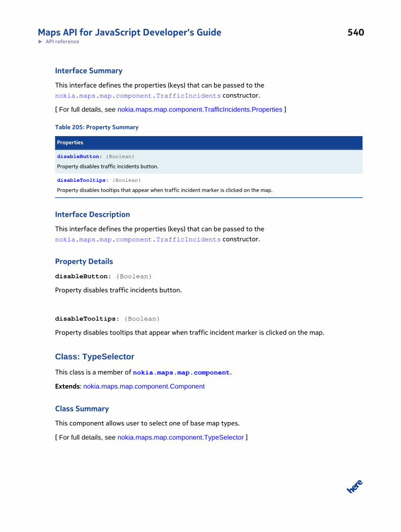
Maps API for JavaScript Developer's Guide 540► API reference
Interface Summary
This interface defines the properties (keys) that can be passed to the
nokia.maps.map.component.TrafficIncidents constructor.
[ For full details, see nokia.maps.map.component.TrafficIncidents.Properties ]
Table 205: Property Summary
Properties
disableButton: {Boolean}
Property disables traffic incidents button.
disableTooltips: {Boolean}
Property disables tooltips that appear when traffic incident marker is clicked on the map.
Interface Description
This interface defines the properties (keys) that can be passed to the
nokia.maps.map.component.TrafficIncidents constructor.
Property Details
disableButton: {Boolean}
Property disables traffic incidents button.
disableTooltips: {Boolean}
Property disables tooltips that appear when traffic incident marker is clicked on the map.
Class: TypeSelector
This class is a member of nokia.maps.map.component.
Extends: nokia.maps.map.component.Component
Class Summary
This component allows user to select one of base map types.
[ For full details, see nokia.maps.map.component.TypeSelector ]
Maps API for JavaScript Developer's Guide 541► API reference
Property Summary
Directly Inherited Properties
Inherited from class nokia.maps.map.component.Component :
mapDisplay
Method Summary
Directly Inherited Methods
Inherited from class nokia.maps.map.component.Component :
attach, destroy, detach, getId
Inherited from class nokia.maps.util.OObject :
addObserver, get, remove, removeObserver, set
Class Description
This class defines a user interface component that allows the user to change the current base map
type. Note that the component might not show all of the available base map types. Please check
nokia.maps.map.Display#availableBaseMapTypes to see the complete list of map types.
To instantiate this class, use the default constructor without arguments:
var myTypeSelector = new nokia.maps.map.component.TypeSelector();
Constructor Details
nokia.maps.map.component.TypeSelector()
This method initializes a new instance of TypeSelector.
Class: ViewControl
This class is a member of nokia.maps.map.component.
Extends: nokia.maps.map.component.Component
Class Summary
This class enables user to manipulate map, like changing heading tilt and center of the map.
[ For full details, see nokia.maps.map.component.ViewControl ]
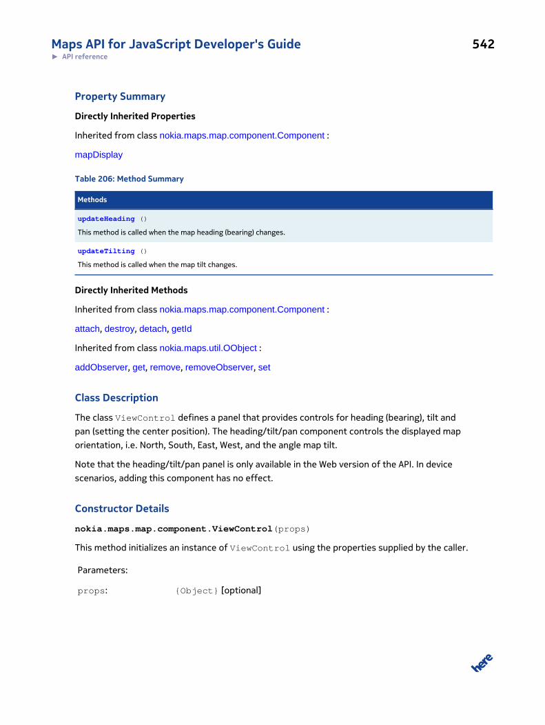
Maps API for JavaScript Developer's Guide 542► API reference
Property Summary
Directly Inherited Properties
Inherited from class nokia.maps.map.component.Component :
mapDisplay
Table 206: Method Summary
Methods
updateHeading ()
This method is called when the map heading (bearing) changes.
updateTilting ()
This method is called when the map tilt changes.
Directly Inherited Methods
Inherited from class nokia.maps.map.component.Component :
attach, destroy, detach, getId
Inherited from class nokia.maps.util.OObject :
addObserver, get, remove, removeObserver, set
Class Description
The class ViewControl defines a panel that provides controls for heading (bearing), tilt and
pan (setting the center position). The heading/tilt/pan component controls the displayed map
orientation, i.e. North, South, East, West, and the angle map tilt.
Note that the heading/tilt/pan panel is only available in the Web version of the API. In device
scenarios, adding this component has no effect.
Constructor Details
nokia.maps.map.component.ViewControl(props)
This method initializes an instance of ViewControl using the properties supplied by the caller.
Parameters:
props: {Object} [optional]
Maps API for JavaScript Developer's Guide 543► API reference
an object which can contain properties / methods to be appended to in-
stances of this class; the object extends the component.
Method Details
updateHeading()
This method is called when the map heading (bearing) changes. It updates the map component to
reflect these changes.
updateTilting()
This method is called when the map tilt changes. It updates the the map component to reflect these
changes.
Class: ZoomBar
This class is a member of nokia.maps.map.component.
Extends: nokia.maps.map.component.Component
Class Summary
This component enables zoom in and out buttons.
[ For full details, see nokia.maps.map.component.ZoomBar ]
Property Summary
Directly Inherited Properties
Inherited from class nokia.maps.map.component.Component :
mapDisplay
Method Summary
Directly Inherited Methods
Inherited from class nokia.maps.map.component.Component :
attach, destroy, detach, getId
Inherited from class nokia.maps.util.OObject :
addObserver, get, remove, removeObserver, set
Maps API for JavaScript Developer's Guide 544► API reference
Class Description
The class ZoomBar defines a component that allows the user to control the zoom level of the map.
In the basic version, the zoom bar consists of two buttons (labeled "+" and "-") that permit the map
user to change the zoom level.
To instantiate this class, use the default constructor without arguments:
var myZoomBar = new nokia.maps.map.component.ZoomBar();
Constructor Details
nokia.maps.map.component.ZoomBar()
This method initializes a new instance of ZoomBar.
Class: ZoomRectangle
This class is a member of nokia.maps.map.component.
Extends: nokia.maps.map.component.Component
Class Summary
This component adds zoom rectangle functionality to the map.
[ For full details, see nokia.maps.map.component.ZoomRectangle ]
Table 207: Property Summary
Properties
on: {Boolean}
This property holds a value indicating if the zoom rectangle mode is currently activated (true) or not (false).
rectNode: {DomElement}
This property holds a reference to rectangle DOM element used for the zoom rectangle selection.
Directly Inherited Properties
Inherited from class nokia.maps.map.component.Component :
mapDisplay
Maps API for JavaScript Developer's Guide 545► API reference
Table 208: Method Summary
Methods
static switchOnOff ()
This method toggles the zoom rectangle functionality.
Directly Inherited Methods
Inherited from class nokia.maps.map.component.Component :
attach, destroy, detach, getId
Inherited from class nokia.maps.util.OObject :
addObserver, get, remove, removeObserver, set
Class Description
This map component adds zoom rectangle functionality. When the component is activated, the user
can zoom into an area by dragging a rectangle on the map.
Constructor Details
nokia.maps.map.component.ZoomRectangle(props)
This method initializes a new instance of ZoomRectangle.
Parameters:
props: {Object} [optional]
optional initialization parameters
Property Details
on: {Boolean}
This property holds a value indicating if the zoom rectangle mode is currently activated (true) or not
(false).
rectNode: {DomElement}
This property holds a reference to rectangle DOM element used for the zoom rectangle selection. By
default, the element is a <div> with a border: "2px solid black", unless otherwise specified.
Maps API for JavaScript Developer's Guide 546► API reference
Method Details
static switchOnOff()
This method toggles the zoom rectangle functionality.
Interface: Properties
This interface is a member of nokia.maps.map.component.ZoomRectangle.
Interface Summary
This interface defines the properties (keys) that can be passed to the
nokia.maps.map.component.ZoomRectangle constructor.
[ For full details, see nokia.maps.map.component.ZoomRectangle.Properties ]
Interface Description
This interface defines the properties (keys) that can be passed to the
nokia.maps.map.component.ZoomRectangle constructor.
Namespace: objects
This namespace is a member of nokia.maps.map.component.
Namespace Summary
This namespace implements draggable behavior for map markers.
Namespace Description
This namespace implements draggable behavior for map markers.
Class: DragMarker
This class is a member of nokia.maps.map.component.objects.
Extends: nokia.maps.map.component.Component
Class Summary
This component allows markers to be draggable.
[ For full details, see nokia.maps.map.component.objects.DragMarker ]
Maps API for JavaScript Developer's Guide 547► API reference
Table 209: Property Summary
Properties
enabled: {Boolean}
This Boolean property is set to true if the component is enabled, false otherwise.
Directly Inherited Properties
Inherited from class nokia.maps.map.component.Component :
mapDisplay
Method Summary
Directly Inherited Methods
Inherited from class nokia.maps.map.component.Component :
attach, destroy, detach, getId
Inherited from class nokia.maps.util.OObject :
addObserver, get, remove, removeObserver, set
Class Description
This component implements the default draggability for markers. If this component is added to the
map, all markers and standard markers on which the property "draggable" is set to true can be
dragged by the user.
Constructor Details
nokia.maps.map.component.objects.DragMarker
This method initializes an instance of DragMarker, using the properties supplied by the caller. The
method is a virtual constructor for the component.
Parameters:
props: {Object}
The default observable key-value pairs for this component (see
nokia.maps.util.OObject).
Maps API for JavaScript Developer's Guide 548► API reference
Property Details
enabled: {Boolean}
This Boolean property is set to true if the component is enabled, false otherwise.
Namespace: panning
This namespace is a member of nokia.maps.map.component.
Namespace Summary
This namespace implements panning functionality, including kinetic panning.
Namespace Description
This namespace implements panning functionality, including kinetic panning. It makes panning
possible when the use clicks on the map or drags it.
Class: Click
This class is a member of nokia.maps.map.component.panning.
Extends: nokia.maps.map.component.Component
Class Summary
This component pans the map when the user clicks in the map.
[ For full details, see nokia.maps.map.component.panning.Click ]
Table 210: Property Summary
Properties
enabled: {Boolean}
This property determines if Click is enabled (true) or not (false).
Directly Inherited Properties
Inherited from class nokia.maps.map.component.Component :
mapDisplay
Method Summary
Directly Inherited Methods
Maps API for JavaScript Developer's Guide 549► API reference
Inherited from class nokia.maps.map.component.Component :
attach, destroy, detach, getId
Inherited from class nokia.maps.util.OObject :
addObserver, get, remove, removeObserver, set
Class Description
This component pans the map when the user clicks in the map.
Constructor Details
nokia.maps.map.component.panning.Click(props)
This method initializes an instance of Click, using the properties supplied by the caller. The method
is a virtual constructor for the component.
Parameters:
props: {Object}
The default observable key-value pairs for this component (see
nokia.maps.util.OObject).
Property Details
enabled: {Boolean}
This property determines if Click is enabled (true) or not (false).
Class: Drag
This class is a member of nokia.maps.map.component.panning.
Extends: nokia.maps.map.component.Component
Class Summary
This component enables map dragging with the left mouse button or with the finger on a touch
screen.
[ For full details, see nokia.maps.map.component.panning.Drag ]
Maps API for JavaScript Developer's Guide 550► API reference
Table 211: Property Summary
Properties
enabled: {Boolean}
This property indicates if the drag component is enabled.
useKineticPanning: {Boolean}
This property indicates whether the drag component uses kinetic panning if it is available.
Directly Inherited Properties
Inherited from class nokia.maps.map.component.Component :
mapDisplay
Method Summary
Directly Inherited Methods
Inherited from class nokia.maps.map.component.Component :
attach, destroy, detach, getId
Inherited from class nokia.maps.util.OObject :
addObserver, get, remove, removeObserver, set
Class Description
This component enables map dragging with the left mouse button or with the finger on a touch
screen.
Constructor Details
nokia.maps.map.component.panning.Drag(props)
This method initializes an instance of Drag, using the properties supplied by the caller. The method is
a virtual constructor for the component.
Parameters:
props: {Object}
The default observable key-value pairs for this component (see
nokia.maps.util.OObject).
Maps API for JavaScript Developer's Guide 551► API reference
Property Details
enabled: {Boolean}
This property indicates if the drag component is enabled. The value is true if the component is
enabled, false otherwise.
useKineticPanning: {Boolean}
This property indicates whether the drag component uses kinetic panning if it is available. The value
is true if kinetic panning is used, false otherwise.
Class: Kinetic
This class is a member of nokia.maps.map.component.panning.
Extends: nokia.maps.map.component.Component
Class Summary
This component enables kinetic panning functionality on the map.
[ For full details, see nokia.maps.map.component.panning.Kinetic ]
Property Summary
Directly Inherited Properties
Inherited from class nokia.maps.map.component.Component :
mapDisplay
Method Summary
Directly Inherited Methods
Inherited from class nokia.maps.map.component.Component :
attach, destroy, detach, getId
Inherited from class nokia.maps.util.OObject :
addObserver, get, remove, removeObserver, set
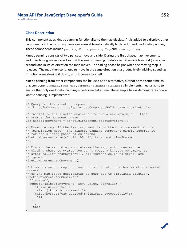
Maps API for JavaScript Developer's Guide 552► API reference
Class Description
This component adds kinetic panning functionality to the map display. If it is added to a display, other
components in the panning namespace are able automatically to detect it and use kinetic panning.
These components include panning.Click, panning.Tap and panning.Drag.
Kinetic panning consists of two pahses: move and slide. During the first phase, map movements
and their timing are recorded so that the kinetic panning module can determine how fast (pixels per
second) and in which direction the map moves. The sliding phase begins when the moving map is
released. The map then continues to move in the same direction at a gradually diminishing speed (as
if friction were slowing it down), until it comes to a halt.
Kinetic panning from other components can be used as an alternative, but not at the same time as
this component: nokia.maps.map.component.panning.Kinetic implements mechanisms to
ensure that only one kinetic panning is performed at a time. The example below demonstrates how a
kinetic panning is implemented:
// Query for the kinetic component.var kineticComponent = display.getComponentById("panning.Kinetic");
// Initialize the kinetic engine to record a new movement -- this // starts the movement phase.var kineticMovement = kineticComponent.startMovement();
// Move the map. If the last argument is omitted, no movement occurs// (simulation mode); the kinetic panning component simply records it // for the sliding phase calculations.kineticMovement.move(47, 11, 08, 15, true, evt.timeStamp);//...
// Finish the recording and release the map, which causes the // sliding phase to start. You can't reuse a kinetic movement, so// after calling endMovement(), all further calls to move() are // ignored.kineticMovement.endMovement();
// From now on the map continues to slide until another kinetic movement occurs// or the map speed decelerates to zero due to simulated friction.kineticMovement.addObserver( "finished", function(kineticMovement, key, value, oldValue) { if (value===true) { alert("kinetic movement "+ (this.aborted?"was aborted":"finished successfully")+ "!"); } }, this);
Maps API for JavaScript Developer's Guide 553► API reference
Constructor Details
nokia.maps.map.component.panning.Kinetic(props)
This method initializes an instance of Kinetic, using the properties supplied by the caller. The
method is a virtual constructor for the component.
Parameters:
props: {Object}
The default observable key-value pairs for this component (see
nokia.maps.util.OObject).
Class: Tap
This class is a member of nokia.maps.map.component.panning.
Extends: nokia.maps.map.component.Component
Class Summary
This component pans the map when the user taps in the map.
[ For full details, see nokia.maps.map.component.panning.Tap ]
Table 212: Property Summary
Properties
enabled: {Boolean}
This property determines if Tap is enabled (true) or not (false).
useKineticPanning: {Boolean}
This property determines if Tap is to use kinetic panning when available (true) or not (false).
Directly Inherited Properties
Inherited from class nokia.maps.map.component.Component :
mapDisplay
Method Summary
Directly Inherited Methods
Inherited from class nokia.maps.map.component.Component :
attach, destroy, detach, getId
Maps API for JavaScript Developer's Guide 554► API reference
Inherited from class nokia.maps.util.OObject :
addObserver, get, remove, removeObserver, set
Class Description
This component pans the map when the user taps in the map.
Constructor Details
nokia.maps.map.component.panning.Tap(props)
This method initializes an instance of Tap, using the properties supplied by the caller. The method is
a virtual constructor for the component.
Parameters:
props: {Object}
The default observable key-value pairs for this component (see
nokia.maps.util.OObject).
Property Details
enabled: {Boolean}
This property determines if Tap is enabled (true) or not (false).
useKineticPanning: {Boolean}
This property determines if Tap is to use kinetic panning when available (true) or not (false).
Namespace: zoom
This namespace is a member of nokia.maps.map.component.
Namespace Summary
This namespace implements zooming functionality, allowing the map zoom to change when the user
clicks or taps on the map, scrolls the mouse wheel or uses gestures.
Maps API for JavaScript Developer's Guide 555► API reference
Namespace Description
This namespace implements zooming functionality, allowing the map zoom to change when the user
clicks or taps on the map, scrolls the mouse wheel or uses gestures.
Class: DoubleClick
This class is a member of nokia.maps.map.component.zoom.
Extends: nokia.maps.map.component.Component
Class Summary
This class represents a component that zooms the map when the user double clicks into it.
[ For full details, see nokia.maps.map.component.zoom.DoubleClick ]
Table 213: Property Summary
Properties
enabled: {Boolean}
This property determines if the component is enabled (true) or disabled (false).
Directly Inherited Properties
Inherited from class nokia.maps.map.component.Component :
mapDisplay
Method Summary
Directly Inherited Methods
Inherited from class nokia.maps.map.component.Component :
attach, destroy, detach, getId
Inherited from class nokia.maps.util.OObject :
addObserver, get, remove, removeObserver, set
Class Description
This class represents a component that zooms the map when the user double clicks into it. It zooms
in on a left mouse button double click and zooms out on a right mouse button double click.
Maps API for JavaScript Developer's Guide 556► API reference
Constructor Details
nokia.maps.map.component.zoom.DoubleClick(props)
This method initializes an instance of DoubleClick, using the properties supplied by the caller. The
method is a virtual constructor for the component.
Parameters:
props: {Object}
The default observable key-value pairs for this component (see
nokia.maps.util.OObject).
Property Details
enabled: {Boolean}
This property determines if the component is enabled (true) or disabled (false). When
nokia.maps.map.component.zoom.DoubleClick is disabled, zooming in response to mouse
double clicks does not occur.
Class: DoubleTap
This class is a member of nokia.maps.map.component.zoom.
Extends: nokia.maps.map.component.Component
Class Summary
This class represents a component that zooms in the map view when the user taps twice on the map
on a touch screen.
[ For full details, see nokia.maps.map.component.zoom.DoubleTap ]
Table 214: Property Summary
Properties
enabled: {Boolean}
This property determines if the component is enabled (true) or disabled (false).
Directly Inherited Properties
Inherited from class nokia.maps.map.component.Component :
mapDisplay
Maps API for JavaScript Developer's Guide 557► API reference
Method Summary
Directly Inherited Methods
Inherited from class nokia.maps.map.component.Component :
attach, destroy, detach, getId
Inherited from class nokia.maps.util.OObject :
addObserver, get, remove, removeObserver, set
Class Description
This class represents a component that zooms in the map view when the user taps twice on the map
on a touch screen.
Constructor Details
nokia.maps.map.component.zoom.DoubleTap(props)
This method initializes an instance of DoubleTap, using the properties supplied by the caller. The
method is a virtual constructor for the component.
Parameters:
props: {Object}
The default observable key-value pairs for this component (see
nokia.maps.util.OObject).
Property Details
enabled: {Boolean}
This property determines if the component is enabled (true) or disabled (false). When
nokia.maps.map.component.zoom.DoubleTap is disabled, zooming on double tap does not
occur.
Class: Gesture
This class is a member of nokia.maps.map.component.zoom.
Extends: nokia.maps.map.component.Component
Class Summary
This component will zoom the map if the user makes a zoom gesture at a touch screen.
Maps API for JavaScript Developer's Guide 558► API reference
[ For full details, see nokia.maps.map.component.zoom.Gesture ]
Table 215: Property Summary
Properties
enabled: {Boolean}
If this property is false, then the component will be disabled and no zoom will occur.
Directly Inherited Properties
Inherited from class nokia.maps.map.component.Component :
mapDisplay
Method Summary
Directly Inherited Methods
Inherited from class nokia.maps.map.component.Component :
attach, destroy, detach, getId
Inherited from class nokia.maps.util.OObject :
addObserver, get, remove, removeObserver, set
Class Description
This component will zoom the map if the user makes a zoom gesture at a touch screen.
Constructor Details
nokia.maps.map.component.zoom.Gesture()
This method initializes an instance of Gesture.
Property Details
enabled: {Boolean}
If this property is false, then the component will be disabled and no zoom will occur.
Class: MouseWheel
This class is a member of nokia.maps.map.component.zoom.
Extends: nokia.maps.map.component.Component
Maps API for JavaScript Developer's Guide 559► API reference
Class Summary
This class represents a component that zooms in the map view when the user taps twice on the map
on a touch screen.
[ For full details, see nokia.maps.map.component.zoom.MouseWheel ]
Table 216: Property Summary
Properties
enabled: {Boolean}
This property determines if the component is enabled (true) or disabled (false).
Directly Inherited Properties
Inherited from class nokia.maps.map.component.Component :
mapDisplay
Method Summary
Directly Inherited Methods
Inherited from class nokia.maps.map.component.Component :
attach, destroy, detach, getId
Inherited from class nokia.maps.util.OObject :
addObserver, get, remove, removeObserver, set
Class Description
This class represents a component that zooms in the map view when the user taps twice on the map
on a touch screen.
Constructor Details
nokia.maps.map.component.zoom.MouseWheel()
This method initializes an instance of MouseWheel.
Property Details
enabled: {Boolean}
Maps API for JavaScript Developer's Guide 560► API reference
This property determines if the component is enabled (true) or disabled (false). When
nokia.maps.map.component.zoom.MouseWheel is disabled, zooming in response to double taps
does not occur.
Namespace: providerThis namespace is a member of nokia.maps.map.
Namespace Summary
This namespace provides basic provider classes that can be extended and used for providing own
tiles or objects to map.
Namespace Description
This namespace provides basic provider classes that can be extended and used for providing own
tiles or objects to map.
Class: BitmapProvider
This class is a member of nokia.maps.map.provider.
Extends: nokia.maps.map.provider.Provider
Class Summary
This is an class representing a bitmap provider.
[ For full details, see nokia.maps.map.provider.BitmapProvider ]
Property Summary
Directly Inherited Properties
Inherited from class nokia.maps.map.provider.Provider :
description, getInvalidationMark, id, label, max, min
Table 217: Method Summary
Methods
create (id, bBox, cacheOnly) : {nokia.maps.map.provider.BitmapProvider.Request}
This method creates bitmap data.
getId () : {String}

Maps API for JavaScript Developer's Guide 561► API reference
Methods
This method returns created request ID.
request (bBox, cacheOnly, callback) : {nokia.maps.map.provider.BitmapProvider.Request |undefined}
Method requests an bitmap specified by getUrl method if given screen bounding box intersects with provider bounding box.
Directly Inherited Methods
Inherited from class nokia.maps.map.provider.Provider :
getCopyrights, providesLevel, shutdown, update
Inherited from class nokia.maps.util.EventTarget :
addListener, dispatch, removeListener
Event Summary
Directly Inherited Events
Inherited from class nokia.maps.map.provider.Provider :
response, update
Class Description
This provider is helpful to display bitmap in given bounding box. When updateCycle property is set
than bitmap is periodically exchanged.
Constructor Details
nokia.maps.map.provider.BitmapProvider(options)
This method initializes the bitmap provider, using the caller-supplied options.
Parameters:
options: {nokia.maps.map.provider.BitmapProvider.Options}
Method Details
create(id, bBox, cacheOnly):
{nokia.maps.map.provider.BitmapProvider.Request}
This method creates bitmap data.

Maps API for JavaScript Developer's Guide 562► API reference
Parameters:
id: {String}
Id of created bitmap request.
bBox: {nokia.maps.geo.BoundingBox}
BoundingBox returned by
nokia.maps.map.provider.BitmapProvider#getBoundingBox method.
cacheOnly: {Boolean}
A flag to signal that bitmap is created in cacheOnly mode, see
nokia.maps.map.provider.BitmapProvider#request method.
Returns:
{nokia.maps.map.provider.BitmapProvider.Request}
getId(): {String}
This method returns created request ID.
Returns:
{String}
request(bBox, cacheOnly, callback):
{nokia.maps.map.provider.BitmapProvider.Request | undefined}
Method requests an bitmap specified by getUrl method if given screen bounding box intersects with
provider bounding box.
Parameters:
bBox: {nokia.maps.geo.BoundingBox}
Screen bounding box.
cacheOnly: {boolean} [optional, default: false]
A flag to signal that only cached bitmaps should be taken into account
Maps API for JavaScript Developer's Guide 563► API reference
callback: {function(nokia.maps.map.provider.BitmapProvider.Request}
Callback given by layer called when bitmap request was finished.
Returns:
{nokia.maps.map.provider.BitmapProvider.Request
| undefined}
The Request object which is handling bitmap image creation or undefined
to signal "non provided" for request which are not covered by provider
bounding box.
Interface: Options
This interface is a member of nokia.maps.map.provider.BitmapProvider.
Interface Summary
This interface defines properties of class BitmapProvider
[ For full details, see nokia.maps.map.provider.BitmapProvider.Options ]
Property Summary
Directly Inherited Properties
Inherited from class nokia.maps.map.provider.Provider.Options :
description, getCopyrights, label, max, min, updateCycle
Table 218: Method Summary
Methods
getBoundingBox () : {nokia.maps.geo.BoundingBox}
Returns the bounding box of a provided image.
Interface Description
This interface defines properties of class BitmapProvider
Method Details
getBoundingBox(): {nokia.maps.geo.BoundingBox}
Maps API for JavaScript Developer's Guide 564► API reference
Returns the bounding box of a provided image.
Returns:
{nokia.maps.geo.BoundingBox}
Class: Request
This class is a member of nokia.maps.map.provider.BitmapProvider.
Class Summary
This is an class representing a bitmap provider request object.
[ For full details, see nokia.maps.map.provider.BitmapProvider.Request ]
Table 219: Property Summary
Properties
bbox: {nokia.maps.geo.BoundingBox}
Holds bounding box for which request was triggered.
data: {*}
Holds the data of Request.
id: {String}
Holds id of request.
state: {Boolean | undefined}
Holds the state of the request.
Table 220: Method Summary
Methods
abort ()
Aborts the ongoing bitmap image request
send (onStateChange)
Fires request to crate new bitmap image
Class Description
This is an helper class which holds all necessary information to finalize bitmap request (paint it or
request from server).
Maps API for JavaScript Developer's Guide 565► API reference
Constructor Details
nokia.maps.map.provider.BitmapProvider.Request(id, bbox, provider)
This method initializes the bitmap provider request.
Parameters:
id: {String}
Request id
bbox: {nokia.maps.geo.BoundingBox}
Requested bounding box
provider: {nokia.maps.map.provider.Provider}
Provider which create instance of request
Property Details
bbox: {nokia.maps.geo.BoundingBox}
Holds bounding box for which request was triggered.
data: {*}
Holds the data of Request.
id: {String}
Holds id of request.
state: {Boolean | undefined}
Holds the state of the request. Value undefined means undefined state. Value true means that
request was successful. Value false means that request wasn't successful.
Method Details
abort()
Aborts the ongoing bitmap image request
Maps API for JavaScript Developer's Guide 566► API reference
send(onStateChange)
Fires request to crate new bitmap image
Parameters:
onStateChange: {Function(nokia.maps.map.provider.BitmapProvider.Request)}
Callback called when state changed
Class: CanvasProvider
This class is a member of nokia.maps.map.provider.
Extends: nokia.maps.map.provider.BitmapProvider
Class Summary
This class represents a provider a canvas object that supports drawing.
[ For full details, see nokia.maps.map.provider.CanvasProvider ]
Table 221: Property Summary
Properties
draw:
This method draws an image on the canvas specified by the caller.
getBoundingBox: {nokia.maps.geo.BoundingBox}
This function retrieves the bounding box of a provided image.
Directly Inherited Properties
Inherited from class nokia.maps.map.provider.Provider :
description, getInvalidationMark, id, label, max, min
Method Summary
Directly Inherited Methods
Inherited from class nokia.maps.map.provider.BitmapProvider :
create, getId, request
Inherited from class nokia.maps.map.provider.Provider :
Maps API for JavaScript Developer's Guide 567► API reference
getCopyrights, providesLevel, shutdown, update
Inherited from class nokia.maps.util.EventTarget :
addListener, dispatch, removeListener
Event Summary
Directly Inherited Events
Inherited from class nokia.maps.map.provider.Provider :
response, update
Class Description
This class represents a provider a canvas object that supports drawing.
Constructor Details
nokia.maps.map.provider.CanvasProvider(options)
This method initializes the canvas provider using the caller-supplied options.
Parameters:
options: {nokia.maps.map.provider.CanvasProvider.Options}
An object containing instance intialization prameters.
Example:
map = new nokia.maps.map.Display(...);var cycleIndex = 0, canvasProvider = new nokia.maps.map.provider.CanvasProvider({ min: 0, max: 20, opacity: 0.5, updateCycle: 1/10, //seconds draw: function(canvas, callback) { var ctx = canvas.getContext("2d"); canvas.width = 500; canvas.height = 500; ctx.fillStyle = "rgb(200,0,0)"; ctx.fillRect (0, 0, canvas.width, canvas.height); ctx.font = "100pt Arial"; ctx.fillStyle = "rgb(200,200,0)"; ctx.fillText("" + (1+cycleIndex), 10, 110);
Maps API for JavaScript Developer's Guide 568► API reference
// The following call is mandatory, it triggers the // actual render on the map callback(canvas, true, true); }, getBoundingBox: function () { return new nokia.maps.geo.BoundingBox([54.992047222, 1.912952778], [46.855536111, 15.898755556]) } });
canvasProvider.addListener("update", function (evt) { cycleIndex = ++cycleIndex % 10 || 0; }); map.overlays.add(canvasProvider);
Property Details
draw:
This method draws an image on the canvas specified by the caller. The method must be supplied by
CanvasProvider instances.
getBoundingBox: {nokia.maps.geo.BoundingBox}
This function retrieves the bounding box of a provided image. This function must be supplied by
CanvasProvider instances.
Interface: Options
This interface is a member of nokia.maps.map.provider.CanvasProvider.
Extends: nokia.maps.map.provider.BitmapProvider.Options
Interface Summary
This interface defines properties of the class {@link nokia.maps.map.provider.CanvasProvider}.
[ For full details, see nokia.maps.map.provider.CanvasProvider.Options ]
Property Summary
Directly Inherited Properties
Inherited from class nokia.maps.map.provider.Provider.Options :
description, getCopyrights, label, max, min, updateCycle
Maps API for JavaScript Developer's Guide 569► API reference
Method Summary
Directly Inherited Methods
Inherited from class nokia.maps.map.provider.BitmapProvider.Options :
getBoundingBox
Interface Description
This interface defines properties of the class {@link nokia.maps.map.provider.CanvasProvider}.
Class: Request
This class is a member of nokia.maps.map.provider.CanvasProvider.
Extends: nokia.maps.map.provider.BitmapProvider.Request
Class Summary
This class represents a canvas provider request object.
[ For full details, see nokia.maps.map.provider.CanvasProvider.Request ]
Table 222: Property Summary
Properties
data: {HTMLCanvasElement}
This property holds the data associated with the request, which is and instance of HTMLCanvasElement.
Directly Inherited Properties
Inherited from class nokia.maps.map.provider.BitmapProvider.Request :
bbox, data, id, state
Table 223: Method Summary
Methods
abort ()
This method aborts a pending draw canvas request.
send (onStateChange)
This method sends a request to crate new canvas image.
Directly Inherited Methods
Maps API for JavaScript Developer's Guide 570► API reference
Inherited from class nokia.maps.map.provider.BitmapProvider.Request :
abort, send
Class Description
This is a helper class which holds a reference to requested canvas, the related bounding box and a
callback.
Constructor Details
nokia.maps.map.provider.CanvasProvider.Request(id, bbox, provider)
This method initializes the canvas provider request.
Parameters:
id: {String}
Request id
bbox: {nokia.maps.geo.BoundingBox}
An object representing the requested bounding box
provider: {nokia.maps.map.provider.Provider}
An object representing the provider to which the request is addressed.
Property Details
data: {HTMLCanvasElement}
This property holds the data associated with the request, which is and instance of
HTMLCanvasElement.
Method Details
abort()
This method aborts a pending draw canvas request.
send(onStateChange)
This method sends a request to crate new canvas image.
Maps API for JavaScript Developer's Guide 571► API reference
Parameters:
onStateChange: {Function(nokia.maps.map.provider.CanvasProvider.Request)}
A callback function to be invoked when the image state has changed.
Interface: IData
This interface is a member of nokia.maps.map.provider.
Interface Summary
An interface for a data object which is provided by a nokia.maps.map.Provider.
[ For full details, see nokia.maps.map.provider.IData ]
Table 224: Property Summary
Properties
id: {String}
The ID of the provider data.
Table 225: Method Summary
Methods
getInvalidations (invalidationMark) : {Number}
To obtain the invalidation states of a provider's data.
Interface Description
An interface for a data object which is provided by a nokia.maps.map.Provider.
Property Details
id: {String}
The ID of the provider data. The ID starts with the ID of the provider which provided the data object
followed by an underscore "_".
Method Details
getInvalidations(invalidationMark): {Number}
To obtain the invalidation states of a provider's data.

Maps API for JavaScript Developer's Guide 572► API reference
Parameters:
invalidationMark: {Number}
A invalidationMark to check against.
Returns:
{Number} a bit mask which specifies the invalid parts of the checked provider date. If
no bit is set (value 0) the provider data is valid. The meaning of all bits has
to be defined by concrete Provider implementation which provides the da-
ta.
Class: ImageProvider
This class is a member of nokia.maps.map.provider.
Extends: nokia.maps.map.provider.BitmapProvider
Class Summary
This class represents an image provider.
[ For full details, see nokia.maps.map.provider.ImageProvider ]
Table 226: Property Summary
Properties
getBoundingBox: {nokia.maps.geo.BoundingBox}
This method retrieves the bounding box of the image.
getUrl: {String}
This method retrieves the URL of the image associated with the given instancenokia.maps.map.provider.ImageProvider.
Directly Inherited Properties
Inherited from class nokia.maps.map.provider.Provider :
description, getInvalidationMark, id, label, max, min
Method Summary
Directly Inherited Methods
Inherited from class nokia.maps.map.provider.BitmapProvider :
Maps API for JavaScript Developer's Guide 573► API reference
create, getId, request
Inherited from class nokia.maps.map.provider.Provider :
getCopyrights, providesLevel, shutdown, update
Inherited from class nokia.maps.util.EventTarget :
addListener, dispatch, removeListener
Event Summary
Directly Inherited Events
Inherited from class nokia.maps.map.provider.Provider :
response, update
Class Description
This class represents an image provider. It displays an image in a bounding box. When the property
updateCycle is set, then the image is periodically exchanged.
Constructor Details
nokia.maps.map.provider.ImageProvider(options)
This method initializes the image provider, using the caller-supplied options.
Parameters:
options: {nokia.maps.map.provider.ImageProvider.Options}
An object containing instance intialization prameters.
Example:
map = new nokia.maps.map.Display(...);//create and ImageProvidervar imageIds = "image1.jpg image2.jpg image3.jpg image4.jpg".split(" "), numberOfImagesToCache = 4, cycleIndex = 0, rainRadar = new nokia.maps.map.provider.ImageProvider({ min: 0, max: 20, getBoundingBox: function () { return new nokia.maps.geo.BoundingBox([54.992047222, 1.912952778], [46.855536111, 15.898755556]); },

Maps API for JavaScript Developer's Guide 574► API reference
getUrl: function () { return "http://example.com/" + imageIds[cycleIndex]; }, updateCycle: 2/3, //seconds cache: new nokia.maps.util.Cache(numberOfImagesToCache) });
rainRadar.addListener("update", function (evt) { cycleIndex = ++cycleIndex % imageIds.length || 0; }); map.overlays.add(rainRadar);
Property Details
getBoundingBox: {nokia.maps.geo.BoundingBox}
This method retrieves the bounding box of the image. This method must be supplied by instances of
nokia.maps.map.provider.ImageProvider.
getUrl: {String}
This method retrieves the URL of the image associated with the given instance
nokia.maps.map.provider.ImageProvider. This method must be supplied by instances of
nokia.maps.map.provider.ImageProvider.
Interface: Options
This interface is a member of nokia.maps.map.provider.ImageProvider.
Extends: nokia.maps.map.provider.BitmapProvider.Options
Interface Summary
This interface defines the properties of the class {@link nokia.maps.map.provider.ImageProvider}.
[ For full details, see nokia.maps.map.provider.ImageProvider.Options ]
Property Summary
Directly Inherited Properties
Inherited from class nokia.maps.map.provider.Provider.Options :
description, getCopyrights, label, max, min, updateCycle
Maps API for JavaScript Developer's Guide 575► API reference
Table 227: Method Summary
Methods
draw (callback)
This method draws a new image on the specified canvas.
getUrl () : {String}
This method retrieves the URL of the image associated with the given instance of ImageProvider.
Directly Inherited Methods
Inherited from class nokia.maps.map.provider.BitmapProvider.Options :
getBoundingBox
Interface Description
This interface defines the properties of the class {@link nokia.maps.map.provider.ImageProvider}.
Method Details
draw(callback)
This method draws a new image on the specified canvas. The method must be implemented by
instances of {@link nokia.maps.map.provider.ImageProvider}.
Parameters:
callback: {Function(HTMLCanvasElement|Boolean|Boolean)}
Callback function to be called when the new image is drawn to canvas. Its
parameters are:
• canvas (HTMLCanvasElement) - An object representing the canvas on
which to draw
• drawn (Boolean) - true if drawing was successful, otherwise false. The
value is set to false when nothing was drawn, for example, because no
data were provided.
• synchronous (Boolean) - true if the callback is called synchronously,
otherwise false
getUrl(): {String}

Maps API for JavaScript Developer's Guide 576► API reference
This method retrieves the URL of the image associated with the given instance of ImageProvider.
Returns:
{String} The URL of the image associated with the given instance of Image-
Provider.
Class: Request
This class is a member of nokia.maps.map.provider.ImageProvider.
Extends: nokia.maps.map.provider.BitmapProvider.Request
Class Summary
This is a class representing an image provider request object.
[ For full details, see nokia.maps.map.provider.ImageProvider.Request ]
Table 228: Property Summary
Properties
data: {Image}
This property holds the data associated with the request, which is the image object.
id: {String}
This property holds the id of the request.
Directly Inherited Properties
Inherited from class nokia.maps.map.provider.BitmapProvider.Request :
bbox, data, id, state
Table 229: Method Summary
Methods
abort ()
This method aborts the pending image provider request.
send (onStateChange)
This method sends a request for notification to the image provider.
Directly Inherited Methods
Inherited from class nokia.maps.map.provider.BitmapProvider.Request :
Maps API for JavaScript Developer's Guide 577► API reference
abort, send
Class Description
This is a helper class which holds a reference to the requested image and the related bounding box
and callback.
Constructor Details
nokia.maps.map.provider.ImageProvider.Request(id, bbox, provider)
This method initializes an image provider request.
Parameters:
id: {String}
The request id for ImageTile.Request; the value is URL of the image.
bbox: {nokia.maps.geo.BoundingBox}
An object representing the bounding box (containing the image).
provider: {nokia.maps.map.provider.Provider}
An object representing the provider to which the request is addressed
Property Details
data: {Image}
This property holds the data associated with the request, which is the image object.
id: {String}
This property holds the id of the request. In this case the id is the URL of the image.
Method Details
abort()
This method aborts the pending image provider request.
send(onStateChange)
Maps API for JavaScript Developer's Guide 578► API reference
This method sends a request for notification to the image provider.
Parameters:
onStateChange: {Function(nokia.maps.map.provider.ImageProvider.Request)}
A callback function to be called when the image state has changed.
Class: ImgTileProvider
This class is a member of nokia.maps.map.provider.
Extends: nokia.maps.map.provider.TileProvider
Class Summary
This class provides Image objects as map tiles.
[ For full details, see nokia.maps.map.provider.ImgTileProvider ]
Property Summary
Directly Inherited Properties
Inherited from class nokia.maps.map.provider.TileProvider :
pixelProjections
Inherited from class nokia.maps.map.provider.Provider :
description, getInvalidationMark, id, label, max, min
Method Summary
Directly Inherited Methods
Inherited from class nokia.maps.map.provider.TileProvider :
cancel, checkAddy, create, createId, destroy, request
Inherited from class nokia.maps.map.provider.Provider :
getCopyrights, providesLevel, shutdown, update
Inherited from class nokia.maps.util.EventTarget :
addListener, dispatch, removeListener
Maps API for JavaScript Developer's Guide 579► API reference
Event Summary
Directly Inherited Events
Inherited from class nokia.maps.map.provider.Provider :
response, update
Class Description
A class to provide Image objects as tiles. These Implementation of a TileProvider tries to load Images
from a URL which will be specified by the ImgTileProvider instance. The world is repeating on x-axis.
Constructor Details
nokia.maps.map.provider.ImgTileProvider(options)
Parameters:
options: {nokia.maps.map.provider.ImgTileProvider.Options}
Interface: Options
This interface is a member of nokia.maps.map.provider.ImgTileProvider.
Interface Summary
The interface defines properties of class ImgTileProvider
[ For full details, see nokia.maps.map.provider.ImgTileProvider.Options ]
Property Summary
Directly Inherited Properties
Inherited from class nokia.maps.map.provider.TileProvider.Options :
alpha, cache, opacity, scalable
Inherited from class nokia.maps.map.provider.Provider.Options :
description, getCopyrights, label, max, min, updateCycle
Table 230: Method Summary
Methods
getUrl (level, row, col) : {string}
Maps API for JavaScript Developer's Guide 580► API reference
Methods
A method to create the URL for the specified tile.
Interface Description
The interface defines properties of class ImgTileProvider
Method Details
getUrl(level, row, col): {string}
A method to create the URL for the specified tile.
Parameters:
level: {number}
The zoom level of the requested tile URL.
row: {number}
The row of the requested tile URL.
col: {number}
The column of the requested tile URL.
Returns:
{string} The URL of the requested tile or false if the tile is not provided
Class: Provider
This class is a member of nokia.maps.map.provider.
Extends: nokia.maps.util.EventTarget
Class Summary
This is an abstract class that represents a map provider.
[ For full details, see nokia.maps.map.provider.Provider ]
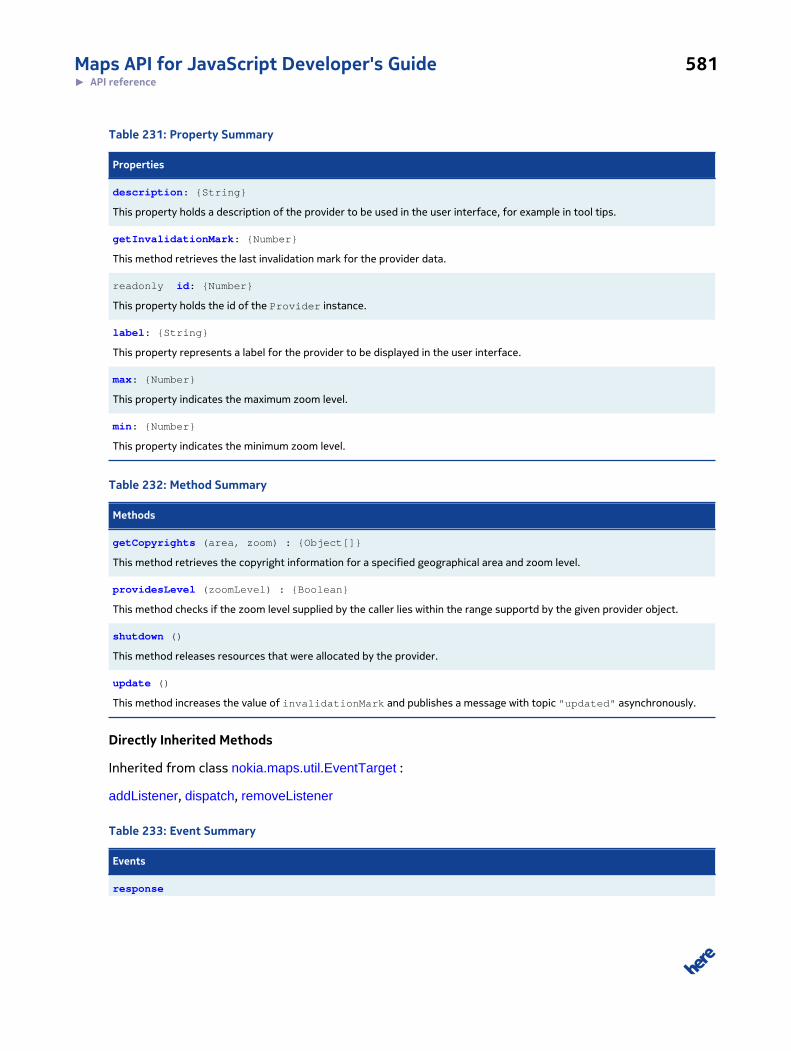
Maps API for JavaScript Developer's Guide 581► API reference
Table 231: Property Summary
Properties
description: {String}
This property holds a description of the provider to be used in the user interface, for example in tool tips.
getInvalidationMark: {Number}
This method retrieves the last invalidation mark for the provider data.
readonly id: {Number}
This property holds the id of the Provider instance.
label: {String}
This property represents a label for the provider to be displayed in the user interface.
max: {Number}
This property indicates the maximum zoom level.
min: {Number}
This property indicates the minimum zoom level.
Table 232: Method Summary
Methods
getCopyrights (area, zoom) : {Object[]}
This method retrieves the copyright information for a specified geographical area and zoom level.
providesLevel (zoomLevel) : {Boolean}
This method checks if the zoom level supplied by the caller lies within the range supportd by the given provider object.
shutdown ()
This method releases resources that were allocated by the provider.
update ()
This method increases the value of invalidationMark and publishes a message with topic "updated" asynchronously.
Directly Inherited Methods
Inherited from class nokia.maps.util.EventTarget :
addListener, dispatch, removeListener
Table 233: Event Summary
Events
response
Maps API for JavaScript Developer's Guide 582► API reference
Events
This event is fired when an asynchronously processing of a request has been finished.
update
This event is fired if when the provider content has been changed.
Class Description
This is an abstract class representing a map provider. A provider can be understood as a data vendor
for items such as:
• Map tiles - this is common functionality
• Spatial objects - for example to visualize traffic or public transport lines
• Marker objects - for example to mark stores in a store finder overlay
The constructor for this class initializes an object based on Provider, using the argument provided
by the caller.
Constructor Details
nokia.maps.map.provider.Provider(options)
Parameters:
options: {nokia.maps.map.provider.Provider.Options}
Property Details
description: {String}
This property holds a description of the provider to be used in the user interface, for example in tool
tips.
Default Value: ""
getInvalidationMark: {Number}
This method retrieves the last invalidation mark for the provider data.
See: nokia.maps.map.provider.Provider#getInvalidations
readonly id: {Number}
Maps API for JavaScript Developer's Guide 583► API reference
This property holds the id of the Provider instance.
label: {String}
This property represents a label for the provider to be displayed in the user interface.
Default Value: ""
max: {Number}
This property indicates the maximum zoom level. Its value must be an integer in range from -1 to 30.
A value of -1 indicates that the provider doesn't provide data in any zoom level.
Default Value: -1
min: {Number}
This property indicates the minimum zoom level. Its value must be an integer in the range from 0 to
30.
Default Value: 0
Method Details
getCopyrights(area, zoom): {Object[]}
This method retrieves the copyright information for a specified geographical area and zoom level.
This method can be defined by nokia.maps.map.provider.Provider.Options#getCopyrights.
Parameters:
area: {nokia.maps.geo.BoundingBox}
The GEO area for which to obtain the copyright information.
zoom: {Number}
The zoom level for which to obtain the copyright information.
Returns:
Maps API for JavaScript Developer's Guide 584► API reference
{Object[]} An array of objects, each containing the string elements "label" and "alt",
for example [ { label: "DigitalGlobe 2009", alt: "copyright
2009 DigitalGlobe, Inc." } ]
providesLevel(zoomLevel): {Boolean}
This method checks if the zoom level supplied by the caller lies within the range supportd by the
given provider object.
Parameters:
zoomLevel: {Number}
The zoom level to check.
Returns:
{Boolean} true if the supplied zoom level is in range of [min ... max] zoom level sup-
ported by the provider, otherwise false.
shutdown()
This method releases resources that were allocated by the provider. Note that after the method has
been called, the engine is unusable.
update()
This method increases the value of invalidationMark and publishes a message with topic
"updated" asynchronously.
Event Details
response
This event is fired when an asynchronously processing of a request has been finished.
Event Handler Param-
eters:
evt {nokia.maps.util.Event}
An object representing the event.
Maps API for JavaScript Developer's Guide 585► API reference
update
This event is fired if when the provider content has been changed.
Event Handler Param-
eters:
evt {nokia.maps.util.Event}
An object representing the event
Interface: Options
This interface is a member of nokia.maps.map.provider.Provider.
Interface Summary
This interface defines options for the class Provider constructor.
[ For full details, see nokia.maps.map.provider.Provider.Options ]
Table 234: Property Summary
Properties
description: {String}
This property holds a description of the provider to be used in the user interface, for example in tool tips.
getCopyrights: {Function}
This property is designed to hold a function that retrieves copyright information.
label: {String}
This property represents a label for the provider, for example to indicate the type or overlay buttons.
max: {Number}
This property indicates the maximum zoom level.
min: {Number}
This property indicates the initial minimum zoom level.
updateCycle: {Number}
This property indicates the interval between automatic update cycles in seconds (integer).
Interface Description
This interface defines options for the class Provider constructor.
Maps API for JavaScript Developer's Guide 586► API reference
Property Details
description: {String}
This property holds a description of the provider to be used in the user interface, for example in tool
tips.
getCopyrights: {Function}
This property is designed to hold a function that retrieves copyright information.
See: nokia.maps.map.provider.Provider#getCopyrights
label: {String}
This property represents a label for the provider, for example to indicate the type or overlay buttons.
max: {Number}
This property indicates the maximum zoom level. Its value must be an integer in range from -1 to 30.
A value of -1 indicates that the provider doesn't provide data in any zoom level.
min: {Number}
This property indicates the initial minimum zoom level. Its value must be an integer in the range from
0 to 30.
updateCycle: {Number}
This property indicates the interval between automatic update cycles in seconds (integer). If the value
is less then 1 the property is ignored. See also nokia.maps.map.provider.Provider#update
Class: TileProvider
This class is a member of nokia.maps.map.provider.
Extends: nokia.maps.map.provider.Provider
Class Summary
This is an abstract base class representing a tile provider.
Maps API for JavaScript Developer's Guide 587► API reference
[ For full details, see nokia.maps.map.provider.TileProvider ]
Table 235: Property Summary
Properties
readonly pixelProjections: {Object}
This property holds a hash table of pixel projections for for all supported integral levels [min .
Directly Inherited Properties
Inherited from class nokia.maps.map.provider.Provider :
description, getInvalidationMark, id, label, max, min
Table 236: Method Summary
Methods
cancel (id) : {nokia.maps.map.provider.Tile}
This method informs the TileProvider that a requested tile is no longer required.
checkAddy (level, row, col) : {Number}
This method checks if a tile address (level, row, column) is valid and, if necessary, adjusts the column (repeating world on x-axis).
create (level, row, col, id, cacheOnly) : {nokia.maps.map.provider.Tile}
This method creates a new tile.
createId (level, row, col, noCheck) : {String}
This method creates a unique tile id if the specified tile would provided.
destroy ()
This method destroys a TileProvider and frees resources.
request (level, row, col, cacheOnly) : {nokia.maps.map.provider.Tile | Boolean}
This method requests a specified tile.
Directly Inherited Methods
Inherited from class nokia.maps.map.provider.Provider :
getCopyrights, providesLevel, shutdown, update
Inherited from class nokia.maps.util.EventTarget :
addListener, dispatch, removeListener
Maps API for JavaScript Developer's Guide 588► API reference
Event Summary
Directly Inherited Events
Inherited from class nokia.maps.map.provider.Provider :
response, update
Class Description
This is an abstract base class representing a tile provider. Derived classes must implement the
create() method.
Constructor Details
nokia.maps.map.provider.TileProvider(options)
This method initializes the tile provider, using the caller-supplied options.
Parameters:
options: {nokia.maps.map.provider.TileProvider.Options}
Property Details
readonly pixelProjections: {Object}
This property holds a hash table of pixel projections for for all supported integral levels [min ... max].
Method Details
cancel(id): {nokia.maps.map.provider.Tile}
This method informs the TileProvider that a requested tile is no longer required.
Parameters:
id: {String}
The id of the requested tile
Returns:
{nokia.maps.map.provider.Tile}A tile object whose loading has been cancelled, otherwise undefined.
Maps API for JavaScript Developer's Guide 589► API reference
checkAddy(level, row, col): {Number}
This method checks if a tile address (level, row, column) is valid and, if necessary, adjusts the column
(repeating world on x-axis).
Parameters:
level: {Number}
The zoom level of the requested tile
row: {Number}
The row of the requested tile
col: {Number}
The column of the requested tile
Returns:
{Number} The adjusted column if the tile address is valid, otherwise -1
create(level, row, col, id, cacheOnly): {nokia.maps.map.provider.Tile}
This method creates a new tile. This method must be implemented by derived classes. The method is
used internally by a TileProvider instance when a tile is requested.
Parameters:
level: {Number}
The zoom level of the requested tile
row: {Number}
The row of the requested tile
col: {Number}
The column of the requested tile
id: {String}
The ID of the requested tile
Maps API for JavaScript Developer's Guide 590► API reference
cacheOnly: {Boolean} [optional, default: false]
A flag to signal that only cached tiles should take into account
Returns:
{nokia.maps.map.provider.Tile}The requested tile
createId(level, row, col, noCheck): {String}
This method creates a unique tile id if the specified tile would provided. The id starts with the
TileProvider id followed by an underscore ("_"). If the TileProvider uses the same ids for different tiles
(for example repeating on x-axis), the id must be adjusted.
The standard implementation returns false for the following cases:
• if level is less this.min
• if level is greater this.max
• if row is negative
• if row is greater than 2^level (the numbers of tiles per axis for this level)
Otherwise it returns an ID in this format: "providerId_level_row_col", where col is adjusted to the
range of [0 ... number_of_tiles_per_axis].
Parameters:
level: {Number}
The zoom level of the requested tile
row: {Number}
The row of the requested tile
col: {Number}
The column of the requested tile
noCheck: {Boolean} [optional, default: false]
A flag to signal that the ID should created without validation check
Returns:
{String} The created ID or false if the requested tile is not provided
Maps API for JavaScript Developer's Guide 591► API reference
destroy()
This method destroys a TileProvider and frees resources.
request(level, row, col, cacheOnly): {nokia.maps.map.provider.Tile |
Boolean}
This method requests a specified tile. IMPLEMENTATION HINTS:
• cacheOnly is true:
◦ returns a Tile: TileProvider was able to create the requested Tile instantly.
◦ returns true: The Tile ID found in TileIdCache but the TileProvider will provide the requestedTile delayed (see "response" event).
◦ returns false: The TileProvider doesn't provide the requested Tile or the requested Tile wasnot found in Cache.
• cacheOnly was set to false (or omitted):
◦ returns a Tile: TileProvider was able to create the requested Tile instantly.
◦ returns true: The TileProvider will provide the requested Tile delayed.
◦ returns false (or undefined): The TileProvider does not provide the requested Tile.
• The TileProvider should take into account that more than one customer could request one andthe same tile. Therefore a separate counter for each item of the requestedTiles list is necessary.A request() call has to increase this counter.
Parameters:
level: {number}
The zoom level of the requested tile
row: {number}
The row of the requested tile
col: {number}
The column of the requested tile
cacheOnly: {boolean} [optional, default: false]
A flag to signal that only cached tiles should be taken into account
Returns:
Maps API for JavaScript Developer's Guide 592► API reference
{nokia.maps.map.provider.Tile
| Boolean}
The requested tile if it could created immediately or false to signal "not
provided/not cached" or true to signal "will possibly provide with a delay".
See: nokia.maps.map.provider.TileProvider#response
Interface: Options
This interface is a member of nokia.maps.map.provider.TileProvider.
Interface Summary
This interface defines properties of class TileProvider
[ For full details, see nokia.maps.map.provider.TileProvider.Options ]
Table 237: Property Summary
Properties
alpha: {Boolean}
This property is a flag that indicates if the provided tiles use PNG alpha transparency.
cache: {nokia.maps.util.Cache}
This property holds the tile cache.
opacity: {Number}
This property holds the opacity as a value between 0 (transparent) and 1 (opaque) to use for all tiles of the given provider.
scalable:
This property is a flag that indicates if the provided tiles may be scaled during zoom level changes of the map.
Directly Inherited Properties
Inherited from class nokia.maps.map.provider.Provider.Options :
description, getCopyrights, label, max, min, updateCycle
Interface Description
This interface defines properties of class TileProvider
Property Details
alpha: {Boolean}
This property is a flag that indicates if the provided tiles use PNG alpha transparency. This is needed
to support PNG alpha transparency in older browsers.
Maps API for JavaScript Developer's Guide 593► API reference
Default Value: false
cache: {nokia.maps.util.Cache}
This property holds the tile cache. If omitted, a global three-level cache (optimized for tiles) is used. If
the property is set to null, no cache is used.
Default Value: nokia.maps.map.provider.TileProvider.prototype.cache
opacity: {Number}
This property holds the opacity as a value between 0 (transparent) and 1 (opaque) to use for all tiles
of the given provider.
Default Value: 1
scalable:
This property is a flag that indicates if the provided tiles may be scaled during zoom level changes of
the map.
Default Value: true
Namespace: positioningThis namespace is a member of nokia.maps.
Namespace Summary
This namespace defines facilities related to positioning and specifically an implementation of the
W3C Geolocation API.
Namespace Description
This namespace defines facilities related to positioning and specifically an implementation of the
W3C Geolocation API.
Maps API for JavaScript Developer's Guide 594► API reference
Class: ManagerThis class is a member of nokia.maps.positioning.
Extends: nokia.maps.util.OObject
Class Summary
This class provides a set of methods based on the W3C geolocation API specification.
[ For full details, see nokia.maps.positioning.Manager ]
Table 238: Method Summary
Methods
clearWatch (watchId)
This method clears and stops the specified position watch.
getCurrentPosition (successCallback, errorCallback, options)
This method retrieves the current position, if available, and fires an event containing the data.
watchPosition (successCallback, errorCallback, options) : {Number}
This method starts periodic monitoring of the position sensor and fires events containing any new or changed data collectedfrom the sensor.
Directly Inherited Methods
Inherited from class nokia.maps.util.OObject :
addObserver, get, remove, removeObserver, set
Class Description
This class provides a set of methods based on the specification of the W3C geolocation API. The API
reference can be found here.
Constructor Details
nokia.maps.positioning.Manager()
This method initializes an instance of of positioning.Manager.
Method Details
clearWatch(watchId)
Maps API for JavaScript Developer's Guide 595► API reference
This method clears and stops the specified position watch.
Parameters:
watchId: {Number}
represents the watcher ID returned from
nokia.maps.positioning.Manager#watchPosition.
getCurrentPosition(successCallback, errorCallback, options)
This method retrieves the current position, if available, and fires an event containing the data.
Parameters:
successCallback: {Function}
A function to call when the position data is available
errorCallback: {Function}
A function to call when there is an error getting the position data
options: {Object}
An anonymous object containing options for getting the position data
watchPosition(successCallback, errorCallback, options): {Number}
This method starts periodic monitoring of the position sensor and fires events containing any new or
changed data collected from the sensor.
Parameters:
successCallback: {Function}
A function to call when the position data is available
errorCallback: {Function}
A function to call when there is an error retrieving position data
options: {Object}

Maps API for JavaScript Developer's Guide 596► API reference
An anonymous object containing options for retrieving position data
Returns:
{Number} the watcher ID
Namespace: componentThis namespace is a member of nokia.maps.positioning.
Namespace Summary
This namespace provides facilities to obtain geo-positioning information.
Namespace Description
This namespace provides facilities to obtain geo-positioning information.
Class: Positioning
This class is a member of nokia.maps.positioning.component.
Extends: nokia.maps.map.component.Component
Class Summary
This class represents a component which handles geolocation positioning from browser.
[ For full details, see nokia.maps.positioning.component.Positioning ]
Property Summary
Directly Inherited Properties
Inherited from class nokia.maps.map.component.Component :
mapDisplay
Table 239: Method Summary
Methods
requestPosition (successCallback, errorCallback)
This method requests the current geo positioning information from the positioning manager.
Maps API for JavaScript Developer's Guide 597► API reference
Directly Inherited Methods
Inherited from class nokia.maps.map.component.Component :
attach, destroy, detach, getId
Inherited from class nokia.maps.util.OObject :
addObserver, get, remove, removeObserver, set
Class Description
This class represents a component that switches positioning on and off. It is currently only supported
in the nokia_generic UI package. Due to the missing support of the W3C Geolocation API it is not
working in all Internet Explorer versions up to version 8.
Constructor Details
nokia.maps.positioning.component.Positioning()
This method initializes a new instance of Positioning.
Method Details
requestPosition(successCallback, errorCallback)
This method requests the current geo positioning information from the positioning manager. When
the position information has been retrieved, the map moves to the current position and an accuracy
circle is drawn using the method #showPosition().
Parameters:
successCallback: {Function}
If a position is found this function would be called.
errorCallback: {Function}
If error occurs this callback would be executed.
See: nokia.maps.positioning.Manager
Namespace: routingThis namespace is a member of nokia.maps.
Maps API for JavaScript Developer's Guide 598► API reference
Namespace Summary
This namespace defines facilities for calculating routes and adding them to a map display.
Namespace Description
This namespace defines facilities for calculating routes and adding them to a map display.
Class: ManagerThis class is a member of nokia.maps.routing.
Extends: nokia.maps.util.OObject
Class Summary
This class acts as a proxy to the routing service and is responsible for storing the currently selected
routes.
[ For full details, see nokia.maps.routing.Manager ]
Table 240: Property Summary
Properties
state: {String}
This property holds the state of the request sent by the given instance of the Manager.
Table 241: Method Summary
Methods
calculateRoute (waypoints, mode)
This method invokes the back-end calculateRoute service.
clear ()
This method clears all the stored routes.
destroy ()
This method cleans up the given instance of routing.Manager before releasing it from memory.
getErrorCause () : {nokia.maps.routing.ServiceError}
This method returns the cause of an error.
getRoutes () : {nokia.maps.routing.Route[]}
This method retrieves routes that have been calculated by the back end.
Maps API for JavaScript Developer's Guide 599► API reference
Directly Inherited Methods
Inherited from class nokia.maps.util.OObject :
addObserver, get, remove, removeObserver, set
Class Description
This class acts as a proxy to the routing service and is responsible for storing the currently selected
routes.
Constructor Details
nokia.maps.routing.Manager()
This method creates a new empty instance of the Manager class.
Property Details
state: {String}
This property holds the state of the request sent by the given instance of the Manager. The possible
values are: "initial", "started", "finished", "failed" and "cleared".
Method Details
calculateRoute(waypoints, mode)
This method invokes the back-end calculateRoute service.
Parameters:
waypoints: {nokia.maps.routing.WaypointParameterList}
A list of waypoints containing start, destination, and optional via points; the
list represents the basis for a route calculation
mode: {nokia.maps.routing.Mode}
An object that defines the mode for the routes to be calculated
clear()
This method clears all the stored routes.
Maps API for JavaScript Developer's Guide 600► API reference
destroy()
This method cleans up the given instance of routing.Manager before releasing it from memory.
It is important to call this method especially when you use asynchronous code, because it kills
coroutines, thus preventing errors.
getErrorCause(): {nokia.maps.routing.ServiceError}
This method returns the cause of an error.
Returns:
{nokia.maps.routing.ServiceError}
The error object containing the error type
getRoutes(): {nokia.maps.routing.Route[]}
This method retrieves routes that have been calculated by the back end.
Returns:
{nokia.maps.routing.Route[]}
The routes returned by the back end.
Interface: ManeuverThis interface is a member of nokia.maps.routing.
Interface Summary
This interface defines a maneuver, which describes an action that a person needs to perform when
following a route.
[ For full details, see nokia.maps.routing.Maneuver ]
Table 242: Property Summary
Properties
direction: {String}
This property holds a maneuver direction hint.
instruction: {String}
Maps API for JavaScript Developer's Guide 601► API reference
Properties
This property contains a textual instruction describing the required maneuver, for example, "Turn left onto Minna St.
length: {Number}
This property holds the length of the segment following the given maneuver until the next maneuver.
position: {nokia.maps.geo.Coordinate}
This property holds an object containing the coordinates of the position, where the maneuver starts.
shape: {nokia.maps.geo.Shape}
This property holds a shape object (a polyline) that represents the route segment following the given maneuver until the nextmaneuver.
travelTime: {Number}
This property holds the time needed to travel the route segment following the given maneuver until the next maneuver.
type: {String}
This property contains an identifier to differentiate public from private transport maneuvers.
Interface Description
This interface defines a maneuver, which describes an action that a person needs to perform when
following a route. Specifically, a maneuver applies to a particular route link, which is a part of a
route calculated by the back-end server, has a server-assigned identifier, and is defined as a set of
instances of nokia.maps.geo.Coordinate.
Property Details
direction: {String}
This property holds a maneuver direction hint. The possible values are:
• "forward"
• "bearRight"
• "lightRight"
• "right"
• "hardRight"
• "uTurnRight"
• "uTurnLeft"
• "hardLeft"
• "left"
• "lightLeft"
Maps API for JavaScript Developer's Guide 602► API reference
• "bearLeft"
instruction: {String}
This property contains a textual instruction describing the required maneuver, for example, "Turn left
onto Minna St."
length: {Number}
This property holds the length of the segment following the given maneuver until the next maneuver.
position: {nokia.maps.geo.Coordinate}
This property holds an object containing the coordinates of the position, where the maneuver starts.
shape: {nokia.maps.geo.Shape}
This property holds a shape object (a polyline) that represents the route segment following the given
maneuver until the next maneuver.
travelTime: {Number}
This property holds the time needed to travel the route segment following the given maneuver until
the next maneuver. The routing type determines if the value of the property takes into account
traffic information.
type: {String}
This property contains an identifier to differentiate public from private transport maneuvers.
Possible values are:
• "publicTransport"
• "privateTransport"
Interface: ModeThis interface is a member of nokia.maps.routing.
Maps API for JavaScript Developer's Guide 603► API reference
Interface Summary
This interface defines route modes, types and other options applicable to route calculations.
[ For full details, see nokia.maps.routing.Mode ]
Table 243: Property Summary
Properties
options: {String[]}
This property specifies the routing options to be applied when calculating the route.
trafficMode: {String}
This property indicates if traffic information is to be considered when calculating the route.
transportModes: {String[]}
This property defines the transport mode to be used in the route calculation.
type: {String}
This property holds a route type applicable to the route calculation.
Interface Description
This interface defines route modes, types and other options applicable to route calculations.
Property Details
options: {String[]}
This property specifies the routing options to be applied when calculating the route. The possible
values are:
• "avoidTollroad" - indicates that the route should avoid toll roads
• "avoidMotorway" - indicates that the route should avoid motorways (highways)
• "avoidBoatFerry" - indicates that the route should avoid boat ferries
• "avoidRailFerry" - indicates that the route should avoid rail ferries
• "avoidPublicTransport" - indicates that the route should avoid public transport
• "avoidTunnel" - indicates that the route should avoid tunnels
• "avoidDirtRoad" - indicates that the route should avoid dirt roads
• "avoidPark" - indicates that the route should avoid parks
• "preferHOVLane" - indicates that the route should give preference to high-occupancy vehicle
(HOV) lanes
Maps API for JavaScript Developer's Guide 604► API reference
• "avoidStairs" - indicates that the route should avoid stairs
trafficMode: {String}
This property indicates if traffic information is to be considered when calculating the route. The
possible values are:
• "enabled" - indicates that the dynamic traffic conditions are to be taken into account (current
traffic traffic patterns, short term closures, long term closures
• "disabled" - indicates that dynamic traffic conditions are not to be taken into account, but
only time restrictions and seasonal closures
• "default" - indicates that the service is to apply traffic-related constraints suitable for the
selected routing type, transport mode and departure time, and it is to take into consideration
user entitlements automatically
transportModes: {String[]}
This property defines the transport mode to be used in the route calculation. The possible values are:
• "car" - indicates that the route is to be suitable for cars
• "pedestrian" - indicates that the route is for pedestrians (walking)
• "truck" - indicates that the route is to be suitable for trucks (heavy goods vehicles)
type: {String}
This property holds a route type applicable to the route calculation. The possible values are:
• "shortest" - the shortest route between the start and finish points, disregarding traffic
conditions
• "fastest" - a route that allows the destination to be reached in the shortest amount of time;
the travel time takes into consideration traffic information (if trafficMode is selected)
• "fastestNow" - a convenience option that combines the route type "fastest" with the traffic
mode "enabled" and takes into consideration the departure time; if the departure time is
omitted, the current time ("now") is assumed
• "directDrive" - an option that combines the route type "fastest" and the traffic mode
"disabled" and takes into consideration the departure time; if departure time is omitted, the
current time ("now") is assumed
• "scenic" - a route that favors interesting scenery and landscapes

Maps API for JavaScript Developer's Guide 605► API reference
Interface: RouteThis interface is a member of nokia.maps.routing.
Interface Summary
This interface defines a route.
[ For full details, see nokia.maps.routing.Route ]
Table 244: Property Summary
Properties
legs: {nokia.maps.routing.RouteLeg[]}
This property holds an array that represents the partition of the route into legs between the different waypoints.
mode: {nokia.maps.routing.Mode}
This property holds an object that represents the route mode used in the route calculation.
shape: {nokia.maps.geo.Shape}
This property holds a route shape object as a polyline.
summary: {nokia.maps.routing.RouteSummary}
This property holds information about the overall route distance and time summary.
waypoints: {nokia.maps.routing.Waypoint[]}
This property holds a list of waypoints that have been defined when requesting a route calculation.
Interface Description
This interface defines a route. A route describes a path through the route network between at least
two waypoints (start and end). It is calculated by a back-end server and includes a list of route links
and maneuvers. A maneuver describes an action a person needs to perform to follow a route. For
example, it can contain an instruction to turn right or left or an indication of the direction of travel,
etc. A maneuver applies to a route link, which is a part of a route that has a unique id (allocated by the
server) and consists of a list of points/locations (defined in terms of their geographic coordinates).
Property Details
legs: {nokia.maps.routing.RouteLeg[]}
This property holds an array that represents the partition of the route into legs between the different
waypoints.
Maps API for JavaScript Developer's Guide 606► API reference
mode: {nokia.maps.routing.Mode}
This property holds an object that represents the route mode used in the route calculation.
shape: {nokia.maps.geo.Shape}
This property holds a route shape object as a polyline. Its accuracy depends on the resolution
specified in mpp (meters per pixel) when requesting the route. In some use cases (such as Web
portals), only the route's shape is required, without the nested structure and detailed knowledge of
the links and their ids; the shape does not need to be acquired by traversing the route's links, but can
be represented using this attribute at route level.
summary: {nokia.maps.routing.RouteSummary}
This property holds information about the overall route distance and time summary.
waypoints: {nokia.maps.routing.Waypoint[]}
This property holds a list of waypoints that have been defined when requesting a route calculation.
The first waypoint is defined as the start of the route; the last waypoint marks the destination. Any
waypoints in between the two define "via points".
Interface: RouteLegThis interface is a member of nokia.maps.routing.
Interface Summary
This interface defines a route leg, which represents a section of a route between two consecutive
waypoints.
[ For full details, see nokia.maps.routing.RouteLeg ]
Table 245: Property Summary
Properties
end: {nokia.maps.routing.Waypoint}
This property holds an object representing the waypoint at the end of the route leg.
length: {Number}
Maps API for JavaScript Developer's Guide 607► API reference
Properties
This property holds the length of the given leg of the route.
link: {String[]}
List of all links which are included in this portion of the route.
maneuvers: {nokia.maps.routing.Maneuver[]}
This property holds a list of all maneuvers which are included in this section of the route.
start: {nokia.maps.routing.Waypoint}
This property holds an object representing the waypoint at the start of the route leg.
subLegSummary: {nokia.maps.advrouting.RouteSummary}
Distance and time summary information for any sub legs of this route leg.
travelTime: {Number}
This property holds the time needed to travel the length of the given route leg.
Interface Description
This interface defines a route leg, which represents a section of a route between two consecutive
waypoints.
Property Details
end: {nokia.maps.routing.Waypoint}
This property holds an object representing the waypoint at the end of the route leg. It refers to one
of the waypoints in the Route object, an element in Route.waypoints.
length: {Number}
This property holds the length of the given leg of the route.
link: {String[]}
List of all links which are included in this portion of the route.
maneuvers: {nokia.maps.routing.Maneuver[]}
This property holds a list of all maneuvers which are included in this section of the route.

Maps API for JavaScript Developer's Guide 608► API reference
start: {nokia.maps.routing.Waypoint}
This property holds an object representing the waypoint at the start of the route leg. It refers to one
of the waypoints in the Route object, an element in Route.waypoints.
subLegSummary: {nokia.maps.advrouting.RouteSummary}
Distance and time summary information for any sub legs of this route leg. The service defines sub
legs where passThrough waypoints are used, so the list may be empty if no such waypoints exist
within this route leg.
travelTime: {Number}
This property holds the time needed to travel the length of the given route leg. The routing type
determines if this value takes into account traffic information.
Interface: RouteSummaryThis interface is a member of nokia.maps.routing.
Interface Summary
This interface defines a route summary.
[ For full details, see nokia.maps.routing.RouteSummary ]
Table 246: Property Summary
Properties
baseTime: {Number}
This property holds the total travel time required to travel the length of the route, not considering traffic, but taking thetransport mode into account.
distance: {Number}
This property holds the total distance covered by the route (the distance a traveler covers by following the route from startto finish).
flags: {String[]}
This property contains an array of strings that hold special criteria that specify, for example, ferry or motorway usage, andwhich are matched by the route.
trafficTime: {Number}
This property holds the total time required to travel the length of the route, considering traffic.
Maps API for JavaScript Developer's Guide 609► API reference
Interface Description
This interface defines a route summary.
Property Details
baseTime: {Number}
This property holds the total travel time required to travel the length of the route, not considering
traffic, but taking the transport mode into account.
distance: {Number}
This property holds the total distance covered by the route (the distance a traveler covers by
following the route from start to finish).
flags: {String[]}
This property contains an array of strings that hold special criteria that specify, for example, ferry or
motorway usage, and which are matched by the route. The possible values are:
• "motorway" - indicates that the link is a motorway
• "boatFerry" - inidcates that the link can only be traversed by using a boat ferry
• "railFerry" - indicates that the link can only be traversed by using a rail ferry
• "publicTransport" - indicates that the link can only be traversed by using public transport
• "gatedArea" - indicates that the link is part of a gated area
• "privateRoad" - indicates that the link is part of a private road
• "tollroad" - indicates that the link is part of a toll road
• "station" - indicates a public transport station
trafficTime: {Number}
This property holds the total time required to travel the length of the route, considering traffic.
Interface: ServiceErrorThis interface is a member of nokia.maps.routing.

Maps API for JavaScript Developer's Guide 610► API reference
Interface Summary
This interface represents a routing service error.
[ For full details, see nokia.maps.routing.ServiceError ]
Table 247: Property Summary
Properties
message: {String}
This property contains the error message with textual explanation of the error.
subtype: {String}
This property holds a subtype of the service error.
type: {String}
This property holds the service error type.
Interface Description
This interface represents a routing service error.
Property Details
message: {String}
This property contains the error message with textual explanation of the error.
subtype: {String}
This property holds a subtype of the service error. The possible values are:
• "invalidInputData" - indicates that the request contains invalid input data (wrong format,
contradictory input, etc.)
• "contractViolate" - indicates that the contract exists for the given token, but is not yet
active or has already expired
• "permissionError" - indicates that the access permission for the given token has been
denied by the service
• "exceededUsageLimit" - indicates that the usage limit as given in the user's contract
associated with the given token has been reached
• "invalidCredentials" - indicates that the specified token was invalid or no contract could be
found for this token
Maps API for JavaScript Developer's Guide 611► API reference
• "insufficientRights" - indicates that the user's contract exists for the given token, but a
required entitlement is missing
• "networkAccessDenied" - indicates that network access to the requested resource has been
denied
• "serviceNotAvailable" - indicates that the service is not available (server down, resource
not found, etc.)
• "timeout" - indicates that a timeout occurred
• "noRouteFound" - indicates that no route could be constructed based on the input
parameter(s)
• "waypointNotFound" - indicates that one of the requested way points (start/end or a via
point) could not be found in the routing network
• "linkIdNotFound" - indicates that a link id passed as input parameter could not be found in
the underlying map data
• "invalidRouteId" - indicates that the route could not be reconstructed based on the given
route id
• "positionOffRoute" - indicates that the specified position is too far away from the route; a
position is considered to be off the route if it lies 500m or more away from it
type: {String}
This property holds the service error type. The possible values are:
• "applicationError" - indicates an error, which was thrown because the business logic has
detected some error
• "systemError" - indicates an error, which was thrown due to technical reasons
• "permissionError" - indicates an error, which was thrown due to invalid credentials or
missing entitlements
Interface: WaypointThis interface is a member of nokia.maps.routing.
Interface Summary
This interface defines a waypoint, which is a point along a route explicitly specified as part of route
definition as a location through which the route must pass.
[ For full details, see nokia.maps.routing.Waypoint ]
Maps API for JavaScript Developer's Guide 612► API reference
Table 248: Property Summary
Properties
mappedPosition: {nokia.maps.geo.Coordinate}
This property holds an object containing the geographical coordinates of the nearest point on the link (route) to the originalposition specified as part of the route calculation request (the position of the waypoint on the calculated route).
originalPosition: {nokia.maps.geo.Coordinate}
This property holds an object containing the geographical coordinates of the position of the waypoint as it was originallyspecified in the route calculation request.
Interface Description
This interface defines a waypoint, which is a point along a route explicitly specified as part of route
definition as a location through which the route must pass. A waypoint can correspond to a route
link position (nokia.maps.advrouting.LinkPosition) or it can be the result of map matching. In the first
case, the attribute mappedPosition is not filled.
Property Details
mappedPosition: {nokia.maps.geo.Coordinate}
This property holds an object containing the geographical coordinates of the nearest point on the link
(route) to the original position specified as part of the route calculation request (the position of the
waypoint on the calculated route).
originalPosition: {nokia.maps.geo.Coordinate}
This property holds an object containing the geographical coordinates of the position of the waypoint
as it was originally specified in the route calculation request.
Class: WaypointParameterListThis class is a member of nokia.maps.routing.
Class Summary
This class represents a list of waypoints that may be defined by instances of various location classes.
[ For full details, see nokia.maps.routing.WaypointParameterList ]
Maps API for JavaScript Developer's Guide 613► API reference
Table 249: Method Summary
Methods
addCoordinate (coord)
This method adds an object containing geographical coordinates to the given instance of WaypointParameterList.
addLocation (location)
This method adds a location object to the given instance of WaypointParameterList.
addPlace (place)
This method adds a place object to the given instance of WaypointParameterList.
clear ()
This method clears the given instance of the waypoint parameter list.
size () : {Number}
This method retreives the size of the given instance of the waypoint parameter list.
toCoordinates () : {nokia.maps.geo.Coordinate[]}
This method converts the given instance of the WaypontParameterList to an array of instances ofnokia.maps.geo.Coordinate.
Class Description
This class represents a list of waypoints that may be defined by instances of various location
classes. Thus a waypoint may be specified, using an instance of nokia.maps.geo.Coordinate,
nokia.maps.search.Place or nokia.maps.search.Location.
Constructor Details
nokia.maps.routing.WaypointParameterList()
This method initializes an instance of WaypointParameterList that contains a list of waypoints
with potentially different representations.
Method Details
addCoordinate(coord)
This method adds an object containing geographical coordinates to the given instance of
WaypointParameterList.
Parameters:
coord: {nokia.maps.geo.Coordinate}
Maps API for JavaScript Developer's Guide 614► API reference
An object containing the geographical coordinates of a location
addLocation(location)
This method adds a location object to the given instance of WaypointParameterList.
Parameters:
location: {nokia.maps.search.Location}
A location object to be added
addPlace(place)
This method adds a place object to the given instance of WaypointParameterList.
Parameters:
place: {nokia.maps.search.Place}
A place object to be added
clear()
This method clears the given instance of the waypoint parameter list.
size(): {Number}
This method retreives the size of the given instance of the waypoint parameter list.
Returns:
{Number} A numeric value representing the number of waypoint parameters in the list
toCoordinates(): {nokia.maps.geo.Coordinate[]}
This method converts the given instance of the WaypontParameterList to an array of instances of
nokia.maps.geo.Coordinate.
Returns:
Maps API for JavaScript Developer's Guide 615► API reference
{nokia.maps.geo.Coordinate[]}
An array of latitude-longitude objects
Namespace: componentThis namespace is a member of nokia.maps.routing.
Namespace Summary
This namespace defines facilities that add interactive behavior to routes displayed on the map.
Namespace Description
This namespace defines facilities that add interactive behavior to routes displayed on the map.
Class: IsolineResultSet
This class is a member of nokia.maps.routing.component.
Class Summary
This class represents the result set containing the response to a request for an isoline routing
calculation.
[ For full details, see nokia.maps.routing.component.IsolineResultSet ]
Table 250: Property Summary
Properties
container: {nokia.maps.map.Container}
This property is a container for the isoline, representing the results of the isoline routing calculation.
Class Description
This class represents the result set containing the response to a request for an isoline routing
calculation. The class provides some useful methods for handle the response data in combination
with a map.
Constructor Details
nokia.maps.routing.component.IsolineResultSet(isoline, settings)
Maps API for JavaScript Developer's Guide 616► API reference
This method initializes an instance of an IsolineResultSet with a response to a request for an
isoline routing calcuation.
Parameters:
isoline: {nokia.maps.geo.Shape}
An object containing the isoline data which represents the result of an iso-
line routíng calculation.
settings: {Object}
An optional hash object with settings for the drawing of the isoline. The pos-
sible attributes of the object are:
• "brush" - the brush to fill the isoline
• "pen" - the pen to draw the border of the isoline
For a further details of the attributes, please see
nokia.maps.map.Polygon.Properties
Property Details
container: {nokia.maps.map.Container}
This property is a container for the isoline, representing the results of the isoline routing calculation.
Class: RouteResultSet
This class is a member of nokia.maps.routing.component.
Class Summary
This class represents a route calculation result set.
[ For full details, see nokia.maps.routing.component.RouteResultSet ]
Class Description
This class represents a route calculation result set. It can be initiated with a response from a route
calculation request and provides methods to handle this response in combination with a map.
Constructor Details
nokia.maps.routing.component.RouteResultSet(routedata, settings)
Maps API for JavaScript Developer's Guide 617► API reference
The constructor initializes an instance of RouteResultSet on the basis of the arguments supplied
by the caller. A new instance can be created, using a response to a route calculation request.
Parameters:
routedata: {nokia.maps.routing.Route}
The route data which represent the results of a route calculation
settings: {Object}
An optional hash object specifying settings for the drawing of the route; the
possible attributes are as defined under nokia.maps.map.Polyline.Properties
and include:
• "color" - the color of the route
• "width" - the width of the route in pixels
Namespace: searchThis namespace is a member of nokia.maps.
Namespace Summary
This namespace provides search, including places search, as well as geocoding and reverse geocoding
functionality.
Namespace Description
This namespace provides search, including places search, as well as geocoding and reverse geocoding
functionality.
Interface: AddressThis interface is a member of nokia.maps.search.
Interface Summary
This interface defines a location address, for example a street address.
[ For full details, see nokia.maps.search.Address ]
Maps API for JavaScript Developer's Guide 618► API reference
Table 251: Property Summary
Properties
city: {String}
This property refers to the locality of the address.
country: {String}
This property holds an ISO 3166-alpha-3 country code.
county: {String}
This property includes the second subdivision level(s) below the country.
district: {String}
This property holds the subdivision level below the city.
houseNumber: {String}
This property holds the house number.
label: {String}
This property holds an assembled address for display purposes.
postalCode: {String}
This property is designed to hold the postal code.
state: {String}
This property includes the first subdivision level(s) below the country.
street: {String}
This property holds the street name in the requested primary language.
Interface Description
This interface defines a location address, for example a street address. The attributes are normalized
to US postal address property names that can be mapped to localized address properties, using
mapping tables for GDF (for example, "State" matches "Bundesland" in Germany).
Property Details
city: {String}
This property refers to the locality of the address. Some products map "city" directly to Address.city.
For GDF, a country-specific mapping is required.
country: {String}
Maps API for JavaScript Developer's Guide 619► API reference
This property holds an ISO 3166-alpha-3 country code.
county: {String}
This property includes the second subdivision level(s) below the country. The use of this field is
optional if a second subdivision level is not available.
district: {String}
This property holds the subdivision level below the city. The use of this field is optional if a second
subdivision level is not available.
houseNumber: {String}
This property holds the house number. Depending on regional characteristics, the value may also
be a house name. For API implementations which do not support separate street and house number
fields, this field can be omitted.
label: {String}
This property holds an assembled address for display purposes.
postalCode: {String}
This property is designed to hold the postal code.
state: {String}
This property includes the first subdivision level(s) below the country. Some products map "region"
directly to Address.state. For GDF, a country-specific mapping is required.
street: {String}
This property holds the street name in the requested primary language. For API implementations
which do not support separate street and house number fields, this field may also contain the house
number value.
Maps API for JavaScript Developer's Guide 620► API reference
Interface: LocationThis interface is a member of nokia.maps.search.
Interface Summary
This interface defines a location.
[ For full details, see nokia.maps.search.Location ]
Table 252: Property Summary
Properties
address: {nokia.maps.search.Address}
This property holds a reference to an optional Address object.
displayPosition: {nokia.maps.geo.Coordinate}
This property holds an object containing the geographic coordinates of the location, where map markers should be placed.
label: {String}
This property holds a descriptive label of the location for display purposes in the requested primary language.
mapView: {nokia.maps.geo.BoundingBox}
This property holds a bounding box which completely encloses the physical extent of the location.
navigationPositions: {nokia.maps.geo.Coordinate[]}
This property holds an array of instances of nokia.maps.geo.Coordinate That represent the location when it is used forrouting waypoints.
Interface Description
This interface defines a location. The location type refers to a physical location including its physical
extent. A location can be referenced either by LRO ID or by its address.
Property Details
address: {nokia.maps.search.Address}
This property holds a reference to an optional Address object.
displayPosition: {nokia.maps.geo.Coordinate}
This property holds an object containing the geographic coordinates of the location, where map
markers should be placed.

Maps API for JavaScript Developer's Guide 621► API reference
label: {String}
This property holds a descriptive label of the location for display purposes in the requested primary
language.
mapView: {nokia.maps.geo.BoundingBox}
This property holds a bounding box which completely encloses the physical extent of the location.
navigationPositions: {nokia.maps.geo.Coordinate[]}
This property holds an array of instances of nokia.maps.geo.Coordinate That represent the
location when it is used for routing waypoints.
Interface: LocationFilterThis interface is a member of nokia.maps.search.
Interface Summary
This interface defines a location filter.
[ For full details, see nokia.maps.search.LocationFilter ]
Table 253: Property Summary
Properties
city: {String}
This property holds the identifier of the administrative area at GDF Order8 level (examples US: City, DE: Gemeinde).
country: {String}
This property holds the country code (3 bytes, ISO 3166-1-alpha-3).
county: {String}
This property holds the identifier of the administrative area at GDF Order2 level (examples US: County, DE: Kreis)
district: {String}
This property holds the identifier of the administrative area at GDF Builtup level (examples US: n/a, DE: Ortsteil).
houseNumber: {String}
This property holds the house number.
locationId: {String}
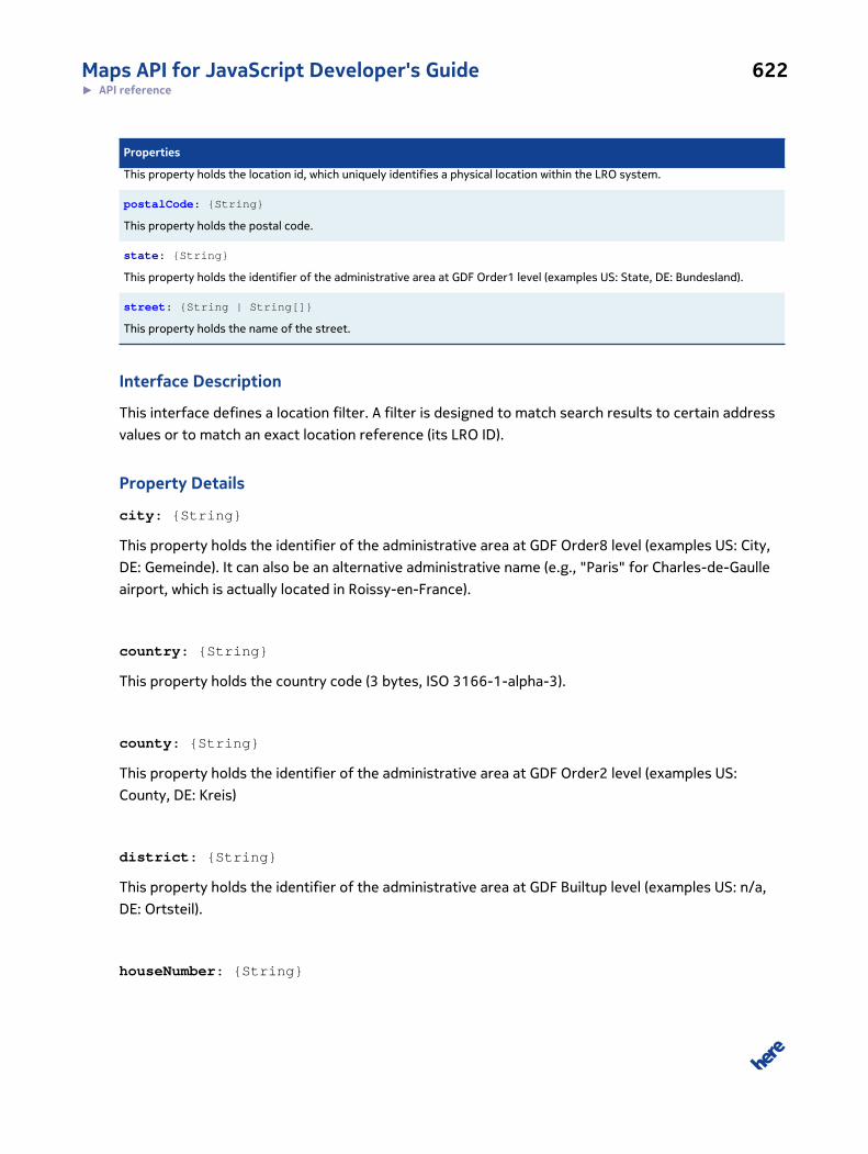
Maps API for JavaScript Developer's Guide 622► API reference
Properties
This property holds the location id, which uniquely identifies a physical location within the LRO system.
postalCode: {String}
This property holds the postal code.
state: {String}
This property holds the identifier of the administrative area at GDF Order1 level (examples US: State, DE: Bundesland).
street: {String | String[]}
This property holds the name of the street.
Interface Description
This interface defines a location filter. A filter is designed to match search results to certain address
values or to match an exact location reference (its LRO ID).
Property Details
city: {String}
This property holds the identifier of the administrative area at GDF Order8 level (examples US: City,
DE: Gemeinde). It can also be an alternative administrative name (e.g., "Paris" for Charles-de-Gaulle
airport, which is actually located in Roissy-en-France).
country: {String}
This property holds the country code (3 bytes, ISO 3166-1-alpha-3).
county: {String}
This property holds the identifier of the administrative area at GDF Order2 level (examples US:
County, DE: Kreis)
district: {String}
This property holds the identifier of the administrative area at GDF Builtup level (examples US: n/a,
DE: Ortsteil).
houseNumber: {String}
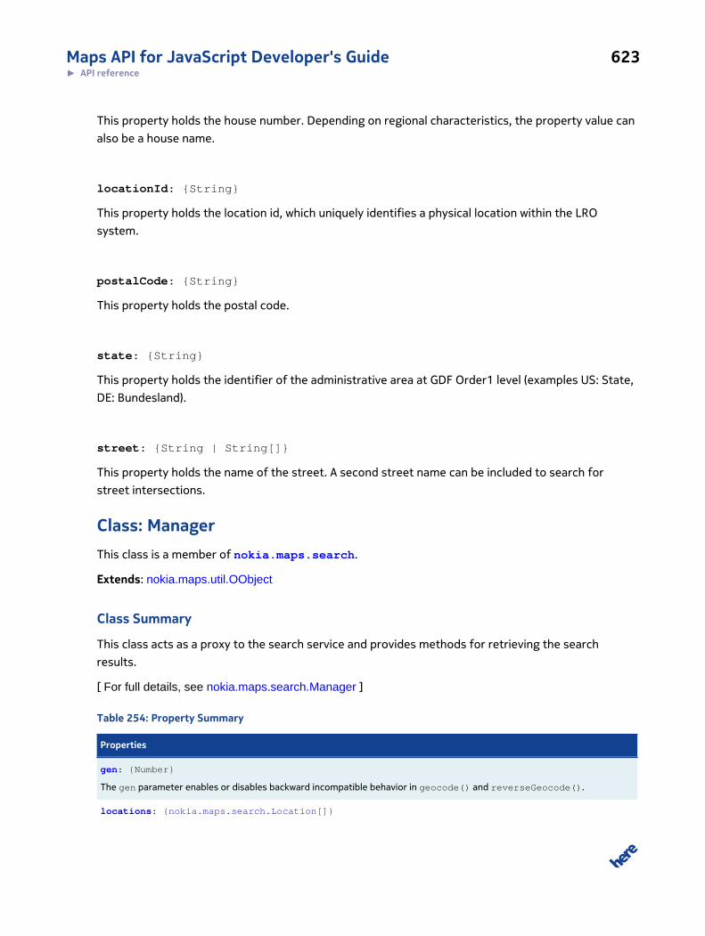
Maps API for JavaScript Developer's Guide 623► API reference
This property holds the house number. Depending on regional characteristics, the property value can
also be a house name.
locationId: {String}
This property holds the location id, which uniquely identifies a physical location within the LRO
system.
postalCode: {String}
This property holds the postal code.
state: {String}
This property holds the identifier of the administrative area at GDF Order1 level (examples US: State,
DE: Bundesland).
street: {String | String[]}
This property holds the name of the street. A second street name can be included to search for
street intersections.
Class: ManagerThis class is a member of nokia.maps.search.
Extends: nokia.maps.util.OObject
Class Summary
This class acts as a proxy to the search service and provides methods for retrieving the search
results.
[ For full details, see nokia.maps.search.Manager ]
Table 254: Property Summary
Properties
gen: {Number}
The gen parameter enables or disables backward incompatible behavior in geocode() and reverseGeocode().
locations: {nokia.maps.search.Location[]}
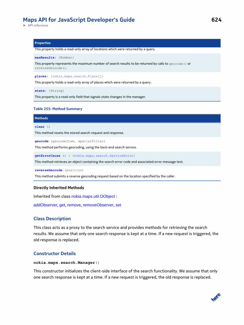
Maps API for JavaScript Developer's Guide 624► API reference
Properties
This property holds a read-only array of locations which were returned by a query.
maxResults: {Number}
This property represents the maximum number of search results to be returned by calls to geocode() orreverseGeocode().
places: {nokia.maps.search.Place[]}
This property holds a read-only array of places which were returned by a query.
state: {String}
This property is a read-only field that signals state changes in the manager.
Table 255: Method Summary
Methods
clear ()
This method resets the stored search request and response.
geocode (geocodeItem, spatialFilter)
This method performs geocoding, using the back-end search service.
getErrorCause () : {nokia.maps.search.ServiceError}
This method retrieves an object containing the search error code and associated error message text.
reverseGeocode (position)
This method submits a reverse geocoding request based on the location specified by the caller.
Directly Inherited Methods
Inherited from class nokia.maps.util.OObject :
addObserver, get, remove, removeObserver, set
Class Description
This class acts as a proxy to the search service and provides methods for retrieving the search
results. We assume that only one search response is kept at a time. If a new request is triggered, the
old response is replaced.
Constructor Details
nokia.maps.search.Manager()
This constructor initializes the client-side interface of the search functionality. We assume that only
one search response is kept at a time. If a new request is triggered, the old response is replaced.
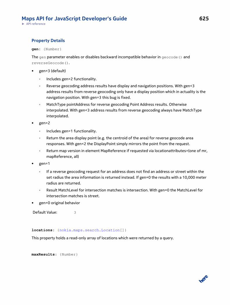
Maps API for JavaScript Developer's Guide 625► API reference
Property Details
gen: {Number}
The gen parameter enables or disables backward incompatible behavior in geocode() and
reverseGeocode().
• gen=3 (default)
◦ Includes gen=2 functionality.
◦ Reverse geocoding address results have display and navigation positions. With gen<3
address results from reverse geocoding only have a display position which in actuality is the
navigation position. With gen=3 this bug is fixed.
◦ MatchType pointAddress for reverse geocoding Point Address results. Otherwise
interpolated. With gen<3 address results from reverse geocoding always have MatchType
interpolated.
• gen=2
◦ Includes gen=1 functionality.
◦ Return the area display point (e.g. the centroid of the area) for reverse geocode area
responses. With gen<2 the DisplayPoint simply mirrors the point from the request.
◦ Return map version in element MapReference if requested via locationattributes=(one of mr,
mapReference, all)
• gen=1
◦ If a reverse geocoding request for an address does not find an address or street within the
set radius the area information is returned instead. If gen=0 the results with a 10,000 meter
radius are returned.
◦ Result MatchLevel for intersection matches is intersection. With gen=0 the MatchLevel for
intersection matches is street.
• gen=0 original behavior
Default Value: 3
locations: {nokia.maps.search.Location[]}
This property holds a read-only array of locations which were returned by a query.
maxResults: {Number}
Maps API for JavaScript Developer's Guide 626► API reference
This property represents the maximum number of search results to be returned by calls to
geocode() or reverseGeocode().
places: {nokia.maps.search.Place[]}
This property holds a read-only array of places which were returned by a query. Places can contain
multiple sub locations. Every sub location is also contained in the overall location property.
state: {String}
This property is a read-only field that signals state changes in the manager. The possible values are:
"initial", "started", "finished", "failed" and "cleared".
Method Details
clear()
This method resets the stored search request and response.
geocode(geocodeItem, spatialFilter)
This method performs geocoding, using the back-end search service.
Parameters:
geocodeItem: {String | nokia.maps.search.LocationFilter}
A string that contains search text (unqualified search) or a location filter ob-
ject (qualified address search)
spatialFilter: {nokia.maps.geo.BoundingBox | nokia.maps.geo.Corridor |
nokia.maps.geo.Proximity}
A bounding box, a corridor or a proximity object to be used to limit the result
set to a certain geographic area
getErrorCause(): {nokia.maps.search.ServiceError}
This method retrieves an object containing the search error code and associated error message text.
Returns:
Maps API for JavaScript Developer's Guide 627► API reference
{nokia.maps.search.ServiceError}
An object containing information about the search error
reverseGeocode(position)
This method submits a reverse geocoding request based on the location specified by the caller. A
default radius is applied.
Parameters:
position: {nokia.maps.geo.Coordinate}
An object containing the geo coordinates of a location that repesents the in-
put for the reverse geocoding request
Interface: PlaceThis interface is a member of nokia.maps.search.
Interface Summary
This interface defines a place object and its properties.
[ For full details, see nokia.maps.search.Place ]
Table 256: Property Summary
Properties
categories: {String[]}
This property holds an array of strings which represent a list of POI category names.
locations: {nokia.maps.search.Location[]}
This property holds an array of Location objects.
name: {String}
This property holds the descriptive name of a place in the requested primary language for display purposes.
primaryEmail:
This property holds the primary e-mail address of the place.
primaryFax:
This property holds the primary fax number of the place.
primaryIM:
Maps API for JavaScript Developer's Guide 628► API reference
Properties
This property holds the primary instant messaging account of the place.
primaryPhone:
This property holds the primary phone number of the place.
primaryURL:
This property holds the primary URL of the place.
suppliers: {String[]}
This property holds an array of strings containing supplier names.
Interface Description
This interface defines a place object and its properties. A place is an entity that encapsulates
information about objects, services, etc., that can be found at a specific location. A place can
represent a single point defined its latitude and longitude or it may be an area or feature of the
landscape identified as a Point of Interest (POI). Information often associated with a place includes
contact details and media (images and reviews).
Property Details
categories: {String[]}
This property holds an array of strings which represent a list of POI category names.
locations: {nokia.maps.search.Location[]}
This property holds an array of Location objects.
name: {String}
This property holds the descriptive name of a place in the requested primary language for display
purposes.
primaryEmail:
This property holds the primary e-mail address of the place.
primaryFax:
Maps API for JavaScript Developer's Guide 629► API reference
This property holds the primary fax number of the place.
primaryIM:
This property holds the primary instant messaging account of the place.
primaryPhone:
This property holds the primary phone number of the place.
primaryURL:
This property holds the primary URL of the place.
suppliers: {String[]}
This property holds an array of strings containing supplier names.
Interface: ServiceErrorThis interface is a member of nokia.maps.search.
Interface Summary
This interface represents a search service error.
[ For full details, see nokia.maps.search.ServiceError ]
Table 257: Property Summary
Properties
message: {String}
This property holds additional information about the error.
subtype: {String}
This property holds the subtype of the service error.
type: {String}
This property holds the identifier of the service error type.
Maps API for JavaScript Developer's Guide 630► API reference
Interface Description
This interface represents a search service error.
Property Details
message: {String}
This property holds additional information about the error.
subtype: {String}
This property holds the subtype of the service error. The possible values are:
• "invalidInputData" - indicates that the request contains invalid input data (wrong format,
contradictory input, etc.)
• "contractViolate" - indicates that the contract exists for given token, but is not yet active or
has already expired
• "permissionError" - indicates that the access permission for the given token has been
denied by the service
• "exceededUsageLimit" - indicates that the usage limit specified in the user's contract which
is assigned to the given token has been reached
• "invalidCredentials" - indicates that the specified token was invalid or no contract could be
found for this token
• "insufficientRights" - indicates that the user's contract exists for the given token, but a
required entitlement is missing
• "networkAccessDenied" - indicates that network access to the requested resource has been
denied
• "serviceNotAvailable" - indicates that the service is not available (server down, resource
not found, etc.)
• "timeout" - indicates that a time-out occurred
type: {String}
This property holds the identifier of the service error type. The possible values are:
• "applicationError" - indicates an error thrown because the business logic has detected
some error
• "systemError" - indicates a technical error
Maps API for JavaScript Developer's Guide 631► API reference
• "permissionError" - indicates an error thrown due to invalid credentials or missing
entitlements
Namespace: componentThis namespace is a member of nokia.maps.search.
Namespace Summary
This namespace defines facilities to help make search functionality interactive.
Namespace Description
This namespace defines facilities to help make search functionality interactive.
Class: GeocodeComponent
This class is a member of nokia.maps.search.component.
Extends: nokia.maps.map.component.Component
Class Summary
This class shows the results of a geocoding on the display.
[ For full details, see nokia.maps.search.component.GeocodeComponent ]
Property Summary
Directly Inherited Properties
Inherited from class nokia.maps.map.component.Component :
mapDisplay
Method Summary
Directly Inherited Methods
Inherited from class nokia.maps.map.component.Component :
attach, destroy, detach, getId
Inherited from class nokia.maps.util.OObject :
addObserver, get, remove, removeObserver, set
Maps API for JavaScript Developer's Guide 632► API reference
Class Description
This class shows the results of a geocoding on the display. To do this, it retrieves the results
from an instance of nokia.maps.search.component.SearchResultSet that is available as
consequence of a call to a method on nokia.maps.search.Manager.
Constructor Details
nokia.maps.search.component.GeocodeComponent(searchManager)
This method initializes and instance of nokia.maps.search.component.GeocodeComponent to
provide a means of displaying geocoding results.
Parameters:
searchManager: {nokia.maps.search.Manager}
An instance of a Search Manager.
Class: SearchComponent
This class is a member of nokia.maps.search.component.
Extends: nokia.maps.map.component.Component
Class Summary
This class displays the results of a search.
[ For full details, see nokia.maps.search.component.SearchComponent ]
Property Summary
Directly Inherited Properties
Inherited from class nokia.maps.map.component.Component :
mapDisplay
Method Summary
Directly Inherited Methods
Inherited from class nokia.maps.map.component.Component :
attach, destroy, detach, getId
Inherited from class nokia.maps.util.OObject :
Maps API for JavaScript Developer's Guide 633► API reference
addObserver, get, remove, removeObserver, set
Class Description
This class displays the results of a search. To do this, it retrieves the search results from an
instance of nokia.maps.search.component.SearchResultSet available as a result of calling
placeSearch() on nokia.maps.search.Manager.
Constructor Details
nokia.maps.search.component.SearchComponent(searchManager)
This method initializes an instance of nokia.maps.search.component.SearchComponent to
make it possible to display search results.
Parameters:
searchManager: {nokia.maps.search.Manager}
An instance of search manager through which to run a search and obtain the
search results
Class: SearchResultSet
This class is a member of nokia.maps.search.component.
Class Summary
This class rpresents search results.
[ For full details, see nokia.maps.search.component.SearchResultSet ]
Table 258: Property Summary
Properties
container: {nokia.maps.map.Container}
This property holds a container of markers, representing the results.
Class Description
This class rpresents search results. An instance of this class can be initiated with a response to a
search request (method call on searchManager and provides some useful methods to handle this
response in combination with a map.
Maps API for JavaScript Developer's Guide 634► API reference
Constructor Details
nokia.maps.search.component.SearchResultSet(searchResults)
This method initializes an instance of SearchResultSet, using the arguments provided by the
caller.
Parameters:
searchResults: {nokia.maps.search.Location[]}
An array containing search results obtained via search.Manager
Property Details
container: {nokia.maps.map.Container}
This property holds a container of markers, representing the results.
Namespace: utilThis namespace is a member of nokia.maps.
Namespace Summary
This namespace defines utility classes and interfaces used in other namespaces in this API to support
map objects, animations and graphics.
Namespace Description
This namespace defines utility classes and interfaces used in other namespaces in this API to support
map objects, animations and graphics.
Class: ArrowsThis class is a member of nokia.maps.util.
Class Summary
This class defines the properties of arrows, used when stroking map shapes with arrows to visualize
the direction.
[ For full details, see nokia.maps.util.Arrows ]
Maps API for JavaScript Developer's Guide 635► API reference
Property Summary
Directly Inherited Properties
Inherited from class nokia.maps.util.IArrows :
color, frequency, length, width
Class Description
This class defines the properties of arrows, used when stroking map shapes with arrows to visualize
the direction.
Constructor Details
nokia.maps.util.Arrows(props)
This method initializes an instance of Arrows. Note that if the caller does not provide initial property
values, the method uses defaults.
Parameters:
props: {nokia.maps.util.IArrows}
The initial values of the Arrows properties as a JavaScript object
Class: BrushThis class is a member of nokia.maps.util.
Class Summary
This class defines the properties of brush objects that can be used when filling map shapes with
color.
[ For full details, see nokia.maps.util.Brush ]
Property Summary
Directly Inherited Properties
Inherited from class nokia.maps.util.IBrush :
color, fill

Maps API for JavaScript Developer's Guide 636► API reference
Class Description
This class defines the properties of brush objects that can be used when filling map shapes with
color.
Constructor Details
nokia.maps.util.Brush(props, brush)
This method initializes an instance of Brush. Note that if the caller does not provide initial property
values, the method uses defaults.
Parameters:
props: {nokia.maps.util.IBrush}
The initial values of the Brush properties as a JavaScript object
brush: {nokia.maps.util.Brush} [optional]
If provided, this object is copied to create a new instance of the class
Class: CacheThis class is a member of nokia.maps.util.
Class Summary
A cascadable LRU-Cache (Least Recently Used).
[ For full details, see nokia.maps.util.Cache ]
Table 259: Property Summary
Properties
change:
A method whose return value should be returned by addFilter function to signal "The entry data has been changed byaddFilter".
static change:
A method whose return value should be returned by addFilter function to signal "The entry data has been changed byaddFilter".
static constant DONT: {Object}
The value to return by addFilter function to signal "The entry should not be added".
static constant NEXT: {Object}

Maps API for JavaScript Developer's Guide 637► API reference
Properties
The value to return by addFilter function to signal "The entry should be added in next level if possible".
static constant NOT_ENOUGH_SPACE: {Object}
A return value of nokia.maps.util.Cache#add to signal that the cache can't store the data because there is not enough spaceto store the data.
Table 260: Method Summary
Methods
add (id, data, size) : {Object | undefined}
To add an entry to the cache.
destroy ()
To clean up the cache on shut down.
get (id, noUpdate) : {Variant}
To get a possibly cached entry.
remove (id, nonRecursive) : {Variant}
To remove a possibly existing entry from cache.
removeAll (idPrefix)
To remove all cache entries which starts with the given id prefix.
Class Description
A cascadable LRU-Cache (Least Recently Used). Each cache level is configurable by it's size plus
optional addFilter and an onDrop callback.
Constructor Details
nokia.maps.util.Cache(size, addFilter, onDrop, nextCache)
Parameters:
size: {Number} [optional, default: 1]
The maximum size of this this cache for all entry data. The size must be a
number between 0...Infinity. See also nokia.maps.util.Cache#add size argu-
ment.
addFilter: {Function} [optional]
Maps API for JavaScript Developer's Guide 638► API reference
A filter to use when a cache entry should be added via add(). If the addFilter
argument is omitted the original data will be stored. This function will get
the data of the cache entry to add as argument. It has to return one of the
following values:
• nokia.maps.util.Cache.DONT to signal that the entry should not be
added and possibly existing entries should be removed.
• nokia.maps.util.Cache.NEXT to signal that the entry should be added in
next cache level.
• The return value of nokia.maps.util.Cache.change to signal that the en-
try has been changed.
onDrop: {Function} [optional]
A call-back which will be triggered if a cache entry dropped out on the last
level. This function will get the data of the dropped cache entry as argu-
ment. This call-back can be used to clean-up cache entry data.
nextCache: {nokia.maps.util.Cache} [optional]
A cache which will used as next level. Least recently used entries of this
cache will automatically moved the the nextCache when the maximum size
of this cache is reached. If omitted the least recently used entry will be
dropped instead.
Property Details
change:
A method whose return value should be returned by addFilter function to signal "The entry data has
been changed by addFilter".
static change:
A method whose return value should be returned by addFilter function to signal "The entry data has
been changed by addFilter".
static constant DONT: {Object}
The value to return by addFilter function to signal "The entry should not be added".
Maps API for JavaScript Developer's Guide 639► API reference
static constant NEXT: {Object}
The value to return by addFilter function to signal "The entry should be added in next level if
possible".
static constant NOT_ENOUGH_SPACE: {Object}
A return value of nokia.maps.util.Cache#add to signal that the cache can't store the data because
there is not enough space to store the data.
Method Details
add(id, data, size): {Object | undefined}
To add an entry to the cache.
Parameters:
id: {String}
The ID of the entry to add.
data: {Variant}
The data of the entry to cache.
size: {Number} [optional, default: 1]
The size of the data. If omitted or undefined the default value will be tak-
en. See also nokia.maps.util.Cache#add size argument. It's recommended to
use a rough estimation of the data size in byte. As an example: a string has a
size of 2 * length (16 bit UniCode), a IMG has a size of width * height * 4 (RG-
BA), a number has a size of 8 Byte (IEEE double) etc.pp.
Returns:
{Object | unde-
fined}
the status of the add operation. The return value could be one of:
• undefined - if the entry was added to the cache
• nokia.maps.util.Cache.NEXT if the entry could not added because a
addFilter has signaled "NEXT" but there is no next cache level.
Maps API for JavaScript Developer's Guide 640► API reference
• nokia.maps.util.Cache.DONT if the entry could not added because a
addFilter has signaled "DONT".
destroy()
To clean up the cache on shut down.
get(id, noUpdate): {Variant}
To get a possibly cached entry.
Parameters:
id: {String}
The ID of the requested cache entry.
noUpdate: {Boolean} [optional, default: false]
A flag to signal that the cache should not be updated so that the requested
entry will be not the "most recently used" entry.
Returns:
{Variant} the data of the cached entry or undefined if not found.
remove(id, nonRecursive): {Variant}
To remove a possibly existing entry from cache.
Parameters:
id: {String}
The ID of the entry to remove.
nonRecursive: {Boolean} [optional, default: false]
A flag to signal that the entry should NOT removed recursive in next cache
levels.
Returns:
Maps API for JavaScript Developer's Guide 641► API reference
{Variant} The data of the removed entry or undefined if not found.
removeAll(idPrefix)
To remove all cache entries which starts with the given id prefix.
Parameters:
idPrefix: {String}
The ID prefix of the entries to remove.
Example:
myCache.removeAll(myProvider.id); // remove all cache entries whose ID starts with the ID of myProvider
Class: CoroutineThis class is a member of nokia.maps.util.
Class Summary
This class represents a coroutine that guarantees code execution in a non-blocking way.
[ For full details, see nokia.maps.util.Coroutine ]
Table 261: Property Summary
Properties
static AF_MAX_EXEC_TIME: {Number}
This property holds the maximal execution time for those coroutine being executed within the animation frame request (seenokia.maps.util.Coroutine.ExecutionContext#useAnimationFrame and nokia.maps.util.Coroutine#MAX_EXEC_TIME for details.
static AF_SLICE_SIZE: {Number}
This property holds the maximal size of each time slice for a coroutine being executed within the animation frame request(see nokia.maps.util.Coroutine.ExecutionContext#useAnimationFrame and nokia.maps.util.Coroutine#SLICE_SIZE for details.
static constant BLOCKED: {Object}
This property holds a special object returned by the sleep(), wait() and suspend() methods.
static constant BLOCKING: {Number}
Coroutine status constant indicating that a context is blocked at a condition or sleeping.
static constant KILLED: {Object}
Maps API for JavaScript Developer's Guide 642► API reference
Properties
This property holds a special object returned by the kill() method.
static MAX_EXEC_TIME: {Number}
This property holds the maximum execution time or the number of milliseconds consumed by coroutines before control ishanded over to the browser and so to other JavaScript code.
static constant RUNNING: {Number}
Coroutine status constant indicating that a context is currently running.
static SLICE_SIZE: {Number}
This property holds the maximum size of each time slice for a coroutine.
static constant TERMINATED: {Number}
Coroutine status constant indicating that a context is terminated.
static constant YIELDED: {Object}
This property holds a special object returned by the yield() method.
Table 262: Method Summary
Methods
static all () : {nokia.maps.util.Coroutine.ExecutionContext[]}
This method returns an array with all the execution contexts currently marked as "running" or "blocking".
static broadcast (obj)
This method signals all coroutines blocking on an object and resumes them.
static catchException (enable)
This method enables exception catching in the scheduler to ignore errors in coroutines or it can be used to disable exceptioncatching for debugging purposes.
static count () : {Number}
This method retrieves the number of contexts not being terminated, thus the return value includes all running and blockedcontexts.
static create (name, fn, args) : {Function}
This method creates a new coroutine, using the name and implementation supplied by the caller.
static createEx (name, fn, defaults, args) : {Function}
This method creates a new coroutine using the name and implementation supplied by the caller.
static current () : {nokia.maps.util.Coroutine.ExecutionContext}
This method returns the currently executed context or null if no context is executed right now.
static forId (id) : {nokia.maps.util.Coroutine.ExecutionContext}
This method retrieves the execution context with the given id or undefined if no such context exists.
static forName (name) : {nokia.maps.util.Coroutine.ExecutionContext[]}
Maps API for JavaScript Developer's Guide 643► API reference
Methods
This method searches through the list of all contexts currently in the "running" or "blocking" state and returns all those thatare bound to the coroutine with the name supplied by the caller.
static kill (context, reason) : {Object}
This method immediately terminates the currently executed coroutine or the supplied coroutine context.
static killAll ()
This method destroys all execution contexts currently in the "running" or "blocking" state.
static resume (context)
This method resumes the supplied executed execution context.
static scheduler (isTestUnitCall)
This method forces the scheduler to run at once.
static schedulerCpuTime () : {Number}
This method retrieves the total CPU time that the scheduler itself has consumed.
static schedulerNextRuntime () : {Number}
This method retrieves the UNIX timestamp showing when the scheduler should run again.
static scope (fn)
This method clones the given function and moves the clone into the internal scope of the coroutine scheduler, removing theoriginal scope remembered by the function.
static shallYield () : {Boolean}
This method checks if the currently executed coroutine context must yield or not.
static signal (obj) : {nokia.maps.util.Coroutine.ExecutionContext}
This method signals the given object and resumes the next coroutine that is blocked on this object, if any.
static sleep (timeout, context) : {Object}
This method puts a coroutine context to sleep.
static suspend (context, timeout) : {Object}
The method suspends the supplied execution context or the currently executed context.
static taskCpuTime () : {Number}
This method retrieves the total CPU time that all contexts have consumed.
static totalCpuTime () : {Number}
This method retrieves the number of milliseconds since the scheduler was started.
static wait (obj, timeout, context) : {Object}
This method blocks the a coroutine on the object provided by the caller.
static yield (context) : {Object}
This method makes the currently executed coroutine or the supplied one yield.
Maps API for JavaScript Developer's Guide 644► API reference
Class Description
There are many different ways to run code in a non-blocking way. The most common is to use
threads which are parallel execution paths. Threads can be cooperative or preemptive. In a
cooperative threading design, each thread or process is in full control of the CPU and must explicitly
release the CPU so that another thread or process can take control of the CPU. In preemptive
threading, a scheduler takes away the CPU from a thread and allocates it to another thread, therefore
the thread has little or no control over when it is runs and on which CPU.
Preemptive versus cooperative threading
Each of the two threading models has certain advantages and disadvantages. Cooperative threading
is much simpler for developers, because access control is not required. It guarantees that the
memory (and so variables) and all other resources are only accessed by the currently executing
code. It is not possible for one instruction to modify a variable, while another tries to read it or
(worse) modify it too, therefore it impossible to access a value that is in a "half updated" state. This
means that in cooperative threading there is no need for mutexes to synchronize access to memory
(variables). Another advantage is performance. Because no synchronization is required, cooperative
threading can be implemented more simply and a thread switch is much cheaper then in a preemptive
environment.
However, the disadvantage of cooperative threading is that each process can only use one processor,
because otherwise mutexes would become necessary, as each variable could be modified by one
thread, while another is reading it (or even worse, both could be modifying the same object at the
same time, possibly leaving the object in an unusable state). Therefore true parallel execution
within one process is not possible. The other disadvantage is that a bug in the code may block the
application, making it unresponsive. In extreme cases, it may block the entire operating system,
making it unresponsive, because the thread executing the faulty code does not release the CPU.
JavaScript execution
All JavaScript code is executed in an execution context. Whenever some JavaScript code is executed,
a new execution context is created. An execution context is an abstract collection that contains an
activation and a variable object (as well internal information). These objects contain all the arguments
supplied to a function and all the variables declared within the code, using the var statement.
Because in reality the activation and variable objects are the same object, we simply use the term
variable object to refer to both of them from here on. If an argument is named, its value is referenced
in the variable object using that name; if a named argument is not supplied, a variable with the name
of the argument exists in the variable object, but has the value undefined (the variable declared, but
its value is undefined). This is important, because assigning a value to it does not lead to pollution
of the global scope.
The scope chain
Maps API for JavaScript Developer's Guide 645► API reference
For any JavaScript code to be executed, there must be a global execution context in which this code
can be run. In a browser environment, the browser creates such a global execution context and fills
the variable object of that global context with some default values, for example it sets document,
navigator or Math. The variable object in this global context contains a reference to the global
context (window), which is helpful in modifying the global scope. So every browser window has its
own global execution context, where the variable object of the global context can be accessed via the
window variable.
To resolve a variable name to a value, the JavaScript interpreter needs to look up the variable name
in the so-called scope chain. A newly created function "remembers" the current execution context.
Every time the function is called, the interpreter creates a new execution context and assigns the
previous execution context as the parent of the new context, thus building the scope chain. If the
JavaScript interpreter has to resolve a variable named "foo", it first searches in the variable object
of the current execution context, which is the local context for the function. If no variable with that
name is found there, the interpreter searches the parent execution context, then its parent, and so
on, going up the chain until it reaches the global execution context (which has no parent). In short,
the scope chain of a function is established at function create time and each subsequent call to the
function adds a new element to that chain.
This is different for the eval statement, because eval executes the code that is passed to it in the
current execution context. Therefore a variable declared within an eval statement with the var
keyword extends the current execution context.
The following example shows the impact of this:
// Create new variables within the variable object // of the current execution context. // var x = 1; var y = 99;
// Create a new function -- it remembers the current execution // context as its scope chain. The code is discussed below. // var alertX = function () { alert("x: "+x+", y: "+y); var y; };
// Calling the function creates a new execution context with // a new variable object, the parent execution context of this new // execution context is set to the execution context that was // remembered at the create time of the function. // // The interesting thing at this point is the output: // // "x: 1, y: undefined" //
Maps API for JavaScript Developer's Guide 646► API reference
// The reason is that the new execution context contains a variable // declaration for "y", but no value is assigned to it, while // the only definition for "x" is in the parent context, and "x" is // assigned a value there. // alertX();
// eval() is slow and should be avoided. The // interpreter must evaluate the code passed to eval() // within the current execution context, so the declaration of the // variable "x" in that code has no effect, because "x" is already // declared in the variable object of the previous execution context. // Assigning 2 to "x" now modifies the "x" in the current execution // context, therefore the following code causes alert() // to display "2" twice. // eval("var x = 2; alert(x);"); alert(x);
// The following example demonstrates that the execution context is remembered // at function create time. The example creates an anonymous function, // remembers the current execution context and then directly calls // the new function. The function call causes a new execution context to be // created with the parent execution context set to the current // execution context (note that create and call time of the function are // the same now). // (function () { // The code below causes the variable with the name "x" to be declared // in the variable object of the current execution context. Therefore // the variable of parent context with the same name is no longer // accessible from within the function. // var x = 3;
// However, the call to the function alertX() below, creates a new execution // context with a new variable object, and assigns as the parent execution // context the execution context current at the time of the call. The code // within alertX() cannot find a variable with the name "x" in its own variable // object. It then searches its parent execution context (not the current // execution context, where it would find "x" set to 3). In the parent context, // "x" has the value of 2. Thus, the following line outputs "2" and not "3": // alertX();
// Below, we create a new function. It is created there and then, therefore it // remembers the current execution context. Note that it contains the same // code that the alertX() function. //
Maps API for JavaScript Developer's Guide 647► API reference
var fn = function () { alert("x: "+x+", y: "+y); var y; };
// So when we call this function, a new execution context is created // and the execution context remembered at the create time of the function // is assigned as the parent execution context. Because the create time // of this function is just one line above, it is the current execution // context. So the interpreter searches for "x" in the variable object // of the new execution context, not fails to find it and then searches the parent // execution context, which is the current execution context that contains // a variable with the name "x" and the value "3". Therefore this // time, the output is "3" and not "2". // fn(); })();
Threading
The above-described scope chain explains why every execution context is bound to exactly one
thread and every execution context must be bound to the thread to which its parent execution
context is bound. For this reason, multi-threading is not possible in JavaScript and this is also why
web-workers (the threads of HTML 5) do not have access to variables of the current window or to the
DOM tree of the Web page. Every web-worker has its own global execution context and the execution
context of a web-worker does not contain a reference to any window. That is also the reason why
web-workers can only communicate using strings. Strings are immutable (read-only) and therefore
there is no need to synchronize access to strings.
Most browsers use the same thread to render the UI, to parse the DOM tree and to execute
JavaScript. Therefore as long as JavaScript is executed, no rendering of the UI or Web pages occurs,
but note that this does not apply to all browsers. In any case, a buggy JavaScript code may block the
browser and therefore all browser vendors implement some way to detect if JavaScript is blocking
to prevent the browser becoming unresponsive to the user. For example, the Internet Explorer stops
processing JavaScript after a certain number of instructions have been processed (by default around
5 million) and informs the user that a script is making the browser unresponsive, asking the user to
continue the script or to abort it. Other browsers, for example Firefox, make the message conditional
on elapsed execution time rather than a number of instructions.
Why you should use a coroutine and not setTimeout()
It can happen (and within this API it happens often) that some code must run for a number of seconds
and/or more than 5 million instructions must be executed to perform a specific action. This happens,
for example in map rendering to process huge polylines or a large number of polylines/polygons.
Even though this does not always force an alert box of the browser to pop up, it makes the browser
slow and unresponsive to the user input for as long as the JavaScript code runs. This situation may
Maps API for JavaScript Developer's Guide 648► API reference
last a second or longer and it may occur multiple times in a row. Note that the performance of a
browser is heavily dependent on the device on which the browser is running. Browsers do not have
any built-in support for these cases, the function setTimeout() by itself does not help, because
it does not take into account which function consumes how much processor time and so does
not help the developer keep the browser responsive. It is possible to implement a function with a
mechanism that prevents the browser becoming unresponsive, but problems are likely to arise if two
or more such function run concurrently without any knowledge of one another. This API offers the
nokia.maps.util.Coroutine class as a safe solution.
Support for coroutines
As a user of this API you can create your own coroutines. The API implements a scheduler
(nokia.maps.util.Coroutine.scheduler) which keeps track of how much CPU time each coroutine
consumes, ensuring that 80% of the available CPU time (so of the time not consumed by other
JavaScript libraries) is distributed to all running coroutines, leaving approximately 20% of the free
CPU time to the browser itself for rendering and event processing. The API assists the developer in
writing coroutines by offering functions that help coroutines release CPU at the right moment and
the API helps in saving or restoring the state of a coroutine. However, that still leaves some work to
be done by the developer of a coroutine.
Scheduler details
The scheduler ensures that each coroutine receives time to execute without consuming all available
CPU time, so that there is enough time left for the browser to render the Web page(s), the UI and
to process user input and to execute other JavaScript code. The scheduler implements the above-
described design in software. Therefore the scheduler contains a global execution context. Whenever
a new coroutine is created, the current execution context is "remembered" with the coroutine, and
whenever a coroutine is called, a new execution context is created and its parent execution context
it set to the execution context "remembered" with the coroutine at create time. The scheduler itself
supports automatic priority management. So coroutines consuming a lot of CPU time are degraded
while those not consuming any CPU time are upgraded. This ensures that coroutines consuming only
a small amount of CPU time (for example those handling user input processing) are not delayed by
coroutines consuming large amounts of CPU time (for example rendering jobs). The major advantage
of the coroutines can be seen on mobile devices which have much less CPU power then desktop PCs.
Introduction to coroutines
Not every function can become a coroutine and a coroutine is not a normal function. As already
mentioned, coroutines are cooperative, therefore there is no need for mutexes. A coroutine appears
as if it were executed directly when it is called. A coroutine has to call the method shallYield()
from time to time to check if it is time to release the CPU. If the shallYield() returns true,
the coroutine must call the method yield() and return to the caller. Calling yield() signals the
Maps API for JavaScript Developer's Guide 649► API reference
scheduler that the function is not finished, but wants to give way to some other code. Some time
later, the scheduler calls the coroutine again to allow it to continue its work.
Because of this, coroutines must remember their state and execution position between calls. A
coroutine can store variables including information about the current point of execution with the
variable object. Additionally, it is possible for one coroutine to call another coroutine and then wait for
the called coroutine to finish (otherwise both coroutines would execute in parallel). Note that it is also
possible that a coroutine may not end at all, so that it is executed in an endless loop, for example,
rendering functions do not stop unless the nokia.maps.map.Display class to which they belong is
destroyed; instead, they just go to sleep if there is nothing for them to do.
The possible states of the execution context of a coroutine are:
• terminated - the coroutine is finished
• running - the coroutine is currently running, but this execution context is not necessarily being
executed; multiple execution contexts can be marked as "running", but in fact, they can only run
one after another in succession (see nokia.maps.util.Coroutine.current)
• blocking - the coroutine is waiting for something, either waiting for a coroutine it has called or
just sleeping for a moment
Simple coroutine examples
The following example shows a very simple coroutine that increments a counter and another
coroutine that updates a div-tag with the current value of the counter:
// A shortcut for easier access to the coroutine class: // var Coroutine = nokia.maps.util.Coroutine;
// Create a new coroutine with the name "counter". It receives two // arguments, the variable object and the execution context. // var counterCo = Coroutine.create("counterCo", function (scope, context) { // The following check is important, because if the parent // context contains a variable "counter" a simple check for // scope.counter would return true (scope chain) and then // using the counter of the parent context might lead to // errors. // if (!scope.has("counter")) scope.counter = 0;
// Loop until counter reaches 1 million. // while (scope.counter < 1*1000*1000) { // Increment the counter. // scope.counter++;
Maps API for JavaScript Developer's Guide 650► API reference
// If we shall yield now, do that. // if (Coroutine.shallYield()) return Coroutine.yield(); } });
// Now let's run an instance of the coroutine. // var counterCoCtx = counterCo();
// Create another coroutine to be used as render coroutine. This method // receives as the first argument a reference to the counter coroutine // execution context it is to track and to the div-tag into which the state // of the counter is to be rendered. var renderCo = Coroutine.create("renderCo", function (scope, context) { while (true) { // Output the current counter by accessing the variable // object of the counter coroutine and reading the value. // scope.div.innerHTML = "Current count is "+scope.counterCoCtx.scope.counter;
// If the counter context is terminated, we terminate too. // if (scope.counterCoCtx.status === Coroutine.TERMINATED) break;
// Otherwise put this coroutine to sleep for 10ms and then return. return Coroutine.sleep(10); }; }, // "counterCoCtx" is bound to the first parameter of the coroutine, // the variable "div" to the second parameter. // "counterCoCtx", "div");
// Call the rendering coroutine for two different div-tags, but // the same counter. // var renderAContext = renderCo(counterCoCtx, document.getElementById("outputA")); var renderBContext = renderCo(counterCoCtx, document.getElementById("outputB"));
This was a very simple example of how to write coroutines. The whole concept becomes much
more complex if one coroutine needs to invoke another coroutine or if it is necessary to wait until
a coroutine has calculated a return value. As you can see, each coroutine receives the reference to
the variable object. This does not mean that it is not possible to use local variables, but it should be
taken into account that the state of the real local variables cannot be saved between two calls to a
coroutine and therefore they must be used with caution.
Complex coroutines
Maps API for JavaScript Developer's Guide 651► API reference
The example below shows a much more complex coroutine, where one coroutine calls another and
waits until the called coroutine is finished before using the return value from the called coroutine.
// A shortcut to access the static coroutine class more easily. // var Coroutine = nokia.maps.util.Coroutine;
// Create a function that adds all numbers from "from" to "to" and returns // the sum (and yes, we are aware that there are better ways to do it). // var addFromToCo = Coroutine.create("addFromToCo", function (scope) { // If the "sum" variable is not yet defined, initialize it with 0. // if (!scope.has("sum")) scope.sum = 0;
// Loop until we've added all values. while (scope.from <= scope.to) { // Add the value of "from" to our "sum". // scope.sum += scope.from++;
// If we are to release the CPU, do it. if (Coroutine.shallYield()) return Coroutine.yield(); }
// If we're finished, return the calculated sum. return scope.sum; }, "from", "to");
// Create another coroutine to add a number from "a" to "b" "n" times. // var addMultiCo = Coroutine.create("addMultiCo", function (scope) { // In this case, everything gets a bit more complicated and we // have not only to remember some state variables, but also // the current execution point of the method (which we call "ip" // -- short for "instruction pointer") when the function is // called for the first time
// When the method is called for the first time, the variable "sum" // contains the calculated sum, "i" contains the counter to count to // "n", and "addFromToCo" is a reference to an instance of the coroutine // that calculates the sum from "a" to "b". // if (!scope.has("ip")) { scope.sum = 0; scope.i = 0; scope.ip = 1; }
// Now let's run a loop from "i" to "n". // while (scope.i < scope.n) { // If the current instruction pointer is 1, we have to call // the "addFromTo" coroutine now
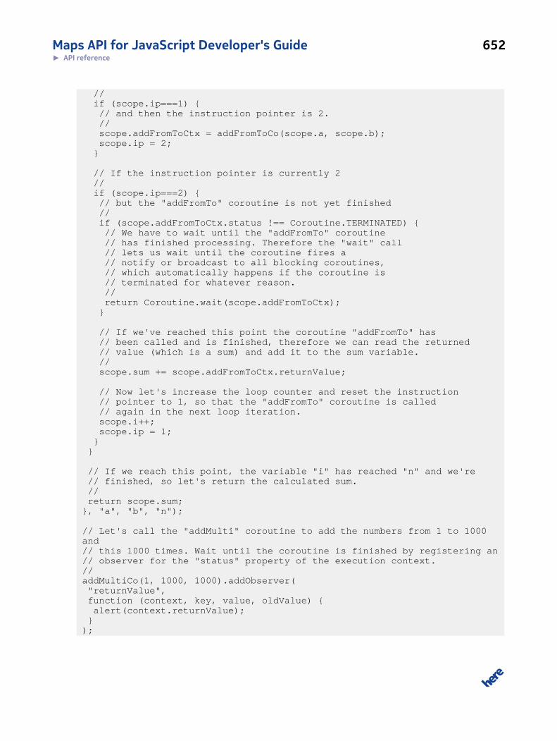
Maps API for JavaScript Developer's Guide 652► API reference
// if (scope.ip===1) { // and then the instruction pointer is 2. // scope.addFromToCtx = addFromToCo(scope.a, scope.b); scope.ip = 2; }
// If the instruction pointer is currently 2 // if (scope.ip===2) { // but the "addFromTo" coroutine is not yet finished // if (scope.addFromToCtx.status !== Coroutine.TERMINATED) { // We have to wait until the "addFromTo" coroutine // has finished processing. Therefore the "wait" call // lets us wait until the coroutine fires a // notify or broadcast to all blocking coroutines, // which automatically happens if the coroutine is // terminated for whatever reason. // return Coroutine.wait(scope.addFromToCtx); }
// If we've reached this point the coroutine "addFromTo" has // been called and is finished, therefore we can read the returned // value (which is a sum) and add it to the sum variable. // scope.sum += scope.addFromToCtx.returnValue;
// Now let's increase the loop counter and reset the instruction // pointer to 1, so that the "addFromTo" coroutine is called // again in the next loop iteration. scope.i++; scope.ip = 1; } }
// If we reach this point, the variable "i" has reached "n" and we're // finished, so let's return the calculated sum. // return scope.sum; }, "a", "b", "n");
// Let's call the "addMulti" coroutine to add the numbers from 1 to 1000 and // this 1000 times. Wait until the coroutine is finished by registering an // observer for the "status" property of the execution context. // addMultiCo(1, 1000, 1000).addObserver( "returnValue", function (context, key, value, oldValue) { alert(context.returnValue); } );
Maps API for JavaScript Developer's Guide 653► API reference
This example should make one thing clear: It is very easy to use coroutines for a normal user, that is
at application level, but it is much harder to write them. The user just needs to call the coroutine like
a normal function, except he is interested in the return value. To obtain it, he calls the method and
registers an observer for the "returnValue" property, waiting until the method is finished so that he
can then process the return value asynchronously.
Constructor Details
nokia.maps.util.Coroutine(name, fn)
This method is the constructor for the class.
It creates an instance of the class on the basis of the arguments supplied by the caller.
Parameters:
name: {String}
The name of the coroutine
fn: {Function}
The function that implements the coroutine
Property Details
static AF_MAX_EXEC_TIME: {Number}
This property holds the maximal execution time for those coroutine being executed within the
animation frame request (see nokia.maps.util.Coroutine.ExecutionContext#useAnimationFrame and
nokia.maps.util.Coroutine#MAX_EXEC_TIME for details.
static AF_SLICE_SIZE: {Number}
This property holds the maximal size of each time slice for a coroutine being executed within the
animation frame request (see nokia.maps.util.Coroutine.ExecutionContext#useAnimationFrame and
nokia.maps.util.Coroutine#SLICE_SIZE for details.
static constant BLOCKED: {Object}
This property holds a special object returned by the sleep(), wait() and suspend() methods.
static constant BLOCKING: {Number}

Maps API for JavaScript Developer's Guide 654► API reference
Coroutine status constant indicating that a context is blocked at a condition or sleeping.
static constant KILLED: {Object}
This property holds a special object returned by the kill() method.
static MAX_EXEC_TIME: {Number}
This property holds the maximum execution time or the number of milliseconds consumed by
coroutines before control is handed over to the browser and so to other JavaScript code.
The smaller this time slice becomes, the more often the browser regains control and the smoother
the execution of coroutines, so the browser appears to be more responsive, but as more overhead is
produced and finally as less CPU time is used for the API, so as slower the API execution.
static constant RUNNING: {Number}
Coroutine status constant indicating that a context is currently running.
static SLICE_SIZE: {Number}
This property holds the maximum size of each time slice for a coroutine.
This value determines how many coroutines can run per scheduled time period, so it decides how
long it takes until a coroutine gets a slice of CPU time. If this value is too big and a large number
of coroutines run simultaneously, it can take seconds until each coroutine gets some CPU time, so
tasking becomes unsteady, but performance is improved as fewer coroutine switches occur. If this
value is too small and a large number of coroutines run at simultaneously, each coroutine gets a slice
of CPU time faster, but the slice is also smaller, so execution of coroutines may seem to smoother,
but the amount of CPU time lost due to coroutine switching increases, so the overall performance
decreases.
This value is normally exactly 25% of the maximum execution time and you should keep it around
that value. However, if you decrease the maximum execution time below 50ms you should consider
increasing this value to 100%, so the same value as the maximum execution time and if you increase
the maximum execution time to above 300ms you should consider changing this value to 10% of the
maximum execution time (e.g. 75 for 300).
static constant TERMINATED: {Number}
Maps API for JavaScript Developer's Guide 655► API reference
Coroutine status constant indicating that a context is terminated.
static constant YIELDED: {Object}
This property holds a special object returned by the yield() method.
Method Details
static all(): {nokia.maps.util.Coroutine.ExecutionContext[]}
This method returns an array with all the execution contexts currently marked as "running" or
"blocking".
Returns:
{nokia.maps.util.Coroutine.ExecutionContext[]}
An array with all execution contexts in the state "running" or "blocking", the
array may be empty if no context is currently executed
static broadcast(obj)
This method signals all coroutines blocking on an object and resumes them.
Parameters:
obj: {Object}
The object on which to resume all blocking coroutines.
Example:
var Coroutine = nokia.maps.util.Coroutine, condition = {}, myCo = Coroutine.create("myCo", function (scope, context) { // If this is the first run ... if (!scope.ip) { // ... block on the condition. scope.ip = 1;
return Coroutine.wait(condition); } alert("coroutine "+ context.name+" is now awake!"); // coroutine terminates here. });
// Call the coroutine twice.
Maps API for JavaScript Developer's Guide 656► API reference
myCo(); myCo();
// After two seconds, wake all waiting coroutines. setTimeout(function () { Coroutine.broadcast(condition); }, 2000);
static catchException(enable)
This method enables exception catching in the scheduler to ignore errors in coroutines or it can be
used to disable exception catching for debugging purposes. By default, exceptions are caught and
written into the debug console.
Parameters:
enable: {Boolean}
true enables exception catching, false disables it
static count(): {Number}
This method retrieves the number of contexts not being terminated, thus the return value includes
all running and blocked contexts.
Returns:
{Number} The number of contexts that are not terminated
static create(name, fn, args): {Function}
This method creates a new coroutine, using the name and implementation supplied by the caller.
Parameters:
name: {String}
The name of the coroutine
fn: {Function}
The function that implements the coroutine
args ...: {String} [optional]
Maps API for JavaScript Developer's Guide 657► API reference
An unlimited number of strings with the names of the arguments of this
function
Returns:
{Function} The coroutine with the supplied function as internal run-function
See: nokia.maps.util.Coroutine
static createEx(name, fn, defaults, args): {Function}
This method creates a new coroutine using the name and implementation supplied by the caller. It
creates coroutine by nokia.maps.util.Coroutine.create call and links defaults to the coroutine context.
Parameters:
name: {String}
The name of the coroutine
fn: {Function}
The function that implements the coroutine
defaults: {Object} [optional]
A hashmap with default values for all created contexts, currently the only
options being supported are priority and useAnimationFrame
args ...: {String} [optional]
An unlimited amount of strings with the names of the arguments of this
function
Returns:
{Function} The coroutine with the supplied function as internal run-function
See: nokia.maps.util.Coroutine
static current(): {nokia.maps.util.Coroutine.ExecutionContext}
This method returns the currently executed context or null if no context is executed right now.
Maps API for JavaScript Developer's Guide 658► API reference
Returns:
{nokia.maps.util.Coroutine.ExecutionContext}
The currently executed context or null if no context is executed
static forId(id): {nokia.maps.util.Coroutine.ExecutionContext}
This method retrieves the execution context with the given id or undefined if no such context
exists.
Parameters:
id: {String}
The unique execution context id for which to search
Returns:
{nokia.maps.util.Coroutine.ExecutionContext}
The execution context with the given unique id or undefined if no context
with that id exists
static forName(name): {nokia.maps.util.Coroutine.ExecutionContext[]}
This method searches through the list of all contexts currently in the "running" or "blocking" state
and returns all those that are bound to the coroutine with the name supplied by the caller.
Parameters:
name: {RegExp | String}
The name of the coroutine to find or the regular expression to match
against the coroutine name
Returns:
{nokia.maps.util.Coroutine.ExecutionContext[]}
An array with all contexts where the matching name was found or an empty
array if no coroutine matches
Maps API for JavaScript Developer's Guide 659► API reference
static kill(context, reason): {Object}
This method immediately terminates the currently executed coroutine or the supplied coroutine
context.
Parameters:
context: {nokia.maps.util.Coroutine.ExecutionContext} [optional]
The coroutine context to terminate; if not provided, the currently executed
coroutine context is terminated, if executed
reason: {Object} [optional]
Reason for termination, if any; if the first argument is omitted, the
second argument becomes the first and must not be an instance of
nokia.maps.util.Coroutine.ExecutionContext.
Returns:
{Object} If the context is killed, the method returns a nokia.maps.util.Coroutine.KILL
object, otherwise undefined
static killAll()
This method destroys all execution contexts currently in the "running" or "blocking" state.
The method is intended for debugging purposes or to be used when the user has left a Web site and
resources are to be freed.
static resume(context)
This method resumes the supplied executed execution context.
It unblocks the context from any condition on which it is currently blocked or wakes it up if it is
sleeping. If it is a realtime context, the context becomes the next one to be executed, otherwise it is
added at the end of the pending contexts.
Parameters:
context: {nokia.maps.util.Coroutine.ExecutionContext}
The execution context to resume

Maps API for JavaScript Developer's Guide 660► API reference
static scheduler(isTestUnitCall)
This method forces the scheduler to run at once.
Note that you should avoid calling this method, except if you have a very specific reason to do so,
because by calling the scheduler directly, you bypass the normal scheduling and therefore you can
cause the coroutine switching to become jerky and the browser might become unresponsive.
Parameters:
isTestUnitCall: {Boolean} [optional]
True if this is a test unit call, false otherwise (this parameter may only be
used for internal test units).
static schedulerCpuTime(): {Number}
This method retrieves the total CPU time that the scheduler itself has consumed.
The returned value is not very precise, because some method calls are not be counted for the
scheduler due to performance impact. If the context calls for example yield() or sleep(), this
counts as context time, even though a small amount of that time normally should have be scheduler
time.
Returns:
{Number} The number of milliseconds of CPU time the scheduler has consumed for it-
self
static schedulerNextRuntime(): {Number}
This method retrieves the UNIX timestamp showing when the scheduler should run again.
This together with the manual scheduler call can be used to work around browser bugs such as the
bug in IE that causes it not to call any function registered using setTimeout or setInterval while
the user drags with the left mouse button. To counteract this, for example, nokia.maps.dom.Page
class implements a workaround that calls the scheduler within a mousemove or drag event if the
current time is later then the scheduler's next run time.
Returns:
{Number} The UNIX timestamp showing when the scheduler should be executed again
Maps API for JavaScript Developer's Guide 661► API reference
static scope(fn)
This method clones the given function and moves the clone into the internal scope of the coroutine
scheduler, removing the original scope remembered by the function.
This method is intended for debugging or hot-fixing purposes. It allows you to modify, read and
replace internal methods and properties.
Parameters:
fn: {Function}
The function which is copied into the scope.
static shallYield(): {Boolean}
This method checks if the currently executed coroutine context must yield or not.
Returns:
{Boolean} true if the currently executed coroutine context is to yield control, other-
wise false
static signal(obj): {nokia.maps.util.Coroutine.ExecutionContext}
This method signals the given object and resumes the next coroutine that is blocked on this object, if
any.
Parameters:
obj: {Object}
The object on which to signal the next blocking coroutine
Returns:
{nokia.maps.util.Coroutine.ExecutionContext}
Either the context that has been unblocked or undefined if no coroutine
was blocking on this object
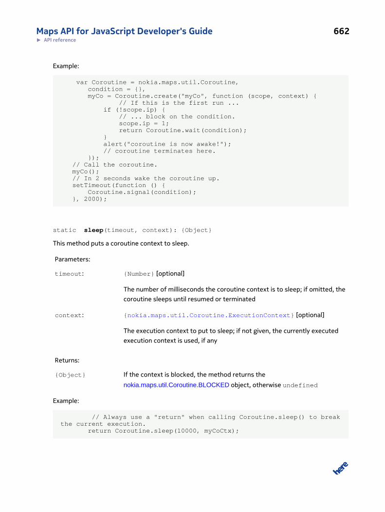
Maps API for JavaScript Developer's Guide 662► API reference
Example:
var Coroutine = nokia.maps.util.Coroutine, condition = {}, myCo = Coroutine.create("myCo", function (scope, context) { // If this is the first run ... if (!scope.ip) { // ... block on the condition. scope.ip = 1; return Coroutine.wait(condition); } alert("coroutine is now awake!"); // coroutine terminates here. }); // Call the coroutine. myCo(); // In 2 seconds wake the coroutine up. setTimeout(function () { Coroutine.signal(condition); }, 2000);
static sleep(timeout, context): {Object}
This method puts a coroutine context to sleep.
Parameters:
timeout: {Number} [optional]
The number of milliseconds the coroutine context is to sleep; if omitted, the
coroutine sleeps until resumed or terminated
context: {nokia.maps.util.Coroutine.ExecutionContext} [optional]
The execution context to put to sleep; if not given, the currently executed
execution context is used, if any
Returns:
{Object} If the context is blocked, the method returns the
nokia.maps.util.Coroutine.BLOCKED object, otherwise undefined
Example:
// Always use a "return" when calling Coroutine.sleep() to break the current execution. return Coroutine.sleep(10000, myCoCtx);
Maps API for JavaScript Developer's Guide 663► API reference
static suspend(context, timeout): {Object}
The method suspends the supplied execution context or the currently executed context.
Parameters:
context: {nokia.maps.util.Coroutine.ExecutionContext} [optional]
The execution context that to suspend; if omitted or null/undefined, the
currently executed context is suspended, if any
timeout: {Number} [optional]
The maximum amount of time to block in milliseconds; if null or unde-
fined, the method blocks until the coroutine is notified, resumed or termi-
nated
Returns:
{Object} If the context is blocked, the method returns the
nokia.maps.util.Coroutine.BLOCKED object, otherwise undefined
Example:
// Always use a "return" when calling Coroutine.suspend() to break the current execution. return Coroutine.suspend(myCoCtx);
static taskCpuTime(): {Number}
This method retrieves the total CPU time that all contexts have consumed.
Returns:
{Number} The number of milliseconds of CPU time all contexts have consumed togeth-
er
static totalCpuTime(): {Number}
This method retrieves the number of milliseconds since the scheduler was started.
Returns:
Maps API for JavaScript Developer's Guide 664► API reference
{Number} The number of milliseconds since the scheduler was started
static wait(obj, timeout, context): {Object}
This method blocks the a coroutine on the object provided by the caller.
Note that the object gets a new property called "$blocking" which is managed by the coroutine
manager and must not be modified.
Parameters:
obj: {Object}
The object on which the coroutine is to be blocked
timeout: {Number} [optional]
If provided, this argument is the maximum length of time in milliseconds
that the coroutine blocks, otherwise if the argument is null or undefined,
the method blocks for ever
context: {nokia.maps.util.Coroutine.ExecutionContext} [optional]
The execution context to block; if the argument is omitted, the currently ex-
ecuted context is used, if any is currently executed
Returns:
{Object} If the context is blocked, the method returns the
nokia.maps.util.Coroutine.BLOCKED object; otherwise undefined
Example:
var Coroutine = nokia.maps.util.Coroutine, condition = {}, myCo = Coroutine.create("myCo", function (scope, context) { // If this is the first run ... if (!scope.ip) { // ... block on the condition. scope.ip = 1; // Using a "return" when calling Coroutine.yield() we break the current execution return Coroutine.wait(condition); } alert("coroutine is now awake!"); // coroutine terminates here. });
Maps API for JavaScript Developer's Guide 665► API reference
// Call the coroutine. myCo(); // Wake up the coroutine in two seconds. setTimeout(function () { Coroutine.signal(condition); }, 2000);
static yield(context): {Object}
This method makes the currently executed coroutine or the supplied one yield.
Parameters:
context: {nokia.maps.util.Coroutine.ExecutionContext}
The execution context of the coroutine to yield, if not given the currently ex-
ecuted context is suspended
Returns:
{Object} If the context is blocked the method returns the
nokia.maps.util.Coroutine.YIELDED object, otherwise undefined
Example:
var YIELD_EVERY = 64, yieldCount = 0, Coroutine = nokia.maps.util.Coroutine, myCo = Coroutine.create("myCo", function (scope, context) { console.log("yieldCount" + yieldCount); while (++yieldCount < 1000) { // Break the execution of the while loop, using the yield method. // Using a "return" when calling Coroutine.yield() we break the current execution. if (!(yieldCount % YIELD_EVERY)) return Coroutine.yield(); // coroutine terminates here. } }); myCo();
Class: ExecutionContext
This class is a member of nokia.maps.util.Coroutine.
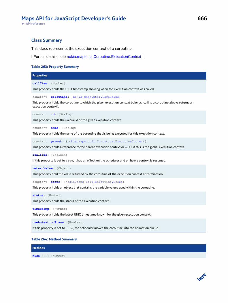
Maps API for JavaScript Developer's Guide 666► API reference
Class Summary
This class represents the execution context of a coroutine.
[ For full details, see nokia.maps.util.Coroutine.ExecutionContext ]
Table 263: Property Summary
Properties
callTime: {Number}
This property holds the UNIX timestamp showing when the execution context was called.
constant coroutine: {nokia.maps.util.Coroutine}
This property holds the coroutine to which the given execution context belongs (calling a coroutine always returns anexecution context).
constant id: {String}
This property holds the unique id of the given execution context.
constant name: {String}
This property holds the name of the coroutine that is being executed for this execution context.
constant parent: {nokia.maps.util.Coroutine.ExecutionContext}
This property holds a reference to the parent execution context or null if this is the global execution context.
realtime: {Boolean}
If this property is set to true, it has an effect on the scheduler and on how a context is resumed.
returnValue: {Object}
This property hold the value returned by the coroutine of the execution context at termination.
constant scope: {nokia.maps.util.Coroutine.Scope}
This property holds an object that contains the variable values used within the coroutine.
status: {Number}
This property holds the status of the execution context.
timeStamp: {Number}
This property holds the latest UNIX timestamp known for the given execution context.
useAnimationFrame: {Boolean}
If this property is set to true, the scheduler moves the coroutine into the animation queue.
Table 264: Method Summary
Methods
nice () : {Number}
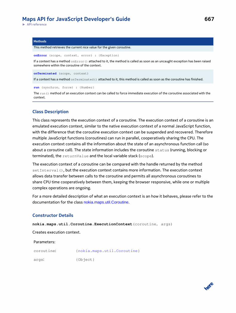
Maps API for JavaScript Developer's Guide 667► API reference
Methods
This method retrieves the current nice value for the given coroutine.
onError (scope, context, error) : {Exception}
If a context has a method onError() attached to it, the method is called as soon as an uncaught exception has been raisedsomewhere within the coroutine of the context.
onTerminated (scope, context)
If a context has a method onTerminated() attached to it, this method is called as soon as the coroutine has finished.
run (synchron, force) : {Number}
The run() method of an execution context can be called to force immediate execution of the coroutine associated with thecontext.
Class Description
This class represents the execution context of a coroutine. The execution context of a coroutine is an
emulated execution context, similar to the native execution context of a normal JavaScript function,
with the difference that the coroutine execution context can be suspended and recovered. Therefore
multiple JavaScript functions (coroutines) can run in parallel, cooperatively sharing the CPU. The
execution context contains all the information about the state of an asynchronous function call (so
about a coroutine call). The state information includes the coroutine status (running, blocking or
terminated), the returnValue and the local variable stack (scope).
The execution context of a coroutine can be compared with the handle returned by the method
setInterval(), but the execution context contains more information. The execution context
allows data transfer between calls to the coroutine and permits all asynchronous coroutines to
share CPU time cooperatively between them, keeping the browser responsive, while one or multiple
complex operations are ongoing.
For a more detailed description of what an execution context is an how it behaves, please refer to the
documentation for the class nokia.maps.util.Coroutine.
Constructor Details
nokia.maps.util.Coroutine.ExecutionContext(coroutine, args)
Creates execution context.
Parameters:
coroutine: {nokia.maps.util.Coroutine}
args: {Object}
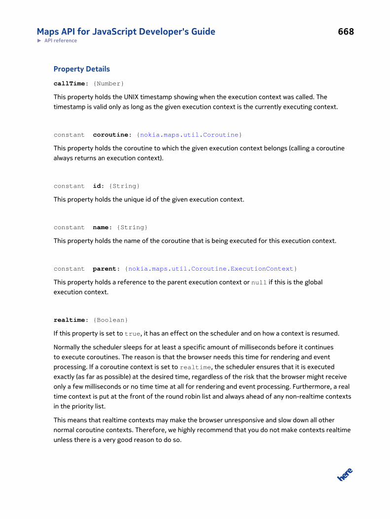
Maps API for JavaScript Developer's Guide 668► API reference
Property Details
callTime: {Number}
This property holds the UNIX timestamp showing when the execution context was called. The
timestamp is valid only as long as the given execution context is the currently executing context.
constant coroutine: {nokia.maps.util.Coroutine}
This property holds the coroutine to which the given execution context belongs (calling a coroutine
always returns an execution context).
constant id: {String}
This property holds the unique id of the given execution context.
constant name: {String}
This property holds the name of the coroutine that is being executed for this execution context.
constant parent: {nokia.maps.util.Coroutine.ExecutionContext}
This property holds a reference to the parent execution context or null if this is the global
execution context.
realtime: {Boolean}
If this property is set to true, it has an effect on the scheduler and on how a context is resumed.
Normally the scheduler sleeps for at least a specific amount of milliseconds before it continues
to execute coroutines. The reason is that the browser needs this time for rendering and event
processing. If a coroutine context is set to realtime, the scheduler ensures that it is executed
exactly (as far as possible) at the desired time, regardless of the risk that the browser might receive
only a few milliseconds or no time time at all for rendering and event processing. Furthermore, a real
time context is put at the front of the round robin list and always ahead of any non-realtime contexts
in the priority list.
This means that realtime contexts may make the browser unresponsive and slow down all other
normal coroutine contexts. Therefore, we highly recommend that you do not make contexts realtime
unless there is a very good reason to do so.
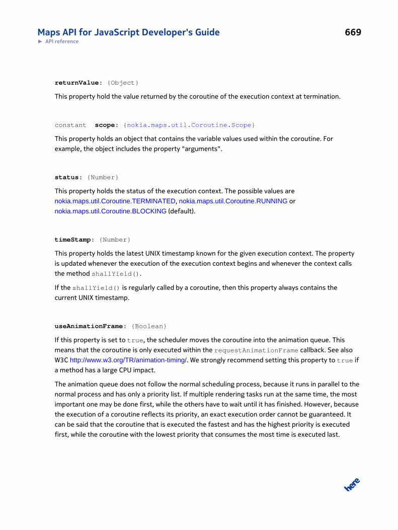
Maps API for JavaScript Developer's Guide 669► API reference
returnValue: {Object}
This property hold the value returned by the coroutine of the execution context at termination.
constant scope: {nokia.maps.util.Coroutine.Scope}
This property holds an object that contains the variable values used within the coroutine. For
example, the object includes the property "arguments".
status: {Number}
This property holds the status of the execution context. The possible values are
nokia.maps.util.Coroutine.TERMINATED, nokia.maps.util.Coroutine.RUNNING or
nokia.maps.util.Coroutine.BLOCKING (default).
timeStamp: {Number}
This property holds the latest UNIX timestamp known for the given execution context. The property
is updated whenever the execution of the execution context begins and whenever the context calls
the method shallYield().
If the shallYield() is regularly called by a coroutine, then this property always contains the
current UNIX timestamp.
useAnimationFrame: {Boolean}
If this property is set to true, the scheduler moves the coroutine into the animation queue. This
means that the coroutine is only executed within the requestAnimationFrame callback. See also
W3C http://www.w3.org/TR/animation-timing/. We strongly recommend setting this property to true if
a method has a large CPU impact.
The animation queue does not follow the normal scheduling process, because it runs in parallel to the
normal process and has only a priority list. If multiple rendering tasks run at the same time, the most
important one may be done first, while the others have to wait until it has finished. However, because
the execution of a coroutine reflects its priority, an exact execution order cannot be guaranteed. It
can be said that the coroutine that is executed the fastest and has the highest priority is executed
first, while the coroutine with the lowest priority that consumes the most time is executed last.

Maps API for JavaScript Developer's Guide 670► API reference
Another difference between the scheduling of the animation queue and normal scheduling
is that sleep or wait times are not precise, because the rendering is bound to the
requestAnimationFrame method of the browser. If a browser tab is in the background, the
browser reduceS the number of calls to the requestAnimationFrame() method dramatically
and may even cut it down to zero, therefore reducing the amount of time used for rendering. This
helps save battery power on mobile devices, because while a user is not viewing a page no animation
frame requests are performed. Therefore even methods that have nothing to do with rendering,
but are very expensive (for example heavy calculations) may be marked as useAnimationFrame to
decrease CPU usage on mobile devices and to save battery power.
Note that if this property is set, precede and postpone have no effect for the given coroutine
context.
Method Details
nice(): {Number}
This method retrieves the current nice value for the given coroutine.
The nice value is the final absolute priority with which the scheduler handles the context. When the
nice value is higher, the context acquires CPU time faster. The nice value is limited between -200 (bad
context consuming a lot of CPU time with a very low priority) and +100 (good context, not consuming
much CPU time, but has a very high priority).
The scheduler executes one context from the round robin list and then the context with the highest
nice value from the priority list. Afterwards, it decrements the nice value and increments the activity
value.
This has been designed to ensure that each context receives at least a small amount of CPU time
(50% is given away in equal chunks to all contexts, regardless of priority) while contexts with a higher
priority and those that are often idle receive the other 50% of CPU time, depending on their priority
and activity (high priority and low activity comes first).
Activity is taken into account for the reason that there may be contexts waiting for user input. Those
contexts have low activity levels, but are very important with regard to user satisfaction, because
the user expects a fast reaction to his input. Therefore, activity is a very important point for the
scheduler. If a context has a very high priority but it is consuming all the CPU time given to it, it
receives a lower priority than an idle context with a very low priority (unless the context with the lower
priority begins to consume CPU time as well).
The nice value is calculated simply as priority minus activity, limiting it to a value between -200 (bad)
and +100 (good).
Maps API for JavaScript Developer's Guide 671► API reference
Note that the nice value returned by this method is not be updated in real-time for performance
reasons. While a coroutine is idle, the nice value decreases, but this is not reflected by this method.
Therefore the value returned by the method might not be accurate.
Returns:
{Number} The current nice value of this coroutine (not accurate)
onError(scope, context, error): {Exception}
If a context has a method onError() attached to it, the method is called as soon as an uncaught
exception has been raised somewhere within the coroutine of the context. The method sets the
reason for the exception and returns null or undefined, or it returns the exception itself to signal
that it was not able to determine the reason for the error and that the context is being terminated.
Parameters:
scope: {Object}
The variable object representing the scope from the context
context: {nokia.maps.util.Coroutine.ExecutionContext}
The execution context
error: {Exception}
The exception that was the reason for the error
Returns:
{Exception} The exception object if the method cannot determine the reason for the ex-
ception, null or undefined to indicate that the reason for the exception
has been determined and/or that the exception should be ignored by the
scheduler
onTerminated(scope, context)
If a context has a method onTerminated() attached to it, this method is called as soon as the
coroutine has finished.
Parameters:
Maps API for JavaScript Developer's Guide 672► API reference
scope: {Object}
The variable object representing the scope from the context
context: {nokia.maps.util.Coroutine.ExecutionContext}
The execution context
run(synchron, force): {Number}
The run() method of an execution context can be called to force immediate execution of the
coroutine associated with the context. The method is used internally by the scheduler to run a
context. It should not be called by third-party applications, except, where there is an important
reason to run the context immediately and synchronously.
The run() method removes the coroutine context from all internal lists before the code of the
coroutine is executed.
Parameters:
synchron: {Boolean} [optional]
If this argument is provided and true, the method shallYield() nev-
er returns true, therefore the context is executed synchronously; please
be aware that there is no guarantee that the coroutine will not put itself to
sleep unless it supports synchronous calls
force: {Boolean} [optional]
If this argument is true the method will ignore the precedence and post-
pone settings as well as the useAnimationFrame option, otherwise run-
ning the method will not do anything as long as it is postponed to any other
method or we're out of an animation frame.
Returns:
{Number} A UNIX timestamp indicating when the method finished executing
Class: Scope
This class is a member of nokia.maps.util.Coroutine.
Maps API for JavaScript Developer's Guide 673► API reference
Class Summary
Scope is an abstract class designed to hold variables available within the scope of a coroutine.
[ For full details, see nokia.maps.util.Coroutine.Scope ]
Table 265: Property Summary
Properties
arguments: {Object[]}
An array with all the parameters that have been passed to the coroutine.
context: {nokia.maps.util.Coroutine.ExecutionContext}
The execution context that is bound to the given scope.
global: {nokia.maps.util.Coroutine.Scope}
The reference to the scope of the global execution context.
that: {Object}
The object to which this pointed at the time the coroutine was called.
Table 266: Method Summary
Methods
hasOwn (name) : {Boolean}
This method checks if the variable named by the caller is defined in the given scope.
set (name, value) : {nokia.maps.util.Coroutine.ExecutionContext}
This method sets the value of a variable on the basis of the variable name and value supplied by the caller.
Class Description
Scope is an abstract class designed to hold variables available within the scope of a coroutine.
Property Details
arguments: {Object[]}
An array with all the parameters that have been passed to the coroutine.
context: {nokia.maps.util.Coroutine.ExecutionContext}
The execution context that is bound to the given scope.
Maps API for JavaScript Developer's Guide 674► API reference
global: {nokia.maps.util.Coroutine.Scope}
The reference to the scope of the global execution context.
that: {Object}
The object to which this pointed at the time the coroutine was called.
Method Details
hasOwn(name): {Boolean}
This method checks if the variable named by the caller is defined in the given scope. The method is
an alias for the W3C method hasOwnProperty(). It returns a Boolean indicating whether a variable
with the given name is defined at this scope. The method is an alias to W3C's hasOwnProperty().
Parameters:
name: {String}
The string containing the name of the property to be tested.
Returns:
{Boolean} true if the property exists in this scope, otherwise false
set(name, value): {nokia.maps.util.Coroutine.ExecutionContext}
This method sets the value of a variable on the basis of the variable name and value supplied by the
caller. The method searches all scopes in the scope chain and sets the the value of the first variable
with a matching name. If no matching variable exists, the method creates it within the global scope.
This method simulates the behavior of the normal assignment in JavaScript, example:
var Coroutine = nokia.maps.util.Coroutine, outerFn = function () { var text = "Old Value", innerFn = function () { // Modifies the "text" variable from the parent scope: text = "New Value"; }; innerFn(); alert(text); }; var outerCo = Coroutine.create("outer", function (scope) { scope.text = "Old Value";
Maps API for JavaScript Developer's Guide 675► API reference
scope.innerCo = Coroutine.create("inner", function (scope) { // The assignment // scope.text = "New Value"; // results in a new variable with the value "New Value" // in the current scope and does not change the variable // named 'text' in the parent scope. Therefore to change // the value of the variable 'text' in the parent scope, // it is necessary to use the method set(): scope.set("text", "New Value"); });
scope.ctx = scope.innerCo(); scope.ctx.run(); alert(scope.text); }); outerFn(); outerCo();
Parameters:
name: {String}
The string containing the name of the property to be set
value: {Object}
The value to be assigned to property specified by the argument name
Returns:
{nokia.maps.util.Coroutine.ExecutionContext}
A reference to the given execution context for chaining (this)
Class: EventThis class is a member of nokia.maps.util.
Class Summary
Simplified Event class without bubbling.
[ For full details, see nokia.maps.util.Event ]
Table 267: Property Summary
Properties
readonly defaultPrevented: {Boolean}
This property indicates whether preventDefault() has been called for this event.
Maps API for JavaScript Developer's Guide 676► API reference
Properties
readonly target: {nokia.maps.util.EventTarget}
This property holds the target object of the event.
timeStamp: {Number}
This property specifies the time at which the event was created in milliseconds relative to 1970-01-01T00:00:00Z.
readonly type: {String}
This property holds the local name of the event type.
Table 268: Method Summary
Methods
preventDefault ()
This method cancels the default action for the given event.
Class Description
This class implements a Event like the W3C interface but simplified (no bubble and capture phases)
Event but with less complexity. See also Concept event
For more details about event dispatch please refer to the documentation of the class
nokia.maps.util.EventTarget.
Constructor Details
nokia.maps.util.Event(type)
Parameters:
type: {String}
The type of the Event
Property Details
readonly defaultPrevented: {Boolean}
This property indicates whether preventDefault() has been called for this event.
readonly target: {nokia.maps.util.EventTarget}
This property holds the target object of the event.
Maps API for JavaScript Developer's Guide 677► API reference
timeStamp: {Number}
This property specifies the time at which the event was created in milliseconds relative to
1970-01-01T00:00:00Z.
readonly type: {String}
This property holds the local name of the event type.
Method Details
preventDefault()
This method cancels the default action for the given event.
Class: EventTargetThis class is a member of nokia.maps.util.
Class Summary
This class implements the W3C DOM Level 3 interface EventTarget
[ For full details, see nokia.maps.util.EventTarget ]
Table 269: Method Summary
Methods
addListener (type, callback)
This method registers an event listener on the EventTarget
dispatch (evt) : {Boolean}
This method dispatches an event.
removeListener (type, callback)
This method removes an event listener.
Class Description
This class implements the W3C DOM Level 3 interface EventTarget It can be used as a mixin for any
JavaScript class or it can be applied at runtime to any JavaScript object by simply patch the object to
Maps API for JavaScript Developer's Guide 678► API reference
EventTarget. Note that for the sake of compatibility the W3C, some methods have been renamed.
For example, addEventListener() becomes addListener().
Usage example:
myObject = new nokia.maps.util.EventTarget() myObject.addListener("customEvent", function (evt) { alert( evt.type ); }); // Now you can fire an event at "myObject": myObject.dispatch( new nokia.maps.util.Event("customEvent") );
The listener queue
Constructor Details
nokia.maps.util.EventTarget(obj)
The class constructor mixes the functionality of EventTarget into the argument object.
Parameters:
obj: {Object}
The object to be extended with EventTarget functionality
Method Details
addListener(type, callback)
This method registers an event listener on the EventTarget
Parameters:
type: {String}
Specifies the event type for which the listener is to be registered.
callback: {Function}
The function used as the callback for the event. This function is called when-
ever an event occurs of the event type for which the listener was registered.
The function receives an event argument that contains contextual informa-
tion about the event (see nokia.maps.util.Event).

Maps API for JavaScript Developer's Guide 679► API reference
dispatch(evt): {Boolean}
This method dispatches an event.
Parameters:
evt: {nokia.maps.util.Event}
An object representing the event to be dispatched
Returns:
{Boolean} Indicates whether any of the listeners which handled the event called
Event.preventDefault(). If Event.preventDefault() was called,
the return value is false, otherwise it is true
removeListener(type, callback)
This method removes an event listener. Calling removeListener with arguments that do not identify
any currently registered listener on the EventTarget has no effect.
Parameters:
type: {String}
Specifies the event type associated with the event for which the listener was
registered.
callback: {Function}
The callback function to be removed.
Interface: IArrowsThis interface is a member of nokia.maps.util.
Interface Summary
This interface represents properties for arrows.
[ For full details, see nokia.maps.util.IArrows ]
Maps API for JavaScript Developer's Guide 680► API reference
Table 270: Property Summary
Properties
readonly color: {String}
This property holds the value of the fill color used for the arrow shapes.
readonly frequency: {Number}
This property indicates the frequency of arrow shapes.
readonly length: {Number}
This property indicates the length of the arrow shapes.
readonly width: {Number}
This property indicates the width of the arrow shapes.
Interface Description
This interface represents the common properties of arrows objects. An implementation of this
interface can be used in nokia.maps.map.Polyline to define the arrows style.
Property Details
readonly color: {String}
This property holds the value of the fill color used for the arrow shapes. The format is RGBA (the
alpha value is optional). When defining the RGBA value, please follow the CSS specification, which
requires a string containing:
• a leading "#" character (followed by ...)
• two or one hex digits for every channel
Default Value: "#FFFC"
readonly frequency: {Number}
This property indicates the frequency of arrow shapes. The value is taken as factor of the arrow's
length. A value of 1 results in arrows without space in between. The value must be greater than 0.
Default Value: 5
readonly length: {Number}
Maps API for JavaScript Developer's Guide 681► API reference
This property indicates the length of the arrow shapes. The value is taken as factor of the line's width
where the arrows are painted. The value must be greater than 0
Default Value: 1.6
readonly width: {Number}
This property indicates the width of the arrow shapes. The value is taken as factor of the line's width
where the arrow description is applied. The value must be greater than 0.
Default Value: 1.2
Interface: IBoxThis interface is a member of nokia.maps.util.
Interface Summary
This interface defines a box.
[ For full details, see nokia.maps.util.IBox ]
Table 271: Property Summary
Properties
bottom: {Number}
This property holds the numeric value for the bottom side of the box.
left: {Number}
This property holds the numeric value for the left side of the box.
right: {Number}
This property holds the numeric value for the right side of the box.
top: {Number}
This property holds the numeric value for the top side of the box.
Interface Description
This interface class defines a box with properties that hold the screen coordinates of the sides of the
box: top, right, bottom and left.
Maps API for JavaScript Developer's Guide 682► API reference
Property Details
bottom: {Number}
This property holds the numeric value for the bottom side of the box.
left: {Number}
This property holds the numeric value for the left side of the box.
right: {Number}
This property holds the numeric value for the right side of the box.
top: {Number}
This property holds the numeric value for the top side of the box.
Interface: IBrushThis interface is a member of nokia.maps.util.
Interface Summary
This interface represents brush objects.
[ For full details, see nokia.maps.util.IBrush ]
Table 272: Property Summary
Properties
readonly color: {String}
This property holds the value of the fill color used for the brush.
readonly fill: {String}
This property indicates the fill type to be used for the brush.
Interface Description
This interface represents the common properties of brush objects. An implementation of this
interface can be used in nokia.maps.map.Object to define fill colors.
Maps API for JavaScript Developer's Guide 683► API reference
Property Details
readonly color: {String}
This property holds the value of the fill color used for the brush. The format is RGBA (the alpha value
is optional). When defining the RGBA value, please follow the CSS specification, which requires a
string containing:
• a leading "#" character (followed by ...)
• two or one hex digits for every channel
Default Value: "#00F8"
readonly fill: {String}
This property indicates the fill type to be used for the brush. The value should be one of the
following:
• "solid" - indicates a sold fill
• "none" - indicates no fill
Default Value: "solid"
Interface: IPenThis interface is a member of nokia.maps.util.
Interface Summary
This interface class defines a IPen object.
[ For full details, see nokia.maps.util.IPen ]
Table 273: Property Summary
Properties
readonly lineCap: {String}
This property specifies the shape to be used at the end of open subpaths when they are stroked.
readonly lineJoin: {String}
This property specifies the shape to be used on the corners of paths or basic shapes when they are stroked.
readonly lineWidth: {Number}
This property holds the width of lines in coordinate space units.
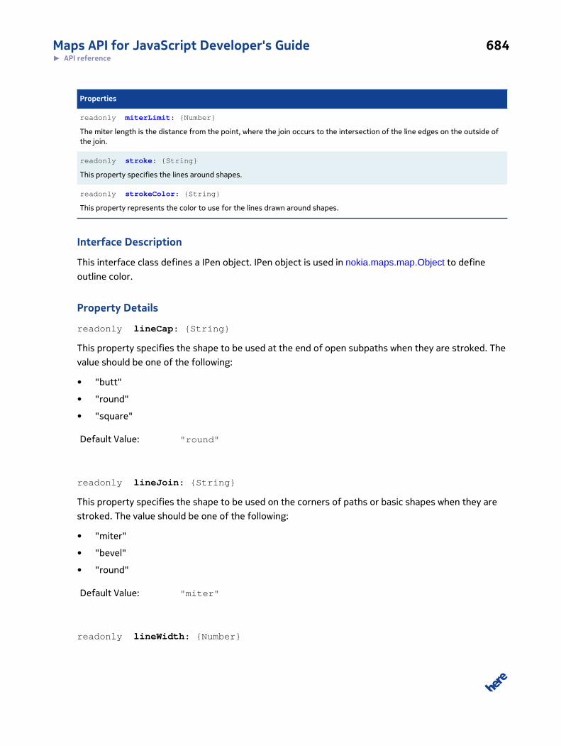
Maps API for JavaScript Developer's Guide 684► API reference
Properties
readonly miterLimit: {Number}
The miter length is the distance from the point, where the join occurs to the intersection of the line edges on the outside ofthe join.
readonly stroke: {String}
This property specifies the lines around shapes.
readonly strokeColor: {String}
This property represents the color to use for the lines drawn around shapes.
Interface Description
This interface class defines a IPen object. IPen object is used in nokia.maps.map.Object to define
outline color.
Property Details
readonly lineCap: {String}
This property specifies the shape to be used at the end of open subpaths when they are stroked. The
value should be one of the following:
• "butt"
• "round"
• "square"
Default Value: "round"
readonly lineJoin: {String}
This property specifies the shape to be used on the corners of paths or basic shapes when they are
stroked. The value should be one of the following:
• "miter"
• "bevel"
• "round"
Default Value: "miter"
readonly lineWidth: {Number}
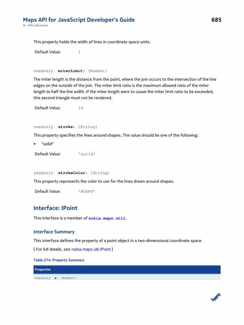
Maps API for JavaScript Developer's Guide 685► API reference
This property holds the width of lines in coordinate space units.
Default Value: 1
readonly miterLimit: {Number}
The miter length is the distance from the point, where the join occurs to the intersection of the line
edges on the outside of the join. The miter limit ratio is the maximum allowed ratio of the miter
length to half the line width. If the miter length were to cause the miter limit ratio to be exceeded,
this second triangle must not be rendered.
Default Value: 10
readonly stroke: {String}
This property specifies the lines around shapes. The value should be one of the following:
• "solid"
Default Value: "solid"
readonly strokeColor: {String}
This property represents the color to use for the lines drawn around shapes.
Default Value: "#00F8"
Interface: IPointThis interface is a member of nokia.maps.util.
Interface Summary
This interface defines the property of a point object in a two-dimensional coordinate space.
[ For full details, see nokia.maps.util.IPoint ]
Table 274: Property Summary
Properties
readonly x: {Number}
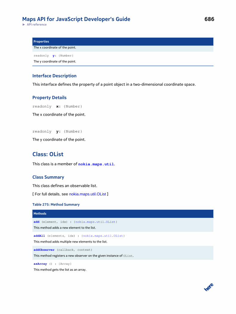
Maps API for JavaScript Developer's Guide 686► API reference
Properties
The x coordinate of the point.
readonly y: {Number}
The y coordinate of the point.
Interface Description
This interface defines the property of a point object in a two-dimensional coordinate space.
Property Details
readonly x: {Number}
The x coordinate of the point.
readonly y: {Number}
The y coordinate of the point.
Class: OListThis class is a member of nokia.maps.util.
Class Summary
This class defines an observable list.
[ For full details, see nokia.maps.util.OList ]
Table 275: Method Summary
Methods
add (element, idx) : {nokia.maps.util.OList}
This method adds a new element to the list.
addAll (elements, idx) : {nokia.maps.util.OList}
This method adds multiple new elements to the list.
addObserver (callback, context)
This method registers a new observer on the given instance of OList.
asArray () : {Array}
This method gets the list as an array.

Maps API for JavaScript Developer's Guide 687► API reference
Methods
clear ()
This method clears all elements from the list.
get (idx) : {Variant}
This method gets the value for the specified list element.
getLength () : {Number}
This method getg the length of the list.
indexOf (obj) : {Number}
This method retrieves the index of the first object in this list that matches the object supplied by the caller.
remove (obj) : {Variant}
This method removes from the list the first element that matches the object supplied by the caller.
removeAll (elements) : {nokia.maps.util.OList}
This method removes multiple elements from the list.
removeAt (idx) : {Variant}
This method removes an element by a given index from the list.
removeObserver (callback, context) : {nokia.maps.util.OObject}
This method unregisters an observer.
set (element, idx) : {Variant}
This method sets (replaces) an element at the given index in the list.
Class Description
This class defines an observable list.
Constructor Details
nokia.maps.util.OList(elements)
This method initializes a new instance of the class.
Parameters:
elements: {Array} [optional, default: []]
The initial list elements to use; if omitted, an empty array is used
Method Details
add(element, idx): {nokia.maps.util.OList}
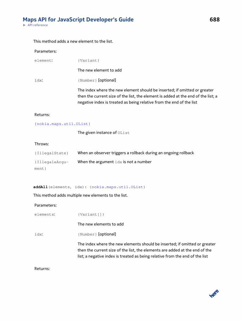
Maps API for JavaScript Developer's Guide 688► API reference
This method adds a new element to the list.
Parameters:
element: {Variant}
The new element to add
idx: {Number} [optional]
The index where the new element should be inserted; if omitted or greater
then the current size of the list, the element is added at the end of the list; a
negative index is treated as being relative from the end of the list
Returns:
{nokia.maps.util.OList}
The given instance of OList
Throws:
{IllegalState} When an observer triggers a rollback during an ongoing rollback
{IllegaleArgu-
ment}
When the argument idx is not a number
addAll(elements, idx): {nokia.maps.util.OList}
This method adds multiple new elements to the list.
Parameters:
elements: {Variant[]}
The new elements to add
idx: {Number} [optional]
The index where the new elements should be inserted; if omitted or greater
then the current size of the list, the elements are added at the end of the
list; a negative index is treated as being relative from the end of the list
Returns:
Maps API for JavaScript Developer's Guide 689► API reference
{nokia.maps.util.OList}
The given instance of OList
Throws:
IllegalState if an observer triggers a rollback during an ongoing rollback
addObserver(callback, context)
This method registers a new observer on the given instance of OList. The observer is a callback to
be invoked when the instance changes, typically when an element is added or removed.
Parameters:
callback: {Function}
The callback function to be invoked after the list has been modified; the call-
back must accept the following arguments:
• (OList) oList - the OList instance itself
• (String) operation - the name of the operation which triggered a change
to the given instance of OList and therefore a call to the callback. The
operation is either "add" or "remove"
• (Variant) element - the element which was added or deleted
• (Number) idx - the index of the element concerned
The callback can signal that a rollback should be triggered by returning
true.
context: {Object} [optional]
The context to use when the callback is invoked. If not set than global con-
text is used.
asArray(): {Array}
This method gets the list as an array.
Returns:
{Array} The list as an array
Maps API for JavaScript Developer's Guide 690► API reference
clear()
This method clears all elements from the list.
Throws:
IllegalState if an observer triggers a rollback during an ongoing rollback
get(idx): {Variant}
This method gets the value for the specified list element.
Parameters:
idx: {Number}
The index of the element to get
Returns:
{Variant} The value of the element
Throws:
IllegaleArgument if an observer triggers a rollback during an ongoing roll-
back
getLength(): {Number}
This method getg the length of the list.
Returns:
{Number} The length of the list
indexOf(obj): {Number}
This method retrieves the index of the first object in this list that matches the object supplied by the
caller.
Parameters:
Maps API for JavaScript Developer's Guide 691► API reference
obj: {Variant}
The object for which to return the index.
Returns:
{Number} The index of the first matching object in this list or -1 if the object provided
by the caller is not found in the list
remove(obj): {Variant}
This method removes from the list the first element that matches the object supplied by the caller.
Parameters:
obj: {Variant}
The element to remove
Returns:
{Variant} The removed element
Throws:
IllegalState if an observer triggers a rollback during an ongoing rollback.
removeAll(elements): {nokia.maps.util.OList}
This method removes multiple elements from the list.
Parameters:
elements: {Variant[]}
The elements to remove
Returns:
{nokia.maps.util.OList}
The given instance of OList
Throws:
Maps API for JavaScript Developer's Guide 692► API reference
IllegalState if an observer triggers a rollback during an ongoing rollback
removeAt(idx): {Variant}
This method removes an element by a given index from the list.
Parameters:
idx: {Number}
The index of the element which should be removed
Returns:
{Variant} The removed element or null if a observer signaled a rollback
Throws:
IllegalState if an observer triggers a rollback during an ongoing rollback
removeObserver(callback, context): {nokia.maps.util.OObject}
This method unregisters an observer.
Parameters:
callback: {Function}
The observer method to be removed
context: {Object}
The context in which the given callback should be called
Returns:
{nokia.maps.util.OObject}
The reference to the given OObject instance
set(element, idx): {Variant}
This method sets (replaces) an element at the given index in the list.
Maps API for JavaScript Developer's Guide 693► API reference
Parameters:
element: {Variant}
The element to set at the index specified by idx
idx: {Number}
The index of the element which should be replaced
Returns:
{Variant} The replaced element or undefined if an observer has triggered a rollback
Throws:
IllegalState if an observer triggers a rollback during an ongoing rollback
Class: OObjectThis class is a member of nokia.maps.util.
Class Summary
This class encapsulates an inheritable object that has observable properties.
[ For full details, see nokia.maps.util.OObject ]
Table 276: Method Summary
Methods
addObserver (key, callback, context) : {nokia.maps.util.OObject}
This method registers an observer for the property named by the caller.
get (key) : {Variant}
This method retrieves the value of the property with the name provided by the caller.
remove (key) : {nokia.maps.util.OObject}
This method removes the property with the name provided by the caller.
removeObserver (key, callback, context) : {nokia.maps.util.OObject}
This method removes the observer for the property named by the caller.
set (nameOrObject, value, force) : {nokia.maps.util.OObject}
This method sets property values, using the property names and values supplied by the caller.
Maps API for JavaScript Developer's Guide 694► API reference
Class Description
This class encapsulates an inheritable object that has observable properties.
Constructor Details
nokia.maps.util.OObject(props)
This method initializes an instance of OObject that is inheritable and has observable properties.
Parameters:
props: {Object} [optional]
The initial hash of properties with names and values.
Method Details
addObserver(key, callback, context): {nokia.maps.util.OObject}
This method registers an observer for the property named by the caller. Note that modifying the
property from within the observer is allowed, but discouraged, because this forces the observer chain
to be invoked again and the old one aborted. This could lead to endless recursions and should be
done carefully.
Parameters:
key: {String}
The name of the property to observe; the wild card "*" can be used to ob-
serve any property
callback: {Function}
The function to be called if the observed property is modified; the function
must be able to receive the following arguments:
• (OObject) obj - a reference to the given object
• (String) key - the name of the property that was modified, created or
deleted
• (Variant) value - the new value that the property should be set to
• (Variant) oldValue the old value of the property
context: {Object} [optional, default: null]
Maps API for JavaScript Developer's Guide 695► API reference
The context in which the given function should be called. If omitted, the
global object is used.
Returns:
{nokia.maps.util.OObject}
A reference to the given OObject instance
get(key): {Variant}
This method retrieves the value of the property with the name provided by the caller.
Parameters:
key: {String}
The name of the property whose value is to be retrieved
Returns:
{Variant} The retrieved value of the property named by the caller or undefined if no
such property exists
remove(key): {nokia.maps.util.OObject}
This method removes the property with the name provided by the caller.
Parameters:
key: {String}
The name of the property to be removed
Returns:
{nokia.maps.util.OObject}
The reference to the given OObject instance
removeObserver(key, callback, context): {nokia.maps.util.OObject}
This method removes the observer for the property named by the caller.
Maps API for JavaScript Developer's Guide 696► API reference
Parameters:
key: {String}
The name of the property that should no longer be observed
callback: {Function}
The observer method to be removed
context: {Object} [optional]
The context in which the given callback should be called
Returns:
{nokia.maps.util.OObject}
The reference to the given instance of OObject
set(nameOrObject, value, force): {nokia.maps.util.OObject}
This method sets property values, using the property names and values supplied by the caller. It
takes an object whose keys match property names. The values corresponding to the keys are the new
values for the properties to set.
To set a single property, the caller can provide two arguments, the name of the property as a string
and the value to be set. For all properties, the following rules apply:
• If no property with the given name exists yet, the property is created.
• If a derived class defines a member method with the name of the key postfixed by "Setter", this
method is called first; it is given the value and should return the "filtered" value to be set.
• After this "filtering" all registered observers of this value are called - if and only if this filtered
value differs from the old value. The "observers" MUST NOT use code that leads to secondary
setting of properties in this object/property or elsewhere, as this could result in endless loops.
The members of the object passed to set() are not tested against hasOwnProperty().
Parameters:
nameOrObject: {String | Object}
The name of the property to be set or the object from which to take the
properties and their values
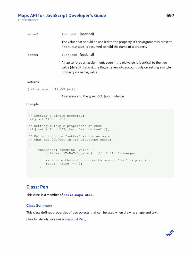
Maps API for JavaScript Developer's Guide 697► API reference
value: {Variant} [optional]
The value that should be applied to the property; if this argument is present,
nameOrObject is assumed to hold the name of a property
force: {Boolean} [optional]
A flag to force an assignment, even if the old value is identical to the new
value (default false); the flag is taken into account only on setting a single
property via name, value
Returns:
{nokia.maps.util.OObject}
A reference to the given OObject instance
Example:
// Setting a single property: obj.set("foo", 123);
// Setting multiple properties at once: obj.set({ foo: 123, bar: "second one" });
// Definition of a "setter" within an object // that has OObject in its prototype chain:{ ... fooSetter: function (value) { this.wantsToBeTriggered(); // if "foo" changes // ensure the value stored to member "foo" is pure int return value >>> 0; }, ...}
Class: PenThis class is a member of nokia.maps.util.
Class Summary
This class defines properties of pen objects that can be used when drawing shape and text.
[ For full details, see nokia.maps.util.Pen ]
Maps API for JavaScript Developer's Guide 698► API reference
Property Summary
Directly Inherited Properties
Inherited from class nokia.maps.util.IPen :
lineCap, lineJoin, lineWidth, miterLimit, stroke, strokeColor
Class Description
This class defines properties of pen objects that can be used when drawing shape and text.
Constructor Details
nokia.maps.util.Pen(props, pen)
This method initializes a Pen object, using default values if property values are not specified by the
caller.
Parameters:
props: {nokia.maps.util.IPen}
An object that specifies the initial values for the properties it names; default
values are used for any properties that are not named in this object
pen: {nokia.maps.util.Pen} [optional]
An object from which to create a new instance of Pen
Class: PointThis class is a member of nokia.maps.util.
Class Summary
This class represents a location within a two-dimensional space.
[ For full details, see nokia.maps.util.Point ]
Table 277: Property Summary
Properties
static isCoveredBy: {String | Boolean}
This method checks if the x/y coordinate is covered by the given shape.
Maps API for JavaScript Developer's Guide 699► API reference
Directly Inherited Properties
Inherited from class nokia.maps.util.IPoint :
x, y
Table 278: Method Summary
Methods
add (other) : {nokia.maps.util.Point}
This method obtains the sum of the given point and the point supplied by the caller.
ceil () : {nokia.maps.util.Point}
This method creates a new point whose x and y coordinates are obtained by rounding up the coordinates of the given point.
clone () : {nokia.maps.util.Point}
This method creates a exact clone of the given point.
distance (other) : {Number}
This method gets the distance to another point.
divide (divisor) : {nokia.maps.util.Point}
This method creates a new point whose x and y coordinates are obtained by dividing the coordinates of the given points bygiven divisor.
equals (other) : {Boolean}
This method checks if the given point is equal to the point supplied by the caller.
floor () : {nokia.maps.util.Point}
This method creates a new point whose x and y coordinates are obtained by rounding down the coordinates of the givenpoint.
getNearest (first, second) : {nokia.maps.util.Point}
This method calculates a point on the line defined by the two points provided by the caller such that calculated point liesnearest to the given point.
isCoveredBy (path, lineWidth, closed) : {String | Boolean}
This method checks if the point is covered by the given polygon.
len () : {Number}
This method calculates the distance between the origin and the origin (x: 0, y: 0).
max (other) : {nokia.maps.util.Point}
This method creates a new point whose x and y coordinates are the largest values selected from the given point and thepoint supplied by the caller.
min (other) : {nokia.maps.util.Point}
This method creates a new point whose x and y coordinates are the smallest values selected from the given point and thepoint supplied by the caller.

Maps API for JavaScript Developer's Guide 700► API reference
Methods
modulo (divisor) : {nokia.maps.util.Point}
This method creates a new point whose x and y coordinates are obtained through modulo division of the coordinates of thegiven point by the divisor supplied by the caller.
multiply (multiplier) : {nokia.maps.util.Point}
This method creates a new point whose x and y coordinates are obtained by multiplying the coordinates of the given point bygiven multiplier.
round () : {nokia.maps.util.Point}
This method creates a new point whose x and y coordinates are obtained by rounding of the coordinates of the given point.
span (other) : {nokia.maps.util.Point}
This method creates a new point whose x and y coordinates represent the span (absolute delta) between the given point andthe point supplied by the caller.
sub (other) : {nokia.maps.util.Point}
This method gets a new point by subtracting the point supplied by the caller from the given point.
toString () : {String}
This method creates a textual representation of the given point.
validate () : {Boolean}
This method checks if the x and y coordinates are valid numbers.
Class Description
This class represents a location within a two-dimensional space.
Constructor Details
nokia.maps.util.Point(x, y)
Parameters:
x: {Number}
The x coordinate of the location
y: {Number}
The y coordinate of the location
Property Details
static isCoveredBy: {String | Boolean}
Maps API for JavaScript Developer's Guide 701► API reference
This method checks if the x/y coordinate is covered by the given shape.
Method Details
add(other): {nokia.maps.util.Point}
This method obtains the sum of the given point and the point supplied by the caller.
Parameters:
other: {nokia.maps.util.IPoint}
A point which is to be added to the given point
Returns:
{nokia.maps.util.Point}
The new point representing a sum of the given point and that supplied by
the caller
ceil(): {nokia.maps.util.Point}
This method creates a new point whose x and y coordinates are obtained by rounding up the
coordinates of the given point.
Returns:
{nokia.maps.util.Point}
The rounded point
clone(): {nokia.maps.util.Point}
This method creates a exact clone of the given point.
Returns:
{nokia.maps.util.Point}
An object representing the cloned point
distance(other): {Number}
Maps API for JavaScript Developer's Guide 702► API reference
This method gets the distance to another point.
Parameters:
other: {nokia.maps.util.IPoint}
Another point
Returns:
{Number} The distance between the points
divide(divisor): {nokia.maps.util.Point}
This method creates a new point whose x and y coordinates are obtained by dividing the coordinates
of the given points by given divisor.
Parameters:
divisor: {Number}
The divisor to use
Returns:
{nokia.maps.util.Point}
The point resulting from the division
equals(other): {Boolean}
This method checks if the given point is equal to the point supplied by the caller.
Parameters:
other: {nokia.maps.util.IPoint}
Another point to compare
Returns:
{Boolean} true if equal, otherwise false
Maps API for JavaScript Developer's Guide 703► API reference
floor(): {nokia.maps.util.Point}
This method creates a new point whose x and y coordinates are obtained by rounding down the
coordinates of the given point.
Returns:
{nokia.maps.util.Point}
The new point
getNearest(first, second): {nokia.maps.util.Point}
This method calculates a point on the line defined by the two points provided by the caller such that
calculated point lies nearest to the given point.
Parameters:
first: {nokia.maps.util.IPoint}
First point on the line
second: {nokia.maps.util.IPoint}
Second point on the line
Returns:
{nokia.maps.util.Point}
The point on the line that lies nearest to the given point
isCoveredBy(path, lineWidth, closed): {String | Boolean}
This method checks if the point is covered by the given polygon.
Parameters:
path: {Number[]}
The path of a polygon; the closing leg is not required
lineWidth: {Number}
The width of the line
Maps API for JavaScript Developer's Guide 704► API reference
closed: {Boolean} [optional, default: false]
A Boolean indicating if the path should be treated as closed (polygon)
Returns:
{String |
Boolean}
false, if the point is not covered by the supplied polygon, otherwise a let-
ter that indicates which part of the polygon covers the point:
• "V" a vertex
• "E" a edge
• "S" the surface
len(): {Number}
This method calculates the distance between the origin and the origin (x: 0, y: 0).
Returns:
{Number} The distance between the origin and the given point
max(other): {nokia.maps.util.Point}
This method creates a new point whose x and y coordinates are the largest values selected from the
given point and the point supplied by the caller.
Parameters:
other: {nokia.maps.util.IPoint}
Another point
Returns:
{nokia.maps.util.Point}
The new point
min(other): {nokia.maps.util.Point}
Maps API for JavaScript Developer's Guide 705► API reference
This method creates a new point whose x and y coordinates are the smallest values selected from the
given point and the point supplied by the caller.
Parameters:
other: {nokia.maps.util.IPoint}
Another point
Returns:
{nokia.maps.util.Point}
The new point
modulo(divisor): {nokia.maps.util.Point}
This method creates a new point whose x and y coordinates are obtained through modulo division of
the coordinates of the given point by the divisor supplied by the caller.
Parameters:
divisor: {Number}
The divisor to use
Returns:
{nokia.maps.util.Point}
The new point
multiply(multiplier): {nokia.maps.util.Point}
This method creates a new point whose x and y coordinates are obtained by multiplying the
coordinates of the given point by given multiplier.
Parameters:
multiplier: {Number}
The multiplier to use
Returns:
Maps API for JavaScript Developer's Guide 706► API reference
{nokia.maps.util.Point}
The point resulting from applying the multiplier to the given point
round(): {nokia.maps.util.Point}
This method creates a new point whose x and y coordinates are obtained by rounding of the
coordinates of the given point.
Returns:
{nokia.maps.util.Point}
The new point
span(other): {nokia.maps.util.Point}
This method creates a new point whose x and y coordinates represent the span (absolute delta)
between the given point and the point supplied by the caller.
Parameters:
other: {nokia.maps.util.IPoint}
Another point
Returns:
{nokia.maps.util.Point}
The new point
sub(other): {nokia.maps.util.Point}
This method gets a new point by subtracting the point supplied by the caller from the given point.
Parameters:
other: {nokia.maps.util.IPoint}
The point to subtract from the given point
Returns:
Maps API for JavaScript Developer's Guide 707► API reference
{nokia.maps.util.Point}
A point resulting from the subtraction
toString(): {String}
This method creates a textual representation of the given point.
Returns:
{String} The textual representation of the point
validate(): {Boolean}
This method checks if the x and y coordinates are valid numbers.
Returns:
{Boolean} true if the coordinates are valid, otherwise false.
Class: RectangleThis class is a member of nokia.maps.util.
Class Summary
This class represents a rectangular area in a two-dimensional coordinate space.
[ For full details, see nokia.maps.util.Rectangle ]
Table 279: Property Summary
Properties
bottomRight: {nokia.maps.util.Point}
This property holds a Point object that contains the coordinates of the lower right corner of the given rectangle.
topLeft: {nokia.maps.util.Point}
This property holds a Point object that contains the coordinates of the upper left corner of the given rectangle.
Table 280: Method Summary
Methods
addPoint (point) : {nokia.maps.util.Rectangle}
Maps API for JavaScript Developer's Guide 708► API reference
Methods
This method computes a wider rectangle that covers the point specified by the caller.
addPoints (points) : {nokia.maps.util.Rectangle}
This method widens the given rectangle so that it covers the points provided by the caller.
centerTo (point) : {nokia.maps.util.Rectangle}
This method widens the rectangle so that the given point lies in its center.
clone () : {nokia.maps.util.Rectangle}
This method obtains a clone of the given rectangle.
Class Description
This class represents a rectangular area in a two-dimensional coordinate space. The area is defined in
terms of its top-left and bottom-right corners specified via instances of nokia.maps.util.Point.
Constructor Details
nokia.maps.util.Rectangle(points)
This method creates an instance of the class on the basis of the point objects provided by the caller.
Parameters:
points: {nokia.maps.util.Point[]}
A list containing at least one point; the the created rectangle contains all the
received points
Throws:
{Error} Indicates that the points is empty.
Property Details
bottomRight: {nokia.maps.util.Point}
This property holds a Point object that contains the coordinates of the lower right corner of the
given rectangle.
topLeft: {nokia.maps.util.Point}
This property holds a Point object that contains the coordinates of the upper left corner of the
given rectangle.
Maps API for JavaScript Developer's Guide 709► API reference
Method Details
addPoint(point): {nokia.maps.util.Rectangle}
This method computes a wider rectangle that covers the point specified by the caller.
Parameters:
point: {nokia.maps.util.Point}
The point to cover
Returns:
{nokia.maps.util.Rectangle}
A reference to the newly computed rectangle
addPoints(points): {nokia.maps.util.Rectangle}
This method widens the given rectangle so that it covers the points provided by the caller.
Parameters:
points: {nokia.maps.util.Point[]}
An array of points to cover
Returns:
{nokia.maps.util.Rectangle}
A reference to the given rectangle
centerTo(point): {nokia.maps.util.Rectangle}
This method widens the rectangle so that the given point lies in its center.
Parameters:
point: {nokia.maps.util.Point}
The intended center of the rectangle
Returns:

Maps API for JavaScript Developer's Guide 710► API reference
{nokia.maps.util.Rectangle}
A reference to the given rectangle
clone(): {nokia.maps.util.Rectangle}
This method obtains a clone of the given rectangle.
Returns:
{nokia.maps.util.Rectangle}
A clone of the given rectangle
Class: StripThis class is a member of nokia.maps.util.
Class Summary
This class represents a special array that contains objects, all of the same type, and each with the
same properties.
[ For full details, see nokia.maps.util.Strip ]
Table 281: Property Summary
Properties
data: {Object[]}
This property holds the array values.
static constant LAT_LNG: {nokia.maps.util.Strip}
This property is a template for ["latitude", "longitude"] strips.
names: {String[]}
This property holds an array of the names of the properties defined on each of the objects in the strip.
offsets: {Object}
This hashtable holds the relative offset of each object property held in the array (from 0 to n-1).
static constant X_Y: {nokia.maps.util.Strip}
This property is a template for ["x", "y"] strips.

Maps API for JavaScript Developer's Guide 711► API reference
Table 282: Method Summary
Methods
static stencil (template, data)
This method creates a new instance of Strip by reusing the meta data of an existing strip object and an optional data array.
Class Description
This class represents a special array that contains objects, all of the same type, and each with the
same properties. The objects are not added to the array as objects, but instead the array contains
just the values of the properties of the objects. Each object is allocated one slot in the array for every
property it contains. For example, if each object in the array has two properties called "x" and "y",
then the length of the array is twice the number of objects added to it.
Constructor Details
nokia.maps.util.Strip(names, data)
This method creates a new instance of the class, using the arguments provided by the caller.
Parameters:
names: {String[]}
An array of strings holding the names of objects
data: {Object[]} [optional, default: []]
An array holding the property values for each of the objects identified in the
to names argument
Property Details
data: {Object[]}
This property holds the array values. To get the number of objects contained in the array, the length
of the data array must be divided by the length of the names property, so:
size = arr.data.length / arr.names.length;
static constant LAT_LNG: {nokia.maps.util.Strip}
This property is a template for ["latitude", "longitude"] strips.
Maps API for JavaScript Developer's Guide 712► API reference
names: {String[]}
This property holds an array of the names of the properties defined on each of the objects in the
strip.
offsets: {Object}
This hashtable holds the relative offset of each object property held in the array (from 0 to n-1).
static constant X_Y: {nokia.maps.util.Strip}
This property is a template for ["x", "y"] strips.
Method Details
static stencil(template, data)
This method creates a new instance of Strip by reusing the meta data of an existing strip object and
an optional data array.
Parameters:
template: {nokia.maps.util.Strip}
A Strip to be used as a template for creating a new instance of Strip
data: {Object[]} [optional, default: []]
An array of data with which to populate the new instance
Example:
strip1 = new Strip(["foo", "bar"], foobar1); strip2 = Strip.stencil(strip1, foobar2);
Class: Vector3DThis class is a member of nokia.maps.util.
Class Summary
This class represents a three dimensional vector.
Maps API for JavaScript Developer's Guide 713► API reference
[ For full details, see nokia.maps.util.Vector3D ]
Table 283: Property Summary
Properties
readonly x: {Number}
This property holds the x component of the vector.
readonly y: {Number}
This property holds the y component of the vector
readonly z: {Number}
This property holds the z component of the vector.
Table 284: Method Summary
Methods
add (other) : {nokia.maps.util.Vector3D}
This method creates the sum of the given vector and the vector provided by the caller.
angle (px, py, intertX, intertY) : {Number}
This method retrieves the angle of the given vector in decimal degrees to the given point within a coordinate system in whichthe highest (positive) values are in the top right.
divide (other) : {nokia.maps.util.Vector3D}
This method creates vector that represents the quotient obtained by dividing the given vector by the one supplied by thecaller.
dot (other) : {Number}
This method creates the dot product of the given vector and the one provided by the caller.
magnitude () : {Number}
This method calculates the length of the given vector.
multiply (other) : {nokia.maps.util.Vector3D}
This method creates a vector that represents the product of the given vector and the one provided by the caller.
normal (other) : {nokia.maps.util.Vector3D}
This method creates the normal vector of the plane between the given vector and the one provided by the caller.
normalize () : {nokia.maps.util.Vector3D}
This method creates normalized representation of the given vector.
subtract (other) : {nokia.maps.util.Vector3D}
This method creates a vector that represents the difference between the given vector and the vector supplied by the caller.
Maps API for JavaScript Developer's Guide 714► API reference
Class Description
This class represents a three dimensional vector.
Property Details
readonly x: {Number}
This property holds the x component of the vector.
readonly y: {Number}
This property holds the y component of the vector
readonly z: {Number}
This property holds the z component of the vector.
Method Details
add(other): {nokia.maps.util.Vector3D}
This method creates the sum of the given vector and the vector provided by the caller.
Parameters:
other: {nokia.maps.util.Vector3D}
The vector to be added
Returns:
{nokia.maps.util.Vector3D}
A vector representing the sum of the given vector and the vector supplied
by the caller
angle(px, py, intertX, intertY): {Number}
This method retrieves the angle of the given vector in decimal degrees to the given point within a
coordinate system in which the highest (positive) values are in the top right.
Maps API for JavaScript Developer's Guide 715► API reference
For screen coordinates, the y-axis must be inverted. For a normalized vector, the method can be
called without parameters to return its normalized angle.
Parameters:
px: {Number} [optional, default: 0]
The x-coordinate of the point to which the angle is to be calculated; if not
provided zero is used
py: {Number} [optional, default: 0]
The y-coordinate of the point to which the angle is to be calculated; if not
provided zero is used
intertX: {Boolean} [optional, default: false]
If provided and true, the x-axis is inverted, therefore the coordinates are
increasing to the left and decreasing to the right
intertY: {Boolean} [optional, default: false]
If provided and true, the y-axis is inverted, therefore the coordinates are
increasing to the bottom and decreasing to the top
Returns:
{Number} The angle of this vector in degrees, relative to the given coordinate
divide(other): {nokia.maps.util.Vector3D}
This method creates vector that represents the quotient obtained by dividing the given vector by the
one supplied by the caller.
Parameters:
other: {nokia.maps.util.Vector3D}
The vector by which divide the given vector
Returns:
{nokia.maps.util.Vector3D}

Maps API for JavaScript Developer's Guide 716► API reference
A vector representing a quotient of the division of the given vector by the
one supplied by the caller
dot(other): {Number}
This method creates the dot product of the given vector and the one provided by the caller.
Parameters:
other: {nokia.maps.util.Vector3D}
The vector with which the given vector is to be dot-multiplied
Returns:
{Number} The dot product of the two vectors
magnitude(): {Number}
This method calculates the length of the given vector.
Returns:
{Number} The length of this vector
multiply(other): {nokia.maps.util.Vector3D}
This method creates a vector that represents the product of the given vector and the one provided
by the caller.
Parameters:
other: {nokia.maps.util.Vector3D}
The vector to be multiplied
Returns:
{nokia.maps.util.Vector3D}
A vector resulting from the multiplication of the given vector by the one
supplied by the caller
Maps API for JavaScript Developer's Guide 717► API reference
normal(other): {nokia.maps.util.Vector3D}
This method creates the normal vector of the plane between the given vector and the one provided
by the caller.
Parameters:
other: {nokia.maps.util.Vector3D}
The vector provided by the caller
Returns:
{nokia.maps.util.Vector3D}
The normal vector of the plane between the given vector and that provided
by the caller
normalize(): {nokia.maps.util.Vector3D}
This method creates normalized representation of the given vector.
Returns:
{nokia.maps.util.Vector3D}
The normalized representation (length = 1) of th vector
subtract(other): {nokia.maps.util.Vector3D}
This method creates a vector that represents the difference between the given vector and the vector
supplied by the caller.
Parameters:
other: {nokia.maps.util.Vector3D}
The vector to be subtracted from the given vector
Returns:
{nokia.maps.util.Vector3D}
Maps API for JavaScript Developer's Guide 718► API reference
A vector resulting from the subtraction