marine environment protection mepc 71/inf.24 … · the pulau kukup mangrove forest is home to...
TRANSCRIPT

I:\MEPC\71\MEPC 71-INF-24.docx
E
MARINE ENVIRONMENT PROTECTION COMMITTEE 71st session Agenda item 8
MEPC 71/INF.24
28 April 2017 Original: ENGLISH
IDENTIFICATION AND PROTECTION OF SPECIAL AREAS AND PSSAs
Protection of Pulau Kukup (Kukup Island) and Tanjung Piai (Cape Piai)
Submitted by Malaysia
SUMMARY
Executive summary: This document overviews the environmental, ecological, economic and cultural attributes of the Pulau Kukup (Kukup Island) and Tanjung Piai (Cape Piai) National Parks, or PK-TP, located at the southern tip of Peninsular Malaysia and outlines the need to protect the national and RAMSAR designated parks from increasing pressures from international shipping in the Straits of Malacca and Singapore (SOMS). A proposal to designate PK-TP as a PSSA is submitted as part of the framework cooperation agreement between IMO and the Norwegian Agency for Development Cooperation (Norad) for the prevention of pollution from ships through the adoption of PSSAs within the East Asian region. PK-TP is a marine area unique for its extensive mangroves and intertidal mudflats which support fisheries, aquaculture and tourism sectors. PK-TP PSSA proposal suggest for the establishment of two Associated Protective Measures (APMs) i.e. area to be avoided (ATBA) and mandatory no anchoring area (MNAA), in order to prevent damage to the wetlands ecosystem and to ensure sustainability of the local tourism and fishery sectors.
Strategic direction: 7.1
High-level action: 7.1.2
Output: 7.1.2.2
Action to be taken: Paragraph 101
Related documents: MEPC 71/8/1; resolutions A.1061(28) and A.982(24); resolution MEPC.267(68); MEPC 67/15 (annex 2, paragraphs 22 to 24), MEPC 67/INF.25 and MEPC 68/INF.22

MEPC 71/INF.24 Page 2
I:\MEPC\71\MEPC 71-INF-24.docx
INTRODUCTION 1 Pulau Kukup (Kukup Island) and Tanjung Piai (Cape Piai), or PK-TP, are coastal protected areas in the Malaysian state of Johore located at the Southern tip of Peninsular Malaysia (figure 1). Malaysia has proposed designating PK-TP as a Particularly Sensitive Sea Area (PSSA). The PK-TP consists of two of the most important wetlands of international importance gazetted under the RAMSAR Convention 1971. The PK-TP is two out of only three areas of important coastal wetlands areas in Malaysia that have been gazetted due to their significant ecological, environmental and social attributes. The coordinates and a chartlet of the proposed PK-TP PSSA are provided in annex 1, and are located within the Malaysian territorial waters. 2 The proposed area for PSSA designation is located in Sector 6 of the Straits of Malacca and Singapore (SOMS) Vessel Traffic Information System (VTIS) within the vicinity of the SOMS' Traffic Separation Scheme and Deepwater Route (refer to figure 2). This sector is one of the narrowest in SOMS and is also the entry point to the Port of Tanjung Pelepas and the Straits of Singapore. The primary ecosystems present in both areas are mangroves and intertidal mudflats which support fisheries, aquaculture, and tourism sectors. Both areas are also subjected to heavy international shipping pressures as they are located in the narrow stretch of the SOMS. A list of references used in the preparation of this document is provided at annex 2.
Figure 1: Proposed Malaysia PK-TP PSSA (in area bounded by the solid black line) Source: Marine Department Malaysia, 2017

MEPC 71/INF.24 Page 3
I:\MEPC\71\MEPC 71-INF-24.docx
3 The objective of the proposed PSSA designation is to address PK-TP's fragility and to protect it from the increasing threat of international shipping activities. The proposal includes the implementation of two Associated Protective Measure (APMs) which will, with minimal impacts on the shipping industry, help reduce the risk of shipping-related incidents in this sensitive area. Details of the APM are in paragraphs 88 and 89.
Figure 2: Traffic Separation Scheme, Deepwater Route and Inshore Traffic Zone in the SOMS. Source: Forbes and Basiron, 2008
DESCRIPTION OF THE AREA General 4 Pulau Kukup is a 6.4 km2 island situated about 1 km offshore and is the world's second largest uninhabited mangrove island, making it one of the few intact sites of this type that is left in Southeast Asia. Tanjung Piai is comprises 5.2 km2 of mangroves and almost four km2 of intertidal mudflats and is the southernmost point of continental Asia. The PK-TP area is part of a larger mangrove and seagrass area in Southern Peninsular Malaysia that comprises Pulau Kukup, Tanjung Piai, and Sungai Pulai National Parks and RAMSAR sites. The PK-TP was legally gazetted as National Parks under the Johore State Park Corporation Enactment, 1989 on 27 March 1997 and 26 February 2004 respectively and as Wetlands of International Importance under the RAMSAR Convention 1971 on 31 January 2003. The primary ecosystems present in both areas are mangroves and intertidal mudflats which support significant fisheries, aquaculture, and tourism sectors. 5 Both areas are however subjected to heavy international shipping pressures as they are located in the narrow stretch of the Straits. PK-TP is located in Sector 6 in the SOMS. In 2014, almost 45,000 eastbound vessels were recorded by the Tanjung Piai VTIS

MEPC 71/INF.24 Page 4
I:\MEPC\71\MEPC 71-INF-24.docx
including 10,811 tankers, 12,501 container vessels, 8,357 bulk carriers, and 1,671 very large crude carriers (VLCCs). In addition to vessel traffic, the Marine Department Malaysia also reported laid-up vessels and vessels waiting to enter ports in the area being illegally anchored within or near the PK-TP area. This activity has resulted in illegal discharges of oily waste, sewage and garbage into the waters of PK-KP which threaten the coastal and marine life, fishing industry, as well as adversely affecting the tourism sector in the area. 6 The ecological treasures within the PK-TP consist of significant mangrove diversity as well as habitats and endangered species compositions. The PK-TP also makes for critical habitat and house endangered species. The protection of the PK-TP area would contribute towards the protection of this continuum of important coastal ecosystems and the economic activities they support. The Wetlands Ecosystem in PK-TP 7 Pulau Kukup is covered completely by mangroves and it is estimated that half of the world's 54 true mangrove species are found on the island. The wetland supports species such as the flying fox, smooth otter, bearded pig, long-tailed macaque; all listed as threatened, vulnerable or near-threatened under the International Union of Conservation of Nature (IUCN) Red Book. Pulau Kukup is categorised as an Important Bird Area (IBA) for Malaysia by Birdlife International and is home to vulnerable and endangered bird species such as the lesser adjutant stork, milky stork and the straw headed bulbul, and serves as wintering sites for migratory species such as the common redshank and white-winged tern. Pulau Kukup is also an important route for dolphins transiting between the island and the mainland and is habitat to several species of endangered mammals. Pulau Kukup is important for flood control, physical protection (e.g. as a windbreaker), and shoreline stabilisation as it shelters the mainland town from severe storm events. The coastal strait between Pulau Kukup and the mainland are a thriving industry for marine cage culture. The mudflats are rich with shellfish and provide food and income to local people. Tourism is another use of the island and the government supports ecotourism activities in the area. 8 Tanjung Piai comprises 5.2 km2 of mangrove and almost four km2 of intertidal mudflats or eight kilometre strip of coastline of coastal mangroves and intertidal mudflats with the southern-most tip of the continental Asia at one end. This area is especially important for protection from seawater intrusion and coastal erosion. Tanjung Piai is flanked by the Straits of Malacca to the west and the Straits of Johor to the east. Like Pulau Kukup, it is also important for mangroves with 26 true mangrove species present in the small area. The area is habitat to several endangered and threatened mammals such as the pig-tailed macaque, long tailed macaque, and the bearded pig as well as birds such as the mangrove pitta, mangrove blue flycatcher, mangrove whistler, and the globally threatened lesser adjutant stork. The scaly anteater, common porcupine, smooth otter and bearded pig found in the area are classified as vulnerable or near threatened listed in the IUCN Red List. Tanjung Piai is also important to the local economy and supports significant tourism and fisheries activities. The site enjoys the status of a State Park for eco-tourism. Considering its significance, Tanjung Piai has also been recognized and accorded a National Heritage Site status on 10 May 2012. Due to increased sea traffic however, the western side of Tanjung Piai has been affected by oil spills which cause natural erosion processes in nearly 70 ha of the mangrove forest. It has been observed that the seaward mangrove area of Tanjung Piai is experiencing die-back and erosion possibly as a result of wave action from shipping activities near the area.

MEPC 71/INF.24 Page 5
I:\MEPC\71\MEPC 71-INF-24.docx
ECOLOGICAL, SOCIO-ECONOMIC AND SCIENTIFIC CRITERIA General 9 As wetlands of international importance, PK-TP simultaneously evinces multiple criteria for PSSA designation. This part indicates the presence of all these criteria within the area. As a general rule ecological, socio-economic, and scientific values apply across the entire PK-TP, especially with respect to marine life, habitat, and human uses. Certain values related to its terrestrial components are naturally localised and concentrated, but overall, the pristine conditions of their surrounding waters and the entire PK-TP area also ensure sustainability of the environmental conditions that make such localised areas viable. Ecological Criteria Uniqueness or rarity 10 Pulau Kukup is a 6.4 km2 uninhabited mangrove island located 1 km offshore from the south-western tip of the state of Johore, Malaysia. It is a mangrove island surrounded by mudflats with mature mangrove in the interior, rapidly accreting zones on the west coast and extensive intertidal mudflats, particularly on the north-west coast. The globally vulnerable Lesser Adjutant stork (Leptoptilus javanicus) population is commonly sighted feeding on the mudflats surrounding the island and local reports suggest that this bird may be breeding on the mangrove island. The mangrove community on this island is unique and highly threatened in Malaysia and the region. The Pulau Kukup mangrove forest is home to about 18 'true' mangrove plant species which represents very rich species diversity if compared to other far larger mangrove areas in Peninsular Malaysia. Larut Matang Mangroves in the northern for example, occupying an area of 40,000 over hectares has only 21 true mangrove species. Given the smaller size of Pulau Kukup (647.2 ha), it greatly contributes to the biological diversity of the region. Mangroves in Pulau Kukup comprise a very special flora of species adapted to the hostile marine conditions. Only relatively small plant species number is able to grow under these harsh conditions. 11 Pulau Kukup wetlands support some globally relevant species such as the Flying Fox (Pteropus vampyrus) which is listed in Appendix II under CITES; Smooth Otter (Lutra perspicillata) which is listed as Vulnerable under the IUCN Red Data List and listed in Appendix II under CITES; Bearded Pig (Sus barbatus) which is listed as Near-threatened under IUCN Red Data List; Long-tailed Macaque (Macaca fascicularis) which is listed as Vulnerable under IUCN Red List and listed in Appendix II under CITES; Lesser Adjutant (Leptoptilos javanicus) stork which is listed as Vulnerable under the IUCN Red List Data and in the World List of Threatened Birds. The Lesser Adjutant population has been constantly sighted feeding in the mudflats off Kukup Island. Unofficial reports have indicated there is breeding colony within the islands' forest. Surveys have shown consistent numbers of waders and shorebirds within the vicinity which may represent about 20% of the Peninsular Malaysia's population. The fact that it is a sanctuary for the globally vulnerable Lesser Adjutant (with possible breeding colony) makes it an area of globally relevant conservation concern. 12 In Tanjung Piai, the wetlands support many threatened and vulnerable species, which are listed in tables of the report (Wetlands International, 2001). To summarise, three wetland-dependent birds are near threatened (Mangrove Pitta, Mangrove Blue Flycatcher, Mangrove Whistler) and two primates (Long-tailed Macaque, Pig-tailed Macaque), whereas the Scaly Anteater; Common Porcupine; Smooth Otter and Bearded Pig are either classified as Vulnerable or Near-Threatened; which are among the main criteria considered in its status as an internationally important wetland area. Long-tailed Macaque is a Near-Threatened species and the Pig-tailed Macaque is listed as Vulnerable (IUCN, 2000). The Lesser Adjuntant

MEPC 71/INF.24 Page 6
I:\MEPC\71\MEPC 71-INF-24.docx
Leptoptilos javanicus, a threatened species of stork was observed in the vicinity of Tanjung Piai and areas stretching towards the West Coast of the Johor. Over 50 individuals were recorded (DANCED Project Document 4, 1998). This is significant as it represents more than one percent of the estimated world population. A unique feature of Tanjung Piai is that it has an exceptionally many big-sized trees of Rhizophora stylosa at a very high density (68 trees in a 0.2 ha plot). No other mangrove forests in Peninsular Malaysia exhibit such trend based on previous studies conducted in Pulau Langkawi, Port Dickson, Melaka, and Sungai Belungkor, and Sungai Santi in Johore. Critical habitat 13 The PK-TP are breeding grounds and feeding habitats for many commercially important fishes, prawns, crabs and other fish and seafood species (Hooi, 2008). Pulau Kukup is covered completely by mangroves. The geology of Pulau Kukup is typified by the clayey alluvial soil or mud (readily erodible clay and silt) which has a high nutrient content and retaining capacity with sulfidic and sulfuric horizon. Small areas of coarse shell grit also exist in the island. The wetland supports species such as the flying fox (Pteropus vampyrus), smooth otter (Lutra perspicillata), bearded pig (Sus barbatus), long-tailed macaque (Macaca fascicularis); all listed as Threatened, Vulnerable or Near-Threatened under the IUCN Red List. Pulau Kukup is categorised as an Important Bird Area (IBA) for Malaysia by Birdlife International and is home to vulnerable and endangered bird species such as the lesser adjutant stork (Leptoptilos javanicus), milky stork and the straw headed bulbul, and serves as wintering sites for migratory species such as the common redshank and white-winged tern as a stop-over and breeding ground. Pulau Kukup is also an important route for dolphins transiting between the island and the mainland and is habitat to several species of endangered mammals (Hooi, 2008). Tanjung Piai comprises mangroves and intertidal mudflats, especially important for protection from seawater intrusion and coastal erosion. The area is habitat to several endangered and threatened mammals. Globally Vulnerable Lesser Adjutant is observed in the vicinity of the site, coming from North Asia and Russia. Waters of four main rivers traversing Tanjung Piai are abundant with commercially valuable species. Dependency 14 One of the most important highlights of PK-TP is the mangroves which occur in the intertidal zone all along the coastline. Pulau Kukup is important for flood control, physical protection e.g. windbreaker and shoreline stabilisation as it shelters the mainland town from severe storm events. It decreases the wave energy reaching the Kukup Town thus reducing the impacts of coastal erosion. The island mangroves trap sediments arising from the estuaries feeding into the coastal areas. The marine fisheries industry in Malaysia contributes considerably to the national economy in terms of income, foreign exchange and employment. Fish represents the main source of animal protein and supplies up to 60% of total protein consumption in Malaysia. The shallow environment in the Straits allows the sun to penetrate the waters, generating the growth of plankton which is a natural diet for many different types of fishes. The temperature of this waterway is relatively warm, recorded to be around 29.8oC with an average salinity of 31%. These features enhance the waters of the SOMS, making it conducive to marine life. Representativeness 15 The IMO MEPC sixty-ninth session considered the potential for the use of Ecologically or Biologically Significant Marine Areas (EBSAs) criteria developed under the Convention on Biological Diversity (CBD) to aid in the review of existing or identification of prospective PSSAs. A comparative analysis of their criteria highlighted that both EBSAs and PSSAs share common features related to ecological sensitivity, although they are no substitute for the PSSA criteria

MEPC 71/INF.24 Page 7
I:\MEPC\71\MEPC 71-INF-24.docx
which include socio-economic aspects as well as assessing an area's vulnerability to impacts from international shipping. The Committee suggested that in considering potential PSSAs in future, interested parties should consider EBSAs as a valuable reference tool to support the use of the Revised PSSA Guidelines. 16 The CBD Regional Workshop to Facilitate the Description of Ecologically or Biologically Significant Marine Areas (EBSAs) in the Seas of East Asia from 13-18 December 2015 further identified EBSAs areas in the region, attended by key representatives from the IMO – Norad PSSA member countries. The PK-TP PSSA proposed by Malaysia fulfils the criteria to fit into Area 9 of EBSAs in the Southern part of the Straits of Malacca. Diversity 17 Like all other forested ecosystems, mangroves play crucial roles in many ecological aspects. Mangroves host a high number of species diversity including flora and fauna. The combination of mangroves and their adjacent habitats i.e. seagrass beds, mudflats, reefs, islands, rivers, estuaries and deltas, form a complex network involving multiple biological and physical processes. 18 Pulau Kukup is unique example of an intact mangrove island which is a rarity in Malaysia. In Southeast Asia, mangrove islands have disappeared more frequently in the name of development as compared to coastal or riverine mangroves. Globally under the Ramsar Lists mangrove ecosystem is as much poorly represented (only four Ramsar Listed mangroves sites occur in Asia). In Malaysia, it has been observed that mangrove islands are threatened ecological community. More efforts are required to encourage protection of such fragile ecosystem and where appropriate given international recognition since such ecosystems are very few and far between nationally and regionally. 19 Pulau Kukup mangrove forest represents very rich species diversity if compared to other far larger mangrove areas in Peninsular Malaysia. Larut Matang Mangroves in Malaysia for example, occupying an area of 40,000 over hectares has only 21 true mangrove species. Given the smaller size of Pulau Kukup (647.2 ha) it greatly contributes to the biological diversity of the region. Mangroves, creeks and intertidal mudflats are the main habitats that occur in Pulau Kukup. Pulau Kukup wetlands can be grouped into eight main vegetation zonations i.e. Zone 1 (Rhizophora apiculata - Brugueira cilíndrica dominated), Zone 2 (mixed forest of Avicennia alba - Sonneratia alba), Zone 3 (a rich diverse area with mature mangrove trees dominated by Rhizophora – Brugueira - Avicennia), Zone 4 (mixed forest dominated by Rhizophora apiculata in presence of Brugueira - Avicennia marina), Zone 5 (mixed forest dominated by Rhizophora mucronata in presence of Brugueira parviflora - Rhizophora apiculata - Xylocarpus granatum), Zone 6 (a rich diverse area dominated by Rhizophora apiculata), Zone 7 (an area of mature tall trees mixed with Rhizophora – Brugueira – Avicennia - Xylocarpus granatum - Ceriops tagal), and Zone 8 (unvegetated Intertidal mudflat area). The mangrove area does not undergo any significant seasonal variation. No plant species has been introduced or deemed as invasive has been noted. The mangroves play a significant role in the food chain as they are stores as feed for marine life, namely fish species. In addition, mangroves are nurseries for marine life and provide food for migrating species including water birds. 20 Tanjung Piai shows a relatively clear zonation pattern which has changed, to an extent, due to the oil pollution affecting the area. Typically, there is an Avicennia - Sonneratia community on the seaward sediments where there is soft, deep mud, though Rhizophora - Bruguiera forest is often the most dominant as the soils become firmer. Three species of raptors namely Brahminy Kite, Osprey and the Crested Serpent-eagle are observed. The other birds observed are eight species of common waders and shore birds. A total of 20

MEPC 71/INF.24 Page 8
I:\MEPC\71\MEPC 71-INF-24.docx
'true' mangrove species and nine mangrove-associated species are found here. Some of the mangrove dependent commercial fish species found in Tanjung Piai include Anodontosoma spp., Lates calcarifer, Arius spp., Siganus spp., Johnius/Sciaena spp., Pomadasys spp., Lutjanus spp., Pampus chinensis, Liza spp., Eleutheronema spp., Stolephorus spp., and Megalops cyprinoides. 21 Noteworthy fauna such as the lesser adjutant stork and other rare/uncommon species including the Malaysian plover, spotted green shank, Asian dowitcher, spoon-billed sandpiper and Chinese crested tern have been recorded. Four species of mammals present in the site are included in the CITES list (IUCN, 2000) consisting of dusky leaf monkey (Presbytis obscura), long tailed macaque (Macaca fascicularis), pig-tailed macaque (Macaca nemestrina) and the smooth otter (Lutra perspicillata). There is however no count data of birds. 22 The mangrove species recorded in Tanjung Piai (refer to table 1) for instance are noteworthy because for a relatively small area like as in the case of Tanjung Piai, the species diversity and abundance is quite high.
Table 1: Mangrove vegetation in Tanjung Piai
Source: RAMSAR Sites Information Services. 2008

MEPC 71/INF.24 Page 9
I:\MEPC\71\MEPC 71-INF-24.docx
Productivity 23 Mangroves are active regulators for almost all natural processes including nutrient cycle, silt deposit, water quality and water cycle as well as highly efficient carbon accumulator. In supporting food web, mangroves play an important role to many fish, shrimp, and mollusc species since the environment provide shelter also rich with organic matter as food for the fish and all (Marican et al. 2015). Fisheries landings for Malaysia for instance are largely from the West Coast of Peninsular Malaysia at more than 700,000 metric tonnes annually, making up more than 45% of the total catches recorded (Ishak and Hooi, 2008a). The broader economic values of the resources in the Straits, including productive coastal ecosystems, extensive capture fisheries, aquaculture, and coastal tourism are provided in Chua et al. 2000 based on the Malacca Straits Environmental Profile (Chua et al., 1997) and other studies undertaken by the GEF/UNDP/IMO Regional Programme for Marine Pollution Prevention and Management in the East Asian Seas. The publication emphasises that there are navigational hazards in the Straits, which is attributed to its shallow waters, narrow channels and shoals. Economic efficiency however dictates that vessels continue to use the Straits. 24 Mangroves are also the breeding, spawning, hatching and nursing grounds for various marine lives. Mangroves are the essential component that links all coastal habitats and ecosystems. Mangroves provide a habitat and a breeding ground for fish, crabs, shrimps and other marine dwellers, which in turn contributes to the livelihood of local communities (Ishak and Hooi, 2008b. The marine fisheries landing for Johore were recorded to be amongst the highest from the west coast of Peninsular Malaysia, at 86,175 metric tonnes in 2013 with the value of RM 545.40 million. This is in comparison to 68,400 metric tonnes in 2009 at a value of RM 306.92 million. The coastal straits between Pulau Kukup and the mainland are also thriving industry for marine cage culture. The mudflats are rich with shellfish and provide food and income via collection to local people. The aquaculture industry in Malaysia could lose an estimated amount of RM66.5 million ($26 million) as a consequence of an oil spill in Johore (Tahir, 2012). Spawning or breeding grounds 25 Various species spawn or breed within the PK-TP. For instance, juvenile fish dominate the catch in four main rivers that traverse Tanjung Piai, but there are also adults of some commercially valuable species such as the Sea Bass (Lates calcarifer), Snappers (Lutjanus argentimaculatus and Lutjanus johni), Threadfins (Polynemus indicus and Eleutheronema tetradactylum), Tarpon (Megalops cyprinoides), White Pomphret (Pampus argenteus) and Head Grunter (Pomadasys hasta). Other common fish species include the Catfish (Arius spp.), Catfish Eel (Plotosus spp.), Mullets (Liza spp.), and Jewfish/sciaenids. The most abundant fish includes the Clupeids (Anodontostoma chacunda and Ilisha megaloptera), Ambassids, Engraulids (Stolephorus and Thryssa; Anchovies) and Leiognatids. These are not commercially valuable fish, but serve as food for large carnivores such as Sea Basses and Snappers (DANCED Project Document No.9, 1999). The presence of many species of fish and prawns provides excellent information both on the importance of Tanjung Piai and feeding and nursery grounds for marine life in the Straits of Melaka. The harvest of fish and prawns in the estuary is not significant, however, the area is a storehouse of juvenile fish and penaeid prawns, which migrate to inshore, and offshore waters and provide for the existence of fisheries.

MEPC 71/INF.24 Page 10
I:\MEPC\71\MEPC 71-INF-24.docx
Naturalness 26 There is currently no permanent human settlement on PK-TP area. The nearest town is Pekan Kukup which is about 30 km from Tanjung Piai, and administered under Pontian District. Pulau Kukup is known to be one of the largest uninhabited mangrove islands in the world. Low impact tourism and ecotourism activities are carried out in the area. Conservation and preservation of the island natural heritage with the highest priority of preventing the extinction of the mangrove ecosystem, sustaining the ecological health of the wetlands that has high values and economic benefits, promoting and sustaining the high biodiversity that consists of many endangered species, as well as important birds landing area; are of essential importance by the authorities managing the parks. No harvesting of mangroves forest is allowed, with replanting continuously carried out in areas that have eroded, especially in the west coast of the island. Passive recreational, ecological tourism, fisheries and mariculture are to comply with environmental standards set by the regulating authority and monitored to be within the carrying capacity of the island. No direct waste and sewerage discharge is allowed into the Straits and needs to be treated to acceptable standards set by the Department of Environment Malaysia. 27 Socially Pulau Kukup is important for local subsistence in terms fishing and shellfish harvest. The thriving cage culture industry depends very much on the ecological integrity of the island as it provides natural shelter. However, the adjacent mainland town is benefiting from the existence of Pulau Kukup. Tourism provides large revenue to the people living in the town in the form of tourists patronising the seafood restaurants, chalets, souvenir shops, boat tours, ferry rides, and other activities. 28 The coastline of Tanjung Piai consists of rocky and sandy beaches with slightly embayed shoreline. The water quality at Tanjung Piai is generally good. The level of turbidity in the waters of Tanjung Piai is due to the presence of sediments and particles. Tanjung Piai Forest Reserves is a mangrove forest that acts as the buffer between the hinterland and coastal zone. Moderate to severe erosion and oil pollution along its shoreline are among the major issues and concerns faced in the area, emphasising on the need for coastal protection at and around Tanjung Piai. As much as possible, the protection enforced by the local authorities struggles in enabling the coastline to retain its characteristics and promote mangrove regeneration due to external disturbances mainly from shipping activities in the vicinity. 29 Tanjung Piai consists of large and mature Rhizophora stylosa with a very distinctive zoning of seafront Avicennia, followed by Rhizophora and Bruguiera. Passage of vessels entering and exiting the western Johor Straits close to Tanjung Piai generates frequent ship wakes. A comparison between topographic map prepared in 1968 and satellite images taken in 1989, 1994, 2004 and 2009 revealed that the coastline retreat at Tanjung Piai from 1968 to 2009 is about seven meters per year. Maximum fetch length at Tanjung Piai is about 80 km. Tanjung Piai is located close to international shipping lanes due to close proximity of deep waters where the 10 meters CD depth is about 1 km from the coastline. Mangrove replanting programmes are often carried out by the local authorities to accelerate mangrove regeneration. Offshore submerged breakwaters are being developed to create calm wave condition behind the structures inducing coastline stability allowing mangroves to regenerate. Integrity 30 The PK-TP RAMSAR sites in Johore provide valuable benefits for the region and internationally. This area is recognised as internationally important under the RAMSAR Convention on wetlands – formalising the country's commitment to maintain the ecological character of the wetlands ecosystem. The area is however under pressure from pollution and

MEPC 71/INF.24 Page 11
I:\MEPC\71\MEPC 71-INF-24.docx
erosion. The aquaculture industry of cockles, oysters, and mussels are particularly vulnerable to damage from oil spills. The area is said to have slowly recovered from a 25,000 tonne oil spill following a collision in 1997 (Malaysia's Response to the Evoikos Incident, 1998) involving the Evoikos tanker in the vicinity. Natural wave action causes erosion but this is accentuated by ship wakes in the area. Tourism activities are being carefully managed to avoid damaging the sites and valuable ecosystem services. 31 A range of conservation efforts in PK-TP were also based on the mangroves ecosystem function in carbon storage. The initial calculation projected for possible benefits from sustainable forest management practices in the area and carbon revenues estimate is USD 16 to USD 54 million over the next 30 years (Khazanah Nasional, 2013; 2015). The assessment also highlighted that the key practical, legal and institutional building blocks required to implement a successful carbon project are in place towards increasing carbon stock from the area from the current 300,000 tonnes over 30 years. 32 Mangroves are tropical forests found in coastal areas that are regularly flooded by tidal water and have a global coverage of 13.8–15.2 million ha (Spalding et al., 2010; Giri et al., 2011).The international scientific community is increasingly recognising the role of natural systems in climate change mitigation. While forests have historically been the primary focus of such efforts, coastal wetlands – particularly mangroves – are highly regarded important as effective carbon sinks (Howard et al. 2017). Current climate mitigation efforts in the coastal and marine realm focuses primarily on coastal wetlands, as they represent long-term carbon sinks and potential carbon sources upon conversion, and can be managed for their carbon sequestration value. Malaysia as a member of the Coral Triangle programme highly regards the importance of coastal ecosystems integrity in support to its obligations to environmental protection and climate change mitigation efforts. The expected associated impacts hence would extend not only to Malaysia but to the rest of the Southeast Asian region as well. Fragility 33 As the merging point between terrestrial and aquatic biomes, mangroves thrive through unique evolutionary mechanisms that involve complex and dynamic processes in their ecological adaptations. The natural adaptation mechanisms and the systematic ecological connectivity within the coastal complexes are very dynamic and that leads to them being the most productive ecosystems in the tropics. While being ecologically productive, the coastal complex is very fragile even with a minute change to their environment. 34 The RAMSAR List of Wetlands of International Importance, according to Article 2 of the treaty text, is the keystone of the RAMSAR Convention, with its chief objective to develop and maintain an international network of wetlands which are important for the conservation of global biological diversity and for sustaining human life through the maintenance of their ecosystem components, processes and benefits/services. There is however a caution to Parties under the Montreux Record of the Convention. Sites included in the Montreux Record, "a record of RAMSAR sites where changes in ecological character have occurred, are occurring or are likely to occur" maintained by the Secretariat in consultation with the Contracting Party concerned (under Recommendations 4.8, 4th Conference of the Parties (COP), Montreux, Switzerland). The Montreux Record is the principle tool of the Convention for highlighting those sites where an adverse change in ecological character has occurred, is occurring, or is likely to occur as a result of technological developments, pollution or other human interference; and which are therefore in need of priority conservation attention. It shall be maintained as part of the RAMSAR Database and shall be subject to continuous review. Contracting Parties in whose territory are located sites which have incurred or are being threatened by change in ecological character are to take swift and effective action to prevent or remedy such changes. Tanjung Piai for instance has been given a notification on the

MEPC 71/INF.24 Page 12
I:\MEPC\71\MEPC 71-INF-24.docx
Montreux guidelines. Due to increased sea traffic, the western side of Tanjung Piai has been affected by oil spills which caused natural erosion processes in nearly 70 ha of the mangrove forest (The RAMSAR Convention, Online). The Department of Irrigation and Drainage (DID) Malaysia, under the National Coastal Erosion Study (NCES for Malaysia) categorised PK-TP under Category 1 (critical), where erosion rates occur at greater than 4 m/year considered in conjunction with transportation factors, amongst others. 35 Mangroves in the PK-TP are fragile ecosystems, requiring a delicate balance of environmental conditions to survive and thrive. Shipping activities may generate low-level but constant impacts that accumulate over time, such as operational pollution, as well as introduce risks of occasional or accidental impacts such as oil spills that may be relatively brief but potentially catastrophic. Tanjung Piai for instance is already suffering from adverse impacts of oil pollution which caused natural erosion processes in nearly 70 ha of the mangrove forest and continuous ship wakes. Coincidence with human induced stresses arising from shipping activities is presently a major risk faced in the area. Table 2 shows the record of marine pollution incidents and effects in the PK-TP area in the 20-year period ending 2014. Table 2: Fisheries and aquaculture activities affected by marine pollution in the PK-TP
area, August 1994 – April 2014
Year Date Area affected Effect of the
pollution
Pollution source
1994 6 August Laut Serkat Tanjung Piai Kukup
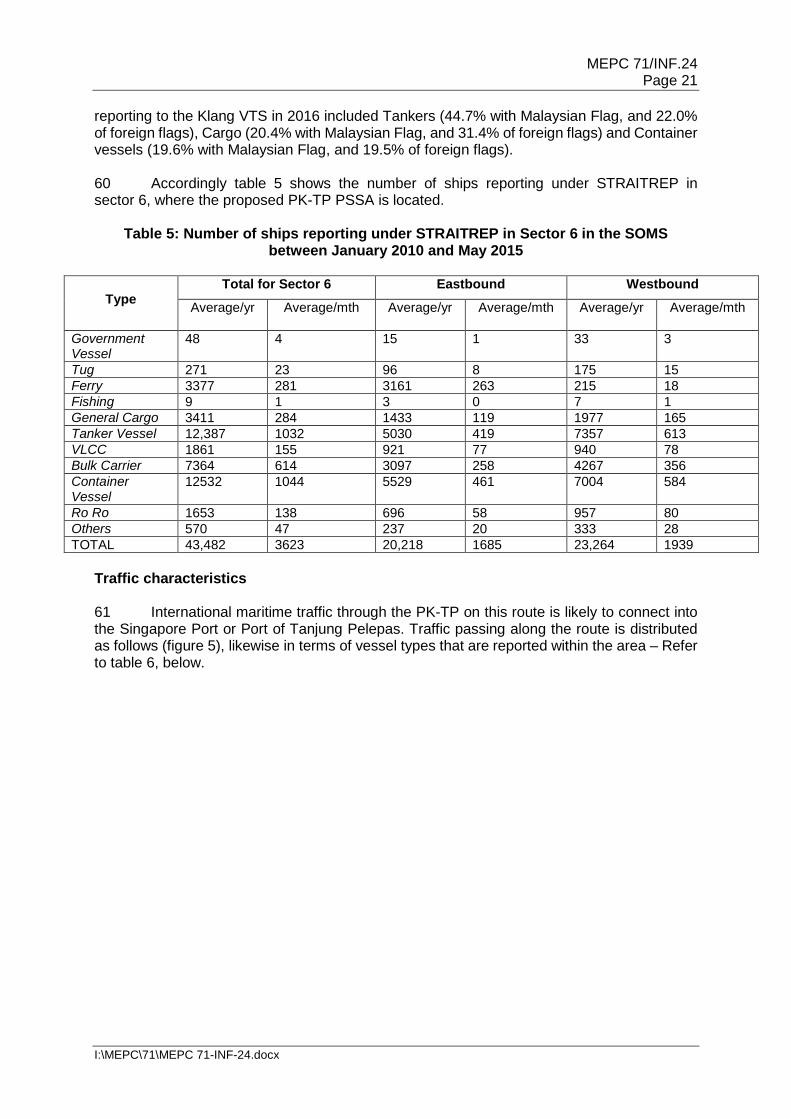
Oil pollution
24 September
Kukup Laut Oil pollution
1995 15 July Laut Serkat Tanjung Piai Kukup
Oil pollution
1996 7 August Laut Tanjung Piai Serkat Kukup
Oil pollution
1997 19 July Laut Serkat Tanjung Piai Kukup
Vessel collision (Oil from EVOIKOS)
19 October Laut Serkat Tanjung Piai Kukup
Oil pollution
1998 na Selat Kukup Pollution from river discharge
1999 10 August Laut Serkat Tanjung Piai Kukup
Oil pollution
2001 6 September Laut Serkat Tanjung Piai Kukup
Oil pollution
2002 20 May Laut Tanjung Piai Selat Kukup
Oil pollution
2003 na Selat Kukup Pollution from river discharge

MEPC 71/INF.24 Page 13
I:\MEPC\71\MEPC 71-INF-24.docx
Year Date Area affected Effect of the
pollution
Pollution source
2004 na Selat Kukup Pollution from river discharge
2005 20 May Laut Serkat Tanjung Piai Kukup
Oil pollution
2006 na Selat Kukup Pollution from river discharge
2007 na Selat Kukup Pollution from river discharge
2008 September Controlled by Sri Endon vessel
Oil pollution
2009 September Controlled by Sri Endon vessel
Oil pollution
2010 na Selat Kukup Pollution from river discharge
2011 29 October Laut Tanjung Piai Serkat Kukup
Oil pollution
2012 25 June Laut Tanjung Piai Serkat Kukup
Oil pollution
2013 na Selat Kukup Pollution from river discharge
2014 9 April Selat Kukup Pollution from river discharge
Note: na – complete information not available Source: Department of Fisheries Malaysia (Johore State, Pontian District) Legend
High financial losses incurred Destruction caused to fishery/ aquaculture equipment No loss to fishery/ aquaculture equipment Pollution controlled with no harm
Bio-geographic Importance 36 The PK-TP area is hugely valuable, both to the economy of Johore and internationally. This value is however often overlooked because the benefits are assumed to be 'free' and enduring, and as a result the value is being eroded – to the detriment of current and future generations in Johore. National efforts have been raised on building awareness of the value of the RAMSAR sites in Johore and taken into account in decisions making processes which affect the mangroves in the area. Pulau Kukup has been estimated at a total value of USD 190 million and Tanjung Piai at USD 130 million in terms of its direct and indirect contributions. The PK-TP area provides benefits to local communities, businesses and the wider economy of Johore, as well as to global society. The valuation was conducted by Khazanah Nasional and the Iskandar Regional Development Agency in 2015 under the 'RAMSAR Conservation Initiative' and is based on the framework of Total Economic Value (TEV) for both services currently traded in markets as well as services that benefit society but are not currently markets associated. Factors considered include support for offshore fisheries dependent on mangroves for ocean fisheries catch value in the area, the protection to the coastline from erosion, flooding

MEPC 71/INF.24 Page 14
I:\MEPC\71\MEPC 71-INF-24.docx
and salt water intrusion, filtration of impurities from water supporting aquaculture activities in the area, harbour of rare and endemic biodiversity, carbon storage in helping to mitigate climate change, tourists attraction through offer of unique experience, support to the freshwater fishing industries, as well as a source of sustainable timber and fuel. 37 More specifically, the market values include commercial fisheries, aquaculture, tourism, freshwater fisheries and commercial timber through sustainable practices. Estimates were derived based on the net revenue of the industry in the area and the degree to which the industry relies on the mangroves for maintaining its revenues. For example, 35% of the value of commercial fisheries in Johore is dependent on mangroves which provide nursery habitats, and this is attributed to the RAMSAR sites based on their area relative to the total mangrove area in Johore. The non-market values include coastal protection, biodiversity and carbon storage. Estimates were derived based on the social value of these services. For coastal protection and carbon storage, the potential replacement cost was used as a proxy based on the cost of sea walls and current carbon offset price, respectively. For biodiversity, the estimate was drawn from other studies in the area which use welfare economies to derive the amount people are willing to pay to protect similar sites. 38 A noticeable feature recorded for both Pulau Kukup and Tanjung Piai is their significantly high value for coastal protection, and distinctly for Pulau Kukup for its aquaculture importance in the area. Social, cultural and economic criteria Social or economic dependency 39 The PK-TP area directly contributes to the national and local economies through tourism revenues generated from ecotourism activities, as well as fishery and aquaculture sectors. Wetlands are globally classified as one of the valuable ecosystems that need to be preserved due to their multi-functions and vitality in providing for sustainable ecosystems to human welfare. The Millennium Ecosystem Assessment (MEA) for instance, estimated that wetlands provide services worth $15 trillion worldwide. The highest benefits are found in Asia with an economic value of $1.8 billion per year. The PK-TP area has been valued at USD 320 million, pointing to the need to sustain and conserve the natural resources found in PK-TP (Hamid et al. 2015). 40 Currently PK-TP is used mainly for tourism activities and fishing by local fishermen. Bird watching, boat rides to the creek of the mangroves and guided walks are allowed. The occurrence of fire flies in the Sonneratia mangrove species has attracted visitors to the site. Table 3 for instance shows the number of visitors to PK-TP from 2008-2011. The annual tourism income from Pulau Kukup is valued at about RM 50 million and RM 42 million for Tanjung Piai. A visitor centre with a 325 m boardwalk was built near the southern-most tip of Tanjung Piai. Small interpretative board walks about 300 m exist with small chalets to stay built on the mangroves. Pulau Kukup lays in the vicinity of a 150 year old fishing village of Kukup in Pontian district, in an area stepped in history. 41 Table 4 shows the fisheries and aquaculture activities in PK-TP monitored by the Department of Fisheries Malaysia. Exports of these products are mainly for the Singapore market carried through land and sea transport equalling to 2,600 to 3,000 metric tonnes annually.

MEPC 71/INF.24 Page 15
I:\MEPC\71\MEPC 71-INF-24.docx
Table 3: Number of visitors to PK-TP, 2008 - 2011
Year Pulau Kukup Tanjung Piai
2008 32,854 45,597 2009 26,883 51,807 2010 24,850 55,808 2011 36,221 62,181
Source: Johore National Parks Corporation, 2016
Table 4: Fisheries and aquaculture activities in the PK-TP area, 2016
Activity Places in the vicinity of
PK-TP
Number of fishermen/
aquaculturists
Number of sites within PK-
TP
Size (in meter square, m2 )
Fishermen Air Masin Village Kukup Laut Village Sg Durian Village Serkat Village
35 100 44 102
None na
Fisheries cages
Air Masin Village Kukup Laut Village
50 21
4636 2178
108,593 67,405
Fish and shrimp products
Air Masin Village Kukup Laut Village
30 1
None na
Note: na – not applicable Source: Department of Fisheries Malaysia (Johore State, Pontian District)
Human dependency 42 Mangroves are selective as they only occur in the intertidal zones along the tropics and the subtropical zone. Species diversity is higher closer to the equator especially in the South East Asia region due to the high temperatures which favours their establishment and growth. Mangroves colonise sheltered areas along the shorelines where wave and wind are mild compared to areas facing the open sea. Mangroves are found to be the centre for providing substantial services and a life support system to their surroundings. Their natural surroundings include the neighbouring ecosystems such as the coral reefs, seagrass beds, mudflats, riverine and delta swamps and forest, islands, as well as the inland hinterland. This mixed combination of ecosystems, referred to as the tropical coastal complex, consists of an enormous range of biological diversity and networks. A mangrove forest consists not only by plants that are uniquely adapted to their environment, but also are home for various benthic and faunal organisms, either permanently or temporarily. 43 Mangroves play as important roles producer, regulator and host to multiple natural processes and activities. Mangroves complement their surroundings by providing shelter and breeding grounds to coral fishes and act as a buffer to protect coral reefs and seagrasses from being silted. Sufficient water vaporised from these wetlands regulate a healthy water cycle and atmospheric activity. The unique root system and the hydrology of the mangrove soil help in flood control and land building to extend the forest area, while the tide scours the sediment to reshape the adjacent bays and lagoons, and form deltas and off-shore islands. The trophic level and the food and energy chains are naturally maintained in the complex. These are beneficial to humans. A significant link is found between human dependency on mangroves and the coastal complex.

MEPC 71/INF.24 Page 16
I:\MEPC\71\MEPC 71-INF-24.docx
Cultural heritage 44 Around six villages which are located at the fringe of Tanjung Piai i.e. Belukang Village, Perepat Punggor Village, Perpat Pasir Village, Serong Laut Village, Chokoh Kecil Village, and Chokoh Besar Village, which are assumed to have a high dependence on mangrove resources, namely fisheries. Tourism is the other income earning activity at these villages. However, people in these villages mainly engage in farming activity as the hinterlands of Tanjung Piai have extensive farmlands. The fish catch from the mangroves of Tanjung Piai is not so significant in terms of tonnage, however, it is an important resource for artisanal fisheries. Fishing jetties exist in River Belukang, River Perepat Pasir, River Perepat Punggor, and River Chokoh Besar. Tanjung Piai is also a national icon, being the southernmost tip of mainland Asia. It is hence a priority site for ecotourism, as well as a natural site declared under the Department of National Heritage Malaysia. Scientific and education criteria Research 45 The PK-TP area has been earmarked for research development by virtue of its RAMSAR site status. The area is currently being utilised as a scientific study area with researchers from the local universities and research institutions conducting studies on the various aspects of the ecosystems and marine life found in the area. Although not a proper field station, the visitor centre located at the site has facilities for researchers to stay overnight and conduct scientific studies. Bird watchers frequent the area. The site is frequented by local universities to conduct research on mangrove ecosystem and its dependent biodiversity. Local NGOs frequent the site to do annual migratory water bird counts. Mangroves in PK-TP are proudly a unique lab for ecology, environmental and sustainability studies. From taxonomy to ecosystem dynamics, and from habitats connectivity to ecosystems health, it stores a wide array of mangroves species in the area, showcasing an outstanding number of species and list in comparison with other mangroves sites within the region. Baseline for monitoring studies 46 A number of funding and in kind supports from major international conservation donors have also been secured over the years. For instance since 1991, the Global Environment Facility (GEF) approved 14 projects in Malaysia, with USD 46 million direct funding and USD 118 million in co-financing – with the more recent project on 'Enhancing Effectiveness and Financial Sustainability of Protected Areas in Malaysia', which is presently based in Johore, Malaysia. This showcase demonstrated exceptional conservation outcomes with community co-benefits on related aspects. Other sources include academia, as well as corporate and individual donations and revenues generated from tourism and recreational activities into research priorities. Education 47 PK-TP is more than just a nature reserve. The park offers nature education activities for individuals or groups wishing to make the most out of their visit to the parks. A wetlands Communication, Education, Participation and Awareness (CEPA) programme has been continuously organised in conjunction with World Wetlands Day. Interpretative exhibits exist in the centre which also has a small museum on mangroves and migratory birds. Dissemination materials have been prepared for the public. There are also facilities for school visits. Visitors centre with boardwalks in the parks provides for nature interpretative materials, guided walks,

MEPC 71/INF.24 Page 17
I:\MEPC\71\MEPC 71-INF-24.docx
VULNERABILITY TO IMPACTS FROM INTERNATIONAL SHIPPING ACTIVITIES General 48 The SOMS is about 500 nautical miles in length, making it the longest Straits used for international navigation. It encompasses major marine and coastal ecosystems and supports a major fisheries industry. It is widest at its northern limits at 220 nautical miles, and narrowest around the Riau Archipelago at about eight nautical miles. The SOMS is an important marine area for Malaysia and the Littoral States. The SOMS are seen as strategic sea lane of communication that facilitates global trade. The Straits form the shortest route connecting the oil suppliers from the Middle East with the East Asian economies of China, Japan and South Korea (Richardson, 2008). Besides the 15,000 fishing vessels in the Straits, there are presently more than 80,000 commercial vessels traversing the SOMS, as well as numerous other vessels. Navigation in the Straits is therefore an activity which requires caution and professionalism on the part of the commercial vessels, but also the provision of adequate safety of navigation as well as environmental protection measures on the part of the Littoral States. To aid this, a Traffic Separation Scheme (TSS) has been put in place covering a length of about 240 km. 49 Oil spills are typical with shipping activities, either through operational or accidental discharges, particularly in constricted and congested sipping routes like the SOMS (Basiron, 2010). Some of the highest risks have been seen from major oil and hazardous and noxious substance spills in the SOMS over time. An average of two maritime accidents per year is recorded in the Straits. More than 800 accidents have been recorded over the last decade or so. These incidents have resulted in environmental damages to the Straits, mostly from oil pollution (Basiron, 2010). Some of the major incidences that took place in the SOMS include the Showa Maru that spilled 54,000 barrels of crude oil from grounding on 6 January 1975, Nagasaki Spirit and Ocean Blessing spilled 1000,000 barrels of crude oil from collision on 20 September 1992, Sun Vista spilled 14,000 barrels of fuel oil when she sunk on 21 May 1999, Natuna Sea spilled 49,000 barrels of crude oil from grounding on 3 October 2000, Indah Lestari spilled 89 barrels of phenol from sinking in the Johor Strait on 13 June 2001. Besides the threats of oil pollution from spills, illegal operational discharges also contribute oil pollution to the Straits environment. The level of oil pollution from operational discharges however, could be higher as the figures above did not take into account the amount of oil discharged through deballasting and tanker cleaning. 50 The Malacca Straits Environmental Profile prepared under the GEF/UNDP/IMO Regional Programme for the Prevention and Management of Marine Pollution in the East Asian Sea (Chua et al. 1997) for instance estimated the extent of oil pollution from shipping operations in the Straits to be in the following categories i.e. deballasting (Significant), tank cleaning (Uncertain), bilge water and sludge (2 tonnes/day amounting to 730 metric tonnes/year), and discharges from small vessels (2 tonnes/day totalling to about 4,400 metric tonnes/year in the Straits). While the littoral States have the capacity to address oil spills, impact of oil spills can be long-lasting particularly on mangroves and inter-tidal zones habitats. Mangroves affected by the Showa Maru oil spill in 1975 for example showed little signs of recovery two years after the incident. Other impact of shipping has also been recorded in the Straits but they are not as well publicised as oil spill incidents. Heavy shipping for example, has caused coastal erosion in the southern part of the West Coast of the State of Johor in the Straits. In Tanjung Piai for example, coastal erosion and oil pollution caused by vessels threatens important mangrove ecosystems in the RAMSAR designated State Park. 51 The number of ships reporting to the STRAITREP (up to December 2016) shows an increasing trend overall from a total of 71,359 vessels in 2009 to 83,740 vessels reporting in 2016. The risk associated with shipping depends on the volume of shipping in a particular
MEPC 71/INF.24 Page 18
I:\MEPC\71\MEPC 71-INF-24.docx
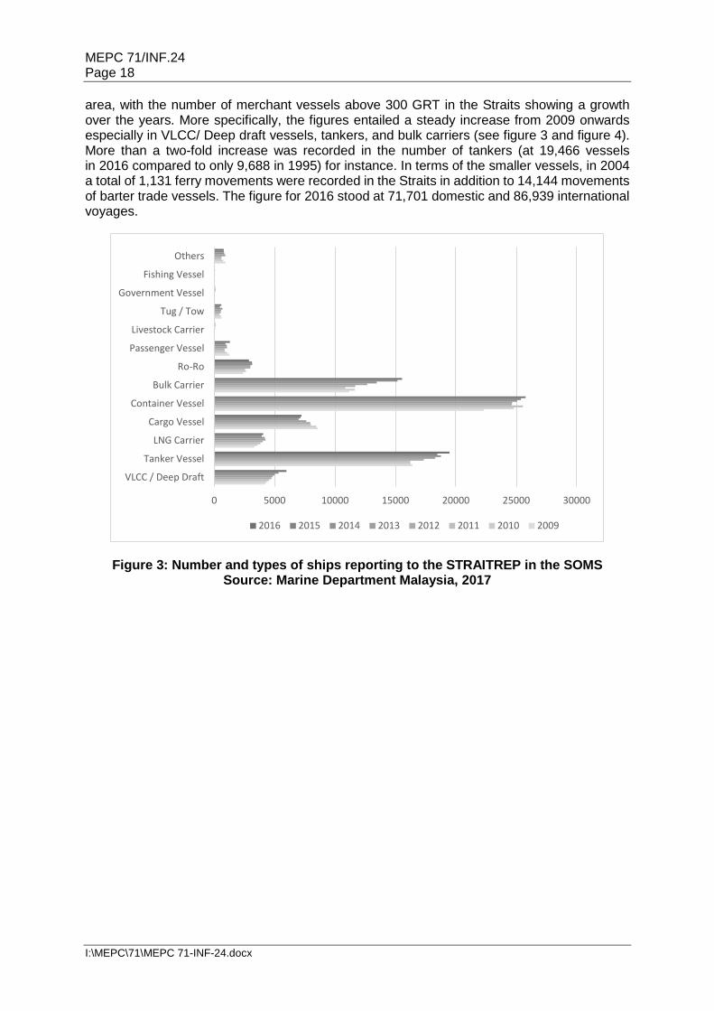
area, with the number of merchant vessels above 300 GRT in the Straits showing a growth over the years. More specifically, the figures entailed a steady increase from 2009 onwards especially in VLCC/ Deep draft vessels, tankers, and bulk carriers (see figure 3 and figure 4). More than a two-fold increase was recorded in the number of tankers (at 19,466 vessels in 2016 compared to only 9,688 in 1995) for instance. In terms of the smaller vessels, in 2004 a total of 1,131 ferry movements were recorded in the Straits in addition to 14,144 movements of barter trade vessels. The figure for 2016 stood at 71,701 domestic and 86,939 international voyages.
Figure 3: Number and types of ships reporting to the STRAITREP in the SOMS Source: Marine Department Malaysia, 2017
0 5000 10000 15000 20000 25000 30000
VLCC / Deep Draft
Tanker Vessel
LNG Carrier
Cargo Vessel
Container Vessel
Bulk Carrier
Ro‐Ro
Passenger Vessel
Livestock Carrier
Tug / Tow
Government Vessel
Fishing Vessel
Others
2016 2015 2014 2013 2012 2011 2010 2009

MEPC 71/INF.24 Page 19
I:\MEPC\71\MEPC 71-INF-24.docx
Figure 4: Number and types of ships reporting to the STRAITREP in the SOMS Source: Marine Department Malaysia, 2017
52 In 2000, an average of 399 vessels passed through the SOMS every day which translates to one vessel every 3.6 minutes (Sakamoto, 2008). It 2004, it was reported that more than 900 ships sailed the Straits of Singapore every day, which means that one ship passes the Straits of Singapore every 1.6 minutes (ICJ, 2004). In 2010, the British Broadcasting Corporation (BBC) News reported that the SOMS accommodates almost six times the volume of navigational traffic that goes through the Suez Canal every year (BBC News, 2010). 53 From 1970 until 1986, an average number of shipping transits did not exceed 50,000 per year. There are approximately more than 80,000 transits per year presently, showing an increase of about 40 percent (Razif, 1997). The shipping carrying capacity study for the Straits conducted by the Maritime Institute of Malaysia (MIMA) estimated 122,640 vessels in 2024 (Ibrahim and Shahryari, 2008; Ibrahim and Shahryari, 2009; Ibrahim et al. 2008). Other studies including the World Bank's prediction was recorded at 122,500 vessels in 2025, and the Japan International Transport Institute (JITI)'s projection at 140,000 vessels in 2020 (Ho, 2009). Another source quoted predicted that the Straits will be navigated by approximately 150,000 vessels annually by 2020 (Beckman, 2009). Although these separate studies on the carrying capacity of the SOMS differ in their methodologies and with slightly different conclusions on the exact amount of shipping the Straits can carry and when that might occur, there is general consensus that shipping density will increase and that congestion will occur, with direct risks on the environment and resources in the Straits. 54 In terms of navigational traffic, the SOMS come second only to the Dover Strait (Graham, 2006). It is estimated that more than 10 million barrels of oil pass through the SOMS daily (IISS, 2006). Tankers and bulk carriers transport vast quantities of oil, coal, iron ore and minerals to the Southeast and Northeast Asia; while on the other direction, millions of containers are carried to consumer markets from all over the globe (Ho, 2009). Oil tankers constitute the second biggest type of vessel plying the SOMS, after container vessels.
64000
66000
68000
70000
72000
74000
76000
78000
80000
82000
84000
86000
0
5000
10000
15000
20000
25000
30000
2009 2010 2011 2012 2013 2014 2015 2016VLCC / Deep Draft Tanker Vessel LNG Carrier Cargo VesselContainer Vessel Bulk Carrier Ro‐Ro Passenger VesselLivestock Carrier Tug / Tow Government Vessel Fishing VesselOthers Total

MEPC 71/INF.24 Page 20
I:\MEPC\71\MEPC 71-INF-24.docx
55 The PK-TP would be an area of particular significance as PSSA in the Straits of Malacca. Dyke et al. (2009) for instance stated that the Straits of Malacca is a logical candidate to be designated by IMO as a PSSA because of the human and economic dependency. In terms of Straits used for international navigation, to date, the Torres Strait is the only strait that has been designated as a PSSA. Located at the northern end of the Great Barrier Reef, the Torres Strait is a waterway that is difficult to navigate due to the small islands and islets, fringing reefs, having shallow waters and strong tidal flows found along its length. There are parallels between the Torres Strait and SOMS, as both are waterways a number of navigational hazards, both are rich in the concentration of marine biodiversity and are important fishing grounds, both possess historical and cultural significance and most importantly, both are straits used for international navigation. In terms of traffic characteristics however, the navigational traffic in the SOMS is approximately 25 times higher than the Torres Strait (Rusli, 2011).
56 As one of the most important maritime arteries in the world, there is a clear need for a comprehensive review of all the measures that would be required to optimise the sea lane conditions to provide users with a secure transit, whilst safeguarding the coastal and marine environment in the SOMS. Members of the shipping industry and user states should continue to work closely together with the littoral states to improve the safety of navigation in the SOMS. The proposed PSSA area by Malaysia is hence one such effort underway to address issues with the participation of all relevant stakeholders. With direct assistance from IMO and Norad, Malaysia's proposed PSSA in the Straits has therefore been highlighted also under the ambit of the Cooperative Mechanism on Safety of Navigation and Environmental Protection in the SOMS; which is a landmark voluntary arrangement between the Littoral States, User States and other stakeholders, in spirit of the United Nations Convention on the Law of the Sea (UNCLOS) Article 43.
Vessel traffic characteristics
Operational factors 57 Despite the collation of data and the studies conducted, obtaining accurate shipping statistics in the Strait presents a challenging task due to the fact that through traffic in the waterway need not report at any calling stations along it. Although there are reporting systems such as the Vessel Traffic Information System (VTIS) in used in the Strait, reporting is done on a voluntary basis and limited to certain calling points. The task of quantifying traffic density is made harder as ships do not follow specific routes except at portions of the Strait under the coverage of the various navigation systems in the sea lane such as the Automatic Identification System (AIS) and the Traffic Separation Scheme (TSS). This is compounded by the unrecorded cross-traffic of barter ships between Peninsular Malaysia and Sumatra, and the presence of unknown numbers of small fishing vessels and traditional small crafts. Adding to the statistical discrepancy is the fact that not all ships using the Straits call at the ports of the littoral states, which may hence go unrecorded (Ibrahim and Khalid, 2007). Vessel types 58 The numbers of transiting tankers remained steady over the years, indicating the importance of the Straits for oil transportation. Overall type and total number of vessel reporting to Klang VTS included major categories in Tanker (23.3%), Container (30.8%) and Bulk Carrier vessels (18.6%). VLCCs and deep draft carriers made up about 7.1% in the total number recorded in 2016. 59 The vessels that ply the SOMS fly various flags from numerous countries. The Malaysian flag vessels reporting to the Klang VTS in 2016 were about 4,506 vessels only compared to 79,132 vessels in total of foreign flags. The top three categories of vessels
MEPC 71/INF.24 Page 21
I:\MEPC\71\MEPC 71-INF-24.docx
reporting to the Klang VTS in 2016 included Tankers (44.7% with Malaysian Flag, and 22.0% of foreign flags), Cargo (20.4% with Malaysian Flag, and 31.4% of foreign flags) and Container vessels (19.6% with Malaysian Flag, and 19.5% of foreign flags). 60 Accordingly table 5 shows the number of ships reporting under STRAITREP in sector 6, where the proposed PK-TP PSSA is located.
Table 5: Number of ships reporting under STRAITREP in Sector 6 in the SOMS between January 2010 and May 2015
Type
Total for Sector 6 Eastbound Westbound
Average/yr Average/mth
Average/yr Average/mth Average/yr Average/mth
Government Vessel
48 4 15 1 33 3
Tug 271 23 96 8 175 15 Ferry 3377 281 3161 263 215 18 Fishing 9 1 3 0 7 1 General Cargo 3411 284 1433 119 1977 165 Tanker Vessel 12,387 1032 5030 419 7357 613 VLCC 1861 155 921 77 940 78 Bulk Carrier 7364 614 3097 258 4267 356 Container Vessel
12532 1044 5529 461 7004 584
Ro Ro 1653 138 696 58 957 80 Others 570 47 237 20 333 28 TOTAL 43,482 3623 20,218 1685 23,264 1939
Traffic characteristics 61 International maritime traffic through the PK-TP on this route is likely to connect into the Singapore Port or Port of Tanjung Pelepas. Traffic passing along the route is distributed as follows (figure 5), likewise in terms of vessel types that are reported within the area – Refer to table 6, below.

MEPC 71/INF.24 Page 22
I:\MEPC\71\MEPC 71-INF-24.docx
Figure 5: Ships density plot for PK-TP area between January 2013 and March 2016
Table 6: Number of ship arrivals reported inside the PK-TP area between January – December 2016
Type International Domestic
Barge 0 19 Fishing Vessel 15 145 Full Container 693 0 General Cargo 0 217 Passenger Ship 752 1293 Tug Boat 16 21 Others 44 0 TOTAL 1520 1695
Harmful substances carried 62 The significant proportion of tankers passing through the area is a cause for concern. The threat of oil pollution and potential catastrophic impact on the sensitive area is well known. Natural factors Hydrographical 63 Hydrodynamic modelling using 2008 field data was carried out for the area. The modelling results (Aslinda et al. 2014) showed that during the flood tide, Tanjung Piai is subjected to current speeds of 0.1 to 0.3 m/s compared to current speeds of 0.3 to 0.6 m/s
Ship Type: Passenger Vessel Cargo Vessel Tanker Vessel Others

MEPC 71/INF.24 Page 23
I:\MEPC\71\MEPC 71-INF-24.docx
during ebb tide. Results also show that there are some local current patterns formed within the Tanjung Piai area due to the presence of the Kukup Island. Model simulations incorporating the proposed coastal protection measures indicated positive and negative impacts of the hydrodynamic changes around the study area. The results showed that the magnitude of the current speed and wave height would be reduced in the area behind the structures, but slightly increased on the other parts of the coast. These changes determined the sediment transport movement in the area. 64 Wave simulations show that most of the waves come from Singapore and the Straits of Malacca, with amplitudes of over 1.5 m, are reduced to less than 0.8 m as they travel towards the Tanjong Piai coast. These local hydrodynamic conditions, combined with the existence of regular ship wakes, are believed to be the reason for the intensive erosion at Tanjung Piai.
Meteorological 65 The PK-TP area is located in an equatorial climate location, with rain from both northeast monsoon, November to March and the southwest monsoon from around March to August. Tanjung Piai encounters rainfall throughout the year and averages about 2,400mm for the site. Pulau Kukup is a natural mangrove island with six small creeks dissecting the islands in various places. It experiences a humid tropical climate with rain from both the north-east and Southwest monsoons. Average rainfall ranges from 2,000 – 2,500 mm with an even distribution throughout the year. Oceanographic 66 Along the shores of Tanjung Piai, tides are mixed semi-diurnal meaning they have two highs and two lows each day but of unequal elevation and time of high water. The tide fluctuates from 3.4 to 1.8 m and maximums during spring tide. Natural type of wetland with mangrove forests and associated mudflats, the geology includes marine clay and silt found throughout the coastline and along the rivers, with alluvial type soils. The water quality is generally fair and along the manmade canals that store surface water and storm water which was created to prevent flooding and tidal gates control the release of water to the sea. The mangroves along Tanjung Piai prevent excessive sediments from entering the water ways so sediment trapping is one of the most significant roles of the mangroves. The presence of manmade canals and tidal gates help to regulate flow in to the wetland which assists in flood control. The 50-100 m strip of mangroves surrounding Tanjung Piai is a buffer which helps to stabilise the shoreline against huge tidal waves. 67 Pulau Kukup experiences semi-diurnal tidal exposure with two high tides and low tides in a day. Tidal range in Pulau Kukup can rise as high as 3.7 m. The interior of the island is largely dry during normal tides. However, the island is completely flooded during spring tides. The mudflats are rapidly accreting on the west coast while eroding along the south-east coast. Other Information 68 According to GESAMP (1990), sea-based pollution arises from two main sources namely accidental and operational sources, and the risks of pollution arising from both sources can be found in the Strait which hosts huge volume of traffic and a host of economic activities in its waters and along its coast. Compared to the other seas littoral to Malaysia, the Straits of Malacca accounts for 47% of 165 cases reported in Strait of Malacca, South China Sea, Sulu and Sulawesi Sea and Straits of Johore (table 7). The potential magnitude of oil pollution in the Straits looms large due to the high number of vessels operating through the Straits.

MEPC 71/INF.24 Page 24
I:\MEPC\71\MEPC 71-INF-24.docx
69 Although many new technologies and regulations are in place to overcome the problem of operational discharge, some ships still discharge their tanks; offload their toxic sludge and even solid waste in the relative calm waters of the Strait or its approaches to save costs of discharging them at the next port. The effects of operational discharge on a busy and narrow sea lane like the Strait can be considerable depending on the size of vessel. Besides oil pollution from ship accidents, operational discharge also contributes to pollution from oil-based sources in the Straits (Jaswar and Maimun, 2013; Lewey and Wybrow, 2004). 70 The Strait's environment faces threats arising from increasing number of vessel traffic include degradation to the coastal mangroves along and in the sea lane. Mangrove swamps, which are low energy level areas which are likely to trap oil, along the Strait are especially vulnerable. When the air roots of these mangrove trees are clogged with oil, the oxygen level will fall, causing mortality to the plants.
Table 7: Oil pollution incidents in Malaysian waters
Location Year Total 1999 2000 2001 2002 2003 2004 2005
Straits of Malacca
22 22 13 8 2 5 6 78
South China Sea
22 8 5 8 5 8 7 63
Straits of Johore
4 1 0 7 3 2 2 19
Sulu & Sulawesi
Seas
0 2 1 0 0 0 2 5
Total 48 33 19 23 10 15 17 165 Source: Ibrahim and Khalid, 2007
71 Oil spills and oil discharges from vessels in the vicinity of the area have been brought to the shore by the incoming tide in the PK-TP area on numerous occasions. More serious incidences recorded include in October 1997 (involved vessels collision i.e. Evoikos and Oraphin), September 2003 (vessel discharges), September 2011 (vessel discharges), and June 2012 (vessel discharges). As case examples, records from the Johore National Parks Corporation (JNPC) for the incident that happened on 13 September 2011 occurred along a 300 m stretch of the coastal area along the west coast of Tanjung Piai. About three to six inches of oil was found in the muddy substrate in the area. The devastating incident called for a National Coastal Cleanup mobilisation with financial support from the state government. The incident that took place on 26 June 2012 occurred along a 1.2 km stretch of coastal area along Tanjung Piai. An estimated 5 ha of mangroves area was badly degraded due to the incident. About 1.8 tonnes of oil was collected with assistance from some 300 volunteers. 72 Tar balls can also be seen along the beaches lining both sides of the SOM. There are quite a few tar balls along the shoreline near the mangrove area. Most of the fish landings on the west coast Peninsular Malaysia are associated with mangrove. It provides an important breeding ground for many fish, crab, prawns, and other marine animals. This uncontrollable marine pollution will damage the ecosystem in Tanjung Piai and Kukup Island. This includes loss of revenues for fishermen because of fouled nets or closure of fishing areas, reduction in fish stocks, tainting of fish tissue and consumers refusing to purchase fish products from affected areas. The upward trend in ship transits PK-TP translates into an expected increasing risk in shipping-related impacts, both operational and accidental. Increasing trend of shipping traffic has been projected in the SOMS, and as a consequence increases the vulnerability of the PK-TP area.

MEPC 71/INF.24 Page 25
I:\MEPC\71\MEPC 71-INF-24.docx
ASSOCIATED PROTECTIVE MEASURES PROPOSED TO PROTECT THE AREA FROM IDENTIFIED VULNERABILITY 73 Almost all projects under the Cooperative Mechanism are aimed at providing safe navigation rather than focusing on the protection and preservation of the marine environment of the Straits. The general perception is that accidents can be avoided is there is regime to promote safer shipping in the Straits. If accidents can be avoided, the marine environment of the Straits can be spared from unwarranted oil and other noxious substances spills (Rusli, 2012). The perception may have been accurate one or two decades ago when the volume of shipping traffic was not high. With the projected steady increase in maritime traffic in the Straits over the next decade, the importance of environmental protection and preservation schemes, beyond the perspective of the enhancement of safety of navigation in the Straits, are apparent. 74 The Convention on Wetlands of International Importance or also known as RAMSAR Convention (2003) have classified Pulau Kukup State Park, Sungai Pulai Forest Reserve, and Tanjung Piai State Park as RAMSAR site. The area that have been identified are important for flood control, physical protection, and shoreline stabilisation. These specific places also become habitats for many threatened and vulnerable wetland-dependent species as they teem with commercially valuable species (IUCN Red Book, 2000) (Marican et al., 2015). Existing protective measures 75 Iskandar Malaysia is a National Project to develop a vibrant new region at the southern gateway of Peninsular Malaysia. A regional authority body Iskandar Regional Development Authority (IRDA) was formed in 2007 with specific roles to plan, promote and facilitate in which to coordinate the economic, environmental and social planning, infrastructure development and management of Iskandar Malaysia in southern Johore. Blueprints have been developed as subsets or supplementary of Comprehensive Development Plan (CDP) to address aspects mentioned above. IRDA refers to the CDP as the guiding document in developing the area through planned strategies, structured implementation and action plans. 76 The Shoreline Management Plan (SMP) for Iskandar Malaysia has been prepared to assist the public and private sectors and community to work together in developing and managing the coastline within the Iskandar Malaysia region so that all benefits in making the region through active involvement and cooperation from relevant Government agencies, the private sector, NGOs and the communities. The shoreline of Iskandar Malaysia stretches from Pulau Kukup on the west to the eastern side of Johore. The management area covers 1 km inland and I km offshore from the mean sea level. The SMP sets a clear framework of sustainable planning and development policies and programmes for the effective management of Iskandar Malaysia's shoreline to benefit the community in the area and the nation as a whole. Objectives within the SMP include to conserve, protect and enhance the natural beauty of the shoreline; understanding and appreciation by the public through improving and extending opportunities for recreational, educational and tourism activities; maintain and improve the environmental health of inshore waters affecting the coasts and beaches; protect areas at risk of coastal erosion, marine pollution and other negative environmental impacts; and protect the livelihood and well-being of communities in the area. 77 The PK-TP area is already subjected to national protective measures through its establishment as State Parks and a RAMSAR sites in Malaysia. The JNPC is the lead authority to manage the area. Key documents that guide the strategies and policies for management of the area include the National Policy on Environment, National Physical Plan, Johore State Structure Plan, CDP 2025 for Iskandar Malaysia, as well as district local plans for Pontian and Johore Bahru. The policies and strategies can be summarised into three strategic directions

MEPC 71/INF.24 Page 26
I:\MEPC\71\MEPC 71-INF-24.docx
for the SMP i.e. to 'protect, conserve and improve' the environment of the shoreline in the area. Included in the strategies in place are the threats from increasing shipping activities in PK-TP in order to address specifically risks from coastal erosion and oil pollution. A set of objectives have been created in the area covering the physical (including morphology, coastal processes, development control, land use and water quality), ecological (including marine, inter-tidal and terrestrial habitats and biological resources), socio-cultural (including welfare of the coastal population) and for economic management (including commercial activities) in the area. 78 The Ministry of Transport Malaysia and Marine Department Malaysia focuses on maritime safety aspects focusing on safety of navigation, oil spill response and vessel traffic system in the SOMS to ensure Malaysian waters are safe, secure and to preserve the marine environment. With the increasing number of ships plying Malaysian waters, aids to navigation is vital not only for the smooth sailing of ships to their destinations but also to ensure safe passage. In this regards, Malaysia has put in place aids to navigation along the coastline which include lighthouses, beacons and also buoys. These navigational aids are maintained and managed by the Light Dues Board which is under the administration of the Marine Department Malaysia.
79 The Traffic Separation Scheme (TSS) is an initiative to facilitate marine traffic in the Straits and to reduce the risk of close quarter situation between ships plying the area. Through this system, ships are separated by the navigation routes determined by the Marine Department of Malaysia. In view that the Straits of Malacca recorded an excess of 80,000 ships passing through the Straits every year, a Vessel Traffic System (VTS) have been installed along the Straits of Malacca to monitor ship movement. Ships passing through the area of VTS operation will be monitored using a tracking system and are identified by their 'call sign'. In any situation that may lead to the possibility of collision, the VTS duty officer will give an early warning of the situation so that ships can take appropriate action to avoid any collision or accident from occurring.
80 The Maritime Safety Committee (MSC), at its sixty-ninth session (11 to 20 May 1998), adopted in accordance with the provisions of Assembly resolution A.858(20), and by the annexed resolution MSC.73(69), mandatory ship reporting systems in the SOMS.
81 The Marine Electronic Highway Demonstration Project (MEH Project) was funded by the Global Environment Facility (GEF) and the International Bank for Reconstruction and Development (IBRD) (Sekimizu et al. 2001). This project involves three countries namely Indonesia, Malaysia and Singapore, in collaboration with the IMO, International Hydrographic Organisation (IHO), International Chamber of Shipping (ICS) and the International Association of Tanker Owners (INTERTANKO). The MEH project focused, amongst others, on the protection of the marine environment, and safety and security of marine traffic in the Straits.
82 Ships operation carry with it risk of ships incidents and collisions which may lead to oil spills, with potential negative impacts on the marine environment and maritime communities at large. Malaysia has taken numerous efforts in terms of capabilities on oil spill response. This is taken significantly by Malaysia to the extent of ASEAN level cooperation involvement through involvement in the Joint Oil Spill Preparedness and Response (Memorandum of Understanding, MoU – ASEAN OSPAR). The MoU emphasises on the enhancement of capacity and capability in managing large scale oil spill incidents through personnel and assets mobilisation. Member States, including Malaysia, looks into the exchange of knowledge and information on methods, technologies and equipments use for oil spill response in accordance with international practices. Malaysia works closely with the SOMS Littoral States through the Revolving Fund in combating oil pollution caused by ships.

MEPC 71/INF.24 Page 27
I:\MEPC\71\MEPC 71-INF-24.docx
83 The Ministry of Transport Malaysia has enacted related acts/ordinances/gazette to regulate activities related to port operations and shipping. Among the most important include the Merchant Shipping Ordinance 1952 [Ord. 70/1952]. The Environmental Quality Act 1974 governs pollution control in the Malaysian waters, and is under the purview of the Department of Environment Malaysia. In related aspects, the National Parks Act 1980 addresses also the protection, preservation and care of a National Park and of permanent works and works of maintenance and of facilities and amenities and of wild life and vegetation and features of scenic, scientific or historical interest therein; the regulation of traffic and carriage of passengers within the National Park; as well as the seizure and disposal of any vehicle and vessel in respect of which there is a contravention of regulation made under this regulation, amongst others.
84 International affairs clarify the objectives and list of ratified international conventions; objectives and list of Maritime Transport Agreement and also Malaysia as a Council Member of IMO. Malaysia is an active IMO Member State in the ratification of international conventions and subsequent actions in the harmonization of domestic laws to international standards, and the prevention of sub-standard ships entering into Malaysian waters. Discussions and deliberations are made with various stakeholders before Malaysia ratifies a given convention; similar efforts were taken in the identification and proposal for PK-TP PSSA. Related conventions include the Protocol on Preparedness, Response and Co-Operation To Pollution Incidents by Hazardous and Noxious Substances 2000; International Convention for the Prevention of Pollution from Ships 1973, as modified by the Protocol of 1978 relating thereto (MARPOL) for all Annexes; International Convention on Oil Pollution Preparedness, Response and Co-operation (OPRC) 1990; and Convention on the International Regulations for Preventing Collisions at Sea (COLREG) 1972, as amended; to provide some examples.
85 Malaysia is also an active Member State in the Cooperative Mechanism as a form of cooperation between the littoral States and user States of the SOMS namely Malaysia, Singapore and Indonesia in the field of navigational safety and pollution in accordance with Article 43 of the UNCLOS 1982 (Djalal, 1999; Djalal, 2008). The Cooperative Mechanism is composed of main components which include for instance the Cooperative Forum and the Tripartite Technical Experts Group (TTEG). The Cooperative Forum is a platform for discussion and sharing of opinions regarding safety of navigation and environmental protection among the littoral States and user States of the Straits, with an opportunity for the littoral States to obtain feedback from user States on safety of navigation as well as measures to enhance it through cooperation. The TTEG was established by the Littoral States in the SOMS in 1975 due to the importance of the Straits of Malacca and Singapore to international shipping. The establishment of TTEG also shows the commitment of the littoral States to the safety of navigation in the Straits of Malacca including marine conservation at all times. The TTEG meeting is held every year involving representatives of the three littoral States to discuss on issues of navigation of safety, mechanism and methods to improve the level of safety of navigation, marine environmental protection and management of shipping traffic throughout the Straits. The hosting of the meeting is rotated among the three littoral States. Malaysia has highlighted the PK-TP PSSA at these meetings from 2014-2016 to gain support on the initiative.
86 The Department of Drainage and Irrigation (DID) Malaysia under the Ministry of Environment and Natural Resources Malaysia monitors coastal erosion in Malaysia. Since 2003, DID in cooperation with other relevant agencies have constructed various types of structures to protect Tanjung Piai, however, to limited success rate. The Malaysian Government has invested more than RM 5 million (USD 1.5 million) for infrastructure development in the area (DID, 2013; Aslinda et al. 2014). A breakwater system is also presently in place to address the critical coastal erosion from continuing and to stabilise the coastline at Tanjung Piai. About RM 48 million have been invested into the construction plan, which begun in 2014.

MEPC 71/INF.24 Page 28
I:\MEPC\71\MEPC 71-INF-24.docx
87 Despite the extensive protective measures already being undertaken, it is recognized that these measure need to be complemented by measures designed specifically for the international shipping industry and in accordance with the standards and procedures set by IMO as the primary institution for the management of international shipping. Issues relating to vessel source pollution are endemic in the SOMS and with the projected increase of shipping traffic in future years, current protective measures may not be entirely sufficient to safeguard the marine environment of this waterway (Rusli, 2012). As more vessels ply the Straits, safety and environmental concerns will become more acute for the Littoral States bordering the SOMS (Hamzah, 2008). New protective measures 88 Malaysia seeks the implementation of an Area To Be Avoided (ABTA) and Mandatory No Anchoring Area (MNAA) for all ships of 300 GRT and above in the proposed PSSA for the PK-TP area as the most urgent and practical associated protective measure to reduce the risks associated with international shipping activities. The proposed measures will be detailed for submission to the IMO technical sub-committee as required. 89 High risks of pollution and adverse effects on the PK-TP area are directly associated with the proximity of shipping around and along the PK-TP boundary. Keeping large vessels shipping away from the area is the best and most obvious means of substantially reducing the risks from the threats identified. Implementation of the proposed APMs will thus reduce the existing risks from these dangers. 90 Other associated protective measures may be proposed by Malaysia before the appropriate IMO Committee at a later time. Possible impacts of proposed measures 91 The establishment of the ABTA and MNAA will cause minimal to no disruption of current and future international maritime traffic around the PK-TP, as the available data shows that only a portion, not the whole, of shipping traffic around the area actually enter its boundaries. MISCELLANEOUS ISSUES Area 92 A description of the proposed PSSA and a chartlet is provided in annex 1. Enforcement 93 Failure to comply with the proposed measures will be met with law enforcement measures consistent with the MSO 1952. 94 A ship that is monitored to be on a course that will take the ship into the PK-TP area shall be hailed on radio, identified, and issued a warning by the Marine Department Malaysia. Non-compliance shall be meted with the corresponding administrative fine by the Marine Department Malaysia, as well as corresponding action to report the incident to the offending vessel's flag State for investigation and imposition of sanctions. Implementation after designation 95 Designation of the ABTA and MNAA as APMs will complement existing legislation and administration regulations on the PK-TP. Further administrative regulation to publicise the proposed PK-TP PSSA in official nautical charts will be undertaken once the PSSA has been designated.

MEPC 71/INF.24 Page 29
I:\MEPC\71\MEPC 71-INF-24.docx
Summary of existing measures to protect the TRNP 96 The management and protection of the PK-TP as State Parks is in line with the Malaysian commitments under multi-lateral environmental agreements, among the most important of which are summarised below. 97 The 1992 UN Conference on Environment and Development (UNCED) Agenda 21, Chapter 17 (Protection of the Oceans) of which encourages signatory States to undertake various measures to maintain the biological diversity and productivity of marine species under national jurisdiction, including the establishment and management of protected areas. The establishment and protection of the PK-TP is among the Malaysian undertakings in pursuit of Agenda 21. 98 The CBD which seeks the conservation of biological diversity and the sustainable use of its components. The CBD provides for the establishment of protected areas in which special measures are taken to conserve biological diversity and the protection of ecosystems, natural habitats and the maintenance of viable populations of species in natural surroundings. The PK-TP carries out the Malaysian obligations under the CBD. 99 The 1982 UN Convention on the Law of the Sea (UNCLOS) which provides the legal framework for the management of the oceans and the basis upon which to pursue the conservation and protection of the marine environment. Signatories to UNCLOS are obligated to conserve, manage, and protect the marine environment, which includes the conservation and management of the living marine resources under national jurisdiction. The establishment and protection of the PK-TP is consistent with UNCLOS. 100 The 1972 Convention on Wetlands of International Importance, especially as Waterfowl Habitat (RAMSAR Convention) which aims to stem the loss of wetlands worldwide, especially those are important for migratory waterfowl. It defines wetlands as fresh, brackish and saltwater marshes, including marine waters up to six metres in depth at low tide and any deeper marine waters contained within the wetland area. The PK-TP was included in the RAMSAR List of Wetlands of International Importance on 31 January 2003. Action requested of the Committee 101 The Committee is invited to consider the information contained in this document for the submitted proposal from Malaysia to designate the PK-TP marine area as a PSSA to strengthen environmental protection in the area.
***


MEPC 71/INF.24 Annex 1, page 1
I:\MEPC\71\MEPC 71-INF-24.docx
ANNEX 1
DESCRIPTION OF THE PROPOSED AREA TO BE AVOIDED (ATBA) AND
MANDATORY NO ANCHORING AREA (MNAA)
CHARTLET OF THE PROPOSED PK-TP PSSA In accordance with paragraph 7.5.2.2 of the Revised PSSA Guidelines, an area to be avoided (ATBA) and mandatory no anchoring area (MNAA) by ships of 300 GT and over is to be established as Associated Protective Measures (APMs) in the PK-TP area proposed as a Particular Sensitive Sea Area (PSSA) for reasons of environmental, ecological, economic and cultural attributes, and bounded by a dotted line connecting the following geographical coordinates (based on the World Geodetic System (WGS) 1984 datum):
Latitude Longitude
From Pt. 1 1º 20' 29.85" N 103º 26' 16.11" E to Pt. 2 1º 20' 29.85" N 103º 24' 23.99" E to Pt. 3 1º 17' 23.86" N 103º 24' 23.99" E to Pt. 4 1º 14' 57.58" N 103º 28' 52.58" E to Pt. 5 1º 14' 41.11" N 103º 29' 52.41" E to Pt. 6 1º 15' 48.51" N 103º 30' 50.65" E to Pt. 7 1º 15' 54.67" N 103º 30' 46.44" E
CHARTLET OF THE PROPOSED PK-TP PSSA
***


MEPC 71/INF.24 Annex 2, page 1
I:\MEPC\71\MEPC 71-INF-24.docx
ANNEX 2
REFERENCES
A. Amir. 2014. MyMangrove (The Malaysian Mangrove Research and Network), Institute for Environment and Development (LESTARI), University Kebangsaan Malaysia. Ref. GUP-2014-032/ERGS/1/2012/STWNO1/UKM/03/2 (GGPM-PLW-033-2010/APNNGR/LESTARI/UKM). 4 pp. A. Hamid, M.A. Syamsul Herman, M.A. Ahmad, S. Ramachandran, S., and Husin, T. In Mahdzar, M., S.M. Ling, M.B. Nair and A. Shuib (eds). 2015. The importance of economic valuation for conservation in Lower Kinabatangan Segama Wetland, Sabah. Proceedings of the International Conference on Natural Resources, Tourism and Services Management. University Putra Malaysia. pp. 396-397. Aslinda, N.A., Wan Hasliza, W.J., Mohd Razi, A.H. 2014. Coastal Erosion at Tanjung Piai, Johor, Malaysia. Journal of Coastal Research, 71(1):122-130. Basiron, M.N. 2010. Anatomy of an oil spill, 2010 17(3) MIMA Bulletin, pp. 39. Basiron, M.N. and Tan, K.H. 2007. The environment impact of increased vessels traffic in the Straits of Malacca and Singapore. MIMA Bulletin, 14(1) 2007. Pp. 15-22. B.A. Hamzah. 2008. Straits of Malacca: Burden sharing, transit passage and sovereignty of coastal state. Document presented at the International Symposium on Safety and Protection of the Marine Environment in the Straits of Malacca and Singapore, Kuala Lumpur, Malaysia. pp. 77-83. BBC News. [Electronic Version]. Singapore Warns of threat to Tankers in Malacca Strait (2010), BBC News http://news.bbc.co.uk/2/hi/asia-pacific/8549053.stm Chua, T.E., S.A. Ross, and H. Yu. Malacca Straits Environmental Profile (GEF/UNDP/IMO Regional Programme for the Prevention and Management of Marine Pollution in East Asian Seas, 1997). pp. 85-92. Beckman, R. 2009. The establishment of cooperative mechanism for the Straits of Malacca and Singapore under Article 43 of the United Nations Convention on Law of the Sea (UNCLOS). In A. Chircop, Ted. L. McDorman and Susan J. Rolston (eds). The Future of Ocean Regime-Building-Essays in Tribute to Douglas M. Johnston (Martinus Nijhoff, 2009), 234-235. Chua, T., Ingrid R.L, G., S Adrian, R., Stella Regina, B., Bresilda, G., and M Corazon, E. (eds). 2000. The Malacca Straits. Marine Pollution Bulletin (Seas at the Millennium: An Environmental Evaluation), 41, 160-178. DANCED Project Document No. 9. 1999. Mangrove fisheries of the Sungai Pulai Estuarine System. Integrated Management Plan for Sustainable Use of the Johore mangroves. DANCED Project Document No. 4, Technical Report Series. Department of Drainage and Irrigation (DID). 2013. Projek pengawalan hakisan pantai di Tanjung Piai, Pontian, Johor (Erosion control projects at Tanjung Piai, Pontian, Johor). Document presented at Seminar on project/study on implementation at Tanjung Piai Ramsar Site, Johor, 16 July 2013 at the Ministry of Natural Resources and Environment Putrajaya.
MEPC 71/INF.24 Annex 2, page 2
I:\MEPC\71\MEPC 71-INF-24.docx
Department of Fisheries Malaysia. 2017. [Electronic Version]. Retrieved from http://www.dof.gov.my/index.php/pages/view/2312 Department of Wildlife and National Parks Peninsular Malaysia. 1987. Malaysian Wetland Directory. Djalal, H., 1999. Funding and managing international Partnership for the Malacca and Singapore straits consonant with Article 43 of the UNCLOS 1982. Singapore Journal of International and Comparative Laws, 3. Djalal, H., 2008. The development of cooperation on the Straits of Malacca and Singapore. Document presented at the international Symposium on safety and protection of the marine environment in the straits of Malacca and Singapore, Kuala Lumpur. Dyke, J.M.V., 2009. Transit passage through international straits. In: Chircop, A., McDorman, T.L., Rolston, S.J. (eds). The Future of Ocean Regime-Building: Essays in Tribute to Douglas M. Johnston. Martinus Nijhoff Publishers, Leiden. Forbes, V.L and Basiron, M.N. 2008. The Malaysia's Maritime Realm Atlas. Maritime Institute of Malaysia (MIMA, book publication. ISBN: 9789839275445. Graham, E. 2006. Japan's sea lane security, 1940-2004: A matter of life and death (Nissan Institute. Routledge, Japanese Studies Series. pp. 26-27. GESAMP. 1990. The States of the marine environment. Joint Group of Experts on the scientific aspects of marine pollution. Oxford, Blackwell Scientific Publications. Giri, C., Ochieng, E., and Tieszen, L.L. 2011. Status and distribution of mangrove forests of the world using Earth observation satellite data. Global Ecol Biogeogr 20: 154–59. H.M. Ibrahim and Shahryari, M. 2008. The ship carrying capacity of the Malacca straits. MIMA Bulletin 15(4). H.M. Ibrahim and Shahryari, M. 2009. Analysis of carrying capacity and critical governance strategies for the Straits of Malacca. document presented at the 6th MIMA International Conference on the Straits of Malacca: Chartering the Future. Kuala Lumpur, Malaysia. 5pp. H.M. Ibrahim, Husin, H.A., Sivaguru, D., 2008. The straits of Malacca: setting the scene. In: Ibrahim, H.M., Husin, H.A. (eds). Profile of the Straits of Malacca: Malaysia's Perspective. Maritime Institute of Malaysia (MIMA), Kuala Lumpur. H.M Ibrahim and N. Khalid. 2007. Growing shipping traffic in the Straits of Malacca: Some reflections on the environmental impact. Document presented at the Global Maritime and Intermodal Logistics Conference, Singapore, 17-18 December 2007. 20 pp. Ho, J. 2009. The Strait of Malacca and Singapore: Ensuring Safe and Efficient Shipping [Electronic Version]. RSIS Commentaries. Retrieved from. http://www.rsis.edu.sg/publications/Perspective/RSIS1192009.pdf. Hooi, T.K. 2008. Natural resources exploitation and utilisation. In H.M. Ibrahim and Hairil Anuar, H. (eds). Profile of the Straits of Malacca: Malaysia's perspectives. Maritime Institute of Malaysia (MIMA), 2008. pp.72.

MEPC 71/INF.24 Annex 2, page 3
I:\MEPC\71\MEPC 71-INF-24.docx
Howard, J., A. Sutton-Grier, D. Herr, J. Kleypas, E. Landis, E. Mcleod, E. Pidgeon and S. Simpson. 2017. The Ecological Society of America, Front Ecol Environ 15(1): 42–50. International Court of Justice (ICJ). Case concerning sovereignty over Pedra Branca/ Pulau Batu Puteh, Middle Rocks and South Ledge (Malaysia/ Singapore): Memorial of Singapore (Government of Singapore, 2004). [Electronic Version]. Retrieved from http://www.icj.cij.org/docket/files/130/14133.pdf, pp. 10-11. International Institute for Strategic Studies, Energy and Maritime Security. 2006. document presented at The 3rd IISS Regional Security Summit. The Manama Dialogue, Manama, Bahrain. 46 pp. Iskandar Malaysia Shoreline Management Plan: West Coast of Johore, Malaysia. 2015. CDPii (2014-2025). 29 pp. Ishak, S.N. and Hooi, T.K. 2008a. Fisheries in the straits of Malacca. In: Ibrahim, H.M., Husin, H.A. (Eds.), Profile of the Straits of Malacca: Malaysia's Perspective. Maritime Institute of Malaysia (MIMA), Kuala Lumpur. Ishak, S.N. and Hooi, T.K. 2008b. Shaping the future of the cockle industry in Malaysia. MIMA Bulletin 15(3). Jaswar, R. and Maimun, M. 2013. Effect of Oil Spill Pollution in Malacca Strait to Marine Ecosystem. Department of Aeronautical, Automotive and Ocean Engineering, Faculty of Mechanical Engineering, University Technology Malaysia. Johor State Forestry Department and DANCED. 1999. Management Plan for the Mangroves of Johor (2000-2009). Joshua, H. Ho. 2009. Enhancing Safety, Security and Environmental Protection in the Straits of Malacca and Singapore: The Co-operative Mechanism, Ocean Development and International Law, 40(2): 233-234. Khazanah Nasional. 2015. Mangroves Matter: True Value of Johore's RAMSAR Sites and solutions for conservation. Printed pamphlet. Khazanah Nasional. 2013. Overview of the RAMSAR Third Strategic Plan (2009-2015) and 2013 Action Plan for the Iskandar RAMSAR Sites (Johore National Parks Corporation). Presentation delivered at the Stakeholders Engagement Session to Develop the Strategy and Plans for 'Friends of Iskandar RAMSAR (FIR)': A Public-Private Partnership Initiative, 7 February 2013. Lewey, S. and Wybrow, P. (2003). Marine Environment: Issues in Shipping and Ports. MIMA Bulletin, 10(1) 2007: 29-33. Malaysia's Response to the Evoikos Incident., 1998. Document presented at the Petroleum Association of Japan: Oil Spill Symposium, Tokyo. [Electronic Version]. Retrieved from http://www.pcs.gr.jp/doc/esymposium/12172/98_abdullah-h-mohammad-e.pdf Management Plan for the Mangroves of Johore (MPMJ), 2000-2009. 1999. Forestry Department Peninsular Malaysia, Johor State and DANCED, 236 pp. Marine Department Malaysia. 2017. [Electronic Version]. Retrieved from http://www.marine.gov.my/jlm/#.WP_QnfknIY0

MEPC 71/INF.24 Annex 2, page 4
I:\MEPC\71\MEPC 71-INF-24.docx
Marine Environment Protection Committee (MEPC) 69th Session. 2016. Agenda item 21 MEPC 69/21 13 May 2016 Original: English. Report of the Marine Environment Protection Committee on Its Sixty-Ninth Session, pg. 5. N.W. Marican, N.M. Nawi, N.H. Kamarulzaman and Z. Samdin. 2015. A Development of Conceptual Framework for Sustainable Mangrove Forest Programs Participation in Malaysia. In M. Mahdzar, S.M. Ling, M.B. Nair, and A. Shuib (eds). Proceedings of the International Conference on Natural Resources, Tourism and Services Management. University Putra Malaysia. 107 pp. RAMSAR Sites Information Services. 2008. Annotated List of Wetlands of International Importance Malaysia. [Electronic Version]. Retrieved from http://archive.ramsar.org/cda/en/ramsar-pubs-notes-anno-malaysia/main/ramsar/1-30-168%5E16529_4000_0__ Razif, M.A. 1997. The financial cost of risk management in the Straits of Malacca. In Hamzah Ahmad (ed), The Straits of Malacca: International Cooperation in Trade, Funding and Navigational Safety. Pelanduk, pp. 187-188. Richardson, M. 2008. The sealane and energy security lifeline between the Persian Gulf and Asia. In Andrew Forbes (ed). Asian Energy Security: Regional Cooperation in the Malacca Strait. Sea Power Centre Australia. pp. 118-119. Rusli, M.H.M., 2011. The Impacts of Shipping on the Marine Environment of Critical Maritime Chokepoints: A Study of the Straits of Malacca and Singapore. Document presented at the 2nd World Biodiversity Congress, Kuching, Sarawak, Malaysia. Rusli, M.M.H. 2012. Balancing shipping and the protection of the marine environment of straits used for international navigation: A study of the Straits of Malacca and Singapore, Thesis, Australian National Centre for Ocean Resources and Security, University of Wollongong, 2012. 448 pp. Sakamoto, S. 2008. Non-State Actors role in the cooperative mechanism for the Straits of Malacca and Singapore: Seeking to substantiate UNCLOS Article 43. Document presented at the International Symposium on Safety and Protection of the marine environment in the Straits of Malacca and Singapore, Kuala Lumpur, Malaysia. pp. 2. Sekimizu, K., Sainlos, J.C. and Paw, N.J. 2001. The Marine Electronic Highway in the Straits of Malacca and Singapore- An Innovative Project for the Management of Highly Congested and Confined Waters. Tropical Coasts. [Electronic Version]. Retrieved from http://www.imo.org/includes/blastDataOnly.asp/data_id%3D3668/marineelectronichighwayarticle.pdf Spalding, M., Kainuma M., and Collins, L. 2010. World Atlas of Mangroves. London, UK, and Washington, DC: Earthscan. Tahir, N.M. 1996. Fate of spilled oil and ecological and socioeconomic impacts of oil pollution in the Straits of Malacca, The International Hydrographic Organisation, Limits of Oceans and Seas: 3rd edition. 1953. The World Conservation Union (IUCN). 2000. Red List of Threatened Species. Published by IUCN, Compiled by Craig Hilton-Taylor. 61 pp.

MEPC 71/INF.24 Annex 2, page 5
I:\MEPC\71\MEPC 71-INF-24.docx
Wetlands International, Malaysia Programme. 1999. Ecological Assessment of Pulau Kukup, Johore. Fact Sheet. Wetlands International Malaysia Programme. 2001. Ecological Assessment of Sungai Pulai Mangrove Forest Reserve and Proposed Tanjung Piai State Park: To determine its status as Wetlands of International Importance (RAMSAR Sites).
___________