marine oil spill exercise leveraging neracoos “visibility” august, 2009 seacoast science center...
TRANSCRIPT

Marine Oil Spill ExerciseMarine Oil Spill Exercise Leveraging NERACOOS “Visibility” Leveraging NERACOOS “Visibility”
August, 2009 August, 2009 Seacoast Science CenterSeacoast Science Center
John CannonJohn CannonNational Weather ServiceNational Weather Service
Collaborative partner…Steve Lehmann (NOAA’s Office of Response and Collaborative partner…Steve Lehmann (NOAA’s Office of Response and Restoration)Restoration)

Hurricane “Bill”: Rescue Operations at AcadiaHurricane “Bill”: Rescue Operations at AcadiaPeople swept out to sea at Acadia due to rogue wavePeople swept out to sea at Acadia due to rogue wave

Hurricane “Bill”Hurricane “Bill” Warnings/DiscussionsWarnings/Discussions
MEZ023>028-NHZ014-221900-MEZ023>028-NHZ014-221900-/O.NEW.KGYX.CF.Y.0004.090823T0400Z-090823T2100Z//O.NEW.KGYX.CF.Y.0004.090823T0400Z-090823T2100Z/COASTAL YORK-COASTAL CUMBERLAND-SAGADAHOC-LINCOLN-KNOX-COASTAL YORK-COASTAL CUMBERLAND-SAGADAHOC-LINCOLN-KNOX-COASTAL WALDO-COASTAL ROCKINGHAM-COASTAL WALDO-COASTAL ROCKINGHAM-422 AM EDT SAT AUG 22 2009422 AM EDT SAT AUG 22 2009
...A COASTAL FLOOD ADVISORY IN EFFECT FROM MIDNIGHT TONIGHT TO 5...A COASTAL FLOOD ADVISORY IN EFFECT FROM MIDNIGHT TONIGHT TO 5PM SUNDAY...PM SUNDAY...
THE NATIONAL WEATHER SERVICE IN GRAY HAS ISSUED A COASTAL FLOODTHE NATIONAL WEATHER SERVICE IN GRAY HAS ISSUED A COASTAL FLOODADVISORY...WHICH IS IN EFFECT FROM MIDNIGHT TONIGHT TO 5 PM ADVISORY...WHICH IS IN EFFECT FROM MIDNIGHT TONIGHT TO 5 PM SUNDAY.SUNDAY.
THE NERACOOS COASTAL FLOOD NOMOGRAMTHE NERACOOS COASTAL FLOOD NOMOGRAM INDICATES THAT MINOR INDICATES THAT MINOR SPLASH-OVER MAY OCCUR SHORTLY AFTER MIDNIGHT TONIGHT. MINOR SPLASH-OVER MAY OCCUR SHORTLY AFTER MIDNIGHT TONIGHT. MINOR AND LOCALLY MODERATE SPLASH-OVER CONDITIONS...SOME COASTAL AND LOCALLY MODERATE SPLASH-OVER CONDITIONS...SOME COASTAL INUNDATION AS WELL AS BEACH EROSION...ARE MORE LIKELY EARLY INUNDATION AS WELL AS BEACH EROSION...ARE MORE LIKELY EARLY SUNDAY AFTERNOON...NEAR THE TIME OF HIGH TIDE. DANGEROUS RIP SUNDAY AFTERNOON...NEAR THE TIME OF HIGH TIDE. DANGEROUS RIP CURRENTS WILL CONTINUE AS WELL.CURRENTS WILL CONTINUE AS WELL.
----------------------------------------------------------------------------------------------------------------------------------------------------------------------------------------------------------------------DICSUSSION...NERACOOS OBSERVATIONS SHOWING WAVE ACTION LEFTOVER FROM HURRICANE BILL GRADUALLY SUBSIDING TODAY. HOWEVER...THERE WILL STILL BE A FEW SWELLS IN THE 3 TO 6 FOOT RANGE OFFSHORE. THEREFORE...HAVE LEFT A SMALL CRAFT ADVISORY FOR SEAS IN PLACE THROUGH TODAY. WINDS SHOULD BE RELATIVELY LIGHT TODAY AND TONIGHT.

What are the Hazards within the NERACOOS What are the Hazards within the NERACOOS domain??domain??
• Severe thunderstormsSevere thunderstorms– LightningLightning
• Marine IssuesMarine Issues– Dense fogDense fog– HurricanesHurricanes– Coastal Flooding Coastal Flooding
• Splash-overSplash-over– Extra-tropical Marine StormsExtra-tropical Marine Storms– TsunamisTsunamis– Arctic sea smoke/freezing sprayArctic sea smoke/freezing spray– Extremely Cold water/Rip currentsExtremely Cold water/Rip currents
• Fresh Water FloodingFresh Water Flooding– Urban and fresh water floodingUrban and fresh water flooding
• Winter StormsWinter Storms– Ice storms/snowstormsIce storms/snowstorms
• Oil spills (or other hazardous spills)Oil spills (or other hazardous spills)• Airborne threat, chemical etc. (run atmospheric models)Airborne threat, chemical etc. (run atmospheric models)• Fire WeatherFire Weather

Another Historical Tanker Accident…Another Historical Tanker Accident…
Importance of NERACOOS visibility dataImportance of NERACOOS visibility data
▪83 foot Trawler sunk off Cape Anne in dense fog▪Disputed collision with 541 foot Tanker
“Starbound” struck and sinks 100 am August 5th, 2001

Marine Spill ExerciseMarine Spill Exercise
• Scheduled for March 10Scheduled for March 10thth, 2010, 2010
• ““SONS”: Spill of national significanceSONS”: Spill of national significance– Will draw more than 1000 participants to the Will draw more than 1000 participants to the
regionregion
• Spill will occur along the coastal waters near Spill will occur along the coastal waters near PortlandPortland– Portland = 2Portland = 2ndnd largest oil port on the east coast largest oil port on the east coast
• Marks 20Marks 20thth anniversary of the Exxon Valdez spill anniversary of the Exxon Valdez spill
• Can be used as a venue to discuss NERACOOS Can be used as a venue to discuss NERACOOS networknetwork

Will be providing weather Will be providing weather briefingsbriefings• Briefings will occur for days 3 and 4 “after” the accident
- Actually this will work out as the long-lived storm impact the coast for several days
• Oil impacts Mass Bay, Cape Cod and Long Island Sound
• In what format??? Graphics? NERACOOS Plots? Not sure.
• Type of media attention?

Storm Requirements for the Storm Requirements for the DrillDrill
• Northeast wind to drive oil Northeast wind to drive oil along the coastlinealong the coastline
• Wind shift required to drive Wind shift required to drive oil south through Southern oil south through Southern New England and Long New England and Long IslandIsland
• Will be attending “Science Will be attending “Science of Oil Spills” training in NH of Oil Spills” training in NH this fall (NOAA SSC) this fall (NOAA SSC)

Marine Oil Spill Exercise: Patriots Day StormMarine Oil Spill Exercise: Patriots Day Storm
• Leverage usefulness of the NERACOOS data networkLeverage usefulness of the NERACOOS data network– Atmospheric models are poor over the open ocean (buoy Atmospheric models are poor over the open ocean (buoy
data very important)data very important)– Retrograding low: NERACOOS data criticalRetrograding low: NERACOOS data critical
• Long-lived storm with high impactLong-lived storm with high impact• Recent event…that many will rememberRecent event…that many will remember

Patriot’s Day Storm (April 16, Patriot’s Day Storm (April 16, 2007)2007)

Patriot’s Day Storm (Infrared Satellite Images)Patriot’s Day Storm (Infrared Satellite Images)

Patriot’s Day (April 16, 2007)Patriot’s Day (April 16, 2007)

Beach Communities Hit HardBeach Communities Hit Hard


Inundation (Portland)Inundation (Portland)

Freshwater FloodingFreshwater Flooding

Damage to Marinas (often Damage to Marinas (often underreported)underreported)
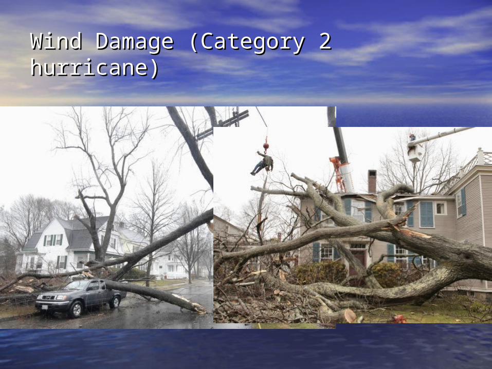
Wind Damage (Category 2 hurricane)Wind Damage (Category 2 hurricane)

SheltersShelters

Courtesy: Portland Press Herald


Can Share NERACOOS Products During the Can Share NERACOOS Products During the Drill Drill (below is an example from the Patriot’s (below is an example from the Patriot’s Day Storm)Day Storm)

Thanks for your time!Thanks for your time!
• Questions/Comments???Questions/[email protected]@noaa.gov
USCG District 1Steve LehmannNOAA SSCCDR 1st Coast Guard District (MEP)408 Atlantic AvenueBoston, Massachusetts 02110
Phone: 617.223.8016