marine protected areas - california...
TRANSCRIPT

Monterey Bay National Marine Sanctuary Volunteer Training Manual
Marine Protected Areas (MPAs) The oceans of our great grandfathers were truly amazing places: large fish were plentiful and catching a trophy fish was not out of the question. The oceans appeared to be endless and full of fish or invertebrates for the taking. While some may argue that the oceans are just as vast and full of fish today as they were in 1850, others cite the change in fishing technology as the major advantage humans have over fish that allows for ever more fish to be caught for consumption. In 1804 the world population was estimated to be 1 billion, in 1959 world population was estimated to be 3 billion and in 2015 it was over the 7 billion mark. The growth in the human population increases demand on the world’s ocean to provide easily available fish as a main protein source. While developing countries along coastlines heavily depend upon fish for protein, more affluent countries have increased fish consumption for the reported health benefits among other reasons.
Resource managers have implemented measures to try and conserve fish resources- catch limits, boat limits, size limits. In order to provide more fish for the world aquaculture and mariculture have also grown in popularity. But in this case of the Tragedy of the Commons, we see that not all commercial fishers on the high seas are playing by the same rules. In order to protect fish stocks and ensure some fish species survive into the future, resource managers are now increasingly turning to Marine Protected Areas. What are Marine Protected Areas? Marine Protected Areas are areas of the ocean set aside as nurseries and designated as limited “take”, no-“take” or in some cases no entry zones established to allow marine species to increase numbers or range. “Take” refers to fishing practices where fish or other marine life are removed for human consumption or other uses.

Monterey Bay National Marine Sanctuary Volunteer Training Manual
Why Marine Protected Areas? Around the globe marine spatial planning professionals and resource managers have adopted Marine Protected Areas in various forms to help in the restoration of the marine environment. At this point in time, 1.8% of the world’s oceans are in Marine Protected Areas. Research has shown that protecting habitats and species inside of Marine Protected Areas leads to a healthy reproductive stock that will increase its population and spillover into areas outside of the Marine Protected Area. Some of the documented benefits of Marine Protected Areas are:
• Higher abundance and larger size of fish, invertebrates and plants. • Increased biodiversity- the number of different species found, the more the better. • Greater biomass- increased body size of individual animals and/or increase number of animals.
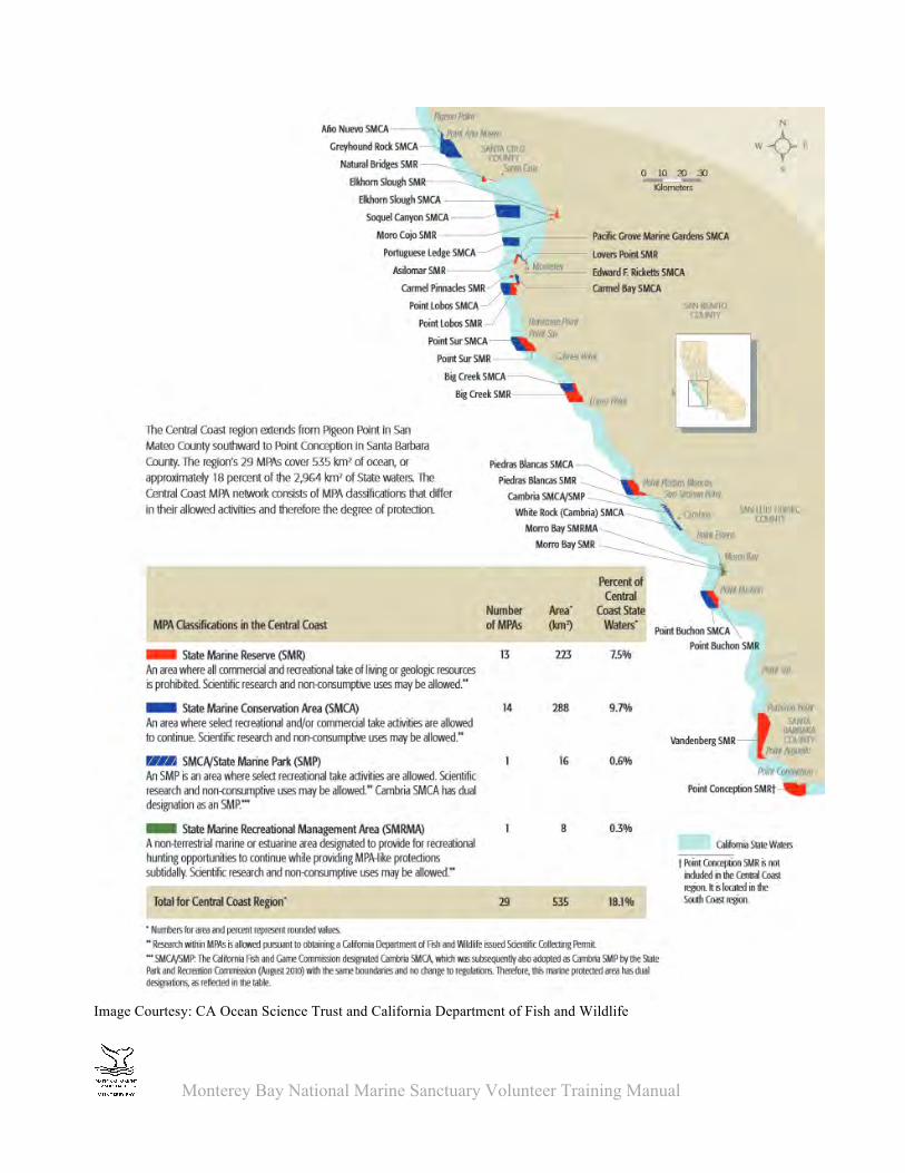
Marine Protected Areas are especially important for slow growing species such a rockfish and abalone to have the time and space to mature and reproduce. Scientists have shown that the bigger, older, fertile female fish (BOFFF’s) are better at producing more eggs that are more viable, than younger and smaller fish. Marine Protected Areas provide the area necessary for these species to grow to maturity without human threats. Is the Monterey Bay National Marine Sanctuary a Marine Protected Area? Federally designated Marine Protected Areas can take many forms from National Marine Sanctuaries, National Marine Monuments, Reserves and Conservation Areas. National Marine Sanctuaries are just one of the many MPAs that can be found in Federal waters (Federal waters generally extend from 3 miles to 200 miles offshore, but there are exceptions!). Monterey Bay National Marine Sanctuary does not regulate fishing or “take” but does regulate activities within the sanctuary which in turn influence what can survive in specific areas. Commercial fishing is regulated by the National Marine Fisheries Service (NMFS) and recreational fishing is regulated by the California Department of Fish and Wildlife State of California Marine Protected Areas In 1999 the State of California passed the Marine Life Protection Act (MLPA), which allowed for the establishment a network of Marine Protected Areas in state waters (mean high water to 3 miles). In 2007, California established 29 Marine Protected Areas in central California that were then incorporated into the greater network of 124 Marine Protected Areas established in 2012 now covering 12% of state coastal waters. Stakeholders were key in the establishment of all Marine Protected Areas by assisting with the identification of key areas. Stakeholders included marine scientists, representatives of the public, SCUBA divers, commercial fishers, recreational fishers.

Monterey Bay National Marine Sanctuary Volunteer Training Manual
There are three main types of Marine Protected Areas in California: State Marine Conservation Areas (SMCA) Commercial and recreational fishing or taking is approved for allowed species. Each SMCA will have specific regulations on what sort of species and gear is allowed. Check for individual regulations at each SMCA. SMCAs in coastal Central California:
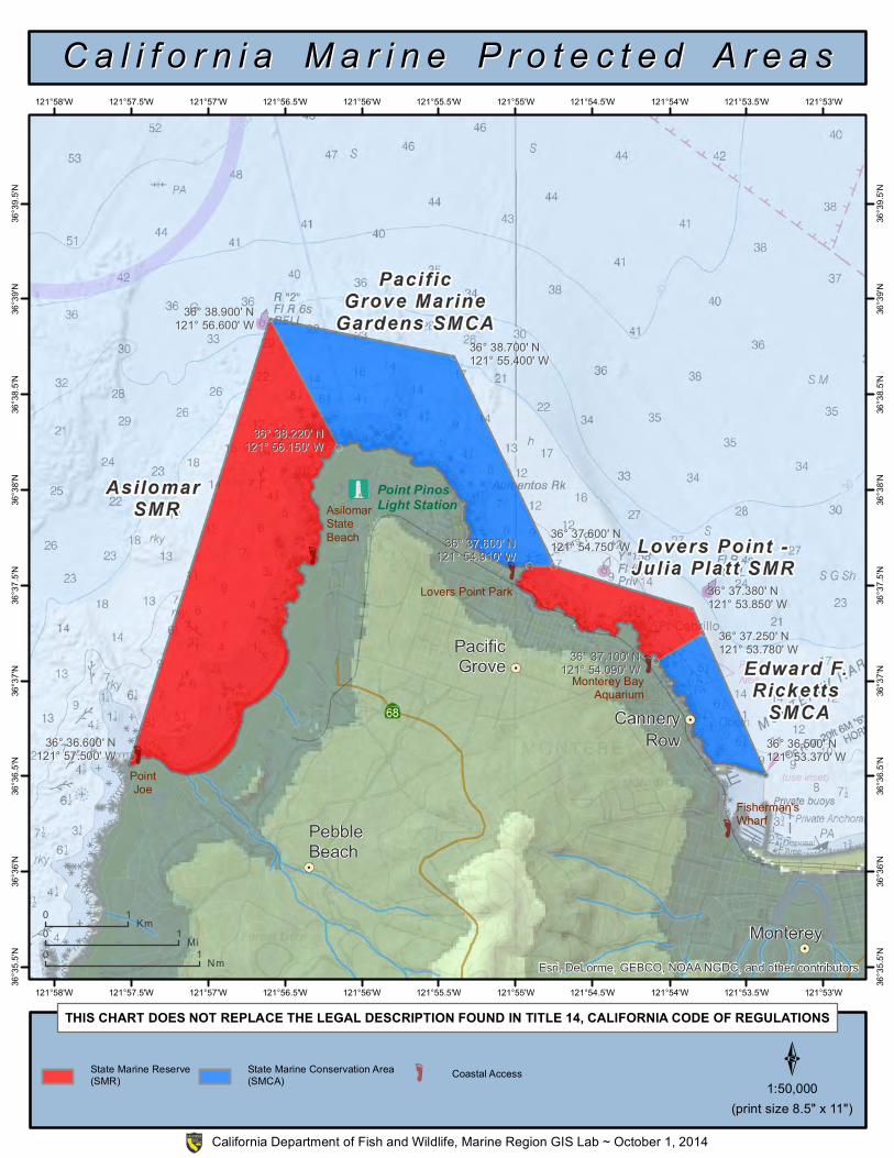
• Ano Nuevo SMCA • Greyhound Rock SMCA • Elkhorn Slough SMCA • Pacific Grove Marine Gardens SMCA • Edward F. Ricketts SMCA • Carmel Bay SMCA • Point Lobos SMCA • Point Sur SMCA • Big Creek SMCA
State Marine Reserves (SMR) No take or extraction is allowed of any kind. Scientific permits can be allowed but as with all permits must be approved through the California Department of Fish and Wildlife. State Marine Reserves in coastal Central California:
• Natural Bridges SMR • Elkhorn Slough SMR • Moro Cojo SMR • Lovers Point- Julia Platt SMR • Asilomar SMR • Carmel Pinnacles SMR • Point Lobos SMR • Point Sur SMR • Big Creek SMR
State Marine Parks (SMP) No commercial fishing is allowed but some types of recreational fishing or take may be allowed. Check for individual regulations at each park. There is just one of these types of Marine Protected Areas in Central California and is in the southern region. State Marine Parks in coastal Central California:
• Cambria SMCA+SMP
Monterey Bay National Marine Sanctuary Volunteer Training Manual
Image Courtesy: CA Ocean Science Trust and California Department of Fish and Wildlife

Monterey Bay National Marine Sanctuary Volunteer Training Manual
Some key messages to share with visitors:
• Marine Protected Areas are like National Parks- some activities are allowed others are not. It is up to you as a recreational or commercial fisherman to know the rules.
• Big Old Fertile Female Fish- in some species of fish, the bigger and older females produce more eggs of higher quality than younger and smaller fishes. Additionally, larger females are better able to survive through times when the spawning is just not quite right and may be able to spawn at times that younger females cannot.
• Marine Protected Areas are open to everyone to enjoy and visit within the limits spelled out the Marine Protected Areas regulations.
• Lastly, and maybe most importantly- when talking about Marine Protected Areas with your
visitors, don’t automatically use the abbreviation for Marine Protected Areas (MPA). This abbreviation may not be a term your visitor may know about.

Frequently Asked Questions on California’s Marine Protected Areas (MPAs) What are marine protected areas, or MPAs? Like parks protect wildlife and habitats on land, marine protected areas (MPAs) protect and restore wildlife and habitats along the coast of California. California’s marine protected areas come in many “flavors”; the size and level of protection, including fishing restrictions, can vary from one area to the next. Also called underwater parks, they’re designed to protect plants and animals within an entire ecosystem, rather than protecting just a single species. In December 2012, California became an international leader in ocean protection by completing the United States’ first statewide network of marine protected areas that are designed to ensure healthy, vibrant ocean life for generations to come.
Why do we need marine protected areas? California’s coastal waters are some of the richest in the world, but real problems lurk below the ocean's surface. Ninety percent of the big fish that existed in the 1950s are missing and three-fourths of California’s kelp forest has disappeared since the 1960s1. Meanwhile, California fishing communities are still recovering from the collapse of the west coast groundfish fishery and the closure of all five commercial abalone fisheries. In numerous studies worldwide, MPAs have proven to boost fish size, abundance and diversity, and increase the productivity and resilience of the protected area. How do they protect the entire ocean ecosystem? Marine protected areas safeguard critical ocean habitat, allowing sensitive marine communities such as rocky reefs and seagrass beds to thrive and recover. These special places also protect biological hotspots and important foraging grounds. This in turn benefits a range of species including plants like bull kelp, invertebrates like sea stars, and marine mammals such as seals and otters. As safe havens, underwater parks offer a home and refuge for big, old, fat, female fish to recover, grow and replenish our oceans. What can I do in an underwater park? There are many ways to enjoy California’s ocean parks. You can swim, dive, surf, kayak, watch birds and mammals and simply relax in nature. You can also bring your children to explore marine life in tidepools, as long as you take only photos and leave animals and shells where they are. Or, you can get involved in a citizen science project and help study wildlife and monitor ocean change, or become a volunteer educator who teaches visitors about life above and beneath the waves.
Is fishing and the take of marine life allowed? Fishing and the take of marine life such as shellfish or seaweed is allowed in about half of California’s marine protected areas. Each type or kind of marine protected area has different regulations; inside state marine parks, sport fishing is encouraged, but commercial fishing is prohibited. In state marine reserves, fishing is not allowed. It’s best to visit the California Department of Fish and Wildlife website at www.dfg.ca.gov/mlpa to learn about the specific rules for each marine protected area. How big are most of the state marine protected areas, and how far out do they extend from shore? All of California’s state marine protected areas are located inside the state water boundaries within three

nautical miles from shore. Their size, shape and location vary. Some are only a few hundred meters out from the shore, and others extend out to the federal waters (three nautical miles). Each was designed as part of a statewide network, following a set of scientific guidelines. How do marine protected areas address water pollution? The Marine Life Protection Act that created the underwater park system in California provides authority to regulate what is taken out of the ocean; other state and federal laws regulate what goes into the ocean. For example, Areas of Biological Significance, National Marine Sanctuaries and National Estuaries actually do have laws to promote better water quality. Water quality is an issue along California’s coast, and marine protected areas can boost efforts to reduce pollution by attracting attention to our coast’s ecological and economic value. How do the state marine protected areas affect the fishing industry? California fishermen have suffered economic hardships in recent years due to declines in commercially important fish and inadequate management. For example, landings in the commercial rockfish fishery declined statewide by 95 percent over the past 25 years3. Marine protected areas can help restore the ocean ecosystem, which can improve the sustainability of commercial and recreational fishing, draw visitors, and enhance tourism, California’s biggest coastal industry. The central coast MPAs have been in place for five years. What changes are you seeing? Five years is a short period of time for recovery of marine populations to occur, so recovery is expected to continue over many years. Short-lived species such as oysters or clams can recover quickly, but many slow-growing species such as rockfish need more than five years to show signs of recovery. Some researchers, like Mark Carr of the University of California Santa Cruz, have seen some improvements in fish populations. Other scientists and fishermen are working together now to measure changes to tell us how our underwater parks are performing over time. What are you learning in other areas of California where marine protected areas have been in place longer? In California’s Channel Islands, where MPAs have been in place for 10 years, a 2012 study found that lobsters were more abundant and larger in protected areas, with over five more legal-sized lobsters caught per trap on average inside the refuges.2 Recreational fishing in parts of the islands actually increased from 2003 to 2008, as did commercial landings for some of the Islands’ largest fisheries, such as squid, urchin, lobster and crab. There are signs of success from places around the world that demonstrate the many benefits of conservation (see http://californiampas.org/pages/about/success.html). 1 Myers, A., Worm, B. (2003) Rapid worldwide depletion of predatory fish communities. Nature 423(280-283). 2Kay, M.C., (2012) Effects of marine reserves on California spiny lobster are robust and modified by fine-scale habitat features and distance from reserve borders. Marine Ecology Progress Series, April 2012 3 Rockfish resources of the south central California coast: Analysis of the resources from party boat data, 1980-2005. Stephens, J. et al. (2006). CalCOFI Rep., Vol. 47, 2006


36° 37.600' N36° 37.600' N121° 54.910' W121° 54.910' W
36° 38.700' N36° 38.700' N121° 55.400' W121° 55.400' W
36° 38.220' N36° 38.220' N121° 56.150' W121° 56.150' W
36° 38.900' N36° 38.900' N121° 56.600' W121° 56.600' W
36° 36.600' N36° 36.600' N121° 57.500' W121° 57.500' W
36° 36.500' N36° 36.500' N121° 53.370' W121° 53.370' W
36° 37.250' N36° 37.250' N121° 53.780' W121° 53.780' W36° 37.100' N36° 37.100' N
121° 54.090' W121° 54.090' W
36° 37.380' N36° 37.380' N121° 53.850' W121° 53.850' W
36° 37.600' N36° 37.600' N121° 54.750' W121° 54.750' W
CanneryRow
Monterey
PacificGrove
PebbleBeach
AsilomarStateBeach
PointJoe
Monterey BayAquarium
Lovers Point Park
Fisherman'sWharf
Point PinosLight Station
Esri, DeLorme, GEBCO, NOAA NGDC, and other contributors121°53'W
121°53'W
121°53.5'W
121°53.5'W
121°54'W
121°54'W
121°54.5'W
121°54.5'W
121°55'W
121°55'W
121°55.5'W
121°55.5'W
121°56'W
121°56'W
121°56.5'W
121°56.5'W
121°57'W
121°57'W
121°57.5'W
121°57.5'W
121°58'W
121°58'W
36°39
.5'N
36°39
.5'N
36°39
'N
36°39
'N
36°38
.5'N
36°38
.5'N
36°38
'N
36°38
'N
36°37
.5'N
36°37
.5'N
36°37
'N
36°37
'N
36°36
.5'N
36°36
.5'N
36°36
'N
36°36
'N
36°35
.5'N
36°35
.5'N
C a l i f o r n i a M a r i n e P r o t e c t e d A r e a sC a l i f o r n i a M a r i n e P r o t e c t e d A r e a s
THIS CHART DOES NOT REPLACE THE LEGAL DESCRIPTION FOUND IN TITLE 14, CALIFORNIA CODE OF REGULATIONS
D1:50,000
0 1 Km
0 1 Nm
0 1 Mi
State Marine Reserve(SMR)
State Marine Conservation Area(SMCA) õ Coastal Access
(print size 8.5" x 11")
California Department of Fish and Wildlife, Marine Region GIS Lab ~ October 1, 2014


