marion county multi-hazard mitigation plan planning ... · marion county multi-hazard mitigation...
TRANSCRIPT

Marion County Multi-Hazard Mitigation Plan Planning Committee Meeting
10 am -12pm Wednesday, August 31, 2005 EOC
47 S. State Avenue, Indianapolis
AGENDA
1. Overview of the Multi-Hazard Mitigation Plan (MHMP) Requirements 2. Role of the Planning Committee and Project Timeline 3. Identify Local Hazards
4. Identify Critical Facilities
5. Schedule Next Planning Committee Meeting
Marion County Multi-Hazard Mitigation Plan Planning Committee Meeting
10am-12pm, Wednesday, August 31, 2005
Emergency Operations Center 47 S. State Avenue, Indianapolis
MEETING SUMMARY
Planning Committee Members Present: John Ball, Indianapolis Police Department Thomas Bassett, GIS Shane Booker, Indy Parks Steve Campbell, Office of the Mayor Robert Cheshire, Beech Grove Fire Department. Randal Collins, Emergency Management Gregg Harris, Indianapolis Fire Department Adam Holman, Department of Metropolitan Development Fred Laughlin, Indianapolis Downtown, Inc. Mathew McCormack, IMAGIS Phyllis Peden, Marion County Health Department Dennis Peters, Indianapolis Police Department Donna Price, Department of Metropolitan Development Steve Pruitt, Department of Public Works Ray Raney, MECA Phil Reuter, Indianapolis Fire Department Dennis Slaughter, Department of Metropolitan Development David Surina, GIS Tom White, Department of Public Works Others Present: Siavash Beik, Christopher Burke Engineering, Ltd. (CBBEL) Sheila McKinley, Christopher Burke Engineering, Ltd. (CBBEL) Jason Tidwell, Christopher Burke Engineering, Ltd. (CBBEL) 1. Overview of the Multi-Hazard Mitigation Plan (MHMP) Requirement The Disaster Mitigation Act of 2000 (DMA 2000) requires both the state and local communities to prepare for disasters through pre and post disaster planning. This process reinforces the importance of mitigation planning and the need for communities to plan for a disaster before it occurs in order to reduce the physical, social, and economical impact. In order for National Flood Insurance Program (NFIP) communities to be eligible for future mitigation funds, they must adopt either their own MHMP or participate in the development of a multi-jurisdictional MHMP. The development of a MHMP is the necessary first step of a multi-step process to implement programs, policies, and projects to mitigate the effect of hazards in Marion
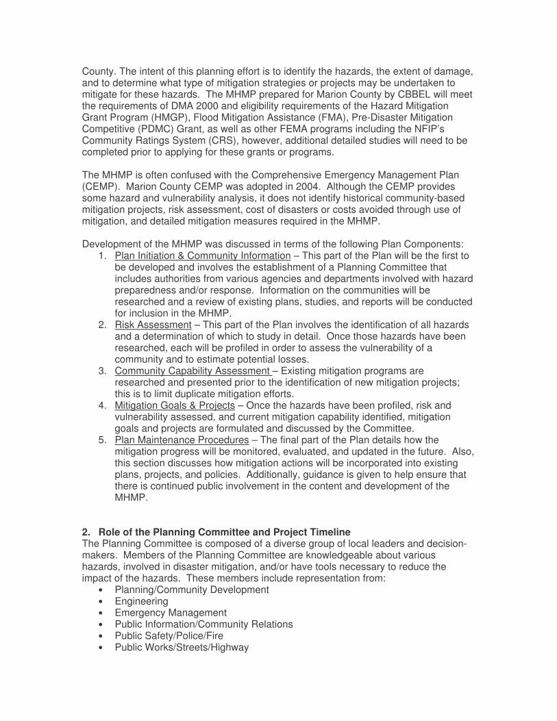
County. The intent of this planning effort is to identify the hazards, the extent of damage, and to determine what type of mitigation strategies or projects may be undertaken to mitigate for these hazards. The MHMP prepared for Marion County by CBBEL will meet the requirements of DMA 2000 and eligibility requirements of the Hazard Mitigation Grant Program (HMGP), Flood Mitigation Assistance (FMA), Pre-Disaster Mitigation Competitive (PDMC) Grant, as well as other FEMA programs including the NFIP’s Community Ratings System (CRS), however, additional detailed studies will need to be completed prior to applying for these grants or programs. The MHMP is often confused with the Comprehensive Emergency Management Plan (CEMP). Marion County CEMP was adopted in 2004. Although the CEMP provides some hazard and vulnerability analysis, it does not identify historical community-based mitigation projects, risk assessment, cost of disasters or costs avoided through use of mitigation, and detailed mitigation measures required in the MHMP. Development of the MHMP was discussed in terms of the following Plan Components:
1. Plan Initiation & Community Information – This part of the Plan will be the first to be developed and involves the establishment of a Planning Committee that includes authorities from various agencies and departments involved with hazard preparedness and/or response. Information on the communities will be researched and a review of existing plans, studies, and reports will be conducted for inclusion in the MHMP.
2. Risk Assessment – This part of the Plan involves the identification of all hazards and a determination of which to study in detail. Once those hazards have been researched, each will be profiled in order to assess the vulnerability of a community and to estimate potential losses.
3. Community Capability Assessment – Existing mitigation programs are researched and presented prior to the identification of new mitigation projects; this is to limit duplicate mitigation efforts.
4. Mitigation Goals & Projects – Once the hazards have been profiled, risk and vulnerability assessed, and current mitigation capability identified, mitigation goals and projects are formulated and discussed by the Committee.
5. Plan Maintenance Procedures – The final part of the Plan details how the mitigation progress will be monitored, evaluated, and updated in the future. Also, this section discusses how mitigation actions will be incorporated into existing plans, projects, and policies. Additionally, guidance is given to help ensure that there is continued public involvement in the content and development of the MHMP.
2. Role of the Planning Committee and Project Timeline The Planning Committee is composed of a diverse group of local leaders and decision-makers. Members of the Planning Committee are knowledgeable about various hazards, involved in disaster mitigation, and/or have tools necessary to reduce the impact of the hazards. These members include representation from:
• Planning/Community Development • Engineering • Emergency Management • Public Information/Community Relations • Public Safety/Police/Fire • Public Works/Streets/Highway
• Building/Zoning/Code Enforcement • GIS • Parks/Recreation • Residents/Business Owners/Stakeholders • NFIP Communities:
• Marion County/Indianapolis • City of Beech Grove • City of Lawrence • City of Southport • Town of Speedway
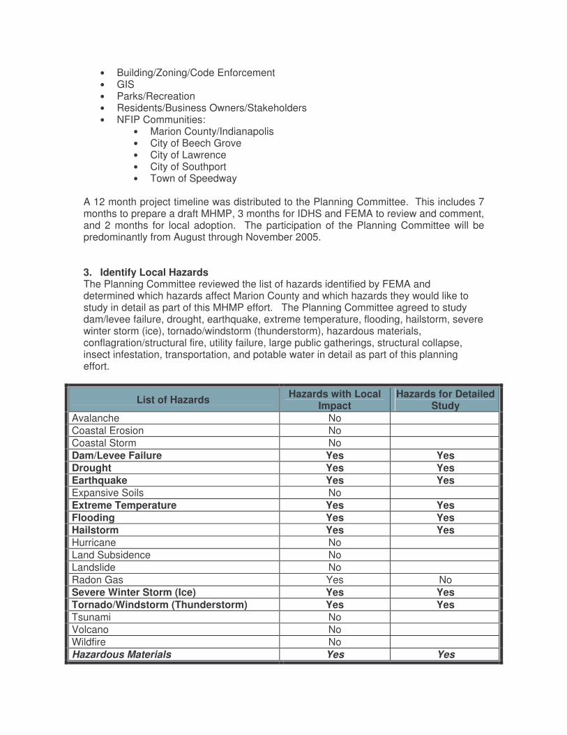
A 12 month project timeline was distributed to the Planning Committee. This includes 7 months to prepare a draft MHMP, 3 months for IDHS and FEMA to review and comment, and 2 months for local adoption. The participation of the Planning Committee will be predominantly from August through November 2005. 3. Identify Local Hazards The Planning Committee reviewed the list of hazards identified by FEMA and determined which hazards affect Marion County and which hazards they would like to study in detail as part of this MHMP effort. The Planning Committee agreed to study dam/levee failure, drought, earthquake, extreme temperature, flooding, hailstorm, severe winter storm (ice), tornado/windstorm (thunderstorm), hazardous materials, conflagration/structural fire, utility failure, large public gatherings, structural collapse, insect infestation, transportation, and potable water in detail as part of this planning effort.
List of Hazards Hazards with Local Impact
Hazards for Detailed Study
Avalanche No Coastal Erosion No Coastal Storm No Dam/Levee Failure Yes Yes Drought Yes Yes Earthquake Yes Yes Expansive Soils No Extreme Temperature Yes Yes Flooding Yes Yes Hailstorm Yes Yes Hurricane No Land Subsidence No Landslide No Radon Gas Yes No Severe Winter Storm (Ice) Yes Yes Tornado/Windstorm (Thunderstorm) Yes Yes Tsunami No Volcano No Wildfire No Hazardous Materials Yes Yes
List of Hazards Hazards with Local Impact
Hazards for Detailed Study
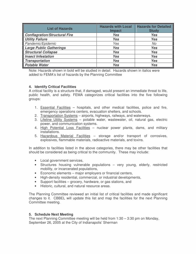
Conflagration/Structural Fire Yes Yes Utility Failure Yes Yes Pandemic/Epidemic Yes No Large Public Gatherings Yes Yes Structural Collapse Yes Yes Insect Infestation Yes Yes Transportation Yes Yes Potable Water Yes Yes
Note: Hazards shown in bold will be studied in detail. Hazards shown in italics were added to FEMA’s list of hazards by the Planning Committee
4. Identify Critical Facilities A critical facility is a structure that, if damaged, would present an immediate threat to life, public health, and safety. FEMA categorizes critical facilities into the five following groups:
1. Essential Facilities – hospitals, and other medical facilities, police and fire, emergency operations centers, evacuation shelters, and schools.
2. Transportation Systems – airports, highways, railways, and waterways. 3. Lifeline Utility Systems – potable water, wastewater, oil, natural gas, electric
power, and communication systems. 4. High Potential Loss Facilities – nuclear power plants, dams, and military
installations. 5. Hazardous Material Facilities – storage and/or transport of corrosives,
explosives, flammable materials, radioactive materials, and toxins. In addition to facilities listed in the above categories, there may be other facilities that should be considered as being critical to the community. These may include:
• Local government services, • Structures housing vulnerable populations – very young, elderly, restricted
mobility, or incarcerated populations, • Economic elements – major employers or financial centers, • High-density residential, commercial, or industrial developments, • Support facilities – grocery, hardware, or gas stations, and • Historic, cultural, and natural resource areas.
The Planning Committee reviewed an initial list of critical facilities and made significant changes to it. CBBEL will update this list and map the facilities for the next Planning Committee meeting. 5. Schedule Next Meeting The next Planning Committee meeting will be held from 1:30 – 3:30 pm on Monday, September 26, 2005 at the City of Indianapolis’ Sherman
Marion County Multi-Hazard Mitigation Plan Planning Committee Meeting
1:30 pm-3:30 pm Monday, September 26, 2005
City of Indianapolis’ Sherman Offices 604 North Sherman Drive, Indianapolis
AGENDA
6. Review Updated Critical Facilities 7. Review Hazards and Highlights from Initial Research 8. Discuss Existing Mitigation Efforts 9. Discuss Local Mitigation Goals
10. Schedule Next Planning Committee Meeting
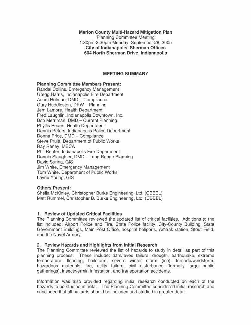
Marion County Multi-Hazard Mitigation Plan Planning Committee Meeting
1:30pm-3:30pm Monday, September 26, 2005 City of Indianapolis’ Sherman Offices
604 North Sherman Drive, Indianapolis
MEETING SUMMARY
Planning Committee Members Present: Randal Collins, Emergency Management Gregg Harris, Indianapolis Fire Department Adam Holman, DMD – Compliance Gary Huddleston, DPW – Planning Jem Lamore, Health Department Fred Laughlin, Indianapolis Downtown, Inc. Bob Merriman, DMD – Current Planning Phyllis Peden, Health Department Dennis Peters, Indianapolis Police Department Donna Price, DMD – Compliance Steve Pruitt, Department of Public Works Ray Raney, MECA Phil Reuter, Indianapolis Fire Department Dennis Slaughter, DMD – Long Range Planning David Surina, GIS Jim White, Emergency Management Tom White, Department of Public Works Layne Young, GIS Others Present: Sheila McKinley, Christopher Burke Engineering, Ltd. (CBBEL) Matt Rummel, Christopher B. Burke Engineering, Ltd. (CBBEL) 1. Review of Updated Critical Facilities The Planning Committee reviewed the updated list of critical facilities. Additions to the list included: Airport Police and Fire, State Police facility, City-County Building, State Government Buildings, Main Post Office, hospital heliports, Amtrak station, Stout Field, and the Navel Armory. 2. Review Hazards and Highlights from Initial Research The Planning Committee reviewed the list of hazards to study in detail as part of this planning process. These include: dam/levee failure, drought, earthquake, extreme temperature, flooding, hailstorm, severe winter storm (ice), tornado/windstorm, hazardous materials, fire, utility failure, civil disturbance (formally large public gatherings), insect/vermin infestation, and transportation accidents. Information was also provided regarding initial research conducted on each of the hazards to be studied in detail. The Planning Committee considered initial research and concluded that all hazards should be included and studied in greater detail.
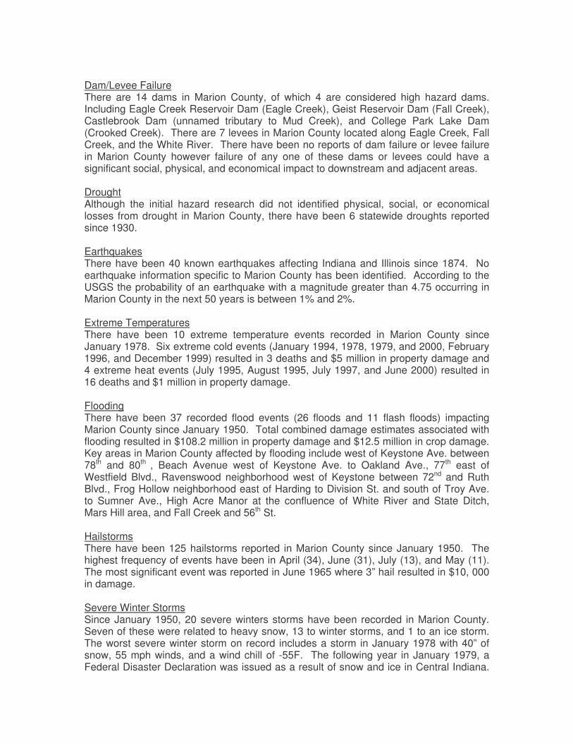
Dam/Levee Failure There are 14 dams in Marion County, of which 4 are considered high hazard dams. Including Eagle Creek Reservoir Dam (Eagle Creek), Geist Reservoir Dam (Fall Creek), Castlebrook Dam (unnamed tributary to Mud Creek), and College Park Lake Dam (Crooked Creek). There are 7 levees in Marion County located along Eagle Creek, Fall Creek, and the White River. There have been no reports of dam failure or levee failure in Marion County however failure of any one of these dams or levees could have a significant social, physical, and economical impact to downstream and adjacent areas. Drought Although the initial hazard research did not identified physical, social, or economical losses from drought in Marion County, there have been 6 statewide droughts reported since 1930. Earthquakes There have been 40 known earthquakes affecting Indiana and Illinois since 1874. No earthquake information specific to Marion County has been identified. According to the USGS the probability of an earthquake with a magnitude greater than 4.75 occurring in Marion County in the next 50 years is between 1% and 2%. Extreme Temperatures There have been 10 extreme temperature events recorded in Marion County since January 1978. Six extreme cold events (January 1994, 1978, 1979, and 2000, February 1996, and December 1999) resulted in 3 deaths and $5 million in property damage and 4 extreme heat events (July 1995, August 1995, July 1997, and June 2000) resulted in 16 deaths and $1 million in property damage. Flooding There have been 37 recorded flood events (26 floods and 11 flash floods) impacting Marion County since January 1950. Total combined damage estimates associated with flooding resulted in $108.2 million in property damage and $12.5 million in crop damage. Key areas in Marion County affected by flooding include west of Keystone Ave. between 78th and 80th , Beach Avenue west of Keystone Ave. to Oakland Ave., 77th east of Westfield Blvd., Ravenswood neighborhood west of Keystone between 72nd and Ruth Blvd., Frog Hollow neighborhood east of Harding to Division St. and south of Troy Ave. to Sumner Ave., High Acre Manor at the confluence of White River and State Ditch, Mars Hill area, and Fall Creek and 56th St. Hailstorms There have been 125 hailstorms reported in Marion County since January 1950. The highest frequency of events have been in April (34), June (31), July (13), and May (11). The most significant event was reported in June 1965 where 3” hail resulted in $10, 000 in damage. Severe Winter Storms Since January 1950, 20 severe winters storms have been recorded in Marion County. Seven of these were related to heavy snow, 13 to winter storms, and 1 to an ice storm. The worst severe winter storm on record includes a storm in January 1978 with 40” of snow, 55 mph winds, and a wind chill of -55F. The following year in January 1979, a Federal Disaster Declaration was issued as a result of snow and ice in Central Indiana.
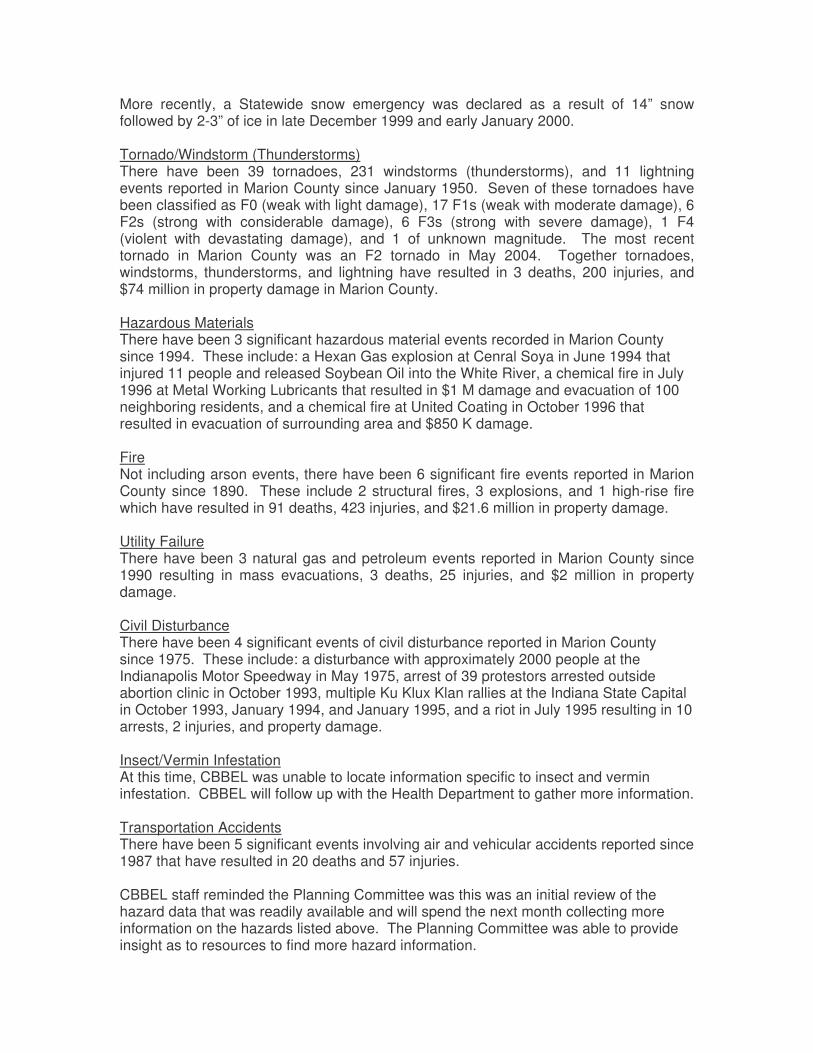
More recently, a Statewide snow emergency was declared as a result of 14” snow followed by 2-3” of ice in late December 1999 and early January 2000. Tornado/Windstorm (Thunderstorms) There have been 39 tornadoes, 231 windstorms (thunderstorms), and 11 lightning events reported in Marion County since January 1950. Seven of these tornadoes have been classified as F0 (weak with light damage), 17 F1s (weak with moderate damage), 6 F2s (strong with considerable damage), 6 F3s (strong with severe damage), 1 F4 (violent with devastating damage), and 1 of unknown magnitude. The most recent tornado in Marion County was an F2 tornado in May 2004. Together tornadoes, windstorms, thunderstorms, and lightning have resulted in 3 deaths, 200 injuries, and $74 million in property damage in Marion County. Hazardous Materials There have been 3 significant hazardous material events recorded in Marion County since 1994. These include: a Hexan Gas explosion at Cenral Soya in June 1994 that injured 11 people and released Soybean Oil into the White River, a chemical fire in July 1996 at Metal Working Lubricants that resulted in $1 M damage and evacuation of 100 neighboring residents, and a chemical fire at United Coating in October 1996 that resulted in evacuation of surrounding area and $850 K damage. Fire Not including arson events, there have been 6 significant fire events reported in Marion County since 1890. These include 2 structural fires, 3 explosions, and 1 high-rise fire which have resulted in 91 deaths, 423 injuries, and $21.6 million in property damage. Utility Failure There have been 3 natural gas and petroleum events reported in Marion County since 1990 resulting in mass evacuations, 3 deaths, 25 injuries, and $2 million in property damage. Civil Disturbance There have been 4 significant events of civil disturbance reported in Marion County since 1975. These include: a disturbance with approximately 2000 people at the Indianapolis Motor Speedway in May 1975, arrest of 39 protestors arrested outside abortion clinic in October 1993, multiple Ku Klux Klan rallies at the Indiana State Capital in October 1993, January 1994, and January 1995, and a riot in July 1995 resulting in 10 arrests, 2 injuries, and property damage. Insect/Vermin Infestation At this time, CBBEL was unable to locate information specific to insect and vermin infestation. CBBEL will follow up with the Health Department to gather more information. Transportation Accidents There have been 5 significant events involving air and vehicular accidents reported since 1987 that have resulted in 20 deaths and 57 injuries. CBBEL staff reminded the Planning Committee was this was an initial review of the hazard data that was readily available and will spend the next month collecting more information on the hazards listed above. The Planning Committee was able to provide insight as to resources to find more hazard information.
3. Discuss Existing Mitigation Efforts Prior to recommending new hazard mitigation measures it is necessary to identify and understand the existing mitigation measures currently in place in all jurisdictions participating in the planning process. As a large group, the Planning Committee reviewed FEMA’s six mitigation measures – prevention, property protection, natural resource protection, emergency services, structural control projects, and public information. However due to the complexity of the existing programs, policies, and projects throughout the multiple departments of the City of Indianapolis, Beech Grove, Lawrence, Southport, and Speedway, CBBEL suggested meeting with individuals rather than discussing these as a group. The following outlines the six mitigation measures that will be included in the Multi-Hazard Mitigation Plan. Prevention Prevention measures are designed to keep the problem from occurring or getting worse. These include government administrative or regulatory actions or processes that influence that way land and buildings are developed and built to ensure that future development does not increase hazard damage. Examples include:
• Land Use Planning & Zoning • Floodplain Management • Watershed-based Projects & Studies • Geographic Information Systems (GIS) • Safe Rooms & Community Shelters • Tree Maintenance
Property Protection Property protection measures are used to modify or remove existing buildings or structures to protect them from hazard damage. These measures may be relatively inexpensive to the community since they are implemented through a cost-share with the property owner. Many of the measures do not affect the building’s appearance or use, making them particularly appropriate for historical sites and landmarks. Examples include:
• Building Protection • Property Insurance • Building Codes
Natural Resource Protection Natural resource protection measures can minimize hazard losses by preserving or restoring natural areas and the natural functions of floodplain and watershed areas. Examples include:
• Erosion and sediment control • Stream corridor restoration • Stormwater Management • Wetland protection
Emergency Services Emergency services measures protect people and property during and immediately after a hazard. Most counties and many cities have emergency management offices to coordinate warning, response and recovery during a disaster. Examples include:
• Emergency Operations Center (EOC) • Emergency Warning Systems • Mutual Aid Agreements
• Power Back-up Generators Structural Projects Structural project measures involve the construction of structures to reduce the impact of a hazard or to prevent a hazard from reaching a property. Examples include:
• High Hazard Dams • Flood Control Structures
Public Information Public information measures inform and educate citizens, elected officials, and property owners about the hazards and ways to protect themselves and their property. Examples include:
• Map information • Outreach projects • Education programs • Real estate disclosures • Technical assistance
4. Set Mitigation Goals The Planning Committee reviewed and discussed the States MHMP mitigation goals as well as the following draft MHMP mitigation goals. These draft goals are for multiple hazards and correspond to FEMA’s six mitigation measures. 1. Prevention
The multi-hazard goal for prevention is to continue to manage the development of land and buildings to reduce the impact of hazards on people and property.
2. Property Protection
The multi-hazard goal for property protection is to continue to modify the buildings subject to hazard damage to protect people and property from the impacts of hazards.
3. Natural Resource Protection
The multi-hazard goal for natural resource protection is to continue to preserve and maintain the function of existing natural resources to reduce the impact of hazards to people and property.
4. Emergency Services
The multi-hazard goal for emergency services is to continue to improve the efficiency, timing and effectiveness of warning, response and recovery efforts before, during, and immediately after a hazard.
5. Structural Projects
The multi-hazard goal for structural projects is to continue to use structures, where feasible, to minimize the potentially damaging effects of hazards on people and property.
6. Public Information
The multi-hazard goal for public information is to continue to educate and inform the public about the risks of hazards and ways to protect themselves and their property.

Following some discussion, the Planning Committee agreed to think about these suggested mitigation goals before making a final decision. 5. Schedule Next Planning Committee Meeting The next Planning Committee meeting will be held from 1:30pm–3:30pm on Monday, October 24, 2005.
Marion County Multi-Hazard Mitigation Plan Planning Committee Meeting
1:30pm-3:30pm Monday, October 24, 2005 City of Indianapolis’ Sherman Offices
604 North Sherman Drive, Indianapolis
AGENDA
1. Review Hazard and Estimated Damage Data 2. Calculate Priority Risk Index for Each Hazard 3. Discuss Public Participation
4. Schedule Next Planning Committee Meeting
Marion County Multi-Hazard Mitigation Plan Planning Committee Meeting
1:30pm-3:30pm Monday, October 24, 2005
City of Indianapolis’ Sherman Offices 604 North Sherman Drive, Indianapolis
MEETING SUMMARY
Planning Committee Members Present: Tom Bassett, GIS Victoria Cluck, DPW - Planning Adam Holman, DMD – Compliance Jeff Larmore, Health Department Fred Laughlin, Indianapolis Downtown, Inc. Ron Lauster, Soil & Water Conservation District Phyllis Peden, Health Department Dennis Peters, Indianapolis Police Department Donna Price, DMD – Compliance Steve Pruitt, Department of Public Works Ray Raney, MECA Dennis Slaughter, DMD – Long Range Planning Dale True, IPD/EMA Others Present: Zach Bishton, Christopher Burke Engineering, Ltd. (CBBEL) Sheila McKinley, Christopher Burke Engineering, Ltd. (CBBEL) Jason Tidwell, Christopher B. Burke Engineering, Ltd. (CBBEL)
1. Review Hazard and Estimated Damage Data
CBBEL staff provided a summary for civil disturbance, dam/levee failure, drought, earthquakes, extreme temperatures, flooding, hailstorm, hazardous materials, infestation, severe winter storm, structural fire, tornado/windstorm, transportation, and utility failures. The summary gave an overview based on previous occurrences, inventory of assets, and estimate of potential loss. The following comments were made during the hazard discussion:
• All: The values for Estimate Potential Loss seem too low. CBBEL explained that these are national averages from HAZUS. CBBEL agreed that they do not reflect the true value of loss in Marion County and will find better numbers locally. Also, need to consider infrastructure loss not just building loss.
• Civil Disturbance: Add July 1995 riot at 42nd & College that lasted 3 days and Circle City Classic to list.
• Dam/Levee Failure: Add Williams Creek dam (at Westfield Blvd) to list, although a low-head, it could result in significant loss downstream.
• Drought: A large number of communities surrounding Indianapolis are dependent on Indianapolis Water, contamination or restricted water use could have a significant regional impact. CBBEL will collect more information on potential loss.
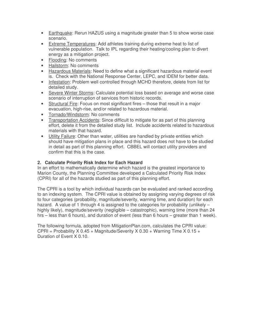
• Earthquake: Rerun HAZUS using a magnitude greater than 5 to show worse case scenario.
• Extreme Temperatures: Add athletes training during extreme heat to list of vulnerable population. Talk to IPL regarding their heating/cooling plan to divert energy as a mitigation project.
• Flooding: No comments • Hailstorm: No comments • Hazardous Materials: Need to define what a significant hazardous material event
is. Check with the National Response Center, LEPC, and IDEM for better data. • Infestation: Problem well controlled through MCHD therefore, delete from list for
detailed study. • Severe Winter Storms: Calculate potential loss based on average and worse case
scenario of interruption of services from historic records. • Structural Fire: Focus on most significant fires – those that result in a major
evacuation, high-rise, and/or related to hazardous material. • Tornado/Windstorm: No comments • Transportation Accidents: Since difficult to mitigate for as part of this planning
effort, delete it from the detailed study list. Include accidents related to hazardous materials with that hazard.
• Utility Failure: Other than water, utilities are handled by private entities which should have mitigation plans in place and this hazard does not have to be studied in detail as part of this planning effort. CBBEL will contact utility providers and confirm that this is the case.
2. Calculate Priority Risk Index for Each Hazard In an effort to mathematically determine which hazard is the greatest importance to Marion County, the Planning Committee developed a Calculated Priority Risk Index (CPRI) for all of the hazards studied as part of this planning effort. The CPRI is a tool by which individual hazards can be evaluated and ranked according to an indexing system. The CPRI value is obtained by assigning varying degrees of risk to four categories (probability, magnitude/severity, warning time, and duration) for each hazard. A value of 1 through 4 is assigned to the categories for probability (unlikely – highly likely), magnitude/severity (negligible – catastrophic), warning time (more than 24 hrs – less than 6 hours), and duration of event (less than 6 hours – greater than 1 week). The following formula, adopted from MitigationPlan.com, calculates the CPRI value: CPRI = Probability X 0.45 + Magnitude/Severity X 0.30 + Warning Time X 0.15 + Duration of Event X 0.10.
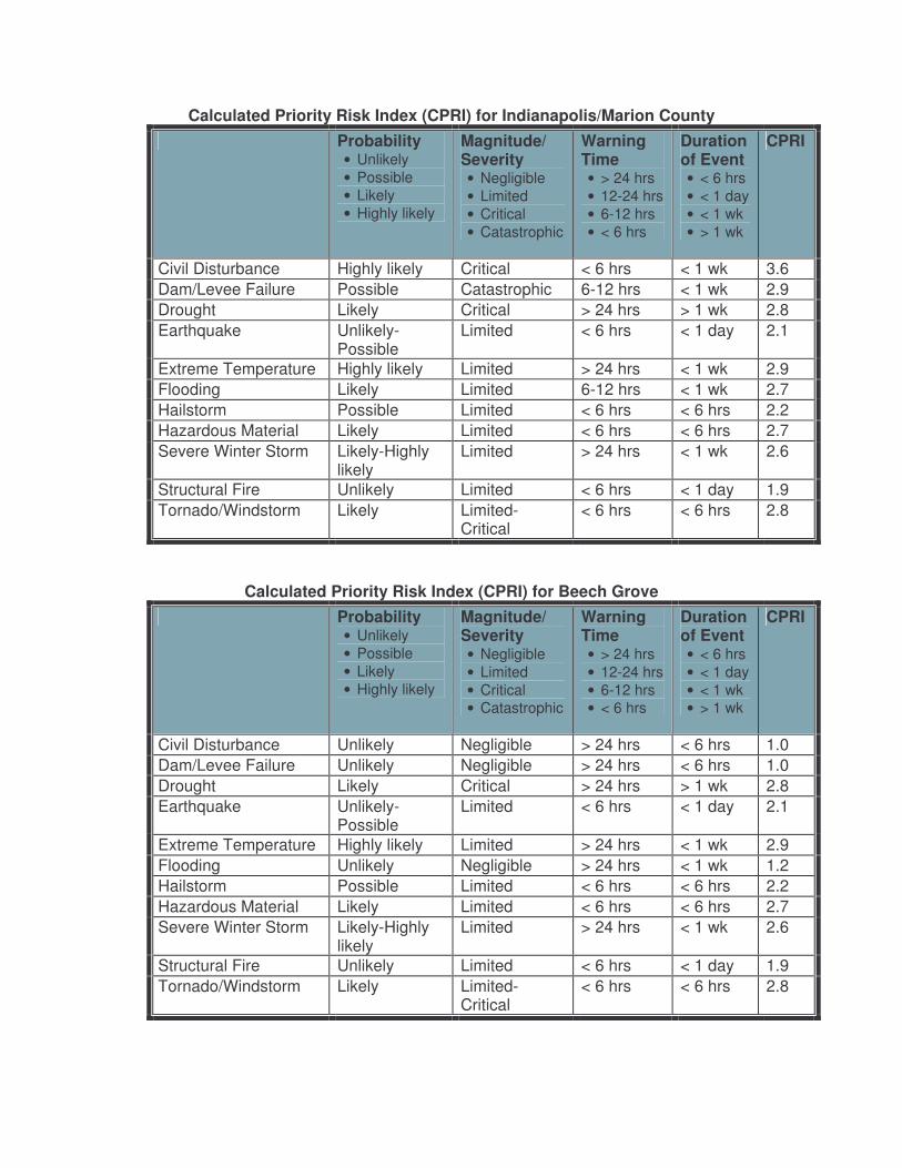
Calculated Priority Risk Index (CPRI) for Indianapolis/Marion County Probability
• Unlikely • Possible • Likely • Highly likely
Magnitude/ Severity • Negligible • Limited • Critical • Catastrophic
Warning Time • > 24 hrs • 12-24 hrs • 6-12 hrs • < 6 hrs
Duration of Event • < 6 hrs • < 1 day • < 1 wk • > 1 wk
CPRI
Civil Disturbance Highly likely Critical < 6 hrs < 1 wk 3.6 Dam/Levee Failure Possible Catastrophic 6-12 hrs < 1 wk 2.9 Drought Likely Critical > 24 hrs > 1 wk 2.8 Earthquake Unlikely-
Possible Limited < 6 hrs < 1 day 2.1
Extreme Temperature Highly likely Limited > 24 hrs < 1 wk 2.9 Flooding Likely Limited 6-12 hrs < 1 wk 2.7 Hailstorm Possible Limited < 6 hrs < 6 hrs 2.2 Hazardous Material Likely Limited < 6 hrs < 6 hrs 2.7 Severe Winter Storm Likely-Highly
likely Limited > 24 hrs < 1 wk 2.6
Structural Fire Unlikely Limited < 6 hrs < 1 day 1.9 Tornado/Windstorm Likely Limited-
Critical < 6 hrs < 6 hrs 2.8
Calculated Priority Risk Index (CPRI) for Beech Grove Probability
• Unlikely • Possible • Likely • Highly likely
Magnitude/ Severity • Negligible • Limited • Critical • Catastrophic
Warning Time • > 24 hrs • 12-24 hrs • 6-12 hrs • < 6 hrs
Duration of Event • < 6 hrs • < 1 day • < 1 wk • > 1 wk
CPRI
Civil Disturbance Unlikely Negligible > 24 hrs < 6 hrs 1.0 Dam/Levee Failure Unlikely Negligible > 24 hrs < 6 hrs 1.0 Drought Likely Critical > 24 hrs > 1 wk 2.8 Earthquake Unlikely-
Possible Limited < 6 hrs < 1 day 2.1
Extreme Temperature Highly likely Limited > 24 hrs < 1 wk 2.9 Flooding Unlikely Negligible > 24 hrs < 1 wk 1.2 Hailstorm Possible Limited < 6 hrs < 6 hrs 2.2 Hazardous Material Likely Limited < 6 hrs < 6 hrs 2.7 Severe Winter Storm Likely-Highly
likely Limited > 24 hrs < 1 wk 2.6
Structural Fire Unlikely Limited < 6 hrs < 1 day 1.9 Tornado/Windstorm Likely Limited-
Critical < 6 hrs < 6 hrs 2.8
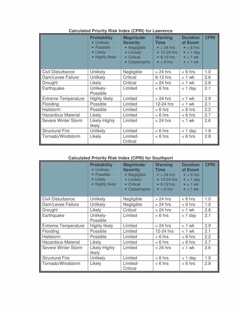
Calculated Priority Risk Index (CPRI) for Lawrence Probability
• Unlikely • Possible • Likely • Highly likely
Magnitude/ Severity • Negligible • Limited • Critical • Catastrophic
Warning Time • > 24 hrs • 12-24 hrs • 6-12 hrs • < 6 hrs
Duration of Event • < 6 hrs • < 1 day • < 1 wk • > 1 wk
CPRI
Civil Disturbance Unlikely Negligible > 24 hrs < 6 hrs 1.0 Dam/Levee Failure Unlikely Critical 6-12 hrs < 1 wk 2.6 Drought Likely Critical > 24 hrs > 1 wk 2.8 Earthquake Unlikely-
Possible Limited < 6 hrs < 1 day 2.1
Extreme Temperature Highly likely Limited > 24 hrs < 1 wk 2.9 Flooding Possible Limited 12-24 hrs < 1 wk 2.1 Hailstorm Possible Limited < 6 hrs < 6 hrs 2.2 Hazardous Material Likely Limited < 6 hrs < 6 hrs 2.7 Severe Winter Storm Likely-Highly
likely Limited > 24 hrs < 1 wk 2.6
Structural Fire Unlikely Limited < 6 hrs < 1 day 1.9 Tornado/Windstorm Likely Limited-
Critical < 6 hrs < 6 hrs 2.8
Calculated Priority Risk Index (CPRI) for Southport Probability
• Unlikely • Possible • Likely • Highly likely
Magnitude/ Severity • Negligible • Limited • Critical • Catastrophic
Warning Time • > 24 hrs • 12-24 hrs • 6-12 hrs • < 6 hrs
Duration of Event • < 6 hrs • < 1 day • < 1 wk • > 1 wk
CPRI
Civil Disturbance Unlikely Negligible > 24 hrs < 6 hrs 1.0 Dam/Levee Failure Unlikely Negligible > 24 hrs < 6 hrs 1.0 Drought Likely Critical > 24 hrs > 1 wk 2.8 Earthquake Unlikely-
Possible Limited < 6 hrs < 1 day 2.1
Extreme Temperature Highly likely Limited > 24 hrs < 1 wk 2.9 Flooding Possible Limited 12-24 hrs < 1 wk 2.1 Hailstorm Possible Limited < 6 hrs < 6 hrs 2.2 Hazardous Material Likely Limited < 6 hrs < 6 hrs 2.7 Severe Winter Storm Likely-Highly
likely Limited > 24 hrs < 1 wk 2.6
Structural Fire Unlikely Limited < 6 hrs < 1 day 1.9 Tornado/Windstorm Likely Limited-
Critical < 6 hrs < 6 hrs 2.8
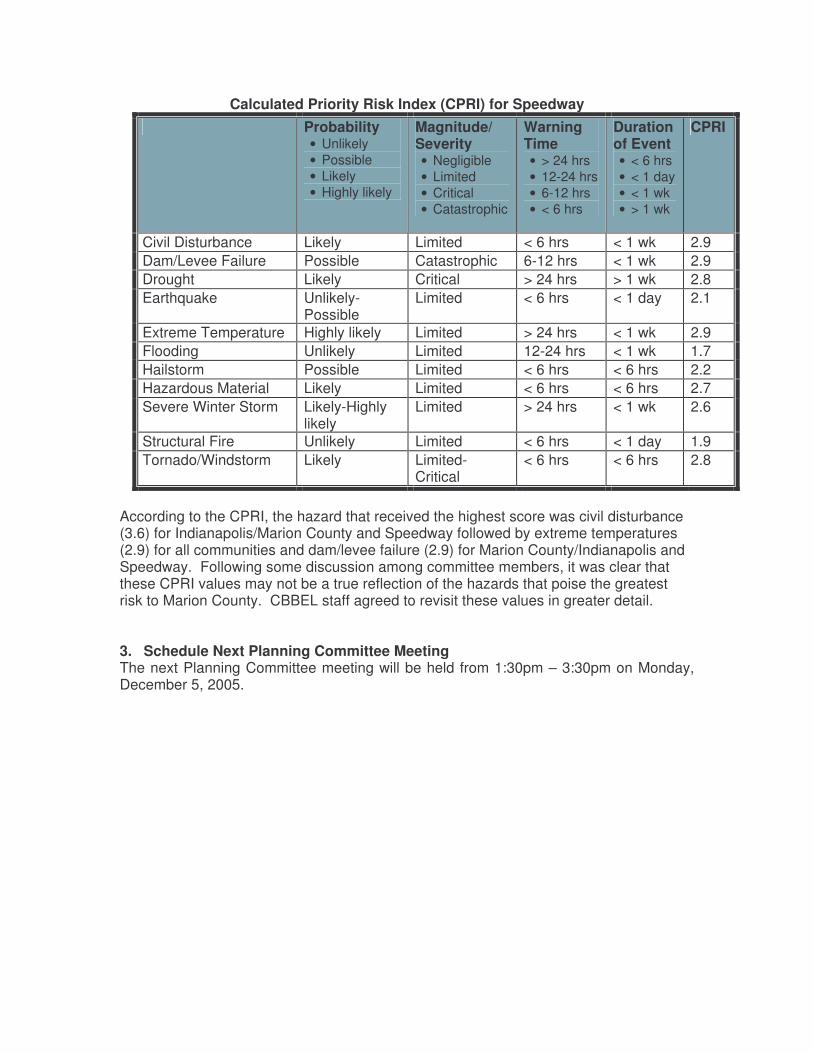
Calculated Priority Risk Index (CPRI) for Speedway Probability
• Unlikely • Possible • Likely • Highly likely
Magnitude/ Severity • Negligible • Limited • Critical • Catastrophic
Warning Time • > 24 hrs • 12-24 hrs • 6-12 hrs • < 6 hrs
Duration of Event • < 6 hrs • < 1 day • < 1 wk • > 1 wk
CPRI
Civil Disturbance Likely Limited < 6 hrs < 1 wk 2.9 Dam/Levee Failure Possible Catastrophic 6-12 hrs < 1 wk 2.9 Drought Likely Critical > 24 hrs > 1 wk 2.8 Earthquake Unlikely-
Possible Limited < 6 hrs < 1 day 2.1
Extreme Temperature Highly likely Limited > 24 hrs < 1 wk 2.9 Flooding Unlikely Limited 12-24 hrs < 1 wk 1.7 Hailstorm Possible Limited < 6 hrs < 6 hrs 2.2 Hazardous Material Likely Limited < 6 hrs < 6 hrs 2.7 Severe Winter Storm Likely-Highly
likely Limited > 24 hrs < 1 wk 2.6
Structural Fire Unlikely Limited < 6 hrs < 1 day 1.9 Tornado/Windstorm Likely Limited-
Critical < 6 hrs < 6 hrs 2.8
According to the CPRI, the hazard that received the highest score was civil disturbance (3.6) for Indianapolis/Marion County and Speedway followed by extreme temperatures (2.9) for all communities and dam/levee failure (2.9) for Marion County/Indianapolis and Speedway. Following some discussion among committee members, it was clear that these CPRI values may not be a true reflection of the hazards that poise the greatest risk to Marion County. CBBEL staff agreed to revisit these values in greater detail.
3. Schedule Next Planning Committee Meeting The next Planning Committee meeting will be held from 1:30pm – 3:30pm on Monday, December 5, 2005.
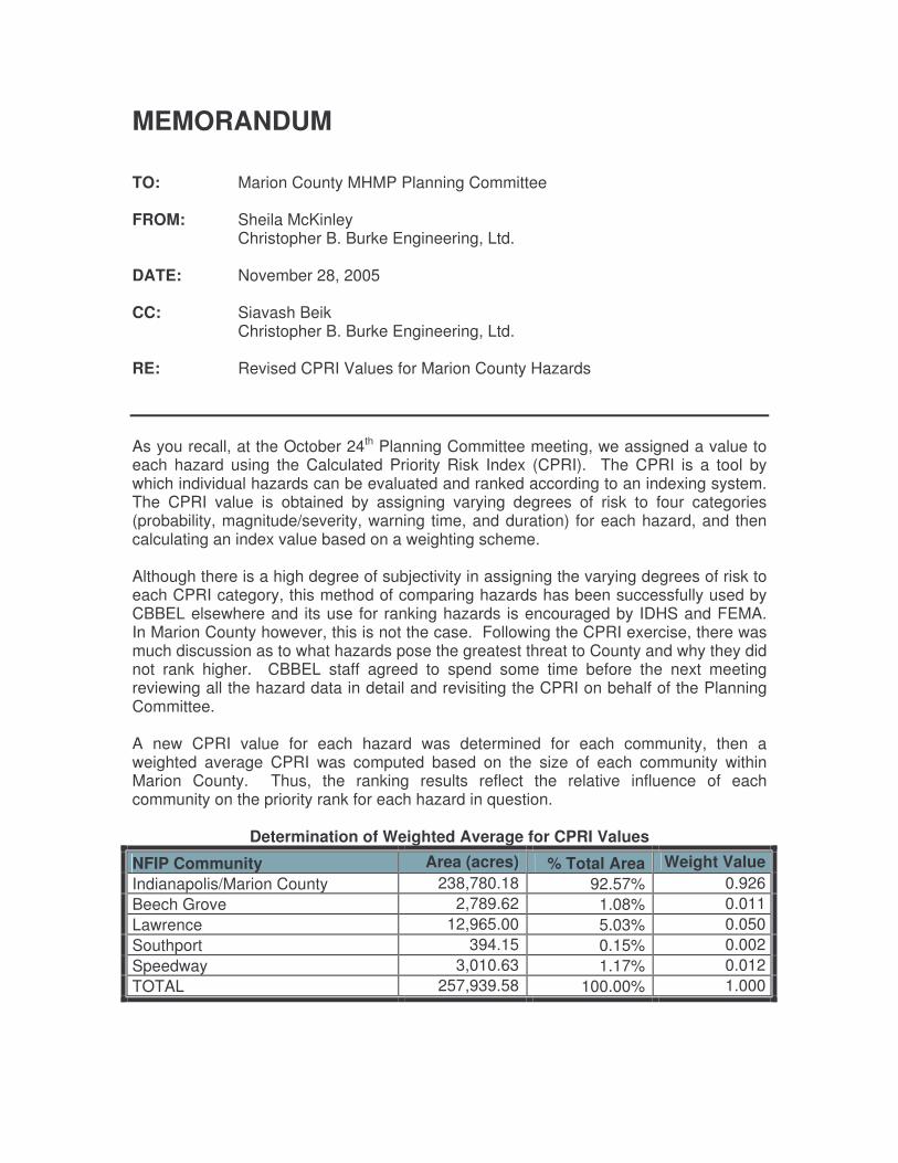
MEMORANDUM TO: Marion County MHMP Planning Committee FROM: Sheila McKinley Christopher B. Burke Engineering, Ltd. DATE: November 28, 2005 CC: Siavash Beik Christopher B. Burke Engineering, Ltd. RE: Revised CPRI Values for Marion County Hazards As you recall, at the October 24th Planning Committee meeting, we assigned a value to each hazard using the Calculated Priority Risk Index (CPRI). The CPRI is a tool by which individual hazards can be evaluated and ranked according to an indexing system. The CPRI value is obtained by assigning varying degrees of risk to four categories (probability, magnitude/severity, warning time, and duration) for each hazard, and then calculating an index value based on a weighting scheme. Although there is a high degree of subjectivity in assigning the varying degrees of risk to each CPRI category, this method of comparing hazards has been successfully used by CBBEL elsewhere and its use for ranking hazards is encouraged by IDHS and FEMA. In Marion County however, this is not the case. Following the CPRI exercise, there was much discussion as to what hazards pose the greatest threat to County and why they did not rank higher. CBBEL staff agreed to spend some time before the next meeting reviewing all the hazard data in detail and revisiting the CPRI on behalf of the Planning Committee. A new CPRI value for each hazard was determined for each community, then a weighted average CPRI was computed based on the size of each community within Marion County. Thus, the ranking results reflect the relative influence of each community on the priority rank for each hazard in question.
Determination of Weighted Average for CPRI Values
NFIP Community Area (acres) % Total Area Weight Value Indianapolis/Marion County 238,780.18 92.57% 0.926 Beech Grove 2,789.62 1.08% 0.011 Lawrence 12,965.00 5.03% 0.050 Southport 394.15 0.15% 0.002 Speedway 3,010.63 1.17% 0.012 TOTAL 257,939.58 100.00% 1.000
The following table identifies the priority ranking of each hazard based on a weighted average Calculated Priority Risk Index (CPRI).
Combined Calculated Priority Risk Index (CPRI) for
Indianapolis/Marion County, Beech Grove, Lawrence, Southport, and Speedway
Hazard Original CPRI Weighted CPRI Flooding 2.0 3.3 Dam/Levee Failure 2.1 2.9 Tornado/Windstorm 2.8 2.7 Severe Winter Storm 2.6 2.3 Civil Disturbance 1.9 2.2 Hailstorm 2.2 2.1 Hazardous Materials 2.7 2.1 Drought 2.8 2.0 Earthquake 2.1 2.0 Extreme Temperature 2.9 1.9 Structural Fire 1.9 1.8
During the Planning Committee meeting, extreme temperature (2.9) ranked as the number one hazard throughout Marion County followed by tornado/windstorm (2.8) and drought (2.8), hazardous materials (2.7), severe winter storms (2.6), hailstorm (2.2), dam/levee failure (2.1), earthquake (2.1), flooding (2.0), civil disturbance (1.9), and structural fire (1.9). According to the revised and weighted CPRI, flooding (3.3) ranked as the number one hazard throughout Marion County followed by dam/levee failure (2.9), tornado/windstorm (2.7), severe winter storm (2.3), civil disturbance (2.2), hailstorm (2.1), hazardous materials (2.1), drought (2.0), earthquake (2.0), extreme temperatures (1.9), and structural fire (1.8). The following tables detail the revised CPRI values for each NFIP community.
Revised Calculated Priority Risk Index (CPRI) for Indianapolis/Marion County
Probability • Unlikely • Possible • Likely • Highly likely
Magnitude/ Severity • Negligible • Limited • Critical • Catastrophic
Warning Time • > 24 hrs • 12-24 hrs • 6-12 hrs • < 6 hrs
Duration of Event • < 6 hrs • < 1 day • < 1 wk • > 1 wk
CPRI
Civil Disturbance Possible Limited < 6 hrs < 1 day 2.3 Dam/Levee Failure Possible Catastrophic < 6 hrs < 1 wk 3.0 Drought Possible Limited > 24 hrs > 1 wk 2.1 Earthquake Unlikely-
Possible Limited < 6 hrs < 1 day 2.1
Extreme Temperature Possible Limited > 24 hrs < 1 wk 2.0 Flooding Highly Likely Critical 6-12 hrs < 1 wk 3.5 Hailstorm Possible Limited < 6 hrs < 6 hrs 2.2 Hazardous Material Possible Limited < 6 hrs < 6 hrs 2.2
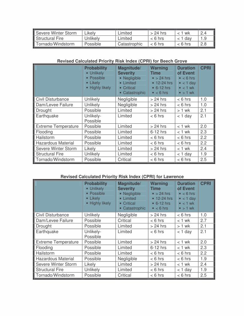
Revised Calculated Priority Risk Index (CPRI) for Beech Grove Probability
• Unlikely • Possible • Likely • Highly likely
Magnitude/ Severity • Negligible • Limited • Critical • Catastrophic
Warning Time • > 24 hrs • 12-24 hrs • 6-12 hrs • < 6 hrs
Duration of Event • < 6 hrs • < 1 day • < 1 wk • > 1 wk
CPRI
Civil Disturbance Unlikely Negligible > 24 hrs < 6 hrs 1.0 Dam/Levee Failure Unlikely Negligible > 24 hrs < 6 hrs 1.0 Drought Possible Limited > 24 hrs > 1 wk 2.1 Earthquake Unlikely-
Possible Limited < 6 hrs < 1 day 2.1
Extreme Temperature Possible Limited > 24 hrs < 1 wk 2.0 Flooding Possible Limited 6-12 hrs < 1 wk 2.3 Hailstorm Possible Limited < 6 hrs < 6 hrs 2.2 Hazardous Material Possible Limited < 6 hrs < 6 hrs 2.2 Severe Winter Storm Likely Limited > 24 hrs < 1 wk 2.4 Structural Fire Unlikely Limited < 6 hrs < 1 day 1.9 Tornado/Windstorm Possible Critical < 6 hrs < 6 hrs 2.5
Revised Calculated Priority Risk Index (CPRI) for Lawrence Probability
• Unlikely • Possible • Likely • Highly likely
Magnitude/ Severity • Negligible • Limited • Critical • Catastrophic
Warning Time • > 24 hrs • 12-24 hrs • 6-12 hrs • < 6 hrs
Duration of Event • < 6 hrs • < 1 day • < 1 wk • > 1 wk
CPRI
Civil Disturbance Unlikely Negligible > 24 hrs < 6 hrs 1.0 Dam/Levee Failure Possible Critical < 6 hrs < 1 wk 2.7 Drought Possible Limited > 24 hrs > 1 wk 2.1 Earthquake Unlikely-
Possible Limited < 6 hrs < 1 day 2.1
Extreme Temperature Possible Limited > 24 hrs < 1 wk 2.0 Flooding Possible Limited 6-12 hrs < 1 wk 2.3 Hailstorm Possible Limited < 6 hrs < 6 hrs 2.2 Hazardous Material Possible Negligible < 6 hrs < 6 hrs 1.9 Severe Winter Storm Likely Limited > 24 hrs < 1 wk 2.4 Structural Fire Unlikely Limited < 6 hrs < 1 day 1.9 Tornado/Windstorm Possible Critical < 6 hrs < 6 hrs 2.5
Severe Winter Storm Likely Limited > 24 hrs < 1 wk 2.4 Structural Fire Unlikely Limited < 6 hrs < 1 day 1.9 Tornado/Windstorm Possible Catastrophic < 6 hrs < 6 hrs 2.8
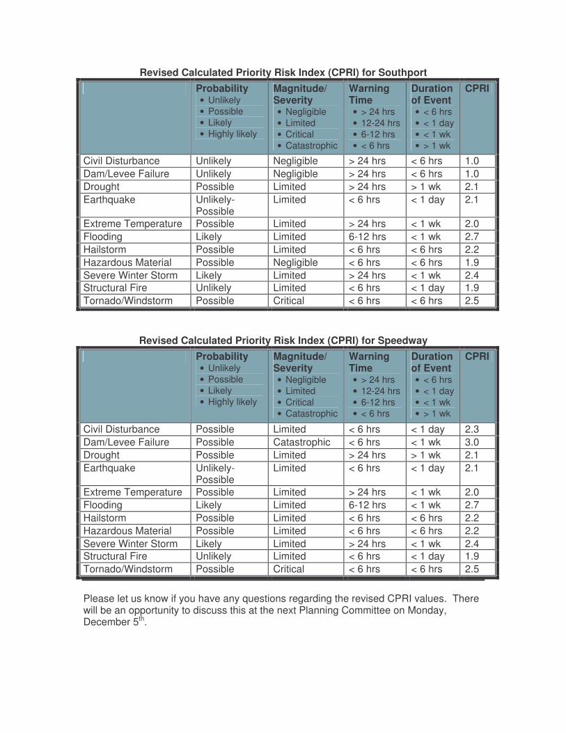
Revised Calculated Priority Risk Index (CPRI) for Southport Probability
• Unlikely • Possible • Likely • Highly likely
Magnitude/ Severity • Negligible • Limited • Critical • Catastrophic
Warning Time • > 24 hrs • 12-24 hrs • 6-12 hrs • < 6 hrs
Duration of Event • < 6 hrs • < 1 day • < 1 wk • > 1 wk
CPRI
Civil Disturbance Unlikely Negligible > 24 hrs < 6 hrs 1.0 Dam/Levee Failure Unlikely Negligible > 24 hrs < 6 hrs 1.0 Drought Possible Limited > 24 hrs > 1 wk 2.1 Earthquake Unlikely-
Possible Limited < 6 hrs < 1 day 2.1
Extreme Temperature Possible Limited > 24 hrs < 1 wk 2.0 Flooding Likely Limited 6-12 hrs < 1 wk 2.7 Hailstorm Possible Limited < 6 hrs < 6 hrs 2.2 Hazardous Material Possible Negligible < 6 hrs < 6 hrs 1.9 Severe Winter Storm Likely Limited > 24 hrs < 1 wk 2.4 Structural Fire Unlikely Limited < 6 hrs < 1 day 1.9 Tornado/Windstorm Possible Critical < 6 hrs < 6 hrs 2.5
Revised Calculated Priority Risk Index (CPRI) for Speedway Probability
• Unlikely • Possible • Likely • Highly likely
Magnitude/ Severity • Negligible • Limited • Critical • Catastrophic
Warning Time • > 24 hrs • 12-24 hrs • 6-12 hrs • < 6 hrs
Duration of Event • < 6 hrs • < 1 day • < 1 wk • > 1 wk
CPRI
Civil Disturbance Possible Limited < 6 hrs < 1 day 2.3 Dam/Levee Failure Possible Catastrophic < 6 hrs < 1 wk 3.0 Drought Possible Limited > 24 hrs > 1 wk 2.1 Earthquake Unlikely-
Possible Limited < 6 hrs < 1 day 2.1
Extreme Temperature Possible Limited > 24 hrs < 1 wk 2.0 Flooding Likely Limited 6-12 hrs < 1 wk 2.7 Hailstorm Possible Limited < 6 hrs < 6 hrs 2.2 Hazardous Material Possible Limited < 6 hrs < 6 hrs 2.2 Severe Winter Storm Likely Limited > 24 hrs < 1 wk 2.4 Structural Fire Unlikely Limited < 6 hrs < 1 day 1.9 Tornado/Windstorm Possible Critical < 6 hrs < 6 hrs 2.5
Please let us know if you have any questions regarding the revised CPRI values. There will be an opportunity to discuss this at the next Planning Committee on Monday, December 5th.
Marion County Multi-Hazard Mitigation Plan Planning Committee Meeting
1:30pm-3:30pm Monday, December 5, 2005 City of Indianapolis’ Sherman Offices
604 North Sherman Drive, Indianapolis
AGENDA
5. Discuss Revised Calculated Priority Risk Index Values 6. Discuss Existing and Proposed Mitigation Projects
7. Discuss the Next Steps in the Planning Process
Marion County Multi-Hazard Mitigation Plan Planning Committee Meeting
1:30pm-3:30pm Monday, December 5, 2005
City of Indianapolis’ Sherman Offices 604 North Sherman Drive, Indianapolis
MEETING SUMMARY
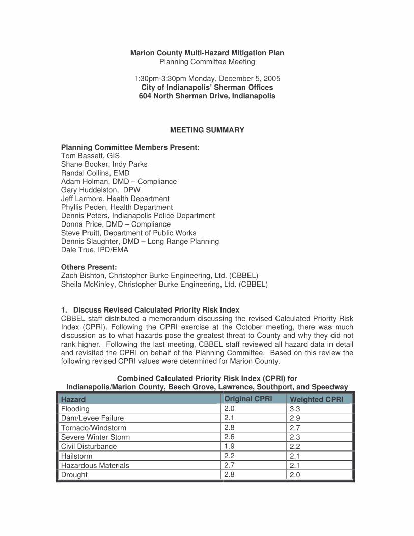
Planning Committee Members Present: Tom Bassett, GIS Shane Booker, Indy Parks Randal Collins, EMD Adam Holman, DMD – Compliance Gary Huddelston, DPW Jeff Larmore, Health Department Phyllis Peden, Health Department Dennis Peters, Indianapolis Police Department Donna Price, DMD – Compliance Steve Pruitt, Department of Public Works Dennis Slaughter, DMD – Long Range Planning Dale True, IPD/EMA Others Present: Zach Bishton, Christopher Burke Engineering, Ltd. (CBBEL) Sheila McKinley, Christopher Burke Engineering, Ltd. (CBBEL)
1. Discuss Revised Calculated Priority Risk Index CBBEL staff distributed a memorandum discussing the revised Calculated Priority Risk Index (CPRI). Following the CPRI exercise at the October meeting, there was much discussion as to what hazards pose the greatest threat to County and why they did not rank higher. Following the last meeting, CBBEL staff reviewed all hazard data in detail and revisited the CPRI on behalf of the Planning Committee. Based on this review the following revised CPRI values were determined for Marion County.
Combined Calculated Priority Risk Index (CPRI) for Indianapolis/Marion County, Beech Grove, Lawrence, Southport, and Speedway
Hazard Original CPRI Weighted CPRI Flooding 2.0 3.3 Dam/Levee Failure 2.1 2.9 Tornado/Windstorm 2.8 2.7 Severe Winter Storm 2.6 2.3 Civil Disturbance 1.9 2.2 Hailstorm 2.2 2.1 Hazardous Materials 2.7 2.1 Drought 2.8 2.0
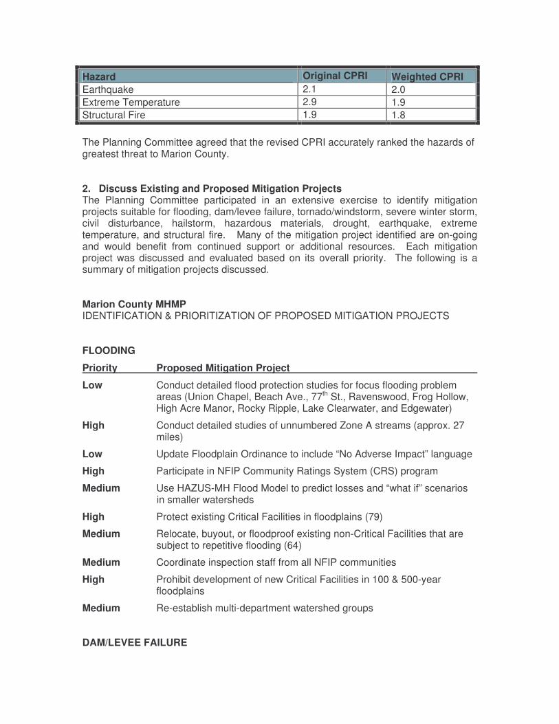
Hazard Original CPRI Weighted CPRI Earthquake 2.1 2.0 Extreme Temperature 2.9 1.9 Structural Fire 1.9 1.8
The Planning Committee agreed that the revised CPRI accurately ranked the hazards of greatest threat to Marion County. 2. Discuss Existing and Proposed Mitigation Projects The Planning Committee participated in an extensive exercise to identify mitigation projects suitable for flooding, dam/levee failure, tornado/windstorm, severe winter storm, civil disturbance, hailstorm, hazardous materials, drought, earthquake, extreme temperature, and structural fire. Many of the mitigation project identified are on-going and would benefit from continued support or additional resources. Each mitigation project was discussed and evaluated based on its overall priority. The following is a summary of mitigation projects discussed. Marion County MHMP IDENTIFICATION & PRIORITIZATION OF PROPOSED MITIGATION PROJECTS FLOODING
Priority Proposed Mitigation Project
Low Conduct detailed flood protection studies for focus flooding problem areas (Union Chapel, Beach Ave., 77th St., Ravenswood, Frog Hollow, High Acre Manor, Rocky Ripple, Lake Clearwater, and Edgewater)
High Conduct detailed studies of unnumbered Zone A streams (approx. 27 miles)
Low Update Floodplain Ordinance to include “No Adverse Impact” language
High Participate in NFIP Community Ratings System (CRS) program
Medium Use HAZUS-MH Flood Model to predict losses and “what if” scenarios in smaller watersheds
High Protect existing Critical Facilities in floodplains (79)
Medium Relocate, buyout, or floodproof existing non-Critical Facilities that are subject to repetitive flooding (64)
Medium Coordinate inspection staff from all NFIP communities
High Prohibit development of new Critical Facilities in 100 & 500-year floodplains
Medium Re-establish multi-department watershed groups
DAM/LEVEE FAILURE
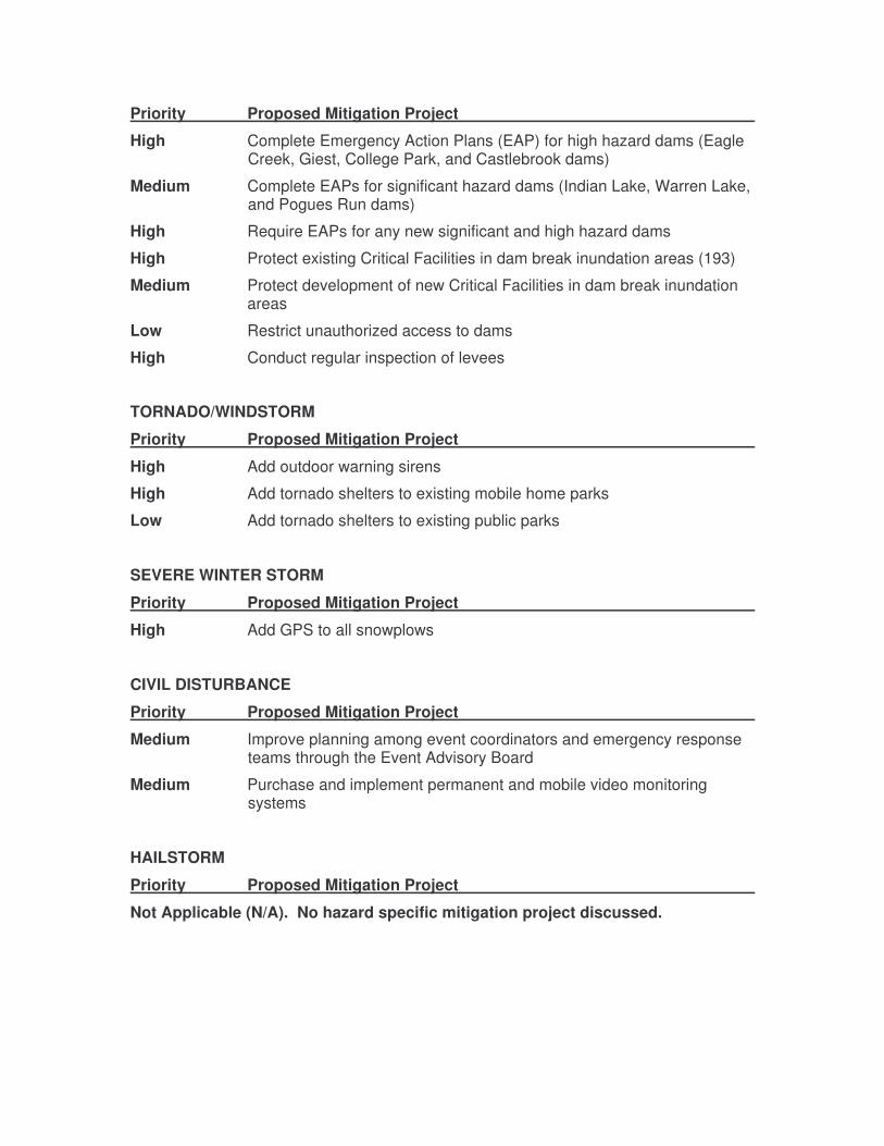
Priority Proposed Mitigation Project
High Complete Emergency Action Plans (EAP) for high hazard dams (Eagle Creek, Giest, College Park, and Castlebrook dams)
Medium Complete EAPs for significant hazard dams (Indian Lake, Warren Lake, and Pogues Run dams)
High Require EAPs for any new significant and high hazard dams
High Protect existing Critical Facilities in dam break inundation areas (193)
Medium Protect development of new Critical Facilities in dam break inundation areas
Low Restrict unauthorized access to dams
High Conduct regular inspection of levees
TORNADO/WINDSTORM
Priority Proposed Mitigation Project
High Add outdoor warning sirens
High Add tornado shelters to existing mobile home parks
Low Add tornado shelters to existing public parks
SEVERE WINTER STORM
Priority Proposed Mitigation Project
High Add GPS to all snowplows
CIVIL DISTURBANCE
Priority Proposed Mitigation Project
Medium Improve planning among event coordinators and emergency response teams through the Event Advisory Board
Medium Purchase and implement permanent and mobile video monitoring systems
HAILSTORM
Priority Proposed Mitigation Project
Not Applicable (N/A). No hazard specific mitigation project discussed.
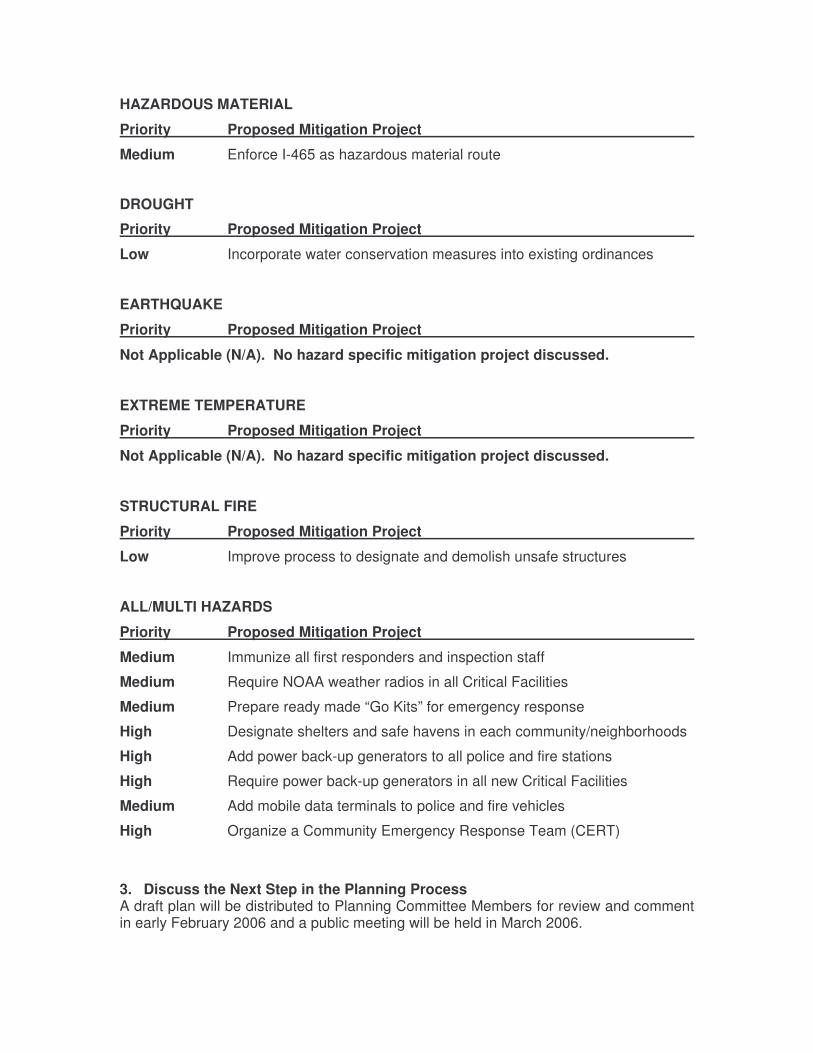
HAZARDOUS MATERIAL
Priority Proposed Mitigation Project
Medium Enforce I-465 as hazardous material route
DROUGHT
Priority Proposed Mitigation Project
Low Incorporate water conservation measures into existing ordinances
EARTHQUAKE
Priority Proposed Mitigation Project
Not Applicable (N/A). No hazard specific mitigation project discussed.
EXTREME TEMPERATURE
Priority Proposed Mitigation Project
Not Applicable (N/A). No hazard specific mitigation project discussed.
STRUCTURAL FIRE
Priority Proposed Mitigation Project
Low Improve process to designate and demolish unsafe structures
ALL/MULTI HAZARDS
Priority Proposed Mitigation Project
Medium Immunize all first responders and inspection staff
Medium Require NOAA weather radios in all Critical Facilities
Medium Prepare ready made “Go Kits” for emergency response
High Designate shelters and safe havens in each community/neighborhoods
High Add power back-up generators to all police and fire stations
High Require power back-up generators in all new Critical Facilities
Medium Add mobile data terminals to police and fire vehicles
High Organize a Community Emergency Response Team (CERT)
3. Discuss the Next Step in the Planning Process A draft plan will be distributed to Planning Committee Members for review and comment in early February 2006 and a public meeting will be held in March 2006.