mark scheme (results) summer 2016 pearson edexcel ... edexcel international gcse/certificate in...
TRANSCRIPT

Mark Scheme (Results) Summer 2016 Pearson Edexcel International GCSE/Certificate in Geography (4GE0/KGE0)

Edexcel and BTEC Qualifications Edexcel and BTEC qualifications come from Pearson, the world’s leading learning company. We provide a wide range of qualifications including academic, vocational, occupational and specific programmes for employers. For further information, please visit our website at www.edexcel.com. Our website subject pages hold useful resources, support material and live feeds from our subject advisors giving you access to a portal of information. If you have any subject specific questions about this specification that require the help of a subject specialist, you may find our Ask The Expert email service helpful. www.edexcel.com/contactus Pearson: helping people progress, everywhere Our aim is to help everyone progress in their lives through education. We believe in every kind of learning, for all kinds of people, wherever they are in the world. We’ve been involved in education for over 150 years, and by working across 70 countries, in 100 languages, we have built an international reputation for our commitment to high standards and raising achievement through innovation in education. Find out more about how we can help you and your students at: www.pearson.com/uk Summer 2016 Publications Code 4GE0_01_1606_MS All the material in this publication is copyright © Pearson Education Ltd 2016

General Marking Guidance
All candidates must receive the same treatment. Examiners must mark the first candidate in exactly the same way as they mark the last. Mark schemes should be applied positively. Candidates must be rewarded for what they have shown they can do rather than penalised for omissions. Examiners should mark according to the mark scheme not according to their perception of where the grade boundaries may lie. There is no ceiling on achievement. All marks on the mark scheme should be used appropriately. All the marks on the mark scheme are designed to be awarded. Examiners should always award full marks if deserved, i.e. if the answer matches the mark scheme. Examiners should also be prepared to award zero marks if the candidate’s response is not worthy of credit according to the mark scheme. Where some judgement is required, mark schemes will provide the principles by which marks will be awarded and exemplification may be limited. When examiners are in doubt regarding the application of the mark scheme to a candidate’s response, the team leader must be consulted. Crossed out work should be marked UNLESS the candidate has replaced it with an alternative response.
Placing a mark within a level mark band This guidance is to help with the rewarding of responses to the 6- and 9-mark items once the appropriate level mark band has been determined.
Level 1 responses will be valid but sketchy and show only basic awareness of the point of the question e.g. simple random points. Level 3 responses will be developed and considered with range and/or depth e.g. good use of examples and facts. Level 2 responses will show an attempt to address the command word with some development of the answer but will remain imbalanced/skewed/restricted/partial/limited.
1. 2 mark bands (the 6-mark “Explain” items)
Start with the presumption that the mark will be the higher of the two. A poorly supported response gets the lower mark.
2. 3 mark bands (the 9-mark “Discuss” items)
Start with the presumption that the mark will be the middle of the three. A poorly supported response gets the lower mark. A well supported response gets the higher mark.

Section A: The natural environment and people Question 1 – River environments
Question Number
Answer Mark
1(a)(i)
Accept any time in hours between 4 and 5 (1) (1)
Question Number
Answer Mark
1(a)(ii)
A - has shorter lag time or vice-versa re B (1) B - has lower peak discharge or vice-versa re A (1) Accept answers which show difference by quoting data. (2)
Question Number
Answer Mark
1(a)(iii)
A - a dam (1)
Question Number
Answer Mark
1(b)(i)
Full and accurate definition = 2 marks e.g. discharge exceeds channel capacity or equivalent; water table above ground. Statement with some valid hint of definition = 1 mark e.g. overflows banks (2)
Question Number
Answer Mark
1(b)(ii)
1 mark per valid and distinctive cause stated. 2nd mark for development as to how it causes flooding, e.g. high rainfall (1)> higher discharge (1)
Accept rainfall twice where different types identified e.g. heavy (1) & prolonged (1). Development to be distinctive for both development marks.
snowmelt (1) > increased run-off in spring raising river levels (1)
deforestation (1)> as per snowmelt development or reference to reduced infiltration and more run-off (1)
urbanisation (1)> tarmac/concrete increase (1) or drains take rainfall directly to river(1)
(4) (1+1) + (1+1)

Question Number Indicative content 1(c)
Expect to read about V-shaped valleys, interlocking spurs, waterfalls, potholes and their formation and early stage of development. Accept: meanders and channel variables (e.g. large bedload size; steep bed gradients...) provided answer refers to causation. Reject reference only to landform characteristics, e.g. shape, size, appearance of classic upper course landforms. Max marks with or without annotated diagrams. Fully annotated diagrams ok for max.
Level Mark Descriptor Level 1 1-2 Expect basic statements with little or no actual
explanation, e.g. appropriate upper course landforms identified.
Level 2 3-4 Expect some reference to valid landform formation, e.g. an attempt to explain; offering of an example(s). May focus on limited range of landforms, perhaps one only.
Level 3 5-6 Expect thorough explanation of at least two valid landforms. Good extended answer creating upper course context and accounting for the nature and formation of landforms.

Question Number Indicative content 1 (d)
This item is a management item and seeks a response about how water supplies are being managed to ensure adequate supply as demand grows all the time. Allow some small credit (2 marks max) for attention to reasons for rising demand. Some areas experience general shortages others seasonal shortage according to the pattern of weather. Many LICs have serious water supply problems, esp. of clean water. Candidates can legitimately write about water quantity and/or water quality. Responses about clean water supplies and quality control will need to refer to treatment works as well as water storage projects (e.g. dam and reservoir construction), water extraction schemes (e.g. from boreholes, rivers, the sea), water transfer schemes (from water-rich to water-poor areas) and pipeline networks. Reservoirs, boreholes, pipes, are likely to be how candidates see “ways.” Case studies of such projects and schemes, e.g. Hoover Dam water to central California; water movement within Spain; reservoirs in wet uplands, used properly will extend answers though this is not a purely case study item and max marks/Level3 do not require such. Accept demand-reduction programmes, e.g. rationing and to relevant current issues, e.g. Californian mega-drought; Middle East & “water wars” such as disputes over Nile water.
Level Mark Descriptor Level 1 1-3 Expect a sketchy presentation of simple points relating to
ways of guaranteeing adequate supplies. Answers may be focussed on either one way outlined or a number of ways little more than stated. Award this level for answers on causes of rising demand only.
Level 2 4-6 Expect an attempt to develop a partial consideration of valid ways of managing supplies to meet rising demand. Will be some development of ways such as storage projects or water movement schemes either in depth or breadth.
Level 3 7-9 Expect a balanced and detailed presentation of salient material about at least two ways (e.g. reservoir scheme; treatment works) well developed. May offer case study material and reasons for rising water demand. Expect some sense of examination/argument/evaluation.

Question 2 – Coastal environments
Question Number
Answer Mark
2 (a)(i)
Sea wall (1)
Question Number
Answer Mark
2(a)(ii)
B - To hold the coastline (1)
Question Number
Answer Mark
2(a)(iii)
Cost – hard engineering costlier or vice-versa (1) Environmental impact – e.g. hard engineering has greater environmental impact or vice-versa (1); soft engineering more visually attractive (1)
(2) (1+1)
Question Number
Answer Mark
2(b)(i)
Allocate 1 mark to each word in term i.e. natural = physical or non-human (1); system = e.g. cycle (1); stores and flows linked (1); integrated processes (1); one thing affects another (1)
(2) (1+1)

Question Number
Answer Mark
2(b)(ii)
Award 1 mark for each valid physical process identified e.g. wave erosion; wave deposition; longshore drift; mass movement; weathering. 2nd mark in each case for indicating the role of the process in the coastal system, e.g. longshore drift (1) moves material along coastline (1).
(4) (2 +2)
Question Number Indicative content 2(c)
This item will hopefully be answered in case-specific terms, e.g. coral reef case study but accept up to Level 2 a generic response in terms of the threat to ecosystems posed by tourism, industrialisation, agricultural practices, deforestation and economic development generally.
Level Mark Descriptor Level 1 1-2 Expect some basic points about ecosystem threats. Will be
stated only and perhaps generic. Answer may be coastal environment rather than specifically coastal ecosystem.
Level 2 3-4 Expect an attempt to explain the nature and/or cause of at least one threat. Threats will be partly developed in terms of range and depth.
Level 3 5-6 Expect a well-developed consideration of a range of threats (at least two) set in context of one named ecosystem for which specific locational ecosystem knowledge offered.

Question Number Indicative content 2 (d)
The variety of coastal landscape is partly due to changing sea level. Sea level rises resulting in retreating coastlines
(submergence). Sea level rising relative to the coast drowns the existing coastline creating new landforms, i.e. rias, fjords, new islands.
Sea level falls resulting in advancing coastlines (emergence). When sea level falls relative to the coast new coastline appears from the sea giving characteristic landforms, e.g. raised beaches, wave-cut platforms, relict cliffs.
Candidates may also write about coastal flooding with rising sea level (currently about 2 mm p.a. associated with global warming) and its impact on coastal lowlands, e.g. salt marshes, deltas. Responses about more frequent and more severe coastal flooding, the disappearance of low-lying islands, loss of land area, acceptable. Too much reference to the causes of sea level change, i.e. eustatic and isostatic or to coastal ecosystem impacts e.g. coral reefs is not credit-worthy. Diagrams of relevant landforms, e.g. fjords and examples e.g. Maldives, Bangladesh are credit-worthy.
Level Mark Descriptor Level 1 1-3 Expect a basic awareness of the impact of sea level change
on coasts with a few simple effects stated. Answer will be limited and skewed in coverage.
Level 2 4-6 Expect sea level change to be addressed albeit in a restricted consideration of its impact on coastal variety. Some development of key impacts, e.g. new landforms, coastal flooding ... Clear but unbalanced in terms of depth and/or breadth.
Level 3 7-9 Expect sea level change covered in reasonable depth and breadth with reference to both submergence and emergence. Shows good understanding of question of coastal variety with developed impacts. May offer place examples/case study material. May offer some attempt to evaluate by comparing/contrasting submergence/emergence in terms of determinants of coastal variety at the top of level, e.g. as to their relative importance in time and/or space.

Question 3 – Hazardous environments
Question Number
Answer Mark
3 (a)(i)
Eye Accept centre of hurricane (1); between 100-200 km. (1) (1)
Question Number
Answer Mark
3(a)(ii)
A - high wind (1)
Question Number
Answer Mark
3(a)(iii)
visibility rises as pressure falls (1) or vice-versa (1); high pressure and high visibility (1) or vice-versa (1).
in the eye rainfall and wind speed fall as pressure falls (1) or vice-versa (1); outside the eye falling pressure and increasing rainfall/wind speed (1) or vice-versa (1). N.B. rainfall/wind speed and pressure relationships more complex than pressure-visibility relationship so eye needs recognising in answers to rainfall and wind speed.
(2) (1+1)
Question Number
Answer Mark
3(b)(i)
Award 2 marks for full accurate definition, e.g. series of vibrations/shock waves (1) among the rocks in the Earth's crust (1). Part definitions, e.g. shaking ground; Earth tremors; ground movements = 1 mark
(2) (1+1)
Question Number
Answer Mark
3(b)(ii)
Credit each valid way identified with 1 mark, e.g. prediction (1); building design (1); emergency plans (1); communication systems (1) 2nd mark in each case for developing response so that mitigation evident, e.g. prediction (1) allows for warning/evacuation (1); earthquake-proof buildings (1) reduce chance of collapse (1)
(4) (1+1) + (1+1)

Question Number Indicative content 3 (c)
Volcanoes generally occur along plate boundaries, especially at destructive and constructive boundaries. Candidates will need to explain the processes taking place at these two types of boundary in order to answer the question. Diagrams of the processes occurring are appropriate as is reference to hotspot volcanoes away from plate boundaries.
Level Mark Descriptor Level 1 1-2 Expect basic statements about plate boundary location or
hotspots. May identify plate movement at one boundary type.
Level 2 3-4 Expect an attempt to explain and develop points about plate boundary movement process and causation. Reference may be one or both types of relevant plate boundary. e.g. both boundary type movements identified.
Level 3 5-6 Expect both types of plate boundary to be addressed with process explanation sound and developed. May offer examples though generic explanations can receive max.

Question Number Indicative content 3(d)
This can be a specification case study question – the comparative impacts of a tropical storm in an LIC and an HIC. Reference to contrasting hurricane impact on a West Indian island and the southern states of the USA is appropriate. The answer should focus on “how” the impact varies. Good answers will identify how the scale of an event’s impact will tend to vary according to level of economic development. Case study material showing how an event did actually vary in impact is very relevant. Natural disasters rather than hazard damage are more likely in LICs as both short-term and long-term impact. Good answers will distinguish between short- and long-term impact. Credit reference to hazard management (e.g. mitigation plans before plus actions during and after the storm's passage; differences in prediction and preparation; early warning; emergency services; evacuation) as a result of different levels of development, i.e. GDP; governance; infrastructure ...
Level Mark Descriptor Level 1 1-3 Expect simple statements about differing scale of impact
between HICs and LICs or a range of impacts not necessarily located in HICs or LICs. Likely to be generic and descriptive.
Level 2 4-6 Expect some development of the contrasting impacts as a result of management quantity/quality between HICs and LICs, e.g. warning > evacuation> lower death toll.
Level 3 7-9 Expect both HICs and LICs addressed and a clear sense of case-study style material offered, i.e. some depth of treatment and exemplification. Candidates offer responses assessing the contrasting impact, e.g. was like this in HIC and not like it was in LIC because… Strong discussions of comparative impacts of tropical storms generally (rather than of one as a case study) worthy of towards the top of this level. Expect some evaluative remark for max mark.

Section B People and their environments Question 4 – Economic activity and energy
Question Number
Answer Mark
4(a)(i) B - Biotechnology firm (1)
Question Number
Answer Mark
4(a)(ii)
Expect to point mark with 1 mark per valid observation, e.g. greenfield site (1); rural (1); open site (1); level ground (1); road access (1) attractive working environment (1); secure site (1); potential labour force/nearby settlement (1); near university (1); space for parking facilities (1); cheaper land (1); room for expansion (1).
(3) (1+1+1)
Question Number
Answer Mark
4(b)(i)
Max mark calls for full accurate definition e.g. decline in the importance of manufacturing (1) in an industrialised country (1). Award 1 mark for partial answers along right lines. e.g. factories close; less heavy industry .. (2)
Question Number
Answer Mark
4(b)(ii)
Award 1 mark to each valid and distinctive cause identified e.g. cheaper labour elsewhere (1); fewer rules and regulations elsewhere (1); raw material exhaustion (1); obsolete technology (1); sector shift (1) 2nd mark available in each case if factor developed into a full reason/cause, e.g. cheaper Asian labour (1) lead to global shift of manufacturing out of HICs in N. America and W. Europe (1).
(4) (1+1) +(1+1) or (1+1+1) + (1) or vice versa

Question Number Indicative content 4(c) This is a specification case study question – comparative
study of sectoral shifts in one HIC and one LIC along the lines of the Clarke-Fisher model. An LIC with a large primary sector, e.g. 50% of workforce, modest secondary e.g. 20% and tertiary sectors, e.g. 30% contrasts with a HIC with its large tertiary sector, e.g. 60%, modest secondary sector, e.g. 20%, small primary sector, e.g. 10% and emerging quaternary sector, e.g. 10%. For max marks this pattern needs to be set in the context of two named countries but should deal with explaining either how they differ or why differ (i.e. reasons behind pre-industrialisation, industrialisation and tertiarisation).
Level Mark Descriptor Level 1 1-2 Expect a few basic, perhaps random points about sectoral
size in one of more countries. Level 2 3-4 Expect some range of statements referring to the inter-
country contrasts. Response will be unbalanced and partial but have some development and attempt to explain. Generic answers re HICs/LICs acceptable.
Level 3 5-6 Expect a coherent and well-developed account of the key contrasts between two named examples with reference to all 3 main sectors. Some evidence of using case study type knowledge to explain how one differs from another including some suggested reasons. Precise detailed knowledge of the two named examples for top of level.

Question Number Indicative content 4(d)
Candidates are asked about the relative merits of using renewables, e.g. wind, tidal, solar versus non-renewables, e.g. coal, natural gas so responses that dwell on negative impacts (e.g. fossil fuels and air pollution; renewable and small scale) are worthy of less credit (i.e. limit to Level 2 max if written purely as negatives) than answer written in terms of positive aspects (e.g. renewables do not give off air pollutants; non-renewables are more efficient). Answers should focus on advantages/benefits/merits of renewable sources: will not run out environmentally cleaner – low carbon sustainable job creation & technology encouragement secure local supplies can be less expensive to run long term. Some may distinguish between types of renewable source, e.g. biomass renewable if usage does not exceed replenishment rate; tidal and wave power jobs and technology in W. Scotland. And EITHER non-renewable source advantages e.g. produce large amounts of power portable and internationally traded – export earnings extraction supports local economy can be cheaper to use start-up costs can be low not always an “eyesore.” OR their negative side e.g. polluting; import-dependence … so making for debate re renewable advantages. Some answers may differentiate between types of non-renewable source, e.g. oil imports open up export markets; secure nuclear electricity supplies. Some may develop an overall support or opposition argument to one or both energy types, e.g. renewables are better because ...
Level Mark Descriptor Level 1 1-3 Expect a limited range of points with little or no
development, e.g. renewables non-polluting. May offer negatives/ disadvantages, e.g. renewables do not produce much power.
Level 2 4-6 Expect some development of a number of key points. May be unbalanced with focus on one of the two types of source. Top of Level 2 expect evidence of some basic discussion or argument.
Level 3 7-9 Expect a range of well-developed relevant factors, at least two with balance between renewables and non-renewables. At top of Level 3, a coherent argument which evaluates each source type with some judgement given.

Question 5 – Ecosystems and rural environments Question Number
Answer Mark
5(a)(i)
Credit any valid observable piece, e.g. no people (1); closed shop (1); shuttered up/abandoned property (1) (1)
Question Number
Answer Mark
5(a)(ii)
D - rural depopulation (1)
Question Number
Answer Mark
5(a)(iii)
rural employment opportunities down because less farming employment (1)
less farming employment because of labour-saving mechanisation (1)
small farms/fewer tenant farmers as farms have increased in size (1)
more/cheaper imported food so less reliant on home/local production (1) greater variety (1).
Use professional discretion to accept valid alternatives.
(2) (1+1)
Question Number
Answer Mark
5(b)(i)
Max marks call for full and accurate definition, e.g. an area of valuable scenery (1) identified by government and managed by an authority (1). No credit for reasons for their establishment. 1 mark answers will be partial and may focus on protection or special landscape e.g. wilderness. (2)
Question Number
Answer Mark
5(b)(ii)
1st marks in each case for basic factor/reason, e.g. conservation (1); urban visitor needs/tourism (1); residents' interests (1); environmental protection (1) NOT just protection! 2nd marks available for developing it into full reason, e.g. urban visitors (1) access to enjoyment and understanding of the countryside is promoted (1) or survival of wilderness (1) or provide income for villagers (1).
(4) (1+1) + (1+1) or (1+1+1) +1 or vice-versa

Question Number Indicative content 5(c)
The different types of farming can be classified as: arable, pastoral and mixed commercial and subsistence intensive and extensive product-titled, e.g. rice farming, sheep farming, banana
plantation Candidates can focus on any one or more of these four classifications. Good candidates will be able to give meaning to at least two types, preferably in the same classification and relate it in an explanatory way to a type of distinctive rural environment/area e.g. sheep farming in hill country; arable farming on plains; intensive farming in rural areas close to cities; bananas in wet tropical environments ... A wide range of examples is acceptable with the thrust being on explaining farming decisions in terms of environmental location and/or socio-economic background. Environmental/socio-economic/ and farming contrast needs to be there in better answers.
Level Mark Descriptor Level 1 1-2 Expect a few simple, perhaps random points about farming
types in different environments/societies e.g. lists of relevant factors.
Level 2 3-4 Expect a partial, unbalanced account containing an attempt to explain one or two farming types with some reference to environmental/socio-economic factors, e.g. landscape, climate, access, tradition
Level 3 5-6 Expect clear understanding of the role of environmental factors in farming type decision-making. At least two farming types well explained in their environmental/socio-economic context. Expect the focus to be on “why” with consideration of named type of environment is fit for farming purpose identified.

Question Number Indicative content 5(d)
Achieving adequate food supply is a contemporary issue with various causes, including rising demand from continuing population growth, especially in LICs where famine, malnutrition and food shortages feature. Food supply is unequally distributed with food surpluses mostly in HICs while others experience shortage. This item is a question about policy and not directly about food shortage causes. Good candidates will write about farming strategies to raise production as well as ways to improve food distribution. Tackling shortages at the farming level involves improved agricultural technology; GM crops; HYVs; irrigation schemes; education schemes ... Tackling shortages at the distribution level involves better infrastructure and services, improved aid management, improved market access, outbreaks of peace, better storage.... Some candidates may justifiably recognise the role of factors beyond food and farming, e.g. birth control. Reward responses that take population control approach, i.e. fewer mouths to feed. Accept responses that refer to the variability of food supply within HICS (e.g. food banks in UK). Managing shortages, mostly in LICs and attempting to increase supply in a world of growing population, rising wealth and more extreme weather is a major challenge.
Level Mark Descriptor Level 1 1-3 Expect basic, perhaps random points about “how” farmers
might raise production, particularly in LICs or of other ways in which food supply can be increased.
Level 2 4-6 Expect some development of the key strategies/methods farming and food distribution may help to limit famine and malnutrition. Answer will have limited range (e.g. farming strategies only) but will present some sense in which food shortage is an important contemporary issue.
Level 3 7-9 Expect a coherent and balanced consideration of the challenge based on at least 2-3 well-developed ways in which farming and/or food distribution can contribute to food shortage alleviation. Some discussion/evaluation of the alternatives esp. at top of level. Can address LICs only.

Question 6 – Urban environments
Question Number
Answer Mark
6(a)(i)
Credit any valid observation from Figure 6, e.g. area around the power station has been cleared (1); evidence of building works e.g. cranes (1); new modern buildings (1); construction site (1) (1)
Question Number
Answer Mark
6(a)(ii)
C improving an urban area through investment (1)
Question Number
Answer Mark
6(a)(iii)
Both marks can be gained either if two distinctive points are made, e.g. close to central London (1); unused land (1); close to river/river view (1); close to open, green space (1) or if the two points have a valid link but are different, e.g. close to central London (1) and its jobs (1). Do not expect full developed reasons per mark.
(2) (1+1)
Question Number
Answer Mark
6(b)(i)
Max marks call for full and accurate definition e.g. plot of land rural/ urban-rural fringe (1) that has not yet been subject to development (1). N.B. greenfield sites can be in urban area! 1 mark for part definitions, e.g. never used land (1); natural land (1); rural fringe land (1) (2)
Question Number
Answer Mark
6(b)(ii)
Allow 1 mark for each legitimate basic reason/factor e.g. space (1); attractive environment (1); easy access (1); no clearance (1) 2nd marks for development into fuller reason offering partial explanation, e.g. easy access (1) for deliveries from outside local
area (1) space (1) for car parking attracts customers (1). room for expansion (1) increased production (1) attractive environment(1) helps recruit staff who
favour pleasant working conditions (1).
(4) (1+1) + (1+1) or (1+1+1) + (1) or vice versa

Question Number Indicative content 6(c)
Candidates are asked to refer to either HICs or LICs though not asked to explicitly state which. Credit generic answers or context-specific work as long as context clear. The problems facing rapidly growing urban areas whether LIC or HIC can be similar e.g. traffic congestion, air pollution … Good answers can be generic though problems must relate to rapidly growing urban areas rather than urban areas in general e.g. deindustrialisation, areas of decline/deprivation… Expect answers particularly in LICs to include mention of congestion, adequate transport provision, sufficient employment opportunities, street crime, under-provision of public services, low environmental quality…. With regard to HIC urban areas, accept issues associated with economic overheating, e.g. housing affordability; high cost of living, as well as the usual pressure on resources problems.
Level Mark Descriptor Level 1 1-2 Expect basic points lacking appropriate explanation,
perhaps problem(s) merely listed and generic in nature. Level 2 3-4 Expect some development of identified problems with a
partial attempt to explain. There will some depth or some range but answer will lack balance. LIC or HIC context may be offered.
Level 3 5-6 Expect an expanded answer with at least two well-developed problems set in an LIC or HIC context. Some generic responses neither HIC or LIC-specific may reach this level. Explanation must be present and examples may be offered.

Question Number Indicative content 6(d)
Planners, politicians (both central government and local community leaders), property developers and industrialists are key stakeholders in urban rebranding through the decisions they make. Good answers will either implicitly or explicitly show understanding that rebranding involves changing the outside world's view of an urban area. This is likely to require regeneration that covers both renewal (i.e. upgrading old buildings) and redevelopment (i.e. demolition and new buildings). Candidates will need to consider how stakeholders initiate ideas for the future of an area, grant permission to build and change land use, find funding, market an area's image… Rebranding and regeneration is a process in which various stakeholders play a part; the question asks for the part played by some to be considered. Examples from a regenerated and rebranded city may be helpful e.g. the part being played by the university building programmes in UK inner cities. Expect evaluation of the relative roles at the top level e.g. UK central government’s “northern powerhouse” initiative v. work of local business community.
Level Mark Descriptor Level 1 1-3 Expect either identification of legitimate decision
makers/stakeholders or a basic awareness of the urban rebranding (regeneration) process with some simple, perhaps random points possibly related to either rebranding or regeneration.
Level 2 4-6 Expect a clear but partial consideration of the process in which there is some range or depth but imbalance, e.g. focus on one aspect or decision maker/stakeholder. There will be some development of one or more stakeholder’s role and examples may be offered at the top of the level.
Level 3 7-9 Expect a sound and fairly comprehensive presentation of the process with some depth and range, e.g. the role of at least two different decision-makers is recognised and developed in terms of how they influence the regeneration/rebranding process. An identified example may be offered. Expect some evaluation of roles, e.g. how significant, degree of comparison ...esp. at top of level.

Section C Practical Geographical Enquiry Question 7 River Environments Fieldwork
Question Number
Answer Mark
7(a)(i)
B - invertebrates can be indicators of pollution levels (1)
Question Number
Answer Mark
7(a)(ii)
“… this investigation refers to a river water quality investigation. Point mark either 3x1 for relevant equipment listing e.g. base map (1); pH chemical testing kit (1); net (1); collection jars/beaker (1); test tubes (1); small white inspection dish (1); identification sheets (1); secchi disc (1); hand lens (1); gloves (1); stationary whether individual items (1) ... Or award 2 marks where one named piece of equipment (1) is either also described or its purpose given, e.g. net (1) used for dipping to extract samples of water
and its contents (1) ID sheets (1) show diagrams of main species of
invertebrates (1) Full marks always require the identification of at least two pieces of equipment.
(3) (1+1+1) or (1+1) + 1

Question Number
Answer Mark
7(a)(iii)
Ensure sources are secondary i.e. published/non-original for credit. Source needs identifying for 3-4 marks. 1-2 marks for up to 2 types of secondary data and a further 1-2 marks for linking to their valid sources. Data can relate to: pre-fieldwork background planning information
e.g. NRA (1) water depth or speed (1); OS Map (1) ease of access to water (1)
actual water quality/fieldwork or associated data e.g. previous water quality studies (1); local Planning Dept. searches (1); Meteorological Office (1) with 2nd marks once valid sources identified for initial mark for development so that it clear why research appropriate. Valid to respond in risk assessment and health & safety terms from a secondary source e.g. Met Office but only to one source, e.g. water depth (1) to avoid drowning in case fell in (1). Primary risk assessments not acceptable though previous one would be. Development marks need to be as distinctive as initial marks!
Previous water quality studies (1) give a framework to compare and contrast (1).
(4) (1+1)+(1+1)
Question Number
Answer Mark
7(b)(i)
Point mark an appropriate pH value collection method reserving 1 mark for point that method repeated at 2 other sites. Suggest other 3 marks awarded as follows: water sample(1); mix with ... (1) universal indicator/pH kit chemicals ; colour chart use (1) i.e. 3 basic stages with 1 mark each.
(4) (1+1+ 1+1)

Question Number
Answer Mark
7(b)(ii)
Expect responses referring to data collation and storage, e.g. spreadsheets and/or data presentation e.g. graphs/diagrams. Max marks can be for both or either one and awarded on a points basis e.g. developed a spreadsheet (1) to collate data collected (1) so that easily retrieved (1) choose which to represent graphically (1) Accept responses that include research, design and/or presentation as valid for credit.
(3) (1+1+1)
Question Number
Answer Mark
7(b)(iii)
1 mark per each of following: both axes labelled, e.g. species number; site (1) accuracy of plotting of mayfly data – 15 & 0 by, e.g.
dot or vertical line graph or bars or divided bar (1) ditto for maggot data – 0 & 5 (1) “ “ blood worm data – 1 & 6 (1) Accuracy required for credit.
(4) (1+1+ 1+1)

Question Number Indicative content 7(b)(iv)
Conclusions should relate to all the data (Fig. 7b) not just that presented in Fig. 7c. The following conclusions on variation can be reached from an analysis of Fig. 7b: pH drops from site 1 to site 3, i.e. water becomes more
acidic visual state quality drops most animals where plants and pH neutral blood worm (indicative of high pollution) where state of
river was poor and water most acidic N.B. cased caddis, mayfly & shrimps tend to indicate lower pollution levels. Water quality can be said to improve from 1 to 3 and then clearly deteriorates from 3 to 7. Better answers will see links and relationships between listed bullet-points and perhaps raise the possibility that factors other than pollution (e.g. water velocity ...) may be responsible for the freshwater animal population.
Level Mark Descriptor Level 1 1-2 Expect basic, perhaps random observations from the data.
Points may be merely based on Fig. 7c only. Level 2 3-4 Expect some development of basic points but answer will
be partial in terms of depth and range. Attempts to draw at least one conclusion of variation as opposed to mere site by site descriptions at top of level.
Level 3 5-6 Expect an expanded answer with at least two well-developed concluding statements. Will support statements with data and/or may use simple descriptive statistics such as a mean. Conclusions reached show evidence of links and relationships across the data.

Question 8 Hazardous environments fieldwork
Question Number
Answer Mark
8(a)(i)
C - Because there are opportunities for action at all three stages (1)
Question Number
Answer Mark
8(a)(ii)
“ ….this investigation” refers to interviewing to collect peoples’ views. Point mark either 3x1 for relevant equipment listing for interviewing, e.g. base map (1); stationary inc. individual items (1); personal ID (1); clipboard (1); voice recorder (1); mobile phone/camera (1) Or award 2 marks where identified piece of equipment (1) is either also described or its purpose given, e.g.
clipboard (1) to enable recording during interview (1)
voice recorder (1) into which interviewee speaks their responses (1)
Full marks always require the identification of at least two pieces of equipment. Allow for other than street interviews, e.g. postal; family & friends ... and credit accordingly
(3) (1+1+1)

Question Number
Answer Mark
8(a)(iii)
Ensure sources are secondary i.e. published/non-original for credit. Look to award 1-2 marks for identifying the type of secondary data and a further 1-2 marks for their named source e.g. local government. Data can relate to: pre-fieldwork background planning information e.g.
best day or time of day (1); place selection (1); ease of access to location (1); permission to interview (1)
actual interview/fieldwork or associated data e.g. previous questionnaire surveys (1); local Planning Dept. searches (1)
2nd marks once valid sources identified for initial mark for development so that it clear why research appropriate. Valid to respond in risk assessment and health & safety terms by identifying a source from which risks can be assessed but primary risk assessment not acceptable. Such risks to relate to only one source e.g. Local police (1) safe place selection (1). Development marks need to be as distinctive as initial marks! Previous questionnaire surveys (1) to check how distance-decay can affect results (1).
(4) (1+1) + (1+1)
Question Number
Answer Mark
8(b)(i)
Figure 8b stem refers to two locations and implies street or residence survey. Reserve 1 mark to basic idea of suitable site(s) chosen. Suggest other 3 marks awarded as follows: representative sampling (1); questioning/opinion-giving (1); recording of views (1). These 3 stages can be applied to street interviewing of pedestrians or other means of interviewing residents of an area.
(4) (1+1+ 1+1)

Question Number
Answer Mark
8(b)(ii)
Expect responses referring to data collation and storage, e.g. spreadsheets and/or data presentation, e.g. graphs/diagrams. Max marks can be for both or either one and awarded on a points basis, e.g. developed a spreadsheet (1) to collate data collected (1) so that data easily retrievable (1) can choose which to present graphically (1) Accept responses that include research, design and/or presentation as valid for credit.
(3) (1+1+1)
Question Number
Answer Mark
8(b)(iii)
1 mark per each of following: both axes labelled accurately, e.g. numbers;
before/during/after (1) accuracy of plotting/clarity of management quality
before event – 9, 10 & 1, e.g. bars or divided bar (1) ditto for during event – 11,6 & 3 (1) ditto for after event – 13, 6 & 1 (1) Accuracy required for credit.
(4) (1+1 +1+1)

Question Number Indicative content 8(b)(iv)
Conclusions should relate to all the data (Fig. 8b) not just that presented in Fig. 8c. The following conclusions can be reached from an analysis of Fig. 8b: views at 10 km away more favourable than at 1 km
away for all three times during and after management generally best received closest to event management least good lots of no opinions at both locations, especially for
before event management after the event seems to be well managed at 10 km before management generally the most neutral more people identify poorly managed during the event. Better answers will introduce the reasons why management was considered poor (e.g. lack of prediction & warning before the event), link it to distance from the event (e.g. 10 people at 1 km from event unhappy with emergency supplies) and support their conclusions with data.
Level Mark Descriptor Level 1 1-2 Expect basic, perhaps random observations from the data.
Points may be merely based on Fig. 8c only. Level 2 3-4 Expect some development of basic points but answer will
be partial in terms of depth and range. Attempts to draw at least one conclusion.
Level 3 5-6 Expect an expanded answer with at least two well-developed statements. May support statements with data and/or use simple descriptive statistics such as a mean. Evidence of links and relationships between the data reached.

Question 9 Ecosystems and rural environments fieldwork
Question Number
Answer Mark
9(a)(i)
C - quadrat (1)
Question Number
Answer Mark
9(a)(ii)
“… this piece of equipment” refers to a quadrat. Allocate 1 mark to each of following: lay on ground (1); easier if ground flat (1); work square by square (1); identify species in square (1); assess %s of species and bare ground in each square (1). Max marks available if callipers, augur or metre ruler’s role in ecosystem investigations described (avoiding double jeopardy re 9ai where candidate fails to identify quadrat). Award on a 4x1 mark basis as above e.g. metre ruler to measure soil depth (1); use along with augur (1); place on ground alongside augur (1); read off soil horizon depths/total soil depth (1)
(4) (1+1+ 1+1)
Question Number
Answer Mark
9(a)(iii)
Allocate 1 mark to one named sampling strategy e.g. systematic (1); random (1); stratified (1). Award up to 2 further marks for outlining its use in ecosystem component fieldwork, e.g. random sampling (1) use of random numbers table (1); use random numbers on grid square (1) created with two tapes (1). Mark use of strategy on points basis. Accept large sample as a strategy.
(3) (1+1+1)

Question Number
Answer Mark
9(b)(i)
Chart needs 4 lines in addition to the 0 line at 12 o’clock. Allocate 1 mark to each of these 4 lines provided the resultant slices appropriately labelled with plant name e.g. clockwise from 12 o’clock 10%-line separating bilberry from grass (1) 50%-line separating grass from heather (1); 60%-line separating heather from lichen; 85%-line separating lichen from bracken. Max mark needs 4 accurate lines and 5 correct labels. Without labelling max of 1 mark. 3 marks where one label missing. Accept pie completion where species plotted with largest % at 12 o’clock, i.e. grass and others arranged clockwise according to size. Max mark rule above still applies.
(4) (1+1+ 1+1)
Question Number
Answer Mark
9(b)(ii) Type 1 item
Award 1 mark for naming a simple statistical technique, e.g. mean (1); mode (1); median (1); average (1); best-fit line (1); trend line/trend (1); correlation (1) Remaining 2 marks to be awarded on a points basis for outlining its use with the data in Figure 9b, e.g. mean (1) calculate mean over the 3 sites (1) for
each plant species (1). correlation (1) simply correlate soil depth and soil pH
(1) negative correlation as depth increases pH falls (1)
(3) (1+1+1)

Question Number Indicative content 9(b)(iii)
Conclusions should relate to all the data, i.e. Fig. 9b, and not just that presented, i.e. Fig. 9c. Key plant diversity conclusions are: predominant species at 1 grass, at 2 heather and at 3
sphagnum moss all species present at site 2 least diversity at site 3 site 1 is plant-rich and balanced but site 2 most
biodiverse Reasons for this range of diversity may be related to the abiotic components of each site, e.g. shallowest soil where slope steepest and
heather/bilberry/ling dominate deep, peaty soil where gradient shallowest and
sphagnum dominates Better answers will offer biotic-abiotic relationships evident in the data as well as data support for these conclusions. Summary of data for the 3 sites: SITE 1 : lowest altitude (300m) “medium” soil depth (700cm) “medium” slope (1:30) most neutral pH of 6 grass dominant but all species except sphagnum SITE 2 : “medium” altitude (400m) steepest slope (1:20) shallowest soil (50cm) “medium” pH of 5.5 most diversity with all species (heather dominant) SITE 3 : highest altitude (450m) shallowest slope (1:50) deepest soil (1m) lowest pH of 4 (most acidic) lest diversity, mostly sphagnum
Level Mark Descriptor Level 1 1-2 Expect basic, perhaps random observations from the data.
Points may be merely based on Figure 9c only. Level 2 3-4 Expect some development of basic points but answer will
be partial in terms of depth and range. Attempts to draw at least one conclusion.
Level 3 5-6 Expect an expanded answer with at least two well-developed statements. May support statements with data. Evidence of links and relationships between the data reached.

Question Number
Answer Mark
9(b)(iv)
This item seeks to get candidates to appreciate that the accuracy of conclusions depends on: the entire fieldwork process (1) e.g. the accuracy
and reliability of the primary data collection (1); the appropriateness of the equipment (1); the suitability of the sites (1) sample size (1)
the post-fieldwork processes: data-conclusions match (1); additional research information sought (1); other secondary sources used (1); fit geographical “theory” (1)
Max of 3 marks for evaluating fieldwork process or reviewing post-fieldwork stage. Max mark answers to address both aspects.
(4) (1+1+ 1+1)

Question 10 Urban Environments Fieldwork
Question Number
Answer Mark
10(a)(i)
C - town street plan (1)
Question Number
Answer Mark
10(a)(ii)
“… this resource” refers to a street plan. Allocate 1 mark to each of following roles: means of transect selection (1); sampling site selection along transect (1); collating group work, e.g. meeting points (1); recording sheet, e.g. land use (1). Credit any other valid and distinctive role. Max mark available for reference to student sketch map, Goad shopping plan, OS map extract on a 4x1 mark basis e.g. OS map extract : choose transect (1);site selection (1); navigate on day (1); source of land use information (1).
(4) (1+1+ 1+1)
Question Number
Answer Mark
10(a)(iii)
Allocate 1 mark to one named sampling strategy, e.g. systematic (1); random (1); stratified (1). Award up to 2 further marks for outlining its use in EQ fieldwork, e.g. systematic sampling (1) representative transect line (1) group size large enough to give enough EQ scores at each assessment site to be statistically significant (1). Mark use of strategy on points basis, e.g. number of sites on transect; time dimension, credit-worthy aspect of sampling strategy. Accept large sample as a strategy.
(3) (1+1+1)
Question Number
Answer Mark
10(b)(i)
Four lines needing plotting for completion. Allocate 1 mark to each of the 4 lines and its attendant label i.e. line at 1 separating cleanliness from noise level (1); line at 5 separating noise level and building condition (1); line at 8 separating building condition and safety (1); line at 10 separating safety and visual appeal (1). Max mark requires 4 lines plotted and 5 correct labels. Without any labelling max of 1. 3 marks where one label missing.
(4) (1+1+ 1+1)

Question Number
Answer Mark
10(b)(ii)
Award 1 mark for naming a simple statistical technique e.g. mean (1); mode (1); median (1); average (1); best-fit line (1); trend line/trend (1); correlation (1) Remaining two marks to be award on a points basis for outlining its use with the data in Figure 10b, e.g. mean (1) calculate mean score for each site (1) by
.... (1) mode (1) most frequent score (1) at site ... is… (1)
(3) (1+1+1)
Question Number Indicative content 10(b)(iii)
Conclusions should relate to all the data, i.e. Fig. 10b, and not just that presented, i.e. Fig. 10c. Key conclusions are: site 2 has highest overall quality though noise given
modest score general quality lowest at site 1 with cleanliness and
safety real issues site 3 a mixed bag of scores significant between sites re cleanliness, building
condition and safety Look for responses that summarise, compare and contrast the three sites. Better answers will also offer data support for these conclusions and perhaps apply general findings to their knowledge of CBD edges, shopping high streets and town centre market areas, i.e. seek to explain general pattern.
Level Mark Descriptor Level 1 1-2 Expect basic, perhaps random observations from the data.
Points may be merely based on Figure 10c only. Level 2 3-4 Expect some development of basic points but answer will
be partial in terms of depth and range. Attempts to draw at least one conclusion.
Level 3 5-6 Expect an expanded answer with at least two well-developed statements. May support statements with data and seek to explain EQ variations identified. Evidence of links and relationships between the data reached (general pattern).

Question Number
Answer Mark
10(b)(iv)
This item seeks to get candidates to appreciate that the accuracy of conclusions depends on: the entire fieldwork process (1) e.g. the accuracy
and reliability of the primary data collection (1); the appropriateness of the equipment (1); the suitability of the sites (1) sample size (1)
the post-fieldwork processes: data-conclusions match (1); additional research information sought (1); other secondary sources used (1); fit geographical “theory” (1)
Max of 3 marks for evaluating fieldwork process or reviewing post-fieldwork stage. Max mark answers to address both aspects.
(4) (1+1 +1+1)

Section D Global issues Question 11 – Fragile environments
Question Number
Answer Mark
11(a)(i)
C - 1980s (1)
Question Number
Answer Mark
11(a)(ii)
Credit up to two significant and observable trends, e.g.
above long-term average before 1970 (1) below long-term average post-1970 (1) decline 1951-1985 (1) erratic (e.g. anomalies) since 1985
(2) (1+1)
Question Number
Answer Mark
11(a)(iii)
Credit any valid stated effect (1) or developed effect (2) e.g. drought (1); soil damage (1); wildlife changes (1) or drought (1) causes decline in vegetation (1) soil erosion (1) increases with drought (1) soil erosion (1) encourages desertification (1) Credit legitimate effects in years when rainfall higher e.g. better harvest (1)
(2) (1+1)
Question Number
Answer Mark
11(b)(i)
Max mark requires full and accurate definition e.g. the felling (1) and clearance (1) of forested land. Partial but valid statements, e.g. cutting down trees (1) burning (1).. No marks for examples.
(2) (1+1)
Question Number
Answer Mark
11(b)(ii) Allocate 1 mark to each valid and distinctive cause identified e.g. timber extraction (1); agriculture/ranching/oil palm plantations (1); mining (1); transport (1); settlement (1) 2nd marks for outlining/expanding linked to 1st mark so that cause clear, e.g. road building (1) across forest requires trees to be felled & cleared (1)
(4) (1+1+ 1+1)

Question Number
Answer Mark
11(b)(iii)
Reserve 1 mark for clarification of sustainability, i.e. forest conserved for future as well as used today (1). Commercial timber market is global so international cooperation essential if forests to be managed sustainably (1). Conserving forests will only work if all in the commercial timber chain support it, e.g. overseas timber buying companies (1); individual customers of timber products (1); international timber organisations involved with sustainable sources (1); kite marking of timber from sustainable sources (1) Up to 3 marks available for outlining the role of international cooperation. International action over global warming has a sustainable forest management dimension. Accept responses (max 2 marks) adopting this global warming stance, e.g. UN pressure to conserve carbon sinks; aid in return for deforestation slow-down deals.
(4) (1+1+ 1+1)

Question Number Indicative content 11(c)
The final bullet point in Figure 11b offers a start to this answer. Candidates should address the problems/threats to people (“human society”) and environments (“natural life-support systems”) from continued temperature rise and changes to the wider climate. The focus should be on why: people are threatened e.g. spread of tropical diseases;
coastal flooding from rising sea levels; migrations in search of water; famines and food shortage from droughts
environments are threatened e.g. ecosystem changes from vegetation fires; warmer oceans and marine extinctions; impacts on wildlife of extreme weather events
The consequences of global warming and climate change are mixed and much depends on location and context.
Level Mark Descriptor Level 1 1-2 Expect basic, perhaps random yet valid points of
consequence. Likely to sketchy and unbalanced in terms of people and environments.
Level 2 3-4 Expect a partial and unbalanced attempt to explain with some development of basic points of consequence. Some range or depth offered but can be unbalanced with attention to either people or environments only.
Level 3 5-6 Expect an expanded answer with some range, depth and balance. Two well-developed consequences will at least be offered. Expect attention to both people and environments.

Question Number Indicative content 11(d)
International policy to protect climate is a specification case study item, although whereas no case study material is asked for, material relating to actual measures taken will help the answer. Candidates should know of the UN view that 2 degrees C. is a safe threshold and that the work of the UNIPCC (United Nations Intergovernmental Panel on Climate Change) to hold warming to that threshold, e.g. Paris 2015 Conference. Measures since 1988 to reduce global warming, including the Kyoto Protocol (1997), have been general attempts to reduce greenhouse gas emissions. HICs have been working towards targets to cut carbon dioxide emissions to 1990 levels. Cutting emissions has involved encouraging renewable sources of energy; afforestation; changing agricultural practices; installing clean technology in cars, power stations; energy efficiency schemes in homes; carbon credits market; carbon capture Better candidates will attempt to comment on the effectiveness and outcomes of these measures to cut emissions, e.g. patchy take-up internationally; the reaction in the USA, India & China to UNIPCC initiatives
Level Mark Descriptor Level 1 1-3 Expect a basic awareness of the point of the question.
Sketchy response including a few simple actions. Level 2 4-6 Expect some development of the answer with valid
observations but unbalanced and restricted in range and/or depth. Some attempt to address specific measures, perhaps in a space-generic sense.
Level 3 7-9 Expect some depth of treatment with a coherent explanation of specific measures, at least two. Some evidence of evaluation of measures esp. at top of level. Shows good understanding of topic of trying to mitigate global warming by emissions control. Measures can be generic or country-specific. Expect an evaluative remark for max mark.

Question 12 – Globalisation and migration
Question Number
Answer Mark
12(a)(i)
Europe (1) (1)
Question Number
Answer Mark
12(a)(ii)
C - 410 000 (1)
Question Number
Answer Mark
12(a)(iii)
Credit any one of following points: operates in 150/many countries (1); employs worldwide 170 000 outside India (1); Figure 12a shows employees in 8 major regions of the world (1). (1)
Question Number
Answer Mark
12(a)(iv)
Credit basic valid point with 1 mark up to max of 2 e.g. major employer (1); major exporter (1) Max mark also for one fully developed point, e.g. major employer (1) providing earnings and spending power for 410 000 Indian workers (1).
(2) (1+1)
Question Number
Answer Mark
12(b)(i)
Max marks require full and accurate definition e.g. tourism that aims to conserve fragile ecosystems (1) and provide jobs and income for local people (1). Partial yet valid statements = 1 mark e.g. environmentally-friendly tourism (1); a sustainable form of tourism (1) ..
(2) (1+1)

Question Number
Answer Mark
12(b)(ii)
Accept any valid sustainable tourism project as ecotourism, e.g. Galapagos, Bhutan ... although no direct credit for name. Point mark descriptive points applicable to a named project, e.g. regulations (1); policing environmental impact policy (1); control tourist numbers (1); close relationship with local community (1); environmentally-conscious transport (1); funding local economy/using local sources (1) 2nd marks can be for developed points e.g. area made a National Park with regulations on tourists (1) no removal of natural materials such as plants (1).
(4) (1+1+ 1+1)
Question Number
Answer Mark
12(b)(iii)
Credit each valid factor with 1 mark e.g. increased leisure time (1); modern air transport (1); marketing (1); increasing wealth (1) 2nd marks in each case where factor developed into full reason, e.g. modern air transport (1) jet aeroplanes mean
nowhere more than about 24 hours travel time away (1).
increasing wealth (1) overseas travel and accommodation increasingly affordable to increasing numbers of people (1).
(4) (1+1+ 1+1) or (1+1+1) + 1 or vice-versa

Question Number
Indicative content
12(c)
Modern production from commodity acquisition to finished production sale tends to fit into a chain of activities, often covering different locations, perhaps across the world. Chains now tend to be more common and longer. The internationalised nature of many of these chains has gone hand-in-hand with the rise of the global economy, i.e. the fact that national economies are now so linked and intertwined into one worldwide economic system. Good candidates will make clear the meaning of globalisation, i.e. interdependence of countries. In order to explain why this growing interdependence has gone hand-in-hand with the growth of commodity chains, candidates should consider the following factors: there is more global trade (imports/exports) as companies
seek to access overseas markets for their products, e.g. free trade zones such as EU
more foreign investment as capital movements internationally are easier and encouraged
foreign aid obligations encourage greater global trade labour costs and quality vary from country to country and
encourage outsourcing modern transport is fast, reliable and plentiful and supports
greater international trade information technologies allow business to operate worldwide. These and other developments encourage the growth of production and commodity chains. The question set is one of causation; why there are more and longer chains in today’s global economy. They are there to exploit local advantages by business, which is largely motivated by profits, costs, markets ... Figure 12b is a piece of data-stimulus no more !
Level Mark Descriptor Level 1 1-2 Expect basic valid points made, perhaps random,
undeveloped relevant factors but lacking explanation. Level 2 3-4 Expect some attempt to explain with key factors
characteristic of globalisation but response limited in either range or depth. One well-developed relevant factor can be credited at this level.
Level 3 5-6 Expect some well developed reasons, at least two behind the growth of chains and their link into the globalisation process evident. Answer should have good depth or range and a clear understanding of the nature and role of these chains in globalisation and the modern global economy.

Question Number Indicative content 12(d)
This is a specification case-study item with the answer focusing on consequences of the migration flow. Many may offer contemporary flows, e.g. Africans to southern Europe; Middle East to western Europe; Mexicans to USA ... More historic flows equally acceptable but there should be clarity about the identity of the source and destination country. The consequences can be benefits and/or costs for the country not the individual migrant, e.g. Source country: benefits, e.g. some migrants send
foreign currency back home; pressure on public services reduced costs, e.g. loss of labour supplies; investment in their education wasted
Destination country: benefits, e.g. lower labour costs; cultural enrichment costs, e.g. increased demands on public services; social tension
Guard against crediting anti-immigration comments where the tone is xenophobic and racist!
Level Mark Descriptor Level 1 1-3 Expect basic awareness of point of question. Simple,
sketchy, random points, perhaps generic. Level 2 4-6 Expect a clear but restricted consideration of some key
points though response likely to be unbalanced and lacking in depth or breadth. Attempts to mount an argument. Expect both source and destination countries addressed at top of level.
Level 3 7-9 Expect a coherent, balanced argument with a number of developed points and both source and destination country covered. Expect an element of evaluation, e.g. weighing up costs and benefits esp. at top of level.

Question 13 – Development and human welfare
Question Number
Answer Mark
13(a)(i)
Qatar (1)
Question Number
Answer Mark
13(a)(ii)
B countries with higher GDP pp usually have higher happiness ratings (1)
Question Number
Answer Mark
13(a)(iii)
Award 1-2 marks as per examples below for any valid observation that GDP pp and happiness index are not always positively correlated on Figure 13a, e.g. Qatar versus Cyprus (1) happiness ranking almost
identical but GDP pp vastly different (1) Pakistan versus Togo (1) similar GDP pp but
happiness level quite different (1) Qatar highest GDP pp (1) but not highest happiness
(1) (2) (1+1)
Question Number
Answer Mark
13(a)(iv)
Credit any recognised quality of life indicator, i.e. housing (1); health (1) literacy rate (1); life expectancy (1) or one of those being commonly used in happiness and well-being studies, e.g. degree of equality (1); human rights (1); sense of family (1); unemployment rate (1) Exercise professional discretion! Avoid crediting purely economic measures, e.g. GDP/GNI; employment by sector (1)
Question Number
Answer Mark
13(b)(i) Max marks call for full, accurate definition, e.g. simple equipment appropriate to LICs that meets their local needs. Partial statement along the right lines = 1 mark, e.g. technology suited to know-how in LICs (1); easy to use technology (1) ...
(2) (1+1)

Question Number
Answer Mark
13(b)(ii)
For max marks answer needs to look at both the use of intermediate technology, i.e. easily learned (1); easy to maintain (1); affordable (1) but max of 1 mark for reference to use its encouragement of development, i.e. bottom-up
development (1); time-saving (1); raises rural production (1)
Creditable responses can be brief (1) or developed points (2).
(4) (1) + (1+ 1+1)
Question Number
Answer Mark
13(b)(iii)
Award 1 mark to valid and distinctive ways identified e.g. foreign aid (1); fair & freer trade (1); debt relief (1); infrastructure investment (1); agricultural revolution (1); encourage TNCs (1); micro-finance (1); education (1) 2nd marks for outlining/developing a valid factor into a clear way in which economic development encouraged.
(4) (1+1) + (1+1) or (1+1+1) +1 or vice-versa
Question Number Indicative content 13(c)
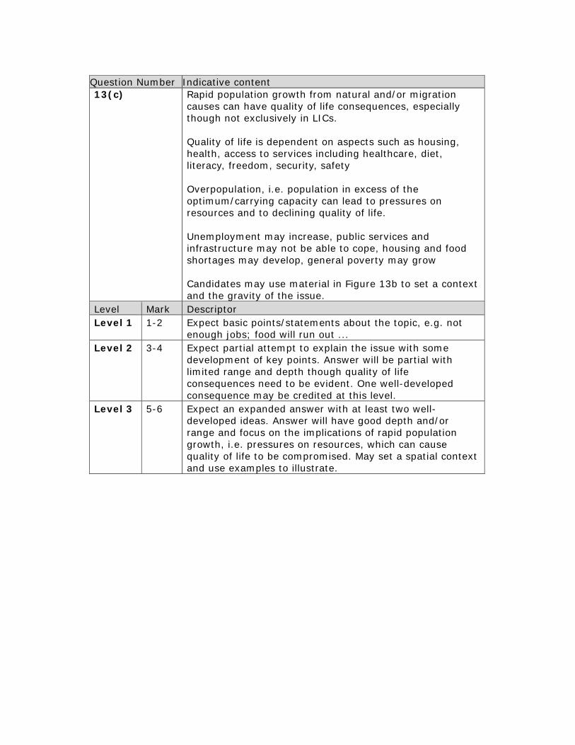
Rapid population growth from natural and/or migration causes can have quality of life consequences, especially though not exclusively in LICs. Quality of life is dependent on aspects such as housing, health, access to services including healthcare, diet, literacy, freedom, security, safety Overpopulation, i.e. population in excess of the optimum/carrying capacity can lead to pressures on resources and to declining quality of life. Unemployment may increase, public services and infrastructure may not be able to cope, housing and food shortages may develop, general poverty may grow Candidates may use material in Figure 13b to set a context and the gravity of the issue.
Level Mark Descriptor Level 1 1-2 Expect basic points/statements about the topic, e.g. not
enough jobs; food will run out ... Level 2 3-4 Expect partial attempt to explain the issue with some
development of key points. Answer will be partial with limited range and depth though quality of life consequences need to be evident. One well-developed consequence may be credited at this level.
Level 3 5-6 Expect an expanded answer with at least two well-developed ideas. Answer will have good depth and/or range and focus on the implications of rapid population growth, i.e. pressures on resources, which can cause quality of life to be compromised. May set a spatial context and use examples to illustrate.

Question Number Indicative content 13(d)
Candidates are asked to consider the causes of the North-South divide in a global sense, i.e. the global development gap. There remains a huge disparity in wealth and level of development (both economic and human) between the HICs of N. America, W. Europe (parts of Northern Hemisphere) plus Australasia and LICs in Africa, S. America and parts of Asia (Southern Hemisphere). Despite the existence of some emerging economies, there is vast and arguably increasing development gap at this spatial scale. The crux of the answer should relate to factors that contributed to these global inequalities: industrialisation colonialism and trade war governance and political leadership natural resources natural and human hazards debt Where candidates refer to relevant factors e.g. core; periphery; industrialisation; trade; natural resources but set in a spatial scale other than global e.g. regional then credit up to a max of L2 top. Candidates may address the existence of the gap, i.e. its symptoms and extent rather than or as well as causation; limit such responses only to bottom of Level 2. Better candidates may point out that the gap at this spatial scale is a general pattern and that, for example, affluence does exist in LICs & the so-called poor South.
Level Mark Descriptor Level 1 1-3 Expect a basic awareness of the global development gap
and some simple, sketchy points about either its causes or symptoms/extent.
Level 2 4-6 Expect some valid reasons/causes with some development but consideration of topic partial and unbalanced. Some breadth or depth to answer. Needs to address causation/why exists.
Level 3 7-9 Expect a good understanding of the question set. Answer has good range and/or depth in the causes offered. At least 2-3 well-developed causes offered. Expect an element of evaluation, e.g. the significant reason; interplay between factors especially at top of level.

Pearson Education Limited. Registered company number 872828 with its registered office at 80 Strand, London WC2R 0RL