marlboro area transportation study appendicies
DESCRIPTION
Appendix A: Map1- Real Property Classification of Hamlet Map2- Environmental Features of Hamlet Map3- Historic and Cultural Features of Hamlet Map 4- Exisitng Zoning Appendix B- Parking StudyTRANSCRIPT

The Marlboro Hamlet Area Transportation Plan DRAFT Report August 2008
Creighton Manning Engineering | Behan Associates
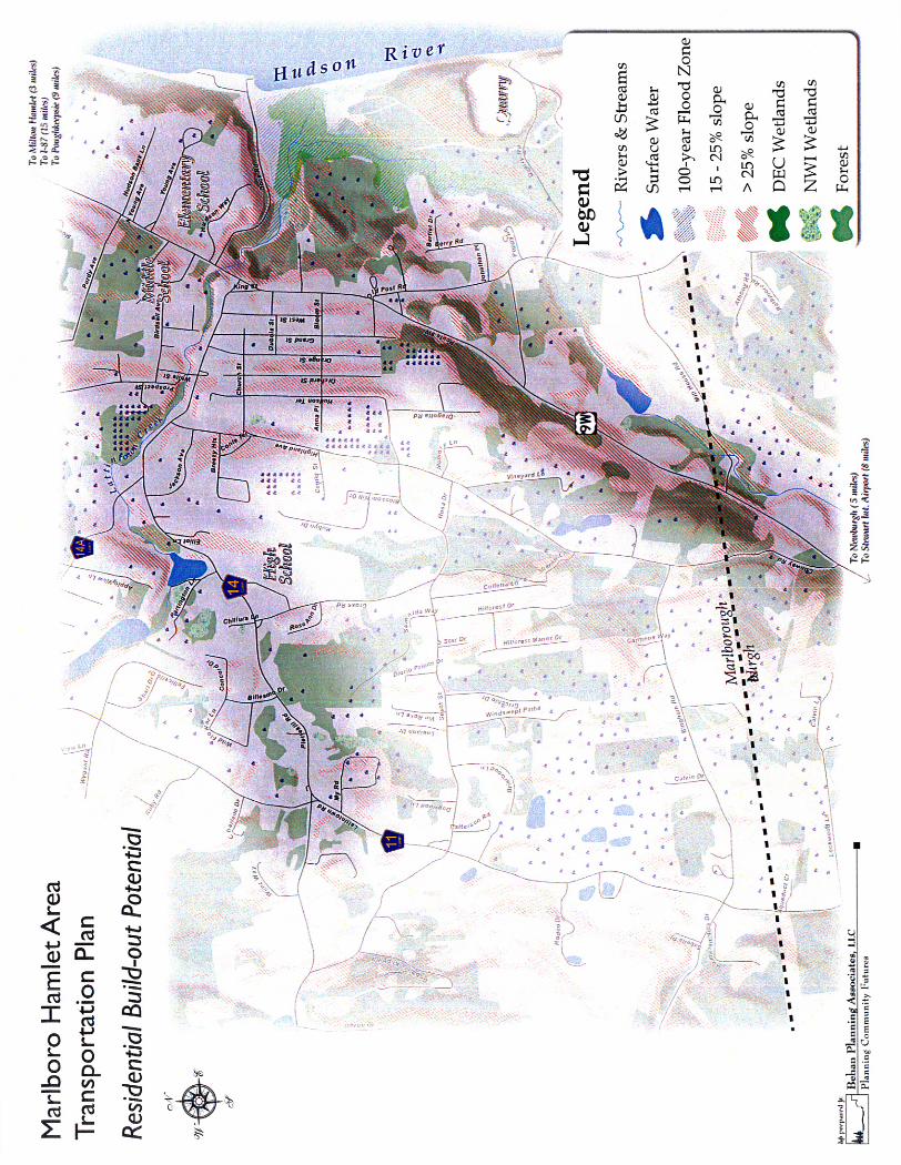
Appendix A – Land Use Maps
Marlboro Hamlet Area Transportation Plan Town of Marlborough, New York


The Marlboro Hamlet Area Transportation Plan DRAFT Report August 2008
Creighton Manning Engineering | Behan Associates
Appendix B – Parking Study Memorandum
Marlboro Hamlet Area Transportation Plan Town of Marlborough, New York
Marlboro Hamlet Area Transportation Plan Appendix – B Page 1 of 2
17 COMPUTER DRIVE WEST ALBANY, NY 12205 PHONE 518-446-0396 FAX 518-446-0397
Memo To: Dennis Doyle & Bill Tobin
From: Dan Reynolds & Mark Sargent, P.E.
CC: Advisory Committee
Date: April 29, 2008
Re: Parking Study
Project: Marlboro Hamlet Area Transportation Plan
CME Project No. 07-110d
1.0 Methodology A parking accumulation and duration study was conducted for the above referenced project on April 10, 2008 in the Hamlet of Marlboro, NY. The study included on-street and off-street parking areas in close proximity to the Hamlet Center. The limits of the study area and time of study were confirmed in consultation with the Study Advisory Committee which includes Town officials, business owners and representatives from Ulster County, and the NYSDOT. The study area was surveyed every half hour between 10:00 AM and 2:30 PM. Weather during the data collection was 70 degrees and sunny. A map of the study area is included in Attachment A. 2.0 Observations See Attachment B – Data Summary and Occupancy Information, for a summary table and occupancy map.
• There are a total of 215 parking spaces in the study area (83 on-street and 132 in parking lots). • The overall peak parking demand for the study area occurred between 12:00 and 12:30 pm,
when 94 parking spaces (44% of the total supply) were occupied. • The west side of King Street experienced the highest on-street parking demand averaging 71%
occupied, and peaking at 83% occupancy. • The Key Bank lot experienced the highest off-street parking demand averaging 74% occupied,
with a peak of 93% occupancy. • The angled parking along Western Avenue was approximately 60% occupied during its worst-
case observation, meaning there is typically some reserve parking available. • Similarly, the east side of Route 9W near the Raccoon Saloon saw a maximum parking demand
of 50%. • Parking demand is concentrated around the Western Avenue/King Street intersection with more
available spaces being found on the fringes of the study area. • The average length of stay for a vehicle in the study area was approximately 1.4 hours. • 13% of all vehicles observed were parked during the entire length of the study. • Parking turnover varied based on location but was most prominent near eateries and other
businesses.

Marlboro Hamlet Area Transportation Plan Appendix – B Page 2 of 2
• Parking regulation signs did not clearly identify the beginning and end of parking zones. 3.0 Conclusions & Recommendations Based on these observations, vehicles are parking along the north side of Western Ave, west side of King Street, and in the Key Bank parking lot with more frequency than other locations in the study area. Vehicles are typically parked very close to the destination with less people parking further away and walking. Signs warning people that their car will be towed located in private lots such as Carmichael’s Deli, Lou’s Spirits, and Pizza Works, may contribute to the street spaces being more congested while those lots remain relatively empty. The average length of stay for two hour parking was approximately 1 hour, and it appears that the parking regulations were being followed. The study concludes that when parking occupancy is at its greatest there are still open spaces available directly in front of or near destinations. Nevertheless, shared parking should be pursued with private lot owners and those business owners with relatively empty lots such as Marlboro Market and Carmichael’s Deli. Releasing the restriction on their lots could help reduce congestion of the on street parking and balance the overall parking supply. The study also concludes that a small reduction in the overall parking supply could be tolerated, where curb-bump outs and pedestrian crossing improvements may impact a few spaces. F:\Projects\2007\07-110d\traffic\Parking Study\07-110d Parking Memo.doc

Attachment A – Study Area Limits
Appendix B - Parking Memorandum Marlboro Area Transportation Plan
Town of Marlborough, New York


Attachment B – Data Summary & Occupancy Information
Appendix B - Parking Memorandum Marlboro Area Transportation Plan
Town of Marlborough, New York

Marlboro Parking StudyConducted 4/10/08 10AM - 2PMCME Project: 07-110d
CarsAvg. Length Parked
Parking of Stay Unique EntireBlock Face/ Lot Type (Hrs) Capacity 10:00AM 10:30 AM 11:00 AM 11:30 AM 12:00 PM 12:30 PM 1:00 PM 1:30 PM 2:00 PM Total Avg Occ. Cars Study
1A NA NA NA NA NA NA NA NA NA NA NA NA NA NA NAoccupancy % NA NA NA NA NA NA NA NA NA NA NA
1B P 1.42 5 3 2 3 2 2 2 1 2 3 20 5 1occupancy % 60% 40% 60% 40% 40% 40% 20% 40% 60% 44%
2A NA NA NA NA NA NA NA NA NA NA NA NA NA NA NAoccupancy % NA NA NA NA NA NA NA NA NA NA NA
2B D, 2HR 0.78 28 9 10 16 18 16 16 11 12 12 120 57 5occupancy % 32% 36% 57% 64% 57% 57% 39% 43% 43% 48%
3A P, 2HR 0.75 12 4 3 2 2 3 3 3 1 2 23 11 1occupancy % 33% 25% 17% 17% 25% 25% 25% 8% 17% 21%
3B P 0 3 0 0 0 0 0 0 0 0 0 0 0 0occupancy % 0 0 0 0 0 0 0 0 0 0 0 0
4A P, 2HR 0.39 10 1 0 1 4 5 2 5 4 6 28 22 0occupancy % 10% 0% 10% 40% 50% 20% 50% 40% 60% 31%
4B NA NA NA NA NA NA NA NA NA NA NA NA NA NA NAoccupancy % NA NA NA NA NA NA NA NA NA NA NA
5A P 0.25 5 2 0 0 0 0 0 0 2 3 7 7 0occupancy % 40% 0% 0% 0% 0% 0% 0% 40% 60% 16%
5B P 2.5 5 1 1 1 1 1 1 2 2 1 11 2 1occupancy % 20% 20% 20% 20% 20% 20% 40% 40% 20% 24%
6A P, 2HR 0.45 3 1 2 1 0 1 2 3 2 2 14 10 0occupancy % 33% 67% 33% 0% 33% 67% 100% 67% 67% 52%
6B P 1.78 12 7 9 8 7 9 9 10 10 8 77 19 4occupancy % 58% 75% 67% 58% 75% 75% 83% 83% 67% 71%
Subtotal (On - Street) Avg = 1.04 Hrs 83 28 27 32 34 37 35 35 35 37 300 0 133 12Occupancy % 34% 33% 39% 41% 45% 42% 42% 42% 45%
Page 1 of 2

Marlboro Parking StudyConducted 4/10/08 10AM - 2PMCME Project: 07-110d
CarsAvg. Length Parked
Parking of Stay Unique EntireBlock Face/ Lot Type (Hrs) Capacity 10:00AM 10:30 AM 11:00 AM 11:30 AM 12:00 PM 12:30 PM 1:00 PM 1:30 PM 2:00 PM Total Avg Occ. Cars Study
Lot A (Marlboro Market) Cust. 0.6 24 4 3 4 6 7 7 4 2 2 39 22 0occupancy % 17% 13% 17% 25% 29% 29% 17% 8% 8% 18%
Lot B (Café Spuntino) Cust/Res. 1.36 12 5 5 4 5 9 9 8 7 6 58 18 4occupancy % 42% 42% 33% 42% 75% 75% 67% 58% 50% 54%
Lot C (Retail/Residential) Res./Emp. 3.5 6 4 4 4 4 3 3 3 3 2 30 4 2occupancy % 67% 67% 67% 67% 50% 50% 50% 50% 33% 56%
Lot D (Keybank) Cust. 0.97 14 10 10 11 10 11 8 10 10 13 93 38 5occupancy % 71% 71% 79% 71% 79% 57% 71% 71% 93% 74%
Lot E (Env. Labor Works) Emp. 2.38 35 6 7 7 6 8 7 8 7 7 63 12 6occupancy % 17% 20% 20% 17% 23% 20% 23% 20% 20% 20%
Lot F (Retail) Cust. 2.85 6 1 1 4 4 4 5 4 4 4 31 5 1occupancy % 17% 17% 67% 67% 67% 83% 67% 67% 67% 57%
Lot G (Pizza Works) Cust. 1.11 15 4 5 3 4 10 6 10 10 7 59 22 3occupancy % 27% 33% 20% 27% 67% 40% 67% 67% 47% 44%
Lot H (Lou's Spirits) Cust. 1.3 8 2 3 3 3 3 4 4 3 5 30 10 1occupancy % 25% 38% 38% 38% 38% 50% 50% 38% 63% 42%
Lot I (Carmichaels Deli) Cust. 1.05 12 2 1 2 1 2 2 1 1 1 13 5 1occupancy % 17% 8% 17% 8% 17% 17% 8% 8% 8% 12%
Subtotal (Parking Lots) Avg = 1.68 Hrs 132 38 39 42 43 57 51 52 47 47 416 0 136 23Occupancy % 29% 30% 32% 33% 43% 39% 39% 36% 36%
Total Avg = 1.38 Hrs 215 66 66 74 77 94 86 87 82 84 716 0 269 35Occupancy % 31% 31% 34% 36% 44% 40% 40% 38% 39%
Key:P = ParallelD = DiagonalNA = Parking Not AvailableCust. = Customer, Emp. = Employee, Res. = Residential
Page 2 of 2

The Marlboro Hamlet Area Transportation Plan DRAFT Report August 2008
Creighton Manning Engineering | Behan Associates
Appendix C – Public Workshop Summaries
Marlboro Hamlet Area Transportation Plan Town of Marlborough, New York

Marlboro Hamlet Area Transportation Plan January 17, 2008 Public Workshop Summary Notes
Overview: The first public workshop for the Marlboro Hamlet Transportation Plan was held on Thursday, January, 17, 2008 at the Marlboro Middle School off of Route 9W. The workshop was attended by more than 60 residents and stakeholders. The workshop began with a presentation by the consulting team of Creighton Manning Engineering and Behan Planning Associates which outlined the project goals; existing conditions with respect to transportation and land use; and potential opportunities for the corridor and hamlet. After the presentation, residents met in smaller groups with facilitators from Creighton Manning Engineering, Behan Planning Associates, Ulster County Planning, and Ulster County Transportation Council to discuss concerns and opportunities for the corridor and hamlet in more depth. Within these groups, participants were asked to identify areas of stability (places that they wanted to keep the same) and areas of change. Participants were also asked to identify desired connections (such as road connections, sidewalk connections, or trail connections). Lastly, they were asked to prioritize their desired improvements into a wish list. After the wish lists were developed, they were all placed together on the wall and participants were asked to vote by placing stickers next to their top five priorities. Below is a summary of the results. Workshop Results: Areas of stability (places or topics that the participants wanted to keep or maintain in the corridor):
• Existing businesses in the hamlet • King Street south (going out of hamlet) • The feel of the town and hamlet • Location of the schools • Location of fire station • Historic buildings • Orchards and open lands/views
Areas of change (places or topics that the participants wanted to change or improve in the corridor):
• Senior housing area • Intersection at Young Avenue • Triangle area (King St.-9W-Western Ave.) • Lack of parking -- a problem for businesses and residents • Lack of crosswalks -- a problem for businesses and residents • Corner of Western Ave./9W -- a problem for truck traffic • Infrastructure improvements (sewer and water) needed
Page 1

Marlboro Hamlet Area Transportation Plan January 17, 2008 Public Workshop Summary Notes
Opportunities for improvements:
• Integrate parking into future development projects near the hamlet • Parcel south of the intersection of Dock Road with 9W (currently vacant – could
become parkland, access, etc.) • Parking for post office • Create “gateways” at edges of the hamlet. Several groups suggested a southern
gateway at Old Post Road/9W intersection • Develop sidewalks between the hamlet and the schools • Incorporate street trees, lights, and aesthetic features into roadway redesign • Parcel at Grand and Church Street – key open parcel • Potential for commercial development along the west side of Route 9W between
Middle School and Purdy Ave. • Provide areas for viewing the Hudson River north of Raccoon Saloon (good
views) • Look into adding a light at Bloom Street/library • Consider locating the utilities underground • Install big crosswalks and a pedestrian push button at the Raccoon Saloon area • Reduce speed from Purdy going south into hamlet • Consider a roundabout at the King/9W intersection • Add crosswalk at St. Mary’s Church area • Consider a light at old Post Road and 9W • Consider local park potential at “Dockside” parcel (views overlooking river) • Improve the turning radius at NW corner of 9W/Western • Explore speed limit reduction
Desired connections:
• Middle school should be connected to future sidewalks on 9W • Sidewalks are needed between middle school and Route 9W on Birdsall Ave. • Crosswalks and sidewalks needed throughout hamlet • Road connection from Birdsall Ave. through to Western Ave • Road connection from Purdy to Prospect Street • Connect 90-unit (approved) project on NE corner of Highland and South St.
(roads and sidewalks) to Route 9W • Connect Gerentine Way (roads and sidewalks) through to Birdsall Ave. and any
future development (such as proposed Bayside development) • Sidewalks or trail between high school and hamlet on Western Ave. • Road connection from Highland to Birdsall to 9W
Page 2
Marlboro Hamlet Area Transportation Plan January 17, 2008 Public Workshop Summary Notes
Summary of Wish Lists: Top Five Priorities for the Corridor #1: Sidewalks/Crosswalks Sidewalk and crosswalk connections in and near the hamlet was the highest priority for workshop participants. Sidewalk connections between the schools and the hamlet were also priority. Several participants noted Port Ewen in Ulster County as a good example for streetscape improvements. Below are some of the specific ideas related to sidewalks and crosswalks:
• Sidewalk along Birdsall Ave. • Sidewalks to elementary school and high school from 9W • Sidewalks or trail to High School from hamlet • Sheltered sidewalks and curbing (CVS to hamlet, Western to Marlboro High
School) • Crosswalks needed at St. Mary’s, Library St., Western Ave., Schools, Raccoon
Saloon #2: Traffic Intersections, Flow and Safety The majority of participants were concerned about traffic movement along Route 9W. Participants want the traffic to continue to move through the hamlet while also ensuring that safety is met. Many suggestions for additional traffic lights and turning lanes were provided towards this end. Some of these are listed below:
• Traffic lights at King Street and Western • Traffic lights at Dock Rd. and Schools • 3rd turn lane from Milton through the Town of Marlborough • Traffic light by the library • Roundabout near King Street • Left turn lane onto Western Ave • Push-button signals at intersections • One-way counter-clockwise traffic flow in hamlet
#3: Parking in the Hamlet Many participants were concerned about the lack of parking in the hamlet. Business owners were particularly concerned because they are affected financially by the lack of parking. Participants noted the challenges associated with on-street parking in the hamlet. Most participants felt that the best alternative might be to identify a site close to the hamlet for a parking structure. Below are some of the suggestions:
• Shared parking behind existing businesses • Public parking at Dock Rd. and behind post office • Municipal parking at the corner of Western and West • Striped parking spaces
#4: Traffic Calming/Speed Reduction Some participants were concerned with slowing down traffic as it enters the hamlet. Traffic calming alternatives such as reducing the speed limit and design alternatives such as a planting strip or raised median were mentioned. Below are some specific comments related to traffic calming:
Page 3

Marlboro Hamlet Area Transportation Plan January 17, 2008 Public Workshop Summary Notes
• Planting strip to calm traffic (tree planting or medians) in hamlet center • Reduce speed from Lyons Lane to South • Reduced speed limit near schools
#5: Aesthetics Improving the aesthetics of the hamlet was important to many participants. Streetscape improvements which include street trees, lighting, and other features were discussed. Other improvements such as providing viewing points of the falls and the Hudson River were suggested. Below are a few specific suggestions:
• Walkways/park at falls near bridge • Bridge beautification at Dock Rd. • Aesthetics/beautification/lighting of hamlet streetscape
Other ideas that were discussed:
• Enhance commercial accessibility • Create detours for accidents • Police officer needed to direct 9W traffic • Alternative route to the north from Western Ave. • Define/close up curb cuts (such as at gas station and funeral home) • Gateway at Post Road and South Street • Commercial development north of hamlet • Divert school buses from King/9W to Western/9W • Connection African Lane to Hudson Lane (trail) • Apartments above retail
F:\Projects\2007\07-110d\public involvement\Public Meeting 1\1-17-08 Workshop Summary.doc
Page 4

Marlboro Hamlet Area Transportation Plan
Public Workshop #2 May 29, 2008
WORKSHOP SUMMARY
The second Public Workshop for the Marlboro Hamlet Area Transportation Plan was held on May 29, 2008 at 5:30 pm at the Marlboro Middle School. The purpose of the meeting was to present and receive comments on the developed transportation alternatives for the Hamlet, as well as the Overall Land Use and Transportation Recommendations. The workshop was advertised online on the Town of Marlborough website and through local news publications. Meeting flyers were posted at the Library and the Town Hall. The workshop was attended by approximately 25 people. Appendix A contains the attendance sheets. The meeting was facilitated by Mark Sargent of Creighton Manning Engineering (CME). The workshop began with an open house session in which the transportation alternatives for the Hamlet and the Overall Land Use and Transportation Recommendations were displayed at several stations. CME staff and Ulster County Transportation Council (UCTC) representatives were present at each station to note comments and to respond to any questions. Town Supervisor Alphonso Lanzetta provided an introduction which was followed by a technical PowerPoint presentation delivered by Mark Sargent. During the presentation it was noted that several of the transportation alternatives had major impacts including effecting private property. Following the presentation was a question and answer period after which community members were asked to rank the transportation alternatives and the Overall Land Use and Transportation Recommendations. Community members were asked to rank the alternatives on a three tier scale; Satisfied, Somewhat Satisfied, Dissatisfied. Once ranking was completed, there was a group review of the ranking results and discussion of next steps. Community members were encouraged to revisit the stations and to pose any closing questions or comments. Below is a summary of the general themes, comments and concerns noted during the workshop, followed by a summary of the ranking.

Page 2
General Themes, Comments, and Concerns Parking In general, there was concern regarding the loss of parking within the Hamlet associated with the transportation alternatives, specifically the on-street parking located on the east side of 9W near the Raccoon Saloon and Pizza Town. The Community was made aware that it is the policy of the New York State Department of Transportation (NYSDOT) to replace parking that would be lost due to the project on a one to one basis. However, this replacement does not account for the growth in demand within the next 30 years. Locating opportunities for additional off-street parking, such as the empty lot on the north end of the Hamlet behind the DeWitt Insurance building, and practices such as off-street shared parking by area businesses would help alleviate the on-street parking demand in the future. Community members also raised questions regarding private parking. Discussion focused on identifying which entity would pay for the acquisition of private parking. It was noted that any replacement/payment for private parking will be decided on a case by case basis. In addition to parking concerns connected to the transportation alternatives, there was concern that the parking study conducted in April 2008 from 10:00 a.m. to 2:30 p.m. did not consider the evening peak hour. There was some feeling from the community that the changes in demand occurred during the dinner hour. CME agreed that the time of day could change location and demand. The parking study was conducted using input from the Advisory Committee, including local business owners, as well as industry peak hour standards. Additional Developments A particular concern was the proposed growth within the area and the effect on traffic at the center of the Hamlet. There was a question as to whether the study included the two proposed developments, Dockside and Bayside in the analysis. Mark Sargent explained that the growth factor used to calculate future traffic included the additional traffic that would be generated by the two proposed developments. The Effect on Private Property In general, there was a negative reaction to losing the buildings located within the triangle. Community members noted that these buildings are not on the historic registry, but are considered historic to many community residents. There was less resistance regarding the loss of the DeWitt Insurance building, which is located on the northwest corner of the 9W/Western Avenue intersection. Suggested Alternative It was suggested that an additional alternative be considered. The suggested alternative would provide circular one-way travel flow around the center triangle. This would be accomplished by adding a lane on both King Street and Western Avenue and changing the traffic flow on 9W between King Street and Western Avenue to northbound only traffic. Southbound traffic on 9W would be diverted onto Western Avenue and King Street and then return to 9W south of King Street. The alternative includes a dedicated northbound left-turn lane from 9W onto Western Avenue and a

Page 3
dedicated northbound through lane on 9W. The two lanes on King Street would be eastbound exclusive left- and right-turn lanes, while the two lanes on Western Avenue would be westbound exclusive left-turn and through lanes. Mark Sargent noted that the Advisory Committee reviewed this alternative, but decided not to pursue it due to pedestrian safety issues. Summary of Transportation Alternatives Ranking Results Alternative 1 - Pedestrian Accommodates (With and Without a Signal) Fifteen community members ranked this alternative. Three members gave the alternative a ranking of Somewhat Satisfied and twelve gave the ranking of Dissatisfied. In general, there was concern that this alternative would not improve the current traffic/pedestrian issues and would not adequately accommodate future traffic. Alternative 2 – Left Turn at Western Avenue Sixteen community members ranked this alternative. Two members gave the alternative a ranking of Satisfied, eight members gave the ranking of Somewhat Satisfied and six gave it a ranking of Dissatisfied. In general, members approved of the traffic flow changes that were posed, but were concerned that this alternative would remove essential on-street parking, specifically on the east side of 9W near the Raccoon Saloon and would not be able to adequately accommodate future parking needs of the Hamlet area. This was the second most favored alternative. Alternative 3 - Left Turn at King Street Seventeen community members ranked this alternative. One member gave the alternative a ranking of Satisfied, three members gave the ranking of Somewhat Satisfied and thirteen gave it a ranking of Dissatisfied. There was considerable concern that the alternative would remove essential on-street parking. In addition, there was strong opposition against affecting the buildings within the triangle area. Alternative 4 - Two-Way traffic on Western Avenue Fifteen community members ranked this alternative. Two members gave the alternative a ranking of Satisfied, three members gave the ranking of Somewhat Satisfied and ten gave it a ranking of Dissatisfied. Similar to Alternative 3, there was considerable concern regarding on-street parking and affecting the buildings within the triangle area. Alternative 5 - Roundabout at 9W/King Street or 9W/Western Avenue Eighteen community members ranked this alternative. All eighteen community members gave the alternative a ranking of Dissatisfied. There was consensus that this alternative does not meet any of the project objectives.

Page 4
Alternative 6 - Couplet Sixteen community members ranked this alternative. Eleven members gave the alternative a ranking of Satisfied, four members gave the ranking of Somewhat Satisfied and one member designated a ranking in between Somewhat Satisfied and Dissatisfied. In general, members liked the traffic flow and pedestrian changes that were posed. There was some concern regarding the number of on-street parking spaces which would be lost. Summary of Written Comments Received
A. A continued concern in the Village is parking. Employees and customers of local businesses need to access parking near or at least within walking distance of desired establishments.
B. Maintaining the integrity of the Hamlet is important. The potential loss of buildings and long established local businesses is a concern.
F:\Projects\2007\07-110d\public involvement\Public Meeting 2\07-110d PM2 Summary.doc

The Marlboro Hamlet Area Transportation Plan DRAFT Report August 2008
Creighton Manning Engineering | Behan Associates
Appendix D – Traffic Forecasting Memorandum
Marlboro Hamlet Area Transportation Plan Town of Marlborough, New York

Marlboro Hamlet Area Transportation Plan – Appendix D Page 1 of 2
17 COMPUTER DRIVE WEST ALBANY, NY 12205 PHONE 518-446-0396 FAX 518-446-0397
Memo To: Mr. Dennis Doyle
From: Mark Sargent, P.E., Michelle Sandoz-Dennis
CC: Mr. Bill Tobin
Date: April 24, 2008
Re: Traffic Growth Estimate
Project: Marlboro Hamlet Area Transportation Plan
CME Project No. 07-110d
1.0 Introduction The estimated 2020 and 2030 traffic volumes are based on an analysis of existing traffic growth trends, a land use build-out analysis, and information regarding proposed projects in and around the Marlboro Hamlet. Traffic volume data and estimated traffic growth rates collected from various sources were reviewed and compared to the estimated residential and commercial growth documented in the land use build out analysis and trip generation estimates from currently proposed projects. 2.0 Traffic Volume Data Traffic volume data used to calculate the growth rate were collected from the Ulster County Transportation Council (UCTC), the Orange County Transportation Council (OCTC), and the New York State Department of Transportation (NYSDOT). Historical, short-term, and long-term growth rates were calculated. Table 1 summarizes the collected information.
Historical traffic volume data found in the 1992 through 2006 Traffic Data Reports, published by NYSDOT as well as 2007 traffic count data collected from UCTC, indicates that traffic volumes on Route 9W in the Hamlet have been increasing by approximately 2.21% per year over the last several years. Attachment A is the regression analysis. OCTC provided a comparable estimate of historical growth in Orange County of 2.23% per year. UCTC provided traffic count data for the Marlboro Hamlet area and full access to the Ulster County Transportation Traffic Simulation Model. Review of the data indicates that existing volumes are expected to show a short-term growth rate of 1.4% per year from 2007 to 2020 and a long-term growth rate of 1.3% per year from 2007 to 2030. OCTC provided traffic count and growth rate information for traffic at the Ulster County line located less than a quarter mile from the Marlboro Hamlet. OCTC recommends a 1.3% annual growth rate.

Marlboro Hamlet Area Transportation Plan – Appendix D Page 2 of 2
Table 1 – Traffic Growth Rates Historical Growth
Short-Term Long-Term Source
Annual Annual 2020 2030 Annual 2020 2030 UCTC -- 1.4% 19.8% 37.7% 1.3% 18.3% 34.6% OCTC 2.23% 1.3% 18.3% 34.6% 1.3% 18.3% 34.6% NYSDOT TDR (1990-2006)
2.21% -- -- -- -- -- --
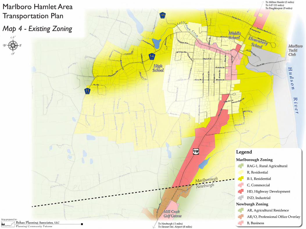
-- Not Applicable 3.0 Land Use Build-Out Analysis Behan Planning completed a build-out analysis using environmental constraints and zoning regulations. Attachment B is a summary of the conducted build-out analysis. The results of the analysis indicate there is the potential for approximately 570 new single-family residential units and 1 million square feet of commercial development within the study area. 4.0 Proposed Projects Conversations with representatives from the Hamlet indicate that there are two proposed projects in the Hamlet area; the Bayside project located on the west side of Route 9W at Young Avenue (a 99 unit multi-family development) and the Graziosi project located on the east side of Route 9W north of Dock Road (a 117 Townhouse development). The peak hour trip generation estimate for both projects is summarized in Table 2. Combined the projects are expected to generate between 110 and 130 peak hour trips.
Table 2 – Trip Generation Summary
AM Peak Hour PM Peak Hour Project LUC
In Out Total In Out Total
Bayside (99 units) 1 Apartment - 210 10 40 50 40 21 61
Graziosi (117 units) 2 Town House – 230 10 49 59 46 23 69
Total 20 89 109 86 44 130 1 ITE trip generation rates. 2 Taken from the Graziosi TIS dated August 24, 2004. 5.0 Conclusion Based on the preceding historical and projected land development and traffic growth information, an annual growth rate of 1.3% per year was established for this study. This equates to a growth factor of 18.2% and 43.6% by 2020 and 2035 respectively. The projected growth rate is consistent with both County models, represents approximately 20% of the build out analysis and easily accounts for the additional traffic generated by the two pending projects. F:\Projects\2007\07-110d\traffic\07-110d Growth Memo.doc

Attachment A – Regression Analysis
Appendix D - Traffic Forecasting Memorandum Marlboro Area Transportation Plan
Town of Marlborough, New York


Appendix B – Build-Out Analysis
Appendix D - Traffic Forecasting Memorandum Marlboro Area Transportation Plan
Town of Marlborough, New York