martishang fgdc arc_catalog_metadata_template
TRANSCRIPT
Creating and Maintaining Geospatial Metadata
In the USDA Forest Service Using ESRIs ArcCatalog
Guidance for Creating a “Local Template” Metadata File
and
Recommendations for Populating
Both Required and Optional Metadata Elements
Completed under the auspices of the Geospatial Advisory Committee
as a component to the Forest Service GIS Data Dictionary
6/12/2003 v2.0.0, M.Martischang


martishang_fgdc_ArcCatalog_metadata_template Tables of Contents and Figures - Page 3 of 82
Table of Contents
Table of Contents ........................................................................................................................................... 3 Introduction ..................................................................................................................................................... 7
Office of Management and Budget (OMB) Information Quality Guidelines ................................................... 8 FGDC/ISO Metadata Standard Harmonization ............................................................................................ 8 Conventions Used in This Paper ................................................................................................................. 8 Warnings .................................................................................................................................................... 9 Assumptions ............................................................................................................................................... 9
Preface to Parts One and Two ........................................................................................................................ 9 Become Familiar with ArcGIS Metadata Online Help ................................................................................... 9 Use the FGDC Metadata Workbook Electronically For Rapid Supplementary Help ...................................... 9 Note on How ArcCatalog Handles “One-to-Many” Relationships ................................................................. 9
Part One – Create and Populate Metadata Template File .............................................................................. 11 Populate Metadata Template .XML File With Local “Default” Values ......................................................... 15
Identification Section (1) ....................................................................................................................... 15 Data Quality Section (2)........................................................................................................................ 23 Data Organization Section (3) ............................................................................................................... 25 Spatial Reference Section (4) ............................................................................................................... 25 Entity Attribute Section (5) .................................................................................................................... 25 Distribution Section (6) ......................................................................................................................... 27 Metadata Reference Section (7) ........................................................................................................... 33
Part Two – Populate “Non-Template” and “Local” Metadata Elements ........................................................... 35 Guidance for “Non-Template” and “Local” Metadata Elements .................................................................. 35 Assumptions ............................................................................................................................................. 35
Identification Section (1) ....................................................................................................................... 37 Data Quality Section (2)........................................................................................................................ 47 Data Organization Section (3) ............................................................................................................... 53 Spatial Reference Section (4) ............................................................................................................... 55 Entity Attribute Section (5) .................................................................................................................... 59
Appendix A – Configuring ArcCatalog ........................................................................................................... 65 Appendix B – Explanatory FGDC Metadata Graphics .................................................................................... 71 Appendix C – “Styleguide” for This Document ............................................................................................... 81

martishang_fgdc_ArcCatalog_metadata_template Tables of Contents and Figures - Page 4 of 82
Table of Figures
Figure 1. ArcGIS Desktop Help window. ................................................................................................... 9 Figure 2. Record navigation toolbar. ....................................................................................................... 10 Figure 3. Record navigation toolbar when no records exist. ..................................................................... 10 Figure 4. Record navigation toolbar when one record exists. ................................................................... 10 Figure 5. Initial ArcCatalog window. ........................................................................................................ 11 Figure 6. Connect to Folder window. ....................................................................................................... 11 Figure 7. Load the metadata_template.xml file to ArcCatalog. ................................................................. 12 Figure 8. Open the FGDC “Metadata Editor” window............................................................................... 13 Figure 9. FGDC Metadata Editor window. ............................................................................................... 14 Figure 10. Identification/General tab (1.x). ............................................................................................ 15 Figure 11. Identification/Contact tab (1.9).............................................................................................. 16 Figure 12. Identification/Contact/Details…/General tab (10.x). .............................................................. 17 Figure 13. Identification/Contact/Details…/Address tab (10.x). .............................................................. 18 Figure 14. Identification/Citation tab (8.4). ............................................................................................. 19 Figure 15. Identification/Citation/Details…/General tab (8.x).................................................................. 19 Figure 16. Identification/Citation/Details…/Series/Publication Information tab (8.x). ............................... 20 Figure 17. Identification/Keywords tab (1.6.x)........................................................................................ 21 Figure 18. Identification/Security tab (1.12.x). ....................................................................................... 22 Figure 19. Data Quality/General tab (2.6).............................................................................................. 23 Figure 20. Distribution/General tab (6.x). .............................................................................................. 27 Figure 21. Distribution/Distributor tab (6.1). ........................................................................................... 28 Figure 22. Distribution/Standard Order Process/General tab (6.4.x). ..................................................... 28 Figure 23. Distribution/Standard Order Process/Non-digital Form tab (6.4.1). ........................................ 29 Figure 24. Distribution/Standard Order Process/… /General tab (6.4.2.1.x). .......................................... 30 Figure 25. Distribution/Standard Order Process/… /Online Transfer - Network tab (6.4.2.2.1.1.x). ......... 31 Figure 26. Distribution/Standard Order Process/Digital Form/Online Transfer - Dialup tab. .................... 31 Figure 27. Distribution/Standard Order Process/Digital Form/Offline Transfer tab (6.4.2.2.2.x). ............. 32 Figure 28. Template entries, Metadata Reference/General tab (7.x)...................................................... 33 Figure 29. Template entries, Metadata Reference/Extensions tab. ........................................................ 33 Figure 30. Identification/General tab (1.2.x and 1.1). ............................................................................. 37 Figure 31. Identification/Citation/Details…/General tab (8.x).................................................................. 38 Figure 32. Identification/Time Period/Single Date/Time tab (9.1). .......................................................... 39 Figure 33. Identification/Time Period/Multiple Dates/Times tab (9.2). .................................................... 40 Figure 34. Identification/Time Period/Range of Dates/Times tab (9.3.x)................................................. 41 Figure 35. Identification/Status tab (1.4.x). ............................................................................................ 42 Figure 36. Identification/Keywords tab (1.6.x)........................................................................................ 43 Figure 37. Identification/Browse Graphic tab (1.10.x). ........................................................................... 44 Figure 38. Identification/Cross Reference tab........................................................................................ 45 Figure 39. Data Quality/General tab (2.x). ............................................................................................. 47 Figure 40. Data Quality/Attribute Accuracy tab (2.1.x). .......................................................................... 48 Figure 41. Data Quality/Positional Accuracy tab (2.4.x). ........................................................................ 49 Figure 42. Data Quality/Source Information/General tab (2.5.1.x). ......................................................... 50 Figure 43. Data Quality/Process Step tab (2.5.2.x). ............................................................................... 51 Figure 44. Data Organization/General tab (3.1). .................................................................................... 53 Figure 45. Spatial Reference/General Coordinate System tab (4.1)....................................................... 55 Figure 46. Reference/ Horizontal Coordinate System/Planar Coordinate System tab (4.1.2.4.x). ........... 55 Figure 47. Reference/ Horizontal Coordinate System/Encoding Information tab (4.1.2.x)....................... 56 Figure 48. Spatial Reference/Vertical Coordinate System tab (4.2.x). .................................................... 57 Figure 49. Entity Attribute/Detailed Description/Entity Type tab (5.1.1.x). .............................................. 59 Figure 50. Entity Attribute/Detailed Description/Attribute/General tab (5.1.2.x)....................................... 60 Figure 51. Entity Attribute/Detailed Description/Attribute/Date tab (5.1.2.x)............................................ 60 Figure 52. Entity Attribute/… /Attribute (Enumerated) Domain Values tab (5.1.2.4.1.x). ......................... 61 Figure 53. Entity Attribute/… /Attribute (Range) Domain Values tab (5.1.2.x). ....................................... 61 Figure 54. Entity Attribute/… /Attribute (Codeset) Domain Values tab (5.1.2.4.3.x). ............................... 62 Figure 55. Entity Attribute/… /Attribute (Unrepresentable) Domain Values tab (5.1.2.4.4). ..................... 63 Figure 56. Entity Attribute/Overview Description tab (5.2.x). .................................................................. 63

martishang_fgdc_ArcCatalog_metadata_template Tables of Contents and Figures - Page 5 of 82
Figure A1. Default ArcCatalog window. ................................................................................................. 65 Figure A2. The ArcCatalog Options window with the File Types tab selected. ........................................ 65 Figure A3. Empty File Type window. ..................................................................................................... 66 Figure A4. Entering file extensions and their description. ....................................................................... 66 Figure A5. A file type added to ArcCatalog. ........................................................................................... 66 Figure A6. Description of type shortened from 23 to 6 characters. ......................................................... 67 Figure A7. Collection of file types that will now be displayed in ArcCatalog. ........................................... 67 Figure A8. Metadata choices for addition to the ArcCatalog Details view. .............................................. 68 Figure A9. Setting metadata viewing, creation, update, and editor choices. ........................................... 68 Figure A10. ArcCatalog window reflecting customizations made (compare with Figure A1). ................ 69 Figure B1. The FGDC metadata standard has 11 sections numbered 0 through 10. .............................. 71 Figure B2. FGDC Content Standards for Digital Geospatial Metadata (FGDC-STD-001-1998). ............. 72 Figure B3. Elements of the Identification Section(1). ............................................................................. 73 Figure B4. Elements of the Data Quality Section(2). .............................................................................. 74 Figure B5. Elements of the Spatial Data Organization Section(3). ......................................................... 75 Figure B6. Elements of the Spatial Reference Information Section(4). ................................................... 76 Figure B7. Elements of the Entity and Attribute Information Section(5). ................................................. 77 Figure B8. Elements of the Distribution Information Section(6). ............................................................. 78 Figure B9. Elements of the Metadata Reference Information Section(7). ............................................... 79 Figure B10. Elements of the Citation(8), Time Period(9), and Contact Information Sections(10). ......... 80


martishang_fgdc_ArcCatalog_metadata_template Introduction and Preface - Page 7 of 82
Introduction
The FGDC Content Standard for Digital Geospatial Metadata (CSDGM) defines dozens of metadata elements for the purpose of objectively documenting and disclosing the source(s), characteristics, quality, and lineage of spatial data sets so that potential users of those data sets can reasonably determine the fitness of a data set for the purpose(s) they intend to use it for. Some of these elements receive the same entry, regardless of the data set being documented (e.g., address and phone number of the office maintaining the data set) and could be referred to as “local template” entries for the site. This paper describes how to create a “local template” metadata file and pre-populate it with the rarely or never changing “default” metadata elements such that they need only be entered once and simply re-used thereafter as metadata files are completed for each unique data set a site maintains. With respect to Forest Service data sets there are two categories of “template” metadata elements that can be authored and/or entered one time and then re-used repeatedly in either a fully automated or semi-automated fashion:
Local template metadata elements: Metadata that is the same for all data sets maintained by a given site. For example, office address, phone number, distribution methods, distribution media types, etc. This guide identifies these elements and offers suggestions for their entry.
Data set template metadata elements: Metadata that is the same for a given data set regardless of the site location the data is stored and maintained at. All of the Forest Service GIS Data Dictionary data sets are candidates for having certain metadata entries written once and then literally copy/pasted into each local metadata file. For example, an abstract paragraph authored once for “travel_routes” could be re-used by all sites in the Forest Service, regardless of their location. This guide suggests which elements these are but does not offer any specific guidance for their completion. Authorship of “data set template” elements would be the responsibility of national application development teams, boards of users, or nationally identified work-groups who are intimately familiar with the business requirements and content of the Forest Service corporate data sets.
Of the dozens of metadata elements defined, the FGDC identifies only 10 as being required. None of these 10 required elements are “local template” elements. Six of the 10 are “data set template” elements and the remaining four are “local unique” elements. The 10 required elements are identified in this document with bolded red font in the figure captions that introduce them (e.g., Originator (8.1):). To address these two
circumstances, this guide is written in two parts: Part One: Describes how to create a “local template” file and populate it with “default” metadata information
that is common to multiple data sets maintained at a Forest Service office. For those who previously used the ARC/INFO v7.x ‘DOCUMENT’ command, this is analogous to populating the “site” tables that ‘DOCUMENT’ maintained. None of the “default” local template metadata elements for a given site are FGDC required.
Part Two: Suggests guidance, format, and in some cases, content for metadata elements that are unique to each data set. Most of the “not-default” metadata elements are FGDC “optional”.
The mechanics of how to create an ArcCatalog metadata template file have been taken from ESRIs Online Support Center, Knowledgebase article 15270. Recommendations for text strings entered to the template file are from Mike Martischang, GIS Coordinator Region 9 and were composed following guidance in the FGDC Metadata Workbook Version 2.0, ArcGIS help files, and the Forest Service metadata standards web page. Since the Forest Service standard for geospatial metadata documentation at this time is the FGDC format, all screen shots and advice for template entries are relative to the FGDC stylesheet in ArcCatalog. It is important to remember that as Forest Service geospatial data become more readily available via the internet that persons external to the Forest Service and, indeed, from all over the world, will be reviewing Forest Service metadata files. What seem like “obvious” or “lengthy” metadata entries will ensure that metadata are meaningful and useful to the international community that the internet makes us part of. Because our geospatial data will be evaluated and used by persons outside the Forest Service and, indeed, outside the U.S., it becomes wise to make seemingly “obvious” metadata entries (e.g., Country = “United States” in a point of contact address, indicating standard time zone along with office hours, or spelling out commonly used Forest Service acronyms on their first use [for instance, Land Management Plan (LMP)… in an abstract]).

martishang_fgdc_ArcCatalog_metadata_template Introduction and Preface - Page 8 of 82
Office of Management and Budget (OMB) Information Quality Guidelines In February of 2002 the OMB published “Guidelines for Ensuring and Maximizing the Quality, Objectivity, Utility, and Integrity of Information Disseminated by Federal Agencies”. This guidance required agencies to issue their own implementing guidelines that, in addition to defining policies that maximize information quality, objectivity, utility and integrity, include administrative mechanisms for affected persons to seek and obtain correction of information disseminated by the agency that does not comply with the OMB guidelines. Tiered to OMBs guidelines are USDAs Quality of Information Guidelines that the Forest Service is expected to tier to. As information that is used to conduct Forest Service business and that is often requested by other agencies and publics GIS data sets are subject to OMBs information quality guidelines. The FGDC metadata standard provides a more than adequate framework for documenting and disclosing “quality, objectivity, utility and integrity” of GIS data and provides a partial solution to providing “mechanisms for affected persons to seek and obtain correction of information”. However, it must be clearly understood that the FGDC metadata standard is a tool intended for objective disclosure of data condition and is not intended to serve as tool for providing standards of production to data set developers and maintainers.
FGDC/ISO Metadata Standard Harmonization The International Organization for Standardization (ISO) has defined metadata standard ISO 19115 and the FGDC has been engaged in activities to “harmonize” CSDGM (FGDC-STD-001-1998) with ISO 19115. As of mid-April 2003:
The final draft of ISO 19115 is awaiting formal approval from the ISO Central Secretariat.
The American National Standards Institute (ANSI) has adopted the ISO standard without change.
FGDC version 2 (in final review) is harmonized with ISO 19115.
Mapping, or “cross-walking”, elements is in progress to protect current metadata investments and facilitate their migration to FGDC version 2.
Since the Forest Service metadata standard is FGDC, when version 2 is released in final form, we will essentially be migrating to the ISO 19115 metadata standard. ArcCatalog already offers an ISO “stylesheet” that supports the ISO metadata standard. When the “FGDC-ISO cross-walk” is completed, tools provided by both the FGDC and ESRI will make the translation task seamless. Monitor the FGDC/ISO Metadata Standard Harmonization web site to keep up with implementation progress.
Conventions Used in This Paper All figures are screen shots of the FGDC stylesheets in ArcCatalog.
Numbered instructions in a figure caption correspond with numbered “callouts” in the screen shot graphic.
Numbered instruction items begin with the name of the element, as displayed in the FGDC stylesheet, followed in parenthesis by the FGDC CSDMG v2.0 reference number. This reference number can be used in an electronic search (Ctrl + F) to find the description of that element in the FGDC Metadata Workbook file.
In Part One, numbered instructions identify specific “default” metadata elements to be populated in the metadata “template” file. Recommended text string entries are indicated in quotes in the numbered instruction item of the figure caption.
Metadata elements regarded as required by FGDC standards contain red text strings that begin with “REQUIRED:” followed by a brief description of what should be entered. Some, but not all, required metadata items can be populated in the template file. However, many of the required metadata items are unique for each coverage, for example, the currentness reference.
The MSWord “comments” feature has been used to suggest those FGDC metadata elements that should be authored by national application development teams, boards of users, and/or WO staff. Use the word search function (Ctrl + F) to search for the keyword “authorship” to rapidly find comment text. Note, to navigate to and manage comments and markup, activate the “Reviewing” toolbar (View | Toolbars | Reviewing).
A “grayed-out” data entry field means entries are made via a more detailed “sub-menu”. Usually a labeled button with an ellipsis (three dots, …) appears beside grayed-out fields and opens the detailed sub-menu.
Metadata elements that are automatically populated when a data set metadata.xml file is opened in ArcCatalog are identified with a red star ( ) appearing on the screen shot figure. See warnings below!
martishang_fgdc_ArcCatalog_metadata_template Introduction and Preface - Page 9 of 82
Warnings Do not enter metadata for values that ArcCatalog automatically updates. If you enter information for these
values ArcCatalog will not update this information in the future.
When metadata is imported it will overwrite existing elements.
Assumptions A complete and correct projection file is present on the data set.
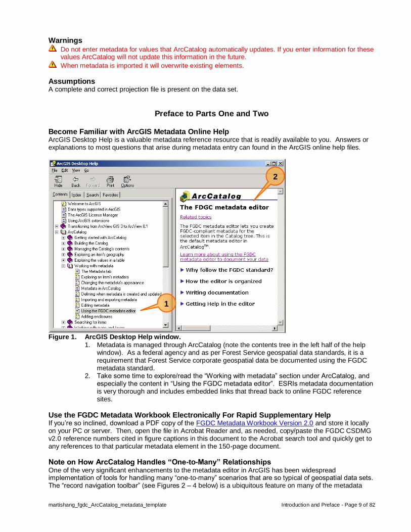
Preface to Parts One and Two Become Familiar with ArcGIS Metadata Online Help ArcGIS Desktop Help is a valuable metadata reference resource that is readily available to you. Answers or explanations to most questions that arise during metadata entry can found in the ArcGIS online help files.
Figure 1. ArcGIS Desktop Help window.
1. Metadata is managed through ArcCatalog (note the contents tree in the left half of the help window). As a federal agency and as per Forest Service geospatial data standards, it is a requirement that Forest Service corporate geospatial data be documented using the FGDC metadata standard.
2. Take some time to explore/read the “Working with metadata” section under ArcCatalog, and especially the content in “Using the FGDC metadata editor”. ESRIs metadata documentation is very thorough and includes embedded links that thread back to online FGDC reference sites.
Use the FGDC Metadata Workbook Electronically For Rapid Supplementary Help If you’re so inclined, download a PDF copy of the FGDC Metadata Workbook Version 2.0 and store it locally on your PC or server. Then, open the file in Acrobat Reader and, as needed, copy/paste the FGDC CSDMG v2.0 reference numbers cited in figure captions in this document to the Acrobat search tool and quickly get to any references to that particular metadata element in the 150-page document.
Note on How ArcCatalog Handles “One-to-Many” Relationships One of the very significant enhancements to the metadata editor in ArcGIS has been widespread implementation of tools for handling many “one-to-many” scenarios that are so typical of geospatial data sets. The “record navigation toolbar” (see Figures 2 – 4 below) is a ubiquitous feature on many of the metadata
1
2

martishang_fgdc_ArcCatalog_metadata_template Introduction and Preface - Page 10 of 82
entry screens and facilitates documentation of “many” characteristics to “one” metadata element (e.g., one data set may be composed of features collected from many different source scales). The ability to document one-to-many circumstances like this creates quasi “sub-dataset” metadata functionality. The following discussion was largely taken from Arc Desktop Help files, specifically, ArcCatalog/Working with metadata/Using the FGDC metadata editor/Writing documentation section and explains use of the record navigation toolbar. Some metadata elements can be repeated many times (a “one-to-many” scenario). For example, several keywords may be used to describe the data’s subject or an individual associated with a dataset may have several phone numbers. When a single element can be repeated, ArcCatalog has a toolbar located immediately below the element text box containing buttons that let one add, delete, and navigate through “many” entries for the single element. For each repeating element the toolbar's status line shows the name of the repeating element and indicates both the total number of entries for that element and which entry is currently displayed. The appropriate navigation buttons are unavailable when you're at the first or last entry. When it is a group of elements that can be repeated, the toolbar is located at the bottom of the group. For example, a shapefile can have many attributes, and several elements are used to describe each one; a toolbar controls the group of elements which are repeated for each attribute. Similarly, coverages have many feature classes. Another toolbar on the same tab controls the group of elements describing the feature class, which includes the group of elements describing its attributes. The figures below illustrate what the text above describes.
Figure 2. Record navigation toolbar.
When three or more records exist, all six navigation tools are operational.
Figure 3. Record navigation toolbar when no records exist.
Only the add record tool is operational.
Figure 4. Record navigation toolbar when one record exists.
Only the add and delete record tools are operational.

martishang_fgdc_ArcCatalog_metadata_template Part One – Create Template Metadata File - Page 11 of 82
Part One – Create and Populate Metadata Template File Steps necessary to create a metadata template file and populate those metadata elements that remain the same for all, or most, of the geospatial data sets with “default” metadata entries common to a given Forest Service site.
Step 1. Create and save an empty metadata template file (e.g., “metadata_template.xml”). 1. Open an ascii text editor such as TextPad or Notepad. 2. Add the following two lines to the text file:
<metadata> </metadata>
3. Save the text file with a .xml extension (e.g., “metadata_template.xml”) at a location on the server where any potential metadata author in the cell can access it.
Step 2. Start and navigate ArcCatalog to where the metadata_template.xml file has been stored. To begin populating the “metadata_template.xml” file with those metadata elements that will be the same for all (or the majority of) the data sets for which you’ll define metadata (i.e., your “corporate”, data dictionary coverages), start ArcCatalog (Figure 2) and navigate to the “metadata_template.xml” file created in Step 1.
Figure 5. Initial ArcCatalog window.
Navigate ArcCatalog to where the “metadata_template.xml” file in Step 1 has been saved. 1. To begin navigating, use the “Connect to Folder” button to open up the “Connect to Folder”
window (see Figure 6 below).
Figure 6. Connect to Folder window.
1. Navigate to the subdirectory where the metadata_template.xml file has been stored.
1
1
martishang_fgdc_ArcCatalog_metadata_template Part One – Create Template Metadata File - Page 12 of 82
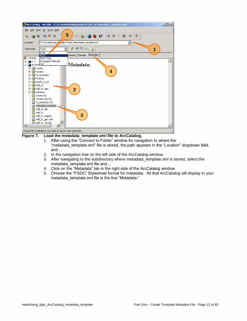
Figure 7. Load the metadata_template.xml file to ArcCatalog.
1. After using the “Connect to Folder” window for navigation to where the “metadata_template.xml” file is stored, the path appears in the “Location” dropdown field, and…
2. In the navigation tree on the left side of the ArcCatalog window. 3. After navigating to the subdirectory where metadata_template.xml is stored, select the
metadata_template.xml file and… 4. Click on the “Metadata” tab in the right side of the ArcCatalog window. 5. Choose the “FGDC” Stylesheet format for metadata. All that ArcCatalog will display in your
metadata_template.xml file is the line “Metadata:”
3
4
5
1
2

martishang_fgdc_ArcCatalog_metadata_template Part One – Create Template Metadata File - Page 13 of 82
Step 4. Open and begin entering “default” text to your metadata_template.xml file.
Figure 8. Open the FGDC “Metadata Editor” window.
1. Click once on the “Edit metadata” button and the FGDC “Metadata Editor” window (see Figure 9 below) opens.
1
martishang_fgdc_ArcCatalog_metadata_template Part One – Create Template Metadata File - Page 14 of 82
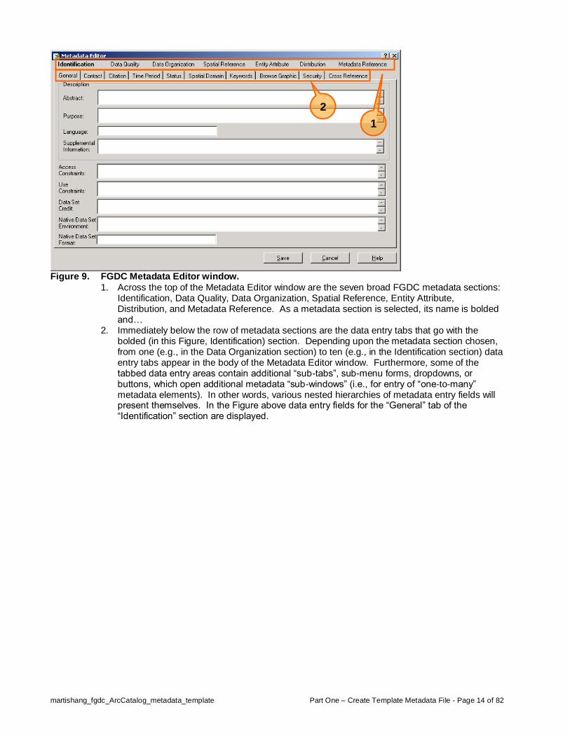
Figure 9. FGDC Metadata Editor window.
1. Across the top of the Metadata Editor window are the seven broad FGDC metadata sections: Identification, Data Quality, Data Organization, Spatial Reference, Entity Attribute, Distribution, and Metadata Reference. As a metadata section is selected, its name is bolded and…
2. Immediately below the row of metadata sections are the data entry tabs that go with the bolded (in this Figure, Identification) section. Depending upon the metadata section chosen, from one (e.g., in the Data Organization section) to ten (e.g., in the Identification section) data entry tabs appear in the body of the Metadata Editor window. Furthermore, some of the tabbed data entry areas contain additional “sub-tabs”, sub-menu forms, dropdowns, or buttons, which open additional metadata “sub-windows” (i.e., for entry of “one-to-many” metadata elements). In other words, various nested hierarchies of metadata entry fields will present themselves. In the Figure above data entry fields for the “General” tab of the “Identification” section are displayed.
1
2
martishang_fgdc_ArcCatalog_metadata_template Part One – Populate Default Template – Identification - Page 15 of 82
Populate Metadata Template .XML File With Local “Default” Values
Identification Section (1) Basic information about the data set. Now that an “empty” metadata_template.xml file has been created, loaded to ArcCatalog, and opened in the FGDC editor, “default” metadata elements can be populated. “Default” metadata elements are those that are true for all, or nearly all, the geospatial data sets at your site all, or most of, the time and that rarely, or never, change, regardless of the data being documented. Examples of default metadata elements for your particular site include the: mailing address of your office, office hours, phone number of the GIS Coordinator, file and media formats used to deliver requested data, data steward/editor names, etc.
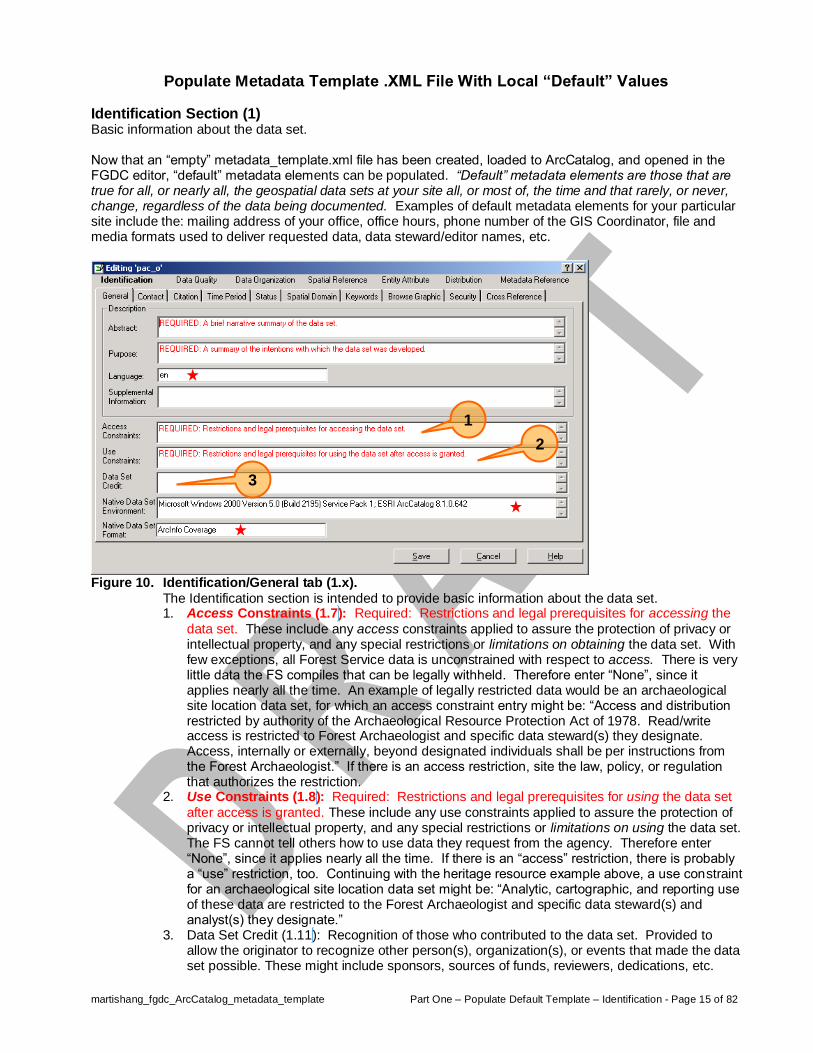
Figure 10. Identification/General tab (1.x).
The Identification section is intended to provide basic information about the data set. 1. Access Constraints (1.7): Required: Restrictions and legal prerequisites for accessing the
data set. These include any access constraints applied to assure the protection of privacy or intellectual property, and any special restrictions or limitations on obtaining the data set. With few exceptions, all Forest Service data is unconstrained with respect to access. There is very little data the FS compiles that can be legally withheld. Therefore enter “None”, since it applies nearly all the time. An example of legally restricted data would be an archaeological site location data set, for which an access constraint entry might be: “Access and distribution restricted by authority of the Archaeological Resource Protection Act of 1978. Read/write access is restricted to Forest Archaeologist and specific data steward(s) they designate. Access, internally or externally, beyond designated individuals shall be per instructions from the Forest Archaeologist.” If there is an access restriction, site the law, policy, or regulation that authorizes the restriction.
2. Use Constraints (1.8): Required: Restrictions and legal prerequisites for using the data set
after access is granted. These include any use constraints applied to assure the protection of privacy or intellectual property, and any special restrictions or limitations on using the data set. The FS cannot tell others how to use data they request from the agency. Therefore enter “None”, since it applies nearly all the time. If there is an “access” restriction, there is probably a “use” restriction, too. Continuing with the heritage resource example above, a use constraint for an archaeological site location data set might be: “Analytic, cartographic, and reporting use of these data are restricted to the Forest Archaeologist and specific data steward(s) and analyst(s) they designate.”
3. Data Set Credit (1.11): Recognition of those who contributed to the data set. Provided to allow the originator to recognize other person(s), organization(s), or events that made the data set possible. These might include sponsors, sources of funds, reviewers, dedications, etc.
1
2
3

martishang_fgdc_ArcCatalog_metadata_template Part One – Populate Default Template – Identification - Page 16 of 82
Figure 11. Identification/Contact tab (1.9).
1. Point of Contact (1.9): Contact information for an individual or organization that is knowledgeable about the data set. Click the “Details…” button to open a “Contact Information” window (see Figure 12 below) where detailed data about contact(s) can be entered.
1

martishang_fgdc_ArcCatalog_metadata_template Part One – Populate Default Template – Identification - Page 17 of 82
Figure 12. Identification/Contact/Details…/General tab (10.x).
Contact information for an individual or organization that is knowledgeable about the data set (continued). Here’s where you might want to spend some time and enter all the names and contact information for all of the data stewards on your Forest, thereby creating a “pick-list” of names to choose from. 1. Primary Contact (10.1 or 10.2): Identifies weather an individual or an organization has the
“most significant association” with a data set. Intended to distinguish cases in which the primary contact is a person, whose organizational affiliation is incidental, versus those in which the primary contact is an organization, whose personnel are incidental. Use the radio buttons to choose weather the contact is an individual named person or an organization.
2. Person (10.1.1): The full name of the individual to which the contact type applies. Example: Michael F. Martischang.
3. Organization (10.1.2): The name of the organization to which the contact type applies. Example: USDA Forest Service – Six Rivers National Forest.
4. Position (10.3): Title of the individual. Example: GIS Coordinator. For items 5, 6, 7, and 8 it is possible to enter multiple telephone numbers or email addresses (i.e., the “one-to-many” scenario) for each individual or organization using the record navigation toolbar. 5. Contact Voice Telephone (10.5): The telephone number, including area code, by which
individuals can speak to the individual or organization. Example: 707-441-3587. 6. Contact Fax Number (10.7): The telephone number, including area code, of a facsimile
machine of the individual or organization. Example: 707-442-1942. 7. Contact Email Address (10.8): Address of the electronic mailbox of the organization or
individual. Example: [email protected]. 8. Contact TDD/TTY Telephone (10.6): The telephone number, including area code, by which
hearing-impaired individuals can contact the organization or individual. Example: 707-442-1791.
9. Hours of Service (10.9): Hours and days of the week office is open for walk-in business to the public and during which time a phone call is likely to be answered. Use military time for clarity, capital letters for days of the week, and indicate the time zone the office operates within. For example, “0800 – 1630 M – F, CT” indicates an office open to the public between 8:00 am and 4:30pm Monday through Friday in the Central Time zone. Use ET for eastern time, CT for central time, MT for mountain time and PT for pacific time (there is no need to distinguish between daylight savings and standard time).
10. Contact Instructions (10.10): Supplemental instructions on how or when to contact the individual or organization. Example: Office is closed on federal holidays.
1
3
2
4
5
6
7
8
9
10
martishang_fgdc_ArcCatalog_metadata_template Part One – Populate Default Template – Identification - Page 18 of 82
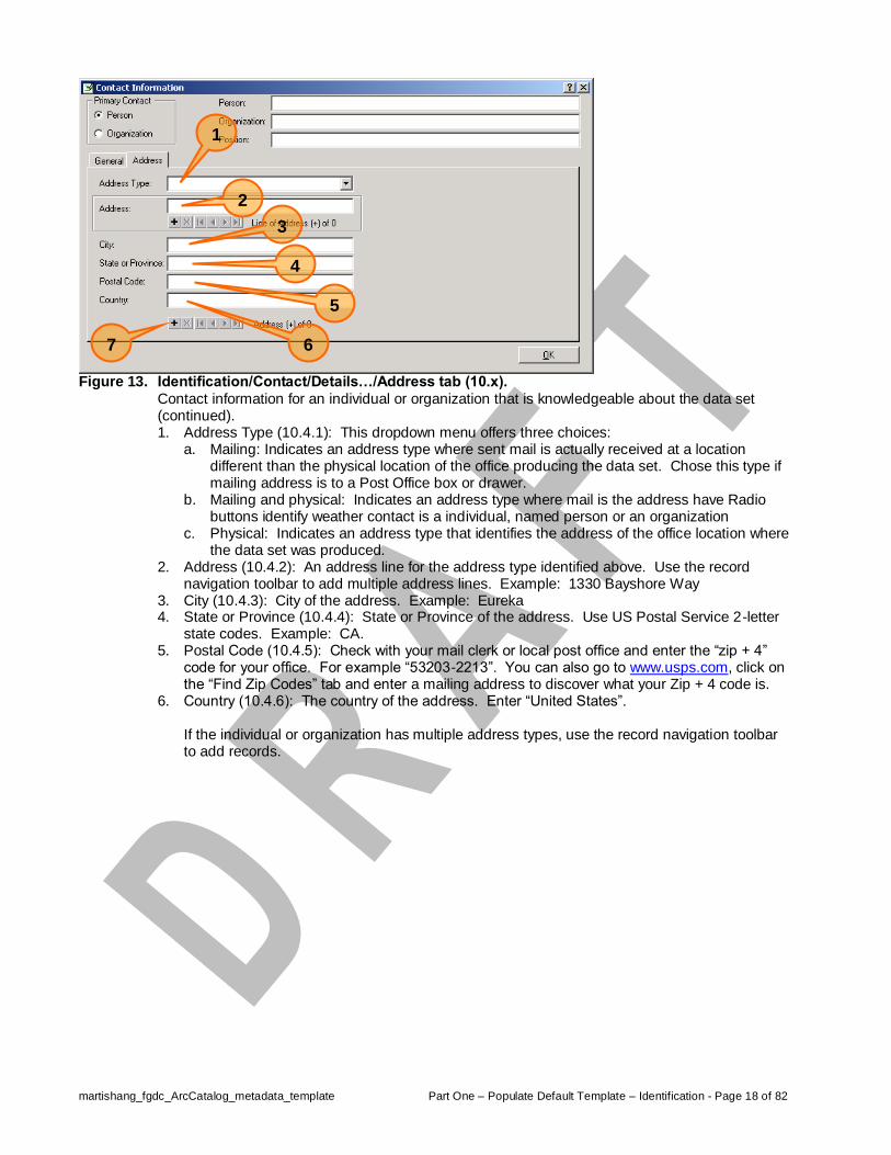
Figure 13. Identification/Contact/Details…/Address tab (10.x).
Contact information for an individual or organization that is knowledgeable about the data set (continued). 1. Address Type (10.4.1): This dropdown menu offers three choices:
a. Mailing: Indicates an address type where sent mail is actually received at a location different than the physical location of the office producing the data set. Chose this type if mailing address is to a Post Office box or drawer.
b. Mailing and physical: Indicates an address type where mail is the address have Radio buttons identify weather contact is a individual, named person or an organization
c. Physical: Indicates an address type that identifies the address of the office location where the data set was produced.
2. Address (10.4.2): An address line for the address type identified above. Use the record navigation toolbar to add multiple address lines. Example: 1330 Bayshore Way
3. City (10.4.3): City of the address. Example: Eureka 4. State or Province (10.4.4): State or Province of the address. Use US Postal Service 2-letter
state codes. Example: CA. 5. Postal Code (10.4.5): Check with your mail clerk or local post office and enter the “zip + 4”
code for your office. For example “53203-2213”. You can also go to www.usps.com, click on the “Find Zip Codes” tab and enter a mailing address to discover what your Zip + 4 code is.
6. Country (10.4.6): The country of the address. Enter “United States”. If the individual or organization has multiple address types, use the record navigation toolbar to add records.
1
2
5
4
3
6
7

martishang_fgdc_ArcCatalog_metadata_template Part One – Populate Default Template – Identification - Page 19 of 82
Figure 14. Identification/Citation tab (8.4).
1. Citation Title (8.4): The name by which the data set is known. Click the “Details…” button to open a “Citation Information” window (Figure 15).
Figure 15. Identification/Citation/Details…/General tab (8.x).
Information on this tab is intended provide clear, accurate, concise, and complete citation information for use by others when citing use of your data in literature citations. 1. Originator (8.1): REQUIRED: The name of an organization or individual that developed the
data set. If the name of editors or compilers are provided, the name(s) must be followed by "(ed.)" or "(comp.)" respectively. Enter “USDA Forest Service, <your_forest_name> National Forest”. Cite individuals by name and specific contribution in section 1.11 (see Figure 10 above). Note that it is possible to add multiple originators. If a data set is composed of data from two or more originators, be sure to cite the other contributions.
2. Publication Date (8.2): REQUIRED: The date when the data set is published or otherwise
made available for release. 3. Publication Time (8.3): In most cases this is immaterial. Enter “Unknown”.
1
2
5
4
3
1

martishang_fgdc_ArcCatalog_metadata_template Part One – Populate Default Template – Identification - Page 20 of 82
Figure 16. Identification/Citation/Details…/Series/Publication Information tab (8.x).
1. Series Name (8.7.1): Name of the series publication of which the data is a part. A series is a succession of volumes or issues published with related subjects or authors, similar format and price, or continuous number. Try “USFS Corporate Geospatial Data”, or “NRIS”, “Alp”, “Infra”, “Terra”, etc.
2. Issue Identification (8.7.2): Information identifying the issue of the series publication of which the data set is a part. Use standard developers 3-part versioning code for “version”, “update”, “fix” (v.u.f, e.g., 8.1.2).
3. Publication Place (8.8.1): Name of the city (and state and country, if necessary to uniquely identify the city) where the data set was published or released.
4. Publisher (8.8.2): For nearly all Forest Service data sets, they do not exist as functional, meaningful objects until a National Forest creates it and populates it. For nearly all FS data sets (for some ALP sets this may not apply), enter “USDA Forest Service, <insert_full_national_forest/grassland/prairie_name_here>” (e.g., “USDA Forest Service, Medewin National Tallgrass Prairie”, or “USDA Forest Service, Six Rivers National Forest”).
5. FYI Note, Larger Work Citation (8.11): Pressing the Details… button opens a “Larger Work Citation information” window which looks and works identically to the “Citation information” window.
1
2
3
4
5

martishang_fgdc_ArcCatalog_metadata_template Part One – Populate Default Template – Identification - Page 21 of 82
Figure 17. Identification/Keywords tab (1.6.x).
1. Theme/Keyword (1.6.1.2): REQUIRED: Common-use word or phrase used to describe the
subject of the data set. 2. Theme/Thesaurus (1.6.1.1): REQUIRED: Reference to a formally registered thesaurus or a
similar authoritative source of theme keywords. US Forest Service GIS Data Dictionary??? 3. Place/Keyword (1.6.2.2): The geographic name of a location covered by a data set. 4. Place/Thesaurus (1.6.2.1): Reference to a formally registered thesaurus or a similar
authoritative source of place keywords. GNIS? USFS administered places directory?
4
3
2
1

martishang_fgdc_ArcCatalog_metadata_template Part One – Populate Default Template – Identification - Page 22 of 82
Figure 18. Identification/Security tab (1.12.x).
Handling restrictions imposed on the data set because of national security, privacy, or other concerns. 1. Security Classification System (1.12.1): The Forest Service has no defined data security
classification system. Enter “None in place”. 2. Security Classification (1.12.2): Name of the handling restrictions on the data set. Six choices
are offered: Top Secret, Secret, Confidential, Restricted, Unclassified, and Sensitive. At this time nearly all Forest Service geospatial data sets are “Unclassified”. Only some heritage resource and law enforcement related data sets are likely to have “Restricted” or “Confidential” classification.
3. Security Handling Description (: Enter: “If there is ever doubt, contact the appropriate resource staff who has stewardship responsibility and the GIS Coordinator.
3
2
1

martishang_fgdc_ArcCatalog_metadata_template Part One – Populate Default Template – Data Quality - Page 23 of 82
Data Quality Section (2) A general assessment of the quality of the data set.
Figure 19. Data Quality/General tab (2.6).
1. Cloud Cover (2.6): The area of a data set obstructed by clouds and expressed as a percentage (integer between 0 and 100) of the spatial extent. Most of the time metadata entries will be for vector data for which cloud cover does not apply, therefore, enter “na” (not applicable). If documenting DOQ, scanned aerial photos, or multi-spectral imagery, enter an appropriate estimate of percentage of cloud cover.
1


martishang_fgdc_ArcCatalog_metadata_template Part One – Populate Default Template – Data Organization, Spatial Reference, & Entity Attribute - Page 25 of 82
Data Organization Section (3) The mechanism used to represent spatial information in the data set. The data organization section contains no elements that can be populated in common for all data sets.
Spatial Reference Section (4) The description of the reference frame for, and the means to encode, coordinates in the data set. The spatial reference section contains no elements that can be populated in common for all data sets.
Entity Attribute Section (5) Details about the information content of the data set, including the entity types, their attributes, and the domains from which attribute values may be assigned. The entity attribute section contains no elements that can be populated in common for all data sets. Some elements in this section are automatically populated for feature type and default INFO item data definitions, however, most entries in this section are unique for each data set and therefore require unique entry.


martishang_fgdc_ArcCatalog_metadata_template Part One – Populate Default Template – Distribution - Page 27 of 82
Distribution Section (6) Information about the distributor of and options for obtaining the data set. The distribution section provides information about the distributor of and options for obtaining the data set. It is intended to provide answers to questions like: From whom can I obtain the data? What formats are available? What media are available? Are the data available online? What is the price of the data?
Figure 20. Distribution/General tab (6.x).
1. Resource Description (6.2): The identifier by which the distributor knows the data set. Typically this is a unique catalog number assigned to a data set by data provider with huge quantities of data. In the Forest Service scenario this could simply be the data set name, as stored in the data library.
2. Distribution Liability (6.3): The “data disclaimer”. Following is a boiler-plate data disclaimer to be entered here: “This product is reproduced from geospatial information prepared by the U.S. Department of Agriculture, Forest Service. By removing the contents of this package or taking receipt of these files via electronic file transfer methods, you understand that the data stored on this media is in draft condition. Represented features may not be in an accurate geographic location. The Forest Service makes no expressed or implied warranty, including warranty of merchantability and fitness, with respect to the character, function, or capabilities of the data or their appropriateness for any user's purposes. The Forest Service reserves the right to correct, update, modify, or replace this geospatial information without notification. For more information, contact <Insert office name and phone number - not a person name>. (FSM 7149.12)”
3. Custom Order Process (6.5): Description of custom distribution services available and the terms and conditions for obtaining these services.
4. Technical Prerequisites (6.6): Description of any technical capabilities that the consumer must have to use the data set in the form(s) provided by the distributor. Typically a Forest Service site will be prepared to deliver data in an ARC/INFO “export” file format (*.e00). Only ESRI products can “import” and display these files. Use the record navigation toolbar to add additional records if multiple description, liability, order process, or prerequisites apply to the dataset.
1
2
3

martishang_fgdc_ArcCatalog_metadata_template Part One – Populate Default Template – Distribution - Page 28 of 82
Figure 21. Distribution/Distributor tab (6.1).
1. Distributor (6.1): Clicking the “Details…” button brings up a “Contact Information” window as shown in Figure 9. Assuming that all key data steward and coordination personnel names have been entered while back at Figure 9, completing this field should simply be a matter of choosing your distribution point name/contact/address from the contact information you’ve previously entered. Use the record navigation toolbar to add additional records if your datasets are available from more than one distributor.
Figure 22. Distribution/Standard Order Process/General tab (6.4.x).
1. Non-digital/Digital Form radio buttons (6.4.1 and 6.4.2): Indicate if the fees, turnaround, and ordering instructions are for a non-digital or a digital format.
2. Fees (6.4.3): Refer to section 7149 of FSM 7100 - 3. Turnaround (6.4.5): Indicate number of business days between time of receipt of request and
out-going delivery of requested data. For example, one might enter “10 business days from date of receipt of request”.
1
1
2
3
4

martishang_fgdc_ArcCatalog_metadata_template Part One – Populate Default Template – Distribution - Page 29 of 82
4. Ordering Instructions (6.4.4): General instructions and advice about, and special terms and services provided for, the data set by the distributor. Use the record navigation toolbar to add additional records if multiple dataset ordering, turnaround, and instruction formats apply to your data.
Figure 23. Distribution/Standard Order Process/Non-digital Form tab (6.4.1).
1. Non-digital Form (6.4.1): Describe each option for obtaining the data set on non-computer compatible media (e.g., plotted maps on paper or film) and the dimensions of the media. This is where you will identify your commitment to literally making maps. Use the record navigation toolbar to add additional records if multiple standard order processes exist for your data. Characterize as many non-digital formats as you are capable of and willing to produce upon request. You should consider the media supplies you typically keep on hand or are willing to procure on short notice to fulfill the request. Formats to consider might include: a. 20 lb bond paper 8.5”x11”, 8.5”x14”, 11”x17” b. Coasted paper 8.5”x11”, 8.5”x14”, 11”x17” c. 3-mil transparent film 8.5”x11”, 8.5”x14” d. 3-mil semi-opaque film up to 36”x 72” e. etc., etc.
1

martishang_fgdc_ArcCatalog_metadata_template Part One – Populate Default Template – Distribution - Page 30 of 82
Figure 24. Distribution/Standard Order Process/… /General tab (6.4.2.1.x).
1. Format Name (6.4.2.1.1): Dropdown menu offers 35 choices: ARCE (ARC/INFO export) and ARCG (ARC/INFO generate) are probably the two formats that Forest Service sites will be transferring data in for the time being. The FGDC advises that if new format name is used that the full name of the format be given. Proposal: If appropriate, use “ArcGIS personal geodatabase” if delivering a personal geodatabase to a requester.
2. Format Version (6.4.2.1.2): Identify the version of the ESRI software used to create the export, generate or personal geodatabase (e.g., 7.2.1 or 8.1.2)
3. Format Version Number Format: Indicate if the format version number in element 6.4.2.1.2 is simply a number or a date.
4. Format Specification (6.4.2.1.4): Name of a subset, profile, or product specification of the format. Suggestion/Confusion: For an export file, enter “ESRI proprietary”; for a generate file, enter “ASCII”; for a personal geodatabase, enter “Microsoft Access database”.
5. Information Content (6.4.2.1.5): 6. File Decompression Technique (6.4.2.1.6): Dropdown menu offers one choice: no
compression applied. If you customarily deliver compressed files, specify the compression tool used (e.g., WinZip, Unix ‘compress’, Unix tar/compress, Unix gzip, etc) and include the means of obtaining the algorithms used. Use the record navigation toolbar to add additional records if your site is capable of and willing to deliver multiple digital formats.
1
6
5
4
3
2

martishang_fgdc_ArcCatalog_metadata_template Part One – Populate Default Template – Distribution - Page 31 of 82
Figure 25. Distribution/Standard Order Process/… /Online Transfer - Network tab (6.4.2.2.1.1.x).
If you post data for online distribution via a network connection, enter appropriate network specifications. 1. Computer Contact (6.4.2.2.1.1.1 or 6.4.2.2.1.1.2): 2. Network Resource Name (6.4.2.2.1.1.1.1): 3. Access Instructions (6.4.2.2.1.1.1.2): 4. Online Computer and Operating System (6.4.2.2.1.1.1.3):
Use the record navigation toolbar to add additional records if your data is offered from multiple network resource names.
Figure 26. Distribution/Standard Order Process/Digital Form/Online Transfer - Dialup tab.
If you post data for online distribution via a dialup connection, enter appropriate dialup specifications. Use the record navigation toolbar to add additional records if your data is offered from multiple online transfer sources.
1
4
3
2
martishang_fgdc_ArcCatalog_metadata_template Part One – Populate Default Template – Distribution - Page 32 of 82
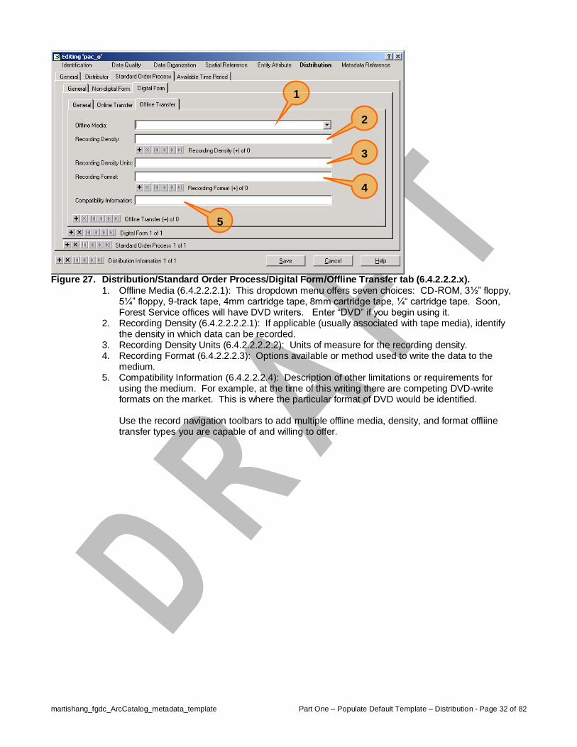
Figure 27. Distribution/Standard Order Process/Digital Form/Offline Transfer tab (6.4.2.2.2.x).
1. Offline Media (6.4.2.2.2.1): This dropdown menu offers seven choices: CD-ROM, 3½” floppy, 5¼” floppy, 9-track tape, 4mm cartridge tape, 8mm cartridge tape, ¼“ cartridge tape. Soon, Forest Service offices will have DVD writers. Enter “DVD” if you begin using it.
2. Recording Density (6.4.2.2.2.2.1): If applicable (usually associated with tape media), identify the density in which data can be recorded.
3. Recording Density Units (6.4.2.2.2.2.2): Units of measure for the recording density. 4. Recording Format (6.4.2.2.2.3): Options available or method used to write the data to the
medium. 5. Compatibility Information (6.4.2.2.2.4): Description of other limitations or requirements for
using the medium. For example, at the time of this writing there are competing DVD-write formats on the market. This is where the particular format of DVD would be identified. Use the record navigation toolbars to add multiple offline media, density, and format offliine transfer types you are capable of and willing to offer.
1
3
4
5
2

martishang_fgdc_ArcCatalog_metadata_template Part One – Populate Default Template – Metadata Reference - Page 33 of 82
Metadata Reference Section (7) Information on the currentness of the metadata information, and the responsible party.
Figure 28. Template entries, Metadata Reference/General tab (7.x).
1. Metadata Access Constraints (7.8): Restrictions and legal prerequisites for accessing the metadata, including any special restrictions or limitations on obtaining the metadata. This element is related to data set access constraints (element 1.7).
2. Metadata Use Constraints (7.9): 3. Metadata Security Information – Classification System (7.10.1): 4. Metadata Security Information – Classification (7.10.2): Dropdown menu offers six choices,
for which “unclassified” will probably be the most frequent choice. 5. Handling Information (7.10.3):
Figure 29. Template entries, Metadata Reference/Extensions tab.
Use the record navigation toolbar to indicate additional metadata profiles in which you deliver metadata. The “ESRI Metadata Profile” is both FGDC and ISO compliant.


martishang_fgdc_ArcCatalog_metadata_template Part Two – Populate Unique Elements – Introduction and Assumptions - Page 35 of 82
Part Two – Populate “Non-Template” and “Local” Metadata Elements
Guidance for “Non-Template” and “Local” Metadata Elements Part 2 of this guide offers explanations of and suggested format and content for metadata entries to “non-template” and “local” metadata elements that are unique to each data set used and maintained by a given Forest Service site. Many “non-template” metadata elements are unique to the data set. Others are unique to the data set and the “local” site. Acknowledging this subtle distinction indicates that “non-template” and “local” metadata content should ideally come from two sources:
For elements unique to the data set national application development teams (and/or their associated User Boards) should assume responsibility for authoring metadata “boiler-plate” content. (Note: there may be some elements that receive an initial entry by a national application development team and that are subsequently appended to by local data stewards.)
For elements unique to the data set and the “local” site, local data stewards should assume responsibility for authoring metadata content.
In this version of this document, for each metadata element itemized in the figure captions suggestions are offered as to who should author the content that will be use to populate the element. “NADT” indicates that a national application development team should author nationally consistent text that all sites would “paste” into their metadata files for a particular data set metadata the element. “LDT” indicates local development teams should author and populate the element. For some elements both NADT and LDT should be responsible for supplying metadata entries. In these cases, the LDT entry should be appended to (i.e., not replace) the NADT entry. For example, “Abstract (1.2.1) [NADT+LDT]” would suggest that a national application development team should author an entry for pasting into the “abstract” element and that it’s likely (but not necessary) that local development teams would author additional text blocks or entries to append to the nationally supplied content.
Assumptions The metadata template file has already been created and populated with all the template, or “default”, values unique to a given Forest Service office and stored at a commonly accessible location on the server. The geospatial data set for which metadata is to be compiled has a complete and accurate projection file. Step 1. Using Windows Explorer, copy the metadata template file (e.g., metadata_template.xml) into the
subdirectory folder that is the name of the geospatial data set for which metadata is being compiled. During the process of copying the template file, rename it to “metadata.xml”.
Step 2. Start ArcCatalog and using the “Connect to Folder” button, navigate it to the workspace that contains the coverage you copied/renamed the metadata.xml file into in Step 1. Step 3. In the left panel (subdirectory tree) of the ArcCatalog window click once on the subdirectory
name that is the geospatial data set for which you are going to complete metadata for. This is the same subdirectory into which the metadata.xml file in Step 2 has been placed. Select the FGDC stylesheet and the click once on the Metadata tab in the right panel of the ArcCatalog window (Figure 7 and Figure 8).


martishang_fgdc_ArcCatalog_metadata_template Part Two – Populate Unique Elements – Identification - Page 37 of 82
Identification Section (1) Basic information about the data set. Now that an “empty” metadata_template.xml file has been created and loaded to ArcCatalog and opened in the FGDC editor, “default” metadata elements can be populated. “Default” metadata elements are those that are true for all, or nearly all, the geospatial data sets at your site all, or most of, the time and that rarely, or never, change, regardless of the data being documented. Examples of default metadata elements for your particular site include the: mailing address of your office, office hours, phone number of the GIS Coordinator, file and media formats used to deliver requested data, data steward/editor names, etc.
Figure 30. Identification/General tab (1.2.x and 1.1).
The Identification section is intended to provide basic information about the data set. The "Abstract" briefly describes the "what" aspects of the data set (For example, what information is in the data set? What area is covered?). The "Purpose" describes the "why" aspects of the data set (For example, why was the data set created?). Concise, brief paragraphs are the objective here. 1. Abstract (1.2.1): Required: A brief narrative summary of the data set. Ideally, a Forest
should append a brief, succinct paragraph to the lead abstract paragraph authored by the national application development team.
2. Purpose (1.2.2): Required: A summary of the intentions with which the data set was
developed. Ideally, a Forest should append a brief, succinct paragraph to the lead purpose paragraph authored by the national application development team. Proposal: “To support project-level planning, decision making, implementation and monitoring.”
3. Supplemental Information (1.2.3): Other descriptive information about the data set. 4. Data Set Credit (1.1.1): Provided to allow the “originator” (see element 8.1)) to recognize
individuals who contributed to accomplishment the data set. Contributors might include sponsors, sources of funding, reviewers, designers, dedications, etc.
1
2
3
4

martishang_fgdc_ArcCatalog_metadata_template Part Two – Populate Unique Elements – Identification - Page 38 of 82
Figure 31. Identification/Citation/Details…/General tab (8.x).
1. Originator (8.1): REQUIRED: The name of an organization or individual that developed the
data set. If the name of editors or compilers are provided, the name must be followed by “(ed.)” or “(comp.)” respectively. Enter “Unknown” if the originator of the data set is unknown. Note that it is possible to enter more than one originator using the record navigation toolbar.
2. Publication Date (8.2): REQUIRED: The date when the data set is published or otherwise
made available for release. This would be the date a data set was placed in a data library, data clearinghouse, or ftp site and made available for operational use or access. Enter date in format of day (use leading zero on single digits), month (first 3-letters), year (4-digit), for example, 09 Sep 2002. If exact day of publication is unknown, enter month (first 3-letters), year (4-digit), for example, Sep 2002. If exact day and month are unknown, enter year (4-digit), for example, 2002. If exact year is unknown, enter “Unknown”.
3. Publication Time (8.3): The time of day when the data set is published or otherwise made available for release. In most cases this is immaterial to Forest Service data sets, although if data set is of an extremely time sensitive nature (e.g., wildfire perimeter progressions), enter publication time in 24-hour format (e.g., 0900, or 1630). Otherwise, leave this field blank.
4. Edition (8.5): The version of the title. 5. Other Citation Details (8.9): Any other information required to complete the citation. 6. Online Linkage (8.10): By default the path to the data set actually being documented by
ArcCatalog is entered here. Using the record navigation toolbar it is possible to add additional online linkage URLs and/or servers and directory paths.
2
3
1
4 6
5

martishang_fgdc_ArcCatalog_metadata_template Part Two – Populate Unique Elements – Identification - Page 39 of 82
Figure 32. Identification/Time Period/Single Date/Time tab (9.1).
Information about the currentness of a data set (that is, information about how “up-to-date” is a data set) is important to many, if not most, potential users. Most users are interested in the currentness of a data set related to the “ground condition” (that is, when the “real world” looked the way it s described in the data set). Unfortunately, sometimes only the time that the information was recorded or published is known. The Currentness Reference element requires the producer to identify if the Time Period of Content dates and times refer to the ground condition, or some later time when the information was recorded, published, etc. 1. Currentness Reference (1.3.1): REQUIRED: The basis on which the time period of content
information is determined. Two choices are offered: a. Ground condition: On rare occasions the date(s) and time(s) of collection of data in the
data set may be known. For example, if polygons in a data set were interpreted from satellite imagery, the date(s) and time of imagery are known.
b. Publication date: This is the currentness reference that applies to nearly all FS vector data.
2. Select Date/Time schema: Choose one of three radio buttons to indicate a single source date (9.1), multiple source dates (9.2) or a range of source dates (9.3).
3. Calendar Date (9.1.1): REQUIRED: The year (and optionally month, or month and day) for
which the data set corresponds to the ground. Notice that there is no record navigation bar for adding or navigating multiple date/time records.
4. Time of Day (9.1.2):
1
3
2

martishang_fgdc_ArcCatalog_metadata_template Part Two – Populate Unique Elements – Identification - Page 40 of 82
Figure 33. Identification/Time Period/Multiple Dates/Times tab (9.2).
1. Calendar Date (9.1.1): REQUIRED: The year (and optionally month, or month and day) for
which the data set corresponds to the ground. Notice there is a record navigation toolbar for adding or navigating multiple date/time records. Add as many source date records as are known to compose the data set.
2. Time of Day (9.1.2): Use the record navigation toolbar to add as many discrete dates for your dataset as apply.

martishang_fgdc_ArcCatalog_metadata_template Part Two – Populate Unique Elements – Identification - Page 41 of 82
Figure 34. Identification/Time Period/Range of Dates/Times tab (9.3.x).
1. Beginning Date (9.3.1): REQUIRED: The year (and optionally month, or month and day) for
which the data set corresponds to the ground. 2. Beginning Time (9.3.2): From this dropdown menu choose “unknown”. Most of the time the
beginning time of a data set is unknown. However, for coverage that has a definite temporal component (e.g., a fire perimeter coverage), this would be a critical and required metadata element.
3. Ending Date (9.3.3): 4. Ending Time (9.3.4):
martishang_fgdc_ArcCatalog_metadata_template Part Two – Populate Unique Elements – Identification - Page 42 of 82
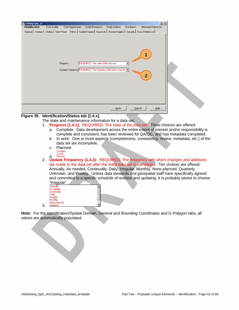
Figure 35. Identification/Status tab (1.4.x).
The state and maintenance information for a data set. 1. Progress (1.4.1): REQUIRED: The state of the data set. Three choices are offered:
a. Complete: Data development across the entire extent of interest and/or responsibility is complete and consistent, has been reviewed for QA/QC, and has metadata completed.
b. In work: One or more aspects (completeness, consistency, review, metadata, etc.) of the data set are incomplete.
c. Planned:
d. 2. Update Frequency (1.4.2): REQUIRED: The frequency with which changes and additions
are made to the data set after the initial data set is completed. Ten choices are offered: Annually, As needed, Continually, Daily, Irregular, Monthly, None planned, Quarterly, Unknown, and Weekly. Unless data stewards and geospatial staff have specifically agreed and committed to a specific schedule of revision and updating, it is probably wisest to choose “Irregular”.
3. Note: For the Identification/Spatial Domain, General and Bounding Coordinates and G-Polygon tabs, all
values are automatically populated.
1
2

martishang_fgdc_ArcCatalog_metadata_template Part Two – Populate Unique Elements – Identification - Page 43 of 82
Figure 36. Identification/Keywords tab (1.6.x).
1. Theme/Keyword (1.6.1.2): REQUIRED: Common-use word or phrase used to describe the subject of the data set.
2. Theme/Thesaurus (1.6.1.1): REQUIRED: Reference to a formally registered thesaurus or a similar authoritative source of theme keywords. US Forest Service GIS Data Dictionary???
3. Place/Keyword (1.6.2.2): The geographic name of a location covered by a data set. 4. Place/Thesaurus (1.6.2.1): Reference to a formally registered thesaurus or a similar
authoritative source of place keywords. GNIS? USFS administered places directory? Use the record navigation toolbars to add multiple keywords (very likely) and multiple Thesaurus sources for those keywords, if applicable.
4
3
2
1

martishang_fgdc_ArcCatalog_metadata_template Part Two – Populate Unique Elements – Identification - Page 44 of 82
Figure 37. Identification/Browse Graphic tab (1.10.x).
A browse graphic is an image of the data set. The image allows prospective users to move beyond textual descriptions and see what the data set looks like. The image might show a simple display of the data set, the results of an application that used the data set, different aspects of the quality of the data set, or other information. If you choose to use browse graphics as a component of your metadata, the filename and its description will be unique 1. Filename (1.10.1): Name of a related graphic file that provides an illustration of the data set. 2. Description (1.10.2): A text description of the illustration. 3. File Type (1.10.3): Ten choices are offered: CGM, EPS, EMF, GIF, JPEG, PBM, PS, TIFF,
WMF, and XWD. If you have chosen to use browse graphics, choose a suitable file type and consistently use it, as a service to potential data consumers and so you can enter it as a default value in the metadata_template.xml file. Use the record navigation toolbar to characterize each additional browse graphic description and file type you serve.
3
2
1

martishang_fgdc_ArcCatalog_metadata_template Part Two – Populate Unique Elements – Identification - Page 45 of 82
Figure 38. Identification/Cross Reference tab.
An example of a cross reference situation would be between watershed polygons and hydrologic channels and waterbodies. (watershed coverage with NHD, and vice versa). 1. Citation Title: Pressing the Details… button brings up a “Citation information” window identical
to that shown in Figure 15 and Figure 16.
1


martishang_fgdc_ArcCatalog_metadata_template Part Two – Populate Unique Elements – Data Quality - Page 47 of 82
Data Quality Section (2) A general assessment of the quality of the data set.
Figure 39. Data Quality/General tab (2.x).
1. Logical Consistency Report (2.2): An explanation of the fidelity of relationships in the data set and tests used. Tests for logical consistency can be sub-divided into four categories: a. Logical Consistency: Evaluations of the fidelity of relationships encoded in the data
structure. b. Valid Values: Can detect gross blunders but not necessarily all aspects of logical
consistency. c. Graphic Data: Evaluations that address the following questions, do lines intersect only
where intended? Are there any duplicate lines? Are all areas completely described? Are there any over- or under-shoots? Are any polygons too small or too narrow? Are any lines too short, or too close together?
d. Specific Topological Tests: Automated procedures that verify that all chains intersect at nodes (report tolerance values), cycles of chains and nodes are consistent around polygons, inner rings embed consistently in enclosing polygons. The quality report should identify the software (name and version) used to verify these conditions. Results of a ‘DESCRIBE’ command that shows no errors is an example of a “topological test” that could be reported as “topologically clean”.
e. Date of Test: Date tests are applied. If corrections and modifications are made to the data set following tests for logical consistency, the quality report should indicate how the new information (corrections) was checked for logical consistency.
2. Completeness Report (2.3): Information about omissions, selection criteria, generalization, definitions used, and other relevant mapping rules used to derive the data set. For example, identify geometric thresholds such as minimum area or width of polygons, minimum length of lines, or the threshold at which true area features are depicted as points.
1
2

martishang_fgdc_ArcCatalog_metadata_template Part Two – Populate Unique Elements – Data Quality - Page 48 of 82
Figure 40. Data Quality/Attribute Accuracy tab (2.1.x).
An assessment of the accuracy of the identification of entities and assignment of attribute values in the data set. 1. Accuracy Report (2.1.1): An explanation of the accuracy of the identification of the entities
and assignments of values in the data set and a description of the tests used. 2. Value (2.1.2.1): An estimate of the accuracy of the identification of the entities and
assignments of attribute values in the data set. 3. Explanation (2.1.2.2): Identification of the test that yielded the attribute accuracy value.
1
2
3

martishang_fgdc_ArcCatalog_metadata_template Part Two – Populate Unique Elements – Data Quality - Page 49 of 82
Figure 41. Data Quality/Positional Accuracy tab (2.4.x).
An assessment of the accuracy of the positions (horizontally and vertically) of spatial objects in the data set. 1. Horizontal Accuracy – Report (2.4.1.1): An explanation of the accuracy of the horizontal
coordinate measurements and a description of the tests used. 2. Horizontal Accuracy – Value (2.4.1.2.1): An estimate of the accuracy of the horizontal
coordinate measurements in the data set expressed in (ground) meters. 3. Horizontal Accuracy – Explanation (2.4.1.2.2): Identification of the test that yielded the
horizontal positional accuracy value. 4. Vertical Accuracy – Report (2.4.2.1): An explanation of the accuracy of the vertical coordinate
measurements and a description of the tests used. 5. Vertical Accuracy – Value (2.4.2.2.1): An estimate of the accuracy of the vertical coordinate
measurements in the data set expressed in (ground) meters. 6. Vertical Accuracy – Explanation (2.4.2.2.2): Identification of the test that yielded the vertical
positional accuracy value.
1
2
3
4
5
6

martishang_fgdc_ArcCatalog_metadata_template Part Two – Populate Unique Elements – Data Quality - Page 50 of 82
Figure 42. Data Quality/Source Information/General tab (2.5.1.x).
1. Source Scale Denominator (2.5.1.2): This is the number to the right of the semi-colon in a “representative fraction” scale value. For example 7.5’ PBS quads are produced and published at 1:24000 scale so the source scale denominator would be “24000”.
2. Type of Source Media (2.5.1.3): This dropdown menu offers 22 choices that range from “audiocassette” to “videotape”. Choices that Forest Service offices would most frequently use are: CD-ROM, computer program, digital tape media, paper, stable-base material, or transparency.
3. Source Citation Abbreviation (2.5.1.5): 4. Source Contribution (2.5.1.6): If a given data set contains features from multiple sources,
identify which features and/or the percentage of the total feature-content that came from the various sources. Use the record navigation toolbar to identify multiple source contributors. It will probably be common for some coverages to contain data from a variety of sources. For example from: digitized PBS sheets, CFFs, GPS, 100k DLG, HUD from DOQs, etc.
5. Note: The “Source Citation” and “Source Time Period of Content” tabs display screens identical to those shown in Figures 11, 12, 14, 15, and 16. Refer to these Figures for explanations of how to compete source citations and source time period of content.
1
2
3
4
5
martishang_fgdc_ArcCatalog_metadata_template Part Two – Populate Unique Elements – Data Quality - Page 51 of 82
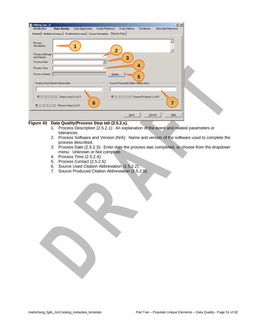
Figure 43. Data Quality/Process Step tab (2.5.2.x).
1. Process Description (2.5.2.1): An explanation of the event and related parameters or tolerances.
2. Process Software and Version (N/A): Name and version of the software used to complete the process described.
3. Process Date (2.5.2.3): Enter date the process was completed, or choose from the dropdown menu: Unknown or Not complete.
4. Process Time (2.5.2.4): 5. Process Contact (2.5.2.6): 6. Source Used Citation Abbreviation (2.5.2.2): 7. Source Produced Citation Abbreviation (2.5.2.5):
1
2
3
5
6
7
4


martishang_fgdc_ArcCatalog_metadata_template Part Two – Populate Unique Elements – Data Organization - Page 53 of 82
Data Organization Section (3) The mechanism used to represent spatial information in the data set.
Figure 44. Data Organization/General tab (3.1).
With the exception of the “Indirect Spatial Reference:” field, all entries in this tab are automatically populated. 1. Indirect Spatial Reference (3.1): Name of types of geographic features, addressing schemes,
or other means through which locations are referenced in the data set. Any way to describe a location without using coordinates, for example, county or city names, highway numbers, township, range, and section numbers, linear reference systems, street addresses, etc. In other words, the location referencing systems commonly used and understood by humans.
1


martishang_fgdc_ArcCatalog_metadata_template Part Two – Populate Unique Elements – Spatial Reference - Page 55 of 82
Spatial Reference Section (4) The description of the reference frame for, and the means to encode, coordinates in the data set.
Figure 45. Spatial Reference/General Coordinate System tab (4.1).
All entries in this tab are automatically populated using values extracted or computed from the coverage projection file.
Figure 46. Reference/ Horizontal Coordinate System/Planar Coordinate System tab (4.1.2.4.x).

martishang_fgdc_ArcCatalog_metadata_template Part Two – Populate Unique Elements – Spatial Reference - Page 56 of 82
Figure 47. Reference/ Horizontal Coordinate System/Encoding Information tab (4.1.2.x).

martishang_fgdc_ArcCatalog_metadata_template Part Two – Populate Unique Elements – Spatial Reference - Page 57 of 82
Figure 48. Spatial Reference/Vertical Coordinate System tab (4.2.x).
1. Altitude System Definition – Datum Name (4.2.1.1): The identification given to the surface of reference from which altitudes are measured. This dropdown menu offers two choices: National Geodetic Vertical Datum of 1929 or North American Vertical Datum of 1988.
2. Altitude System Definition – Distance Units (4.2.1.3): Units in which altitudes are recorded. This dropdown menu offers two choices: feet or meters.
3. Altitude System Definition – Encoding Method (4.2.1.4): The means used to encode the altitudes. This dropdown menu offers three choices: Explicit elevation coordinate included with horizontal coordinates, Implicit coordinate, or Attribute values.
4. Altitude System Definition – Resolution (4.2.1.2): The minimum distance possible between two adjacent altitude values, expressed in altitude distance units (4.2.1.3). Use the record navigation toolbar to identify multiple altitude system definitions for a data set.
5. Depth System Definition – Datum Name (4.2.2.1): The identification given to the surface of reference from which depths are measured. This dropdown menu offers 36 choices.
6. Depth System Definition – Distance Units (4.2.2.3): Units in which depths are recorded. Two choices are offered: feet or meters.
7. Depth System Definition – Encoding Method (4.2.2.4): The means used to encode depths. Three choices are offered: Explicit depth coordinate included with horizontal coordinates (a DEM is an example of this encoding method), Implicit coordinate, and Attribute values
8. Depth System Definition – Resolution (4.2.2.2): The minimum distance possible between two adjacent depth values, expressed in depth distance units of measure. Use the record navigation toolbar to identify multiple depth system definitions for a data set.
1
2
3
4
5
6
7
8


martishang_fgdc_ArcCatalog_metadata_template Part Two – Populate Unique Elements – Entity Attribute - Page 59 of 82
Entity Attribute Section (5) Details about the information content of the data set, including the entity types, their attributes, and the domains from which attribute values may be assigned. Entities are things that are typically represented with spatial features (points, lines, areas) in a GIS. Attributes are characteristics of entities that are populated with values. The Forest Service has chosen to store nearly all spatial feature attribute data in Oracle database applications (e.g., Water, Fauna, Infra, ALP, etc.) that are joined via Oracle control numbers (CN) to their respective spatial data set(s). This partitioning of the resource information management model would indicate that it should be the responsibility of the application development teams, and their associated boards of users, to complete a large part of the entity attribute metadata (domains, codesets, reference sources, citations, etc.) while local sites would should be responsible for documenting methods of data collection, completeness, etc. An exception to this would be any feature attributes that a local site might choose to maintain beyond those defined in a national application, in related tables (kept in Oracle, Access, or INFO DBMSs). Completing attribute metadata for “local tables” would be the responsibility of the local site. Comments have been inserted with the keyword “NADT” (for national application development team) to any metadata element that should probably be the responsibility of the national teams.
Figure 49. Entity Attribute/Detailed Description/Entity Type tab (5.1.1.x).
1. Definition (5.1.1.2): The description of the entity type. 2. Definition Source (5.1.1.3): The authority for the definition.
1
2

martishang_fgdc_ArcCatalog_metadata_template Part Two – Populate Unique Elements – Entity Attribute - Page 60 of 82
Figure 50. Entity Attribute/Detailed Description/Attribute/General tab (5.1.2.x).
1. Attribute Value Accuracy (5.1.2.9.1): 2. Attribute Value Accuracy Explanation (5.1.2.9.2): 3. Attribute Value Measurement Frequency (5.1.2.10):
Figure 51. Entity Attribute/Detailed Description/Attribute/Date tab (5.1.2.x).
1. Beginning Date of Attribute Values (5.1.2.7): The earliest or only date for which attribute values are current.
2. Ending Date of Attribute Values (5.1.2.8): Latest date for which the information is current. Used only when a range of dates are provided.
1
2
3
1
2

martishang_fgdc_ArcCatalog_metadata_template Part Two – Populate Unique Elements – Entity Attribute - Page 61 of 82
Figure 52. Entity Attribute/… /Attribute (Enumerated) Domain Values tab (5.1.2.4.1.x).
A domain is the set of possible values of an attribute. 1. The FGDC metadata standard identifies four categories of value domains: enumerated,
range, codeset, and unrepresented. An enumerated domain is one comprised of an explicit, finite list of values, usually stored in a “look-up” or “type” table. For example, an attribute “road surface” might have an enumerated domain of three values: “paved”, “gravel”, “native”.
2. Value (5.1.2.4.1.1): 3. Value Definition (5.1.2.4.1.2): 4. Value Definition Source (5.1.2.4.1.3):
Figure 53. Entity Attribute/… /Attribute (Range) Domain Values tab (5.1.2.x).
A domain is the set of possible values of an attribute. The FGDC metadata standard identifies four categories of value domains: enumerated, range, codeset, and unrepresented. A range domain is one comprised of a sequence, series, or scale of usually numeric values between limits.
1
2
3
1
2
3
4
5
6
4
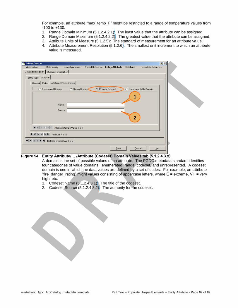
martishang_fgdc_ArcCatalog_metadata_template Part Two – Populate Unique Elements – Entity Attribute - Page 62 of 82
For example, an attribute “max_temp_F” might be restricted to a range of temperature values from -100 to +130. 1. Range Domain Minimum (5.1.2.4.2.1): The least value that the attribute can be assigned. 2. Range Domain Maximum (5.1.2.4.2.2): The greatest value that the attribute can be assigned. 3. Attribute Units of Measure (5.1.2.5): The standard of measurement for an attribute value. 4. Attribute Measurement Resolution (5.1.2.6): The smallest unit increment to which an attribute
value is measured.
Figure 54. Entity Attribute/… /Attribute (Codeset) Domain Values tab (5.1.2.4.3.x).
A domain is the set of possible values of an attribute. The FGDC metadata standard identifies four categories of value domains: enumerated, range, codeset, and unrepresented. A codeset domain is one in which the data values are defined by a set of codes. For example, an attribute “fire_danger_rating” might values consisting of uppercase letters, where E = extreme, VH = very high, etc. 1. Codeset Name (5.1.2.4.3.1): The title of the codeset. 2. Codeset Source (5.1.2.4.3.2): The authority for the codeset.
1
2

martishang_fgdc_ArcCatalog_metadata_template Part Two – Populate Unique Elements – Entity Attribute - Page 63 of 82
Figure 55. Entity Attribute/… /Attribute (Unrepresentable) Domain Values tab (5.1.2.4.4).
A domain is the set of possible values of an attribute. The FGDC metadata standard identifies four categories of value domains: enumerated, range, codeset, and unrepresented. An unrepresentable domain is one for which the set of values can not be represented. For example, an attribute “last_name” intended to hold values for client’s last names. 1. Unrepresented Domain (5.1.2.4.4): Description of the values and reasons why they cannot be
represented.
Figure 56. Entity Attribute/Overview Description tab (5.2.x).
1. Dataset Overview Description (5.2): The summary of, and citation to detailed description of, the information content of the dataset.
2. Dataset Entity and Attribute Overview (5.2.1): Detailed summary of the information contained in a dataset.
3. Dataset Entity and Attribute Citation (5.2.2): Reference to the complete description of the entity types, attributes and attribute values for the dataset.
1
2
3


martishang_fgdc_ArcCatalog_metadata_template Appendix A – Configuring ArcCatalog - Page 65 of 82
Appendix A – Configuring ArcCatalog
Upon starting ArcCatalog only text, coverage, and geodatabase files are displayed in the Contents tab on the right panel of the window and for each of these files only their name and type attributes are listed (Figure A1). The utility and efficiency of ArcCatalog can be expanded and customized by opening the Tools/Options… window and tweaking various aspects of the interface (see ArcDesktop Help/ ArcCatalog/Building the Catalog). To expand the kind of file types displayed in ArcCatalog’s Contents tab, as well as columns of information about the files, begin by clicking on the File Types tab of the Options window (Figure A2), then the New Type.. button, which will open a File Type window (Figure A3).
Figure A1. Default ArcCatalog window.
Figure A2. The ArcCatalog Options window with the File
Types tab selected.

martishang_fgdc_ArcCatalog_metadata_template Appendix A – Configuring ArcCatalog - Page 66 of 82
The File Type window offers two data entry fields and a generic Windows file icon (Figure A3). Enter an extension (do not include the leading “.”) to that field then press the Tab key. For common extensions the Description of type and correct icon will automatically populate. Click OK to commit the file type to ArcCatalog. After clicking on the OK button in the File Type window it closes and returns you to the Options window, which now displays the newly added file type (Figure A5). Note that the Remove and Edit… buttons are now active.
Figure A3. Empty File Type window.
Note the generic windows file icon.
Figure A4. Entering file extensions and their description.
When registered file extensions are added (e.g., “doc”) the Description and Icon are auto-populated.
Figure A5. A file type added to ArcCatalog.

martishang_fgdc_ArcCatalog_metadata_template Appendix A – Configuring ArcCatalog - Page 67 of 82
In the interests of narrowing the width of the file Type column in the Contents tab of ArcCatalog you can choose to abbreviate Description of type entries. From the Options window (Figure A5) highlight a file type you wish to edit and click on the Edit… button to re-open the File Type window. Move the cursor to the Description of type field and edit to a shorter text string, in this example, from “Microsoft Word Document” to “MSWord” (Figure A6). Using the steps describe above, a collection of commonly used file types have been added to ArcCatalog and given meaningful, but shorter, file descriptions (Figure A7). What makes this significant is that any file type listed in ArcCatalog can have a FGDC metadata file created for it. By expanding the number of files listed in ArcCatalog it now becomes possible to create metadata for key ancillary documents and files that might be related to a particular geospatial data set. For example, a MSWord guidebook that describes a standard sampling procedure could have a metadata file completed, or a Forest Plan document that’s been converted to an Acrobat format could be documented.
Figure A6. Description of type shortened from 23 to
6 characters.
Figure A7. Collection of file types that will now be displayed
in ArcCatalog.
It now becomes possible, as deemed locally appropriate, to generate a FGDC metadata file for these types of files.
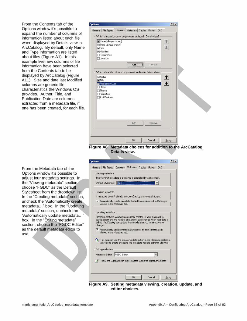
martishang_fgdc_ArcCatalog_metadata_template Appendix A – Configuring ArcCatalog - Page 68 of 82
From the Contents tab of the Options window it’s possible to expand the number of columns of information listed about each file when displayed by Details view in ArcCatalog. By default, only Name and Type information are listed about files (Figure A1). In this example five new columns of file information have been selected from the Contents tab to be displayed by ArcCatalog (Figure A11). Size and date last Modified columns are generic file characteristics the Windows OS provides. Author, Title, and Publication Date are columns extracted from a metadata file, if one has been created, for each file. From the Metadata tab of the Options window it’s possible to adjust four metadata settings. In the “Viewing metadata” section, choose “FGDC” as the Default Stylesheet from the dropdown list. In the “Creating metadata” section, uncheck the “Automatically create metadata…” box. In the “Updating metadata” section, uncheck the “Automatically update metadata…” box. In the “Editing metadata” section, choose the “FGDC Editor” as the default metadata editor to use.
Figure A8. Metadata choices for addition to the ArcCatalog
Details view.
Figure A9. Setting metadata viewing, creation, update, and
editor choices.

martishang_fgdc_ArcCatalog_metadata_template Appendix A – Configuring ArcCatalog - Page 69 of 82
Figure A10. ArcCatalog window reflecting customizations made
(compare with Figure A1).


martishang_fgdc_ArcCatalog_metadata_template Appendix B – Explanatory FGDC Metadata Graphics - Page 71 of 82
Appendix B – Explanatory FGDC Metadata Graphics The following graphics were copied from the FGDC Content Standard for Digital Geospatial Metadata (CSDGM) document and are helpful in illustrating the relationship of the metadata sections to one another and the hierarchical structure they embody.
Figure B1. The FGDC metadata standard has 11 sections numbered 0 through 10.
Section 0, “Metadata”, provides the starting point and is composed of the “main sections” of the standard. Sections 1 through 7 are the main sections of the standard. Sections 8 through 10 support other sections and provide a common method and format to define citation, temporal, and contact information.

martishang_fgdc_ArcCatalog_metadata_template Appendix B – Explanatory FGDC Metadata Graphics - Page 72 of 82
Figure B2. FGDC Content Standards for Digital Geospatial Metadata (FGDC-STD-001-1998).

martishang_fgdc_ArcCatalog_metadata_template Appendix B – Explanatory FGDC Metadata Graphics - Page 73 of 82
Figure B3. Elements of the Identification Section(1).

martishang_fgdc_ArcCatalog_metadata_template Appendix B – Explanatory FGDC Metadata Graphics - Page 74 of 82
Figure B4. Elements of the Data Quality Section(2).

martishang_fgdc_ArcCatalog_metadata_template Appendix B – Explanatory FGDC Metadata Graphics - Page 75 of 82
Figure B5. Elements of the Spatial Data Organization Section(3).

martishang_fgdc_ArcCatalog_metadata_template Appendix B – Explanatory FGDC Metadata Graphics - Page 76 of 82
Figure B6. Elements of the Spatial Reference Information Section(4).

martishang_fgdc_ArcCatalog_metadata_template Appendix B – Explanatory FGDC Metadata Graphics - Page 77 of 82
Figure B7. Elements of the Entity and Attribute Information Section(5).

martishang_fgdc_ArcCatalog_metadata_template Appendix B – Explanatory FGDC Metadata Graphics - Page 78 of 82
Figure B8. Elements of the Distribution Information Section(6).

martishang_fgdc_ArcCatalog_metadata_template Appendix B – Explanatory FGDC Metadata Graphics - Page 79 of 82
Figure B9. Elements of the Metadata Reference Information Section(7).
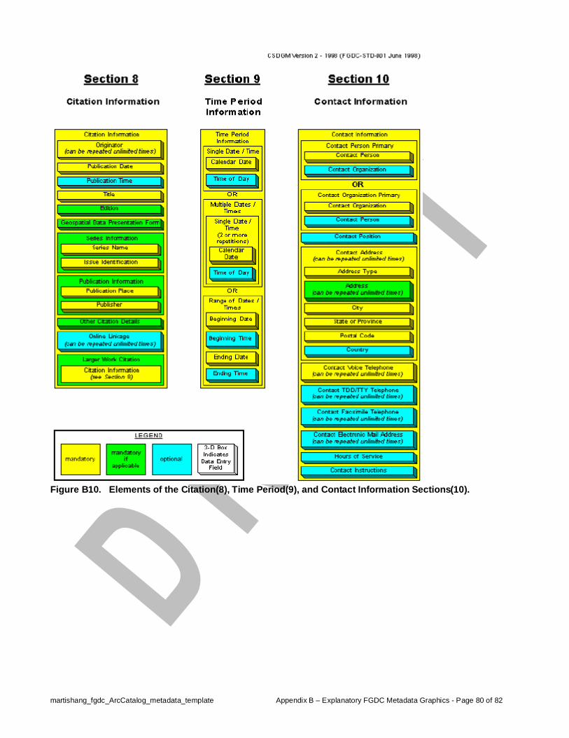
martishang_fgdc_ArcCatalog_metadata_template Appendix B – Explanatory FGDC Metadata Graphics - Page 80 of 82
Figure B10. Elements of the Citation(8), Time Period(9), and Contact Information Sections(10).

martishang_fgdc_ArcCatalog_metadata_template Appendix C – Styleguide for This Document - Page 81 of 82
Appendix C – “Styleguide” for This Document This document will require correction, revision, and maintenance. In the interest of preserving the formatting, captioning, and hyper-linking features that were used to construct it, document design specifications and settings are itemized here for reference by future document editors. Software: Microsoft Word 2002 (Office XP suite)
Page Format: Page size: 8 ½” x 11”
Page Orientation: portrait only
Margins: Top/bottom: 0.75” Inside/outside: 0.75” Gutter: 0.2”
Mirror margins (to allow for left margin binding) Header: 0.5” Footer: 0.5”
Columns: Used only in Appendix A. Number of: 2 Column 1: 2.2” wide, 0.1” spacing Column 2: 4.5” wide
Font & Font Sizes: Font(s): Arial only Font sizes: Title: 14pt. bolded Headings: Heading 1, 12pt bolded, centered 1st Subheading: Heading 2, 11pt bolded, left 2nd Subheading: Heading 3, 11pt bolded, left
(Note: using “Heading” styles for document headings and subheadings created “tags” used by the software to assemble the table of contents.)
Body text: 10pt Caption text: 10pt bolded, followed by 10pt Callouts: 10pt Text emphasis: italics Headers: unspecified… no text in headers Footers: 8pt
Headers/Footers: Header: No text entered, no formatting Footer: For each section: Used the header/footer toolbar to unselect the
“Same as previous” feature, which enabled different text to be entered to the footer of each section (see aligned right, below).
Aligned left: Filename, automatically inserted using the
header/footer toolbar. Aligned right: Part name + section name + page x of y
automatically inserted using the header/footer toolbar.
Breaks: Section: Odd page (so sections always begins on an odd page) Page: Breaks to next page
Figures: Format: Bitmap screen grabs Size: Reduced to 70% of original capture size Alignment: Always to left margin of page or column Captions: Hanging indents, built using Insert | Reference | Caption menu, which
created “tags” used by the software to assemble table of figures.

martishang_fgdc_ArcCatalog_metadata_template Appendix C – Styleguide for This Document - Page 82 of 82
Caption Label: Three defined. Used “Figure” in main body of document; “Figure A” in
Appendix A section; “Figure B” in Appendix B section. Callouts: Inserted using the Autoshapes | Callouts menu on the drawing toolbar
and selecting “oval”. Set font to Arial 12pt bold. Right-clicked on callout to open Format AutoShap menu where Fill color of orange was chosen, Transparency set to 50%, Line color of orange chosen, and of Weight 1.5pt.
Tables of: Contents: Built using default settings from the Insert | Reference | Index &
Tables | Table of Contents tab menu. Upon inserting the table of contents, it was selected and font size set to 10pt Arial.
Figures: Built using default settings from the Insert | Reference | Index &
Tables | Table of Figures tab menu. Because three different figure caption label formats were used (“Figure”, “Figure A”, and “Figure B”) it is necessary to use the Insert Table of Figures menu three times, selecting, in order, each of the three caption label formats to insert. Upon inserting the three table of figures, they were selected and font size set to 10pt Arial.