master plan 2019 st george airport - shire of balonne
TRANSCRIPT
Master Plan 2019
ST GEORGE AIRPORT
Prepared for: Balonne Shire Council
YSGE03 – MASTER PLAN 2019 – ST GEORGE AIRPORT i
DOCUMENT CONTROL
Document Title: Master Plan 2019 – St George Airport
Activity ID: YSGE03
Release Date: XX July 2019
Prepared by: G Holmes
Reviewed by: K Tonkin
Released by:
Revision History: Not for Release
Revision History
Version Description Transmitted Reviewed by Date
0.1 First Draft 31 July 2019
COPYRIGHT AND DISCLAIMER NOTICE
This document and the information contained herein should be treated as commercial-in-
confidence. No part of this work may be reproduced or copied in any form or by any
means (graphic, electronic or mechanical, including photocopying, recording, taping or
information retrieval system) or otherwise disclosed to any other party whatsoever,
without the prior written consent of Aviation Projects Pty Ltd.
This report has been prepared for the benefit solely of the Client, and is not to be relied
upon by any other person or entity without the prior written consent of Aviation Projects
Pty Ltd.
© Aviation Projects Pty Ltd, 2019. All rights reserved

YSGE03 – MASTER PLAN 2019 – ST GEORGE AIRPORT ii
TABLE OF CONTENTS Document Control ___________________________________________________________i
Copyright and Disclaimer Notice _______________________________________________i
Table of Contents __________________________________________________________ ii
List of Tables ______________________________________________________________ iv
List of Figures _____________________________________________________________ iv 1. PLANNING CONTEXT ___________________________________________________ 1 1.1. Background ________________________________________________________ 1 1.2. Site description _____________________________________________________ 2 1.3. Regional characteristics _____________________________________________ 2 1.4. Role and history _____________________________________________________ 3 1.5. Current operations __________________________________________________ 3 1.6. Strategic intent _____________________________________________________ 3 1.7. Purpose of master planning study ______________________________________ 3 1.8. Master planning outcomes ___________________________________________ 4 1.9. Strategic Alignment _________________________________________________ 4 1.10. Planning horizons ___________________________________________________ 4 1.11. Previous planning studies ____________________________________________ 4 1.12. Scope and Limitations _______________________________________________ 5 1.13. Methodology _______________________________________________________ 5 2. STAKEHOLDER CONSULTATION __________________________________________ 6 2.1. Stakeholder engagement program _____________________________________ 6 2.2. Face to face meetings and telephone interviews _________________________ 6 2.3. Results of personal interviews _________________________________________ 7 2.4. Online and printed survey responses ___________________________________ 7 3. SWOT ANALYSIS _____________________________________________________ 13 4. EXISTING AERODROME FACILITIES _____________________________________ 14 4.1. Aeronautical infrastructure __________________________________________ 14 4.2. Support facilities ___________________________________________________ 14 4.3. Landside development ______________________________________________ 14 4.4. Ground transport ___________________________________________________ 15
5. DEMAND ___________________________________________________________ 16 5.1. Regional population growth _________________________________________ 16 5.2. Historical passenger demand ________________________________________ 16 5.3. Historical aircraft movement demand _________________________________ 16 5.4. Historical freight demand ___________________________________________ 16 5.5. Forecast passenger demand _________________________________________ 16 5.6. Future RPT/charter routes __________________________________________ 17 5.7. Aircraft parking capacity ____________________________________________ 17 5.8. Passenger terminal capacity ________________________________________ 17 5.9. Freight operations capacity _________________________________________ 17 6. DEVELOPMENT CONSTRAINTS _________________________________________ 18 6.1. Planning _________________________________________________________ 18 6.2. Regulatory context _________________________________________________ 19 6.3. Design Standards __________________________________________________ 20 6.4. Environmental _____________________________________________________ 20 6.5. Heritage __________________________________________________________ 20 7. AIRCRAFT MOVEMENT AREAS _________________________________________ 21 7.1. Runway __________________________________________________________ 21 7.2. Runway pavements ________________________________________________ 21 7.3. Wind roses ________________________________________________________ 21 7.4. Taxiways _________________________________________________________ 22 7.5. Parking aprons ____________________________________________________ 22 7.6. Hangar facilities ___________________________________________________ 22 7.7. Helicopter facilities ________________________________________________ 22 7.8. Aerodrome lighting_________________________________________________ 22 8. AVIATION SUPPORT FACILITIES ________________________________________ 23 8.1. Fuel _____________________________________________________________ 23 8.2. Ground support equipment __________________________________________ 23 8.3. Navigation and approach aids _______________________________________ 23 8.4. Weather information service _________________________________________ 23 8.5. Aerodrome rescue and firefighting services ____________________________ 23 8.6. Air traffic control and airspace _______________________________________ 23
YSGE03 – MASTER PLAN 2019 – ST GEORGE AIRPORT iii
8.7. Transport security __________________________________________________ 23 9. PASSENGER FACILITIES _______________________________________________ 25 9.1. Passenger terminal _________________________________________________ 25 9.2. Aeromedical facilities _______________________________________________ 25 10. COMMERCIAL LAND USE AND DEVELOPMENT ____________________________ 26 10.1. Current leasing and charging regime __________________________________ 26 10.2. Future commercial and business prospects ____________________________ 26 11. GROUND TRANSPORT SYSTEMS ________________________________________ 27 11.1. External network ___________________________________________________ 27 11.2. Internal network ___________________________________________________ 27 11.3. Airside access _____________________________________________________ 27 11.4. Public car parking __________________________________________________ 27 11.5. Rental car parking demand __________________________________________ 27 11.6. Buses ____________________________________________________________ 27 11.7. Taxis _____________________________________________________________ 27 11.8. Aviation fuel _______________________________________________________ 27 12. UTILITIES AND CIVIL INFRASTRUCTURE __________________________________ 28 12.1. Water ____________________________________________________________ 28 12.2. Electricity _________________________________________________________ 28 12.3. Sewer/septic ______________________________________________________ 28 12.4. Communications ___________________________________________________ 28 12.5. Stormwater _______________________________________________________ 28 12.6. Perimeter fencing __________________________________________________ 28 13. AERODROME SAFEGUARDING _________________________________________ 29 13.1. Operational airspace ________________________________________________ 29 13.2. Lighting restriction zone _____________________________________________ 29 13.3. Wildlife hazard buffer zone ___________________________________________ 29 13.4. Building restricted areas for aviation facilities __________________________ 29 13.5. Public safety areas _________________________________________________ 30 13.6. Aircraft noise ______________________________________________________ 30 14. MASTER PLAN _______________________________________________________ 31 14.1. Short term - stage one ______________________________________________ 31
14.2. Longer term development ___________________________________________ 32 15. REVENUES AND COSTS _______________________________________________ 33 15.1. Revenues _________________________________________________________ 33 15.2. Costs ____________________________________________________________ 33 16. GLOSSARY __________________________________________________________ 34 17. REFERENCES _______________________________________________________ 35 ANNEXURES ____________________________________________________________ 36 SHORT TERM – 2-3 YEARS__________________________________________________ 1 LONG TERM ______________________________________________________________ 1 AERODROME SAFEGUARDING ______________________________________________ 1
YSGE03 – MASTER PLAN 2019 – ST GEORGE AIRPORT iv
LIST OF TABLES
Table 1 Respondents suggestions on airport facilities ____________________________ 10
Table 2 St George Airport long term strategic vision ______________________________ 11
Table 3 St George Airport SWOT analysis ______________________________________ 13
Table 4 Runway declared distances __________________________________________ 14
Table 5 Project population Balonne Shire Council 2016 - 2041 ____________________ 16
Table 6 MOS 139 Table 2.2-1 Aerodrome Reference Code ________________________ 20
Table 7 St George Airport (YSGE) aerodrome and procedure charts _________________ 23
LIST OF FIGURES
Figure 1 Location map ______________________________________________________ 1
Figure 2 St George Airport location ____________________________________________ 1
Figure 3 Site overview ______________________________________________________ 2
Figure 4 Long Distance Aviation Services _______________________________________ 3
Figure 5 Expected Level of Service ____________________________________________ 8
Figure 6 Current Level of Service _____________________________________________ 8
Figure 7 Airport facilities desired by respondents ________________________________ 9
Figure 8 Flight destinations desired by respondents _____________________________ 10
Figure 9 St George Airport commercial development ____________________________ 11
Figure 10 St George Airport runway __________________________________________ 14
Figure 11 Scheduled destinations ___________________________________________ 17
Figure 12 Planning Scheme Map P2 St George _________________________________ 18
Figure 13 QLD Globe Land Use overlay _______________________________________ 19
Figure 14 9 am wind rose __________________________________________________ 21
Figure 15 3 pm wind rose __________________________________________________ 22
YSGE03 – MASTER PLAN 2019 – ST GEORGE AIRPORT 1
1. PLANNING CONTEXT
1.1. Background
St George Airport is a community asset owned and operated by Balonne Shire Council
(BSC), located 2 km south east of St George town centre. The airport has been operating
as a Certified aerodrome since 2008. As a Certified aerodrome, St George is obligated to
maintain compliance with CASA Manual of Standards Part 139 (MOS 139).
St George is a small rural community of 3,048 people within the Balonne Shire Council
region, located 512 km west of Brisbane (see Figure 1), in south western Queensland. St
George has links with Roma as the region’s major regional activity centre, as well as
strong ties with both Goondiwindi, particularly in relation to agriculture, and Toowoomba,
for administrative, health and financial services. The nearest substantial population
centre is located approximately 386 km to the east at Toowoomba, and Roma
approximately 196 km to the north. Its remoteness and isolation underpin the importance
played by key community infrastructure assets like the St George Airport. The airport is
located just 2 km from the St George town centre and provides critical connectivity to
both regional communities and accessibility to capital city facilities. The airport also plays
a key role in enabling local and regional economic development opportunities to the
agri-business and aviation sectors. The opening of available land at St George Airport for
hangar development will enable these business opportunities to turn into reality.
There are a small number of existing hangars and other minor facilities at the airport and
Balonne Shire has demonstrated demand for a range of new businesses and private
users wishing to invest in private hangar facilities. There are no sites prepared for the
development of any new hangars which have direct taxiway and / or apron access.
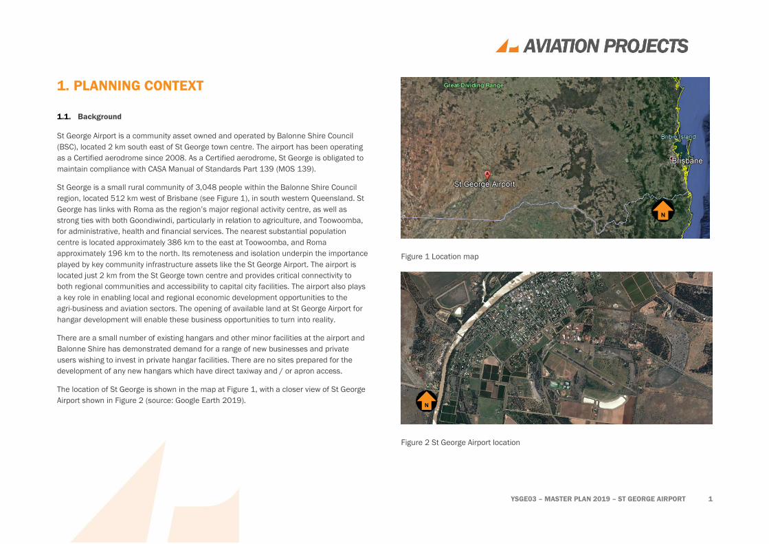
The location of St George is shown in the map at Figure 1, with a closer view of St George
Airport shown in Figure 2 (source: Google Earth 2019).
Figure 1 Location map
Figure 2 St George Airport location
YSGE03 – MASTER PLAN 2019 – ST GEORGE AIRPORT 2
1.2. Site description
St George is a Code 3 aerodrome with a single sealed 1,520 m x 30 m runway and a
published Pavement Classification Number (PCN) of 15, meaning aircraft with an Aircraft
Classification Number (ACN) of up to 15 can operate. Currently Regional Express Airlines
(Rex) operates twice weekly services to Cunnamulla, Thargomindah and Brisbane via
Toowoomba, using a SAAB 340, 33 seat aircraft with an ACN of 7.
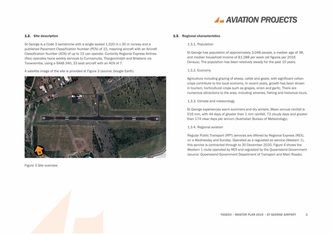
A satellite image of the site is provided at Figure 3 (source: Google Earth)
Figure 3 Site overview
1.3. Regional characteristics
1.3.1. Population
St George has population of approximately 3,048 people, a median age of 38,
and median household income of $1,288 per week (all figures per 2016
Census). The population has been relatively steady for the past 10 years.
1.3.2. Economy
Agriculture including grazing of sheep, cattle and goats, with significant cotton
crops contribute to the local economy. In recent years, growth has been shown
in tourism, horticultural crops such as grapes, onion and garlic. There are
numerous attractions to the area, including wineries, fishing and historical tours.
1.3.3. Climate and meteorology
St George experiences warm summers and dry winters. Mean annual rainfall is
516 mm, with 44 days of greater than 1 mm rainfall, 73 cloudy days and greater
than 174 clear days per annum (Australian Bureau of Meteorology).
1.3.4. Regional aviation
Regular Public Transport (RPT) services are offered by Regional Express (REX),
on a Wednesday and Sunday. Operated as a regulated air service (Western 1),
this service is contracted through to 30 December 2020. Figure 4 shows the
Western 1 route operated by REX and regulated by the Queensland Government
(source: Queensland Government Department of Transport and Main Roads).

YSGE03 – MASTER PLAN 2019 – ST GEORGE AIRPORT 3
Figure 4 Long Distance Aviation Services
1.4. Role and history
St George Airport is a main transit point for Balonne Shire residents. The airport also
helps serve the Royal Flying Doctor Service (RFDS), for medical transport. Light aircraft
charters and agricultural industries also use the St George Airport.
1.5. Current operations
Current aircraft operations include:
• Saab 340B aircraft operated by Regional Express to Cunnamulla, Thargomindah
and Brisbane via Toowoomba (Wellcamp); and
• Light general aviation and agribusiness aircraft operate private and charter
flights to various destinations.
There is a helicopter landing point, however it is used infrequently.
1.6. Strategic intent
Balonne Shire Council intends to ensure that St George Airport is appropriately positioned
to deliver the positive social and economic benefits associated with the shire.
This will be achieved by operating the airport as a commercial entity striving for cost
neutrality, that has fully adopted a user pays methodology. Council will ensure operational
expenses can be met as and when they fall due, that safety is not compromised, and that
capital works are appropriately planned and budgeted for in response to demonstrated
demand.
1.7. Purpose of master planning study
The purpose of the Master Plan is to establish a framework for the future planning and
development for an industrial and airport precinct at St George Airport to ensure Balonne
Shire Council achieves its strategic objectives and capitalises on the aeronautical and
commercial opportunities provided by the airport.

YSGE03 – MASTER PLAN 2019 – ST GEORGE AIRPORT 4
The Master Plan is intended to establish the basis for more detailed studies of design,
infrastructure planning, and land use planning required to achieve the strategic direction.
1.8. Master planning outcomes
The Master Plan will provide a direction for the airport in terms of future infrastructure
development and cost recovery, balanced against the economic and social requirements
and aspirations of the local community
1.9. Strategic Alignment
Balonne Shire Council in association with the Economic Development Advisory Committee
facilitated the development of the Balonne Shire Economic Development Plan 2018 -
2022.
The following specific actions included in the Balonne Shire Economic Development Plan
2018 - 2022 are relevant to the development of this Master Plan:
• Theme 3 - Enabling economic prosperity: strategic planning and infrastructure
provision – Catalyst project of planning and development, which would identify
opportunities to expand the St George Airport; and
• Theme 3 - Enabling economic prosperity: strategic planning and infrastructure
provision - Performance Measures which includes development of a Master Plan
for St George Airport.
1.10. Planning horizons
The Master Plan nominally considers a planning horizon of 20 years, comprised of short
term and longer-term timeframes:
• Short term – two-three years; and
• Longer term Master Plan horizon – beyond the short term to 20 years.
1.11. Previous planning studies
There were no previous planning studies which were required to be considered for the
development of this master plan.
YSGE03 – MASTER PLAN 2019 – ST GEORGE AIRPORT 5
1.12. Scope and Limitations
The scope of work for the master planning study was specified as follows:
• assessment of the airport’s current facilities and operations;
• analysis of trends in the number and types of aircraft using the airport,
passenger numbers and the implication of those trends to facilities and
operations now and into the future;
• assessment of regulatory requirements, the points at which those requirements
may be triggered at St George Airport, and the implication of those requirements
on facilities and operations;
• identification of opportunities to improve the financial viability of the airport;
• consultation with key stakeholders, including Councillors, Balonne Shire Council
residents, and local businesses to identify their expectations and requirements
of the airport now and into the future;
• gap analysis of the airport’s current and projected facilities and operations;
• recommendation of actions for Council (and other stakeholders, where
appropriate) to close those gaps; and
• development of an indicative scope, cost and timing of each recommended
action.
1.13. Methodology
The master planning study was conducted generally in accordance the Australian Airports
Association Airport Practice Note 4 - Regional Airport Master Planning Guideline Planning
and modified according to the Scope of Work.
The following key activities were conducted during the course of the study:
• Inception meeting and site orientation;
• Stakeholder consultation activities including site visit;
• Consolidation of stakeholder feedback;
• Preparation of concept plans for client endorsement;
• Preparation of draft Master Plan including drawings, plans and cost estimates;
• Final stakeholder consultation including review of draft Master Plan; and
• Preparation of final Master Plan for client acceptance.

YSGE03 – MASTER PLAN 2019 – ST GEORGE AIRPORT 6
2. STAKEHOLDER CONSULTATION
A comprehensive stakeholder consultation plan was designed to maximise the
opportunity for the local community and aviation stakeholders to provide input to the
development of the Master Plan.
2.1. Stakeholder engagement program
Engagement activities conducted during the consultation period 29 May – 28 June 2019
included:
• Telephone and/or face to face consultation with Councillors;
• A media release to advise residents of the St George Airport Master Plan its
purpose, timeframe and feedback options (for BSC confirmation);
• A teleconference with the Deputy Mayor;
• A link on the Council website and Facebook profile to an online survey; and
• A set of Frequently Asked Questions published on the Council website to
promote the program to the wider community.
2.2. Face to face meetings and telephone interviews
A representative of Aviation Projects personally spoke with the following people, either
face to face or via telephone:
• All Councillors who made their contact details available;
• The president of the Chamber of Commerce;
• Mr Jason O’Toole (BalonneAirwork); and
• Mr Peter Lindsay (Vanderfield /pilot).

YSGE03 – MASTER PLAN 2019 – ST GEORGE AIRPORT 7
2.3. Results of personal interviews
The results of the face to face and telephone interviews reflect the wide and varied
interests of those consulted. A summary of responses for each interest group is provided
below.
2.3.1. Councillors
The Mayor, Deputy Mayor and other Councillors expressed varied opinions
regarding the future of the airport.
2.3.2. Commercial aircraft operators
A lack of refuelling at the airport can limit operations, refuelling station at the
airport would be ideal (either JetA1 and Avgas).
2.3.3. Local aircraft operators
Local aircraft operators were generally satisfied with the facilities but would like
improvements made to basic amenities.
Operators would like more hangars onsite, with the ability to lease or purchase.
2.3.4. General themes
The following themes emerged from the personal interviews:
• Council would like the airport to be agile and be given the opportunity
to adapt long term;
• Councillors like the proximity to town;
• Some councillors feel the airport meets current town needs;
• There is a consensus that an increase in passenger services will be
better for the town and its people;
• The passenger terminal could be improved.
2.4. Online and printed survey responses
A short online survey, provided via the Council website through the website Survey
Monkey asked the following questions:
1. What do you like about St George Airport?
2. What is your expected level of service at St George Airport?
a. Excellent (no delays, excellent level of comfort)
b. High (very few delays, high level of comfort)
c. Good (acceptable delays, good level of comfort)
d. Adequate (acceptable delays for short periods, adequate level of comfort)
3. How would you rate the current St George Airport?
a. Excellent (no delays, excellent level of comfort)
b. High (very few delays, high level of comfort)
c. Good (acceptable delays, good level of comfort)
d. Adequate (acceptable delays for short periods, adequate level of comfort)
e. Inadequate (unacceptable delays, inadequate level of comfort)
f. Unacceptable (unacceptable delays, unacceptable levels of comfort)
4. If your expectations of St George Airport are not being met, what improvements
do you think are needed for them to be met?
5. What services or facilities would you like to see at St George Airport in the
future?
a. Bigger passenger terminal
b. Taxis on standby

YSGE03 – MASTER PLAN 2019 – ST GEORGE AIRPORT 8
c. Local area information
d. Conference or meeting facilities
e. Retail outlets
f. Other (please specify below)
6. What other destinations would you like to be able to fly to or from St George?
7. What commercial development opportunities would you like to see at St George
Airport?
8. What do you see as the long-term strategic vision for St George Airport?
9. What social and economic benefits do you associate with St George Airport?
10. If you have any other comments or input, please provide that here.
2.4.1. Survey results
The online survey attracted 39 participants.
There were several common themes to the responses:
• Respondents generally like how well the airport is maintained, the
proximity to town and ease of service.
• The customer experience generally did not meet expectations on:
o provided seating;
o lack of shaded or undercover areas outside;
o lack of air-conditioning in terminal;
o outdated terminal facility; and
o infrequency of services to and from St George.
The difference between expected and current level of service is illustrated in
Figure 5 and Figure 6.
Figure 5 Expected Level of Service
Figure 6 Current Level of Service

YSGE03 – MASTER PLAN 2019 – ST GEORGE AIRPORT 9
Survey respondents highlighted a number of improvements they believe need to
be introduced at St George Airport. These improvements included:
• terminal facilities:
o improve seating inside and outside terminal (6);
o more toilets (1);
o transfers into town (1);
o security check (1);
o secure parking (1);
o improvements to Avgas supply (1);
o free Wifi (1); and
o reconfigured access to baggage drop-off and pickup (1).
• terminal building:
o shaded areas (4);
o update terminal building (4); and
o covered walkway to aircraft (2).
• customer service:
o increase in frequency of services (5);
o improvements to aircon in terminal (1); and
o staff manners (1).
2.4.2. Requested airport facilities
Airport facilities are desired by respondents are shown in Figure 7.
Figure 7 Airport facilities desired by respondents

YSGE03 – MASTER PLAN 2019 – ST GEORGE AIRPORT 10
Other (specify): respondents were given an opportunity to provide comments on
airport facilities they would like to see at St George Airport in the future. A
summary of respondents’ suggestions is shown in Table 1.
Table 1 Respondents suggestions on airport facilities
Survey respondents Category No. of respondents
Improved terminal building Terminal building 4
Lease or purchase of hangars Airport services 2
Improved terminal lighting Terminal precinct area 1
Improved parking Airport services 1
Car hire Airport services 1
Improved seating for terminal Terminal facilities 1
Vending machines Terminal facilities 1
2.4.3. Flight destinations
Flight destinations desired by respondents are shown in Figure 8.
Figure 8 Flight destinations desired by respondents
Other destinations mentioned by respondents included:
• Darwin (1);
• Cairns (1);
• Townsville (1);
• Barcaldine (1);
• Northern Queensland (1); and
• Gold Coast (1).
2
2
2
2
3
3
7
15
0 2 4 6 8 10 12 14 16
Toowoomba
Moree
Charleville
Longreach
Melbourne
Brisbane
Roma
Sydney
Desired destination
YSGE03 – MASTER PLAN 2019 – ST GEORGE AIRPORT 11
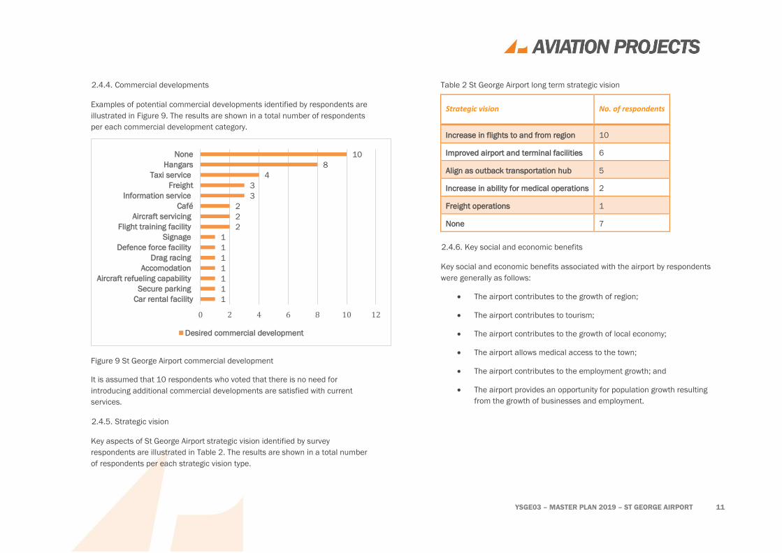
2.4.4. Commercial developments
Examples of potential commercial developments identified by respondents are
illustrated in Figure 9. The results are shown in a total number of respondents
per each commercial development category.
Figure 9 St George Airport commercial development
It is assumed that 10 respondents who voted that there is no need for
introducing additional commercial developments are satisfied with current
services.
2.4.5. Strategic vision
Key aspects of St George Airport strategic vision identified by survey
respondents are illustrated in Table 2. The results are shown in a total number
of respondents per each strategic vision type.
Table 2 St George Airport long term strategic vision
Strategic vision No. of respondents
Increase in flights to and from region 10
Improved airport and terminal facilities 6
Align as outback transportation hub 5
Increase in ability for medical operations 2
Freight operations 1
None 7
2.4.6. Key social and economic benefits
Key social and economic benefits associated with the airport by respondents
were generally as follows:
• The airport contributes to the growth of region;
• The airport contributes to tourism;
• The airport contributes to the growth of local economy;
• The airport allows medical access to the town;
• The airport contributes to the employment growth; and
• The airport provides an opportunity for population growth resulting
from the growth of businesses and employment.
1
1
1
1
1
1
1
2
2
2
3
3
4
8
10
0 2 4 6 8 10 12
Car rental facility
Secure parking
Aircraft refueling capability
Accomodation
Drag racing
Defence force facility
Signage
Flight training facility
Aircraft servicing
Café
Information service
Freight
Taxi service
Hangars
None
Desired commercial development

YSGE03 – MASTER PLAN 2019 – ST GEORGE AIRPORT 12
2.4.7. Comments on St George Airport development
Key comments on St George Airport development were generally as follows:
• The council would like the airport to remain adaptable and agile for the
future;
• The councillors and respondents are happy with the airport’s proximity
to town;
• The terminal and facilities are generally outdated, and need
renovating;
• The airport is generally clean and tidy;
• The taxiways are an issue with limited space, to and from aprons;
• The respondents were interested in increasing the airports potential
for freight and tourism;
• The lack of shade and outside seating in the terminal facilities is a
common complaint;
• The RFDS shed is not in an ideal location, and is not used to its full
potential;
• Security could be improved at the airport;
• Infrequency of flight service is a common theme, with respondents
generally wanting more services to/from current destinations;
• Respondents would like the opportunity to lease or purchase hangars;
• The terminal and facilities are not very suitable for those with
disabilities; and
• The airport should provide better aircraft refuelling service.
2.4.8. Survey respondent location
The pool of survey respondents was formed online with links to the survey given
on the Balonne Shire Council website through SurveyMonkey. It is assumed that
the respondents of the survey are Balonne Shire Council residents, or those who
have regular interactions with the St George Airport.
YSGE03 – MASTER PLAN 2019 – ST GEORGE AIRPORT 13
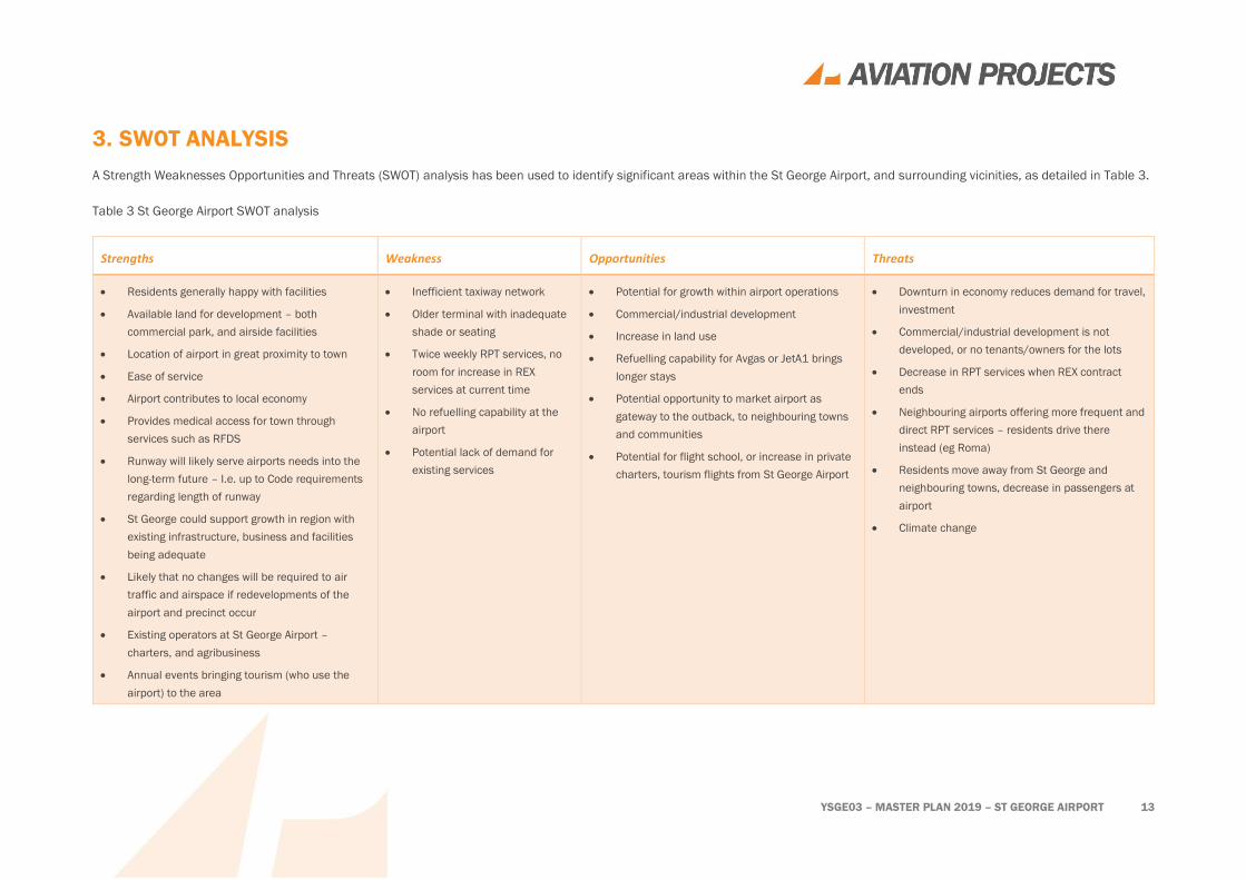
3. SWOT ANALYSIS
A Strength Weaknesses Opportunities and Threats (SWOT) analysis has been used to identify significant areas within the St George Airport, and surrounding vicinities, as detailed in Table 3.
Table 3 St George Airport SWOT analysis
Strengths Weakness Opportunities Threats
• Residents generally happy with facilities
• Available land for development – both
commercial park, and airside facilities
• Location of airport in great proximity to town
• Ease of service
• Airport contributes to local economy
• Provides medical access for town through
services such as RFDS
• Runway will likely serve airports needs into the
long-term future – I.e. up to Code requirements
regarding length of runway
• St George could support growth in region with
existing infrastructure, business and facilities
being adequate
• Likely that no changes will be required to air
traffic and airspace if redevelopments of the
airport and precinct occur
• Existing operators at St George Airport –
charters, and agribusiness
• Annual events bringing tourism (who use the
airport) to the area
• Inefficient taxiway network
• Older terminal with inadequate
shade or seating
• Twice weekly RPT services, no
room for increase in REX
services at current time
• No refuelling capability at the
airport
• Potential lack of demand for
existing services
• Potential for growth within airport operations
• Commercial/industrial development
• Increase in land use
• Refuelling capability for Avgas or JetA1 brings
longer stays
• Potential opportunity to market airport as
gateway to the outback, to neighbouring towns
and communities
• Potential for flight school, or increase in private
charters, tourism flights from St George Airport
• Downturn in economy reduces demand for travel,
investment
• Commercial/industrial development is not
developed, or no tenants/owners for the lots
• Decrease in RPT services when REX contract
ends
• Neighbouring airports offering more frequent and
direct RPT services – residents drive there
instead (eg Roma)
• Residents move away from St George and
neighbouring towns, decrease in passengers at
airport
• Climate change
YSGE03 – MASTER PLAN 2019 – ST GEORGE AIRPORT 14
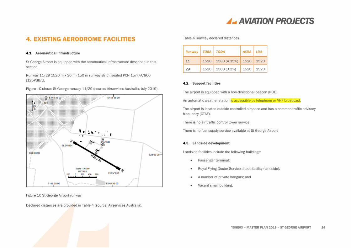
4. EXISTING AERODROME FACILITIES
4.1. Aeronautical infrastructure
St George Airport is equipped with the aeronautical infrastructure described in this
section.
Runway 11/29 1520 m x 30 m (150 m runway strip), sealed PCN 15/F/A/860
(125PSI)/U.
Figure 10 shows St George runway 11/29 (source: Airservices Australia, July 2019).
Figure 10 St George Airport runway
Declared distances are provided in Table 4 (source: Airservices Australia).
Table 4 Runway declared distances
Runway TORA TODA ASDA LDA
11 1520 1580 (4.35%) 1520 1520
29 1520 1580 (3.2%) 1520 1520
4.2. Support facilities
The airport is equipped with a non-directional beacon (NDB).
An automatic weather station is accessible by telephone or VHF broadcast.
The airport is located outside controlled airspace and has a common traffic advisory
frequency (CTAF).
There is no air traffic control tower service.
There is no fuel supply service available at St George Airport
4.3. Landside development
Landside facilities include the following buildings:
• Passenger terminal;
• Royal Flying Doctor Service shade facility (landside);
• A number of private hangars; and
• Vacant small building;

YSGE03 – MASTER PLAN 2019 – ST GEORGE AIRPORT 15
4.4. Ground transport
Access to the airport is via sealed single-lane Cliff Parsons Drive, off the Carnarvon
Highway, which terminates in a cul-de-sac west of the passenger terminal.
A small number of sealed unmarked car parks are provided in front of the passenger
terminal. The remainder of car parking positions are unsealed.
YSGE03 – MASTER PLAN 2019 – ST GEORGE AIRPORT 16
5. DEMAND
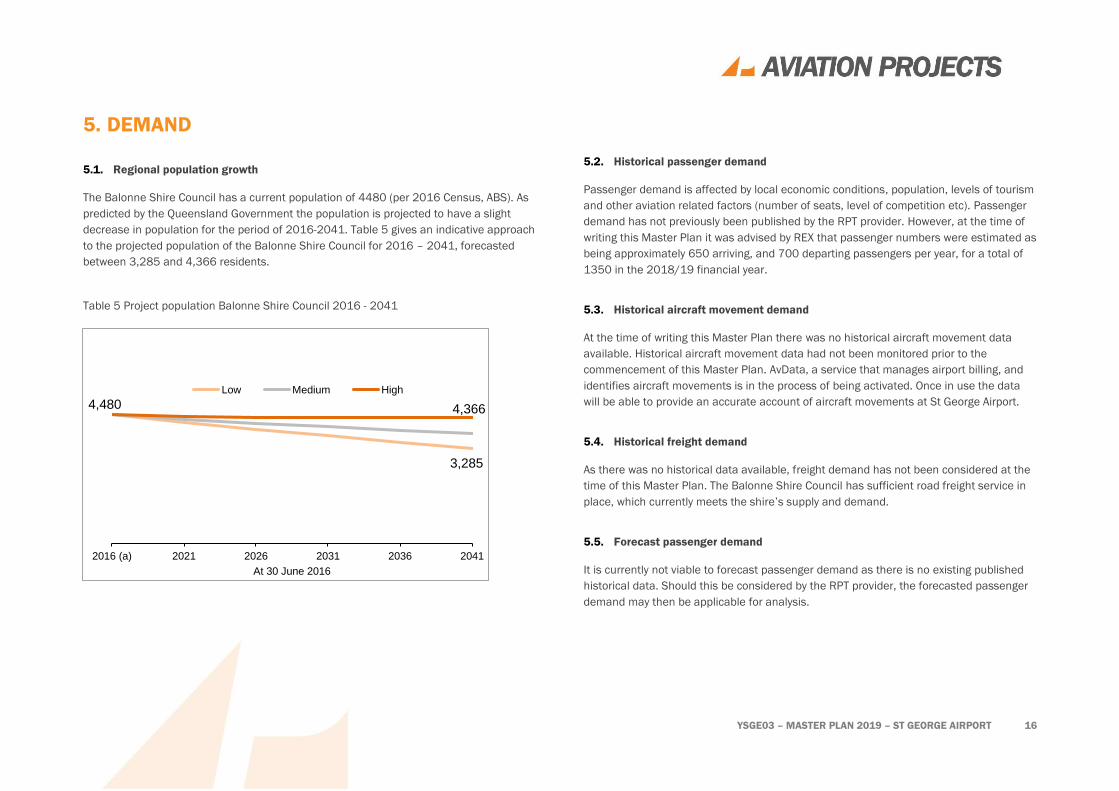
5.1. Regional population growth
The Balonne Shire Council has a current population of 4480 (per 2016 Census, ABS). As
predicted by the Queensland Government the population is projected to have a slight
decrease in population for the period of 2016-2041. Table 5 gives an indicative approach
to the projected population of the Balonne Shire Council for 2016 – 2041, forecasted
between 3,285 and 4,366 residents.
5.2. Historical passenger demand
Passenger demand is affected by local economic conditions, population, levels of tourism
and other aviation related factors (number of seats, level of competition etc). Passenger
demand has not previously been published by the RPT provider. However, at the time of
writing this Master Plan it was advised by REX that passenger numbers were estimated as
being approximately 650 arriving, and 700 departing passengers per year, for a total of
1350 in the 2018/19 financial year.
5.3. Historical aircraft movement demand
At the time of writing this Master Plan there was no historical aircraft movement data
available. Historical aircraft movement data had not been monitored prior to the
commencement of this Master Plan. AvData, a service that manages airport billing, and
identifies aircraft movements is in the process of being activated. Once in use the data
will be able to provide an accurate account of aircraft movements at St George Airport.
5.4. Historical freight demand
As there was no historical data available, freight demand has not been considered at the
time of this Master Plan. The Balonne Shire Council has sufficient road freight service in
place, which currently meets the shire’s supply and demand.
5.5. Forecast passenger demand
It is currently not viable to forecast passenger demand as there is no existing published
historical data. Should this be considered by the RPT provider, the forecasted passenger
demand may then be applicable for analysis.
4,480
3,285
4,366
2016 (a) 2021 2026 2031 2036 2041
At 30 June 2016
Low Medium High
Table 5 Project population Balonne Shire Council 2016 - 2041

YSGE03 – MASTER PLAN 2019 – ST GEORGE AIRPORT 17
5.6. Future RPT/charter routes
According to the survey results, there is a desire for additional services to Brisbane, as
well as new routes to Sydney, Roma and Melbourne. A map showing current scheduled
destinations, including Cunnamulla, Thargomindah, and Brisbane via Toowoomba
(Wellcamp), is provided at Figure 11 (source: Great Circle Mapper).
Identified in Figure 4, the Western 1 route is regulated by the Queensland Government
until 30 December 2020. After this time potential remodelling of the route could be
presented to the RPT operator, to provide additional services to and from St George
Airport.
Figure 11 Scheduled destinations
5.7. Aircraft parking capacity
Presently the airport suffers from constraints in aircraft parking due to limited apron
space during high traffic periods.
5.8. Passenger terminal capacity
The passenger terminal is does not meeting community expectations, in that it is not
large enough to accommodate all passengers and is not easily accessible for people with
disabilities. Upgrading the terminal could prove beneficial for operations and passenger
comfort.
5.9. Freight operations capacity
At the time of preparing the Master Plan there were no routine freight operations at the
airport.
YSGE03 – MASTER PLAN 2019 – ST GEORGE AIRPORT 18
6. DEVELOPMENT CONSTRAINTS
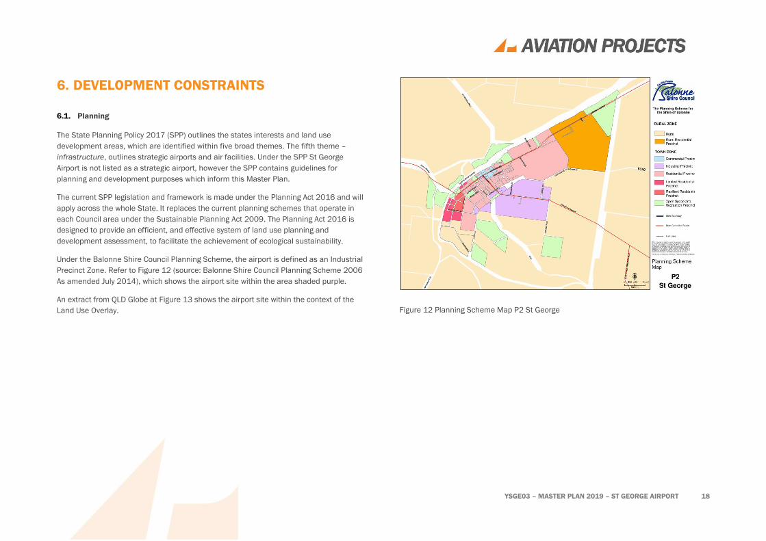
6.1. Planning
The State Planning Policy 2017 (SPP) outlines the states interests and land use
development areas, which are identified within five broad themes. The fifth theme –
infrastructure, outlines strategic airports and air facilities. Under the SPP St George
Airport is not listed as a strategic airport, however the SPP contains guidelines for
planning and development purposes which inform this Master Plan.
The current SPP legislation and framework is made under the Planning Act 2016 and will
apply across the whole State. It replaces the current planning schemes that operate in
each Council area under the Sustainable Planning Act 2009. The Planning Act 2016 is
designed to provide an efficient, and effective system of land use planning and
development assessment, to facilitate the achievement of ecological sustainability.
Under the Balonne Shire Council Planning Scheme, the airport is defined as an Industrial
Precinct Zone. Refer to Figure 12 (source: Balonne Shire Council Planning Scheme 2006
As amended July 2014), which shows the airport site within the area shaded purple.
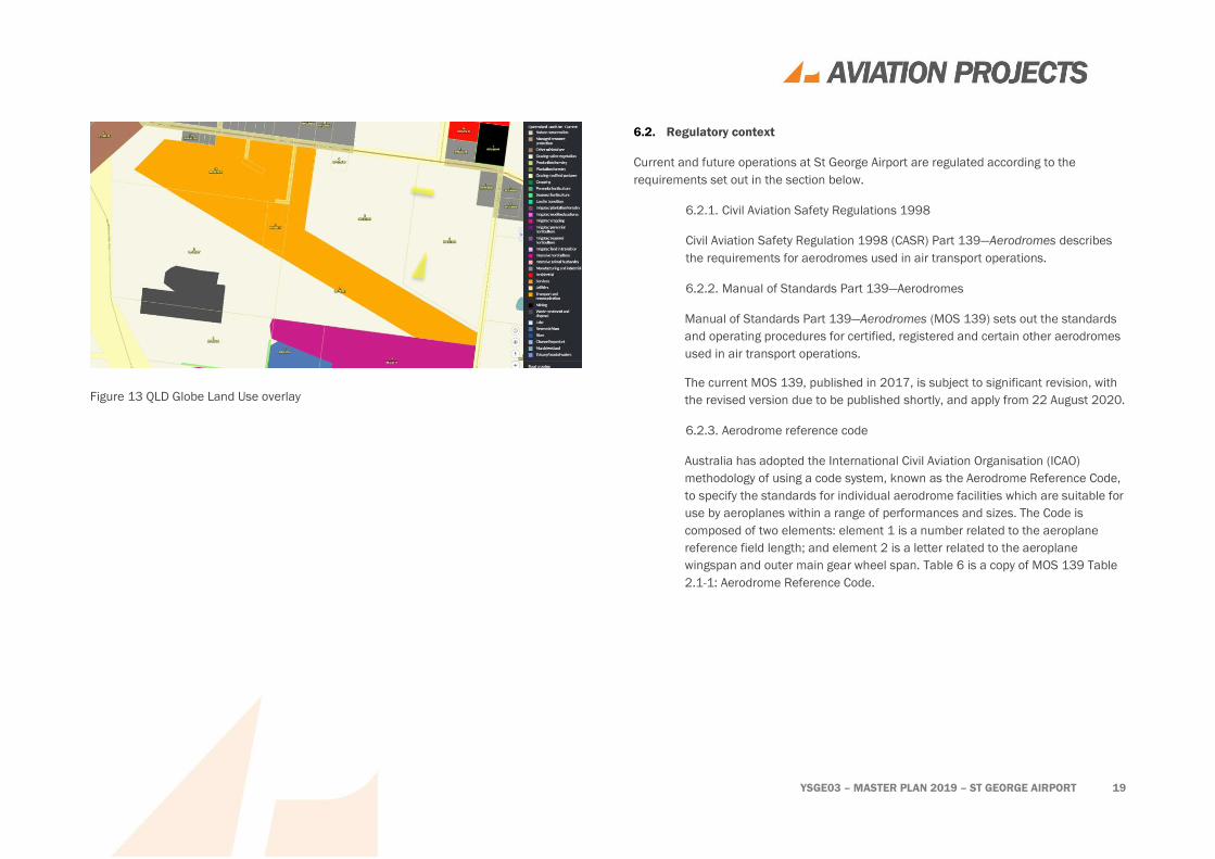
An extract from QLD Globe at Figure 13 shows the airport site within the context of the
Land Use Overlay.
Figure 12 Planning Scheme Map P2 St George
YSGE03 – MASTER PLAN 2019 – ST GEORGE AIRPORT 19
Figure 13 QLD Globe Land Use overlay
6.2. Regulatory context
Current and future operations at St George Airport are regulated according to the
requirements set out in the section below.
6.2.1. Civil Aviation Safety Regulations 1998
Civil Aviation Safety Regulation 1998 (CASR) Part 139—Aerodromes describes
the requirements for aerodromes used in air transport operations.
6.2.2. Manual of Standards Part 139—Aerodromes
Manual of Standards Part 139—Aerodromes (MOS 139) sets out the standards
and operating procedures for certified, registered and certain other aerodromes
used in air transport operations.
The current MOS 139, published in 2017, is subject to significant revision, with
the revised version due to be published shortly, and apply from 22 August 2020.
6.2.3. Aerodrome reference code
Australia has adopted the International Civil Aviation Organisation (ICAO)
methodology of using a code system, known as the Aerodrome Reference Code,
to specify the standards for individual aerodrome facilities which are suitable for
use by aeroplanes within a range of performances and sizes. The Code is
composed of two elements: element 1 is a number related to the aeroplane
reference field length; and element 2 is a letter related to the aeroplane
wingspan and outer main gear wheel span. Table 6 is a copy of MOS 139 Table
2.1-1: Aerodrome Reference Code.

YSGE03 – MASTER PLAN 2019 – ST GEORGE AIRPORT 20
Table 6 MOS 139 Table 2.2-1 Aerodrome Reference Code
Code Element 1 Code Element 2
Code
number
Aeroplane reference field
length
Code
letter
Wing span
1 Less than 800 m A Up to but not including
15 m
2 800 m up to but not
including 1200 m
B 15 m up to but not
including 24 m
3 1200 m up to but not
including 1800 m
C 24 m up to but not
including 36 m
4 1800 m and over D 36 m up to but not
including 52 m
E 52 m up to but not
including 65 m
F 65 m up to but not
including 80 m
6.3. Design Standards
BSC desires an aerodrome that will ultimately conform to standards applicable to code 3C
instrument non-precision requirements as specified in MOS 139.
The Master Plan contemplates proposed changes to the requirements specified in MOS
139 to the extent they have been explained, but do not necessarily reflect the final
version as it is still pending publication.
6.4. Environmental
No significant environmental issues were identified during the study.
6.5. Heritage
No significant heritage issues were identified during the study.
YSGE03 – MASTER PLAN 2019 – ST GEORGE AIRPORT 21
7. AIRCRAFT MOVEMENT AREAS
7.1. Runway
Runway 11/29 is satisfactory for the current and expected scope of aircraft operations in
terms of length and width.
7.2. Runway pavements
Little is known about the pavement structure or actual bearing strength of the runways
other than the data that is published in ERSA.
Pavement bearing strength testing will help to validate the current published data and
inform decisions about agreeing to pavement concessions for heavier aircraft.
The existing runway pavement may require strengthening in order to accommodate larger
and heavier aircraft in the future. Further detailed pavement design and management
work, based on geotechnical investigation results, will inform the scope and cost of this
future requirement.
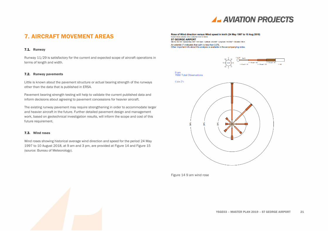
7.3. Wind roses
Wind roses showing historical average wind direction and speed for the period 24 May
1997 to 10 August 2018, at 9 am and 3 pm, are provided at Figure 14 and Figure 15
(source: Bureau of Meteorology).
Figure 14 9 am wind rose

YSGE03 – MASTER PLAN 2019 – ST GEORGE AIRPORT 22
Figure 15 3 pm wind rose
7.4. Taxiways
St George Airport has two stub taxiways. The main taxiway adequately services the main
parking apron.
The secondary stub taxiway serves the current hangar precinct but does not meet
minimum width standards for the types of aircraft using it.
7.5. Parking aprons
St George Airport has two aprons. The main apron is located east of the terminal, and
services the RPT flights. The second apron which is primarily used by private charters and
agribusinesses is located to the west of the terminal building. There is currently no direct
access between the two aprons, with aircraft having to taxi via the runway for access
between the two aprons.
7.6. Hangar facilities
The only hangar facilities currently at the St George Airport are on land leased from
Council. Interest has been expressed by survey respondents for further opportunities to
lease or purchase a hangar.
7.7. Helicopter facilities
There is a dedicated helicopter landing pad at St George Airport.
7.8. Aerodrome lighting
The St George Airport lighting facilities include:
• RWY 11/29 low intensity runway lights (LIRL);
• RWY 11/29 portable lights (PTBL); and
• TWY LGT blue edge lights.

YSGE03 – MASTER PLAN 2019 – ST GEORGE AIRPORT 23
8. AVIATION SUPPORT FACILITIES
8.1. Fuel
Fuel is not available for sale at the airport.
8.2. Ground support equipment
Ground support equipment is provided by airlines or their ground handling agents.
8.3. Navigation and approach aids
St George Airport is equipped with a non-directional (radio) beacon (NDB).
A check of the AIP via the Airservices Australia website showed that St George Airport is
served by non-precision terminal instrument flight procedures as per Table 7 (source:
Airservices Australia, 2018).
Table 7 St George Airport (YSGE) aerodrome and procedure charts
Chart name (Procedure Designer) Effective date
AERODROME CHART (AsA) 16 AUG 2018
NDB RWY 11 (AsA) 14 NOV 2013
RNAV-Z (GNSS) RWY 11 (AsA) 28 MAY 2015
RNAV-Z (GNSS) RWY 29 (AsA) 28 MAY 2015
8.4. Weather information service
The St George Airport weather information services include:
• terminal area forecast (TAF) CAT D;
• meteorological terminal aviation routine weather report (METAR);
• aviation special weather report (SPECI); and
• aerodrome weather information service (AWIS)
8.5. Aerodrome rescue and firefighting services
There is no aerodrome rescue and firefighting service, and one is not expected to be
required within the master planning period.
8.6. Air traffic control and airspace
The airspace around St George Airport is Class G (i.e. non-controlled airspace) from the
surface to F180.
Air traffic control communication is available through Brisbane Centre (FIA).
No change is required to air traffic control or airspace arrangements.
8.7. Transport security
St George Airport is classified as a security-controlled airport under the Aviation Transport
Security Act 2004 and the Aviation Transport Security Regulations 2005.
A perimeter fence encloses the airside area of St George Airport and the boundary is
clearly marked with signage.
Airside access for St George Airport is via gates off the current parking bay. Access
through these gates is via a lock and key which is issued and controlled by Balonne Shire
Council.
No change is anticipated to aviation security arrangements in the short term.
YSGE03 – MASTER PLAN 2019 – ST GEORGE AIRPORT 24
In the longer term, security screening may be required, for example, if an aircraft with a
seating capacity of more than 40 regularly operates to the airport.
It is not expected that security screening will be required within the master planning
horizon.

YSGE03 – MASTER PLAN 2019 – ST GEORGE AIRPORT 25
9. PASSENGER FACILITIES
9.1. Passenger terminal
The passenger terminal serves the airport well, but as indicated via survey responses, the
terminal could be improved by:
• Facilitating better access by people with disabilities;
• Improvements to seating both inside and outside of the general terminal;
• Shaded or undercover waiting areas; and
• Updated terminal facility, with improved air conditioning.
9.2. Aeromedical facilities
The RFDS transfer building, located to the south of the passenger terminal in the car park
on landside, is not often used. The building could be re-purposed into a multi-use shed to
better suit the needs of both the RFDS and St George Airport

YSGE03 – MASTER PLAN 2019 – ST GEORGE AIRPORT 26
10. COMMERCIAL LAND USE AND
DEVELOPMENT
10.1. Current leasing and charging regime
Aeronautical fees/charges are not levied on users of St George Airport.
Leases on the airport include:
• Hangars; and
• An area airside for the Bureau of Meteorology weather station.
10.2. Future commercial and business prospects
Future opportunities exist to provide hangar lots with airside access and industrial lots on
the landside fronting the Carnarvon Highway.
BSC has grant funding to construct a small hangar precinct.
YSGE03 – MASTER PLAN 2019 – ST GEORGE AIRPORT 27
11. GROUND TRANSPORT SYSTEMS
11.1. External network
The external road network is considered adequate for the master planning horizon.
11.2. Internal network
The internal road network will need to be upgraded to provide access to future
development sites.
11.3. Airside access
Airside access is considered adequate.
11.4. Public car parking
At the time of preparing this Master Plan, the parking at St George Airport, was
considered adequate for the current needs. Future considerations could be made to
future proof the facilities to allow for more secure long-term parking. However, the main
carpark is thought to be adequate for current demand.
11.5. Rental car parking demand
There is no rental car service located at St George Airport.
11.6. Buses
There is no direct bus service access to St George Airport.
11.7. Taxis
There is no taxi service at St George Airport, although taxis are available on request.
11.8. Aviation fuel
There is no on-site aviation fuel storage or station.
Preliminary negotiations have been conducted for the provision of Avgas.

YSGE03 – MASTER PLAN 2019 – ST GEORGE AIRPORT 28
12. UTILITIES AND CIVIL INFRASTRUCTURE
12.1. Water
Water to the site is supplied from town water through the Balonne Shire Council water
supply network.
12.2. Electricity
A reticulated electricity service is provided on site.
A back-up diesel generator is available for the aerodrome lighting system.
There is capacity to install some solar panels on the roof of the terminal building.
12.3. Sewer/septic
Waste treatment is via individual septic systems.
A significant increase in development on the airport may initiate a requirement for BSC to
provide a connection to the town sewerage system.
12.4. Communications
Telephone service is provided via landline and is considered acceptable.
ADSL internet is provided via landline.
12.5. Stormwater
Generally, stormwater run-off is managed effectively onsite. Rainwater is collected from
the passenger terminal through a small rainwater tank. To improve stormwater
management and collection onsite, a stormwater run-off plan could be considered in the
long term
12.6. Perimeter fencing
The perimeter fencing is considered adequate for its purpose.

YSGE03 – MASTER PLAN 2019 – ST GEORGE AIRPORT 29
13. AERODROME SAFEGUARDING
The Commonwealth Government has an interest in better planning and integrated
development on and around airports and to lessen the adverse effects of aviation activity
on the environment and communities. While not a planning authority, it provides guidance
on broader issues such as noise around airports that can be used by statutory authorities
to achieve the stated objectives. The National Airports Safeguarding Advisory Group
(NASAG) has produced the National Airport Safeguarding Framework to advance this
agenda. The Framework should also be taken into consideration when designing
development on and in the vicinity of the airport.
13.1. Operational airspace
13.1.1. Obstacle limitation surfaces
An airport’s obstacle limitation surfaces (OLS) define the operational airspace
that should be kept free of obstacles for aircraft operations being conducted
under the visual flight rules. Both current and future (ultimate) OLS should be
considered in the design of developments on and within the vicinity of the
airport.
Manual of Standards Part 139 Chapter 7 provides relevant parameters for the
design of the OLS.
Details of the OLS are provided in plans TBA
13.1.2. PANS-OPS surfaces
PANS-OPS surfaces define the operational airspace a pilot is required to use
when flying an aircraft under the instrument flight rules—that is, when relying on
instruments for navigation. Development should seek to avoid any permanent
encroachments into current and future PANS-OPS airspace.
Detailed information about the PANS-OPS surfaces is provided by Airservices
Australia in documentation held by the Airport Manager.
Further information can be found in NASF Guideline F: Managing the Risk of Intrusions
into the Protected Airspace of Airports.
13.2. Lighting restriction zone
Manual of Standards Part 139 - Aerodromes establishes a restriction to lighting within the
vicinity of an airport which, by reason of its intensity, configuration or colour, might
endanger the safety of an aircraft. The vicinity of the airport can be taken to be within a
6km radius of the airport.
Details of lighting restriction zones are provided in plan TBA
Further information can be found in NASF Guideline E: Managing the Risk of Distractions
to Pilots from Lighting in the Vicinity of Airports.
13.3. Wildlife hazard buffer zone
All wildlife on or around an airport should be regarded as a potential hazard to aircraft
safety. Most wildlife strikes occur on and in the vicinity of airports, where aircraft fly at
lower elevations. Flying vertebrates (e.g. birds or bats) mainly use airspace within 300
metres of the ground so are likely to conflict with aircraft when they are at their most
vulnerable, i.e. immediately after take-off and during landing approaches or other low
flying manoeuvres. Development should seek to avoid creating wildlife attracting land
uses both on and within the vicinity of the airport.
Details of wildlife hazard buffer zones are provided in plan TBA
Further information can be found in NASF Guideline C: Managing the Risk of Wildlife
Strikes in the Vicinity of Airports.
13.4. Building restricted areas for aviation facilities
The Building Restricted Area (BRA) is defined as a volume where buildings and other
objects have the potential to cause unacceptable interference to the signal-in-space
transmitted by the radio navigation facility. All radio navigation facilities have a BRA

YSGE03 – MASTER PLAN 2019 – ST GEORGE AIRPORT 30
defined which may extend to a significant distance from the facility. The purpose of the
Building Restricted Area is not intended to prohibit development but rather to trigger an
assessment of a proposed building or development for its impact on the radio navigation
facility. The BRA is primarily intended to be used by Aerodrome Operators and Local
Planning Authorities but is also required to be used by the systems engineer when
selecting a new site for a radio navigation facility. All development applications near a
radio navigation facility shall be assessed to determine if the facility BRA is infringed. If
there is no infringement the assessment process may be terminated, and the application
approved.
13.4.1. NDB
All development proposals within 60 m of the NDB antenna, and development
proposals between 60 m and 300 m from the centre of the NDB antenna that
exceed an angle of elevation of 5° from ground level at the centre of the NDB
antenna, shall be assessed by an NDB Technical Authority (i.e. Airservices
Australia).
The NDB BRA is represented in in Plans TBA.
Further information can be found in NASF Guideline G: Protecting Aviation Facilities —
Communications, Navigation and Surveillance (CNS).
13.5. Public safety areas
NASAG has drafted a new Guideline for Public Safety Zones (PSZs) to mitigate the risk to
people on the ground near airports by informing a consistent approach to land use at the
end of Australian airport runways. PSZs seek to limit land uses that would increase the
number of people in the zone or result in the storage of hazardous materials in the zone.
The Guideline is intended to assist land-use planners at all levels to better consider public
safety when assessing development proposals and rezoning requests and when
developing strategic land use plans.
Since there is no formal requirement to implement public safety zones, and because of
the uncertainty about specific design parameters, this concept has not been incorporated
in the Master Plan.
Further information can be found in NASF Guideline I (Managing the Risk in Public Safety
Zones at the Ends of Runways) (draft under development).
13.6. Aircraft noise
Aircraft noise can affect the allocation of appropriate uses on and external to the airport
site.
Australian Noise Exposure Forecast (ANEF) contours provide a scientific measure of the
aircraft noise exposure levels around airports taking into account the frequency, intensity,
time and duration of aircraft operations. Standard methodology for evaluating the noise
climate around airports is defined in AS 2021-2015 Acoustics – Aircraft Noise Intrusion –
Building Sitting and Construction, which recognises the ANEF contour charts as the
primary method for long-term noise impact assessment.
Australian Noise Exposure Concept (ANEC) is a map, based on a hypothetical set of
conditions of runways, aircraft types and so on, that may be produced during
consideration of options for aerodrome development.
There is no ANEF for St George Airport.
Whilst no specific investigation has been conducted, it is assumed that noise levels
created by proposed operations on the aerodrome will be acceptable.
In lieu of an ANEF, BSC could contemplate the preparation of a Fly Neighbourly Advice.
Further information can be found in NASF Guideline A: Measures for Managing Impacts of
Aircraft Noise.
YSGE03 – MASTER PLAN 2019 – ST GEORGE AIRPORT 31
14. MASTER PLAN
Staging of infrastructure development for the Master Plan aligns with anticipated changes
in demand and user requirements within the two nominal time frames – short term (1-3
years) and longer term.
The actual order and timing of nominated changes will, in part, depend upon realised
demand and available funding.
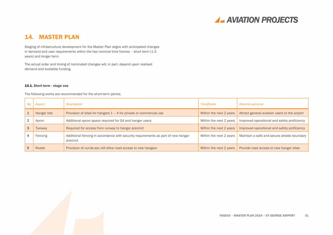
14.1. Short term - stage one
The following works are recommended for the short-term period.
No Aspect Description Timeframe Desired outcome
1 Hangar lots Provision of sites for hangars 1 – 4 for private or commercial use Within the next 2 years Attract general aviation users to the airport
2 Apron Additional apron space required for GA and hangar users Within the next 2 years Improved operational and safety proficiency
3 Taxiway Required for access from runway to hangar precinct Within the next 2 years Improved operational and safety proficiency
4 Fencing Additional fencing in accordance with security requirements as part of new hangar
precinct
Within the next 2 years Maintain a safe and secure airside boundary
5 Roads Provision of cul-de-sac will allow road access to new hangars Within the next 2 years Provide road access to new hangar sites
YSGE03 – MASTER PLAN 2019 – ST GEORGE AIRPORT 32
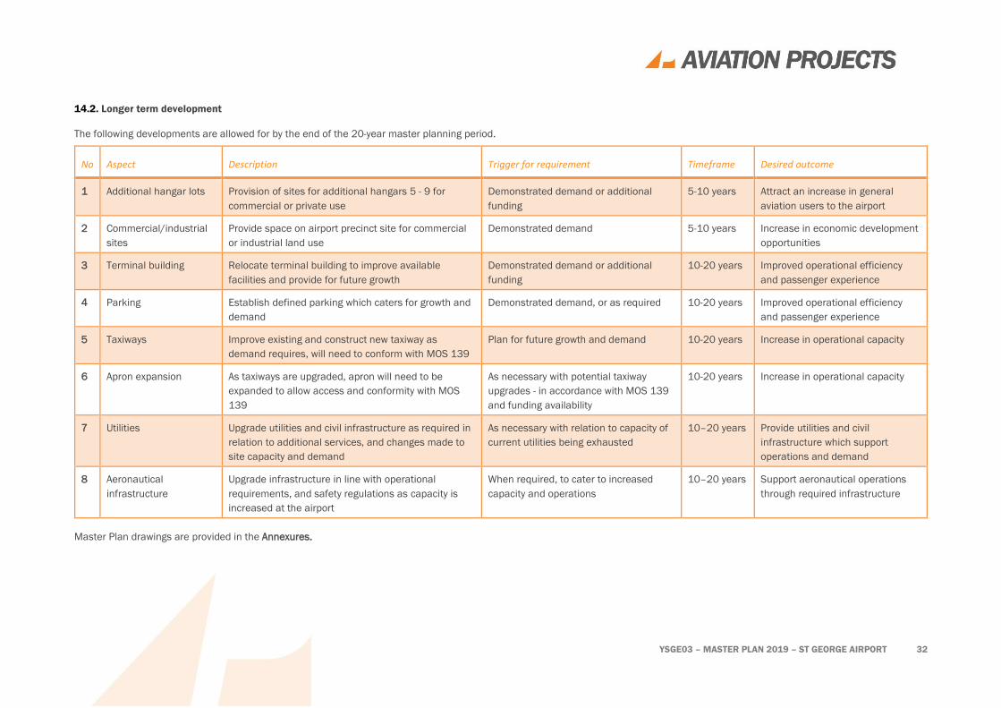
14.2. Longer term development
The following developments are allowed for by the end of the 20-year master planning period.
No Aspect Description Trigger for requirement Timeframe Desired outcome
1 Additional hangar lots Provision of sites for additional hangars 5 - 9 for
commercial or private use
Demonstrated demand or additional
funding
5-10 years Attract an increase in general
aviation users to the airport
2 Commercial/industrial
sites
Provide space on airport precinct site for commercial
or industrial land use
Demonstrated demand 5-10 years Increase in economic development
opportunities
3 Terminal building Relocate terminal building to improve available
facilities and provide for future growth
Demonstrated demand or additional
funding
10-20 years Improved operational efficiency
and passenger experience
4 Parking Establish defined parking which caters for growth and
demand
Demonstrated demand, or as required 10-20 years Improved operational efficiency
and passenger experience
5 Taxiways Improve existing and construct new taxiway as
demand requires, will need to conform with MOS 139
Plan for future growth and demand 10-20 years Increase in operational capacity
6 Apron expansion As taxiways are upgraded, apron will need to be
expanded to allow access and conformity with MOS
139
As necessary with potential taxiway
upgrades - in accordance with MOS 139
and funding availability
10-20 years Increase in operational capacity
7 Utilities Upgrade utilities and civil infrastructure as required in
relation to additional services, and changes made to
site capacity and demand
As necessary with relation to capacity of
current utilities being exhausted
10–20 years Provide utilities and civil
infrastructure which support
operations and demand
8 Aeronautical
infrastructure
Upgrade infrastructure in line with operational
requirements, and safety regulations as capacity is
increased at the airport
When required, to cater to increased
capacity and operations
10–20 years Support aeronautical operations
through required infrastructure
Master Plan drawings are provided in the Annexures.
YSGE03 – MASTER PLAN 2019 – ST GEORGE AIRPORT 33
15. REVENUES AND COSTS
A detailed analysis of revenues and costs has not been performed as part of the master
planning activity. Notable issues that arose during the study are documented for further
consideration.
15.1. Revenues
A detailed analysis of revenues associated with the staged upgrade of St George Airport
and Industrial precinct has not been prepared as part of the master planning activity.
15.2. Costs
A high-level estimate of costs for the proposed works in Stage 1 Hangar development has
been prepared.
Further preliminary design work is required in order to adequately scope and specify the
work required to deliver the various aspects of the overall plan before a final cost
estimate can be prepared.

YSGE03 – MASTER PLAN 2019 – ST GEORGE AIRPORT 34
16. GLOSSARY
AAGR average annual growth rate
AIP Aeronautical Information Package
AMSL above mean sea level
ANEC Australian Noise Exposure Concept
ANEF Australian Noise Exposure Forecast
ARFFS aerodrome rescue and fire fighting service
AsA Airservices Australia
ATC air traffic control
BRA building restricted area
BSC Balonne Shire Council
CAAP Civil Aviation Advisory Publication
CAR Civil Aviation Regulation 1988
CASA Civil Aviation Safety Authority
CASR Civil Aviation Safety Regulation 1998
CTAF Common Traffic Advisory Frequency
ERSA En Route Supplement Australia
GA general aviation
GNSS Global Navigation Satellite System
GPS Global Positioning System
GSE ground support equipment
HLS helicopter landing site
ICAO International Civil Aviation Organization
INP instrument non-precision
IWDI illuminated wind direction indicator
LGA local government authority
LIRL low intensity runway lights
MOS Manual of Standards
MTOW maximum take-off weight
NASF National Airports Safeguarding Framework
NBN National Broadband Network
NDB Non-Directional Beacon
OLS obstacle limitation surfaces
PANS-OPS Procedures for Air Navigation Services – Aircraft Operations
PAPI Precision Approach Path Indicator
PSZ public safety zone
RFDS Royal Flying Doctor Service
RNAV-GNSS Area Navigation – Global Navigation Satellite System
RPT regular public transport
RTIL runway end identifier lights
SGS satellite ground station
SPP State Planning Policy

YSGE03 – MASTER PLAN 2019 – ST GEORGE AIRPORT 35
17. REFERENCES
• Airservices Australia, Aeronautical Information Package; including En Route
Supplement Australia (ERSA, RDS, DAP) effective 24 May 2018;
• Balonne Shire Economic Development Plan 2018 – 2022;
• Civil Aviation Safety Authority, Civil Aviation Safety Regulations 1998;
• Civil Aviation Safety Authority, Manual of Standards Part 139 – Aerodromes
version 1.14: dated January 2017;
• Department of Infrastructure and Regional Development (C’th), Airport Traffic
Data 1985-86 to 2016-17 (xls format);
• International Civil Aviation Organization, International Standards and
Recommended Practices (SARPS) Annex 14 Aerodromes, Volume 1 Aerodrome
Design and Operations and Volume II Heliports; and
• Queensland Government, Department of State Development, Manufacturing,
Infrastructure and Planning, State Planning Policy 2017.

YSGE03 – MASTER PLAN 2019 – ST GEORGE AIRPORT 36
ANNEXURES
Short term
• Site Plan – Stage 1 Hangars
Long term
• Site Plan – Airport
• Site Plan - Ultimate
Aerodrome Safeguarding
• OLS Overall
• OLS
• Airport Planning, Light and Building Restriction Zones
• Airport Planning, Wildlife Hazard Buffer Plan

YSGE03 – MASTER PLAN 2019 – ST GEORGE AIRPORT
SHORT TERM – 2-3 YEARS

YSGE03 – MASTER PLAN 2019 – ST GEORGE AIRPORT
LONG TERM
YSGE03 – MASTER PLAN 2019 – ST GEORGE AIRPORT
AERODROME SAFEGUARDING

Melbourne Office
Pavel Davidyuk
M +61 467 431 111
Victory Tower
Level 2/ 420 Collins Street
Melbourne Victoria 3000
Brisbane Head Office
Keith Tonkin
M +61 417 631 681
P +61 7 3371 0788
F +61 7 3371 0799
PO Box 116, Toowong DC, Toowong Qld 4066
19/200 Moggill Road, Taringa Qld 4068
Perth Office
Kassem Seedat
M +61 407 990 835
Exchange Tower
Level 17/ 2 The Esplanade
Perth Western Australia 6000