master plan document | portsmouth, ohio
TRANSCRIPT

ELEVATE PORTSMOUTH MASTER PLAN1
Master Plan Document | Portsmouth, OhioSeptember 30, 2020

2
Contributors
City of Portsmouth
Scioto Foundation
Steering Committee
Consultant TeamSam Sutherland, City Manager
Tracy Shearer, Community Development Director
Kim Cutlip, Executive Director
Patty Tennant, Program Officer
Andrew Graf, Friends of Portsmouth/Business
Owner
Asa Jewett, Edward Jones
Barb Bradbury, Connex/Portsmouth Farmers
Market
Charlotte Gordon, Southern Ohio Museum & Cultural Center/City Council/14th Street Community
Center
Chris Hamilton, Desco Federal Credit Union
David Kilroy, Kricker Innovation Hub
Drew Carter, 14th Street Community Center
Gerald Cadogan, Portsmouth City Schools
Jeff Bauer, Shawnee State University
Jeremy Burnside, Friends of Portsmouth/
Business Owner
John Mahle, Desco Federal Credit Union
Chris Hermann, AICP, MKSK
Arin Blair, AICP, MKSK
Sarah Lilly, MKSK
Chris Will, MKSK
Kris Ruggles, PE, Strand Associates
THANK YOU TO EVERYONE WHO WAS INVOLVED IN THE PLANNING PROCESS TO PRODUCE THE ELEVATE PORTSMOUTH MASTER PLAN.
Justin Clarke, SOMC
Justin Schmidt, Business Owner
Kim Cutlip, Scioto Foundation
Kyle James, Business Owner
Nathan Prosch, Scioto County Engineer’s Office/
School Board
Patty Tennant, Scioto Foundation
Sam Sutherland, City of Portsmouth
Sean Dunne, City Council/SSU
Terry Ockerman, Portsmouth Metropolitan
Housing Authority
Tim Glockner, Friends of Portsmouth/Glockner
Tim Wolfe, Friends of Portsmouth
Tracy Shearer, City of Portsmouth
Will Burke, OSCO Industries
On behalf of the City of Portsmouth, I would personally like to thank each and every person who helped create this plan. The detailed process of initial interviews, stakeholder meetings and hard work of the Steering Committee and City Staff that got us to this point demonstrated a true dedication to our community. Through forward thinking and vision Portsmouth now has a plan to assist us in elevating our town to a brighter future.
Sam Sutherland
City Manager

3 ELEVATE PORTSMOUTH MASTER PLAN
TABLE OF CONTENTS
1 | Background
2 | Community Engagement
3 | Analysis
4 | Recommendations
5 | Implementation
IntroductionPlan Process
OverviewWhat We HeardAll America CityVision + Guiding Principles
Plan ReviewExisting ConditionsPlan Framework
Future Land Use PlanImplementation Matrix
Plan Framework1. Identify Small Investments That Will Make Big Impacts2. Facilitate Big Projects That Will Catalyze Lasting Change3. Expand and Enhance Successful Nodes of Activity4. Support Neighborhoods5. Leverage Existing Assets
505262707682
222440
10121618
67
8894


ELEVATE PORTSMOUTH MASTER PLANELEVATE PORTSMOUTH MASTER PLAN
BackgroundIntroduction
Plan Process
1 |

6
Introduction
The Portsmouth Master Plan—Elevate Portsmouth—sets forth a vision for the future of the city with a range of short-term and long-term strategies for implementation. Elevate Portsmouth is a guide and supporting framework for the people in Portsmouth—city residents, business owners, and civic leaders—as they foster downtown revitalization and consider future land use. The plan also provides strategic direction for Portsmouth to continue to attract new residents, tourists, and development to the city.
PLAN PROCESSElevate Portsmouth was developed in an eight-month process in close collaboration with the City, the Scioto Foundation, and a wide range of community leaders and stakeholders. The plan did not start from scratch, but was created within the momentum of planning and visioning work the community had completed in recent years. Recent planning processes include the 2019 Rethinking Downtown Portsmouth Summit and the 2015 Community Revitalization Plan.
Portsmouth is full of passionate, innovative leaders. People are investing and collaborating in the city by building organizations, events, businesses, educational institutions, arts and culture anchors, and more. And they didn’t start yesterday.
People and groups have been working for decades to support this community in organizations such as the Scioto Foundation, 14th Street Community Center and Main Street Portsmouth. Recent non-profits such as Friends of Portsmouth have added to the momentum with record-breaking community organizing and support from local business owners.
This plan is for the community. The vision, recommendations, and action steps are a snapshot of what people are excited about in the city today, and what we—as a community and experienced planning team—documented for a plan to move forward.
This plan is flexible. The concepts are prompts for people and groups to take the lead and run with. Each illustration is a starting point to inspire people and groups to refine and customize for a just-right fit in Portsmouth. Some ideas are new, and some have been around a long time. Each are simmering, ready for the innovative leaders, collaborators, and investors in Portsmouth to expand and create.
HOW TO USE THIS PLAN

ELEVATE PORTSMOUTH MASTER PLAN7
Plan Process
Kick-off, Steering Committee #1: Visioning & Opportunities Meeting, and Site Tour
Stakeholder Interviews
Existing Conditions Review & Analysis
Steering Committee Meeting #2
Place-Based Strategies
Catalytic Site Development Concepts
Steering Committee #3 Meeting
Draft Plan
Steering Committee #4: Draft Plan Review September 2nd
Final Plan
UNDERSTANDING & OPPORTUNITY ANALYSIS
PLACE STRATEGIES & CATALYSTS
PLAN DOCUMENTATION & ACTION PLAN
WINTER ‘20 SPRING ‘20 SUMMER ‘20
This process overview depicts the three-phase plan development and community engagement process conducted from February to September 2020.


ELEVATE PORTSMOUTH MASTER PLANELEVATE PORTSMOUTH MASTER PLAN
Community EngagementOverview
What We Heard
All America City
Vision + Guiding Principles
2 |

10
Overview
STAKEHOLDERS The stakeholder list grew from those engaged in the 2019 Rethinking Downtown Portsmouth Summit and included civic leaders, residents, and the business community in Portsmouth. The planning team conducted a series of interviews with stakeholders early in the planning process to define the challenges and opportunities in the city. Interviews were arranged by topic and included:
• Development, Land Use, and Downtown Revitalization
• Infrastructure, Transportation
• Neighborhoods, Nonprofits, and Faith Community
• Arts, Culture, History, and Tourism
• Parks, Recreation, Open Space, Conservation, and Riverfront
• Business, Employment, and Economic Development
STEERING COMMITTEE A citizen-volunteer Steering Committee guided the planning process in a series of four meetings and review period of the draft plan. This group of civic leaders, residents, and the business community in Portsmouth included representation of primary employers such as Shawnee State University and the Southern Ohio Medical Center, local developers and small-business owners, City Council, City Schools, arts & culture, non-profit and volunteer organization leaders.
The first meeting was held in the Scioto Foundation Meeting Room. The subsequent meetings were conducted online with Zoom, using interactive polling and screen sharing to engage the members in active discussion about the plan progress.

ELEVATE PORTSMOUTH MASTER PLAN11

At the launch of the planning process, three activities in the lobby of the Scioto Foundation asked stakeholders and Steering Committee members three questions.
1. Where do you go?
2. Where do you avoid?
3. Where should we focus? Where are the areas of opportunity?
Three maps were displayed on 36x48 inch boards and prompted participants to place three stickers of each color to answer the question for the corresponding map. The results were digitized into a “heat map” style representation of the results. The more stickers that were placed in a single area on the map, the darker the results are shown. In the results shown here, you can see trends of how often a place’s greatest challenges overlap with its greatest opportunities.
In the “strengths” and “opportunities” map results, the Boneyfiddle District and Chillicothe Street Downtown received the most votes. The East End was identified as the city’s greatest challenge, but also received many votes as an opportunity area for the city as well.
NORTH
NORTH
52
52
823
823
23
23
23
23
23
23
335
335
140
140
Scioto River
Scioto River
Little
Sci
oto
Rive
r
Little
Sci
oto
Rive
r
NEW BOSTON
NEW BOSTON
SOUTHSHORE
SOUTHSHORE
Ohio River
Ohio River
SOUTHPORTSMOUTH
SOUTHPORTSMOUTH
ELEVATE PORTSMOUTH MASTER PLAN 12
What We HeardHEATMAP FINDINGS
Greenlawn Cemetery
High School, Elementary School, Athletic Complex
Southern Ohio Medical Center
Boneyfiddle, Murals, 2nd Street businesses
Spartan Stadium
Shawnee State University
Theater, Restaurant Cluster
Chillicothe St
East End
River Run Healthcare, Royal Inn
Aging strip retail centers
Train tracks
Tracy Park
Harding Ave.
United Way
HEATMAP | STRENGTHS
HEATMAP | WEAKNESSES

Boneyfiddle, Murals, 2nd Street businesses
Chillicothe St., Martings Building, 5/3rd Building
Tracy Park
Alexandria Point
Sciotoville School
East End
Athletic Complex
Spartan Stadium
Mound Park
Larry Hisle Park
McKinley Pool, County Sheriff
NORTH
52
823
52
23
23
23
139
335
140
Scioto River
Little
Sci
oto
Rive
r
NEW BOSTON
Ohio River
SOUTHPORTSMOUTH
HEATMAP | OPPORTUNITIES

14
What We HeardTOP THEMES FROM STAKEHOLDER CONVERSATIONS
These ten themes summarize what we learned from community desires based on the engagement processes of the 2019 Rethinking Downtown Portsmouth summit and the 2015 Community Revitalization Plan and what we heard from Portsmouth Stakeholders and the Steering Committee during the engagement process for Elevate Portsmouth.

ELEVATE PORTSMOUTH MASTER PLAN15
Portsmouth is an engaged community. A broad range of community members are fully engaged, focused on a myriad of programs, events, and projects including downtown revitalization and community recovery.
Positive momentum in Portsmouth is building. Despite regional economic challenges, people who have spent their life in Portsmouth describe remarkable changes over the past decade. Folks who moved away are moving back and buying homes. Generations of Portsmouth community are collaborating and investing in the city.
It’s important to celebrate Portsmouth. There is a desire to celebrate achievements and foster community pride. This builds strength, resilience, and community attachment to place—helping attract further investment and maintain positive momentum. Positive and optimistic messages can help uplift the community and overcome stigma of negative news coverage.
The Riverfront is a top priority. From access to events and connectivity, the river continues to be top of mind for investment and opportunity.
There is opportunity to be known as a Lifestyle City. Portsmouth is a walkable urban center with a growing number of attractions, hospitality options, affordable housing and a university. Local and regional outdoor attractions—riverfront, mountain biking, hiking, forest—plus shopping, restaurants, and museums can be utilized to build a “Lifestyle City” brand for Portsmouth.
Several areas are emerging as hubs of community activity. These include a number of revitalized buildings in the Historic Downtown Boneyfiddle District, Downtown areas such as Gallia Street with Lofts Coffee and 3rd Street with Shawnee State and the Innovation Hub.
Many neighborhoods and community members are struggling. Building resilience includes both the celebration of achievements and the acknowledgment of difficulties. A shortage of jobs, lack of skilled workforce training, poverty, hunger, substance abuse and recovery, aging housing, and the need for more housing options are prominent issues in the community and must be addressed to the extent possible in city plans and neighborhood strategies.
Focus on aesthetics and increasing vibrancy. To attract visitors, residents, business owners, employees, and students to visit more often, stay longer, and/or invest and live in Portsmouth, a focus on aesthetics and vibrancy is important. This includes continuing ongoing beautification and clean-up efforts, and increasing focus of low-cost, high-impact projects.
There is a need for more housing options. Homes in Portsmouth are generally modest in size and price, with maintenance and upkeep needs of mid-century and older homes. Customers for subsidized housing need access to these affordable homes, while empty nesters and young professionals would like to see more options for new and upgraded homes. There are needs for apartment and rental options at all income levels.
There is a need for community-wide education and coordination on funding strategies. To address infrastructure, programming, community housing needs, and maintenance of civic spaces, there is a need for education and coordination about best practices and innovative funding strategies.

16
All America City2020 NATIONAL CIVIC LEAGUE AWARD WINNER
Portsmouth is a 2020 winner of the National Civic League “All America City Award.” According to the league, “The All-America City Award recognizes communities that leverage civic engagement, collaboration, inclusiveness and innovation to successfully address local issues.”
The following items are highlighted in the award description, and illustrate the successful collaboration, projects completed, and momentum in the Portsmouth community that will help make this master plan a success.
• The community has implemented strategies for addressing the opioid epidemic that have led to significant reductions in youth substance use and improved outcomes in the population.
• Portsmouth is actively transforming spaces in the city for 21st Century needs to create a healthy, visually appealing and inclusive city for residents. Accomplishments highlighted in the award include the following:
» Public art, including the 60 floodwall murals
» New spaces that encourage exercise and outdoor activity, such as the paved activity path through Mound Park
• Historical spaces transformed, including funding for improvements to McKinley Pool, significant to Ohio’s Civil Rights Movement
• Community building through events and activities. The list on the awards page includes:
» Winterfest includes activities such as ice skating, Christmas lights, snow tubing, carriage rides, a vendor village, a gift shop and a children’s museum pop-up.
» Glocktoberfest is the celebration of the city’s past, present, and future from the perspective of the Glockner Family and their 170+ year journey to the present.
» River Days festival offers a daytime parade in which contestants from each local school compete with themed floats.
» Blues, Brews and Barbecue festival includes live music, craft beer and a barbecue competition.
» Plant Portsmouth featured 1,405 residents coming together to break the Guinness World Record for the most people potting plants simultaneously.
» Christmas Caroling highlighted 1,880 community members breaking the world record for the most people Christmas caroling.
» Present wrapping featured 1,482 people breaking the record for most people wrapping presents together.
» Portsmouth Block Party includes free food, inflatables, a dunk tank, a petting zoo and live music.
» Final Friday in Boneyfiddle is a free outdoor concert series that enhances commerce and community in the Historic Boneyfiddle shopping district.
» The Southern Ohio Senior Games encourage older people to have healthier lifestyles.
» Annual Service Day involves churches and organizations providing community service.
Learn more here: www.nationalcivicleague.org/america-city-award/.
Find the full Portsmouth award description here: www.nationalcivicleague.org/2020-all-america-city-finalist-portsmouth-oh/

ELEVATE PORTSMOUTH MASTER PLAN17
Winterfest River Days
Final Friday Southern Ohio Senior Games Plant Portsmouth
Glocktoberfest

18
#.# Page HeaderSUBHEADER
Vision ELEVATE PORTSMOUTH
Portsmouth is a Lifestyle City rich with history and driven by people dedicated
to its resilience—advancing the community through collaboration, local businesses, education, public spaces,
festivals and events. From the southern edge of Ohio, Portsmouth is looking up.

ELEVATE PORTSMOUTH MASTER PLAN19
Guiding PrinciplesPILLARS OF A LIFESTYLE CITY
PILLARS OF A
LIFESTYLE CITY
BusinessesOptions
Nei
ghbo
rhoo
ds
Spaces
Diverse Local
Bro
ad Recreation
Str
ong
Great P
ublic
Bold Characte
r
Ongoing Communityand HistoryCelebration
The Elevate Portsmouth Vision builds on what we heard from plan stakeholders and the Steering Committee, visions for revitalization in previous plans, and the Rethinking Downtown Portsmouth Summit. Overwhelmingly, people in Portsmouth identify it as a Lifestyle City. This concept has great potential to be the defining identity for the City. At the time of this planning process, no other city was found to be claiming itself as a Lifestyle City and the concept had yet to be defined. The Pillars of a Lifestyle City define what that means for Portsmouth and act as guiding principles for achieving the vision. This vision and concept can be used beyond the pages of this master plan to shape the brand of the city - for marketing, signage, social media, website content, programs and events.


ELEVATE PORTSMOUTH MASTER PLAN
AnalysisPlan Review
Existing Conditions
Plan Framework
ELEVATE PORTSMOUTH MASTER PLAN
3 |

22
Plan Review
The Portsmouth, Ohio Plans for the Future Community Revitalization Plan contains many recommendations and illustrations that the people of Portsmouth are excited to implement. The plan was created as part of the America’s Best Communities Challenge sponsored by Frontier Communications, in which Portsmouth was a semi-finalist. The vision for the Revitalization plan is:
“For the Port of Portsmouth to become a premier regional destination for industrial development and riverfront recreation while enhancing commercial opportunities downtown — a place where residents and visitors alike can enjoy recreational activities, cultural enrichment and unique entertainment.”
A key recommendation in this plan is for the city to complete a Master Plan, which was the catalyst for Elevate Portsmouth.
Elevate Portsmouth is a step in implementing the Revitalization Plan’s recommendations. The Master Plan brings forward high impact recommendations prioritized through the planning process and refined illustrations to catalyze revitalization in the city.

ELEVATE PORTSMOUTH MASTER PLAN23

24
Existing ConditionsCOMMUNITY
Portsmouth, Ohio’s smallest legacy city, was settled on two rivers by indigenous people including the Hopewell who constructed the Portsmouth Earthworks. After centuries of growth and colonization, the street grid that shapes the city as we know it was drawn in 1803. Portsmouth was soon after established as a city and began its pattern of development and economy we see reflected today—close-knit residential neighborhoods; port and primary transportation corridors; an industry, manufacturing, entrepreneurship (and today, healthcare) economy; public and university education. In 1937, the city suffered a devastating flood. Today, the flood wall that was constructed to protect the city from future events features a blocks-long mural that draws visitors from a tri-state region.
The 1937 flood led to a flight of residents that continued through the civil-rights era and decades-long national decline in downtown populations. Today, the city is supporting infrastructure capable of housing nearly 45,000 people with a population closer to 20,000. This leads to considerable budget challenges and deferred maintenance. However, these factors also create affordable real estate opportunities and the open capacity for growth, investment and redevelopment.
Portsmouth has challenges. Many residents suffer from poverty, addiction and recovery, and underemployment, and national media coverage throughout the 2010s focused on people there who are suffering. However, stories that also shine (including national media coverage from world-record breaking events) are people working diligently to help Portsmouth thrive. Elevate Portsmouth is a tool to support the people and organizations who are revitalizing Portsmouth—supporting residents, investing in neighborhoods, and expanding the local economy.
90,000
80,000
70,000
60,000
50,000
40,000
30,000
20,000
10,000
019101900 1920 1930 1940 1950 1960 1970 1980 1990 2000 2010 2020
Scioto CountyCity of Portsmouth
42,560
86,565
20,226
79,499

ELEVATE PORTSMOUTH MASTER PLAN25
1803 1815 1850 1873 1902 1937 1954 1980 20031986
Portsmouth Flood of 1937
Southern Ohio Medical Center opens
Portsmouth formally laid out by Henry Massie
Area is inhabited by indigenous peoples, including the Hopewell culture who constructed the Portsmouth Earthworks
BOOMING INDUSTRIAL CAPITALLate 1800’s to mid-1900’s
GROWING OHIO CITYEarly to mid-1800’s
PRE-EUROPEAN SETTLEMENT100-300 CE
RIVER CITY REDEFINEDMid-1900’s to present
Portsmouth established as a city
Robert Bell opens the city’s first shoe factory
Scioto Valley Firebrick Company plant opened
Portsmouth Library built with funding from Andrew Carnegie
Empire Detroit Steel’s
Portsmouth Works plant
closes and 1,300 steelworkers
laid off
Shawnee State University established
Floodwall Mural completed

ELEVATE PORTSMOUTH MASTER PLAN 26
Existing ConditionsREGION
Regional job centers include Portsmouth, Chillicothe, and Gallipolis, OH; Ashland, KY; Huntington and Charleston, WV. Some residents travel further for jobs, including Dayton, Cincinnati and Columbus Ohio and Parkersburg West Virginia.
A Peer Cities analysis, comparing cities in the region similar in size and economy to Portsmouth, revealed Portsmouth residents are living with higher levels of unemployment and poverty. However, this comparison also reveals that Portsmouth has a skilled trade workforce, lower overall cost of living, affordable housing and real estate, and a cluster of jobs in and near the city.
Portsmouth
Ashland
Chillicothe
Marietta
$29,000
$38,400
$44,000
$37,500
Portsmouth
Ashland
Chillicothe
Marietta
$74,000
$99,300
$112,400
$104,600
Portsmouth
Ashland
Chillicothe
Marietta
48.3%
60.4%
57.6%
52.5%
Portsmouth
Ashland
Chillicothe
Marietta
16.4 mins
19.3 mins
19.7 mins
15.6 mins
Portsmouth
Ashland
Chillicothe
Marietta
Portsmouth
Ashland
Chillicothe
Marietta
14.2%
15.0%
20.8%
26.4%
6.7%
5.0%
4.5%
5.5%
Median Household Income Unemployment Rate
Median Property Value Population with Bachelor Degree or Higher
Home Ownership Rate Mean Commute Time

71 33
823
75
70
77
275
23
23
52
52
35
35
64
64
77
7
5050
CHILLICOTHE ATHENS
GALLIPOLIS
ASHLAND
LANCASTER
MAYSVILLE
CINCINNATI
COLUMBUS
HUNTINGTON
PARKERSBURG
CHARLESTON
DAYTON
OHIO RIVER
MUSKINGHAM
RIVER
SCIOTO RIVER
KANAWHA RIVER
NORTH
PORTSMOUTHPop. 20,200Emp. 14,939
CHILLICOTHEPop. 21,700Emp. 29,176
MARIETTAPop. 13,600Emp. 13,219
ASHLANDPop. 20,400Emp. 17,728
REGIONAL PEER CITIES

52
823
52
23
23
23
139
335
140
Scioto River
Little
Sci
oto
Rive
r
NEW BOSTON
SOUTHSHORE
Ohio River
SOUTHPORTSMOUTH
N&W Railroad Terminal
Scioto Docking Wheelersburg Terminal
CSX Bridge
HEARTLAND CORRIDORIMPROVING RAIL CONNECTION FROM THE PORT OF NORFOLK WITH CHICAGO
THE SOUTH PORTSMOUTH /SOUTH SHORE AMTRAK STATION SERVES +/- 1,000 PASSENGERS
OF CARGO PASS THRU PORTSMOUTH VIA THE OHIO RIVER ANNUALLY
33BTONS
NORTH
ELEVATE PORTSMOUTH MASTER PLAN 28
Existing ConditionsCONNECTIVITY
Major freight and transportation corridors frame the city, including US 52, US 23, SR 823, SR 852, SR 104, freight and passenger rail lines, and the Ohio River.
Carl D. Perkins Memorial Bridge U.S. Grant Bridge
CITYWIDE FREIGHT + RAIL

AADT 29,000
AADT 18,600
AADT 18,800
AADT 10,100
AADT 11,400
AADT 2,500
AADT 9,100
US Grant Bridge
Carl D. Perkins Memorial Bridge
Slab Run Interchange
US 23 TRAVERSES DOWNTOWN VIA GAY & WASHINGTON STREETS
US 23
SR-823 (PORTSMOUTH BYPASS) OPEN TO TRAFFIC IN 2018
SR 823
US 52US 52 IS THE MAJOR EAST-WEST CONNECTION FOR PORTSMOUTH
NORTH
52
823
23
23
23
139104
852
335
Scioto River
Little
Sci
oto
Rive
r
NEW BOSTON
SOUTHSHORE
Ohio River
SOUTHPORTSMOUTH
CITYWIDE CONNECTIVITY

ELEVATE PORTSMOUTH MASTER PLAN 30
Existing ConditionsCORRIDORS & GATEWAYS
Downtown Portsmouth is shaped by its historic street grid. 2nd Street and Chillicothe Street form the “L” of the most active retail and event spaces of the city. The iconic US Grant Bridge marks the gateway to the city at the south. US 52 divides Downtown and the East End from Portsmouth’s northern neighborhoods.
While truck traffic is intended to bypass Portsmouth using routes 852 and 823 (as seen on page 25), truck traffic is still seen cutting north/south through the city. The Downtown core along Chillicothe Street is framed by the corridor pairs of Gay Street and Washington Street, which act as the US23 Chillicothe Street bypass for trucks.
US 23 looking north from U.S. Grant Bridge
US 52 looking east into Portsmouth
US 23 looking south into Portsmouth

Scioto River
Gallia St
AADT 29,000
AADT 18,800
AADT 10,100
Gateways
The “L”
Ohio River23
NORTH
52
52
Scioto River
Gallia St
Grant St
Hut
chin
s S
t
Har
mon
St
17th St
Kinneys Ln
2nd St
4th St
5th St
6th St7th St
8th St
3rd St
Mar
ket S
t
Jeff
erso
n S
t
Mad
ison
St
Cour
t St
Chill
icot
he S
t
Was
hing
ton
St
Robinson Ave
23
Grant St
Hut
chin
s S
t
Har
mon
St
17th St
Kinneys Ln
7th St
8th St
Robinson Ave
52
2nd St
4th St
5th St
6th St
Mar
ket S
t
Jeff
erso
n S
t
Mad
ison
St
Cour
t St
Chill
icot
he S
t
Gay
St
Was
hing
ton
St
3rd St
23
DOWNTOWN CORRIDORS + GATEWAYS

Greenlawn Cemetery
Riverfront Park
Mound Park
Hillsides
Floo
dway 10
47
10
52
823
52
23
23
23
139
335
140
Scioto River
Little
Sci
oto
Rive
r
NEW BOSTON
SOUTHSHORE
Ohio River
SOUTHPORTSMOUTH
ELEVATE PORTSMOUTH MASTER PLAN 32
Existing ConditionsGREEN SYSTEMS
Portsmouth is nestled in steep hills and shaped by the confluence of the Scioto and Ohio Rivers, in a region plentiful with natural beauty. Portions of Wayne National and Daniel Boone National Forests and Shawnee State Park attract residents and visitors for outdoor recreation. In the city, the riverfront is a span of open space peppered with small parks and access points to enjoy the river view and have a picnic. Floating docks on the Ohio River foster river recreation in the summer and invite boaters to visit Downtown. Greenlawn Cemetery and Mound Park are enjoyed by families and people walking for exercise.
Riverfront Park Mound Park
CITYWIDE GREEN SYSTEMS

WayneNationalForest
Shawnee StatePark
WayneNationalForest
Tar Hollow State Forest
Daniel Boone National Forest
Paint Creek State Park
Ohio River Scenic Byway
71 33
823
75
70
77
275
23
23
52
52
35
35
64
64
77
7
5050
CHILLICOTHE ATHENS
GALLIPOLIS
ASHLAND
LANCASTER
MAYSVILLE
CINCINNATI
COLUMBUS
HUNTINGTON
PARKERSBURG
CHARLESTON
DAYTON
OHIO RIVER
MUSKINGHAM
RIVER
SCIOTO RIVER
KANAWHA RIVER
NORTH
PORTSMOUTH
REGIONAL GREEN SYSTEMS

ELEVATE PORTSMOUTH MASTER PLAN 34
52
823
52
23
23
23
139
335
140
Scioto River
Little
Sci
oto
Rive
r
NEW BOSTON
SOUTHSHORE
Ohio River
SOUTHPORTSMOUTH
NORTH
Existing ConditionsHYDROLOGY
Portsmouth is defined by the water. With steep hillsides at its north edge, the Scioto River along the west and the Ohio River along the south, much of the developed ground in Portsmouth is in the floodplain. While the Downtown Portsmouth land was perfectly situated for human habitation and industry, it also brought significant challenges. The flood of 1937 put two-thirds of the city under 12 feet of water. Today, 10 miles of levee and floodwall system protect the city from instances of rising water.
1,226 ft
134 ft
Photo from 1937 flood Portsmouth Floodwall
CITYWIDE TOPOGRAPHY

Ohio River
Scioto River
Little
Sci
oto
Rive
r
Tygrats Creek
Levee Protection Zone
Scioto River Floodway
Ohio & Scioto River/Confluence
25%AREA OF PORTSMOUTH WITHIN THE LEVEE PROTECTION ZONE
1937 FLOOD
THE OHIO RIVER CRESTED 12 FEET ABOVE THE ORIGINAL FLOOD WALL, COVERING 2/3 OF THE CITY
10 MI.LEVEE & FLOODWALL SYSTEM
Floodwall & Levee System
NORTH
52
823
52
23
23
23
139
335
140
Little
Sci
oto
Rive
r
NEW BOSTON
SOUTHSHORE
SOUTHPORTSMOUTH
Scioto River
CITYWIDE HYDROLOGY

36
Existing ConditionsLAND USE
Like many cities today, Downtown Portsmouth is largely concentrated with commercial and governmental/institutional land uses. Residential neighborhoods are concentrated in the area east of Downtown known as the East End and in the northern portion of the city. Two anchor institutions that show very prominently on the map are Shawnee State University and the Southern Ohio Medical Center. The large segment of industrial land use east of the East End is the North & West Railroad Terminal and rail yard.
Adding to the character of the city are large portions of underdeveloped land in the hills north of route 52. The east-most portion of Portsmouth is known as Sciotoville. It functions largely like its own small village that maintains a high school and elementary academy.
Southern Ohio Medical Center
Mound Park
Sciotoville Elementary Academy
Vern Riffe Center for the Arts

Southern Ohio Medical Center
N&W Railroad Terminal
Shawnee State University
Hillside
NORTH
52
823
52
23
23
23
139
335
140
Scioto River
Little
Sci
oto
Rive
r
NEW BOSTON
SOUTHSHORE
Ohio River
SOUTHPORTSMOUTH
Residential
Commercial
Industrial
Government/Institutional
Open Space
EXISTING LAND USE
DOWNTOWN EAST END
SCIOTOVILLE

38
Existing ConditionsCOMMUNITY CHARACTER
In scale, architecture, and sidewalk/street grid, Portsmouth has the community character that young professionals, empty-nesters, entrepreneurs, and historic preservationists have been flocking to, nationwide, for more than 20 years. The urban design of Downtown Portsmouth is walkable, comfortable and charming. The neighborhoods have modest-size homes on walkable streets that are reflective of “traditional neighborhood design” that has become increasingly popular in the 2000’s. People in Portsmouth—whether newcomers, lifetime residents, or those who left in their youth and have returned—are investing in the buildings and neighborhoods, adding vibrancy to homes and commercial buildings that need care.
The historic structures of Portsmouth have typical maintenance and structural care needs, as historic preservationists, financiers, engineers and architects are used to handling. However, the fact that these buildings sat in 12 feet of water during the 1937 flood mean they often need careful attention to the health of their brick and mortar in order to remain structurally sound during renovation and maintenance.
The homes in Portsmouth are affordable, but many need significant maintenance and improvements. Programs for homeowners may help more members of the community to invest in property maintenance and renovation. Higher end and middle-higher end housing are missing in the city. Young professionals and empty-nesters who could afford a new home, condo, or apartment do not have that option. Therefore, they are purchasing the affordable housing that then becomes unavailable for lower income residents. Increasing the variety of housing options by adding new single and multi-family residential will help balance housing needs in the city.

ELEVATE PORTSMOUTH MASTER PLAN39

ELEVATE PORTSMOUTH MASTER PLAN 40
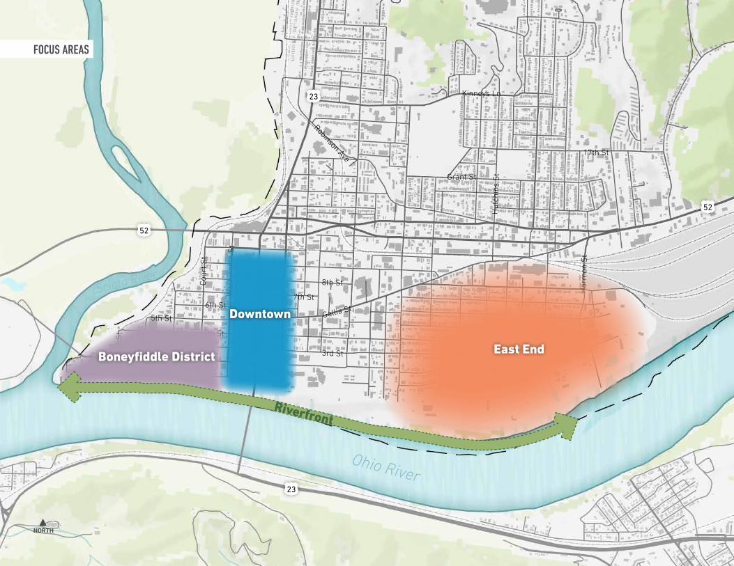
Plan FrameworkFOCUS AREAS
The existing conditions analysis and conversations with stakeholders and the Steering Committee led the planning team to focus Elevate Portsmouth on three primary areas of the city: Boneyfiddle District, Downtown, and the East End.
Downtown
Boneyfiddle District
East End
52
52
Ohio River
Scioto River
Gallia St
Grant St
Hut
chin
s S
t
Har
mon
St
17th St
Kinneys Ln
Gay
St
2nd St
4th St
5th St
6th St7th St
8th St
3rd St
Mar
ket S
t
Jeff
erso
n S
t
Mad
ison
St
Cour
t St
Chill
icot
he S
t
Was
hing
ton
St
Robinson Ave
23
23
NORTH
East EndBoneyfiddle District
Downtown
Riverfront
FOCUS AREAS

42
Plan FrameworkBONEYFIDDLE
The Boneyfiddle District is Portsmouth’s historic city center. With recent investments added to decades of renovation, 2nd Street in the Boneyfiddle District has become a bustling place to live, visit, and build a business. This area is already attracting a lot of attention, and with a few catalytic ideas, it can continue to flourish. Public spaces, river views, residential, and walkability were identified as important ideas for Boneyfiddle.
Challenges:
• Preserving existing historic buildings
• Infilling “missing teeth” (new buildings in places in between buildings where historic buildings were removed)
• Encouraging pedestrian activity
• Attracting tenants
• Integrating housing
• Parking location / wayfinding
Opportunities:
• Strengthen gateways
• Strengthen connection to the river and Downtown
• “Bridge” the floodwall and provide safe views and connectivity
• Integrate pedestrian amenities
• Improve streetscape, pedestrian experience and public spaces
• Add residential opportunities
• Renovation of river amphitheater and other Community Revitalization Plan recommendations, with connection to Boneyfiddle
Riverview Retirement & Senior Housing
Portsmouth Floodwall
Alexandria Point

ELEVATE PORTSMOUTH MASTER PLAN43
Front StFront St
Ohio River Scenic BywayOhio River Scenic Byway
Madison S
tM
adison St
Massie S
tM
assie StScioto St
Scioto St
Jefferson St
Jefferson St
Market St
Market St
Court St
Court St
Washington St
Washington St
Gay StGay St
Chillicothe St
Chillicothe St
4th St4th St
5th St5th St
6th St6th St
7th St7th St
8th St8th St
9th St9th St
10th St10th St
3rd St3rd St
2nd St2nd St
Ohio River
Scioto River
52
73
Alexandria PointAlexandria Point
Final FridaysFinal Fridays
Friends of PortsmouthFriends of PortsmouthCluster of Antiques Cluster of Antiques
& Boutiques& Boutiques
Portmouth Brewing Co.Portmouth Brewing Co.
Welcome CenterWelcome Center
Patties & PintsPatties & Pints
Facade Project by Main StreetFacade Project by Main Street
Market Street CafeMarket Street Cafe
Retirement & Senior HousingRetirement & Senior Housing
BONEYFIDDLE DISTRICT FRAMEWORK DIAGRAM

44
Plan FrameworkDOWNTOWN
Downtown, primarily Chillicothe Street, is Portsmouth’s business district. With the tallest buildings and most storefronts in the city, this area has the potential to be an anchor for employment and experiential retail (read—a unique variety of local shops and restaurants) in the region. Connected to Shawnee State University and the Boneyfiddle District, with available office and retail space, Downtown is primed for redevelopment and new development. New residential, public spaces, and connection to the University were identified as important ideas for Downtown.
Challenges:
• Attracting tenants
• Integrating housing
• Building maintenance / renovation
• Parking location / wayfinding
• Transportation infrastructure prioritizing vehicles coming across the US Grant Bridge, decreasing pedestrian safety and disconnecting Shawnee State from Downtown
Opportunities:
• Strengthen Gallia corridor
• Strengthen 2nd St. / Chillicothe St. connection
• Connect Shawnee State to Downtown
• Attract more people Downtown
• Connect Downtown to the river
Martings Building
The Lofts @840
Roy Rogers Esplanade

ELEVATE PORTSMOUTH MASTER PLAN45
Ohio River
Shawnee State University
Shawnee State University
Dog Park
Dog Park
Tracy ParkTracy Park
Roy Rogers Esplanade
Roy Rogers Esplanade
Martings BuildingMartings Building
Innovation HubInnovation Hub
Cirque D’Art TheatreCirque D’Art Theatre
Scioto Foundation Scioto Foundation Park ApartmentsPark Apartments
Holiday InnHoliday Inn
Sleep Inn SiteSleep Inn Site
Facade Project by Main StreetFacade Project by Main StreetFront Street Bike LaneFront Street Bike Lane
Former 5/3 BankFormer 5/3 Bank
The Lofts @840The Lofts @840
Lofts Coffee ShopLofts Coffee Shop
Hurth ApartmentsHurth Apartments
Municipal BuildingMunicipal Building
Southern Ohio MuseumSouthern Ohio Museum
DOWNTOWN FRAMEWORK DIAGRAM
Vern Riffe Center for the ArtsVern Riffe Center for the Arts

46
Plan FrameworkEAST END
Bound by the railyards, Ohio River and US 52 transportation corridor, the East End neighborhood has experienced a concentration of poverty and disinvestment over many years. Residents of this area feel cut off from Downtown and struggle with feeling whether they are invited to take part in events and new investment in the city. At the same time, the East End has rich character—with historic manufacturing buildings, walkable streets, affordable housing, and the historic Spartan Stadium. Programs for homeowners, connections to Downtown, and Spartan Stadium were identified as important ideas for the East End.
Challenges:
• Barriers to connectivity to other neighborhoods, to schools and downtown
• Aging housing
• Lack of housing variety
• Lack of usable green space, recreation options
• Unemployed and recovery community
Opportunities:
• Strengthen connectivity to other neighborhoods, to schools and downtown
• Support and encourage reinvestment in housing
• Increase housing options
• Attract employment options
• Resident services, job training
Spartan Stadium
Portsmouth Public Library
Portsmouth High School

ELEVATE PORTSMOUTH MASTER PLAN47
Spartan StadiumSpartan Stadium
Stadium LunchStadium Lunch
Portsmouth High SchoolPortsmouth High School
Mitchellace RedevelopmentMitchellace Redevelopment
Norfolk Southern RailyardNorfolk Southern Railyard
3rd Street Disconnection3rd Street Disconnection
Portsmouth Elementary SchoolPortsmouth Elementary School
Greenlawn CemeteryGreenlawn Cemetery
Mound ParkMound Park
EAST END FRAMEWORK DIAGRAM
Secondary Connector
Broken Connection
Trail Connection
Primary Connector


ELEVATE PORTSMOUTH MASTER PLAN
Plan Framework
1. Identify Small Investments That Will Make Big Impacts
2. Facilitate Big Projects That Will Catalyze Lasting Change
3. Expand and Enhance Successful Nodes of Activity
4. Support Neighborhoods
5. Leverage Existing Assets
ELEVATE PORTSMOUTH MASTER PLAN
Recommendations4 |

50
Plan FrameworkFIVE STRATEGIES
The existing conditions analysis, engagement conversations, and focus areas designation led to a Five Strategy framework for Elevate Portsmouth. The recommendations section of Elevate Portsmouth leads with the Vision for the city, and principles for achieving it (articulated as Pillars of a Lifestyle City). Then, the plan recommendations are organized into the five-strategy framework:
Examples of this strategy already at work in Portsmouth include the Kricker Innovation Hub, the Riverfront Amphitheater Concepts from the Revitalization Plan, and preservation of historic buildings.
Examples of this strategy already at work in Portsmouth include the Spock Memorial Dog Park, upcoming Front Street Bike Lane, and 2nd Street Façade Project by Main Street.
IDENTIFY SMALL INVESTMENTS THAT
WILL MAKE BIG IMPACTS
FACILITATE BIG PROJECTS THAT WILL
CATALYZE LASTING CHANGE
1 2

ELEVATE PORTSMOUTH MASTER PLAN51
Examples of this strategy already at work in Portsmouth include the 2nd Street cluster of restaurants, retail storefronts, and residences, the Sleep Inn under construction adjacent to the Downtown Holiday Inn, and the buildings and public realm of Shawnee State’s campus.
Examples of this strategy already at work in Portsmouth include new residential at The Lofts @840, planned redevelopment of the Mitchellace historic building, and the 14th Street Community Center community garden and plethora of support programming.
Examples of this strategy already at work in Portsmouth include the murals on the flood wall along Front Street, highlighting the collection of community assets along the Ohio River, and the proposed connections featured in the Scioto County Active Transportation Plan.
EXPAND AND ENHANCE SUCCESSFUL NODES
OF ACTIVITY
SUPPORT NEIGHBORHOODS
LEVERAGE EXISTING ASSETS
3 4 5

52
1. Identify Small Investments That Will Make Big ImpactsSTOREFRONT ACTIVATION
Vacant storefronts detract from walkability and deter potential customers from frequenting the businesses that are open. On Chillicothe Street, a storefront activation program could help attract students, residents and visitors to shop and walk along the streets downtown. More people, things to look at, and clean open-looking storefronts will help with Downtown vibrancy and increase potential for attracting permanent retail and restaurants in those places. Several models exist for this type of activation.
A. Activate the windows. It can be local art, an interactive poster, or items for sale. Clean windows with items on display will engage pedestrians walking by and drivers deciding whether to stop and park. Windows boarded up? Get muralists to paint the boards. Storefront programs can inspire students, artists, and entrepreneurs to enliven spaces from the sidewalk without concern whether buildings are open or have permits for occupancy.
B. Activate a single storefront. Find one or a few creative owners to run a temporary activation program in their storefront. This could be managed by the City or an organization. Give grants to artists or entrepreneurs to create an experience in a storefront for a predetermined amount of time. The first program in a single storefront could act as a pilot program for expanding it to multiple storefronts.
C. Activate multiple storefronts. Create a program within the City that provides grant incentives for building owners to make their storefronts available for activation. This could include cleaning and replacing of windows for window activation and interior renovations for storefront activation.
CURATED STOREFRONT PROGRAM | AKRON, OHThe vision of Akron’s “Curated Storefront” program is: Transforming Akron to a viable and attractive urban destination through the arts. The program, established in 2016 by the King Arts Foundation in partnership with the Downtown Akron Partnership, sought to activate vacant downtown storefronts with vibrant art exhibits. The program has since become its own non-profit organization. In the span of the program, 25 buildings have hosted 86 storefront exhibits with work from 122 artists. Thirty-two of the 122 artists have exhibited work multiple times. Today, 11 of the storefronts that housed the program (which had been empty for years) have been commercially developed or revitalized.
Source: www.curatedstorefront.org

ELEVATE PORTSMOUTH MASTER PLAN53
PEOPLE’S LIBERTY GLOBE GRANTS | CINCINNATI, OHFrom 2014-2019, People’s Liberty, a philanthropic lab launched by the Carol Ann and Ralph V. Hail Jr./U.S. Bank Foundation, awarded three (3) $15,000 Globe Grants per year to local artists, designers, and creatives to transform a storefront gallery into an interactive pop-up experience for six weeks. Award winning projects included a play library, art galleries, a sustainable shop, a free recording studio, a microcinema, a STEAM learning playscape, and a Turkish coffeehouse. In 2018 alone, nearly 6,000 guests visited the storefront to engage with a Globe Grantee project.
Curated Storefront in Akron, OH
Globe Grant Storefront - Microcinema
Globe Grant Storefront - Play LibraryCurated Storefront in Akron, OH

54
1. Identify Small Investments That Will Make Big ImpactsARTISTIC CROSSWALKS
One of the most inexpensive ways to liven up a space is paint. Decorative crosswalks encourage walking, help connect places, slow down traffic, and help pedestrians feel safer. A city-wide crosswalk project could unite neighborhoods, strengthen unique district identities, celebrate local artists, and show swift progress in Elevate Portsmouth implementation.
Paint will wear quickly, so some cities that implement decorative crosswalks decide to do semi-permanent hardened plastic applications instead of paint. Permanent decorative crosswalks are much more expensive but should be considered with any road repaving project and would be appropriate for critical pedestrian crossings, such as where 2nd Street crosses Chillicothe Street near Shawnee State’s campus. This plan recommends three artistic crosswalk programs:
1. Downtown + Boneyfiddle Artistic Crosswalks
• City administered and implemented program
• Select 3 - 5 crosswalk locations to designate. Suggestions include across Chillicothe at the Roy Rogers Esplanade, across Chillicothe at the Kricker Innovation Hub, across 2nd Street at Market, at Court, and at Jefferson.
• Center crosswalk design around a theme. Get ideas through a community engagement process or juried art competition.
• Implement painted crosswalks annually with a new theme, or hardened plastic crosswalks with a highly supported theme as a longer-term option.
2. City-wide Artistic Crosswalks
• City administered, community implemented program
• Allow resident groups to paint their intersections or crosswalks. Create a permitting process to allow neighbors
and groups to implement.
• The city ensures the correct materials are used and painters follow their project plan. Application process may include:
• Permission of surrounding landowners
• Project sketch, measurements, budget, materials and contacts
• Before and after photos
3. Permanent Artistic Crosswalks
• City administered and implemented program
• Consider creative permanent crosswalk instillations with multicolored pavers at key intersections during infrastructure projects.
• Early in the improvement planning and roadway design process, engage a registered landscape architect on the team to produce design concepts and cost estimates.

ELEVATE PORTSMOUTH MASTER PLAN55
Artistic crosswalk in Bexley, OH Photo credit: Epic Small www.epicsmall.com
Artistic crosswalk in Bexley, OH Photo credit: Epic Small www.epicsmall.com
Painted crosswalk by a school in Maryland
Artistic crosswalk in Ironton, OH
Artistic crosswalk in Ironton, OH
Pride Month crosswalks in Phoenix

56
1. Identify Small Investments That Will Make Big ImpactsPARKLETS
Parklets are a great way to create more public space right where you need it – in front of restaurants and retail shops. A parklet turns a single parking space into a creative and attractive place for people to sit and gather. Parklet examples come from cities of all shapes and sizes and have become even more popular during the period of social distancing when everyone wants to gather outside. All you need to make a parklet are some creative and crafty individuals, permission and guidance from the city and agreement from the restaurant or store owner where you are placing the installation. The City or an organization such as the Scioto Foundation could install a pilot parklet on Chillicothe or 2nd Street as an example to promote the program and show design inspiration. Key components for the City to initiate a parklet program include:
• Application process including potential incentives or grant support
• Design and safety guidance and requirements
• Stakeholder engagement facilitation
• Timeline and implementation protocol
Outdoor Dining Parklet at Patties & Pints

ELEVATE PORTSMOUTH MASTER PLAN57
Photo credit: Epic Small
Parklet in City of Terrace
Parklet in Philadelphia
Photo credit: Epic Small
Parklet in Sao Paolo

58
1. Identify Small Investments That Will Make Big ImpactsROY ROGERS ESPLANADE ACTIVATION
At the heart of Downtown, the Roy Rogers Esplanade is a defining public space. Holding events and a regular farmers market, the plaza connects Chillicothe Street to major arts and culture institutions on Gallia Street. These ideas show the esplanade re-activated with small improvements to attract more people, instigate Instagram-able moments, and connect a larger pedestrian loop to Shawnee State, creating a public space anchor for a defined Portsmouth Arts & Innovation District. These interventions would not only make the space more attractive to students, residents, and visitors, but also could attract the attention of potential investors and companies to the vacant Martings and 5/3rd office buildings. People want to live and work next to vibrant places.
Arts & Culture District
With pedestrian signage, storytelling signage and artistic crosswalks, a Portsmouth Arts & Innovation District could be created. This walking loop would guide visitors and students to a series of arts, culture and innovation institutions in the city.
PORTSMOUTH ARTS & INNOVATION DISTRICT
Verne Riffe Center for the Arts
Southern Ohio Museum + Cultural Center
Roy Rogers Esplanade
Kricker Innovation Hub
Gallia St
3rd St
4th St
Chillicothe S
t
Gay S
t
2nd St
DESIGN DETAIL OF 12’ SCRIM
12 F
EET
12 F
EET

ELEVATE PORTSMOUTH MASTER PLAN59
ROY ROGERS ESPLANADE | 12 FEET UNDER CONCEPT
Scrim Mounted at 12’ High
Historical Marker
Artistic Crosswalk

60
1. Identify Small Investments That Will Make Big ImpactsROY ROGERS ESPLANADE ACTIVATION
Two other concepts explored for the Esplanade are depicted here. One is a theme based on the story of Indian Head Rock. The second is another flood concept titled 1937. This idea depicts a 1937 vehicle is placed in the plaza, sunken to tell the story of the flood. It is neighbored by a sunken-looking home structure piece of art that could be a play structure for kids. Of the Esplanade concepts, the 12-Feet Under theme depicted on the previous page was the most popular theme, based on significance of the 1937 flood to the city and flexibility of the plaza space preserved in the improvement concept.
Key components for small improvements that activate public spaces include:
• Organize improvements with a theme or story (other theme ideas could reference mound builders, early industry (e.g. Selby Shoes), and river travel (e.g. barges and boats))
• Add color and interest with a combination of paint, art, shade structures, and lighting
• Include living and green elements such as trees, shrubs, and flowers
• Provide a variety of seating to attract all ages
DESIGN DETAIL OF BOULDERS
DESIGN DETAIL OF CAR SCULPTURE

ELEVATE PORTSMOUTH MASTER PLAN61
ROY ROGERS ESPLANADE | INDIAN HEAD ROCK CONCEPT
ROY ROGERS ESPLANADE | 1937 CONCEPT
Artistic Crosswalk
Large Boulders for Sitting & Climbing
Flooded Car Sculpture from 1937
Flooded House Photo Op
Custom Seating Integrated with Steps
Historical Marker
Artistic Crosswalk

2. Facilitate Big Projects That Will Catalyze Lasting Change2ND STREET LANDING
Shawnee State University campus and students are disconnected from Downtown Portsmouth. The transportation infrastructure that exists today has done a great job at what it was planned for – to get trucks off Chillicothe Street – but it also defined the edges of the university, separating the walkable campus from the walkable downtown streets. The 2nd Street Landing concept is a long-term play for transforming the northwest edges of Shawnee State University campus to become part of Downtown Portsmouth.
This three-phased approach is aligned with campus planning within the university. It starts with gateways, connects campus to Downtown in the medium term, and in the long term blends the edges of each so they maintain their distinct identities while also becoming part of one cohesive place. These illustrations highlight the first two phases of the three-phased approach to achieve the 2nd Street Landing concept.
1. Emphasize the Primary Gateways
• Short-term
• Locations: 2nd Street Crossing and 3rd Street Entrance
Create a safe and interesting pedestrian crossing experience designed for the comfort of students walking and biking to and from campus and downtown. Install a signalized crossing at 2nd Street. Open 3rd Street with a campus gateway feature. These elements will also serve to slow traffic and create a grand entrance to the university.
2. Formalize the Pedestrian Edges of Campus and Secondary Gateways
• Medium-Term.
• Locations: Along 3rd Street and entrances at Waller and Stinton Streets
Install planted traffic calming infrastructure to add visual interest and guide traffic traveling through Portsmouth north from the US Grant Bridge. Enhance the gateways into campus on 3rd Street at Waller and Sinton Streets. Install bike lanes connected into the larger Portsmouth bikeways system. Plant trees and add other creature comforts to enhance the walkable, pedestrian-focused experience on campus.
x x x x
23
852
23
52
73
8
8
SPD 55
SPD 55
SPD 55
SPD 55
SPD 25
SPD 35
852
Remove Slip Ramp
Two-Way Conversion
Reconnect 3rd Street
Two-Way Conversion
SouthboundTraffic Lights: 3
Average Speed: 55
NorthboundTraffic Lights: 4
Average Speed: 55
Carl D. Perkins Memorial Bridge
Right Turn Slip Ramp
ENABLING CHANGES FOR PHASE 3
62

2ND STREET LANDING CONCEPT | PHASES 1 & 2
GAY
STR
EET
Vern Riffe Center for the Arts
James A. Rhodes Athletic Center
Administration Building
Kricker Innovation
Hub Clark Memorial Library
CHIL
LICO
THE
STR
EET
U.S
. GR
AN
T B
RID
GE
STINTON STREET
3RD STREET
4TH STREET
BR
OA
D S
TREE
T
WA
LLER
STR
EET
Signalized Crosswalk
Enhanced Pedestrian Crossing
Traffic Calming Streetscape
On-Street Parking
Enhanced Streetscape and Traffic Calming
Shawnee State Entry Feature
ELEVATE PORTSMOUTH MASTER PLAN63

64
2. Facilitate Big Projects That Will Catalyze Lasting Change2ND STREET LANDING
The long-term vision for 2nd Street Landing is for Shawnee State University to reach the edges of Downtown, maintaining their distinct identities while also becoming part of one cohesive place. This would transform what is now known as the “L” (Downtown to Boneyfiddle, i.e. Chillicothe Street to 2nd Street) into a “T” (Downtown, Boneyfiddle and Shawnee State). The blending of campus and downtown / retail corridors is a strategy that is reflected in many universities. See examples from Ohio University, Ohio State University, and Purdue University. The synergies of this integrated connection builds strength in the city and on campus. Key components and benefits of this concept include:
• Successful reroute of all truck traffic traveling north from Kentucky onto the Carl D. Perkins Memorial bridge and route 852. This is currently the preferred and officially designated trucking route. However today, trucks are still using the US Grant Bridge north through Portsmouth.
• Removal of curved 2nd Street to Gay Street slip ramp and reinstatement of the historic street grid, including two-way connection of 3rd Street from Campus to Downtown.
• Gain of new development ground at southeast corner of Chillicothe and 3rd Streets for new campus buildings, student housing, retail, office or mixed-use projects, as determined by market forces or Shawnee State University growth.
• Formalized pedestrian crossing, with treatments such as specialized pavement, median or raised intersection, from campus across Chillicothe Street. Continued pedestrian amenities along 2nd Street into the Boneyfiddle District.
• Highly visible pedestrian campus gateway installation with plaza and plantings on Chillicothe Street into campus.
ALTERNATIVE CAMPUS GATEWAY CONCEPT
Purdue University Gateway
Ohio University GatewayOhio State University Planned Connection to High Street, Columbus

ELEVATE PORTSMOUTH MASTER PLAN65
2ND STREET LANDING CONCEPT | PHASE 3
Formalized Pedestrian Crossing
Campus Gateway
Realigned 3rd Street
Infill Development Opportunity

66
2. Facilitate Big Projects That Will Catalyze Lasting ChangeSPARTAN STADIUM RECREATION PARK
Renovation and activation of Spartan Stadium was one of the most requested ideas in the master plan engagement process. This concept shows how the stadium could serve as a semi-regional location for multiple sports leagues, neighborhood meeting and event space, and large event venue. This concept is a size and capacity study that is meant to serve as a basis for ongoing discussions and inspiration to potential investors. Components in the concept include:
• Spartan Stadium historic renovation for sporting, music, and civic events
• Connection to Downtown via trail system on the levee
• Playground
• Formalized parking area with central gathering space, food truck parking, walking paths, and climbing wall
• Pavilion and food court with seating
• Sand Volleyball or basketball court
• BMX jump track
• Three regulation soccer field and one mid-size field. These should include at least two informal for flexibility to other uses.
• Variety of six baseball and softball diamonds, including regulation-sized fields
BMX Jump Track
Climbing Wall at Scioto Audubon Metro Park
Seating

ELEVATE PORTSMOUTH MASTER PLAN67
SPARTAN STADIUM RECREATION PARK CONCEPT
BMX Jump Track
Playground
Soccer Fields
Parking Lot with Food Truck Parking
Climbing Wall
Historic Renovation of Spartan Stadium
Trail Connection to Downtown
Baseball + Softball Diamonds

68
2. Facilitate Big Projects That Will Catalyze Lasting ChangeHISTORIC PRESERVATION
Portsmouth is rich with historic buildings of high-quality architecture and character people cherish. Not only does historic preservation preserve the quality of a place, it adds jobs, attracts businesses and residents, and catalyzes investment in surrounding properties.
Owners of historic buildings have access to historic preservation tax credits that can finance nearly half of project renovation costs. Winning Ohio Historic Preservation Tax Credits is a competitive process that favors projects in smaller cities and places of higher need. These credits provide owners up to 25% of qualified expenses toward rehabilitation. Annually, $60 Million is available to applicants in two application cycles.
In an Economic Impact Study completed by Cleveland State University and Team NEO, Ohio’s first $246 Million invested in historic preservation has led to $2 Billion in economic development, more than 20,000 jobs and an $80.5 Million expansion of public revenues.
For every $1Million spent in historic preservation, Ohio has seen $40Million in total economic activity.*
GOODYEAR HALL | AKRON, OHGoodyear Hall in Akron was originally the headquarters complex for Goodyear Tire & Rubber Company. After Goodyear relocated its headquarters elsewhere, the former office building was converted into a mixed use development with the help of state and federal historic tax credits. The development includes 106 apartment units, first floor retail space, and the rehabilitation of the 1,500 seat theater and historic gymnasium original to the building.
The Federal Historic Preservation application process is not competitive. This credit only requires applicants to meet the qualifications set by the National Park Service (NPS) to receive 20% of qualifying rehabilitation expenses. According to NPS, Federal Historic Preservation Tax credits generated $6.2 Billion in GDP in 2017 and created more than 107,000 jobs.**
*Source: Ohio Historic Preservation Tax Credit Key
Facts, 9/1/2011, Ohio Department of Development.
**Source: www.nps.gov/orgs/1207/htc2017.htm
Goodyear Theater Lobby

ELEVATE PORTSMOUTH MASTER PLAN69
CARLISLE BUILDING | CHILLICOTHE, OHAfter a devastating fire, the fate of the historic Carlisle Building in downtown Chillicothe was unknown. The building Fortunately, Adena Health System, the region’s largest employer, wanted to invest in the downtown and sought out the Chesler Group, a development group out of Cleveland. Chesler Group purchased the building and pieced together funding to rehab and restore the building. Funding sources included traditional bank financing, a $1 million loan and $500,00 grant from JobsOhio, a $500,000 loan from the Chillicothe-Ross Community Foundation, and state and federal historic tax credits. Chesler Group transformed the building into office space for Adena Health System, as well as 32 apartments for medical residents and visiting staff.
Carlisle Building Exterior
Adena Offices in Carlisle Building

70
3. Expand and Enhance Successful Nodes of ActivityMARKET SQUARE
ALTERNATIVE A: STAGE
ALTERNATIVE C: MEDIAN PAVILION
Market Square is the highest prioritized and most supported of all Elevate Portsmouth concepts. This square of open space currently holds events including Winterfest and a regular farmers market in the Boneyfiddle District. Several concepts were developed for placemaking and activation of this space. The preferred concept was the Pavilion. Planning team and committee members also liked the Median Pavilion concept on Market Street. As this idea is pursued with follow-on planning and conceptual design, a combined alternative with the flexible green space at the square and pavilion on Market Street should be discussed. Key components for the Market Square Pavilion concept are:
• Food truck parking • Trees and shade • Small picnic shelter or vendor space • Picnic tables or other type of group and
individual seating • Small playground or climbable/interactive
public art • Overhead lighting • Flexible pavilion that can hold vendors
for events such as farmers markets and craft fairs, community events such as neighborhood gatherings and festivals, and potential for reservation for private gatherings as a revenue generator for maintenance and operations.
ALTERNATIVE B: FLEXIBLE GREEN SPACE

ELEVATE PORTSMOUTH MASTER PLAN71
MARKET SQUARE ENHANCEMENT CONCEPT
Food Truck Parking
Flexible Pavilion
Small Playground
Creative Seating Options
Lighting
Vending

72
3. Expand and Enhance Successful Nodes of ActivityRIVERVIEW NEIGHBORHOOD ACTIVATION
The Riverview Neighborhood was selected to illustrate concepts of where and how additional residential options might fit into the Boneyfiddle District and how a connection across the floodwall to the river might look. This location was used in the concept illustrations because a) there are sites that look to have redevelopment potential, b) its proximity to the river, and c) its proximity to the restaurants and shops on 2nd Street.
The concept shows a makeover of the existing green space to function as a public space and make a direct visual connection from Front Street to Second Street. In the most popular concept, residential and mixed-use buildings are shown along Front Street. Each have balconies and higher-level spaces where people can enjoy views of the river over the floodwall. Another concept for this area shows an elevated park and pedestrian bridge over the floodwall.
ALTERNATIVE A: PLAZA + RESTAURANT
ALTERNATIVE B: PEDESTRIAN BRIDGE + ELEVATED PARK

ELEVATE PORTSMOUTH MASTER PLAN73
MARKET SQUARE ENHANCEMENT CONCEPT
Mixed Use Building with Restaurant Opportunity
Activated Public Plaza
Connection to Riverfront
Potential Residential Buildings with Ground Floor Parking

74
Today, there are some concerns for visitors and customers finding parking spaces. Overall, the consensus was that plenty of on-street and off-street parking exists today. However, it is not always marked or obvious what spaces are available to the public for parking. Further, some merchants mention difficulty loading and unloading merchandise and customer purchases. The City should consider adding signage and wayfinding to clearly direct drivers to public parking spaces.
A downtown parking study could identify the needs for signage and ideal placement, as well as recommendations for loading zone spaces and other needs. A study could also identify parking opportunities for attracting a major employer to the Martings or 5/3rd building, which was mentioned as a constraint to economic development there.
Also, as investment continues in Downtown and Boneyfiddle, needs for public parking may increase. The City should keep a look out for opportunities to formalize and offer parking proximate to both areas. On the map, several lots look like they are informally offering parking opportunities today.
The City may seek to purchase lots or operate public parking in public/private partnerships with landowners. As development increases, some landowners may see value in developing paid parking lots.
In any of these cases, investment should also include placemaking elements to ensure the parking does not detract from the character of the area. This includes screening with trees, green edges, fences and/or art. Also, streetscape and pedestrian wayfinding signage are essential for visitors and customers to find the businesses and arts and culture institutions of Downtown and Boneyfiddle after they get there—and feel comfortable walking to find them.
3. Expand and Enhance Successful Nodes of ActivityPARKING FOR BONEYFIDDLE & DOWNTOWN
Streetscape Improvements
Parking Screening

ELEVATE PORTSMOUTH MASTER PLAN75
4TH S
T
2ND
ST
3RD
ST
FRO
NT S
T
MARKET ST
Market Market SquareSquare
RiverviewRiverview
CrosswalksCrosswalks
Formalize Formalize ParkingParking
Streetscape + Streetscape + WayfindingWayfinding
POTENTIAL PARKING OPPORTUNITIES

76
4. Support NeighborhoodsTRACY PARK INFILL DEVELOPMENT
The Tracy Park Residential infill examples show how new residential options could develop facing the park, including how a mixed-use residential site could give the existing businesses on Chillicothe Street a walkable new home. New apartment, townhome and condo-style residential options were identified as important in the planning process. Additional options for renters and buyers looking to invest in newer or higher end properties will reserve Portsmouth’s affordable homes for those who need them. Infill at Tracy Park is one example where residential infill would be a good fit for Downtown Portsmouth.
Tracy Park is an important northern gateway into Downtown. New development along the park could transform the entrance to downtown for pedestrians and vehicles. More people living around the park would increase the activity there and help the park function as a ‘Central Park’ type space as it did historically.
TRACY PARK RESIDENTIAL INFILL Townhomes or Apartments

ELEVATE PORTSMOUTH MASTER PLAN77
TRACY PARK RESIDENTIAL AND COMMERCIAL INFILL
Restaurant Patio
Bank
Townhomes or Apartments
Connected Parking Lot

78
4. Support NeighborhoodsEAST END NEIGHBORHOOD CENTER
The East End Neighborhood is missing a central gathering space. Also, the Mitchellace property has been purchased and is an expected site for redevelopment. The East End Neighborhood Center concept illustrates how a new park could act as a focal point for the neighborhood. Investing in green space first, with pedestrian connections to the surrounding blocks, could become an important place for the community as well as serve an attraction to new residential development overlooking the park. This example places the green space on the Mitchellace site, to build on the energy that redevelopment will bring to the neighborhood. Green space on this site, whether it is as large as shown or smaller and incorporated into other development, could serve new users of the site as well as the surrounding neighborhood.
Another site discussed in the planning process was a green lot currently owned and used by a local church, between 7th and 6th Streets, Adams and Chapel Avenues.
Key components of this concept are: • Public / private investment in green
space with paths, benches and shade trees
• Programming and maintenance plan for keeping the park clean and hosting events
• Park as amenity to attracting residents, employees, and investors
• Park and events as community building and fostering community pride
• Public investment as a signal to landowners and potential developers to catalyze private investment
• Mitchellace redevelopment including medical office, need-based, and senior housing

ELEVATE PORTSMOUTH MASTER PLAN79
EAST END NEIGHBORHOOD CENTER
Historic Renovation of Mitchellace Building
Streetscape Improvements
Organizing Green Space with Trees + Shade
Residential Infill Opportunity

80
4. Support NeighborhoodsEAST END NEIGHBORHOOD CENTER
Stakeholders in Portsmouth emphasize the need for residential neighborhoods to feel clean and safe for residents. Achieving this requires a mix of public and private investment and collaboration. Incentivizing owners to take care of their properties can help in areas where there are many rental properties and owners that do not live in town. See example of the Good Landlord Program from Salt Lake City, UT.
Collaboration among residents and community organizations can support beautification initiatives and identify code violations to support the City in neighborhood revitalization efforts. See the Oakwatch program from Pittsburgh, PA.
GOOD LANDLORD PROGRAM | SALT LAKE CITY, UTThe goal of the Good Landlord Program is to promote best practices for rental property management to ensure the safety and welfare of residents in the city. Under City ordinance, all residential rental properties require a business license and landlords who participate in the voluntary Good Landlord Program are eligible for up to a 95% discount on the annual licensing fees. Landlords in the program must complete a City-approved training course every three years, track all evictions and occupancy denials, and sign lease agreements with tenants.
Continued support and collaboration with community organizations such as the 14th Street Community Center, property owners, neighborhood businesses, and schools, along with public investment in parks and streetscapes can add strength and vitality to the East End neighborhood.

ELEVATE PORTSMOUTH MASTER PLAN81
OAKWATCH | PITTSBURGH, PAOakwatch is a resident-led neighborhood safety and beautification initiative in the Oakland neighborhood of Pittsburgh. Their mission is to improve the quality of life in the area by bringing people and institutions together to identify code violations, advocate for remediation, and monitor outcomes. They tackle issues like negligent landlords, vacant lot reclamation, abandoned and decaying homes, and other public nuisances. They are co-managed by the Oakland Planning & Development Council (OPDC) along with a resident chairperson. Partnering with the City of Pittsburgh and the local Police Department is also crucial in helping them achieve their mission. Oakwatch has been lauded in the Pittsburgh area as a model for collaborative public safety advocacy and code enforcement.
Oakwatch Meeting
Oakwatch Meeting

82
The Shawnee Recreation Trail is a semi-regional concept for connecting Portsmouth with its natural features and neighboring assets. This concept links together ideas that have been put forth by the Scioto County Active Transportation Plan, Revitalization Plan, and trail plans by the advocacy group Portsmouth Connex. The concept diagram depicts greenways (shared use paths) and blueways (water trails on the Ohio and Scioto Rivers).
The greenways in the diagram start at the east, connecting to Spartan Stadium and up through the East End neighborhood streets. The greenway travels west on top of the levee until it reaches the floodwall, where it becomes a bike path on Front Street all the way to Alexandria Park. At Alexandria Point, the greenway splits north up along a natural park in the Scioto River floodway and into Portsmouth neighborhoods north of downtown. The branch continuing west crosses the Scioto River, either through a pedestrian/bikeway bridge or dedicated lane on the existing bridge, and connects to the Raceway Park and Riverside Park. The blueways in the diagram show water access points along the Ohio and Scioto Rivers.
5. Leverage Existing AssetsSHAWNEE RECREATION TRAIL
Greenways and blueways are economic development catalysts. They drive outdoor recreation tourism and investment at each connection point. Formalizing blueways and greenways with water access points, wayfinding, parking, and connection to city streets can foster outdoor outfitter/rental businesses, food/beverage businesses, and companion retail shops.
Connecting the natural assets of Portsmouth into a Shawnee Recreation Trail system would formalize the city’s identity as a Lifestyle City and support the health and wellness of the community.
Riverfront Park
Spartan Stadium
Alexandria Point
Riverside Park
Raceway Park
Floodplain
SCIOTO R.
OHIO RIVER
23
852
52
73
8
52
EXISTING RIVERFRONT ASSETS

ELEVATE PORTSMOUTH MASTER PLAN83
SHAWNEE RECREATION TRAIL
River Access Points
Pedestrian/Bike Bridge
Enhanced Riverfront Greenway
Natural Area
Bike Lane + Floodwall Murals
Alexandria Point
Spartan Stadium Spartan Stadium Recreation ParkRecreation Park
Greenlawn Greenlawn CemeteryCemetery
Alexandria Alexandria PointPoint
Riverfront Riverfront ParkPark
Raceway Raceway ParkPark
Riverside ParkRiverside Park

84
5. Leverage Existing AssetsREGIONAL PARKS DISTRICT
The City of Portsmouth could partner with adjacent jurisdictions along the Ohio and Scioto Rivers to create a regional parks district that would oversee the development, operations, and maintenance of the parks and recreation facilities in the area. This parks district could be the responsible implementation entity for some of the recommendations in this plan including the Shawnee Recreation Trail and Spartan Stadium Recreation Park.
In Ohio, parks districts are created by citizens to preserve open space, protect natural areas, and provide recreational and educational opportunities. The majority of funding for parks districts comes from levies supplied by the residents of the parks district. Parks districts must have appointed park commissioners, with a minimum of three commissioners or they can elect to expand the membership to five commissioners. The board of commissioners may hire employees and contract for services. A parks district may include all or part of the territory within a county, but may not divide any existing township or municipal boundaries within the county.
ELEVATE PORTSMOUTH MASTER PLAN
BELLBROOK-SUGARCREEK PARK DISTRICTThe Bellbrook-Sugarcreek Park District was created in 1972 by local residents with the foresight to realize that areas must be set aside as parks. The majority of funding for the Park District comes from levies supplied by the residents of the City of Bellbrook and Sugarcreek Township. Local support, cooperation with other agencies, and great volunteers enable the Park District to meet the park and outdoor recreation demands of current and future generations. The Park District owns and/or manages nine developed parks and six undeveloped properties totaling approximately 660 acres within the Bellbrook-Sugarcreek Township area.

ELEVATE PORTSMOUTH MASTER PLAN85
CENTERVILLE-WASHINGTON PARK DISTRICT | CENTERVILLE, OHFounded in 1959 as the Washington Township Park District, the Centerville-Washington Park District now operates eight community parks, nine nature parks, and thirty-four neighborhood parks encompassing 1,030 acres in the City of Centerville and Washington Township. In addition to maintaining the parks, the Centerville-Washington Park District also offers outdoor recreational programming throughout the year for the community to enjoy. The Park District is governed by a three-member Board of Commissioners who are appointed by the Court of Common Pleas of Montgomery County. Each board member serves for a three-year term. The Park District also employs about 30 staff members (full- and part-time) who perform administrative duties, oversee parks facilities and operations, and lead programs.


ELEVATE PORTSMOUTH MASTER PLANELEVATE PORTSMOUTH MASTER PLAN
Future Land Use Plan
Implementation Matrix
Implementation5 |

The Future Land Use Plan is a statement of policy to be used as a guide for development and infrastructure decisions. The Future Land Use Map is an illustrative depiction of a long-term vision for growth and general development patterns to be encouraged by municipal policy and decision making moving forward.
Adoption of this Plan and the Future Land Use Map does not change existing zoning. Over time, the Zoning Code and Zoning Map may be modified through development approvals and municipal actions as a means to implement the policy recommendations of the Land Use Plan and Future Land Use Map. However, until any such amendments are adopted into the Zoning Ordinance, the Future Land Use Map does not directly affect how properties may be used today. Even in circumstances in which zoning classifications and requirements are changed in the future, existing uses and structures remain legal (often referred to as “grandfathered”), potentially with some limitations that are specified in the Zoning Code.
How to Use the Future Land Use Plan
The Future Land Use Plan should be consulted as a key guide when making decisions about development proposals. Likewise, proposals should demonstrate how they align with this plan. In some cases, the Plan’s recommendations may help to determine whether a requested change in zoning classification should be approved. The Plan may also be used to influence the details of how a proposed development is ultimately built.
Regional, City, Community and Neighborhood Nodes
The “nodes” marked on the map mark places with clusters of retail and civic land uses, as well as important gateways to and from neighborhoods and places in the city. These areas should get special attention in site plan review to ensure the development quality and site plan aligns with the desired character of that area.
For example, a residential apartment building in the traditional neighborhood area would likely be surrounded by some lawn and have a surface parking lot. However, if a new apartment building is to be developed on Front Street in the Boneyfiddle district, especially the closer it is located to the community node of Market and 2nd Streets, it should take on a different character. Here, parking should be tucked underneath the building, if the site allows for this, and balconies overlooking the river should be a key feature of the building (as depicted in the Riverview Neighborhood Activation concept).
88
Future Land Use PlanOVERALL MAP

NORTH
52
52
823
52
23
23
23
139
335
140
Scioto River
Little
Sci
oto
Rive
r
NEW BOSTON
SOUTHSHORE
Ohio River
SOUTHPORTSMOUTH
Gallia St
Off
nere
St
2nd St
Kinneys Ln
Gay
St
Mar
ket S
t
Coles Blvd
Gra
ndvi
ew A
ve
Traditional Neighborhood
Neighborhood Transition
Neighborhood Business District
Mixed Use Commercial
University District
Mixed/Healthcare District
Industrial/Logistics Flex
City Node
Regional Node
Community Node
Neighborhood Node
Hillside Neighborhood
Hillside
Parks and Open Space
PORTSMOUTH FUTURE LAND USE MAP
DRAFT

90
5.3 Future Land Use PlanFUTURE LAND USE MAP DEVELOPMENT AREA CHARACTERISTICS
Hillside Neighborhood is characterized by lesser sloped areas close to the hillside areas. Single family homes are nestled into the topography and connected with looping streets that follow the area’s natural slopes. Smaller scale multifamily homes may fit on sites with larger flat spots.
Hillside is characterized by steep slopes on the north edge of the city and through the center of the city north of New Boston.
PARKS & OPEN SPACE HILLSIDE HILLSIDE NEIGHBORHOODParks and Open Space are characterized by all types of recreation and wild spaces. This includes formalized parks such as Mound Park and Tracy Park as well as open spaces such as the unprogrammed space along the Ohio and Scioto Rivers.
Primary Uses Single family residential
Secondary Uses
Duplex, townhomes
Density 2-6 dwelling units per acre; low, constrained due to topography
Transportation Local roads, as connected as possible despite topography constraints
Parking Driveways, garages, on-street as applicable
Open Space Natural areas, pocket parks
Primary Uses Open space, forest
Secondary Uses
Single family homes, low impact development
Density Low
Transportation Limited access due to slopes, private drives to home sites
Parking n/a
Open Space Forest and natural areas
Primary Uses Parks, conservation, trails, recreation
Secondary Uses
Storm water, development related to recreation functions
Density n/a
Transportation Pedestrian focused, connected trails, small service and parking access roads
Parking Surface parking concentrated at trail heads, playgrounds
Open Space n/a

ELEVATE PORTSMOUTH MASTER PLAN91
TRADITIONAL NEIGHBORHOOD NEIGHBORHOOD TRANSITIONNeighborhood Transition is the area that transitions from Traditional Neighborhood to the denser areas of Downtown and Boneyfiddle and to the Mixed Use Commercial areas along the primary transportation corridors. New residential development should include a mixture of housing types. Neighborhood Transition areas may include a variety of single-family (detached and attached) and multi-family building types with employment, schools, and neighborhood commercial (gyms, essential retail, local restaurant).
Traditional Neighborhood is characterized primarily by early and mid-20th Century single family homes. Parks, places of worship and neighborhood commercial (small restaurants, shops), historic warehouses and proximity to mixed employment are also present. Existing housing stock should be preserved and improved; however, there are opportunities for single-lot infill development, which should be of compatible scale and character with surrounding homes.
The Neighborhood Business District includes Downtown and Boneyfiddle District, primarily fronting Chillicothe Street and 2nd Street. Also known as the “L,” this area has a unique identity and is the retail, civic, and employment spine of Portsmouth. The tallest and densest area of the city, this area is characterized by historic buildings lining the sidewalks with retail storefronts, restaurants, and employment on the first floor. Museums and arts/culture institutions, non-profits, and plazas are also frequent. Upper stories may hold residential or office uses. Non-historic sites and new construction should be sensitive to the historic form and scale of the area.
NEIGHBORHOOD BUSINESS DISTRICT
Primary Uses Employment, retail, restaurants, civic, arts & culture institutions, hospitality
Secondary Uses
Non-profit, multifamily residential, open space
Density 20-60 dwelling units per acre (when residential is present)
Transportation Traditional street grid. Historic street grid should be maintained and reconnected where possible
Parking On-street, surface lots hidden behind buildings with alley or cross-street access, garage parking for larger developments may be applicable
Open Space Plazas, streetscapes, formal public spaces
Primary Uses Multifamily, local business/employment (small office), education
Secondary Uses
Single family residential, neighborhood commercial, boutique hospitality
Density 6-20 dwelling units per acre
Transportation Traditional street grid. Historic street grid should be maintained and reconnected where possible
Parking Private garages, surface lots and on-street as appropriate to the housing type(s)
Open Space Neighborhood and regional park and trail connections; school fields; streetscape, natural stormwater control areas
Primary Uses Single family and multifamily residential
Secondary Uses
Parks, neighborhood commercial, civic and faith, adaptation of historic structures
Density 3-12 dwelling units per acre
Transportation Traditional street grid. Historic street grid should be maintained and reconnected where possible.
Parking On-street, attached or detached garages access from street or back alley.
Open Space City parks, streetscape, neighborhood parks, semi-public open spaces

92
5.3 Future Land Use PlanFUTURE LAND USE MAP DEVELOPMENT AREA CHARACTERISTICS
Primary Uses Higher education
Secondary Uses
Residential, civic, complimentary commercial, hospitality
Density n/a
Transportation Access to entry, parking incl. emergency. Campus characterized by pedestrian pathways/connections. Robust, safe pedestrian crossings connect campus to city.
Parking Surface lots in centralized locations, on-street and loading zone parking where applicable
Open Space Formalized, connected open space network
Primary Uses Healthcare and related office and employment uses
Secondary Uses
Specialized residential (i.e. senior housing, assisted living, recovery), support retail, hosp.
Density Based on proximity to surrounding neighborhood scale
Transportation Primary corridor connection. Highly accessible for visitors, patients, and emergency vehicles
Parking Off-street, centralized and shared when possible, on street as applicable adjacent to residential
Open Space Campus-like settings with centralized green spaces programmed for health and wellness, streetscapes, walking paths/connections to nearby trails
Primary Uses Commercial, employment
Secondary Uses
Medical services, multifamily residential, hospitality
Density 30-60 units per acre (when residential is present)
Transportation Arterial corridors with access management best practices, pedestrian and bicycle connections as applicable.
Parking Off-street surface (shared parking encouraged), on-street in certain areas (such as proximate to residential or retail as traffic calming, and side streets)
Open Space Connection to nearby greenways and trails is encouraged
Anchored by the Southern Ohio Medical Center and other medical areas in the city and characterized by medical complimentary uses. Can include hospitals, dentist/doctor and other medical office, rehabilitation centers, support retail (such as pharmacy), and specialized residential (such as senior housing, assisted living, and recovery).
Shawnee State Campus buildings, open space, and complementary uses such as student housing and retail (book stores, coffee shops, etc.)
The Mixed Use Commercial area follows Portsmouth’s primary transportation corridors: US 23 north of Downtown and US 52 east and west through the city. This area is characterized by commercial development including chain restaurant, strip retail mixed with employment and medical office/counseling/rehabilitation centers. Though these areas are likely to be auto-oriented, measures should be taken to incorporate pedestrian facilities, such as sidewalks, connected parking lots and other access management standards, protected bike lanes, and street trees.
MIXED USE COMMERCIAL UNIVERSITY DISTRICT MIXED/HEALTHCARE DISTRICT

ELEVATE PORTSMOUTH MASTER PLAN93
Primary Uses Employment, light/advanced manufacturing, warehousing and distribution
Secondary Uses
Office, exterior storage, showroom retail sales, artist/maker/entrepreneurial spaces
Density n/a
Transportation Designed to accommodate truck traffic
Parking Off-street surface lots
Open Space Employee amenity spaces, integrated open space/landscape areas, connections to nearby greenways and trails
Characterized by employment uses including lite industry, distribution, and logistics. Flexible uses may include re-purpose/adaptation of historic structures for entrepreneurial ventures or artist loft/maker spaces. Areas may accommodate large format users with back-of-house spaces for industrial and warehouse uses as well as front-of-house office and commercial space. Landscaping requirements should screen development from the right-of-way and neighboring properties.
INDUSTRIAL/LOGISTICS FLEX

94
Implementation MatrixSUMMARY OF RECOMMENDATIONS
RECOMMENDATION IMMEDIATE NEXT STEP TIME FRAME RESPONSIBLE ENTITY FUNDINGORDER OF
MAGNITUDE COSTS
SHORT-TERM
MEDIUM-TERM
LONG-TERM
LEAD SUPPORT PUBLIC PRIVATEPUBLIC/PRIVATE
Storefront Activation Identify locations, create program parameters
City, Scioto Foundation
Arts Commission
$
Downtown + Boneyfiddle Artistic Crosswalks
Identify locations, theme, materials
City Foundations, Arts Commission
$
City-wide Artistic Crosswalks
Create program parameters Residents City, Arts Commission
$
Permanent Artistic Crosswalks
Revisit in related planning/infrastructure conversations
City Arts Commission
$
Parklets Consider Downtown Parking Study and/or wayfinding and signage plan to build support for parklets
Civic groups, business owners, residents
City
$
Roy Rogers Esplanade Activation
Identify project partners, choose theme
City Foundations, arts community
$ - $$
2nd Street Landing Pedestrian crossing improvements, Coordination with Shawnee State
City Shawnee State University, ODOT
$$$ - $$$$
Spartan Stadium Recreation Park
Implement playground, neighborhood park improvements, seek partnerships for larger vision
City Regional Park Agency, County, foundations, neighborhood associations
$$ - $$$$
Implementation of Elevate Portsmouth—ideas big and small—will take collaboration. This means ongoing community engagement, making sure to reach Portsmouth’s diverse community, one-on-one conversations with business owners and property owners, and collaboration across organizations. Funding opportunities that can support more than one entity or project should be prioritized. Big ideas should be brought into ongoing plans and conversations to support their implementation long term. The table below includes guidance for collaboration, time frame and high-level cost guidance for implementation.

ELEVATE PORTSMOUTH MASTER PLAN95
RECOMMENDATION IMMEDIATE NEXT STEP TIME FRAME RESPONSIBLE ENTITY FUNDINGORDER OF
MAGNITUDE COSTS
SHORT-TERM
MEDIUM-TERM
LONG-TERM
LEAD SUPPORT PUBLIC PRIVATEPUBLIC/PRIVATE
Historic Preservation Provide information to building owners, promote HP and celebrate buildings that have been preserved
Building owners, Developers
State Preservation Office
$$$ - $$$$
Market Square Pavilion Concept design plan, materials, furnishings, cost estimates
City Foundations, civic groups
$$
Riverview Neighborhood Activation Concept (residential infill)
Coordination with Riverview owners, conversations with potential residential developers
Property owners, developers
City$$ - $$$
Tracy Park Infill Development
Conversation with land owners, potential developers
Property owners, developers
City$$ - $$$
East End Neighborhood Center (green space)
Identify neighborhood park location, conversation with land owners
Property owners
City$$
Shawnee Recreation Trail
Identify neighborhood park location, conversation with land owners, conversation with potential Regional Parks District partners
City, neighboring jurisdictions, property owners
Regional Park Agency, County, foundations, neighborhood associations/advocacy groups
$$$ - $$$$
Regional Parks District Form exploration task force, identify partners
City, neighboring jurisdictions
Advocacy groups $$ - $$$$
