master plan re-exam 2008 v2a - monroe township, gloucester
TRANSCRIPT

2008master plan re-examination report
prepared by:
3 s. broad streetsuite 3c
woodbury, nj 08096p.856.251.9989 f.856.202.8007
mk file no. MP08001-MK
j. timothy kernan, pe, pp, cmen.j. planner license no. 05400
monroe townshipgloucester county, new jersey
adopted by monroe township planning board on february 28, 2008
by resolution PB-48-08


acknowledgements
mayorMichael F. Gabbianelli, Mayor
township councilDan Teefy, PresidentRon Garbowski, Vice PresidentMarvin DilksBill A. Julio
Walter BrysonFrank CaligiuriWilliam Sebastian
planning boardObie O’Brien, ChairmanMichael F. Gabbianelli, MayorV. James AgnesinoBarry StragaTom CraneTimothy Brown
Frank Caligiuri, CouncilmanRobert Hochswinder, Vice ChairmanRob CataniaJames Muth, AlternateLarry Cooper, Alternate
planning board secretaryCarolyn F. Farrell
planning board solicitorLeonard T. Schwartz, Esquire
planning board plannerJ. Timothy Kernan, P.E., P.P., C.M.E.
planning board engineerRaymond Jordan, P.E., P.P., C.M.E.
business administratorKevin Heydel
township engineerChris R. Rehmann, P.E., P.L.S., P.P.
township solicitorCharles A. Fiore, Esquire

MONROE TOWNSHIPGloucester County, New Jersey
MASTER PLAN RE-EXAMINATION REPORTFEBRUARY, 2008
Adopted By: MONROE TOWNSHIP PLANNING BOARD ON February 28, 2008 Resolution No. PB-48-08 Adopted Pursuant to N.J.S.A. 40:55D-28, The New Jersey Municipal Land Use Law
Prepared By: melvin|kernan development strategies LLC 3 S Broad Street, Suite 3C Woodbury, New Jersey 08096 (856) 251-9989
__________________ _J. Timothy Kernan, P.E., P.P., C.M.E.Monroe Township PlannerN.J. Planner License No. 05400
introduction
The Township Planning Board is amending its recently adopted Master Plan Re-examination Report Dated April 2007 (adopted April 5, 2007 by Resolution No. PB-38-07) and May 2007 (adopted May 24, 2007 by Resolution No. PB-64-07) to address the following:
A. Rescinding recommendation to rezone heavily forested land to the FD-10, Forest Residential District 10 zone. The parcels will remain in their current districts: RD-RR, Rural Development Residential Receiving, and RD-RS, Rural Development Residential Sending........................p. 1
B. Rescinding recommendation to rezone an area to the AG, Agricultural Production District. The parcels will remain in their current district: RD-A, Rural Development Agricultural..............p. 4
C. Recognizing a growing residential area (Diamond Lakes) as appropriate for public sewer service to safeguard it from the potentially deleterious effects of on-site septic systems..p. 7
D. Rezoning an area from RG-MR, Regional Growth Moderate Residential District to RD-A, Rural Development Agricultural in order to bolster its agricultural utility.........................................p.13
E. Rezoning an area from RG-RA, Regional Growth Residential Age Restricted District to RG- MR, Regional Growth Moderate Residential District.................................................................p. 17
F. [Section Removed]
G. Amending the zoning ordinance to add defi nitions to Section 175-11 for Assisted Living Facility, Continuing Care and revising the defi nition for Long Term Care and/or Nursing Home.............................................................................................................................................p. 28
H. Amending the zoning ordinance that deals with Section 175-157J, Accessory Dwelling Units................................................................................................................................................p. 31
I. Amending the zoning ordinance that deals with Section 175-125, Open Space and providing supporting documentation for fi nancial contributions in-lieu of providing open space and recreation facilities.........................................................................................p. 34
J. Amending the existing sewer service plan to remove the area identifi ed area in D above, and including a possible sewer connection to the Diamond Lakes area....................................p. 50
K. Circulation System Amendments to add more proposed bus stops.....................................p.53
A
maste
r plan
re-e
xami
natio
n rep
ort
1 •
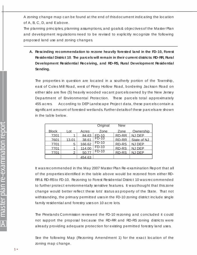
A zoning change map can be found at the end of this document indicating the location of A, B, C, D, and E above. The planning principles, planning assumptions, and goals & objectives of the Master Plan and development regulations need to be revised to explicitly recognize the following proposed land use and zoning changes.
A. Rescinding recommendation to rezone heavily forested land in the FD-10, Forest Residential District 10. The parcels will remain in their current districts: RD-RR, Rural Development Residential Receiving, and RD-RS, Rural Development Residential Sending.
The properties in question are located in a southerly portion of the Township, east of Coles Mill Road, west of Piney Hollow Road, bordering Jackson Road on either side are fi ve (5) heavily wooded vacant parcels owned by the New Jersey Department of Environmental Protection. These parcels total approximately 455 acres. According to DEP Landscape Project data, these parcels contain a signifi cant amount of forested wetlands. Further details of these parcels are shown in the table below.
Block Lot AcresOriginal
ZoneNew Zone Ownership
7201 1 84.63 FD-10 RD-RR NJ DEP7601 13.01 38.61 FD-10 RD-RR State of NJ7701 5 166.62 FD-10 RD-RS NJ DEP7701 1 114.00 FD-10 RD-RS NJ DEP7701 2 50.77 FD-10 RD-RS NJ DEP
454.63
It was recommended in the May 2007 Master Plan Re-examination Report that all of the properties identifi ed in the table above would be rezoned from either RD-RR & RD-RS to FD-10. Rezoning to Forest Residential District 10 was recommended to further protect environmentally sensitive features. It was thought that this zone change would better refl ect these lots’ status as property of the State. That not withstanding, the primary permitted uses in the FD-10 zoning district include single family residential and forestry uses on 10 acre lots.
The Pinelands Commission reviewed the FD-10 rezoning and concluded it could not support the proposal because the RD-RR and RD-RS zoning districts were already providing adequate protection for existing permitted forestry land uses.
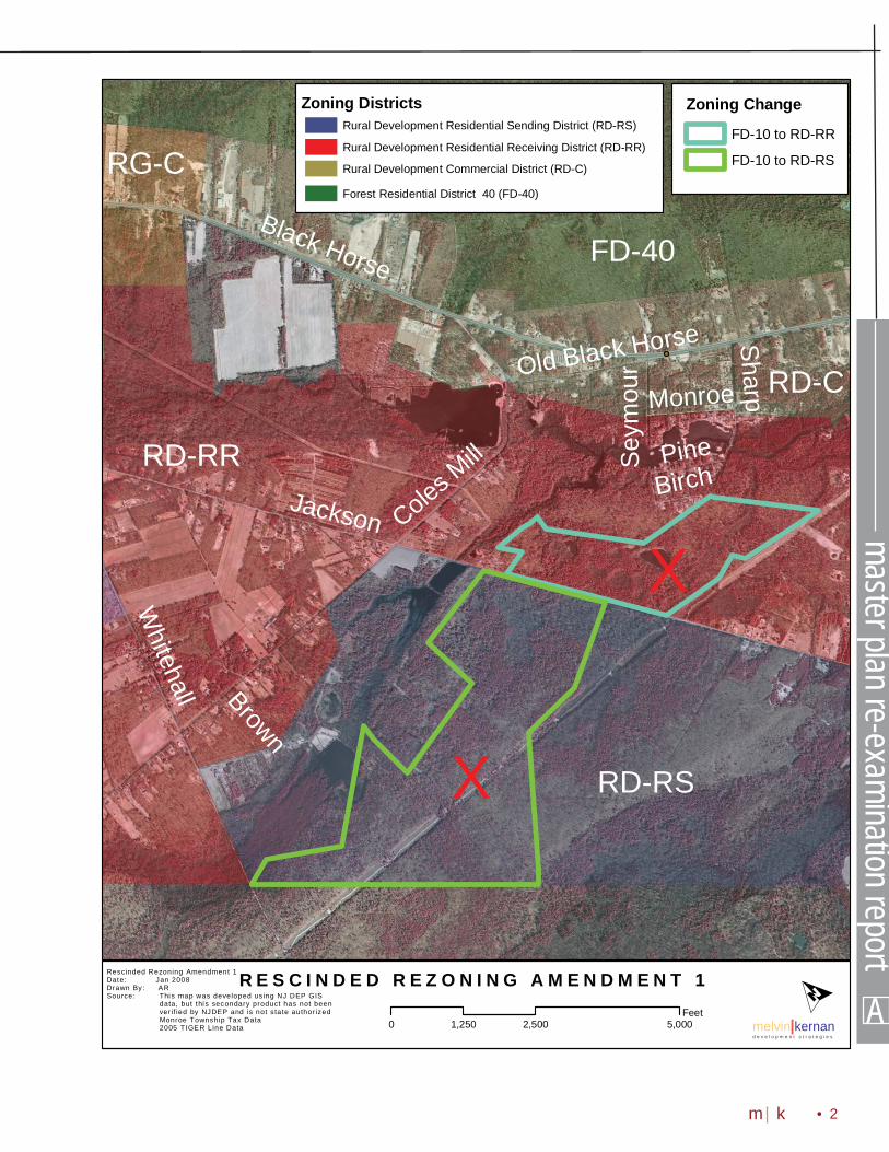
See the following Map (Rezoning Amendment 1) for the exact location of the zoning map change.
A
master plan re-examination report
• 2m|k
R E S C I N D E D R E Z O N I N G A M E N D M E N T 1Rescinded Rezoning Amendment 1Date: Jan 2008Drawn By: ARSource: This map was developed using NJ DEP GIS
data, but thi s secondary product has not beenver if ied by NJDEP and is not state author izedMonroe Township Tax Data2005 TIGER Line Data melvin|kernan
d e v e l o p m e n t s t r a t e g i e s
Jackson
Black Horse
Coles Mill
Whitehall
Sharp
Pine
Brown
Old Black Horse
Seym
our
Birch
Monroe
O0 2,500 5,0001,250
Feet
RD-RR
RD-RS
RD-C
RG-C
FD-40
Zoning DistrictsRural Development Residential Sending District (RD-RS)
Rural Development Residential Receiving District (RD-RR)
Rural Development Commercial District (RD-C)
Forest Residential District 40 (FD-40)
Zoning Change
FD-10 to RD-RR
FD-10 to RD-RS
X
X

A
maste
r plan
re-e
xami
natio
n rep
ort
Objectives:
• To conserve and manage natural resources within the Township.
• To protect State, regional and local areas of critical environmental concern.
• To develop policies to preserve trees, especially specimen or landmark trees, while being sensitive to the rights of private property owners.
• To facilitate the proper preservation and restoration of the aesthetic qualities of the Township.
• To give priority to preserving large contiguous tracts of forests and lands containing unique areas of environmental sensitivity.
• To permanently preserve environmentally sensitive land as open space, to the greatest extent practicable.
Compliance with Goals and Objectives of the Master Plan
The land zoning map change from Forest Residential District 10 (FD-10) to Rural Development Residential Sending and Receiving (RD-RR and RD-RS) conforms to the current Master Plan. The goals and objectives that specifi cally apply are as follows:
Goals:
• Provide for a variety of residential, commercial, industrial, agricultural, recreational and conservation uses.
• Prevent development in sensitive environmental areas.
• Recognize that open space preservation must become the responsibility of the Township, and that the agricultural community alone will not be able to ensure that open space will remain in the Township forever.
• Preserve the Township’s natural and cultural resources that contribute to both the positive image and overall strength of the Township.
• Eliminate the potential for confl icts among dissimilar land uses.
• Prevent development in sensitive environmental areas.
3 •

B B
master plan re-examination report
• 4m|k
B. Rescinding recommendation to rezone an area to the AG, Agricultural Production District. The parcels will remain in their current district: RD-A, Rural Development Agricultural.
The properties in question are located east of Malaga Road and south of Winslow Road. Rezoning this cluster of 11 parcels that, it was previously believed, would provide an opportunity to strengthen and preserve the agricultural nature of their area. With the exception of approximately two residential homes and one farm these parcels are largely vacant. These parcels are contiguous to an AG, Agricultural Production Zoning District. The May 2007 Master Plan Re-Examination Report noted that expanding that AG District by rezoning these parcels could encourage agricultural use in large, contiguous tracts which are important for groundwater recharge and wildlife habitat preservation.
These parcels total approximately 124 acres. Further details of these parcels are shown in the table below.
Block Lot AcresOriginal Zone
New Zone Ownership
4301 20 10.2 AG RD-A EKPAJI, YAKUBU
4301 21 14.4
AG RD-A NEIL, GARY JOSEPH & MARGARET
MARY4301 22 25.11 AG RD-A THOMPSON, JOHN & MARY4301 23 0.97 AG RD-A COYLE, STEVEN W4301 24 2.82 AG RD-A COYLE, STEVEN W
4301 25 4.94
AG RD-A CALDWELL, ROBERTJR CO/RHONDA
WARNER4301 26 6.21 AG RD-A HASSAB,JOSEPH & NANCY4301 27 8.8 AG RD-A HUNG, PHU4301 28 10 AG RD-A MANFREDI, RALPH & LONIA, JOHN4301 29 6.38 AG RD-A RUTTER, CLYDE W III4001 27 33.7 AG RD-A AGNESINO, VINCENT JAMES & JUNE 123.53
The Pinelands Commission reviewed the AG Rezoning and concluded it could not support the proposal because the RD-A District was already providing adequate protection for agricultural and existing rural character.
It is now recommended that this area remain in the RD-A district. The agricultural use on these tracks of land, as well as the existing rural character of this area can be preserved in the current zone.
See the following Map (Rezoning Amendment 2) for the exact location of the zoning map change.
B
maste
r plan
re-e
xami
natio
n rep
ort
5 •
Compliance with Goals and Objectives of the Master Plan
The zoning map change from Agricultural Production (AG) to Rural Development Agricultural (RD-A) conforms to the current Master Plan. The goals and objectives that specifi cally apply are as follows:
Goals:
• Provide for a variety of residential, commercial, industrial, agricultural, recreational and conservation uses.
• Preserve the Township’s natural and cultural resources that contribute to both the positive image and overall strength of the Township.
Objectives:
• To conserve and manage natural resources within the Township.
• To protect prime agricultural lands from encroachment by development through a combined system of limiting density, ensuring sections of agricultural land are preserved through deed-restriction and other preservation tools made available through the Municipal Land Use Law.
• To facilitate the proper preservation and restoration of the aesthetic qualities of the Township.
• To develop policies to preserve trees, especially specimen or landmark trees, while being sensitive to the rights of private property owners.

B B
master plan re-examination report
• 6m|k
R E S C I N D E D R E Z O N I N G A M E N D M E N T 2Rescinded Rezoning Amendment 2Date: Jan 2008Drawn By: ARSource: This map was developed using NJ DEP GIS
data, but thi s secondary product has not beenver if ied by NJDEP and is not state author izedMonroe Township Tax Data2005 TIGER Line Data melvin|kernan
d e v e l o p m e n t s t r a t e g i e s
AG
Malaga
Winslow
Corkery
Black Horse
Huber
Bettinger
Broad
Mills
ForestHolly
Con
cord
Lebanon
Battl
es
TheresaKa
ren
Georges
Fiber Optic
Chinkapin
O0 2,000 4,0001,000
Feet
FD-40
RD-A
AG
RG-C
FD-10
RG-RA
RD-A
RG-MR
RG-PR
RG-PR
Rural Development Commercial District (RD-C)
Rural Development Agricultural District (RD-A)
Regional Growth Town Commercial District (RG-TC)
Regional Growth Planned Residential District (RG-PR)
Regional Growth Moderate Residential District (RG-MR)
Regional Growth Commercial District (RG-C)
Agricultural Production District (AG)
Zoning Districts Zoning ChangeRD-A to AG
X

C
maste
r plan
re-e
xami
natio
n rep
ort
7 •
C. Recognizing a growing residential area (Diamond Lakes) as appropriate for public sewer service to safeguard it from the potentially deleterious effects of on-site septic systems.
Residential development in the area surrounding Diamond Lakes, south of the Black Horse Pike in the Pinelands, has been growing for some time. In some cases, homes which were once secondary cottages are now primary residences. Public centralized sewer is not currently available to this area and wastewater is managed via private on-site septic systems.
The Township has experienced similar situations with lake-adjacent development previously in the cases of the Victory Lakes and Timber Lakes developments. In those cases water contamination from on-site septic systems grew to signifi cant levels. Well water contamination at Timber Lakes even grew to the point where mitigation was required in the form of a State Spill Fund grant (see 2003 Publicly Funded Cleanups Site Status Report - Gloucester County).
In order to prevent such contamination at Diamond Lake, it is recommended that the area delineated in the map that follows (Diamond Lakes Map) be provided with public centralized sewer service where possible to serve current
development. The area shown below contains 183 parcels (not including the lake itself) making up approximately 45 acres around the lake. It is recommended that the Wastewater Management Plan be updated in accordance with this recommendation if possible. The parcels within the Diamond Lakes Area are shown in the table on the next pages.
In connection with the proposal to provide public sewer service to the Diamond Lakes area of the Township, the Pinelands Commission noted that N.J.A.C. 7:50-5.26(b)(10) provides that centralized waste water treatment and collection facilities shall be permitted to serve the Rural Development Area only in accordance with N.J.A.C. 7:50-6.84(a)(2). Said section provides that the development of new waste water treatment or collection facilities which are designed to improve the level of nitrate/nitrogen attenuation of more than one existing on-site waste water treatment system where a public health problem has been identifi ed are permitted provided that: (i) There will be no direct discharge into any surface water body; (ii) The facility is designed only to accommodate waste water from existing residential, commercial, and industrial development; (iii) Adherence to (a)(1)(ii)above1 cannot be achieved due to limiting site conditions or that the costs to comply with the standard will result in excessive user fees; and (iv) The design level of nitrate/nitrogen attenuation is the 1. N.J.A.C. 7:50-6.84(a)(1)(ii) sets forth: All discharg-es from the facility or use are of a quality and quantity such that ground water exiting from the parcel of land or entering a surface body of water will not exceed two parts per million nitrate/nitrogen.

B C
master plan re-examination report
• 8m|k
maximum possible within the cost limitations imposed by such user fee guidelines but in no case shall ground water exiting from the parcel or entering a surface body of water exceed fi ve parts per million nitrate/nitrogen. Diamond Lakes Parcels:
Block Lot Acres Zone Block Lot Acres Zone7401 1 0.47 RD-RR 7404 2 0.16 RD-RR7401 4 0.16 RD-RR 7404 3 0.16 RD-RR7401 5 0.16 RD-RR 7404 4 0.16 RD-RR7401 6 0.16 RD-RR 7404 5 0.16 RD-RR7401 7 0.16 RD-RR 7404 6 0.16 RD-RR7401 8 0.16 RD-RR 7404 7 0.16 RD-RR7401 9 0.16 RD-RR 7404 8 0.16 RD-RR7401 10 0.16 RD-RR 7404 9 0.16 RD-RR7402 1 0.14 RD-RR 7404 10 0.16 RD-RR7402 2 0.14 RD-RR 7405 1 0.14 RD-RR7402 3 0.14 RD-RR 7405 2 0.14 RD-RR7402 4 0.14 RD-RR 7405 3 0.14 RD-RR7402 5 0.14 RD-RR 7405 4 0.14 RD-RR7402 6 0.14 RD-RR 7405 5 0.14 RD-RR7403 1 0.12 RD-RR 7405 6 0.14 RD-RR7403 2 0.11 RD-RR 7406 1 0.17 RD-RR7403 3 0.1 RD-RR 7406 2 0.13 RD-RR7403 5 0.32 RD-RR 7406 3 0.12 RD-RR7404 1 0.16 RD-RR 7406 4 0.14 RD-RR7406 5 0.18 RD-RR 7413 1 0.46 RD-RR7407 1 0.16 RD-RR 7414 1 0.4 RD-RR7407 2 0.16 RD-RR 7414 2 0.17 RD-RR7407 3 0.16 RD-RR 7414 3 0.17 RD-RR7407 4 0.16 RD-RR 7414 4 0.17 RD-RR7407 5 0.16 RD-RR 7414 5 0.12 RD-RR7407 6 0.16 RD-RR 7414 6 0.17 RD-RR7407 7 0.16 RD-RR 7414 7 0.17 RD-RR7407 8 0.16 RD-RR 7414 8 0.17 RD-RR7407 9 0.16 RD-RR 7414 9 0.17 RD-RR7407 10 0.16 RD-RR 7414 10 0.17 RD-RR7408 1 0.14 RD-RR 7414 11 0.19 RD-RR7408 2 0.14 RD-RR 7414 12 0.96 RD-RR7408 3 0.14 RD-RR 7414 13 0.43 RD-RR7408 4 0.14 RD-RR 7414 14 0.11 RD-RR7408 5 0.14 RD-RR 7414 15 0.11 RD-RR7408 6 0.14 RD-RR 7414 16 0.28 RD-RR7409 1 0.22 RD-RR 7415 7 1.55 RD-RR7409 2 0.24 RD-RR 7415 8 0.09 RD-RR7409 3 0.26 RD-RR 7415 9 0.07 RD-RR7409 4 0.13 RD-RR 7415 10 0.13 RD-RR7409 5 0.13 RD-RR 7415 11 0.13 RD-RR7409 6 0.14 RD-RR 7415 12 0.13 RD-RR7409 7 0.13 RD-RR 7415 13 0.14 RD-RR7410 1 0.26 RD-RR 7415 14 0.16 RD-RR

C
maste
r plan
re-e
xami
natio
n rep
ort
9 •
7410 2 0.22 RD-RR 7415 15 0.17 RD-RR7410 3 0.18 RD-RR 7415 16 0.18 RD-RR7410 4 0.24 RD-RR 7415 17 0.14 RD-RR7411 1 0.11 RD-RR 7415 18 0.05 RD-RR7411 2 0.11 RD-RR 7415 19 0.14 RD-RR7411 3 0.11 RD-RR 7415 20 0.14 RD-RR7411 4 0.11 RD-RR 7415 21 0.14 RD-RR7411 5 0.11 RD-RR 7415 22 0.29 RD-RR7411 6 0.13 RD-RR 7415 23 0.14 RD-RR7411 7 0.11 RD-RR 7415 24 0.14 RD-RR7411 8 0.03 RD-RR 7415 25 0.14 RD-RR7411 9 0.03 RD-RR 7415 26 0.43 RD-RR7411 10 0.06 RD-RR 7416 4 0.23 RD-C7411 11 0.07 RD-RR 7416 5 0.41 RD-C7412 1 0.29 RD-RR 7416 6 0.3 RD-C7412 2 0.26 RD-RR 7416 7 0.19 RD-C7412 3 0.23 RD-RR 7416 8 0.3 RD-C7412 4 0.17 RD-RR 7416 9 19 RD-C7412 5 0.11 RD-RR 7416 10 0.3 RD-C7412 6 0.07 RD-RR 7416 11 0.19 RD-C7412 7 0.05 RD-RR 7416 12 0.3 RD-C7416 13 0.19 RD-C 7416 42 0.14 RD-C7416 14 0.3 RD-C 7416 43 0.17 RD-C7416 15 0.19 RD-C 7416 44 0.17 RD-C7416 16 0.3 RD-C 7416 45 0.17 RD-C7416 17 0.19 RD-C 7416 46 0.17 RD-C7416 18 0.3 RD-C 7416 47 1.14 RD-C7416 19 0.19 RD-C 7416 50 0.75 RD-C7416 20 0.32 RD-C 7502 18 1.07 RD-C7416 21 0.18 RD-C 7502 19 0.4 RD-RR7416 22 0.23 RD-C 7502 20 0.4 RD-RR7416 23 0.17 RD-C 7502 21 0.4 RD-RR7416 24 0.11 RD-C 7502 22 0.4 RD-RR7416 25 0.11 RD-C 7502 23 0.4 RD-RR7416 26 0.11 RD-C 7502 24 0.4 RD-RR7416 27 0.11 RD-C 7502 25 0.4 RD-RR7416 28 0.11 RD-C 7502 26 0.4 RD-RR7416 29 0.11 RD-C 7502 27 0.17 RD-RR7416 30 0.11 RD-C 7502 28 0.42 RD-RR7416 31 0.11 RD-C 7601 15 1.44 RD-RR7416 32 0.11 RD-C 7601 16 0.17 RD-RR7416 33 0.11 RD-C 7601 17 0.96 RD-RR7416 34 0.11 RD-C 7601 18 0.7 RD-RR7416 35 0.11 RD-C 7601 19 0.73 RD-RR7416 36 0.11 RD-C 7502 28 0.42 RD-RR7416 37 0.11 RD-C 7601 15 1.44 RD-RR7416 38 0.11 RD-C 7601 16 0.17 RD-RR7416 39 0.11 RD-C 7601 17 0.96 RD-RR7416 40 0.11 RD-C 7601 18 0.7 RD-RR7416 41 0.11 RD-C 7601 19 0.73 RD-RR

B C
master plan re-examination report
• 10m|k
N.J.A.C. 7:50-5.26 (b) (10) provides that public centralized sewer service treatment and collection facilities will be permitted to serve a Rural Development Area like Diamond Lakes, only in accordance with N.J.A.C. 7:50-6.84 (a)(2).
N.J.A.C. 7:50-6.84 (a)(2) provides that the development of new public waste water treatment or collection facilities which are designed to improve the level of nitrate/nitrogen attenuation of more than one existing on-site waste water treatment system where a public health problem has been identifi ed are permitted provided that:
1. There will be no direct discharge into any surface water body.
2. The facility is designed only to accommodate waste water from existing residential, commercial and industrial development.
3. Adherence to #2 above cannot be achieved due to limiting site conditions or that the costs to comply with the standard will result in excessive user fees.
4. The design level of nitrate/nitrogen attenuation is the maximum possible within the cost limitations imposed by such user fee guidelines but in no case shall ground water exiting from the parcel or entering a surface body of water exceed fi ve (5) parts per million nitrate/nitrogen.
In order to provide public centralized sewer service to the Diamond Lakes area it will fi rst be necessary to fully document a public health problem. Once that has been done, it will then be necessary to demonstrate that the installation of the public sewer system will comply with N.J.A.C. 7:50-6.84 (a) (2) (i) through 6.84 (a) (2) (iv) and to restrict access to the sewer line to existing development only. This Master Plan Re-Examination Report makes these conditions explicit in the discussion of the Diamond Lakes Area.
See the following Map (Diamond Lakes Map) for the exact location of the public health concern area for possible sewer extension.

C
maste
r plan
re-e
xami
natio
n rep
ort
11 •
D I A M O N D L A K E S M A PDiamond LakesDate: May 2007Drawn By: ARSource: This map was developed using NJ DEP GIS
data, but th is secondary produc t has not beenver if ied by NJDEP and is not state author izedMonroe Township Tax Data2005 TIGER Line Data melvin|kernan
d e v e l o p m e n t s t r a t e g i e s
AG
Sharp
Pine
Black Horse
Seym
our
Birch
Monroe
Spruce 1st3rd4th
Old Black Horse
O0 520 1,040260
Feet
RD-RR
RD-C

B C
master plan re-examination report
• 12m|k
Compliance with Goals and Objectives of the Master Plan
The suggested sewer service addition conforms to the current Master Plan. The goals and objectives that specifi cally apply are as follows:
Goals:
• Direct growth to areas where infrastructure capacity is currently available or committed to be available in the future.
• Guide future development and community facilities to meet the needs of the residents of the Township, while ensuring that new development is compatible with existing development without degrading the Township’s cultural and natural resources.
• Preserve the Township’s natural and cultural resources that contribute to both the positive image and overall strength of the Township.
• Establish and maintain the level of community facilities and public services required to satisfy the needs of present and future residents of Monroe Township, and allow for the well planned expansion of these public facilities and services.
Objectives:
• To conserve and manage natural resources within the Township.
• To provide for streets, utilities, schools, parks, police and fi re protection, and other municipal services suffi cient to meet the needs of the residential and commercial areas of the Township.
• To protect the substantial investments in public facilities that already exist and plan for new facilities to serve residents in a timely, orderly and effi cient manner.
• To ensure that those public facilities and services necessary to support development are adequate to serve the development at the time the development is available for occupancy and use without decreasing current service levels below locally established minimum standards.
• To plan and develop a timely, orderly and effi cient arrangement of public facilities and services to serve as a framework for future development.
• To carefully consider the costs and benefi ts of any utility extension to ensure that such extension promotes the logical and orderly extension of development adjacent to existing development.
• To encourage existing development to tie into new utility extensions.

D
maste
r plan
re-e
xami
natio
n rep
ort
13 •
to further preserve its rural character. Primary permitted uses in the RD-A zoning district includes individual single family residential and agricultural uses on minimum 10 acre lots.
See the following Map (Morgan Road Area Zoning Change) for the exact location of the zoning map change.
D. Rezoning an area from RG-MR, Regional Growth Moderate Residential District to RD-A, Rural Development Agricultural in order to bolster its agricultural utility.
In the northern portion of the Township, generally bounded by Morgan Road, Orbanus Lane, Winslow Road and Malaga Road, are some large lot residential, vacant, open space, forest and agricultural parcels owned by a variety of individuals. These parcels total approximately 214 acres. According to the tax map and aerials, these parcels contain farmland and vacant land. Further details of these parcels are shown in the table on the next page.
The rezoning from RG-MR to RD-A recognizes a largely rural open space and farmland area. The area is bordered to the north and east by the existing RD-A District. Orbanus Lane serves as a reasonable western boundary between the remaining RG-MR zone and the newly expanded RD-A zone. Along the new zone’s southern boundary exists a 30 lot residential subdivision known as “Marrissa Estates” and existing commercial uses at the intersection of Winslow and Malaga – the B&N Auto and Truck Repair Business and the B&N Auto Sales business.
It is recommended that all of the properties identifi ed in the table on the next page be rezoned from RG-MR to RD-A to energize agricultural use on large tracts of land in this area and

B D
master plan re-examination report
• 14m|k
Block Lot AcresOriginal
ZoneNew Zone Ownership
2702 1 0.87 RG-MR RD-A SCIRROTTO, ANTHONY J & GAE2702 2 0.56 RG-MR RD-A SMITH, RUSSEL H & ARLINDA2702 3 0.51 RG-MR RD-A SMITH, RUSSEL H & ARLINDA2702 4 1.05 RG-MR RD-A DAGOSTINO, KEITH2702 5 0.50 RG-MR RD-A HOOKER, CAROLYN BEVERLY2702 6 0.54 RG-MR RD-A LLOYD, PAUL JR & ANNIE L2702 7 0.52 RG-MR RD-A JONES, GLORIA JEAN2702 8 0.60 RG-MR RD-A READ, WILLIAM & GINTHER, JANE2702 9 0.57 RG-MR RD-A DAVIS, WILLIAM JR & SHIRLEY2702 10 7.65 RG-MR RD-A GRANT DEVELMNT/ C/O T KETTANEH2702 11 30.50 RG-MR RD-A PHILADELPHIA SUBURBAN DEVL PA2702 19 6.85 RG-MR RD-A WERNEGA, JOHN JR2702 20 4.14 RG-MR RD-A CARUSO, ANTHONY F2702 21 4.46 RG-MR RD-A CARUSO, ANTHONY F2702 22 0.46 RG-MR RD-A HATZ, JOANN2702 23 0.55 RG-MR RD-A CARUSO, ANTHONY F2702 24 7.22 RG-MR RD-A CARUSO, ANTHONY F2702 28 3.77 RG-MR RD-A MULLER, SHIRLEY ANN2702 29 5.49 RG-MR RD-A BAUGHMAN, HARRY D JR2702 30 5.51 RG-MR RD-A YOOTHMAN, JOHN W & LISA C2702 31.01 3.32 RG-MR RD-A BOULDEN, WALTER & BRENDA2702 31.02 3.26 RG-MR RD-A GILLINGHAM, MICHAEL T & HOLLY L2702 31.03 3.25 RG-MR RD-A TOBLER, KEITH & TOBLER, CAROLYN2702 32 9.81 RG-MR RD-A STEFANOW, ROBERT W2702 33 17.62 RG-MR RD-A LEHMAN, EDMOND J C/O HELEN2702 34 7.73 RG-MR RD-A MCALEESE, CHERYL A2702 35 9.30 RG-MR RD-A LONG, MICHAEL A & JENNIFER2702 36 2.13 RG-MR RD-A BAUGHMAN, HARRY D JR2702 37 2.21 RG-MR RD-A CARUSO, ANTHONY2702 38 9.28 RG-MR RD-A MACDONALD, KENNETH L2702 39 10.78 RG-MR RD-A DEVINE, EDWARD2702 40 19.26 RG-MR RD-A PHILADELPHIA SUBURBAN2702 41 20.69 RG-MR RD-A PHILADELPHIA SUBURBAN2702 42 8.15 RG-MR RD-A LOMBARDO, GREGORY R2702 43 0.80 RG-MR RD-A ROSE, DOROTHY2702 44 1.27 RG-MR RD-A RUSK, KATHLEEN2702 45 2.17 RG-MR RD-A SMITH, CHARLES W JR & CYNTHIA2702 46 0.54 RG-MR RD-A COLEY, WM H
213.89

D
maste
r plan
re-e
xami
natio
n rep
ort
15 •
M O R G A N R O A D A R E A Z O N I N G C H A N G EMorgan Road Area Zoning ChangeDate: Jan 2008Drawn By: ARSource: This map was developed using NJ DEP GIS
data, but thi s secondary product has not beenver if ied by NJDEP and is not state author izedMonroe Township Tax Data2005 TIGER Line Data melvin|kernan
d e v e l o p m e n t s t r a t e g i e s
ACMERed.
Malaga
NewBr
ookly
n
Morgan Orbanus
Winslow
t
RD-A
R-2
RG-MR
RG-PR
RG-C
FD-10
RG-C
O0 1,500 3,000750
Feet
RG-MR to RD-ABlock Lot Acres
2702 1 0.872702 2 0.562702 3 0.512702 4 1.052702 5 0.52702 6 0.542702 7 0.522702 8 0.62702 9 0.572702 10 7.652702 11 30.52702 19 6.852702 20 4.142702 21 4.462702 22 0.462702 23 0.552702 24 7.222702 28 3.772702 29 5.492702 30 5.512702 31.01 3.322702 31.02 3.262702 31.03 3.252702 32 9.812702 33 17.622702 34 7.732702 35 9.32702 36 2.132702 37 2.212702 38 9.282702 39 10.782702 40 19.262702 41 20.692702 42 8.152702 43 0.82702 44 1.272702 45 2.172702 46 0.54
Zoning DistrictsSuburban Residential Option District (R-2)
Rural Development Commercial District (RD-C)
Rural Development Agricultural District (RD-A)
Regional Growth Moderate Residential District (RG-MR)
Regional Growth Commercial District (RG-C)
Forest Residential District 10 (FD-10)
Agricultural Production District (AG)
Acme Shopping Center Redevelopment Zone
Zoning ChangeRG-MR to RD-A

B D
master plan re-examination report
• 16m|k
Compliance with Goals and Objectives of the Master Plan
The zoning map change from RG-MR to Rural Development Agricultural (RD-A) conforms to the current Master Plan. The goals and objectives that specifi cally apply are as follows:
Goals:
• Provide for a variety of residential, commercial, industrial, agricultural, recreational and conservation uses.
• Guide future development and community facilities to meet the needs of the residents of the Township, while ensuring that new development is compatible with existing development without degrading the Township’s cultured and natural resources.
• Preserve the Township’s natural and cultural resources that contribute to
both the positive image and overall strength of the Township.
• Recognize that open space preservation must become the responsibility of the Township, and that the agricultural community alone will not be able to ensure that open space will remain in the Township forever.
• Prevent development in sensitive environmental areas.
Objectives:
• To conserve and manage natural resources within the Township.
• To permanently preserve environmentally sensitive land as open space, to the greatest extent practicable.
• To preserve the rural nature and agricultural base of the RG, AG and FD zoning districts by maintaining appropriate development density levels in such zones and ensuring compliance with the Pinelands Comprehensive Management Plan at N.J.A.C. 7:50 in Pinelands areas.
• To protest prime agricultural lands from encroachment by development through a combined system of limiting density, ensuring sections of agricultural land are preserved through deed – restriction and other preservation tools made available through the Municipal Land Use Law.
• To develop policies to preserve trees, especially specimen or landmark trees,while being sensitive to the sights of private property owners.
• To give priority to preserving large contiguous tracts of forests and lands containing unique areas of environmental sensitivity.

E
maste
r plan
re-e
xami
natio
n rep
ort
17 •
E. Rezoning an area from RG-RA, Regional Growth Residential Age Restricted District to RG-MR, Regional Growth Moderate Residential District.
South of Lakeside Drive and West of Whitehall Road is located two (2) small areas which are now zones RG-RA. Further details of these parcels are shown in the table below.
Block Lot Acres
Original
Zone
New
Zone Ownership8001 34 1.83 RG-RA RG-MR HAAS, GEORGE C & SHIRLEY8001 33 2.28 RG-RA RG-MR BOVITT, ANTHONY G & PATRICIA8001 34.02 1.70 RG-RA RG-MR HAAS, GEORGE C & SHIRLEY8001 32 1.95 RG-RA RG-MR MILLER, BRENDA L8001 34.01 1.49 RG-RA RG-MR HAAS, GEORGE C & SHIRLEY8001 31 1.65 RG-RA RG-MR SANDERS, DOUGLAS8001 30.01 1.87 RG-RA RG-MR JAROCH, RUTH8001 29 8.36 RG-RA RG-MR JOHNSON, MARK8001 30 3.38 RG-RA RG-MR KITCHENS, DORIS F9006 34 0.55 RG-RA RG-MR KACY, JOHN J & IRENE9006 15 0.87 RG-RA RG-MR EVERHAM, JEFFERY & TRACEY9006 35 0.44 RG-RA RG-MR JEFFERSON, MARY LEE9006 36 0.44 RG-RA RG-MR LAROSA JR, WILLIAM J & RUTH9006 37 0.44 RG-RA RG-MR SUAREZ, WILLIAM & KIMBERLY9006 38 0.53 RG-RA RG-MR ESPOSITO, SALVATORE J JR9006 39 0.75 RG-RA RG-MR MAYER, FRANCIS & MICHELE R9006 39.01 0.74 RG-RA RG-MR MCHUGH, PETER F & HELEN H9006 39.02 0.73 RG-RA RG-MR WAGNER, ROY J & DEBORAH A9006 39.03 0.71 RG-RA RG-MR RICHENDOLLAR, TIMOTHY9102 12 6.22 RG-RA RG-MR JOHNSON, HELEN9102 11 5.77 RG-RA RG-MR PITRE, CYRUS & JENNIFER9102 11.01 4.87 RG-RA RG-MR LOSCALZO, JOSEPH & CINDY
47.57
The rezoning from RG-RA to RG-MR recognizes the fact that site plan approval has been granted for the construction of an age-restricted development known as “Colonial Estates at Whitehall” to be constructed on lots within the RG-RA zone except for those surrounding and adjacent lots proposed to be rezoned to RG-MR. The lots to be rezoned are all wooded. Access will be from stub streets off of Lakeside Drive, 10th Street and Sunny Hill Avenue. These lots will provide infi ll housing opportunities consistent with existing RG-MR development and zoning.
See the following Map (Rezoning Amendment 4) for the exact location of the zoning map change.

E
master plan re-examination report
• 18m|k
W H I T E H A L L R O A D A R E A Z O N I N G C H A N G EWhitehal l Road Area Zoning ChangeDate: Jan 2008Drawn By: ARSource: This map was developed using NJ DEP GIS
data, but this secondary product has not beenver if ied by NJDEP and is not state authorizedMonroe Township Tax Data2005 TIGER Line Data melvin|kernan
d e v e l o p m e n t s t r a t e g i e s
Whitehall Rd
JSunset
Lakeside
Sunny
HillVictory
13th
h
Pine
10th
Lake
RD-RR
RG-MR
RG-RA
RD-C
RD-RS
RG-PRRD-A
O0 1,500 3,000750
Feet
RG-RA to RG-MRBlock Lot Acres
8001 34 1.838001 33 2.288001 34.02 1.78001 32 1.958001 34.01 1.498001 31 1.658001 30.01 1.878001 29 8.368001 30 3.389006 34 0.559006 15 0.879006 35 0.449006 36 0.449006 37 0.449006 38 0.539006 39 0.759006 39.01 0.749006 39.02 0.739006 39.03 0.719102 12 6.229102 11 5.779102 11.01 4.87
Zoning DistrictsRural Development Residential Sending District (RD-RS)
Rural Development Residential Receiving District (RD-RR)
Rural Development Commercial District (RD-C)
Rural Development Agricultural District (RD-A)
Regional Growth Planned Residential District (RG-PR)
Regional Growth Moderate Residential District (RG-MR)
Regional Growth Commercial District (RG-C)
Regional Growth Residential Age Restricted District (RG-RA)
Zoning ChangeRG-RA to RG-MR

E
19 •
Compliance with Goals and Objectives of the Master Plan
The zoning map change from RG-RA to RG-MR conforms to the current Master Plan. The goals and objectives that specifi cally apply are as follows:
Goals:
• Encourage a pattern of compact and contiguous growth within appropriate areas of the Township.
• Provide for a variety of residential, commercial, industrial, agricultural, institutional, recreational and conservation uses.
• Guide future development and community facilities to meet the needs of the residents of the Township, while ensuring that new development is compatible with existing development without degrading the Township’s cultural and natural resources.
• Eliminate the potential for confl icts among dissimilar land uses.
Objectives:
• To ensure decent and affordable housing for all present and future residents of the Township, without regard of their economic status by providing for a full range of housing choices that are affordable to low, moderate, middle and upper income households.
• To ensure suffi cient space, privacy and convenience in all residential areas to meet accepted standards of community health, safety and welfare.
• To encourage infi ll residential development.
• To establish safe and convenient transportation routes to serve existing and future land uses.

G
master plan re-examination report
• 28m|k
G. Amending the zoning ordinance to add defi nitions to Section 175-11 for Assisted Living Facility, Continuing Care and revising the defi nition for Long Term Care and/or Nursing Home.
The Pinelands Commission recommended that the Township of Monroe’s defi nition of “Assisted Living” be revised to read as follows: “A facility licensed by the New Jersey Department of Health and Senior Services pursuant to N.J.A.C. 8:36-1 et seq. which is designed and operated to provide apartment style housing and congregate dining while assuring that a coordinated array of supportive personnel and health service are available, as needed, to four (4) or more adult persons unrelated to the proprietor. Each unit in an assisted living facility shall offer, at minimum, one unfurnished room, a private bathroom, a kitchenette and a lockable door on the unit entrance. Assisted living facility shall include assisted living residences and assisted living programs as defi ned at N.J.A.C. 8:36-1.3”. The Commission also recommended that the Township of Monroe’s defi nition of “Continuing Care” be revised to read as follows: “A development regulated in accordance with the rules of the Department of Community Affairs pursuant to N.J.A.C. 5:19 1.1 et seq. which provides a continuum of accommodations and care, from independent living to assisted living to long-term bed care in a nursing facility, at the same or another location to an individual pursuant to an agreement effective for the life of the individual or for a period greater than one year”.
The ordinance should be amended to coincide with the following:

G
ordin
ance
draft
29 •
As used in this Chapter, the following terms shall have the meanings indicated:
ACCESSORY BUILDING, STRUCTURE OR USE – A building, structure or use which:
A. Is subordinate and incidental to and serves a principal building, a principal structure, or a principal use, including but not limited to the production, harvesting and storage, as well as washing, grading and packaging, of unprocessed produce grown on site.
B. Is subordinate in area, extent and purpose to a principal structure or a principal building or a principal use, including but not limited to cabanas, detached garages, carports, greenhouses, storage sheds, non-portable swimming pools, hot tubs and/or spas, gazebos and pergolas.
C. Contributes primarily to the comfort, convenience or necessity of the occupants, business or industry of the principal structure, building or use served.
D. Any accessory building or structure attached to a principal building shall be considered part of the principal building and shall be required to comply with all required setbacks for principal buildings around the periphery of the lot.
E. A construction trailer shall be considered a permitted temporary accessory building or structure when approved pursuant to a development application.
F. A storage trailer shall not be permitted as a temporary building or structure.
G. Is located on the same parcel as the principal structure or principal use served.
H. Is otherwise expressly authorized by the provisions of this chapter, N.J.S.A. 70:55D-1 et. seq. and/or the Pinelands Comprehensive Management Plan.

G
ordinance draft
• 30m|k
ACTIVE ADULT – An individual that is 55 years of age or older.
ASSISTED LIVING FACILITY – An Assisted Living Facility shall be a facility, licensed by the New Jersey Department of Health Senior Services pursuant to N.J.A.C. 8:36-1 et. seq. which is designed and operated to provide apartment style housing and congregate dining while assuring that a coordinated array of supportive personal and health services are available, as needed, to four (4) or more adult persons unrelated to the proprietor. Each unit in an Assisted Living Facility shall offer, at minimum, one unfurnished room, a private bathroom, a kitchenette and a lockable door on the unit entrance. For purposes of this chapter, and Assisted Living Facility shall include assisted living residences and assisted living programs as defi ned at N.J.A.C. 8:36-1.3.
CONGREGATE CARE – A dwelling unit often developed as part of a continuing care retirement community with communal dining facilities and services, such as housekeeping, organized social and recreational activities, transportation services, and other similar support services for residents.
CONTINUING CARE – A development regulated in accordance with the rules of the New Jersey Department of Community Affairs pursuant to N.J.A.C. 5:19-1.1 et seq. which provides a continuum of accommodations and care, from independent living to assisted living to long-term bed care in a nursing facility, at the same or another location to an individual pursuant to an agreement effective for the life of the individual or for a period greater than one (1) year.
INDEPENDENT LIVING – A living arrangement that maximizes independence and self-determination, especially of disabled persons living in a community instead of in a medical facility.
INDEPENDENT MEDICAL AND SPECIALTY CARE – Facilities and uses that include adult day care, hospice care, long-term care and respite care.
LONG TERM CARE AND/OR NURSING HOME – An institution or a distinct part of an institution that is licensed or approved to provide health care under medical supervision for 24 or more consecutive hours to sick, invalid, infi rm, disabled or convalescent persons in addition to lodging and boarding or health-related service, or any combination of the foregoing. Long-term care facility shall include the terms skilled nursing facility and intermediate care facility.

H
maste
r plan
re-e
xami
natio
n rep
ort
31 •
H. Amending the zoning ordinance that deals with Section 175-157J, Accessory Dwelling Units.
The Pinelands Commission conveyed that Ordinance 0:14-2007 does not make it clear that “accessory dwelling units” are dwelling units subject to the density standards of the zone within which they are located as well as the water quality standards of the CMP. Therefore, it is their recommendation that Ordinance 0:14-2007 be amended such that § 175-157(J)(7) reads: “No accessory dwelling unit shall receive a building permit unless the property owner demonstrates that the septic system is adequate to handle the increased loads occasioned by the additional occupancy of the property and complies with § 175-149(A) through (I).” Ordinance O:14-2007 should also be amended such that § 175-157(J)(1) includes the following language: “An accessory dwelling unit and the existing single-family detached dwelling unit to which it is accessory are each dwelling units. Both the accessory dwelling unit and the existing single-family detached dwelling unit to which it is accessory must comply with the density requirements and minimum lot size requirements of the zoning district within which they are located.”
The ordinance should be amended to coincide with the following:

H
ordinance draft
• 32m|k
General Standards:
J. Accessory dwelling units may be permitted as an accessory use in association with an existing single-family detached dwelling units.
(1) An accessory dwelling unit is a small apartment which is part of an existing single-family owner-occupied home, and which is clearly secondary to the single-family home. The accessory dwelling unit shall have a kitchen, bathroom and no more than one (1) bedroom. An accessory dwelling unit and the existing single family detached dwelling unit to which it is accessory are each dwelling units. Both the accessory dwelling unit and the existing single family detached dwelling unit to which it is accessory must comply with the density requirements and minimum lot size requirements of the zoning district within which they are both located.
(2) Owner-occupied means that either the principal dwelling unit or the accessory dwelling unit is occupied by a person who has a legal or equitable ownership interest in the property and bears all or part of the economic risk of decline in value of the property.
(3) An accessory dwelling unit may be permitted as an accessory use to an existing single-family home detached dwelling unit under the following conditions:
(a) Only one (1) accessory dwelling unit is permitted per lot. The accessory dwelling unit shall be located in the same building as the principal dwelling unit or in a building accessory to the principal dwelling unit. Any structure containing an accessory dwelling unit must meet minimum yard and setback requirements for the principal structure. All relevant zoning requirements shall be met.
(b) The maximum fl oor area of an accessory dwelling unit shall be 1,000 square feet or 1/3 the living space of the principal dwelling, whichever is less; provided that this limitation shall not be construed to require an accessory dwelling unit smaller than that required by the New Jersey Mortgage Finance Agency for funding purposes.
(c) A zoning permit for the proposed construction of a new accessory dwelling unit or the creation of a new accessory dwelling unit within an existing building must be issued by the Zoning Offi cer. Planning Board approval is not required for an accessory dwelling unit.

H
ordin
ance
draft
33 •
(d) The section is intended to create year-around housing. Therefore, the accessory dwelling unit may not be utilized for short-term (less than 12 months).
(e) The property owner must occupy either the principal dwelling unit or the accessory dwelling unit as his/her principal residence, and at no time receive rent for the owner-occupied unit.
(f) No accessory dwelling unit shall receive a building permit unless the property owner demonstrates that an adequate potable water supply is available.
(g) No accessory dwelling unit shall receive a building permit unless the property owner demonstrates that the septic system is adequate to handle the increased loads occasioned by the additional occupancy of the property and complies with Sections 175-149 (A) through (I).
(h) The accessory dwelling unit shall be in full compliance with all applicable health and construction codes prior to occupancy.
(i) One (1) off-street parking space must be provided for each vehicle registered to occupants of the one (1) bedroom accessory dwelling unit, in addition to the off-street parking required for the principal dwelling unit. In general, new parking must comply with current parking standards.
(j) An accessory dwelling unit shall be designed to maintain the architectural design, style, appearance, and character of the main building as a single-family residence. If an accessory dwelling unit extends beyond the existing footprint of the main building, such an addition must be consistent with the existing façade, roof pitch, siding, and windows.
(k) Exterior stairs are restricted to the rear or sides of the structure wherever practicable.
(l) A home occupation or home business may be conducted, subject to existing regulations, as an accessory use to either the accessory dwelling unit or the principal dwelling unit, but not both.
I
master plan re-examination report
• 34m|k
I. Amending the zoning ordinance that deals with Section 175-125. Open Space and providing supporting documentation for contributions in-lieu of open space and recreation facilities.
The Pinelands Commission requested that the Township prepare a justifi cation for the proposed increase in the minimum required contribution in-lieu of providing recreation facilities as well as an explanation of the proposed method of calculating the value of open space land for purposes of determining the appropriate amount of the fee required pursuant to Ordinance 0:13-2007 in lieu of providing open space land.
Calculation of in lieu contribution of providing open space and recreation facilities is based upon Ordinance Requirements. The total cost for acquisition and development is summarized below. It is estimated that the cost for the acquisition of an acre of land is $35,000.
Developments with 10 to 50 units require one tot lot. It was determined that 0.34 acres (approximately 162’ x 92’) would be required for the tot lot which includes two benches, two tables and bench sets, one swing set with four swings, one single-platform whirl, seven feet eight inches in diameter, two saddle mates, climber one sandbox, one slide, one trash receptacle, walkways, 15 parking spaces with two accessible spaces, a fi fteen foot perimeter buffer of trees, irrigation system, and subsurface drainage system to retain the net increase of impervious surface from a ten year storm with the minimum use zones as recommended by the equipment manufacturer.
Developments with 51-150 units require one tot lot, one tennis court and one basketball court. It should be noted that section 175-125.L(3) indicates that a tennis court shall be constructed in pairs (two courts) and also indicates the necessary components for the tennis courts. It was determined that 0.60 acres (approximately 144’ x 198’ irregular) would be required for the tennis court (two courts), six parking spaces with two accessible spaces, a fi fteen foot perimeter buffer of trees with irrigation, lighting and a subsurface drainage system designed to retain the net increase in impervious surface from a ten year design storm as required in the Pinelands. It was determined that 0.46 acres (approximately 134’ x 148’) would be required for the basketball court, eleven parking spaces with two accessible spaces, a fi fteen foot perimeter buffer of trees with irrigation, lighting and a subsurface drainage system designed to retain the net increase in impervious surface from a ten year design storm as required in the Pinelands.
I
maste
r plan
re-e
xami
natio
n rep
ort
35 •
The area required for two tot lots, two tennis courts and one basketball court is 2.12 acres, with a land acquisition cost of $74,200 ($35,000 x 2.12), an improvement cost of $976,034.50 for a total cost of $1,050,234.00. This applies to developments with 151-200 dwelling units. Utilizing the median number of units of 175, a contribution of $6,001.34 per lot ($1,050,234.00/175) for active recreation would be required.
The area required for one tot lot, one pair of tennis courts and one basketball court is 1.29 acres, with a land acquisition cost of $45150, ($35,000 x 1.29), an improvement cost of $583,226.00 for a total cost of $628,376.00. This applies to developments with 51-150 units. Utilizing a median number of units of 100, a contribution of $6,283.76 per lot ($628,376.00/100) for active recreation would be required.
The area required for one tot lot is 0.34 acres, with a land acquisition cost of $11,900.00 ($35,000 x 0.34), an improvement cost of $137,958.00 for a total cost of $149,858.00. This applies to developments with 10-50 units. Utilizing a median number of units of 30, a contribution of $4,995.27 per lot ($149,858.00/30) for active recreation would be required.
In order to insure that all residential development participated in providing active recreation, a median number of 25 units was applied to determine the contribution which would account for residential developments with less than ten units. Utilizing a median number of units of 25 a contribution of $5,994.32 ($149,858.00/25) per lot for active recreation would be required.
To summarize:
Developments with 151-200 units (median 175) = $6,001.34Developments with 51-150 units (median 100) = $6,283.76
Developments with 10-50 units (mean 30) = $4,995.27.Accounting for developments with fewer than 10 units, one can utilize the median of 0-50 units (25) to account for developments with under 10 units: the amount = $5,994.32.
Therefore, the in-lieu contribution for 2008 could be $5,994.32. This is based upon utilizing the higher cost calculated between the mean and median number of lots for developments from 10-50 units (utilizing a median of 25 to account for developments less than 10 lots).
Sections 175-125N (4) and (7) currently require an in-lieu fee of $3,500 per dwelling unit and/or lot. It is now recommended that the fee be increased to $5,900 in accordance with the above calculations.

I
master plan re-examination report
• 36m|k
The following charts contain estimates for the construction costs for a tot lot, tennis court and basketball court. Cost estimates could also, but have not been increased to account for a fall surface under the play equipment, tot lot edging, fence mounted windscreen and benches for tennis courts and increased cost for pavement surface materials.
PROJECT NAME: Tot Lot Item Description Units Quantity Est. Unit No. Price Amount1 Silt Fence LF 488 $1.50 $732.002 Roadway Excavation CY 200 $8.00 $1,600.00 Unclassifi ed3 Clearing Site AC 0.34 $10,000.00 $3,400.004 Construction Entrance LS 1 $900.00 $900.005 Dense Graded Aggregate SY 415 $8.00 $3,320.00 Base Course, 6” Thick6 Chain Link Fence, 4” High LF 268 $33.00 $8,844.007 HMA Surface Course, MIX 1-5, 2” Thick TON 50 $60.00 $3,000.008 24” HDPE Perforated Pipe LF 300 $50.00 $15,000.009 Inlets, Type E UNIT 2 $3,500.00 $7,000.0010 Crushed Stone CY 142 $30.00 $4,260.0011 Filter Fabric SY 533 $2.50 $1,332.5012 Concrete Sidewalk 4” SY 117 $40.00 $4,680.00 Thick 13 Gates, Chain Link Fence, UNIT 1 $750.0 $750.00 5” Wide14 Play Sand SY 3,000 $2.00 $6,000.0015 Swing Set UNIT 1 $6,550.00 $6,550.0016 Climber UNIT 1 $1,600.00 $1,600.0017 Saddle Mate UNIT 2 $1,600.00 $3,200.0018 Slide UNIT 1 $5,900.00 $5,900.0019 Whirl UNIT 1 $5,225.00 $5,225.0020 Fertilizing and Seeding, SY 815 $0.80 $652.00 Type A-3 21 Topsoiling SY 815 $2.50 $2,037.5022 Site Irrigation LS 1 $16,500.00 $16,500.0023 Evergreen Trees UNIT 160 $150.00 $24,000.0024 Shade Trees UNIT 6 $450.00 $2,700.0025 Benches UNIT 2 $825.00 $1,650.00

I
maste
r plan
re-e
xami
natio
n rep
ort
37 •
26 Table & Bench Set UNIT 2 $1,500.00 $3,000.0027 Trash Receptacle UNIT 1 $800.00 $800.0028 Sand Box UNIT 1 $1,000.00 $1,000.0029 Pavement Markings LS 1 $500.00 $500.0030 Accessible Signs UNIT 2 $200.00 $400.00
TOTAL CONSTRUCTION COST: $137,958.00

I
master plan re-examination report
• 38m|k
PROJECT NAME: Tennis Court Item Description Units Quantity Est. Unit No. Price Amount1 Silt Fence LF 660 $1.50 $990.002 Roadway Excavation CY 600 $8.00 $4,800.00 Unclassifi ed3 Clearing Site AC 0.65 $10,000.00 $6,500.004 Construction Entrance LS 1 $900.00 $900.005 Dense Graded Aggregate SY 1,800 $8.00 $14,400.00 Base Course 6” Thick 6 Chain Link Fence, 10” High LF 463 $42.00 $19,446.007 HMA Surface Course, Mix 1-5 TON 180 $60.00 $10,800.008 24” HDPE Perforated Pipe LF 1,040 $50.00 $52,000.009 Inlets, Type E. UNIT 2 $3,500.00 $7,000.0010 Crushed Stone CY 495 $30.00 $14,850.0011 Filter Fabric SY 1,387 $2.50 $3,467.5012 Concrete Sidewalk, 4” Thick SY 40 $40.00 $1,600.0013 Gates, Chain Link Fence, 5” Wide UNIT 1 $750.00 $750.0014 HMA Base Course, MIX 1-2 TON 370 $60.00 $22,200.0015 HMA Surface Course, SP-1 TON 90 $45.00 $4,050.0016 Surface Color Coating SF 13,680 $0.75 $10,260.0017 Court Posts UNIT 4 $525.00 $2,100.0018 Court Nets UNIT 2 $235.00 $470.0019 Center Strap & Ground Anchor UNIT 2 $75.00 $150.0020 Fertilizing & Seeding, Type A-3 SY 890 $0.80 $712.0021 Topsoiling SY 890 $2.50 $2,225.0022 Site Irrigation LS 1 $6,800.00 $6,800.0023 Evergreen Trees UNIT 204 $150.00 $30,600.0024 Shade Trees UNIT 20 $400.00 $8,000.0025 Benches UNIT 2 $825.00 $1,650.0026 Court Striping LF 960 $0.50 $480.0027 Lighting UNIT 4 $6,500.00 $26,000.0028 Pavement Markings LS 1 $500.00 $500.0029 Accessible Signs UNIT 2 $200.00 $400.0030 Concrete Wheel Stops UNIT 6 $125.00 $750.00
TOTAL CONSTRUCTION COST: $254,850.50

I
maste
r plan
re-e
xami
natio
n rep
ort
39 •
PROJECT NAME: Basketball Court Item Description Units Quantity Est. Unit No. Price Amount 1 Silt Fence LF 540 $1.50 $810.002 Roadway Excavation CY 400 $8.00 $3,200.00 Unclassifi ed3 Clearing Site AC 0.46 $10,000.00 $4,600.004 Construction Entrance LS 1 $900.00 $900.005 Dense Graded Aggregate SY 1,295 $8.00 $10,360.00 Base Course 6” Thick 6 Chain Link Fence, 10” High LF 343 $40.00 $13,720.007 HMA Surface Course, Mix 1-5 TON 135 $60.00 $8,100.008 24” HDPE Perforated Pipe LF 770 $50.00 $38,500.009 Inlets, Type E. UNIT 2 $3,500.00 $7,000.0010 Crushed Stone CY 365 $30.00 $10,950.0011 Filter Fabric SY 1,027 $2.50 $2,567.5012 Concrete Sidewalk, 4” Thick SY 70 $40.00 $2,800.0013 Gates, Chain Link Fence, 5” Wide UNIT 1 $750.00 $750.0014 HMA Base Course, MIX 1-2 TON 195 $60.00 $11,700.0015 HMA Surface Course, SP-1 TON 45 $45.00 $2,025.0016 Basketball Goals UNIT 2 $2,000.00 $4,000.0017 Fertilizing and Seeding, Type A-3 SY 800 $0.80 $640.0018 Topsoiling SY 800 $2.50 $2,000.0019 Site Irrigation LS 1 $6,120.00 $6,120.0020 Evergreen Trees UNIT 164 $150.00 $24,600.0021 Shade Trees UNIT 16 $400.00 $6,400.0022 Court Striping LF 800 $0.50 $400.0023 Lighting UNIT 4 $6,500.00 $26,000.0024 Pavement Markings LS 1 $500.00 $500.0025 Accessible Signs UNIT 2 $200.00 $400.0026 Concrete Wheel Stops UNIT 11 $125.00 $1,375.00
TOTAL CONSTRUCTION COST: $190,417.50
I
ordinance draft
• 40m|k
The open space ordinance should be amended to coincide with the following:
Open Space: Section 175-125
A. Open space shall be provided in every major residential subdivision or development in an amount as required by Article XIV of this chapter. The open space shall be easily accessible from all parts of the development and shall include, at a minimum, all fl oodplain and wetlands areas; provided, however, areas of fl oodplains, wetlands, wetlands buffer up to 50 feet or stormwater basins may not be counted for more than 50% of the required open space.
E. In the designation of open space areas, consideration shall be given to providing for continuity of open space between sections of a development and between open space within a development and open space on adjacent lands. Open space shall be distributed throughout the development so that there is a hierarchy of activities from preservation areas to passive open space adjacent to and between each residential cluster. Designating all open space in one portion of a development is discouraged.
H. All land set aside for open space shall be developed with active and passive recreational facilities to service the needs of the future resident population. The Planning Board shall have complete and fi nal determination as to the adequacy, usefulness and functionalism of the lands set aside for open space. Active and passive recreational facilities shall include, but not be limited to, ball fi elds for baseball, soccer and football, multipurpose fi elds, basketball and tennis courts, multipurpose court areas, children’s playground equipment including tot lots, passive picnic or sitting areas, swimming pools, bicycle paths and jogging trails, barrier-free designs for the disabled, community buildings and other amenities like benches and sitting areas along pathways and garden plots. Any lands set aside for open space in the FD-10 and FD-40 Zones shall only be developed with low-intensive recreational facilities.
L. In all residential developments which require open space and recreation facilities, the developer shall install, as a minimum, the following recreational facilities on the land which has been set aside for open space area and active recreational purposes. Such facilities shall be located and screened to provide privacy for the users and to avoid nuisances such as noise and glare with respect to the residential uses within the development. The Planning Board may, at its discretion, alter the following schedule of open space and active recreation facilities required, or require equivalent facilities.

I
ordin
ance
draft
41 •
Dwelling Units
Minimum Open Space Area
(Acres)
Tot Lots1
Tennis Courts3
Basketball Grounds4
Multi-purpose Fields7
Play Grounds2
Neighborhood Parks9
1 – 9 0 -- -- -- -- -- --10 – 50 1 1 -- -- -- -- --51 – 150 5 1 1 1 -- -- --
151 – 200 10 2 2 1 -- -- --
201 – 250 15 2 2 1 1 1 --251 – 350 20 2 3 1 1 1 --351 – 450 30 2 4 1 1 1 --450 Plus 30 4 8 4 2 2 1
(1) Tot-lots. Tot-lots shall be a minimum of 5,000 square feet excluding areas required for fencing, buffering or walkways and shall contain, as a minimum, the following improvements:
(a) Four (4) foot high chain link fence with gate and/or other landscape buffering or screening bordering residential properties and roadways.
(b) Two (2) benches, each to be eight (8) feet long and constructed of aluminum.
(c) Two (2) table and bench sets.
(d) Ground cover shall be in accordance with the requirements of the New Jersey Uniform Construction Code, Playground Safety Subcode.
(e) One (1) swing set with four (4) swings, two of which shall be tot swings, one (1) tot chair and one (1) slashproof belt seat 2 3/8 inches outside diameter; legs and top rails with 2 7/8 inches outside diameter fi ttings, eight (8) feet in height.
(f) One (1) single-platform whirl seven (7) feet eight (8) inches in diameter.
(g) Two (2) saddle mates with metal “c” springs.
(h) One (1) climber, two (2) feet by twelve (12) feet, with a height of approximately four (4) feet seven (7) inches.

I
ordinance draft
• 42m|k
(i) One (1) sandbox, fi fteen (15) feet by fi fteen (15) feet.
(k) One (1) trash receptacle with retractable bottom, ten-gallon capacity, green in color.
(2) Playgrounds. Playgrounds shall be not less than three (3) acres in size, excluding areas required for fencing, buffering or walkways, and shall contain, as a minimum, the following improvements:
(a) Not fewer than one (1) tot-lot as defi ned above.
(b) Not fewer than one (1) play lot which shall contain, as a minimum, the following improvements:
[1] One (1) heavy-duty swing set with legs and top rail not less than 2 3/8 inches outside diameter and with two-and-seven-eights-inch fi ttings. The swing set is to be at least ten (10) feet in height with not fewer than four (4) slash-proof belt-type seats.
[2] One (1) bicycle rack not less than ten (10) feet in length, of aluminum construction or such other materials as may be approved by the Township Planning Consultant.
(c) Playing fi elds and courts.
[1] Not less than 2.25 acres of seeded or sodded open space (not otherwise utilized as a tot-lot and/or playground) which shall, as a minimum, contain one of the following:
[a] Two (2) basketball and two (2) tennis courts.
[b] One (1) baseball and one (1) softball fi eld.
[c] One (1) football and one (1) soccer fi eld.
[2] Football and soccer fi elds may share all or portions of the same open area.

I
ordin
ance
draft
43 •
[3] Baseball and softball fi elds may share portions of the same open area.
[4] Where playing fi elds as noted above share all or portions of the same area, the layout of such fi elds shall be subject to the approval of the Township Planning Consultant.
(3) Tennis courts. Tennis courts shall be of regulation sealer and in all cases shall be constructed in pairs (two (2) courts) and shall be constructed as follows:
(a) The courts shall be four (4) inches of bituminous stabbed base on a properly prepared subgrade as set forth by the Township Engineer, on one-and-one-half (1.5) inches of FABC leveling course, and one-and-one-half (1 ½) inch SP-1 vinyl latex top course and shall be color-coated with light green for the in-play and brick red for the out-of-play. The sealer shall be California Products Corporation or equal as approved by the Township Planning Consultant.
(b) There shall be one (1) set of ground sockets set in concrete on each court.
(c) There shall be one (1) set of tennis posts three-and-one-half (3 ½) inches outside diameter with heavy-duty nylon tennis nets on each court.
(d) There shall be one (1) reel per court.
(e) Tennis courts shall be surrounded with a twelve (12) foot high green vinyl chain link fence with entrance gate and buffered planting as designated by the Township Planning Consultant.
(f) Night lighting may be required by the Planning or Zoning Board. If required, night lighting with timers shall be approved by the Township Planning Consultant.
(g) One (1) bench eight (8) feet in length and constructed of aluminum shall be installed at each court.
(4) Basketball courts. Basketball courts shall be a minimum size of 50 feet by 84 feet and shall contain, as a minimum the following requirements:
(a) Two (2) fan shaped aluminum basketball backstops.

I
ordinance draft
• 44m|k
(b) Two (2) four and one half (4 ½) inch outside diameter basketball posts with forty-eight (48) inch extension.
(c) Two (2) double ring and double brace goals with metal nets.
(d) Four (4) inches of bituminous stabbed base course on a properly prepared subgrade as set forth by the Township Engineer, 1.5 inches of FABC leveling course, and one (1) inch SP-1 vinyl latex top course.
(e) Night lighting may be required by the Planning or Zoning Board. If required, night lighting with timers shall be approved by the Township Planning Consultant.
(5) Baseball or softball fi elds. The baseball/softball fi elds shall have a minimum slope of 2% and not to exceed 3%, with grading to be approved by the Township Engineer, and shall contain, as a minimum, the following requirements:
(a) Baseball/softball fi eld combinations should conform to the recommended standards in design.
(b) There shall be one (1) backstop with four (4) panels: two (2) ten (10) foot back panels and two (2) side panels ten (10) feet high with complete overhang over the back and side panels.
(c) There shall be two (2) side fences, four (4) feet high and twenty (20) feet long, with chain link fencing on both sides of the side panels.
(d) There shall be two (2) fi fteen (15) foot long players’ benches, constructed of aluminum.
(e) The infi eld should be covered with infi eld dirt as required by the Township Engineer.
(6) Football/soccer fi elds. Football/soccer fi elds should be a minimum of 1 ¾ acres and shall have a minimum of 2% percent slope and not to exceed 3% percent slope and shall be approved by the Township Engineer. All fi elds should be designed so as to face north to south and should contain, as a minimum, the following requirements:
(a) Football/soccer fi eld combinations should conform to the recommended

I
ordin
ance
draft
45 •
standards in design.
(b) There shall be two (2) combination football/soccer posts.
(c) There shall be two (2) heavy-duty nylon soccer nets.
(d) There shall be two (2) aluminum benches, each fi fteen (15) feet in length.
(7) Multipurpose fi elds. Multipurpose fi elds shall be a minimum size of 250 feet by 420 feet, exclusive of area required for fencing, screening, buffering and parking facilities or other ancillary facilities, and shall contain, as a minimum, the following improvements:
(a) Completely grassed fi eld.
(b) Baseball/softball backstop in one corner of the site.
(c) Football/soccer fi eld goal posts made of pipe at each end of the fi eld.
(d) A minimum of two percent and maximum of three percent slope.
(e) Night lighting may be required by the Planning or Zoning Board. If required, night lighting with timers shall be approved by the Township Planning Consultant.
(8) Pedestrian, bicycle and fi tness trails.
(a) Pedestrian and bicycle trails when constructed as one trail shall be a minimum of six (6) feet wide. Fitness trails are to be a minimum of three (3) feet wide. Trails should be constructed free of branches or other obstructions, are to have a minimum slope of 2% and should follow the contour of the area where possible. Trails should be constructed of two (2) inch FABC-1 surface course over six (6) inches of quarry blend. Paths should generally follow ground contours, streams, lakes, ponds or other natural features and shall have a destination. When crossing roadways in a development, appropriate depressed curbing, signs and crosswalk striping shall be provided.
I
ordinance draft
• 46m|k
(b) Walkways and bicycle paths shall have information signs. If trails are designed to be specifi cally used for bicycles, then a sign marked with the international bicycling symbol shall be used. The path system shall meet the following requirements:
[1] Fitness trails shall be twenty (20) piece unit with information signs explaining use of each apparatus (wooden units).
[2] Pedestrian walkways shall have one (1) aluminum park bench, six (6) feet in length, for every half (½) mile.
[3] Information signs shall be placed at various points of interest along the trail.
(9) Neighborhood parks. A neighborhood park shall be a minimum of seven (7) acres. Included in the minimum acreage is fencing, screening, buffering and landscaping bordering residential properties or any roadway and shall contain, as a minimum, the following requirements:
(a) Tot-lot. One (1) fully enclosed with four (4) foot high chain link fence, one
(1) entrance gate.
(b) Playground: one (1).
(c) Multipurpose paved courts: two (2) basketball and two (2) tennis courts.
(d) Multipurpose fi eld: one (1) baseball/softball and one (1) combination football/soccer fi eld.
(e) Picnic area: a minimum of half (½) acre and shall have, as a minimum, fi ve (5) aluminum picnic tables and three (3) grills.
(f) Parking area: a minimum of one (1) car per three hundred (300) persons of population served with not fewer than ten (10) parking spaces, with two (2) parking spaces for the disabled.
(10) Barrier-free site designs for the disabled. All tot-lots, playgrounds, tennis/

I
ordin
ance
draft
47 •
basketball courts, parks and any other recreation areas shall be barrier-free so as to allow accessibility for the disabled. Such areas are to be fully accessible, both in the active areas as well as in the passive areas, and shall contain, as a minimum, the following requirements:
(a) There shall be two (2) parking spaces for the handicapped with international disabled person symbol.
(b) Walkways shall be a minimum of six (6) feet wide for easy mobility.
(c) There shall be access ramps where steps are otherwise required on entrance to any recreational site. Ramps shall be four (4) feet wide with two (2) continuous handrails 32 inches high. All ramps shall be designed to meet ADA requirements.
(d) Gates on all chain link fences shall have a clear opening of 34 inches.
(e) On all walkways which cross roads or sidewalks, a depressed curb shall be provided for accessibility by the handicapped.
(11) Community buildings. In developments of over 150 dwelling units, consideration shall be given toward a recreation center/community multipurpose building. Such facilities should be within walking or easy biking distance of the majority of the residents it is intended to serve.
(12) Other amenities. Consider jogging trails and exercise areas a residential age-restricted project. Provide benches and sitting areas along pathways where appropriate and particularly where they can incorporate or provide views of a signifi cant landscape feature, recreational facility or interesting site design of the project. Consider an area reserved for small garden plots in larger developments.
M. The Board may require a developer to make certain site preparation improvements to the open spaces and may require that the site preparation improvements are made a part of the plan and are noted therein. These improvements may include, as a minimum, the following:
(1) Removal of dead or diseased trees.
(2) Thinning of trees or other growth to encourage more desirable growth.

I
ordinance draft
• 48m|k
(3) Grading and seeding.
(4) Improvements or protection of the natural drainage system by the use of protective structures, stabilization measures and other similar devices.
N. Contributions in-lieu of open space and recreation facilities.
(1) The Board may determine that good planning and use of resources on a community-wide basis requires that recreational improvements and open space that would otherwise be required within a cluster development be waived and instead the developer be required to contribute to a fund to be used by the Township of Monroe. Such fund shall be used only in accordance with the Township’s Master Plan and in accordance with the Capital Improvement Plan of the Township as approved by the Township Council on recommendation from the Planning Board.
(2) Where the Board determines that active recreational improvements and open space will be waived, any approval by the Board for development shall contain fi ndings of fact as to the need to devote recreational and open space resources elsewhere and shall, as a condition of such development approval, require the applicant to enter into an agreement with the Township Council to pay its fair share of the cost of such recreational improvements and the value of land for recreational purposes. The agreement shall provide for payments in amounts and at development milestones as has been applied to other interested parties similarly situated to the developer in question within the zone.
(3) The amount of the contribution required pursuant hereto in-lieu of construction of active and passive recreation facilities and the value of the land for recreational purposes shall be $5,900 per dwelling unit and/or lot. An evaluation of the costs may be reviewed annually by the Township Council in order to determine if the per lot or unit contribution needs to be adjusted.
(4) Payment of the contribution required pursuant hereto shall be made prior to the signing of the fi nal plans by the Planning or Zoning Board Chairman, Planning or Zoning Board Secretary and Township Clerk and shall be equal to the per-lot amount times the number of building lots shown on the fi nal plans to be signed and fi led and shall be made payable to the designated parks and recreation fund.

I
ordin
ance
draft
49 •
(5) The cash bequest in-lieu of recreation facilities and open space shall be used exclusively for Township park and recreation purposes and shall be placed in the current budget line item designated “parks and playgrounds, other expenses”. The contribution in-lieu of recreation facilities shall be placed in the budget by way of a dedication by rider. The Township Council and Mayor shall be provided with a quarterly report as to the status of said account.
(6) All major residential subdivision or developments except age-restricted and affordable projects, that do not contain open space for the purpose of providing on-site recreation facilities shall also be required to pay the in-lieu fee of $5,900 per dwelling unit and/or lot.

J
master plan re-examination report
• 50m|k
J. Amending the existing sewer service plan to remove the area now shown over the identifi ed area in Section D above and including a possible sewer connection to the Diamond Lakes area.
The sewer service area is proposed for removal because the zone map is being changed from RG-MR, Regional Growth Moderate Residential District to RD-A, Rural Development Agricultural, which does not permit sewer service. Removal of this area from the sewer service area plan will assist in the promotion of agricultural preservation and low density development.
A possible sewer connection has been shown to be consistent with the description in Section C above.

J
maste
r plan
re-e
xami
natio
n rep
ort
51 •
HWY 42
TUCKAHOERD
MAIN ST
BLUEBE
FRIES
MILL
RD
GLASSBORO WILLIAMSTOWN RD
GLASSBORO CROSS KEYS RD
HERBERTBLVD
LAKE AVE RAD
CLA
YTO
NAV
E
STANGER AV
SYKESVILLE
RD
WILLIAMSTO
WAL
NU
TST
BUTLER DR
CH
ES
TNU
TS
T
PITMAN DOWNER RD
SYKES LNORCHARD RD
JAN
VIE
RR
D
HANCOCKAV
SIC
KLER
VILL
ER
D
LOISDR
YORK
AV
CR
OSS
KEYS
BER
LIN
RD
OAK
ST
MIN
KLAN
EGLASGOW RD
MONET
HEWITT AV
PINE
ST
CLINTON AVBI
DEN
AVE
AVERY
DR
LILLIAN DR
MAR
SH
AAV
OHIOAVE
MAY
AV
PED
RIC
KAV
ARC
HAV
DAHLIAAV
ARLINGTON DR
DAW
NLA
BARBADOS DR
STOCKTON D
OXFORDPL KALI LA
ATLANTIC AV
CH
ESTN
UT
ST
HWY 42
HWY 42
M O N R O E T O W N S H I P S E W E R SG L O U C E S T E R C O U N T
Monroe Sewer Service AreaDate: Jan 2008Drawn By: ARSource: The base sewer service area for this map is taken from
the MMUA WMP Amendment Map created byFederici & Akin Consulting Engineers and dated1/20/2000 in combination with the amendmentsillustrated in the April 2007 Re-examination Report,and May 2007 Re-examination Report Amendment.This map was developed using NJ DEP GIS data,but this secondary product has not been verified byNJDEPand is not state authorized Monroe TownshipTax Data 2005 TIGER Line Data.
LegendSewer Service Area (as last suggested in Master Plan Amendment)
Removed From SSA
Possible Sewer Connections for Public Health
Pinelands Management Area Boundary

• 52m|k
US 322
MAL
AGA
RD
JACKSON RD
WINSLOW RD
CORKERY LN
EBELLRD
WH
ITE
HAL
LR
D
COLES MILL RD PINE
YHO
LLO
WRD
HUBERAV
SUNSET AV
LAKESIDE DR
BROADLN
S SHORE DR
ADIX RD
FIFTH RD
MORGAN ROAD
N SHORE DR
TOWN NEW BROOKLYN RD
GR
EEN
AV
HIGHLAND RD
SUNNYHILL AVE
SHAR
PSR
D
LAKE AV
LUTH
ERAV
E
DUBLE RD
PINE DR
MAGNOLIA AV
T CT
LEBANON AV
SIXT
EEN
THST
CH
INKA
PIN
AV
SIKO
RSKI
RD
BETT
ING
ERRD
1ST
ST
KARE
NDR
BATT
LES
RD
MILLS LA
SEYM
OU
RST
FRYE
RS
RD
DR
TAYL
OR
LAN
E
LI LA
BLACK RD
FRANCES LN
0 10,000Feet
S E R V I C E A R E AT Y , N J O
SEWER SERVICE AREA &PROPOSED AMENDMENTS
melvin|kernand e v e l o p m e n t s t r a t e g i e s

K
maste
r plan
re-e
xami
natio
n rep
ort
53 •
K. Circulation System Amendments to add more proposed bus stops.
With anticipated commercial development expected to draw more regional consumers (Acme Shopping Center and Mink Lane Redevelopment Sites, development at Rt. 322 and Fries Mill Road, and possible large scale retail establishment(s) on the Black Horse Pike), now is an appropriate time to re-examine regional access to Monroe Township.
In order to relieve traffi c congestion between the Atlantic City Expressway and the Black Horse Pike, an additional exit for the Atlantic City Expressway is recommended. An Expressway exit at Winslow Road (potential Interchange 33) is suggested in order to provide a more direct route to the center of Monroe and to establish an alternative to Sicklerville Road and the Black Horse Pike.
It is also suggested that the proposed South Jersey Light Rail Transit system be routed through Monroe Township from Glassboro to Williamstown along Glassboro Williamstown Road, and from Williamstown to Winslow along Sicklerville Road. Such a link would provide direct transit access to coming development centers such as new development at the intersection of Fries Mill Rd & Rt. 322 as well as to the future commercial development at the Mink Lane Redevelopment Site.
These additions are hereby made to the Circulation Element of the Master Plan with adoption of this amendment. These circulation recommendations are illustrated in the revised Circulation Map on that follows.

K
master plan re-examination report
• 54m|k
Compliance with Goals and Objectives of the Master Plan
The suggested circulation changes conform to the current Master Plan. The goals and objectives that specifi cally apply are as follows:
Goals:
• Direct growth to areas where infrastructure capacity is currently available or committed to be available in the future.
• Provide for the safe and effi cient movement of goods and people through the Township.
• Encourage continued efforts to coordinate regional services and conservation efforts.
• Establish acceptable level of service and/or performance measures for transportation and community facilities and ensure the adequate and timely provision of those facilities in order to support existing and planned development.
Objectives:
• To establish safe and convenient transportation routes to serve existing and future land uses.
• To provide for the orderly and effi cient movement of people and goods throughout the Township.
• To carefully design new roads to be multi-modal and thus to enhance and facilitate the movement of motor vehicles, pedestrians, bicyclists, and other traffi c.
• To encourage the development and use of public transit.
• To support mixed use development patterns that encourage multimodal transportation options and thus reduce overall automobile trips.
• To provide for a road network that separates through traffi c from local traffi c and directs through traffi c to the regional roadway network.
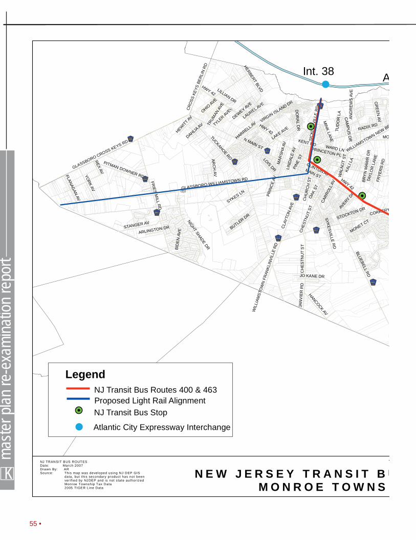
K
maste
r plan
re-e
xami
natio
n rep
ort
55 •
HWY 42
TUCKAHOERD
MAIN ST
CORKERY
BLUEBELLRD
FRIES
MILL
RD
GLASSBORO WILLIAMSTOWN RD
GLASSBORO CROSS KEYS RD
HERBERTBLVD
LAKE AVE RADIX RD
YORK
AV
CLA
YTO
NAV
E
MO
STANGER AV
SYKESVILLER
D
WILLIAMSTOWN NEW BR
WAL
NU
TST
BUTLER DR
CH
ESTN
UT
ST
GR
EEN
AV
PITMAN DOWNER RD
SYKES LN
JAN
VIE
RR
D
HANCOCKAV
SIC
KLER
VIL
LER
D
LOISDR
CR
OSS
KEYS
BER
LIN
RD
FLANAGAN
AV OAK
STREX
AV
PRINCETON PL
MIN
KLAN
EHARRELLAV
MONET CTNIGHTSHADE
DR
HEWITT AV
PINE
ST
CLINTON AV
N MAIN ST
BID
ENAV
E
WIL
LIAM
STO
WN
FRAN
KLIN
VILL
ER
D
WARD LN
AVERY
DR
LILLIAN DR
MAR
SHA
AV
OHIOAVE
KENT RD
LIN
DAL
EAV
PRIN
CE
AV
VIRGINISLAND DR
JO KANE DR
ARC
HAV
LAURELAVE
DAHLIAAV
ARLINGTON DR
CARR
OLL
AV
FRYE
RS
RD
STOCKTON DR
DO
RA
LD
R
CAM
PU
SD
R
CH
UR
CH
ST TAYL
OR
LAN
E
BRY
NM
AWR
DR
KALI
LAAN
DR
EWS
AVE
TUD
OR
LA
TRUM
ANAV
E
TYLER AVE
DEWEY AVE
HWY 42
CH
ESTN
UT
ST
HWY 42
!H
!H
!H
N E W J E R S E Y T R A N S I T B UM O N R O E T O W N S H
NJ TRANSIT BUS ROUTESDate: March 2007Drawn By: ARSource: This map was developed using NJ DEP GIS
data, but thi s secondary product has not beenver if ied by NJDEP and is not state author izedMonroe Township Tax Data2005 TIGER Line Data
4567689GLOUCESTER
4567658GLOUCESTER
4567655GLOUCE STER
4567610GLOUCE STER
4567555GLOUCESTER
4567654GLOUCESTER
4567610GLOUCE STER
4567536GLOUCE STER
4567612GLOUCE STER
4567633GLOUCE STER
£¤322
!(42
NJ Transit Bus Routes 400 & 463
!H NJ Transit Bus Stop
Legend
Proposed Light Rail Alignment
!
Int. 38
! Atlantic City Expressway Interchange
A

• 56m|k
US 322
MAL
AG
AR
D
JACKSON RD
WINSLOW RD
ERY LN
WH
ITEH
ALL
RD
COLES MILL RD
PINE
YHO
LLO
WRD
HUBERAV
SUNSET AV
LAKESIDE DR
BROADLN
S SHORE DR
FIFTH RD
MORGAN ROAD
N SHORE DR
W BROOKLYN RD
OR
BAN
ESLN
HIGHLAND RD
SUNNYHILL AVE
LAKE AV
LUTH
ERAV
E
DUBLE RD
PINE DR
MAGNOLIA AV
SHAR
PSR
D
LEBANON AV
SIXT
EEN
THST
CO
NC
OR
DD
R
SIKO
RSKI
RD
BETT
ING
ERRD
1ST
ST
KARE
NDR
BATT
LES
RD
SEYM
OU
RST
D
MILLS
LABLACK RD
FRANCES LN
0 10,000Feet
B U S R O U T E SS H I P O
NJ TRANSITBUS ROUTES
melvin|kernand e v e l o p m e n t s t r a t e g i e s
4567536GLOUCE STER
4567659GLOUCE STER
4567538GLOUCE STER
!H
!H
!H
!H
!H!H
!
!
Int. 33
Int. 31
Atlantic CityExpressway

WALDEN LN
SUNNYSIDE LN
SICKLER
VILLERD
BROOKDALEBLVD
8THAV
BROAD LN
HAMMERSCHLAG
AVE
MALAGARD
BARBAD
OS DR
BARCLAYCT
ST. ANDREWS CT
GARWOODAV
DEBRA
DR
LAKEAVE
HERBERT BLVD
CRYSTALDR
GRANDVIEWAVE
[SUNNY
ESTATES]
N MAIN ST
GRANDIS
ON TERR
CORKERY LN
SYKESVILLERD
WINSLOW TWPGLOUCESTER TWP
BLACK HORSE PIKE
BLACKHORSE
PIKE
MALAGARD
WINSLO
W RD
TUCKAHOERD
MAIN ST
CORKERY LN
JACKSON RD
BLUEBELL RD
WHITEHALL
RD
FRIESMILL
RD
COLES MILLRD
PINEY
HOLLOWRD
GLASSB
ORO W
ILLIAM
STOWN
RD
HUBER AV
GLASSBOROCROSSKEYSRD
LAKESIDEDR
S SHOREDR
BROAD LNHERBERT BLVD
LAKEAVE
RADIX
RD
FIFTH RD
CLAYTO
NAVE
MORGAN
ROAD
STANGERAV
N SHOREDR
AMESRD
WILLIAMSTOWNNEWBROOKLYNRD
WALNUTST
BUTLERDR
JANVIERRD
PITMAN DOWNER RD
GREENAV
ORCHARDRD
SYKESLN
HANCOCK AV
ORBANES
LN
LOIS DR
HIGHLANDRD
YORK AV
JOBSLN
SUNNYHILLAVE
FLANAGAN AV
OAKST
LAKEAV
REX AV
LUTHER
AVE
DUBLE RD
PINE DR
SHARPS
RD
PRINCETON PL
SEVENTEENTH
ST
MAGNOLIAAV
VICTORY AVE
FORESTDRIVE
MINKLANE
MONET CT
GLASGOWRD
NIGHTSHADE
DR
NEWST
HARRELLAV
HEWITTAV
PINEST
RED OAK RD
ROUN
AVLEB
ANON
AV
VILLAGEPKWY
CLINTON AV
N MAIN ST
HARDINGAVE
PARK AVE
CLAYTONAV
BERKSHIRE
BIDENAVE
WARD LN
WILLIA
MSTO
WNFRANKLIN
VILLERD
SNOWBERRY
DR
SIXTEENTH
ST
DUNDEEDR
BRIARW
OODDR
TRENTON DR
OAKAVE
AVERYDR
CHINKAPINAV
JONES
RD
OHIOAVE
WRIGHT PL
KIRK RD
LILLIAN DR
MARSHAAV
HUDSON AVE
KENT RD
KETALAVE
CONCORDDR
KENTUCKYAV G
ORDONAVE
HESSIAN DR
MAYAV
PEDRICKAV
BETULADR
MILDERAVE
ELDRIDGEAV
WASHINGTONAV
LINDALEAV
PRINCEAV
SIKORSKI RD
FERN RD
MONROE AV
BETTINGER
RD
FOXTAILDR
PIN OAK RD
DEBRADR
ELOISDR
OLD BLACK HO
RSE PIKE
VIRGINISLANDDR
BUCKHORNDR
HARVARDPL
LILY AV
JONES K
ANEDR
ARCHAV
EPINEST
1STST
TARADR
NEWTONAV
ARLINGTONDR
LAURELAVE
SUNSETAVE
DAHLIAAV
THOMASAV
16THAV
13THAV
ABERDEENRD
14THAV
12THAV
15TH AV
DAWNLA
HOWARDDR
17THAV
9THAV
ACADEMY ST
IRIS AVE
TWELVEOAKSDR
CARROLL
AV
FRYERSRD
BARBADOS DR
SEYMOURST
KAREN
DR
THERESALN
BATTLES
RD
POPLAR
ST
FREDRICKST
STOCKTON
DR
SAYBROOKAV
WCOLLINSDR
CROSS
KEYSBERLINRD
SENNA DR
ROSE AV
CORNUSCT
CAMPUSDR
TULIP AV
HOLLYPKW
Y
DORALDR
CORAAV
NEVADA
AVE
TRINIDADBLVD
CHURCHST
MILLSLA
DAISY AV
CLAYTONWILLIAMSTOWNRD
MAPLE AV
GREENFIELDAVE
OXFORD PL BRYNMAW
RDR
IRONWOOD DR
FLORENCEBLVD
AMES ROAD
WGARW
OODAV
TAYLORLANE
RENOIR WAY
LOMOND RD
HARRISONAVE
SILVERBIRCH
RD
FLEXON AV
MAXIN
EAVE
RIDGEDR
JOANIEAV
ASTER AV
11THAV
MAIDSTONEDR
MAUI DR
ANDREWSAVE
KALILA
WILDWOODAV
RIDINGSDR
FRANCE
S LN
ATLANTIC AV
BODINE AV
SHERWOODDR
CAINSMILL
RD
BLACK
RD
VIOLET AV
KILBURN AV
10THAV
BRADFORD DR
WALNUTAVE
ETTORE DR
W LAKE AV
BIRCH ST
KENNEDYAV
TUDORLA
SPRUCE ST
TRUMANAVE
STKITTS
DR
WHISPERINGWOODS DR
WHITE OAK RD
PADDOCKLN
VIRGINIAAV
MIRACLE
DR
MEADOWSDR
QUEEN A
NNEDR
POPLARLN
TYLERAVE
WELSH A
VE
DEWEYAVE
RAILROAD AV
REMBRANDTWAY
MEIVIADRIVE
ROSEBUDDR
CHRISTINALANE
GYPSY LA
MC CARTY AVE
HALLST
SADDLEBROOKDR
PRINCESS ST
BUCHANAN AVE
MARIANAV
HILBERT ST
BLUESTEMAVE
ROSETREE DRBLA
CKOAK RD
JOSIECT
KINGJAMES
DR
PICASSO CT
IRELANDTERR
DAVINCIWAY
LAFAYETTE ST
FIELDHOUSE WAY
FLORIDAAVE
NELSON
DR
SYCAMORE
LNTAMARIND PL
THOREAULA
FILBERT ST
DARTMOOR
AVE
PINEAV
ASPEN R
D
STEEPL
ECHASE
DR
MADISON AV
LINWOODAV
GREEN
BRIARDR
6THAV
UPPERDAM
DR
PICKWICK
DR
HEMLOCK D
R
FALKIRK RD
ARIZONAAV
IPSW
ICHLA
MCKINLEYAVE
DAVIS AVE
MULBERRY LA
SCHOOL HOUSERD
WLOISDR
ARROWTRAILDR
ARBUTUS AV
S BEECHAM RD
DENISE LN
CURTISAV
HONEYSUCKLE
RD
BALSAMRD
MARYLANDAVE
N RIVER RD
7THAV
BONNIEBLUECIR
PROSSERRD
THACKERYLN
MICAWBERDR
DEVONSHIREDRIVE
STALLIONCT
WMAGNOLIALA
INDIANAAV
KEY
WEST
DR
URBAN LN
BOSTON AVE
CROWFO
OTLA
CANDLEWOODRD
TEXAS AVE
HOLLYAV
SASSAFRAS LA
NEWBROOKLYNRD
LINDENAV
CROSSKEYSAVE
COBBLESTO
NE EAST FOX TRAIL
ELMLN
MONROE AVE
CENTERAV
JUNIPERAV
SPRUCEAV
WILLOWAV
JOHANNA CT
KERRYLYNN
CT
COLTS
RUN RD
YARDLEY PL
SUNNYHILL AV
PANAMA CT
BREWER ST
GREERAV
5THAV
HORSESHOE LA
WATER ST
COPPERFIELDDR
MAIDAWY
PARADISE RD
RITA PL
POECT
BIRCHAV
PATRIC
IA CT
POPLARAV
OAKAV
LORNECT
WOODHILL CT
STTHOMASBLVD
TERRY
CT
PALMER C
T
MIMOSACT
GENOBEE AVE
KENMORE DR
TOTEM PL
WHITE CEDAR LN
HARTMANAVE
BEECHCT
STOCKTON
LOOP
DUNKIRKST
LOAMST
BIRCHTERR
PALOMINO PL
MARTINIQUE DR
ELMTERR
FREEPORT WAY
IVYCT
THISTLE CT
HEATH CT
LARCHCT
MOOREAV
CAREXCT
CEDARTERR
GLASSBORO W
ILLIAM
STOWN
RD
BLACK HORSE PIKE
YORK AV
PINE ST
BLACK HORSE PIKE
SICKLERVILLE
RD
MAPLE
AV
CHESTN
UTST
N MAIN ST
HOLLYPKWY
BLACK HORSE PIKE
SHARPS
RD
OHIOAVE
VIRGINIAAV
LAKEAVE
BIRCHLN
CENTRAL AV
BAVARIAN
WAY
18THAV
SPRUCELN
MICHIGAN
AVE
GEORGIAAVE
HOLIDAYCITY BLVD
WILLOW
LN
LAURELLN
INVERNESSRD
LONGFELLOW
DR
HAMPTON WY
PRINCETON RD
ENDINGO AVE
3RDST
4THST
CRESTWOODDR
2NDST
RENAISSANCEDR
ADAMSAVE
MADRONE AV
LARCH AV
CRYSTALDR
OXFORD RD
VERONICA LN
ROBIN
LN
STMARTIN
CT
KENNEDYAVE
DALE LN
OLIVIA DR
DELAW
AREAVE
CAPRI CT
CLEVELAND AVE
HAMMONDDR
NEW JERSEY AVE
EISENHOWER
AVE
DENISECT
KIRKWALLDR
PERTHRD
WALTERDR
FERRIS LN
TEABERRYAVE
BRIDLEPATH LA
RASPBERRY LA
ATLANTA CT
JENNIFERLN
N BEECHAMRD
WINDMOORWY
LAURELAV
LITTLE LN
FRANCIS DR
ALBERTUS
DR
SHETLAND
LA
CHERRYBLOSSOM R
D
CORMARTYDR
DUBLIN CT
CEDARAV
CAROL AV
POLKAVE
DURNESSDR
JASMINE LN
3RDAV
MAPLE
AVE
OAK RD
OKLAHOMAAVE
SUMMERSWEET DR
HOSPITALITYAV
FRESCOES
WAY
TORTOLA
STMONACO
WY
MYRTLEAV
HANOVER LN
VERMONTAV
WILLIAM AV
COATSBRIDGE RD
FORESTCT
CHEW
ST
4THAV
SYCAMORE
AV
BERWICKBLVD
SHISLER AV
BAYBERRY LN
WEST
AVE
CHARLO
TTEAV
DEBRACT
BUTTONWOOD
ST
LIBRARY
ST
JEFFERSO
NAV
BAYWOODDRIVE
WHITMANLA
WESTFOXTRAIL
MILDRED AV
GILBERT CT
IRIS PL
HICKORYLN
2NDAV
LOCUSTLN
LOCUSTLN
MEADE CT
COLORADOAVE
CALIFORNIAAVE
STONEHENGEDR
PEACHTERR
RACHELLAUREN
WAY
LOWER
DAMDR
RUTGERS RD
COLTRUN
RD
LEIGHCT
NEW HAMPSHIRE A
V
ATWOODRD
WALNUT
TERR
FORRESTDR
FORRESTDR
DESCHLER BLVD
GLEN HAVEN CT
HILLE TERR
CONNECTICUTAVE
EMAGNOLIA
LA
KINGSTO
NCT
MAPLETERR
ST CROIXDR
J BURGER DR
CONSTITUTION WAY
TUCKER ST
CARIBBEANWAY
SHUTE AVE
MILTON AVE
SASSAFRAS CT
VIRGINIA PL
YARDLEY PL
EVERGREENLN
MERCER PL
EMORY PL
WHITE
CEDAR
CT
GALLOWAY CT
MARIA ELENA DR
OAKTER
R
SCARLETT CT
MALLARD CT
APPLE TERR
EASTONCT
FULBROOK ST
WAGNER CT
CEZANNE CT
CHATSFORD RD
CORNWALL PL
ESSLERWAY
TIFFANYLA
DORSETCT
GABLE
CT
KINWOOD PL
GARFIELD PLMUSEE CT
OHARACT
BORDEAUXCT
WILSONLA
1STAV
FAGANCIR
CHINKAPIN C
T
DICKENSCT
MELAINECT
TIMBERLINE LN
OLIVIA
CT
YARROWCT
PINETERR
GREENWICH CT
SALIX CT
CURRANT CT
SUNDRO
P CT
REDWOOD CT
HOFFMANAVE
TAYLORCT
BAYBERRY CT
TAHOE C
T
KILBURNPL
ARUBACT
HUXLEY CT
POPLAR
TERR
PRINCETON BLVD
HAWTHORNE CT
RIOCOURT
SHAMROCK WY
WOODLANDCT
SHERMAN CT
ROCK
CRES
T CT
WESTOVERCT
PERSIMMONCT
DUNDEECT
SILVER B
IRCH C
T
SHADBUSH CT
BOXWOOD C
T
BALSAMCT
ORANGE LNNEW HOPE LN
MONROE AVE
CHESTNUTST
WILLOW AV
WHISPERING
WOODS
DR
THOREAU LA
ELMLN
MONROETOWNAPTS
RAILROAD AV
BP
FD-40
R-2
AG
RD-RS
R-2
C
RD-RR
R-2
FD-10
AG
RG-PR
RD-A
RD-C
RD-ARA
RG-C
R-2
AO
AO
AO
CR-2
RD-AC
RG-MR
RA
R-3
RG-PR
RARG-MR
C
BP
RG-C
C
C
C
C
CO
RG-RA
RG-RA
RD-RR
RG-C
C
RG-MR
C
R-1
RG-PR
RG-40
RG-C
RG-30
RG-TC
RG-40
CO
RG-C
RG-LI
RG-C
R-1
RG-C
RG-30
RG-C
BP
BUENAVISTATW
PHAMMONTONTOWN
FOLSOMBORO
FRANKLIN TWP
WASHINGTON TWP
CLAYTON BORO
GLASSBORO BORO
0 10,000Feet
MO N R O E T OW N S H I P Z O N I N G C H A N G E SG L O U C E S T E R C O U N T Y , N J O
Monroe ZoningDate: FEB 2008Drawn By: ARSource: This map was developed using NJ DEP GIS
data, but th is secondary product has not beenver i f ied by NJDEP and is not state author izedMonroe Township Tax Data2005 TIGER Line Data
GREAT EGG HARBOR RIVER
4567555GLOU CESTER
4567612GLO UC ESTE R
4567536GLO UC ESTE R
4567659GLO UC ESTE R
4567633GLO UC ESTE R
£¤322
£¤322
¬«42
4567538GLO UC ESTE R
4567612GLO UC ESTE R
4567610GLO UC ESTE R
4567610GLO UC ESTE R
4567654GLO UC ESTE R
1
2
34
5
6
7
8
9
10
11
11
12
13
HOSPITALITY BRANCH
SCOTLAND RUN
SQUAKUM BRANCH
TIMBER LAKES
SUNSETLAKE
VICTORYLAKES DIAMOND
LAKE
4567658GLOU CESTER
4567555GLOU CESTER
4567536GLO UC ESTE R
4567655GLOU CESTER
[CORKERYSQUARE]
[CARRIAGEGLEN]
4567689GLOU CESTER
1
2
* = These changes were passed by council but will require an ordinanceamendment to be approved by the Pinelands Commission.
3
4
5
6
7
8
9
10
11
12
13
ChangesProposed RA to R-2
R-2 to C
R2, BP to MU-AR Mixed Use Age-Restricted
BP to C
Proposed Rt 322 & Fries Mill Redevelopment Site
BP to AH, Affordable Housing District
Proposed RG-MR to RD-A
Proposed ACME addition
RD-A to RG-MR*
Proposed RG-PR to RD-A*
Proposed RG-RA to RG-MR
RG-C, RD-C, RD-RR to RG-SC*
Investigating Public Health Concerns- Possible Sewer Extension
Zoning Districts
Pinelands Boundary
Rural Development Residential Sending District (RD-RS)Airport Overlay (AO)
OVERLAYS
Acme Shopping Center Redevelopment Zone
Regional Growth Residential District 30 (RG-30)
Regional Growth Residential District 40 (RG-40)
Rural Development Residential Receiving District (RD-RR)
PINELANDS
Commercial District (C)
County Boundaries
Commercial Overlay (CO)
Regional Growth Residential Age Restricted District (RG-RA)
Regional Growth Planned Residential District (RG-PR)
Regional Growth Moderate Residential District (RG-MR)
Regional Growth Light Industrial District (RG-LI)
Regional Growth Commercial District (RG-C)
Regional Growth Town Commercial District (RG-TC)
Rural Development Agricultural District (RD-A)
Rural Development Commercial District (RD-C)
NON-PINELANDS
Residential District 1 (R-1)
Suburban Residential Option District (R-2)
Residential 3 District(R-3)
Residential Age-Restricted District (RA)
Business Park District (BP)
Mink Lane Redevelopment Zone
REMCOR Redevelopment Zone
Forest Residential District 10 (FD-10)
Agricultural Production District (AG)
Forest Residential District 40 (FD-40)Recommended by Planning Board on September 9, 2004 Resolution No. PB-76-04).
Adopted by Township Council on February 22, 2005 (Ordinance No. O:02-2005).
Amended by Township Council on December 4, 2006 (Ordinance O:49-2006).
Amended by Township Council on April 24, 2007 (Ordinance O:27-2007).