mastery of content and pedagogy: evaluation of strategies for teacher institutes
TRANSCRIPT
This article was downloaded by: [University of Connecticut]On: 30 October 2014, At: 06:28Publisher: RoutledgeInforma Ltd Registered in England and Wales Registered Number: 1072954 Registered office: Mortimer House,37-41 Mortimer Street, London W1T 3JH, UK
Journal of GeographyPublication details, including instructions for authors and subscription information:http://www.tandfonline.com/loi/rjog20
Mastery of Content and Pedagogy: Evaluation ofStrategies for Teacher InstitutesMichael C. Jurmu , Jacqueline Maclnnis Jurmu & Judith W. MeyerPublished online: 16 Aug 2007.
To cite this article: Michael C. Jurmu , Jacqueline Maclnnis Jurmu & Judith W. Meyer (1999) Mastery ofContent and Pedagogy: Evaluation of Strategies for Teacher Institutes, Journal of Geography, 98:1, 14-22, DOI:10.1080/00221349908978849
To link to this article: http://dx.doi.org/10.1080/00221349908978849
PLEASE SCROLL DOWN FOR ARTICLE
Taylor & Francis makes every effort to ensure the accuracy of all the information (the “Content”) containedin the publications on our platform. However, Taylor & Francis, our agents, and our licensors make norepresentations or warranties whatsoever as to the accuracy, completeness, or suitability for any purpose of theContent. Any opinions and views expressed in this publication are the opinions and views of the authors, andare not the views of or endorsed by Taylor & Francis. The accuracy of the Content should not be relied upon andshould be independently verified with primary sources of information. Taylor and Francis shall not be liable forany losses, actions, claims, proceedings, demands, costs, expenses, damages, and other liabilities whatsoeveror howsoever caused arising directly or indirectly in connection with, in relation to or arising out of the use ofthe Content.
This article may be used for research, teaching, and private study purposes. Any substantial or systematicreproduction, redistribution, reselling, loan, sub-licensing, systematic supply, or distribution in anyform to anyone is expressly forbidden. Terms & Conditions of access and use can be found at http://www.tandfonline.com/page/terms-and-conditions
Mastery of Content and Pedagogy: Evaluation of Strategies for Teacher Institutes
Michael C. Jurmu, Jacqueline MacInnis Jurmu, and Judith W. Meyev
ABSTRACT Considerable attention has been
paid to the evaluation of the effective- ness of various components of summer institutes conducted by many state alliances, but little attention has been focused on the mastery of geography content. This study shows that six minor modifications in the standard format for such institutes can modestly increase the mastery of geography con- tent by participants. Outcomes were compared between two summer insti- tutes in successive summers, both of which focused on similar environmen- tal geography topics. Changes were made in the format for inservice lessons, the daily evaluation form, the group investigation process, staff-pre- sented demonstration lessons, consulta- tion by faculty and geography students as participants prepared inservice lessons, and geography material avail- able.
Key Words: program evaluation, geo- graphic content, inservice training
Michael C. Jurmu is Visiting Lecturer in the Department of Geography, University of Wisconsin-Fox Valley, Menasha, Wisconsin 54952 USA and a Ph.D. candi- date in the Department of Geography, lndiana State University, Terre Haute, Indiana. 47809 USA.
Jacqueline Maclnnis Jurrnu is a geographic consultant in Menasha, Wisconsin, 54952 USA.
Judith W. Meyer is Professor in the Department of Geography, University of Connecticut, Stows, Connecticut 06269- 2148 USA.
For slightly more than a decade geographers have been using a model for inservice training for K-12 teachers initially designed by the National Geographic Society’s Geography Education Program. These teachers are being expected to teach more geography content, in part because of national and state movements to increase such instruction. However, many of them have limited preparation for teaching geogra- phy, either in terms of knowledge of geography content or knowledge of geography pedagogy. Geography inservice programs and summer ”trainer of trainers’’ institutes for teachers supported by the National Geographic Society have thus had a dual focus-content and pedagogy.
Cole and Ormrod (1995) have explored the characteristics of effec- tive teacher inservice training and concluded that the model used by the geographic alliances for their summer training programs is respon- sive to best practice for inservice programming and addresses Shulman’s three critical areas of knowledge (pedagogical, content, and pedagogical content) (Shulman 1986). The National Geographic Society has conducted careful evaluations of many of these summer institutes, and surveys conducted of participants in the institutes indicate that most of the respondents have made changes in the way they teach geography (Katzenmeyer 1994).
Most of the evaluations conducted of summer institutes have focused on Shulman’s pedagogical and pedagogical content knowledge. Evaluators have paid less attention to mastery of content knowledge, and the participants in alliance summer institutes do not stress content mastery in their recollections of the value of the program in which they have participated (Cole and Ormrod 1995). Anecdotal discussions among alliance leaders also suggest that they are less than satisfied with the geography content mastery of many of their novice teacher consul- tants. Evidence from case studies of both high school and elementary teachers suggests that the teacher’s content comprehension impacts on the styles of teaching employed in the classroom (Leinhardt and Greeno 1985, Shulman 1987), so content mastery is as important as mastery of new pedagogy.
This study examines the impact of minor modifications in the for- mat of an inservice institute on teachers’ mastery of geography content by identifying differences in teacher behavior between two summer institutes, the second of which incorporated modifications to emphasize content mastery. The overall purpose is to measure if participants’ per- ception and use of geography content and their pedagogical geography knowledge improved if they participated in the modified institute.
Journal of Geography 98:14-22 01999 National Council for Geographic Education
Dow
nloa
ded
by [
Uni
vers
ity o
f C
onne
ctic
ut]
at 0
6:28
30
Oct
ober
201
4
New Strategies for Summer Geography Institutes 15
EXPERIMENTAL DESIGN
The two summer institutes, taught in 1993 and 1994, both focused on an environmental themel. Each summer the two-week training experience exposed the participants to the various nuances of geography through content lectures, field activities, lesson demonstrations, group-interaction sessions, and individual instruction by the institute staff. The participants in turn demonstrated their newly acquired abilities by conducting an inservice pre- sentation for the other participants based on the environmental theme.
by participants in the first institute revealed that many of them did not specifically incorporate geog- raphy content, focusing instead on more nebulous environmental topics, despite the focus by expert geography presenters on the key elements of physi- cal systems and environment and society. In addi- tion, the pedagogical geography content used in the lessons was primarily at the simplest cognitive level-knowing, rather than understanding or applying. Without increasing the time devoted to content presentations during the institute itself, the following six modifications were made for the sec- ond institute to support increased mastery of con- tent as well as enhanced pedagogical content.
Observation of the inservice lessons presented
1. The format for the participants’ inservice lessons (and for the demonstration lessons) was more explicitly focused on geography content. The lesson had to pertain to a geographic content topic of the institute (energy, forests, water); incorporate any, or all, of the 5 Themes in Geography that were a focus in the insti- tute; and follow a standardized outline. To measure the impact of this modifica- tion, we analyzed the packets prepared by each participant, using a standardized format for content analysis2. Individual authors separately analyzed each year’s packets, but two authors conducted duplicate analyses of approximately 25% of the packets; this triangulation yielded identical content analysis results.
Incorporation of an appropriate topic, incorporation of geographic vocabulary, and method/tools presented by the par- ticipants were self-evident within the inservice materials. Determining if the materials were presented as a geography
lesson was based upon its explicit inclu- sion in the purpose or objectives, and/or mention within some aspect of the les- son. If geography was incorporated into the purpose or objectives, the materials were assessed to determine if all, some, or none of the objectives would be attained based on the content presented.
The cognitive levels of learning expected from the students were measured using the levels identified by geographers in developing the National Assessment of Educational Progress in Geography (NAEP Geography Consensus Project 1994). The cognitive level the inservice materials fostered was assigned the knowing level if the content required simple recognition of geographical top- ics, terms, or locations (e.g., students describe the physical characteristics of a place). The next level, understanding, was assigned to materials that encour- aged perception and comprehension of the significance of geographical themes or relationships (e.g., students explain why a species grows in a particular area). An inservice lesson achieved the cogni- tive level of applying when it contained materials and exercises that allowed demonstration of the ability to identify, discern, and then accurately utilize geo- graphic concepts (e.g., students redesign a throw-away society to make it more sustainable). The daily evaluation form was modified to explicitly ask for two content ideas participants had learned from lectures and discussions, as well as for two new ideas for use in the classroom. The previ- ous form simply asked them to list ideas they could implement. We summarized these forms for the types of geography content discussed, the relevant geograph- ic elements, and the cognitive level that participants expected from their stu- dents; the same standards were used to assign cognitive level that were used in the inservice packet analysis. The group investigation process, a small group discussion following content lec- tures, was more structured in the second institute. A form was used to guide dis- cussion which explicitly identified the
2.
3.
Dow
nloa
ded
by [
Uni
vers
ity o
f C
onne
ctic
ut]
at 0
6:28
30
Oct
ober
201
4

16 lurmu, Jurmu, and Meyer
geographic standards within the key ele- ments of physical systems and environ- ment and society, and then raised ques- tions regarding key ideas, level of cogni- tive learning (knowing, understanding, applying), and teaching strategies. These discussions were taped, transcribed, and distributed to the participants as quickly as possible. We summarized these dis- cussions, linked them to Geography for Life standards, and again assigned a cog- nitive level to the key ideas.
4. Staff-presented demonstration lessons were tied directly to the content lectures.
5. A geography faculty member and two geography graduate assistants met with the participants as they prepared their own inservice lessons. We assembled articles from nontechnical journals containing geography content topics covered in the institute for use by the participants as reference in develop- ing their inservice presentations.
6.
In addition to the analysis of inservice materi- als, daily evaluations, and group investigations, we employed a fourth measure to estimate the impact of the six modifications. A standard pre/post effica- cy instrument, using a five-point Likert scale, asked participants to rate their ”preparedness” on several dimensions of content, pedagogy and leadership that were addressed during the institute?
qualitatively, primarily through content analysis of daily evaluation forms, transcripts of small-group discussions, and the packets produced by partici- pants for their personal inservice presentation, com- bined with the pre/post efficacy instrument. The latter two measures were available for both insti- tutes and allow for direct comparison. The other two measures provide additional confirmation of the attention to content by the participants in the second institute.
The impact of the six modifications is measured
RESULTS
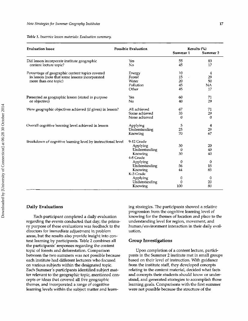
Inservice Material Analysis
Twenty-three inservice packets were available from Summer 1 and 24 packets were available for Summer 2, the institute with the modifications. The percentage of lessons containing a geography topic from the institute increased in Summer 2 from 55%
to 83%, a significant difference (p < 0.05) based on a T test of differences between proportions (Table 1). Although the differences were not statistically sig- nificant between the two years on the remaining measures of the inservice material, they did show evidence of positive change. Those lessons where an aspect of geography was expressed in the objec- tives or purpose rose from 60% to 71%. Achievement of all the geographic objectives in a lesson (if given) also increased, but only slightly. The overall cognitive learning levels (knowing, understanding, and applying) for the inservice materials remained relatively similar for each year, with only understanding levels rising 4%. The pri- mary emphasis in the inservice lessons was on knowing levels of cognition, but high school teach- ers did place more emphasis on understanding and applying than did teachers of younger children.
Participant Confidence
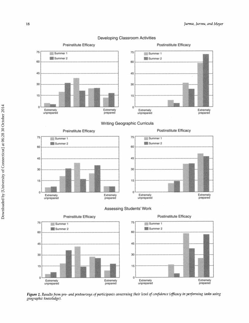
The pre/post efficacy test asked participants their perceptions concerning level of confidence in performing several tasks using geographic knowl- edge. The results were initially used to evaluate the overall effectiveness of the institutes, and both years showed a normal distribution of responses to each item prior to the institute and a skewed distri- bution after the institute at the ”prepared” or ”extremely prepared” level. Selected items also pro- vide some information about the impact of the six modifications on participants’ confidence in using geographic content, but none show statistically sig- nificant differences, based on a test of differences between proportions.
to write geography curricula, most participants expressed some level of preparedness. Post-institute levels increased for both years (Figure 1). Confidence in developing geographical classroom activities (Figure 1) rose from pre- to post-institute for both summers. More Summer 2 participants felt extremely prepared to create activities and the actu- al percentage increase was slightly higher than in Summer 1. Confidence prior to the Summer 1 insti- tute regarding assessment of students’ geographic work was somewhat higher than Summer 2 (Figure 1). After the institute, a larger percentage of Summer 2 participants felt extremely prepared to assess students’ geographic work and that percent- age of change was also higher than for the Summer 1 group.
When questioned on their pre-institute abilities
Dow
nloa
ded
by [
Uni
vers
ity o
f C
onne
ctic
ut]
at 0
6:28
30
Oct
ober
201
4
New Strategies for Summer Geopaphy Institutes 17
Table 1. Inservice lesson materials: Evaluation summary.
Evaluation Issue Possible Evaluation Results (%) Summer 1 Summer 2
Did lesson incorporate institute geographic content lecture topic?
Percentage of geographic content topics covered in lesson (note that some lessons incorporated more than one topic)
Presented as geographic lesson (stated in purpose or objective)
Were geographic objectives achieved (if given) in lesson?
Overall cognitive learning level achieved in lesson
Breakdown of cognitive learning level by instructional level
Yes No
Energy Forest Water Pollution Other
Yes No
All achieved Some achieved None achieved
Applying Understanding Knowing
9-12 Grade Applying Understanding Knowing
4-8 Grade Applying Understanding Knowing
K-3 Grade Applying Understanding Knowing
55 45
10 15 20 45 45
60 40
67 33 0
5 25 70
50 0
50
0 56 44
0 0
100
83 17
4 29 50
NA 17
71 29
71 29 0
4 29 67
20 40 40
0 15 85
0 20 80
Daily Evaluations
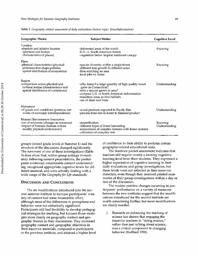
Each participant completed a daily evaluation regarding the events conducted that day; the prima- ry purpose of these evaluations was feedback to the directors for immediate adjustment in problem areas, but the results also provide insight into con- tent learning by participants. Table 2 combines all the participants’ responses regarding the content topic of forests and deforestation. Comparison between the two summers was not possible because each institute had different lecturers who focused on various subjects within the designated topic. Each Summer’s participants identified subject mat- ter relevant to the geographic topic, mentioned con- cepts or ideas that covered all five geographic themes, and incorporated a range of cognitive learning levels within the subject matter and learn-
ing strategies. The participants showed a relative progression from the cognitive learning level of knowing for the themes of location and place to the understanding level for region, movement, and human/environment interaction in their daily eval- uation.
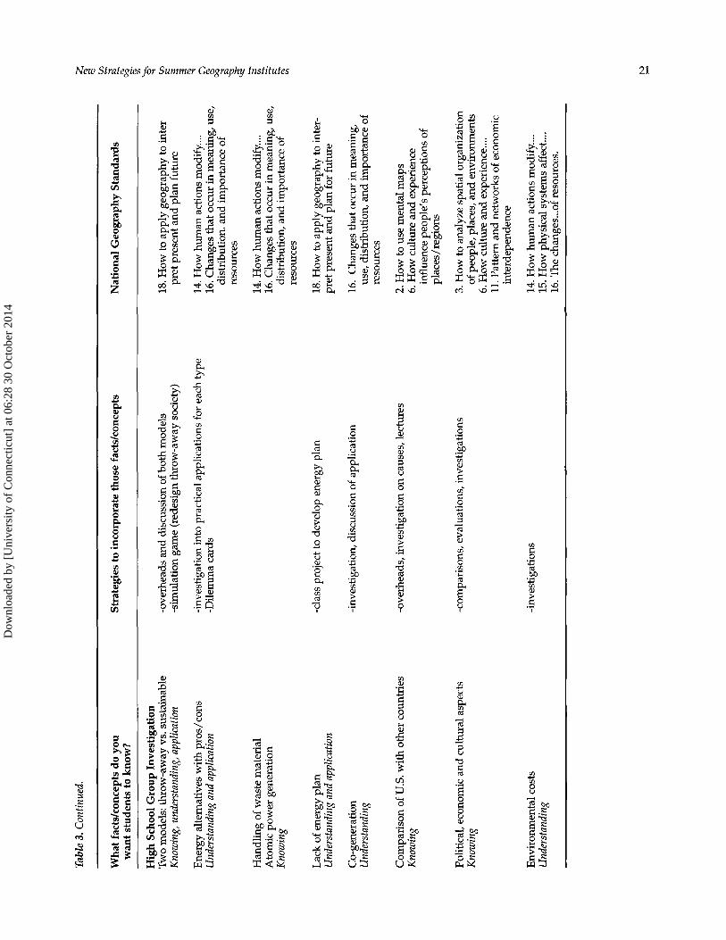
Group Investigations
Upon completion of a content lecture, partici- pants in the Summer 2 institute met in small groups based on their level of instruction. With guidance from the institute staff, they developed concepts relating to the content material, decided what facts and concepts their students should know or under- stand, and generated strategies to accomplish those learning goals. Comparisons with the first summer were not possible because the structure of the
Dow
nloa
ded
by [
Uni
vers
ity o
f C
onne
ctic
ut]
at 0
6:28
30
Oct
ober
201
4
18 Jurrnu, Jurrnu, and Meyer
Figure 1. Resultsfrorn pre- and postsurveys of participants concerning their level of confidence (efficacy in performing tasks using geographic knowledge).
Dow
nloa
ded
by [
Uni
vers
ity o
f C
onne
ctic
ut]
at 0
6:28
30
Oct
ober
201
4
New Strategies for Summer Geography Institutes
Table 2. Geography content assessment of daily evaluations (lecture topic: forest/deforestation)
19
Geographic Theme Subject Matter Cognitive Level
Location -absolute and relative location
(physical and human characteristics of places)
Place -physical characteristics (physical processes that shape patterns; spatial distribution of ecosystems)
Region -comparison across physical and cultural realms (characteristics and spatial distribution of ecosystems)
Movement -of goods and conditions (patterns, net- works of economic interdependence)
Human/Environment Interaction -use of resources (changes in resources) -impact of humans (human actions modify physical environment)
-deforested areas of the world 4 . S . vs. South American forests -vegetation below tropical rainforest canopy
Knowing
-species diversity within a single forest Knowing -different tree growth in different areas -fires enriching an area -local jobs vs. forest
-why doesn‘t a large quantity of high quality wood
-why a species grows in area? -compare U.S. vs South American deforestation -transition areas as bird habitats -use of slash and burn
Understanding grow in Connecticut?
-wood products exported to Pacific Rim -process from tree in forest to finished product
Understanding
-desertification Knowing -different types of forest harvesting -replacement of complex systems with lesser systems -utilization of complete tree
Understanding
groups (mixed grade levels in Summer 1) and the structure of the discussion changed significantly. The summary of one of these investigations (Table 3) does show that, within group settings immedi- ately following content presentations, the partici- pants evidenced considerable content understand- ing, recognized appropriate cognitive levels for dif- ferent material, and were actually dealing with a wide range of the Geographyfor Life standards.
DISCUSSION AND CONCLUSIONS
The six modifications introduced into the sec- ond summer institute to increase participants’ mas- tery of content had some measurable effect, although most of the differences in perceptions and behavior were not statistically significant. Participants still had flexibility to develop pedagog- ical strategies for teaching, but focused those strate- gies more clearly on geography content and geo- graphic themes in their discussions. They increased geography content and geographic objectives in their inservice materials, compared to participants in the previous institute, and attained a higher level
of confidence in their ability to perform certain geography-related educational tasks.
teachers still require mostly a knowing cognitive learning level from their students. They expressed a higher expectation of cognitive learning in their daily evaluations and group investigations, but these levels were not reflected in their inservice materials, even though they received printed sum- maries of their group investigations within a day or two of the discussion.
The modest positive changes occurring in par- ticipants’ performance on a variety of measures between the two institutes suggest that the modifi- cations introduced for the second institute are worth considering further, but more modifications are clearly needed.
The inservice packet assessment indicates that
1. Research on enhancing the teaching of science has shown that engaging the inservice teachers in ”doing science,” rather than just talking about science, was a critical component in changing behavior (Radford 1998).
Dow
nloa
ded
by [
Uni
vers
ity o
f C
onne
ctic
ut]
at 0
6:28
30
Oct
ober
201
4

Tabl
e 3. G
roup
inve
stiga
tions
of lec
ture
on
ener
gy.
!2
Wha
t fac
tsko
ncep
ts d
o yo
u w
ant s
tude
nts t
o kn
ow?
Stra
tegi
es to
inco
rpor
ate
thos
e fa
ctsk
once
pts
Nat
iona
l Geo
grap
hy S
tand
ards
Ele
men
tary
Sch
ool G
roup
Inv
estig
atio
n A
war
enes
s -e
nerg
y co
nsci
ousn
ess
-bet
ter s
ourc
es a
nd a
ltern
ativ
es
-eas
y th
ings
are
not
alw
ays b
ette
r -la
bor-
savi
ng d
evic
es th
at u
se e
nerg
y Kn
owin
g an
d un
ders
tand
ing
Agr
icul
ture
and
tran
spor
tatio
n Kn
owin
g
Was
te of
ene
rgy
Und
ersta
ndin
g
Idea
of
perp
etua
l, re
new
able
and
non
rene
wab
le
Know
ing
Mid
dle
Scho
ol G
roup
Inv
estig
atio
n H
uman
/env
iron
men
t in
tera
ctio
n-us
e of
ener
gy
Appl
icat
ion
sour
ces
Mak
e st
uden
ts a
war
e-co
nsci
ous
of en
ergy
Und
ersta
ndin
g co
nsum
ptio
n
-tur
ning
off
light
s; h
ave
them
do
at h
ome
-info
rm p
aren
ts of
ene
rgy
was
tes
-mak
e pos
ters
of d
evic
es n
ow a
nd w
hat w
as u
sed
in p
ast
-map
ping
of a
reas
: ene
rgy
sour
ces,
uses
, etc
. -f
ield
trip
s to
loca
l pow
er p
lant
or o
ther
sour
ce of
alte
rnat
ive
1. H
ow to
use
map
s and
oth
er
geog
raph
ic re
pres
enta
tions
... to
acqu
ire, p
roce
ss a
nd re
port
in
form
atio
n fr
om sp
atia
l per
spec
tive
17. A
pply
geo
grap
hy to
inte
rpre
t pas
t en
ergy
-com
pare
with
ano
ther
cou
ntry
(US
vs ...)
-u
se of
com
pute
r gra
phic
s in
clas
s 3.
How
to a
naly
ze sp
atia
l org
aniz
atio
n of
peop
le, p
lace
s, e
nvir
onm
ents
-wri
te le
tter t
o pl
aces
whe
re th
ey th
ink
ener
gy is
was
ted
-che
ck fo
r was
te a
roun
d sc
hool
; be
“Env
iroga
tors
“
-exp
lain
diff
eren
ces b
etw
een
sun,
coal
, win
d, n
ucle
ar e
nerg
y
14. H
ow h
uman
act
ions
mod
ify
(invo
lvem
ent i
n co
mm
unity
) ph
ysic
al e
nvir
onm
ent
15. H
ow p
hysi
cal s
yste
ms a
ffec
t hum
an
syst
ems
-use
map
s an
d de
mog
raph
ics t
o re
desi
gn m
ore
effic
ient
bu
s ro
ute
for s
choo
l, ba
sed
on st
uden
ts in
cla
ss
-rea
d el
ectri
c met
ers,
com
pare
am
ount
s and
life
styl
es
with
in d
iffer
ent h
omes
, diff
eren
t era
s -tr
ace e
lect
ricity
back
to s
ourc
e (i.
e. co
al, w
ater
, etc
.- us
ually
som
e ty
pe of
nat
ural
form
cre
atin
g so
urce
)
1. H
ow to
use
map
s and
oth
er g
eo-
grap
hic r
epre
sent
atio
ns ...
2. H
ow to
use
men
tal m
aps t
o or
gani
ze
info
rmat
ion
abou
t peo
ple,
pla
ces ..
.
6. H
ow c
ultu
re an
d ex
perie
nce i
nflu
- en
ce p
eopl
e’s p
erce
ptio
ns of
pla
ces
11. P
atte
rn a
nd n
etw
orks
of e
cono
mic
in
terd
epen
denc
e 14
. How
hum
an a
ctio
ns m
odif
y....
15. H
ow p
hysi
cal s
yste
ms a
ffec
t ....
16. C
hang
es th
at O
CC
UT
in m
eani
ng, u
se,
dist
ribu
tion,
and
impo
rtan
ce of
re
sour
ces
pret
pas
t 4
3 s 4 3 E: E: = s2 3
R
17. H
ow to
app
ly g
eogr
aphy
to in
ter-
18. H
ow to
app
ly g
eogr
aphy
to in
ter-
pr
et p
rese
nt a
nd p
lan
futu
re
3
Dow
nloa
ded
by [
Uni
vers
ity o
f C
onne
ctic
ut]
at 0
6:28
30
Oct
ober
201
4
Tabl
e 3. C
ontin
ued.
2
2
Wha
t fac
ts/c
once
pts d
o yo
u St
rate
gies
to in
corp
orat
e th
ose
fact
s/co
ncep
ts
Nat
iona
l Geo
grap
hy S
tand
ards
ii
wan
t stu
dent
s to
kno
w?
9.
Hig
h Sc
hool
Gro
up In
vest
igat
ion
3
Kno
win
g, un
ders
tand
ing,
appl
icatio
n -s
imul
atio
n ga
me
(red
esig
n thr
ow-a
way
soci
ety)
pr
et p
rese
nt a
nd p
lan
futu
re
s Tw
o m
odel
s: th
row
-aw
ay v
s. su
stai
nabl
e -o
verh
eads
and
disc
ussi
on of
bot
h m
odel
s 18
. How
to a
pply
geo
grap
hy to
inte
r v, i.!
Ener
gy a
ltern
ativ
es w
ith p
ros/
cons
U
nder
stand
ing
and
appl
icatio
n
Han
dlin
g of
was
te m
ater
ial
Ato
mic
pow
er g
ener
atio
n Kn
owin
g
Lack
of
ener
gy p
lan
Und
ersta
ndin
g and
app
licat
ion
Co-
gene
ratio
n U
nder
stand
ing
Com
pari
son
of U
.S. w
ith o
ther
cou
ntri
es
Know
ing
Polit
ical
, eco
nom
ic a
nd c
ultu
ral a
spec
ts
Know
ing
-i n 09
3
-inve
stig
atio
n in
to p
ract
ical
appl
icat
ions
for e
ach
type
14
. How
hum
an a
ctio
ns m
odif
y....
-Dile
mm
a ca
rds
16. C
hang
es th
at o
ccur
in m
eani
ng, u
se,
8 di
stri
butio
n. an
d im
port
ance
of
a 9
3
$. i$ di
stri
butio
n, an
d im
port
ance
of
2
reso
urce
s
14. H
ow h
uman
act
ions
mod
ify. ...
16
. Cha
nges
that
occ
ur in
mea
ning
, use
, .-I.
reso
urce
s
-cla
ss p
roje
ct to
dev
elop
ener
gy p
lan
-inve
stig
atio
n, di
scus
sion
of a
pplic
atio
n
-ove
rhea
ds, i
nves
tigat
ion
on c
ause
s, le
ctur
es
-com
paris
ons,
eval
uatio
ns, in
vest
igat
ions
18. H
ow to
app
ly g
eogr
aphy
to in
ter-
pr
et p
rese
nt a
nd p
lan
for f
utur
e
16.
Cha
nges
that
occ
ur in
mea
ning
, us
e, d
istr
ibut
ion,
and
impo
rtan
ce of
re
sour
ces
2. H
ow to
use
men
tal m
aps
6. H
ow c
ultu
re a
nd e
xper
ienc
e in
fluen
ce pe
ople
's pe
rcep
tions
of
plac
es/r
egio
ns
3. H
ow to
ana
lyze
spat
ial o
rgan
izat
ion
of pe
ople
, pla
ces,
and
env
iron
men
ts
6. H
ow c
ultu
re a
nd e
xper
ienc
e ....
11. P
atte
rn a
nd n
etw
orks
of e
cono
mic
in
terd
epen
denc
e
Env
ironm
enta
l cos
ts
-inve
stig
atio
ns
14. H
ow h
uman
act
ions
mod
if y..
.. U
nder
stand
ing
15. H
ow p
hysi
cal s
yste
ms a
ffect
....
16. T
he c
hang
es ... o
f re
sour
ces.
Dow
nloa
ded
by [
Uni
vers
ity o
f C
onne
ctic
ut]
at 0
6:28
30
Oct
ober
201
4
Jurmu, Jurmu, and Meyeu 22
2.
3.
4.
5.
Teacher consultants who are providing demonstration lessons should emphasize a geographic content topic from the insti- tute and stress higher levels of cognitive learning. Many participants do not have an in-depth background in geography and they need continued reinforcement of these concepts and instructional proce- dures to implement them accurately in the classroom. Institute directors may want to require inservice topics chosen by participants to directly relate to one of the content lec- tures, and challenge participants to incor- porate higher levels of cognitive learning, as appropriate for the targeted grade level. This insures attentiveness during the lectures and discussions and encour- ages participants to create a geographic lesson strategy strictly from their new learning experiences. Such a requirement will also give the participants experience that is applicable in developing geo- graphic curricula. Using geography content experts (faculty and/or graduate students) to consult with participants as they develop their lessons can help increase the geography content in classroom lessons or inservice presentations. Focusing daily evaluations and discus- sion guides on geographic content and knowledge of pedagogical geographic content (levels of cognitive learning) reg- ularly reminds the participants of the focus of the institute.
These modifications to a fairly standardized approach to alliance summer institutes can result in increased attention to both geography content and pedagogical geography knowledge without sub- stantially increasing the amount of time directly devoted to presentations of geography content. That is important, since these Alliance institutes typically serve three purposes-improving the understanding of geography content, enhancing the pedagogical skills, and preparing for being an edu- cational leader through inservice presentations.
Alliances are rarely able to conduct the type of quasi-experimental effort described in this research, because the foci of summer programming changes regularly. Nevertheless, the geography content and levels of cognitive learning proposed by partici- pants can be compared, based on participants’ pre- vious experience with geography, either through summer institutes or college level courses. If signifi- cant differences are apparent, evidence is available for the importance for teachers of continued educa- tion in geography content, not just in pedagogy.
NOTES Subsequent summer institutes sponsored by the Connecticut Geographic Alliance focused on interdiscipli- nary perspectives, in response to demand from K-12 teach- ers in the state. Findings from this research were incorpo- rated in the design of those institutes, but no further opportunity was available for a follow-up quasi-experi- mental study. The scoring instrument is available from the Connecticut Geographic Alliance. The efficacy instrument, developed by the Connecticut Geographic Alliance with assistance of Steven Owen, Professor of Educational Psychology at the University of Connecticut, is available from the Alliance.
REFERENCES Cole, D. B., and J. E. Ormrod. 1995. Effectiveness of teaching
pedagogical content knowledge through summer geography institutes. Journal of Geography 94:427433.
Katzenmeyer, M. 1994. ASGI Follow-up Survey Results. Washington, D.C: National Geographic Society.
Leinhardt, G., and J. G. Greeno. 1985. Expertise in mathematics instruction: Subject matter knowledge. Journal of Educational P s y c h o k ~ 77247-271.
NAEP Geography Consensus Project. 1994. Geography Framework for the 1994 National Assessment of Educational Progress. Washington D.C: National Assessment Governing Board of the US. Department of Education.
for professional development for science education reform. journal of Research in Science Teaching 3573-88.
in teaching. Educational Researcher 15:4-14.
the new reform. Harvard Educational Review 571-22.
Radford, D. L. 1998. Transferring theory into practice: a model
Shulman, L. S. 1986. Those who understand: Knowledge growth
Shulman, L. S. 1987. Knowledge and teaching: Foundations of
Dow
nloa
ded
by [
Uni
vers
ity o
f C
onne
ctic
ut]
at 0
6:28
30
Oct
ober
201
4