mastro, - laventa...our friend khin maung swe, a zool-ogist, and professor tin new (head of the...
TRANSCRIPT

Antonio DE VIVO, Francesco LO MASTRO, Leonardo PICCINI
Namun: grotte d'Oriente Namun: caves of the East Estratto da: Kur, 5, 2005 Reprinted from: Kur, 5, 2005

6
ES
PL
OR
AZ
ION
I G
EO
GR
AF
ICH
E
Osservati dalla popolazione locale Tono e Leo attrezzano l’inghiottitoio di Te Toke Taung Observed by some locals, Tono and Leo rig the entrance of Te Toke Taung

7
ES
PL
OR
AZ
ION
I GE
OG
RA
FIC
HE
Antonio De Vivo, Francesco Lo Mastro, Leonardo Piccini
È il 4 febbraio quando ci ritroviamo all'aeroporto diRoma, come sempre stracarichi, ad attendere il volo checi porterà a Yangon. Abbiamo atteso a lungo questomomento. Passato ore e giorni ai monitor dei computere sulle (poche) carte topografiche inviateci dai nostriamici birmani, steso lunghi elenchi di materiali tecnici elogistici, tentato in ogni modo di valutare il più piccolodettaglio. Come si sa, ogni spedizione esplorativa è unpo' un salto nel buio, e questa lo è in particolare, consi-derando che il paese che sta per ospitarci è, in effetti,ancora un po' chiuso nei confronti degli stranieri. Comeabbiamo scritto sul numero 2 di questa stessa rivista, learee carsiche di Myanmar sono davvero per noi “unanuova frontiera”. Starà a noi scoprirne le soglie, com-prenderne gli accessi. Un profondo, straordinario fascinosembra averci contagiato.Siamo in tredici: oltre a chi scrive, Giuseppe Casagrande,Gaetano Boldrini, Paolo Petrignani, Martino Frova, EnzoProcopio, Roberta Tedeschi, Beppe Messana, MassimoLiverani, Ludovico Scortichini e Tim Stratford. Tutti italia-
February the 4th, 2005. Overloaded as usual, we meet at theRome Airport, waiting for the flight to Yangon. This is a longawaited moment. We have spent hours and days staring at com-puter monitors and pondering over the (few) topographicalmaps sent by our Burmese friends, laid down long lists of tech-nical and logistic equipment, trying in every possible way toconsider even the smallest detail. It is known that every explo-rative expedition is a little like a shot in the dark; this is evenmore the case now, considering how the country that is going tohost us is still rather closed towards foreigners. As we wrote inKur number 2, Myanmar’s karst areas are really a “new fron-tier” for us. We will have to discover its thresholds, understandits accesses. We appeared to have been infected by a deep,extraordinary fascination.Altogether, there are thirteen of us: besides your authors,Giuseppe Casagrande, Gaetano Boldrini, Paolo Petrignani,Martino Frova, Enzo Procopio, Roberta Tedeschi, BeppeMessana, Massimo Liverani, Ludovico Scortichini and TimStratford were in the group. All Italians, except Tim Stratford;our friend and fellow member from the other side of the
Namun: caves of the East

8
ni tranne l'ultimo della lista, il nostro amico e socio d'ol-tremanica. Fu proprio lui a coinvolgerci un paio d'anni orsono. Un suo primo viaggio solitario portò alla stesura diun progetto, ad un fitto scambio epistolare e alla collabo-razione con l'Università di Yangon e l'Università diBologna. È grazie a questa collaborazione, sfociata nellafirma di un Memorandum of Understanding (MOU) seora siamo in partenza. Ma se sappiamo già grossomododove andare è anche grazie alla prospezione realizzata l'an-no scorso da alcuni nostri soci (vedi Kur n°2). Un lavoroprezioso, sia per le conoscenze acquisite sui luoghi, sia peri rapporti intrecciati con docenti e ricercatoridell'Università.L'arrivo a Yangon è caratterizzato dallo sdoganamentod'ingenti quantità di bagagli e materiali, accompagnati daelenchi dettagliati e studiati con aria un po' stupita daigentilissimi addetti dell'aeroporto. La nostra permanenzanella capitale è molto breve: vogliamo spostarci il primapossibile nelle aree carsiche, ma prima di partire incontria-mo i nostri collaboratori birmani dell'Università.Accompagnati dall'amico zoologo Khin Maung Swe,accolti dalla professoressa Tin Nwe, dirigente delDipartimento di Zoologia, conosciamo Maung MaungGyi, U Hla Tun Phyru, Aung Mon e Zaw Win, zoologo ilprimo, archeologi il secondo e il terzo, geologo il quarto,che saranno nostri compagni in questo viaggio di scoper-
Channel. It was actually he who got us involved in this projecta couple of years ago. His first, solitary, trip led to the layout ofa plan, to an intense exchange of letters and to the collabora-tion with the Yangon and Bologna Universities. If we are heretoday, ready to leave, it is thanks to the latter and the subse-quent signing of a Memorandum of Understanding. At thesame time, though, we have to thank the preliminary surveycarried out by some of our members last year (see Kur n°.2) forgiving us at least a general idea of where to go. Their job wasquite valuable, both for gathering information about the areaand for the establishing relationships with the University pro-fessors and researchers.Arrival in Yangon is characterized by the clearing of our largeamounts of luggage and equipment, all matched with long anddetailed shipping lists that are checked by extremely polite,although slightly puzzled, airport officers. Our stay in the cap-ital is very short; we want to reach the karst areas as soon aspossible, but before we leave we want to meet our localUniversity collaborators. Our friend Khin Maung Swe, a zool-ogist, and Professor Tin New (Head of the Department ofZoology) introduce us to Maung Maung Gyi (also a zoologist),to U Hla Tun Phyru, Aung Mon (both archaeologists) and toZaw Win (a geologist). They will be our fellow travelers duringour trip to the discovery of the underground world of southernShan State. Another geologist, Ta O, will join us on site in afew days.Our public relations, however, are not limited to the academicworld, as we had the pleasure of a dinner invitation from theItalian ambassador, Mr. Raffaele Miniero and his wife, Mrs.Pina. Being the good speleologists we are, we manage to providea passionate description of our activities and deal a hard blowto the wine stockpile of our country’s Embassy.As dawn breaks, on February the 7th we leave the cozy YomaInn; it is time to move north. The Air Mandalay plane thatcarries our soon-to-be-parted group lands noisily in the smallHeho Airport. Waiting for us are the drivers and vehicles thatfor the next twenty days will rattle us along the dusty roads sur-rounding the small towns of Kalaw and Pinlaung. One of themain targets of our mission is still unnamed. It is a huge por-tal, a large karst sinkhole we spotted during the commercialflight from Yangon to Heho. The GPS coordinates were takenfrom the plane, so who knows how accurate they are. We also
Carso a coni a Pinhton / The cone karst of Pinhton
ES
PL
OR
AZ
ION
I G
EO
GR
AF
ICH
E
In partenza dal monastero / Leaving the monastery

9
ES
PL
OR
AZ
ION
I GE
OG
RA
FIC
HE
ta del mondo sotterraneo dello Stato Shan meridionale.Un altro geologo, Ta O, ci raggiungerà nella zona operati-va tra qualche giorno. Ma le nostre pubbliche relazioni non si limitano ai contat-ti con il mondo accademico. Abbiamo, infatti, il piacere diun invito a cena da parte dell'ambasciatore italiano inMyanmar Raffaele Miniero e della moglie Pina. Da bravispeleologi riusciamo a dare, oltre a un'appassionata descri-zione della nostra poco conosciuta attività, anche un seriocolpo alle riserve vinicole della patria sede diplomatica. L'alba del 7 lasciamo l'accogliente Yoma Inn: è giunto ilmomento di spostarsi verso nord. L'aereo della AirMandalay, che ci vede ancora per poco tutti insieme, atter-ra rumorosamente nel piccolo aeroporto di Heho, dove adaspettarci ci sono gli autisti e le vetture che ci sballotteran-no per 20 giorni sulle rosse e polverose strade dei dintornidelle cittadine di Kalaw e Pinlaung. Tra i principali obbiettivi della spedizione ce n'è uno chenon ha ancora un nome. Si tratta di un gigantesco portale,un grande inghiottitoio carsico, visto dall'aereo l'annoscorso durante il volo di linea tra Yangon e Heho. Abbiamodelle coordinate prese dall'aereo con il GPS, e quindi chis-sà quanto approssimative. Sappiamo anche che non cisono villaggi nei pressi, o per lo meno non ne abbiamovisti. Abbiamo invece le carte della zona, situata a ovest diPinlaung, una piccola cittadina circa 80 km a sud di Kalaw,che ci mostrano un'area tormentata, chiaramente carsica,con molti bacini chiusi e valli cieche drenate da inghiotti-toi. Quale di questi sia il portale visto dall'aereo non lo sap-piamo ancora con esattezza, ma pensiamo possa trattarsi diuno di quelli che, dalla carta, sbarrano le valli principali ditutta la zona.È l'11 febbraio quando ci dividiamo in due gruppi, unoche rimarrà a Kalaw, per esplorare grotte in questa zona eraccogliere documentazione sul loro uso religioso, e unaltro deciso a raggiungere il grande inghiottitoio.Trasferitici a Pinlaung, iniziamo a raccogliere informazionisulle possibilità di accesso alla zona che ci interessa. Uneccezionale colpo di fortuna ci fa incontrare subito con ilresponsabile del villaggio di Pinhton, uno sperduto inse-
know that there are no villages nearby, or at least we did notsee any. We have the maps of the area, though, which is locat-ed west of Pinlaung, a small town about 80 km south ofKalaw. It is a ravaged, clearly karst area, with many enclosedbasins and blind valleys drained by sinkholes. We do not knowyet which of these is the portal we saw from the plane; we thinkit could be one of those that, according to the map, block thearea’s main valleys.On February the 11th we split into two groups. One willremain in Kalaw and will explore the caves in the area, docu-menting their use for religious purposes; the other is set to reachthe big sinkhole. Once in Pinlaung, we begin to look into theaccessibility of the area we are interested in. Right away, witha major strike of luck we bump into the head of the Pinhtonvillage, a remote settlement located at the edge of the karst areawe want to reach.The talks take the whole afternoon, but the picture gets moreand more intriguing. The head of the village, U Han, confirmsthe presence of large caves into which the surface water streamsdisappear. We are also told that Pinhton can be reached in threehours, on a mule track suitable for ox- or buffalo-pulled car-riages. In the village there is a small Buddhist monastery, homeof just one monk, which can provide food and accommodationfor us. Besides, and more importantly, it looks like there wouldbe no problems for us to move there for our researches and theman really seems willing to have us in his village. All we haveto do is then get ready to leave as soon as possible. We decide togive up the comforts of Pinlaung (a large, cozy home, good localrestaurants) in exchange for 12 days of monastic life in theregion we want to explore.The following day we are already able to load our equipmenton a pick-up truck and reach Yegauk, the small village at theend of the car-accessible road. Finding two buffalo-towed car-riages for our 400 kg luggage takes up some time. The twobeasts sure look mighty, but do not seem too thrilled by the taskthat awaits them. Early in the afternoon we are ready to go.Reaching Pinhton is an uneventful business, traveling along aneasy path cutting through dry rice-fields, clear-cut hills andflat, farmed land. All in all, the landscape is rather barren, atleast in this season. However, the scenery changes considerably
Campo base al monastero / Base camp at the monastery

10
diamento ai margini della zona calcarea dove vorremmorecarci. La discussione richiede un intero pomeriggio, ma progres-sivamente il quadro si fa sempre più interessante. Il capovillaggio, U Han, ci conferma la presenza di grandi grottein cui scompaiono i corsi d'acqua superficiali. Veniamoanche a sapere che per arrivare a Pinhton occorrono circa3 ore di cammino lungo una mulattiera che può esserepercorsa da carri trainati da buoi o bufali. Nel villaggio c'èun piccolo monastero buddista, abitato da un solo mona-co, che può ospitarci, garantendoci anche il vitto. Inoltre,cosa più importante, pare non ci siano problemi a spostar-si là per le nostre ricerche, e l'uomo pare sinceramente dis-posto a ospitarci nel suo villaggio. Non c'è che darsi dafare per partire al più presto. Decidiamo così di rinuncia-re alle comodità di Pinlaung (una casa ampia e conforte-vole, con buoni ristoranti locali) per 12 giorni di vitamonastica in zona esplorativa.L'indomani siamo già in grado di caricare tutto il nostrobagaglio su un pick-up e di giungere a Yegauk, il piccolovillaggio dove termina la strada carrozzabile. Impieghiamoun po' di tempo a trovare due carri, trainati da bufali, pertrasportare i circa 400 kg di bagagli che ci accompagnano.I due bestioni hanno un aspetto decisamente poderoso,ma non sembrano tanto entusiasti del lavoro che li aspet-ta. Nel primo pomeriggio siamo già pronti a partire.Il trasferimento a Pinhton avviene senza grossi intoppi,lungo un comodo sentiero, attraverso risaie asciutte, colli-ne disboscate e zone pianeggianti coltivate. Nel comples-so il paesaggio è abbastanza desolante, almeno in questastagione, ma cambia decisamente quando riusciamo a get-tare il primo sguardo sulla zona carsica, caratterizzata dauna spettacolare morfologia a coni e cockpits (grandidepressioni di origine carsica a forma irregolare), coperteda vegetazione rigogliosa.L'abitato di Pinhton conta una cinquantina di case, per lopiù palafitte in bambù e qualche rara casa di legno, abita-te da circa 500 anime, tra cui un gran numero di bambi-ni. Si tratta di un villaggio di contadini dove è arrivato benpoco della tecnologia moderna, e tutto si svolge ancorasecondo ritmi e costumi che si ripetono probabilmente da
once we manage to glance for the first time at the karst area. It features a spectacular morphology, with cones and cockpits(large, irregularly shaped karstic depressions), covered by thriv-ing vegetation.Pinhton comprises about 50 houses, mostly bamboo palafittesand the occasional wooden house, and is inhabited by about500 people (including numerous children). It is a farming set-tlement, where little has arrived in terms of modern technolo-gy. Here everything still works according to century-old rhythmsand habits.While waiting for the carriages, which are moving quite slow-ly due to the heavy load and the intense heat that is wearing outthe poor animals, we use our time to gather more information.Communication is hampered by a quadri-lingual translation,both incoming and outgoing. Locals only speak their owntongue, Pa O, and U Han is the only one who also speaksBurmese. Khin then translates from Burmese into English,which luckily most of us understand without problems. U Hanand some other villagers tell us about a large sinkcole, locatedless than one hour away from the village. We decide to go havea look right away, so that we’ll be able to better plan our activ-ities for the following days.It is a short, downhill walk. Along the way, we meet men andwomen who are returning to their homes, carrying wood loadsand the vegetables they have harvested in the flat areas at thebottom of the valley, the only places where one can farm duringthe dry season.We quickly arrive at the river that flows along the valley under-neath Pinhton. It is 5-6 meters wide and has a flow of approx-imately 1500 liters/second. Further down, a mighty 100-metertall limestone wall blocks the valley. Following the water flowwe reach an awesome portal, at least 40 meters tall, throughwhich the river enters underground. The place, we are told, iscalled Hte-Shwe. The location and the abundant vegetationprotruding from above, however, indicates that this is not like-ly the sink we spotted from the plane last year. Back to the vil-lage, in the light of dusk, we meet our friends and the two car-riages. The two buffaloes look really exhausted.The following day is spent reaching another large sinkhole,located 5 kilometers W-SW of Pinhton. We leave early, with acouple of guides and some porters. The first part of the trip is
ES
PL
OR
AZ
ION
I G
EO
GR
AF
ICH
E
In risalita da Te Toke Taung / Climbing up from Te Toke Taung

11
ES
PL
OR
AZ
ION
I GE
OG
RA
FIC
HE
secoli. Nell'attesa dell'arrivo dei carri, che viaggiano lentis-simi per il carico e il caldo che sfianca le due povere bestie,approfittiamo per raccogliere ulteriori informazioni. Lacomunicazione è ostacolata dalla traduzione quadrilinguein andata e in ritorno: la lingua locale è, infatti, il Pa O, el'unico a parlare anche il birmano è U Han. Khin traducepoi dal birmano all'inglese, che fortunatamente la maggiorparte di noi capisce senza problemi. U Han e qualche abi-tante ci parlano di un grande inghiottitoio situato a menodi un'ora dal villaggio. Decidiamo di andare subito a dareun'occhiata, in modo da poter programmare meglio l'atti-vità per i prossimi giorni.Il percorso è breve, e tutto in discesa. Nel tragitto incon-triamo uomini e donne che tornano alle case, con i lorocarichi di legna per il fuoco e prodotti vegetali raccolti nellezone pianeggianti di fondo valle, le uniche dove è possibi-le coltivare durante la stagione secca.Arriviamo in breve al fiume che scorre nella valle sottostan-te a Pinhton. Il letto è largo sui 5-6 metri, la portata intor-no a 1500 l/s. Verso valle un possente muro calcareo, altopiù di cento metri, chiude la valle. Seguendo il flusso dellacorrente, ci troviamo in breve di fronte ad un maestosoportale, alto non meno di 40 m, dove il fiume entra; illuogo, ci dicono, è chiamato Hte-Shwe. La posizione el'abbondante vegetazione che si protende dall'alto ci fannodubitare, però, che possa trattarsi dell'inghiottitoio vistodall'aereo l'anno scorso. Tornati al villaggio, con le ultimeluci del giorno, incontriamo i nostri carri e i nostri compa-gni; i due bufali sono terribilmente affaticati, sembranoproprio allo stremo.Il giorno successivo è dedicato a raggiungere un'altro gran-de inghiottitoio che si trova circa 5 km a OSO di Pinhton.Partiamo presto, accompagnati da un paio di guide e qual-che portatore. Il primo tratto del percorso è agevole, poi,dopo un paio d'ore di cammino, una traccia in ripidadiscesa ci porta a raggiungere il fiume. Proseguiamo lungocorrente camminando nel greto, con l'acqua che talvoltaarriva sino alla vita; un breve tratto inforrato ci obbliga aqualche arrampicata su pareti scivolose. Poi, finalmente, ciappare un enorme portale, alto una cinquantina di metri.L'ambiente è grandioso; il fiume, la cui portata supera cer-
relatively easy but then, after a couple of hours, a steep pathtakes us to the river. We push ahead, following the stream in thepebbly riverbed, the water reaching up to our waists. For ashort tract the river deepens in a gorge and we have to climbonto slippery walls. Eventually, a huge portal, at least 50-metershigh, appears in front of us. The river, whose flow must be morethat 2 cubic meters per second, jumps into a deep abyss after aseries of short rapids. The walls of the sinkhole are covered withdeep green plants and moss; the water spray creates a spectacu-lar rainbow. Altogether, the view is breathtaking; for a speleol-ogist, at any rate. We are told that the locals call this place TeToke Taung.After donning our equipment we begin a descent along the leftside, where it seems possible to proceed away from the waterfall,under the bewildered and worried look of our guides. Settingthe rope line is not easy, as the rock turns out to be covered in aspongy limestone crust into which the expansion pitons have nogrip. We eventually solve the problem by blocking a knot in acrack of the wall; this way we manage to reach a terrace besidethe waterfall.The cave continues beyond the waterfall, in a gorge, a fewmeters wide and about 30 meters tall, into which the roaringriver falls. Proceeding along the waterway is out of the question.We’ll have to come back, probably next year, with proper equip-ment and more time to spare. The following day, February the13th, we once more go through the path that leads to the cave wesaw two days before. We split into two groups; the first one goesto a fossil part that can be easily reached climbing on the leftwall. The second one, equipped with diving outfits, tries to passthe lake into which the torrent rushes down. At the top, weexplore a wide, dry hall; it contains large, inactive concretionsand several short branches that lead to the outside. The lake, onthe other hand, turns out to be 80 meters long and blocked bya large calcite flow, on which there sits a stack of tree trunks andbranches carried by the river floods.A long cross climb above the lake allows us to reach a concre-tion ledge, leading to a wide tunnel with a strong airflow. Thetunnel, short but rich in concretions and with a floor partiallycovered by large pisoliths, opens up on the lake on the oppositeside of the blockade. While setting the ropes to descend back tothe water level, we see a ray of light just ahead of us, illuminat-
Late The Myaung Saint: condotta freatica fossile Late The Myaung Saint: fossil phreatic gallery

12
ES
PL
OR
AZ
ION
I G
EO
GR
AF
ICH
Etamente i 2 metri cubi al secondo, dopo una serie di brevirapide si getta in una profonda voragine. Le pareti delpozzo sono ricoperte di piante e muschi di un verde cari-co. L'acqua nebulizzata crea uno spettacolare arcobaleno.L'insieme è da togliere il fiato, almeno per uno speleolo-go. Apprendiamo che il posto è conosciuto dai locali comeTe Toke Taung.Ci vestiamo e iniziamo ad attrezzare una calata sulla sini-stra, dove pare si possa scendere fuori dal getto della casca-ta, sotto gli sguardi esterrefatti e allo stesso tempo assaipreoccupati delle nostre guide. L'attrezzamento con lacorda non è facile, anche perché la roccia risulta coperta dauna crosta calcarea spugnosa, dove i chiodi ad espansionenon fanno presa. Risolviamo con un nodo incastrato inuna fessura e riusciamo a raggiungere un terrazzo al latodella cascata.La prosecuzione è oltre la cascata, in una forra, larga qual-che metro e alta una trentina, in cui si getta rombando ilfiume. La progressione lungo la via dell'acqua è impossi-bile. Dovremo tornare, probabilmente il prossimo anno,attrezzati meglio e con più tempo a disposizione.L'indomani, 13 febbraio, ripercorriamo il sentiero per lagrotta vista due giorni prima. Ci dividiamo in due gruppi:il primo diretto ad una parte fossile, che si raggiungearrampicandosi facilmente sulla parete sinistra, e un'altro,attrezzato con mute da sub, a tentare di superare il lago incui si getta il torrente. In alto esploriamo un ampio saloneasciutto, con grandi concrezioni inattive e varie brevi dira-mazioni che si riaffacciano verso l'esterno. Il lago risultainvece lungo 80 m, sbarrato da una grande colata calciticasu cui si ammassa una catasta di tronchi e rami portatidalle piene. Un lungo traverso in arrampicata sopra il lago ci permettedi raggiungere un ballatoio di concrezione da cui s'accedead un'ampia galleria con forte corrente d'aria. La galleria,breve ma ricca di concrezioni e con il pavimento ricoper-to, a tratti, da grosse pisoliti, si riaffaccia sul fiume oltre losbarramento sul lago. Attrezzando il salto per scenderenuovamente sull'acqua, vediamo un raggio di luce, inavanti, che rischiara un ampio salone. Siamo già in vistadell'uscita. La grotta si rivela essere dunque un tipico traforo carsico,lungo in totale 300 m, che collega due bacini superficiali.Scendiamo sino a raggiungere una spiaggetta a lato deltorrente. Un salto di pochi metri non ci permette di pro-seguire, ma riusciamo a godere dello spettacolo dei raggidel sole, vicino al tramonto, che entrano dal portale d'u-scita illuminando una ampio salone dove, in basso, scorreil torrente formando una serie di rapide. Usciamo veloce-mente e raggiungiamo gli altri al monastero, quando èormai buio fitto, per comunicare la buona notizia.La sera mettiamo su carta i punti presi con il GPS e ci ren-diamo conto che quelli che abbiamo visto sono i dueinghiottitoi che interrompono il percorso del fiume prin-cipale della zona. Ci sono poi tutta una serie di baciniminori, anch'essi chiusi, che dovrebbero avere portateminori e quindi le grotte da essi alimentate, se ci sono,dovrebbero essere più facili da percorrere. Parlando con ilocali veniamo a sapere di due altri inghiottitoi, qualchekm a nord di Pinhton, non lontano dal villaggio diPinkha: decidiamo dunque di provare con quelli.Come speravamo, troviamo grotte con portate decisamen-te più abbordabili. Iniziamo da quello più a nord. La pro-gressione pare essere subito acquatica e quindi entriamoindossando le mute in neoprene. La grotta, denominataMaung Nyunt, ha inizio con un’ampia galleria, larga sui 5m e alta altrettanto, ricca di concrezioni, in cui il torrentescorre formando una serie di piccole vasche. La grotta pro-segue alternando lunghi tratti allagati, in cui occorre tal-volta nuotare, a tratti con brevi rapide. Dopo uno strettopassaggio laterale, battuto dall'acqua, sbuchiamo inun'ampia forra alta oltre 20 m, in cui il torrente scorre pla-cido tra laghi lunghi e profondi che ci obbligano a nuota-re. È qui che ci rendiamo conto che le nostre mute nonsono adeguate ad una progressione che ti costringe a stare
ing a wide hall. We are already getting close to the exit.The cave hence turns out to be the typical karst tunnel, 300meters long, joining two superficial basins. We go down until wereach a small beach beside the water stream. A drop of fewmeters does not allow us to proceed, but we still can enjoy a spec-tacular display. It is now almost sunset, and the sunrays enterthe exit portal and illuminate a large hall, at the bottom ofwhich the torrent forms a series of rapids. We quickly make ourway back and it is completely dark when we join the others atthe monastery and tell them the good news.Later in the evening, we plot on the maps the GPS coordinatesthat we took during the day and realize that we have seen thetwo sinks that interrupt the course of the main river in the area.There are also a bunch of smaller basins, also closed, whichshould have lesser flows; the caves they feed, if any, should hencebe easier to proceed through. The locals tell us about two moresinkholes, a few kilometers north of Pinhton, not far fromPinkha. We decide to give them a try. As we had hoped, thecaves we find have much more manageable flows. We start offwith the northernmost one. Right off the bat, the progressionappears to be aquatic and we don our neoprene suits. TheMaung Nyunt Cave, as it is called, begins with a wide tunnel(approx. 5 meters tall and wide); it is rich in concretions andthe torrent flow forms a series of small pools. Further ahead arelong flooded stretches, where we have to swim, alternated withstretches of short rapids. After a narrow lateral passageway, beat-en by the water, we come out in a wide gorge, 20 meters high.Here the water flows placidly between long and deep lakes,which force us to swim. It is here that we realize how our out-fits are not suited for a completely aquatic progression. The tem-perature is between 16 and 18 °C and some of us are startingto get chilled. We then decide to quickly go ahead to take a quicklook. It has been years since we have had the chance to explorea cave like this, possibly since the time of our fantastic explo-rations of Rio La Venta (Chiapas, Mexico).We realize that we are not the only ones splashing around in thewater. The pools are populated by large, light colored fish,shrimp and some crabs. So, the cave turns out to be quite inter-esting from a biological point of view, as well. On the walls we
Pavimento di pisoliti nella grotta di Hte Shwe Pisoliths deposit in Hte Shwe sinkhole

13
ES
PL
OR
AZ
ION
I GE
OG
RA
FIC
HE
Lamain Gu: controluce con pipistrello / Lamain Gu: backlight on flying bat
sempre in acqua. La temperatura, infatti, è intorno a 16-18 gradi e alcuni di noi cominciano ad avere problemi difreddo. Decidiamo quindi di proseguire ancora un po',veloci, a dare un'occhiata. Sono anni che non ci capita diesplorare una grotta così, forse dai tempi delle entusia-smanti esplorazioni nel Rio La Venta, in Chiapas(Messico).Ci rendiamo anche conto che non siamo i soli a sguazzarenell'acqua. Le vasche sono popolate da grossi pesci di colo-re chiaro, nonché da gamberi e qualche granchio. La grot-ta si rivela dunque assai interessante anche dal punto divista biologico. Sulle pareti scopriamo invece la presenza diisopodi, ragni e svariati insetti, alcuni chiaramente prove-nienti dall'esterno.Nei giorni successivi torniamo per portare avanti il rilievoe per appurare che, dopo oltre un km di sviluppo, la grot-ta continua grande e sempre allagata. Esploriamo e rilevia-mo anche due grotte asciutte, una nelle vicinanze diMaung Nyunt e una non lontano da Te Toke Taung. Tuttielementi che confermano la grossa potenzialità di quest'a-rea. Nel frattempo una domanda sta prendendo formanelle nostre teste: dove uscirà tutta l'acqua assorbita dalgrande inghiottitoio di Te Toke Taung?Mentre a Pinhton ci poniamo questa ovvia e affascinantedomanda, a Kalaw proseguono le ricerche nei dintorni delpaese, fondamentalmente divisi in due squadre. Tim e glistudiosi birmani si occupano delle grotte a caratterearcheologico-cultuale, mentre gli altri si dedicano alle cavi-tà più “tecniche”, con eccezione della grotta di U HminGu, che è esplorata e rilevata da tutto il gruppo giacchépresenta entrambe le caratteristiche. Giuseppe Messana,biospeleologo, pur nella ristrettezza del tempo a sua dispo-sizione, riesce a effettuare campionamenti e prospezioni indiverse cavità dell'area. Ogni mattina, con rare eccezioni,partiamo per destinazioni diverse per tornare a sera inol-trata e ritrovarci davanti al computer a inserire dati e fotodelle cavità esplorate, accuditi sempre da Ko Thein Htun,il gentilissimo proprietario della “Good Night” guest house.Non sono tanto le fatiche speleologiche a sfiancarci, però,quanto i postumi prodotti dagli infernali mezzi di traspor-to: ore ed ore passate su due camionette dalle sospensioniinesistenti e aperte da tutti i lati alla finissima polvere rossa
find isopods, spiders and various bugs, some of which clearlycome from outside. During the following days we get back tocontinue our survey; we find out that after developing for morethan one kilometer the cave still goes on- still wide and flood-ed. We also explore and map two dry caves, one near MaungNyant and another not far from Te Toke Taung. All the ele-ments indicate a great potential for this area. Meanwhile, aquestion is beginning to nag inside our heads: where does allthe water taken up by the large Te Toke Taung sinkhole re-sur-face?While we ponder over this obvious and yet fascinating ques-tion, over at Pinhton, the group in Kalaw continues itsresearches in its surroundings, after dividing into two units.Tim and the Burmese scientists deal with the caves of archae-ological and religious importance, while the others are busywith the more “technical” ones. The only exception is represent-ed by U Hmin Gu , which displays both features and is there-fore explored and mapped by the whole group. Despite the lit-tle time available, Giuseppe Messana, a biospeleologist, man-ages to carry out samplings and surveys in several caves of thearea.Just about every morning we take off towards different destina-tions and do not get back until late in the evening. We all gath-er together in front of the computer to upload data and imagesof the caves we have explored. Ko Thein Htun, the very kindowner of the “Good night guest house”, takes good care of us.What really kills us though, are not the hardships of speleology,but the side effects of our hellish means of transportation.Hours and hours aboard two pick-up trucks with non-existingshocks and with all sides open to the thin, red dust that pene-trates inside the lungs as well as all the way in one’s underwear.We allow ourselves some relaxing time either immersing our-selves in the colorful crowd of the local market, or searching fornovelties through the tiny downtown shops.Despite the small size of the group, and some of us are not evenactual speleologists, we manage to get a lot of work done. Weare particularly impressed by Zaw, the geologist, who follows usall the way to the bottom of almost all the caves. Through thewaters and difficult, narrow passages, he maintains the envi-able calm and patience that are so typical of the locals.During thirteen days of full activity we explore and map aboutten caves, mostly in conglomerate rock; three are more than

ES
PL
OR
AZ
ION
I G
EO
GR
AF
ICH
E
14
che penetra nei polmoni e sin sotto gli indumenti più inti-mi. Ci concediamo qualche momento di riposo visitandoil mercato settimanale in un autentico bagno di folla e dicolori, o alla ricerca di curiosità nei negozietti del centrocittadino. Nonostante si sia in pochi, e che alcuni delgruppo non siano veri speleologi, riusciamo ugualmente afare un bel po' di lavoro. Ci stupisce in particolare il geo-logo Zaw, che ci segue, con l'invidiabile calma e pazienzatipica di questa gente, in acqua e in strettoie assai impe-gnative fino al fondo di quasi tutte le grotte. Nei tredici giorni di piena attività esploriamo e topografia-mo una decina di cavità, prevalentemente nel conglomera-to, delle quali tre con sviluppo superiore a 600 m (LateThe Myaung Saint, Kyaing Sung Cave, U Hmin Gu), duea carattere archeologico-cultuale (U Hmin Gu, Myin MaHti Gu), una risorgenza attiva (Yang Nyaung Gu), una adandamento verticale frequentata dai locali per la raccoltadi guano (Lemain Gu). Battiamo anche una vasta zona didoline alla periferia della città di Kalaw con il posiziona-mento degli imbocchi tramite punti GPS. Ciò che apparechiaro è che l’intera area di Kalaw è potenzialmente pro-mettente, anche se il fatto che le cavità si aprano quasitutte in un conglomerato calcareo pone qualche limite agrandi sviluppi. A questo punto, per chiudere la spedizione in bellezza, nonrimane che individuare il punto d'uscita delle acque sotter-ranee dell'area di Pinhton. Siamo certi che la risorgente diquello che pare essere un unico vasto sistema carsico nonpuò passare inosservata. Due metri cubi al secondo inmagra non sono pochi e, solo dall'inghiottitoio che abbia-mo visto, durante le piene entrano probabilmente nonmeno di 50-60 metri cubi al secondo: non è quindi diffi-cile immaginare cosa possa uscire alla risorgenza.Dalla carta topografica risulta che a ovest della vasta areacarsica di Pinhton si trova un'ampia valle percorsa da unfiume, il Paung Laung; è facile supporre, dunque, che larisorgente si trovi lungo questa valle. Ma dove?Osservando bene la carta notiamo che la valle del PaungLaung ha affluenti importanti solo sul lato destro (quellooccidentale), mentre dal lato sinistro gli affluenti sono dibreve sviluppo, poiché la zona, essendo carsica, non ha unavera rete di drenaggio. Di tutti questi affluenti ce n'è uno,però, che è tracciato sulla carta con una linea insolitamen-te grossa rispetto a quella che appare essere l'estensione delsuo bacino. O si tratta di un'imprecisione grafica, oppurel'affluente è più grande di quanto dovrebbe. Le carte sonodel 1937, e sono state realizzate da cartografi britannici,certamente tra i migliori al mondo, allora come oggi. Cosastrana, l'affluente, per quanto breve, ha un nome“Namun”, che ci risulta stranamente evocativo.A questo punto è indispensabile andare a verificare di per-sona, ma la cosa pare non essere così semplice. Occorre unpermesso speciale, che solo il responsabile governativolocale può darci. Bisogna poi affittare una barca per risali-re il fiume. Pare inoltre che nella stagione secca la naviga-zione non sia sempre possibile. Insomma, ci sono un saccodi incognite. Tornati a Pinlaung riusciamo a ottenere i permessi e l'in-domani 21 febbraio partiamo all'alba con un pick-up.Dopo essersi diretta a sud per qualche decina di km, lastrada taglia verso SO, attraversando una spettacolare areacarsica di conglomerati, con forme a torri e guglie acumi-nate. Il viaggio è lungo e non proprio confortevole, ma ilpaesaggio è fantastico, e possiamo apprezzare il lento cam-biamento dalle zone più aride degli altopiani a quelle piùumide del fondovalle.Dopo tre ore di viaggio raggiungiamo il villaggio di Link-le e in breve troviamo un barcaiolo disposto a portarci super il fiume. Non siamo sicuri di essere riusciti a spiegarglibene dove vogliamo andare, ma abbiamo fiducia nei nostriGPS che ci indicano la meta.Il fiume ha poca acqua, appena sufficiente per la naviga-zione con il nostro barcone di legno lungo una decina dimetri. Dopo un paio d'ore di navigazione, tra piccoliagglomerati di capanne di bambù, bufali al bagno e colos-
600 meters long (Late The Myaung Saint, Kaying Sing Cave,U Hmin Gu), two have archaeological-religious value(U Hmin Gu and Myin Ma Hti Gu), one is an active resur-gence (Yang Nyaung Gu) and one has a vertical development(Lemain Gu), where the locals go to collect guano. We also scoura vast doline area just outside the town of Kalaw, mapping theentrances by GPS. It seems clear that the whole Kalaw areaseems to be a promising one, although the fact that almost allthe caves open up in a limestone conglomerate does limit thepossibility of major developments.At this point, to wrap up the expedition properly we just haveto find the point of exit for the underground waters in thePinhton area. We are sure that the resurgence of what appearsto be a single, vast karst system cannot be hard to find. Twocubic meters per second during the dry season are not a trivialamount and during a spate the sinkhole we have seen must letin at least 50-60 cubic meters per second. it is not hard toimagine what must come out of the resurgence then.From our map we see that west of the Pinhton karst area lays awide valley, with a river (called Paung Luang) flowing throughit. It is easy to suppose that the resurgence must be somewherealong the valley, but where?Examining the map more closely, we notice that the PaungLuang Valley has got important tributaries only along its right(western) side; on the left sides there are only short affluents, asthe karst area does not have a real draining network. Of all thetributaries, though, one seems to be indicated by a particularlythick line on the map, especially when considering the size of itsbasin. It is either a print mistake or the tributary is indeed larg-er than it should be. Our maps date back to 1937 and weremade by British topographers, amongst the best in the worldboth then and now. Oddly enough, short as it is the tributaryis called “Namun”, a name that sounds strangely evocative tous. At this point we must go verify in person, but the task doesnot appear to be so simple. We need a special permit, which canonly be issued by the local representative of the central govern-ment. Then we have to rent a boat to sail up the river, and itappears that during the dry season sailing is not always possi-
Late The Myaung Saint: galleria attiva / active gallery

15
ES
PL
OR
AZ
ION
I GE
OG
RA
FIC
HE
Inghiottitoio di Hte Shwe / Hte Shwe sinkhole
16
ES
PL
OR
AZ
ION
I G
EO
GR
AF
ICH
Eble. In a nutshell, there are a lot of uncertainties. Back inPinlaung we manage to obtain all the necessary permits andthe following day, February the 21st, we leave at the crack ofdawn in a pick-up truck. After proceeding southwards for fewtens of kilometers the road cuts toward southwest, crossing aspectacular region of karst conglomerates, with towers andpointed spires. The trip is long and not exactly comfortable, butthe landscape is fantastic; we can appreciate the slow changebetween the relatively dry highlands and the more humid bot-tom of the valley.After a three-hour trip we reach the Link-Le village, where wequickly find a boatman willing to take us up the river. We arenot so sure we were able to explain to him where we want to go,but we trust our GPS will show us our destination. The river haslittle water, just enough for our ten-meter long, wooden flatboatto sail. After a couple of hours spent sailing amongst small clus-ters of huts, bathing buffaloes and colossal trees covered in redflowers, we have a feeling we might have gone too far north. Wealso realize that the water level has further dropped and some-times the propeller of our engine cuts through the riverbed like amotorized cultivator. Querying our guide we discover that thereare indeed two places named Namun: one is the tributary we arelooking for, the other is a small settlement along the river, lost upnorth in the middle of nowhere. Obviously, our boatman wastaking us to the wrong one.We head back and, at long last, what appeared to be an aban-doned river bend turns out to be our coveted tributary. Fromhere we have to continue on foot, as sailing is no longer possi-ble. One hour later, having passed patches of nearly intact for-est and fields of farmed ginger, we reach the edge of the moun-tain wall. The place is very beautiful; a series of travertine ter-races make up a maze of water streams and small lakes, half-covered by the forest. The water seems to come out from manypoints but the main resurgence appears to be at the top of someshort of rapids. Beyond them, the canal, now dry, stops at thefoot of the wall. No magnificent entrance, this time, just amodest hole approximately two meters high and wide. Only two of us get in, carrying our led lights. A short climbtakes us into a larger environment; further down the walls getmore and more separated, well hidden from the ridiculousbeams of our flashlights. Making our way down through mud-covered rocks, we reach the shore of a large lake. The other sideis nowhere to be seen, but we hear the loud sound of a water-fall that rushes into the lake, approximately 30-40 meters fromus. We also feel a strong air current.We have therefore seen both the beginning and the end of theNamun’s waters history. All we know about what lays inbetween is that waterfall noise, with the blow of cold andhumid air exiting from the darkness. They will wait for usuntil our next expedition…
sali alberi pieni di fiori rossi, cominciamo a sospettared'essere troppo a nord. Ci accorgiamo anche che l'acqua èdiminuita e ogni tanto l'elica del motore scava nel lettocome una motozappatrice. Interrogando la nostra guidalocale scopriamo che di posti chiamati Namun ce ne sonodue: uno è l'affluente che stiamo cercando, l'altro unosperduto insediamento lungo il fiume, su a nord. Il nostrobarcaiolo ci stava ovviamente portando nel posto sbaglia-to. Torniamo indietro e, finalmente, quella che sembravaessere un'ansa abbandonata del fiume si rivela essere ilnostro agognato affluente. Da qui occorre risalire a piedi,perché la navigazione non è più possibile. Dopo un'ora dipercorso, attraversando piantagioni di ginger e tratti diforesta quasi intatta, arriviamo ai margini della muraglia.Il posto è molto bello; una serie di terrazze di travertinoformano un labirinto di rivoli e laghetti semi coperti dallaforesta. L'acqua sembra uscire in più punti, ma l'emergen-za principale si trova alla sommità di alcune brevi rapide,oltre le quali il canale, ormai asciutto, termina ai piedidella parete. Nessun colossale ingresso, questa volta, masolo un modesto pertugio, non più alto di un paio dimetri e largo poco meno.Entriamo solo in due, con le nostre lampade a led. Unabreve arrampicata porta in un ambiente più grande; piùavanti le pareti si allontanano, fuori dalla portata dellenostre ridicole luci. Scendendo tra massi coperti di fangoarriviamo sulle rive di un grande lago. L'altra sponda nonè visibile, ma si sente forte il rumore di una cascata checade nel lago, a circa 30-40 metri di distanza. C'è ancheuna forte corrente d'aria. Abbiamo così visto l'inizio e la fine della storia delle acquedi Namun: tutto quello che sappiamo di ciò che sta inmezzo è in quel rumore di cascata e in quel soffio d'ariafredda e umida che vengono dal buio. Che ci aspetteran-no fino alla prossima esplorazione…
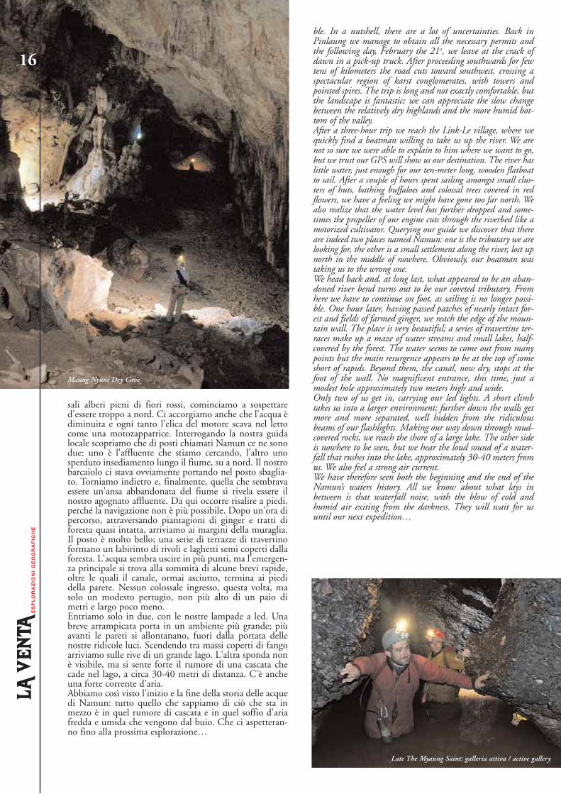
Maung Nyunt Dry Cave
Late The Myaung Saint: galleria attiva / active gallery