may 2012 oracle spatial user...
TRANSCRIPT

1
May 2012 Oracle Spatial User Conference

May 23, 2012 Ronald Reagan Building and International Trade Center
Washington, DC USA

Siva Ravada Director of Development

New Performance Enhancements in Oracle Spatial

Program Agenda
• Introduction • Faster Operators • Improved GeoRaster operations • Router and Geocoder enhancements • Data Management Improvements • Discussion

What are Performance Enhancements ?
• Better utilization of DB resources and new features – Securefiles, compression
• Improved and faster Algorithms for solving problems – Spatial operators
• Tools to improve business workflows – Transportable tablespaces
• Hardware related enhancements – Exadata

7
Securefiles and SDO_GEOMETRY
• The SDO_ORDINATES in the geometry can be stored as securefiles lob CREATE TABLE MAP_WORLD_SEC ( COUNTRY" VARCHAR2(50), CAPITAL VARCHAR2(30), GEOMETRY MDSYS.SDO_GEOMETRY ) VARRAY "GEOMETRY"."SDO_ELEM_INFO" STORE AS SECUREFILE LOB VARRAY
"GEOMETRY"."SDO_ORDINATES" STORE AS SECUREFILE LOB
• Several options for securefiles storage – SECUREFILE LOB (CACHE) – SECUREFILE LOB (CACHE COMPRESS) – SECUREFILE LOB (CACHE COMPRESS HIGH)
8
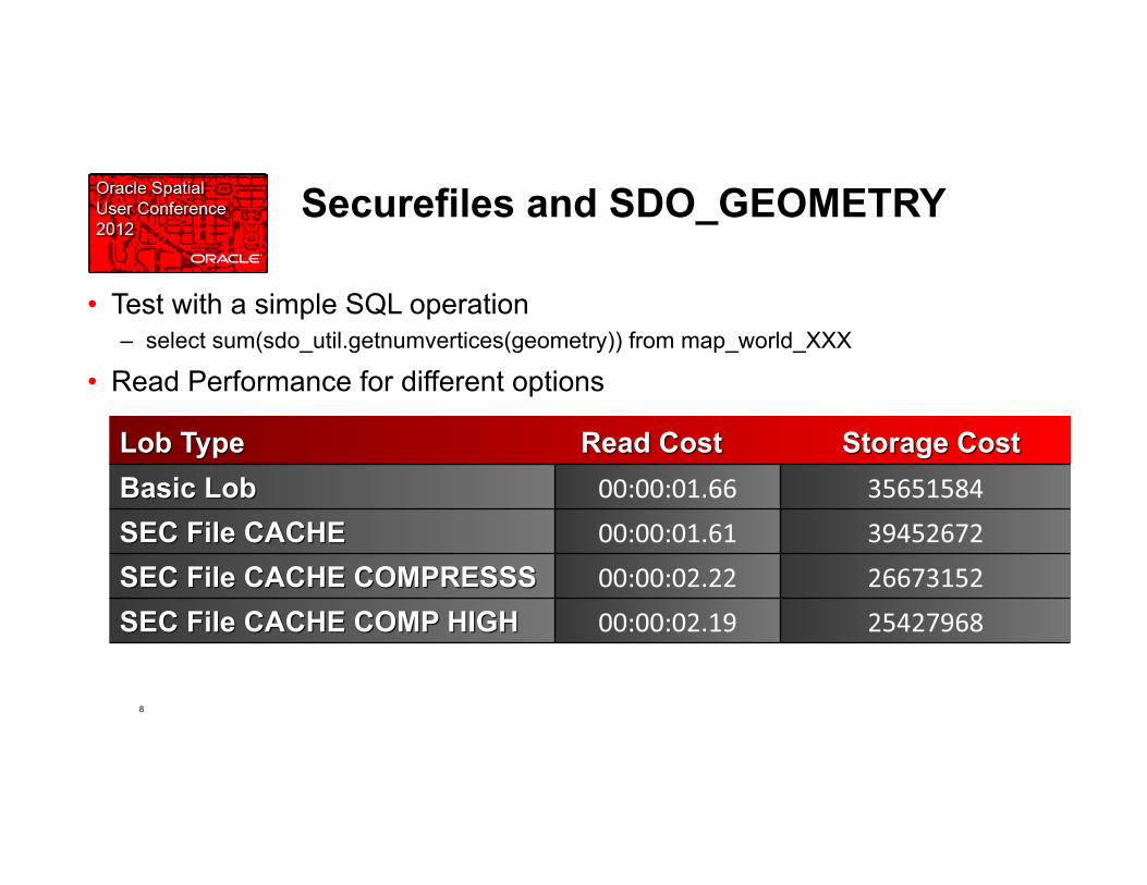
Securefiles and SDO_GEOMETRY
• Test with a simple SQL operation – select sum(sdo_util.getnumvertices(geometry)) from map_world_XXX
• Read Performance for different options

9
How to get the most out of Securefiles for SDO_GEOMETRY
• VARRAY’s have 3 types of storage based on the size and storage options – Always store as a lob (always stored in lob segments) – Store small varrays (less than 4K) inline and store bigger varrays as out of line
lob segments
• When the VARRAY storage is specified explicitly, it always stores it as a lob, even for smaller varrays – Sepcify ENABLE STORAGE IN ROW to make sure inline storage is enabled for
smaller VARRAYs
• Set this parameter in init.ora – db_block_checking=false

10
Securefiles and GeoRaster
• Used the dataset of 50 DOQs to conduct the tests • The results show very good performance improvement of SecureFiles over
BasicFiles : load: 1.16 times faster mosaic: 2.5 times faster pyramiding: 3.3 times faster copy: 4.15 times faster changeFormatCopy: 4.23 times faster subset: 3.4 times faster

11
Redo Log Enhancements
• Problem: Excessive redo generated for DML operations on tables with Spatial indexes – MDRT tables store the index nodes as lobs and these lobs tend to generate lot
of redo
• Several techniques are used to reduce the redo in 11.2.0.3 – Reduce the updates to the index nodes – Delayed write of the index nodes – Better bulk insert/delete algorithm to reduce the number of modified
nodes

12
Redo Log Enhancements
• Improvements with delayed write: 380K rows – Normal Insert 1,509,711,160 07:34.09 00:06.26
Delayed Write 1,246,742,644 06:36.33 00:05.47
• New redo algorithms – New Code : 2,577,576,572 blocks; Elapsed: 00:12:24.92
Old Code : 1,034,054,352 blocks; Elapsed: 00:07:02.97
• Real World proof points – I/O reduced by about 90% for index insert/delete operations – Throughput increased by 50% for DML operations

13
Redo Log Enhancements
• Improvements with delayed write: 380K rows – Normal Insert 1,509,711,160 07:34.09 00:06.26
Delayed Write 1,246,742,644 06:36.33 00:05.47
• New redo algorithms – New Code : 2,577,576,572 blocks; Elapsed: 00:12:24.92
Old Code : 1,034,054,352 blocks; Elapsed: 00:07:02.97
• Real World proof points – I/O reduced by about 90% for index insert/delete operations – Throughput increased by 50% for DML operations

14
Query Processing Enhancements
• Better use of R-tree indexing technology to improve the performance of all operators (in memory R-tree)
• Improve both Geodetic and non-Geodetic operations • Interior tile optimizations in 10.2 is based in quad-tree tiles
– This does not extend well to Geodetic data
• This new approach addresses 4 areas – High performance – Self-tuning ⇒ no user tuning – Small footprint ⇒ high scalability for enterprise users – Handle Earth’s curved surface, poles, equator, international date line

15
Use in memory R-tree in two steps
• MBR (A) is from a R-tree index, either leaf node, or non-leaf node: 1) MBR (A) intersects polygon? 2) MBR (A) is inside polygon?
A

16
• Data Sets – 1: An energy company: 39,000 locations in USA, a query polygon 4 times as big
as Texas, 197,146 line segments – 2: A transportation system: 3 million locations and 30 regions around world as
query polygons: e.g. “Canada/Mountain”, “American/Honolulu”, “Germany”. average: 59,000 line segments, “Norway” 343,395 line segments
– 3: US Business Area data set: 10 million locations • 50 US states, average: 1,755 line segments, “Alaska”” 18,603 line segments; • 1061 local regions, average: 520 line segments, “Long Island”: 6,915 line segments
Query Processing Enhancements

17
Query Processing Enhancements: ANYINTERACT
ANYINTERACT Operator (cartesian)
Data Set 1 Data Set 2 Data Set 3 Data Set 4
10.2 71 7778 935 2158
11.2.0.3 2.44 190 58 64
ANYINTERACT Operator (geode?c)
Data Set 1 Data Set 2 Data Set 3 Data Set 4
10.2 204 20883 2559 11685
11.2.0.3 1.4 88 52 81

18
Query Processing Enhancements: INSIDE/CONTAINS
INSIDE Operator (cartesian)
Data Set A
10.2 12 minutes
11.2.0.3 30 seconds
INSIDE Operator (geode?c)
Data Set A
10.2 22 minutes
11.2.0.3 1 minute
Data set A: Table 1 has 260,520 geometries. Table 2 has 12,795 geometries.
Both tables have polygon geometries.
Experiment: Nested Loop join: 12,795 calls to the operator.

19
Query Processing Enhancements: SDO_WITHIN_DISTANCE
WITHIN_DISTANCE Operator (cartesian)
Data Set
10.2 21 minutes
11.2.0.3 3 minutes
WITHIN_DISTANCE Operator (geode?c)
Data Set with
10.2 2hr 28 minutes
11.2.0.3 4 minute Data set A: Table 1 has 260,520 geometries. Table 2 has 12,795 geometries. Both tables have polygon geometries.
Experiment: Nested Loop join: 12,795 calls to the operator.

GeoRaster Load Performance

21
• GDAL is the best open source geospatial ETL tool/API for raster data – It now natively supports importing and exporting many formats, to/from
SDO_GEORASTER, including GeoTIFF, JPEG2000, ECW, NITF, HDF, NetCDF, ERDAS IMG, USGS DEM, SPOT, and more.
– GDAL is written in C++ and has very good performance – It provides C/C++, Java, Python API for accessing GeoRaster – It provides many tools. Two of the important ones are:
• gdal_translate – utility to translate raster formats to/from GeoRaster objects
• gdalinfo – utility to view information about a raster, such as a GeoRaster object
ETL tool – the GDAL GeoRaster Driver

22
• Loading a 800 MB GeoTiff – File is compressed LZW – Uncompressed size is 5GB – 4 band image
• Loading using GDAL with default blocking (256x256x4) takes … 4 hours!
• Loading with a blocking of (256x256x1) takes 4 minutes! • Most of the time is CPU: used by gdal_translate
Understanding Image Structure

23
• Check the structure of the input TIFF file:
• Image is blocked in very wide and very narrow strips • Very costly for the GeoTIFF driver to collect the pixels to fill
our blocks!
Understanding Image Structure
gdalinfo 129-286.tif
Driver: GTiff/GeoTIFF Files: D:\Files\Data\129-286.tif Size is 42252, 31198 ... Band 1 Block=42252x32 Type=Byte, ColorInterp=Red Band 2 Block=42252x32 Type=Byte, ColorInterp=Green Band 3 Block=42252x32 Type=Byte, ColorInterp=Blue Band 4 Block=42252x32 Type=Byte, ColorInterp=Undefined

24
• GDAL uses little memory by default • Set larger caches using GDAL_CACHEMAX option
• Loading the 800 MB Tiff with a blocking of (256x256x4) now completes in less than 3 minutes!
GDAL and Memory
gdal_translate -of georaster sf1.tif --config GDAL_CACHEMAX 1024 georaster:scott/tiger@orcl111,us_rasters,georaster -co blockxsize=512 -co blockysize=512 -co blockbsize=3 -co interleave=bip -co srid=26943 -co "insert=values (1, 'sf1.tif', 'Aerial photo San Francisco 1', sdo_geor.init('us_rasters_rdt_01', 1),null,null)"

25
• Option 1 – Load and compress, then generate pyramid
• Option 2 – Load, then generate pyramid, then compress the result
• The second option is more efficient
Loading and Compression

Q&A