mcloughlins beach community plan - wellington … beach community plan welcome to the mcloughlins...
TRANSCRIPT

McLoughlins Beach Community Plan
Welcome to the McLoughlins Beach
Community Plan 2009


Vision Statement
“McLoughlins Beach will develop as a seaside holiday village and a key regional boating access point for the waters of the Ninety Mile Beach and Nooramunga Marine and Wildlife Reserve.
Residential Streets will be attractive, incorporate landscaping and provide for safe pedestrian movement. Development will be sustainable and recognise the environmental constraints of the area.
The importance of the area for boating and recreational fishing will be recognised with the provision of appropriate facilities.
The foreshore will provide a focal point for the community and contain high quality facilities for residents and visitors. A pathway network will give safe access to key destinations around the village.”

4
Results of Community Survey Initial survey: 177 sent, 78 returned, 44% Return Rate Items raised were themed and resent for prioritisation. Prioritising survey : 177 sent, 82 returned, 46% Response Rate Summary The McLoughlins Beach community survey shows consistent trends towards retaining the tranquillity and character of the area, protecting the waterways for recreational fishing/boating and limiting commercial activities to maintain these qualities. The role of Government Authorities, their openness/ responsiveness to local issues and better value for rates, feature highly throughout the survey. Retaining and maintaining the existing infrastructure and the addition of a shared pathway linking these areas is a priority, as is the desire to enhance liveability at McLoughlins Beach’s with better electricity supply, telecommunications availability, drainage and control/eradication of rabbits and sandflies. The respondents showed clear indication not to increase commercial and residential development within McLoughlins Beach. Qualities most valued in the community: � The majority of respondents valued the tranquillity of McLoughlins Beach � 22% of respondents valued the water related hobbies (fishing/boating) Community priorities � 27% of respondents want lower rates/ better value for rates and better recognition/communication/consultancy in future decisions or town issues � 14% of respondents wanted better links with authorities and better transparency of responsibility � 15% of respondents want better telecommunications (Mobile & Broadband) Township priorities � The highest response was for no caravan park, about 14%; 6% wanted a caravan park � The next highest response was not to have any commercial subdivision/development with 11% � Fixing the electricity supply/streetlights and power disruptions is important to McLoughlins Beach Environment Priorities � 36% of respondents wanted commercial fishing eliminated. This is the highest single response and a clear priority for McLoughlins Beach � 10% of respondents want residential development restricted to protect the environment/town character � Rabbits and sandflies are a problem to 27% of respondents Recreation Priorities � 40% of respondents wanted safe walking/riding/pram paths around town (20%) and to keep the beach clean and accessible (20%) � The Jetty area upgrade was important to 17% of respondents � A large single item response was to have a salt water hand pump at the fish cleaning table (14%) Infrastructure Priorities � To repair/renew/maintain the Footbridge (21%) and Jetty (19%) made up 40% of the response � Fixing drainage and to eradicate still water to reduce mosquito’s attracted 12% of responses Percentages above 10% 36%- No Commercial Fishing, 33%- Retain tranquillity, 21%- Fix footbridge, 20%- Walking tracks, 20%- Beach access & cleanliness, 19%- Fix jetty, 18%- Lower rates, 17%- Enhance jetty area, 15%- Telecommunications, 14%- Maintain Coastal Parks, 14%- Fix hand pump, 14%- Eradicate sandflies, 14%- No caravan park, 13%- Control rabbits, 12%- Fix drainage, 12%- Enhance playground, 11%- Maintain boat ramps, 11%- No commercial subdivisions, 10%- Restrict residential development, 10%- Fix electricity problems.

5
History of McLoughlins Beach In the early 1920’s up till the early 1960’s, a jetty existed on the foreshore to the west, this jetty was the brainchild of a woman, named Mrs Tess Henderson (Hackenhoff), they were the first people in the Woodside hotel, originally from South Australia. The jetty had a wooden trolley, that users could put all the days equipment on and push it to where they had their boat moored along the jetty, then on return you could stack all your boating gear back on it to push it back to the shore line. The trolley had a frame made out of pipe on the west side, and was rolling on a pair of steel train trolley wheels. At the end of the jetty there was a set of steps going down into the water on the approach side, which were always dam slippery. A big tin wall on the west side acted as a wind shelter for the people fishing on the jetty. People familiar with the old jetty might remember that you would be flat out trying to find two boards on the jetty that were the same width.
Around this time McLoughlins Beach was a very busy fishing village with many boats being moored along the foreshore. McLoughlins Beach also had a hire boat business that operated throughout the sixty’s. The majority of the jetty disappeared in the early 1980’s; today you can see some timbers from the old jetty lying in the mud.

6
Along the foreshore there were many boat sheds. These survived until the late 1970’s. The boat sheds represented just what fishing at McLoughlins Beach was all about, getting together after a days fishing and telling all the story’s of the days catch. These were some of the owners of the boat sheds: Jim Joyce, Ron Rogers, Dal Pozza, Mr Clark, Ernie Peel, Lacandro, Rowley, Joe Drane and Leavy. The foreshore looks very different today, no sign of the boatsheds, none of the hustle and bustle and fishing activities, just a miss placed bus shelter.
Boat sheds on the McLoughlins Beach foreshore survived till the late 1970’s.

7
Settlement Profile McLoughlins Beach is a small holiday and residential settlement adjoining the Nooramunga Marine and Coastal Park located approximately 20 km to the east of Yarram, 11 km off the South Gippsland Highway, around 232 km from Melbourne and approximately 70 km from Traralgon. The village provides access to the Ninety Mile Beach and is highly accessible to residents of the Latrobe Valley. It is bordered by flat to gently undulating cleared farming land, which is part of the coastal plain at the foot of the Strzelecki Ranges. The settlement is adjacent to important regional boat launching and mooring facilities on the sheltered tidal waterways of Nooramunga Marine and Coastal Park. Direct access for fishing in the ocean waters of Bass Strait and the sheltered waters of the Marine Park are conveniently gained from this area. Other forms of recreation access to the most western end of the Ninety Mile Beach are available via a pedestrian bridge across the inlet. This area offers sheltered nature walks, fishing and walking on the ocean beach. The road to the settlement is a sealed no-through road so there is no passing traffic. The access road to the boat ramp passes through the northern half of the settlement. McLoughlins Beach contains approximately 190 standard residential allotments on uniformly flat low lying land and is abutted by wetlands on three sides. Open farming land exists to the west of the settlement. A number of the existing subdivided allotments are within the wetland areas. Approximately 130 houses exist of varying quality and style and range from simple fishing cottages to substantial new two storey dwellings. Most buildings are lightweight framed structures with timber or fibro-cement cladding. There are no commercial facilities within the town. Most roads in the settlement are sealed and have open grassed swale drains. There is no street tree planting in the settlement. The primary recreation areas of McLoughlins Beach are at the southern end of the town. The Ted Jeffs Reserve contains a children’s playground and the Foreshore Park, a toilet, shelter and jetty that extends across the tidal wetlands to the inlet channel. A boardwalk from this area connects to the boat ramp and footbridge.

8
Statistical Information (ABS 2006) A Statistical Snapshot of McLoughlins Beach Population McLoughlins
Beach Total
Wellington Total
Victoria Total
2006 152 40,080 4,932,422 2001 139 39,759 4,660,991 Growth 9.3% 0.8% 5.8% McLoughlins Beach grew by 9.3% between 2001 and 2006. This is faster than the average for Wellington Shire and Victoria. Age distribution
McLoughlins Beach age distribution goes against current population trends. The percentage of under 15’s are increasing and the over 65’s have decreased, both of which goes against current trends for both Wellington Shire and rural Australia
Family Structure Family McLoughlins
Beach Wellington Victoria
Couple families with children 40.5% 41.9% 46.9% Couple families without children 51.4% 42.4% 35.9% One parent families 8.1% 14.7% 15.4% McLoughlins Beach has a lower percentage of single parent families than either Wellington or Victoria Culture / Diversity 78% of people living in McLoughlins Beach were born in Australia compared with 84% of those living in Wellington Shire and 70% of those in Victoria. Income 43% of households in McLoughlins Beach had incomes less than $26,000 pa. This is higher than the overall figures of 25% for Wellington and 19% of residents of Victoria. Employment 56 people in McLoughlins beach were employed (69.5% full time and 15.3% part time). Unemployment was at 5.1% (8.3% in 2001) compared to 5.9% in Wellington and 5.4% in Victoria. Home ownership In 2006 80% of homes in McLoughlins Beach were either owned or being bought, which compares with 72% for Wellington and 69% for the whole of Victoria.
Age 2001 2006 under 15
15.0% 15.9%
Over 65 23.2% 22.77%

9
From the survey results we are working to:
� Repair and retain the jetty
� Repair and retain the footbridge
� Eliminate commercial fishing
� Improve, repair and maintain drainage
� Improve walking tracks
� Maintain and enhance boat ramps, loading jetty and car park
� Enhance jetty area
� Enhance Progress Park

10
Repair and retain the jetty The McLoughlins jetty was first built in the present location in 1967. It was refurbished in 1984, re-decked and a new hand rail fitted in 2008 by Gippsland Ports who recognise this jetty as a boat berthing platform, this jetty provides the only land access at low water to vessels approaching from the direction of McLoughlins Entrance.
In the past, there have been a number of emergencies where the jetty has played an important part in the rescue and recovery operations. Some of these events have included: A snake bite victim was brought into the jetty by boat to a waiting ambulance. A very sick workman from a cable laying ship off shore was brought into the jetty to a waiting ambulance. Tuesday the 13th April 2004 five men in a boat capsized at the entrance, one man drowned. Monday the 17th April 2006 a fourteen year old boy was knocked unconscious and suffered lacerations and abrasions to both hands, after a wave smashed the windscreen of the boat he was in. (see photos below)

11
Repair and retain the footbridge The footbridge, located adjacent to the McLoughlins beach regional boat ramp, was built in the present design in 1972 by the Ports and Harbours Division through a tourism grant. The Wellington Shire is the managers of this infrastructure.
The number of people using this piece of infrastructure is increasing year by year. With greater numbers visiting the area, the footbridge gives the only pedestrian access to the beginning of the internationally recognised Ninety Mile Beach and to McLoughlins Entrance.
This is an established tourism destination for bushwalking, sightseeing, whale watching and for recreational beach fishing.
Many of those who visit are from interstate, overseas as well as many regions of Victoria. These visitors contribute a large amount of money to the local economy (see public survey results)
For McLoughlins beach residents of all ages, this is their only feasible means of access to the surf beach and the surrounding native bushland of the primary dunes and walking tracks.

12
Elimination of commercial fishing
The Nooramunga Marine Coastal Park is located at the Bruthen Creek end of the estuary. This is one of the few remaining estuarine parks where commercial fishing is still permitted.
McLoughlins Beach residents support and would advocate for the elimination of commercial fishing in this area, to ensure sustainable recreational fishing.
Recreational fishermen contribute a large amount of money to local businesses, in their use of accommodation, food, fuel, equipment and support services. (see public survey results)
13
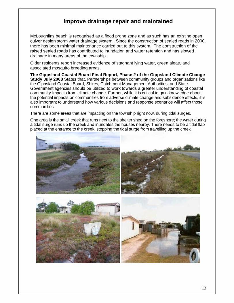
Improve drainage repair and maintained
McLoughlins beach is recognised as a flood prone zone and as such has an existing open culver design storm water drainage system. Since the construction of sealed roads in 2000, there has been minimal maintenance carried out to this system. The construction of the raised sealed roads has contributed to inundation and water retention and has slowed drainage in many areas of the township.
Older residents report increased evidence of stagnant lying water, green algae, and associated mosquito breeding areas.
The Gippsland Coastal Board Final Report, Phase 2 o f the Gippsland Climate Change Study July 2008 States that, Partnerships between community groups and organizations like the Gippsland Coastal Board, Shires, Catchment Management Authorities, and State Government agencies should be utilized to work towards a greater understanding of coastal community Impacts from climate change. Further, while it is critical to gain knowledge about the potential impacts on communities from adverse climate change and subsidence effects, it is also important to understand how various decisions and response scenarios will affect those communities.
There are some areas that are impacting on the township right now, during tidal surges.
One area is the small creek that runs next to the shelter shed on the foreshore; the water during a tidal surge runs up the creek and inundates the houses nearby. There needs to be a tidal flap placed at the entrance to the creek, stopping the tidal surge from travelling up the creek.

14
Improve walking tracks While the McLoughlins Beach township has no recognised footpath system, it has several unconnected sections of walking track serving sections of the surrounding areas. These include the Boardwalk; the footbridge to surf beach and tracks to Reeves Beach and McLoughlins Beaches and McLoughlins Entrance.
At present the shared tracks don’t link up and are very poorly maintained.
The boat ramp road is currently used by many pedestrians returning from the beach or walking a circuit of the township. This section of road carries all boating traffic and is the only section of the township where a speed limit of 80km is permitted.
There is no alternative for residents of the northern section of the township to access the boat ramp, foot bridge or associated tracks other than via this busy road.
Residents support a connection of all the existing sections and an extension of the shared pathway and boardwalk network, to provide a safe and complete circuit of the township which is accessible for people of all ages and all abilities.
NB: The only section of pathway deemed wheelchair accessible is the boardwalk between the jetty and the boat ramp car park. (Check with WSC Access for All Abilities coordinator)
Note: In “The vision for McLoughlins Beach” • Accessibility should be inclusive of all and walkable settlements that allow safe and enjoyable pedestrian movement are desirable. A sense of arrival, effective circulation and way finding are also important features of a settlement. • The foreshore will provide a focal point for the community and contain high quality facilities for residents and visitors. A pathway network will give safe access to key destinations in and around the village and improve access for all levels of mobility

15
Create a network of shared pathways throughout the village.

16
Maintain and enhance boat ramps, loading jetty and car park
For detailed actions refer to Appendix B: Foreshore Restoration & Boat Ramp Enhancement Plan 2008
The McLoughlins Beach boat ramp is an important asset to the McLoughlins Beach community, to the neighbouring coastal communities; and to the economic viability of Woodside and economy of Yarram. Silting from the Bruthen Creek has caused low to medium tide access to the ramp tricky or non existent. This silt requires removal to maintain current levels of accessibility and to deepen the launching area as boats are being damaged due to the large rocks at the end of the ramp. The Ratepayers Association is conducting a boat ramp user’s survey to identify the travel patterns of the visiting fishermen as well as to compile more accurate user data. This data is recorded in Appendix B; the Foreshore Restoration & Boat Ramp Enhancement Plan 2008
Reference- Gippsland Boating Coastal Action Plan 2002
Item 2.17 McLoughlins Beach McLoughlins Beach is an important regional boat ramp that needs some facilities to be constructed to enable it to fulfil that role. It can provide relatively safe access to the ocean for boats up to about seven metres. 2.17.1 Condition Survey There is a good two-lane ramp and jetty at McLoughlins Beach as well as a well laid out gravel parking area and toilets. Extension of car parking is constrained by the surrounding public land. The launching facilities are very popular as they provide the easiest route to the sea for visitors from the Latrobe Valley. There is also easy access to the Ninety Mile Beach via a pedestrian bridge across the inlet. The boat ramp experiences erosion problems which may require extended footings or other on-going maintenance regimes. The channel to the ramp at McLoughlins Beach is narrow and the entrance to the ocean is across a bar that is highly mobile. New day markers have recently been installed in the channel to improve the navigability. 2.17.2 New Facilities Required [WSC, GP, NRE]

17
It is recommended that McLoughlins Beach be maintained as a regional boating ramp and that it be upgraded progressively. The main improvements that should be made to McLoughlins Beach in order of priority are: • Improved lighting of the ramp and car park; • Maintenance to remove scour hole at the end of the jetty; • A fish cleaning table; • A designated boat cleaning area; • Improved picnic and barbecue areas; • An additional jetty (or pontoon) immediately on the western side of the ramps to improve the efficiency of use of both lanes. Safety for boats at sea is a significant issue. Recreational boats regularly have trouble safely traversing the entrance. It is recommended that facilities be provided at McLoughlins for storage of a rescue boat and other necessary equipment. The Royal Volunteer Coastal Patrol supplies a comprehensive search and rescue service at Port Welshpool and at Port Albert. They work in conjunction with the Gippsland Water Police based in Paynesville. A safe precaution would be to have some of the local SES or fishermen trained in emergency procedures so that a quick response to any marine accident can be mounted. A targeted education program on safe crossing of sand bars and regular checking of boat equipment would also assist.
Reference to Robertsons Beach and Manns Beach is al so included to show the importance of McLoughlins as a Regional Boating fac ility:
2.15 Robertsons Beach Robertsons Beach is a small local facility suitable only for small boats. 2.15.1 Condition Survey There is beach launching at Robertsons Beach and limited car parking. There are some difficulties with encroachment of the parking onto private land. 2.15.2 New Facilities Required [PV] No public funding should be spent to improve facilities at Robertsons Beach. Any available funds would be better spent on improving conditions at McLoughlins Beach. It should be noted that this is not in accordance with the Corner Inlet and Nooramunga Marine and Coastal Parks: Draft Management Plan (Parks Victoria 1997) which recommends: ‘Formalise boating access at Robertsons Beach and rationalise the non-formalised boat ramps (e.g. Shellcotts Beach)’. A study should be undertaken to investigate alternative sites that will not damage salt marsh communities. 2.16 Manns Beach Manns Beach is a small local facility suitable only for small boats. 2.16.1 Condition Survey There is a small ramp and jetty as well as some swing moorings at Manns Beach and limited car parking. The facilities are larger and better than at nearby Robertsons Beach. 2.16.2 New Facilities Required As with Robertsons Beach, it is recommended that no public funding be spent to improve facilities. Any available funds would be better spent on improving conditions at McLoughlins Beach.

18
Enhance Progress Park
Progress Park is located on the McLoughlins beach road opposite the boat ramp road. This park is approximately 5000 sq meters, at the moment consists of some small and large shrubs and some grass open area. A public notice board and a concrete pipe acting as a bus shelter are the only structures on this site.
Progress Park in RED

19
The proposed plan for this site is to have a: • Bus parking and trailer car park area. • Bus shelter. • Telstra phone box. • Australia post letter box. • Rotunda • Table and bench seating. Note: Electric BBQ’s will not be provided without toilet facilities within Progress Park.
Proposed plan for “PROGRESS PARK”

20
Enhanced jetty area Within the village the primary focus is the foreshore at the southern end. The jetty, board walk and foreshore are all significant day visitor attractions. The infrastructure and development of the foreshore are in need of upgrading and do not provide an attractive community area. The existing toilet was first built in 1967 and is located in the jetty car park, the majority of this building is cream brick, water is sauced via a bore pumping into a header tank, this water services two female pans and one male pan, a urinal block and hand basin. This toilet block utilises an in ground septic system. The public shelter also located in the jetty car park on the foreshore, has four picnic tables inside. This shelter is also used by the local fishing club and the Residents and Ratepayers Association to hold their meetings.

21
FURTHER THINGS WE ARE WORKING TOWARDS
� LIMIT LOCAL TRAFFIC SPEED TO 40 KM/H IN TOWNSHIP � INSTALL A HAND PUMP AT THE BOAT RAMP FISH CLEANING TABLE � NO COMMERCIAL SUBDIVISION / RESTRICT RESIDENTAL DEVELOPMENT � RETAIN THE TRANQUILLITY OF MC LOUGHLINS BEACH � NO CARAVAN PARK � BETTER LINKS WITH AUTHORITIES � BETTER TELECOMMUNICATIONS � MAINTAIN COASTAL PARKS � RABBIT CONTROL � FLOOD MITAGATION DUE TO CLIMATE CHANGE AND COASTAL SUBSIDANCE

22
Limit local traffic speed in township 40 km/h
The speed through the township is 50 kph with the boat ramp road at 80 km/h. The community highly value the tranquillity of McLoughlins and value the safety of its children and elderly. The township needs to be covered by a LOCAL TAFFIC PRECINCT, reducing the speed limit throughout the town to 40 kph, with additional traffic control devices. • Speed control device at the entrance to McLoughlins Beach • Roundabout at the McLoughlins beach road and the boat ramp road intersection. • Speed control device at Seaward Street and McLoughlins Beach road intersection. • Speed control device near the bend on the McLoughlins Beach road, towards the jetty. The community are seeking, a connecting shared pathway network around the township, linking up all focal point throughout the township.
Boat ramp road showing 80 kph, where there is no shared pathway beside the road.

23
Climate Change, Sea Level Rise and Coastal Subsidence Along the Gippsland Coast
Simulation of Coastal Subsidence and Storm Wave Inundation Risk in the Gippsland Basin. (CSIRO Petroleum Report 07-003 November 2007)

24
Gippsland Coastal Board Final Report, Phase 2 of the Gippsland Climate Change Study July 2008
Summary of action needed
Controlling new development The Board recommends planning and management tools that ensure new development does not occur in areas likely to be vulnerable to sea-level rise increased coastal erosion or coastal subsidence. This may involve proclamation of a statutory sea level rise or erosion setback from the coast which could be depicted as an overlay and/or other appropriate development control in municipal planning schemes.
Local government will therefore need considerable support from the state and federal governments to enable adequate planning and risk management tools to be incorporated into decision-making frameworks.
Planning for the effects of sea-level rise and subs idence Planning authorities need to work on the basis that towns and infrastructure will be seriously affected in the future. For instance, a significant town like Lakes Entrance is likely to be inundated, along with the Princes Highway that runs through it. The options for any particular situation are to:
• do nothing • plan for gradual retreat from affected areas • accommodate the change • protect or defend against the effects of the change. The preferred option will be different for different parts of the coast.
Continuing research and collecting of data Our understanding of the effects of sea level rise and subsidence needs to be improved by collecting and evaluating more data and by refining the models themselves. In particular there is a need for:
• continued improvement of climate change and sea level rise models
• continued improvement of subsidence models
• continued improvement in modelling of the combined effects of sea level rise and subsidence
• more detailed geological survey information
• more detailed topographic data.
Adapting management as new information becomes avai lable In the situation we are in, where the processes involved are still not completely understood and where there are significant gaps in the data, it is important to remain flexible and to adjust responses as knowledge of climate change and subsidence, and their effects, improves. The current coastal planning and management regime can be inflexible and slow to respond to new information as it relates to climate change and coastal subsidence. While it is critical to apply the precautionary principle in plan

25
Location Asset or site Threat
Port Albert
Port infrastructure - including jetties, buildings and ramps
Increased water levels, flooding and increased wave energy and currents
Foreshore areas Increased erosion and inundation of low-lying areas
Historic port sites / buildings
Increased flooding
Storm water outfalls Decreased capacity or efficiency due to increased water levels or inundation by sand
Seawalls Elevated water levels -accelerated decay of seawalls
Robertsons Beach and Manns Beach
Foreshore areas and nearby dwellings
Increased erosion and inundation of low-lying areas
Stormwater outfalls Decreased capacity or efficiency due to increased water levels or inundation by sand
On-site domestic wastewater management (septic
Increased flooding
Boat ramp (and jetty) Erosion and/ or sand inundation
McLoughlins Beach
Foreshore areas and nearby dwellings
Increased erosion and inundation of low-lying areas
Road access Increased flooding
Understanding implications Government at every level needs to make a concerted effort to understand the implications of adverse climate change effects on communities. Economic impacts could be far-reaching, not to mention the social issues that will arise from the loss of infrastructure, amenities, homes, and both indigenous and non-indigenous heritage assets.
Partnerships between community groups and organizations like the Gippsland Coastal Board, shires, Catchment management authorities, and state government agencies should be utilized to work towards a greater understanding of coastal community Impacts from climate change. Further, while it is critical to gain knowledge about the potential impacts on communities from adverse climate change and subsidence effects, it is also important to understand how various decisions and response scenarios will affect those communities.

26
RECOMMENDATIONS
The Coastal Board report makes the following recommendations:
1. That the necessary decisions be made by the state and federal governments to provide a clear policy direction for dealing with anticipated climate change, sea level rise and subsidence effects. 2. That the Gippsland Coastal Board take the lead role in:
• facilitating further research into potential effects of climate change and coastal subsidence on the Gippsland coast
• facilitating the acquisition of data needed for the further research
• understanding the socio-economic implications of climate change on Gippsland coastal communities
• increasing community awareness of the potential effects of climate change on the Gippsland coast.
3. That local government and the Department of Planning and Community Development take the lead role in:
• developing the land use planning policies - including new overlays, statutory sea level rise setbacks or erosion setbacks - that are needed now to cater for future sea level rise and subsidence along the Gippsland coast
• encouraging innovative responses to climate change threats.
4. That local government is provided with the necessary assistance from the state and federal government to deal with the difficult planning, social and economic issues that may result from climate change threats and the responses to those threats!
5. That the state government gains a methodical understanding of the economic, social and cultural values of physical and natural assets that may be lost along the coastline due to adverse climate change effects.

27
McLoughlins Beach Community Plan Rabbit Reduction Strategy Vision: McLoughlins Beach community has reduced rabbit numbers using a coordinated approach to pest management between urban property owners, rural land holders and pest management agencies. Background: McLoughlins Beach Residents and Ratepayers Association conducted an extensive survey of urban property owners in 2007 as part of the Wellington Shire Community Representative Group process. This process aims to widely engage with community members/property owners to build community owned strategies to a list of broad community priorities. The two stage survey process received an average return rate of 45%, receiving on average 80 responses from the 177 sent. While the most common responses relate to maintenance/renewal of recreational infrastructure, the top 10 responses include the eradication of rabbits. McLoughlins Beach Rabbit Reduction Strategy 2010-13 Aim: Develop a community driven program to reduce rabbit numbers Objectives: 1. Partner with pest management agencies 2. Adopt best management practices 3. Identify resources available 4. Utilise an ‘all in’ neighbourhood approach 5. Use various management methods concurrently 6. Continue program for 3 years Actions: Identify key community persons to:
• Develop a ‘program’ to implement the strategy • Take community ownership of the program • Communicate the Best Management Practices • Identify community resources available • Identify resources needed • Develop monitoring tools to measure the strategies success • Develop succession to the program
Implementation: The key drivers will:
• Encouraging the whole community to participate in the program • Partnering with Pest Management Agencies • Administer the program
28
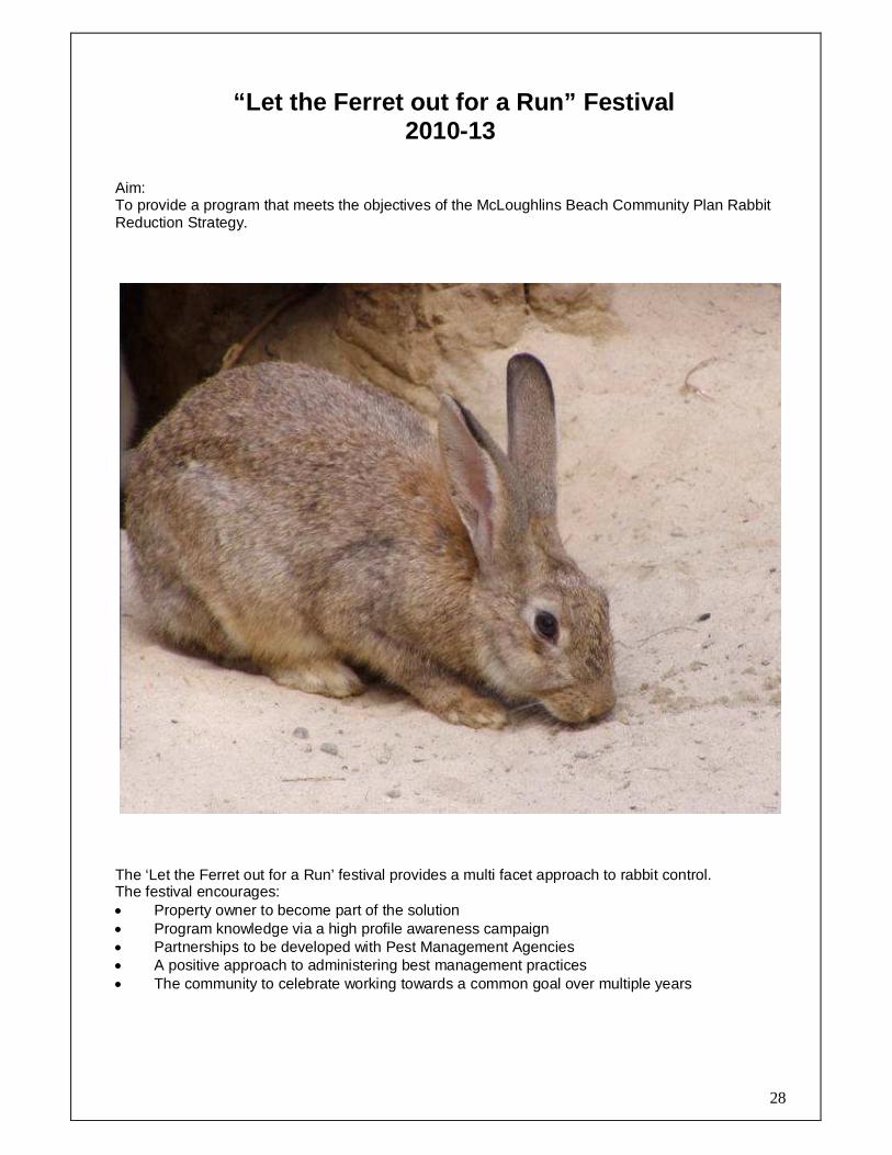
“Let the Ferret out for a Run” Festival 2010-13
Aim: To provide a program that meets the objectives of the McLoughlins Beach Community Plan Rabbit Reduction Strategy.
The ‘Let the Ferret out for a Run’ festival provides a multi facet approach to rabbit control. The festival encourages: • Property owner to become part of the solution • Program knowledge via a high profile awareness campaign • Partnerships to be developed with Pest Management Agencies • A positive approach to administering best management practices • The community to celebrate working towards a common goal over multiple years
29
APPENDIX A
What is a Community Plan?
A Community Plan is a written document produced by a community which identifies and addresses the broadly held social, physical and economic priorities of that community. Additionally it identifies actions to be taken and a responsible coordinator for each action.
Why do we need a Community Plan? A Community Plan enables communities to plan for their future; it provides the basis for the community to work with Council and other Government and non government organisations for funds or support as well as increasing the capacity, ownership, trust and co-operation of the community.
Objectives of a Community Plan The principal of a good community planning process is to provide for broad community representation that reflects the priorities of the community. The objectives of a community plan are to: • Give your community direction or focus; • Consider wider issues than normal; • Develop the capacity to work together; • Build community spirit and cohesion; • Develop communication links with local Government; • To achieve broad community representation in decision making
Benefit of community planning A sound and properly implemented Community Plan should improve your community’s social & economical growth prospects. Sound plans encourage: • Proper selection of community desires; • Discovery of your strengths and weaknesses, thus allowing you to focus in areas of opportunities; • Efficient use of scarce resources; • Improved cooperation with Government bodies; • Sustainable growth of your community structures; • Better understanding of planning; • More cohesive community
While the community plan itself cannot cause change, it is a powerful tool for creating an environment in which change can take place.

30
APPENDIX B
FORESHORE RESTORATION
AND BOAT RAMP
ENHANCEMENT PLAN 2008
Developed by: McLoughlins Beach Residents & Ratepayer Association Inc

31
FORESHORE RESTORATION AND BOAT RAMP ENHANCEMENT PLA N 2008 McLoughlins Beach Residents and Ratepayers Association Inc Incorporation No: A0014169M Project manager Trevor Morey Project team members Colin Coleman John Maxwell The aim of this plan is to outline the communities preferred options for: - Facility maintenance and upgrades - The removal of sediment - Environment restoration and protection of the McLoughlins Beach Boat Ramp area, via collaborative and cooperative facility management practices with the relevant governing authorities. The Residents and Ratepayers Association see their role in guiding and implementing this plan, is to:
• Support grant applications • To be incorporated in the early design • To be consulted at all stages of the implementation of this plan • To have a team member involved during the construction stage
The Residents and Ratepayers Association see that t hese guidelines need to be in place so that there is a smooth imple mentation of this plan.
32
Vision :
McLoughlins Beach is a premium regional boating destination due to the developed culture of environment protection harmonising with the needs of
recreational fishermen Aim: To outline the communities preferred options for- - Facility maintenance and upgrades - Environment restoration and protection of the McLoughlins Beach Boat Ramp area, via collaborative and cooperative facility management practices with the relevant governing authorities Objective: To describe the options preferred by the community of McLoughlins Beach to enhance and protect the coastal environment while managing the increased pressures on the recreational fishing infrastructure within the structure of the McLoughlins Beach Community Plan Supporting Information: The Gippsland Boating Coastal Action Plan identifies; McLoughlins Beach as a Regional Boat Ramp and should be maintained for safety and recreational purposes; it notes, that no public funds should be spent at neighbouring ramps, funds would be better spent at McLoughlins Beach as it services the inlet communities of Manns Beach, Robertsons Beach and is the easiest route for sea visitors from the Latrobe Valley (Pop. 71,000). The McLoughlins Beach Residents & Ratepayers Association is conducting a McLoughlins Beach Boat Ramp Users Questionnaire aimed at discovering who is using the facility and where they are travelling from to gain a better understanding of what pressure is being placed on the McLoughlins Beach Boat Ramp from recreational fishermen. The survey results received over a two week period, Table 1, shows significant boating facility use from outside the Yarram area, the length of stay, type of accommodation and frequency of visit. The data highlights that 50% of vessels launched are 5m in length or greater. Currently, because of sedimentation, a sand bar has developed at the end of the ramp precluding the launching of trailer craft in excess of 5 metres in length apart from a short period of time either side of high tide. Even boats of approximately 4m have difficulty getting to the adjacent channel at half tide or below. A large number of people from outside the area use the ramp and inject a considerable amount of money into the local communities. Accessing the inlet will be severely reduced if the boat access to/from the ramp is not improved and visitor numbers would be expected to rapidly diminish as word spreads about the inlets access issue. The “Seachange” phenomenon contributes to the ageing of the population. With an increase in the ageing population taking up recreational fishing, and the increasing number of disabled anglers wanting to fish in this area, there is a much greater need, to place a high priority on upgrading the infrastructure at McLoughlins Beach boat ramp. As many visitors stay weekends in Caravan Park accommodation, the impact of reduced access to the McLoughlins Beach boat ramp and poor quality infrastructure may cause an economic downturn for businesses that require this type of ‘off-peak’ business to survive.
33
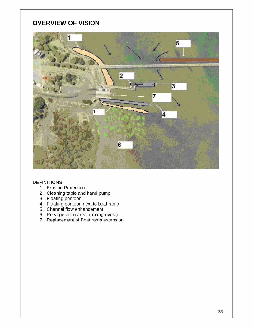
OVERVIEW OF VISION
DEFINITIONS:
1. Erosion Protection 2. Cleaning table and hand pump 3. Floating pontoon 4. Floating pontoon next to boat ramp 5. Channel flow enhancement 6. Re-vegetation area ( mangroves ) 7. Replacement of Boat ramp extension

34
AREA 1 Foreshore Erosion Protection This area has seen erosion protection in the form of blue stone ballast; this kind of ballast is very unstable and has been disrupted by children exploring for small marine life or seeking crabs for fishing and have been washed into the channel by the current, resulting in it no longer providing effective erosion control. The ballast has also been used to smash the solar panels and causes damage to boats during loading/launching at moderate tide levels. A more effective type of material like COLLAPSIBLE BLOCK MATTRESS SYSTEM, a product from Foreshore Protection Pty Ltd should be considered as a more appropriate type of erosion control as it will not negatively affect other areas of the boat ramp, damage boats or be used to smash the solar lighting panels. This will help to enhance the usability of the ramp and lower ongoing maintenance costs.
AREA 2 Cleaning table and hand pump This area will be a 3.6 meter extension to the upper platform of the loading jetty, built with an aluminium mesh floor allowing water and fish waste to pass through, making the area non-slip. It would be possible to reuse the material from the lower landing when it has been removed. Figure 1- The existing cleaning table is currently located on the timber loading jetty. Fish waste and water accumulate on the timber beneath the table, making it very slippery and dangerous for the public. A number of people have already slipped over and injured themselves; some of these accidents have been recorded with the Shire of Wellington. Figure 2- The proposed location for the new cleaning table, would be adjacent to the top landing on the loading jetty. Figure 3- Aluminium mesh would be used for the floor in the cleaning area, allowing water and fish waste to pass through into the water below, providing a very safe non slip area for people to work on, whilst they clean their fish. Figure 1 Figure 2
Figure 3

35
AREA 3 Floating Pontoon Disabled users within angling clubs and the general public find it almost impossible to use this current facility. We have seen an increase in accidents as people attempt to get in or out of their vessels. With an ageing population and the need for disabled users to have access to the sport of recreational fishing this floating pontoon allows for the disabled, the elderly and young children to access their vessels with a great deal of safety. Another advantage of a floating pontoon is the lesser likelihood of damage to vessels.
AREA 4 Floating Pontoon next to boat ramp This proposed floating pontoon will be sited on the south side of the boat ramp. Due to the high level of usage this regional boat ramp receives, there is a need for this extra pontoon. This will allow vessels to use both ramps in safety, also increasing the efficiency of launching and retrieving vessels.

36
AREA 5 Channel Flow Enhancement The channel in the area of the boat ramp is silting up due to sand moving down from the upper reaches of the Bruthen creek. This problem increases when a high volume of water comes down the Bruthen creek washing sediment into the channel. Currently, at low tides, the channel beyond the boat ramp is non-navigable, limiting the use of the ramp. Proposed wall to be constructed as shown in the overview below (Number 5.) An increase in water flow past the boat ramp channel will flush out the sediment and reducing the volume of sand deposited thereby reducing the subsequent need for regular expensive maintenance. This proposal has the support (and has been advocated by) VicPol (SAR), Coastguard and SES. SEDIMENTATION REMOVAL Currently, because of sedimentation, a sand bar has developed at the end of the ramp precluding the launching of trailer craft of all sizes, apart from a short period of time either side of high tide. This sediment build up reaches all the way across to the main channel leading down the estuary. This sediment needs to be removed, greatly improving access for recreational boats, and emergency vessels. The removal of this sediment between the end of the boat ramp and the channel will require a long reach excavator or dredging equipment, sediment being removed needs to be placed in another area away from this site, so that it would not simply wash back into the channel, as would happen if the spoil was simply deposited beside the dredged area. This spoil would also affect the inter-tidal flora and fauna if dumped adjacent to the site. (Over view)
The spoil that is removed from the channel could be placed, at the new proposed day car parking area. (See FUTURE WORKS NEEDED). Along the foreshore towards the jetty or in the town, where there are some local building blocks that need to be raised. Also spoil could be placed along the North side of the boat ramp road (see photos below) This would create a wider shoulder that would be used as a shared pathway, making it a lot safer for the community to walk to the boat ramp and surf beach. This shared pathway, would link up with the boardwalk at the south end of the township along the foreshore, making a safe walking loop in the town. Looking East to the boat ramp Looking We st into the town Boat ramp road shared path way

37
AREA 6 Re-vegetation area This area will be re-vegetated to prevent silt and sand from washing into the navigation channel and the deep water area adjacent to the floating pontoon. The area to be re-vegetated is approximately 576 sq meters. It is proposed that the area will be planted with native mangroves, indigenous to and harvested from the local area.
38
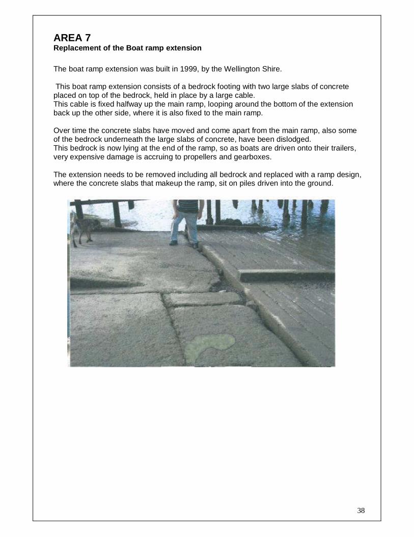
AREA 7 Replacement of the Boat ramp extension The boat ramp extension was built in 1999, by the Wellington Shire. This boat ramp extension consists of a bedrock footing with two large slabs of concrete placed on top of the bedrock, held in place by a large cable. This cable is fixed halfway up the main ramp, looping around the bottom of the extension back up the other side, where it is also fixed to the main ramp. Over time the concrete slabs have moved and come apart from the main ramp, also some of the bedrock underneath the large slabs of concrete, have been dislodged. This bedrock is now lying at the end of the ramp, so as boats are driven onto their trailers, very expensive damage is accruing to propellers and gearboxes. The extension needs to be removed including all bedrock and replaced with a ramp design, where the concrete slabs that makeup the ramp, sit on piles driven into the ground.

39
Future works needed
The boat - trailer preparation areas and the day parking area need to be re-designed, the trailer parking area needs to be sealed and marked to maximise the number of tailers that can park there. It is recommended that the day car parking area be relocated to a separate area to the north of the current location. This will permit the current area to be better utilised as a boat-launching preparation area, removing the problem of a vehicles using the launching area as a preparation area, which dramatically slows the launching and retrieval of vessels, adding to the frustration of boaters. Traffic flow and safety will also be enhanced. (Refer to detailed plan)
Many days during the fishing season both car parks fill to capacity and the overflow spill onto the road side, or anywhere they can find a spot to park. This just adds to the frustration to what should be a nice enjoyable days boating. We have seen an increase in ramp rage at this boat ramp, which is directly linked to the poor infrastructure found here.

40
The boat ramp at McLoughlins beach was designed to cater for recreational boats up to 7 metres. The infrastructure in this area consists of a gravel car and trailer parking area, toilet facilities, solar lighting, loading jetty and a dual concrete ramp. There is an urgent need to upgrade many of these facilities to a standard that truly reflects the high usage rate that this ramp receives.
A large number of people from outside the area use the ramp and inject a considerable amount of money into the local communities. Accessing the inlet will be severely reduced if the boat access to/from the ramp is not improved and visitor numbers would be expected to rapidly diminish as word spreads about the inlets access. In additional to recreational boat use the McLoughlins Beach ramp is also used by emergency services in the event of any accident in the eastern end of the Nooramunga coastal and marine park, on the ocean bar leading out of the inlet or in Base Strait.

41
Trevor Morey President McLoughlins Beach Residents & Ratepayers Association 1 Alexandra Ave Somers VIC 3927 RE: Erosion & sedimentation along Bruthen Creek - An Overview Dear Trevor, After we talked about the problem at the McLoughlins Beach boat ramp I discussed the
sedimentation of Bruthen Creek with Mal Gibson, Operations Manager, with WGCMA, a
summary of this discussion follows.
Since settlement, land clearing, agricultural use and farming practices created an enormous
amount of erosion that has lead to a build up of sand/sediment in Bruthen Creek.
Early attempts to stabilise the banks was done by planting willows along the creek. Their
invasive growth habit and dense root mat decreased the water channel and gave rise to
extensive flooding over adjacent farmland during periods of peak flow.
Recent stream restoration works including extensive rock works at the heads of the various
tributaries, fencing out of stock, willow removal and replanting the banks with indigenous
vegetation. This work has stabilised the banks and headwaters and there is currently no
active head erosion.
A small amount of sand is being removed from the lower reaches of Bruthen Creek below
Yarram but a “slug” of sand and silt is making its way down the creek into Corner Inlet at
McLoughlins Beach and is expected to continue for an estimated 75 years before the
waterway is finally stabilised.
If I can be of any further assistance don’t hesitate to contact me.
Regards
Peter Peter Newgreen Project Officer Capable Coastal Communities

42
MEMO
TO McLaughlins Beach Progress Association
FROM K. CANTLE Inspector
FILE NUMBER
5SLC 080
DATE
5 August 2008
Improving access at the McLaughlins Beach boat ramp. I am the Inspector in Charge of all police services in the Wellington Police Response area which incorporates Mc Laughlins Beach. I have perused the project report on improving the water access at the Mc Laughlins Beach boat ramp. I fully support the need for easier access to the water at this location. During emergency marine events in the vicinity of this location the boat ramp is used by members of the Gippsland Water Police with support from the local Coast Guard, SES and surf life saving clubs. The current situation at the ramp restricts the size and type of vessel utilised by Victoria Police in responding to emergency situations. The improved access will allow emergency responders greater flexibility in the type of vessel deployed which could have an effect on the outcome of the emergency situation. Should you need further information please do not hesitate to contact me.
Wellington PSA Inspector, Division 4, Region 5 58-60 York Street Sale. 3850 DX 218582 Telephone 5143 5070 Facsimile 5143 3464
Tick appropriate box
Attention
Advice/Comments
Approval Please
Approved
Attach to file
Circulate
Comment
File
Information
Note and Return
Please see me

43
President Secretary
Charlie Crutchfield Naomi Scicluna
To Whom It May Concern: Re: Upgrading and improving the safety operations of the McLoughlins Beach boat ramp facilities.
We, as members of the Maffra Angling Club, would like to participate in the push for upgrading the facilities for the handicapped and also the safety of our members for safe boating. We have approximately 180 members and about 70 of these were regular users of this boat ramp. Our older members no longer use this facility because of the poor access to step into a boat off the old ramp. Further more, we have members with a disability who find the facilities at this existing boat ramp unusable and no longer go there to fish. We feel that the Wellington Shire is letting us down as a community in not recognising this ongoing problem. As a community Club, we feel that the upgrading of the McLoughlins Beach boat ramp facilities should be of the highest priority, making this boat ramp safe and user friendly, particularly for the elderly and those with a disability. Julie O’ Brien Treasurer – On behalf of the Maffra Angling Club
PO Box 403 Maffra 3860
President: Charlie Crutchfield 51472435
Vice President: Ron Bedggood
Secretary: Naomi Scicluna 0403566829 Treasurer: Julie O’Brien 51472838
Wet-Mac Editors: Tony & Nikki Wozniak 51411735

44

McLoughlins Beach 2008 boat ramp users
Postcode Town Visitation Frequency Length of stay Accom type
Facility adequacy comment
Boat size
(meters) Improvement Suggestion
1 3015 Spotswood 15 times a year Holiday House 3.2 pontoon jetty for ageing people
2 3051 Nth Melbourne first time day trip Holiday House No please dredge the ramp it is too shallow
3 3057 Brunswick Monthly Weekend Holiday House 5.3 More Berthing Space
4 3071 Thornbury Fortnightly Weekend Friend No 5.8 deepen boatramp area
5 3076 Epping Most weekends Weekend Caravan Park No 5.8 Clean extention to boat ramp, deeper channel
6 3084 Viewbank Area Monthly Weekend Holiday House No 5.4 Add a second jetty to better service second ramp
7 3084 Viewbank Area Fortnightly Weekend Holiday House Yes 3 rubbish clean up, rocks removed, blue stone levy wall, walking track from town to boardwalk
8 3084 Viewbank Area Fortnightly Weekend Holiday House Yes 3 promoted better on TV and other tourist attractions
9 3146 Glen Iris Fortnightly Weekend Holiday House Yes 4.9 don’t need to do anything
10 3156 Ferntree Gully Fortnightly Weekend Holiday House No 4.3 dregde chanel from baot ramp, floating dock
11 3156 Ferntree Gully Fortnightly Weekend Holiday House No 7.1 pier to high at low tide/low at high tide, flexible pole between ramps-damaged when reversing
12 3175 Dandenong 10-15 Times a Year Weekend Caravan Park No 14.2 Another Floating Jetty, Dredge Channel
13 3175 Dandenong weekly Weekend Holiday House No 4.3 need floating ramp
14 3177 Doveton weekly Weekend Holiday House No 5 floating jetty
15 3197 Patterson Lakes Regularly Weekend Caravan Park No 5.8 deeper channel to entrance, easier acces to board baot, clean up mud around ramp
16 3340 Bacchus Marsh Every 2nd Weekend Weekend Holiday House No 5 deeper channel , boat washing
17 3352 Ballarat district 4 times a year Weekend Yes Remove sand from baot ramp
18 3356 Sebastopol 5 times a year Weekend Caravan Park No floating ramp, remove sand
19 3356 Ballarat district 3 times a year Weekend Yes Remove sand from baot ramp
20 3364 Cabbage Tree 2 time a year Weekend No 4.4 floating ramp
21 3480 Donald 10 times year Day trip Yes 4
22 3754 Doreen 10 times a year Weekend Caravan Park No floating jetty, remove sand, make deeper
23 3799 Warburton Holdiays/ fortnightly Weekend Holiday House Yes 5.8, 3.4
24 3820 Warragul Fortnightly Weekend Holiday House Yes 5.2 Stop inside netting and trawlers
25 3820 Warragul 15 Times a Year Day/Weekend Caravan Park Yes 6 Slightly longer jetty so can pull boat up or drop off driver of car
26 3820 Warragul 1-2 a month Weekend Holiday House Yes 5 bigger launching bay
27 3820 Warragul every 2nd weekend Weekend Holiday House Yes 5
28 3825 Latrobe Valley Monthly Day/Overnight Friend No 6 Improve Ramp, Floating pontoon, deepen channel
29 3825 Latrobe Valley weekly Weekend Caravan Park Yes 6 boat ramp at long jetty
30 3825 Latrobe Valley now and again day trip f No 6 dredge chanel, floating ramp
31 3825 Latrobe Valley all sumer Weekend Caravan Park No 6 extend boat ramp, dredge around ramp and pier
32 3825 Latrobe Valley Fortnightly day trip No 6 deeper chanel at ramp
33 3840 Latrobe Valley Weekly (season) Day Trip No 3.9 Floating Pontoon , new jetty, deeper channel
34 3840 Latrobe Valley Fortnightly Weekend Parents House No
35 3842 Latrobe Valley 12 times a year Day trip No 4.45 floating pontoon, new ramp, wider/deeper channel

46
36 3844 Latrobe Valley 3-4 time year Day trip No 3.4 improve baot ramp, mooring facilities, improve fish cleaning facilities
37 3844 Latrobe Valley 6 times a year Overnight Holiday House No 3.9 deeper channel at boat ramp
38 3844 Latrobe Valley 20 times a year Day trip No 4 more jetties on western side of ramp
39 3844 Latrobe Valley 20 times a year Weekend Holiday House No 4 dregde channel
40 3844 Latrobe Valley once a month Day trip Friend No 4 deeper channel, bigger jetty
41 3844 Latrobe Valley 20 times a year Overnight Holiday House No 4.2 better boat launching facilities
42 3844 Latrobe Valley 15 times a year Day trip No 4.4 relocated boatramp to jetty area
43 3844 Latrobe Valley twice a week Overnight Caravan Park No 4.4 longer wider jetty
44 3844 Latrobe Valley Twice a year Day trip No 4.5 deeper channel
45 3844 Latrobe Valley 6 times a year Day trip No 5 improve boat ramp, deepen channel, better channel markings
46 3844 Latrobe Valley Every weekend Holiday House No 5 not enough water to launch baot
47 3844 Latrobe Valley 15-20 times a year Day trip No 5.2 angle of ramps not enough
48 3844 Latrobe Valley 10 times a year Day trip No 5.35 floating jetty, deeper channel
49 3844 Latrobe Valley 12 times year Day trip No 5.4 deeper channel, better jetty
50 3844 Latrobe Valley Once a week Overnight Holiday House No 5.5 new jetty, deepen channel
51 3844 Latrobe Valley Every weekend Day trip No 5.7 floating ramp
52 3844 Latrobe Valley Fortnightly Weekend Caravan Park No 5.7 deepen boatramp area
53 3844 Latrobe Valley 6 times a year Day trip No better mooring at jetty, lights on beacons
54 3844 Latrobe Valley once a month Day trip Friend No better/deeper jetty
55 3844 Latrobe Valley Day trip Yes 3 jetty for tinny at boat ramp, clean sand
56 3844 Latrobe Valley Day trip Yes 3.5 sand from boat ramp, floating jetty for small boats
57 3844 Latrobe Valley 24 times a year Weekend On boat Yes 4.4 channel needs to be deepened
58 3844 Latrobe Valley Weekend Holiday House Yes 5 S bend channel markers
59 3844 Latrobe Valley Weekend Holiday House Yes 5.2 sand removed from boat ramp, floating jetty for wheelchair fishermen
60 3844 Latrobe Valley 15 times a year Day trip Yes 6.5 channel needs straightening and deepening
61 3844 Latrobe Valley Weekly clean out boat ramp
62 3844 Latrobe Valley 40 times a year Day Trip No 4.5 Floating pontoon, jetties either side of ramps, more boat friendly boat morings
63 3844 Latrobe Valley 20 times a year Day trip No 4.25 Floating Jetty
64 3844 Latrobe Valley 6 times a year Day trip Other No 5.35 Floating Jetties, boat cleaning area, channel deepened
65 3844 Latrobe Valley 6 times a year Day/Overnight Other No 5.35 Floating Jetty, Deeper Channel, Fish Cleaning Facilities
66 3844 Latrobe Valley Weekly Weekend Holiday House No 4.2 Fishing Facilities, Floating Pontoon
67 3844 Latrobe Valley Once a Month Day Trip No 5.2 Floating Jetty, Sand Remove
68 3844 Latrobe Valley Weekend Caravan Park No 4.2 Clean Sand Jetty an Handcap
69 3844 Latrobe Valley 3-4 Times a Year Day trip No 4.2 Boat Ramp
70 3844 Latrobe Valley Weekly Weekend Holiday House No 5 Floating Pontoons, Fish Cleaning Facilities
71 3844 Latrobe Valley 10 Times a Year Day Trip Other No 4.5 Deepen channel, extend ramp
72 3844 Latrobe Valley Monthly Day Trip No Floating Pontoon, deepen channel
73 3844 Latrobe Valley Monthly Weekend Holiday House No 4.75 Floating Pontoon, Bigger Ramp, Lights on buoys
74 3844 Latrobe Valley 1-2 Times a Month Day/Overnight Sleep in Boat No 5 Better Ramp, deeper and better marked channel to access entrance
75 3844 Latrobe Valley 20 times a year Day Trip No 4.5 Jetty both sides of ramp, dredge channel, deepen ramp entry

47
76 3844 Latrobe Valley Quarterly Day Trip No 3.9 Upgraded jetty and ramp
77 3844 Latrobe Valley Monthly Day Trip No 3.9 More parking facilities, room on jetty to moor boats, lights on the bouys for returning at night
78 3844 Latrobe Valley 15 times a year Weekend Holiday House No 5.2 deeper chanel at boat ramp, lights on chanel marker
79 3844 Latrobe Valley 2-7 times a year Weekend Holiday House Yes 3.8 stop netting
80 3844 Latrobe Valley 15-20 times a year day trip Friend No 4.2 more ramps for peak usage times, more grade on ramps so car doesn’t have to go into salt water
81 3844 Latrobe Valley Every weekend Weekend Holiday House No 5.5 floating pontoons each side of ramp and dredge sand
82 3844 Latrobe Valley weekly Weekend Holiday House No 3.8 floating pontoon, stop commercial netting
83 3844 Latrobe Valley Twice a year Weekend Holiday House Yes 5 a pontoon at end of ramp
84 3844 Latrobe Valley Every weekend Weekend Holiday House No need pontoon at end of jetty and better fish cleaning equipment
85 3844 Latrobe Valley every weekend Weekend Holiday House Yes 6 stop netting inside and close to shore, better cleaning facilities
86 3844 Latrobe Valley 10 times a year Day Trip 4 cleaning table with hand water pump, clean sand at ramp
87 3847 Rosedale Once a week Day trip Yes 4.2 Lights on channel markers
88 3847 Rosedale Monthly Day trip Yes 4.2 Upgrade of the long jetty
89 3850 Sale 7 times a year Weekend Caravan Park No 5.7 deepen channel at boat ramp and dog leg
90 3850 Sale Every 2nd Weekend Overnight Caravan Park no 6.5 Dreding the sand around the jetty
91 3850 Sale 20 Times a year Day Trip Caravan Park No 5.5 More mooring options, better beacons, cleaning facilities
92 3850 Sale every 2-3 weeks Weekend Holiday House Yes 4.9 ok as is
93 3854 Glengarry 10 Times a Year Day Trip Other Yes 4.2 Better Markers
94 3854 Glengarry 1-2 times a week Day Trip Caravan Park Yes 4.2 Better Launchers at low tide
95 3856 Toongabbie 2-3 times a month Day Trip No 3.2 floating jetty for small boats
96 3856 Toongabbie 10 times a year Day Trip No 4.2 clean sand build up at ramp
97 3856 Toongabbie 14 times a year day trip No 4 clean sand at boat ramp
98 3860 Maffra area Twice a year Weekend Caravan Park No 3.9 Better launching facilities
99 3860 Maffra area 15 times a year Weekend Caravan Park No 5 dredge channel, floating jetty
100 3860 Maffra area Day trip No 5 depper channel, better jetty
101 3860 Maffra area 18 times year Weekend Caravan Park No 5.4 Wheel chair acess to get in boat, floating jetty, deepen channel, modern ramp
102 3860 Maffra area 10 times year Weekend Caravan Park No 5.8 Better launching facilities- Floating Jetty
103 3860 Maffra area 5-6 times year Day trip Caravan Park No 6.8 Canal deepening, jetty scratches boat
104 3860 Maffra area Every 2nd Weekend Weekend Caravan Park No 7.3 Deepen Channel, better boat ramp
105 3860 Maffra area Every 2nd Weekend Weekend Caravan Park No 7.3 Deepen channel, fix boatramp & Jetty
106 3860 Maffra area Regularly Caravan Park No 7.3 Dredge channel, boat ramp needs major work
107 3860 Maffra area 6 times or more Weekend Caravan Park No dredging, floating jetty
108 3860 Maffra area once a year Weekend Caravan Park Yes 3.9
109 3860 Maffra area all year round Weekend Caravan Park 6
110 3860 Maffra area 8 times a year Day trip Friend no 5 Ramp, deeper chanel, low tide
111 3860 Maffra area 3-4 Times a Year Weekend Caravan Park Yes
112 3860 Maffra area 6-10 Times a Year Day Trip Caravan Park No 5.45 Better ramp - floating jetty and deeper channel, more markers, another cleaning station
113 3860 Maffra area weekly Weekend Caravan Park No 5.9 dredge boat ramp

48
114 3860 Maffra area Fortnightly Weekend Holiday House Yes 4.8 straight jetty at boat ramp, not a dog leg
115 3860 Maffra area Monthly day trip Yes 5.4 floating jetty on south side of ramp
116 3874 McLoughlins every day Resident Rented property Yes kayaks a permanaent stainless steel sink with an attached plug at the ramp
117 3874 McLoughlins other other Yes refurbish jetty
118 3874 McLoughlins lots day trip Resident Yes update
119 3874 McLoughlins every day day trip other Yes 3.9 more fish
120 3912 Somerville 10 times a year Weekend Caravan Park No 3 clean sand at boat ramp, floating jetty
121 3927 Somers 20 Times a Year Weekend Holiday House No 6.2 Stop the netters, Floating Pontoon
122 3931 Mornington Monthly Weekend Holiday House No 6 clean up mud, deepen ramp area
123 3971 Yarram area 6 times a year Day trip No 4.5
124 3976 Hampton Park often Weekend Holiday House No 3.5 ban commercial fishing inside inlet
125 Cook Islands once a year Day trip Family No 5.6 support the councils future development of the marine coastal park
126 20 times a year Day trip Other (Car) Yes 4 Floating Pontoon style jetty
127 Overnight other Yes 7.5 water at cleaning table
128 3058 Coburg 10-15 per year Overnight Holiday House yes 5.2
Markers to show end of boat ramp. I also object to payment of boat launch fees. I pay for fishing Licence,Boat reg,Trailer Reg,Local Rates,Tax on fishing gear & Bait.
129 3977 Cranbourne Once a year Day trip Holiday house Yes 5.5 Boat washing
130 3072 Preston 4 times a year 1-2 weeks Holiday House Yes 5.5 Nothings to bad but any good improvements would be great.
131 3844 Latrobe Valley On drives over this way Day trip other yes
132 3850 Sale 2 times a week day trip Caravan Park Yes 6
133 3083 Bundoora 2 times a week Weekend Holiday House no 5 Fish Cleaning facillites walking paths o family can enjoy while were fishing
134 3869 Yinnar 15 times a year Overnight Holiday House yes 5 Mountain brige
135 3844 Latrobe Valley 20 per year Weekend Holiday House yes 5
136 3250 Colac once a year other Friend yes 6 put coner store in
137 3816 Longwarry Holidays Day trrip Friend yes Fix the bridge
138 3197 Patterson Lakes First time other Caravan Park yes more fish
139 3840 Latrobe Valley Dayliy Other 8 more fish
140 3825 Latrobe Valley A lot Weekend Holiday House no 6.5 dredge the chanel fix the boat ramp.
141 3026 Laverton Fortnightly Weekend Holiday House no 4.75 landing on otherside of boat ramps
142 3816 Longwarry Every holiday other other yes a nice new bridge
143 3844 Latrobe Valley Monthly Weekend Holiday House no 5 Floating pontoon best of lot
144 3824 Trafalgar Monthly Weekend Holiday House Yes 3
145 3850 Sale Fortnightly Daytrip Holiday House Yes 6.1 Keep pros out
146 3971 Yarram area Holidays Daytrip other yes 7
147 3840 Latrobe Valley Monthly daytrip Barbeque area for frequent day trips
148 3094 Montmorency First time Stay overnight friend no 5
149 3818 Drouin Monthly overnight holiday house yes 4.2 Hot dog stand
150 3874 McLoughlins everyday other other yes none
151 3200 Frankston North 3-4 Times a Year day trip Holiday House yes canoes somewhere to wash hands and feet for the kids
152 3874 McLoughlins 3 time a week day trip yes 5 better boat ramp

49
153 3840 Latrobe Valley 6 trips year day trip yes 4.8 remove pro fish licence provide float ponton
154 3844 Latrobe Valley Monthly Overnight Holiday House no 5 pontoon
155 3024 Wyndham 20 times a year Weekend Caravan Park yes 6.5 more fish more water
156 3825 Latrobe Valley 10-12 times a year day trip overnight weekend Caravan Park yes 22 deepening chanel
157 3816 Longwarry once a month weekend holiday house yes 5.5 deeper chanel
158 3824 Trafalgar every week weekend Caravan Park yes 7.4 water at cleaning table
159 3874 McLoughlins Weekend holiday house no 4.5 Pontoon or similar on other side of b/r
160 3853 Sale District 10 Times a Year daytrip no 4.35 Pontoon other side of ramp
161 3840 Latrobe Valley everyweekend weekend Caravan Park no cleaning table with water
162 3850 Sale summer holidays daytrip no needs different design middle jetty this is very difficult at times when windy
163 3840 Latrobe Valley 2 times a year daytrip caravan Park yes 4 camping closer to water
164 3840 Latrobe Valley weekend caravan park yes 5 ban netting
165 3831 Neerim South all the time weekend caravan park yes 3 water
166 3201 Carrum downs 1 a month overnight other no 4
167 3869 Yinnar 6 times a year weekend holiday house yes 6 none
168 3844 Latrobe Valley once a week day trip no 5 another jetty floating like along side ramp
169 3862 Stratford weekly overnight caravan park yes 6 get rid of pro fishing
170 3851 Sale District 2-3 times a week day trip other yes 3.8 no more net
171 3850 Sale 2 times a week day trip caravan park yes 6 no more net
172 3850 Sale 2 times a week day trip caravan park yes 1.8 get rid of pro fishing
173 3844 Latrobe Valley summer holidays weekend Holiday House maybe 5 no boat ramp fees for rate payers
174 3850 Sale 2 times a week day trip yes 6 get rid of pro fishing
175 3340 Bacchus Marsh first time stay weekend Caravan Park yes 4 signage of where/how to pay ramp fee
176 3840 Latrobe Valley 3 TRIPS Daytrip no 4.4 ramp
177 3847 Rosedale 6-7 times Daytrip yes 4.4 dredged out the river because cant be used at low tide the boat motor get filled up with sand
178 3840 Latrobe Valley 2 TIMES YEAR Daytrip no 2 clean up the joint
179 3840 Latrobe Valley 12 times a year Daytrip yes 4 new boat ramp and channels deeper
180 3840 Latrobe Valley weekends Daytrip no 4.2 sand bar removed
181 3888 Orbost Caravan Park no 5.5 float poton jetty
182 3032 Ascot Vale 3 times a year day trip friend n/a o
183 3813 Tynon everyday weeks house yes 99 less birds
184 1st time day trip n/a 0 Fix the bridge
185 2159 Glaston NSW 1st time weekend showgrounds yes 4 baw netting
186 3792 The Patch 1 day a year daytrip Caravan Park yes 21 fix board walk
187 3858 Heyfield lots holiday caravan Park no 3.9 deep chanal flot jetty would be nice
188 every weekend more flathead
189 3954 Koonwarra everyhour caravan Park yes 100 more water
190 3762 Bylands once a month weekend friend no 1004 more poos
191 3816 Longwarry every holidays day tyrip friend no 0 more shops
192 3971 Yarram area 10 times a year day trip other no 5 keep & maintain footbridge

50
193 3971 Yarram area 10 Times a Year Daytrip other no keep footbridge
194 3823 Yarragon monthly stayweekend holiday house yes 6 deeper chanel to ramp
195 2486 Tween Heads NSW every year day trip friend no keep bridge dredge chanell
196 3777 Healsville once a month stay weekend holiday house no 5 another boat shop ramp
197 3977 Cranbourne 4 times a year stay weekend Caravan Park no 4 pontoon
198 3847 Rosedale 15 times a year day trip other` no 5.4 less wind
199 3874 McLoughlins I live here other other no better Pier
200 3844 Latrobe Valley 1 week day trip caravan park yes 4 wash area floating jetty
201 3402 Horsham day trip holiday house no 1.5 the pier is shit to low
202 3874 McLoughlins I live here other other no fix bridge
203 3874 McLoughlins Dayliy daytrip yes more fish
204 3844 Latrobe Valley every now and then day trip other yes 2
205 3825 Latrobe Valley in good weather other caravan park no 3.5 drege enterance and channel
206 3825 Latrobe Valley 10 times a year day trip caravan Park no 3.3 floating jetty drege out near ramp
207 3825 Latrobe Valley when weather is good other caravan Park no 5.6 dredge channel and enterance
208 3977 Cranbourne 20 times per year Overnight Friend yes 6
209 3915 Hastings 20 + times a year weekend Friend no 6 floating pontoons fishing cleaning area
210 3265 The Sisters never been here other other no 120 fix foot bridges
211 3875 Bairnsdale never been here other gutter no 0 more fish non drop toilets
212 3844 Latrobe Valley 2 times a year day trip other yes 5
213 3777 Healsville first time Overnight caravan yes 4
214 3818 Drouin never been here day trip caravan park no 5 deeper boat ramp
215 3754 Doreen weekends Holiday House yes better markers and better ligths for night
216 3850 Sale 4-5 times a year overnight Friend yes 3.5 better jettys and boat ramps
217 3851 Sale District often Daytrip yes
218 3082 Mill Park weekly weekend caravan park yes better channel markers
219 3844 Latrobe Valley weekly weekends Holiday House yes 18 new footbridge
220 3860 Maffra area 3-4 weeks Daytrip no 5.7 needs another jetty
221 3844 Latrobe Valley lots saty weekends holiay houses no 9 more fish
222 3844 Latrobe Valley weekly day trip no 5.35 floating ramp
223 3082 Mill Park 2 times a week stay weekend caravan park yes 21 foot channel markers
224 3874 McLoughlins weekly yes 4.4
225 3140 Lilydale 4 times a year day trip Holiday House yes 4 more info on bar conditions
226 3051 Nth Melbourne 4 times a year day rip Friend NO DODGY boat ramo
227 3029 Hopper Crossing monthly other holiday house yes 4.8 floating dock on right side deeper channels
228 3825 Latrobe Valley 5 times a year Daytrip Friend yes
229 3850 Sale weekly daytrip friend yes 5.2 stop commercial fishing in esturayry
230 3102 Kew East rarely daytrip
231 3844 Latrobe Valley 15 times a year Overnight other no 5 better ramp
232 3953 Leongatha most weekends stay weekend Holiday House no bigger jetty more ramps better channel
233 3165 Ferntree Gully 10 per annum weekend caravan park yes 6.3

51
234 3840 Latrobe Valley weather permitting weekends caravan park no 7
235 3151 Burwood East 100 days a year woodside no 5.5 floating pontoon
236 3847 Rosedale 6 monthly weekends holiday house no floating pontoons
237 3172 Springvale South 6 times a year weekends caravan park no 5.5 floating pontoons more lights
238 3840 Latrobe Valley weekly other no 14.5 floating pontoons

52
Stakeholder Consultation Comments reflect input to project consultation and acknowledgement of vision.
• McLoughlins Beach Residents & Ratepayers Association Comment: Signature:
• Parks Victoria Comment: Signature:
• West Gippsland Catchment Management Authority Comment: Signature:
• Wellington Shire Council � Manager Property � Tourism Officer
Comment: Signature: