md state highway administration pm2.5 hotspot analysis
TRANSCRIPT

MD State Highway Administration
PM2.5 Hotspot Analysis
Lessons Learned
AASHTO Air Quality Peer
Exchange Presentation
May 6, 2014

Purpose of Presentation
• Describe Types of Projects Analyzed
• Review Analysis Methodology
• Lessons Learned from using MOVES2010b
• Lessons Learned from using CAL3QHCR
• Lessons Learned from Documenting Results
2

Types of Projects Analyzed
3
• Park and Ride Lots
• New Four-Lane Roadway

Methodology for Park and Ride Lots
• Approached projects as FHWA TDM Strategies
• Recognized Park and Ride Lots reduce vehicle trips to
CBDs
• Obtained Regional MOVES inputs from MPO
• Completed a sketch planning analysis
4

Methodology for Park and Ride Lots
5
• Analyzed Emission Impacts of New or Expanded Park
and Ride Lots
• Determined Expected Annual Reduction of Vehicle-
Miles
• Used MOVES2010b to Determine Average Emissions in
Grams per Vehicle-Mile
• Calculated Expected Annual Reduction of Emissions in
Tons
• Requested Local AQ Agency Agreement that Project met
CAA

Park and Ride Lots - Example Project
• Interchange of MD 175
and Snowden River Pkwy
in Howard County
• Ridesharing lot expansion
96 new passenger vehicle
parking spots.
• No designated truck
parking in the expansion
area.
6
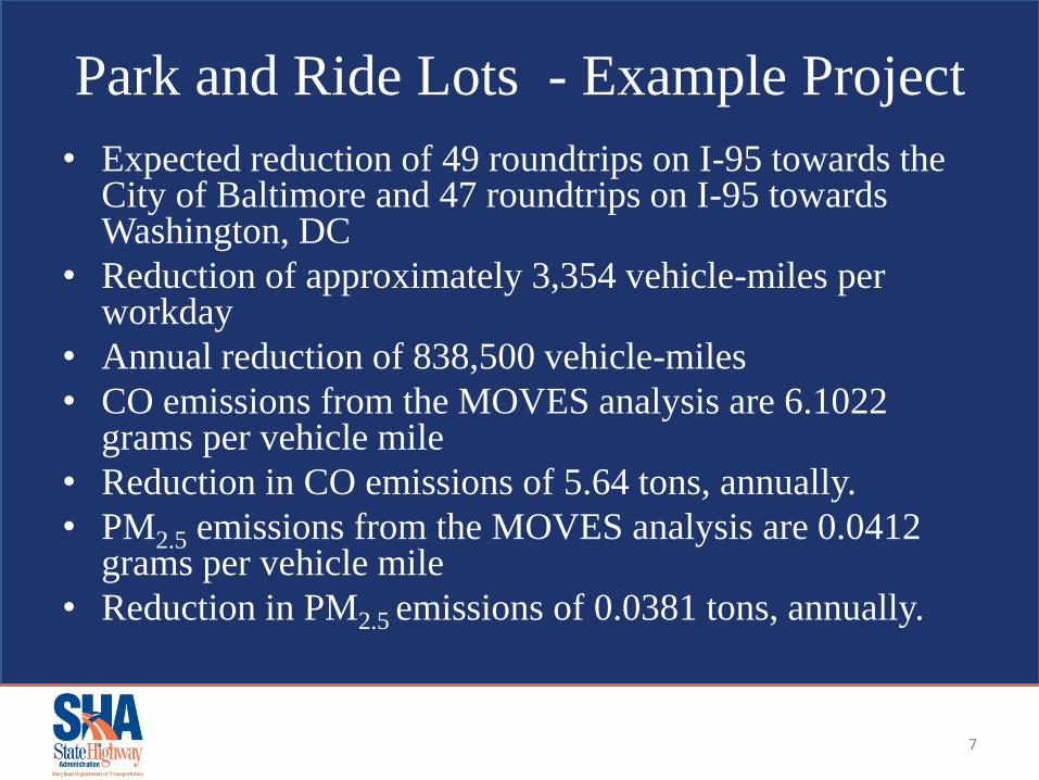
Park and Ride Lots - Example Project
• Expected reduction of 49 roundtrips on I-95 towards the City of Baltimore and 47 roundtrips on I-95 towards Washington, DC
• Reduction of approximately 3,354 vehicle-miles per workday
• Annual reduction of 838,500 vehicle-miles
• CO emissions from the MOVES analysis are 6.1022 grams per vehicle mile
• Reduction in CO emissions of 5.64 tons, annually.
• PM2.5 emissions from the MOVES analysis are 0.0412 grams per vehicle mile
• Reduction in PM2.5 emissions of 0.0381 tons, annually.
7

New Four-Lane Divided Roadway –
Project Background
8
• Located in Montgomery County, MD
• Nonattainment area for 1997 PM2.5 Annual and 24-
Hour standards
• Maintenance area for CO
• 0.6 mile of new 4 lane divided roadway
• Identified as a potential project of air quality concern
and a candidate for hot-spot analysis for both PM2.5
and CO

New Four-Lane Divided Roadway –
Project Description
• ADD SCOPE and MAP
9

Methodology for New Four-Lane
Divided Roadway
• Analysis Years (2007, 2017, 2025, 2040 ) determined
by available MOVES data files from MPO Regional
Conformity Analysis
• Followed Procedures in EPA “Transportation
Conformity Guidance for Quantitative Hot-Spot
Analyses in PM2.5 and PM10 Nonattainment and
Maintenance Areas”
10

Methodology for New Four-Lane
Divided Roadway
11
• Background Emission Concentrations Obtained from EPA Monitor
Value Reports
• 16 MOVES2010b Model Runs Conducted for each Analysis Year
• Model Runs Analyzed Following Pollutants:
1. Carbon Monoxide
2. Primary Exhaust PM2.5-Total
3. Primary PM2.5-Organic Carbon
4. Elemental Carbon
5. Sulfate Particulate
6. Brakewear Particulate
7. Tirewear Particulate
8. Total Energy Consumption

Methodology for New Four-Lane
Divided Roadway
12
• Model Runs Analyzed Following Processes:
1. Running, Start and Extended Idle Exhaust
2. Crankcase Running, Start and Extended Idle Exhaust
• Databases provided by the MPO as used in the Regional Conformity
Analysis included:
1. Meteorology
2. Age Distribution
3. Fuel Supply
4. Fuel Formulation
5. Inspection and Maintenance
• Databases created using MOVES spreadsheet template:
1. Link Source Type
2. Links

Methodology for New Four-Lane
Divided Roadway - Links
13

Methodology for New Four-Lane
Divided Roadway - Receptors
14

MOVES 2010b Lessons Learned
• Helpful to use MPO Regional Conformity Analysis Databases
• Important to name input and output files to correspond with analysis year, quarter and time period
• Traffic data was assembled from several sources to complete Link Source Type database for the Project Data Manager
• Did not include Brake wear and Tire Wear in initial Model Runs
• Nearest monitor source of CO was in adjacent county
• There were no significant other sources of emissions, and road dust and construction activities were not considered
15

CAL3QHCR Lessons Learned
• Needed to recognize link type (e.g., at-grade, bridge)
• Challenge finding recent Met Data, resorted to using data from 1991 for each analysis year
• Some analysis time savings by modifying previous quarter .BAT files, .CTL files, .INP files and .MET files, just required updating analysis year/quarter traffic and emission factor
• Multiple staff worked on different analysis years, needed to confirm using latest model version
16

Documenting Results Lessons Learned
• Only developed Technical Memo for ICG review and
to memorialize analysis process undertaken
• Challenge developing Design Values from
CAL3QHCR output and monitoring station data for
NAAQS timeframes
• No new or worsening violations resulting from
proposed project
17