meeting of the community economic human ...213) 236-1993 or via email [email protected] agendas...
TRANSCRIPT

MEETING OF THE
PLEASE NOTE TIME Thursday, May 3, 2012 1:00 p.m. – 2:00 p.m.
SCAG Main Office 818 W. 7th Street, 12th Floor Policy Committee Room B Los Angeles, CA 90017 (213) 236-1800
If members of the public wish to review the attachments or have any questions on any of the agenda items, please contact Deby Salcido at (213) 236-1993 or via email [email protected] Agendas & Minutes for the Community, Economic, and Human Development Committee are also available at: www.scag.ca.gov/committees/cehd.htm SCAG, in accordance with the Americans with Disabilities Act (ADA), will accommodate persons who require a modification of accommodation in order to participate in this meeting. SCAG is also committed to helping people with limited proficiency in the English language access the agency’s essential public information and services. You can request such assistance by calling (213) 236-1993. We require at least 72 hours (three days) notice to provide reasonable accommodations. We prefer more notice if possible. We will make every effort to arrange for assistance as soon as possible.
COMMUNITY, ECONOMIC & HUMAN DEVELOPMENT COMMITTEE

This Page Intentionally Left Blank
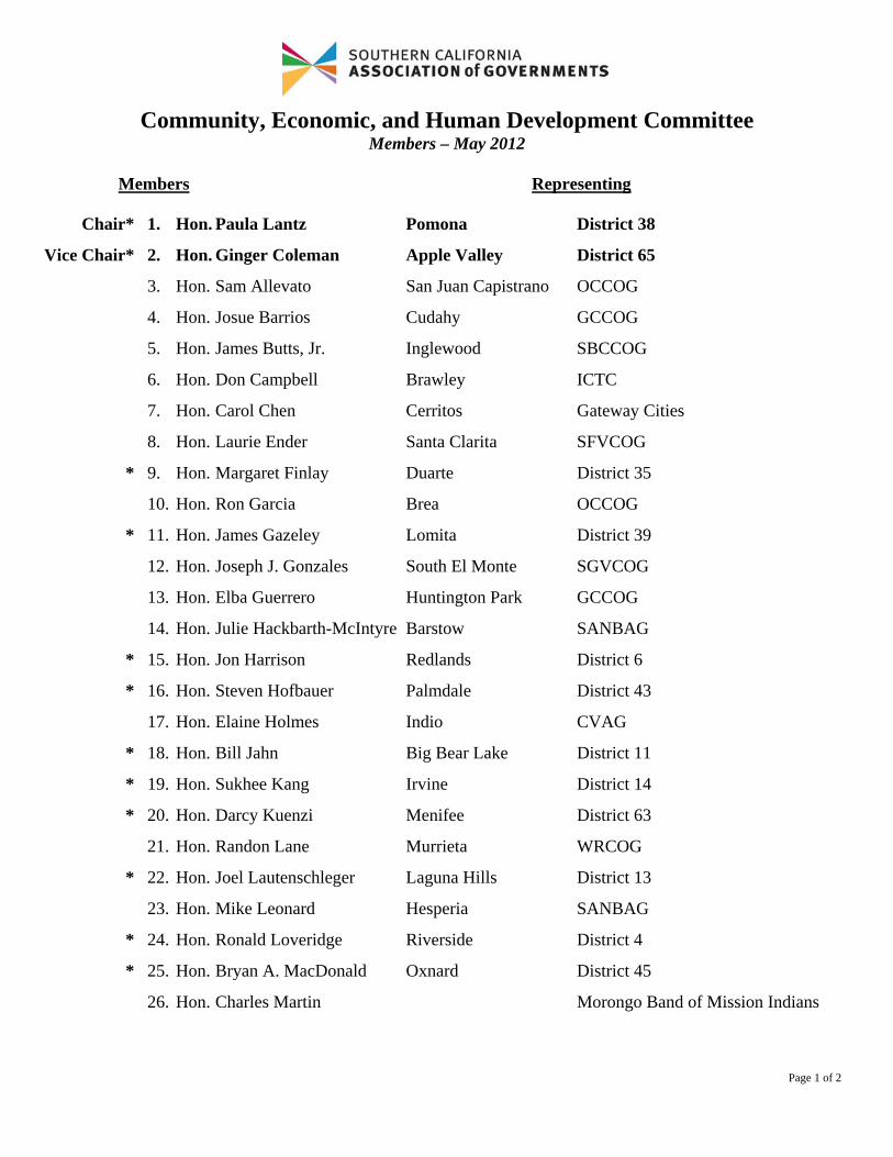
Community, Economic, and Human Development Committee Members – May 2012
Members Representing
Page 1 of 2
Chair* 1. Hon. Paula Lantz Pomona District 38
Vice Chair* 2. Hon. Ginger Coleman Apple Valley District 65
3. Hon. Sam Allevato San Juan Capistrano OCCOG
4. Hon. Josue Barrios Cudahy GCCOG
5. Hon. James Butts, Jr. Inglewood SBCCOG
6. Hon. Don Campbell Brawley ICTC
7. Hon. Carol Chen Cerritos Gateway Cities
8. Hon. Laurie Ender Santa Clarita SFVCOG
* 9. Hon. Margaret Finlay Duarte District 35
10. Hon. Ron Garcia Brea OCCOG
* 11. Hon. James Gazeley Lomita District 39
12. Hon. Joseph J. Gonzales South El Monte SGVCOG
13. Hon. Elba Guerrero Huntington Park GCCOG
14. Hon. Julie Hackbarth-McIntyre Barstow SANBAG
* 15. Hon. Jon Harrison Redlands District 6
* 16. Hon. Steven Hofbauer Palmdale District 43
17. Hon. Elaine Holmes Indio CVAG
* 18. Hon. Bill Jahn Big Bear Lake District 11
* 19. Hon. Sukhee Kang Irvine District 14
* 20. Hon. Darcy Kuenzi Menifee District 63
21. Hon. Randon Lane Murrieta WRCOG
* 22. Hon. Joel Lautenschleger Laguna Hills District 13
23. Hon. Mike Leonard Hesperia SANBAG
* 24. Hon. Ronald Loveridge Riverside District 4
* 25. Hon. Bryan A. MacDonald Oxnard District 45
26. Hon. Charles Martin Morongo Band of Mission Indians

Community, Economic, and Human Development Committee Members – May 2012
Members Representing
Page 2 of 2
*Regional Council Member
* 27. Hon. Larry McCallon Highland District 7
28. Hon. Kathryn McCullough Lake Forest OCCOG
29. Hon. Susan McSweeney Westlake Village LVMCOG
30. Hon. John Mirisch Beverly Hills WSCCOG
* 31. Hon. Carl Morehouse Ventura District 47
32. Hon. Gene Murabito Glendora SGVCOG
* 33. Hon. Kris Murray Anaheim District 19
34. Hon. Ray Musser Upland SANBAG
* 35. Hon. John Nielsen Tustin District 17
36. Hon. Laura Olhasso La Cañada/Flintridge Arroyo Verdugo Cities
37. Hon. John Palinkas Pechanga Band of Luiseño Indians
* 38. Hon. Linda Parks Ventura County VCOG
39. Hon. R. Rex Parris Lancaster North Los Angeles County
* 40. Hon. Jan Perry Los Angeles District 56
* 41. Hon. Andy Quach Westminster District 20
* 42. Hon. Ed P. Reyes Los Angeles District 48
43. Hon. Bob Ring Laguna Woods OCCOG
* 44. Hon. Deborah Robertson Rialto District 8
45. Hon. Gino Sund Altadena SGVCOG
46. Hon. Cathy Warner Whittier GCCOG

COMMUNITY, ECONOMIC AND HUMAN DEVELOPMENT
COMMITTEE AGENDA MAY 3, 2012
The Community, Economic and Human Development Committee may consider and act upon any of the items listed on the agenda regardless of whether they are listed as Information or Action Items. CALL TO ORDER & PLEDGE OF ALLEGIANCE (Hon. Paula Lantz, Chair) PUBLIC COMMENT PERIOD – Members of the public desiring to speak on items on the agenda, or items not on the agenda, but within the purview of the Committee, must fill out and present a speaker’s card to the Assistant prior to speaking. Comments will be limited to three (3) minutes. The Chair may limit the total time for all comments to twenty (20) minutes. REVIEW AND PRIORITIZE AGENDA ITEMS CONSENT CALENDAR Time Page
Approval Item
1. Minutes of the March 1, 2012 Meeting Attachment 1
Receive and File
2. Compass Blueprint Demonstration Project List Attachment 6
ACTION ITEM
3. Proposed Amendment to SCAG’s Guidelines related to the RHNA Trade & Transfer Process (Joann Africa, Chief Counsel)
Attachment 17
CHAIR’S REPORT (Hon. Paula Lantz, Chair) STAFF REPORT (Mark C. Butala, SCAG Staff) FUTURE AGENDA ITEMS Any Committee member or staff desiring to place items on a future agenda may make such a request. ANNOUNCEMENTS ADJOURNMENT The next meeting of the Community, Economic, and Human Development Committee will be held on Thursday, June 7, 2012 at the SCAG Los Angeles Office.

This Page Intentionally Left Blank

_____________________________________________________________________________
COMMUNITY, ECONOMIC & HUMAN DEVELOPMENT COMMITTEE of the
SOUTHERN CALIFORNIA ASSOCIATION OF GOVERNMENTS
March 1, 2012 Minutes
______________________________________________________________________________ THE FOLLOWING MINUTES ARE A SUMMARY OF ACTIONS TAKEN BY THE COMMUNITY, ECONOMIC & HUMAN DEVELOPMENT COMMITTEE. AN AUDIO RECORDING OF THE ACTUAL MEETING IS AVAILABLE FOR LISTENING. The Community, Economic & Human Development Committee held its meeting at SCAG’s downtown Los Angeles office. Members Present Hon. Josue Barrios, Cudahy GCCOG Hon. Don Campbell, Brawley ICTC Hon. Carol Chen, Cerritos GCCOG Hon. Ginger Coleman, Town of Apple Valley District 65 Hon. Margaret Finlay, Duarte District 35 Hon. Ron Garcia, Brea OCCOG Hon. James Gazeley, Lomita District 39 Hon. Jon Harrison, Redlands District 6 Hon. Steve Hofbauer, Palmdale District 43 Hon. Elaine Holmes, Indio CVAG Hon. Bill Jahn, Big Bear Lake (Chair) District 11 Hon. Sukhee Kang, City of Irvine District 14 Hon. Paula Lantz, Pomona (Vice-Chair) District 38 Hon. Joel Lautenschleger, Laguna Hills District 13 Hon. Ronald Loveridge, Riverside District 4 Hon. Kathryn McCullough, Lake Forest OCCOG Hon. Carl Morehouse, San Buenaventura District 47 Hon. Gene Murabito, Glendora SGVCOG Hon. Ray Musser, Upland SANBAG Hon. John Nielsen, Tustin District 17 Hon. Ed Reyes, Los Angeles District 48 Hon. Bob Ring, Laguna Woods OCCOG Hon. Deborah Robertson, Rialto District 8 Hon. Gino Sund, Altadena SGVCOG Members Not Present Hon. Sam Allevato, City of San Juan Capistrano OCCOG Hon. James Butts, Inglewood SBCCOG Hon. Laurie Ender, Santa Clarita SFVCOG Hon. Joseph Gonzales, South El Monte SGVCOG Hon. Elba Guerrero, Huntington Park GCCOG
AGENDA ITEM NO. 1
Page 1

Members Not Present (Cont’d) Hon. Darcy Kuenzi, Menifee District 63 Hon. Randon Lane, Murrieta WRCOG Hon. Mike Leonard, Hesperia SANBAG Hon. Bryan MacDonald, Oxnard District 45 Hon. Charles Martin Morongo Band of Mission Indians Hon. Larry McCallon, Highland District 7 Hon. Julie Hackbarth-McIntyre, Barstow SANBAG Hon. Susan McSweeney, Westlake Village LVMCOG Mirisch, John A., Beverly Hills WSCCOG Hon. Kris Murray, Anaheim District 19 Hon. Laura Olhasso, La Canada-Flintridge Arroyo Verdugo COG Hon. John Palinkas Pechanga Band of Luiseno Indians Hon. Linda Parks, Ventura VCOG Hon. Rex Parris, Lancaster North Los Angeles County Hon. Jan Perry, Los Angeles District 56 Hon. Andy Quach, Westminster District 20 Hon. Cathy Warner, Whittier GCCOG CALL TO ORDER & PLEDGE OF ALLEGIANCE Hon. Bill Jahn, Chair, called the meeting to order at 10:03 a.m., and Hon. Gino Sund to led the Committee in the Pledge of Allegiance. PUBLIC COMMENT PERIOD There were no public comments. ELECTION OF CHAIR AND VICE-CHAIR Joann Africa, Chief Counsel, stated that with respect to the position of Chair, there is only one (1) candidate, Hon. Paula Lantz, and with respect to the Vice-Chair position, there are two (2) candidates, Hon. Ginger Coleman and Hon. Steve Hofbauer. Ms. Africa asked the three (3) candidates to speak to the Committee. Hon. Lantz stated that she has served for two (2) years as Vice-Chair of CEHD and looks forward to the challenges of the coming year. Hon. Coleman stated that she is the Mayor Pro Tem for The Town of Apply Valley, and has served on CEHD and the Regional Council for the past three (3) years. She further stated that she is the San Bernardino County representative on the RHNA Subcommittee, and is looking forward to completing that process. Hon. Hofbauer stated that he is the Mayor Pro Tem of the City of Palmdale, and has served on CEHD and the Regional Council for the past three (3) years. He further stated that he is the alternate representative for Los Angeles County on the RHNA Subcommittee. Hon. Hofbauer reported that he is in the process of creating a Council of Governments (COG) for the High Desert Region. The Chair asked the members to mark their votes on the ballots. Ms. Africa and Ms. Embry collected and tallied the votes. Having received the final tally, the Chair announced that the
Page 2

Hon. Paula Lantz will serve as the new Chair of CEHD and Hon. Ginger Coleman will serve as the new Vice-Chair of CEHD. The Chair congratulated them both. REVIEW AND PRIORITIZE AGENDA ITEMS Based upon discussions with staff prior to the meeting, the Chair requested a Motion to add an item to the Agenda, Overview of Draft 2012-2035 RTP/SCS Comments and Revision Approach, and to continue Item 4 regarding the Green Region Initiative. For the May 3, 2012 meeting, a MOTION was made (Sund) to add the item to the agenda. The MOTION was SECONDED (McCullough) and UNANIMOUSLY APPROVED. It was noted that this additional item would be presented after the Consent Calendar. CONSENT CALENDAR 1. Minutes of February 2, 2012 Meeting
A MOTION was made (Coleman) to approve the Consent Calendar. The MOTION was SECONDED (Finlay) and APPROVED. There was one abstention (McCullough).
INFORMATION ITEMS Overview of Draft 2012-2035 RTP/SCS Comments and Revision Approach Arlene Granadosin, Associate Regional Planner, referred the members to a matrix in the staff report which summarizes the comments received so far on the Draft 2012 RTP/SCS and the proposed staff responses to those comments. Ms. Granadosin highlighted the comments and responses that were particularly relevant to CEHD, and stated that all the comments and responses would be available at the Special Joint Policy Committee meeting on March 21, 2012. 2. Compass Blueprint Demonstration Project Update Mark Butala, Manager of Comprehensive Planning, stated that SCAG currently has 46
active Compass Blueprint Demonstration Projects; 21 projects in progress to be completed by June 30, 2012 and 25 projects funded, with consultant procurement underway and scheduled for kick-off in spring 2012, with completion expected within 6-12 months. Mr. Butala reported that staff is working with two jurisdictions to further develop project scopes before initiating procurement, and three cities will not be proceeding with their projects. A list of all 51 projects is included in the staff report.
Hon. Carl Morehouse reported that Ventura rolled out the Freeway Cap Project Phase 2,
on February 28, 2012 and thanked SCAG staff for their participation, particularly Peter Brandenberg.
Hon. Ron Loveridge stated that the Compass Blueprint Program should be promoted as
SCAG’s program rather than that of local jurisdictions. Hon. Loveridge also requested an Executive Summary of the projects that will chronicle the program at the regional level. Mr. Butala referred him to SCAG’s website where there is a one-page fact sheet for each of the completed projects. Huasha Liu, Director of Land Use and Environmental Planning, indicated an Executive Summary of the projects would be available at the next regular meeting of CEHD.
Page 3

3. Compass Blueprint Recognition Awards Update Mr. Butala stated that the 6th Annual Compass Blueprint Recognition Awards dinner would be held on the evening of Wednesday, April 4, 2012 at the Bonaventure Hotel, as part of the General Assembly. Mr. Butala further stated that the purpose of the awards is to recognize local jurisdictions and developers for plans and projects that are consistent with the goals of the Compass Blueprint Program, regardless of whether or not they have received Compass funding. Mr. Butala encouraged all the members to attend.
CHAIR’S REPORT The Chair reported that the RHNA Subcommittee was in the revision request process and was accepting revision requests until March 15, 2012. The Chair further reported that the next RHNA Subcommittee meeting would be held on March 23, 2012 at 10:00 a.m. at SCAG’s Los Angeles office with video conferencing available at the satellite offices. STAFF REPORT There was no staff report. FUTURE AGENDA ITEMS There were no future agenda items presented. ANNOUNCEMENTS The Chair thanked the members for their support and engagement during his term as Chair of CEHD. Hon. Carl Morehouse thanked Hon. Jahn for his leadership of the Committee and wished him good luck in his race for the State Assembly. Hon. Morehouse reminded members of the American Planning Association National Conference, which will be held April 14 – 16, 2012 at the Los Angeles Marriott. Hon. Morehouse stated that it is an opportunity to showcase Southern California planning. Incoming Chair, Hon. Paula Lantz, confirmed Hon. Bill Jahn’s appointment as Chair of the RHNA Subcommittee. ADJOURNMENT The Chair adjourned the meeting at 10:21 AM. Minutes Approved By: ________________________ Mark Butala, Manager, Comprehensive Planning
Page 4

Page 5

This Page Intentionally Left Blank

DATE: May 3, 2012
TO: Community, Economic and Human Development Committee (CEHD)
FROM: Mark Butala, Manager of Comprehensive Planning, 213-236-1945, [email protected]
SUBJECT: Compass Blueprint Demonstration Project List
EXECUTIVE DIRECTOR’S APPROVAL: RECOMMENDED ACTION: For information only – No action required. EXECUTIVE SUMMARY: Since 2005, SCAG and its local government partners have completed 84 Compass Blueprint Demonstration Projects to date with an additional 46 projects in progress valued at $14 million combined. Details regarding this program are available at www.compassblueprint.org. STRATEGIC PLAN: This item supports SCAG’s Strategic Plan; Goal 1: Improve Regional Decision Making by Providing Leadership and Consensus Building on Key Plans and Policies; Objective a: Create and facilitate a collaborative and cooperative environment to produce forward thinking regional plans. BACKGROUND: Planning assistance to local governments through Compass Blueprint Demonstration Projects is a key component of SCAG’s implementation strategy for the 2012-2035 Regional Transportation Plan/ Sustainable Communities Strategy (RTP/SCS). The program, started in 2005, provides opportunities for member jurisdictions to apply innovative approaches to local-level planning efforts and to become regional examples of great planning. Demonstration Projects enable cities and counties to better evaluate planning options and stimulate sustainable development opportunities. Demonstration Project assistance is offered at no cost to local partners and typically includes a customized program of consultant services, SCAG staff time and other technical assistance. Projects are selected, in part, for their regional or subregional significance. With the recent passage of Senate Bill 375, this year’s program is focusing on reducing regional Vehicle Miles Traveled (VMT) and resulting Greenhouse Gas (GHG) emissions while providing the co-benefits of community livability, mobility, prosperity and sustainability. Other project selection criteria include:
The project's integration of land use and transportation planning and efficiency of infrastructure use;
A mix of housing densities and types, including affordable housing;
The project's inclusion of emerging fields of sustainability such as carbon footprint modeling, climate change mitigation, green building, etc.;
Cooperation with other local governments and transportation commissions;
AGENDA ITEM NO. 2
Page 6

Coordination with project stakeholders through an existing or planned advisory group;
Development planned within or adjacent to existing developed or underutilized areas, with conservation of open space and agricultural lands.
A more comprehensive report on this program will be presented at the June 7, 2012 CEHD meeting.
FISCAL IMPACT: Work associated with this item is included in the current FY 2011-2012 OWP (12-065.0137.01.) ATTACHMENT: List of completed and in-progress Compass Blueprint Demonstration Projects
Page 7

Compass Blueprint Demonstration Project List
Compass Blueprint Demonstration Project List County City Title Year Brief Description Status
Imperial El Centro Project SHAPE 2008 Project SHAPE evaluated the present use of downtown El Centro,
combining historic preservation with economic development and
restoring prosperity and vitality to the district.
Complete
Imperial Calexico Calexico: Gateway to Mexico 2009 This project assisted in the City's efforts to create a specific plan
and circulation analysis to improve mobility at the Port of Entry,
while providing connectivity and revitalization strategies to the
downtown district.
Complete
Imperial El Centro Parking and Circulation Plan 2009 Following on the Project SHAPE Demonstration Project and
adoption of the El Centro Downtown Plan, this project assisted with
specific planning issues related to parking and transportation that
arise out of the Downtown Plan’s recommendation. It included a
parking inventory, a traffic and circulation component and an
analysis of potential strategies for addressing future parking needs.
Complete
Imperial Holtville Blueprint for Downtown Holtville 2009 This project created a Downtown plan and implementation
strategies that redevelop currently vacant and under‐utilized
buildings into a compact, walkable, mixed use center for the City.
Complete
Imperial Brawley Downtown Overlay District 2010 This project created a downtown Specific Plan that evaluates
development options in the city's new Downtown Overlay District.
Complete
Imperial Brawley Non‐Motorized Transportation
Plan
2012 This project will update the City's non‐motorized transportation
plan to improve bicycle, pedestrian, and equestrian access and
mobility.
Contracts
Imperial Imperial Imperial Building Blocks 2012 “Imperial Building Blocks” project will update several elements of
the city’s General Plan, last updated in 1992. With significant public
and stakeholder participation, we will develop new Land Use and
Circulation Elements along with a local Climate Action Plan for the
city.
Contracts
Los Angeles Los Angeles MTA/Tipping Point ROI analysis 2006 Compass Blueprint provided the MTA with Tipping Point/ROI
analysis and visualizations for potential redevelopment sites on the
Wilshire Corridor in Los Angeles.
Complete
Los Angeles Hawthorne MTA/Tipping Point ROI analysis 2006 Compass Blueprint provided the MTA with Tipping Point/ROI
analysis and visualizations for potential redevelopment sites in
Hawthorne.
Complete
Los Angeles Covina MTA/Tipping Point ROI analysis 2006 Compass Blueprint provided the MTA with Tipping Point/ROI
analysis and visualizations for potential redevelopment sites in
Covina.
Complete
Los Angeles South Pasadena South Pasadena Mission Street
Gold Line Station
2006 The project provided an infill analysis of the Mission Street Gold
Line Station area and Caltrans properties in South Pasadena. The
report details the current conditions and future forecasts for the
study area and includes Tipping Point/ROI analysis, visualizations
and site planning.
Complete
Los Angeles Lancaster Lancaster short‐term economic
forecast
2007 The project provided the City with updated economic and
demographic information to illuminate current trends and portend
the future direction of the City. The study includes information on
housing, population, demographic and household characteristics,
employment, taxable sales, income, student enrollment, and crime.
Complete
Los Angeles Compton General Plan Update Small Area
Visioning
2007 Compass Blueprint facilitated a visioning process for the City that
engaged residents, community leaders and other stakeholders to
outline priorities for the City's future. The vision will be
incorporated into the City's updated General Plan and into small‐
area plans for the Brickyard, Compton Station and Artesia Station
areas.
Complete
Los Angeles Rolling Hills
Estates
Peninsula Village Specific Plan 2007 The project tested the application, feasibility and appropriateness
of the Rolling Hills Estates' proposed Peninsula Village Overlay Zone,
intended to “create a mixed‐use center combining high density
residences, office/service developments, and retail uses in an
attractive and functional pedestrian‐oriented environment.”
Complete
4/23/2012 1 of 9Page 8
Compass Blueprint Demonstration Project List
Compass Blueprint Demonstration Project List County City Title Year Brief Description Status
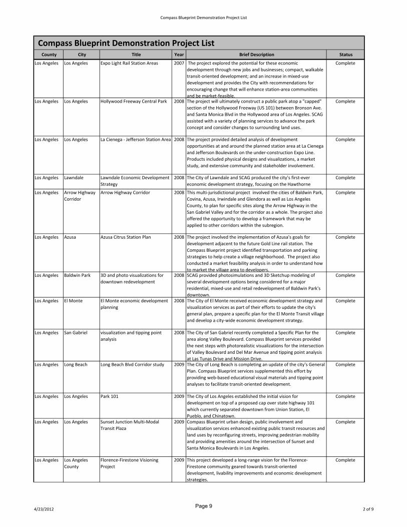
Los Angeles Los Angeles Expo Light Rail Station Areas 2007 The project explored the potential for these economic
development through new jobs and businesses; compact, walkable
transit‐oriented development; and an increase in mixed‐use
development and provides the City with recommendations for
encouraging change that will enhance station‐area communities
and be market‐feasible.
Complete
Los Angeles Los Angeles Hollywood Freeway Central Park 2008 The project will ultimately construct a public park atop a "capped"
section of the Hollywood Freeway (US 101) between Bronson Ave.
and Santa Monica Blvd in the Hollywood area of Los Angeles. SCAG
assisted with a variety of planning services to advance the park
concept and consider changes to surrounding land uses.
Complete
Los Angeles Los Angeles La Cienega ‐ Jefferson Station Area 2008 The project provided detailed analysis of development
opportunities at and around the planned station area at La Cienega
and Jefferson Boulevards on the under‐construction Expo Line.
Products included physical designs and visualizations, a market
study, and extensive community and stakeholder involvement.
Complete
Los Angeles Lawndale Lawndale Economic Development
Strategy
2008 The City of Lawndale and SCAG produced the city's first‐ever
economic development strategy, focusing on the Hawthorne
Complete
Los Angeles Arrow Highway
Corridor
Arrow Highway Corridor 2008 This multi‐jurisdictional project involved the cities of Baldwin Park,
Covina, Azusa, Irwindale and Glendora as well as Los Angeles
County, to plan for specific sites along the Arrow Highway in the
San Gabriel Valley and for the corridor as a whole. The project also
offered the opportunity to develop a framework that may be
applied to other corridors within the subregion.
Complete
Los Angeles Azusa Azusa Citrus Station Plan 2008 The project involved the implementation of Azusa's goals for
development adjacent to the future Gold Line rail station. The
Compass Blueprint project identified transportation and parking
strategies to help create a village neighborhood. The project also
conducted a market feasibility analysis in order to understand how
to market the village area to developers.
Complete
Los Angeles Baldwin Park 3D and photo visualizations for
downtown redevelopment
2008 SCAG provided photosimulations and 3D Sketchup modeling of
several development options being considered for a major
residential, mixed‐use and retail redevelopment of Baldwin Park's
downtown.
Complete
Los Angeles El Monte El Monte economic development
planning
2008 The City of El Monte received economic development strategy and
visualization services as part of their efforts to update the city's
general plan, prepare a specific plan for the El Monte Transit village
and develop a city‐wide economic development strategy.
Complete
Los Angeles San Gabriel visualization and tipping point
analysis
2008 The City of San Gabriel recently completed a Specific Plan for the
area along Valley Boulevard. Compass Blueprint services provided
the next steps with photorealistic visualizations for the intersection
of Valley Boulevard and Del Mar Avenue and tipping point analysis
at Las Tunas Drive and Mission Drive.
Complete
Los Angeles Long Beach Long Beach Blvd Corridor study 2009 The City of Long Beach is completing an update of the city's General
Plan. Compass Blueprint services supplemented this effort by
providing web‐based educational visual materials and tipping point
analyses to facilitate transit‐oriented development.
Complete
Los Angeles Los Angeles Park 101 2009 The City of Los Angeles established the initial vision for
development on top of a proposed cap over state highway 101
which currently separated downtown from Union Station, El
Pueblo, and Chinatown.
Complete
Los Angeles Los Angeles Sunset Junction Multi‐Modal
Transit Plaza
2009 Compass Blueprint urban design, public involvement and
visualization services enhanced existing public transit resources and
land uses by reconfiguring streets, improving pedestrian mobility
and providing amenities around the intersection of Sunset and
Santa Monica Boulevards in Los Angeles.
Complete
Los Angeles Los Angeles
County
Florence‐Firestone Visioning
Project
2009 This project developed a long‐range vision for the Florence‐
Firestone community geared towards transit‐oriented
development, livability improvements and economic development
strategies.
Complete
4/23/2012 2 of 9Page 9

Compass Blueprint Demonstration Project List
Compass Blueprint Demonstration Project List County City Title Year Brief Description Status
Los Angeles Burbank Downtown Mixed‐use, Live‐Work
and Residential Development
Standards
2009 This project evaluated the potential for revised zoning to
accommodate residential, mixed‐use, and live‐work development in
commercial and light industrial areas in Downtown and along two
corridors, from economic and land use policy perspectives.
Complete
Los Angeles Culver City Washington/National Catalytic
Projects & Draft Specific Plan
2009 This project assessed the potential of 3 transit‐oriented, mixed‐use
development projects around the area of the proposed Expo Line
Station in Culver City.
Complete
Los Angeles La Mirada Imperial Highway Corridor Specific
Plan
2010 This project formulated a Specific Plan that considers mixed use
development along the Imperial Highway Corridor in order to meet
RHNA allocation.
Complete
Los Angeles Los Angeles Mayor's Sustainable Transit
Communities (STCs)
2010 This project developed a framework for identifying 10 STCs and
formulating the principles and process for redevelopment in these
areas.
Complete
Los Angeles Los Angeles Jordan Downs Specific Plan 2010 This project assisted in the development of the Jordan Downs
Specific Plan, along with outreach and sustainability strategies for
green building and GHG reductions.
Complete
Los Angeles Los Angeles
County
Florence‐Firestone Community
Plan Phase 2
2010 This project assisted in the creation of a Community Plan through
land use scenarios, market analysis, and transit, bike/ped strategies
to enhance TODs.
Complete
Los Angeles Los Angeles
County
Antelope Valley Area Plan Update 2010 This project assisted in the development of a rural smart growth
strategy, incorporating design strategies, carbon footprint analysis,
outreach, and visualizations.
Complete
Los Angeles Santa Clarita North Newhall Specific Plan 2010 This project assisted in developing a Specific Plan focused on transit‐
oriented and mixed‐use development, walkable and bike‐friendly
land use, and economic and redevelopment opportunities.
Complete
Los Angeles Los Angeles
County
Vision Lennox 2010 This project developed a vision plan through outreach activities,
resulting in visualizations and land use and transportation
strategies.
Complete
Los Angeles SBCCOG Shared Vision for a Sustainable
South Bay
2010 This project assisted the SBCCOG with a series of workshops to
refine, present and build local government support for a
"Sustainable South Bay Strategy."
Complete
Los Angeles Los Angeles Tarzana Crossing 2010 This project provided infill analysis and redevelopment tools for a
TOD, mixed use village around the Orange Line.
Complete
Los Angeles Los Angeles Canoga Connect 2011 This plan provided an effort to bring together residents, and
business owners in envisioning land use changes to complement a
new bus rapid transit station on the Orange Line extension.
Complete
Los Angeles SR‐60 Coalition SR‐60 Gold Line Corridor Study 2011 This project provided services for a coalition made up of the cities of
Monterey Park, Montebello, Rosemead, El Monte, South El Monte,
and the City of Industry. This project had a dual focus: 1) to provide
economic development analysis for the area if Metro identifies this
alignment for the Gold Line Eastside Extension phase II and 2) to
create a planning, design framework for sustainable transit oriented
development at the proposed station locations.
Complete
Los Angeles Bellflower Alondra Overlay Zone 2012 The City of Bellflower is seeking to revitalize an underserved area by
incentivizing mixed use residential and commercial development
around a busy intersection, within close proximity to a potential
future transit station.
Current
Los Angeles Cerritos TOD District 2012 The City of Cerritos is seeking to plan a Transit Oriented District
around a potential future high‐quality transit station, with
implementation milestones which will complement the existing
economic generators in the area.
Current
Los Angeles Downey Downey Civic Center and
Transportation Plan
2012 This project represents implementation of the first phase of the
overall Downey Downtown Specific Plan. The plan envisions
leveraging municipal transit services, and developing passive and
programmed open space around civic facilities.
Current
Los Angeles La Mirada I‐5 Corridor Specific Plan 2012 This is one of three projects that the California Air Resources Board
has chosen to fund as a pilot program emphasizing SB375
implementation near a busy interstate highway. The city is
planning for future economic generators, with a potential housing
component.
Current
4/23/2012 3 of 9Page 10
Compass Blueprint Demonstration Project List
Compass Blueprint Demonstration Project List County City Title Year Brief Description Status
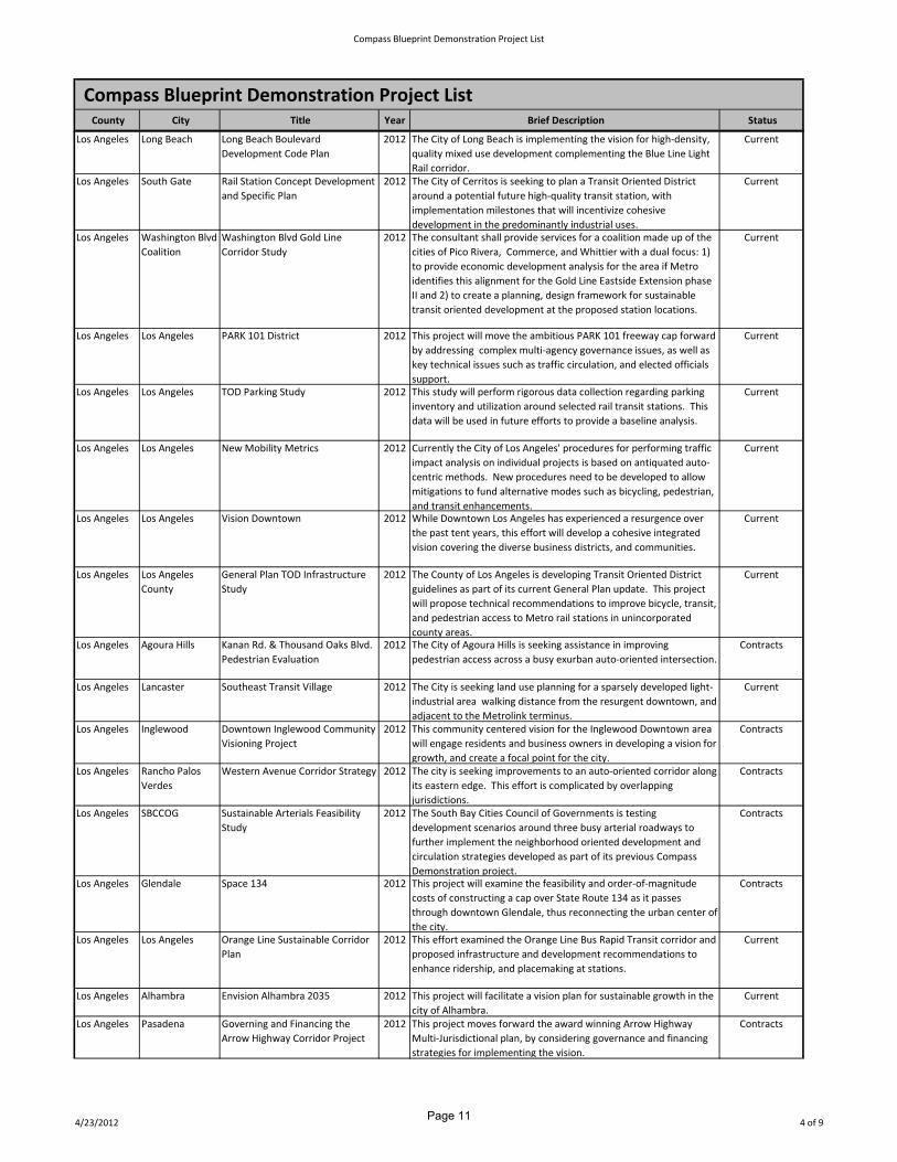
Los Angeles Long Beach Long Beach Boulevard
Development Code Plan
2012 The City of Long Beach is implementing the vision for high‐density,
quality mixed use development complementing the Blue Line Light
Rail corridor.
Current
Los Angeles South Gate Rail Station Concept Development
and Specific Plan
2012 The City of Cerritos is seeking to plan a Transit Oriented District
around a potential future high‐quality transit station, with
implementation milestones that will incentivize cohesive
development in the predominantly industrial uses.
Current
Los Angeles Washington Blvd
Coalition
Washington Blvd Gold Line
Corridor Study
2012 The consultant shall provide services for a coalition made up of the
cities of Pico Rivera, Commerce, and Whittier with a dual focus: 1)
to provide economic development analysis for the area if Metro
identifies this alignment for the Gold Line Eastside Extension phase
II and 2) to create a planning, design framework for sustainable
transit oriented development at the proposed station locations.
Current
Los Angeles Los Angeles PARK 101 District 2012 This project will move the ambitious PARK 101 freeway cap forward
by addressing complex multi‐agency governance issues, as well as
key technical issues such as traffic circulation, and elected officials
support.
Current
Los Angeles Los Angeles TOD Parking Study 2012 This study will perform rigorous data collection regarding parking
inventory and utilization around selected rail transit stations. This
data will be used in future efforts to provide a baseline analysis.
Current
Los Angeles Los Angeles New Mobility Metrics 2012 Currently the City of Los Angeles' procedures for performing traffic
impact analysis on individual projects is based on antiquated auto‐
centric methods. New procedures need to be developed to allow
mitigations to fund alternative modes such as bicycling, pedestrian,
and transit enhancements.
Current
Los Angeles Los Angeles Vision Downtown 2012 While Downtown Los Angeles has experienced a resurgence over
the past tent years, this effort will develop a cohesive integrated
vision covering the diverse business districts, and communities.
Current
Los Angeles Los Angeles
County
General Plan TOD Infrastructure
Study
2012 The County of Los Angeles is developing Transit Oriented District
guidelines as part of its current General Plan update. This project
will propose technical recommendations to improve bicycle, transit,
and pedestrian access to Metro rail stations in unincorporated
county areas.
Current
Los Angeles Agoura Hills Kanan Rd. & Thousand Oaks Blvd.
Pedestrian Evaluation
2012 The City of Agoura Hills is seeking assistance in improving
pedestrian access across a busy exurban auto‐oriented intersection.
Contracts
Los Angeles Lancaster Southeast Transit Village 2012 The City is seeking land use planning for a sparsely developed light‐
industrial area walking distance from the resurgent downtown, and
adjacent to the Metrolink terminus.
Current
Los Angeles Inglewood Downtown Inglewood Community
Visioning Project
2012 This community centered vision for the Inglewood Downtown area
will engage residents and business owners in developing a vision for
growth, and create a focal point for the city.
Contracts
Los Angeles Rancho Palos
Verdes
Western Avenue Corridor Strategy 2012 The city is seeking improvements to an auto‐oriented corridor along
its eastern edge. This effort is complicated by overlapping
jurisdictions.
Contracts
Los Angeles SBCCOG Sustainable Arterials Feasibility
Study
2012 The South Bay Cities Council of Governments is testing
development scenarios around three busy arterial roadways to
further implement the neighborhood oriented development and
circulation strategies developed as part of its previous Compass
Demonstration project.
Contracts
Los Angeles Glendale Space 134 2012 This project will examine the feasibility and order‐of‐magnitude
costs of constructing a cap over State Route 134 as it passes
through downtown Glendale, thus reconnecting the urban center of
the city.
Contracts
Los Angeles Los Angeles Orange Line Sustainable Corridor
Plan
2012 This effort examined the Orange Line Bus Rapid Transit corridor and
proposed infrastructure and development recommendations to
enhance ridership, and placemaking at stations.
Current
Los Angeles Alhambra Envision Alhambra 2035 2012 This project will facilitate a vision plan for sustainable growth in the
city of Alhambra.
Current
Los Angeles Pasadena Governing and Financing the
Arrow Highway Corridor Project
2012 This project moves forward the award winning Arrow Highway
Multi‐Jurisdictional plan, by considering governance and financing
strategies for implementing the vision.
Contracts
4/23/2012 4 of 9Page 11

Compass Blueprint Demonstration Project List
Compass Blueprint Demonstration Project List County City Title Year Brief Description Status
Los Angeles Pomona Metrolink North TOD Plan 2012 The City of Pomona has realized significant planning efforts around
their downtown Metrolink station. This effort will focus attention
on planning around their North Pomona Metrolink station which is
currently surrounded by industrial uses.
Contracts
Los Angeles San Gabriel Greening the Zoning and
Development Codes
2012 This project will result in a draft ordinance that will update open
space, and livability standards in the zoning code.
Contracts
Orange Brea Brea BRT Station Area Concepts 2008 This project received grant funding from Compass Blueprint to
explore opportunities for transit‐oriented development surrounding
proposed Bus Rapid Transit (BRT) stations near the Brea Mall. OCTA
has put on hold plans to implement a Bus Rapid Transit (BRT)
system in Orange County.
Complete
Orange Fullerton Fullerton Southeast Industrial
Area
2008 This demonstration project explores the future role of the
Southeast Industrial Area of Fullerton and more specifically how it
may continue to provide the city with an important jobs base while
at the same time improving its function and form to compete in the
future global economy.
Complete
Orange La Habra La Habra Boulevard Corridor 2008 The project report provides design concepts and policy
recommendations for the City of La Habra to use in future planning
efforts related to improving the economic performance,
functionality, and identity of the La Habra Boulevard corridor.
Complete
Orange Placentia Placentia Metrolink Concepts 2008 Compass Blueprint provided the City of Placentia with urban design
concepts and strategies for a proposed Metrolink station in the
Placita Santa Fe district.
Complete
Orange Laguna Niguel Gateway Specific Plan 2009 Compass Blueprint assisted the City with an update to the Specific
Plan for the area around Laguna Niguel's Metrolink station. The
plan will account for the unique transit‐oriented development
context of this suburban commuter‐rail station area and will serve
as a model for other suburban Metrolink TOD sites.
Complete
Orange Fullerton Downtown 3D Model & Database 2010 This project created a three‐dimensional digital model and database
of downtown, surrounding the transportation center, as an
analytical and communication tool for development.
Complete
Orange Los Alamitos Commercial Corridors Plan 2010 This project focused on the City's two primary commercial
corridors, Katella and Los Alamitos Boulevards, and provide land use
policy and design recommendations for infill and TOD
opportunities.
Complete
Orange Anaheim Platinum Triangle Greenway Plan 2012 The City of Anaheim is developing a master plan for open space
including parks, bike lanes, paths, and pedestrian amenities. This
project focuses on the needs of the Platinum Triangle, and
developing connections between new developments, the Santa Ana
River front, and other destinations in the city.
Current
Orange Dana Point Specific Plan Connectivity Study 2012 This effort will provide the city with counts of pedestrian and
bicycle traffic, and recommendations for improving connectivity
between three specific plan areas that form the focus of Dana
Point's community: The Harbor, the Town Center, and Doheny
Village.
Current
Orange Fullerton Fullerton Smart Growth 2030 2012 The City of Fullerton has completed a number of ambitious planning
efforts recently, this project is seeking to develop strategies for
partnering with private entities to implement the proposed
innovative strategies.
Current
Orange San Juan
Capistrano
Historic Los Rios Streetscape 2012 San Juan Capistrano has maintained a walkable downtown, and
mission area, well connected with the Amtrak and Metrolink rail
station. This project will expand livability and multi‐modal
connections along Los Rios Street, fostering historic development.
Complete
Orange Santa Ana Harbor Boulevard Corridor Vision 2012 Harbor Boulevard is currently a high‐speed auto‐oriented arterial
roadway. The City has developed a vision for connecting the dense
residential communities and neighborhood server retail nodes
along the corridor.
Current
Riverside Temecula Front Street Photomorph 2006 SCAG staff provided photo‐morph visualizations of Front Street in
Temecula's Old Town as part of the City's study of building heights
and potential redevelopment.
Complete
4/23/2012 5 of 9Page 12

Compass Blueprint Demonstration Project List
Compass Blueprint Demonstration Project List County City Title Year Brief Description Status
Riverside Corona Corona Metrolink Station Area
Plan
2007 The North Main Corona Metrolink Station is located just over a half‐
mile north of Corona’s Downtown District. The Demonstration
Project was intended to guide the transition from a stand‐alone
train station and parking garage to a vibrant transit village.
Complete
Riverside Hemet Hemet Metrolink Station Area
Plan
2007 The project created a vision and design concept for transforming
the North Hemet station into a transit village. The concept includes
Metrolink and bus service, high‐density and live‐work housing,
neighborhood retail, parks, structured parking, a farmers' market
and a railroad museum.
Complete
Riverside Moreno Valley/
March AFB
Moreno Valley March AFB
Metrolink Station Area Plan
2007 The project created a design concept and visualizations for the
Moreno Valley/March Field Metrolink station that will be created at
the former March Air Force base. The concept includes Metrolink
and bus service, retail and office uses, op space and commuter
parking.
Complete
Riverside Perris Perris Metrolink Station Area Plan 2007 The Perris Station will be located at the Old Perris Depot, about a
quarter‐mile from the Perris Civic Center in downtown Perris, within
the City’s Downtown Specific Plan area. The station will also include
a new RTA bus transfer site for commuter, intercity, and local
shuttle bus service. The Perris Station is an important regional
transportation link and its opening will be a step toward a mixed‐
use downtown core.
Complete
Riverside Riverside Riverside Metrolink Station Area
Plan
2007 This project will help facilitate the development of a Transit Village
at the Downtown Riverside Metrolink Station. The Compass
Blueprint team conducted a community workshop to gather
neighborhood input, conducted land use opportunities and
constraints analysis, conducted a full‐day design charrette, created
contextual urban design strategies and conducted an open house
with the community to informally discuss the proposed ideas.
Complete
Riverside Temecula Temecula Transit Station Area
Plan
2007 The project will facilitate the development of a future bus transit
station in Temecula, providing conceptual design for development
of surrounding uses including the Murrieta Creek Recreation Basin
and potential transit‐oriented uses to the north. The project also
included circulation analysis focusing on future transit projects and
land uses and pedestrian needs.
Complete
Riverside Coachella Coachella Sphere of Influence
Sustainability Project
2008 The City of Coachella, an emerging desert gateway city, was
interested in applying sustainable growth strategies and a regional
perspective in planning for the city's growth. SCAG assisted the
Coachella Sphere of Influence Sustainability Project with a full range
of services including form‐based codes, urban design and economic
development strategies, public involvement services and
visualizations.
Complete
Riverside Coachella Pueblo Viejo Revitalization Master
Plan
2009 The project assisted in the City's efforts towards a downtown
revitalization plan focused on infill, mixed use development around
a potential transit center.
Complete
Riverside Desert Hot
Springs
City West Visioning Plan 2009 This project developed a land use vision for the area adjacent to a
conservation corridor area (the Coachella Valley Multiple Species
Habitat Conservation Plan) that balances resource conservation and
development.
Complete
Riverside Indio Highway 99 / Indio Boulevard
Study
2009 This project studied redevelopment potential along Indio Boulevard
(connecting Downtown Indio to I‐10), in conjunction with the
proposed Downtown Transportation Center and existing Amtrak
station.
Complete
Riverside Palm Springs Airport ‐ Downtown Shuttle 2009 This project conducted a feasibility study of a Palm Springs Airport‐
Downtown shuttle system to minimize private auto usage into the
highly concentrated and pedestrian‐oriented city center which is
experiencing rapid growth in residential, hotel and mixed use
development.
Complete
Riverside Calimesa Calimesa Boulevard Downtown
Revitalization Project
2009 The City of Calimesa project provided development codes and
design guidelines to create a pedestrian‐oriented atmosphere
consistent with traditional Southern California architectural styles
such as Mission, Rustic Lodge, and Ranch.
Complete
4/23/2012 6 of 9Page 13

Compass Blueprint Demonstration Project List
Compass Blueprint Demonstration Project List County City Title Year Brief Description Status
Riverside WRCOG I‐15 Interregional Partnership 2009 As part of the Interstate 15 Interregional Partnership effort by
WRCOG and SANDAG, SCAG provided assistance to expand the
study area and conduct smart growth corridor analysis, as well as a
Transportation Strategic Implementation Plan along I‐15 and I‐215
in southwestern Riverside County.
Complete
Riverside Cathedral City Date Palm Drive Connector Plan 2010 This project developed a corridor strategy that considers land use,
infill scenarios, transportation and economic development, while
connecting various areas and linking existing plans within the City.
Complete
Riverside Banning Paseo San Gorgonio Downtown
Specific Plan
2010 The purpose of this project was to conduct technical planning
services which would lead to the adoption of the Paseo San
Gorgonio Specific Plan and implementation of future development
in the downtown area of the City of Banning. The Paseo San
Gorgonio Specific Plan covers 66 acres of land area in Downtown
Banning and is intended to create a mixed‐used district that would
lead to a pedestrian‐oriented and livable downtown area focused
on arts and culture.
Complete
Riverside Corona Downtown Redevelopment 2010 This project conducted land use and infill analysis and market
feasibility for two sites within downtown, as well as a bike route
analysis connecting downtown to transit.
Complete
Riverside Lake Elsinore Key to Downtown Implementation
Plan
2010 This project created design standards and visualization products for
the City's planned development of a new Civic Center and focal
point for a larger downtown revitalization master plan.
Complete
Riverside Moreno Valley Alessandro Boulevard Corridor 2010 This project explored TOD opportunities around an emerging rapid
transit line along Alessandro Boulevard, connecting a planned
Metrolink station to Riverside County Hospital.
Complete
Riverside WRCOG Non‐Motorized Transportation
Plan Update
2010 This project assisted in updating the WRCOG Non‐Motorized
Transportation Plan that will inform future RTPs and greenhouse
gas reduction work and provide a basis for capital funding requests.
Complete
Riverside WRCOG Neighborhood Electric Vehicle
Program
2010 This project assisted in creating a conceptual transportation
network and scalable implementation strategy for the deployment
of NEVs in the cities of Riverside, Corona, Norco and Moreno Valley.
Complete
Riverside WRCOG Bus Rapid Transit Route Planning
Project
2010 This project conducted a study to examine bus rapid transit (BRT)
opportunities along several major transportation corridors,
including the proposed Mid‐County Parkway, Interstate 215 and
Interstate 15.
Complete
Riverside Cathedral City Date Palm Drive Corridor Plan
phase 2
2012 This provides ordinances and design efforts to further a corridor
strategy that considers land use, infill scenarios, transportation and
economic development, while connecting various areas and linking
existing plans within the City.
Current
Riverside Rancho Mirage Interim Energy Park Study 2012 The City of Rancho Mirage in coordination with the Band of San
Manuel Indians are researching potential interim uses for land that
will be a future Multi‐Modal transit site. Since the transit site is not
envisioned for at least twenty years, this project will examine
potential short to medium term uses such as parking, and solar
energy generation.
Current
Riverside Calimesa Calimesa Riverwalk Master Plan 2012 The City of Calimesa is leveraging planning efforts along its main
street by designing options for creating a walkable water feature
that runs along an underused flood channel.
Current
Riverside Moreno Valley Alessandro Boulevard Corridor
Plan
2012 The City of Moreno Valley is developing design guidelines,
streetscape standards, and bus shelter concepts to implement the
vision for this busy exurban arterial, which will eventually connect
the City to its planned Metrolink station.
Current
Riverside Temecula Jefferson Corridor & HWY 395
Vision
2012 Compass Blueprint is funding outreach efforts in support of two
inter‐related planning efforts: development of the City of Temecula
led specific plan for Jefferson Avenue, and a WRCOG led effort to
prepare a multi‐jurisdictional vision for Highway 395, of which
Jefferson Avenue forms the southern segment. The outreach effort
includes design charrettes, two project websites, and extensive
outreach to business and property owners along the corridor.
Current
4/23/2012 7 of 9Page 14

Compass Blueprint Demonstration Project List
Compass Blueprint Demonstration Project List County City Title Year Brief Description Status
Riverside Wildomar Wildomar Old Town Vision 2012 The City of Wildomar only recently incorporated, however it has
existed as a recognized community for over one hundred years.
This effort will facilitate a visioning process for the young city to
determine the location , and develop design concepts for the civic
center.
Current
Riverside WRCOG Subregional Sustainability Plan
Framework
2012 The California Air Resources Board chose this project as one of
three projects to fund as an example of innovative planning in
Current
Riverside /
San
Inland Empire Inland Empire Visioning Workshop 2006 Compass Blueprint facilitated a Visioning Workshop to discuss
growth issues and engage ULI members and professionals to help
Complete
San
Bernardino
Upland Downtown Upland Infill Study 2006 The Downtown Upland Infill Study provided Tipping Point/ROI
analysis, visualizations, site planning and parking analysis focused
Complete
San
Bernardino
Montclair North Montclair Parking Analysis 2007 This project analyzed future parking demand and parking structure
implementation strategies within the Fremont Corridor Area of the
North Montclair Specific Plan. Land uses planned for the project
area were reviewed, as well as demand for on‐ and off‐ street
public parking. An alternative development scenario was also
analyzed along with financing methods for constructing parking
structures. Compass Blueprint also prepared visualizations of key
locations within the North Montclair Specific Plan area.
Complete
San
Bernardino
San Bernardino San Bernardino E Street Station
Plan
2007 The project analyzed a range of development opportunities for the
station area. The E Street Station is an important regional
transportation link and its opening will be a step toward a mixed‐
use downtown core that will generate downtown activity. The
project included opportunities and constraints analysis, contextual
urban design strategies circulation analysis, evaluation of joint
development opportunities, a design vision and bus service
recommendations.
Complete
San
Bernardino
Ontario New Model Colony Phase 2 2008 Compass Blueprint services were used to update the New Model
Colony plan, in conjunction with the City's General Plan update.
Land use scenarios and circulation plans were created, along with
development prototypes that respond to projected population and
job growth, as well as market realities and expectations for
development. The project included conceptual plans, visualizations,
tipping point analysis, circulation and traffic analysis, parking
strategies and stakeholder forums.
Complete
San
Bernardino
SANBAG SANBAG ‐ Transportation Land
Use Integration
2008 The subregional project provided Compass Blueprint
implementation services to seven cities in San Bernardino County.
Projects examined opportunity sites for TOD and redevelopment.
Complete
San
Bernardino
Chino Focus Area Revitalization Strategy 2009 The project provided the city with economic development
strategies, analysis of the feasibility of new development in several
planning focus areas and strategies for land use planning in the
context of the city’s economic development goals, housing need,
“Measure M” requiring voter approval of any up‐zoning in the City,
and other planning mandates and priorities.
Complete
San
Bernardino
Fontana Downtown Overlay District 2010 This project conducted an opportunities analysis for transit‐
oriented redevelopment in the Downtown Overlay District.
Complete
San
Bernardino
Grand Terrace Business Corridor Specific Plan 2010 This project updated the Barton Road Specific Plan with a focus on
economic development in order to reduce congestion and improve
jobs/housing balance.
Complete
San
Bernardino
Redlands Transferring Development from
Greenfields to Infill
2010 This project assisted in developing a pilot "Transfer of Development
Rights" program to reduce pressure for outward growth, and
develop TOD strategies around rail stations and downtown.
Complete
San
Bernardino
San Bernardino Regional Energy Efficiency
Program
2010 This project is conducting an outreach program and develop an
implementation plan for the Pilot Regional Energy Efficiency
Program for energy retrofits, solar panel installations and workforce
training.
Complete
San
Bernardino
Victorville Non‐Motorized Transportation
Plan
2010 This project created a Non‐Motorized Transportation Plan that will
identify a system of on‐road and trail routes, facilities and linkages
for bicycles and pedestrians.
Complete
4/23/2012 8 of 9Page 15

Compass Blueprint Demonstration Project List
Compass Blueprint Demonstration Project List County City Title Year Brief Description Status
San
Bernardino
Barstow Barstow Area General Plan
Update Support
2012 This funding will support city staff in creating design standards and
a housing element update for their general plan update.
Current
San
Bernardino
Chino Hills The Shoppes at Chino Hills Specific
Plan Update
2012 Updating an award winning specific plan will allow the city to plan
for a sustainable jobs/housing balance and attract new residents
and employees to a viable shopping district.
Current
San
Bernardino
Fontana Sierra Avenue/Valley Boulevard
Land Use Study
2012 After completing a compelling Vision Plan for the downtown
district, and Metrolink Station, the City of Fontana is seeking to
create a complementary urban node around a busy intersection
surrounded by high density employment, and adjacent to Interstate
210.
Contracts
San
Bernardino
Highland Base Line Corridor Vision 2012 The City of Highland is planning for TOD along its Major Corridors
(Base Line Corridor and Victoria Avenue) to accommodate the
future Foothill Boulevard/5th Street BRT and the Omnitrans sbX
which will link to this study area as the eastern anchor for the larger
corridor study.
Current
San
Bernardino
Rancho
Cucamonga
Development Code/Specific Plan
Analysis
2012 The City of Rancho Cucamonga has created a number of specific
plans to encourage development around nodes which will be stops
on the future Omnitrans sBx Bus Rapid Transit line. This project will
recommend consolidated changes to the zoning code which will
enable the planned vision.
Current
San
Bernardino
Upland College Heights Economic Strategy 2012 This project will study the economic and employment demand in
the eastern San Gabriel Valley, and western San Bernardino regions
to arrive at an economically competitive land use strategy for this
annexed area.
Current
San
Bernardino
Yucca Valley Town Center Mixed Use Plan 2012 The City of Yucca Valley is intelligently planning a walkable district
for a traditional auto‐oriented rural community, and consolidating
important community‐based services.
Contracts
Ventura Fillmore Tipping point analysis for
proposed business park
2008 SCAG performed tipping‐point proforma analyses on three
development scenarios to help the city plan for a proposed 92 acre
business park that will enhance the local jobs‐housing balance.
Complete
Ventura Ventura Compact for a Sustainable
Ventura County
2008 The Demonstration Project covered phase 1 of the county‐wide
"Compact for a Sustainable Ventura County." Tasks included data
collection, updating the 2002 Ventura County Vacant Land Study,
identifying goals and policy options and developing and analyzing a
set of alternative growth scenarios for Ventura County's future.
Complete
Ventura Ventura Ventura Fwy Cap Project 2009 The City of Ventura and SCAG studied the feasibility of decking a
below‐grade section of the 101 freeway and examined the
redevelopment potential and urban design issues that reclaiming
the freeway right‐of‐way will present the City. The project identified
a range of alternatives, locate a multi‐modal transit center, assess
other potential uses and outline a process for moving forward on
creating a new mixed‐use waterfront addition to Ventura's
downtown.
Complete
Ventura Ventura Compact for a Sustainable
Ventura County Phase 2
2009 Continuation of a county‐wide visioning and scenario planning
project begun in 2007 with Demonstration Project assistance.
Phase 2 refined guiding principles and land use‐transportation
scenarios, with an ultimate goal of a "Compact" to be adopted by all
local governments for guiding growth in Ventura County.
Complete
Ventura Oxnard Downtown East TOD Feasibility
Study
2012 This project will investigate the feasibility of relocating significant
agricultural industrial uses from the area adjacent to the transit
center and downtown to available land that is closer to the
interstate and the city's agricultural fields, freeing up the area for
redevelopment.
Current
Ventura Ventura Freeway Cap Project phase2 2012 This project move the vision for a cap over State Highway 101
forward by facilitating collaboration between the city and Caltrans
to envision air‐rights leasing over the cap.
Current
Ventura Ventura Old Town Saticoy Area Plan 2012 This project will prepare an area plan for an underserved minority
community located in unincorporated Ventura County. The project
will establish culturally sensitive building standards, and multi‐
modal mobility infrastructure.
Contracts
4/23/2012 9 of 9Page 16

This Page Intentionally Left Blank

DATE: May 3, 2012
TO: Community, Economic and Human Development (CEHD) Committee Regional Council (RC)
FROM: Joann Africa, Chief Counsel, 213-236-1928, [email protected]
SUBJECT: Proposed Amendment to SCAG’s Guidelines related to the RHNA Trade & Transfer Process
EXECUTIVE DIRECTOR’S APPROVAL: RECOMMENDED ACTION for CEHD Committee: Recommend approval to the Regional Council of a proposed amendment to the SCAG’s Guidelines related to the RHNA Trade & Transfer process, as recommended by the RHNA Subcommittee. RECOMMENDED ACTION for RC: Approve a proposed amendment to the SCAG’s Guidelines related to the RHNA Trade & Transfer process. EXECUTIVE SUMMARY: On February 2, 2012, the RC approved the 5th Cycle RHNA Procedures for Revision Requests, Appeals and Trade & Transfers (hereinafter referred to as the “RHNA Appeals Procedures”), which were reviewed and recommended by the RHNA Subcommittee and the CEHD Committee in December 2011 and January 2012, respectively. As part of its review, with respect to the trade and transfer process, the RHNA Subcommittee recommended that as an additional guideline, jurisdictions choosing to participate in a trade and transfer agreement should be geographically contiguous and preferably within the same county. There was also an exception where the jurisdictions are geographically contiguous but located in bordering counties. Staff is recommending an amendment to this particular guideline in order to provide local jurisdictions who are considering trading with more flexibility. The RHNA Subcommittee considered the proposed amendment on April 24, 2012 and recommended its approval by the CEHD and the RC. STRATEGIC PLAN: This item supports SCAG’s Strategic Plan; Goal 1: Improve Regional Decision Making by Providing Leadership and Consensus Building on Key Plans and Policies; Objective a: Create and facilitate a collaborative and cooperative environment to produce forward thinking regional plans. BACKGROUND: Other than the requirement that the total housing need by income category be maintained in involved parties, the state housing law does not provide any restrictions on trade and transfer agreements among jurisdictions. On February 2, 2012, the SCAG Regional Council approved the RHNA Procedures for Revision Requests, Appeals and Trade & Transfers, which were reviewed and recommended by the RHNA Subcommittee and the CEHD in December 2011 and January 2012, respectively. As part of its review, the RHNA Subcommittee recommended that jurisdictions choosing to participate in a trade and transfer agreement should be geographically contiguous and preferably within the same county. Exceptions may be made where the jurisdictions are geographically contiguous but located in bordering counties.
AGENDA ITEM NO. 3
Page 17

Prior to the RC’s approval of the RHNA Appeals Procedures on February 2, 2012, staff received inquiries related to the clarification on geographical continuity for jurisdictions. As a result, staff informed the RC that the RHNA Appeals Procedures related to the trade and transfer process may need to be amended in the future. The original intent of adding the guideline related to trading jurisdictions being geographically contiguous was based upon a general assumption that such jurisdictions would have common housing interests and would be better suited for the trade and transfer process. As SCAG has now completed the revision requests process and is beginning the appeals process, staff recognizes that local jurisdictions are carefully considering the trade and transfer process as a viable alternative to addressing the Draft RHNA allocations. Currently as written, this particular guideline related to geographic contiguousness could be viewed as an obstacle for a successful trade. For this reason, staff and the RHNA Subcommittee recommend the following changes to the Trade and Transfer Process of the Appeals Procedures (Section IV) as follows (strike-out and underlined text represents the proposed amendment):
“IV. TRADE AND TRANSFER PROCESS
As an alternative to the revision request or appeals processes, a local jurisdiction may attempt a “trade and transfer” of its allocation with another jurisdiction(s), for the purpose of developing an alternative distribution of housing need allocations consistent with existing law. SCAG shall facilitate or assist in trade and transfer efforts by local jurisdictions, to the extent reasonably feasible. As such, local jurisdictions need not request a revision or file an appeal with SCAG in order to attempt trades and transfers. The alternative distribution shall be evidenced by way of a written agreement or other documentation outlining the respective jurisdictions’ modified allocations. Any alternative distribution shall be submitted to SCAG prior to SCAG’s issuance of the Final RHNA Plan, and shall be subject to any post-appeal reallocations as described in Section III above.
SCAG shall include the alternative distribution proposed by the local jurisdictions in the Final RHNA Plan, provided that the proposed alternative distribution maintains or accounts for the total housing need originally assigned to these jurisdictions. Below are guidelines that the local jurisdictions may consider as part of the trade and transfer process:
A. Transfer request shall have at least two willing parties and the total number of
units originally assigned to the group requesting the transfer (hereinafter referred to as the “transfer group”) cannot be reduced.
B. All members of the transfer group are local jurisdictions that are preferably
geographically contiguous and preferably located within the same county, exceptions may be made where the local jurisdictions are geographically contiguous but located in counties that border one another.
Page 18
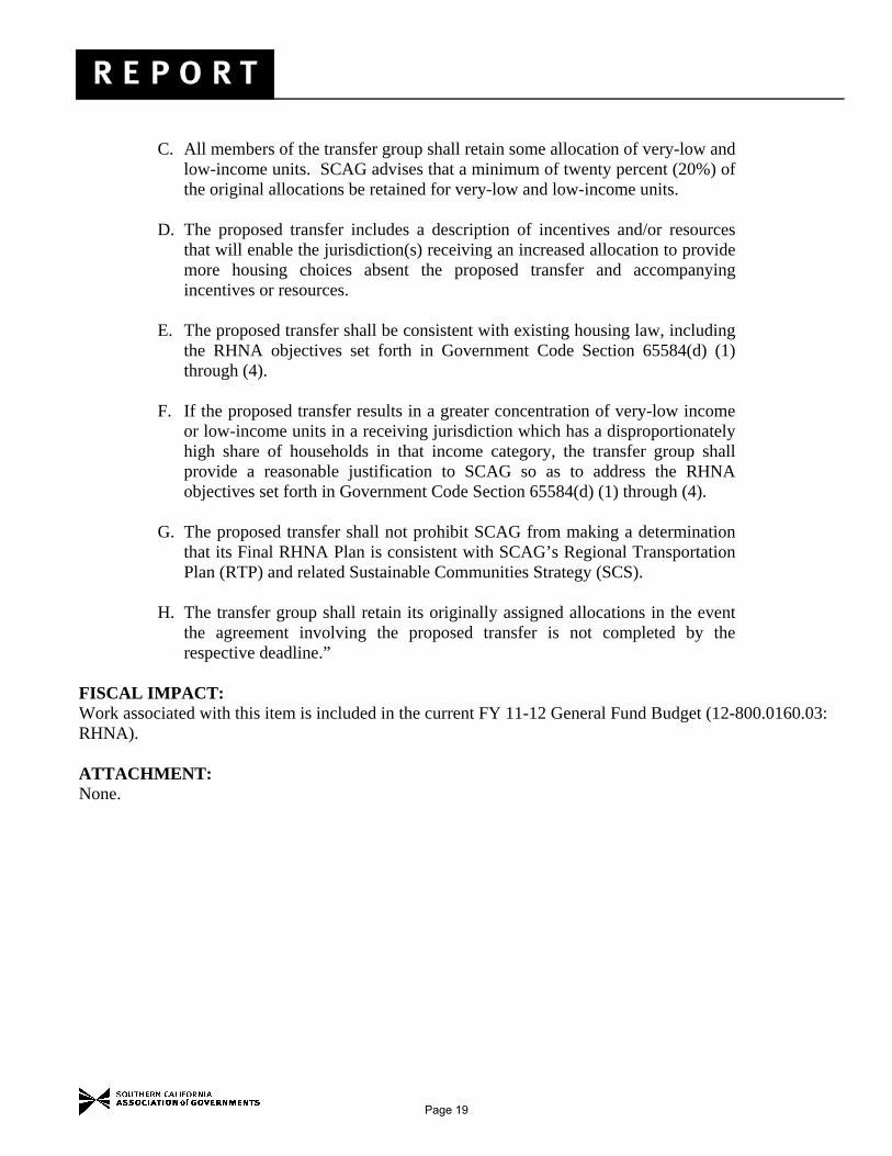
C. All members of the transfer group shall retain some allocation of very-low and
low-income units. SCAG advises that a minimum of twenty percent (20%) of the original allocations be retained for very-low and low-income units.
D. The proposed transfer includes a description of incentives and/or resources
that will enable the jurisdiction(s) receiving an increased allocation to provide more housing choices absent the proposed transfer and accompanying incentives or resources.
E. The proposed transfer shall be consistent with existing housing law, including
the RHNA objectives set forth in Government Code Section 65584(d) (1) through (4).
F. If the proposed transfer results in a greater concentration of very-low income
or low-income units in a receiving jurisdiction which has a disproportionately high share of households in that income category, the transfer group shall provide a reasonable justification to SCAG so as to address the RHNA objectives set forth in Government Code Section 65584(d) (1) through (4).
G. The proposed transfer shall not prohibit SCAG from making a determination
that its Final RHNA Plan is consistent with SCAG’s Regional Transportation Plan (RTP) and related Sustainable Communities Strategy (SCS).
H. The transfer group shall retain its originally assigned allocations in the event
the agreement involving the proposed transfer is not completed by the respective deadline.”
FISCAL IMPACT: Work associated with this item is included in the current FY 11-12 General Fund Budget (12-800.0160.03: RHNA). ATTACHMENT: None.
Page 19