mercercounty guiderail - penn state engineering: larson
TRANSCRIPT

ENGINEERING & GUIDE RAIL MANAGEMENT
December 7, 2017
GIS AS A PLATFORM FOR CONDUCTING GUIDE RAIL
ASSESSMENT.
Transportation Engineering and Safety Conference

ENGINEERING & GUIDE RAIL MANAGEMENTProject BackgroundExisting ConditionsProject ApproachData CollectionEngineering MetricsSummary of FindingsMoving Forward

ENGINEERING & GUIDE RAIL MANAGEMENTProject BackgroundExisting Conditions
Project Approach
Data Collection
Engineering Metrics
Summary of Findings
Moving Forward

• Perform a comprehensive inventory andassessment of existing guide railinstallations.
• Accurately locate and map the existingguide rail installations.
• Document the existing physical andwarranting conditions (hazards).
• Prioritize guide rail upgrades and removalusing a systematic approach.
• Achieve Long-Term Savings.
PROJECT BACKGROUND

Project Sponsor• Delaware Valley Regional Planning
Commission• Fully Funded: $966,000Project Purpose• Locate, Inventory & Assess • Document & Report Design Conditions• Upgrade Substandard Guide RailProject Need• Prioritized Program of Improvements• Establish a Maintenance Reporting System• Improved Roadway Safety
PROJECT BACKGROUND

PROBLEM STATEMENT
Guide Rail
Inventory(Quantity)
Mapping(Location)
Management
Monitor(Condition)
Programming(Schedule)
Maintenance
Reporting & Documentation
Repairing Damaged
Treatments

ENGINEERING & GUIDE RAIL MANAGEMENTProject Background
Existing ConditionsProject Approach
Data Collection
Engineering Metrics
Summary of Findings
Moving Forward

EXISTING CONDITIONSA. Types of Roadways
1. Non County Maintained Roadways2. County Maintained Roadways (500 & Routes)
B. Types of Hazards1. Bridges/Culverts
• County – Maintained• Non County (State)
2. Miscellaneous Hazards/Warranting Obstructions
C. Existing Guide Rail1. Mapped and Inventoried2. Mapped, Not Inventoried3. Not Mapped or Inventoried

ASSET HEIRARCHY
Mercer County DOT&I4 Existing Scenarios of
Bridges & Culverts and GuiderailAsset Hierarchy
County-maintained Guiderail
- NOT MAPPED OR INVENTORIED -
Approx. 652 assembliesassociated with
287 bridges & culverts
Non-CountyMaintained Bridges & Culverts, Approx. 34
- NOT MAPPED OR INVENTORIED -
Miscellaneous hazardsUnknown (8+)
- NOT MAPPED OR INVENTORIED -
1 2
County-maintained Roadways
26 500-600 Routes
County-maintained Roadways
19 500-600 Routes
County-maintained Roadways
40 500-600 Routes
County-maintained Bridges & Culverts
191 On Network - MAPPED AND INVENTORIED -
County-maintained Bridges & Culverts
494 Off Network- MAPPED AND INVENTORIED -
County-maintained Guiderail
- MAPPED BUT NOT INVENTORIED -307 assemblies associated with
113 bridges & culverts
County-maintained Outfalls (?)- NOT M OR I -
3 4
Structure-related Traffic Signs
- MAPPED AND INVENTORIED -
Non- County-maintainedRoadways
Approx. 150 RoadsBased NJOGIS/NJDOT 2014
Centerlines
Structure-related Traffic Signs- M & I -
County-maintained Guiderail
- MAPPED BUT NOT INVENTORIED -
Approx. 119 assemblies
County-maintained (?) Guiderail
- MAPPED BUT NOT INVENTORIED -
Approx. 131 assemblies
County-maintained
Lighting- NOT M OR I -

ENGINEERING & GUIDE RAIL MANAGEMENTProject Background
Existing Conditions
Project ApproachData Collection
Engineering Metrics
Summary of Findings
Moving Forward

PROJECT APPROACH
Scope of Services
• Complete On-Site Inventory• Perform Engineering Assessments• Prioritize Recommended Improvements
Technical Approach
• Led by JMT Technology Group• Utilize Web-Based ArcGIS Online Platform• “Real-Time” Data collection, Management and QC

TECHNICAL APPROACH
Define Data RequirementsDefine
Establish Database SchemaEstablish
Platform for Data collection, Management & QA/QCConfigure/Customize
Pilot the SolutionPilot
Milepost assignments & PrioritizationPost-processing
Transfer Solution to ClientTransfer

TECHNICAL APPROACH
Develop database schema that supports business
Use available starting points
Ensure data supports asset location/data collection/photos
Integrate with existing GIS, asset management systems, & guiderail data
• Define Data Requirements

TECHNICAL APPROACH
• Guide Rail Leading/Trailing End Treatment
• Guide Rail Standard Data• Guide Rail Condition Assessment• Hazards/Warranting Obstructions
• Curb Start/End• Rub Rail Start/End• General Discrepancy Data• Post processing (MP, prioritization,
etc.)
Database Schema

TECHNICAL APPROACHJMT ArcGIS Online Technology Solution
TECHNICAL APPROACH
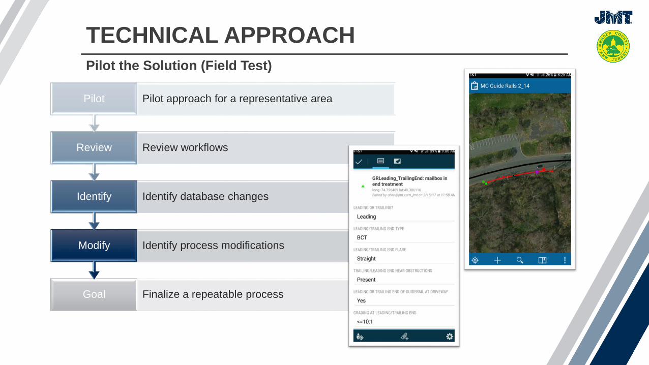
Goal Finalize a repeatable process
Modify Identify process modifications
Identify Identify database changes
Review Review workflows
Pilot Pilot approach for a representative area
Pilot the Solution (Field Test)

TECHNICAL APPROACHWeb-Based Management & QC
ENGINEERING & GUIDE RAIL MANAGEMENTProject Background
Existing Conditions
Project Approach
Data CollectionEngineering Metrics
Summary of Findings
Moving Forward
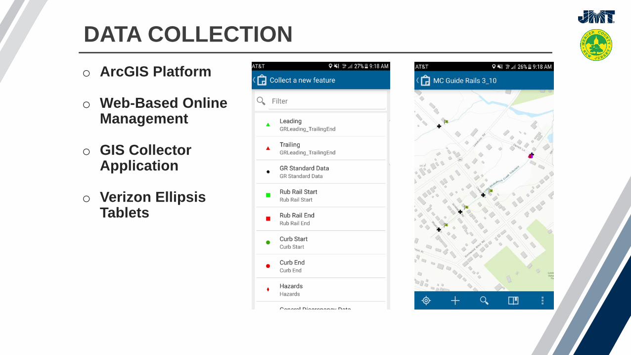
DATA COLLECTIONo ArcGIS Platform
o Web-Based Online Management
o GIS Collector Application
o Verizon Ellipsis Tablets

DATA COLLECTION
o Over 80 Data Collection Elements
o Categorized by Type• Rub Rail (Start/End)• Curb (Start/End)• End Treatments• Standard Data• Hazards• General Discrepancy
Data• Conditions Assessment• Flags
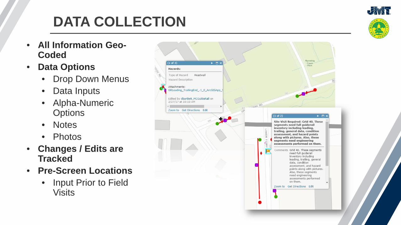
DATA COLLECTION• All Information Geo-
Coded• Data Options
• Drop Down Menus• Data Inputs• Alpha-Numeric
Options• Notes• Photos
• Changes / Edits are Tracked
• Pre-Screen Locations• Input Prior to Field
Visits

DATA COLLECTION• Engineers Perform On-Site
Inspection• By Route• By Grid
• Address Field Issues• Photos• Flags
• Project Management via Dashboard
• Track Progress• Identify Issues

DATA COLLECTION
Aerial LiDAR • Verify Slope Criteria• Pre-Screen Locations• Identify Warranting Conditions

ENGINEERING & GUIDE RAIL MANAGEMENTProject Background
Existing Conditions
Project Approach
Data Collection
Engineering MetricsSummary of Findings
Moving Forward

CONDITION ASSESSMENT
The FHWA Standard Functional Table
(inset below) is the basis for the
functional scoring.
The FHWA uses this table to assess the extent of damage
and Assign Functionality
The FHWA Functionality
Categories are listed as follows:
Guide Rail no Longer Reasonably
Functional;
Guide Rail Should Function Adequately under a majority of
impacts; and,
Should not impair the Guide Rail’s
Ability to perform.

PRIORITIZATIONThe FHWA Functional Scoring System is utilized as the baseline to develop a standardized rating scale for comparing guide rail assemblies for the project.
• Existing, To RemainGuiderail is installed with crash-worthy end-treatments, no extensive damage tophysical conditions and immediate improvements are not warranted.
• Acceptable, To Be ImprovedGuiderail does not require full replacement, but has been assessed in need ofminor repairs, upgrades, or improvements based upon the existing conditions.
• Damaged, To Be ReplacedGuiderail assessed to be damaged to the point where it will not function properly.

PRIORITIZATION
• The FHWA Functional Scoring System is customized to develop a Zero (0) to Ten (10) Rating Scale for prioritizing guide rail.
• Other Design Criteria utilized to evaluate Guide Rail included:
• Roadway Information: Posted Speed Limit, AADT, Crash History.
• Design Features: Length of Need, post spacing, warranting analysis.
• Rail Elements: Rail height, spacer blocks, bolt connections and washers.
• End Treatments: Type, Condition, proximity to fixed objects/utility poles.

PRIORITIZATION• The Final Prioritization & Functional Scoring System creates nine classifications of Guide
Rail.
• Low, Medium and High Priority within the Three (3) Classifications

ENGINEERING & GUIDE RAIL MANAGEMENTProject Background
Existing Conditions
Project Approach
Data Collection
Engineering Metrics
Summary of FindingsMoving Forward
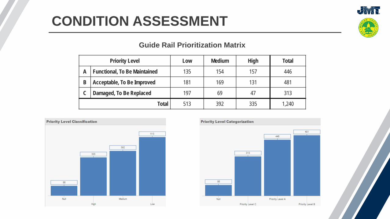
CONDITION ASSESSMENTGuide Rail Prioritization Matrix
Priority Level Low Medium High Total
A Functional, To Be Maintained 135 154 157 446
B Acceptable, To Be Improved 181 169 131 481
C Damaged, To Be Replaced 197 69 47 313
Total 513 392 335 1,240

SUMMARY OF FINDINGSGuide Rail Inventory Summary
• 1,326 Guide Rail Assemblies Mapped• 1,240 Guide Rail Assemblies Inventoried• 2,551 Guide Rail End Treatments Inventoried• 275 Off-Network Bridges/Culverts with No Guide Rail
Assemblies• 47 High-Priority Guide Rail Assemblies
• 148 SKT• 85 FLEAT• 71 ET2000• 428 BCT• 6 ELT• 115 SRT• 23 CRT• 504 GR Attachment
Guide Rail End Treatment Inventory Summary• 7 Impact Attenuator• 134 Flared End• 12 Turned Down• 351 Rounded End• 97 End Anchor• 3 BIB• 443 Other (Shovel Shaped)• 124 Bullnose

ENGINEERING & GUIDE RAIL MANAGEMENTProject Background
Existing Conditions
Project Approach
Data Collection
Engineering Metrics
Summary of Findings
Moving Forward

IMPLEMENT IMPROVEMENTS• Nine Classifications of Guide Rail• Short –Term and Long-Term Improvements
• The short-term recommendation will address theimmediate/high-priority improvements needed to improveguide rail functionality.
• The long-term recommendation will identify the “planning-level” guide rail and/or roadside improvements which shouldbe implemented to sustain guide rail compliancy andfunctionality.

LESSONS LEARNED
• Pilot Field Test• Bridge/Structure Attachments
• Transition Segments• Short –Term and Long-Term Improvements
• Maintenance vs. Enhancements

NEXT STEPS
Program Improvements (Preliminary Cost Estimates)
Create a System Capable of Supporting Future Projects• Identify Guide Rail for Removal• Assess Critical Slopes• Review Hazards & Warrants• Identify Unprotected Warranting Conditions• Complete Inventory of Structures (Bridges/Culverts)
Implement Design, Construction & Maintenance

CONTACT INFORMATION
Mercer County Department of Transportation and Infrastructure Janel A. (Bisacquino) McCoy, GIS [email protected]
Mercer County Department of Transportation and Infrastructure George Fallat, PE, County Traffic [email protected]
Johnson, Mirmiran & Thompson, Inc.James J. Carr, PE, PTP, PTOE, Traffic Engineering & Pl i