mergedfile - · pdf filepage 4 of 22 role to play in the more stabilised dune habitats. cycles...
TRANSCRIPT

An Taisce is a membership-based charity | Join at www.antaisce.org/membership
An Taisce – The National Trust for Ireland | Tailors’ Hall, Back Lane, Dublin, D08 X2A3, Ireland | www.antaisce.org
+353 1 454 1786 | [email protected]
Company Limited by Guarantee | Company 12469 | Charity CHY 4741 | Charity Regulator No. 20006358
EU Transparency Register No. 89747144047-77 Directors: Karl Dowling (Secretary), Philip Kearney, Christopher Massi, Muiris O’Ceidigh, Patricia Oliver, Judy Osborne (British), John Pierce (Chair), Garrett Poynton,
Charles Stanley-Smith (British), John Sweeney.
20171130-02-161012
Clare County Council
Planning and Enterprise Development
Aras Contae an Chlair
New Road
Ennis
Co. Clare
Sent by email to:
30 November 2017
Re: Response to Request for Further Information
Ref: 16/1012
App: TIGL Ireland Enterprises Ltd
For: Permission for development which will comprise of coastal erosion management works at, and adjacent to, Carrowmore Dunes, White Strand, Doughmore Bay and Trump International Golf Links and Hotel, Doonbeg, Co. Clare. The development includes the provision of two new protection structures at the dunes. The construction/development will include excavation of existing sand, the use of sheet piling backstops with soil nailing, geotextile underlay, armourstone protection to the sheet piles with sand and cobbles currently on the beach being used to form a dune profile over a distance of 609 metres (626m curved length with additional revetment overrun) approximately at the southern end of Doughmore Bay, adjacent to and west of the Trump International Golf Hotel. The works will be over a distance of 256 metres (257m curved length with additional revetment overrun) approximately at the northern end of Doughmore Bay, west of the golf course. The storage of the excavated sand on site as part of ongoing replenishment and future site management is also proposed. In a seaward-landward direction the overall extent of the revetment structure will be approximately 12 metres seaward of the existing general dune face with additional underlayers and engineering works. The final structure will be screened from view. Also included as part of the development are enabling works; ancillary construction works and compound; public car park; ongoing access to the beach throughout the construction programme and beyond. An Environmental Impact Statement (EIS) and Natura Impact Statement (NIS) accompanies this planning application.
Site: Carrowmore/Whitestrand/Doughmore, Doonbeg, Co. Clare
Dear Sir/Madam,
Thank you for referring the Response to the Request for Further Information for the above
application to An Taisce. We wish to submit the following comments.

Page 2 of 22
1. Impacts on Ecology, Geomorphology, and the Carrowmore Dunes SAC
It is the considered opinion of An Taisce that the further information submitted for the subject
application has failed to address the key ecological and geomorphological concerns expressed
about the original application by the Planning Authority (PA) and other third parties. This is
largely as a result of the misinterpretation of the erosion occurring at the site and natural sand
dune dynamics. Therefore, An Taisce’s initial concerns about the impact of the proposal on
the habitats and species protected by the Carrowmore Dunes SAC still stand.
1.1 Sand Dunes: Their Importance and Current Threats
Sand dune systems are of enormous value to both coastal environments and human populations as a result of their unique dynamism and the species this allows them to support. Scottish Natural Heritage provides a comprehensive description of a typical dune system1: “Starting at the beach, a dune system may have up to five distinct zones:
1. Strandline – the dune system begins on the beach, on the strandline, where seaweed and other debris have provided a growing medium for specialist plants such as orache and sea rocket.
2. Foredune – some distance above the strandline and before the mobile dune, there may be a band of foredune consisting of sand couch grass.
3. Mobile dune – larger systems have great rolling ridges of mobile sand. Held in place by marram grass (or lyme grass), the sand shifts almost daily with changes in wind direction. Storm events can remove big sections in winter, but these usually return gradually in summer. Mobility is an essential element of dune systems and shouldn’t be confused with erosion. [An Taisce emphasis added]
4. Fixed dune – further inland, the dune becomes more and more fixed by the vegetation. On acid dunes, where there’s little seashell in the sand, dune heath can develop. Some acid dune grasslands are called grey dune, and some of these are lichen-rich. The vegetation on more alkaline systems (not all of which are machair) is dune grassland.
5. Dune slack – in these lower-lying areas between ridges, the vegetation usually requires more moisture. Some dune slacks flood often in winter, while others are permanently flooded.”
According to Everard et al., (2010) coastal sand dune systems support a broad range of flora and fauna owing to the diversity of the ecological niches found within them. Part of this diversity is due to the complex topography and its concomitant vegetation communities, creating a wide range of habitats from dry dune crests to wet dune slacks — a wetland habitat between the dune ridges. Further internal heterogeneity is generated by aspect on steep dune slopes, the degree of grazing and disturbance by animals, and successional processes in both
1 Scottish Natural Heritage, Sand Dunes: https://www.snh.scot/landscapes-habitats-and-
ecosystems/habitat-types/coast-and-seas/coastal-habitats/sand-dunes

Page 3 of 22
dry and wet dune habitats. The diverse niches found within the dynamic mosaic of successional stages within sand dune systems support a wide range of species. Many species dependent on dunes require early successional habitats with sparse vegetation cover and areas of bare sand (Everard et al., 2010). Aside from biodiversity, coastal sand dunes are also increasingly recognised for the ecosystem services they provide which have important socio-economic functions. The porous structure of sandy beaches and dunes absorbs and dissipates wave energy, and stores of sand in the foredunes provide additional material which re-enters the marine transport system and forms a new beach profile after erosion events. These natural processes allow sandy coasts to adapt their morphology and maintain their natural coastal defence role with minimal human intervention necessary, providing there is space to allow natural dynamics to operate. The natural and dynamic coastal protection offered by sand dunes is more cost effective than hard engineered solutions (Everard et al., 2010). Prior to the development of the TIGL Golf Course, the Carrowmore Sand Dunes had been providing a coastal protection service at no cost to the taxpayer for hundreds of years. Across Europe, it is estimated that 85% of sand dune ecosystems are under threat (Heslenfeld et al., 2004). Coastal erosion is thought to impact on approximately 70% of the Earth’s sandy beach environments. The causes of erosion can be of local (e.g. a decrease in sediment supply) or global importance (e.g. a worldwide change in sea level). Climate change driven impacts such as sea level rise and increased erosion will result in the loss of habitat. In some cases sand dunes habitats, will benefit from climate change through to increased sand supply. The impacts of climate change cannot be viewed in isolation, however, as increased seaward erosion can be countered by the landward migration of the sand dunes. Erosion as a result of dune mobility is a natural process and entirely necessary for the development and maintenance of sand dunes. Crucially, human activity presents a substantial threat to dune systems. The UK Article 17 reports2 on habitats and species under the Habitats Direct also identifies “sea defence or coast protection works” as one of the main threats and pressures acting on Embryonic shifting dunes, Shifting dunes along the shoreline with Ammophila arenaria (“white dunes”), Fixed dunes with herbaceous vegetation (“grey dunes”), which are all found at the Doonbeg site. The NPWS explains (Carrowmore Dunes SAC Conservation Objectives Supporting Documents, 20143):
“Dunes are naturally dynamic systems that require continuous supply and circulation of sand. Sediment supply is especially important in the embryonic dunes and mobile dunes, as well as the strandline communities where accumulation of organic matter in tidal litter is essential for trapping sand and initiating dune formation. The construction of physical barriers such as sea defences can interrupt longshore drift, leading to beach starvation and increased rates of erosion. Sediment circulation and erosion also has a
2 UK Article 17 Habitat Reports: http://jncc.defra.gov.uk/page-4064 3 NPWS Carrowmore Dunes SAC Conservation Objectives Supporting Documents, 2014:
https://www.npws.ie/sites/default/files/publications/pdf/Carrowmore%20Dunes%20SAC%20(002250
)%20Conservation%20objectives%20supporting%20document%20-%20Coastal%20habitats%20[Version%201].pdf

Page 4 of 22
role to play in the more stabilised dune habitats. Cycles of erosion and stabilisation are part of a naturally functioning dune system, where the creation of new bare areas allows pioneer species and vegetation communities to develop, increasing biodiversity. The construction of physical barriers can interfere with the sediment circulation by cutting the dunes off from the beach resulting in fossilisation or over-stabilisation of dunes.”
These facts are not interpreted accurately in the applicant’s original proposal or in the RFI responses, as discussed below.
1.2 Misinterpretation of Erosion and Natural Sand Dune Dynamics
An Taisce submit that the applicant’s justification for the proposed protection works as outlined in their RFI responses is largely unchanged from the original application. Their argument is predicated on the erroneous conflation of the erosion occurring on the dune frontage as a result of human intervention behind the dunes with the natural mobility (or erosion) of the dunes that occurs as they attempt to retreat landward.
It is the impact of artificial inland coastal development, in this case the golf course, which causes the loss of sand dune habitat as the sand dunes are fixed and prevented from adapting to rising sea levels and erosion. Infrastructure located within the zone of dynamic variability of the coast is, however, a ‘problem waiting to happen’ for beaches because it compromises their ability to adjust to changed conditions. The most commonly appreciated manifestations of this phenomenon are often referred to as ‘coastal squeeze’, when a coastline is prevented from its landward migration (Pontee, 2013). Ultimately this may cause the complete disappearance of a beach. The negative impact of coastal squeeze due to sea level rise and inland development pressures are established for habitats such as sand dunes and saltmarshes (Wolters et al., 2005). Sea level rise and storms do not automatically result in disappearance of beaches – indeed in most instances, the ability of a beach to respond to periodic perturbations or long-term changes has been the key to their persistence over several millennia. This misconception of dune mobility as an erosion problem is very common (Cooper & McKenna, 2008). In their natural state, sand dunes are dynamic geomorphic features which are able to adjust to stress (Curr et al., 2000). Beach erosion will result in a landward displacement of coastal environments (including dunes) as long as there are no barriers to restrict such migration. Where there are barriers, including those commonly introduced by human activities such as coastal protection works, erosion will reduce coastal habitat area with knock on impacts on the associated flora and fauna of the impacted habitats (Feagin et al., 2005). In some places, coastal development confines the natural community to such a narrow stretch of beach that plants are no longer able to disperse or grow (Feagin et al., 2005). Sea defence and stabilisation works as well as the development and expansion of golf courses are accepted as two of the leading drivers of such sand dune loss internationally (Doody, 1985; Davidson et al., 1991). The current situation in Doonbeg is a perfect example of this: the inappropriate design and management of the golf course is preventing natural coastal realignment. Unless the design of the course is changed, erosion of the frontal edge and coastal squeeze will result in the
Page 5 of 22
loss of sand dune habitat and the diminution of their sea defence role and other ecosystem services. The proposed coastal protection works will only exacerbate this situation as they further prevent the dunes from shifting. In the Conservation Objectives Supporting Document for the Carrowmore Dunes SAC, the NPWS also notes the adverse influence of the golf course: “The physical presence of the golf course has impacted negatively on the functioning of the sand dune as an entire system… This is most notable at the centre of the system where the golf course extends right out to the frontline. Given the fact that this system is retreating the golf course should have been located well back from the seaward edge.” This is supported by the Conclusion of the subject application’s EIS (section 5.8, pg. 71): “Behind the beach frontage, the dune system at Doonbeg is well vegetated and appears to be stable. There does not appear to be a rolling back of the system inland. However, the front face is eroding. Therefore the dune system at Doonbeg is more or less staying where it is with the exception that the front face is retreating, because high energy coastline erosive processes dominate. During periods of calm weather, sand can be carried by wave and aeolian action to the base of the dunes forming embryo dunes. However, the available time period for such dune building process at Doonbeg would appear to be short.” (An Taisce emphasis added). An Taisce submit that although factors such as sea level rise and climate change can influence erosion, in the absence of infrastructure, it is a natural process and entirely necessary for the development and maintenance of sand dunes. It is in fact the location and management of the golf course which is preventing the dunes from migrating landward and in turn leading to the loss of dune habitat. Throughout the RFI responses, the applicant incorrectly attributes this habitat loss to natural dune processes and uses that as evidence that the coastal protection works will be beneficial
1.2.1 The Do-Nothing Scenario The incorrect conflation of the natural dune dynamic erosion with the erosion caused by coastal squeeze from the golf course has led to the applicant to contend throughout their further information responses that the do-minimum or do-nothing scenarios (leaving the beach as it is without the proposed protection works) would “have a profound negative effect upon the attributes of the beach site as a whole” (Response to RFI, pg. 1-27). As discussed in the preceding sections, leaving the dunes as they are without the proposed protection works will allow their natural dynamic processes to continue, thereby having a positive effect on the beach and dunes. It is the imposition of hard defences that will have a profound negative impact by impeding the mobility and achievement of dynamic equilibrium. This will cause real and irreversible habitat loss as dune habitats are unable to naturally shift and regenerate. Concern about the applicant’s interpretation of the do-nothing scenario was raised by the PA in RFI item NIS-2: that “reference to the ‘do nothing’ scenario is not considered to be substantiated by scientific data or analysis.” In light of the evidence presented in the above sections, An Taisce submit that the revised NIS has again failed to scientifically substantiate its claims that the do-nothing scenario will have a detrimental effect on the dunes. It is An

Page 6 of 22
Taisce’s opinion that applicant’s incorrect interpretation of the dune dynamics and the do-nothing scenario undermines their entire justification for the need and justifiability of the proposed works. 1.3 Conservation Objectives of the Carrowmore Dunes SAC The Carrowmore Dunes SAC (site code: 002250) was selected for the following habitats and/or species listed on Annex I / II of the E.U. Habitats Directive (* = priority habitat under the Directive; numbers in brackets are Natura 2000 codes):
[1170] Reefs [2110] Embryonic Shifting Dunes [2120] Marram Dunes (White Dunes) [2130] Fixed Dunes (Grey Dunes)* [1014] Narrow-mouthed Whorl Snail (Vertigo angustior)
The overall aim of the E.U. Habitats Directive is to maintain or restore the favourable conservation status of habitats and species of community interest. Site-specific conservation objectives aim to define favourable conservation condition for a particular habitat or species at that site. The maintenance of habitats and species within Natura 2000 sites at favourable conservation condition will contribute to the overall maintenance of favourable conservation status of those habitats and species at a national level. As detailed by the NPWS, favourable conservation status of a habitat is achieved when:
Its natural range, and area it covers within that range, are stable or increasing, and The specific structure and functions which are necessary for its long-term
maintenance exist and are likely to continue to exist for the foreseeable future, and The conservation status of its typical species is favourable.
The favourable conservation status of a species is achieved when:
Population dynamics data on the species concerned indicate that it is maintaining itself on a long-term basis as a viable component of its natural habitats, and
The natural range of the species is neither being reduced nor is likely to be reduced for the foreseeable future, and
There is, and will probably continue to be, a sufficiently large habitat to maintain its populations on a long-term basis.
1.3.1 Annex I Sand Dune Habitats
Fundamental to the conservation of dune habitats on site is the realisation that “Dune systems are in a constant state of change and maintaining this natural dynamism is essential to ensure that all of the habitats present at a site achieve favourable conservation condition.” This point is stated within the conservation objectives for the SAC and is fundamental to achieving favourable conservation status for the sand dune habitats within the site. Any development which will negatively impact on this natural dynamism must be deemed as having a significant negative impact on the [2110]Embryonic shifting dunes and the [2120] Shifting dunes along the shoreline with Ammophila arenaria (white dune) habitats within the site. In RFI-NIS 4, the PA expresses the concern that:

Page 7 of 22
“The full range of potential effects of the proposed development on the Carrowmore Dunes SAC are not clearly indentified in the NIS. The proposed development by its nature may halt the natural process of coastal eroision and dune dynamics. The NIS does not sufficiently address the potential risk that the entire length of the beach and dune face could potentially be impacted by the proposed development throughout the various stages of construction and operation. Furthermore, the indirect effects, whilst identified, have not been assessed in view of the site’s Conservation Objectives.”
The applicant’s arguments in response to this are underpinned by the assertion that the development will not impact the SAC because the two sections of revetment are outside of the SAC boundaries. For example, in Response to RFI-NIS 4(a), the applicant states: “The impact of the engineered solution will be very localised to the areas north and south of the tie-ins and will not impact dynamics over the entire length of the beach. It will not impact the conservation objectives over and above the do nothing scenario during the operation phase of the works.” The maps provided in the RFI responses clearly show that the SAC boundary lies directly adjacent to the southern end of the northern revetment and around 50m from the northern end of the southern revetment. Furthermore, the dunes between the revetments and the SAC boundary are continuous and unobstructed. It is well established that impacts to one area of a dune system from the installation of hard protection works can adversely affect other areas near and adjacent to the structures (SNH, 2000). This is echoed in the following statement from the NPWS in the Carrowmore Dunes SAC Conservation Objectives Supporting Document (2014): “The remaining mobile dune habitat may be impacted in the future by the activities of the golf course, if the installation of hard coastal protection is permitted in the area outside of, but adjacent to the [c]SAC.” It is An Taisce’s opinion that the impacts of the structures on the dunes adjacent to them, and therefore the SAC, have not been satisfactorily addressed in the RFI responses. In addition to inadequately addressing development impacts on the SAC in relation to spatial proximity, the applicant’s incorrect interpretation of the SAC’s conservation objectives has not substantively changed in the RFI responses. It remains flawed based on the following misinterpretation. In Response to RFI-NIS 5, regarding the need for further assessment of impacts on the SAC’s conservation objectives, the applicant states the following:
“’EC Guidance on the Implementation of the EU Nature Legislation in Estuaries and Coastal Zones’ (2011) states that information on the protected site should include the conservation objectives of the Natura 2000 sites – including future natural changes and the degree to which those changes need to be managed to deliver the site’s conservation objectives… In the light of these EC guidelines it is clear that for Natura 2000 sites including Carrowmore Dunes any natural change to the site can be considered to be a site deterioration if it involves loss of habitat or if it impedes the delivery of the site conservation objectives. It may thus be reasonably considered to be a negative impact on a European site as opposed to a neutral one.”

Page 8 of 22
Asserting that natural changes can cause site deterioration is fundamentally incorrect in this case as the dunes’ mobility, and the natural erosion that entails, is a crucial part of their natural functioning and therefore the conservation objectives of the SAC. Furthermore, the conservation objectives for the dune habitats all state that the targets “are assessed subject to natural processes, including erosion and succession.” In a normally functioning dune system under dynamic equilibrium, habitats may move from one area to another as dunes naturally erode. This does not constitute habitat loss as it part of the normal dune processes, which must be maintained in order to achieve the conservation objectives. If the proposed hard coastal defences are installed, this natural habitat regeneration will be impeded. It is this that will constitute habitat loss and will lead to failure to achieve the conservation objectives. Additionally, in Response to RFI-NIS 5, the applicant continually claims that disturbance and impacts on the dunes during the construction phase will be temporary without long-term effects due to the “intrinsically ephemeral” nature of the dune habitats. No other evidence is given, and this therefore fails to conclusively determine that there will be no long-term damage to the SAC as a result of the construction phase. Therefore, the applicant’s claim in the revised NIS that “it is therefore certain beyond reasonable scientific doubt that there will be no negative impact to the SAC as a result of this development” cannot be substantiated. An Taisce refers the PA to the full set of ecological arguments advanced in our original submission on this application about the SAC’s conservation objectives, all of which still stand and were not addressed adequately in RFI responses.
1.3.2 Annex II Species Vertigo Angustior
The Doonbeg site supports a population of the rare Narrow-Mouthed Whorl Snail (Vertigo angustior, Natura code 1014), which is a protected species listed on Annex II of the E.U. Habitats Directive. Towards the back of the dune system there are two wetland areas that serve as important refuges for Vertigo angustior, particularly in drier summers.
The latest Habitats Directive Article 17 reporting (2013) on the status of protected habitats
and species assessed Ireland’s population of Vertigo angustior as inadequate and declining.
One key reason for the overall decline is degradation of coastal dune habitats such as those
present in the subject site.
In RFI-NIS 7, the PA states:
“The habitat requirements for both the Fixed Dune and Vertigo angustior rely on the
dynamic process of the existing dune system which operates in Doughmore, and
concerns are expressed regarding the impact of the proposal on the same. It is noted
that the NIS (section 2.6.1) states ‘there is no evidence that the wetland SAC areas at
Doonbeg have any value to Vertigo angustior.’ The Planning Authority considers that
this wetland area is important to the species and as such consider that hydrological
changes could potentially affect the wetland SAC outliers, dune slacks, and the habitats
and microhabitats of Vertigo angustior.”

Page 9 of 22
In Response to RFI-NIS 7, the applicant does assess the impact of changes in groundwater
levels and hydrochemistry on the Vertigo angustior population. However, the applicant’s
response fails to address the fact that the proposed coastal protection works will alter and
impede the dynamic process of the existing dune system which are crucial for the maintenance
of the dune wetlands and the population of Vertigo angustior.
Moreover, the applicant states in Conclusion No. 4 of the revised NIS that “Marine erosion of
the dune front has caused significant damage in recent years, destroying large areas of V.
angustior habitat.” This statement is misleading. The snails’ habitat may indeed be reduced
as a result of marine erosion, but habitat reduction for this reason would not occur in an
unaltered dune system in natural dynamic equilibrium, an ecosystem to which the snail is well
adapted. In this case it is due to the golf course preventing the natural landward retreat of
the dunes and causing coastal squeeze as explained previously. The applicant’s claim that
“partial protection of the golf course frontage will result in a significant positive impact on the
local [Vertigo angustior] population,” is not substantiated with scientific evidence. By impeding
the dynamism of the dunes even further with the coastal protection works, the proposal will
only serve to further exacerbate the loss of Vertigo angustior habitat which relies on the
dynamic equilibrium of the dunes and the subsequent maintenance of the wetland areas.
The lack of an impact assessment of changes in sand dune dynamics on the snail population
means that it cannot be concluded that the proposed development would not have an adverse
impact on Vertigo angustior and the associated conservation objectives of the SAC, thereby
contravening Ireland’s obligation under the Habitats Directive to protect the species in the
SAC.
1.4 Relevant Policy
An Taisce note that under Article 6(3) of the Habitats Directive, the PA cannot grant consent
for the proposal unless it is has been clearly established that it will not negatively impact the
SAC:
“Any plan or project not directly connected with or necessary to the management of
the site but likely to have a significant effect thereon, either individually or in
combination with other plans or projects, shall be subject to appropriate assessment
of its implications for the site in view of the site’s conservation objectives. In the light
of the conclusions of the assessment of the implications for the site and subject to the
provisions of paragraph 4, the competent national authorities shall agree to
the plan or project only after having ascertained that it will not adversely
affect the integrity of the site concerned and, if appropriate, after having
obtained the opinion of the general public.” (An Taisce emphasis added)

Page 10 of 22
The requirement for pre-consent certainty that a plan will not adversely impact a Natura 2000
site is also well established in case law. For example, European Court of Justice Case C-
258/11, Peter Sweetman and Others v An Bord Pleanala, states:
“Authorisation for a plan or project, as referred to in Article 6(3) of the Habitats
Directive, may therefore be given only on condition that the competent authorities –
once all aspects of the plan or project have been identified which can, by themselves
or in combination with other plans and projects, affect the conservation objectives of
the site concerned, and in light of the best scientific knowledge in the field – are certain
that the plan or project will not have lasting adverse effects on the integrity of that
site. That is so where no reasonable scientific doubt remains as to the absence of such
effects.”
An Taisce submit that the RFI Reponses have not conclusively and scientifically determined
that there will be no adverse impact on the Carrowmore Dunes SAC.
1.5 Loss of Dune Dynamism at TIGL Aberdeenshire
There are strong parallels between the Doonbeg case and the impact on sand dunes at the
Trump International Golf Links Menie golf course in Aberdeenshire, Scotland. The golf course
overlaps the Foveran Links Site of Special Scientific Interest, which was designated as such
because it was one of the prime examples of mobile sand dune systems in the UK. Before the
golf course was constructed the dunes naturally shifted northward by as much as 11 metres
per year over an area of 15 hectares. However, when TIGL stabilised the dunes for the stated
purpose of protecting the golf course, the dunes’ natural movement was severely impeded.
Dr Jim Hansom, a geomorphologist at Glasgow University, said in an interview with the BBC
(published 8 November 20174) that this loss of natural dynamism will likely result in the dunes
losing their designation as an SSSI. Similarly, Scottish Natural Heritage, which is now assessing
the status of the Foveran Links SSSI, have already stated that the golf course has caused
habitat loss and damage to the dune system. See Appendix 1 for the full text of the report.
This is analogous to the loss of dune dynamism that will occur at the Doonbeg site if the
proposed development is approved. The loss of the dunes’ dynamic equilibrium, a crucial
aspect of favourable conservation status, presents a similar risk to the conservation status of
the Carrowmore Dunes SAC as a whole, a designation that Ireland has a legal obligation to
protect under the Habitats Directive.
We are separately writing to Minister Heather Humphreys and Clare County Council requesting
enforcement compliance on Environmental Impact Assessment mitigation and habitat
management conditions which are attached to the 1999 planning permission for the site (see
attached letters in Appendix 2).
4 BBC report on the detrimental effects of the TIGL golf course in Aberdeenshire, Scotland:
http://www.bbc.com/news/uk-scotland-41845278

Page 11 of 22
2. Other Outstanding Issues
An Taisce submit that the issues with the following RFI responses mean that it cannot be
concluded that the proposal would have no adverse environmental impacts on the
Carrowmore Dunes SAC or the beach area as a whole and that the proposed coastal protection
option is justifiably the optimal solution.
2.1 The Construction Environmental Management Plan (CEMP)
In light of the sensitivity of the site and the surrounding SAC, RFI-EIS 1 requests that “a site
and project-specific CEMP is therefore required for all aspects of the construction process.”
An Taisce acknowledge that the applicant has provided a CEMP that gives many of the details
requested, however, various important details and assessments are still not included.
Crucially, the CEMP has failed to provide surveys and assessments that must carried out prior
to the granting of planning consent. For example, the CEMP states in section 3.8 on Land
Mammals and Molluscs that “A pre-construction otter survey will be undertaken in accordance
with NRA guidelines for the treatment of otters.” Moreover, otters are protected under the
Wildlife Act 1976, the Wildlife (Amended) Act 2000, and Annexes II and IV of the Habitats
Directive meaning that they are strictly protected wherever they occur. It is an offence to
deliberately disturb, hunt, or kill the species or damage or destroy its breeding or resting
place. They are also listed as “near threatened” on the Irish Red List.
The judgement in European Court of Justice Case C183/05, Commission of the European
Communities v. Ireland, establishes the need for assessment of impacts to species before
planning consent is granted:
“As noted by the Advocate General in points 53 to 61 of his Opinion, the authorisation
of a project prior to the environmental impact assessment concluding that that project
would have negative impacts on the environment (the Lough Rynn Estate project), or
the authorisation of other projects without a derogation, even though the preliminary
assessment also concluded that that project would have negative impacts on the
environment (the Ennis Bypass project and the project for the construction of a gas
pipeline in Broadhaven Bay), shows that the species listed in Annex IV(a) to Directive
92/43 and their breeding sites and resting places are subject to disturbances and to
threats which the Irish rules do not make it possible to prevent.”
Other omitted or inadequately assessed details with the potential for environmental impacts
include but are not limited to: the location and specs of the soakaway for the plant fuelling
area, long-term impacts of the use of heavy machinery (such as the crawler crane and
excavator) in the sheet pile installation, and quantity of cobbles and sand that will be
excavated from the seaward side of the piles, and a more thorough examination of potential
impacts on the reef, which is an Annex I habitat and Qualifying Interest of the SAC.
Page 12 of 22
In addition to RFI-EIS 1, RFI-NIS 3 also calls for the CEMP to precisely detail all construction
methods. It also requires that the effects of the proposed mitigation measures be assessed
and demonstrate “their effectiveness on a site-specific basis and relative to the Conservation
Objectives of the European sites.” An Taisce submit that the revised NIS (see State 2 – Natura
Impact Statement Mitigation Measures) has not adequately addressed this point. The majority
of its assertions that the proposed activities are, for instance, “not relevant to terrestrial sand
dune habitats,” “outside SAC areas to avoid any direct impact to adjacent SACs,” or “will have
no impact on habitats in the SAC” are not supported with any scientific evidence or
assessment-backed reasoning as to why the mitigation measures will not have adverse
impacts. The descriptions of the mitigation measures and construction impacts in the CEMP
itself are similarly lacking. Overall, the mitigation measures and the reasoning behind them
are general and tokenistic. This is evident with respect to, for example, the proposed
mitigation measures aimed at protecting bird species found in the nearby Mid-Clare Coast
SPA. The measures are overly general, and only one of the Qualifying Interest bird species,
the Sand Martin, is mentioned specifically.
In light of the above points, An Taisce submit that the revised NIS has failed to present
evidence demonstrating that the mitigation measures have been assessed “on a site-specific
basis and relative to the Conservation Objectives of the European sites.”
2.2 RFI-NIS 2: Assessment of Alternative Options
In introducing their specific further information requests in relation to the Natura Impact
Statement, the PA states the following:
“The Planning Authority does not consider that the Natura Impact Statement (NIS) as
submitted, contains complete, precise and definitive findings and conclusions capable
of removing all reasonable scientific doubt as to the effects of the proposed works on
the adjoining European Sites. In particular concerns are expressed regarding the
impact of the proposal on the conservation objectives of the Carrowmore Dunes SAC.”
Further, RFI-NIS 2 states:
“The NIS as submitted is not considered to present a scientific justification for the
selection of the proposed coastal protection option. It is considered that the
examination of various options is required in order to determine the most feasible
option including an examination of the impacts on the conservation objectives of the
European site, including impacts on coastal processes and dynamism. In addition
reference to the ‘do nothing’ scenario is not considered to be substantiated by scientific
data or analysis.”

Page 13 of 22
An Taisce note that the applicant has provided a comparative summary table of alternatives
in response to this RFI item. However, the table provides no scientific evidence to support its
assessments. In light of the concerns expressed by the Planning Authority about the scientific
justification for the proposed option as well An Taisce’s concerns about the applicant’s
misinterpretation of sand dune processes, An Taisce submit that this comparative table is
insufficient and that a full Stage 3 Assessment of Alternative Solutions as should have been
carried out as part of the revised NIS. Without a more thorough and scientifically supported
assessment of alternative options, it cannot be concluded that the proposed solution is
optimal.
Moreover, the relocation of the specific golf course holes which the application proposes to
protect has not been considered. An Taisce submit that redesigning portions of the golf course
so that the affected holes are moved to other landward locations would be the optimal
solution. It is also likely to be most cost effective solution for the applicant in the long term.
As discussed in section 1.1, dunes will always provide natural coastal protection while the
proposed defences have a life of only 50 years. It would be more sustainable in the long term
to redesign the course so that the affected holes are moved away from the coastline and so
that the natural protection provided by dunes can be optimised.
2.3 RFI-NIS 6: Impacts Beyond the Ends of the Revetments
The PA requested that the impacts of the proposed structures on beach erosion, scouring,
and draw-down be more thoroughly assessed, especially at the end of the revetments and on
the adjacent dunes. The applicant responded: “The impact of the revetment on the adjacent
unprotected frontages (towards the middle of the bay) extends approximately 50m. The
length of the partial protection has been designed so that the downdrift effects of the ends of
the works could be accommodated within the golf course boundaries.” As discussed in section
1.3.1, this does not adequately assess the fact that impacts can extend well into adjacent
dunes beyond hard protection works (SNH, 2000). The claim that impacts will only extend
50m has not been sufficiently substantiated with data. (Also see section 1.3.1).
2.4 RFI-NIS 9: In Combination Effects and the Car Park
RFI-NIS 9 requested a detailed assessment of in combination of the proposal with other
projects, plans, and infrastructural elements, including the car park. The applicant’s Response
to RFI-NIS 9 states, “It is considered that there are no known projects having an in-
combination effect with the project at hand which would lead to a material change to the
environmental impact assessments considered in the context of the EIS or NIS.” The response
does not address the issue of the car park as requested.
The extension of the car park will have significant negative impacts on the receiving
environment by increasing habitat fragmentation in the area. This could have impacts on
protected species such as the otter (Lutra lutra) and the Whorl snail (Vertigo angustior), which
are highly sensitive to disturbance (Moorkens & Killeen, 2011). Also, although the car park is

Page 14 of 22
permeable, therefore decreasing surface water runoff, fuel and other pollutants will
nevertheless be able to leach into the ground below. These impacts should have been
addressed in relation to the impacts that will already occur as a result of the proposed coastal
protection works in accordance with Article 6(3) of the Habitats Directive.
2.5 RFI-EIS 2: Importation of Sand for Dune and Beach Recharge
The PA requested additional information on the source of any sand imported to the site for
the purpose of dune regeneration. An assessment of the impacts of importing sand and the
long term sustainability of the process was also requested. Regarding the source of the sand,
the applicant stated the following in their Response to RFI-EIS 2(a) and (b):
“Commercial sources of Sand in Wexford and Wicklow, such as Anthony Darcy Ltd for
example, routinely supply suitable silica sands to support the maintenance of golf
courses and other sport facilities, nationwide, and some have already supplied silica
sand to Doonbeg Golf Club for course maintenance. A number of commercial
companies supply sand to a range of particle size distributions (i.e. gradings). One
standard grading available which is, without modification, already largely within the
range of gradings found with native sands at Doonbeg. Many of these commercial
suppliers draw from large natural resources with guarantees of sand supply for many
decades.”
Both this statement and the accompanying Preliminary Beach Monitoring and Management
Plan (PBMMP) (Appendix E) fail to specify the source of the sand. The statement above only
vaguely lists unspecified sources that have supplied sand to Irish golf courses, including
Doonbeg, in the past. Anthony Darcy Ltd is the only specific source mentioned, but it is unclear
if they will supply sand for the maintenance of the coastal protections. Similarly, the PBMMP
only states that the source of the imported sand will be on-shore (PBMMP Section 6.3.2).
Volumes are also not indicated.
Furthermore, the applicant has wholly failed to provide an assessment of the impacts of
importing additional sand on the habitats and dynamics of the Doonbeg dunes and beach.
They do briefly address particle size and grading, however, other environmental impacts of
non-native sand have not been evaluated, including, crucially, impacts on the surrounding
SAC. Moreover, the impacts of removing sand from the unspecified commercial source site
have not been addressed.
There are direct parallels between the importation of sand for beach and dune recharge and
the High Court ruling on Bord na Mona’s Edenderry Power Plant [PL 19.245295], wherein
Judge White held that there was "functional interdependence" between the power plant and
the Bord na Mona bogs identified in the planning application. In the case of the Edenderry
Power Plant, it was ruled that the source of the fuel should have been considered as part of
the application for the continued operation of the power plant. This decision was supported
by the clear connection between the operation of the power plant and the supply of the peat
Page 15 of 22
fuel, the construction of the plant in close proximity to the fuel source and the connection
between the supply of the fuel source from Bord na Mona owned bogs via the Bord na Mona
operated railway network to the Bord na Mona owned power plant.
In the Doonbeg case, there is a functional interdependence between the replenishment of the
dune, a key part of the operational phase of the development, and the source of the sand.
Therefore, the impacts of the imported sand, both on the source site and the Doonbeg site,
must be assessed. As this has not been done, it cannot be concluded from that the importation
of sand will not have adverse effects on either the commercial sand source removal site, the
Doonbeg site, or the SAC.
2.6 RFI-EIS 4: Impacts on Either Side of the Protection Structure
The original application (ref. no. 16/1012) states that impacts on the beach to the seaward
side of the structure will be “slight.” In the RFI, the PA notes concerns about beach lowering
in front of the structure due to sea level rise. They requested that beach lowering be assessed
with regard to projected climate change impacts on sea level. The applicant’s response, in its
entirety, reads as follows: “Sea level rise will result in higher waves impacting on the structure
and on the unprotected dunes. As discussed above in Response to RFI-EIS 4(a)(ii), beach
lowering in front of the structure and the dunes will be similar during storms. Therefore any
increase in beach lowering will be similar to the do nothing case.”
The applicant has not provided any scientific data about higher sea levels in the area based
on climate change projections. In the absence of such hard data, it cannot be concluded from
the further information provided that impacts on the beach on the seaward side of the
structures will be “slight” over the 50 year lifetime of the works. Furthermore, the assertion
that “any increase in beach lowering will be similar to the do nothing case” is inaccurate. The
installation of the proposed coastal protection works will change the dynamics of the dunes
and beach and exacerbate the effects of the coastal squeeze caused by the golf course.
Similarly, in RFI-EIS 4(c)(i) the PA questions the assertion that “Impacts (landward of
protection) are also stated to be ‘slight’” and requests evidence that landward dune build up
will not be impeded. Although the applicant concedes their response that the protection “will
in certain conditions reduce transport of sediment from the dune to the beach in these areas,”
they continue by stating that the sand movement from dune to beach will only be indirectly
impacted by extreme storm events. No scientific evidence on this assertion is provided. An
Taisce submit that, by their nature, the protection structures will impede this movement by
altering the natural shifting of dune sediment.
2.7 RFI-EIS 5(a): Haulage Route Baseline Condition and Impact Assessment
The PA requested that a baseline condition survey be undertaken of the road network, critical
junctions, bridges, culverts, and other structures for the two construction haulage routes.
Page 16 of 22
They asked that this include an assessment of the impacts of construction deliveries in excess
of 50,000 tonnes of material to facilitate the development over a three month period.
The applicant states in Response to RFI-EIS 5(a) that this assessment will be carried out post-
planning. An Taisce submit that this is unacceptable as all impacts of the proposed project
must be assessed prior to the granting of development consent as stipulated by the
Environmental Impact Assessment Directive (2014/52/EU). Without such an assessment, it
cannot be determined that the construction haulage will not adversely impact the road
network and associated infrastructure.
3. Conclusions
An Taisce submit that the further information provided by the applicant has not adequately
addressed the concerns expressed by the PA because the response
a) has erroneously interpreted the relationship between the development and the
normal dune dynamics and therefore not adequately scientifically justified the
reasoning behind the protection works and
b) has failed to provide the necessary details, assessments, and surveys to
satisfactorily conclude that the proposal would result in no adverse impacts to the
receiving environment.
It still cannot be concluded that the development would not have significant adverse impacts
on the SAC and the beach site as a whole, thereby breaching Ireland’s legal obligations under
the Environmental Impact Assessment Directive and the Habitats Directive Therefore, on the
basis of the further information provided, An Taisce must again object to the proposed coastal
protection works.
Please acknowledge our submission and advise us on any decision made.
Yours faithfully,
Ian Lumley
Advocacy Officer
An Taisce – The National Trust for Ireland
Phoebe Duvall
MSc Environmental Policy
Planning Office
An Taisce – The National Trust for Ireland
Enclosures:
References, BBC Report, Letter to Minister Heather Humphreys, Letter to Clare County Council

Page 17 of 22
References
Cooper, J. A. G. & McKenna, J. (2008) Working with natural processes: the challenge for
coastal protection strategies. The Geographical Journal, pp. 174(4), 315-331.
Curr, R. H. F. et al. (2000) Assessing anthropogenic impact on Mediterranean sand dunes
from aerial digital photography. Journal of Coastal Conservation, pp. 6(1), 15-22.
Davidson, N. C. et al. (1991) Nature Conservation and Estuaries in Great Britain. Nature
Conservancy Council: Peterborough.
Doody, J. (1985) Sand Dunes and their Management. Focus on Nature Conservation No. 13.
Nature Conservancy Council: Peterborough.
Duggan, J. E. et al. (2008) Ecological effects of coastal armoring on sandy beaches. Marine
Ecology, pp. 29(s1), 160-170.
Everard, M., Jones, L. & Watts, B. (2010) Have we neglected the societal importance of sand
dunes? An ecosystem services perspective. Aquatic Conservation: Marine and
Freshwater Ecosystems, pp. 20(4), 476-487.
Feagin, R. A., Sherman, D. J. & Grant, W. E. (2005) Coastal erosion, global sea-level rise, and
the loss of sand dune plant habitats. Frontiers in Ecology and the Environment, pp.
3(7), 359-364.
Heslenfeld, P., Jungerius, P. D. & Klijn, J. A. (2004) European policy for coastal dunes. In
Coastal Dunes 1 Ecology and Conservation, Martinez ML, Psuty NP (eds).. Ecological
Studies 171, Springer-Verlag: Berlin, p. 335–351.
Moorkens, E. A. and Killeen, I. J. (2011) Monitoring and Condition Assessment of Populations
of Vertigo geyeri, Vertigo angustior and Vertigo moulinsiana in Ireland, Irish Wildlife
Manuals No. 55, [online] available: http://www.npws.ie/sites/default/files/
publications/pdf/IWM55.pdf [accessed: 30/11/2017]
Pontee, N. (2013) 'Defining coastal squeeze: A discussion', Ocean & Coastal Management, 84,
available: Science Direct [accessed: 22/11/2017]
Scottish Natural Heritage (SNH) (2000) beach Dunes: A Guide to Managing Coastal Erosion in
Beach/Dune Systems, [online] available: http://www.snh.gov.uk/publications-data-
and-research/publications/searchthe-catalogue/publication-detail/?id=112 [accessed:
22/11/2017]
Wolters, M. et al. (2005) Saltmarsh erosion and restoration in south-east England: squeezing
the evidence requires realignment. Journal of Applied Ecology, p. 42: 844–851.
Page 18 of 22
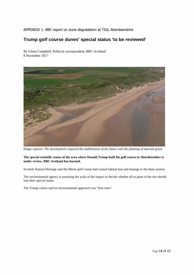
APPENDIX 1: BBC report on dune degradation at TIGL Aberdeenshire
Trump golf course dunes' special status 'to be reviewed'
By Glenn Campbell, Political correspondent, BBC Scotland
8 November 2017
Image caption: The development required the stabilisation of the dunes with the planting of marram grass
The special scientific status of the area where Donald Trump built his golf course in Aberdeenshire is
under review, BBC Scotland has learned.
Scottish Natural Heritage said the Menie golf course had caused habitat loss and damage to the dune system.
The environmental agency is assessing the scale of the impact to decide whether all or parts of the site should
lose their special status.
The Trump course said its environmental approach was "first class".

Page 19 of 22
Image caption: Donald Trump built the golf course at the Menie Estate, which opened in 2012
Donald Trump officially played his first round at the Trump International Golf Links in Aberdeenshire in July
2012.
The golf course covers part of the Foveran Links Site of Special Scientific Interest (SSSI), north of Aberdeen,
which was considered one of the finest examples of a mobile sand dune system in the UK.
Before the course was built, the dune system moved north at substantial speeds - up to 11 metres per year -
across an area of about 15 hectares.
Scottish Natural Heritage, which objected to the golf course development, has been monitoring its
environmental impact.
Image caption: Trump opened his golf course just over five years ago
Page 20 of 22
An SNH spokesperson said: "We're currently reviewing the SSSI boundary of Foveran Links and hope to
complete this by the end of December.
"As expected, there are areas where there has been some permanent habitat loss - for example, where tracks,
tees, fairways and greens have been constructed.
"There have been other habitat changes where, for example, mobile sand dunes have been stabilised through the
planting of marram grass.
"Part of our review will be to assess the significance and scale of this loss and damage."
SNH regularly checks SSSIs for the special features they were selected for.
"If they have changed, it's sometimes necessary to adjust the boundary and de-notify all or parts of the site," the
spokesperson added.
Dr Jim Hansom, a geomorphologist from Glasgow University, said he would be "absolutely surprised" if
Foveran Links did not lose special status.
Image caption: Dr Jim Hansom, from Glasgow University, is an expert on land forms
"It really should be de-notified because there's no dynamism involved in that site now and that was the original
justification for its notification," he said.
"It's been ruined from a virgin undeveloped wilderness site into something that's relatively manicured."
The Trump Organisation was granted outline planning permission to build a golf resort in Aberdeenshire by the
Scottish government in 2008.
It decided after a public local inquiry that the economic impact of what was proposed outweighed
environmental concerns.

Page 21 of 22
Trump International Golf Links Scotland's executive vice-president, Sarah Malone, said the future of the SSSI
was "for the authorities to decide".
Image caption: Sarah Malone questioned why the company would damage the dunes, when the site was bought
because of them
"I don't think it matters to us. It may matter to other people and we'll be comfortable with whatever the option
and the decision on that is," she said.
"We bought the site because of these extraordinary sand dunes. Why would we do anything to damage them?
"The fact of the matter is, contrary to what is propagated by a very small group of people, our environmental
approach was first class."
Trump International has submitted a planning application for a second golf course on its Aberdeenshire estate,
which has also been met with environmental objections.

Page 22 of 22
APPENDIX 2: Letters to Minister Heather Humphreys and Clare County Council
See the following pages.

An Taisce is a membership-based charity | Join at www.antaisce.org/membership
An Taisce – The National Trust for Ireland | Tailors’ Hall, Back Lane, Dublin, D08 X2A3, Ireland | www.antaisce.org
+353 1 454 1786 | [email protected]
Company Limited by Guarantee | Company 12469 | Charity CHY 4741 | Charity Regulator No. 20006358 EU Transparency Register No. 89747144047-77
Directors: Karl Dowling (Secretary), Philip Kearney, Christopher Massi, Muiris O’Ceidigh, Patricia Oliver, Judy Osborne (British), John Pierce (Chair), Garrett Poynton, Charles Stanley-Smith (British), John Sweeney.
Heather Humphreys TD
Minister for Arts Heritage and Gaeltacht
Kildare St
Dublin 2
30 Nov. 2017
Re ; Request for National Parks and Wildlife Service (NPWS ) investigation of :
1 Compliance with Habitats Regulations Obligations
2 Environmental Impact Assessment and Habitats mitigation measures and Condition 6 of
planning permission granted by An Bord Pleanala
at 18 Hole Golf course, hotel, house and other development at White Strand, Cloonmore,
Carrowmore North, Carorwmore, Donoughmore bay, Doonbeg Co Clare, in ownership of
Trump International Golf Links Ireland Enterprises Ltd
Clare Co Co Ref No 98/655 An Bord Pleanala Ref 03.109516
Dear Minister
We request enforcement inspection in relation to the above by National Parks and Wildlife
Service (NPWS) on:
1 Compliance with Habitats Regulations obligations
2 the Environmental Impact Assessment and Habitats mitigation measures and Condition 6 of
planning permission granted by An Bord Pleanala.
As the permission decision was granted under both the Environmental Impact Assessment
Directive and under the Habitats Regulations, this means that mitigation and management
obligations, in particular in relation to ecology remain binding on subsequent and current
owners and require active and ongoing legal compliance and enforcement.

Page 2 of 3
Furthermore condition 6 of the decision states that:
“Prior to commencement of any development works on the site, details of a management plan
shall be submitted to the planning authority for the management and maintenance of the
proposed development which shall include
(a) the entire area of the proposed candidate Special Area of Conservation
(b) habitat of the priority annex I species Angustior vertigo
For the “Reason “To provide for adequate protection measures for areas of Conservation
Importance.”
We have examined the compliance file on the Clare Co Co website and found correspondence
on drainage and landscape in relation to conditions Condition 12 and 13 and a report on rainfall.
By White Young Green in 2008.
We are concerned that there is no documentation available to establish that the EIA Mitigation
and Habitat management requirements being maintained, or that the provisions in the
Management Plan provided under Condition 6 of the 1999 consent are being complied with.
Our concern is prompted by media reports on major ecological damage that has been caused
on the Trump family owned golf resort at Menie in Scotland
A BBC report of 8 Nov 2017 stated:
“The special scientific status of the area where Donald Trump built his golf course in Aberdeenshire is under review, BBC Scotland has learned.
Scottish Natural Heritage said the Menie golf course had caused habitat loss and damage to the dune system.
The environmental agency is assessing the scale of the impact to decide whether all or parts of the site
should lose their special status.”
SEE ATTACHED REPORT
We request that enforcement inspection be carried out by the NPWS to address and determine
compliance with:
1 The Habitats regulation with regard to all issues affecting the priority Annex I species
Angustior vertigo and the Candidate SAC.

Page 3 of 3
2 the EIA Mitigation measures and Habitat management actions attached to the 1999 consent.
3 the provisions in the Management Plan provided under Condition 6 of the 1999 consent
In the event of any deficiencies being identified we request that enforcement action be initiated
by the NPWS under the Habitats Regulations.
Yours sincerely,
Ian Lumley
Advocacy Officer
Attached BBC report of 8 Nov 2017
An Taisce is a membership-based charity. Join at www.antaisce.org/membership
An Taisce – The National Trust for Ireland | Tailors’ Hall, Back Lane, Dublin, D08 X2A3, Ireland | www.antaisce.org
Company 12469 | Charity CHY 4741 | Charity Regulator No. 20006358 | +353 1 454 1786 | [email protected] | Directors: J Leahy, M Mehigan, D Murphy, C Stanley Smith (UK), J Sweeney
Brian McCarthy
Acting Director of Services for Planning and Economic Development
Clare County Council
New Road ,
Ennis Co Clare
30 Nov. 2017
Re ; Compliance with Environmental Impact Assessment and Habitats mitigation measures
and Condition 6 of planning permission granted by An Bord Pleanala for 18 Hole Golf course,
hotel, house and other development at White Strand, Cloonmore, Carrowmore North,
Carorwmore, Donoughmore bay, Doonbeg Co Clare.
In ownership of Trump International Golf Links Ireland Enterprises Ltd
Clare Co Co Ref No 98/655 An Bord Pleanala Ref 03.109516
Dear Mr McCarthy,
We request enforcement inspection in relation to the above planning permission. The
application was obtained by Irish National Golf Club Limited, with ownership having passed
to Trump International Golf Links Ireland Enterprises Ltd.
Permission was granted by An Bord Pleanala ( ref 03.109516 ), in 1999
As the permission decision was granted under both the Environmental Impact Assessment
Directive and under the Habitats regulations, this means that mitigation and management
obligations, in particular in relation to ecology remain binding on subsequent and current
owners and require active and ongoing legal compliance and enforcement.
Furthermore condition 6 of the decision states that:
“Prior to commencement of any development works on the site, details of a management plan
shall be submitted to the planning authority for the management and maintenance of the
proposed development which shall include
(a) the entire area of the proposed candidate Special Area of Conservation
(b) habitat of the priority annex I species Angustior vertigo

Page 2 of 2
For the “Reason “To provide for adequate protection measures for areas of Conservation
Importance.
We have examined the compliance file on the Clare Co Co website and found correspondence
on drainage and landscape in relation to conditions Condition 12 and 13 and a report on rainfall.
By White Young Green in 2008.
We are concerned that there is no documentation available to establish that the EIA Mitigation
and Habitat management requirements are being maintained, and that the provisions in the
Management Plan provided under Condition 6 of the 1999 consent are being complied with.
Our concern is prompted by media reports on major ecological damage that has been caused
on the Trump family golf resort in Scotland,
A BBC report of 8 Nov 2017 stated:
“The special scientific status of the area where Donald Trump built his golf course in Aberdeenshire is under review, BBC Scotland has learned.
Scottish Natural Heritage said the Menie golf course had caused habitat loss and damage to the dune system.
The environmental agency is assessing the scale of the impact to decide whether all or parts of the site should lose their special status.”
SEE ATTACHED REPORT
We request that enforcement inspection be carried out by the Council to address and determine
compliance with:
1 the EIA Mitigation measures and Habitat management actions attached to the consent.
2 the provisions in the Management Plan provided under Condition 6 of the 1999 consent
In the event of any deficiencies being identified we request that Enforcement action be initiated
by the Council under Section 160 Planning and Development Act 2000.
Yours sincerely,
Ian Lumley
Advocacy Officer
Attached BBC report of 8 Nov 2017