mesozoic-cenozoic evolution of the intraplate ... - cornell...
TRANSCRIPT
Journal of the Geological Society, London, Vol. 154, 1997, pp. 653–666, 15 figs. Printed in Great Britain
Mesozoic–Cenozoic evolution of the intraplate Euphrates fault system, Syria:implications for regional tectonics
ROBERT K. LITAK1, MUAWIA BARAZANGI1, WELDON BEAUCHAMP1, DOGAN SEBER1,GRAHAM BREW1, TARIF SAWAF2 & WASIF AL-YOUSSEF2
1Institute for the Study of the Continents, Snee Hall, Cornell University, Ithaca, New York, 14853 USA(e-mail: [email protected])
2Syrian Petroleum Company, Ministry of Petroleum and Mineral Resources, Damascus, Syria
Abstract: A lack of dramatic surface geological structures along the Euphrates River in Syria belie acomplex tectonic history revealed by newly released seismic reflection and well data. We document theintraplate Euphrates fault system, characterize the variation in structural style along its 350 km length inSyria, and infer its Mesozoic–Cenozoic tectonic and deformational history. We then relate the defor-mation of the Euphrates system and other proximate intraplate structures to nearby Arabian plate boundaryprocesses in order to develop a new model for the tectonic evolution of the northern Arabian plate.Throughout most of Mesozoic time, the Euphrates area experienced minor deposition compared to the
Palmyride trough to its southwest, and the Sinjar trough to its northeast. During latest Cretaceous time,however, significant sinistral transtension occurred along the length of the Euphrates fault system in Syria,with graben formation especially noteworthy in southeastern Syria. This episode was probably relatedto events at nearby plate boundaries, and may have reactivated a zone of weakness formed duringPan-African accretion of the Arabian plate. A Palaeogene sag basin formed over the graben system insoutheastern Syria. Neogene continental collision along the northern and eastern Arabian plate bound-aries caused minor reactivation of the Euphrates fault system in a dextral transpressional sense, in concertwith significant inversion and the main phase of uplift of the nearby Palmyride and Sinjar mountains.
Keywords: Syria, Arabian Plate, intraplate processes, seismic profiles, deformation.
The northern Arabian plate comprises diverse structural ele-ments and a variety of temporally and spatially differingstructural styles. Although located in a primarily intraplatesetting, the tectonic history of Syria has been profoundlyaffected by events along nearby plate boundaries (Fig. 1). Thenorthern boundary of the Arabian plate represents a collisionzone in southern Turkey often referred to as the Bitlis suture(e.g., Sengör & Yilmaz 1981; Hempton 1985). The northwest-trending Zagros collision zone is essentially an eastward con-tinuation of the Bitlis zone, produced by continental collisionbetween Arabia and Iran (e.g., Sengör & Kidd 1979; Berberian& Berberian 1981; Berberian & King 1981; Barazangi 1989).The emplacement of ophiolites during Late Cretaceous timealong the northwestern, northern, and eastern margins of theArabian plate indicates an initial episode of convergence atthat time, the extent and nature of which remain controversial(e.g., Beydoun 1991). However, Tertiary island-arc-type vol-canism in Iran implies that subduction of oceanic crust con-tinued until Miocene time, when full-fledged continentalcollision began (e.g., Coleman-Saad 1978). Debate continuesconcerning the Cenozoic history of the Arabian/Anatolianboundary, with various workers favoring either continuedconvergence, subduction, and shortening (Yilmaz 1993) orstrike-slip motion with periods including both extension andconvergence (Karig & Kozlu 1990). Continuing convergencebetween the Arabian and Anatolian plates is now accommo-dated by a combination of thrusting along the Bitlis zone andleft-lateral motion along the East Anatolian Fault as theAnatolian block ‘escapes’ toward the west (e.g., Sengör et al.1985; Burke & Sengör 1986).
To the west lies the Dead Sea Fault System, a left-lateral‘leaky’ transform fault extending from the Red Sea Rift at theGulf of Aqaba in the south, through Lebanon and western-most Syria to a complex triple-junction in southern Turkey.Offset documented along the fault system varies from about105 km in the south to about 20 km in the north (Freund et al.1970; Garfunkel 1981; Quennell 1984; Chaimov et al. 1990).The main phase of motion along the Dead Sea Fault System isthought to have commenced in Miocene time in concert withthe opening of the Red Sea (e.g., Garfunkel 1981; Cochran1983).The Euphrates fault system is an area of significant intra-
plate deformation, extending over 350 km throughout Syria,but has received only limited scrutiny in the open literature.First mentioned by Lovelock (1984) as part of a regionalsynthesis, the Euphrates system has subsequently been asubstantial topic of only three recent publications, all of whichfocussed on aspects of the graben system of southeastern Syria(Sawaf et al. 1993; Alsdorf et al. 1995; de Ruiter et al. 1995).This study complements considerable recent work in thenearby adjoining Palmyride fold belt (McBride et al. 1990; Bestet al. 1990, 1993; Chaimov et al. 1990, 1992, 1993; Al-Saadet al. 1992; Barazangi et al. 1993; Seber et al. 1993; Salel &Séguret 1994; Searle 1994).In this study, we use newly available seismic and well data to
document the first-order deformation history of the Euphratesfault system in Syria. We then relate our observations andinterpretations to published interpretations of other intraplatetectonic elements within and around Syria, and speculate onregional kinematics throughout Mesozoic and Cenozoic time.
653
We argue herein that the complex pattern of intraplate defor-mation within Syria and surrounding areas can be consideredin terms of episodic reactivation of long-lived weak or mobilezones between relatively strong or stable blocks. The reactionof these weak zones to changing stress conditions associatedwith plate boundary events has produced the mosaic nowcharacterizing the structural styles of the northern Arabianplate.
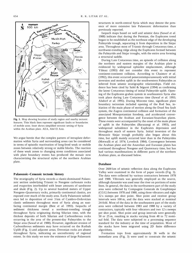
Palaeozoic–Cenozoic tectonic historyThe stratigraphy of Syria records a clastic-dominated Palaeo-zoic section underlying Triassic to Neogene carbonate rocksand evaporites interbedded with lesser amounts of sandstoneand shale (Fig. 2). Up to several hundred meters of UpperNeogene–Quaternary rocks, primarily continental clastics, areexposed over much of the study area. Early Palaeozoic subsid-ence led to deposition of over 3 km of Cambro-Ordovicianclastic sediments throughout most of Syria along an east-facing continental margin (Best et al. 1993). Isopachs ofsediment thickness reveal a northeast-trending troughthroughout Syria originating during Silurian time, with thethickest deposits of both Silurian and Carboniferous rocksoccurring in the area of the present-day Palmyrides to theSinjar area (Sawaf et al. 1988). However, significant erosion ofCarboniferous sediments may have occurred on the RutbahUplift (Fig. 1) and adjacent areas. Devonian rocks are absentthroughout Syria, indicating an unconformity of regionalextent. In this study we note the existence of large Palaeozoic
structures in north-central Syria which may denote the pres-ence of more extensive late Palaeozoic deformation thanpreviously reported.Isopach maps based on well and seismic data (Sawaf et al.
1988) indicate that during the Permian, the Euphrates trendbegan to be established as the northeast edge of the developingPalmyride trough, separating it from deposition in the Sinjararea. Throughout most of Triassic through Cretaceous time, anorthwest-trending ridge along the Euphrates formed betweenthe Palmyride and Sinjar troughs, with the entire area forminga structural saddle.During Late Cretaceous time, an episode of collision along
the northern and eastern margins of the Arabian plate isevidenced by widespread ophiolite emplacement, althoughYilmaz (1993) did not consider this event to representcontinent-continent collision. According to Chaimov et al.(1992), this event occurred penecontemporaneously with initialinversion and modest uplift in the southwestern Palmyrides asinferred from seismic stratigraphic relationships. Field evi-dence has been cited by Salel & Séguret (1994) as confirmingthe latest Cretaceous timing of initial Palmyride uplift. Open-ing of the Euphrates graben system in southeastern Syria alsotook place during Late Cretaceous time (Sawaf et al. 1993;Alsdorf et al. 1995). During Miocene time, significant plateboundary tectonism included opening of the Red Sea, in-itiation of the main phase of motion along the Dead Sea faultsystem, the Zagros continental collision and formation of theassociated Mesopotamian foredeep, and accelerated conver-gence between the Arabian and Eurasian/Anatolian plates.These events were accompanied by the onset of the main phaseof uplift in the Palmyrides (Barazangi et al. 1993), andwidespread subsidence in the Euphrates depression andthroughout much of eastern Syria. Initial inversion of theMesozoic Sinjar trough probably also began about thistime, but uplift mainly occurred later than in the Palmyrides(Metwalli et al. 1974; Lovelock 1984). Convergence betweenthe Arabian plate and the Anatolian and Eurasian plates hascontinued throughout Neogene and Quaternary time, but hashad various manifestations in different parts of the northernArabian plate, as discussed below.
DatabaseOver 2600 km of seismic reflection data along the EuphratesValley were examined in the form of paper records (Fig. 3).The data were collected by various contractors between 1978and 1988. Vibroseis was generally employed as the source,although dynamite was used near the river on portions of somelines. In general, the data in the northwestern part of the studyarea were collected by Compagnie Generale de Geophisique(CGG) between 1978 and 1980, using three vibrators and eight12 s sweeps per shot point. Shot point and receiver groupintervals were 100 m, and the data were stacked at nominal24-fold. Most of the data in the southeastern part of the studyarea were collected between 1983 and 1988 by a variety ofcontractors, typically with four vibrators and two 12 s sweepsper shot point. Shot point and group intervals were generally50 or 25 m, resulting in stacks varying from 48 to 72 nomi-nal fold. The data were subjected to a processing sequencestandard for the industry at the time of acquisition. Most ofthe stacks have been migrated using 2D finite differencealgorithms.Formation tops from approximately 36 wells in the
immediate area (Fig. 3) were used to constrain the seismic
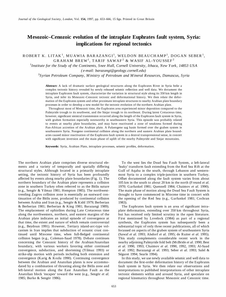
Fig. 1. Map showing location of study region and nearby tectonicfeatures. Thin black lines represent significant faults or boundariesof mobile zone. Inset shows simplified tectonic setting of Syriawithin the Arabian plate. AEA, Abd El Aziz.
654 R. K. LITAK ET AL.

interpretation. Sonic logs for 12 wells provided velocity infor-mation for time-depth conversion and calculation of syntheticseismograms in the following manner: a reflection coefficientseries generated from each sonic log was convolved with aKlauder wavelet made of frequencies identical to the seismicsource. The same frequency filter and gain used in the seismicprocessing were applied to the resulting synthetic seismogram.Other available data included 1:200 000 scale geologicalmaps (Ponikarov 1964) augmented by a high-resolution digitalelevation model and Landsat MSS imagery to map surfacestructures and constrain the seismic interpretation.
Data analysis and interpretationA variety of nomenclature has been used to describe thegeology of the Euphrates area in Syria. In this study, weconsider the Euphrates graben system to be a network ofrelatively deep, Late Cretaceous grabens and half-grabenslargely confined to southeastern Syria (although we note thataspects of this graben system continue far to the northwest).The Euphrates depression is the Late Maastrichtian-Cenozoic,primarily Palaeogene, sag basin overlying the Euphratesgraben system. Lovelock (1984) described the Al-Furat fault asa major transcurrent fault extending from Turkey to Iraq, andserving as the northeastern boundary of the Euphrates grabenbut extending far to the northwest. Since we recognize acomplex network of branching faults with similar overall trendrather than a single fault zone bounding the Euphrates
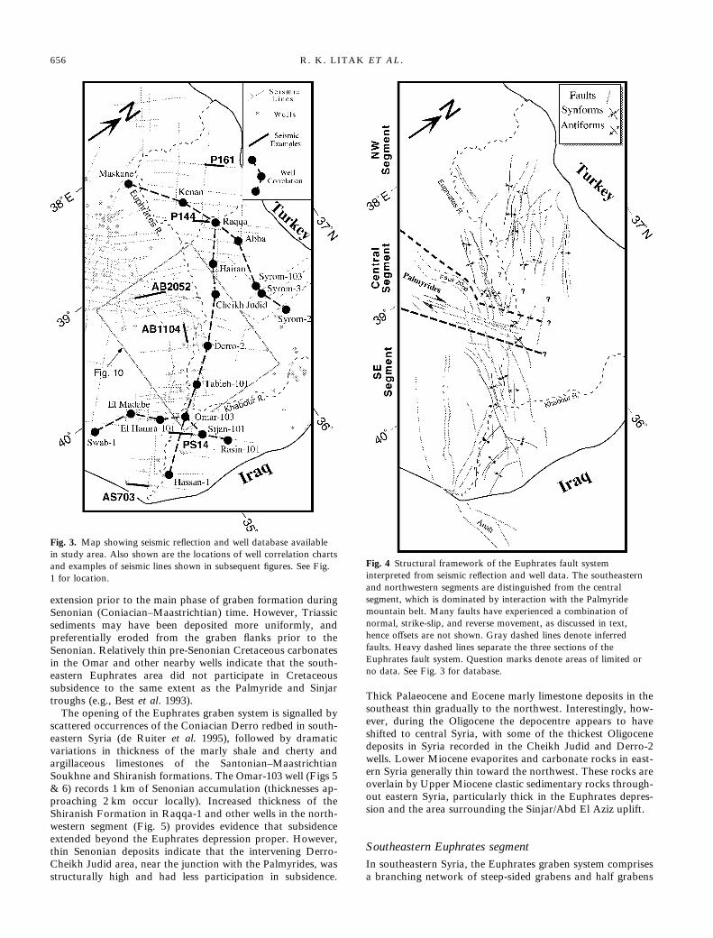
graben system, the entire network is herein referred to as theEuphrates fault system.For the purposes of this study, it is convenient to divide the
Euphrates fault system in Syria into three segments. Mappingof the main structural elements delineates the extent of theEuphrates fault system and deformation within each of thesesegments (Fig. 4). The southeastern segment comprises thearea generally considered to be the Euphrates graben anddepression, consisting of thick Campanian–Maastrichtian andCenozoic sediments. The central segment is a complex zone ofinteraction between the Euphrates trend, the northeasternterminus of the Palmyride mountain belt, and possibly theSinjar and Abd El Aziz uplifts in northeastern Syria. Thenorthwestern segment, part of which is sometimes referred toas the north Euphrates basin, shares some characteristics withthe southeastern segment, but lacks the thick sediments seenthere. Well correlation charts and seismic examples are used toillustrate structural variations among these segments (Fig. 3).Figure 5 illustrates variations in formation thicknesses along
the axis of the Euphrates fault system. Although numerousunconformities are apparent, several features are particularlynoteworthy. First, the Omar-103 well, near the deepest part ofthe Euphrates depression, includes anomalously thick UpperTriassic sediments (primarily shale, limestone, and dolomite).Considerable variations in thicknesses of Upper Triassic for-mations are also apparent in numerous other nearby wells.This suggests uneven subsidence in the area of the Euphratesdepression during Triassic time, possibly an earlier episode of
Fig. 2. Generalized lithostratigraphiccolumn of Syria. Based on compilationsof Syrian Petroleum Company compositelogs. Formation names and ages areslightly different to those used in Iraq.
EVOLUTION OF THE EUPHRATES FAULT SYSTEM 655
extension prior to the main phase of graben formation duringSenonian (Coniacian–Maastrichtian) time. However, Triassicsediments may have been deposited more uniformly, andpreferentially eroded from the graben flanks prior to theSenonian. Relatively thin pre-Senonian Cretaceous carbonatesin the Omar and other nearby wells indicate that the south-eastern Euphrates area did not participate in Cretaceoussubsidence to the same extent as the Palmyride and Sinjartroughs (e.g., Best et al. 1993).The opening of the Euphrates graben system is signalled by
scattered occurrences of the Coniacian Derro redbed in south-eastern Syria (de Ruiter et al. 1995), followed by dramaticvariations in thickness of the marly shale and cherty andargillaceous limestones of the Santonian–MaastrichtianSoukhne and Shiranish formations. The Omar-103 well (Figs 5& 6) records 1 km of Senonian accumulation (thicknesses ap-proaching 2 km occur locally). Increased thickness of theShiranish Formation in Raqqa-1 and other wells in the north-western segment (Fig. 5) provides evidence that subsidenceextended beyond the Euphrates depression proper. However,thin Senonian deposits indicate that the intervening Derro-Cheikh Judid area, near the junction with the Palmyrides, wasstructurally high and had less participation in subsidence.
Thick Palaeocene and Eocene marly limestone deposits in thesoutheast thin gradually to the northwest. Interestingly, how-ever, during the Oligocene the depocentre appears to haveshifted to central Syria, with some of the thickest Oligocenedeposits in Syria recorded in the Cheikh Judid and Derro-2wells. Lower Miocene evaporites and carbonate rocks in east-ern Syria generally thin toward the northwest. These rocks areoverlain by Upper Miocene clastic sedimentary rocks through-out eastern Syria, particularly thick in the Euphrates depres-sion and the area surrounding the Sinjar/Abd El Aziz uplift.
Southeastern Euphrates segmentIn southeastern Syria, the Euphrates graben system comprisesa branching network of steep-sided grabens and half grabens
Fig. 3. Map showing seismic reflection and well database availablein study area. Also shown are the locations of well correlation chartsand examples of seismic lines shown in subsequent figures. See Fig.1 for location.
Fig. 4 Structural framework of the Euphrates fault systeminterpreted from seismic reflection and well data. The southeasternand northwestern segments are distinguished from the centralsegment, which is dominated by interaction with the Palmyridemountain belt. Many faults have experienced a combination ofnormal, strike-slip, and reverse movement, as discussed in text,hence offsets are not shown. Gray dashed lines denote inferredfaults. Heavy dashed lines separate the three sections of theEuphrates fault system. Question marks denote areas of limited orno data. See Fig. 3 for database.
656 R. K. LITAK ET AL.
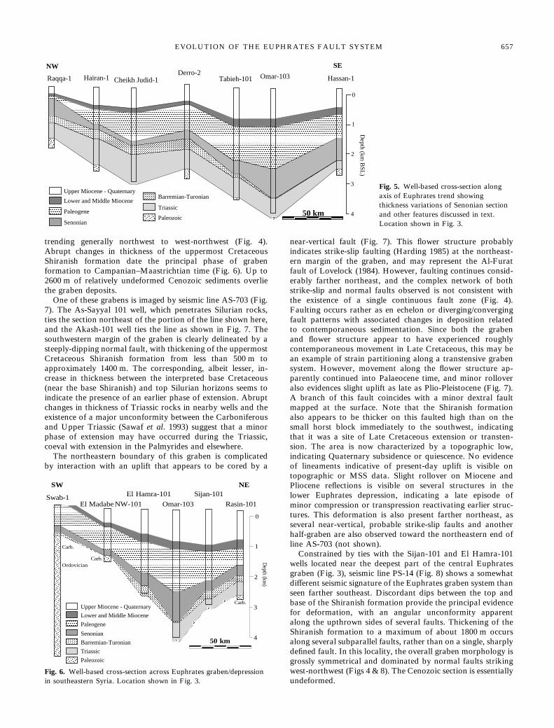
trending generally northwest to west-northwest (Fig. 4).Abrupt changes in thickness of the uppermost CretaceousShiranish formation date the principal phase of grabenformation to Campanian–Maastrichtian time (Fig. 6). Up to2600 m of relatively undeformed Cenozoic sediments overliethe graben deposits.One of these grabens is imaged by seismic line AS-703 (Fig.
7). The As-Sayyal 101 well, which penetrates Silurian rocks,ties the section northeast of the portion of the line shown here,and the Akash-101 well ties the line as shown in Fig. 7. Thesouthwestern margin of the graben is clearly delineated by asteeply-dipping normal fault, with thickening of the uppermostCretaceous Shiranish formation from less than 500 m toapproximately 1400 m. The corresponding, albeit lesser, in-crease in thickness between the interpreted base Cretaceous(near the base Shiranish) and top Silurian horizons seems toindicate the presence of an earlier phase of extension. Abruptchanges in thickness of Triassic rocks in nearby wells and theexistence of a major unconformity between the Carboniferousand Upper Triassic (Sawaf et al. 1993) suggest that a minorphase of extension may have occurred during the Triassic,coeval with extension in the Palmyrides and elsewhere.The northeastern boundary of this graben is complicated
by interaction with an uplift that appears to be cored by a
near-vertical fault (Fig. 7). This flower structure probablyindicates strike-slip faulting (Harding 1985) at the northeast-ern margin of the graben, and may represent the Al-Furatfault of Lovelock (1984). However, faulting continues consid-erably farther northeast, and the complex network of bothstrike-slip and normal faults observed is not consistent withthe existence of a single continuous fault zone (Fig. 4).Faulting occurs rather as en echelon or diverging/convergingfault patterns with associated changes in deposition relatedto contemporaneous sedimentation. Since both the grabenand flower structure appear to have experienced roughlycontemporaneous movement in Late Cretaceous, this may bean example of strain partitioning along a transtensive grabensystem. However, movement along the flower structure ap-parently continued into Palaeocene time, and minor rolloveralso evidences slight uplift as late as Plio-Pleistocene (Fig. 7).A branch of this fault coincides with a minor dextral faultmapped at the surface. Note that the Shiranish formationalso appears to be thicker on this faulted high than on thesmall horst block immediately to the southwest, indicatingthat it was a site of Late Cretaceous extension or transten-sion. The area is now characterized by a topographic low,indicating Quaternary subsidence or quiescence. No evidenceof lineaments indicative of present-day uplift is visible ontopographic or MSS data. Slight rollover on Miocene andPliocene reflections is visible on several structures in thelower Euphrates depression, indicating a late episode ofminor compression or transpression reactivating earlier struc-tures. This deformation is also present farther northeast, asseveral near-vertical, probable strike-slip faults and anotherhalf-graben are also observed toward the northeastern end ofline AS-703 (not shown).Constrained by ties with the Sijan-101 and El Hamra-101
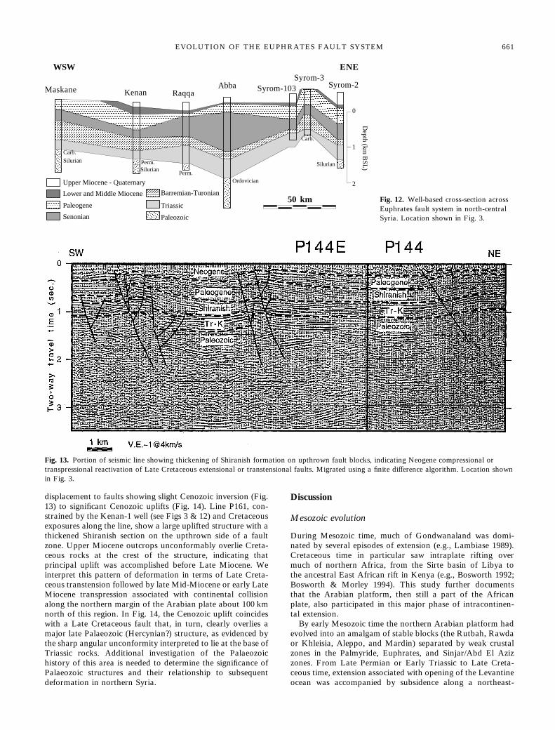
wells located near the deepest part of the central Euphratesgraben (Fig. 3), seismic line PS-14 (Fig. 8) shows a somewhatdifferent seismic signature of the Euphrates graben system thanseen farther southeast. Discordant dips between the top andbase of the Shiranish formation provide the principal evidencefor deformation, with an angular unconformity apparentalong the upthrown sides of several faults. Thickening of theShiranish formation to a maximum of about 1800 m occursalong several subparallel faults, rather than on a single, sharplydefined fault. In this locality, the overall graben morphology isgrossly symmetrical and dominated by normal faults strikingwest-northwest (Figs 4 & 8). The Cenozoic section is essentiallyundeformed.
?50 km
Senonian
Triassic
Paleozoic
Lower and Middle Miocene
Paleogene
Barremian-TuronianUpper Miocene - Quaternary
Omar-103 Hassan-1Tabieh-101Derro-2
Cheikh Judid-1Hairan-1Raqqa-1
NW SE
3
2
1
0
Depth (km
BSL
)
4
Fig. 5. Well-based cross-section alongaxis of Euphrates trend showingthickness variations of Senonian sectionand other features discussed in text.Location shown in Fig. 3.
Carb.
Carb.
50 km
3
2
1
0
Depth (km
)
Omar-103
Sijan-101
Rasin-101
El Hamra-101
El Madabe NW-101Swab-1
SW NE
Carb.
Ordovician
Senonian
Triassic
Paleozoic
Lower and Middle Miocene
Paleogene
Barremian-Turonian
Upper Miocene - Quaternary
4
Fig. 6. Well-based cross-section across Euphrates graben/depressionin southeastern Syria. Location shown in Fig. 3.
EVOLUTION OF THE EUPHRATES FAULT SYSTEM 657
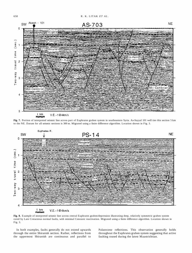
In both examples, faults generally do not extend upwardsthrough the entire Shiranish section. Rather, reflections fromthe uppermost Shiranish are continuous and parallel to
Palaeocene reflections. This observation generally holdsthroughout the Euphrates graben system suggesting that activefaulting ceased during the latest Maastrichtian.
Fig. 7. Portion of interpreted seismic line across part of Euphrates graben system in southeastern Syria. As-Sayyal 101 well ties this section 5 kmto the NE. Datum for all seismic sections is 300 m. Migrated using a finite difference algorithm. Location shown in Fig. 3.
Fig. 8. Example of interpreted seismic line across central Euphrates graben/depression illustrating deep, relatively symmetric graben systemcored by Late Cretaceous normal faults, with minimal Cenozoic reactivation. Migrated using a finite difference algorithm. Location shown inFig. 3.
658 R. K. LITAK ET AL.

Euphrates–Palmyrides junctionStructures of the Euphrates graben continue to the northwestto the junction with the Palmyrides, where the northeasternprovince of the Palmyrides is represented by the Bishricrustal block. In contrast to thin-skinned thrusting andfolding exhibited in the southwestern Palmyrides, thick-skinned transpressional deformation of the Bishri block hasproduced a broad, antiformal uplift (Best 1991). Despiterelatively poor seismic data in this area (probably due toboth complex subsurface structures and poor surface con-ditions), combining seismic and auxiliary data results in thefollowing general observations. A series of near-verticalnortheast-trending faults are apparent on several seismic lines(Fig. 9), and can be mapped using seismic data some 80 kmin distance and tied to the surface exposure of the SouthAl-Bishri fault (Fig. 4), a right-lateral transpressive fault that
forms the southern boundary of the Bishri block (Alsdorfet al. 1995). These faults are also apparent as lineamentson digital topography data (Fig. 10) and Landsat imagery.Topographic expression as well as minor earthquake activityalong the South Al-Bishri fault (Chaimov et al. 1990), indi-cate that these faults are still active. A magnitude Ms=4.9earthquake that occurred on 20 November 1994 was locatednear one of these lineaments, at a depth of 15 km, northeastof the mapped extent of the South Al-Bishri fault (Fig. 10).Evidence concerning the sense of motion of these faults isnot conclusive. The focal mechanism for a 1970 earthquake(mb=4.8) was determined to be dextral (Chaimov et al.1990), but an initial solution for the 1994 event suggestssinistral motion (Dziewonski et al. 1995). For events thissmall, teleseismic determination of locations and focalmechanisms may not be definitive. Moreover, field evidence
Neogene
Paleogene
ShiranishK
Paleozoic
?
? ?
?
Tr
Fig. 9. Seismic line showing flowerstructures interpreted as strike-slip faultsbounding the Palmyride Bishri block.Migrated using a finite differencealgorithm. Location shown in Fig. 3.
KKKhhh
aaa bbbooo
uuurrr
RRR..
EEEuuuppphhhrrraaattteeesss RRRiiivvveeerrr
AAABBB111111000444
35 N39.5 E
35 N
40.5 E
36 N 36 N
39.5 E 40.5 E
20 km
Fig. 10. Map showing topography ofPalmyride/Euphrates junction from adigital elevation model; artificialillumination from northwest (for locationsee Fig. 3). Lineaments highlighted byarrows coincide with flower structures onseismic line AB1104 (Fig. 9), and appearto extend to South Al-Bishri fault insouthwestern corner of figure (see Fig.1). Reported location of Ms=4.9earthquake of 20 November 1994 withfocal mechanism also shown; shadedquadrants are compressional(Dziewonski et al. 1995).
EVOLUTION OF THE EUPHRATES FAULT SYSTEM 659

(Searle 1994) and kinematic models (Chaimov et al. 1993;Searle 1994) are consistent with dextral motion along theSouth Al-Bishri fault. Al-Saad et al. (1992) also reportedevidence for dextral motion on the nearby Jhar fault. Inaddition, one of the faults identified here appears to offsetthe Euphrates river valley by several km in a dextral sense(Fig. 10). The fact that the Shiranish formation thins signifi-cantly across this fault zone implies that either it has experi-enced substantial Neogene dextral motion, or that it wasactive during the Late Cretaceous, perhaps as a dextraltransfer fault. We interpret these features as a right-lateralstrike-slip fault system marking the boundary between theBishri block and the Euphrates fault system (see also Alsdorfet al. 1995).Northwest of these faults a very different structure is appar-
ent (Fig. 11). The flat-lying sediments of the Euphrates area aredisrupted and uplifted by some 1200 m at a flexural featurehere interpreted as the northeastern boundary of the Bishriblock. In map view, this bounding flexure curves from thewesterly strike shown here to strike southwest (Fig. 4). Basedpartly on earthquake focal mechanism data, Chaimov et al.(1990) suggested a right-lateral sense of motion along thenorthwestern boundary of the Bishri block. The existence ofQuaternary sediments indicative of subsidence above the faultzone are consistent with a right-lateral sense of motion alongthe curving northern boundary of the Bishri within an overalltranspressive regime.A digitized sonic log from the Bishri-1 well was used to
create a synthetic seismogram tying line AB-2052; a relativelygood match was obtained (Fig. 11). Note that well controlrequires the Mesozoic section to be much thicker in theBishri block than in the Euphrates area, although the Bishriblock is structurally higher. This indicates that the structure
on Fig. 11 represents true inversion of the MesozoicPalmyride trough.
Northwestern Euphrates segmentNorthwest of the Palmyride–Euphrates intersection, northwest-trending structures are again apparent on the seismic data (Fig.4). Variations in formation thicknesses are noted at severallevels across the Euphrates area, and are again most prominentin the Shiranish formation (Fig. 12). On the seismic data, thesestructures are manifested by thickening of the Shiranishformation on the downthrown side of normal faults. Many ofthese faults show little or no offset of Cenozoic reflections,dating their main period of movement to Campanian–Maastrichtian time. This northwest-trending fault system isvery diffuse, comprising an area perhaps as wide as 80 km, butnowhere do these grabens and half-grabens attain the thick-nesses of those in the southeastern Euphrates segment.Farther northwest, reverse motion is apparent at the top of
Cretaceous and higher stratigraphic levels, requiring eitherlarger, older normal displacements at lower levels or a thickerShiranish section in the hanging wall to explain deeper reflec-tion patterns (Fig. 13). Well control from the Raqqa-1 andKenan-1 wells (see Figs 3 & 12) requires significant thickeningof the Shiranish formation across one or more of these faults.This observation establishes clear evidence for Cenozoic inver-sion of Late Cretaceous normal faults. Many of the faults arenear-vertical and branched (e.g., Fig. 13), suggesting a compo-nent of strike-slip motion possibly indicative of transpressionalreactivation of transtensional structures. Correlating thesefaults along strike toward the northwest, we note a transitionin some of these structures from Cretaceous faults with normal
Neogene -QuaternaryPaleogene
Shiranish
K
JK
J
Two-way travel time (sec.)
Palmyrides Euphrates
Tr
Fig. 11. Portion of seismic line showing complex fault system at northern edge of Bishri block. Interpretation constrained by well data includingsynthetic seismogram in Bishri-1 well. Note thickening of Mesozoic section from Wadi Abid to Bishri wells. Neogene uplift of Bishri block thusappears to have reactivated bounding fault zone of Mesozoic Palmyride trough. Migrated using a finite difference algorithm. Location shown inFig. 3.
660 R. K. LITAK ET AL.
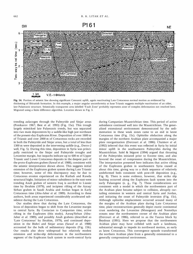
displacement to faults showing slight Cenozoic inversion (Fig.13) to significant Cenozoic uplifts (Fig. 14). Line P161, con-strained by the Kenan-1 well (see Figs 3 & 12) and Cretaceousexposures along the line, show a large uplifted structure with athickened Shiranish section on the upthrown side of a faultzone. Upper Miocene outcrops unconformably overlie Creta-ceous rocks at the crest of the structure, indicating thatprincipal uplift was accomplished before Late Miocene. Weinterpret this pattern of deformation in terms of Late Creta-ceous transtension followed by late Mid-Miocene or early LateMiocene transpression associated with continental collisionalong the northern margin of the Arabian plate about 100 kmnorth of this region. In Fig. 14, the Cenozoic uplift coincideswith a Late Cretaceous fault that, in turn, clearly overlies amajor late Palaeozoic (Hercynian?) structure, as evidenced bythe sharp angular unconformity interpreted to lie at the base ofTriassic rocks. Additional investigation of the Palaeozoichistory of this area is needed to determine the significance ofPalaeozoic structures and their relationship to subsequentdeformation in northern Syria.
Discussion
Mesozoic evolution
During Mesozoic time, much of Gondwanaland was domi-nated by several episodes of extension (e.g., Lambiase 1989).Cretaceous time in particular saw intraplate rifting overmuch of northern Africa, from the Sirte basin of Libya tothe ancestral East African rift in Kenya (e.g., Bosworth 1992;Bosworth & Morley 1994). This study further documentsthat the Arabian platform, then still a part of the Africanplate, also participated in this major phase of intracontinen-tal extension.By early Mesozoic time the northern Arabian platform had
evolved into an amalgam of stable blocks (the Rutbah, Rawdaor Khleisia, Aleppo, and Mardin) separated by weak crustalzones in the Palmyride, Euphrates, and Sinjar/Abd El Azizzones. From Late Permian or Early Triassic to Late Creta-ceous time, extension associated with opening of the Levantineocean was accompanied by subsidence along a northeast-
0
1
2
Maskane Kenan RaqqaAbba Syrom-103
Syrom-3Syrom-2
WSW ENE
50 kmD
epth (km B
SL)
Carb.
Silurian
SilurianSilurian
Carb.
Ordovician
Perm.
Perm.
Senonian
Triassic
Paleozoic
Lower and Middle Miocene
Paleogene
Barremian-Turonian
Upper Miocene - Quaternary
Fig. 12. Well-based cross-section acrossEuphrates fault system in north-centralSyria. Location shown in Fig. 3.
Fig. 13. Portion of seismic line showing thickening of Shiranish formation on upthrown fault blocks, indicating Neogene compressional ortranspressional reactivation of Late Cretaceous extensional or transtensional faults. Migrated using a finite difference algorithm. Location shownin Fig. 3.
EVOLUTION OF THE EUPHRATES FAULT SYSTEM 661
trending aulacogen through the Palmyride and Sinjar areas(Ponikarov 1967; Best et al. 1993) (Fig. 15a). This troughlargely mimicked late Palaeozoic trends, but was separatedinto two main depocentres by a saddle-like high just northeastof the present-day Euphrates River. Deposition of over 1600 mof Triassic and over 2000 m of Cretaceous rocks are recordedin both the Palmyride and Sinjar areas, but a total of less than1300 m were deposited in the intervening saddle (e.g., Derro-2well, Fig. 5). During this time, deposition in Syria was princi-pally restricted to the Sinjar and Palmyride troughs andLevantine margin, but isopachs indicate up to 600 m of UpperTriassic and Lower Cretaceous deposits in the deepest part ofthe proto-Euphrates graben (Sawaf et al. 1988), consistent withthe seismic interpretation shown above. This suggests initialextension of the Euphrates graben system during Late Triassictime; however, some of this discrepancy may be due toCretaceous erosion experienced on the Rutbah and Rawdastructural highs. Initiation of minor subsidence in the east-westtrending Anah graben of western Iraq is ascribed to Liassictime by Ibrahim (1979), and incipient rifting of the Azraq/Sirhan graben in Saudi Arabia and Jordan began in EarlyCretaceous time (Abu-Jaber et al. 1989). According to theseauthors, both areas experienced considerably accelerated sub-sidence during the Late Cretaceous.Our studies show that during the Late Cretaceous, the
locus of deposition began to shift from the Levantine marginto central Syria. By Coniacian to Campanian time, activerifting in the Euphrates (this study), Azraq/Sirhan (Abu-Jaber et al. 1989), and possibly Anah grabens (described as‘Late Cretaceous’ by Ibrahim, 1979), and continued depo-sition in the Bishri and Sinjar areas (Sawaf et al. 1988)accounted for the bulk of sedimentary deposits (Fig. 15b).Our results also show widespread but relatively modestextension and strike-slip deformation in the northwesternsegment of the Euphrates fault system in north-central Syria
during Campanian–Maastrichtian time. This period of activesubsidence continued well into the Maastrichtian. The gener-alized extensional environment demonstrated by the sedi-mentation in these weak zones came to an end in latestCretaceous time (Fig. 15c). Ophiolite obduction along themargins of the northern Arabian plate accompanied a majorplate reorganization (Dercourt et al. 1986). Chaimov et al.(1992) inferred that this event was reflected in Syria by initialminor uplift in the southwestern Palmyrides during theMaastrichtian. Salel & Séguret (1994) argued that thrustingof the Palmyrides initiated prior to Eocene time, and alsofavored the onset of compression during the Maastrichtian.The interpretation presented here indicates that active riftingof the Euphrates graben in southeastern Syria ceased atabout this time, giving way to a thick sequence of relativelyundeformed beds consistent with post-rift deposition (e.g.,Fig. 8). There is some evidence, however, that strike slipfaulting occurred along the Euphrates fault system into theearly Palaeogene (e. g., Fig. 7). These considerations areconsistent with a model in which the northwestern part ofthe Arabian plate became subject to collision, abruptly cur-tailing extension in western and central Syria and Jordan,and initiating the onset of Palmyride inversion (Fig. 15c).Although ophiolite emplacement occurred around many ofthe margins of the Arabian plate during Late Cretaceoustime, plate reconstructions generally depict exotic continentalcrust sundering the Levantine (Mesogean) and Neotethysoceans near the northwestern corner of the Arabian plate(Dercourt et al. 1986), referred to as the Taurus block byBeydoun (1991). Here we propose that the northwesternArabian plate may have collided with such a landmass,substantial enough to impede its northward motion, as earlyas latest Cretaceous. This convergence episode transformedthe northern Arabian plate from a generally extensional to agenerally compressional environment.
Fig. 14. Portion of seismic line showing significant Cenozoic uplift, again reactivating Late Cretaceous normal motion as evidenced bythickening of Shiranish formation. In this example, a major angular unconformity at base Triassic suggests multiple reactivation of an older,late Palaeozoic structure. Seismically transparent area labelled ‘Fault Zone’ probably represents zone of complex deformation not resolved here.Migrated using a finite difference algorithm. Location shown in Fig. 3.
662 R. K. LITAK ET AL.
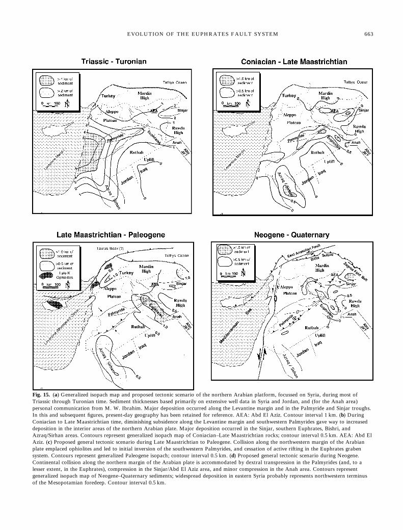
Fig. 15. (a) Generalized isopach map and proposed tectonic scenario of the northern Arabian platform, focussed on Syria, during most ofTriassic through Turonian time. Sediment thicknesses based primarily on extensive well data in Syria and Jordan, and (for the Anah area)personal communication from M. W. Ibrahim. Major deposition occurred along the Levantine margin and in the Palmyride and Sinjar troughs.In this and subsequent figures, present-day geography has been retained for reference. AEA: Abd El Aziz. Contour interval 1 km. (b) DuringConiacian to Late Maastrichtian time, diminishing subsidence along the Levantine margin and southwestern Palmyrides gave way to increaseddeposition in the interior areas of the northern Arabian plate. Major deposition occurred in the Sinjar, southern Euphrates, Bishri, andAzraq/Sirhan areas. Contours represent generalized isopach map of Coniacian–Late Maastrichtian rocks; contour interval 0.5 km. AEA: Abd ElAziz. (c) Proposed general tectonic scenario during Late Maastrichtian to Paleogene. Collision along the northwestern margin of the Arabianplate emplaced ophiolites and led to initial inversion of the southwestern Palmyrides, and cessation of active rifting in the Euphrates grabensystem. Contours represent generalized Paleogene isopach; contour interval 0.5 km. (d) Proposed general tectonic scenario during Neogene.Continental collision along the northern margin of the Arabian plate is accommodated by dextral transpression in the Palmyrides (and, to alesser extent, in the Euphrates), compression in the Sinjar/Abd El Aziz area, and minor compression in the Anah area. Contours representgeneralized isopach map of Neogene–Quaternary sediments; widespread deposition in eastern Syria probably represents northwestern terminusof the Mesopotamian foredeep. Contour interval 0.5 km.
EVOLUTION OF THE EUPHRATES FAULT SYSTEM 663
Cenozoic evolutionAs convergence continued during Palaeogene time, depositionin Syria was mainly confined to the Euphrates depression andSinjar trough. In contrast to Cretaceous graben formation,however, Palaeogene subsidence in the Euphrates depressioninvolved development of a sag basin and generally lackedsignificant faulting. Over 600 m of the Upper Miocene LowerFars formation are recorded in the Omar-103 and several otherwells. However, these thick deposits extend throughout easternSyria, denoting that they are probably only indirectly relatedto the Euphrates depression. Rather, they may represent thenorthwestern terminus of the Mesopotamian foredeep associ-ated with the Neogene Zagros continental collision farther tothe east.At some point during Cenozoic time, the earlier phase of
transtension along the Euphrates system became reactivated astranspressional deformation. Evidence for the timing of thisreactivation may be found in an unconformity in the north-western Euphrates segment at the base of the Upper Miocene(see Fig. 5), possibly due to Mid- to Late Miocene uplift anderosion. Early–Mid-Miocene time marked the onset of boththe main phase of motion along the Dead Sea fault system andmajor uplift in the Palmyrides (Chaimov et al. 1992). In nearbysouthern Turkey, full-scale continental collision along theBitlis suture (Sengör et al. 1980; Yilmaz 1993) and initiation ofmotion along the East Anatolian fault (Burke & Sengör 1986)are ascribed to Late Miocene time. Late Miocene time alsoappears to have marked the beginning of primary uplift of theSinjar. These events are consistent with north-directed com-pression in northern Syria resulting in shortening in the Sinjarand Palmyrides, and right-lateral transpression along theEuphrates (Fig. 15d). The fact that transpressional structuresare less pronounced in the southeastern Euphrates may beexplained by accommodation of strain in the Sinjar and AbdEl Aziz uplifts. The kinematics of this model also requireminor compressional reactivation of the Anah graben (seeFig. 15d). In fact Dunnington (1958) describes an east-trendinganticline in the Anah ‘graben’, ascribed by Lovelock (1984) toMiocene inversion. Minor uplift in the southeastern Euphratesalso affects Pliocene reflections and thus continued through atleast Pliocene time, but is probably no longer active since thearea is now a topographic low.The Palmyrides are currently in a state of right-lateral
transpression (Chaimov et al. 1993), with right-lateral motionprincipally accommodated along the Jhar (Khoury et al. 1975;Al-Saad et al. 1992) and South Al-Bishri faults. Minor seismicity(Chaimov et al. 1990) and the apparent offset of the EuphratesRiver valley by the continuation of the South Al-Bishri fault (seeFig. 10) indicate that they are still active. Right-lateral motionalong these faults is consistent with a northwest direction ofprincipal stress (Chaimov et al. 1993). However, we have pre-viously argued for shortening in the Sinjar/Abd El Aziz andAnah zones and right-lateral transpression along the Euphrates,consistent with a north or north-northeast-directed compressivestress. This apparent discrepancy can be resolved by noting thatthe curving northern boundary of the Arabian plate may resultin a variation in the direction of maximum horizontal stress,with the effects of the northwest-striking Zagros collision super-imposed, in eastern Syria, on an overall northwesterly-directedstress (Fig. 15d). The differing orientations of the Palmyridesand Euphrates with respect to the principal stress direction isprobably primarily responsible for the fact that the Palmyrideshave experienced much more significant Cenozoic inversion thanthe Euphrates system.
With the continuation of the South Al-Bishri fault to theEuphrates River, it appears that the Bishri block may beundergoing counter-clockwise rotation. This reorientation maybe interpreted as an eastward extrusion of the Bishri block inresponse to the convergence occurring in the southwesternPalmyrides, and it occurs near a kink in the Euphrates Rivervalley between two rather linear segments (see Fig. 1). How-ever, unlike the situation involving the Anatolian block (e.g.,Burke & Sengör 1986), no free surface exists to the east of theBishri block or Aleppo plateau, rendering a kinematic in-terpretation problematic. Further documentation of theamount of dextral offset and the extent of the South Al-Bishriand associated faults is necessary to resolve this question. Wehave found no clear evidence that Palmyride structures con-tinue in the subsurface to the Sinjar, as some have speculated(e.g., Ponikarov 1967; Lovelock 1984). However, the structuresin the complex area between the Euphrates River and theSinjar/Abd El Aziz structures have yet to be fully investigated.More thorough study of northeastern Syria is required to fullyintegrate structures in northeastern Syria into a comprehensivemodel of regional kinematics.
Reactivation and tectonic heritageIn its purest version, the original formulation of plate tectonictheory postulated a small number of rigid plates with defor-mation wholly restricted to the plate boundaries (Morgan1968). It is now generally recognized, however, that a plate’sdeformational history may profoundly affect its response tosubsequent plate boundary events. That is, the existence ofolder sutures, shear zones, and failed rifts is common in plateamalgamation and tectonic reactivation. The Arabian platemay be one area where this phenomenon is especially manifest.The structures described in this study can be considered interms of the response of long-lived stable blocks and interven-ing mobile zones reflecting a tectonic heritage dating back atleast to Mesozoic time, and perhaps to the Palaeozoic or evenProterozoic.The orientations of many of these weak zones may have
been established during the Late Proterozoic/Early Cambrianassembly of the Arabian plate from a series of island arcsand/or continental microplates ( e.g., Stoesser & Camp, 1985).In particular, the northwest-trending Najd fault system (Fig. 1)is exposed over an area of more than 1200 by 300 km on theArabian shield (e.g., Agar 1987; Husseini 1989; Beydoun1991). This fault system is thought to represent a complex zoneof strike-slip faulting active late in the Proterozoic Pan-Africanorogeny (Agar 1987; Brown et al. 1989). Much subsequenttectonism, including the Euphrates/Abu Jir trend in Syria andIraq, the Azraq/Sirhan grabens in Jordan and Saudi Arabia,and the Red Sea rift, is oriented subparallel to the Najd faults(Fig. 1), hinting that Najd faulting may extend beneath thePhanerozoic cover of the northern Arabian plate. EnigmaticNeogene and Quaternary basaltic volcanism has occurredthroughout much of the northern Arabian plate (Ponikarov1966), often along northwesterly-striking vents that suggestreactivation of Najd-type fractures. Beydoun (1993) suggestedthat the Zagros trend also developed on a Najd-orientedfracture zone. Many of the Mesozoic and Cenozoic rift basinsof northern and eastern Africa also parallel this trend, andreactivation of Late Proterozoic shear zones has been sug-gested by some workers in the East African rift system(Strecker et al. 1990; Smith & Mosley 1993). The emplacement
664 R. K. LITAK ET AL.
of the Najd fabric may thus have played a fundamental role inthe response of the Arabian plate to subsequent tectonicevents.The northeast-trending Palmyrides may also reflect a Prot-
erozoic inheritance. From modelling a c. 20 mGal difference inBouguer gravity values, Best et al. (1990) argued that thecrustal blocks of the Aleppo Plateau and Rutbah Uplift arefundamentally different in either thickness or mean density,and inferred that the intervening Palmyrides may thus repre-sent a Late Proterozoic terrane boundary (i.e., a suture orshear zone) analogous to those exposed on the Arabian shieldfarther south. Similarly, Bouguer gravity values between theRutbah Uplift and Rawda High in eastern Syria and westernIraq differ by an even greater amount: approximately 40 mGal.Hence, it seems plausible that the same explanation could beapplied there. Modelling of the gravity field in eastern Syria byBrew et al. (1997) confirms the viability of this interpretation,suggesting that the area of the present Euphrates depression insoutheast Syria may also represent a Proterozoic terraneboundary, following the speculation of Best et al. (1993). Thefact that the Euphrates fault system parallels the Late Protero-zoic Najd faults mapped in the Arabian Shield to the south-west (Fig. 1) lends further credence to the notion that theEuphrates fault system possesses a Proterozoic heritage.The relationship between the Rawda High, the Mardin High
in southern Turkey, and the intervening Sinjar Uplift and AbdEl Aziz structural zone (Fig. 1) is less clear. The tectonichistory of the Sinjar shares many elements with thePalmyrides, both areas encompassing Mesozoic depocentresuplifted during Cenozoic inversion (Sawaf et al. 1993). How-ever, this area has not yet received extensive study in the openliterature, and its earlier history remains largely unknown. Thepre-Mesozoic relationship between the Mardin High andAleppo Plateau across the northwestern Euphrates fault sys-tem is also obscure. The postulated Proterozoic ‘Euphratessuture’ may have extended through this area, making thepresent-day Palmyride/Euphrates intersection a Proterozoictriple-junction. Alternatively, the Aleppo and Mardin zonesmay have been a single stable block before being disrupted byCretaceous and subsequent deformation centred to the south-east. The latter explanation would appear to be consistent withthe greater magnitude of deformation experienced in thesoutheastern segment of the Euphrates fault system. Clearly,further study is needed on the pre-Mesozoic history of thisregion.
ConclusionsThe Mesozoic and Cenozoic geological evolution of theEuphrates fault system is documented along its 350 km lengthin Syria. Throughout much of Mesozoic time, the Euphratestrend constituted a saddle-like ridge between the Palmyrideand Sinjar/Abd El Aziz troughs. However, an extensive systemof normal and strike-slip faults along the Euphrates trendreflects the development of a transtensive regime by LateCretaceous time. This regime is manifested by a network ofdeep grabens and half-grabens along the Euphrates in south-eastern Syria, with similar but less pronounced features in thenorthwestern segment of the Euphrates system. Developmentof an overlying Palaeogene sag basin in southeastern Syria wasfollowed by Miocene subsidence in eastern Syria. Miocene–Pliocene transpressional reactivation of the Euphrates faultswas particularly noteworthy in the northwestern segment in
north-central Syria, and probably commenced earlier than insoutheastern Syria.Integrating these observations with other regional tectonic
elements results in aspects of a new kinematic model for thenorthern Arabian plate, components of which remain to betested by more extensive mapping in eastern Syria. In thisproposed model, a series of plate boundary events interact withpre-existing structures, some of which probably reflect the LateProterozoic assembly of the Arabian plate. A Mesozoic exten-sional regime was later altered by Late Cretaceous collisionalong the northwestern margin of the Arabian plate, resultingin initial minor uplift of the Palmyride mountains and cessa-tion of active rifting along the Euphrates fault system. Wide-spread north-south shortening in Miocene time along the Bitlisand Zagros sutures resulted in inversion and uplift of thePalmyride and Sinjar troughs, right-lateral transpression innorth-central Syria, and subsidence in eastern Syria in associ-ation with development of the Mesopotamian foredeep. Con-tinuing Plio-Pleistocene convergence caused additional (minor)transpression along the length of the Euphrates fault systemaccompanied by right-lateral strike-slip faulting and counter-clockwise rotation in the northeastern Palmyrides, andcontinuing uplift of the Sinjar region.
Seismic and well data for this study have been provided by theSyrian Petroleum Company. This research is supported by Arco,Exxon, Mobil, and Unocal. Journal referees M. W. Ibrahim and G.Ross provided helpful reviews, as well as careful and insightfulreview by referee Martin Smith. Additionally, D. Alsdorf provided athoughtful review of the manuscript. E. Williams assisted withdatabase management and map preparation. Institute for the Studyof the Continents contribution number 205.
References
A-, N.S., K, M.M. & C, V.V. 1989. Mesozoic-Palaeogene basin development within the eastern Mediterranean border-land. Journal of Petroleum Geology, 12, 419–436.
A, R.A. 1987. The Najd fault system revisited; a two-way strike-slip orogenin the Saudi Arabian Shield. Journal of Structural Geology, 9, 41–48.
A-, D., S, T., G, A., B, M., B, J. & C, T.1992. Crustal structure of central Syria: The intracontinental Palmyridemountain belt. Tectonophysics, 207, 345–358.
A, D., B, M., L, R., S, D., S, T. & A-, D.1995. The intraplate Euphrates depression–Palmyrides mountain belt junc-tion and relationship to Arabian plate boundary tectonics. Annali diGeofisica, 38, 385–397.
B, M. 1989. Continental collision zones: Seismotectonics and crustalstructure. In: J, D.E. (ed.) The Encyclopedia of Solid Earth Geophysics.Van Nostrand Reinhold Company, New York, 58–75.
——, S, D., C, T., B, J., L, R., A-, D. & S, T.1993. Tectonic evolution of the northern Arabian plate in western Syria. In:M, E., M, A. & B, E. (eds) Recent Evolution andSeismicity of the Mediterranean Region. NATO ASI Series, KluwerAcademic Publishers, The Netherlands, 117–140.
B, F. & B, M. 1981. Tectono-plutonic episodes in Iran. In:G, H. & D, F. (eds) Zagros, Hindu Kush, Himalaya geodynamicevolution. American Geophysical Union, Geodynamics Series 3, 5–32.
—— & K, G.C.P. 1981. Towards a paleogeography and tectonic evolution ofIran. Canadian Journal of Earth Sciences, 18, 210–265.
B, J.A. 1991. Crustal evolution of the northern Arabian platform beneath theSyrian Arab Republic. PhD. Dissertation, Cornell University, Ithaca, NY.
——, B, M., A-S, D., S, T. & G, A. 1990. Bouguergravity trends and crustal structure of the Palmyride Mountain belt andsurrounding northern Arabian platform in Syria. Geology, 18, 1235–1239.
——, ——, ——, —— & —— 1993. Continental margin evolution of thenorthern Arabian platform in Syria. American Association of PetroleumGeologists Bulletin, 77, 173–193.
EVOLUTION OF THE EUPHRATES FAULT SYSTEM 665

B, Z.R. 1991. Arabian plate hydrocarbon geology and potential—a platetectonic approach. American Association of Petroleum Geologists Studiesin Geology 33.
—— 1993. Evolution of the northeastern Arabian plate margin and shelf:Hydrocarbon habitat and conceptual future potential. Revue de l’InstitutFrançais du Pétrole, 48, 311–345.
B, W. 1992. Mesozoic and early Tertiary rift tectonics in East Africa.Tectonophysics, 209, 115–137.
—— & M, C.K. 1994. Structural and stratigraphic evolution of the Anzarift, Kenya. Tectonophysics, 236, 93–115.
B, G.E., L, R.K., S, D., B, M., A-I, A. & S, T.1997. Basement depth and sedimentary velocity structure in the northernArabian platform, eastern Syria. Geophysical Journal International, 128,617—631.
B, G.F., S, D.L. & H, A.C. J. 1989. Shield area of westernSaudi Arabia. In: Geology of the Arabian peninsula. US Geological SurveyProfessional Paper 560-A.
B, K. & S, C. 1986. Tectonic escape in the evolution of thecontinental crust. In: B, M. & B, L. (eds) ReflectionSeismology: The Continental Crust. American Geophysical Union, Geo-dynamics Series 14, 41–53.
C, T., B, M., A-S, D., S, T. & G, A. 1990.Crustal shortening in the Palmyride fold belt, Syria, and implications formovement along the Dead Sea fault system. Tectonics, 9, 1369–1386.
——, ——, ——, —— & —— 1992. Mesozoic and Cenozoic deformationinferred from seismic stratigraphy in the southwestern intracontinentalPalmyride fold-thrust belt, Syria. Geological Society of America Bulletin,104, 704–715.
——, ——, —— & —— 1993. Seismic fabric and 3-D upper crustal structure ofthe southwestern intracontinental Palmyride fold belt, Syria. AmericanAssociation of Petroleum Geologists Bulletin, 77, 2032–2047.
C, J.R. 1983. Model for the development of the Red Sea. AmericanAssociation of Petroleum Geologists Bulletin, 67, 41–69.
C-S, S. 1978. Fold development in Zagros simply folded belt,southwestern Iran. American Association of Petroleum Geologists Bulletin,62, 984–1003.
R, R.S.C., L, P.E.R. & N, N. 1995. The EuphratesGraben of eastern Syria: A new petroleum province in the northern MiddleEast. In: A-H, M.I. (ed.), GEO ’94: The Middle East PetroleumGeosciences, 1, Gulf PetroLink, Manama, Bahrain, 357–368.
D, J. & 18 1986. Geological evolution of the Tethys belt fromthe Atlantic to the Pamirs since the Lias. Tectonophysics, 123, 241–315.
D, H.V. 1958. Generation, migration, accumulation, and dissipationof oil in northern Iraq. In: W, L.G. (ed.) Habitat of Oil. AmericanAssociation of Petroleum Geologists, Tulsa, Oklahoma, USA, 1194–1251.
D, A.M., E, G. & S, M.P. 1995. Centroid-momenttensor solutions for October-December 1994. Physics of the Earth andPlanetary Interiors, 91, 187–201.
F, R., G, Z., Z, I., G, M., W, T. & D,B. 1970. The shear along the Dead Sea rift. Philosophical Transactions ofthe Royal Society of London, A267, 107–130.
G, Z. 1981. Internal structure of the Dead Sea leaky transform (rift) inrelation to plate kinematics. Tectonophysics, 80, 81–108.
H, T.P. 1985. Seismic characteristics and identification of negative flowerstructures, positive flower structures, and positive structural inversion.American Association of Petroleum Geologists Bulletin, 69, 582–600.
H, M.R. 1985. Structure and deformation history of the Bitlis suture nearLake Hazar, southeastern Turkey. Geological Society of America Bulletin,96, 233–243.
H, M.I. 1989. Tectonic and deposition model of late Precambrian-Cambrian Arabian and adjoining plates. American Association of Petro-leum Geologists Bulletin, 73, 1117–1131.
I, M.W. 1979. Shifting depositional axes of Iraq: An outline of geosyn-clinal history. Journal of Petroleum Geology, 2, 181–197.
K, D.E. & K, H. 1990. Late Paleogene-Neogene evolution of the triplejunction region near Maras, south-central Turkey. Journal of the GeologicalSociety, London, 147, 1023–1034.
K, M., L, M. & P, M. 1975. Preliminary structural analysis ofPalmyrides (Syria). The General Establishment of Geology and MineralResources: Ministry of Petroleum, Electricity, and Mineral Resources ofSyria.
L, J.J. 1989. The framework of African rifting during the Phanerozoic.Journal of African Earth Sciences, 8, 183–190.
L, P. 1984. A review of the tectonics of the northern Middle East region.Geological Magazine, 121, 577–587.
MB, J.H., B, M., B, J., A-S, D., S, T., A-O, M.& G, A. 1990. Seismic reflection structure of intracratonic Palmyridefold-thrust belt and surrounding Arabian platform, Syria. American Associ-ation of Petroleum Geologists Bulletin, 74, 238–259.
M, M.H., P, G. & M, M.M. 1974. Petroleum-bearingformations in northeastern Syria and northern Iraq. American Associationof Petroleum Geologists Bulletin, 58, 1781–1796.
M, W.J. 1968. Rises, trenches, great faults, and crustal blocks. Journal ofGeophysical Research, 73, 1959–1982.
P, V.P. (ed.) 1964. The geological map of Syria, scale 1:200 000.Ministry of Industry, Damascus, Syrian Arab Republic.
—— (.) 1966. The geological map of Syria, scale 1:1 000 000. Ministry ofIndustry, Damascus, Syrian Arab Republic.
—— (.) 1967. The geology of Syria: explanatory notes on the geological map ofSyria, scale 1:500 000, part I: Stratigraphy, igneous rocks, and tectonics.Ministry of Industry, Damascus, Syrian Arab Republic.
Q, A.M. 1984. The Western Arabian rift system. In: D, J.E. &R, A.H.F. (eds) The Geological Evolution of the EasternMediterranean. Geological Society, London, Special Publications, 17, 775–778.
S, J.F. & S, M. 1994. Late Cretaceous to Palaeogene thin-skinnedtectonics of the Palmyrides belt (Syria). Tectonophysics, 234, 265–290.
S, T., A-S, D., G, A., B, M., B, J.A. & C,T. 1993. Structure and stratigraphy of eastern Syria across the Euphratesdepression. Tectonophysics, 220, 267–281.
——, Z, T. & S, O. 1988. The distribution and litho-stratigraphic basefor the sedimentary formations in the Syrian Arab Republic. Unpublishedreport, Syrian Petroleum Company, Damascus, Syria.
S, M.P. 1994. Structure of the intraplate eastern Palmyride Fold Belt,Syria. Geological Society of America Bulletin, 106, 1332–1350.
S, D., B, M., C, T.A., A-S, D., S, T. &K, M. 1993. Upper crustal velocity structure and basementmorphology beneath the intracontinental Palmyride fold-thrust belt andnorth Arabian platform in Syria. Geophysical Journal International, 113,752–766.
S, A.M.C. & K, W.S.F. 1979. Post collisional tectonics of theTurkish-Iranian plateau and a comparison with Tibet. Tectonophysics, 55,361–376.
—— & Y, Y. 1981. Tethyan evolution of Turkey: A plate tectonicapproach. Tectonophysics, 75, 181–241.
——, B, K. & D, J. 1980. Tectonics of the North Anatolian transformfault. In: I, A.M. & V, A. (eds) Multidisciplinary approach toearthquake prediction. Friedr. Vieweg and Sohn, Braunschweig/Weisbaden,3–22.
——, G, N. & S, F. 1985. Strike-slip faulting and related basinformation in zones of tectonic escape: Turkey as a case study. In: B,K.T. & C-B, N. (eds) Strike-Slip Deformation, Basin Formation,and Sedimentation. Society of Economic Paleontologists and MineralogistsSpecial Publications, 37, 227–265.
S, M. & M, P.N. 1993. Crustal heterogeneity and basement influenceon the development of the Kenya Rift, East Africa. Tectonics, 12, 591–606.
S, D.B. & C, V. 1985. Pan-African microplate accretion of theArabian shield. Geological Society of America Bulletin, 96, 817–826.
S, M.R., B, P.M. & E, G.H. 1990. Rotation of exten-sion direction in the central Kenya Rift. Geology, 18, 299–302.
Y, Y. 1993. New evidence and model on the evolution of the southeastAnatolian orogen. Geological Society of America Bulletin, 105, 251–271.
Received 7 June 1996; revised typescript accepted 25 November 1996.Scientific editing by David Snyder.
666 R. K. LITAK ET AL.