meterology chapter 6. homework read all of chapter 6 in your jeppesen private pilot manual phak...
TRANSCRIPT

Meterology Chapter 6


HOMEWORK
• READ ALL OF CHAPTER 6 IN YOUR JEPPESEN PRIVATE PILOT MANUAL
• PHAK CHAPTER 11• DO ALL OF THE
QUESTIONS IN• ASA Chapter 6
Content
• Composition of the Atmosphere• Temperature• Moisture• Stability• Clouds• Pressure• Circulation and wind• Air Masses and fronts• Thunderstorms• Aircraft Icing
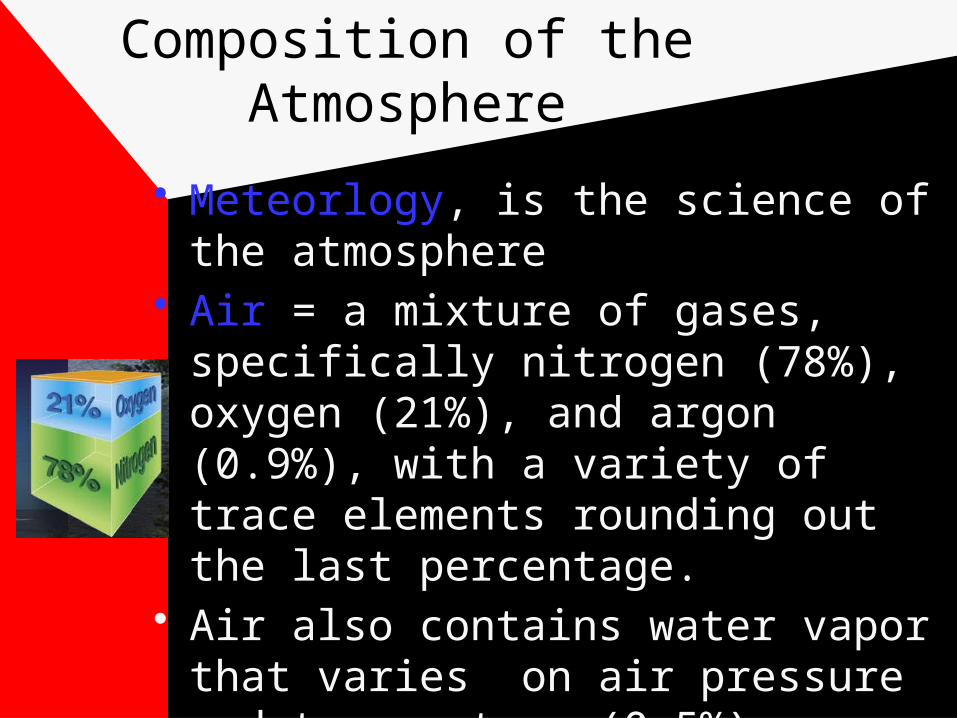
Composition of the Atmosphere
• Meteorlogy, is the science of the atmosphere
• Air = a mixture of gases, specifically nitrogen (78%), oxygen (21%), and argon (0.9%), with a variety of trace elements rounding out the last percentage.
• Air also contains water vapor that varies on air pressure and temperature (0-5%).
Composition of the Atmosphere
• The atmosphere also contains a large number of impurities or particles called condensation nuclei.
• Condensation nuclei can come in the form of dust, unburned hydrocarbons emitted by vehicles, salt spray, and plant pollen etc..

Structure of the Atmosphere
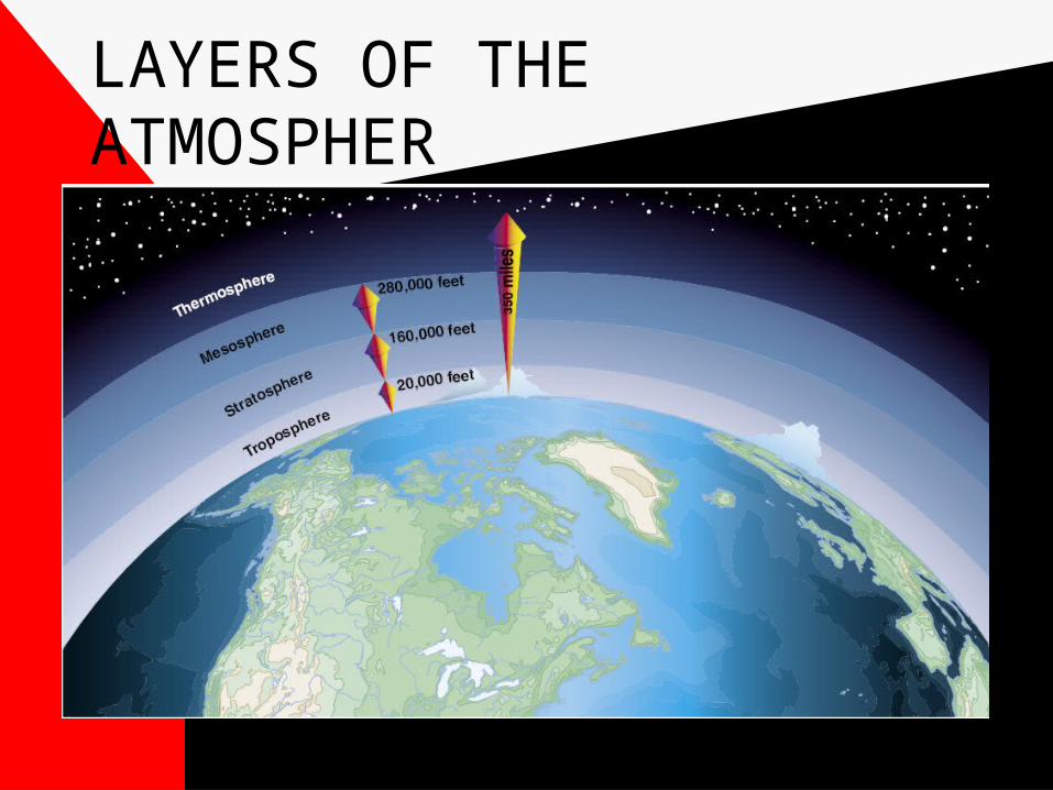
LAYERS OF THE ATMOSPHER

Structure of the Atmosphere
• Most flying is done in the troposphere. The troposphere is typically higher is the summer than in the winter
• Majority of weather is found in the troposphere
• Tropopause is above the troposphere and is characterized by little verticle motion of the air, constant temperature and very low pressure.
Structure of the Atmosphere
• The Stratosphere is above the tropopause and is characterized by little vertical motion of the air (very stable), relatively small changes in temperature with height except for a warming trend near the top. Also very low pressure, low moisture and absence of most types of clouds.

Temperature
• The atmosphere reflects 55% of the sun’s energy, so only about 45% gets to earth
• Temperature is the degree of hotness or coldness of a body or environment.
• Measurement of the energy of the molecules (movement)
• 5/9(F - 32) = Cº• 9/5(C + 32) = Fº

Temperature
• Temperature decreases with an average lapse rate of 2 degrees C (or 3.5 degrees F) per 1000 feet,
• 3 degrees per 1,000 ft for dry air compared to 1-2.8 degrees C for moist air..
• The melting point of ice is 0 C or 32 F
• The boiling point of water is 100 C or 212 F
• 15 degrees C ISA sea level
Temperature Heat transfer
• Conduction - two molecules collide, the second absorbs some of the firsts energy
• Convection - heat transfer from vertical motion
• Advection - when temperature is transferred horizontally over the surface.

Moisture
• As water vapor increases, condensation (for example, clouds) or precipitation (discharge of moisture) may occur. Precipitation is affected by temperature (warm air can hold more moisture than can cold air) and the presence of particles on which moisture can condense.

Moisture
• Relative Humidity - is the ratio (expressed as a %) of water vapor present in the air to the maximum amount of water vapor the air could hold under current conditions.
• Thus it is both a measure of water vapor content and an indicator of how close conditions might be for condensation or precipitation.

Moisture
• You can increase relative humidity of a parcel of air by lowering its temperature or increasing moisture.
• If the temperature gets to low and there is particulate matter in the air, the water contained in the air can change abruptly from its gaseous state to its liquid state.
• Clouds and precipitation are simply visible moisture.

Moisture/Relative humidity
• D.P.T.= Temperature at which the air becomes saturated (clouds form)

Moisture
• Condensation nuclei- if these nuclei come in contact with water vapor, the vapor molecules adhere to the particle, and when enough of them are collected (a function of temp. and saturation), the particle become large enough to become visible.
Fog
• When the temperature reaches the Dew point temperature on the surface you have fog.
• You can expect fog anytime the Temp/DPT spread is within 4 degrees F or 2 degrees C. and narrowing.
Sublimation/Evaporation
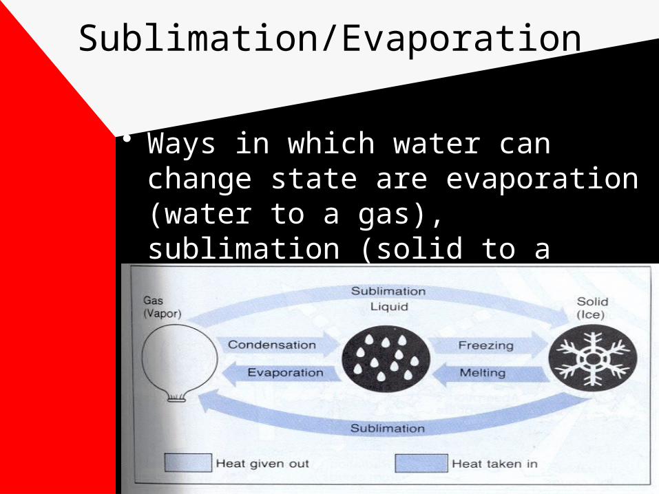
• Ways in which water can change state are evaporation (water to a gas), sublimation (solid to a gas), freezing and melting
Stability
• Air currents that remain still and horizontal are stable air currents.
• Air currents that move vertically and quickly are unstable air currents.
• Areas where you find strong lifting forces for the air, lots of moisture, and cloud condensation nuclei look out for thunderstorms
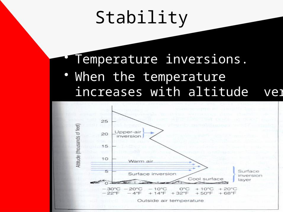
Stability
• Temperature inversions.• When the temperature increases
with altitude very stable atmosphere

Stability
• Vertical motion of the air can lead to unstable atmospheric conditions and turbulence. Dry air is more stable than moist air
• Convection currents (or thermals) develop as different shades and densities of the land differentially absorb and reflect heat, leading to vertical air movement.
Stability
• Unstable air- cumuliform clouds, showery precipitation, rough air, good visibility
• Stable air- stratiform clouds and fog, continuous precipitation, smooth air, fair to poor visibility
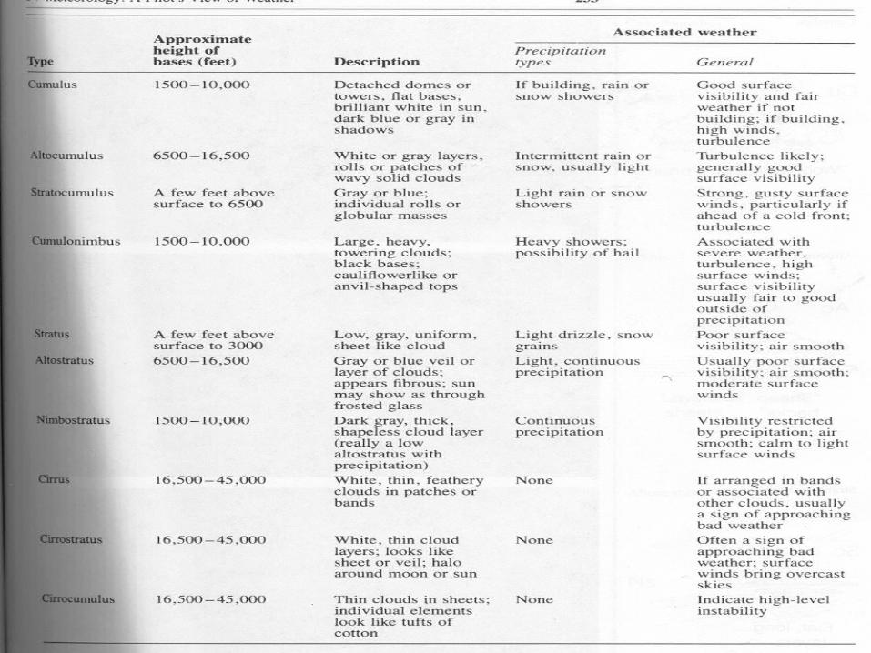
Clouds 6-22-25
• Two categories • (stratus or cumulus)• Stratus horizontal
development• Cumulus (vertical
development)• Also High (Cirrus), Middle (Alto,
Nimbo), Low (Stratus)• 6-20 determining cloud bases


Pressure
• Atmospheric pressure can be measure: (1) in inches of mercury the International Standard Atmosphere pressure is 29.92” Hg or
• (2)14.7 psi or (3)1013,2 mb• One inch of mercury = about 34
milibars.• Millibar pressures are common on
weather charts.
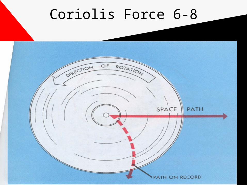
Coriolis Force 6-8

Pressure
• Atmospheric Pressure decreases with an altitude increase.
• Wind travels clockwise and out around a high. Counterclockwise and in around a low. In Northern Hemisphere

Pressure
• The stronger the pressure gradient (closer the pressure isobars are together) the stronger the wind

Pressure
• Generally speaking a high pressure system brings favorable weather while Low pressure systems worse weather. Fronts follow low pressure systems. Low pressure systems follow jet streams

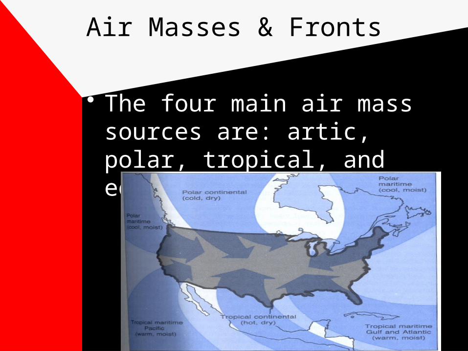
Air Masses & Fronts
• An Air Mass = an extensive body of air with fairly consistent stability, temperature, and moisture content. Air Masses as they move, move in a predictable way. The line of discontinuity between two unlike airmasses is called a front.
Air Masses & Fronts
• The four main air mass sources are: artic, polar, tropical, and equatorial.

Air Masses & Fronts
• Air masses are classified as cold or hot in reference to the ground over which they pass.
• Cold air moving over a warm surface produces convective currents (unstable air. )
• While warm air moving over a cold surface provides stability to the air mass.

Cold Fronts
• Cold front - is an advancing mass of cold air superseding a mass of warm air.
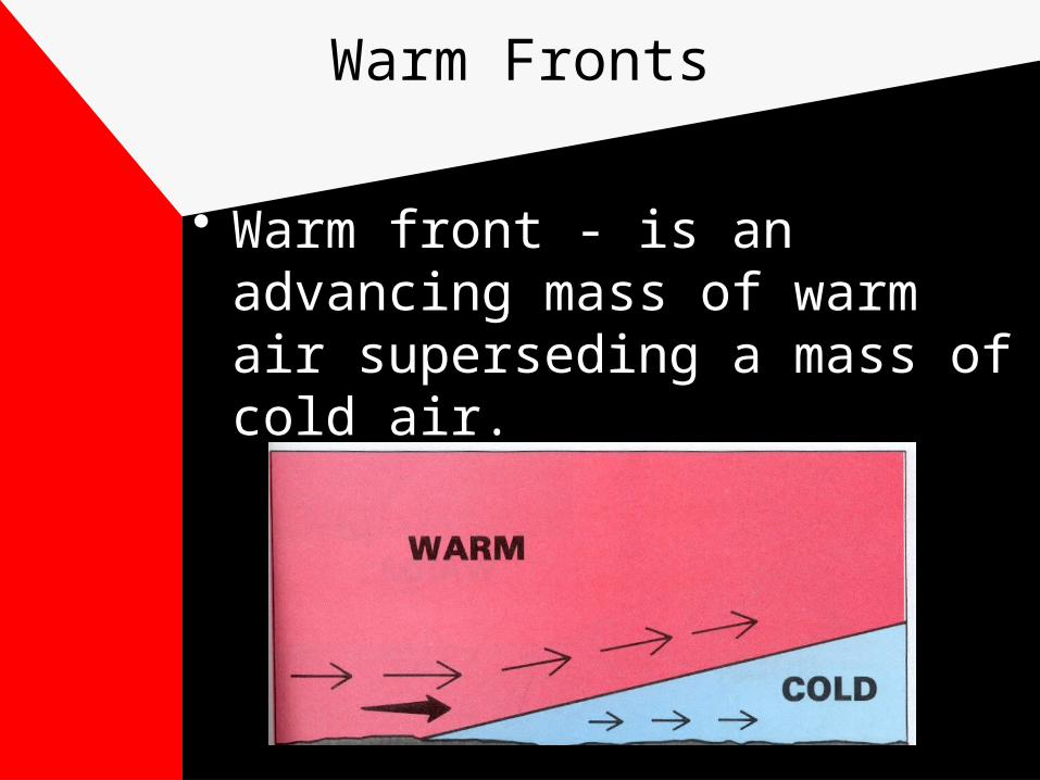
Warm Fronts
• Warm front - is an advancing mass of warm air superseding a mass of cold air.

Warm Fronts
• Warm front - Clouds at any altitude, slow moving, more stable precipitation, fog

Cold Fronts
• Cold front - Fast moving, more unstable, turbulence, strong precipitation, better visibility

Air Masses & Fronts
• Stationary front - is one in which the relative forces of both the warm and cold air masses are so well balanced that neither one prevails and the front remains stationary.
• Frontogenesis - the formation of a front (formation of a steep temperature gradient
• Frontolysis - front dispates (dies)• Occluded front- overtaken by faster
CF

Air Masses & Fronts
• Frontal Passage - the time at which the pressure stops dropping and starts to increase.
• Should also experience a • Temperature Change• Wind direction change

Thunderstorms
• Three stages of a thunderstorm (Cumulus-initial building stage, rapid vertical development and updrafts in and around the cloud)
• (mature stage-precipitation starts, up and down drafts, lightning)
• (disipating stage-dieing stage, down drafts disipate the updrafts)
• Storm is considered dead once it stops precipiating.

Thunderstorms

Icing
• Careful with use of icing equipment• Read your POH• Avoid icing if your aircraft is not
certified to enter known icing conditions
• Freezing rain offers the highest accumulation of ice.