methodist episcopal cemetery . intensive d,ocumentary study
TRANSCRIPT
�Ll~b L {f:, ~C;? i. ')2) ")j JJL-(
IIIII,IIIIIII
METHODIST EPISCOPALCEMETERY
. INTENSIVED,OCUMENTARY STUDY
SECOND AVENUENEW YORK, NEW YORK
SECOND AVENUE SUBWAY
III
I;IIIII:IIII',III,IIII,II
METHODIST EPISCOPAL CEMETERYINTENSIVE DOCUMENTARY STUDY
SECOND AVENUENEW YORK, NEW YORK
SECOND AVENUE SUBWAY
Prepared by:
Historical Perspectives, Inc.P.O. Box 3037
Westport, CT 06880
Prepared for:
Allee King Rosen and Fleming, Inc,'117 East 29th Street
New York, NY 10016
June 2003
Authors:Nancy Dickinson
Faline Schneidennan-Fox (RPA)
IIIII'IIIII·1II,III·III
Methodist Episcopal Cemetery - Topic Intensive Study. Second Avenue Subway
TABLE OF CONTENTS
EXECUTIVE SUMMARY v
1. INTRODUCTION 1
II. RESEARCH GOALS AND METHODS 2
m. RESEARCH RESULTS
A. Boundaries
B. Interments
C. Disinterments and Reintennents
3
4
6
8
IV. SENSITIVITY FOR HUMAN REMAINS 13
V. CONCLUSIONS AND RECOMMENDATIONS 13
BffiLIOGRAPHY
FIGURES
PHOTOGRAPHS
APPENDICES
11
IIII,I',III,II'III'IIIIII
Methodist Episcopal CemeteIy - Topic Intensive Study. Second Avenue Subway
LIST OF FIGURES
1. USGS Jersey City, NJ and Brooklyn, NY Quadrangles1981.
2. Insurance Maps. Sanborn 2001. Methodist Episcopal Cemetery APE, SecondAvenue between 1st and 2nd Streets.
3. Area of Potential Archaeological Sensitivity. Methodist Episcopal Cemetery, SecondAvenue, East 1st to 2nd Streets. Holmes 1867.
4. Project Site Survey in 1805. Second Avenue, East 1St to 2nd Streets. Liber 71, Page199.
5. Project Site Survey in 1820. Second Avenue, East 1st to 2nd Street. Randel 1820.
6. "Stillwell's" Cemetery Survey in 1826 on Block 443 Outside of APE. Liber 210,Page 284.
7. Farms Map Showing 1805 Boundaries in Relation to 1817 Boundaries. SecondAvenue, East 1st to 200 Streets. Holmes 1867.
8. Philif Minthorne Farm Superimposed on 1917 Base Map. Second Avenue, East 1st
to 2n Streets. Farm Histories, Vol.2, Map 15.
9. Area of Potential Sensitivity for Burials. Methodist Episcopal Cemetery APE,Second Avenue between I" and 2nd Streets.
111
IIII,IIIIIIII'IIIIIII
Methodist Episcopal Cemetery - Topic Intensive Study. Second Avenue Subway
PHOTOGRAPH
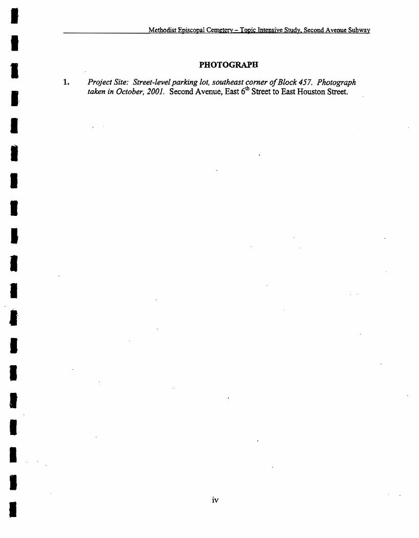
1. Project Site: Street-level parking lot, southeast corner of Block 457. Photographtaken in October, 2001. Second Avenue. East 6th Street to East Houston Street.
IV
IIIIIIIII'IIIIIIIIII'
Methodist Episcopal Cemetery - Topic Intensive Study, Second Avenue Subway
EXECUTIVE SUMMARY
MTA New York City Transit (MTA NYCT) has prepared a Supplemental DraftEnvironmental Impact Statement (SDEIS) for a proposed full-length Second Avenue Subwayextending from 12Sth Street to Lower Manhattan (SDEIS, March 2003). The EnvironmentalImpact Statement (BIS) for the project is being prepared for the Federal TransitAdministration (FTA) as lead agency, in accordance with the National Environmental PolicyAct (NEPA). As per Section .106 of the National Historic Preservation Act of 1966, anarchaeological resources analysis was prepared for the project. This document, SecondAvenue Subway, Phase IA Archaeological Assessment (Historical Perspectives, Inc., March2003) established Areas of Potential Effect (APEs) for the project (e.g. the areas where theproposed project may affect potential archaeological resources), identified designated andpotential archaeological resources that may be affected by the proposed project, and assessedthe proposed action's effects on those resources. This Phase IA was accepted by the NewYork State Historic Preservation Office-(SHPO). It was also accepted by the New York CityLandmarks Preservation Commission (LPC).
Under Section 106, a draft Programmatic Agreement was also prepared and is included in theSDEIS, to be executed by FTA, MTA NYCT, and SHPO. The draft ProgrammaticAgreement sets forth protocols to be followed pertaining to Archaeological Properties in theSecond Avenue Subway APE, including areas sensitive for human remains. Protocolsestablished specifically for cemetery areas include 1) establishing the appropriate descendantcommunities for each cemetery site and initiating contact with them, and 2) undertakingintensive documentary research on the cemetery sites. The results of the cemetery analysesare to be summarized in a report for submission to SHPO for review.
Within the APE of the proposed Second Avenue Subway, the Phase lA identified the westsidewalk on Second Avenue between East First and Second Streets adjacent to Block 457 aspotentially sensitive for human remains. These remains may have been interred within theAPE if the Methodist Episcopal Cemetery (originally referenced in the Phase IA as theMethodist Episcopal Cemetery [MEC]. but which became the Methodist Episcopal Church-East Circuit [MEC-EC] cemetery), formerly located on Block 457 in the first half of the 19th
century, ever extended beneath the sidewalk. The proposed project has the potential to affectthis site through the construction of the Houston Street Station.
Documentary research undertaken for this Topic Intensive Study.and presented here indicatesthat the Methodist Episcopal Church-East Circuit (MEC-EC) cemetery 'once did in factextend into the area of the present Second Avenue west sidewalk as well as a portion of thepresent Second Avenue roadbed. At the time that the cemetery was first laid out, it wasbordered to the east by First Street (not to be mistaken with the present day east-west crossstreet), which was replaced in 1817 by Second Avenue. The new Second Avenue shifted thetrajectory of the street bed farther west, so that the southeastern-most part of the formercemetery became located beneath the present day approximately 20-foot-wide west sidewalkof Second Avenue and a portion of the presently existing Second Avenue street bed(approximately the westernmost 25 foot width of the Second Avenue roadbed) from aboutthe southwest comer of present Second Avenue arid East First Street north to a point midway
v
IIIII"IIIIIIIIIIIIII
Methodist Episcopal Cemetery - Topic Intensive Study, Second Avenue Subway
between East First and Second Streets. Documents failed to provide the original number ofburials within the cemetery so there is no guarantee that all human remains were removedprior to the laying out of Second Avenue over the former cemetery area. Therefore, the areaof sensitivity for burials which may have been accidentally left on site within the APE for theconstruction of the Houston Street Station has been expanded to include both the westsidewalk and approximately the westernmost 25 foot width of the Second Avenue roadbedfrom the southwest comer of East First Street to a point midblock between East First andSecond Streets. Since depths of potential burial vaults andlor other internments were at leastto 14 feet below grade, it is anticipated that burials would be found anywhere from thesurface down to 14 feet below grade.
Due to the possibility that human remains from the Methodist Episcopal Church-East Circuitcemetery may be extant on the project site, Historical Perspectives recommends avoidance ofthe sensitive area through project re-design. If avoidance is impossible, then archaeologicaltesting of the site prior to construction and/or archaeological monitoring at the time ofconstruction. in accordance with the appropriate state and federal standards, is recommended.
RP A-certified professional archaeologists, with an understanding of and experience in therecovery of skeletal material, would be required to be part of the testing team. Prior to anyarchaeological testing and/or project construction, a protocol, defining the testing plan andprocedures for handling skeletal material, would be developed in consultation with SHPO ..This protocol would incorporate input from the Church of All Nations (formerly the FirstGerman Methodist Episcopal Church), the descendant church of the Methodist EpiscopalChurch-East Circuit cemetery. This congregation is presently located at 48 S1. Mark's Place.A representative from MTA NYCT discussed with Revered LaPorta of the Church of AllNations in June 2003 the potential for human remains to be present in the APE and theappropriate protocol to follow should human remains be found. It was agreed that MTANYCT would transfer any human remains to the Church of All Nations for appropriatereburial in another location, should any such remains be encountered during testing and/orproject construction.
VI
IIIIIIIIIIIIIIIIIII
Methodist Episcopal Cemetery - To.pic Intensive Study, Second Avenue Subway
I. INTRODUCTION
MTA New York City Transit has prepared a Supplemental Draft Environmental ImpactStatement (SDEIS) for a proposed full-length Second Avenue Subway extending from 125th
Street to Lower Manhattan (SDEIS, March 2003). The Environmental Impact Statement(EIS) for the project is being prepared for the Federal Transit Administration (PTA) as leadagency, in accordance with the National Environmental Policy Act (NEPA). As per Section106 of the National Historic Preservation Act of 1966, an archaeological resource analysis,which established Areas of Potential Effect (APEs) for the project (e.g.' the areas where theproposed project may affect potential archaeological resources), identified designated andpotential archaeological resources that may be affected by the proposed project, and assessedthe proposed action's effects on those resources, was completed. This document, SecondAvenue Subway, Phase 1A Archaeological Assessment (Historical Perspectives, Inc., March2003) was accepted by the New York State Historic Preservation Office (SHPO). It was alsoacceptedby the New York City Landmarks Preservation Commission (LPC).
Under Section 106, a draft Programmatic Agreement was also prepared and is included in theSDEIS, to be executed by FTA, MTA NYCT, and SHPO. The draft ProgrammaticAgreement sets forth protocols to be followed pertaining to Archaeological Properties in theSecond Avenue Subway APE, including areas sensitive for human remains. Protocolsestablished specifically for cemetery areas include 1) establishing the appropriate descendantcommunities for each cemetery site and initiating contact with them, and 2) undertakingintensive documentary research on the cemetery sites. The results of the cemetery analysesare to be summarized in a report for submission to SHPO for review.
The Phase lA Archaeological Assessment identified the west sidewalk of Second Avenuebetween East First and Second Streets within the APE as sensitive for burials associated withthe former Methodist Episcopal cemetery. The Phase lA indicated that the cemetery wasformerly located on Block 457, on the west side of Second Avenue between East First andSecond Streets. The Phase lA indicated that it was possible that burials from the cemeteryextended out under the west sidewalk of Second Avenue within the APE for the constructionof the Houston Street Station. The depth of burials was approximated from the surface downto approximately 14 feet below grade.
Documentary research undertaken for this Topic Intensive Study indicates that a portion ofthe cemetery -originally referenced as the Methodist Episcopal cemetery (MEC), but whichbecame the Methodist Episcopal Church-East Circuit (MEC-EC) cemetery-was in facthistorically located in what is now the present Second Avenue sidewalk and a portion of theSecond Avenue roadbed from ca.1805-1817, and-on the city block itself from ca, 1805-1855(Figures I, 2 and Photograph 1). For detailed information and cartographic history for theBlock 457 through time, please refer to 4.5.6.Appendix, 4.5.6.1 Block Histories, pages 11-27of the Phase lA.
1
IIIIIIIIIII"IIIIIIII
Methodist Episcopal Cemetery - TQPic Intensive Study, Second Avenue Subway
II. RESEARCH GOALS AND METHODS
The proposed project has the potential to affect the circa 1805-1817 portion of the MEC-ECcemetery, once located in the present area of the west sidewalk. of Second Avenue and aportion of the Second Avenue roadbed, through the construction of the Houston StreetStation.
This Topic Intensive Study compiles the documentary research that was completed for theMethodist Episcopal Church-East Circuit (MEC-EC) (Figure 2 and Photograph 1). It 1) "identifies areas sensitive for historical burials that may be affected by the proposed project;2) documents post-cemetery period development and redevelopment to assess the potentialeffect it may have had on the cemetery-period resources; 3) assesses the potential projecteffects on the cemetery resources; and 4) provides recommendations for additionalarchaeological study and/or mitigation, where necessary.
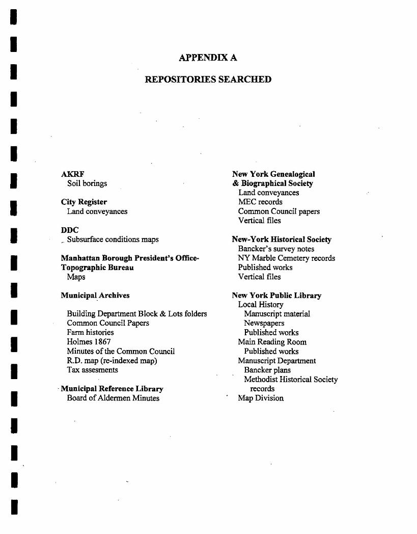
To accomplish the goals stated above, a variety of documentary and cartographic sources, aswell as archivists, librarians, and genealogists, who have studied New York City cemeteries,were consulted. See Appendix A for a list of the repositories searched.
Historical maps and atlases were obtained from local repositories and studied for land useover time. Evidence of prior disturbance was also established in order to determine siteintegrity and the potential presence of burials. Establishing prior impacts was essentialtoward determining whether additional research would be necessary. Among the maps andatlases consulted were: Manatus 1639; Montresor 1766; RatzenlRatzer 1766/1767; BritishHeadquarters' Map 1782; McComb 1789; Taylor Roberts 1797; Randel 1807; Bridges 1807;Colton 1836; Tanner 1836; Dripps 1852, 1867; Perris 1853, 1857-1862; Viele 1865;Robinson 1885, 1893; Bromley 1897, 1911, 1916, 1926, 1932, 1955, 1967, 1974; Sanborn1984/1985, and 1990/1991. See the Phase IA report, 4.5.6 Appendix, 4.5.6.1 BlockHistories, pages 11-27, for a full discussion of the changes through time to the MEC-ECcemetery parcel (Kearns et al 2003).
Additional maps particularly pertinent to the cemetery included: the 1805 Survey Maps inthe Deeds, Evert Bancker's survey maps, John Randel, Junior's 1807 drawings for the 1811Commissioners' Plan, the 1820 John Randel, Jr. farm maps at the Manhattan BoroughPresident's Office's Topographic Bureau, a 1917 manuscript "reindexed" map (R.D. 359) atthe Municipal Archives, and maps from the deeds overlaid by the published 1867 Holmesmap. New York City public-services manuscript plan views of subsurface conditionsprovided by the MTA also contributed to the understanding of the changes in land use as theproject property was developed and redeveloped.
Numerous local and regional histories were examined for relevant data including 1. N.Stokes' Iconography of Manhattan Island, Vols. Ill, V, and VI, which provided informationon farm maps of the area and general history of the use of the area of land in the APE.Greenwald's manuscript entitled The Cemeteries of New York City for 1830 and CaroleInskeep's The Graveyard Shift.' A Family Historians Guide to NYC Cemeteries along withKenneth Jackson's The Encyclopedia of New York City provided general information on
2
IIIIIIIIIIIIIIIIIII
Methodist Episcopal Cemetery - Topic Intensive Study, Second Avenue Subway
cemeteries in New York City during the early 19th century when the MEC cemetery wasestablished.
The official manuscript records of the Methodist Episcopal Church were reviewed, as was anessay in the New York Genealogical and Biographical Society's (NYG&BS) newsletter onthe "Methodist Records of New York City in the NYG&BS Library." The vertical files atboth the NYHS and the NYPL were also examined. In addition, local and regionalnewspapers, journals and magazines were consulted including The New York Times (NYC)backfile index that dates from 1851 onward and JSTOR, an online journal database.
Other resources and/or city offices that were consulted during the course of further researchfor this project include: The City Register of New York for conveyance records; The NewYork City Municipal Archives for city records such as farm maps, the 1917 reindexed map,the Minutes of the Common Council and tax assessment records; The Municipal Library forBoard of Alderman Minutes; The Department of Buildings of New York City; The New YorkPublic Library's Local History and Manuscript Divisions for records on city cemeteries; andthe New-York Historical Society.
In addition, numerous genealogists and historians with knowledge of the MEC-EC orreinterments were contacted. These included: The Reverend James R. McGraw, Rector ofthe John Street United Methodist Church; Betty Soames, Archivist for the New York AnnualConference of the United Methodist Church; Wayne Kempton, Archivist for the EpiscopalDiocese of New York; Harry Macy, Jr., Editor of The NYG&BS Newsletter; Ken Cobb,
. Archivist at the Municipal Archives (MA); and, Bill Moloney, at the Cypress Hills Cemetery(CHC).
Finally, a site visit was conducted and a photographic record of current conditions was made(photograph 1).
ID. RESEARCH RESULTS
The MEC-EC cemetery was originally identified on historical maps and atlases on city Block457 west of and adjacent to Second Avenue between East First and Second Streets (Kearns etal 2003). The west sidewalk of Second Avenue between East First and .Second Streets wasidentified as sensitive in the Phase lA due to the possibility that ,burials extended out of thecemetery boundaries and into the APE. Further documentary research for this study foundthat the original boundaries of the cemetery were greater than previously documented in thePhase IA, and thus what was once the southeastern comer of the cemetery now lies in theAPE in the area of the west Second Avenue sidewalk and a portion of the Second Avenueroadbed from mid-block between East First and Second Streets, south to approximately thesouthwest comer of Second Avenue and East First Street.' Therefore, the area originallydetermined to be potentially sensitive for burials in the Stage lA report has been revised andexpanded. The following discussion details the. history of the cemetery and its boundaries,
IThe former cemetery area also extends south into what is now First Street, outside the Second Avenue Subwayproject APE (see Figures 3 and 4).
3
IIIIIIIIIIIIIIIIIII
Methodist Episcopal Cemetery - Topic Intensive Study. Second Avenue Subway
attempts to delineate potentially sensitive areas, and documents interments and disintermentsto the extent that is possible.
A. Boundaries
What became the :MEC-EC cemetery property in 1805 had been part of the farm of farmerPhilip Minthom (T.R. 534; Figure 8). In 1765, as a part of his last will and testament, therewas a partition of the farm among the deceased's children and spouses (Liber 37: 447-448).Each of his children received "an equal undivided one-ninth part of the property" (Ibid.).Those property lines continued to be drawn on most of the subsequent maps, including the2001 Sanborn (Figure 2), so that the cemetery was easily defined on both early and latermaps (Figures 2-5 and 7-8).
Nicholas Romine (Romain), then a house carpenter, and his wife Margaret Romine(Romain[eD were granted the southernmost parcel of the farm, on which the :MEC-ECcemetery would become located after 1805 when Nicholas Romine, a blacksmith, and hiswife, Elizabeth Romine, sold part of their parcel to Trustees of the Methodist EpiscopalChurch in the City of New York (Liber 71:194-198). The Romine parcel and the contiguousGraham parcel (the grantors were Joseph Graham, a gardener, and his wife, Hannah Graham)formed the property that the Methodist Episcopal Church in the City of New York purchasedin fee simple (Liber 71: 199-203).
It is also not clear as to when the first burials took place since there are no MEC of NYTrustees' minutes available between 1805 and 1820, by which time the Randel 1820 maplabeled the cemetery site, "Methodist Cemetery" (Figure 5). The:MEC cemetery did notappear on Randel's 1807 manuscript map, but then, neither did any other contemporarycemetery in the neighborhood. Although the Trustees of the Methodist Church were awarded$191.26 in 1816 for "property taken for [opening] 2nd avenue", there is no mention of acemetery (MCC VIII:403). Yet with Second Avenue opening in 1817, there was thepotential for about 11 years' worth of burials, some of which could lie beneath SecondAvenue; Figures 4 and 7 show the relationship between the 1805 lots facing the then FirstStreet (that was to be renamed Second Avenue) and the realigned Second Avenue shown onthe 1867 map. In,1818 the Committee on Assessments referred to the cemetery as " ... a pieceof ground ... exclusively used as a Cemetery .... " (MCC X:132-133).
The discussion about opening Second Avenue above North Street (present day East HoustonStreet) had begun as early as 1811 when the nortblsouth street in place above North Streetwas then named First Street (MCC VI:597). With 'the ongoing Common Council discussionsabout land taking and compensation as well as about petitions and lawsuits concerning themerits. of constructing a Second Avenue north of North Street, it was not until 1817 that theavenue was opened for use (MCC VI:632; VII:216, 723, 738; VllI:270, 403, 421, 447, 487,633,639; IX:140; X: 132-133;XI:249). It was during this time that a portion of the cemeterylay in the future path of the Second Avenue street bed and sidewalk.
While the newly aligned Second Avenue was in place in 1817, it was not until 1820 thatpeople along the avenue petitioned for a sidewalk (MCC XI:356). Within a year not only had
4
IIIIIIIIIIIIIIIIIII
Methodist Episcopal Cemetery - Topic Intensive Study. Second Avenue Subway
the ordinance passed providing for the-paving and laying the curb and gutter stone, but alsothe contractors had received payment for the work (MCC XI:259, 370, 727; Xll:143). Sincesidewalks were taken from the street rather than from the land within the block, there is apotential for burial remains to underlie both the street bed and the sidewalk within the APE.
In 1835 there were plans to build a church on the northwest corner of East First Street andSecond Avenue, on Block 457 adjacent to the APE. The MEC of NY Board of Trusteesminutes indicated the following:
... [an] examination of the Ground at the corner of 1st Street and 2nd Avenuerelative to the Ground being in a State for the erecting a Church thereon.... ...Sixty by Seventy five feet fronting on 1st Street, as there would be but few ofthe dead to be removed & those that would have" to be removed should bedeposited in a Vault under the Church provided for the purpose .... (Volume99: MEC of NY, Board of Trustees, Minutes, 1835-1856. In the MethodistEpiscopal Church .... :Official Manuscript Records. Placed on indefinitedeposit in the NYPL by the Methodist Historical Society and the MethodistBook Concern).
During 1835-1836, five individual churches joined to form the East Circuit, and togetherbecame the overseers of what was renamed the Methodist Episcopal Church-East Circuitcemetery (MEC-EC) (Liber 364:508-522). Appendix B provides a table that lists the "earlynames and founding dates for the five churches of the East Circuit as well "asthe other namesby which they have been known. Throughout this report, the churches will be referenced bytheir 19th century names.
A 1917 manuscript "reindexed" map (R.D. 359) at the MA, plus the maps from the deeds, incombination with the published 1867 Holmes map (Figure 7), at both the MA and NYPL,allowed for a fine-grain analysis of the changes in the block, sidewalk, and street bed.Another 1917 map, from the Farm Histories folders on microfilm at the MA, overlaid the1765 partition map included in a 1795 land conveyance upon a base map that included 20th
century block numbers, allowing for a coordination of both landowners names and their real. estate in real space (Figure 8).
The cartographic evidence for the MEC-EC cemetery on Block 457 outside the APE showedthat the irregular six-sided "Methodist Cemetery" parcel in 1820 had become larger and anirregular rectangular "Methst Cemetery" by 1852 (Randel; Dripps). Although the
. "Cemetery" retained the same boundaries a year later, it was in 1855 that the MEC-EC soldthe cemetery parcel in fee simple (fee simple is the most common type of ownership thatallows one to have unlimited control over a property) (Liber 679:541-545). According to theTrustees' minutes, human remains were exhumed and reinterred in Cypress Hills Cemetery(CHC) and Evergreen Cemetery (1853-1855).
Between 1857 and 1862, the cemetery's fanner location on Block 457 had been subdividedinto 13 lots, each with structures, one of which was a "Provison House" (perris 1857-62).Second Avenue and East First Street continued to define the eastern and southern boundariesof Block 457. Mid-block between Second Avenue and Bowery, Extra Place and the diagonal
5
IIIIIII"IIIIIIIIIIII
Methodist fuliscQPal Cemetery - Topic Intensive Stucly. Second Avenue Subway
property line from the 1765 partition were still portrayed on maps where they previouslyformed the western and northern boundaries of the cemetery. Despite the fact that thecemetery had been removed, these boundary lines were visible on maps and atlases untilsome time between 1974 and 1984/1985 when a narrow passageway connected the formercemetery parcel with the equivalent of two lots on the northeast corner of the block (Dripps1867; Robinson 1885; Bromley 1897. 1911, 1916, 1926. 1932, 1955, 1967. 1974, 1984/1985,199011991).
B. Interments
Absent from the manuscript collection were any early records between 1805 when the MECof the City of New York was the grantee, in fee simple. of the cemetery property (Liber71:194-203) and 1820 when John Randel, Jr. labeled .the southeast comer of Block 457"Methodist Cemetery" (Figure 5). This report relied heavily on the Trustees' minutes of thecollective five parishes of MEC-EC of New York, 1835-1861, on microfilm at the NYPL.Trustees' and Quarterly Conferences' minutes for the individual churches (Allen Street,Bowery Village, Second StreetIForsyth Street, Second Street, and Willett Street) were notreviewed.
The manuscript records provided a context for the decisions the trustees made concerning thedevelopment of the MEC-EC cemetery. Although the actual numbers of burials andexhumations are not included, dates of use and discussions about placement of graves andwalkways as well as location and depths of vaults furnish details absent from any otherrecord found to date. While Carolee Inskeep's book on New York City cemeteries includedinformation about several of the individual MEC-EC cemeteries, there was no mention at allof the MEC-EC cemetery on Block 457 (2000). Stokes was also silent on the subject (1916-1928).
Some time after 1805. but by 1818, a portion of Block 457 and what is now the SecondAvenue roadbed was described as " ... a piece of ground... exclusively used as aCemetery .i :" (Liber 71:194-198; MCC' X:132-133). No available records list the numbersof interments, much less the surnames of those buried in the MEC-EC cemetery.Nonetheless, the Trustees' minutes and other contemporary cemetery records do providemany details about not only the "mechanics" of burials, hut also the attitudes of the 19th
century parishioners.
Apparent from the Methodist Society Cemetery's conveyance map of 1822. describing the"Stillwell" cemetery outside the APE and one block directly east of the MEC-EC cemetery,was the ordered placement of blocks of burying lots, some facing east/west and many facingnorth/south, that were divided by 3.5 foot wide walkways (Figure 6). The individual lotswere numbered and were 5 feet wide and 8 feet long (Liber 210:285). No depth for theburial shafts was noted.
For comparative purposes, information on other vaults from nearby cemeteries was pursued.One of these, the nearby New York Cemetery, placed their vaults 10 feet below the 1830surface (Trustees of the New York Marble Cemetery 1830-1832). This cemetery, outside theAPE and one block directly north of the location of the MEC-EC cemetery, is still in
6
IIIIIIIII·IIIIIIIIII
Methodist Episcopal Cemetery - Topic Intensive Study, Second Avenue Subway
existence. Their vaults were constructed from Tuckahoe marble. In 1830 the ground-waterlevel beneath the New York Cemetery was 35 feet. and in 2000. when someone descendedinto a subterranean vault. it was dry (Trustees: Ibid.; Brown 1999; Kelley 2000).
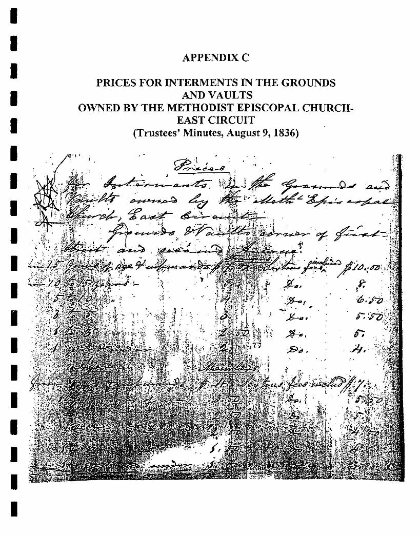
The :MEC-EC's Trustees' minutes do not describe graves and grave shafts. but vaults arementioned several times in 1835 and 1836. The Building Committee "recommended theboard to build 10 private Vaults to be about 8 bl12 feet in the clear and built after themanner of the Vaults in the Marble Cemetery in 2n Street ... " (October 1835). The Trustees'chose to have four new public vaults "at the Comer of 1st Street & 2nd Avenue" each 14 feetin depth and to be made of limestone for .it would be improper to build the Vaults withblue Stone or brick as was contemplated ," (February 3 and 17, 1836; October 28. 1835).At the same time, the Trustees approved the expenditure for a "brick wall [about 270 feet inlength] around the said Ground .. .running measure 8 feet in height & coped with good blueStone ... :' (Ibid.), During the late spring of 1836. the Trustees recommended .... , that thesidewalks around the Burying ground, comer of first Street & 2nd Avenue be paved withBrick .,» (June 15. 1836).
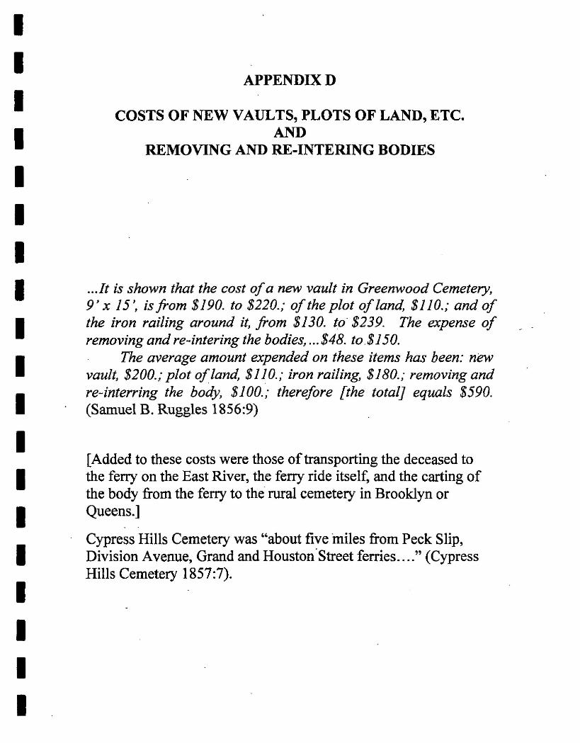
In the spring the Board of Trustees were informed "that the Arches of the Vaults nowbuilding in first street, were too high above the surface, etc." (May 18, 1836). By summer,the problem must have been solved, for the vaults were finished (July 20, 1836). Acommittee was then formed to set the rates for the interment "in the Grounds and Vaultsowned by the Metbt Episcopal Church. East Circuit...comer first Street and secondAvenue.v.jfor] members and others .... (August 9, 1836). Appendix C provides a list ofprices set for interment, which can be compared to the prices quoted by Ruggles in 1856 forexhumation, transportation, and reinterment, presented in Appendix D. The Trustees agreedto have the Sextons' Fees charged at one half the going rates, "for burying poor Members,when the Trustees give the Ground" (Ibid.). At that same board meeting, the Trustees'Committee recommended and approved the following:
...Brother William Hadley to take charge of the Interments comer of firststreet and second avenue whose duty is shall be to keep a Record in a Bookto be furnished him, of all Interments, with the name and age of everyperson interred, together with' the name of the Sexton so interring.
. The Com[mittee]jUrtherrecommended, that the Board of Trustees ineach Section keep a Record of all Interments within their Sections; and thatthe Treasurers of all the Boards meet quarterly to make dividends (?), andreceive the accounts of the persons in charge of the Vaults and Grounds towhich the Board of Treasurers they are to be accountable for the faithfulperformance of their duties (Ibid.).
It appears that the Trustees were seeking some sort of order and greater accountability interms of the financial aspects of the MEC-EC cemetery on Block 457. but documentsdetailing these accounts for the period between 1835-1855 could not be located.i It is likelythat the "sections" referred to by the Trustees pertain to areas controlled by each of the fivechurches within the East Circuit; it is possible that each church had its own section within the
2 Research indicated they are not available in public or private repositories.
7
Cf
IIIIIIIIIII"IIIIIIII
Methodist Episcopal Cemetery - To,pic Intensive Study. Second Avenue Subway
I I
cemetery. Several of the individual churches also had their own churchyard cemeteryseparate from the subject cemetery on Block 457. However, the MEC-EC also ownedanother cemetery as a group in Williamsburg, "on Long Island", as they referred to it. In1835, for that cemetery, which would today be in Brooklyn if still in existence, the Trusteesrecommended that "in the future the plots should be sold in their regular order and not permitany purchaser to select a plot out of regular rotation" (April 5). This suggests that there wasa need ordesire to regulate the placement of graves and vaults. Later that year, the minutesmention that the MEC-EC cemetery has had an increase in "interments, not only of personsfirmly attached to the Church, but [also] of others ... :' (December 16, 1835). This mighthave signaled the need for an orderly choosing of burial plot locations as opposed to allowingthe living to choose which part of the cemetery their dead were buried.
During 1835-1836. when the individual five churches formed the East Circuit (Liber364:508-522), the MEC-EC was also considering closing the cemetery. exhuming the deadbodies. and constructing a church in the cemetery's place on the southeast comer of Block457. In the end, they decided to maintain the cemetery. but. in the process, there was anairing of conflicting attitudes about exhumation as well as about the merits of urban versussuburban cemeteries. They concluded that there was a need for burial grounds within thecity. They also noted the "difficulties they [met] from the friends of those recently buriedthere s: also from public sentiment ... on of having the friends or relatives removed from thecemetery. ''There was a "veneration for the ashes (figuratively or actually?) of the departed."Physicians were concerned about the "exhalation arising from the ground" should the deadbodies be exhumed. They and the public health officials. believing that miasma was thecause of illness, were concerned with both burials and exhumations, particularly in light ofthe yellow fever and other contagious disease outbreaks recurring from the late 18th centuryonward.
Thus, although the number of the .dead interred in the MEC-EC cemetery on Block 457 andin the APE is unknown, the building material and depth of the vaults. the size of theindividual plots, and the location of a brick wall and brick sidewalks surrounding thecemetery can be surmised.
C. Disinterments
Research indicates that the MEC-EC Board of Trustees was not against exhumation entirely.The Trustees appointed a committee "to examine the oldest Vaults in the 1st Street BuryingGround with powers to have the same Cleaned out if they deem it expedient" (February 17,1836). In 1854 they removed all the burials from the MEC-EC cemetery on Block 457outside the APE in preparation for selling the project site parcel to George W. Edwards oneyear later (Liber 679:541-545). No records as of yet have been found that list the numbers ofthe dead who were exhumed and removed to other burying grounds or cemeteries either in1817 when Second Avenue and East First Street were laid out across a portion of it, or laterin 1854-55 when the remaining cemetery parcel was sold for development.
While the, MEC-EC's Board of Trustees were making decisions about disinterments in their .cemetery onBlock 457, there were several New York City ordinances and laws as well as
8
IIIIIIIIIIIIIIIIIII
Methodist Episcopal Cemetery - Topic Intensive Study, Second Avenue Subway
State laws that influenced the disinterment policies for all Manhattan cemeteries in the 19th
century. The 1842 and 1847 State laws as well as the 1851 New York City ordinance had themost direct impacts on the MEC-EC cemetery on Block 457.
Ordinances and Laws
Eighteenth-century New York City' ordinances and a late-19th century volume on the laws ofthe state of New York relating to ... burial grounds and cemeteries ..•. provided no informationon the "mechanics" of a cemetery, such as the depth of burial shafts, the number of "layers"of interments allowed, the limit to the number of burials within a specified space, etc. (1707,1749, 1763, 1774, 1793, 1797, 1799, 1881), However, a review of ordinances pertaining tothe location of cemeteries in Manhattan indicates they were pertinent to the MEC-ECcemetery.
In 1804, a year before the MEC bought the parcel on Block 457, the Common Council (CC)passed an ordinance" ... That no person shall inter any Corpse in any Cemetery or other placein the said City to the Southward and westward of Pump Street and Nicholas Street ...."(pump Street became modem day Walker Street) with certain exceptions (MCC m:462).The MEC churches that would use the cemetery on the northwest comer of East First Streetand Second Avenue were almost a mile north of the "no burial line." Nonetheless, since theyburied both church members and others in their cemetery, the ordinance could have had aneffect on the early use of the cemetery parcel, purchased in 1805~ as it may have caused anincrease in the number of burials in the MEC-EC cemetery.
Later in 1804, the CC ordained, among other things, that the Sextons keep a weekly Register"of the persons buried in such Cemetery, Vault or burying ground ... under a penalty oftwenty five dollars for each neglect .... " (MCC III:576). The ordinance also required that "onthe Tuesday of every week in such papers as the Corporation employ an accurate list of thedeaths of the preceding week with the age Sex disease and other particulars of each personso dying and where buried " (MCC m:577). If such records for the MEC-EC cemeteryexist, these records have not yet been located, notwithstanding an intensive, documentarysearch.
At least as early as 1806, the year after the MEC-EC purchased the parcel that became acemetery, the CC's Comminee of the Board of Health recommended, among nine otherthings, that " ... the interment of dead bodies within the city ought to be prohibited .... n (asquoted in Stokes V: 1442). The 1809 resolution rescinded the permission to construct vaultsbeneath streets and sidewalks. However, the 1809 resolution probably did not affect theMEC-EC cemetery because Second Avenue (and East First Street) had not yet beenconstructed over a portion of the cemetery. As described above, it was in 1817 that theSecond Avenue street bed was constructed over a portion of the cemetery, encroaching onany potential burials within the easternmost portion of the cemetery' (See Figures 4 and 7).
3 The MCC included the following revoking of previous grants. On June 26,,1809, the following Resolutionwas presented and agreed to Resolved, that in future no permission be granted to build any vault for intermentof the Dead under any of the Streets of this City (MCC V:S95). On July 10, 1809, Resolved that all Licensesgranted for building Vaults under the Street adjoining any Church, be rescinded, except so far as to completing
9
IIIIIIIIIIIIIIIIIII
Methodist Episcopal Cemetery - Topic Intensive Study, Second Avenue Subway
It was not until 1823, after many years of discussion and debate, that the CC passed a lawindicating that "[it shall not] be lawful to inter in any vault or tomb south of [Canal, Sullivan,and Grand Streets)" (from MCC XII:811, March 31, 1823, as quoted in Stokes V:1628).This law that went into effect, with some alterations, in June 1823, also included amoratorium on opening any grave southward of the new "no burial" line (MCC XIV:633;Stokes V:I442), The law affected burials south of Grand Street, and, at the same time,probably increased the use of the MEC-EC cemetery as a burying ground."
Further increase in the number of burials in the MEC-EC cemetery by both "the deceasedchurch members and others may have been the outgrowth of the deliberations by aCommittee of Delegates from different Religious Societies and the MCC's Committee onLaws in 1825. The result was a 57-page report (MCC XN:576-634) that revised the 1823law yet again.S
The MEC-EC probably complied with an 1842.State law that required that a "ReligiousSociety can not Remove Human Remains from Burying Ground without Written Consent"because the Board of Trustees of the MEC-E~ proceeded with the removal of the humanremains in 1854 (Snyder 1881:108; Board of Trustees Minutes 1850-1856).6
Yet it was a combination of the 1847 State Rural Cemeteries Act and the 1851 New YorkCity ordinance that forbade interments south of 86th Street and prohibited the creation of newcemeteries in Manhattan that provided the impetus for the removal of the human remainsfrom the MEC-EC cemetery and the reintennent of the dead bodies at the CHe andEvergreen Cemetery in rural Brooklyn (Jackson 1995:198; Cypress Hills Cemetery 1884:5;Trustees' Minutes November 21, 1853; Inskeep 2000:xi). Aclmowledging the wisdom of thelegislature, the fledgling CHC, which opened in 1848, claimed that " ... the Legislature of1847, at the instance of many intelligent and public spirited men, erected a general lawconferring upon voluntary Associations the right of establishing Rural Cemeteries throughoutthe State.... " (Cypress Hills Cemetery 1884). These suburban and rural cemeteries tended tofollow the contemporary Romantic ideals about designing cemeteries as ''retreats from the
the same where Contracts have been made, or the ground opened in consequence of such license heretoforer;anted. (MCC V:611-612). .
What is interesting is the number of vaults noted in the MCC: JuneI823 ... during the Year preceeding (sic)the Ordinance, there were 821 interments within those limits, and there are within the said limits, 87 Public orChurch Vaults. and 417 private or family vaults (MCC:XIV:638).s One of the three resolutions was That it be recommendied[to the Churches, and religious societies to extendtheir places of interment as far as possible beyond the line of Grand Street, and not to permit the deposite (sic)of a large and inconvenient number of dead bodies, in any tomb or vault, in anyone field or inclosure (sic).?;tCC XIV:634).
Laws 1842. chap. 215, passed April 11.' §2. It shall not be lawful for any person or persons to remove anydead body or human remains from any burying ground, for the interment of which compensation shall havebeen received by any church or religious corporation, or by any officer or officers thereof, and which shall havebeen used for that purpose during the last three years, with the intent to convert the said burying ground to anyother purpose, without having first obtained the consent in writing of three-fourths in number of thecongregation or society of such church or corporation; and which consent shall be proved or acknowledgedand recorded in the mann er prescribed by the first section of this act, before any such removal shall becommenced or attempted. (Snyder 1881.'108).
10
IIIIIIIIIIIIIIIIIII
Methodist Episcopal Cemetery - Topic Intensive Study. Second Avenue Subway
crowding and pressures of the city. It was believed that the air made unhealthful by humanremains would be purified by trees .... n (Jackson Op, Cit.).
The 1851 New York City ordinance that banned burials south of 86th Street and forbade thecreation of new cemeteries in Manhattan signified the end of burial operations at the MEC-EC cemetery on Block 457. Additionally, as Manhattan moved uptown, the cemetery land,as negotiablereal estate, represented a source of potential needed income since the churchesof the East Circuit were frequently in need of capital. In 1853 the MEC-EC Trustees appliedto the Supreme Court (of New York State) to:
...Leave to sell the ground usedfor a Cemetery or burial ground situated inthe City of New York at the NW corner of second Avenue And First Street.. .....After paying the expenses of such sale and of the Removal of the deadfromsuch ground.... ...to remove the dead from said Ground to some suitableburial ground in Cypress Hills or the Evergreen Cemeteries...
(November 21, 1853)
Permission must have been granted because, in 1854, money was allocated for the removal ofthe dead (January 9, 1854). The removal of the human remains probably took place during1854, as Inskeep suggested, for the land on Block 457 was sold in 1855 and redeveloped nolater than some time between 1857 and 1862 (Inskeep 2000: 5-6, 108-109, 215; Trustees'Minutes, February 12, 1855; Liber 679:541-545; Perris 1857-1862).
As in the case of the interments, the actual number of disinterments from the MEC-EC'scemetery is as yet unknown. Extrapolations from the known number of church members at aparticular time combined with the founding date and the average life span would provideonly an estimated number of church members buried in the cemetery.' This would excludethe unknown numbers of dead who were listed as "Strangers" in the 1836 interment priceslist (Appendix C).
Samuel B. Ruggles, writing in 1856, noted that there were 25,460 interments in GreenwoodCemetery alone between 1851, when the New York ordinance forbade interments south of86th Street and prohibited any new cemeteries in Manhattan, and 1854.8 Carolee Inskeepwrote that were ..... 15,000 [bodies] removed from New York City Methodist cemeteries to aplot in Cypress Hills Cemetery between 1854 and 1856 .... " (2000:6,109,215). That wouldmean that there would have been an average of 41 burials or reburials a day for only two ofthe many rural cemeteries surrounding Manhattan for the years 1854-1856 by only a handfulof churches. Accurate record keeping would have been very difficult.
In 1940, the Historical Records Survey, attempting to preserve the history of the MethodistEpiscopal Church in the New York vicinity, noted " ... that little has been done to preserve the
7 As reported to a conference of the MECs in the City of New York in June 1845, four of the five MEC-ECchurches were listed as to date founded and number of communicants: Forsyth Street, 1790,655; Allen Street1810,955; Willet Street, 1819,664; and Second Street, 1832,793. Bowery Village was not on the list.~Green1eaf 1850:329) - '
The interments in Greenwood Cemetery were: 1851,5,254; in 1852,5,933; in 1853, 7,189; and in 1854, 8,084(Ruggles 1856:10)..
11
IIIIIIIIII.1IIIIIIII
Methodist Episcopal Cemetery - Topic Intensive Study, Second Avenue Subway
records of our local churches .... " (wpA 1940:iii). However, Betty Soames, Archivist for theNew York Annual Conference of the United Methodist Church, has no records for the fiveMECs connected with the MEC-EC cemetery. The records available at the NYG&BS and inthe voluminous manuscript collection of the Methodist Historical Society at the NYPL do notinclude interment, exhumation, and reburial data. The CHC records will begin to beavailable online in June 2003, but are not accessible until then. However, since CHC wasestablished in 1847/48, their records would only be able to provide information on thenumber of bodies reinterred from the MEC-EC cemetery in the 1850~ - not in 1817 whenand if bodies were removed from what is now the 2nd Avenue roadbed and sidewalk withinthe APE.
Even if numbers and surnames of the dead may be gotten from the CHe records, there isalways a chance for bodies to have been missed during the exhumation process, as Inskeepnoted for the Stillwell Methodist Cemetery, outside the APE, one block east of the MEC-ECcemetery (Inskeep 2000:109; Figure 6). Inskeep states that at that cemetery,
Some graves may have been missed during the removal [between 1854 and1856 with the rest of the 15,000 removed from NYC Methodist cemeteries toCHC]. In 1891, the New York State legislature authorized the "Board ofEducation in the Cityof New York... to remove the human remains buried inthe old burying ground, between lSI andr Streets and I" and zu1 Avenues insaid city... and to reinter the same in any cemetery or burying-ground selectedby or under the direction of the said Board of Education." It isn't clear howmany graves remained, when the removal took place, or where the bodieswere reinterred. (Ibid.)
Additionally, some families may have reburied their family members in any number of othercemeteries besides CHC and Evergreen.
The ordinances and laws concerning burials, exhumation, and reburial under which theTrustees ofMEe-EC operated in the first half of the 19th century were located. Some slightinformation about disinterments was found in the MEC-Ee's Trustees' Minutes. The 1836minutes noted that some of the oldest vaults might have been cleaned out - possibly due tothe stench and concerns about public health - thus possibly disinterring some skeletal remainsthat might have been buried there for at least 18 years. However, as previously noted, in1836, there was a discussion about and decision not to disinter the dead from the MEC-EC'scemetery on Block 457 (December 16). In 1853 and 1854 the Trustees allocated money forremoving the dead from the burying ground (November 14 and 21, 1853; January 9, 1854).However, as in the case of the interments, the actual number of disinterments from the ME~-Ee's cemetery is at this time not yet known.
12
IIIIIIIIIIIIIIIIIII
Methodist Episcopal Cemetery - TWic Intensive Study. Second Avenue Subway
IV. SENSITMTY FOR HUMAN REMAINS
The Second Avenue Subway APE is sensitive for human remains, which were interred at theMEC-EC Cemetery between cal805 and 1817. The Second Avenue roadbed and westsidewalk extend over the former southeastern comer of the cemetery parcel. When it wasfirst laid out, the cemetery bordered an earlier street bed designated as First Street (not to beconfused with modem-day East First Street) on its eastern side. Later, with the laying out ofSecond Avenue in 1817. there was a shift in the alignment of the street bed, so that thesoutheastern-most part of the cemetery was incorporated into what is now the APE.Therefore. a portion of the cemetery may lie beneath both the sidewalk and the SecondAvenue street bed (See Figure 3, 4, and 7; Figure 9), and there is the possibility ofencountering human remains in the APE.
Proposed cut-and-cover construction for the Houston Street Station adjacent to Block 457(MT A 2002) has the potential to disturb any potential human remains that may lie beneaththe 20-foot wide sidewalk and the westernmost 25-foot width of Second Avenue fromapproximately from midway between East Second and First Streets south the southwesternintersection of Second Avenue and East First Street (Figure 9). As described above, therewas an approximately 10-year period in which the burial ground bordered an earlier streetbed (First Street) that lay to the east of present day Second Avenue and that was subsequentlycovered over by that avenue in 1817 (Figures 4. 9).
V. CONCLUSIONS AND RECOMMENDATIONS
The APE has potential archaeological sensitivity for human remains that were interred in thefanner MEC-EC Cemetery some time between 1805 and 1817. The 1805 survey map placesan approximately 25-foot wide section of the cemetery within the existing Second Avenuestreet bed and a 20-foot wide section within the present sidewalk width (Figures 3. 4, 7).This trapezoid-shaped sensitive area within the APE is approximately 45 feet to 25 feet inwidth, from north to south, by 100 feet in length. However, since mapped boundaries ofcemeteries are not always exact. and bodies were known to be buried outside demarcatedboundaries, it should be conservatively assumed that a slightly greater area in the APE ispotentially sensitive for burials. Block 457 itself, outside the APE, is also sensitive for humanremains for the period between 1805 and 1854 (Block 457; Figures 3, 9). Burials would belocated from the surface down to about 14 feet below grade.
Documentary research has been unable to determine the original number of burials within theAPE, so it is impossible to mow if all remains were removed from the site. Therefore, thereis the possibility for human remains to exist beneath the west side of Second Avenue andbeneath the sidewalks from mid-block between East First and Second Streets, south to justbelow East First Street (Figure 9).
Due to the possibility that human remains from the Methodist Episcopal Church-East Circuitcemetery may be present within the project APE and could be disturbed through constructionof the Houston Street Station, Historical Perspectives recommends avoidance of this parcelthrough project re-design. If avoidance is not feasible, then archaeological testing prior to
13
IIIIIIIIIIIIIIII·1II
Methodist Episcopal Cemetery - Topic Intensive Study, Second Avenue Subway
construction andlor archaeological monitoring during construction, in accordance with theStandards for Cultural Resource Investigations and the Curation of ArchaeologicalCollections in New York State (1994), the Secretary of the Interior's Standards andGuidelinesfor Archaeology and Historic Preservation (48 FR 44716, September 29, 1983);and the Advisory Council on Historic Preservation's handbook Treatment of ArchaeologicalProperties (1980), would be necessary.
RPA-certified professional archaeologists, with an understanding of and experience in therecovery of skeletal material, would be required to be part of the testing team. Prior toarchaeological field testing and/or project construction, a protocol defining the testing planand procedures for handling skeletal material would be developed in consultation withSHPO. This protocol would incorporate input from the Church of All Nations (formerly theFirst German Methodist Episcopal Church), the descendant church of the MethodistEpiscopal Church-East Circuit cemetery. This congregation is presently located at 48 St.Mark's Place. A representative from MTA NYCT discussed with Revered LaPorta of theChurch of All Nations in June 2003 the potential for human remains to be present in the APEand the appropriate protocol to follow should human remains be found. It.was agreed thatMTA NYCT would transfer any human remains to the Church of All Nations for appropriatereburial in another location, should any such remains be encountered during testing and/orproj ect construction.
14
IIIIIIIIIIIIIIIIIII
Methodist Episcopal Cemetery - Topic Intensive Study. Second Avenue Subway
BffiLIOGRAPHY
Augustyn, Robert T. and Paul E. Cohen1997 Manhattan in Maps 1527-1995. Rizzoli, New York.
Bancker, Evert, Jr.1784 Manuscript Plans of Block 457 general area. Bancker Manuscript Collection, New
York Public Library .
. n.d. Manuscript Survey Books (field notes). Manuscript Collection, New-YorkHistorical Society.
Bottome, Francis .1864 Bowery Village Methodist Episcopal Church: A Discourse. Hosferd & Ketchum,
New York.
Bridges, William1807 Plan of the City of New- York, with the recent and intended improvements.
William Bridges, New York.
1811 Map of the City of New York and Island of Manhattan as laid out by theCommissioners (Commissioners Plan). William Bridges, New York.
British Headquarters Map1782 British Headquarters Map. PUblic Records Office, London.
Bromley, George W. and Walter S.1897 Atlas oj the City of New York, Borough of Manhattan. From actual surveys and
official plans I by George Wand Walter S. Bromley. G.W. Bromley & Co.,Philadelphia.
1911 -Atlas of the City of New York, Borough of Manhattan. From actual surveys andofficial plans I by George Wand Walter S. Bromley. G.W. Bromley & Co.,Philadelphia.
1916 Atlas oj the City oj New York, Borough a/Manhattan. From actual surveys andofficial plans / by George W and Walter S. Bromley. G. W. Bromley & Co.,Philadelphia. .
1926 Land Book of the Borough of Manhattan, city of New York. G.W. Bromley, NewYork.
1932 Atlas oj the City of New York, borough of Manhattan. From actual surveys andofficial plans. G. W. Bromley, Philadelphia.
1955 Manhattan Land BookoJthe City ofNew York. G. W. Bromley, New York.
15
I·IIIIIIIIIIIIIIIIII
Methodist Episcopal Cemetery - To,pic Intensive Study, Second Avenue Subway
Bromley (con't.)1967 Atlas of the City of New York, borough of Manhattan. From actual surveys and
official plans. G. W. Bromley, Philadelphia. 1955 corrected to 1967.
1974 Atlas of the City of New York, borough of Manhattan. From actual surveys andofficial plans. G. W. Bromley, Philadelphia.
Brown, Anne Wright1998 Marble Cemetery Interments, 1830-1937.. Authorized by the New York Marble
Cemetery, Inc. Kinship, Rhinebeck., New York ..
City of New York, City Clerk1833 City Clerk File Papers. Box 3006 at the Municipal Archives. February 4.
City of New York, Common Council1930 Minutes of the Common Council of the City of New York, 1784-1831. Published by
the City of New York. New. York.
Passim Common Council Papers on microfilm at the Municipal Archives.
City of New York, Ordinances1797 Several Laws, Orders & Ordinances Established by the Mayor. William Bradford,
New York.
1749 Laws, Statutes, Ordinances and Constitutions, Ordained ... by the Mayor. J. Parker,New York.
1763 Laws, Statutes, Ordinances and Constitutions, Ordained ... by the Mayor. John Holt,New York.
1774 Laws, Statutes, Ordinances and Constitutions, Ordained ... by the Mayor.
Hugh Gaine, New York.
1703 Laws and Ordinances, Ordained ...by the Mayor. Hugh Gaine, New York.
1797 Laws and Ordinances, Ordained ... by the ~ayor. George Forman, New York.
1799 Laws and Ordinances, Ordained ... by the Mayor. John Furman, New York.
City of New York, Borough of Manhattan, Building Departmentn.d. Block and Lot Folders for Block 457. On file at the Municipal Archives.
16
IIIIIIIII-IIIIIII.1II
Methodist Episcopal Cemetery - Topic Intensive Study. Second Avenue Subway
City of New York, Borough of Manhattan, Department of Finance, City Register (CityRegister)
n.d. Block Index of Reindexed Conveyances, pre 1917 for Block 457.
1765 Liber 37, pages 447-448.
1795 Liber 50, pages 366-371. Maps, pages 370-371.
1805 Liber 71, pages 194-203. Map, page-199.
1826 Liber 210, pages 284-286, Map, page 284.
1836 Liber 364, pages 508-522.
1855 Liber 679, pages 541-545.
City of New York, Borough of Manhattan, Department of Finance, Registrar's Office, NewYork County, Reindexing Department, Map Division -
1917 Tracts and Farms with Street Changes, County of New York, R.D. 359, Plate 9~June. Available at the-Municipal Archives.
1917 Tract Report Number 534. Nicholas &. Margaret Romine, March 27, 1790.Available at the Municipal Archives.
Cobb, Kenneth2003 Personal communication, January 20,2003.
Colton, Joseph H.1836 Topographical Map of the City and County of New York and the Adjacent Country.
- Published by J.H~ Colton &Co., New York.
Cypress Hills Cemetery1855 The Cypress Hills Cemetery. Cypress Hills Cemetery, New York.
1884 The Cypress Hills Cemetery. Cypress Hills Cemetery, New York.
1898 Organization & Catalogue of Properties. Cypress Hills Cemetery, New York.-
Deak, Gloria Gilda1988 Picturing America: Prints, Maps, and Drawings Bearing on ... the Development
of the Territory that is now the United States. Princeton University Press,Princeton .
17
IIIIIIIIIIIIIIIIIII
Methodist Episcopal Cemetery - Topic Intensive Study, Second Avenue Subway
DeLeuw, Cather & Co.1973 Soil Borings. As reported in the Lower Manhattan Access, Technical Memorandum-
Geotechnical Assessment of Second Avenue Subway South, Volume 2: AppendicesIT-VIT. Prepared March 2001 by SYSTRA Consulting, Inc., for the MetropolitanTransportation Authority. Appendix LL-2.
Doggett, John, Jr.1851 Doggett's New York City Street Directory for 1851. John Doggett, Jr., New York.
Digita1.nyp1.orgNYPL's digital library collection.
Dripps, Matthew .1852 Map of the City of New York Extending Northward to 50th Street. M. Dripps,.
New York.
1867 New York City, County, and Vicinity. Prepared for Valentine's Manual, by M. Dripps,New York.
Dunshee, Kenneth Holcomb1952 As You Pass By. Hastings House, New York.
Greenleaf, Jonathan1846 A History of the Churches of All Denominations in the City of New York, from
the First Settlement to the year 1846. E. French, New York.
1850 A History of the Churches of All Denominations. E. French, New York.
Greenwald, Frank1933 The Cemeteries of New York City before 1830. Typescript in the Manuscript
Department of the New-York Historical Society.
Holmes, J. B.1867 Map of Part of the Stuyvesant Property together with the other Properties Adjoining,
Accurately Made from Old Deeds, Maps & other Reliable Sources. 2nd edition. July.Available at both the Map Division, New York Public Library and MunicipalArchives .:
Hornberger, Eric1994 The Historical Atlas of New York City: A Visual Celebration of Nearly 400 Years of
New York City's History. With Alice Hudson, Cartographic Consultant. Henry Holtand Company, New York.
Inskeep, Carolee1999 The Graveyard Shift: A Family Historian's Guide to· New York City Cemeteries.
Ancestry Publishing, Orem, Utah.
18
IIIIIIIIIIIIIIIIIII
Methodist Episcopal Cemetery - Topic Intensive Study, Second Avenue Subway
Interment.netOnline cemetery information.
Jackson, C.E.1865 Walks about New York. Facts and Figures, Gathered from Various Sources.
Published for the Society 10 Bible House, New York.
Jackson, Kenneth T. ed.1994 The Encyclopedia of New York City. Yale University Press, New Haven,
Connecticut.
JSTOROnline journal database.
Keams, Betsy. Cece Saunders, and Faline Schneiderman-Fox2003 Second Avenue Subway Phase 1A Archaeological Assessment. Prepared by Historical
Perspectives, Inc. (HPI) for AKRF, New York. March 12.
Kelley. Tina1999 "Marble Walls, Roomy, But No Place to Live." New York Times, May 22,2000.
Kempton, Wayne2003 Personal communication, November 6, 2003.
Kouwenhoven, John A.1953. The Columbia Historical Portrait of New York: Doubleday & Company, Inc.,
New York.
Macy, Harry, Jr.1933 "Methodist Records of New York City in the NYG&BS Library." The NYG&B
Newsletter 4:4:27-29. Winter.
2003 Personal communication, February 10.
ManatusMap1639 "Aenwysing der voomaemste Plaetste op de Manatus (Indication of the chief places
in Manhattan)." .In Manhattan in Maps l527~1995. Robert T. Augustyn and Paul E.Cohen. Rizzoli, New York, 1997. .
McComb, John1789 The New-York Directory and Register for the Year 1789. Hodge, Allen, and
Campbell, New York
McGraw, The Reverend James R.2002 Personal communication, November 8.
19
IIIIIIIIIIIIIIIIIII
Methodist Episcopal Cemetety - Topic Intensive Study, Second Avenue Subway
Methodist Historical Society in the City of New York1931 Catalogue, Methodist Episcopal Church (principally New York and Vicinity)
Official Manuscript Records Placed on Indefinite Deposit in the New YorkPublic Library by the Methodist historical Society and the Methodist BookConcern. Typescript at the NYPL.
Manuscript Records on microfilm. Manuscript Department, NYPL.
Manuscript Records and transcriptions in the NYG&BS.
Metropolitan Transit Authority (MTA)2002 "Second Avenue Subway: Tunnel Constniction Techniques" brochure. MTA, New
York.
Moloney, Bill2002 Personal communication, December 19.
Montresor, John1766 A Plan of the City of New-York & its Environs to Greenwich on the North or Hudson
River ...Surveyed in the Winter, 1766. Mary Ann Rocque, London.
Moscow, Henry1976 The Street Book: An Encyclopedia of Manhattan's Names and Their Origins.
Hagstrom Company, Inc., New York.
Municipal Archives1917 Farm Histories on microfilm. Table of Contents and microfilm available at the
Municipal Archives.
New York Archaeological Council (NY AC)1994 Standards for Cultural Resource Investigations and the Curation of Archaeological
Collections. New York Archaeological Council.
New York City Subway Resources1995- IRT, BMT, INn: A Brief History of the Subway. At nycsubway.org.2001
New York Times1859/ Both backfile index online and in black-volume hard copy.present
Perris, William1853 Maps a/the City a/New-York. Volume 4. William Perris, New York.
1857/ Maps a/the City a/New-York. Third edition. William Perris, New York.1862
20
IIIIIIIIIIIIIIII'III
Methodist Episcopal Cemetery - Topic Intensive Study, Second Avenue Subway
Platt, Warren2002 Personal communication, February 5,2003.
Randel, John Jr.1807 The City 0/ New YorkAs Laid Out by the Commissioners, with the Surrounding
Country. John Randel, New York.
1812/ Field Books (surveying notes). Manuscript Department of the New-York1822 Historical Society,
1820 Farm Maps, 1820: East River to Third Avenue, Houston Street to 12Vh Street.Volume 1. Ace. No. 210, Borough of Manhattan, Office of the President,Topographic Bureau.
1864 "The City of New York, North of Canal Street, in 1801 to 1821." In David T,Valentine, Manual of the Corporation of the City of New York. Edmund Jones &Co" New York.
Ratzer, Bernard1766/ Plan of the City a/New York Surveyed in 1767, As printed in Augustyn and
67 Cohen, 1997.
Ratzen, Bernard .1766/ Plan of the City of New York As printed in Augustyn and Cohen, 1997.
67 .
Robinson, Edward1885 Atlas of the City of New York. Robinson, New York.
1893 Atlas a/the City of New York. Robinson, New York.
Ruggles, Samuel B., referee1856 An Examination of the Law of Burial in a Report to the Supreme Court in New-York
D. Fanshaw, New York.
Sanborn Map Company1984 Insurance Maps of the City of New York,'Borough of Manhattan. Sanborn Map Co.,
New York. .
1990 Insurance Maps of the City of New York: Borough of Manhattan. Sanborn Map Co.,New York.
1999 Insurance Maps of the City of New York.'Borough of Manhattan. Sanborn Map Co.,New York.
21
IIIIIIIIIII
··1IIIIIII
Methodist Episcopal Cemetery - Topic Intensive Study. Second Avenue Subway
Soames, Betty1999 Personal communication, November 11, 2002.
Snyder, William L.1881 Laws of the State of New York Relating to Religious Corporations; Together with
Statutes Relating to Burial Grounds and Cemeteries. Baker, Voorhis & Co., NewYork. .
Spielmann & Brush1881 Certified Copies of Original Maps of the Property in New York City. Spielmann &
Brush, Hoboken.
Stokes, I.N. Phelps1918 The Iconography of Manhattan Island. Vol. m. Robert Dodd, New York.
1922 The Iconography of Manhattan Island. Vol. IV. Robert Dodd, New York.
1926 The Iconography of Manhattan Island. Vol. V. Robert Dodd, New York.
1928 The Iconography of Manhattan Island. Vol. VI. Robert Dodd, New York.
Stuart, Schuylern.d, The Story of Cypress Hills Cemetery. n.p.
Tanner, Henry1836 A New Universal Atlas Containing Maps of the various Empires, Kingdoms, States
and Republics Of The World. With a special map of each of the United States, Plansof Cities &c. H.S. Tanner, Philadelphia.
Taylor. B. and J. Roberts1797 A New and Accurate Plan of the City of New York. (Taylor-Roberts Plan).
Trustees of the New York Marble Cemetery1830- Abstract of Title. Vault Owners and.Accounts of the New York Marble Cemetery.1832 Manuscript Collection of the New-York Historical Society.
1995- Minute BookoJthe Trustees of the New York Marble Cemetery, 1831-1893.1893 Manuscript Collection of the New-York Historical Society.
United States Geological Survey (USGS)1979 Brooklyn Quadrangle. 7.5 minute series.
Viele, Egbert Ludovicus .1865 Sanitary and Topographical Map of the City and Island of New York. Egbert L.
Viele, New York.
22
IIIII-IIIIIIIIIIIIII
Methodist Episcopal Cemetery - Topic Intensive Study, Second Avenue Subway
Works Progress Administration1936 Subsurface Conditions: Lower East Side, Manhattan, Department of Water
Gas and Electric. Project 609. Sheet 103. December 9. WorksAdministration, New York.
Supply.Progress
1940 The Historical Records Survey: Inventory of the Church Archives in New York City-The Methodist Church. Works Progress Administration, New York.
.;
23
II
Historical Perspectives, Inc.
IIIIII
IIIIIIIII
FIGURE 1
IU.S.G.S. Jersey City and Brooklyn Quadrangles, 1981.
II
Historical Perspectives, Inc.
I
I
JI aT IIIi
I..,···
~ 1- • • "1t_~0 ..8 •
~ l ~~"::~li Il.ii~_,.. _~"'''.If ~ .... '5 ::- :_.-
~.~laP" ... 9It ?11"r:-l- I'!I'f'II" • • •'"~ t'I'_"! ~ .... "
"Ie • ,_rr~,;-:;:Jlli 8::u b,,~~::..:I~,:l~.~11"
_.~IE. 6 TJ' s r. •
III
IIIIII s,..
___ .-- c=-- - .......
I FIGURE 2
I Insurance Maps. Sanborn 2001.Methodist Episcopal Cemetery APE,
Second Avenue between 1st and 2nd Streets.Approximate Scale: ~ inch = 100 feetI
II
Historical Perspectives, Inc.
I
I
IIIIIII
IIIII FIGURE 3
II ~
PORTION OF MECIN SECONDAVENUE APE
Area of Potential Archaeological Sensitivity.Methodist Episcopal Cemetery, Second Avenue,
East l" to 2nd Streets. Holmes 1867.
I Approximate Scale: 1II = 100'
IIIIIIIIIIIIIIIIIII
Historical Perspectives, Inc.
SECOND STREET•••,,,,
~
PORTION OF MECIN SECONDAVENUE APE FIGURE 4
Project Site Survey in 1805.Second Avenue, East I" to 2nd Streets. Liber 71, Page 199.
Approximate Scale: III = 100'
II
Historical Perspectives, Inc.
I
I
IIIII
III FIGURE 5
I Project Site Survey in 1820.Second Avenue, East 1st to 2nd Street. Randel 1820.
I No Scale.
IIIII
IIIIIIIIIIIIIIIIIII
Historical Perspectives, Inc.
~" .:..,rc'~~" '~i"""::':~',;~,-~,...';w~.;;. ; - ... ,;''''' .. ~., •.t!-,~.""';'TO '~<"r .,\.,:'; l'?;,,'Z:::.~';'£ ~,- ~~~~- ';~A:'~ ,~'s; t~~~~i't::~~:~~-{~~~:/'.~'If,ey;~ ~~~.;-~~~~~~~ i~
,:-.. .-', \.
~ ''I.:.~
,-
.... T .. ~~: •• \:.
-:- .
.. ~.,>
'. :
"
r. ~." ..
l·~..,!~ ,'.'l~:I~l'l'"If; ,"I J
l:~1'\'(\
fKI ';I
1\
\.I1
,, .
" ,',.
~4 .~.' .. §~v,
~ ... ~. 1
:,. L .'."
4"" Jol
•...1 .- ~
,", .
• ' •• '-4'
'...~ "...~......
".'
, ..._~ .....;
.." .......
•• 1 •. -
> • ,,: ....
i.. ···e·~". ~',!" :
FIGURE 6
"Stillwell's" Cemetery Survey in 1826 on Block 443 Outside of APE.Liber 210, Page 284.
No Scale.
II
Historical Perspectives, Inc.
IIIIIIIIIIIIIII
FIGURE 7
IFarms Map Showing 1805 Boundaries in Relation to 1817 Boundaries.
Second Avenue, East 1st to 2nd Streets. Holmes 1867.
I Approximate Scale: 1II = 100'
II Historical Perspectives, Inc.
I
I
IIIIIIII
IFIGURES
II
Philip Minthorne Farm Superimposed on 1917 Base Map.Second Avenue, East 1st to 2nd Street. Farm Histories, Va1.2, Map 15.
IApproximate Scale: 1" = 400'
III
1I
Historical Perspectives, Inc.
I1 I
\ e. I I
I.,.
l:f.. - ~ .,' ...._~J .. 10 I:~[ ~-~~" ~,..._ "110... -~.. ~ OIl ~ .. '1'5 a I~~ Ii1Io'llr- • it110~ I-~~ iJIf -11:Il' • •.... ~ ~ ~8
~ •• ,II"
rro;;r:; :JIII1"JIi • fj i'>~-f':::I:.. !~~~1I.;,.L: r- .... .. .p ~ I:" l;
.
i
I .,.....
.,, ." ST •
IIIIIII1-II 5".
___ .-- Cf-- ... -r
I FIGURE 9
1 Area of Potential Sensitivity for Burials. Sanborn 200 1.Methodist Episcopal Cemetery APE,
Second Avenue between 1st and 2nd Streets.Approximate Scale: ~ inch = 100 feetI
-------------------Historical Perspectives, Inc
PHOTOGRAPH IProjec! Site: Street-level parking lot, southeast corner ofBlock 457,
Photograph taken in ( Ictober 20{)/.Second Avenue, East 6th Street to East Houston Street.
IIIIIIIIIIIIIIIIIII
APPENDIX A
REPOSITORIES SEARCHED
AKRFSoil borings
City RegisterLand conveyances
nnc_ Subsurface conditions maps
Manhattan Borough President's Office-Topographic Bureau
Maps
Municipal. Archives
Building Department Block & Lots foldersCommon Council PapersFarm historiesHolmes 1867Minutes of the Common CouncilR.D. map (re-indexed map)Tax assesments
.Municipal Reference LibraryBoard of Aldermen Minutes
New York Genealogical& Biographical Society
Land conveyancesMEC recordsCommon Council papersVertical files
New-York Historical SocietyBancker's survey notesNY Marble Cemetery recordsPublished worksVertical files
New York Public LibraryLocal History
Manuscript materialNewspapersPublished works
Main Reading RoomPublished works
Manuscript DepartmentBancker plansMethodist Historical Society
recordsMap Division

IIIIIIIII,II·IIIIIIII
APPENDIX B
METHODIST EPISCOPAL CHURCHESOF THE EAST CIRCUIT
Church Name Year Founded Other Names Prior 10 1900 Pre-l900 Locations (s)
2nd Street : '1832 276 East 2nd Street7th Street 1800 Two-Mile Stone Meeting
Bowery Villa~e -. 121 East 7th Street (1837)Allen Street 1810 Fourth Street Allen Street
Rivington StreetFersvtn Street 1789 New
SecondSecond Street Forsvth Street
Willett Street 1817 Willen Street bet. Grand & Broome Streets
This table is adapted from Table B: Methodist Records of NYC in the NYG&BS Library:By Church in The NYG&B Newsletter. Vol. 4, No_4, Winter 1993, page 29.
II
APPENDIXCI
PRICES FOR INTERMENTS IN THE GROUNDSAND VAULTS
OWNED BY THE METHODIST EPISCOPAL CHURCH-EAST CIRCUIT
(Trustees' Minutes, August 9, 1836)
III ~ .. ~.. ..I ""?
IIII
~ + I
~.' 1.... ":".-
.]$-"."..,.'..... ,
; .J:?-.., , s:~. D; .'
~ ,. ,;If., . , .
I,
..... ,.}(: ....
IIIIIII
IIIIIIIIIIIIIIIIIII
APPENDIXD
COSTS OF NEW VAULTS, PLOTS OF LAND, ETC.AND
REMOVING AND RE-INTERING BODIES
...It is shown that the cost of a new vault in Greenwood Cemetery,9' x 15', is from $190. to $220.; of the plot of land, $110.; and ofthe iron railing around it, from $130. to' $239. The expense ofremoving and re-intering the bodies, ...$48. to.$150.
The average amount expended on these items has been: newvault, $200.; plot of land, $110.; iron railing, $180.; removing andre-interring the body, $100.; therefore [the total} equals $590.(Samuel B. Ruggles 1856:9)
[Added to these costs were those of transporting the deceased tothe ferry on the East River, the ferry ride itself, and the carting ofthe body from the ferry to the-rural cemetery in Brooklyn orQueens.]
Cypress Hills Cemetery was "about five miles from Peck Slip,Division Avenue, Grand and HoustonStreet ferries .... " (CypressHills Cemetery 1857:7).