methodology for assessing bush fire risk for low risk ......³ project vesta – fire in dry...
TRANSCRIPT

1 OF 12NSW RURAL FIRE SERVICE – SHORT FIRE RUN
The size and shape of a bush fire hazard will influence the behaviour of bush fire and the associated risk to the built environment. Small or narrow parcels of vegetation have less opportunity to support fully developed bush fires because of their limited size. These areas are referred to in this document as a short fire run (SFR).
To date, the NSW Rural Fire Service (NSW RFS) does not have a formal method of assessing the reduced risk of bush fire with regards to SFRs. As a result, SFRs are usually assessed as if they are large scale hazards which can often result in unrealistic and onerous bush fire protection requirements. Historically, due to there being no formal methodology, SFRs have been assessed based on expert judgement which can result in an inconsistent approach.
This Methodology Paper provides an overview of the NSW RFS proposal for assessing lower threat bush fire hazards for SFR in bush fire prone areas. This is undertaken by determining the reduced head width and flame height of the SFR, as appropriate, then calculating the amount of radiant heat impacting an asset. From this calculation more appropriate bush fire protection measures or risk treatments can be determined.
For developments on bush fire prone land, the application of the SFR methodology to determine the required bush fire protection measures is considered a performance based solution under Planning for Bush Fire Protection. The proposal will need to be supported
by a Bush Fire Design Brief (BFDB) which includes the site particulars together with the methodology proposed, and the inputs and outputs from calculations to support the proposal.
MethodologyPlanning for Bush Fire Protection 2006 (PBP) uses the methodology identified within AS3959-2009 Method 2 to determine the potential bush fire impact on a site. AS3959-2009 Method 2 requires the fire head width and flame length to be calculated so that the level of radiant heat likely to impact an asset can be estimated. The SFR adopts a similar methodology, however, introduces modifications from other accepted science to calculate the reduced fire head width and flame height attributed to lower threat bush fire hazards. In this paper those two dimensions are referred to as the view factor ¹.
To determine a SFR head width (the first dimension) site specific information needs to be compiled. The site specific information is then substituted into an equation to determine the fire’s length/breath ratio using the forward rate of spread and wind speed. The shape and
SHORT FIRE RUNMethodology for Assessing Bush Fire Risk for Low Risk Vegetation
May 2019Community Resilience
1 view factor is a geometrical factor determined by calculating the radiant heat flux to which an asset might be exposed. This is a function of flame geometry identifying the location of flame and the receiver (asset).
2 OF 12NSW RURAL FIRE SERVICE – SHORT FIRE RUN
growth (forward rate of spread) of the ‘design fire’ can then be determined mathematically and presented as an ellipse.
The two basic dimensions of an elliptical fire outline are its length and breadth. The length/breath ratio is calculated by dividing the total fire length by the maximum fire width or breadth ².
The method for determining the SFR flame height (the second dimension) varies depending on the vegetation formation. For forest and woodland vegetation formations the RFS has adopted findings from CSIRO Project Vesta ³ to calculate the flame height using surface, near surface and elevated fuels only. There is no allowance for bark and canopy fuels as the SFR is not expected to support a crown fire. For heath formations the AS3959 Method 2 process will be used to estimate flame height of the design fire.
The SFR method also uses updated fuel loads based on commissioned research undertaken by the University of Wollongong and recent scientific papers. Where differing vegetation formations are present and when selecting the appropriate vegetation assemblage to use, Planning for Bush Fire Protection still requires the predominate vegetation to be classified by structure and formation as per Keith (2004). The revised fuel loads for those vegetation formations are expected to be adopted in the soon to be released rewrite of Planning for Bush Fire Protection. A condensed revised table is available in Appendix A.
Calculations using the data for the reduced risk design fire are determined by:
Modified McArthur Forest Mk 5 equation to calculate Rainforest, Wet Sclerophyll, Dry Sclerophyll Forest or Woodland formations and Project Vesta (CSIRO).
Byram’s fire intensity equation to calculate Tall Heath, Short Heath, Chenopod Sub Formation & Acacia Sub Formation.
The NSW RFS have developed a SFR tool (calculator) to determine the SFR output.
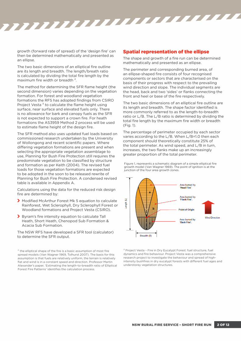
Spatial representation of the ellipseThe shape and growth of a fire run can be determined mathematically and presented as an ellipse.
The perimeter and corresponding burned area, of an ellipse-shaped fire consists of four recognised components or sectors that are characterised on the basis of their progress with respect to the prevailing wind direction and slope. The individual segments are the head, back and two ‘sides’ or flanks connecting the front and heel or base of the fire respectively.
The two basic dimensions of an elliptical fire outline are its length and breadth. The shape factor identified is more commonly referred to as the length-to-breadth ratio or L/B. The L/B ratio is determined by dividing the total fire length by the maximum fire width or breadth (Fig. 1).
The percentage of perimeter occupied by each sector varies according to the L/B. When L/B=1.0 then each component should theoretically constitute 25% of the total perimeter. As wind speed, and L/B in turn, increases, the two flanks make up an increasingly greater proportion of the total perimeter.
Figure 1, represents a schematic diagram of a simple elliptical fire growth model (Van Wagner 1969). The point of ignition is at the junction of the four area growth zones.
² the elliptical shape of the fire is a basic assumption of most fire spread models (Van Wagner 1969, Tolhurst 2007). The basis for this assumption is that fuels are relatively uniform, the terrain is relatively flat and wind is in a constant speed and direction. Professor Martin Alexander’s paper, ‘Estimating the length-to-breadth ratio of Elliptical Forest Fire Patterns’ identifies the calculation process.
³ Project Vesta – Fire in Dry Eucalypt Forest: fuel structure, fuel dynamics and fire behaviour. Project Vesta was a comprehensive research project to investigate the behaviour and spread of high-intensity bushfires in dry eucalypt forests with different fuel ages and understorey vegetation structures.

3 OF 12NSW RURAL FIRE SERVICE – SHORT FIRE RUN
The assumption, in the current development assessment process, is that the resultant head width for a fully developed fire is over 100 metres.
The simplest fire pattern is that of a single ignition source, on flat terrain and under calm conditions, spreading out at an equal rate in all directions from its ignition point in a more or less circular fashion, with the origin roughly in the centre of the burning area. The stronger the wind speed, the narrower and elongated the elliptic fire shape.
Thus, as wind speed increases the expected head width decreases. Figure 3 shows simple elliptical fire shapes of various L/B with identical areas but different perimeter lengths. This illustrates the growth pattern of a free-burning point source ignition on level terrain in the absence of wind (L/B=1.0) and under the influences of increasingly stronger winds (L/B=1.5 - 7.0).
Mathematically, the calculation of the reduced head width for a SFR is undertaken by using a slower wind speed within the forward rate of spread calculation, For a fully developed fire, the NSW RFS uses a wind speed of 45 km/hr which provides the worst case bush fire impact for new development on bush fire prone land.
Figure 3. Simple elliptical fire shapes of various length-to-breadth ratios (L/B)
Figure 2 Proposed short fire run head fire width
AssumptionsThe proposed SFR model relies on a number of assumptions to calculate the modified fire shape and flame height, these are:
Wind direction and speed is constant in the direction of fire spread;
Slope is considered relatively flat and uniform throughout the length of the fire run;
Fuel load is distributed equally and is continuous for the entire fire run length;
The shape of the fire is based on a uniform slope;
The fire develops from a single ignition point and does not consider time of ignition or fire growth;
Flaming is restricted to surface, near surface and elevated fuels;
The fire does not become a crown fire (scorching and intermittent involvement of the canopy fuels permitted, no sustained crown fire) ⁴.
Fire run is measured perpendicular to contours ⁵.
No allowance for ember showers has been considered ⁶.
⁴ The SFR methodology also assumes that due to the short fire run of low risk bush fires, canopy fires will not be sustained. A nominal fire run of 150 metres has been assumed as is measured on the effective slope. Fire runs exceeding 150 metres need to be specifically supported within a BFDB. There are no useful rules in bush fire science that can be applied to determine when a canopy will become involved.
⁵ In the application of the SFR methodology, and to calculate a worst case FROS, fire run is measured perpendicular (90 degrees) to the contour layout and directly at the asset.
⁶ Small parcels of land that could support a SFR must not have connectivity to larger parcels of land containing vegetation capable of a fully developed fire. This will remove or severely reduce the instance of ember attack from an area external to the proposed SFR.

4 OF 12NSW RURAL FIRE SERVICE – SHORT FIRE RUN
LimitationsAs in all mathematical models, operating parameters will degenerate as parameters exceed the design or purpose of the model. As such both the Forest and Heath formation models have had the following limitations applied.
Limited to 30 degrees for downslope inputs. Drop down menu in the SFR model for effective slope, site slope and upslope has been capped in the selection field;
Limited to 20 degrees for the site slope due to fuel management issues;
Limited to 15 degrees for upslope;
Limited to 150 metre fire run length, measured on the effective slope (see footnote 4 below);
Limited to maximum input of 2 metres in height for elevated fuel (Project Vesta) in forest formations only. For heath formations the height of the vegetation is measured on site; and
Forest and Heath formation fuel loads are as advised by University of Wollongong research.
Note: All aspects of a proposed SFR performance based proposal need to be supported in a Bush Fire Design Brief (BFDB). The above limitations need to be addressed with special attention applied to any proposals exceeding the limitations and must be supported by an alternate calculation process that better calculates the steeper slopes.
A proposed SFR must not have connectivity with any other parcels of land containing vegetation capable of supporting a fully developed fire that would directly impact the asset.
Process for calculating SFR in Forest, Rainforest and Woodland vegetation classes:STEP 1
The following site specific data needs to be compiled so that the outcomes for a fully developed fire can be determined.
Collect and record site-specific data such as:
effective slope (degrees),
site slope (degrees),
elevation of receiver (metres),
vegetation formation and fuel load (University of Wollongong),
distance from asset to vegetation (metres),
regional climatic data (FFDI),
measured SFR length (metres), and
average elevated fuel height (Project Vesta).
for calculation purposes determine flame temperature depending on development purpose (Residential or Special Fire Protection Purpose) ⁷.
STEP 2 - Determine the FFDI.
Appropriate FFDI values have been determined and are identified for each specific Local Government Area (LGA) in Table A2.3 in Planning for Bushfire Protection 2006.
STEP 3 - Determine Forward Rate of Spread.
To calculate the forward rate of fire spread the following equation shall be used:
For Forest & Woodland (Noble et al. 1980):
R = 0.0012 * FDI * W * exp (0.069 * slope)
where
R = forward rate of spread (km/hr)
FFDI = Forest Fire Danger Index
W = fuel load (t/ha), determined by referring to Table at Appendix A
slope = effective slope (degrees)
⁷ For SWFR calculation purposes flame temperature is determined by development purpose. i.e. Residential (1090K) & SFPP (1200K).

5 OF 12NSW RURAL FIRE SERVICE – SHORT FIRE RUN
STEP 4 - Determine Fully Developed Fire Intensity (Modified McArthur Mk 5).
The intensity of the Fully Developed Fire shall be determined by:
I = H * W * R / 36
where
I = fire intensity (kW/m)
H = heat of combustion (kJ/kg), approximated as 18,600 kJ/kg
W = overall fuel loads (t/ha), determined by referring to Appendix A.
R = forward rate of spread (km/hr) as determined in Step 3
STEP 5 - Determine Fully Developed Fire Flame Length.
Fully Developed Fire Flame Length shall be determined by:
Lf = (13 * R + 0.24 * W) / 2
where
Lf = flame length (m)
R = forward rate of spread (km/hr), determined in Step 3
W = overall fuel loads (t/ha), as determined in step 4.
STEP 6 - Determine Fully Developed Fire Transmissivity.
The Fully Developed Fire atmospheric transmissivity T is calculated by the empirical formula (Fuss S.P. and Hamins A. 2002):
T = a0 + a1L + a2L2 + a3L
3 + a4L⁴
where
L = path length, determined by d -0.5Lfcosa.
an = coefficient determined by C1n+ C2nTa+ C3nT+ C4nRH.
Ta = ambient temperature, approximated as 308 K.
T = flame temperature, approximated as 1200 K.
RH = relative humidity, approximated as 25%.
C1n, C2n, C3n and C4n = Constants defined in Table 1.
where
Calculate the following to determine SFR Characteristics.Some steps in calculating the SFR potential have not been shown as those calculations have already been undertaken in the preceding methodology for a FDF. Those calculations already determined have been utilised in the SFR methodology where appropriate to reduce unnecessary duplication.
Standard SFR input characteristics (default)
Flame: Width = determined by head width calculation using the L/B ratio and must be less than 100 metres in width to qualify as a SFR.
Temperature = 1090 Kelvin (K). (SFPP = 1200K)
Emissivity = 0.95.
Fuel Load: For SFR use surface fuel load only to determine SFR Intensity.
Fire Weather: Select appropriate FFDI (NSW RFS website).
Wind Speed: 30 km/hr.
STEP 8 - Determine SFR length.
A simple SFR is measured perpendicular to the contours from the furthest point of vegetation away from the asset to the closest point of vegetation to the asset. SFR on cross slopes can also be calculated although varying flank fire spread will apply and as such is more complicated. Assessment requiring a higher degree of bush fire behaviour knowledge is required.
STEP 7 - Determine Fully Developed Fire Radiation.
The radiation Qr shall be determined by:
n C1n C2n C3n C4n
0 1.486 -2.003 x 10⁻³ 4.68 x 10⁻⁵ -6.052 x 10⁻²
1 1.225 x 10⁻² -5.900 x 10⁻⁵ 1.66 x 10⁻⁶ -1.759 x 10⁻³
2 -1.489 x 10⁻⁴ 6.893 x 10⁻⁷ -1.922 x 10⁻⁸ 2.092 x 10⁻⁵
3 8.381 x 10⁻⁷ -3.823 x 10⁻⁹ 1.0511 x 10⁻¹⁰ -1.166 x 10⁻⁷
4 -1.685 x 10⁻⁹ 7.637 x 10⁻¹² -2.085 x 10⁻¹³ 2.350 x 10⁻¹⁰
Table 1. Constants to calculate coefficient an
6 OF 12NSW RURAL FIRE SERVICE – SHORT FIRE RUN
where
STEP 9 - Determine SFR Intensity. (Modified Byram 1959).
The intensity of the FDF shall be determined by:
I = H * surface fuels * R/36
where
I = fire intensity (kW/m)
H = heat of combustion (kJ/kg), approximated as 18,600 kJ/kg
W = surface fuel loads (t/ha), determined by referring Table 1.
R = Forward rate of spread (FROS)
STEP 10 - Calculate SFR Head Width.
The SFR head width represents the horizontal dimension of the view factor. To calculate the SFR head width we need to determine the length/breath ratio using:
L/B ratio = 1.0 + 0.0012 V 2.154
where
V = wind speed km/hr
STEP 11 - Calculate SFR Flame Height.
Flame length calculation for the SFR is derived from the CSIRO Project Vesta which restricts the fuel load to surface, near surface and elevated fuels only to a maximum of 2 metres in height. Canopy fuels have been discounted. The SFR Flame Height shall be determined by:
Fh = 0.0193 * R^0.723 * EXP (0.64 * Efh)
where
Fh = Flame height in metres
R = forward rate of spread (m/hr)
Efh = elevated fuel height (metres)
Surface fuels, near surface and elevated fuel structure will vary between individual vegetation formations and classifications. For the appropriate elevated fuel height for the selected vegetation classification refer to Fuel Height Key table at Appendix B.
STEP 12 - Calculate SFR Radiation.
The radiation Qr shall be determined by:
For Tall Heath, Short Heath, Chenopod Sub Formation & Acacia Sub Formation.STEP 1 - The following site specific data needs to be compiled so that the outcomes for a fully developed fire can be determined.
Collect and record site-specific data such as:
effective slope,
site slope,
elevation of receiver,
vegetation formation and fuel load,
distance from asset to vegetation,
regional climatic data (FFDI),
measured SFR length, and
Overall fuel load as identified in Appendix A.
STEP 2 - Determine Forward Rate of Spread
To calculate the forward rate of fire spread the following equation shall be used:
For Heath, Shrubland and scrub (Catchpole et al. 1998):
R = 0.023 * V1.21 * VH0.54
where
R = rate of spread (km/hr)
V = average wind speed at 10 metres above ground (km/hr)
VH = average height of classified vegetation (metres)
STEP 3 - Determine SFR Intensity (Byram 1959).
I = H * W * R/36
where
I = fire intensity (kW/m)
H = heat of combustion (kJ/kg), approximated as 18,600 kJ/kg
W = overall fuel loads (t/ha), determined by referring Table 1.

7 OF 12NSW RURAL FIRE SERVICE – SHORT FIRE RUN
where
SFR Calculation exampleTest site specifics
Effective slope = 11 degrees.
Site slope = 3 degrees.
Elevation of receiver = 1.8 metres.
Vegetation formation and fuel load = Sydney Coastal DSF 21.3 / 27.3
Distance from asset to vegetation = 31 metres (drip line to gutter line)
Regional climatic data (FFDI) = 100
Measured SFR length = 62 metres (perpendicular to contours)
Average elevated fuel height = 2 metres (max)
Standard FDF input characteristics (default)
Flame: Width = 100 metres.
Temperature = 1090 Kelvin (K). (SFPP = 1200K)
Emissivity = 0.95.
Fuel Load: As identified in Appendix A.
Fire Weather: Select appropriate FFDI (NSW RFS website)
Wind Speed: 45 km/hr.
Ambient Temperature: 35 degrees Celsius (C).
Relative Humidity: 25 percent (%)
Heat of Combustion: 18600 (kJ/kg)
Standard SFR input characteristics (default)
Flame: Width = determined by head width calculation and must be less than 100 metres in width to qualify as a SFR.
Temperature = 1090 Kelvin (K). (SFPP = 1200K)
Emissivity = 0.95.
Fuel Load: For SFR use full surface and elevated fuel load.
Fire Weather: Select appropriate FFDI (RFS PBP 2006).
Wind Speed: nominally 30 km/hr (or as determined)
STEP 4 - Calculate SFR Head Width.
The SFR head width represents the horizontal dimension of the view factor. To calculate the SFR head width we need to determine the length/breath ratio using ⁸ :
L/B ratio = 1.0 + 0.0012 V 2.154
where
V = wind speed (km/hr) ⁸
STEP 5 - Determine SFR Flame Height. (Project Vesta)
Flame Length shall be determined by:
Fh = 0.0193 * R0.723 * exp(0.64 * Efh)
Where:
Fh = flame height
R = forward rate of spread (m/hr)
Efh = elevated fuel height (m)
STEP 6 - Calculate SFR Radiation.
The radiation Qr shall be determined by:
⁸ The FRROS and wind speed as identified by Professor Martin Alexander (University of Alberta Canada) His paper ‘Estimating the length-to breadth ratio of elliptical Forest Fire Patterns’ identifies the calculation process at bottom of page

8 OF 12NSW RURAL FIRE SERVICE – SHORT FIRE RUN
Appendix A.Vegetation Formations and associated fuel loads as determined by University of Wollongong.
VEGETATION VEGETATION CLASSIFICATIONSURFACE
AND ELEVATED
OVERALL FUEL LOAD (INCLUDING BARK AND CANOPY) 1
Rainforest All 10 13.2
Wet Sclerophyll Forests(Shrubby)
North Coast WSF (Shrubby) 22 35.98
South Coast WSF (Shrubby) 22 35.35
Northern Escarpment WSF (Shrubby) 22 36.6
Southern Escarpment WSF (Shrubby) 22 36.1
Wet Sclerophyll Forests(Grassy)
Northern Hinterlands WSF (Grassy) 20 33.1
Southern Lowlands WSF (Grassy) 20 32.8
Northern Tablelands WSF (Grassy) 20 31.53
Southern Tablelands WSF (Grassy) 20 30.1
Montane WSF (Grassy) 26 36.6
Dry Sclerophyll Forests(Shrub/Grass)
Clarence DSF 14 25.18
Hunter Macleay DSF 14 24.6
Cumberland DSF 14 24.97
Southern Hinterland DSF 14 25.93
Northern Gorge DSF 14 25.8
Central Gorge DSF 14 25.8
New England DSF 14 25.23
North West Slopes DSF 14 24.47
Upper Riverina DSF 14 25.09
Pilliga Outwash DSF 7 11.05
Dry Sclerophyll Forests(Shrubby)
Coastal Dune DSF 20.5 31.1
North Coast DSF 21.3 28.44
Sydney Coastal DSF 21.3 27.3
Sydney Hinterland DSF 21.3 27.42
Sydney Sand Flats DSF 20.5 29.5
South Coast Sands DSF 20.5 30.9
South East DSF 17 28
Southern Wattle DSF 17 28
Northern Escarpment DSF 21.3 28.05
Sydney Montane DSF 21.3 27.47
Northern Tablelands DSF 22.5 31.5
Southern Tablelands DSF 22.5 30.85
Western Slopes DSF 15 18.86
Yetman DSF 15 18.86
Pine Plantations(PBP – Radiata Pine)
N/A 21 31
¹ Fuel loads are expressed in tonnes per hectare

9 OF 12NSW RURAL FIRE SERVICE – SHORT FIRE RUN
VEGETATION VEGETATION CLASSIFICATIONSURFACE
AND ELEVATED
OVERALL FUEL LOAD (INCLUDING BARK AND CANOPY) ¹
Woodlands
Coastal Valley GW 10 18.07
Tablelands Clay GW 10.5 18.61
New England GW 10.5 20.2
Southern Tableland GW 10.5 19.01
Sub-alpine woodlands 18 27.3
Western Slopes GW 10.5 18.3
Floodplain transition woodlands 10.5 18.9
Semi-arid woodlands (grassy)
Inland floodplain woodlands; north-west floodplain woodlands; riverine plain woodlands; Brigalow Clay Plain woodlands
5.9 9.0
Semi-arid woodlands (PBP - Use for all classes except Dune Mallee and Sand plain Mallee)
North-west alluvial sand woodlands; riverine sandhill woodlands; inland rocky hill woodlands; subtropical semi-arid woodlands; western peneplain woodlands; semi-arid sand plain woodlands; desert woodlands
11.9 14.5
Semi-arid woodlands (PBP - Semi-arid woodlands (shrubby) – Mallee
Dune Mallee woodlands; Sand plain mallee woodlands 13.3 16.5
Forested Wetlands (Coastal swamp forest)
Coastal swamp forests 22.6 34.1
Forested Wetlands (Riverine forest)
Coastal floodplain wetlands; Eastern riverine forests; inland riverine forests
8.2 15.1
Heathlands(PBP - Tall Heath)
Keith: May include classes: Sydney coastal heaths; Coastal headland heaths; Wallum sand heath.
PBP Note: Use for Heath > 2 metres. This example calculated @ 4metres height for PBP.
36.9 36.9
Heathlands, Freshwater Wetlands and Alpine Complex(PBP - Short Heath)
Keith: Includes classes: South Coast heaths; Northern montane heaths; Sydney montane heaths; Southern montane heaths; Coastal heath swamps (Freshwater wetlands formation); Alpine heaths (Alpine complex formation). May include classes: Sydney coastal heaths; Coastal headland heaths; Wallum sand heaths.
PBP Note: Use for heath < 2m tall. This example calculated @ 2 metres height for PBP.
15.0 15.0
Arid shrublands (acacia)
Keith: North-west Plain Shrublands; Gibber Transition Shrublands; Stony Desert Mulga Shrublands; Sand Plain Mulga Shrublands.
PBP Note: This example calculated @ 1.5 metres height for PBP.
6.2 6.2
Arid shrublands (chenopod)Keith: Riverine Chenopod Shrublands; Aeolian Chenopod Shrublands; Gibber Chenopod Shrublands. PBP Note: This example calculated @ 1.5 metres height for PBP.
3.2 3.2
Freshwater Wetlands (PBP – Does not include class Heath swamp, which is included in short heath.)
Keith: Montane bogs and fens; Coastal freshwater lagoons; Montane lakes; Inland floodplain swamps; Inland floodplain shrublands.
PBP Note: This example calculated @ 1 metre height for PBP.
4.4 4.4
Alpine Complex
Keith: Alpine herblands; Alpine fjaeldmarks; Alpine bogs and fens. PBP Note: Does not include class Alpine heaths, which is included in short heath. This example calculated @ 1 metre height for PBP.
5.8 5.8
Grassland
Keith: Maritime Grasslands, Temperate Montane Grasslands, Western Slopes Grassland, Riverine Plain Grasslands and Semi-arid Floodplain Grasslands.
PBP Note: Dominated by perennial grasses and the presence of broad- leaved herbs on flat topography. Lack of woody plants. Plants include grasses, daisies, legumes, geraniums, saltbushes and copperburrs.
6.0 6.0
¹ Fuel loads are expressed in tonnes per hectare
10 OF 12NSW RURAL FIRE SERVICE – SHORT FIRE RUN
RAINFOREST
Subtropical RainforestsComplex closed forest. Trees 20-40m comprising an uneven canopy festooned with diverse lianas and epiphytes. Open shrub/sapling stratum including palms. Scattered groundcover of herbs and ferns.
Tall
Northern Warm Temperate Rainforests Closed forest up to 30m tall dominated by a few species (generally 4-15), occasional lianas and epiphytes, open shrub/sapling stratum and open to relatively dense fern/herb groundcover. Tall
Southern Warm Temperate Rainforests Closed forest with stands dominated by a few species (generally<4), occasional lianas and epiphytes, open shrub/sapling stratum and open to relatively dense fern/herb groundcover. Tall
Cool Temperate Rainforests Simple closed forest 20-25m tall with one or two dominant tree species, very sparse shrub/sapling layer and mostly dense ferny groundcover. Low
Dry Rainforests Low closed forest to 20 m tall with occasional emergent eucalypts, sparse shrub and ground strata. Medium
Western Vine Thickets Dry rainforest. Canopy 4-10m tall with many gaps; Emergent trees. Vines prominent; shrub understorey; grasses in canopy gaps. Medium
Littoral Rainforests Low closed forest to 15 m tall with occasional shrubs and sparse groundcover. Medium
WET SCLEROPHYLL FORESTS
North Coast Wet Sclerophyll ForestsTall dense forests. Straight-boled dominant eucalypts 30-60m tall. Subdominant open stratum of mesophyllous small trees or tall shrubs up to 15m. Frequent vines and mesophyllous shrubs in understorey and continuous groundcover of ferns and forbs.
Medium
South Coast Wet Sclerophyll Forests Tall dense eucalypt forests with straight-boled trees 30-50m tall. Understorey includes an open stratum of tall mesophyllous shrubs, occasional vines and a continuous herbaceous groundcover. Tall
Northern Escarpment Wet Sclerophyll Forests Tall dense eucalypt forest 30-50m tall, with an open sub-canopy of tall mesophyllous shrubs and groundcover of ferns and herbs. Tall
Southern Escarpment Wet Sclerophyll Forests Tall dense eucalypt forest 30-60m, with understorey of open or closed stratum of mesomorphic shrubs and relatively dense groundcover of ferns and herbs. SEE BOOK re variability of understorey. Medium
Northern Hinterland Wet Sclerophyll Forests Tall open dry eucalypt forests to 40m with scattered sclerophyll shrubs and continuous grassy groundcover. Low
Southern Lowland Wet Sclerophyll Forests Open to semi-dense eucalypt forests up to 30m tall with a non-sclerophyllous shrub stratum and prominent grassy groundcover. Low
Northern Tableland Wet Sclerophyll Forests Tall eucalypt forest 30-40m, with scattered small trees and shrubs and dense groundcover of grasses and herbs. Medium
Southern Tableland Wet Sclerophyll Forests Open eucalypt forest 20-35m tall, with open non-sclerophyll shrub stratum and relatively continuous herbaceous groundcover. Low
Montane Wet Sclerophyll Forests Eucalypt forest up to 25m tall with prominent non-sclerophyllous shrub stratum and herbaceous groundcover. Low
DRY SCLEROPHYLL FORESTS
Clarence Dry Sclerophyll Forests Dry open eucalypt forest to 30m tall with open sub-canopy, sparse shrub stratum and continuous grassy groundcover. Low
Hunter-Macleay Dry Sclerophyll Forests Dry open eucalypt forest to 30m tall with sparse semi-sclerophyll shrub stratum and semi-continuous grassy understorey. Low
Cumberland Dry Sclerophyll Forests Open dry eucalypt woodland to 25 m tall with an open sub-canopy; open sclerophyll shrub stratum and semi-continuous grassy groundcover. Low
Southern Hinterland Dry Sclerophyll Forests Open eucalypt forest to 25m tall with open semi-sclerophyll shrub stratum and continuous grassy groundcover. Low
Northern Gorge Dry Sclerophyll Forests Open eucalypt forest to 20m tall with open sub-canopy, sparse shrub stratum and continuous grassy groundcover. Low
Central Gorge Dry Sclerophyll Forests Open eucalypt forest with scattered non-sclerophyllous shrubs and groundcover of herbs, ferns and grasses. Low
New England Dry Sclerophyll Forests Dry open forest to 25m tall with open, mostly sclerophyll shrub stratum and continuous grassy groundcover. Low
North-west Slopes Dry Sclerophyll Woodlands Open eucalypt woodland with open sclerophyllous shrub stratum and grassy groundcover. Tall
Upper Riverina Dry Sclerophyll Forests Open eucalypt woodland up to 20 m tall with open sclerophyllous shrub stratum and grassy groundcover. Tall
Pilliga Outwash Dry Sclerophyll ForestsOpen eucalypt forest up to 25m tall with an open substratum of pines and wattles, a diverse sclerophyll shrub stratum dominated by legumes and scattered groundcover of grasses, graminoids and forbs.
Low
Coastal Dune Dry Sclerophyll Forests Tall dry eucalypt forest to 40m with a rather dense sclerophyll shrub stratum and mixed groundcover of sclerophyll graminoids and ferns. Tall
North Coast Dry Sclerophyll Forests Open eucalypt forests to 25m with prominent sclerophyll shrub stratum and open grassy groundcover. Medium
FORMATION DESCRIPTION (KEITH 2002)SFR
VegetationHeight
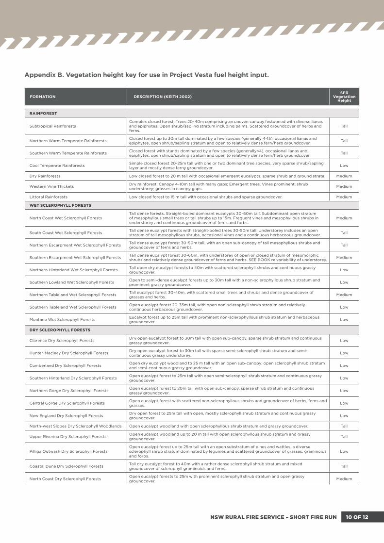
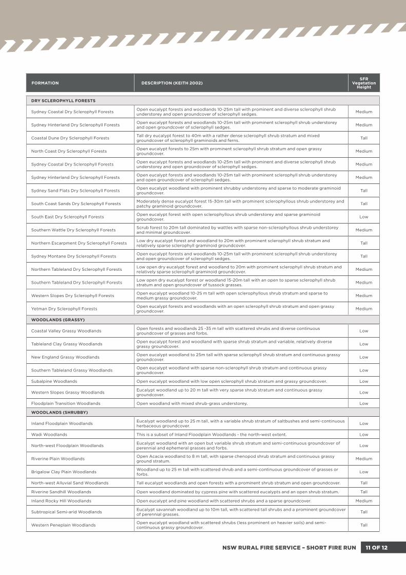
Appendix B. Vegetation height key for use in Project Vesta fuel height input.
11 OF 12NSW RURAL FIRE SERVICE – SHORT FIRE RUN
DRY SCLEROPHYLL FORESTS
Sydney Coastal Dry Sclerophyll Forests Open eucalypt forests and woodlands 10-25m tall with prominent and diverse sclerophyll shrub understorey and open groundcover of sclerophyll sedges. Medium
Sydney Hinterland Dry Sclerophyll Forests Open eucalypt forests and woodlands 10-25m tall with prominent sclerophyll shrub understorey and open groundcover of sclerophyll sedges. Medium
Coastal Dune Dry Sclerophyll Forests Tall dry eucalypt forest to 40m with a rather dense sclerophyll shrub stratum and mixed groundcover of sclerophyll graminoids and ferns. Tall
North Coast Dry Sclerophyll Forests Open eucalypt forests to 25m with prominent sclerophyll shrub stratum and open grassy groundcover. Medium
Sydney Coastal Dry Sclerophyll Forests Open eucalypt forests and woodlands 10-25m tall with prominent and diverse sclerophyll shrub understorey and open groundcover of sclerophyll sedges. Medium
Sydney Hinterland Dry Sclerophyll Forests Open eucalypt forests and woodlands 10-25m tall with prominent sclerophyll shrub understorey and open groundcover of sclerophyll sedges. Medium
Sydney Sand Flats Dry Sclerophyll Forests Open eucalypt woodland with prominent shrubby understorey and sparse to moderate graminoid groundcover. Tall
South Coast Sands Dry Sclerophyll Forests Moderately dense eucalypt forest 15-30m tall with prominent sclerophyllous shrub understorey and patchy graminoid groundcover. Tall
South East Dry Sclerophyll Forests Open eucalypt forest with open sclerophyllous shrub understorey and sparse graminoid groundcover. Low
Southern Wattle Dry Sclerophyll Forests Scrub forest to 20m tall dominated by wattles with sparse non-sclerophyllous shrub understorey and minimal groundcover. Medium
Northern Escarpment Dry Sclerophyll Forests Low dry eucalypt forest and woodland to 20m with prominent sclerophyll shrub stratum and relatively sparse sclerophyll graminoid groundcover. Tall
Sydney Montane Dry Sclerophyll Forests Open eucalypt forests and woodlands 10-25m tall with prominent sclerophyll shrub understorey and open groundcover of sclerophyll sedges. Tall
Northern Tableland Dry Sclerophyll Forests Low open dry eucalypt forest and woodland to 20m with prominent sclerophyll shrub stratum and relatively sparse sclerophyll graminoid groundcover. Medium
Southern Tableland Dry Sclerophyll Forests Low open dry eucalypt forest or woodland 15-20m tall with an open to sparse sclerophyll shrub stratum and open groundcover of tussock grasses. Medium
Western Slopes Dry Sclerophyll Forests Open eucalypt woodland 10-25 m tall with open sclerophyllous shrub stratum and sparse to medium grassy groundcover. Medium
Yetman Dry Sclerophyll Forests Open eucalypt forests and woodlands with an open sclerophyll shrub stratum and open grassy groundcover. Medium
WOODLANDS (GRASSY)
Coastal Valley Grassy Woodlands Open forests and woodlands 25 -35 m tall with scattered shrubs and diverse continuous groundcover of grasses and forbs. Low
Tableland Clay Grassy Woodlands Open eucalypt forest and woodland with sparse shrub stratum and variable, relatively diverse grassy groundcover. Low
New England Grassy Woodlands Open eucalypt woodland to 25m tall with sparse sclerophyll shrub stratum and continuous grassy groundcover. Low
Southern Tableland Grassy Woodlands Open eucalypt woodland with sparse non-sclerophyll shrub stratum and continuous grassy groundcover. Low
Subalpine Woodlands Open eucalypt woodland with low open sclerophyll shrub stratum and grassy groundcover. Low
Western Slopes Grassy Woodlands Eucalypt woodland up to 20 m tall with very sparse shrub stratum and continuous grassy groundcover. Low
Floodplain Transition Woodlands Open woodland with mixed shrub-grass understorey. Low
WOODLANDS (SHRUBBY)
Inland Floodplain Woodlands Eucalypt woodland up to 25 m tall, with a variable shrub stratum of saltbushes and semi-continuous herbaceous groundcover. Low
Wadi Woodlands This is a subset of Inland Floodplain Woodlands - the north-west extent. Low
North-west Floodplain Woodlands Eucalypt woodland with an open but variable shrub stratum and semi-continuous groundcover of perennial and ephemeral grasses and forbs. Low
Riverine Plain Woodlands Open Acacia woodland to 8 m tall, with sparse chenopod shrub stratum and continuous grassy ground stratum. Medium
Brigalow Clay Plain Woodlands Woodland up to 25 m tall with scattered shrub and a semi-continuous groundcover of grasses or forbs. Low
North-west Alluvial Sand Woodlands Tall eucalypt woodlands and open forests with a prominent shrub stratum and open groundcover. Tall
Riverine Sandhill Woodlands Open woodland dominated by cypress pine with scattered eucalypts and an open shrub stratum. Tall
Inland Rocky Hill Woodlands Open eucalypt and pine woodland with scattered shrubs and a sparse groundcover. Medium
Subtropical Semi-arid Woodlands Eucalypt savannah woodland up to 10m tall, with scattered tall shrubs and a prominent groundcover of perennial grasses. Tall
Western Peneplain Woodlands Open eucalypt woodland with scattered shrubs (less prominent on heavier soils) and semi-continuous grassy groundcover. Tall
FORMATION DESCRIPTION (KEITH 2002)SFR
VegetationHeight

12 OF 12NSW RURAL FIRE SERVICE – SHORT FIRE RUN
WOODLANDS (SHRUBBY)
Desert Woodlands Low open eucalypt woodland to 12 m tall with mixed shrub and grass understorey. Tall
Dune Mallee Woodlands Mallee eucalypt woodland with an open stratum of shrubs and prominent stratum of hummock grasses. Medium
Sand Plain Mallee Woodlands Mallee eucalypt woodland with a prominent stratum of shrubs and variable groundcover of chenopods. Medium
Semi-arid Sand Plain Woodlands Open woodland with chenopod understorey. Tall
FORESTED WETLANDS
Coastal Swamp Forests Low dense mixed forest of eucalypts and paperbarks with minimal shrub cover and dense graminoid groundcover. Medium
Coastal Floodplain Forests A mosaic of open Casuarina forest and sedge-land. Low
Eastern Riverine Forests Open Casuarina forest with a variable shrub stratum and patchy groundcover. Low
Inland Riverine Forests Open eucalypt forest up to 40 m tall with a dense species-rich herbaceous groundcover interspersed with open ground and scattered shrubs rarely present. Low
FORMATION DESCRIPTION (KEITH 2002)SFR
VegetationHeight
Assumed maximum vegetation height keyTall = > 1.4 metres - < 2.0 metres
Medium = > 0.9 metres - < 1.4 metres
Low = 0 metres - < 0.9 metres
References:
Estimating the length-to-breadth ratio of elliptical forest fire patterns. 1985. Alexander, M.E. Pages 287-304 in Proceedings of the 8th Conference on Fire and Forest Meteorology, April 29-May 2, 1985, Detroit, Michigan. Society of American Foresters, Bethesda, Maryland.
Elliptical-fire perimeter- and area-intensity distributions. 1992. Catchpole, E.A.; Alexander, M.E.; Gill, A.M. Canadian Journal of Forest Research 22(7): 968-972.