metropolitan nashville urban forestry and …metropolitan nashville urban forestry and landscape...
TRANSCRIPT

2
METROPOLITAN NASHVILLE URBAN FORESTRY AND LANDSCAPE MASTER PLAN
URBAN FORESTRYis the care and management of tree
of improving the urban environment.
JULY 2016
The vision, goals and guide for the future of Nashville’s Urban Forest.

METROPOLITAN NASHVILLE URBAN FORESTRY AND LANDSCAPE MASTER PLAN
1
VISION STATEMENT
To protect, restore, preserve and enhance Nashville’s greatest natural asset, its Urban Forest, and to fulfill the vision of Nashville as a ‘Green City’.
MISSION STATEMENT
The Metro Nashville Urban Forestry and Landscape Master Plan is a road map to manage and grow Nashville’s urban forest and to inspire and engage others in the care and protection of trees and landscape.
This plan provides guidance for tree and landscape programs for both public and private lands through government and non-government partnerships.
A healthy urban forest for Nashville will provide sustainable benefits of • Cleaner air and water, • Reduced flooding, • Less noise,• Lower energy consumption, • Cooler temperatures, • Better wildlife habitat, • Beautiful streets and neighborhoods, • Increased property values, and • Improved health and well-being of our citizens.

METROPOLITAN NASHVILLE URBAN FORESTRY AND LANDSCAPE MASTER PLAN
2
TABLE OF CONTENTS
EXECUTIVE SUMMARY
INTRODUCTION
6- Purpose
6- Project Background
6- Acknowledgments
7- Nashville Planning Documents that Support the Urban Forest
8- How Nashville Compares to Other Cities
9- How this Plan was Developed
WHAT DO WE HAVE?
12- Cultural and Natural Prehistory of Nashville
12- Time-Line of Events that Have Impacted the Nashville Urban Forest
14- Environmental Factors
15- Nashville’s Current Tree Resources
16- Assessing Metro Urban Forestry and Landscape Coordination Program
18- Satellite Cities
19- Division of Land Management in Nashville
WHAT DO WE ENVISION?
22- Elements of a Complete Urban Forestry and Landscape Program
HOW DO WE GET THERE?
26- Needs, Goals and Objectives
27- GOAL 1- STANDARDS 32- GOAL 2- OUTREACH
34- Outline of City-Wide Citizen Based Urban Forestry Program
35- GOAL 3- CANOPY GOALS
40- Assessment of Equipment and Personnel
41- Implementation
42- Monitoring
PRIORITY AREA MAPS
44- Setting Urban Tree Canopy Priority Areas
44- Tree Calculator
46
12
22
26
44

METROPOLITAN NASHVILLE URBAN FORESTRY AND LANDSCAPE MASTER PLAN
3
DID YOU KNOW ?Trees Provide ECONOMIC Benefits
• Research reveals that many business owners regard the urban forest as an “outdoor extension of a business’ customer service commitment” and sends a “message of care,” improving the retailer’s or company’s overall image.
• Increased business value: Trees enhance community economic stability by attracting businesses and tourists.
• Customers are willing to pay as much as 10 percent more for certain goods and services if businesses are located on tree-lined streets.
• Consumer product testing in shopping areas with large numbers of shade trees were rated 30 percent higher than identical products rated in shopping areas that were barren of trees.
• Tree-lined business and retail districts encourage patrons to linger and shop longer.
• Workers without a view of nature from their desks reported 23% more instances of illnesses than those with a view of greenery.
• Increased home value: The presence of trees has a positive effect on occupancy rates and residential home sales. Neighborhood greenspaces or greenways typically increase the value of properties located nearby.
• Healthy trees can add up to 15 percent to residential property value.
• Strategically placed trees around a building can reduce summer cooling costs by as much as 30%, while winter heating costs can be reduced by a similar percentage by the use of trees as windbreaks.
• Trees absorb and store an annual average of 13 pounds of carbon each year. Community trees across the United States store 6.5 million tons of carbon per year, resulting in a savings of $22 billion in control costs.
• Streets with little or no shade need to be repaved twice as often as those with tree cover.
• Both business/commercial land and farm/forest land pay more than $1 in taxes for every $1 they get back in services. However, residential land costs more in services than it pays in revenues. So when a county cuts down trees or converts farmland to build a subdivision, it is actually poorer.
http://www.southernforests.org/urban/benefits-of-urban-trees

METROPOLITAN NASHVILLE URBAN FORESTRY AND LANDSCAPE MASTER PLAN
4
EXECUTIVE SUMMARY
STANDARDSUpdate and Implement Landscape Standards and Enhance the Metro Landscape Coordination Program
Expand and organize into three areas of service:• OPERATIONS• PLANNING AND REVIEW • OUTREACH
OPERATIONS- assist Metro Public Works operations with vehicles, equipment and personnel needed to plant and maintain Nashville’s street trees.
PLANNING AND REVIEW- partner with Metro Code’s, Public Works, Planning, Parks and non-Metro groups to review plans to ensure they meet the goals approved by Metro and set forth in this master plan. Emphasis is on planning, Global Information System (GIS) mapping and monitoring of projects.
Other roles include developing a Street Tree Program, standards for planting and maintenance, job classifications and requirements and training programs for front line workers.
This master plan is the result of recommendations put forward in the 2008 Metro Tree Advisory Committee’s Proposal- Managing Nashville’s Urban Forest It was presented to the Mayor’s Office and City Council in that same year. It’s recommendations to develop and maintain an Urban Forest Program were adopted into the 2009 Green Ribbon Committee’s- Report on Environmental Sustainability. This master plan was funded by a donation to the non-profit Keep Nashville Beautiful from the Atticus Foundation. Work began in January of 2014.
The Nashville Urban Forest and Landscape Master Plan provides a road map to manage and grow Nashville’s tree canopy. It creates a shared vision for the future of the urban forest to support Metro efforts and engage the community in the care and protection of trees and landscapes.
There is a need to address the impact that rapid development is having on our cities’ natural resources. The duty to protect, restore, and maintain our tree canopy is important because of the beneficial services trees provide such as cleaner air and water, shade as well as economic, psychological, health, and aesthetic benefits.
SOME REASONS FOR THIS PLAN
To facilitate better communication between landscape managers.
To streamline more efficient use of funding, personnel and resources.
To use as a tool to acquire funding from various sources.
To Illustrate the benefits of a well-managed Urban Forest and landscape.
To emphasize the role of trees in stormwater reduction and quality.
To use for education, outreach and volunteer efforts.
To guide us into the future.
OUTREACHEngage the Public in the Metro Landscape Coordination Program
OUTREACH- interface with volunteer and community groups to facilitate projects on private land, engage non-profit partners in tree programs, education, fundraising, open platform GIS mapping, tree seedling nurseries, and maintenance.
CANOPY GOALSImplement Tree Density Goals
The Tree Canopy Target Percentage Goals and Priority Area Maps are a tool to guide the city to high priority areas suitable for preservation and tree planting projects. They are intended to be used by organizations such as Metro and TDOT as well as non-profit groups and citizens.
GOAL 1 GOAL 2 GOAL 3
When comparing Nashville to other cities of similar size, we find that
Nashville lacks a citywide, comprehensive tree program to support
Metro landscape efforts and fund tree related
projects. Increasing tree canopy on private land
can only be done with the involvement of our citizens
and business owners.

METROPOLITAN NASHVILLE URBAN FORESTRY AND LANDSCAPE MASTER PLAN
5
DID YOU KNOW ?Trees produce OXYGEN and clean and cool the air.
• In exchange for giving oxygen, trees absorb carbon dioxide produced from the combustion of fuels.
• Trees remove or trap lung-damaging dust, ash, pollen and smoke from the air.
• Trees provide shade which reduces temperatures.
• Recent research has demonstrated that urban heat islands alter rainfall patterns. Urban trees lessen the impact of the urban heat island effect and reduce changes in weather patterns.
• One acre of trees produces enough oxygen for 18 people every day.
http://www.southernforests.org/urban/benefits-of-urban-trees

METROPOLITAN NASHVILLE URBAN FORESTRY AND LANDSCAPE MASTER PLAN
6
INTRODUCTION
PURPOSE As Nashville continues to grow at an accelerating rate, the need to protect, restore, and maintain its tree canopy becomes increasingly important and time sensitive. Trees provide many proven beneficial ecosystem services such as cleaner air and water and reduced temperatures as well as psychological, health, and aesthetic benefits to people.
The Nashville Urban Forest and Landscape Master Plan will provide a road map to effectively and pro-actively manage and grow Nashville’s tree canopy and enliven its landscapes. It will facilitate better coordination and communication between landscape managers and promote more efficient use of funding, personnel, and resources. It will provide a shared vision for the future of the urban forest to inspire and engage the community and its leaders in the care and protection of trees. This master plan is a starting point rather than an end point. Implementation of the plan is necessary to accomplish its goals. This requires ongoing financial and administrative support, advocacy, monitoring, and making adjustments as needed.
PROJECT BACKGROUND
Nashville’s Urban Forest and Landscape Master Plan was funded by a generous grant from the Atticus Foundation. It is an outgrowth of the 2008 report prepared by the Metro Tree Advisory Committee entitled Managing Nashville’s Urban Forest which analyzed the city’s role in preserving, growing, and maintaining the urban forest, revealed shortcomings, and made short and long-term recommendations. The recommendations were carried forward in the Green Ribbon Committee’s Report on Environmental Sustainability, 2009.
The Nashville Urban Forest and Landscape Master Plan also builds on the previous actions, studies, and reports listed below: Links to these documents can be found at trees.nashville.gov
• Green and Complete Streets Program- 2016• Nashville Next- General Plan for Nashville- 2015• Metro Nashville Code of Ordinance review- 2014 • Street Tree Inventory of Nashville’s Inner Loop- July 2013• Nashville Next- Natural Resources and Green Spaces- March 2013• Nashville Landscape Guidelines and Best Management Practices - March 2013• Creation of a position for a Metro Landscape Coordinator- January 2013• Nashville Open Space Plan- March 2011• Metro Nashville Tree Canopy Assessment Project- 2010• Nashville Green Infrastructure Master Plan- November 2009
ACKNOWLEDGMENTS The project advisor is Jennifer Smith, Metro Landscape Coordination Program. The planning consultants are:
Carol Ashworth- Ashworth Environmental Design, LLC, Civic Engineering & IT, INC., and Neil Letson- Village Trees, LLC.
The Metro Tree Advisory Committee is involved in all aspects of the planning process to provide assistance and recommendations. Other collaborators are:
• Cleanwater Nashville• Cumberland River Compact• Hands On Nashville• Metro Parks, Water Services,
Planning (Nashville Next), General Services, and Codes
• Nashville Civic Design Center• Nashville Tree Foundation• Nature Conservancy• TN Environmental Council• TN Urban Forest Council• Trees Nashville

METROPOLITAN NASHVILLE URBAN FORESTRY AND LANDSCAPE MASTER PLAN
7
NASHVILLE PLANNING DOCUMENTS THAT SUPPORT THE URBAN FOREST
At the present time there is an exciting synergy in Nashville involving environmental issues that brings together many diverse groups and agendas but almost all have trees as a common element. Many of these groups have conducted surveys to collect public opinion on matters related to the Urban Forest. Several Metro planning documents produced in recent years show support for the Urban Forest.
Trees play an important role in reclaiming public space as detailed in Nashville Next- Natural Resources & Hazard Adaptation Goals, Policies, and Actions Report, Review Draft March 2015. Preserve and expand upon Nashville’s existing tree canopy including urban trees, street trees and larger tracts of forested lands.
• Implement the Metro Nashville Urban Forestry and Landscape Master Plan to promote diverse tree plantings. Create a street tree policy, residential tree ordinance, maintenance program, and preservation policy. Enact a planting program to supplement cases where trees must be removed. Fund and train more interdisciplinary inspectors to handle enforcement of these regulations.
• Support the ecological integrity and public enjoyment of Nashville’s wildlife habitats, watersheds, open spaces, floodplains, and tree canopies.
• Fund a tree planting and maintenance program to meet Nashville’s tree canopy goal. This program is a collaboration between Metro Public Works, Metro Parks and Greenways, the Tennessee Department of Transportation, utility providers, and private stakeholders to plant trees along available space in highway and street rights-of-way, within parks and public lands, in parking lots, and on Metro-owned property. Emphasis on this partnership should be placed within the urban core, ensuring the survival of trees, providing shade and stormwater retention, and adding aesthetic value.
Nashville Next- Growth Preservation Survey, January 2014 responses shows the majority of Nashville citizens support preservation of the Urban Forest.
Reclaiming Public Space- A Report by the Nashville Civic Design Center, March 2013
• In the center is downtown, which should become a heart of green. A green, thriving urban core will have
more parks and greenways, a revitalized riverfront with a network of open spaces, a substantial increase in tree canopy, and innovations such as green roofs and rain gardens that capture and filter stormwater.
Nashville Open Space Plan by Nashville Naturally, March 2011• By 2012, designate a full time Metro staff person
to develop and manage an urban forestry program (to manage urban tree planning, planting and maintenance as well as work to improve tree ordinance enforcement and coordination with non-profit tree groups such as the Nashville Tree Foundation, Trees Nashville, and the Tennessee Urban Forestry Council).
• Integrate Metro department activities related to forest and water resource protection issues, specifically tree planting and maintenance, community parks and gardens, public works streetscape improvements and parks and greenways planning.
• Double the downtown tree canopy in the next 10 years (85 acres).
• According to Metro Water Services, in the urban core alone, there are 475 acres of potential green roofs, 811 acres of suitable urban tree planting locations, and 1,175 acres of surface parking that could be made more permeable. Imagine the difference that could be made if these strategies were used throughout Davidson County.
Mayors’ Office- Green Ribbon Report, June 2009• We would like to plan for a Nashville that will have a
robust tree canopy and significantly improved air quality.• Develop and maintain an Urban Forest Program.• Plant 100,000 trees in the Metro area to help with
cooling.• Plant 250,000 trees downtown.• Mayor’s Pledge- I pledge to plant and care for at least
one tree this year.
INTRODUCTION
METROPOLITAN NASHVILLE URBAN FORESTRY AND LANDSCAPE MASTER PLAN
8
WHAT ARE OTHER CITIES DOING?
City Oversight Design Guidelines Maintenance Regulatory Staff Master PlanNon-profit
Support
Trees Recognized in
Green Infrastructure
OutreachTree
Recognition Program
Dedicated Funding
Atlanta
Tree Conservation Commission (TCC)
Yes, permit required to remove
trees > 6"
Yes, with Tree Atlanta
Arborist in plans review, public
property regulated in Parks
2014Tree Atlanta
with $2 million annual budget
YesCommunity
programs and grants thru Tree Atlanta
Yes
Tree Trust Fund funds TCC, Trees Atlanta & municipal
AustinUrban Forestry Board
Yes, permit required to remove
trees > 6"In Parks
Arborist in plans review
Covers city property
TreeFolks
yes, specific tree support in Division of
Watersheds
Planting Grants & Community
programs, trains unban forest
stewards
YesMunicipal &
nonprofit
ChattanoogaTree Commission
YesIn Public Works and Contracted
LA in plans review 2014Take Root
Chattanoogayes
Community planting & education
programsyes Municipal
CharlotteCharlotte Tree Advisory Commission
15% tree save guideline
Landscape Management Department
Land Development Dept.
No Trees Charlotte Yes
Community programs, grants and education thru Trees
Charlotte
Crown Tree Awards,
Champion Trees
In lieu, Trees
Charlotte & municipal
MurfreesboroUrban Env. Commission and Tree Board
YesUrban
Environmental Department
Arborist does plans review
No No Yes Education ProgramsLandscape
awardsMunicipal
Nashville
Metro Landscape Coordination Program and Codes Dept.
YesParks Dept.,
Contracted and Public Works
Urban Forester in Codes Dept.
2016
Cumberland River Compact and Nashville
Tree Foundation
Stormwater LID Manual and
Complete Streets
Metro Tree Advisory Committee & Public
Works
George Cate Award and
Big Old Tree Contest
Tree Bank in
Landscape Codes
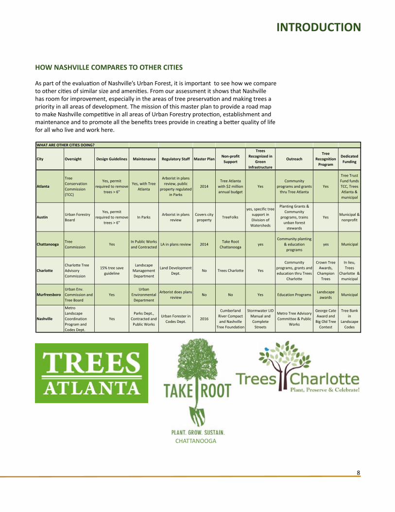
HOW NASHVILLE COMPARES TO OTHER CITIES
As part of the evaluation of Nashville’s Urban Forest, it is important to see how we compare to other cities of similar size and amenities. From our assessment it shows that Nashville has room for improvement, especially in the areas of tree preservation and making trees a priority in all areas of development. The mission of this master plan to provide a road map to make Nashville competitive in all areas of Urban Forestry protection, establishment and maintenance and to promote all the benefits trees provide in creating a better quality of life for all who live and work here.
INTRODUCTION
CHATTANOOGA

METROPOLITAN NASHVILLE URBAN FORESTRY AND LANDSCAPE MASTER PLAN
9
HOW THIS PLAN WAS DEVELOPED
The master planning process was conducted in three phases: Inventory and Data Collection, Assessment and Analysis, and Development of Goals and Recommendations.
Data collected include the current state of the Nashville’s Urban Forest and its management. The data provides answers the following questions:
• How much tree canopy do we have, where is it, and who maintains it?• What are our current methods of maintaining trees on city properties?• What are the current codes and regulations guiding development?• How do we protect or not protect existing trees?• How do we encourage tree and landscape maintenance?• What are other cities doing ?
Analysis includes assessment of the current extent of tree canopy and its diversity in Nashville, current policies and procedures that govern both public and private maintenance and development, current landscaping regulations and maintenance guidelines, and environmental factors that impact tree growth and development.
Data was also collected through meetings, interviews, surveys, a steering committee, Metro round-table groups, stakeholders, and the public. Research was conducted for such topics as current management policies, responsibilities, and practices within Metro departments and codes and outside Metro such as NES, contractors, non-professional landscapers, and emergency services. The data includes a brief history of events that changed the area’s landscape.
The next step was to identify needs, goals and values to develop recommendations and the tools to implement them.
This management plan will set goals and objectives, which provide the overall destinations of the plan. It also will list actions needed to accomplish the goals and objectives. For each action, the implementation plan will spell out:
• Overall priority ranking• Funding • Budgets• Personnel responsible for
administering• Time schedule
After the management plan is in place, it is important to evaluate how it is working. Monitoring procedures should be implemented. This brings the process to a full cycle. This cycling allows the plan to adapt to changing conditions.
THE MANAGEMENT PLANNING PROCESSAlthough the steps shown are represented as a continuous
cycle, it is common to go back and forth between the first three steps when developing a plan
AWHAT DO WE HAVE?
HistoryEnvironment
How do we compare?Tree Resources
Managers, sta�, equipment etc.Regulations
Satellite citiesWho does what?
BWHAT DO WE WANT?
VisionGoals and Objectives
DARE WE GETTING WHAT WE WANT?
MonitorAnalyzeRevise
CHOW DO WE GET WHAT WE WANT?Recommendations
Actions/ToolsPlan Approval
Implementation
SYNTHESISFindingsTrendsNeeds
INTRODUCTION
METROPOLITAN NASHVILLE URBAN FORESTRY AND LANDSCAPE MASTER PLAN
10
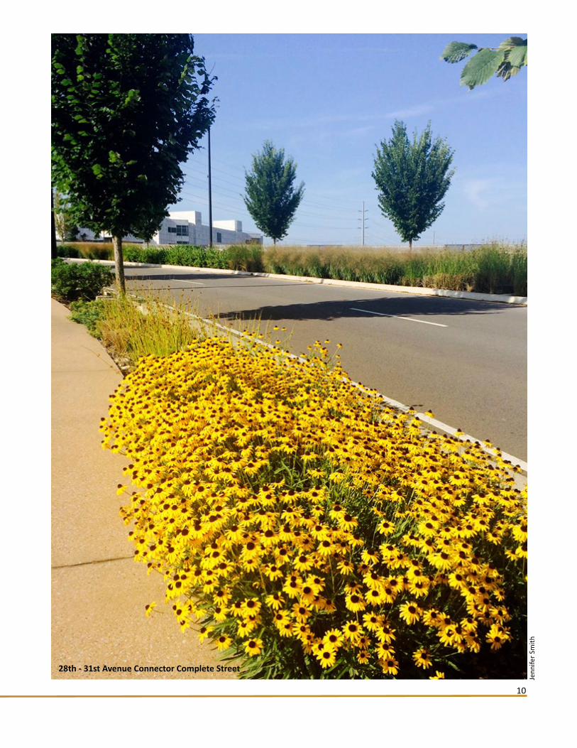
28th - 31st Avenue Connector Complete Street
Jenn
ifer S
mith

METROPOLITAN NASHVILLE URBAN FORESTRY AND LANDSCAPE MASTER PLAN
11
DID YOU KNOW ?Trees and bioretention gardens REDUCE FLOODING and WATER POLLUTION
• Trees as riparian buffers reduce and slow stormwater runoff, trapping soil sediments, nutrients and other pollutants, thus preventing them from entering receiving bodies of water.
• Trees reduce erosion of soil from fields, hills and stream banks and reduce water temperatures, protecting aquatic habitats.
• Trees allow rain to infiltrate the soil, reducing pollutants from runoff and recharging soil moisture and aquifers, which result in a more consistent quantity of potable water.
• Infiltration rates for forested areas are 10-15 times greater than for equivalent areas of turf and grass.
• Trees maintain groundwater and stream base flows.
• Trees trap airborne pollutants and particulate matter, thus preventing them from entering receiving bodies of water.
• Trees reduce volume and peak flow of stormwater runoff, and thus reduce flooding and the cost of constructing stormwater control infrastructure.
• Trees can be used to actively treat many forms of wastewater.
• Bioretention areas filled with trees utilize “green engineering” to delay or eliminate the need for municipalities to build costly underground stormwater management infrastructure.
Tennessee Urban Forestry Council, Trees Make a Difference- Benefits of Urban Forestry, 2010Benefits of Urban Forestry
METROPOLITAN NASHVILLE URBAN FORESTRY AND LANDSCAPE MASTER PLAN
12
WHAT DO WE HAVE ?
CULTURAL AND NATURAL PREHISTORY OF NASHVILLE
The first known settlers in the area of modern Nashville were Native Americans of the Mississippian culture, who lived in the area from about 1000 to 1400 BC. They sowed and harvested corn, made great earthen mounds, and painted richly decorated pottery. They then mysteriously disappeared. Other Native Americans, the Cherokee, Chickasaw and Shawnee, followed and used the area as a hunting ground.
Pre-European Davidson County was entirely forested with an Oak-hickory dominant forest type. Various species of upland Oaks made up two-thirds of the volume. Today trees cover 47 percent of the county. Eastern Red Cedar is the dominant conifer and makes up ten percent of the woodland both in pure stands and mixed with hardwoods. The pure stands of Red Cedar are typically on soils that are shallow over limestone or on limestone outcrops.
TIME LINE OF EVENTS THAT HAVE IMPACTED THE NASHVILLE URBAN FOREST
European settlement began with fur traders in early 1700 when the territory was still part of North Carolina. The first permanent settlement began in 1770 at Bluff Station/Fort Nashborough. The settlers cleared land for building material and farming. Nashville was founded in 1779 by the Robertson-Donelson party of 60 families. It quickly became a cotton center, river port, and railroad hub.
In 1819 the Cumberland Agricultural Society was formed as a conservation group of farmers to improve crop production. Cotton was the major crop pre-civil war. During the Civil War, Nashville fell to Union forces in February 1862. The military cleared a considerable amount of land. The Tennessee Centennial and International Exposition, held in 1897 at the present day Centennial Park, displayed the new farming technology of the day. As farming became more industrialized additional acreage was cleared.
Nashville’s population exploded, rising from 16,988 in 1860 to 80,865 by 1900, and created a major impact on the land. Cotton production declined by 1900 and tobacco became a major crop produced on the Highland Rim. Dutch Elm disease and Chestnut blight appeared in the 1930’s and decimated this species from this area.
The demographic shift from city to suburbs from the 1960’s until present has a huge impact to large tracts of land. Houses replaced farmland and took a heavy toll on natural resources and infrastructure. Nashville’s Urban Renewal also took a toll on trees in the urban core. Homes with yards and trees were demolished and replaced by large paved areas.
Several efforts in recent years have aimed to restore and enhance Nashville’s tree canopy. The Nashville Tree Foundation, founded in 1986, facilitates civic projects and has planted thousands of trees.
After the April 1998 tornado which felled about 20,000 trees, ReLeaf Nashville was established by the Nashville Tree Foundation with Metro Parks and Metro Beautification. They planted 6,757 trees in three years and replaced 50 trees along Main Street in their fourth year. The annual tree planting ReLeafing Day is the Saturday before Thanksgiving.
Green Infrastructure (GI) and Low Impact Development (LID) began in late 1990’s with a focus on protecting water resources through mimicking natural systems. Trees and vegetation are important components in LID systems. Both GI and LID are encouraged by
1700’s
1800’s
1900’s
1960’s
1980’s
1990’s
1990’s

METROPOLITAN NASHVILLE URBAN FORESTRY AND LANDSCAPE MASTER PLAN
13
current Metro stormwater regulations. The demographic trend to return to city from suburbs also began in the 1990’s and continues until present. While ‘Infill’ development reduces the effects of sprawl, it is taking a toll on Urban Canopy through the shrinking of lawn sizes as well as frequent destruction of large trees. In 1999 the Nashville Civic Design Center was formed to elevate the quality of design in Nashville.
Nashville Electric Service’s (NES) accelerated tree trimming program began in 2002. It has significantly reduced the number of tree-related outages at the same time reducing the viability of many of Nashville’s street trees. NES Tree Replacement Program was started to replace removals with power line compatible trees.
The Nashville Civic Design Center published the Plan of Nashville as a guide to future growth in Nashville.
The Metro Tree Advisory Committee presented its Managing Nashville’s Urban Forest proposal to the Mayor’s office in 2008. This master plan is an outgrowth of recommendations from the proposal.
The Green Ribbon Committee’s- Report on Environmental Sustainability aimed to ensure that Nashville continues to be “a livable city with clean air, clean water, open spaces, transportation infrastructure, and energy use profile necessary to provide a prosperous community for current and future generations.” The report included all recommendations from the 2008 Managing Nashville’s Urban Forest proposal.
The Flood of May 2010 devastated the city with $2 billion in damage. Rebuilding efforts since then have focused on flood control. Many trees were lost to the flood and have not been replaced. The Metro Nashville Tree Canopy Assessment Project was done as a baseline for data to use in Urban Forestry planning efforts. Metro stormwater policies have adopted protective floodplain buffers and tree planting plans to enhance their stormwater services. The Complete Street program was started in October of 2010 to include bike, pedestrian, vehicle and transit facilities in street design.
The Metropolitan Landscape Coordination Program was created in 2011 to align the work of Metro Departments and community stakeholders involved in the management of Nashville’s landscapes and green spaces to preserve, develop, expand, and enhance Nashville’s natural beauty by supporting ongoing and future projects. Also in 2011, the Nashville Open Space Plan was completed by Nashville Naturally to conserve the natural environment’s benefits and quality of life in Nashville.
The Metro Planning Department started work on Nashville Next, to address the exploding population growth and future of Nashville. The report Vision, Trends, & Strategies was released in March of 2015. In 2012, Metro added to its Stormwater Management Manual with Volume 4 - Best Management Practices and included Green Infrastructure guidance and incentives. Also started in 2012, the Urban Riparian Buffer Program, Tennessee Department of Agriculture, Division of Forestry to raise awareness and restore riparian buffers.
Metro General Services and Public Works departments developed the Metro Nashville Landscape Guidelines and Best Management Practices manual.
In November, Metro Stormwater received approval from the City Council for a new ordinance pertaining to stormwater management regulations for infill development. The bill includes incentive for tree preservation to mitigate stormwater runoff.
2000’s
2005
2008
2009
2010
2011
2012
2013
2014
WHAT DO WE HAVE ?
Links to these documents can be found at trees.nashville.gov

METROPOLITAN NASHVILLE URBAN FORESTRY AND LANDSCAPE MASTER PLAN
14
Nashville Area Metropolitan Planning Organization- Climate Change Resiliency and Action Plan. As part of the 2040 Regional Transportation Plan update, Nashville is participating in a national smart planning program, Climate Solutions University. This program will develop an environmentally, economically and fiscally sustainable plan which accounts for our region’s natural resources and vulnerability to climate change. This plan will identify the regions important ecosystem processes and benefits, identify the anticipated impacts of climate change in our region, and create an action plan to create resiliency for vulnerable populations and key environmental resources.
Mayor Megan Berry announced the Historic & Specimen Trees Program for protection of the city’s oldest and most important trees and the Green and Complete Streets Program which calls for the inclusion of street trees. The Nashville Civic Design Center produced Shaping the Healthy Community, the Nashville Plan, exploring the relationship between the built environment and public health. The noted strategy for urban forestry is to “plant trees and maintain existing canopy throughout downtown to offset the urban heat island effect, alleviate stormwater runoff, and create a better pedestrian walking experience.”
ENVIRONMENTAL FACTORS
Davidson County lies within the northwestern portion of the Central Basin Geologic Province. The Central Basin is moderately rolling with elevations ranging from 400 to 700 feet above mean sea level (MSL) and is surrounded by the Highland Rim. The Highland Rim is hilly and marked by many narrow ridges and steep-sided valleys. Elevations range between 700 and 800 feet above MSL. The Cumberland River meanders from east to west across the center of the county.
The south and east portion of Nashville-Davidson County is located in the EPA’s Ecoregion known as the Inner Nashville Basin. This is a lower elevated portion of the state where limestone outcrops and shallow soils are common. The soil chemistry favors a rich diversity of native hardwoods and cedar glade species.
Most hilltops in the northwest section have about 2 to 3 feet of wind deposited loamy soil. Most soils in the central and southeastern sections formed in material weathered from the underlying limestone bedrock. There are many rock outcrops and sinkholes in this region. Soils along the Cumberland River and its tributaries formed in alluvial (water) deposits.
Metro Davidson County has a total area of 525.94 square miles. At present, the population estimate of Nashville-Davidson County as of the 2014 census is 668,347. Nashville is the capital and second largest city in Tennessee.
WHAT DO WE HAVE ?
2015
2016
The Cumberland River
Bob
Butte
rs
METROPOLITAN NASHVILLE URBAN FORESTRY AND LANDSCAPE MASTER PLAN
15
Climate:Nashville has a humid subtropical climate with cool to moderately cold winters, and hot, humid summers. Monthly averages range from about 38 °F in January, typically the coldest month, to 80 °F in July, typically the warmest month. The highest recorded temperature was 109°F in 2012. In recent decades, due to urban development, Nashville has developed an urban heat island; temperatures are up to 10 °F warmer in the heart of the city than in rural outlying areas. The entire Nashville region lies within USDA Plant Hardiness Zone 7a which is based on the average extreme temperature during the past 30 years.
Rainfall averages 47.3 inches annually. It is greater in winter and spring while autumn is the driest. Spring and fall are prone to severe thunderstorms, which occasionally bring tornadoes. The most rainfall typically occurs in May. In the winter months, snowfall does occur in Nashville but is usually not heavy. Average annual snowfall is about 5.8 inches, falling mostly in January and February and occasionally March and December.
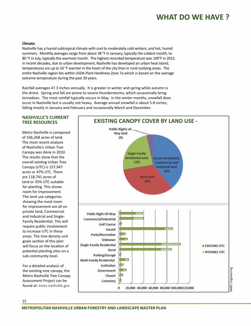
NASHVILLE’S CURRENT TREE RESOURCES
Metro Nashville is composed of 336,268 acres of land. The most recent analysis of Nashville’s Urban Tree Canopy was done in 2010. The results show that the overall existing Urban Tree Canopy (UTC) is 157,947 acres or 47% UTC. There are 118,741 acres of land or 35% UTC suitable for planting. This shows room for improvement. The land use categories showing the most room for improvement are all on private land, Commercial and Industrial and Single-Family Residential. This will require public involvement to increase UTC in these areas. The tree density unit goals section of this plan will focus on the location of potential planting sites on a sub-community level.
For a detailed analysis of the existing tree canopy, the Metro Nashville Tree Canopy Assessment Project can be found at: trees.nashville.gov
WHAT DO WE HAVE ?
EXISTING CANOPY COVER BY LAND USE -
AMEC
Eng
inee
ring

METROPOLITAN NASHVILLE URBAN FORESTRY AND LANDSCAPE MASTER PLAN
16
ASSESSING METRO’S URBAN FORESTRY AND LANDSCAPE COORDINATION PROGRAM
The effectiveness of any local government depends on how well it is structured and directed to provide for the health, safety, and welfare of its citizens. The more organized and focused Metro’s employees are, the more beneficial Metro Nashville’s natural resources will be to its citizens.
Before any steps can be taken to improve Metro Landscape Coordination Program, there has to be an understanding of how the many departments and its partnering non-government organizations currently operate. This requires knowing the key players, what part they play, and how they interact with each other. With this foundation of knowledge, recommendations to improve Metro Landscape Coordination Program can be structured in a way that everyone can accept and adopt.
Assessment GoalThe purpose of this assessment is to better understand how Metro government currently administers and delivers its urban forestry and landscape services. One-on-one interviews were held with Metro department representatives and non-Metro nonprofit organizations to get their perspectives. Each person was asked to describe their department’s or group’s urban forestry and landscape role within Metro government and with the general public. They also provided valuable input on how to make Metro landscape coordination program better and more efficient.
Methodology, Questions, and LimitationsInformation about Metro landscape coordination program was collected through personal one-on-one interviews with:
• Sixteen (16) Metro employees representing eleven (11) local government departments.
In addition, personal interviews were completed with: • Seven (7) non-Metro employees representing
five (5) nonprofit organizations and one state agency.
A detailed 48-question interview was used with Metro employees having primary urban forestry and landscape program responsibilities. A simpler set of questions was used with employees having limited greenscape responsibilities. Questions were designed to understand:
• Each person’s greenscape role, • How their department organization is structured, • What relationships they have with other groups and departments, • What are their program strengths and limitations.
All of the interview results were tabulated, processed, and then analyzed.
Observations and FindingsAs with any organization, there are many strengths in Metro Landscape Coordination Program. But as can be expected, there are also areas that can be improved.
Trends:• Metro area is expected to experience continued urban growth and development .• Urbanization has increased demands on Metro’s urban forest and landscape services.• Urbanization is degrading local natural resources and is impacting environmental quality.• Metro Landscape Coordination Program resources (e.g. budget, personnel,
equipment, training) have not kept up with added program service demands.• Nonprofit tree groups have increased their capacity to provide financial and volunteer resources.
INTERVIEW RESULTS Most Urgent Needs Are:
• Maintenance Plan & Funding
• Better communication andcoordination within Metro
• More Manpower
• Training Programs
• Engage Public in Tree Programs
WHAT DO WE HAVE ?

METROPOLITAN NASHVILLE URBAN FORESTRY AND LANDSCAPE MASTER PLAN
17
Strengths:• The Metropolitan Landscape Coordination Program was started in 2012.• Metro government has many dedicated employees who work very hard to maintain
the community’s urban forest and landscape.• Metro has employees who have expertise in their field regarding urban forestry,
horticulture, and landscaping.• There are Metro employees who have thoughtful ideas and willingness to improve
their effectiveness.• There is a receptiveness among several Metro departments to improve collaboration
and sharing resource services.• There are many good examples of Metro employees crossing departmental lines to
collaborate and support each other.• There are also good examples of Metro employees supporting nonprofit and citizen
tree groups.• Supportive administration and planning support as outlined on page 7. • Metro General Services and Metro Public Works developed the Metro Nashville
Landscape Guidelines and Best Management Practices manual in 2013.
2002 2009 2010 2011 2012 2013 2014 2015Acres 10,200 10,669 10,721 11,131 12,395 13,470 13,864 14,455Employees 20 17 16 15 15 15 15 15
0
2,000
4,000
6,000
8,000
10,000
12,000
14,000
16,000
0
5
10
15
20
25
METRO NASHVILLE’S STAFFING vs. LAND ACQUISITION TRENDSfor Parks, Greenways and Open Space
Metro’s landscape resources such as staff, budget, personnel, equipment and training have decreased while service demands have increased due to additional land acquisitions.
WHAT DO WE HAVE ?
Since 2002, Metro Parks and Greenways acreage has increased by 4,255
acres (+ 35.9%).
Since 2007, the number of Metro Parks has
increased from 108 to 122,
meanwhile employees have decreased 25%.

METROPOLITAN NASHVILLE URBAN FORESTRY AND LANDSCAPE MASTER PLAN
18
Weaknesses:• Lack of accountability. With many departments involved in landscape services, there
is a lack of central oversight.• Metro does not have the capacity to provide maintenance for new tree plantings and
existing mature trees and landscape plantings.• Metro does not have a mechanism in place to monitor and evaluate the effectiveness
and impact of its Urban Forestry and Landscape Program.• Metro has some capacity to respond to immediate critical events (e.g. catastrophic
storms, insects and pests), but no response plans related to Urban Forestry.• Metro’s landscape ordinances are weak and have little tree protection included.• Metro responds to Urban Forest issues in a reactive not proactive manner.
SATELLITE CITIES
Within the geographic boundaries of Nashville-Davidson County Metro government, there are six satellite cities that existed before the formation of the Metropolitan Government in 1963 and did not consolidate into Metro. While the parts of these cities that fall within Davidson County are considered part of Nashville, they still retain their own municipal governments. Because of their independent form of government, these cities provide their own urban services (e.g. police protection, garbage collection, and zoning). Their landscape services and policies also vary from Metro government’s and with each other, making development practices inconsistent. In some cases, a satellite city has higher landscape standards than Metro government’s. But in most cases, the satellite cities standards for landscape services and policies are weaker than Metro government. The following table lists each of the six satellite cities in Davidson County with a breakdown of their landscape services and policies and how they compare to Metro Nashville government.
WHAT DO WE HAVE ?
Satellite CityDesign Guide-lines
Contract for Main-tenance Services
Staff Horticulturalist
and/or PW Labor
Landscape Ordinance
Lisenced Landscape Architect Required
Tree Protection Ordinance
Specimen Tree
Regulations
Green Infrastruc-
ture
Buffers and Tree Density
Required
Water Quality Buffer
Required
Tree Bank Fund
Leaf & Brush
Pick up
Paid from City
Funds
Nashville yes some both yes no no no yes yes yes yes yes yes
Goodlettsville yesyes large
jobs1 horticulturist
PW laboryes yes
yes. Permit 8" cal. or
larger18" or larger yes yes yes
yes. $150/
cal. In.
yes yes
Berry Hill yes yes2 workers in Public Works
yes-limited no no no yes yes no no yes yes
Oak Hill novolunteer
garden clubs
no no no no no no no no no yes no
Forrest Hill yes yes no yes no yes no no yes yes no yes yes
Belle Meade no yes no no noROW
removal only
no no no no no yes yes
Ridgetop noyes large
jobs3 workers in
PW, 1 in Parksno no no no no no no no no yes

METROPOLITAN NASHVILLE URBAN FORESTRY AND LANDSCAPE MASTER PLAN
19
VOLUNTEERS
Cumberland River Compact
Hands On Nashville
Nashville Tree Foundation
Tennessee Environmental
Council
Various Watershed
Alliances
FINANCING PRESERVATION
Various Parks Friends Groups
Nashville Tree Foundation
TN Parks & Greenway
Foundation
Tennessee Nature Conservancy
Friends of Kellytown
US Army Corps of Engineers
Cumberland River Compact
PLANNING
Nashville Civic Design Center
Soil and Water Conservation
US Army Corps of Enginners
PLANTING
Cumberland River Compact
Nashville Tree Foundation
SoundForest
Tennessee Environmental
Council
Trees Nashville
Various Community
Groups
Various Watershed
Alliances
MAINTENANCE
Downtown Partnership
Cumberland River Compact
TDOT
REMOVAL REUSE
TDOT
OUTREACH EDUCATION
Cumberland River Compact
Nashville Tree Foundation
Richland Creek Watershed
Alliance
Tennessee Division of Forestry
Tennessee Environmental
Council
Tennessee Nature
Conservancy
Tennessee Urban Forestry
Council
Tennessee Wildlife
Resources Agency
Trees Nashville
UT/TSU Agricultural Extension
DIVISION OF LAND MANAGEMENT IN NASHVILLE
MET
RO R
ELAT
ED D
EPAR
TMEN
TS
NO
N M
ETRO
REL
ATED
ORG
ANIZ
ATIO
NS
Nashville/Davidson county is a large and diverse area lacking any central oversight of the Urban Forest. Only a small percentage, 4.3%, is owned and managed by Metro government. These charts list the main groups that have a role in the Urban Forest both within and outside Metro government.
Only a small percentage , 4.3% of the county’s land is
controlled by Metro government.Private citizens must
take the lead in preserving and
growing the Nashville Urban Forest.
* MDHA- Metropolitan Development and Housing Authority*NES- Nashville Electric Services*LID- Low Impact Development
Non Profit
WHAT DO WE HAVE ?
PLANNING/ REGULATIONS
Codes
MDHA*
NES*
Parks & Recreation
Planning
Public Schools
Public Works
Water Services
PLANTING
General Services-Capital
Projects
MDHA
NES
Parks & Recreation
Public Schools
Public Works Beautification
Public Works-Capital Projects
Water Services-LID*
Sheriff's Office
MAINTENANCE
General Services-
Contracted
MDHA- Limited
NES- Limited
Parks & Recreation
Public Schools- Limited
Public Works- Rights of Way
Sheriff's Office
Water Services- Limited
REMOVAL REUSE
NES
Parks & Recreation
Public Works
Sheriff's Office
Water Services
OUTREACH EDUCATION
Planning
NES
Public Works-Beautification
Water Services
Metro Parks Nature Centers

METROPOLITAN NASHVILLE URBAN FORESTRY AND LANDSCAPE MASTER PLAN
20
Trees Provide CRIME REDUCTION and Social Benefits
• Public buildings with high levels of greenery had 48% fewer property crimes and 56% fewer violent crimes.
• Residents who live near trees have significantly better relations with and stronger ties to their neighbors, compared to treeless neighborhoods.
• Trees have the potential to reduce social service budgets, decrease police calls for domestic violence, strengthen urban communities, and decrease the incidence of child abuse, a study in Chicago found.
• Fewer reports of physical violence come from homes that have trees outside, compared to barren conditions.
• Green spaces with trees bring people together outdoors, increasing surveillance and discouraging criminals.
http://actrees.org/news/trees-in-the-news/research/more_trees_less_crime/Keep Illinois Beautiful, Benefits of Urban Trees, 2006
DID YOU KNOW ?

METROPOLITAN NASHVILLE URBAN FORESTRY AND LANDSCAPE MASTER PLAN
21
View of Downtown from Nissan Stadium
Nei
l Let
son

METROPOLITAN NASHVILLE URBAN FORESTRY AND LANDSCAPE MASTER PLAN
22
ELEMENTS OF A COMPLETE URBAN FORESTRY AND LANDSCAPE PROGRAM
In its most generic form, there are seven basic elements to a complete urban forestry and landscape program. Each one has an impact on the other. For example, good planning upfront can insure that the right tree and plant material are established in the right spot. With poor or no planning, trees and plant material have a higher risk of needing costly maintenance to mitigate conflicts or incompatibility with its site.
1- Planning and RegulatoryGood planning can be as simple as a landscape plan or as complex as determining ordinances, budgets, staffing, and equipment needed to accomplish program tasks and activities. Regardless, planning provides direction and focus to guide Metro assets toward a sustainable urban forestry and landscape resource.
2- PlantingInstalling trees and plant material is, by far, the most popular urban forestry and landscape activity. But like any other activity, it requires a thoughtful approach that takes into account its future impact. Done right, someone will assess the potential planting site, select the right species and cultivars, select quality plant material, prepare the planting site, use proper planting techniques, and provide post planting care.
3- Maintenance and TrainingMaintenance is the most overlooked part of a complete urban forestry and landscape program, with watering and pruning being the main activity. Other maintenance activities include irrigation, weed control, mulching, fertilization, pest management, and growth regulation. A complete tree and landscape program will improve plant health. A complete program can also help mitigate costs due to catastrophic events and future infrastructure conflicts. For younger trees and plants, trained volunteers can help augment Metro staff and their limited resources. For larger trees and plants, maintenance activities should be either in-house or contracted. Where conflicts exist between trees and infrastructure, repair and replacement of sidewalks and curbs should be factored in.
4- RemovalEventually, all trees and landscape plant material will require removal. The hope is that through a complete maintenance program, the life of a tree or plant can be extended to its maximum potential. When trees and plants do die, are unsound, in decline, have serious pest issues, or interfere with infrastructure, they should be safely removed using trained qualified personnel and equipment. Professional decisions to remove a tree or plant should be made by qualified personnel using science-based guidelines and protocol in each case.
5- Recycling and ReuseManaging wood waste produced by urban trees and landscape plants is the final stage of a life cycle maintenance program. Urban wood waste can be utilized as compost, firewood, wood products, and energy production. The dual benefit is that the urban wood waste is utilized for an added purpose while extending the life of landfills.
6- MonitoringA municipal urban forestry and landscape program is not complete if it doesn’t have a systematic means to observe, track, and record activities or data related to its objectives. Having this capability enables the municipality to measure the success and progress of its programs. There are two key areas where monitoring is needed. One is monitoring the state of its urban forest and landscape. On-the-ground tree inventories, an urban forest
WHAT DO WE ENVISION ?

METROPOLITAN NASHVILLE URBAN FORESTRY AND LANDSCAPE MASTER PLAN
23
Urban Forestry & Landscape
Program Elements
Planning Regulatory
Planting
Maintenance Training
Removal Recycling
Reuse
Monitoring
Outreach
canopy analysis, and ecosystem analysis are good examples. The second is monitoring and evaluating the administrative side of the program. This can help assure that resources are used efficiently, effectively, and strategically. Both can be used to enhance accountability and transparency with government officials, department personnel, non-government partner groups, and citizens.
7- OutreachAn urban forestry and landscape program will never be totally successful unless it involves citizen participation. Citizens benefit because the more they are involved, the better they understand their own civic responsibilities and how government works. Local government benefits because civic engagement helps officials and employees to become more responsive with their decision-making that solves community issues. The result is a greater degree of understanding between local government and its citizens.
To foster and promote a culture of civic engagement,• Partner with a local non-profit to take the initiative in Urban Forestry related
programs.• Cultivate relationships and build partnerships within and outside of Metro
government.• Create an advocacy strategy within Metro.• Develop communication strategy with various media tools such as social networking,
print, newspaper, TV, etc.• Engage in fundraising activities.
THE SEVEN ELEMENTS OF A COMPLETE URBAN FORESTRY AND LANDSCAPE PROGRAM
WHAT DO WE ENVISION ?

METROPOLITAN NASHVILLE URBAN FORESTRY AND LANDSCAPE MASTER PLAN
24
Trees Provide HEALTH Benefits
• Studies have found a correlation between community forests and the average amount of physical activity exerted by neighborhood residents. People are more inclined to get outdoors and exercise when their surroundings are greener. Logically, greater physical activity leads to fewer cases of obesity, which in turn may help reduce other health problems such as heart disease and diabetes.
• Children who spend more time outside pay better attention inside. Attention-deficit/hyperactivity disorder (ADHD) children, in particular, are better able to concentrate, complete tasks, and follow directions after playing in natural settings.
• Trees filter airborne pollutants and can reduce the conditions that cause asthma incidents which increase in urban communities where trees are eliminated in favor of new roads, homes or commercial developments.
• Trees relieve stress, creating significant drops in blood pressure and muscle tension in as little as five minutes.
• The canopy of urban trees eliminates exposure to 40% to 60% of harmful UV-B rays, compared to direct sunlight.
• Trees reduce noise pollution by acting as a buffer and absorbing on average 50% of urban noise.
• Post-operative hospital stays are shortened when patients have a view of trees and open spaces.
http://www.southernforests.org/urban/benefits-of-urban-trees
DID YOU KNOW ?

METROPOLITAN NASHVILLE URBAN FORESTRY AND LANDSCAPE MASTER PLAN
25
Since the start of the Metro Landscape Coordination Program it has partnered with many Metro departments, non-profits, institutions, and citizens. The staff has completed Partnership Listening Tours and is now involved in outreach, education, and directed planting projects.
Some of these partnerships include:• Urban Forestry Educational Exhibit – Earth Day, Lawn and Garden Show
and Urban Garden Festival• Metro Tree Advisory Committee Expanded Format• Historic and Specimen Tree Program• Betty Brown Tree Trail within the new Riverfront Park• Urban Riparian Buffer Program – Clean Water from Urban Forest• Green Alleys• Nashville Next – Natural Resources• Weed Wrangle Nashville – controlling invasive plants in our community• Cheekwood’s Garden Committee• Landscape, Buffering and Tree Replacement Workshop• Tree Density Goals and Priority Area Maps Workshop• Shade the City, Plant More Trees public relations campaign• How to Organize a Successful Tree Planting booklet for Nashville • Emerald Ash Borer Task Force• Tree Seedling Program
DID YOU KNOW ?
Tree Planting Partnerships and Grants• ReLeafing Day Neighborhoods• Flood Recovery• Old Hickory Boulevard• Air Quality Response• Downtown Inner Loop
Complete Streets• Gateway to Heritage on
Jefferson Street• Koreans Veteran’s Boulevard and
Roundabout• 28th Avenue Connector at
Centennial Park• 5th Avenue of the Arts• Murphy Road and Roundabout• 11th Avenue in the Gulch• Division Street Extension
Statewide Partners• Nashville Green Tour to
personnel from other cities – Tennessee Urban Forestry Council
• Presentation on the Metro Tree Advisory Committee at statewide conference
National Partners• Arbor Day’s Tree City Growth
Award• Arbor Day’s Tree Campus USA
Awards• American Forest• Alliance for Community Trees • Arbor Day Sustainable Workshop
and Campus Tree Plantings
Nei
l Let
son

METROPOLITAN NASHVILLE URBAN FORESTRY AND LANDSCAPE MASTER PLAN
26
NEEDS, GOALS AND OBJECTIVES
The current pressures from urban growth and development place enormous challenges to the remaining urban forest and landscape resources. Another source of pressure on Metro are land acquisitions. Since 2007, the number of Metro Parks has increased from 108 to 122. Since 2002, the number of acres in Metro Parks and Greenways has increase by 4,255 acres (35.9%) (See chart page 17). Unfortunately, Metro Government’s capacity to service its municipal landscape has not kept up with increased demand. Staffing in its Parks, Public Works, and other departments has remained stable and in some cases lower than prior to the 2009 recession. New sources of funding and additional budget allocations are needed to implement planning goals.
Communication is a challenge with at least ten different Metro departments playing a role in landscape services. (See page 19). A protocol for communication is needed along with regular coordination and update meetings among departments involved in landscape services. To address these issues we have identified the following key goals:
As part of the Metro Nashville Urban Forestry and Landscape Master Plan, we have examined and analyzed how Metro Government is currently structured to deliver landscape services to its citizens. Much of the analysis is rooted in the feedback heard from both Metro employees and non-Metro representatives involved with landscape services. It became clear that even though different departments and groups were interviewed, their comments were at times consistent with each other and had common themes.
To Metro’s credit, there is a lot of good will between departments when it comes to urban forestry and landscape services, but it tends to be reactive and lack an overall plan. The following objectives are the basis of this plan.
• Update and adopt Metro Nashville Landscape Guidelines and Best Management Practices, 2012.
• Adopt Sustainable Sites Initiative (SITES) standards for all Metro development projects. • Create a Tree and Landscape Crew within Public Works department.• Create additional staff positions to oversee Metro Landscape Coordination Program. • Adequately fund personnel, equipment, and training needs of Metro Landscape
Coordination Program through a dedicated source of funding and non-profit partnerships.
• Initiate better communication and coordination with Metro Landscape Coordination Program and other Metro Departments.
• Implement Urban Canopy Target Percentage Goals and Priority Areas to guide tree planting efforts.
• Upgrade Metro’s use of new technology, geospatial mapping, and equipment.• Review and update existing Metro landscape ordinances. • Work with Satellite Cites to develop landscape ordinances and standards.
There is a need for Metro Government to make
better use of its resources and provide
increased services that improve the
environmental, social, and economic quality
of life for all its citizens.
Between 1960 and 2013, the Davidson County-Nashville’s population
grew 58.7% from 399,743 to 634,464
(U.S. Census).
It is estimated the population will grow
to 752,326 by 2035, an increase of 14.9%
(Woods & Poole Economics; Washington D.C.).
Goal 2- OUTREACH- Engage the Public in Metro Landscape Coordination Program.
Goal 3- CANOPY GOALS- Establish and Implement Tree Density Goals
Goal 1- STANDARDS- Update and Implement Landscape Standards and Enhance the Metro Landscape Coordination Program
HOW DO WE GET THERE ?
Fragmentation of its landscape services delivery
is one of the biggest obstacles within Metro.
No one department is respondsible for
landscape activities.
Instead, services are provided at the individual
department level and only if it is consistent
with that department’s mandated purpose.
As a consequence, service delivery is not
uniform and is unevenly weighted toward planting
with maintenance often being overlooked.

METROPOLITAN NASHVILLE URBAN FORESTRY AND LANDSCAPE MASTER PLAN
27
To fill the present voids in services and increase capabilities, the Metro Landscape Coordination Program could be organized into three areas of oversight:
• OPERATIONS• PLANNING AND REVIEW • OUTREACH
OPERATIONS Landscape Coordination Program Operations will work, as budget allows, with the existing Operations section in Public Works and add equipment and personnel to provide additional landscape services of planting, watering, pruning, and mulching trees.
Landscape Coordination Program Operations will train a specialized Tree Crew to implement a Street Tree Program.
As an alternative to beefing up the Operations division in Public Works, landscape planting and maintenance tasks can be done by a full service private landscape company contracted by Metro. This system is currently being used by Metro General Services, Water Services and Public Works to manage some properties they oversee.
PLANNING AND REVIEW The Planning and Review arm of the Metro Landscape Coordination Program would, in partnership with Metro Code’s One-Stop Shop for permitting and Metro Public Works Engineering Division, review plans for Metro projects to ensure they meet the goals approved by Metro and set forth in this master plan. These goals include Tree Density Units, Sustainable Sites Initiative (SITES) ratings, Metro Landscape Guidelines and Best Management Practices and tree preservation. Planning and Review staff will also work with non-Metro organizations to assist these groups with meeting these same goals. The Planning and Review arm should have an emphasis on planning, Global Information System (GIS) mapping and can carry out monitoring of projects.
Planning and Review will work closely with Public Works Engineering/Sidewalk Division to develop a Street Tree Program to develop proper street tree engineering techniques and oversee the integration of trees into new construction and sidewalk retrofit projects.
Also Planning and Review will develop standards for planting and maintenance, develop job classifications and requirements and develop training programs for front line workers.
OUTREACHThe Outreach arm of the Metro Landscape Coordination Program will continue to work alongside all landscape related Metro departments, Metro Tree Advisory Committee, and non-profit groups to facilitate projects on private land. As stated earlier, this is the majority of land in the county and it is imperative to develop a program to preserve and build the tree canopy on a broad scale to reach our Urban Canopy Target Percentage Goals. The Outreach arm will provide promotion of the program to the public, Urban Forestry related education and training, open platform tree mapping, and fundraising, as well as continue to work with other Metro departments involved in landscape activities such as Parks, Water Services, Codes, Schools, NES, General Services and Planning to develop a protocol for communication.
Metro can improve its services by partnering with citizens, private
businesses, and nonprofits to provide service providers that
augment government’s landscape programs.
Already, there are eight local nonprofit groups,
seven state organizations, and one federal agency that provide some level
of urban forestry and landscape service to
Metro-Davidson County citizens.
Some of these service activities are done as
Metro partnerships, while many others are not.
STANDARDS- Update and Implement Landscape Standards and Enhance the Metro Landscape Coordination Program
HOW DO WE GET THERE ?
GOAL 1:

METROPOLITAN NASHVILLE URBAN FORESTRY AND LANDSCAPE MASTER PLAN
28
ENHANCED METRO LANDSCAPE COORDINATION PROGRAM
PLANNING &REVIEW
PlanningTDU Goals
SITESRegulatory
Guidelines/BMPsTraining
GIS MappingMonitoring
OUTREACH
EduationPromotionMarketingVolunteers
TrainingPlantingTree CareInventory
Fundraising
OPERATIONS
PlantingWatering
MaintenanceRemoval
Recycling/Reuse
Non-Pro�t & Non-Metro Groups
Community GroupsCumberland Region Tomorrow
Cumberland River CompactHands On Nashville
Nashville Tree FoundationPrivate Land Owners
SoundforestTrees Nashville
TN Environmental CouncilOther
Metro Tree Advisory Committee
Metro Departments
General ServicesParks and Recreation
PlanningPublic Works
SchoolsWater/Storm Water
Codes
Non- Metro
Ag. ExtentionUS Army Corps of Engineers
MDHANES
Soil and Water Conservation
METRO LANDSCAPECOORDINATION
PROGRAM
HOW DO WE GET THERE ?
GOAL # 1- STANDARDS- QUICK WIN
Update and adopt Metro Landscape Standards and Best Management PracticesForm a committee of Metro representatives with landscape responsibilities to review current Metro Landscape Guidelines and the Sustainable Sites Initiative (SITES) standards and develop updated Metro Landscape Guidelines. Determine cost for each department to implement the new standards. Assist departments with implementation.
Develop Training Modules and Certification ProgramFront line maintenance workers need to be trained in Metro Landscape Guidelines and Best Management Practices as well as proper safety and horticulture practices such as pruning techniques, pests, watering, mulching, mowing, etc. Working with Metro Human Resources, develop training workshop sessions and additional training materials such a charts and videos. A cost analysis needs to be carried out to determine funding. Potential sources of funds should be identified. Review Job Classifications and Titles Work with Metro Human Resource Department to review and update all Metro landscape and tree management related classifications and make recommendations. Review job titles of related positions and make recommendations for more accurate description of the job’s
RECOMMENDATIONS1-4 months

METROPOLITAN NASHVILLE URBAN FORESTRY AND LANDSCAPE MASTER PLAN
29
Based on information gathered in interviews we have identified some of the components missing in the city’s landscape delivery system.
• Maintenance Plan and Funding.
• Central oversight of Metro Urban Forestry and Landscape services.
• Better communication and coordination within Metro.
• More personnel.
• Training Programs.
• Public Urban Forestry Program.
HOW DO WE GET THERE ?
Currently there is no system within
Metro Public Works to plant, water and
maintain trees in Right Of Ways,outside of the
Complete Street Program.
6 months to 1 year
duties. An example is the title of Landscape Enforcement Officer would better describe the current Metro Codes Urban Forester title. Adjust compensation to retain trained workers.
Identify Maintenance Hot SpotsIdentify and prioritize highly visible public areas that are in need of maintenance and develop a plan of action.
Develop a Maintenance Plan for Significant Complete StreetsWorking with related departments such as Parks and Public Works, develop a maintenance plan and determine cost to implement.
Reinstate Landscape Ordinance requirements to include Metro Public School propertiesIn 2013, Metro Codes allowed Metro Schools to be exempted from meeting Metro Landscape Ordinances. This decision should be reexamined and school properties should be required to meet, or exceed, code requirements as are all other Metro properties.
GOAL # 1- STANDARDS- MID TERM
Tree CrewCreate a Tree Crew within Public Works Operations section to carry out a Street Tree Program on rights-of-ways. Develop tree crew job descriptions, staff and equipment requirements, and budget. Request funding for tree crew during Metro budget cycles.
Update Metro Landscape CodesThe landscape codes should be reviewed and updated as needed or every five years. Some of the most obvious improvements to the codes are:
• Require a Licensed Landscape architect for submittal drawings.• Change parking lot tree requirements to be based on percentage of shade, not on the
number of trees as is currently required. • Include TDU goals from this master plan.• Develop a landscape ordinance that includes tree protection for healthy mature
existing trees.• Develop a system to implement and enforce Ordinance 2.104.070 - Permitting of
Arborists that requires qualified arborist to have a permit before providing tree services. This will reduce tree topping and other unsound practices.
• Assess and improve current codes pertaining to development on slopes and the relationship to impacts on trees.
• Create an educational program for citizens to support the on-line ‘Report a Violation’ for Building Inspection permits to report violations of Tree Replacement Procedures as prescribed in ordinance Article 4, Chapter 17.24.100.
• ‘Green Berets’- Develop a program to train citizens who assist the Metro Urban Forester and Build Inspectors with tree related compliance issues such as tree replacement violations and certifies them to issue a tree violation citation.
Designate Funds from existing Metro feesIt is recommended that some of these funds collected through environmental related activities be earmarked to support urban forestry and landscape projects that enhanceDavidson County environmental quality.
Develop Tree Related Resources for Metro DepartmentsCreate technical publications such as Rights-of-Way/Street Tree Design Guidelines and Best Management Practices and proper Pruning Handbook for front line workers.

METROPOLITAN NASHVILLE URBAN FORESTRY AND LANDSCAPE MASTER PLAN
30
1 -2 yearsGOAL # 1- STANDARDS- LONG TERM
Consider Hiring a Landscape Architect/PlannerConduct a feasibility study for adding a landscape architect/planner to serve in the Planning and Review arm of the Metro Landscape Coordination Program. Most comparable cities’ staff includes this technical expertise.
Develop Protocol for communication between MDHA and other Metro departmentsAlthough MDHA is not funded by Metro, many of their projects are maintained by Metro. This usually falls to the Parks department. A protocol of review and communication during the design and construction phases should be established to coordinate future maintenance needs.
Create Sustainable Funding SourcesA dedicated source of funding, such as a percentage of tax base, as well as non-Metro partnerships should be considered to sustain this program to help Nashville become “the greenest city in the Southeast”. See page 8 for comparison to other cities.
Require all new Metro design/build projects to meet SITES certification at a minimum of a Silver ratingJust as all new Metro buildings are required to meet LEED standards, all Metro owned site development should be required to meet SITES standards. Sustainable Site Initiative (SITES) is the equivalent of LEED but for the development of landscape projects with or without buildings. Following SITES guidelines requires a project to be considered from a holistic perspective and will eliminate most problems associated with unsustainable landscape design. www.sustainablesites.org
Agricultural Extension Service to include urban forestry in their educational servicesPast year’s Metro budgets have included funding to the Agricultural Extension Service to promote its Master Gardener program, provide pesticide safety educational programs, increase citizen horticultural skills and knowledge, and inform Davidson County residents about horticultural educational services and products. Urban Forestry should also be considered.
Soil & Water Conservation to include urban forestry component to their servicesPast year’s Metro budgets have included funding to the Soil & Water Conservation agency to provide education, training, technical services and funding to the following: homeowners, landowners, developers, engineers, and businesses regarding conservation of Davidson County’s water and natural resources. Urban Forestry should also be considered.
Performance measures should be developed for Nashville’s Urban ForestMetro requires all departments and funded entities to follow a strategic planning and performance measurement initiative through the Finance Department’s Office of Budget. The same should be done to track citizen participation through their voluntarism and financial support of urban forestry to make data driven decisions to achieve goals and see value in the way their dollars are spent.
HOW DO WE GET THERE ?
SUSTAINABLE SITES INITIATIVE ‘SITES’
Metro General Services has adopted SITES principles for its properties’ landscape
maintenance.Just as LEED (Green
building rating system) has become the standard for all new Metro building construction, SITES
is recommended for Metro land
development and maintenance.
The central message
of the Sustainable Sites Initiative
program is that any landscape holds
the potential both to improve and
to regenerate the natural benefits and services provided by ecosystems in their undeveloped state.
SITES is a systematic comprehensive set of guidelines and a rating system to define sustainable
sites, measure their performance, and
ultimately elevate the value of landscapes.
http://www.sustainablesites.org/

METROPOLITAN NASHVILLE URBAN FORESTRY AND LANDSCAPE MASTER PLAN
31
HOW DO WE GET THERE ?
GOAL #1- ACTIONS AND TOOLS- IMPLEMENTATION SCHEDULE
PRIORITYFUNDING SOURCE
BUDGET LEADER
Update Standards and Best Management Practices.QUICK WIN
N/A N/AUF/LS Coord. Prog. Planning &
Review Manager
Develop Training Modules and Certification Program.QUICK WIN
Grantto be
determined
UF/LS Coord. Prog . Planning & Review Manager, Premier
Building Maint.
Review Job ClassificationQUICK WIN
N/A N/A UF/LS Coord. Prog. Manager
Identify Maintenance Hot SpotsQUICK WIN
N/A N/AUF/LS Coord. Prog. Planning &
Review Manager
Develop a Maintenance Plan for Complete StreetsQUICK WIN
N/A N/AUF/LS Coord. Prog. Operations
Manager
Reinstate Landscape Ordinance requirements to include Metro Public School properties
QUICK WIN
N/A N/AUF/LS Coord. Prog. Manager
and Metro Codes
Tree CrewMID
TERMto be
determinedto be
determinedUF/LS Coord. Prog. Operations
Manager
Update Metro Landscape Codes.MID
TERMN/A N/A Codes (MTAC to assist)
Designate Funds from existing Metro fees.MID
TERMMetro fees
to be determined
UF/LS Coord. Prog. Manager
Develop Tree Related Resources for Metro Departments.MID
TERMGrant
to be determined
UF/LS Coord. Prog. Manager
Consider hiring Metro Landscape ArchitectLONG TERM
to be determined
to be determined
UF/LS Coord. Prog. Manager
Develop Protocol for communication between MDHA and other Metro departments concerning LS issues.
LONG TERM
N/A N/A UF/LS Coord. Prog. Manager
Create Sustainable Funding Sources.LONG TERM
Tax, Grants, Donations
to be determined
UF/LS Coord. Prog . Outreach Liaison
Require all new Metro design/build projects to meet SITES certification at a minimum of a Silver rating.
LONG TERM
N/A N/AMayor to mandate all LS related
Metro Depts. Just like LEED.
Agricultural Extension Service to include urban forestry in their educational services.
LONG TERM
Reallocate a portion of $282,200
to be determined
UF/LS Coord. Prog . Outreach Liaison
Soil & Water Conservation to include urban forestry component to their services.
LONG TERM
Reallocate a portion of $80,800
to be determined
UF/LS Coord. Prog . Outreach Liaison
Performance measures should be developed for Nashville’s Urban Forest.
LONG TERM
N/A N/AUF/LS Coord. Prog. Planning &
Review Manager
GOAL # 1 –IMPLEMENTATION SCHEDULE-

METROPOLITAN NASHVILLE URBAN FORESTRY AND LANDSCAPE MASTER PLAN
32
HOW DO WE GET THERE ?
Only a small percentage of land in Davidson County is overseen by Metro. Therefore it is essential to engage private landowners in implementing the goals of this plan. A reorganized Metro landscape program will still face challenges to effectively manage the community’s urban forestry and landscape resource (e.g., budget limitations, citizen needs, catastrophic events). Partnerships are needed with the many non-Metro groups and resources that could help fill gaps and augment Metro’s capacity. These groups can provide personnel, equipment, technology, and funding resources. Metro government should work to identify, recruit, and form formal agreements with public, nonprofit, and private sector groups to strengthen the community’s urban forest and landscape resources.
• Identify non-Metro groups with assets to enhance Metro’s greenscape program.• Develop formal agreements that commit and bind non-Metro resources with Metro’s
Landscape Coordination Program.• Identify greenscape projects and needs where non-Metro resources can be used.• Outsource greenscape activities to qualified vendors and nonprofits. • Enhance nonprofit involvement.
GOAL #2- OUTREACH- QUICK WIN
Promote and Implement Metro Historic and Specimen Trees ProgramThis program to protect mature trees was officially announced by Mayor Megan Berry in 2016. It gives authority to Metro Tree Advisory Committee to designate historic and specimen trees. Metro code 17.40.450 - Designation of Historic and Specimen Trees.
Develop Handbooks and Resources for Community• Tree species, planting, pruning, and maintenance including power line approved trees.• No tree topping document. • Green Infrastructure Design for Home Owners.
Create a citizen based Citywide Urban Forestry Program. (See outline pg. 36)To fulfill the vision of this master plan, Nashville needs a high-profile, citywide Urban Forestry program. Metro should expand their partnerships with a local non-profit group to take the lead role in executing the program. This program should be the clearinghouse of all related activities, information, advice, and education on issues concerning landscape in Nashville such as:
• Outreach – Complement Metro education, marketing and promotional efforts.• Fundraising – Grants, annual campaigns, fundraising events.• Mapping – Tracking tree canopy over time and identifying tree planting locations.• Tree Seedling Nursery – Through partnerships, provide seedlings as a resource.• Volunteers – Recruitment and appreciation.• Planting – Proper tree planting and tree maintenance.• Planting Campaigns – Lead by non-profit partners.• Grants – from organizations such as Keep America Beautiful.• ‘Tree Ambassadors’ – Representatives from council districts, neighborhoods, and
individuals to lead Urban Forestry activities and oversee the Historic and Specimen Tree program for their jurisdiction.
OUTREACH- Engage the Public in Metro Landscape Coordination Program.GOAL 2:
RECOMMENDATIONS1-4 months

METROPOLITAN NASHVILLE URBAN FORESTRY AND LANDSCAPE MASTER PLAN
33
6 months to 1 yearGOAL #2- OUTREACH- MID TERM
Advocacy of Urban Forestry and Landscape GoalsIf recommendations from this plan are to be accepted and implemented, advocacy is needed to create change. This is done through public education (e.g. information pamphlets, websites, workshops, and seminars), media activity (news conferences, interviews, and publishing articles), coalition building and grassroots activities.
Assist Satellite Cites in adopting a landscape codeSome of the satellite cities currently have no landscape ordinances leaving their tree canopy vulnerable to development and other pressures. The Metro Tree Advisory Committee could provide assistance to satellite cites to write and adopt a landscape code for their jurisdiction.
Develop a plan of action for pest outbreaksA plan of action needs to be developed to address invasive pests that enter our ecosystem. This is currently happening with the Emerald Ash Borer. A good resource for helping develop this plan is the TN Dept of Agriculture- Integrated Pest Management Program.
HOW DO WE GET THERE ?
GOAL #2- ACTIONS AND TOOLS- IMPLEMENTATION SCHEDULE PRIORITYFUNDING SOURCE
BUDGET LEADER
Promote Citywide Historic and Significant Tree ProgramQUICK WIN
N/A to be determined MTAC
Develop Handbooks and Resources for CommunityQUICK WIN
Grant to be determinedUF/LS Coord. Prog. Planning & Review Manager, UF/LS Coord. Prog. Operations Horticulturist
Create a citizen based Citywide Urban Forestry ProgramQUICK WIN
Dedicated Tax, Grants, Donations
$53,000 start-up, $20,000 annually (salaries not included)
UF/LS Coord. Prog. Outreach Liaison
Advocacy of Urban Forestry and Landscape GoalsMID
TERMDedicated
Tax, Grantsto be determined
UF/LS Coord. Prog. Outreach Liaison
Assist Satellite Cites in adopting a landscape codeMID
TERMN/A N/A
UF/LS Coord. Prog. Planning & Review and Outreach Liaison
Develop a plan of action for pest outbreaks.MID
TERMN/A N/A
UF/LS Cood. Prog. Operations Horticulturalist
GOAL # 2- IMPLEMENTATION SCHEDULE
Nei
l Let
son

METROPOLITAN NASHVILLE URBAN FORESTRY AND LANDSCAPE MASTER PLAN
34
Some specific tools needed to create a Citywide Urban Forestry and Landscape program are:Branding/LogoAn identity for the program or ‘branding’ in the form of a name and logo is needed to be used in educational and promotional material.
WebsiteThere is currently no consistent way to coordinate landscape information that is often widespread and hard to access. Under this brand /identity clearinghouse, we have identified the need for a web-based program to house, distribute and gather information from the public, to and from Metro government and to and from non-profit tree organizations. A website will serve as a central location to access and input information and educate the public. These are only some of the possibilities.
Interactive Tree Mapping:Within the website, there is a need to develop an open source mapping, or do-it-yourself program, so citizens can actively participate in tree inventory and planting programs. This will build interest, participation and a community around municipal and privately owned trees as people add data, maintenance and monitoring tasks, leave comments, and upload images. This system will educate citizens and be a collaborative platform for crowd-sourced tree inventory, ecosystem services calculations, urban forestry analysis, and community engagement. It will also be a tool to manage planning on a scale from street, yard, block, neighborhood, community, to county.
Currently the only software on the market that is open sourced, meaning anyone can add data, is OpenTreeMap. Many cities are currently using this for their urban forest management programs. Some of those cities include: Philadelphia, Grand Rapids, Tampa, Sacramento, and San Francisco among others. To lean more go to: https://www.opentreemap.org/
Additional Website Headings:
Introduction:• General Information• History• Boards, Committees, Partnerships, Supporters
Education/Outreach:Produce educational handbooks for print and to download from the website. Subjects are:
• Tree Planting, Pruning and Maintenance • Parent/Teacher Association Tree Planting • Arborist Guidelines• How to start a Neighborhood Tree Program• Tree Care for Commercial Landscapes• Tree Protection on Private Lots for developers
Events (calendar):• Educational training with Certifications• Volunteer Opportunities• Corporate Work Days• Tree Walks• Meet-Ups- socialize while doing tree projects
Programs:• Historic and Specimen Trees- Voluntary program
to protect notable quality trees thru MTAC• Tree Ambassadors- Citizens who lead Urban
Forestry activities and oversee the Historic and Specimen Tree program for their jurisdiction
• Rights of Way planting • Replacement and Maintenance Requests-
Metro and private property• Streetscaping- programs beyond solely trees.• Emergency Tree Care • Adopt a Tree• Schools• Memorial Trees• Internships• Foodscaping- combining farming and landscaping
to produce food with the focus on fruit trees• Advocacy- to improve public policies to support
Urban Forestry• Volunteers
Support:• Partnerships• Memberships• Sponsors• Donations
Resources:• Certified Arborist• Ag Extension• 811- Call Before You Dig• Metro Contacts
Contact:• Location, phone,
email, etc.• Job Opportunities• Volunteer Sign-up
Downloads:• Forms and permits• Documents• Financial Reports
Q & A: News:
HOW DO WE GET THERE ?
OUTLINE OF A CITYWIDE CITIZEN-BASED URBAN FORESTRY PROGRAM
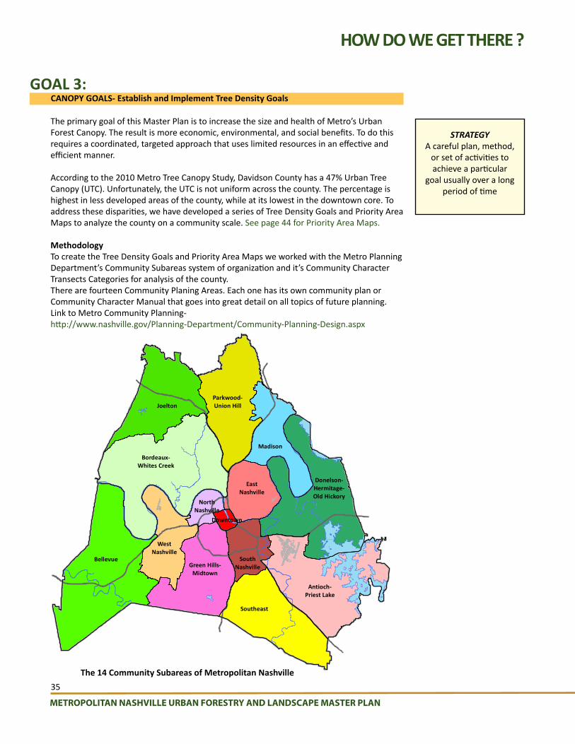
METROPOLITAN NASHVILLE URBAN FORESTRY AND LANDSCAPE MASTER PLAN
35
The primary goal of this Master Plan is to increase the size and health of Metro’s Urban Forest Canopy. The result is more economic, environmental, and social benefits. To do this requires a coordinated, targeted approach that uses limited resources in an effective and efficient manner.
According to the 2010 Metro Tree Canopy Study, Davidson County has a 47% Urban Tree Canopy (UTC). Unfortunately, the UTC is not uniform across the county. The percentage is highest in less developed areas of the county, while at its lowest in the downtown core. To address these disparities, we have developed a series of Tree Density Goals and Priority Area Maps to analyze the county on a community scale. See page 44 for Priority Area Maps.
MethodologyTo create the Tree Density Goals and Priority Area Maps we worked with the Metro Planning Department’s Community Subareas system of organization and it’s Community Character Transects Categories for analysis of the county.There are fourteen Community Planing Areas. Each one has its own community plan or Community Character Manual that goes into great detail on all topics of future planning.Link to Metro Community Planning- http://www.nashville.gov/Planning-Department/Community-Planning-Design.aspx
CANOPY GOALS- Establish and Implement Tree Density Goals
HOW DO WE GET THERE ?
GOAL 3:
JoeltonParkwood-Union Hill
Madison
EastNashville
Bordeaux-Whites Creek
Bellevue
WestNashville
Green Hills-Midtown
Southeast
SouthNashville
Antioch-Priest Lake
Donelson-Hermitage-Old Hickory
NorthNashville
Downtown
STRATEGYA careful plan, method,
or set of activities to achieve a particular
goal usually over a long period of time
The 14 Community Subareas of Metropolitan Nashville

METROPOLITAN NASHVILLE URBAN FORESTRY AND LANDSCAPE MASTER PLAN
36
HOW DO WE GET THERE ?
The Community Character Policies in the Community Character Manual (CCM) are based on a planning tool called the Transect. The Transect is a system for categorizing, understanding and guiding the various development patterns of a region, from the most natural and rural to the most urban. The Transect is an ordering system, which calls for all elements of the natural and built environment to be consistent with the character of the Transect Category that they are within.
Transect Elements:T1- Natural-
Natural open spaceT2- Rural-
Rural open space, Rural neighborhoods, Rural neighborhood centers
T3- Suburban-Suburban open space, Suburban neighborhoods, Suburban neighborhood and Community centers,Suburban residential and mixed-use corridors
T4- Urban- Urban open space, Urban neighborhoods and mixed-use, Urban neighborhood and community centers, Urban residential and mixed-use corridors
T-5 Centers- Centers open space, Regional and super-regional centers, Center mixed-use neighborhoods
T-6 Core/Downtown- Downtown open space, Downtown neighborhood, Civic
D- District- Industrial, Institutional, Mixed business, Office concentration
The Nashville/Davidson County Transect consists of seven categories of natural and built environments:
•T1 Natural,•T2 Rural,•T3 Suburban,•T4 Urban,•T5 Center,•T6 Core/Downtown, and•D District.
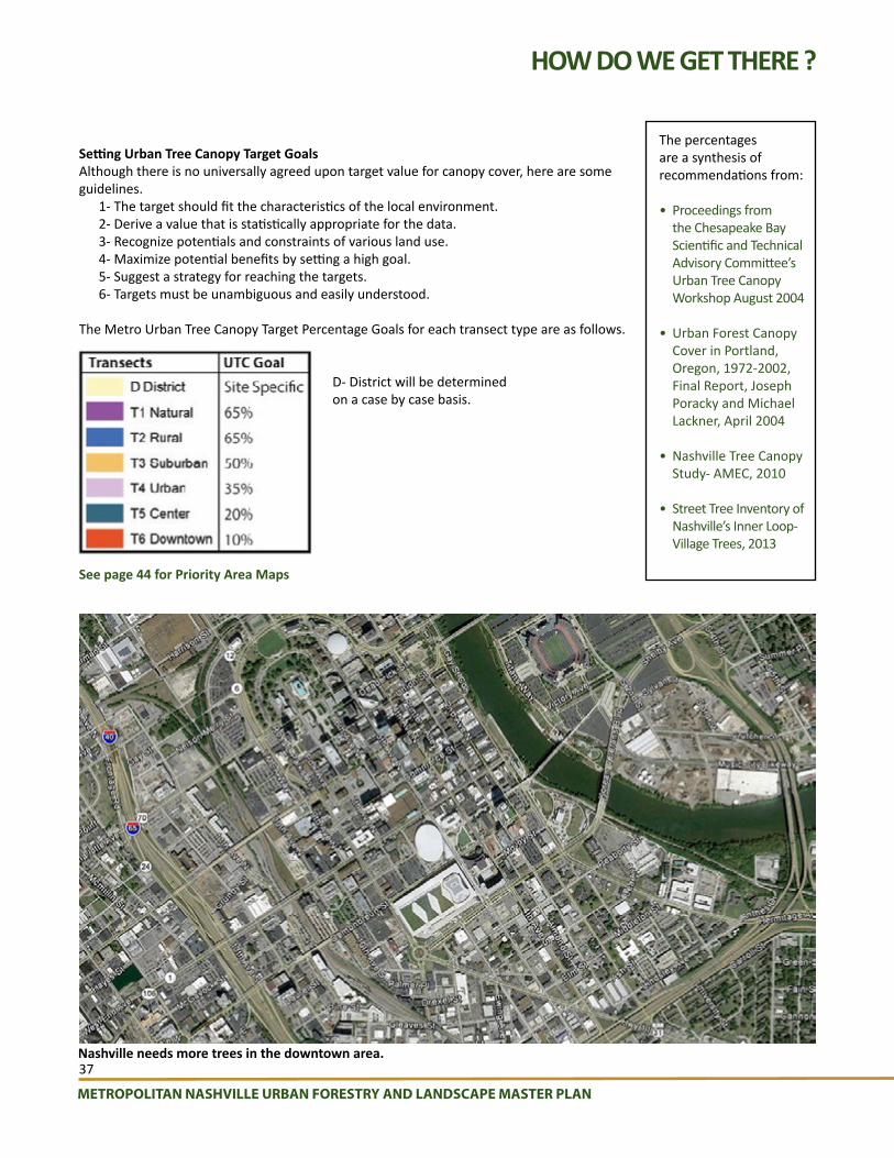
METROPOLITAN NASHVILLE URBAN FORESTRY AND LANDSCAPE MASTER PLAN
37
Setting Urban Tree Canopy Target GoalsAlthough there is no universally agreed upon target value for canopy cover, here are some guidelines.
1- The target should fit the characteristics of the local environment. 2- Derive a value that is statistically appropriate for the data.3- Recognize potentials and constraints of various land use.4- Maximize potential benefits by setting a high goal.5- Suggest a strategy for reaching the targets.6- Targets must be unambiguous and easily understood.
The Metro Urban Tree Canopy Target Percentage Goals for each transect type are as follows.
D- District will be determined on a case by case basis.
HOW DO WE GET THERE ?
See page 44 for Priority Area Maps
Nashville needs more trees in the downtown area.
The percentages are a synthesis of recommendations from:
• Proceedings from the Chesapeake Bay Scientific and Technical Advisory Committee’s Urban Tree Canopy Workshop August 2004
• Urban Forest Canopy Cover in Portland, Oregon, 1972-2002, Final Report, Joseph Poracky and Michael Lackner, April 2004
• Nashville Tree Canopy Study- AMEC, 2010
• Street Tree Inventory of Nashville’s Inner Loop- Village Trees, 2013

METROPOLITAN NASHVILLE URBAN FORESTRY AND LANDSCAPE MASTER PLAN
38
RECOMMENDATIONS1-4 months
HOW DO WE GET THERE ?
GOAL #3- CANOPY GOALS- QUICK WIN
Include Urban Forest Canopy Goals and Strategies in Comprehensive Metro Parks Master Plan UpdateMetro Parks and Recreation is updating it Comprehensive Parks Master Plan in 2016. It includes a tree inventory of all Metro Parks. Goals from this Master Plan should be incorporated.
Present Urban Forest Master Plan Goals and Strategies to City Council representatives and give support for implementationPublic involvement will be required to achieve the goals set forth in this Master Plan. Each community in Nashville will need to find leaders to oversee neighborhood ‘Green” projects. An Outreach team from Metro Landscape Coordination Program will meet with City Council representatives and neighborhood leaders to educate them on the master plan goals and provide support for implementing it’s strategies.
Involve TDOT with Urban Forest Master Plan Goals and Strategies to reforest Right-of-WaysAn Outreach team from Metro Landscape Coordination Program will meet with TDOT to educate them on the master plan goals and find opportunities to reforesting highway rights of ways.
Determine strategy and funding source to produce current tree inventoryThis is a high priority. It is imperative that a strategy be created to produce a leaf-on tree survey of the county and a sustainable source of funding be found to manage the data in a open format data base such as Open Tree Map.
GOAL #3- CANOPY GOALS- MID TERM
Involve Clean Water Nashville and Metro Stormwater with the Urban Forest Master Plan Goals and StrategiesMetro Landscape Coordination Program will work with the Metro Clean Water program to implement green infrastructure in the combined sewer areas, which would include trees and tree boxes, and continue to work with Metro Storm Water and the satellite cities to plant trees in the remaining areas of the county.
Work with Metro Public Schools (MPS) to include tree planting in property management and tree programs in curriculumAn Outreach team from Metro Landscape Coordination Program will meet with MPS to educate them on the master plan goals and find opportunities to partner in tree programs.
Work to retrofit existing parking lots with more treesThe design of many parking lots in Nashville precede the Metro Parking Area Landscape ordinances (Chap. 17.24, Art. III) or Green Infrastructure practices. This is the case citywide but in particular Community Subarea 10- Green Hills-Midtown, Transect T5 Center is an area of focus. It has an existing tree canopy of 9.3%. The target goal is 20%. It is primarily treeless parking lots.
Increase slope provision in Metro ordinance that restricts development from 15% to 20%The more restrictive standard was recommended by the Natural Resources & Hazard Adaptation Resource Team through the NashvilleNext process. The increase would help minimize disturbances on land that is sensitive and retain more natural slopes and tree cover. This helps our goal of investing and increasing our natural environment for beauty, biodiversity, recreation, food production, resiliency, and response to climate change through mitigation and adaptation strategies.
The Clean Water Nashville Overflow Abatement Programis an initiative led by Metro Water Services (MWS) in coordination with partner agencies including the U.S. Environmental Protection Agency (EPA) and the Tennessee Department of Environment and Conservation (TDEC) for the purpose of meeting the Clean Water Act requirements and, in the process, ensuring the environmental health of the Cumberland River and its tributaries for future generations.
6 months to 1 year

METROPOLITAN NASHVILLE URBAN FORESTRY AND LANDSCAPE MASTER PLAN
39
1 -2 years
HOW DO WE GET THERE ?
Accelerate efforts to purchase more open space and get more natural areas under conservationAn Outreach team from Metro Landscape Coordination Program will meet with Metro Parks to educate them on the master plan goals and support their efforts to acquire more conservation areas. Metro Landscape Coordination Program will work with the Tennessee Land Trust to promote conservation easements on remaining open land. MLCP will work with the Metro Assessor’s office to identify Greenbelt properties and encourage development of forestry management plans for these lands with the area forester.
GOAL #3- CANOPY GOALS- LONG TERM
Update tree inventory and monitor projectsOnce a complete tree inventory has been achieved, it will need to be updates at least every five years. By using an open format data base, (Open Tree Map) some of this work can be done by citizens. Monitoring of projects is crucial to show progress or problems. Protocol, staff, and funding should be established for monitoring tree related projects.
Increase trees in stream buffers along impaired streams and watersheds.Metro Landscape Coordination Program will provide education about the goals of this master plan and support to Metro Stormwater and Metro Codes to illustrate how increasing trees in stream buffers can help to meet these goals. See Priority Area Maps recommendations page 44.
ACTIONS AND TOOLS- IMPLEMENTATION SCHEDULE PRIORITYFUNDING SOURCE
BUDGET LEADER
Include Urban Forest Canopy Goals and Strategies in Comprehensive Metro Parks Master Plan Update.
QUICK WIN
N/A N/A UF/LS Coord. Prog. Manager
Present Urban Forest Master Plan Goals and Strategies to City Council representatives and give support for implementation.
QUICK WIN
N/A N/AUF/LS Coord. Prog. Manager and
Outreach Liaison and MTAC
Involve TDOT with Urban Forest Master Plan Goals and Strategies for reforesting Right-of-Ways.
QUICK WIN
N/A N/AUF/LS Coord. Prog. Manager and
Outreach Liaison and MTAC
Determine strategy and funding source to produce current tree inventory .
QUICK WIN
to be determined
to be determined
UF/LS Coord. Prog. Planning & Review Manager, MTAC & others
Involve Clean Water Nashville with Urban Forest Master Plan Goals and Strategies.
MID TERM N/A N/AUF/LS Coord. Prog. Manager and
Outreach Liaison and MTAC
Work with Metro Public Schools to include tree planting in property management and tree programs in curriculum.
MID TERM N/A N/AUF/LS Coord. Prog. Operations
Horticulturist and Outreach Liaison
Look for opportunities and incentives to retrofit existing parking lots with more trees.
MID TERM N/A N/AUF/LS Coord. Prog. Planning &
Review Manager and Metro Planning
Increase slope provision in ordinance that restricts development from 15% to 20%.
MID TERM N/A N/AUF/LS Coord. Prog. Planning & Review Manager, Metro Codes
and Metro Planning
Accelerate efforts to purchase more open space and get more natural areas under conservation.
MID TERM N/A N/AUF/LS Coord. Prog. Manager and
Outreach Liaison and Metro Parks
Update tree inventory and monitor projects.LONG TERM
to be determined
to be determined
UF/LS Coord. Prog. Planning & Review Manager
Increase stream buffers along impaired streams and watersheds.
LONG TERM
N/A N/AUF/LS Coord. Prog. Planning &
Review Manager and Metro Stormwater
GOAL # 3- IMPLEMENTATION SCHEDULE

METROPOLITAN NASHVILLE URBAN FORESTRY AND LANDSCAPE MASTER PLAN
40
HOW DO WE GET THERE ?
PARKS DEPARTMENT
CURRENTCurrent
QuantityDESIRED
Quantity New Total
Staff: StaffLandscape Maintenance Employees
16Landscape Maintenance Employees
14 30
Equipment: EquipmentLandscape Truck (1-8 yrs old)
4 Landscape Truck 1 5
Grapple Mounted Truck
0Grapple Mounted Truck
1 1
5-Yard Dump Trucks (8-yrs old)
25-Yard Dump Trucks
1 3
Bucket Truck 1 Bucket Truck 2 3
Chipper Truck (5 yrs old)
1 Chipper Truck 1 2
Chipper (6 yrs old)
1 Chipper 1 2
Stump Grinder (5 yrs old)
1 Stump Grinder 0 1
Small Tractor (2 yrs old)
1 Small Tractor 0 1
Dingo style Landscape skid steer
0Dingo Style Landscape Skid Steer
1 1
Bobcat Loader (12 & 1 yr old)
2Bobcat type Skid Steer Loader
1 3
Bobcat Attachments:backhoe 1 backhoe 0 1auger 1 auger 0 1stump grinder 1 stump grinder 0 1bucket 2 bucket 0 2
25-gallon sprayer (3 yrs old)
2 25-gallon sprayer 0 2
100-gallon sprayer (15 yrs old)
1100-gallon sprayer
0 1
PUBLIC WORKS DEPARTMENT
CURRENTCurrent
QuantityDESIRED
Quantity New Total
Staff StaffMaintenance Crews
2Maintenance Crews 0 2
Special Maintenance Crew
1Special Maintenance Crew
0 1
Mowing Crews 2 Mowing Crews 1 3Community Service Workers
variesCommunity Service Workers varies Avg. 18
Program Director 1 Program Director 0 1
Planner/GIS 0 Planner/GIS 1 1
Public Information Officer
1Public Information Officer
0 1
Operational Employees
288Operational Employees
40 328
Equipment Equipment
Bucket Trucks 2Bucket Truck (2-man crew)
2 4
Chippers 1Chippers (2-man crew)
0 1
Knuckle-Boom Loaders
2Knuckle-Boom Loader (2-man crew)
1 3
Crane Truck 1Crane Truck (1-man crew)
0 1
URBAN FORESTRY AND LANDSCAPE COORDINATION PROGRAM
CURRENTCurrent
QuantityDESIRED
Quantity New Total
Staff: StaffDirector 0 Director 1 1Operations Horticulturist
1Operations Horticulturist
0 1
Planning & Review Manager
0Planning & Review Manager
1 1
Outreach Liaison 0 Outreach Liaison 1 1
ASSESSMENT OF EQUIPMENT AND PERSONNEL
To implement the objectives of the master plan additional tools and manpower will be required. The following are specific recommendations per department:
URBAN FORESTRY AND LANDSCAPE COORDINATION PROGRAM
CODES DEPARTMENT
CURRENTCurrent
QuantityDESIRED
Quantity New
Total
Staff Staff
Regulatory Urban Forester
1City Landscape Enforcement Officer
0 1
Field Crew Supervisor
0Field Crew Supervisor
1 1
Dedicated Landscape Ordinance Inspector
0
Dedicated Landscape Ordinance Inspector
2 2
NOTE: Currently inspections for Landscape Ordinance compliance are done my Building Codes Inspectors.
Note: Currently inspections for Landscape Ordinance Street Tree complance are done by Building Code Inspectors.

METROPOLITAN NASHVILLE URBAN FORESTRY AND LANDSCAPE MASTER PLAN
41
HOW DO WE GET THERE ?
IMPLEMENTATION
A successful strategy starts with leadership towards a vision for the future and planning tools such as this master plan. Resistance to change is natural. To manage change effectively it is important to involve those affected and to get their understanding and support. Each of the recommendations in this master plan are ways to improve the way Metro provides servcies and the quality of life in Nashville.
Implementation of the plan’s recommendations can be done through Metro Landscape Coordination Program and its non-Metro partnerships to implement these recommendations through an internally facilitated process.
• Internal review• Stakeholder Review• Mayor’s Office review• Budget requests
See pages 33, 35 & 41 for implementation schedules.

METROPOLITAN NASHVILLE URBAN FORESTRY AND LANDSCAPE MASTER PLAN
42
HOW DO WE GET THERE ?
MONITORING
Progress towards changing Metro government’s urban forestry & landscape related departmental structure and service delivery can be measured by monitoring the implementation process. Effective monitoring with a “hands on” approach by Metro Government officials will insure that organizational changes are done as intended, kept on schedule and that corrective actions can be taken in a timely manner. Monitoring sends a signal to those responsible for implementing organizational changes that Metro government leaders are serious about the process and expect these recommendations to become reality.
Monitoring should include measuring work performance, budget efficiency, citizen satisfaction, and worker satisfaction.
Monitoring should also be done to improve the body of knowledge on long-term Urban Forestry sustainability by observing and documenting practices to evaluate their performance over time. The process should be transparent to everyone involved.
Specific elements of the monitoring process include:• Implementing goals specific to each Metro department involved in landscape issues.• A plan or policy that can demonstrate ongoing performance monitoring and reporting.• A checklist of benchmark results to be evaluated such as:
Scope of the monitoring activitiesFrequency of data collectionMethods for collecting dataType of data storage and analysisReporting method and use of the results
• A means of determining achievement based on a monitoring plan or policy to report the performance monitoring evaluation; negative findings will not affect achievement of this or other prerequisites or credits.
• Corrective action to be taken if the implementation of this plan’s recommendations do not perform as intended.
• A plan to increase the body of knowledge on long-term Urban Forestry sustainability by widely communicating the results on the website and in professional publications.

METROPOLITAN NASHVILLE URBAN FORESTRY AND LANDSCAPE MASTER PLAN
43
BLANK
Aerial View of Healthy Urban Tree Canopy
Goog
le E
arth

METROPOLITAN NASHVILLE URBAN FORESTRY AND LANDSCAPE MASTER PLAN
44
PRIORITY AREAS
SETTING URBAN TREE CANOPY PRIORITY AREAS
In addition to determining the appropriate Urban Tree Canopy Target Percentage Goals, the community subareas where analyzed to determine High Priority Areas for tree planting and preservation efforts.
On January 14, 2016 a stakeholder workshop was held, with a diverse group of Metro and non-metro people involved in the urban forest, to determine the priority areas.
The same base maps used for setting tree density percentage goals were analyzed with additional layers of information to determine areas of high priority for tree planting. These layers are:
• Transect areas below Urban Tree Canopy Target percentage goals.• Metro Water Services Visual Stream Assessment.• Metro Building Permits Maps.• Cumberland River Compact- Best Management Practices areas along Sugartree Creek.• Cumberland River Compact Watershed Water Quality Maps.• Recent Park and Recreation Open Space acquisitions.
The following criteria is used also as a guideline in decision making:THE THREE P’s:
Possible, Potential, and Preferable, provide a useful sequence for structuring the goal setting and implementation process. The three Ps are defined as follows:
1. Possible: Where is it biophysically feasible to plant trees?• All land that was not covered by water, a road, or a building was considered a
“possible” planting location.2. Potential: Where is it economically likely to plant trees?• Which areas have regulatory constraints that conserve tree cover or have
incentive supports for adding tree cover? (example: Riparian buffer ordinances near streams or tax incentives for conservation easements)
• Which areas are most effective for achieving water quality or other goals?3. Preferable: Where is it socially desirable to plant trees?• Where will tree cover make neighborhoods more attractive?• Where will tree cover address other issues such as air quality?
TREE CALCULATOR
In addition to these maps, we have developed a handy calculator for determining how many actual trees a percentage number represents. To download go to: trees.nashville.gov

METROPOLITAN NASHVILLE URBAN FORESTRY AND LANDSCAPE MASTER PLAN
45
MARROWBONE LAKE
PALS LAKE
LONG CREEK
LAKE LOUISE
MARROWBONE CREEK
CLAYLICK CREEK
SULPHUR BRANCH
S FORK SYCAMORE CREEK
SYCAMORE CREEK
EARTHMAN FORK CREEK
WHITES CREEK PK
CLAR
KSVI
LLE
PK
CLAY LICK RD
UNION HILL RD
EATO
NS
CR
EEK
RD
OLD CLARKSVILLE PK
Paradise Ridge Park
Joelton Park
§̈¦24
TransectExisting Tree Canopy Acres
Existing Tree Canopy(% of land area)
D District 0 0.0%
T1 Natural 0 0.0%
T2 Rural 16,865 66.8%
T3 Suburban 0 0.0%
T4 Urban 0 0.0%
T5 Center 0 0.0%
T6 Downtown 0 0.0%
PRIORITY AREAS
METROPOLITAN NASHVILLE URBAN FORESTRY AND LANDSCAPE MASTER PLAN Appendix
0 1 Mile0.5
SUBAREA 1: JOELTON
LEGENDTransects
D District
T1 Natural
T2 Rural
T3 Suburban
T4 Urban
T5 Center
T6 Downtown
Parks
Water Bodies
Interstates
Roads
Other
Existing TreeCanopy Acres
0
0
16,865
0
0
0
0
Existing TreeCanopy (% of land area)
0.0%
0.0%
66.8%
0.0%
0.0%
0.0%
0.0%
Tree Canopy Goal
Site Specific
65%
65%
50%
35%
20%
10%
PRIORITIES:1- Preserve existing undisturbed canopy. (See slope recommendation page 40 of Master Plan)
1
1

METROPOLITAN NASHVILLE URBAN FORESTRY AND LANDSCAPE MASTER PLAN
46
Cedar Hill
Parkwood Park
Willow Creek Park
LIC
KTO
N P
K
DICK
ERSO
N PKOLD HICKORY BV
SPRINGFIELD HY
UNION HILL RD
BR
ICK
CH
UR
CH
PK
BRILEY PKWY
SHAW RD
CUNNIFF PW
BELLSHIRE DR
DUE WEST AV N
VILLAGE TL
TINNIN RD
BRICK C
HURCH PK
BAKERS FORK
SHANES FORK
EWING CREEK
WHITES CREEK
LITTLE CREEK
NORTH FORK EWING CREEK
§̈¦24
§̈¦65
TransectExisting Tree Canopy Acres
Existing Tree Canopy(% of land area)
D District 44 20.5%
T1 Natural 242 69.9%
T2 Rural 13,741 69.9%
T3 Suburban 2,651 39.8%
T4 Urban 0 0.0%
T5 Center 0 0.0%
T6 Downtown 0 0.0%
PRIORITY AREAS
METROPOLITAN NASHVILLE URBAN FORESTRY AND LANDSCAPE MASTER PLAN Appendix
SUBAREA 2: PARKWOOD - UNION HILL
LEGENDTransects
D District
T1 Natural
T2 Rural
T3 Suburban
T4 Urban
T5 Center
T6 Downtown
Parks
Water Bodies
Interstates
Roads
Other
Existing TreeCanopy Acres
44
242
13,741
2,651
0
0
0
Existing TreeCanopy (% of land area)
20.5%
69.9%
69.9%
39.8%
0.0%
0.0%
0.0%
Tree Canopy Goal
Site Specific
65%
65%
50%
35%
20%
10%
0 1 Mile0.5
PRIORITIES:Increase T3 canopy from 39.8% to 50%. *(26%)
1- Work with TDOT to plant Rights-of-Ways.
2- Preserve existing undisturbed canopy. (See slope recommendation page 40 of Master Plan) 3- Revegetate disturbed areas along North Fork Ewing Creek between Old Hickory and Winchester Drive.
4- Revegetate disturbed areas along North Fork Ewing Creek near Belshire Road crossing.
2
1
34
*percentage of increase
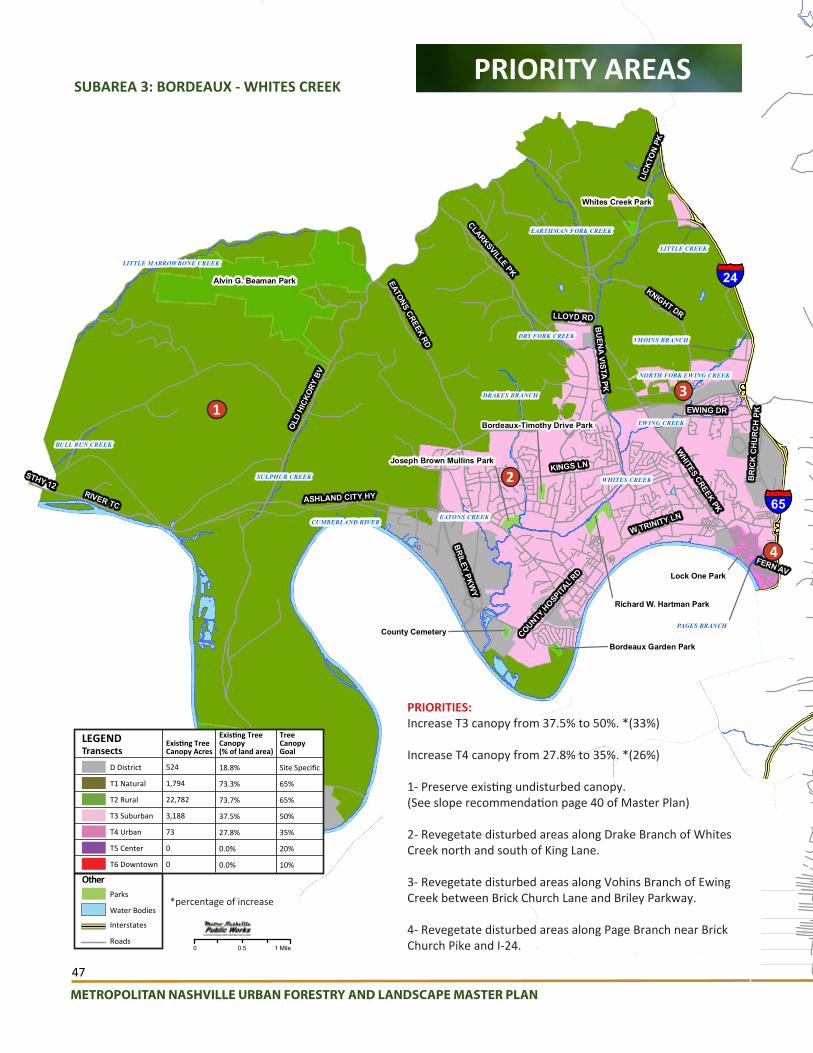
METROPOLITAN NASHVILLE URBAN FORESTRY AND LANDSCAPE MASTER PLAN
47
DRAKES BRANCH
VHOINS BRANCH
PAGES BRANCH
Alvin G. Beaman Park
Bells Bend Park
Richard W. Hartman Park
Joseph Brown Mullins Park
Whites Creek Park
Bordeaux-Timothy Drive Park
County Cemetery
Bordeaux Garden Park
Lock One Park
CUMBERLAND RIVER
WHITES CREEK
EWING CREEK
LITTLE MARROWBONE CREEK
SULPHUR CREEK
EARTHMAN FORK CREEK
DRY FORK CREEK
EATONS CREEK
BULL RUN CREEK
LITTLE CREEK
NORTH FORK EWING CREEK
§̈¦65
BRILEY PKWY
OLD
HICK
ORY
BV
CLARKSVILLE PK
WHITES CREEK PK
ASHLAND CITY HY
KNIGHT DR
KINGS LN
BU
ENA VISTA PK
RIVER TC
EATONS CREEK RD
W TRINITY LN
LICK
TON
PK
EWING DR
BR
ICK
CH
UR
CH
PK
COUNTY H
OSPITAL R
D
LLOYD RD
FERN AV
STHY 12
§̈¦24
TransectExisting Tree Canopy Acres
Existing Tree Canopy(% of land area)
D District 524 18.8%
T1 Natural 1,794 73.3%
T2 Rural 22,782 73.7%
T3 Suburban 3,188 37.5%
T4 Urban 73 27.8%
T5 Center 0 0.0%
T6 Downtown 0 0.0%
PRIORITY AREAS
METROPOLITAN NASHVILLE URBAN FORESTRY AND LANDSCAPE MASTER PLAN Appendix
SUBAREA 3: BORDEAUX - WHITES CREEK
LEGENDTransects
D District
T1 Natural
T2 Rural
T3 Suburban
T4 Urban
T5 Center
T6 Downtown
Parks
Water Bodies
Interstates
Roads
Other
Existing TreeCanopy Acres
524
1,794
22,782
3,188
73
0
0
Existing TreeCanopy (% of land area)
18.8%
73.3%
73.7%
37.5%
27.8%
0.0%
0.0%
Tree Canopy Goal
Site Specific
65%
65%
50%
35%
20%
10%
0 1 Mile0.5
PRIORITIES:Increase T3 canopy from 37.5% to 50%. *(33%)
Increase T4 canopy from 27.8% to 35%. *(26%)
1- Preserve existing undisturbed canopy. (See slope recommendation page 40 of Master Plan)
2- Revegetate disturbed areas along Drake Branch of Whites Creek north and south of King Lane.
3- Revegetate disturbed areas along Vohins Branch of Ewing Creek between Brick Church Lane and Briley Parkway.
4- Revegetate disturbed areas along Page Branch near Brick Church Pike and I-24.
1
2
3
4
*percentage of increase
NEELYS BEND RD
GAL
LATI
N PK
MYATT D
R
STATE RT 45
NESBITT LN
CONFERENCE DR
MOSS TL
CHEY
ENNE
BV
OLD HICKORY BV
DICK
ERSO
N PK
MA
IN ST
ANDERSON LN
GRA
YCRO
FT A
V
ALTA LOMA RD
RAND
Y RD
RIVERGATE PW
WALTON LN
APPLE VALLEY RD
VIETNAM VETERANS BLVD
E CAMPBELL AV
DUE WEST AV W
LONG HOLLOW PK
DRY CREEK RD
BR
IAR
VILL
E R
D
SAND
HURS
T DR
CUMBERLAND RIVER
DRY CREEK
CHEEK LAKE
GIBSON CREEK
E. N. Peeler Park
Madison Park
Pleasant Green Park
Peay Memorial Park
§̈¦65
Existing Tree Canopy Acres
Existing Tree Canopy(% of land area)
339 26.0%
137 51.3%
981 34.9%
an 3,584 37.3%
508 24.0%
23 5.0%
wn 0 0.0%
PRIORITY AREAS
METROPOLITAN NASHVILLE URBAN FORESTRY AND LANDSCAPE MASTER PLAN Appendix
SUBAREA 4: MADISON
LEGENDTransects
D District
T1 Natural
T2 Rural
T3 Suburban
T4 Urban
T5 Center
T6 Downtown
Parks
Water Bodies
Interstates
Roads
Other
Existing TreeCanopy Acres
339
137
981
3,584
508
23
0
Existing TreeCanopy (% of land area)
26.0%
51.3%
34.9%
37.3%
24.0%
5.0%
0.0%
Tree Canopy Goal
Site Specific
65%
65%
50%
35%
20%
10%
0 .75 Mile0.375
PRIORITIES:Increase T5 canopy from 5.0% to 20%. *(300%)
Increase T2 canopy from 34.9% to 65%. *(86%)
Increase T4 canopy from 24% to 35%. *(46%)
Increase T3 canopy from 37.3% to 50%. *(34%)
Increase T1 canopy from 51.3% to 65%. *(27%)
1- Revegetate disturbed areas along Tributary of Gibson Creek between Maple Street and Hickory Street and 2nd Street.
2- Revegetate denuded area along Tributary of of Gibson Creek behind 714 Vantrease Road. 3- Revegetate disturbed areas along Tributary of Gibson Creek across Creekside Health and Rehab property to Saunders Avenue.
4- Revegetate disturbed areas along Tributary of Gibson Creek on Goodpasture School property.
12
3
4
*percentage of increase
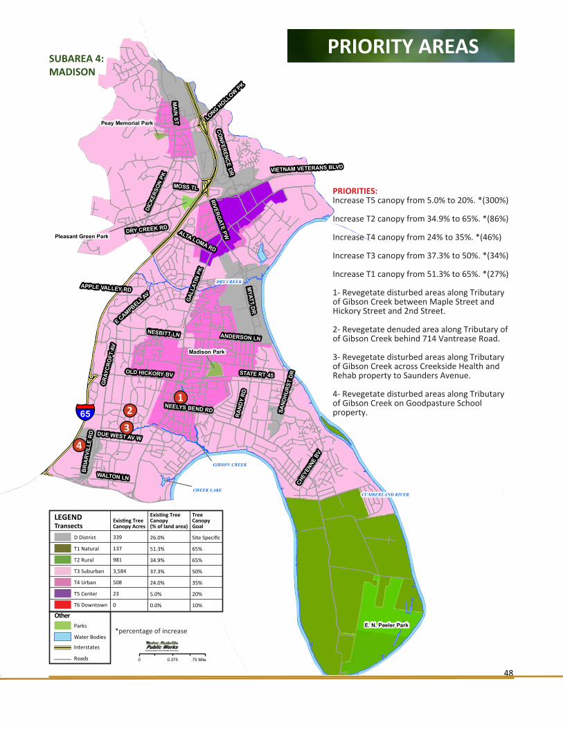
METROPOLITAN NASHVILLE URBAN FORESTRY AND LANDSCAPE MASTER PLAN
48
NEELYS BEND RD
GAL
LATI
N PK
MYATT D
R
STATE RT 45
NESBITT LN
CONFERENCE DR
MOSS TL
CHEY
ENNE
BV
OLD HICKORY BV
DICK
ERSO
N PK
MA
IN ST
ANDERSON LN
GRA
YCRO
FT A
V
ALTA LOMA RD
RAND
Y RD
RIVERGATE PW
WALTON LN
APPLE VALLEY RD
VIETNAM VETERANS BLVD
E CAMPBELL AV
DUE WEST AV W
LONG HOLLOW PK
DRY CREEK RD
BR
IAR
VILL
E R
D
SAND
HURS
T DR
CUMBERLAND RIVER
DRY CREEK
CHEEK LAKE
GIBSON CREEK
E. N. Peeler Park
Madison Park
Pleasant Green Park
Peay Memorial Park
§̈¦65
Existing Tree Canopy Acres
Existing Tree Canopy(% of land area)
339 26.0%
137 51.3%
981 34.9%
an 3,584 37.3%
508 24.0%
23 5.0%
wn 0 0.0%
PRIORITY AREAS
METROPOLITAN NASHVILLE URBAN FORESTRY AND LANDSCAPE MASTER PLAN Appendix
SUBAREA 4: MADISON
LEGENDTransects
D District
T1 Natural
T2 Rural
T3 Suburban
T4 Urban
T5 Center
T6 Downtown
Parks
Water Bodies
Interstates
Roads
Other
Existing TreeCanopy Acres
339
137
981
3,584
508
23
0
Existing TreeCanopy (% of land area)
26.0%
51.3%
34.9%
37.3%
24.0%
5.0%
0.0%
Tree Canopy Goal
Site Specific
65%
65%
50%
35%
20%
10%
0 .75 Mile0.375
PRIORITIES:Increase T5 canopy from 5.0% to 20%. *(300%)
Increase T2 canopy from 34.9% to 65%. *(86%)
Increase T4 canopy from 24% to 35%. *(46%)
Increase T3 canopy from 37.3% to 50%. *(34%)
Increase T1 canopy from 51.3% to 65%. *(27%)
1- Revegetate disturbed areas along Tributary of Gibson Creek between Maple Street and Hickory Street and 2nd Street.
2- Revegetate denuded area along Tributary of of Gibson Creek behind 714 Vantrease Road. 3- Revegetate disturbed areas along Tributary of Gibson Creek across Creekside Health and Rehab property to Saunders Avenue.
4- Revegetate disturbed areas along Tributary of Gibson Creek on Goodpasture School property.
12
3
4
*percentage of increase

METROPOLITAN NASHVILLE URBAN FORESTRY AND LANDSCAPE MASTER PLAN
49
EWING CREEK
PAGES BRANCH
COOPERS BRANCH
ELLI
NG
TON
PK
WY
DICK
ERSO
N PK
GALL
ATIN
PK
HART LN
SHELBY AV
E TRINITY LN
EASTLAND AV
MC GAVOCK PK
MAIN ST
DOUGLAS AV
BROADMOOR DR
RIV
ERSI
DE
DR
SCO
TT A
V
LISC
HEY
AV
JON
ES A
V
SAUN
DERS
AV
CO
WA
N S
T
S 5TH ST
STRATFORD AV
S 14
TH S
TG
ALLA
TIN
AV
CAHAL AV PORTER RD
MO
SS ROSE DR
CLEVELAND ST
EWING DR
DAVIDSON ST
MC
FER
RIN
AV
MER
IDIA
N S
T
S 11
TH S
T
N 1
4TH
ST
BRILEY PKWY
FERN AV
PRES
TON
DR
CEDARWO
OD DR
WOODLAND ST
BRUSH HILL RD
HAYSBORO AV
REVIEW
CLI
NE
AV
SPRING ST
CUMBERLAND RIVER
CUMBERLAND RIVER
SHELBY PARK RESERVOIR
COOPERS CREEK
Shelby Bottoms Park
Shelby Park
Oakwood Park
Fred Douglas Park
Cleveland Park
East Park
South Inglewood Park
McFerrin Park
Tom Joy Park
Kirkpatrick Park
Litton School Park
Eastland Park
Lockeland Springs Park
Bass Park
Shelby Walk Park
§̈¦65
TransectExisting Tree Canopy Acres
Existing Tree Canopy(% of land area)
D District 103 30.1%
T1 Natural 443 46.5%
T2 Rural 0 0.0%
T3 Suburban 1,042 37.7%
T4 Urban 2,627 31.3%
T5 Center 27 6.0%
T6 Downtown 0 0.0%
PRIORITY AREAS
METROPOLITAN NASHVILLE URBAN FORESTRY AND LANDSCAPE MASTER PLAN Appendix
SUBAREA 5: EAST NASHVILLE
LEGENDTransects
D District
T1 Natural
T2 Rural
T3 Suburban
T4 Urban
T5 Center
T6 Downtown
Parks
Water Bodies
Interstates
Roads
Other
Existing TreeCanopy Acres
103
443
0
1,042
2,627
27
0
Existing TreeCanopy (% of land area)
30.1%
46.5%
0.0%
37.7%
31.3%
6.0%
0.0%
Tree Canopy Goal
Site Specific
65%
65%
50%
35%
20%
10%
0 .50 Mile0.25
PRIORITIES:Increase T5 canopy from 6.0% to 20%. *(233%)
Increase T1 canopy from 46.5% to 65%. *(40%)
Increase T3 canopy from 37.7% to 50%. *(33%)
Increase T4 canopy from 31.3% to 35%. *(12%)
1- Revegetate lawn of TN Bureau of Investigation.
2- Revegetate disturbed areas along Ewing Creek paralleling Broadmoor Drive from Dickerson Pike to Ellington Parkway cloverleaf.
1
2
3
3- Revegetate disturbed areas along Pages Creek paralleling Dickerson Pike from Kingston Street to Donald Street. 4- Revegetate disturbed areas along Cooper Creek on properties 1209, 1211 & 1212 Ardee Avenue and at Ardee Avenue crossing.
5- Area of concentrated development. Focus on tree preservation and revegetation.
4
5
*percentage of increase
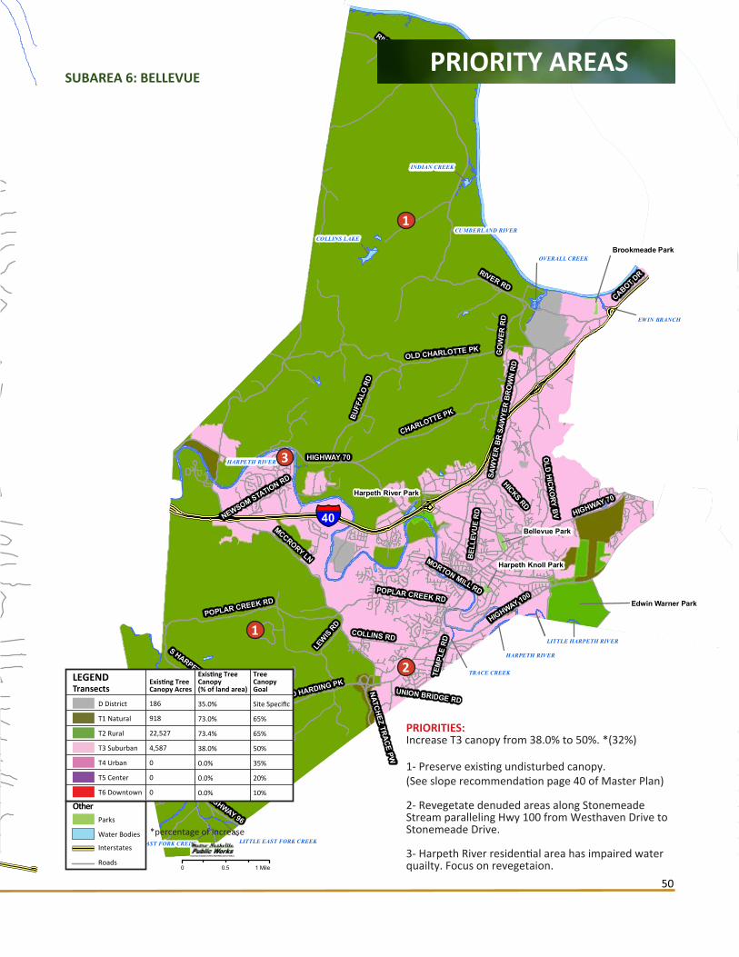
METROPOLITAN NASHVILLE URBAN FORESTRY AND LANDSCAPE MASTER PLAN
50
HIGHWAY 70
HIGHWAY 100
MCCRORY LN
RIVER ROAD PK
CHARLOTTE PK
OLD CHARLOTTE PK
OLD
HIC
KO
RY BV
HICKS RD
BUFF
ALO
RD
RIVER RD
HIGHWAY 96
S HARPETH RD
POPLAR CREEK RD
LEW
IS RD
CABOT DR
GO
WER
RD
COLLINS RD
TEM
PLE
RD
SAW
YER
BR
OW
N R
D
POPLAR CREEK RD
NEWSOM STATION RD
MORTON MILL RD
NATCHEZ TRACE PW
HIGHWAY 70
SAW
YER
BR
OW
N R
D
UNION BRIDGE RD
BEL
LEVU
E R
D
OLD HARDING PK
CUMBERLAND RIVER
HARPETH RIVER
SOUTH HARPETH RIVER
OVERALL CREEK
INDIAN CREEK
HARPETH RIVER
COLLINS LAKE
CUB CREEK
EWIN BRANCH
EAST FORK CREEK
TRACE CREEK
LITTLE EAST FORK CREEK
LITTLE HARPETH RIVER
§̈¦40
Edwin Warner Park
Harpeth River Park
Bellevue Park
Brookmeade Park
Harpeth Knoll Park
TransectExisting Tree Canopy Acres
Existing Tree Canopy(% of land area)
D District 186 35.0%
T1 Natural 918 73.0%
T2 Rural 22,527 73.4%
T3 Suburban 4,587 38.0%
T4 Urban 0 0.0%
T5 Center 0 0.0%
T6 Downtown 0 0.0%
PRIORITY AREAS
METROPOLITAN NASHVILLE URBAN FORESTRY AND LANDSCAPE MASTER PLAN Appendix
SUBAREA 6: BELLEVUE
LEGENDTransects
D District
T1 Natural
T2 Rural
T3 Suburban
T4 Urban
T5 Center
T6 Downtown
Parks
Water Bodies
Interstates
Roads
Other
Existing TreeCanopy Acres
186
918
22,527
4,587
0
0
0
Existing TreeCanopy (% of land area)
35.0%
73.0%
73.4%
38.0%
0.0%
0.0%
0.0%
Tree Canopy Goal
Site Specific
65%
65%
50%
35%
20%
10%
0 1 Mile0.5
PRIORITIES:Increase T3 canopy from 38.0% to 50%. *(32%)
1- Preserve existing undisturbed canopy. (See slope recommendation page 40 of Master Plan)
2- Revegetate denuded areas along Stonemeade Stream paralleling Hwy 100 from Westhaven Drive to Stonemeade Drive.
3- Harpeth River residential area has impaired water quailty. Focus on revegetaion.
1
2
1
3
*percentage of increase
EWING CREEK
PAGES BRANCH
COOPERS BRANCH
ELLI
NG
TON
PK
WY
DICK
ERSO
N PK
GALL
ATIN
PK
HART LN
SHELBY AV
E TRINITY LN
EASTLAND AV
MC GAVOCK PK
MAIN ST
DOUGLAS AV
BROADMOOR DR
RIV
ERSI
DE
DR
SCO
TT A
V
LISC
HEY
AV
JON
ES A
V
SAUN
DERS
AV
CO
WA
N S
T
S 5TH ST
STRATFORD AV
S 14
TH S
TG
ALLA
TIN
AV
CAHAL AV PORTER RD
MO
SS ROSE DR
CLEVELAND ST
EWING DR
DAVIDSON ST
MC
FER
RIN
AV
MER
IDIA
N S
T
S 11
TH S
T
N 1
4TH
ST
BRILEY PKWY
FERN AV
PRES
TON
DR
CEDARWO
OD DR
WOODLAND ST
BRUSH HILL RD
HAYSBORO AV
REVIEW
CLI
NE
AV
SPRING ST
CUMBERLAND RIVER
CUMBERLAND RIVER
SHELBY PARK RESERVOIR
COOPERS CREEK
Shelby Bottoms Park
Shelby Park
Oakwood Park
Fred Douglas Park
Cleveland Park
East Park
South Inglewood Park
McFerrin Park
Tom Joy Park
Kirkpatrick Park
Litton School Park
Eastland Park
Lockeland Springs Park
Bass Park
Shelby Walk Park
§̈¦65
TransectExisting Tree Canopy Acres
Existing Tree Canopy(% of land area)
D District 103 30.1%
T1 Natural 443 46.5%
T2 Rural 0 0.0%
T3 Suburban 1,042 37.7%
T4 Urban 2,627 31.3%
T5 Center 27 6.0%
T6 Downtown 0 0.0%
PRIORITY AREAS
METROPOLITAN NASHVILLE URBAN FORESTRY AND LANDSCAPE MASTER PLAN Appendix
SUBAREA 5: EAST NASHVILLE
LEGENDTransects
D District
T1 Natural
T2 Rural
T3 Suburban
T4 Urban
T5 Center
T6 Downtown
Parks
Water Bodies
Interstates
Roads
Other
Existing TreeCanopy Acres
103
443
0
1,042
2,627
27
0
Existing TreeCanopy (% of land area)
30.1%
46.5%
0.0%
37.7%
31.3%
6.0%
0.0%
Tree Canopy Goal
Site Specific
65%
65%
50%
35%
20%
10%
0 .50 Mile0.25
PRIORITIES:Increase T5 canopy from 6.0% to 20%. *(233%)
Increase T1 canopy from 46.5% to 65%. *(40%)
Increase T3 canopy from 37.7% to 50%. *(33%)
Increase T4 canopy from 31.3% to 35%. *(12%)
1- Revegetate lawn of TN Bureau of Investigation.
2- Revegetate disturbed areas along Ewing Creek paralleling Broadmoor Drive from Dickerson Pike to Ellington Parkway cloverleaf.
1
2
3
3- Revegetate disturbed areas along Pages Creek paralleling Dickerson Pike from Kingston Street to Donald Street. 4- Revegetate disturbed areas along Cooper Creek on properties 1209, 1211 & 1212 Ardee Avenue and at Ardee Avenue crossing.
5- Area of concentrated development. Focus on tree preservation and revegetation.
4
5
*percentage of increase

METROPOLITAN NASHVILLE URBAN FORESTRY AND LANDSCAPE MASTER PLAN
51
VAUGHNS GAP BRANCH
CENTENNIAL BV
HARDING PK
BRILEY PKWY
BELLE
MEA
DE BV
BR
OO
K H
OLL
OW
RD
HILLWOOD BV
ANNE
X AV
DAVIDSON RD
HIGHWAY 70 S HARDING PL
CHARLOTTE AV
WH
ITE
BR
IDG
E PK
COCKRILL BEND BV
MORROW RD
46TH
AV
N
HIGHW
AY 10
0
51ST AV N
DAVID
SON
DR
TYNE BV
MURPHY RD
AMERICAN RD
VINE RIDGE DR
GLEN EDEN DR
SLO
AN R
D
63RD A
V N
HICKORY
VALL
EY RD
JAMES AV
JACKSON BV
OLD HICKORY BV
DR WALTER S DAVIS BV
40TH
AV
N
ABBOTT MARTIN RD
URBANDALE AV
CHARLOTTE PK
VAU
GH
NS
GA
P R
D
CUMBERLAND RIVER
RICHLAND CREEK
RICHLAND CREEK
SUGARTREE CREEK
McCabe Park
West Park
Charlotte Park
England
Richland Park
Parmer Park
H. G. Hill Park
§̈¦40
TransectExisting Tree Canopy Acres
Existing Tree Canopy(% of land area)
D District 655 17.1%
T1 Natural 1 35.5%
T2 Rural 0 0.0%
T3 Suburban 4,347 46.7%
T4 Urban 755 27.0%
T5 Center 0 0.0%
T6 Downtown 0 0.0%
PRIORITY AREAS
METROPOLITAN NASHVILLE URBAN FORESTRY AND LANDSCAPE MASTER PLAN Appendix
SUBAREA 7: WEST NASHVILLE
LEGENDTransects
D District
T1 Natural
T2 Rural
T3 Suburban
T4 Urban
T5 Center
T6 Downtown
Parks
Water Bodies
Interstates
Roads
Other
Existing TreeCanopy Acres
665
1
0
4,347
755
0
0
Existing TreeCanopy (% of land area)
17.1%
35.5%
0.0%
46.7%
27.0%
0.0%
0.0%
Tree Canopy Goal
Site Specific
65%
65%
50%
35%
20%
10%
0 1 Mile0.5
PRIORITIES:Increase T1 canopy from 35.5% to 65%. *(83%)
Increase T4 canopy from 27.0% to 35%. *(30%)
Increase T3 canopy from 46.7% to 50%. *(7%)
1- Increase riparian buffer along Cumberland River.
2- The Nations- area of concentrated development. Focus on tree preservation and revegetation.
3- Revegetate denuded areas along Vaughns Gap Branch between Vaughns Gap Road and Hwy 100 to St. Henry Drive.
4- Revegetate Richland Creek that runs thru Belle Meade Country Club golf course. Create riparian buffer.
5- Revegetate denuded areas of Richland Creek Tributary paralleling Knob Road from Kendall Drive to Highland Park Church.
6- Revegetate denuded areas of Richland Creek north and south of I-40 from Charlotte Avenue to England Park.
7- Restore riparian buffer of Richland Creek north of Quikrete Plant.
6
1
3
2
4
5
7
11
*percentage of increase
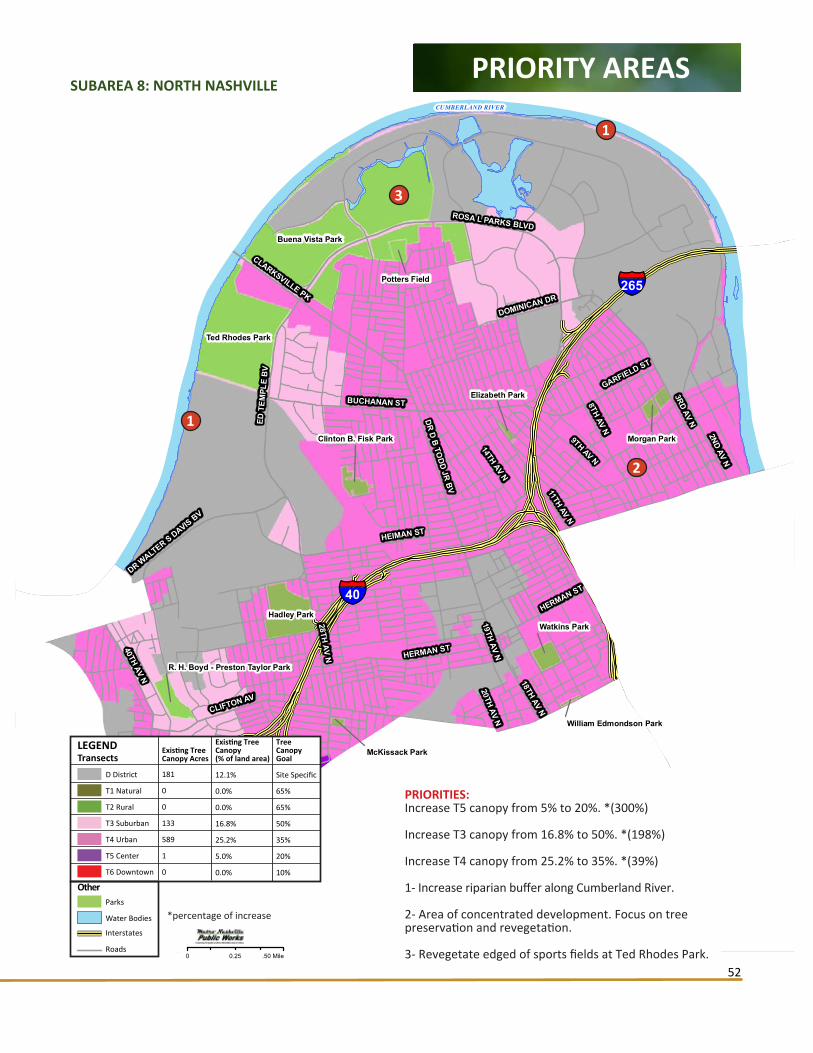
METROPOLITAN NASHVILLE URBAN FORESTRY AND LANDSCAPE MASTER PLAN
52
§̈¦265
§̈¦40
3RD AV NED T
EMPL
E B
V
8TH AV N
28TH AV N
BUCHANAN ST
HEIMAN ST
40TH AV N
ROSA L PARKS BLVD
HERMAN ST
CLARKSVILLE PK
GARFIELD ST
CLIFTON AV
2ND AV N
DR D B TODD JR BV
DR WALT
ER S DAVIS BV
HERMAN ST
DOMINICAN DR
9TH AV N
19TH AV N14TH AV N
20TH AV N
18TH AV N11TH AV N
CUMBERLAND RIVER
Ted Rhodes Park
Hadley Park
Buena Vista Park
Watkins Park
Potters Field
Clinton B. Fisk Park
R. H. Boyd - Preston Taylor Park
Morgan Park
Elizabeth Park
McKissack Park
William Edmondson Park
TransectExisting Tree Canopy Acres
Existing Tree Canopy(% of land area)
D District 181 12.1%
T1 Natural 0 0.0%
T2 Rural 0 0.0%
T3 Suburban 133 16.8%
T4 Urban 589 25.2%
T5 Center 1 5.0%
T6 Downtown 0 0.0%
PRIORITY AREAS
METROPOLITAN NASHVILLE URBAN FORESTRY AND LANDSCAPE MASTER PLAN Appendix
SUBAREA 8: NORTH NASHVILLE
LEGENDTransects
D District
T1 Natural
T2 Rural
T3 Suburban
T4 Urban
T5 Center
T6 Downtown
Parks
Water Bodies
Interstates
Roads
Other
Existing TreeCanopy Acres
181
0
0
133
589
1
0
Existing TreeCanopy (% of land area)
12.1%
0.0%
0.0%
16.8%
25.2%
5.0%
0.0%
Tree Canopy Goal
Site Specific
65%
65%
50%
35%
20%
10%
0 .50 Mile0.25
PRIORITIES:Increase T5 canopy from 5% to 20%. *(300%)
Increase T3 canopy from 16.8% to 50%. *(198%)
Increase T4 canopy from 25.2% to 35%. *(39%)
1- Increase riparian buffer along Cumberland River.
2- Area of concentrated development. Focus on tree preservation and revegetation.
3- Revegetate edged of sports fields at Ted Rhodes Park.
2
1
3
1
*percentage of increase

METROPOLITAN NASHVILLE URBAN FORESTRY AND LANDSCAPE MASTER PLAN
53
4TH AV S
11TH AV N
8TH
AV
S
BROADWAY
3RD AV N
MAIN ST
4TH AV N
CHARLOTTE AV
8TH AV NDEMONBREUN ST
2ND AV N
S 1ST ST
SHELBY AV
LAFAYETTE ST
HERMITAGE AV
CHURCH ST
WOODLAND ST1ST AV S
HERMAN ST
COMMERCE ST
JAMES ROBERTSON PW
11TH AV S
DAVIDSON ST
12TH
AV
S
UNION ST
SYMPHONY PL8TH AV N
2ND AV N
Bi-Centennial Mall
East Bank Greenway
Riverfront Park
Public Square Park
Cumberland Park
Hall of Fame Park
Bicentennial Park
Fort Nashborough
Hope Gardens Park
Church Street Park
Commerce Center Park
§̈¦65
§̈¦40
CUMBERLAND RIVER
TransectExisting Tree Canopy Acres
Existing Tree Canopy(% of land area)
D District 0 0.0%
T1 Natural 0 0.0%
T2 Rural 0 0.0%
T3 Suburban 0 0.0%
T4 Urban 13 17.0%
T5 Center 0 0.0%
T6 Downtown 68 4.3%
PRIORITY AREAS
METROPOLITAN NASHVILLE URBAN FORESTRY AND LANDSCAPE MASTER PLAN Appendix
SUBAREA 9: DOWNTOWN
LEGENDTransects
D District
T1 Natural
T2 Rural
T3 Suburban
T4 Urban
T5 Center
T6 Downtown
Parks
Water Bodies
Interstates
Roads
Other
Existing TreeCanopy Acres
0
0
0
0
13
0
68
Existing TreeCanopy (% of land area)
0.0%
0.0%
0.0%
0.0%
17.0%
0.0%
4.3%
Tree Canopy Goal
Site Specific
65%
65%
50%
35%
20%
10%
0 .20 Mile0.10
PRIORITIES:Increase T6 canopy from 4.3% to 10%. *(133%)
Increase T4 canopy from 17% to 35%. *(105%)
Recomendations for this subarea are in:Street Tree Inventory of Nashville’ Inner Loop- Village Trees, LLC, 2013
*percentage of increasehttp://www.nashville.gov/Public-Works/Com-munity-Beautification/Tree-Information.aspx

METROPOLITAN NASHVILLE URBAN FORESTRY AND LANDSCAPE MASTER PLAN
54
WEST END AV
§̈¦440
§̈¦65
TYNE BV
HILL
SBOR
O PK
FRA
NK
LIN PK
GRA
NNY
WHI
TE P
K
WOODMONT BV
OTTER CREEK RD
ESTE
S R
D
21ST
AV
SB
ELM
ON
T B
V
BATTERY LN
WOODLAWN DR
HOBBS RD
NAT
CH
EZ T
C
BO
WLI
NG
AV
CHIC
KERI
NG R
D
HARDING PK
CHARLOTTE AV
GALE LN
CHURCH ST
STOKES LN
PAG
E RD
HARDING PL
CHEROKEE RD
10TH
AV
S
CRESTMOOR RD
CRAIGHEAD ST
HOGAN RD
12TH
AV
SLE
ALAN
D LN
HARDING PL
EDGEHILL AV
WEDGEWOOD AV
21ST AV N
HIL
LDA
LE D
R
ROBERT E LEE DR
DEMONBREUN ST
LON
E O
AK
RD
THOMPSON LN
FRAN
KLIN
PK
OLD HICKORY BV
BLAIR BV
ABBOTT MARTIN RD
RADNOR LAKE
OTTER CREEK
RICHLAND CREEK
SUGARTREE CREEK
Percy Warner Park
Radnor LakeEdwin Warner Park
Centennial Park
Sevier Park
E. S. Rose Park
Reservoir ParkElmington Park
Green Hills Park
Woodmont Park
Tony Rose Park
St. Bernards Park
Fannie Mae Dees Park
Sally Beaman
Dallas H. Neil Park
Owen Bradley Park
Flora Wilson Community Park
PRIORITY AREAS
METROPOLITAN NASHVILLE URBAN FORESTRY AND LANDSCAPE MASTER PLAN Appendix
SUBAREA 10: GREEN HILLS - MIDTOWN
LEGENDTransects
D District
T1 Natural
T2 Rural
T3 Suburban
T4 Urban
T5 Center
T6 Downtown
Parks
Water Bodies
Interstates
Roads
Other
Existing TreeCanopy Acres
140
2,548
0
8,512
944
108
0
Existing TreeCanopy (% of land area)
16.7%
75.5%
0.0%
52.4%
29.4%
8.6%
0.0%
Tree Canopy Goal
Site Specific
65%
65%
50%
35%
20%
10%
0 .75 Mile0.375
PRIORITIES:Increase T5 canopy from 8.6% to 20%. *(115%)
Increase T4 canopy from 29.4% to 35%. *(19%)
1- Focus on parking lot ‘Greening’.
2- Area of concentrated development. Focus on tree preservation and revegetation.
3- Revegetate Sugartree Creek between Green Hills Health and Rehab Center, YMCA parallel to Hillsboro Circle. This could be a nice amenity for both facilities.
4- Revegetate Bosley Spring Branch in back lawn of Aquinas College and front/side lawn of Montgomery Bell Academy.
5- Revegetate Bosley Spring Branch parallell to Rolland Road between Carden Avenue and Leonard Avenue.
3
2
4
1
5
*percentage of increase

METROPOLITAN NASHVILLE URBAN FORESTRY AND LANDSCAPE MASTER PLAN
55
§̈¦40
§̈¦24
§̈¦65
§̈¦440
SID
CO
DR
GLENROSE AV
FOST
ER A
V
ELM HILL PK
POW
ELL AV
LEBANON PK
MC CALL ST
2ND AV S
FESS
LER
S LN
4TH AV S
POLK
AV
NOLENSVILLE PK
ALLIED DR
CHESTNUT ST
CURREY RD
E TH
OM
PSO
N L
N
LAFAYETTE ST
ROSEDALE AV
HERMITAGE AV
THOMPSON LN
ELGIN ST
SOU
THLA
KE
DR
TRO
USD
ALE
DR
ARMORY DR
WEDGEWOOD AV
FAIR
FIEL
D A
V
WALSH RD
CRAIGHEAD ST
ANTIOCH PK
FOST
ER A
V
NOLENSVILLE PK
MURFREESBORO PK
SPEN
CE L
N
TRIMBLE ST
MILL CREEK
CUMBERLAND RIVER
BROWNS CREEK
Fort Negley
City Cemetery
William Coleman Park
Louise and Rebecca Dudley Park
J. C. Napier Park
Azalea Park
Rosedale Park
Columbine Park
Iris Park
Mildred Shute Minipark
Turner School Park
T r e e C a n o p y B y T r a n s e c t : E x i s t i n g T r e e C a n o p y B y T r a n s e c t : E x i s t i n g S u b a r e a 1 1 : S o u t h N a s h v i l l eS u b a r e a 1 1 : S o u t h N a s h v i l l e
PRIORITY AREAS
METROPOLITAN NASHVILLE URBAN FORESTRY AND LANDSCAPE MASTER PLAN Appendix
SUBAREA 11: SOUTH NASHVILLE
LEGENDTransects
D District
T1 Natural
T2 Rural
T3 Suburban
T4 Urban
T5 Center
T6 Downtown
Parks
Water Bodies
Interstates
Roads
Other
Existing TreeCanopy Acres
337
0
0
1,017
758
0
0
Existing TreeCanopy (% of land area)
10.5%
0.0%
0.0%
36.9%
19.6%
0.0%
0.0%
Tree Canopy Goal
Site Specific
65%
65%
50%
35%
20%
10%
0 .50 Mile0.25
PRIORITIES:Increase T4 canopy from 19.6% to 35%. *(78%)
Increase T3 canopy from 36.9% to 50%. *(36%)
1- Revegetate Brown’s Creek with low canopy trees under power lines. Create riparian buffer.
2- Revegetate East Fork Brown’s Creek parallel to Old Powell Avenue and Powell Avenue along frontage of Walmart, Carmax and Home Depot.
3- Restore and replant Brown’s Creek section thru Fairgrounds. Increase buffer width.
2
1
3
*percentage of increase

METROPOLITAN NASHVILLE URBAN FORESTRY AND LANDSCAPE MASTER PLAN
56
§̈¦40
§̈¦24
§̈¦65
§̈¦440
SID
CO
DR
GLENROSE AV
FOST
ER A
V
ELM HILL PK
POW
ELL AV
LEBANON PK
MC CALL ST
2ND AV S
FESS
LER
S LN
4TH AV S
POLK
AV
NOLENSVILLE PK
ALLIED DR
CHESTNUT ST
CURREY RD
E TH
OM
PSO
N L
N
LAFAYETTE ST
ROSEDALE AV
HERMITAGE AV
THOMPSON LN
ELGIN ST
SOU
THLA
KE
DR
TRO
USD
ALE
DR
ARMORY DR
WEDGEWOOD AV
FAIR
FIEL
D A
V
WALSH RD
CRAIGHEAD ST
ANTIOCH PK
FOST
ER A
V
NOLENSVILLE PK
MURFREESBORO PK
SPEN
CE L
N
TRIMBLE ST
MILL CREEK
CUMBERLAND RIVER
BROWNS CREEK
Fort Negley
City Cemetery
William Coleman Park
Louise and Rebecca Dudley Park
J. C. Napier Park
Azalea Park
Rosedale Park
Columbine Park
Iris Park
Mildred Shute Minipark
Turner School Park
T r e e C a n o p y B y T r a n s e c t : E x i s t i n g T r e e C a n o p y B y T r a n s e c t : E x i s t i n g S u b a r e a 1 1 : S o u t h N a s h v i l l eS u b a r e a 1 1 : S o u t h N a s h v i l l e
PRIORITY AREAS
METROPOLITAN NASHVILLE URBAN FORESTRY AND LANDSCAPE MASTER PLAN Appendix
SUBAREA 11: SOUTH NASHVILLE
LEGENDTransects
D District
T1 Natural
T2 Rural
T3 Suburban
T4 Urban
T5 Center
T6 Downtown
Parks
Water Bodies
Interstates
Roads
Other
Existing TreeCanopy Acres
337
0
0
1,017
758
0
0
Existing TreeCanopy (% of land area)
10.5%
0.0%
0.0%
36.9%
19.6%
0.0%
0.0%
Tree Canopy Goal
Site Specific
65%
65%
50%
35%
20%
10%
0 .50 Mile0.25
PRIORITIES:Increase T4 canopy from 19.6% to 35%. *(78%)
Increase T3 canopy from 36.9% to 50%. *(36%)
1- Revegetate Brown’s Creek with low canopy trees under power lines. Create riparian buffer.
2- Revegetate East Fork Brown’s Creek parallel to Old Powell Avenue and Powell Avenue along frontage of Walmart, Carmax and Home Depot.
3- Restore and replant Brown’s Creek section thru Fairgrounds. Increase buffer width.
2
1
3
*percentage of increase
SORGHUM BRANCH
COLLINS CREEK
§̈¦24
§̈¦65
OLD HICKORY BV
BURKITT RD
BELL RD
HOLT RD
CANE RIDGE RD
HILL RD
TRO
USD
ALE
DR
NO
LEN
SVIL
LE P
K
TUSCULUM RD
BARNES RD
HARDING PL
OCALA DR
BLUE HOLE RD
BAT
TLE
RD
BLACKMAN RD
BREWER DR
ELYSIAN FIELDS RD
PARAGON MILLS RD
AM
ALI
E D
RH
OLT
HIL
LS R
D
OLD FRANKLIN RD
CHURCH ST E
OAKLEY DR
OLD HICKORY BV
PETT
US R
D
HAYWOOD LN
HOGAN RD
REG
ENT
DR
MCMURRAY DR
HARDING PL
EDM
ON
DSO
N P
K
MILL CREEK
SEVENMILE CREEK
APPLE LAKE
INDIAN CREEK
HOLT CREEK
WHITTEMORE BRANCH
OWL CREEK
Cane Ridge Park
Grassmere / Nashville Zoo
Paragon Mills Park
William A. Pitts Park
William Whitfield Park
Wentworth-Caldwell Park
Granbery Park
Providence Park
Cecil Rhea Crawford Park
PRIORITY AREAS
METROPOLITAN NASHVILLE URBAN FORESTRY AND LANDSCAPE MASTER PLAN Appendix
SUBAREA 12: SOUTHEAST
LEGENDTransects
D District
T1 Natural
T2 Rural
T3 Suburban
T4 Urban
T5 Center
T6 Downtown
Parks
Water Bodies
Interstates
Roads
Other
Existing TreeCanopy Acres
330
12
1,102
8,940
150
0
0
Existing TreeCanopy (% of land area)
28.9%
13.4%
45.4%
38.8%
21.2%
0.0%
0.0%
Tree Canopy Goal
Site Specific
65%
65%
50%
35%
20%
10%
0 1 Mile0.5
PRIORITIES:Increase T1 canopy from 13.5% to 65%. *(381%)
Increase T2 canopy from 45.4% to 65%. *(43%)
Increase T4 canopy from 21.2% to 35%. *(65%)
Increaser T3 canopy from 38.8% to 50%. (*29%) 1- Area of new land acquisition for Metro Parks and Recreation. 591 acres. Focus on revegetation.
2- Revegetated denuded section of Sorghum Creek thru Southbook Apartments at Linbar Drive.
3- Widen riparian buffer along entire length of Whittemore Branch. Section of creek to Nolensville Road is denuded and need revegetation.
4- Revegetate Collins Creek parallel to I-24.
5- Revegetate Collins Creek parallel to Cane Ridge Road at Old Franklin Road.
6- Revegetate tributary of Indian Creek thru field near Whittemore Lane and Old Hickory Boulevard.
2
4
5
6
3
*percentage of increase

METROPOLITAN NASHVILLE URBAN FORESTRY AND LANDSCAPE MASTER PLAN
57
MCCRORY CREEK
§̈¦24
§̈¦40
BELL RD
HOBS
ON P
K
MURFREESBORO PK
MT VIEW RD
ANTIOCH PK
DONE
LSO
N PK
ANDERSON RD
HAMILTON CHURCH RD
PIN HOOK RD
UNA ANTIOCH PK
BR
ILEY
PK
WY
CURREY RD
MC
GAV
OC
K P
K
OLD
HIC
KORY
BV
RICHARDS RD
REYN
OLD
S RD
HICKORY HOLLOW PW
COUNTRY WAY RD
FIRESTONE PW
RICE RD
ELM HILL PK
SMITH SPRINGS RDHARDING PL
LAVE
RGNE
COU
CHVI
LLE
PK
VULTEE BV
OLD
FRA
NKLI
N RD
HAYWOOD LN
PERCY PRIEST RESERVOIR
MILL CREEK
SUGGS CREEK
LESTERS LAKE
NORTH CREEK
WHITTEMORE BRANCH
Long Hunter
Percy Priest Reservoir
Hamilton Creek Park
Ezell Road Park
Metro Soccer Complex
Una Recreation Park
Antioch Park
Seven Oaks Park
PRIORITY AREAS
METROPOLITAN NASHVILLE URBAN FORESTRY AND LANDSCAPE MASTER PLAN Appendix
SUBAREA 13: ANTIOCH - PRIEST LAKE
LEGENDTransects
D District
T1 Natural
T2 Rural
T3 Suburban
T4 Urban
T5 Center
T6 Downtown
Parks
Water Bodies
Interstates
Roads
Other
Existing TreeCanopy Acres
2,490
0
4,951
5,072
59
0
0
Existing TreeCanopy (% of land area)
27.1%
0.0%
66.1%
34.0%
13.5%
0.0%
0.0%
Tree Canopy Goal
Site Specific
65%
65%
50%
35%
20%
10%
0 1 Mile0.5
PRIORITIES:Increase T4 canopy from 13.5% to 35%. *(159%) (Global Mall)
Increase T3 canopy from 34.0% to 50%. *(47%)
1- Work with US Corps of Engineers to increase riparian buffers around Percy Priest Reservoir.
2- 600 acre area of new land acquisition for Metro Parks and Recreation. Focus on revegetation.
3- Revegetate denuded section of McCrory Creek thru field at Couchville Pike and Reynolds Road.
4- Revegetate West Fork Hamilton Creek at Nashboro Boulevard and Bell Road and end section inside the boulevard at Long Hunter Court.
1
2
3
4
*percentage of increase

METROPOLITAN NASHVILLE URBAN FORESTRY AND LANDSCAPE MASTER PLAN
58
§̈¦40
LEBANON P
K
BEL
L R
D
BR
ILEY PKW
Y
MC
GAV
OC
K P
K
ELM HILL PK
CENTRAL PK
DO
NEL
SON
PK
SHUTE LN
ROBINSON RD
STEWARTS FERRY PK
MUSIC VALLEY DR
OLD LEBANON DIRT RD
JACKSONIAN DR
PENNINGTO
N BEND RD
JOHN HAGER RD
TWO RIVERS PW
STATE RT 45
AN
DR
EW J
AC
KSO
N
ELM HILL PK
OLD HICKORY BV
CHANDLER RD
HA
DLE
Y AV
TYLER DR
MC CAMPBELL AV
PLEA
SAN
T H
ILL
RD
SWINGING BRIDGE RD
S NEW
HO
PE RD
SPEN
CE
LN
OLD HICKORY BV
PERCY PRIEST RESERVOIR
CUMBERLAND RIVER
OLD HICKORY RESERVOIR
OLD HICKORY RESERVOIR
STONES RIVER
MILL CREEK
STONER CREEK
MCCRORY CREEK
Two Rivers Park
Heartland Park
Hermitage Park
Stone Hall Park
Lock Two Park
Lakewood Ballpark Park
Rachel's Walk
TransectExisting Tree Canopy Acres
Existing Tree Canopy(% of land area)
D District 1,417 31.6%
T1 Natural 0 0.0%
T2 Rural 2,462 51.9%
T3 Suburban 8,650 36.0%
T4 Urban 435 32.0%
T5 Center 0 0.0%
T6 Downtown 0 0.0%
PRIORITY AREAS
METROPOLITAN NASHVILLE URBAN FORESTRY AND LANDSCAPE MASTER PLAN Appendix
SUBAREA 14: DONELSON - HERMITAGE
LEGENDTransects
D District
T1 Natural
T2 Rural
T3 Suburban
T4 Urban
T5 Center
T6 Downtown
Parks
Water Bodies
Interstates
Roads
Other
Existing TreeCanopy Acres
1,417
0
2,462
8,650
435
0
0
Existing TreeCanopy (% of land area)
31.6%
0.0%
51.9%
36.0%
32.0%
0.0%
0.0%
Tree Canopy Goal
Site Specific
65%
65%
50%
35%
20%
10%
0 1 Mile0.5
PRIORITIES:Increase T3 canopy from 36.0% to 50%. *(39%)
Increase T2 canopy from 51.9% to 65%. *(25%)
Increase T4 canopy from 32.0% to 35%. *(9%)
1- Work with US Army Corps of Engineers to increase riparian buffers around Percy Priest Reservoir.
2- Revegetate denuded section of McCrory Creek tributary behind Timberlake Apartments at Timber Valley Road.
1
2
*percentage of increase