michigan state universityipf.msu.edu/_files/pdfs/campus-master-plan-2017.pdf · organization of the...
TRANSCRIPT
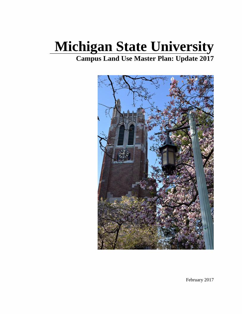
Michigan State University Campus Land Use Master Plan: Update 2017
February 2017

Campus Land Use Master Plan – Update 2017
Page 1
TABLE OF CONTENTS
PREFACE
Purpose of the Campus Master Plan 2
Significant Accomplishments since the 2011 Update 2
CAMPUS PLANNING PRINCIPLES
Introduction 4
General Principles 4
Planning Principles related to Land Use and Facilities 4
Planning Principles related to Environmental Sustainability 5
Planning Principles related to Open Space 6
Planning Principles related to Parking 6
Planning Principles related to Circulation 7
Planning Principles related to Utility Infrastructure 7
LAND USE RECOMMENDATIONS
Programs and Facilities 9
Building Framework 14
Future Redevelopment Opportunities 15
Building Capacity Chart 16
100-Year Floodplain 17
Open Space and Landscape 18
Open Space Framework 22
Protected Green Space 23
Residential Neighborhoods Landscape Framework 24
Motorized Circulation 25
Non-Motorized Circulation 25
Motorized Circulation Framework 27
Non-Motorized Circulation Framework 28
UNIVERSITY ZONING ORDINANCE
Certification 29
Table of Contents 30
Section I Statement of Purpose 31
Section 2 Effectiveness of Ordinance 31
Section 3 Authority of Board of Trustees 31
Section 4 Definitions 31
Section 5 General Regulations 32
Section 6 District Regulations 33
Section 7 Administration 38
Section 8 Amendments 39
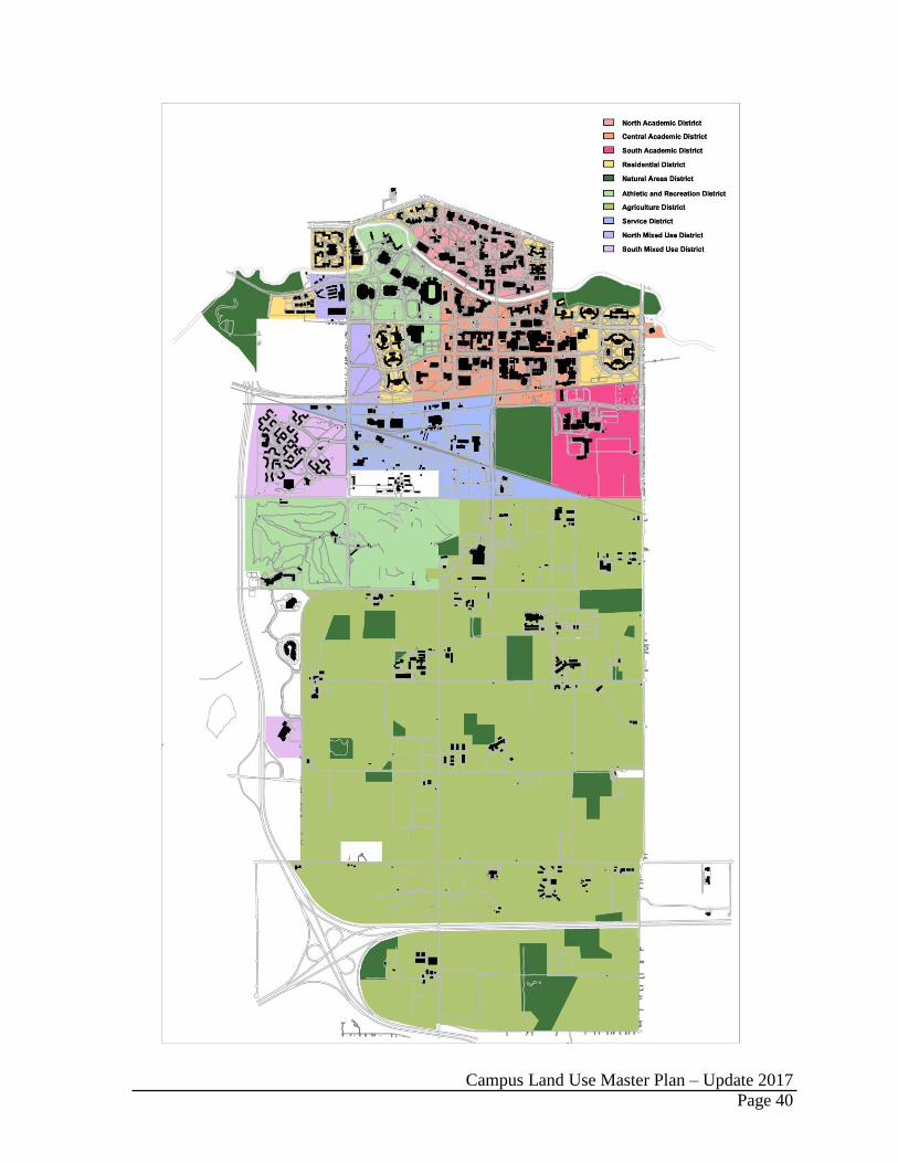
Zoning District Map 40
Protected Green Space 41
Campus Land Use Master Plan – Update 2017
Page 2
PREFACE
PURPOSE OF THE CAMPUS LAND USE MASTER PLAN
The Campus Land Use Master Plan provides a flexible framework for guiding the physical
organization of the Michigan State University (MSU) campus. The plan includes
overarching campus planning principles, specific system recommendations, and the
University Zoning Ordinance. The plan is updated every five years to provide University
administration with a current and relevant decision-making tool in concert with additional
planning documents that include but are not limited to:
Mobility Plan (under development)
Five-Year Plan and Capital Outlay Request
Capital Renewal (deferred maintenance) Priorities
Residential and Hospitality Services Strategic Plan
Utility and Infrastructure Plans (water, steam, electric, gas, storm water)
Power Plant Master Plans
Storm Water Permit
Barrier Free Accessibility Plan
Energy Conservation Plan
Well Head Protection Plan
Given the size and complexity of the campus’s physical composition, coordinating the land
use plan with a mobility plan will facilitate the University’s ability to achieve its mission
within a culture of high performance. Together, the land use and mobility plans will enable
the connections, collaboration, and conversations required to drive academic success and
research innovation. To this end, President Simon has directed the Executive Vice President
for Administrative Services to lead the effort in developing a mobility plan.
SIGNIFICANT ACCOMPLISHMENTS SINCE THE 2011 UPDATE
Over the past five years, the Campus Land Use Master Plan: Update 2011 informed the
implementation of the following major projects.
Major building projects completed or under construction include: NSCL/FRIB
(various projects), Brody Neighborhood (various projects), Bott College of Nursing
Education, Case Hall Addition and Renovation, Shaw Hall Addition and Renovation,
Old College Field (various projects), Wells Hall Addition, Molecular Plant Science,
Landon Hall Addition and Renovation, Endocrine Research, Spartan Stadium North
End Zone Addition, MSU Performing Arts and Teaching Lab, Parking Ramp 7, Bio
Engineering Research, Breslin Center Upgrades and Hall of History, Intercollegiate
Golf Facility, Poultry-Laying Hen Research, Sheep Lambing and Research, and 1855
Place.
Close adherence to the University Zoning Ordinance, with only 5 projects requiring a
zoning variance.
Completion of the RHS Dining Services Master Plan.
Major enhancements to the campus open space system including removal of parking
to create open space adjacent to Shaw Hall and the Munn Field artificial turf field.
Campus Land Use Master Plan – Update 2017
Page 3
Receipt of a Silver Bicycle Friendly University Award from the League of American
Bicyclists. Today more than 68% of campus roads have bike lanes. The campus has
six do-it-yourself fix-it stations in the residential neighborhoods and two secure
bicycle storage facilities with fix-it stations (Grand River and Communication Arts
Garages) and one secure storage facility within the FRIB complex. Nearly 60% of
the MSU River Trail (dedicated bicycle and pedestrian trail) has been constructed
from Harrison Road to Farm Lane.
Completed the four-year West and East Circle Drive infrastructure enhancement
project that improved non-motorized and motorized circulation within the North
Academic District.
Completed the Chestnut Road reconstruction from Shaw Lane north to Red Cedar
Road.
Reconfigured the Bogue Street and Shaw Lane intersection, removing the last
vehicular traffic circle on campus along with closing the Bogue Street segment
between Shaw Lane and Wilson Road to accommodate the FRIB project.
Completion and full operation of the Capital Gateway Multimodal Transit Center
operated by CATA.
Campus Land Use Master Plan – Update 2017
Page 4
CAMPUS PLANNING PRINCIPLES
INTRODUCTION
The University is committed to a comprehensive and continuous land use planning process
that results in a flexible framework to guide future decision making. The University will
consider the use of resources from environmental, regulatory, operational, economic,
historic, and cultural perspectives in support of its teaching/learning, research, and outreach
mission.
The following planning principles will guide future planning for, and development on, the
Michigan State University campus. The principles are organized in the following categories:
General Principles, Land Use and Facilities, Environmental Sustainability, Open Space,
Parking, Circulation, and Utility Infrastructure.
GENERAL PRINCIPLES
Arrange campus buildings, open space, circulation and utility systems to:
– establish positive interactions among academic, research, outreach, cultural, and
operational activities;
– protect and strengthen the campus as a living-learning resource integral to the
University’s mission;
– protect and enhance campus beauty;
– enhance environmental stewardship;
– minimize energy impacts and increase/retain energy efficiencies; and
– optimize safety and facilitate risk management.
PLANNING PRINCIPLES RELATED TO LAND USE AND FACILITIES
Organize the campus in logical districts of compatible land uses. Implement compact campus development to achieve the following benefits:
– preserve and protect existing natural areas and systems to support teaching and research;
– conserve land and maximize land productivity; – protect contiguous agricultural teaching and research land; – encourage social interactions and vitality; – encourage collaboration, partnering, and interdisciplinary connections; – reinforce ties between research and undergraduate teaching; – control utility, transportation, parking, and infrastructure costs; – enhance functional efficiencies; – maximize efficient energy use; and, – minimize utility distribution extensions, which are inefficient and costly to
maintain. Provide intramural recreation fields in locations that balance accessibility for both on-
and off-campus participants.

Campus Land Use Master Plan – Update 2017
Page 5
Protect and enhance campus open space, providing an appropriate balance
(qualitative and quantitative) to the built environment.
Protect the land south of Mount Hope Road from development to support AgBio
Research and the College of Agriculture and Natural Resources’ teaching, research, and outreach mission.
Protect existing and future drinking water well locations in the Agricultural District in
accordance with the Well Head Protection Plan.
Favor reuse, renovation, and repurposing of existing buildings after carefully
assessing programmatic alignment, functionality, long-term capital renewal (deferred
maintenance), historic significance, location, energy efficiency, and replacement
costs.
Organize the arrangement and design of campus buildings and exterior spaces to
encourage human interaction and to foster a sense of shared community among the University’s diverse population. This may include, for example, incorporating “transitional spaces” outside of classrooms for pre- and post-class collaboration and “blended spaces” where food service, study space, and general meeting resources coexist.
Design new buildings and renovations to be architecturally compatible with the best
features of existing adjacent buildings and to be harmonious with their contextual surroundings.
Maximize flexibility in the design of new and renovated space to accommodate changing needs and functions over time.
Recognize historically significant aspects of the campus and the heritage of the
campus as a park and as a living and learning laboratory. Acknowledge that the campus is part of the larger surrounding community. Build
compatible land use relationships and circulation patterns. Consolidate support service facilities into the Services District as defined by the
University Zoning Ordinance.
Organize land uses, facilities, and infrastructure to encourage physical activity.
PLANNING PRINCIPLES RELATED TO ENVIRONMENTAL SUSTAINABILITY
Minimize environmental impacts and maximize resource conservation through
prudent and compact land use, protecting sensitive environmental systems, and incorporating low-impact development guidelines.
Minimize negative impacts to the water quality of the Red Cedar River Watershed;
incorporate Best Management Practices for storm water.
Campus Land Use Master Plan – Update 2017
Page 6
Acknowledge the intrinsic value of biodiversity and enhance natural system integrity
by creating, restoring, and maintaining large-block natural areas and improving their interconnections.
Provide a suite of transportation options that maximize the movement of people and
minimize the movement of cars, thus reducing congestion, vehicle miles traveled, and
greenhouse gas emissions.
Continuously pursue building and utility systems that encourage renewable resource
use and that decrease waste and hazardous materials.
Recognize land use issues associated with climate vulnerability including storm water
management, flooding, snow removal, temperature extremes, and storm intensity.
PLANNING PRINCIPLES RELATED TO OPEN SPACE
Protect and extend the park-like character of the historic circle campus in order to
reinforce and enhance the University’s distinctive physical identity. Enhance the landscape quality south of the Red Cedar River. Promote efficient land use that protects existing, and creates new, green space. Protect, maintain, and develop the campus as an arboretum to support the
University’s teaching/learning, research, and outreach mission. Provide opportunities for academic and social interaction. Provide a variety of open spaces that accommodate the full range of outdoor activity,
for example, large athletic fields to intimate spaces for personal reflection and meditation.
Preserve and protect existing natural areas and enhance their interconnectivity. Integrate public art appropriate to surrounding context (excluding Natural Areas).
PLANNING PRINCIPLES RELATED TO PARKING
Safely and efficiently meet the parking needs of faculty, staff, students, and visitors.
Integrate parking facilities into the campus setting in an aesthetically pleasing manner
consistent with its park-like setting.
Utilize a variety of parking resources including surface lots, decks, and parking
garages; emphasize parking on the campus perimeter.
Provide conveniently located barrier-free spaces across campus.

Campus Land Use Master Plan – Update 2017
Page 7
Reclaim surface lots for green space and future building sites when appropriate.
Relocate parking that contributes to unsafe traffic, bicycle, and pedestrian conditions.
Minimize the loss of open space for small inefficient surface parking lots.
Connect the campus transit system to major parking facilities.
PLANNING PRINCIPLES RELATED TO CIRCULATION
Emphasize personal safety in the circulation system’s planning and design. Design all roads as complete streets (designed and operated to enable safe, attractive,
and comfortable access and travel for all legal users).
Provide a safe, efficient, and effective transportation network that enhances the
overall quality of life on the campus.
Incorporate traffic-calming measures where appropriate.
Plan and design for the following circulation priorities:
– pedestrians first; – bicycles and other forms of non-motorized transportation second; – mass transit and service vehicles third; and, – private vehicles last.
Design for the safety of persons with disabilities in accordance with the Americans
with Disability Act. Reduce private vehicular traffic in academic and residential districts. Effectively integrate with the regional transportation system. Establish a coordinated bicycle system including bike lanes within roadways,
dedicated pathways and/or shared-use pathways, and convenient and appropriately sized storage facilities where appropriate.
Enable an effective and efficient mass transit system including developing residential
neighborhood transit centers to gain transit efficiencies.
PLANNING PRINCIPLES RELATED TO UTILITY INFRASTRUCTURE
Develop campus buildings and infrastructure to foster energy conservation.
Use centralized utility systems wherever feasible to maximize production efficiencies
and to minimize life-cycle operational costs.
Campus Land Use Master Plan – Update 2017
Page 8
Establish consolidated distribution corridors that co-locate utilities and accommodate
maintenance with minimal campus disruptions.
Provide adequate protection and security for critical system components including
electric, steam, chilled water, potable water, existing and future water wells, fiber,
and natural gas.
Provide redundancy for steam, electric, water, and communication utilities.
Enable resource conservation and management through appropriate system design
and controls.
Prepare for developing technologies and their integration into the campus
infrastructure.
Implement practices, install systems, and develop procedures that prolong the
capacity of the power plant, increase reliability, protect health and wellness, reduce
greenhouse gas emissions, while managing affordability.

Campus Land Use Master Plan – Update 2017
Page 9
LAND USE RECOMMENDATIONS
PROGRAMS AND FACILITIES
Academic and Planning Imperatives
The University’s Bolder by Design strategic initiative employs six imperatives to guide the
institution’s teaching/learning, research, and outreach mission. The campus’s physical
organization directly and indirectly supports these imperatives.
Enhancing the student experience
Enriching community, economic, and family life
Expanding international reach
Increasing research opportunities
Strengthening stewardship
Advancing a culture of high performance
The Campus Land Use Master Plan recognizes that land utilization must be optimized to
support the academic mission; that extensive infrastructure systems are expensive to
maintain; and that land conservation, especially in the research farms area, is mission critical.
As a result, the plan centers on these smart growth principles:
Establishing a compact campus composition
Providing a variety of transportation choices
Preserving open space, farmland, and critical environmental areas
Developing a mix of land uses
Creating a walkable community
Facilities Planning Principles
The University continually examines the capital assets necessary to support academic
programs and physical needs that involve new construction, comprehensive renewal,
renovation, reprogramming of selected facilities, and renewal of major subsystems in other
facilities. The assessment of existing facilities shows that the infrastructure components of
many campus buildings have aged significantly. Despite ongoing maintenance and repair
that extends the expected usable life of components well beyond industry standards, many
buildings are now at a point where they require either significant investment or replacement.
Space planning seeks to support student success, growth of the research enterprise,
infrastructure stewardship, and operational efficiencies by:
aligning space resources with academic framework;
allocating and utilizing space strategically;
supporting a range of teaching and research methodologies;
leveraging emerging technology;
effecting operational efficiencies and cost effectiveness;
anticipating evolving teaching and research environments;
forecasting changes in demand and aging infrastructure;
providing accessibility based on universal design and inclusion; and
assessing strategic property acquisitions.

Campus Land Use Master Plan – Update 2017
Page 10
Projected Facility Needs
Michigan State University, through the Office of Planning and Budgets, employs a
continuous capital planning process that integrates academic, support, fiscal, and physical
planning. Institutional participation in the planning process ensures that consideration is
given to relevant issues and that decisions support the University’s direction and mission.
Following a very detailed and carefully conceived planning process, it was estimated that the
University will need a 10 percent increase in building space over the next 20 years. The
growth in space is driven by a planned increase in the number of faculty and the anticipated
increase in funded scientific research, selective and qualitative changes in academic teaching
programs; enhancement of common facilities that enrich campus life and community; and
consolidation and upgrading of operational support facilities.
Capital needs are informed by the Campus Land Use Master Plan and planning activities that
occur within major components of the institution at regular cycles throughout the year. These
components include the annual academic program planning and review, administrative
support planning and review, deferred capital renewal, technology, utility systems, energy
and sustainability planning, as well as planning for motorized and non-motorized circulation
and open space. In this context, budgetary and fiscal analyses at the local, state, and federal
levels are taken into account.
Within each component of planning, a number of more detailed issues are reviewed and
examined relative to their impact on facilities over the short and long term. One approach
used for this more detailed planning is the Campus Infrastructure Planning Work Group.
Bringing together a comprehensive cross section of University constituents, the group
evaluates major construction projects on a number of dimensions to ensure conformity with
the Campus Land Use Master Plan’s planning principles, physical recommendations, and the
University Zoning Ordinance as adopted by the Board of Trustees.
As a matter of operating philosophy and practice, facility planning encompasses the
following issues:
Renovations, as well as maintenance of existing campus facilities and new
construction, are focused to support programs that are central to the University’s
academic mission.
A fundamental guiding principle is that planning is holistic and comprehensive.
In addition to capital renewal of existing facilities, academic program needs are
considered and facility adaptation is planned accordingly. A premium is placed
on reuse of existing facilities, on conservation of open space, energy conservation,
and on health, safety, security, and regulatory requirements. Barrier-free
modifications are given priority, and needs related to technology are considered.
Where appropriate, fixed building equipment, particularly for laboratories and
classrooms, is included in the plans.
New construction and renovation of existing facilities are planned so a project’s
financial investment actively reflects the life cycle of the facility in relation to the
needs of the program, while providing flexibility in the structure to accommodate

Campus Land Use Master Plan – Update 2017
Page 11
potential changes over the longer term. Through the “least life cycle cost
analysis,” facilities are positioned to be responsive to immediate programmatic
needs, as well as longer-term adaptation needs brought about by changes in
programs, advances in technology, and related issues.
The least life cycle cost analysis also enables project development to focus on
designs that reduce the ongoing maintenance cost of facilities. Within this
context, MSU’s high-quality construction standards intentionally create plans and
assemble materials that “design out” as much near and long-term maintenance as
possible. In summary, the anticipated expenses of a facility over its life cycle are
carefully considered in relation to the initial investment in design and materials.
Project decisions made within the context of MSU’s construction standards may,
in some cases, be viewed as more expensive initially but, in practice, actually
reduce the total cost of ownership.
Future Building Opportunities
Future building opportunities are depicted on two graphics. The first entitled Building
Framework, illustrates future opportunities that do not require major demolition of existing
facilities. The second graphic, entitled Major Redevelopment Opportunities, explores
additional development parcels that will require careful assessment of existing facilities
relative to highest and best land use, program relocation, deferred maintenance needs, and
facility replacement costs. Both graphics employ the smart growth strategy of carefully
conceived building “infill” to maximize land use capacity through greater building density.
The plans illustrate where future buildings can be assimilated into the campus context while
reinforcing the Campus Planning Principles and University Zoning Ordinance. As such, the
plans do not dictate when and where growth will occur, rather they identify development
opportunities that can be evaluated to address specific programmatic needs when a project is
identified and funding secured.
Each numbered site is measured and a potential building gross square foot yield is estimated
by incorporating zoning allowances and important contextual features. Where development
opportunity land areas are too large, and architectural speculation is not definable, a floor
area ratio planning metric is assigned to estimate future building square footage.
Based on this assessment, the following quantifies future building opportunities for the
campus lands north of Mount Hope Road. The estimated net potential represents future
building opportunities less any existing building demolition. The campus has historically
added, on average, approximately 2.0 million gross square feet (MGSF) every decade. At
that rate, the net opportunities support nearly 58 years of future growth assuming each site is
developed to its optimal capacity and all redevelopment zones are strategically implemented.

Campus Land Use Master Plan – Update 2017
Page 12
The following identifies future development potential based on opportunities that do not
require significant redevelopment or removal of existing facilities.
Zoning Designation Estimated Gross Potential Estimated Net Potential
North Academic District 405,350 GSF 405,350 GSF
Central Academic District 1,832,615 GSF 1,832,615 GSF
South Academic District 2,457,686 GSF 2,457,686 GSF
Mixed Use District 4,538,950 GSF 3,733,890 GSF
Athletic/Recreation District 429,800 GSF 429,800 GSF
Service District 835,100 GSF 824,235 GSF
Residential District East 130,000 GSF 130,000 GSF
Total Opportunity (w/o redevelopment) 10,638,715 GSF 9,813,576 GSF
Adding in all redevelopment opportunities, the estimated future development potential
increases as noted below.
Zoning Designation Estimated Gross Potential Estimated Net Potential
North Academic District 845,350 GSF 532,340 GSF
Central Academic District 3,560,115 GSF 3,169,583 GSF
South Academic District 2,457,686 GSF 2,457,686 GSF
Mixed Use District 4,538,950 GSF 3,733,890 GSF
Athletic/Recreation District 524,300 GSF 524,300 GSF
Service District 901,850 GSF 873,143 GSF
Residential District East 642,750 GSF 231,582 GSF
Total Opportunity (with redevelopment) 13,480,215 GSF 11,522,524 GSF
STRATEGIC LAND ACQUISITION
The University continually assesses land adjacent to the campus for acquisition to meet
academic and research needs. The existing USDA Avian Disease and Oncology Lab at
Harrison and Mount Hope Roads is a land acquisition priority due to its strategic location
within the contiguous campus boundary. The University has communicated its intent to
reacquire this parcel to congressional representatives and will communicate with the United
States Department of Agriculture when a formal decision to relocate the facility is
announced.
100-YEAR FLOODPLAIN AND STORM WATER MANAGEMENT
Campus land is reserved to provide future storm water management facilities that will
address municipal storm water regulations under the Clean Water Act. Individual building
projects are evaluated by the University Engineer and a technical work group to assess its
ability to meet current storm water management regulations on site. If a project cannot meet
its requirements on site, due to existing development constraints or other unique project
attributes, then the University has the option of utilizing a sub watershed facility in another
location on campus per Michigan Department of Environmental Quality agreements.

Campus Land Use Master Plan – Update 2017
Page 13
Two important Campus Land Use Master Plan recommendations will help reduce the impact
on the Red Cedar River. First, the removal/relocation of Parking Ramp #2 (Auditorium
Road) will convert a sizeable amount of land back to its function as floodplain. Second, the
removal and relocation of approximately 1,000 surface parking spaces in the Central
Academic District will remove an existing land use that has negative impacts both in terms of
storm water quantity and quality.

Campus Land Use Master Plan – Update 2017
Page 14

Campus Land Use Master Plan – Update 2017
Page 15

Campus Land Use Master Plan – Update 2017
Page 16
Campus Land Use Master Plan – Update 2017
Page 17
Campus Land Use Master Plan – Update 2017
Page 18
OPEN SPACE AND LANDSCAPE
THE CAMPUS AS AN ARBORETUM
In 1980, President John A. Hannah remarked, “Long ago it was planned that the campus
should be an outdoor laboratory, with all the variety of trees, shrubs, and woody plants that
could be made to grow in Michigan, labeled and tagged not only for students in botany and
silviculture and landscape architecture, but for all students and faculty and people in the
community.”
President Hannah was reflecting on Professor William Beal’s 1872 proposal for a campus
arboretum. Professor Beal hoped this would lead to a more formalized campus tree planting
program. At the time, trees were grown in an arboretum located between what are today,
Mary Mayo and Campbell Halls; from there they were transplanted across campus.
Professor Beal conducted the first inventory of campus trees in the 1880’s and began the
labeling program identifying trees by common name, scientific name, family, and geographic
origin, a program which continues today (Telewski 2010). As envisioned by Professor Beal,
the campus arboretum serves as a valuable resource for teaching, research, and outreach.
The MSU campus is renowned and beloved by students, faculty, staff, alumni, and visitors.
As such, detailed recommendations are required to protect and enhance its open space and
landscape aesthetic while maintaining an appropriate balance with the evolving built
environment.
The Campus Land Use Master Plan provides a unifying vision for the campus open space
and landscape aesthetic. The plan directs stewardship and preservation of the historic
campus park and guides future enhancement of the built environment, including the campus
as an arboretum for teaching, research, and public outreach.
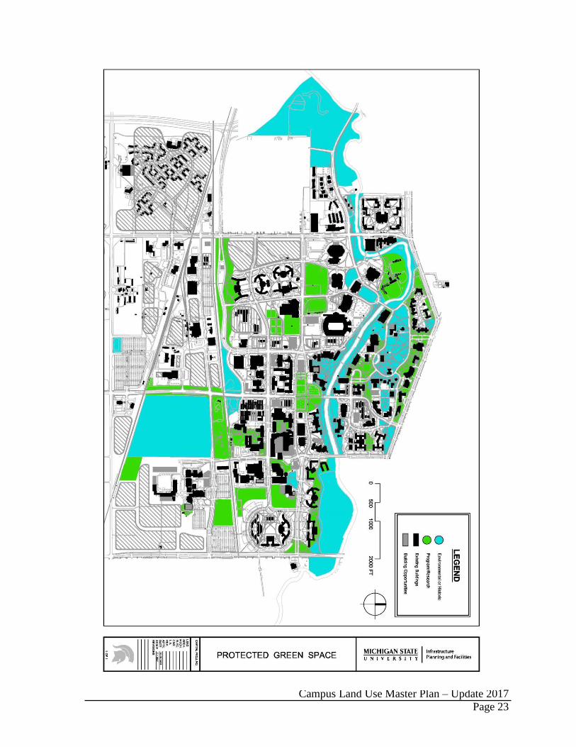
PROTECTED GREEN SPACE
Based on a detailed classification for the open space system, the following areas are deemed
sensitive to development and are subject to protection from any new building footprint or
material change to the campus landscape under the definitions and regulations of the
University Zoning Ordinance.
Component 1 areas identify and protect landscape areas that have an ecological or historic
aspect. Component 2 areas identify and protect green space that provides a unique
programmatic or research land use.
DISTRICT CHARACTERISTICS AND PLANNING GUIDELINES
Historic and Historic Contributing
The park-like setting that students, alumni, and visitors endear is directly influenced by the
historic campus landscape(s). The West Circle Drive area from Grand River Avenue to the
Red Cedar River and from the Beal Entrance to the Lab Row building group is the site of the
Campus Land Use Master Plan – Update 2017
Page 19
original built campus founded in 1855. The prairie-style landscape and informal grouping of
buildings provides a picturesque campus park, unique among American college campuses.
The trees and undulating lawns within the West Circle Drive area were recognized by O.C.
Simonds as “sacred space” (circa 1905). The historic landscape shall be protected from
future development and enhanced through landscape stewardship.
Park-Like Academic
The academic districts of campus, comprised of a diverse collection of trees and shrubs, lend
themselves to supporting teaching, research, and student life activities.
The Prairie School patterning of “sun openings” is prevalent in the North Academic District.
This concept consists of creating alternating areas of deep shade and sunlit lawns that are
reminiscent of the indigenous savannah that once covered much of the northern Midwest.
The trees and undulating lawns within the Circle Campus area were recognized by O.C.
Simonds as “sacred space” (circa 1905) and remain so today.
The extensive roadway network and large building massing within the Central Academic
District creates an intensive built aesthetic that requires substantial landscape interventions to
mitigate for human comfort. Much of what a pedestrian perceives is strongly influenced by
the adjacent roadways and architectural design. Therefore, a strong streetscape and front-
yard landscape is essential to mitigate these elements and to properly transition the landscape
scale from the roadway to the building entrances. Special focus should be on safety and
providing a pleasant experience and sense of scale along pedestrian walkways.
The South Academic District is defined by large architectural structures that collectively do
not provide a sense of place or a pleasant relationship with the pedestrian realm. This
requires that the landscape mitigate for this poor composition; creating a comfortable
pedestrian environment. The landscape needs to be strengthened to better unify the visual
aesthetic and to provide places for social interaction, academic collaboration, and personal
health/relaxation.
Park-Like Residential
Approximately 17,500 students call the University’s seven residential neighborhoods home.
The landscape design for the neighborhoods must address a wide variety of issues including:
scale transition, screening of service functions, providing room for informal recreation, and
more intimate areas for relaxation and mental restoration. Transitioning the scale from large
roadway spaces to more intimate building entrances is important in the front yards.
Recreational amenities and areas for personal relaxation are appropriate in the back yards.
Park-Like Service
The Campus Land Use Master Plan strategizes consolidating support services south of the
Canadian Northern railroad tracks. The landscape should reinforce this area as a vital part of
the overall campus, while acknowledging its purpose and functionality.

Campus Land Use Master Plan – Update 2017
Page 20
Athletic and Recreation
Intercollegiate athletics and intramural recreation activities require a landscape capable of
handling large volumes of people, heavy foot traffic, and various activities that can stress the
landscape (e.g., event parking on intramural fields). While the venues themselves require a
very utilitarian design, this must be balanced with the fact that they are also gateways for
thousands of visitors each year, and as such, must present a high quality aesthetic that
properly represents the University along with mitigating for each venue’s architectural scale.
River Corridor
The Red Cedar River is an iconic campus element that is a core attribute of the campus park.
It is an active natural system that is constantly impacting the campus landscape. A large
collection of ash trees inhabit the river corridor and with the ongoing destruction by the
Emerald Ash Borer, most of these will not survive. The University needs to invest in the
river corridor from a historic, cultural, aesthetic, and environmental perspective.
Signature Landscapes
Signature landscapes are focal points throughout the campus. They vary in size and purpose;
are associated with a heightened design aesthetic; utilize high-quality materials; are often
associated with public art, fountains, or historic features; include irrigation; and, demand
elevated maintenance standards and practices. They are important for encouraging
community interaction and can be considered as eddies within the larger campus park
wherein people can slow down and enjoy a more intimate sense of scale. Signature
landscapes require either priority or elite maintenance levels.
Gardens and Arboreta
These areas are delineated and overseen by a curator or established administrative group.
They are actively designed, planted, and managed - not naturalized. A primary goal for the
use of these areas is education and research with elite maintenance required to sustain the
integrity of the plantings and collections.
Natural Areas
The natural areas are designated by Board of Trustee action and are overseen by the Campus
Natural Areas Committee. They are classified into three categories of protection and
academic use based on their overall quality and their potential for sustained use. They serve
as protected examples of Michigan’s native landscape and wildlife.
Conservation and Demonstration
Conservation and demonstration areas are built landscapes for the purpose of storm water
management, education, and research. They are actively designed, planted, and managed,
requiring a moderate amount of maintenance to ensure integrity of the plantings and
operation of the storm water management features.
Campus Land Use Master Plan – Update 2017
Page 21
Campus Entrances
Campus Entrances (vehicular and pedestrian) provide an opportunity to strengthen the
University’s image and reinforce its reputation for excellence. High quality landscape design
and maintenance practices (elite and priority) are required. Consistent signage and a
homogeneous landscape treatment are desirable for assisting visitor wayfinding and the
efficient movement of goods and services.
Streetscapes
The campus roadway system provides approximately 18 miles of opportunity to establish a
quality image for the University. The streetscape (the landscape setting adjacent to the road)
must address numerous design issues, including safety, image, environmental sustainability,
and wayfinding all within what is often a harsh growing condition.

Campus Land Use Master Plan – Update 2017
Page 22
Campus Land Use Master Plan – Update 2017
Page 23

Campus Land Use Master Plan – Update 2017
Page 24
Campus Land Use Master Plan – Update 2017
Page 25
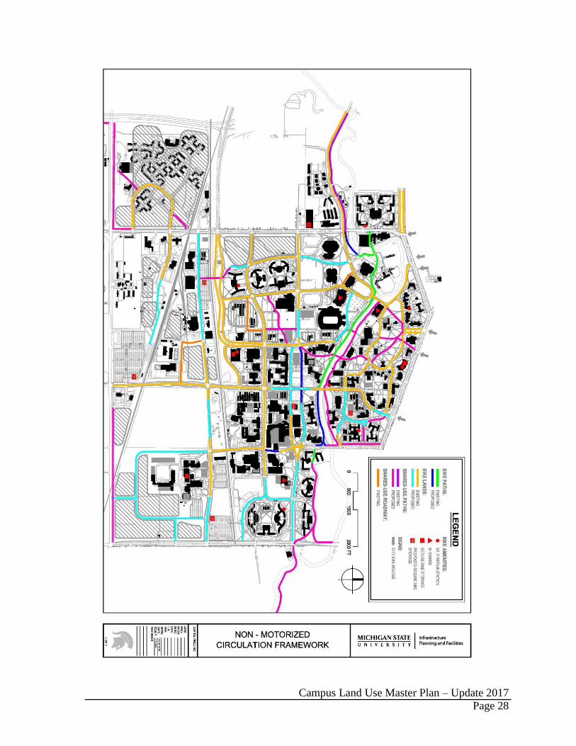
MOTORIZED CIRCULATION FRAMEWORK
NEAR-TERM PRIORITIES
The following motorized projects and initiatives are anticipated in the near term (five- to ten-
year planning horizon).
Develop a comprehensive mobility plan that addresses the movement of people to,
from, and around campus.
Extend Wilson Road to Hagadorn Road with the goal of improving safety by
reducing traffic within the East Residential District, relocating parking adjacent to
Fee Hall, and providing a signalized intersection to aid pedestrians crossing Hagadorn
Road.
Remove Parking Ramp #2 when engineering analysis directs and restore the river
floodplain. Address parking replacement consistent with the mobility plan (under
development) and planning principles guiding more parking on the campus periphery.
LONGER-TERM OPPORTUNITIES
The following projects should be considered in long-range planning to address various
motorized circulation issues.
Redesign the Farm Lane and Grand River intersection including a new traffic signal
at East Circle Drive to improve operational efficiency and safety.
Reconstruct the section of Farm Lane between North and South Shaw Lane to
provide appropriate vehicular turning movements and bike lanes.
Extend Bogue Street through the South Academic District as a two-lane roadway with
center-turn lane as required.
Redesign the Bogue Street and Service Road intersection, removing the awkward
transition from the boulevard cross section.
Extend East Crescent Road through the former Agriculture Exposition site.
Reconfigure Red Cedar Road to provide greater distance from the Kalamazoo and
Beal Streets intersection.
Close the segment of North Shaw Lane between Red Cedar and Science Roads to
private automobile traffic, change South Shaw Lane into a two-way street, and
relocate surface parking.
NON-MOTORIZED CIRCULATION
NEAR-TERM PRIORITIES
The following non-motorized projects and initiatives are anticipated in the near term (five- to
ten-year planning horizon).

Campus Land Use Master Plan – Update 2017
Page 26
Continue to design all roadways as complete streets in accordance with State of
Michigan Public Acts 134 and 135 of 2010 wherein all roadways are to be planned
and designed to meet the needs of all legal users.
Continue to meet the needs of persons with disabilities working through the
Accessibility Committee that includes IPF, FPSM, RCPD, RHS, and athletics.
Continue bringing crosswalk pathway ramps up to ADA standards (e.g., maximum
slopes, truncated domes).
Provide infrastructure to support a suite of transportation options that discourage
single-occupancy vehicle trips to, from, and around campus (e.g., CATA Clean
Commute and Zipcar car-sharing programs) in alignment with the mobility plan.
Fund and construct the final segments of the MSU River Trail.
Enhance and expand bicycle parking within the academic and residential districts
with a goal to accommodate 30% of the resident population.
LONGER-TERM OPPORTUNITIES
The following projects should be considered in long-range planning to address various non-
motorized circulation issues.
Study and implement site improvements at the southwest corner of Chestnut Road
and Shaw Lane to curtail existing J-walking and to enhance pedestrian safety.
Convert dirt-worn paths to permanent walkways.
Continue working with the City of Lansing, City of East Lansing, and Meridian
Township on interconnecting campus and municipal trail systems.
Construct an accessible route from Bessey Hall under the Farm Lane Bridge to
Auditorium Field.
Continue working with the City of East Lansing on reconstructing the Bogue Street
bridge over the river and incorporating the MSU River Trail along the river and east
of Van Hoosen Hall.
Develop a system of sidewalk shared-use pathways along major bicycle travel routes
not adjacent to roadways.
Establish a pedestrian and bicycle pathway along with the North Shaw Lane road
closure between Red Cedar Road and Science Drive.
Consider protected bike lanes where enhanced safety is required.

Campus Land Use Master Plan – Update 2017
Page 27
Campus Land Use Master Plan – Update 2017
Page 28

Campus Land Use Master Plan – Update 2017
Page 29
MICHIGAN STATE UNIVERSITY ZONING ORDINANCE
CERTIFICATION
I HEREBY CERTIFY that the following Act to Codify Regulations Affecting Campus Planning, Designating
Land Area Uses, Establishing a Campus Land Use Master Plan, and Providing for the Administration Thereof,
for the Benefit and Protection of the Property of the Board of Trustees of Michigan State University, was passed
by the Board of Trustees at a meeting duly called and held at East Lansing, Michigan, on the seventeenth day of
February, 2017, at which a quorum was present and voted.
_______________________________________________________
Bill Beekman, Vice President and Secretary of the Board of Trustees
Dated: April 19, 1968
Revision Date: February 17, 2017
Campus Land Use Master Plan – Update 2017
Page 30
TABLE OF CONTENTS
Page
Statement of Purpose 31
Effectiveness of Ordinance 31
Authority of Board of Trustees 31
Definitions 31
General Regulations 32
District Regulations 33
“AC” Academic District 33
“R” Residential District 34
“AR” Athletic and Recreation District 35
“SE” Service District 35
“N” Natural Area District 36
“AG” Agricultural District 36
“MU” Mixed Use District 37
Non-Conforming Uses and Buildings 38
Administration 38
Amendments 39
Zoning District Map 40
Protected Green Space 41

Campus Land Use Master Plan – Update 2017
Page 31
AN ACT TO CODIFY REGULATIONS AFFECTING CAMPUS PLANNING, DESIGNATING
LAND AREA USES, ESTABLISHING A MASTER PLAN, AND PROVIDING FOR THE
ADMINISTRATION THEREOF, FOR THE BENEFIT AND PROTECTION OF THE PROPERTY
OF THE BOARD OF TRUSTEES OF MICHIGAN STATE UNIVERSITY, PURSUANT TO
AUTHORITY CONFERRED BY THE CONSTITUTION AND STATUTES OF THE STATE OF
MICHIGAN.
1.00 - STATEMENT OF PURPOSE
1.1 The Board of Trustees of Michigan State University believes that regulations are essential to preserve the
campus environment of spaciousness and landscape beauty, promote order and unity, and minimize
congestion on the property governed by the Board, and to provide guidelines affecting the improvement
thereof, the Board hereby adopts the following provisions:
2.00 - EFFECTIVENESS OF ORDINANCE
2.1 This ordinance became effective at 12:01 a.m. September 1, 1968. This Ordinance is coordinated with
and becomes an integral part of the Campus Land Use Master Plan and all updates.
3.00 – AUTHORITY OF BOARD OF TRUSTEES
3.1 This ordinance is enacted by the Board of Trustees of Michigan State University pursuant to, and in
accordance with, the authority and responsibility of said Board contained in the Constitution of the State
of Michigan and Public Acts relating thereto.
4.00 – DEFINITIONS
4.1 The term “institution” pertains specifically to Michigan State University at East Lansing, Michigan.
4.2 The term “academic use” encompasses any building or portion thereof that is used for the teaching of
classes, research facilities and administrative and operational facilities, or any similar function and use for
the educational and research purposes of the institution.
4.3 The term “building” refers to principal-use and accessory structures, and all attached architectural
elements including stairs, areaways, ramps, and retaining walls that are integral to the design and function
of the building.
4.4 The term “accessory building” includes a subordinate building or portion of a main building, located
within the same block or district, which is secondary in nature to the principal use.
4.5 The term “accessory use” refers to a use that is subordinate to the principal use within the same block or
district, comprising purposes secondary in nature to those of the principal use.
4.6 The term “ground area of a block” includes all land from the centerline of adjacent streets and roads or
abutting use area established by description on the Zoning District Map. Such lines may be established by
curb lines, section lines, institution property lines, other property lines, or those lines as shown and
described on the Zoning District Map which is a part of this ordinance.
4.7 The term “curb line” is defined by the back of curb on either side of a road that is used for the general
movement of motor vehicles, and encompasses those existing or extended, but does not include the curb
line of parking bays, bus turnouts or similar variations. If no curb exists, the location of a proposed curb
will be considered as the curb line. All setbacks are measured from the back of curb.
4.8 The term “nearest roadway” means that road which lies nearest any side of a building that is used for the
general movement of motor vehicles, and does not include service drives or related variations thereof.
Campus Land Use Master Plan – Update 2017
Page 32
4.9 The term “non-conforming use” includes any building or land occupied and used at the time of the
original adoption of this zoning ordinance which use does not conform with the use regulations
established therefore.
4.10 The term “coverage” refers to the amount of ground area covered by buildings within a specified block of
land defined by the adjacent roadway centerlines.
4.11 The term “protected green space” includes any land area essentially kept in an open lawn, wooded or
landscaped condition, that is free of parking and buildings, and reserved for the general use and enjoyment
by students, faculty, staff, alumni, and the general public. Protected green space areas may include
recreation fields, walkways, bicycle paths, bicycle parking, bridges, sculpture, pavilions, amphitheaters
and other related structures that are compatible with the purpose of these areas.
4.12 The term “service use” refers to any building or land area that is primarily involved with utility services
and functions, and other accessory uses essential to the operation of the institution.
4.13 The terms “story” and “story height” refer to that portion of a building that is included between the surface
of any floor and the surface of the next floor above it.
4.14 The term “setback” refers to the dimension between a building and the adjacent roadway curb line.
4.15 The terms “footprint” and “footprint change” refers to existing buildings or the modification of any
existing building’s footprint.
4.16 The term “material change to the campus landscape” refers to all new buildings. It also refers to new
constructed site features deemed of significant impact to the campus landscape by the Zoning
Administrator.
5.00 - GENERAL REGULATIONS
5.1 Footprint Change: The modification of any existing building footprint requires BOT review.
5.2 Material Change to the Campus Landscape: All new buildings require BOT review. Any non-building
project that has a significant impact on the campus landscape, and not already covered by the BOT project
authorization process, will be identified by the Zoning Administrator and referred to the Vice President
and Secretary of the Board of Trustees for clarification regarding the need for BOT action.
5.3 Districts Established: In order to regulate and restrict the location of buildings and other structures erected
or altered for specified uses, the campus is hereby divided into the following Zoning Districts:
AC-N North Academic District
AC-C Central Academic District
AC-S South Academic District
R Residential District
AR Athletic and Recreation District
SE Service District
N Natural Areas District
AG Agricultural and Natural Resources District
MU-N North Mixed Use District
MU-S South Mixed Use District
5.4 Area Boundaries: The boundaries of Zoning Districts are established on the Zoning District Map attached
hereunto and made a part hereof, and all notations, references, and other descriptions contained thereon
are made a part of this ordinance.
5.5 Compliance: Except as herein provided, no land shall be used, and no building shall be erected, converted,
enlarged, reconstructed, or substantially altered, which does not comply with the district regulations
established by this ordinance for the district in which the building or land is located.

Campus Land Use Master Plan – Update 2017
Page 33
5.6 Essential Utility Services: Structures required in conjunction with the distribution and maintenance of
essential utility services may be permitted in any location when approved by the Zoning Administrator
(refer to Section 7.0 Administration), who shall submit a determination of necessity to the Vice President
and Secretary of the Board of Trustees for clarification regarding the need for BOT action.
5.7 Except as provided herein, no buildings, roads or parking spaces shall be located in the Protected Green
Space areas designated within the Zoning Districts as shown on the Protected Green Space map. The
design of all elements proposed within the protected areas shall be approved by the Zoning Administrator.
Such elements include walkways, bridges, sculpture, pavilions, amphitheaters, bicycle storage, essential
utility services, storm water management features, and modifications to pre-existing disallowed elements
such as parking lots, roads, and service drives. Expansion of existing buildings that abut Protected Green
Space areas requires approval from the Zoning Administrator and shall be allowed only when other
alternatives are proven to be unreasonable and when the expansion will only cause a minor change in the
character of the Protected Green Space.
6.00 - DISTRICT REGULATIONS
6.1 “AC” Academic Districts: The following provisions shall apply to the Academic Districts AC-N, AC-
C, and AC-S:
6.1.1 Permitted Uses: Permitted Uses for the AC Districts shall include the following Principal and
Accessory Uses. All uses not listed are not permitted in the AC Districts unless otherwise
provided for in this ordinance:
6.1.1.1 Principal Uses and Buildings:
Teaching facilities, including classrooms, lecture halls, instructional laboratories, and
similar facilities used for general educational purposes.
Research laboratories, general student facilities other than student housing, faculty
offices, public/private business incubators, and facilities for administrative and
operational functions.
6.1.1.2 Accessory Uses and Buildings:
Surface parking and parking garages.
Uses and structures necessary for the operation of the principal uses and buildings.
Recreation fields and buildings.
Solar or wind power generation and storage.
6.1.2 Building Height Requirements:
6.1.2.1 All buildings shall be limited to six stories of occupied space plus any required
rooftop equipment in Districts AC-C and AC-S, and to four stories of occupied space
plus any required rooftop equipment in AC-N.
6.1.2.2 Teaching facilities shall be located in the lowest floors possible, and not above the
fourth floor of any building.
6.1.2.3 Parking garages shall be limited to six parking levels above and including the ground
level.

Campus Land Use Master Plan – Update 2017
Page 34
6.1.2.4 Accessory buildings shall be no higher than necessary to accommodate the proposed
use, and under no circumstances shall exceed the height of principal uses in the
district.
6.1.3 Set Back Requirements: All buildings shall be set back a minimum of 40 feet from the nearest
curb line of the nearest roadway.
6.1.4 Building Coverage:
6.1.4.1 Buildings shall not cover more than 30% of the ground area of any given block
within the AC District unless otherwise specified herein.
6.1.4.2 Buildings shall not cover more than 35% of the ground area of any given block
within the specific area defined by Red Cedar Road to the west, the CN Railroad to
the south, the Residential District to the east, and South Shaw Lane to the north
unless otherwise specified herein.
6.1.4.3 Buildings shall not cover more than 42% of the ground area for the block of land
defined by South Shaw Lane to the north, Farm Lane to the west, Wilson Road to the
south, and the Residential District to the east.
6.2 “R” Residential District: The following provisions shall apply to the Residential District:
6.2.1 Permitted Uses: Permitted Uses for the “R” District shall include the following Principal and
Accessory Uses. All uses not listed are not permitted in the R District unless otherwise
provided for in this ordinance:
6.2.1.1 Principal Uses and Buildings:
Residence halls and facilities used to provide associated services, such as food
services, and health and wellness.
Multiple unit dwellings.
Primary schools, daycare centers, playgrounds, and other outdoor recreation
facilities.
6.2.1.2 Accessory Uses and Buildings:
Limited academic uses.
Limited retail, recreation, and commercial uses to serve residents.
Other uses necessary to the operation of the principal uses and buildings.
Surface parking and parking garages.
6.2.2 Building Height Requirements:
6.2.2.1 Residence Halls: Height shall be limited to six stories plus any required rooftop
equipment.
6.2.2.2 Accessory Uses and Buildings: Height shall be limited to three stories.
6.2.2.3 Parking garages shall be limited to six levels above and including the ground level.
6.2.3 Set Back Requirements: All buildings shall have a set back of a minimum distance of 50 feet
from the nearest curb line of the nearest roadway.

Campus Land Use Master Plan – Update 2017
Page 35
6.2.4 Building Coverage: Buildings shall not cover more than 20% of the ground area within any
given block in the “R” Districts.
6.3 “AR” Athletic and Recreation District: The following provision shall apply to the Athletic and
Recreation District:
6.3.1 Permitted Uses: Permitted Uses for the “AR” District shall include the following Principal
and Accessory Uses. All uses not listed are not permitted in the AR District unless otherwise
provided for in this ordinance:
6.3.1.1 Principal Uses and Buildings:
Facilities related to recreational, intramural, and sporting events.
6.3.1.2 Accessory Uses and Buildings:
Other uses and buildings necessary to the operation of the principal uses and
buildings.
Surface parking and parking garages.
6.3.2 Building Height Requirements:
6.3.2.1 All buildings shall be limited to four stories in height or to the height necessary to
accommodate the particular sport function and design.
6.3.2.2 Parking garages shall be limited to six levels above and including the ground level.
6.3.3 Set Back Requirements:
6.3.3.1 All recreation, intramural, or sport fields and courts shall have a set back of a
minimum distance of 50 feet from the nearest curb line of the nearest roadway.
6.3.3.2 All buildings shall have a set back of a minimum distance of 65 feet from the nearest
curb line of the nearest roadway.
6.3.4 Building Coverage: Buildings shall not cover more than 25% of the ground area within any
given block in the “AR” District.
6.4 “SE” Service District: The following provisions shall apply to the Service District:
6.4.1 Permitted Uses: Permitted Uses for the “SE” District shall include the following Principal and
Accessory Uses. All uses not listed are not permitted in the SE District unless otherwise
provided for in this ordinance:
6.4.1.1 Principal Uses and Buildings:
Power plants, including solar or wind energy generation and storage.
Maintenance centers.
Water storage and treatment facilities.
Institutional stores.
Storage facilities.
Campus Land Use Master Plan – Update 2017
Page 36
Recycling facilities.
Office buildings.
6.4.1.2 Accessory Uses and Buildings:
Other uses and buildings necessary or similar to the principal uses and buildings
pertinent to the operation of the institution.
Surface parking.
6.4.2 Building Height Requirements: All buildings shall be limited to six stories in height. The only
exceptions allowed will be power plant chimneys, water storage, and similar accessory uses.
6.4.3 Set Back Requirements: All buildings shall have a set back of a minimum distance of 50 feet
from the nearest curb line of the nearest roadway or from the edge of the pavement where
curbs do not exist.
6.4.4 Building Coverage: Buildings shall not cover more than 30% of the ground area within any
given block of the “SE” District.
6.5 “N” Natural Areas District: The following provisions shall apply to the Natural Areas District:
6.5.1 Permitted Uses: Permitted Uses for the “N” District shall include the following Principal and
Accessory Uses. All uses not listed are not permitted in the N District unless otherwise
provided for in this ordinance:
6.5.1.1 Principal Uses:
Permitted uses include observation, nature study, teaching, research and
demonstration in Category I, II, and III Natural Areas as defined by the Campus
Natural Areas Committee and shown on the most recent version of the MSU Campus
Natural Areas Map and Zoning District Map.
6.5.2 Special Provisions: The Natural Areas District shall remain undeveloped. No buildings,
roads, improved walks, utility, or other structures and alterations are permitted in the Natural
Areas District.
6.6 “AG” Agricultural and Natural Resources District: The following provisions shall apply to the
Agriculture and Natural Resources District:
6.6.1 Permitted Uses: Permitted Uses for the “AG” District shall include the following Principal
and Accessory Uses. All uses not listed are not permitted in the AG District unless otherwise
provided for in this ordinance:
6.6.1.1 Principal Uses and Buildings:
Program-related single-family dwellings.
Agricultural and natural resources research, teaching, and outreach facilities for
plants and animals.
Farm areas for experimentation, teaching, outreach, and cultivation or production of
plants and animals for institutional use.
Associated agricultural facilities not operated by the institution.

Campus Land Use Master Plan – Update 2017
Page 37
6.6.1.2 Accessory Uses and Buildings:
Other uses and buildings that are necessary to the operation of the principal uses and
buildings, such as silos, wells, and pumping stations. Potable water storage and
treatment, and maintenance facilities shall be allowed.
Surface parking.
Solar or wind energy generation and storage.
6.6.2 Building Height Requirements: All buildings shall be limited to a height of two stories, with
the exception of silos and similar structures that are necessarily of greater height.
6.6.3 Set Back Requirements: All buildings shall be set back a minimum distance of 100 feet from
the centerline of the nearest public roadway.
6.7 “MU” Mixed Use Districts: The following provisions shall apply to the two independent mixed-use
districts, MU-N and MU-S:
6.7.1 Permitted Uses: Permitted uses for the MU Districts shall include the following Principal and
Accessory Uses. All uses not listed are not permitted in the MU Districts unless otherwise
provided for in this ordinance:
6.7.1.1 Principal Uses and Buildings MU-N:
Teaching facilities, including classrooms, lecture halls, instructional laboratories,
general student facilities, and similar facilities used for general educational purposes.
Research laboratories.
Public/private business incubators.
Student and visiting faculty housing.
Faculty and administrative offices.
Health and wellness facilities.
Academic support.
Auxiliary retail services.
6.7.1.2 Principal Uses and Buildings MU-S
Research laboratories.
Public/private business incubators.
Student, faculty, and alumni retirement housing.
Administrative offices.
Health and wellness facilities.
Auxiliary retail services.
6.7.1.3 Accessory Uses and Buildings:
Campus Land Use Master Plan – Update 2017
Page 38
Surface parking and parking garages.
Uses and structures that are necessary to the operation of the principal uses and
buildings.
Athletic/recreation fields and buildings.
Solar or wind energy generation and storage.
6.7.2 Building Height Requirements:
6.7.2.1 All buildings in the MU-N District shall be limited to six stories of occupied space
plus any required rooftop equipment. Buildings within the MU-S District that
incorporate parking, office space, and housing space are limited to eight stories of
occupied space plus any required rooftop equipment.
6.7.2.2 Teaching facilities shall be located in the lowest floors possible, and not above the
fourth floor of any building.
6.7.2.3 Parking garages shall be limited to six parking levels above and including the ground
level.
6.7.2.4 Accessory buildings shall be no higher than necessary to accommodate the proposed
use and under no circumstances shall exceed the height of the principal use buildings
in the district.
6.7.3 Set Back Requirements: All buildings shall be set back a minimum of 40 feet from the nearest
curb line of the nearest roadway.
6.7.4 Building Coverage: Buildings shall not cover more than 30% of the ground area of any given
block within the MU-N District and 35% of the ground area of any given block within the
MU-S District.
6.8 Non-Conforming Uses and Buildings:
6.8.1 Non-conforming uses: The use of any land area existing at the time of the adoption of this
ordinance, or any amendment to it, may be continued although such use does not conform to
the provisions thereof.
6.8.2 Non-conforming buildings: The use of any building existing at the time of the adoption of this
ordinance, or any amendment to it, may be continued although such use does not conform to
the provisions thereof. Such non-conforming use may be extended throughout a building.
7.00 - ADMINISTRATION
7.1 The Campus Planner shall serve in the role of Zoning Administrator and shall be responsible for the
administration of this ordinance, the District Map, the Protected Green Space map, and the Campus
Land Use Master Plan, all as hereafter amended and modified.
7.1.1 The Campus Planner is specifically granted authority to:
7.1.1.1 Assure that University projects are in compliance with the University Zoning
Ordinance and Campus Land Use Master Plan, including Campus Planning
Principles.
7.1.1.2 Approve the extension, reduction, revision, or interpretation of a zoning district or
building coverage block boundary.

Campus Land Use Master Plan – Update 2017
Page 39
7.1.1.3 Approve the reconstruction of a non-conforming building that has been destroyed or
partially destroyed.
7.1.1.4 Approve the erection and use of a building or the use of land in any location for an
essential utility service, or allow for the enlargement, extension or relocation of these
existing uses.
7.1.1.5 Interpret the provisions of this ordinance where the street layout actually on the
ground varies from the street layout as shown on the Zoning District Map.
7.1.1.6 Determine whether the use of a planned building is permitted in the district in which
it is to be erected, and whether the planned building will cause the ground area
covered by the buildings to exceed the maximum percentage allowed within the
block in which it is to be erected.
7.1.1.7 Approve the design of all building and site features, modifications, and
improvements within Protected Green Space areas when a variance has been
authorized.
7.1.1.8 Refer any specific request for a variance to the Vice President and Secretary of the
Board of Trustees for clarification regarding the need for BOT action.
8.00 - AMENDMENTS
8.1 This ordinance may be amended through approval by the Board of Trustees.
End
Campus Land Use Master Plan – Update 2017
Page 40

Campus Land Use Master Plan – Update 2017
Page 41