midair collision avoidance (maca) pamphlet
TRANSCRIPT

1
MARCH AIR RESERVE BASE MARCHARBPAM91-202
MIDAIR COLLISION AVOIDANCE (MACA)
PAMPHLET
MARCH AIR RESERVE BASE
CALIFORNIA
MARCHARBPAM91-202 DATE: 21 August 2017 OPR: 452 AMW/SEF PRESCRIBED BY: AFI91-202 Certified By: 452 AMW/SE (Lt Col W. Adelmann) RELEASABILITY: There is no restriction on this publication.

2
Fellow Pilots, Southern California is noted for many things. One of them, unfortunately, is the potential for a midair collision due to the heavily congested airspace. This part of the country is one of the most hazardous areas in the world for aircraft. In order to reduce the risk of a major accident, know your personal limitations, learn as much as possible about the airspace system you operate in and know the flight characteristics of the aircraft around you. This pamphlet was developed in the interest of promoting flight safety. It details factors affecting vision, collision avoidance techniques and March ARB aircraft and their departure/approach routes. Hopefully this information will assist you in avoiding situations where the potential for a midair collision is the greatest.
FLY SAFE!
3
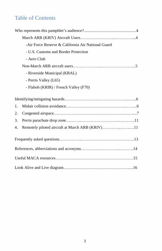
Table of Contents
Who represents this pamphlet’s audience?...................................................4
March ARB (KRIV) Aircraft Users……………………..…………....4
-Air Force Reserve & California Air National Guard
- U.S. Customs and Border Protection
- Aero Club
Non-March ARB aircraft users………………...……………………..5
- Riverside Municipal (KRAL)
- Perris Valley (L65)
- Flabob (KRIR) / French Valley (F70)
Identifying/mitigating hazards…………………….…………………..…...6
1. Midair collision avoidance………………….………………….……...6
2. Congested airspace……………………………………………….…....7
3. Perris parachute drop zone…….…..……………………….….……..11
4. Remotely piloted aircraft at March ARB (KRIV)…………..…….…11
Frequently asked questions……………..…………………….…………..13 References, abbreviations and acronyms………………………..……….14 Useful MACA resources…………………………………………………15 Look Alive and Live diagram…………………………………………....16
4
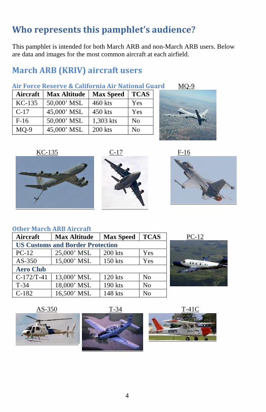
Who represents this pamphlet’s audience? This pamphlet is intended for both March ARB and non-March ARB users. Below are data and images for the most common aircraft at each airfield.
March ARB (KRIV) aircraft users
Air Force Reserve & California Air National Guard MQ-9
KC-135 C-17 F-16
Other March ARB Aircraft Aircraft Max Altitude Max Speed TCAS PC-12
US Customs and Border Protection PC-12 25,000’ MSL 200 kts Yes AS-350 15,000’ MSL 150 kts Yes Aero Club C-172/T-41 13,000’ MSL 120 kts No T-34 18,000’ MSL 190 kts No C-182 16,500’ MSL 148 kts No
AS-350 T-34 T-41C
Aircraft Max Altitude Max Speed TCAS KC-135 50,000’ MSL 460 kts Yes C-17 45,000’ MSL 450 kts Yes F-16 50,000’ MSL 1,303 kts No MQ-9 45,000’ MSL 200 kts No

5
Non-March ARB aircraft users Below lists common aircraft types that frequent airports near March ARB.
Riverside Municipal (KRAL) Aircraft Max Altitude Max Speed Cessna 172 14,000’ MSL 120 kts Piper Cherokee 14,300’ MSL 120 kts Robinson R22 Helo 14,000’ MSL 100 kts
C-172 Pa-28 R-22
Perris Valley (L65) Aircraft Max Altitude Max Speed DHC- 6 Twin Otter 26,700’ MSL 170 kts Shorts Skyvan 22,000’ MSL 200 kts Pilatus Porter 20,500’ MSL 150 kts
DHC-6 Twin Otter SC-7 Skyvan PC-6 Porter
Flabob (KRIR) / French Valley (F70) Aircraft Max Altitude Max Speed Cessna 152 14,700’ MSL 109 kts Beechcraft Bonanza 16,500’ MSL 179 kts Ultralight (General) 12,500’ MSL 90 kts
C-152 Bonanza Ultralight

6
Identifying/mitigating hazards
1. Midair collision avoidance During a three-year study of midair collisions (a.k.a. midairs) involving civilian aircraft, the National Transportation Safety Board (NTSB) determined that: a. Occupants of most midairs were on a pleasure flight with no flight plan filed. b. Nearly all midairs occurred in VFR conditions during weekend daylight hours. c. The majority of midairs were the result of faster aircraft overtaking a slower one. d. No pilot is immune. Experience ranged from initial solo to 15,000 hrs. veterans. e. The vast majority of midairs occurred at uncontrolled airports below 3,000'. f. Enroute midairs occurred below 8,000' and within 25 miles of the airport. g. Flight instructors were onboard one of the aircraft in 37% of the midairs.
Mitigation techniques:
a. PLAN AHEAD - Check NOTAMs, deconflict flight route from Special Use Airspace (SUAS) and Military Training Routes (MTRs).
b. SEE AND AVOID - Scan the airspace ahead and to the side. Periodically scan behind as well, since the majority of midairs occur with one aircraft overtaking another.
c. CLEAR - Before executing any flight maneuver, ensure the area is clear.
d. COMMUNICATE - Broadcast your position and intentions when flying to/from uncontrolled airports. Request and use available ATC services; however, you are ultimately responsible for seeing and avoiding other traffic.
e. SQUAWK - Turn it on (if equipped) and adjust to reply on Mode 3/A and C. Without Mode 3/A, TCAS is ineffective. Without Mode C, TCAS effectiveness is greatly reduced.
f. BE SEEN - Turn on anti-collision or other appropriate lights whenever your engine(s) are running. Also, turn on your landing lights when operating below 10,000' MSL, day or night (especially within 10 miles of an airport) or in areas of reduced visibility.

7
2. Congested airspace March ARB lies within Class C airspace. You should be aware of four other airports adjacent to the March ARB Class C airspace. These airports include: Riverside Municipal (KRAL), Perris Valley (L65), French Valley (F70) and Flabob (KRIR).
Mitigation techniques: March ARB ATC is responsible to provide Class C airspace services at and below 4,000 MSL in the northern inner core as well as at and below 5,000 MSL in the remaining Class C airspace. It is mandatory for all aircraft to establish two-way radio communication by contacting March ARB ATC on 119.25 or 284.0 prior to entering the Class C airspace. Southern California TRACON (SoCal) provides aircraft separation services above the Class C airspace. There are over 600 General Aviation (GA) and approximately 30 military aircraft associated at these airports. Though the March ARB Class C airspace provides aircraft deconfliction by ATC, the risk for a midair collision increases once you leave its confines. Mitigating this risk is achieved by knowing the typical traffic patterns and the aircraft breakdowns at these adjacent airports.
March ARB (KRIV)
Perris Valley (L65)
Flabob (KRIR)
Riverside Municipal (KRAL)
French Valley (F70)

8
March ARB Key Points:
• Transient heavies include the C-5, A330, MD-11, B-747, B-777 and others. • Other aircraft utilizing March’s services include Navy King Airs, Army and Guard
helicopters, Department of Forestry S2 and law enforcement aircraft. • The VFR pattern can be used up to 11,000’ MSL for fighter aircraft. • Numerous radar approaches to RWY 32 end in a circling maneuver. • Unmanned MQ-9 aircraft and the chase ship regularly fly in the vicinity.
VFR TFC PAT: Rectangular – 3000’ Overhead – 3500’
General Aviation TFC PAT - 2200’
TAC WEST RIV /190/2.6 N33 51 57.6 W117 17 49.2 AT OR BELOW 8500’
TAC EAST RIV /089/2.5 N33 53 50.7 W117 13 35.0 AT OR BELOW 8500’
Communications Card SoCal App 134.0 / 278.3
March App/Dep 133.5 / 119.25
March Tower 127.65 / 253.5
**Note: All altitudes in Mean Sea Level (MSL)
IFR TFC PAT – 5000’

9
Riverside Municipal (KRAL) - https://www.riversideca.gov/airport
Perris Valley (L65) - http://www.skydiveperris.com
Communication Card CTAF 122.9
Based GA Aircraft Single-engine
4
Multi-engine 5 Jets 1 Ultralights 125
Communication Card SoCal App 135.4 / 377.125 Tower 121.0 (CTAF) UNICOM 122.95
Based GA Aircraft
Single-engine 138 Multi-engine 20 Jets 2 Helicopters 3
Traffic Pattern Altitude
Rotocraft 1300’ MSL Fixed Wing 1819’ MSL Turbine Acft 2319’ MSL
Traffic Pattern Altitude Fixed Wing 2413’ MSL
IFR Clearance 0700L-2300L March Approach (951) 655-2355 IFR clearance 2300L-0700L SOCAL App: 800-448-3724
10
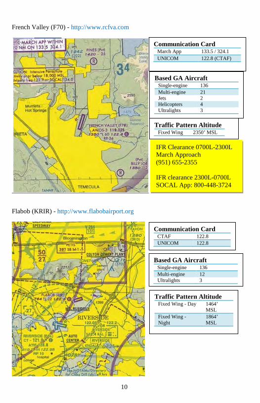
French Valley (F70) - http://www.rcfva.com
Flabob (KRIR) - http://www.flabobairport.org
Communication Card CTAF 122.8 UNICOM 122.8
Based GA Aircraft
Single-engine 136 Multi-engine 12 Ultralights 3
Communication Card March App 133.5 / 324.1 UNICOM 122.8 (CTAF)
Based GA Aircraft Single-engine 136 Multi-engine 21 Jets 2 Helicopters 4 Ultralights 3
Traffic Pattern Altitude
Fixed Wing 2350’ MSL
Traffic Pattern Altitude Fixed Wing - Day 1464’
MSL Fixed Wing - Night
1864’ MSL
IFR Clearance 0700L-2300L March Approach (951) 655-2355 IFR clearance 2300L-0700L SOCAL App: 800-448-3724

11
3. Perris parachute drop zone The west coast’s largest fleet of skydiving aircraft is located at Perris Valley airport. The majority of parachute jumps happen on weekends between sunrise and sunset. Be aware operations can occur up to 18,000’ MSL!
Mitigation techniques: Though March ATC primarily deconflicts aircraft between March ARB and Perris Valley, it is critical that every pilot remain vigilant when operating within this airspace. If you have an available radio, you can monitor operations on Perris Valley’s advisory frequency (122.775), where you will hear pilots communicate with ground personnel or contact March approach (119.25) below 5,000 and SoCal (134.0) when above 5,000 MSL
4. Remotely Piloted Aircraft at March ARB (KRIV) The 163d Attack Wing, California Air National Guard, conducts unmanned MQ-9 Reaper Remotely Piloted Aircraft (RPA) flight operations at KRIV. One unique function to MQ-9 flight operations is the general aviation single-engine chase ship that accompanies the RPA during transit between KRIV and the R-2508 SUAS (near Edwards AFB/KEDW). The chase ship is not required for operations under tower control; however, it may be present under certain conditions. The MQ-9 operates at the same traffic pattern altitude as fixed wing aircraft and only while tower is open and providing Class C services. The majority of flying occurs weekdays, between sunrise and sunset, with occasional night operations. In the event the pilot loses datalink with the MQ-9, it will fly the programmed lost-link path. When transiting the airspace between KRIV and KEDW, it is recommended to always contact the appropriate ATC controlling agency and squawk IFF mode 3/A and C. The MQ-9 does not have TCAS. Also, be sure to clear for both the MQ-9 and its chase ship. The chase ship will squawk a unique transponder code and trail the MQ-9 within 2 nm and 1,000 ft. vertically. The MQ-9 normally transitions to the R-2508 airspace at 8,500 MSL northbound, and returns to KRIV at 9,500 MSL southbound while maintaining contact with the controlling ATC agency.

12
KRIV MQ-9 VFR pattern, lost link flight path and lost link orbit
MQ-9 flight path (green line) between KRIV and SUAS R-2508

13
Frequently asked questions 1. How do I report a near midair collision?
If you find yourself in a near midair collision, it is imperative to first continue flying the aircraft! Notify ATC as appropriate (i.e., if you had to maneuver in response to a TCAS resolution advisory). Once you are in a safe position, be sure to document as much information as possible. Key items include: location, altitude, weather conditions, aircraft call signs and types, as well as the ATC agency. Upon landing, fill out an AF Form 651 (http://www.e-publishing.af.mil/) and turn it into the 452d Air Mobility Wing Flight Safety Office (951-655-4481 / [email protected]).
2. When is the majority of flying by March ARB aircraft conducted?
Operations normally occur 0700-2300L, Monday through Sunday. 3. What/where is the highest potential of being involved in a midair collision with
March ARB aircraft?
Radar base to final for Rwy 32 is the area with the highest amount of traffic conflicts. The frequency of near midairs along the recovery routing to Rwy 32 is greater than any other area in the March ARB airspace. 4. Where should GA aircraft fly to avoid March ARB aircraft?
Avoiding high traffic areas, such as final for Rwy 32, will decrease the possibility of a midair greatly. Also, although nearby MOAs are not restricted from civilian VFR traffic, they should be avoided when active (weekdays and some Saturdays) to minimize midair potential. 5. What are the best ways to see an aircraft to avoid a midair collision? The best way to see and avoid any aircraft is to use a proper scan pattern backed up by properly squawking your assigned transponder code to allow TCAS-equipped aircraft to see you. One scanning technique is to start at one side of the wind screen and allow your eyes to focus every 10-15 degrees. Remember to search above and below the horizon. Traffic conflicts often occur while one aircraft is transiting the flight path of another. You can also detect other aircraft by communicating with ATC. If traveling near March ARB airspace, contact March Approach on 133.5 / 119.25.

14
References, abbreviations and acronyms References AFI 91-202, The US Air Force Mishap Prevention Program, AC 90-48D, Pilots’ Role in Collision Avoidance Abbreviations and Acronyms AF – Air Force AFB – Air Force Base AOPA – Aircraft Owners and Pilots Association APP – Approach ARB – Air Reserve Base ARTCC – Air Route Traffic Control Center ATC – Air Traffic Control DEP – Departure FDC – Flight Data Center GA – General Aviation L – Local time MACA – Midair Collision Avoidance MTR – Military Training Route RPA – Remotely Piloted Aircraft RWY – Runway SUAS – Special Use Airspace TAC – Tactical TCAS – Traffic Collision Avoidance System TFC PAT – Traffic Pattern TRACON – Terminal Radar Approach Control TWR – Tower WX – Weather

15
Useful MACA resources There are numerous MACA resources on the internet. Below is a list of websites you can use during your flight planning. 1. Defense Internet NOTAM Service. This is an official resource to find airport
NOTAMs, TFRs and ARTCC FDC NOTAMs. https://www.notams.jcs.mil
2. Aviation safety reporting system. This is an official resource which uses
NASA as a third party between you and the FAA. Here you can report actual or potential discrepancies involving flight safety with immunity. http://asrs.arc.nasa.gov
3. Aviation safety information analysis and sharing (ASIAS) system. This is an
official resource from the FAA serving as a source to integrate, analyze and share aviation safety data and information. http://www.asias.faa.gov
4. AC 90-48D Change 1. FAA Advisory Circular on pilots’ role in collision
avoidance. https://www.faa.gov/documentLibrary/media/Advisory_Circular/AC_90-48D_CHG_1.pdf
5. How to Avoid a Mid Air Collision. FAA publication P-8740-51 presents the
hazards, causes, and prevention of midair collisions. https://www.faasafety.gov/gslac/ALC/libview_normal.aspx?id=6851
6. Collision Avoidance: See, Sense, Separate. This AOPA Air Safety Institute 8-minute video can be streamed directly from YouTube. https://www.youtube.com/watch?v=NQrzrNkmUzs
7. Collision Avoidance. This AOPA Safety Advisor teaches pilots how to visually
identify potential collision threats and covers procedures that can lessen the risk of an in-flight collision or runway incursion. https://www.aopa.org/training-and-safety/online-learning/safety-advisors-and-safety-briefs/collision-avoidance
8. March ARB MACA. The March ARB website has a link to this document. http://www.march.afrc.af.mil/

16