miljÖredovisning aga bil 8
TRANSCRIPT

MILJÖREDOVISNING BILAGA 8
COD SPAWNING AND IMPACTS FROM CONSTRUCTION WORKS
DOCUMENT ID: W-PE-EIA-POF-MEM-805-020100EN-05

Intended for Nord Stream 2 AG Date July, 2016 Document number W-PE-EIA- POF-MEM-805-020100EN-05
NORD STREAM 2 COD SPAWNING AND IMPACTS FROM CONSTRUCTION WORKS

NORD STREAM 2 Cod spawning and impacts from construction works
Ramboll Denmark T +45 5161 1000 F +45 5161 1001 www.ramboll.com
Revision 05 Date 2016-07-05 Document ID W-PE-EIA- POF-MEM-805-020100EN-05 Reference 1100019533 / PO16-5068 Revision Record: Revision Date Made by Checked by Approved by
(discipline lead)
Approved by (Project Manager)
01 18.01.2016 Annika Ekström, Emma Hällqvist
Pär-Olof Winnansson, MIBR, JCXS
Pär-Olof Winnansson
MIBR
02 13.04.2016 Annika Ekström, Emma Hällqvist
Pär-Olof Winnansson, MIBR, JCXS
Pär-Olof Winnansson
MIBR
03 19.05.2016 Annika Ekström, Emma Hällqvist
Pär-Olof Winnansson
Pär-Olof Winnansson
MIBR
04 05.07.2016 Annika Ekström, Emma Hällqvist
Pär-Olof Winnansson
Pär-Olof Winnansson
MIBR
05 14.09.2016 Annika Ekström, Emma Hällqvist
Pär-Olof Winnansson
Pär-Olof Winnansson
MIBR

Document No.: W-PE-EIA- POF-MEM-805-020100EN-05
CONTENTS
1. INTRODUCTION AND PURPOSE 4 2. COD SPAWNING IN THE BALTIC SEA 4 3. SEDIMENT QUALITY AND HYDROGRAPHICAL
CONDITIONS 7 4. CONSTRUCTION ACTIVITIES 10 4.1 Pipe-lay 10 4.2 Anchor lay vessel 10 4.3 DP vessel 11 5. POTENTIAL IMPACTS AND ASSESSMENT 13 5.1 Potential impacts 13 5.1.1 Increased turbidity 13 6. REFERENCES 24

Page 4 of 28
Document No. W-PE-EIA-POF-MEM-805-020100EN-05
1. INTRODUCTION AND PURPOSE
Nord Stream 2 (NSP2) is a pipeline through the Baltic Sea planned to deliver natural gas from vast reserves in Russia directly to the EU gas market to fill the growing gas import demand. The twin 1,200 kilometre subsea pipelines will have the capacity to supply 55 billion cubic metres of gas per year in an economic, environmentally safe and reliable way, compensating for the drop in the EU’s domestic production. NSP2 follows in the footsteps of the successful experience of construction and operation of the existing Nord Stream Pipeline (NSP), which has been recognised for its high environmental and safety standards, green logistics, open dialogue and public consultation. Ramböll has been requested to assess the possible impacts from pipe lay activities associated with NSP2 on spawning cod in the Bornholm deep. The Bornholm deep is considered to be the only remaining, functional spawning area for the Eastern Baltic cod stock. The purpose of the present memo is to assess the possible impacts on spawning cod, cod eggs and on cod fry (larvae) if construction activities were to take place in the Bornholm deep during cod spawning season, May-September. The purpose of the memo is also to evaluate if possible impacts on cod spawning differ using a lay barge dynamically positioned vessel (DP) or an anchor vessel. The Bornholm deep is included in a larger area which is closed for fishery during the period from 1 May to 31 October. During the consultation phase for Nord Stream the Swedish Board of Fisheries stated that they did not accept any pipe laying activities in the Bornholm Deep during the closed period. The reason for this statement was the risk of suspension of sediment caused by the anchor lay barge. They also mentioned the risk of noise disturbance. Nord Stream accepted the statement from the Swedish Board of Fisheries and no construction activity took place inside the area during the closed period. During the consultation phase for Nord Stream 2 (Nord Stream Extension, named as NEXT) in the spring of 2013 the Swedish Agency for Marine and Water Management had the following comments /47/:
• The pipe laying time schedule should for instance be adapted so that no disturbing work under water take place during fish spawning periods.
• The pipe laying time schedule should be described in relation to the area and time closed to fishery.
In this assessment it is assumed that no seabed intervention works (trenching and rock placement) will take place in the Bornholm Deep during the period closed for fishery, only pipelay.
2. COD SPAWNING IN THE BALTIC SEA
Two different cod stocks – Eastern and Western stock - exist in the Baltic Sea. In the Bornholm basin the Eastern Baltic cod spawn. The spawning season of this stock is initiated in May and ends in September /5/ /32/. During this season the distribution of adult cod is highest in the Bornholm Basin under the halocline compared to other seasons. Baltic cod migrate vertically into the deep part of the Basin to spawn /2/. Previously the Eastern Baltic cod spawned in three different spawning areas: Bornholm Basin, Gotland Basin and Gdansk deep, but since the end of the 1980s the salinity and oxygen conditions have in general only allowed successful spawning, egg fertilisation, and egg development in the Bornholm Deep /1/. A successful cod spawning concerning egg survival requires a minimum salinity of 11 psu in order to keep the cod eggs afloat, an oxygen content of at least 2 ml/l for the eggs to survive and be

Page 5 of 28
Document No. W-PE-EIA-POF-MEM-805-020100EN-05
able to develop and a temperature above 1.5ºC /31/ /32/ /33/. The volume of water where this is fulfilled is called the “reproductive volume” /3/. Where in the water column this reproductive volume is located can differ due to external factors effecting salinity and oxygen levels such as storms and inflow of marine water but is generally located between approximately 45 meters and 75 meters depth in the Bornholm Deep /3/. The depth profile in the closed area for fishery along the preferred pipe route is illustrated in Figure 2-1 below. The Bornholm basin is situated between ~KP 1000 and 1030 in the same figure.
Figure 2-1 Depth profile along the preferred route inside the area closed for fishing (May 1 to October 31). KP corresponds to the distance from the start of the pipeline in km. The locations of KP can be seen in Figure 2-2. The Bornholm deep is situated between ~KP 1000- 1030.
The spawning Eastern Baltic cod tend to aggregate below the halocline in the center of the Basin and have been observed pelagic in water depths between 60-80 m. Contrary, the highest abundance of immature individuals has been observed on the Basin slopes close to the bottom at 40-70 m /2/ /36/. Inflows of highly saline and oxygen rich water enters and refresh the Baltic Sea from the North Sea through Kattegat and the Danish Straits, but for the last decades there have been approximately 10 years between the major inflows. The latest major inflow was observed in December 2014 and was preceded by a series of minor inflows between the end of 2013 and the beginning of 2014 /37/. Before this, major inflows were observed in the years 2002-2003 and in 1993 /30/. The Baltic cod must thus choose a good spot for the eggs in the water column to avoid oxygen depletion, but still be below the halocline to sustain required salinity levels. Studies of horizontal movements of tagged Baltic cod showed that during spawning, cod preferred areas most suitable for egg survival, which indicates that cod are capable of choosing habitats that are optimal for reproductive success /27/. A change in timing of the peak of spawning was observed in the 1990s where the peak was shifted from end April- mid June to the end of July. Timing of spawning of Baltic cod depends on factors such as water temperature during gonadal maturation, density-dependent processes related to the size of the spawning stock and food availability /4/ /5/. Observations of the distribution Eastern Baltic cod and other cod stocks indicate that males mature and arrive earlier to the spawning grounds and are followed by females when they are ready to spawn and that large and old cod tend to initiate spawning prior to small and young individuals/28/. The female cod spawn 17-19 batches and the time between releases of batches might be increasing from the start of spawning season to the end /6/. Therefore there are no fixed periods
Page 6 of 28
Document No. W-PE-EIA-POF-MEM-805-020100EN-05
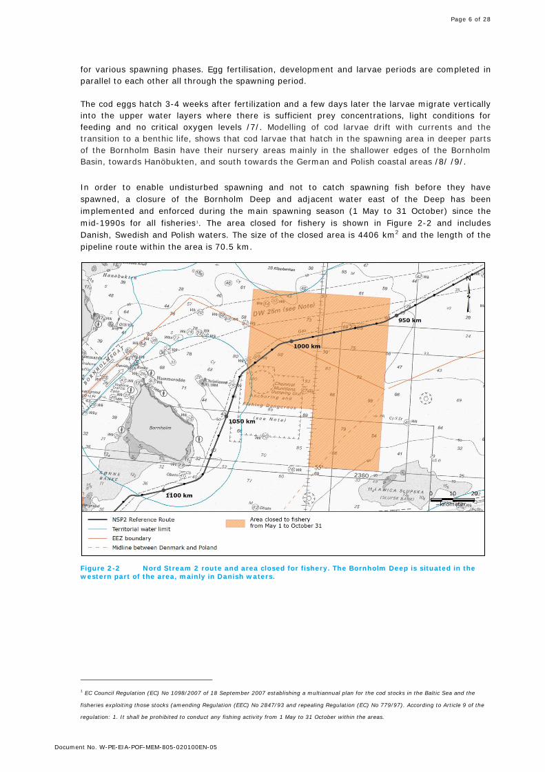
for various spawning phases. Egg fertilisation, development and larvae periods are completed in parallel to each other all through the spawning period. The cod eggs hatch 3-4 weeks after fertilization and a few days later the larvae migrate vertically into the upper water layers where there is sufficient prey concentrations, light conditions for feeding and no critical oxygen levels /7/. Modelling of cod larvae drift with currents and the transition to a benthic life, shows that cod larvae that hatch in the spawning area in deeper parts of the Bornholm Basin have their nursery areas mainly in the shallower edges of the Bornholm Basin, towards Hanöbukten, and south towards the German and Polish coastal areas /8/ /9/. In order to enable undisturbed spawning and not to catch spawning fish before they have spawned, a closure of the Bornholm Deep and adjacent water east of the Deep has been implemented and enforced during the main spawning season (1 May to 31 October) since the mid-1990s for all fisheries1. The area closed for fishery is shown in Figure 2-2 and includes Danish, Swedish and Polish waters. The size of the closed area is 4406 km2 and the length of the pipeline route within the area is 70.5 km.
Figure 2-2 Nord Stream 2 route and area closed for fishery. The Bornholm Deep is situated in the western part of the area, mainly in Danish waters.
1 EC Council Regulation (EC) No 1098/2007 of 18 September 2007 establishing a multiannual plan for the cod stocks in the Baltic Sea and the
fisheries exploiting those stocks (amending Regulation (EEC) No 2847/93 and repealing Regulation (EC) No 779/97). According to Article 9 of the
regulation: 1. It shall be prohibited to conduct any fishing activity from 1 May to 31 October within the areas.

Page 7 of 28
Document No. W-PE-EIA-POF-MEM-805-020100EN-05
3. SEDIMENT QUALITY AND HYDROGRAPHICAL CONDITIONS
The sediment along the route within the Bornholm basin and the area closed for fishing consists mainly of soft sediments, since the area constitutes areas for deposition/ accumulation. As already mentioned, oxygen and the salinity conditions controls the reproductive zone’s allocation within the water column. The halocline in the Bornholm basin is usually set at approximately 60-75 m and below the halocline, salinity increases with depth due to density. For successful egg development a salinity level of 11 psu must be maintained and oxygen conditions must exceed a concentration of 2 mg/l. Oxygen levels decreases with depth since the halocline and thermocline prevents oxygen- rich and poor water to mix. The seabed in the Bornholm basin is therefore usually anoxic (<2mg/l). Hence, spawning and egg development can only take place below the halocline but still a bit up in the water column above anoxic layers. In shallow waters no halocline and thermocline is formed due to wind mixing throughout the water column. Although the wind mixing result in well oxygenated water, shallow waters are not optimal for cod spawning, since the salinity is too low (<11psu) and a reproductive volume cannot be established. In conclusion, the allocation of the reproductive zone is, except for salinity and oxygen conditions, therefore by some means also dependent on water depth. Field investigations were performed by DHI in October 2015 along the ES route and hydrographical parameters such as salinity, oxygen and temperature were measured /39/. Sampling stations where hydrographical conditions have been measured, within or in close vicinity to the restricted fishing area are shown in Figure 3-1. The Bornholm Deep is distinguished by the blue depth lines.
Figure 3-1 Survey stations in October 2015 along the ES-route in Swedish and Danish waters, the restricted fishing area (orange) and depth profiles distinguishing the Bornholm Deep.

Page 8 of 28
Document No. W-PE-EIA-POF-MEM-805-020100EN-05
The depths at the sampling stations along the ES-route, within the restricted area, vary between 67-95 m. The more shallow stations (67-80 m) are situated in Swedish waters while a major part of the actual Bornholm basin is located in Danish waters (77-95 m). Figure 3-2 exemplifies three different depths and consequently different hydrographical conditions along the route and as a result also different potential for an establishment of a stable reproductive volume. In areas with greater depths (>75m) such as the stations in the Bornholm Basin (D_ES_03-D_ES_09) a halocline/thermocline is formed, the bottom is anoxic and a reproductive volume is possible in the example D_ES_07, between 55-75 m (Figure 3-2).
Figure 3-2 Hydrographical conditions at station D_ES_07, S_ES_49 and S_ES_43.
In areas with middle depths (~50-70m), a halocline/thermocline normally is formed, and close to the sea bottom conditions are anoxic. The Swedish station S_ES_49 (in Figure 3-2) which is situated within the restricted fishing area, exemplifies a depth where a reproductive volume theoretically could be formed, but the depth span where the conditions are fulfilled (oxygen and salinity levels) is rather small, in this example between ~57-67. One can assume that cod, which seems to have an ability to choose suitable spawning grounds, probably avoid these areas for spawning /27/. Furthermore studies show that the spawning Baltic cod tend to aggregate in the center and deepest part of the Bornholm Basin /2/. In shallow areas the water is oxygenated by wind mixing and the whole water column has suitable oxygen conditions for cod spawning. On the contrary the mixing of the water column prevents establishment of a halocline and salinity levels are too low (<11psu) for cod to spawn successfully (egg survival) throughout the whole water column. The Swedish station S_ES_43 in Figure 3-2, just north of the restricted area, exemplifies this, where salinity levels are constantly around 7 and oxygen levels at 9 mg/l. In Table 3-1 the Swedish and Danish sampling stations within the restricted area are listed together with depth at the station and measured salinity, temperature and oxygen approximately 1 m above the bottom. In the last column the potential reproductive volume is approximated from diagrams illustrating hydrography at the sampling station.

Page 9 of 28
Document No. W-PE-EIA-POF-MEM-805-020100EN-05
Table 3-1 Depth at the stations and salinity, temperature and oxygen measured approximately 1 m above the seabed, along the preferred route in Swedish and Danish water, October 2015 /39//56/.
Station Absolute depths
Salinity Temp. Dissolved oxygen
Potential reproductive volume
Name no. m psu C° mg/l (depth span, m)
S_ES_47 67 18 7 0.9 ~57-65 S_ES_48 72 18 7 1.0 ~57-67
S_ES_49 78 18 7 1.0 ~56-65 S_ES_50 80 19 7 0.9 ~55-75
S_ES_51 77 19 7 0.7 ~55-72 D_ES_03 80 18.5 7 1.8 ~57-77
D_ES_05 90 19.2 7 0.5 ~55-80
D_ES_07 92 19.3 7 0.1 ~50-80 D_ES_09 95 19.2 7 0.3 ~ 50-75

Page 10 of 28
Document No. W-PE-EIA-POF-MEM-805-020100EN-05
4. CONSTRUCTION ACTIVITIES
The pipelines can be laid down on the seabed either by an anchored lay vessel or a dynamically positioned (DP) vessel. Sea bed intervention work (IW), i.e. trenching and rock placement, is not expected in the area restricted for fishing. Therefore potential impacts would only come from pipeline layout, which is the fundamental for the assessment. The length of the route in area closed for fishery is 70.5 km. Both vessels (anchor and DP) are expected to be able to lay approximately 2-3 km of pipeline per day depending on weather conditions.
4.1 Pipe-lay The pipeline is laid from a barge with a low horizontal speed and a low and controlled vertical velocity of the pipeline that decreases towards zero at the seabed.
4.2 Anchor lay vessel Anchor handling is assumed to include an anchor lay vessel which is positioned with 12 anchors, each weighing up to 25 tonnes. The corridor width on the sea bottom where pipeline installation takes place will be around 2 km per pipeline. The deep water anchor vessel Saipem Castoro Sei has previously been used when laying pipelines in the Nord stream project. In Table 4-1 technical details about the ship and thrusters are presented.
Table 4-1 Technical details about the anchor vessel Castoro Sei /51/
Anchor-vessel (Castoro Sei) Deck load: 3.600 tonnes
Breadth: 70.5 m
Depth to main deck: 29.8 m
Draught: 15.5 m
Length Overall (excluding ramps):
152 m
Speed: 5.8 knots
Anchors: 12 x 25 tonne anchors 12 x 124 tonne anchor winches 3,000 m anchor wire on each winch of 76 mm
Thrusters: 4 x 37 tonne Azimuthal thrusters
The anchors are fastened to 12 anchor winches, each with a 3,000 m anchor wire of 76 mm. The anchors will be placed on the seabed at positions around the lay vessel and moved forward by 3-4 tugboats during the operation of the lay vessel /10/, see Figure 4-1. In addition, 2-6 anchor handling vessels (tug boats) are required per anchor-positioned lay vessel. For the open offshore sections, the anchors are positioned 1,000–2,000 m from the lay vessel. In case of bad weather the anchored vessels may also use their thrusters, but to a lesser extent and with lesser force compared to DP-vessels.

Page 11 of 28
Document No. W-PE-EIA-POF-MEM-805-020100EN-05
Figure 4-1 Anchor patterns at a water depth of 50 m.
The distance between two positions of one anchor during operation of the lay vessel is approximately 500 m /10/. During transport of the anchors from one position to another the anchors are lifted from the seabed, to avoid disturbances on the seabed from anchor and anchor wire, and it is calculated that only very little sediment will be released during transport of the anchors /10/. The anchors are lifted approximately 50 m from the seabed during transportation. In case of shallow water depth, it can be assumed that the anchor is lifted 10 m from the surface /25/. The anchor wire will typically rest on the seabed at a length of 100 - 150 m from the anchor. When the lay vessel is moving forward, the anchor wire will be sweeping across the seabed. This may create some suspension of sediment, even though the movement of the anchor wire is very slow /10/. In soft sediment, it is expected that the anchors will sink into the sediment when they hit the seabed. Therefore, when the anchor is pulled to give the desired holding capacity, no significant suspension of sediment to the water column is expected. When the anchor is pulled back again, some sediment may stick to the anchor and be suspended in the water column /10/.
4.3 DP vessel DP vessel operation allows precise manoeuvring without anchor handling. The use of thrusters (e.g. 10 thrusters) on full dynamic positioning allows the DP vessel to work safely in congested areas /11/. The DP vessel Allseas Solitaire has previously been used when laying pipelines in the Nord stream project and is one of the largest pipelay vessels in the world. In Table 4-2 technical details about the ship and thrusters are described.

Page 12 of 28
Document No. W-PE-EIA-POF-MEM-805-020100EN-05
Table 4-2 Technical details about the DP vessel Allseas Solitaire /52/
DP-vessel (Allseas Solitaire) Carrying capacity: 22 000 tonnes
Breadth: 41 m
Depth to main deck: 24 m Draught: 17.62 m Length Overall (excl. stinger):
300 m
Maximum speed 13.5 knots Thrusters 10 x 5550 kW non-
retractable, fixed pitch azimuth type
Thrusters rotational speed: 0-160 rpm The thrusters are located five on each side and four at foreship, six at aftership. The thrusters are normally not directed towards the seabed but rather more horizontally (Figure 4-2). All thrusters are active during pipe-laying. In some cases the thrusters can be put on non-active mode; e.g. when there is a barge or vessel alongside, in very calm seas (including low tension levels), etc. The DP computer program calculates the direction of the thrusters and active working levels in such a way that the highest level of efficiency can be achieved with as little power consumption as possible /11/.
Figure 4-2 Position of thrusters on Allseas Solitaire /11/.

Page 13 of 28
Document No. W-PE-EIA-POF-MEM-805-020100EN-05
5. POTENTIAL IMPACTS AND ASSESSMENT
In the following sections, potential impacts on cod (spawning adults, eggs and cod fry) from pipe laying activities in the restricted fishing area are described in detail (5.1) and further assessed (5.2). In Table 5-1 the potential impacts are presented for the various pipe laying activities.
Table 5-1 Potential impacts from pipeline layout, anchor vessel and DP-vessel.
Potential impacts Pipe laying activities Pipeline layout Anchor vessel DP-vessel
Increased turbidity (suspended sediments)
X X X
Underwater noise X X Displacement of eggs X
5.1 Potential impacts In the following sections, potential impacts on cod (spawning adults, eggs and cod fry) from pipe laying activities in the restricted fishing area are described in detail.
5.1.1 Increased turbidity Increased suspension of sediment in the water column can lead to a temporary increase in turbidity and sedimentation. High concentrations of suspended material may injure or kill adult and juvenile fish. Particles may accumulate in their gills, reducing their ability of oxygen absorption. Sharp-edged particles may also damage the gills. Cod eggs, may moreover be affected if suspended matter adheres to the eggs, causing them to sink towards the bottom, where there is a risk of oxygen depletion. Empirical studies have shown that very high concentrations of suspended material are generally required in the water column in order to harm fish. Literature reports lethal and sub-lethal concentrations in the magnitude of 580-225 000 mg/l and 650-13 000 mg/l, respectively /12/ /13/ /14 /15/ /16/ /17. The sensitivity of adult fish to suspended particles varies highly between species and their life stages and depends on sediment composition, concentration and duration of exposure. In general pelagic fish are more sensitive to suspended sediment than demersal fish /12/. Lethal concentration rates for pelagic fish has been reported (>580 mg/l). Lethal concentrations for adult cod has not been reported in the literature but is assumed to be in the same concentration range as other demersal fish (>3000 mg/l) /13/. In general, fish eggs and fish fry are more sensitive to increased concentrations of suspended sediment than juvenile and adult fish species. One fundamental difference between fish eggs/yolk sac larvae and juveniles/adults is their ability of movement. It is reasonably to presume and have also been shown that most fish capable of swimming will relocate from such conditions. Therefore sediment dispersion probably seldom has direct lethal consequences among juveniles and adults/13/. Concentrations which cause an avoidance response among juvenile and adult fish have been reported within a magnitude of 3-100 mg/l /42/43/44/45/46. Pelagic fish eggs may also be affected if suspended matter adheres to the eggs, causing them to sink towards the bottom, where there is a risk of oxygen depletion. Laboratory experiments has been conducted to determine how suspended clay, a common source of turbidity in estuaries or due to spilling or dredging works, affected hatching success of six species of anadromous and estuarine fish. The result showed no deleterious effects at concentrations up to 500 mg silt/l, and a reduced hatching success in two of the species at a concentration of 1000 mg/l /20/. Another study has shown that exposure to concentrations of suspended sediment at 300 and 500 mg/l for one day did not affect the development of herring eggs /19/.

Page 14 of 28
Document No. W-PE-EIA-POF-MEM-805-020100EN-05
One cod study have showed that cod eggs exposed to 5 mg/l suspended sediment was still able to float but started to sink after 96 hours in stagnant water /48/. In turbulent water however this effect has been showed to significantly decrease /49/. In the same study the survival rate of yolk-sack larvae started to decrease at 10 mg/l. The limestone concentration in the suspension was high, which is thought to be more harmful compared to clay concentrations. The avoidance threshold to suspended sediments of both glacial clay and limestone was found to be approximately 3 mg/l. Experiments with cod in the dark showed a similar threshold which indicates a non-visual effect. The exposure time is of great importance when it comes to biological effects. It has been shown that the sediment concentration (mg/l) together with exposure time (h) are significant correlated to the degree of a biological effect, whereas only sediment concentration was not /50/.
Table 5-2 Threshold values (sensitivity) for cod of suspended sediment.
egg larvae adult
Avoidance response - - 3mg/l
Lethal 5mg/l* 10mg/l
*Eggs started to sink at 5 mg/l after 96 hours in stagnant water.
5.1.2 Under water noise An increased noise level is presumed to affect fish in several ways. Elevated sound may damage non-auditory tissues as well as auditory tissues (generally sensory cells of the ear) in fish. Fish might suffer from hearing loss, behavioral effects may occur and communication may be inhibited when exposed to enhanced sound levels. The extent to which such noise source levels would give rise to an impact upon fish is dependent upon a number of factors including sound intensity, sound frequency, the rate which sound attenuates (which is varying for different frequencies and environmental conditions), and the exposure duration time. Fish behaviour in response to noise is however not well understood. Sound pressure levels that may deter some species, may attract others. There are relatively few studies that deal with noise-related impacts on fish, and moreover, the studies often show varying results. It is often difficult to extrapolate the results of specific studies or basic research to other conditions, mainly due to the different hearing systems for the species and differences in the physical properties of the sound stimuli. Research on the effects of ship noise on fish, especially noise generated by ships using sonar systems, is summarised by ICES /23/. Noise from shipping exhibit most energy below 1000 Hz and is within the frequency range for most fish species. The authors noted that it is difficult to draw definite conclusions /22/ However, it is clear that fish can detect ship noise at long distances when the ambient levels from other sources are low but they are unlikely to react and move away unless the noise is relatively high, typically in a radius of a few hundred metres from the sound source /24/. There is a high diversity in hearing capabilities among fish, giving different hearing characteristics of the various species. Most species have hearing ranges from approximately 30 Hz to 1000 Hz. There are two principal sensory organs for detection of underwater vibrations and noise: the lateral line system and the inner ear. The lateral line system can detect sound very close to the sound source and is stimulated by low frequency (generally below 150 Hz) water flow relative to the fish body. The inner ear can detect sound from near and far distances /22/.

Page 15 of 28
Document No. W-PE-EIA-POF-MEM-805-020100EN-05
For classification purposes the terms hearing specialists and generalists are commonly used. Hearing specialists have some means of mechanical coupling between the swim bladder and the inner ear. As a result of these additional features, hearing specialists have high sound pressure sensitivity and generally low hearing thresholds, when compared to generalist, and can detect sounds over 3 kHz with best sensitivity (hearing) from ~300 to 1000 Hz. In contrast, the majorities of fishes are generalists and detects sounds up to 1000 Hz, with the best sensitivity from ~100-400 Hz (54-Säby). Cod have a rather restricted frequency range. Sensitivity to sound pressure indicates that the gas-filled swim bladder may be involved in the hearing of cod, although there is no direct coupling. At lower frequencies high amplitudes can be obtained close to source, suggesting sensitivity to particle displacements. A few studies have shown that cod has a hearing range between 10-700Hz and 65-140 dB /53/. In fish, physical damages to the hearing apparatus rarely lead to permanent changes, as the sensory epithelium will regenerate in time. However, temporary hearing loss may occur. A temporary hearing loss (TTS) in fish where swim bladder is involved in hearing has been reported to 186 dB SEL cum.
5.1.3 Displacement of eggs Jet-thruster-induced currents may displace cod eggs out from the “reproductive volume” by pushing them down to more un-favourable anoxic conditions.
5.2 Assessment of impacts In the following sections, potential impacts described in section 5.1, on cod (spawning adults, eggs and cod fry) from pipe laying activities, in the restricted fishing area, are assessed
5.2.1 Assessment of impacts from pipelay Impact from pipelay could potentially arise from:
• Increased turbidity (suspended sediments) due to pipe lay
5.2.1.1 Increased turbidity During the pipeline installation process, sediments from the seabed may be suspended due to the following processes:
• The current generated in front of the pipeline when it is lowered through the water and placed onto the seabed, may eventually bring sediment into suspension
• The pressure from the pipeline when it hits the bottom may create an upwards movement of sediment.
The pipeline is laid from a barge with a low horizontal speed and a low and controlled vertical velocity of the pipeline that decreases towards zero at the seabed. Calculations have shown that only a very small amount of sediment is suspended during pipeline layout directly on the seabed even for worst-case scenarios /41/. From the calculations it was concluded that suspension caused by pipeline installation is negligible in the case of firm sediment. In the case of very soft clay sediments where the pipeline is able to sink down, some small suspension of sediment near the bottom can be expected /41/. However, compared with suspension during trenching and rock-dumping, this is negligible.

Page 16 of 28
Document No. W-PE-EIA-POF-MEM-805-020100EN-05
In the Finnish EEZ, monitoring of water quality during pipe-lay of NSP with Solitaire was carried out in November-December 2010. During pipe-lay in the vicinity of fixed turbidity sensors there were no turbidity recordings above background levels /40/. Monitoring of water quality during pipe-lay of NSP with the anchored lay barge was carried out in the Finnish EEZ in June-July 2010. The observations derived from fixed sensors near the seabed (1,5-2 m above seabed).Vessel operated monitoring showed that at the nearest fixed sensor, 50 m from the pipeline route, there was a minor increase in turbidity up to 3.4 NTU during less than two hours. No increase in turbidity was observed at the location of the farthest sensor, 800 m away from the pipeline. These monitoring data support the calculations that pipe-lay causes no, or only negligible sediment release during normal operation /40/. It is concluded that suspension caused by pipeline installation is negligible.
5.2.2 Assessment of impacts from anchor vessel Impact from anchor vessel could potentially arise from:
• Increased turbidity (suspended sediments) due anchor wire sweep • Underwater noise (propellers)
5.2.2.1 Increased turbidity The processes that may create suspension of sediment are during the laying of the pipes. Suspension will occur when anchors from the anchor vessel are laid on the seabed, when they are pulled up again and when the anchor wire sweeps across the seabed during movement of the lay vessel. The size of the suspension of bottom material can be estimated by the kinetic energy from the anchor when it hits the seabed which is transferred to potential energy of the suspended sediment. Based on previous calculations less than 20% of the kinetic energy of the anchor is transferred to a potential energy of suspended sediment grains /21/. This upper limit of 20% is a conservative estimate and it is more likely that 1% to 10% of the energy is transferred to suspended sediment. It is expected that a very low percentage of the sediment impacted by the anchor chains will be suspended in the water column and that the sediment suspended will be restricted very close to the seabed. The suspension height, defined as the maximum height above seabed where the SSC is < 1 mg/l, during anchor sweeping was calculated during NSP1 to be 10 m /21/. The suspended sediment is assumed to be distributed evenly in the lower 10 meters of the water column on basis of the quite large weight of the anchor. This means that the mass centre point of the suspended sediment is 5 m above the seabed /21/. The average sediment concentration of the water column in the anchor corridor (2040 m) has been estimated to be approximately 0.5 - 2.0 mg/l /10//21/. As the releasing process is dynamic and some of the sediment released, first will be settled before new sediment is released, the actual concentrations will be lower than this. Assuming that the sediment is deposited in the same area, i.e. no further spreading, the sedimentation in the anchor corridor is 0.005 kg/m2. This corresponds to a sedimentation layer of 0.005 mm assuming that the porosity of the settled sediment is 60% /21/ /10/.

Page 17 of 28
Document No. W-PE-EIA-POF-MEM-805-020100EN-05
Figure 5-1 Areas influenced by the anchor wire (2% of the total anchor corridor). /21/. Observe that this is an explanatory sketch and that the number of anchors are 12 for Castoro Sei
When the lay vessel is moving forward, the anchor wire will be sweeping across the seabed in a section of a circle as shown in Figure 5-1. The chain attached to the anchors moves very slow across the sea-bed and most of the material will only be moved just over the top of the chain and the opposing gravity force will keep the material near the bottom. As part of the Finish monitoring program of NSP empirical studies showed a minor increase in turbidity (1-4 NTU) during pipelay by the anchored lay barge above the seabed (1,5-2 m) near the pipeline alignment /29/. On basis of the worst case scenario the suspended sediment is restricted to the bottom layers up to 10 meters above the seabed /10//21/, which in the deepest part of the Bornholm Deep corresponds to a mean depth of approximately 85 m. This is 10 m below the documented reproductive volume of 45-75. The depth span for the potential reproductive volume though is not rigid, it differs depending on the depth and the hydrography, see section 3 Hydrographical conditions and the reproductive zone. Probably, the increased turbidity, would not “reach” the reproductive volume in the deepest and most valuable spawning grounds for the Baltic cod in the Bornholm Deep. If suspended sediment would spread into the reproductive volume, for example in more shallow areas in potential spawning grounds, the sediment concentration, as mentioned before, has been calculated and measured far below lethal and sub-lethal concentrations. It can be concluded from the above, that it takes much higher sediment concentrations than anchor handling produces, for adult fish to be affected negatively. One study showed that eggs were able to float at a sediment concentration of 5 mg/l but started to sink after 96 hours /48/. This shows that exposure time is of great importance when it comes to biological effects. The exposure time connected to the pipe-laying activities will not reach comparable magnitudes. Based of the above it is concluded that there will be minor impacts on cod fish from increased turbidity due to anchor handling.
5.2.2.2 Underwater noise During the construction phase, noise is generated. During pipe-lay, the activity itself will most likely not generate any high levels of noise. The noise comes rather from the pipe-laying vessels, heavy machinery on board these, from supply ships and tugs, moving the anchors. During pipe-lay there can be up to 10 ships in a small area performing various actives. Together, they may generate high levels of noise /54/.

Page 18 of 28
Document No. W-PE-EIA-POF-MEM-805-020100EN-05
Within the restricted area of fishing there is no prohibition of shipping. Noise from shipping, seismic airguns, and pile-driving display energy below 1000Hz and are thus within the frequency range of hearing of must fish species /22/. Based on the amount of ships passing and data from underwater noise measurements in the Baltic Sea, the average existing background noise levels from shipping range from 100 dB re 1µPa away from the ship lanes to 110 dB close to the ship lanes /55/. During winter 2012, noise levels from pipe-lay and trenching were investigated in connection to pipe-laying with the anchor vessel Castoro Sei at two locations near Norra Midsjöbanken. One site was 1,5 km to a major shipping lane but far from the Nord Stream pipeline route, and the other location was 1,5 km to the pipeline route and far away from the major shipping lane. Detected average ambient noise levels were 116.5-116.6 dB re 1 µPa at the site closer to the shipping lane and 110.9-111.5 dB re 1 µPa was measured close to the pipeline route. The mean recorded noise level during pipelay was 130.5 dB. It was also concluded that the source level of the trenching vessel was not greater than that of a commercial vessel /54/. In fish, physical damages to the hearing apparatus rarely lead to permanent changes, as the sensory epithelium will regenerate in time. However, temporary hearing loss may occur. The measured noise levels above are not harmful for fish but distance from sound source play a role in the temporary effect. It is assessed that there may be a minor and temporary impact on individual codfish, but no impact on the Baltic cod stock, including cod spawning. The conclusion is that avoidance reactions among almost all fish species will occur in close proximity to the area where a DP lay vessel is operating, but that the fish will return shortly after the cessation of activities.
5.2.3 Assessment of impacts from from DP-vessel Impact from a DP vessel could potentially arise from:
• Increased turbidity due to a thruster-jet-induced current • Displacement of eggs due to thruster-jet induced currents • Underwater noise (propellers, thrusters-jets)
5.2.3.1 Increased turbidity due to thruster-jet currents The DP-vessel can cause turbulence due to thruster-jet-induced currents. The currents could theoretically cause seabed erosion and dispersion of sediment. High concentrations of suspended material may injure or kill adult and juvenile fish. Particles may accumulate in their gills, reducing oxygen absorption. Sharp-edged particles may also damage the gills. The thruster-currents may induce seabed erosion and dispersion of sediment. Whether these currents will reach the seabed and cause sediment spreading depends on the magnitude of the current, water depth and type of seabed sediment. The velocity on the seabed has been estimated by analytical methods and by numerical modelling (CFD) which are described below. /11/ In /11/ the thruster induced water currents and the resulting seabed erosion has been analysed theoretically for water depth varying from 36 m to 70 m (corresponding to the depth interval for cod spawning in the Bornholm Basin). The potential erosion capacity of three sediment types was evaluated. The conclusions are shown below and are based on the impact of one thruster; i.e. they do not take into account potential group effects from using more than one thruster.
• The effect of the thrusters on the water current is a function of water depth with highest induced water currents at a water depth of 36 m (< 0.74 m/s) and a reduced current at a water depth of 70 m (< 0.24 m/s).

Page 19 of 28
Document No. W-PE-EIA-POF-MEM-805-020100EN-05
• The distance from the opening of the bow thrusters to the zone of maximum jet-induced
current at the seabed varies within 66-202 m for water depths of 36-70 m.
• Erosion and suspension due to vessel positioning with thrusters could potentially occur in shallow areas at water depths of 36-40 m with loose sediment of dry densities <500 kg/m3.
• Erosion and suspension due to vessel positioning with thrusters can occur in shallow
areas at water depths of 40-50 m with very loose sediment of dry densities <200 kg/m3.
• Erosion and suspension due to vessel positioning with thrusters can occur in relatively shallow areas at water depths of 50-65 m with extremely loose sediment of dry densities <100 kg/m3.
Figure 5-2 Erosion of seabed due to propeller action /11/
CFD is a powerful tool for the analysis of fluid flows. It is a computer-based simulation technique that provides an approximate three-dimensional solution to the equations governing the fluid motion. Complex geometries and time-dependent flows are readily handled. There are several parameters, such as the operating direction of thrusters, the type of ship hull, the dimensions and water depth that determine the actual scouring effect. The CFD modelling is based on available information and in-put data are therefore crucial. However details on the dimensions of the lay vessel and the shape of the hull are not known in details. Consequently the modelling is based on assumptions. The following conclusions about the thruster-jet impact were reached /11/:
• The effect of the jets on the seabed is a function of the water depth. The effect is much greater in shallow waters (36 m depth), whereas there is almost no effect at 67 m (found by open-water simulations). The velocities determined by analytical methods are approximately 50% higher than those estimated by CFD modelling. The analytical results are therefore more conservative.
• When thrusters are placed in groups, the total impact on the seabed will increase,
especially if the thrusters are turned in the same direction and act in-line of each other. An increase of jet induced current velocity at the seabed of approximately 25% is found in the case where the thrusters are turned and act almost in-line (found by open water simulations). The velocities determined by analytical methods (estimated for one thruster) are more conservative than the modelling results for a group of thrusters.

Page 20 of 28
Document No. W-PE-EIA-POF-MEM-805-020100EN-05
• The inclusion of the vessel hull is essential to predict the correct propagation of a thruster jet vortex system. The jet system is maintained below the hull, and immediately after the hull the jet is dispersed due to the expansion, and the jet is forced upwards. The result shows that the jet-induced current velocity at the seabed is less than when compared to the open water case. Omitting the hull is therefore a conservative assumption. (Modelling was based on simplified hull geometry. Including the actual hull geometry of the lay vessel Solitare might influence the results).
Based on the modelling and measurements, the analytical results were more conservative compared with modelling results. The erosion rate decreases with increasing depth and increasing dry substance of the sediments. Based on the sediment character along the route in the Bornholm area documented in the DHI survey reports (/39//56/) and the analytical results above, erosion will not take place at the surveyed stations. As presented above, only extremely loose sediments can be affected at water depths greater than 65 m. Along the route in the Bornholm deep the water depths varies between is 67-95 m (Table 3-1) and sediments are relatively consolidated (based on grainsize and dry weight). It can therefore be concluded that there will be no impacts on cod fish caused by turbidity and suspended sediment due to thruster jet-currents.
5.2.3.2 Displacement of eggs due to thruster-jet currents The thruster-jet-induced currents may possible displace down to water depths less favourable and oxygen depleted and thereby possible displace cod eggs out from the “reproductive volume”. This is a previously unexplored area but it can be concluded that obtained current velocities from the thrusters are comparable to natural currents caused by windy weather, which are described below. As long as there is a wind, the surface water flows to approximately 45 degrees to the right of the wind direction. In the northern hemisphere at Baltic Sea latitudes the surface current is about 1.35 % of wind speed at 10 m height above the surface. The surface current pulls the underlying water in motion, which is affected by the so called Coriolis force, making the water move in a vertical spiral (see Figure 5-3).The direction change 2-3 degrees per meter depth increase. The current power decreases simultaneously due to friction. This means that at a certain depth the current is opposite to the surface current. At 100 m depth the power rate is about 4% of the surface current. The phenomenon is called an Ekman spiral. An ideal Ekman Spiral seldom develops because of interference from, for example, coasts and bottom /38/.
Figure 5-3 The Ekman spiral

Page 21 of 28
Document No. W-PE-EIA-POF-MEM-805-020100EN-05
In Table 5-3 wind speed and corresponding calculated velocities at a depth of 100 m are presented. When it is stormy weather (~24-32m/s in the air) the currents at 100 m are 0,96-1,28 m/s and gets stronger as closer to the surface you get.
Table 5-3 Wind speed scales and calculated velocities at a depth of 100m /37/ /38/
General term Beaufort scale m/s (air)
m/s (100m depth water)
Calm 0 0-0,2 0-0,1 Light air 1 0,3-1,5 0,01-0,06 Light breeze 2 1,6-3,3 0,06-0,13 Gentle breeze 3 3,4-5,4 0,14-0,22 Moderate breeze 4 5,5-7,9 0,22-0,32 Fresh breeze 5 8,0-10,7 0,32-0,43 Moderate gale 6 10,8-13,8 0,43-0,55 Moderate gale 7 13,9-17,1 0,56-0,68 Fresh gale 8 17,2-20,7 0,69-0,83 Strong gale 9 20,8-24,4 0,83-0,98 Whole gale 10 24,5-28,4 0,98-1,14 Storm 11 28,5-32,6 1,14-1,30 Hurricane 12 32,7 1,31
Analytical results showed a velocity of < 0.24 m/s at a water depth of 70 m. The modelling results showed almost no increased in velocity at 67 m. The more conservative value of 0,24 m/s at 70m corresponds to a current caused by a moderate to a fresh breeze. Based on this reasoning it is concluded that there will be no impacts on cod fish caused by thruster-induced currents.
5.2.3.3 Underwater noise (propellers, thrusters-jets) During the construction phase, noise is generated as already mentioned in section 5.2.2.2. Average noise levels detected from the anchor vessel was 130.5 dB /54/. Noise levels from the DP-vessel Solitaire were reported during construction of a pipeline to the west of the Shetland Islands, Great Britain /53/, and detected average noise levels were 2-9 dB lower compared to the noise from anchor vessel /54/. Here the water depth was deeper (60 to 70 m) which can affect the sounds distribution and level. But it can be concluded that under water noise from both of the two types of lay vessels (anchor and DP) are comparable and generates low noise levels in comparison to ambient noise disturbance from normal shipping traffic. It is assessed that there may be a minor and temporary impact on individual codfish, but no impact on the Baltic cod stock, including cod spawning. The conclusion is that avoidance reactions among almost all fish species will occur in close proximity to the area where a DP lay vessel is operating, but that the fish will return shortly after the cessation of activities.

Page 22 of 28
Document No. W-PE-EIA-POF-MEM-805-020100EN-05
6. SUMMARY – ASSESMENT OF IMPACTS
Based on the above, pipeline layout causes no, or only negligible sediment release during normal operation compared with suspension during trenching and rock-dumping. Underwater noise, from both anchor and DP-vessel are comparable and generates low noise levels in comparison to ambient noise disturbance from normal shipping traffic. For both types of operation the impact on spawning cod is assessed to be of no or minor significance.
Table 6-1 Assessed impacts from pipeline layout and anchor vessel versus a DP-vessel. Boxes with (-) are impacts that are not assessed, they are not regarded as potential impact, see also Table 5-1.
Pipeline layout Anchor vessel DP-vessel Increased turbidity (suspended sediments)
No impact Minor impact No impact
Underwater noise - No impact
No impact (jet-thrusters)
Displacement of eggs - - No impact Furthermore, the construction phase is very brief and the area affected by the installation operation will be of a small magnitude compared to the spawning area in the Bornholm Basin. Both the vessels are expected to be able to lay approximately 2- 3 km of pipeline per day depending on weather conditions. The duration of effects will only be at the moment where it passes at a given place.

Page 23 of 28
Document No. W-PE-EIA-POF-MEM-805-020100EN-05
7. CONCLUSION
The goal of this memo is to present and assess potential impacts from pipe laying activities on spawning cod in the Bornholm deep and to clarify differences in potential impacts between the two types of vessel. It is concluded that for a worst case scenario of sediment spread due to anchor handling the suspended sediment (>1mg/l) is limited to the bottom 10 m of the water column. At the greatest depths in Bornholm deep, where the cod is known to choose for spawning ground, 10 m above the sea bed is still below the reproductive volume. In “middle depths” (50 -70 m) in the outskirts of the Bornholm deep and the restricted fishing area the sediment might spread up into the potential reproductive volume, but the concentration of the spread will be diluted. Measured and calculated turbidity from the 10 m water column closest to the bottom are far underneath harmful and lethal concentrations. The potential impacts could therefore be seen as minor. It is also concluded that sediment suspension due to a thruster-jet currents are negligible. It is concluded that the currents that will be produced by the jet-thrusters will at 70 m be comparable to natural currents caused by a fresh breeze (corresponding to 5 on the Beaufort scale). Based on this reasoning it is concluded that there will be no impacts on cod fish caused by thruster-induced turbidity and on egg displacement. The primary effect of underwater noise is likely to be that the fish leave the immediate area during the periods when noise from the construction activities is most intense. However, it is expected that the fish will quickly return when construction work has ceased. Because the impacts will be local and short-term they are assessed to be insignificant on the eastern Baltic cod population. The overall conclusions are that the potential impacts, where there are any, on spawning activity and cod eggs in the water column from noise and physical disturbance from pipe layout, DP-vessel and anchor-lay-vessel are assessed to be small, local and short-termed. It is concluded (Table 6-1) that the DP-vessel technique overall has less (no impact) potential impact compared to the anchor-lay-vessel (minor impact) on cod spawning in the restricted area for fishing 1 May-31 October (including the Bornholm Deep). This, because sediment from anchor vessel might spread up into the potential reproductive volume, though the concentration of the spread will be diluted and probable far below lethal levels.

Page 24 of 26
Document No. W-PE-EIA-POF-MEM-805-020100EN-05
8. REFERENCES
/1/ Hinrichsen, H.-H., Schmidt, J.O., Petereit, C. and Möllmann, C. 2005. ICES Journal of Marine Science, 62(5): 878-885. /2/ Tomkiewicz J, Lehmann KM, St John MA (1998) Oceanographic influences on the distribution of Baltic cod, Gadus morhua, during spawning in the Bornholm Basin of the Baltic Sea. Fisheries Oceanography 7:48-62. /3/ Carsten Krog, Spawning of Baltic cod in the Bornholm Basin, Notice to Rambøll, 02/09/08. /4/Kjesbu OS (1994) Time of Start of Spawning in Atlantic Cod (Gadus-Morhua). /5/ Wieland K, Jarre-Teichmann A, Horbowa K (2000) Changes in the timing of spawning of Baltic cod: possible causes and implications for recruitment. Ices Journal of Marine Science 57:452-464. /6/ Kjesbu OS (1989) The Spawning Activity of Cod, Gadus-Morhua l. Journal of Fish Biology 34:195-206. /7/ Grønkjær P and Wieland, K. 1997. Ontogenetic and environmental effects on vertical distribution of cod larvae in the Bornholm Basin, Baltic Sea. Mar. Ecol. Prog. Ser., 154: 91-105. /8/ Gårdmark A, Hinrichsen H-H (2009). Drivande fisklarer- en länk mellan kust och öppet hav. /9/ Hinrichsen, H.-H., Kraus, G., Böttcher. U., Köster, F. 2009. Identifying eastern Baltic cod nurserygrounds using hydrodynamic modelling: knowledge for the design of Marine Protected Areas. ICES Journal of Marine Science, 66: 101-108. /10/ Nord Stream AG, Offshore pipeline through the Baltic Sea. Identification and assessment of potential transboundary environmental impacts from Finland into Estonia (anchored lay barge along the whole route), May 2009. /11/ Nord Stream AG, Offshore pipeline through the Baltic Sea. Environmental assessment of pipeline installation in the Gulf of Finland using DP lay vessel, November 2009. /12/ Moore, P.G. (1977). Inorganic particulate suspensions in the sea and their effects on marine animals. Oceanogr. Mar. Biol. Ann. Rev. 15: 225-363. /13/ Ramböll DK (2014). Rapport Sæby offshore wind farm /14/ Wildish, D. J & Power, J. (1985). Avoidance of suspended sediments by smelt as determined by a new "single fish" behavioral bioassay. Bull. Environ. Contam. Toxicol. 34: 770-774. /15/ Levings, C. D. (1982). The ecological consequences of dredging and dredge spoil disposal in Canadian waters. National research council of Canada. NRCC Associate committee on scientific criteria for environmental quality. Publication NRCC No. 18130. /16/ Redding, J. M & Schreck, C. B. (1987). Physiological effects in Coho salmon and steelhead of exposures to suspended solids. Trans. Am. Fish. Soc., 116: 737-744. /17/ Noggle, C. C. (1978). Behavioural, physiological and lethal effects of suspended sediments on juvenile salmonids. Master Thesis. University of Washington, Seattle, USA.

Page 25 of 26
Document No. W-PE-EIA-POF-MEM-805-020100EN-05
/18/ Rönbäck, P. & Westerberg, H. (1996). Sedimenteffekter på pelagiska fiskägg och gulesäckslarver. Fiskeriverket, Kustlaboratoriet, Frölunda, Sweden. /19/ Kioerboe, T., Frantsen, E., Jensen, C. & Nohr, O. (1981). Effects of suspended-sediment on development and hatching of herring (Clupea harengus) eggs. Estuarine, Coastal and Shelf Science, vol. 13, 107-111. /20/ Auld, A.H. & Schubel, J.R. (1978). Effects of suspended sediment on fish eggs and larvae: A laboratory assessment. Estuarine and Coastal Marine Science, 6. Page 153-164. /21/ Nord Stream AG and Ramboll, 2008, "Memo 4.3a-9 - Release of sediments from anchor operation", Nord Stream AG, Zug, Switzerland. /22/ Thomsen, F., Lüdemann, K., Kafemann, R. & Piper, W. (2006). Effects of offshore wind farm noise on marine mammals and fish. COWRIE Ltd. /23/ ICES (2005). ICES Advisory Committee on Ecosystems (AGISC). Report of the Ad-hoc Group on the impacts of Sonar on Cetaceans and Fish (AGISC) (2nd edition): ICES CM 2005/ACE, 57pp. /24/ ICES Oceanographic Data Center (1995). Underwater noise of research vessels. Review and recommendations. /25/ Nord Stream AG. Offshore pipeline through the Baltic Sea. Release and dispersion of sediment due to anchored lay barge operation in the Finnish EEZ, August 2009. /26/ Nord Stream AG. Monitoring of Water Quality, Sweden 2010-2011 /27/ Mills C, Righton DA, Hinrichsen HH (2006) Habitat occupation of cod in the eastern Baltic: non-random selection in a dynamic environment. ICES Council Meeting paper Q:02: /28/ Tomkiewicz J, Köster FW (1999) Maturation process and spawning time of cod in the Bornholm Basin of the Baltic Sea: Preliminary results. ICES Council Meeting paper Y:25: /29/ Nord stream gas pipeline construction and operation in the Finnish EEZ. Environmental monitoring 2012 annual report. /30/ Feistel R, Nausch G, Hagen E (2006) Unusual Baltic inflow activity in 2002- 2003 and varying deep-water properties. Oceanologia 48:21-35 /31/ Plikshs M, Kalejs M, Grauman G (1993) The influence of the environmental conditions and spawning stock size on the year-class strength of the Eastern Baltic cod. ICES Council Meeting paper J:22 /32/ MacKenzie BR, Hinrichsen HH, Plikshs M, Wieland K, Zezera AS (2000) Quantifying environmental heterogeneity: habitat size necessary for successful development of cod Gadus morhua eggs in the Baltic Sea. Marine Ecology- Progress Series 193:143-156 /33/ Hinrichsen HH, Voss R, Wieland K, Koster F, Andersen KH, Margonski P (2007) Spatial and temporal heterogeneity of the cod spawning environment in the Bornholm Basin, Baltic Sea. Marine Ecology-Progress Series 345:245-254 /34/ Nord Stream pipeline south of Bornholm. Results of physical and chemical analyses of surface sediments. Survey from 4 th to 13 th May 2008.

Page 26 of 26
Document No. W-PE-EIA-POF-MEM-805-020100EN-05
/35/ Nord Stream pipeline south of Bornholm. Additional environmental field investigations –S- Route south of Bornholm. Survey south of Bornholm 4 to 13 may 2008. /36/ Schaber M, Hinrichsen HH, Neuenfeldt S, Voss R (2009) Hydroacoustic resolution of small-scale vertical distribution in Baltic cod Gadus morhua- habitat choice and limits during spawning. Marine Ecology-Progress Series 377:239-253 /37/ HELCOM (Baltic Marine Environment Protection Commission - Helsinki Commission). Available at: http://www.helcom.fi/baltic-sea-trends/environment-fact-sheets/hydrography/water-exchange-between-the-baltic-sea-and-the-north-sea-and-conditions-in-the-deep-basins/ /38/ SMHI (Swedish Meteorological and Hydrological Institute) 2/8 Faktablad nr 52– 2011 /39/ DHI 2016. Seabed Sediments Survey Report for Swedish Waters in 2015 .
/40/ Nord Stream AG, 2011, “Results of environmental and socio-economic monitoring 2010. G-PE-PER-MON-100-08010000”, Ramboll, October 2011. /41/ Nord Stream AG, 2008. Offshore pipeline through the Baltic Sea. Memo 4.3A-4 Spreading of sediments during pipeline layout September 2008. /42/ Scannell 1988; /43/ McLeay et al. 1987 /44/ Wildish, D. J & Power, J. (1985). Avoidance of suspended sediments by smelt as determined by a new "single fish" behavioral bioassay. Bull. Environ. Contam. Toxicol. 34: 770-774. /45/ Messieh, S.N., Wildish, D.J., Peterson, .R.H. 1981. Possible impact from dredging and spoil disposal on the Miramichi Bay herring fishery. St. Andrews (New Brunswick): Canadian Technical Report of Fisheries and Aquatic Sciences. No. 1008. iv + 33 p. /46/ Lawrence and Scherer 1974 /47/ Swedish Agency for Marine and Water Management. 2009. Ansökan om tillstånd enligt lagen (1966:314) om kontinentalsockeln för utläggande av rörledningssystem (två st.) på kontinentalsockeln utanför territorialgränsen inom svensk ekonomisk zon i Östersjön. /48/ Westerberg, H., Rönnbäck, P., & Frimansson, H. (1996). Effects of suspended sediment on cod egg and larvae and the behaviour of adult herring and cod. ICES Marine Environmental Quality Commitee, CM 1996/E:26. /49/ Fiskeriverket. (2005). Öresundsförbindelsens inverkan på fisk och fiske. Fiskeriverket, Göteborg /50/ Newcombe CP, MacDonald DD (1991) Effects of Suspended Sediments on Aquatic Ecosystems. North American Journal of Fisheries Management 11:72-82 /51/ Saipem. Data received 2016-05-18 http://www.saipem.com/sites/SAIPEM_en_IT/scheda/Vessels/Castoro%206.page /52/ Allseas. Data received 2016-05-18

Page 27 of 26
Document No. W-PE-EIA-POF-MEM-805-020100EN-05
http://allseas.com/equipment/solitaire/) /53/ Nedwell, J.R, Edwards, B. Turnpenny, A.W.H. (2004) Fish and Marine Mammal Audiograms: A summary of available information Subacoustech Report ref: 534R0214 /54/ Johansson, T and Andsersson, M.H (2012) Ambient Underwater Noise Levels at Norra Midsjöbanken during Construction of the Nord Stream Pipeline FOI-R--3469--SE ISSN 1650-1942 /55/ Nord Stream 2, Sweden (2016). Underwater noise modelling report /56/ DHI 2016. Seabed Sediments Survey Report for Danish Waters in 2015 .

Document No. W-PE-EIA-POF-MEM-805-020100EN-05