minago project manitoba environment act proposal to amend
TRANSCRIPT

MINAGO PROJECT
Environmental Impact Statement
Minago Project
Manitoba
Environment Act Proposal to Amend
Environmental Act License No. 2981
to Include the Proposed Tailings
and Waste Rock Management Facility (TWRMF)
ENVIRONMENTAL IMPACT STATEMENT
Volume 1 – Part I
Environmental Impact Statement
December 08, 2013
MINAGO PROJECT
Environmental Impact Statement
VICTORY NICKEL INC.
MINAGO PROJECT
PROPOSED TAILINGS AND WASTE ROCK STORAGE FACILITY (TWRMF)
ENVIRONMENTAL IMPACT STATEMENT
EXECUTIVE SUMMARY

VICTORY NICKEL INC.
MINAGO PROJECT
Environmental Impact Statement
i
PROJECT OVERVIEW
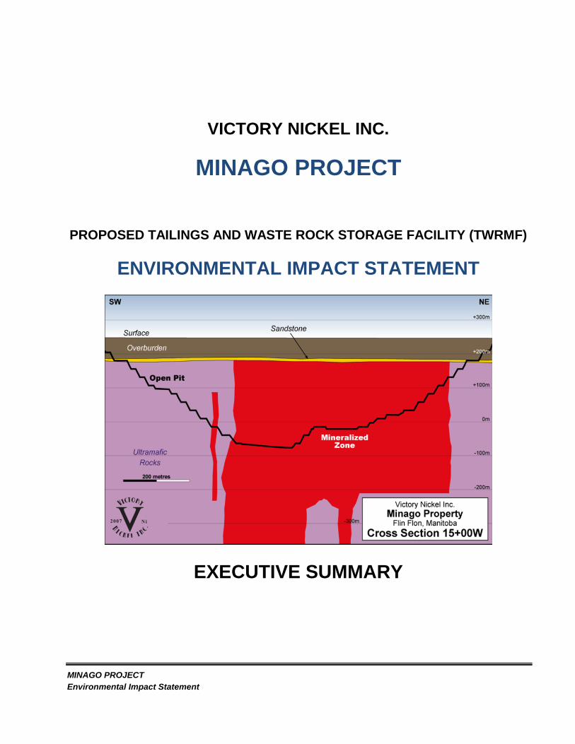
The proposed Minago Project in its entirety is an open pit mining project to produce nickel concentrate
and frac sand. Victory Nickel Inc. received an Environment Act License for the development of the
project as per the 2010 Environment Act Proposal (EAP)/ Environmental Impact Statement (EIS). The
Environment Act Proposal amongst other things includes an Environmental Impact Statement (EIS) for
the enitre project. Apart from the new location and size for the proposed TWRMF, the majority of the
parameters are similar to the 2010 EAP/EIS, as depicted in tha Table below In 2010, the Company
submitted an Environment Act Proposal that included an Environmental Impact Statement which lead
to the issuance of the Environment Act License (EAL) No. 2981. This EAP pertains to the amendment
of the EAL to include the proposed TWRMF.
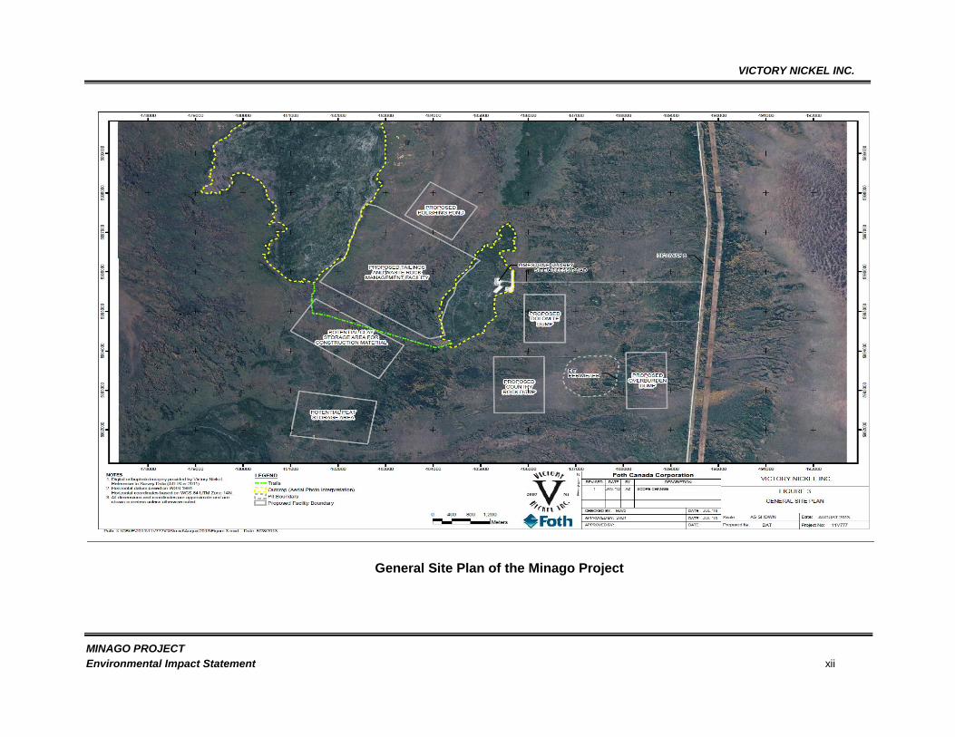
The exisiting TWRMF is lying over a potential ore deposit and as such the company resolved to
relocate the TWRMF to the west part of the property. The TWRMF is proposed to occupy a long,
narrow water saturated muskeg/peat wetland within some forested areas approximately four (4)
kilometres northwest of the proposed pit. This lowland extends approximately 8km from the southwest
to the northeast and is bound on the east and west by sub-parallel dolomite bedrock ridges,
approximately 2.5km apart as shown in the General Site Plan below. The proposed TWRMF structures
would be oriented between the ridges, and along the lowland. All controlled discharges from the
TWRMF will be directed to the Minago River. The proposed TWRMF is part of the Minago Project.
The relocation of the TWRMF to the proposed location is regarded as a major alteration to the
Environment Act License (EAL) and as such an amendment to the EAL No.2981 is required. The
proposed development, therefore, is subject to to the Manitoba Environment Act Review Process. The
proposed TWRMF will be located in the Minago River watershed for this EAP and for the 2010 EAP the
TWRMF was located in the Oakley Creek Watershed. Oakley Creek flows into William River which in
turn flows to the Limestone Bay into Lake Winnipeg. Limestone Bay is considered to be a very
sensitive fish habitat based on the comments raised during the 2010 consultations with the various
Communities of Interest (COI). Therefore, relocating the TWRMF to the Minago River watershed is
considered as a form of accommodation.
VICTORY NICKEL INC.
MINAGO PROJECT
Environmental Impact Statement ii
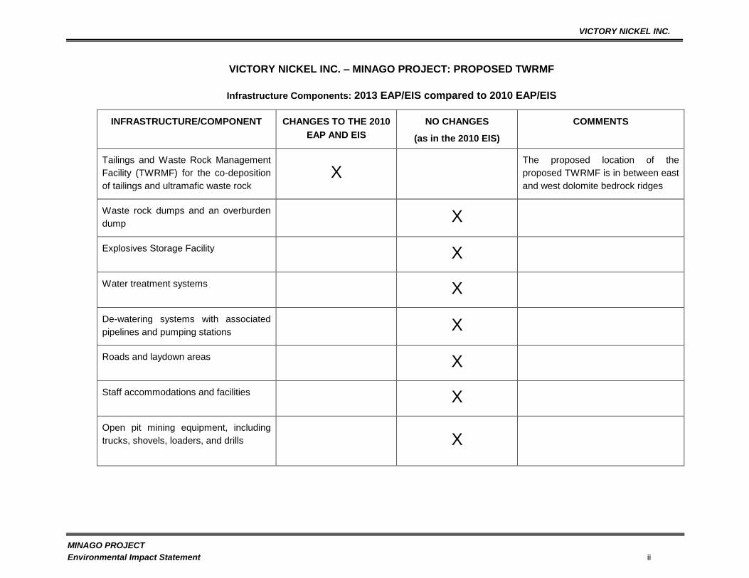
VICTORY NICKEL INC. – MINAGO PROJECT: PROPOSED TWRMF
Infrastructure Components: 2013 EAP/EIS compared to 2010 EAP/EIS
INFRASTRUCTURE/COMPONENT CHANGES TO THE 2010
EAP AND EIS
NO CHANGES
(as in the 2010 EIS)
COMMENTS
Tailings and Waste Rock Management
Facility (TWRMF) for the co-deposition
of tailings and ultramafic waste rock
X
The proposed location of the
proposed TWRMF is in between east
and west dolomite bedrock ridges
Waste rock dumps and an overburden
dump X
Explosives Storage Facility X
Water treatment systems X
De-watering systems with associated
pipelines and pumping stations X
Roads and laydown areas X
Staff accommodations and facilities X
Open pit mining equipment, including
trucks, shovels, loaders, and drills X
VICTORY NICKEL INC.
MINAGO PROJECT
Environmental Impact Statement iii
Infrastructure Components: 2013 EAP/EIS compared to 2010 EAP/EIS (cont'd)
INFRASTRUCTURE/COMPONENT CHANGE NO CHANGE
(as in the 2010 EIS)
COMMENTS
Truck repair and maintenance facilities X
Associated electrical and mechanical
systems X
Discharge system to Oakley Creek X No discharges to Oakley Creek
Discharge system to Minago River X 100% discharge to the Minago River
Processing Plant (PPT) X
PPT Input X
PPT Output X
PPT Reagents Type and Dosage X
PPT Location X
PPT Capacity X
10, 000+/day

VICTORY NICKEL INC.
MINAGO PROJECT
Environmental Impact Statement iv
Infrastructure Components: 2013 EAP/EIS compared to 2010 EAP/EIS (cont'd)
INFRASTRUCTURE/COMPONENT CHANGE NO CHANGE
(as in the 2010 EIS)
COMMENTS
Electrical Systems X
Overburden Removal X Mechanical Means vs. Dredging
Design Basis X The proposed TWRMF is designed
for 31 Mt of Nickel Ore compared to
25.4 Mt in the 2010 EAP/EIS
ARD Characterization Data X No Additional Data was used for
contaminant loading modelling
Ultramafic Rock Quality X 36 Mt for existing and proposed
Life of the Min-Mill Throughout X 31 Mt vs. 25.4 Mt
Anticipated Mine Life X 10 Years Vs. 7 Full Years and 2
Partial Years
Proposed TWRMF Site X To the new location
TWRMF Dam Height X Proposed TWRMF Dam Height: North
Dam = 13m with 2m freeboard, South
Dam = 8m with freeboard compared
to the TWRMF in the 2010 EAP/EIS
of 23m

VICTORY NICKEL INC.
MINAGO PROJECT
Environmental Impact Statement v
Infrastructure Components: 2013 EAP/EIS compared to 2010 EAP/EIS (cont'd)
INFRASTRUCTURE/COMPONENT CHANGE NO CHANGE
(as in the 2010 EIS)
COMMENTS
TWRMF Size (ha) X Proposed Area = 595ha; 2010
EAP/EIS TWRMF Area is 219.70 ha
Polishing Pond (PP) location X
PP Size (ha) X Proposed TWRMF = 120ha; 2010
EAP/EIS = 75 ha
TWRMF Decant Systems X Proposed systems for the TWRMF
mimic the original design as detailed
in the 2010 EAP/EIS
Polishing Pond (PP) Discharge Systems
to the Minago River X Same Systems
Number of engineered Dyke/Dams X Proposed TWRMF = 2; 2010 EAP/EIS
= 4
Note: the other two dykes for the
proposed TWRMF are natural ridges
Spillway Provisions X Same spillway provisions
VICTORY NICKEL INC.
MINAGO PROJECT
Environmental Impact Statement vi
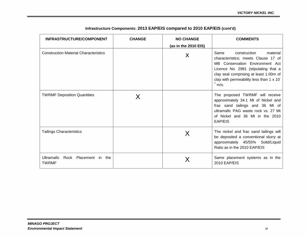
Infrastructure Components: 2013 EAP/EIS compared to 2010 EAP/EIS (cont'd)
INFRASTRUCTURE/COMPONENT CHANGE NO CHANGE
(as in the 2010 EIS)
COMMENTS
Construction Material Characteristics x Same construction material
characteristics; meets Clause 17 of
MB Conservation Environment Act
Licence No. 2981 (stipulating that a
clay seal comprising at least 1.00m of
clay with permeability less than 1 x 10-
7 m/s.
TWRMF Deposition Quantities X The proposed TWRMF will receive
approximately 34.1 Mt of Nickel and
frac sand tailings and 36 Mt of
ultramafic PAG waste rock vs. 27 Mt
of Nickel and 36 Mt in the 2010
EAP/EIS
Tailings Characteristics X The nickel and frac sand tailings will
be deposited a conventional slurry at
approximately 45/55% Solid/Liquid
Ratio as in the 2010 EAP/EIS
Ultramafic Rock Placement in the
TWRMF X Same placement systems as in the
2010 EAP/EIS
VICTORY NICKEL INC.
MINAGO PROJECT
Environmental Impact Statement vii
Infrastructure Components: 2013 EAP/EIS compared to 2010 EAP/EIS (cont'd)
INFRASTRUCTURE/COMPONENT CHANGE NO CHANGE
(as in the 2010 EIS)
COMMENTS
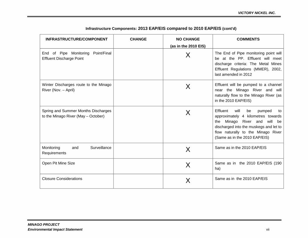
End of Pipe Monitoring Point/Final
Effluent Discharge Point X The End of Pipe monitoring point will
be at the PP. Effluent will meet
discharge criteria: The Metal Mines
Effluent Regulations (MMER), 2002,
last amended in 2012
Winter Discharges route to the Minago
River (Nov. – April) X Effluent will be pumped to a channel
near the Minago River and will
naturally flow to the Minago River (as
in the 2010 EAP/EIS)
Spring and Summer Months Discharges
to the Minago River (May – October) X Effluent will be pumped to
approximately 4 kilometres towards
the Minago River and will be
discharged into the muskegs and let to
flow naturally to the Minago River
(Same as in the 2010 EAP/EIS)
Monitoring and Surveillance
Requirements X Same as in the 2010 EAP/EIS
Open Pit Mine Size X Same as in the 2010 EAP/EIS (190
ha)
Closure Considerations X Same as in the 2010 EAP/EIS
VICTORY NICKEL INC.
MINAGO PROJECT
Environmental Impact Statement viii
Infrastructure Components: 2013 EAP/EIS compared to 2010 EAP/EIS (cont'd)
INFRASTRUCTURE/COMPONENT CHANGE NO CHANGE
(as in the 2010 EIS)
COMMENTS
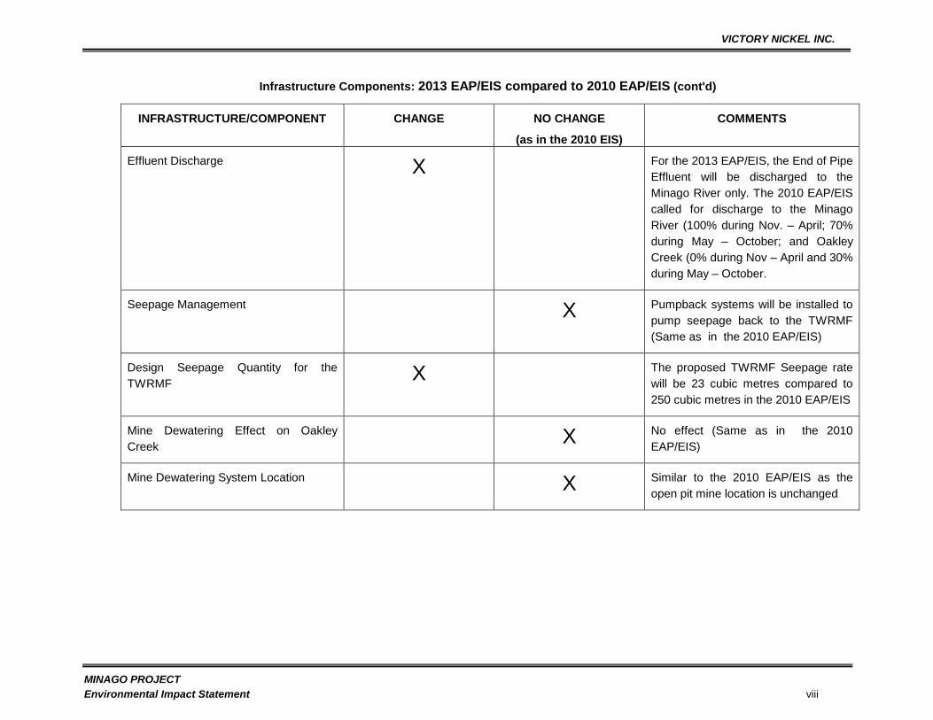
Effluent Discharge X For the 2013 EAP/EIS, the End of Pipe
Effluent will be discharged to the
Minago River only. The 2010 EAP/EIS
called for discharge to the Minago
River (100% during Nov. – April; 70%
during May – October; and Oakley
Creek (0% during Nov – April and 30%
during May – October.
Seepage Management X Pumpback systems will be installed to
pump seepage back to the TWRMF
(Same as in the 2010 EAP/EIS)
Design Seepage Quantity for the
TWRMF X The proposed TWRMF Seepage rate
will be 23 cubic metres compared to
250 cubic metres in the 2010 EAP/EIS
Mine Dewatering Effect on Oakley
Creek X No effect (Same as in the 2010
EAP/EIS)
Mine Dewatering System Location X Similar to the 2010 EAP/EIS as the
open pit mine location is unchanged
VICTORY NICKEL INC.
MINAGO PROJECT
Environmental Impact Statement ix
Infrastructure Components: 2013 EAP/EIS compared to 2010 EAP/EIS (cont'd)
INFRASTRUCTURE/COMPONENT CHANGE NO CHANGE
(as in the 2010 EIS)
COMMENTS
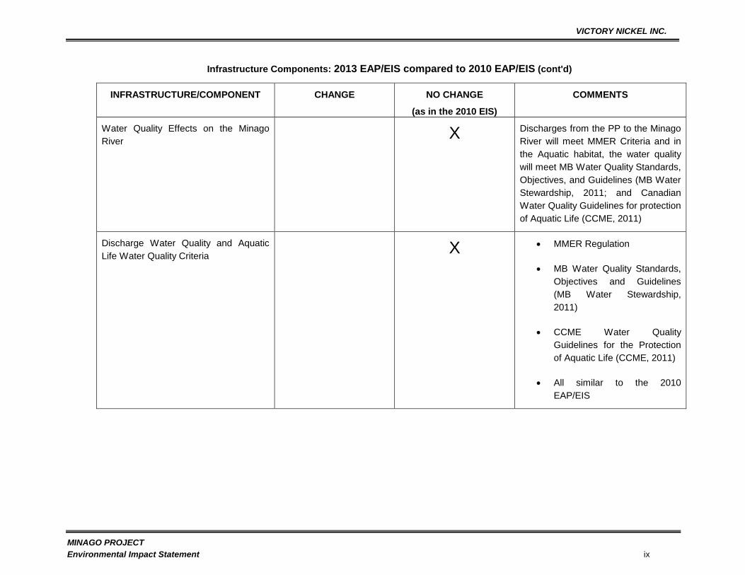
Water Quality Effects on the Minago
River X Discharges from the PP to the Minago
River will meet MMER Criteria and in
the Aquatic habitat, the water quality
will meet MB Water Quality Standards,
Objectives, and Guidelines (MB Water
Stewardship, 2011; and Canadian
Water Quality Guidelines for protection
of Aquatic Life (CCME, 2011)
Discharge Water Quality and Aquatic
Life Water Quality Criteria X MMER Regulation
MB Water Quality Standards,
Objectives and Guidelines
(MB Water Stewardship,
2011)
CCME Water Quality
Guidelines for the Protection
of Aquatic Life (CCME, 2011)
All similar to the 2010
EAP/EIS
VICTORY NICKEL INC.
MINAGO PROJECT
Environmental Impact Statement x
Infrastructure Components: 2013 EAP/EIS compared to 2010 EAP/EIS (cont'd)
INFRASTRUCTURE/COMPONENT CHANGE NO CHANGE
(as in the 2010 EIS)
COMMENTS
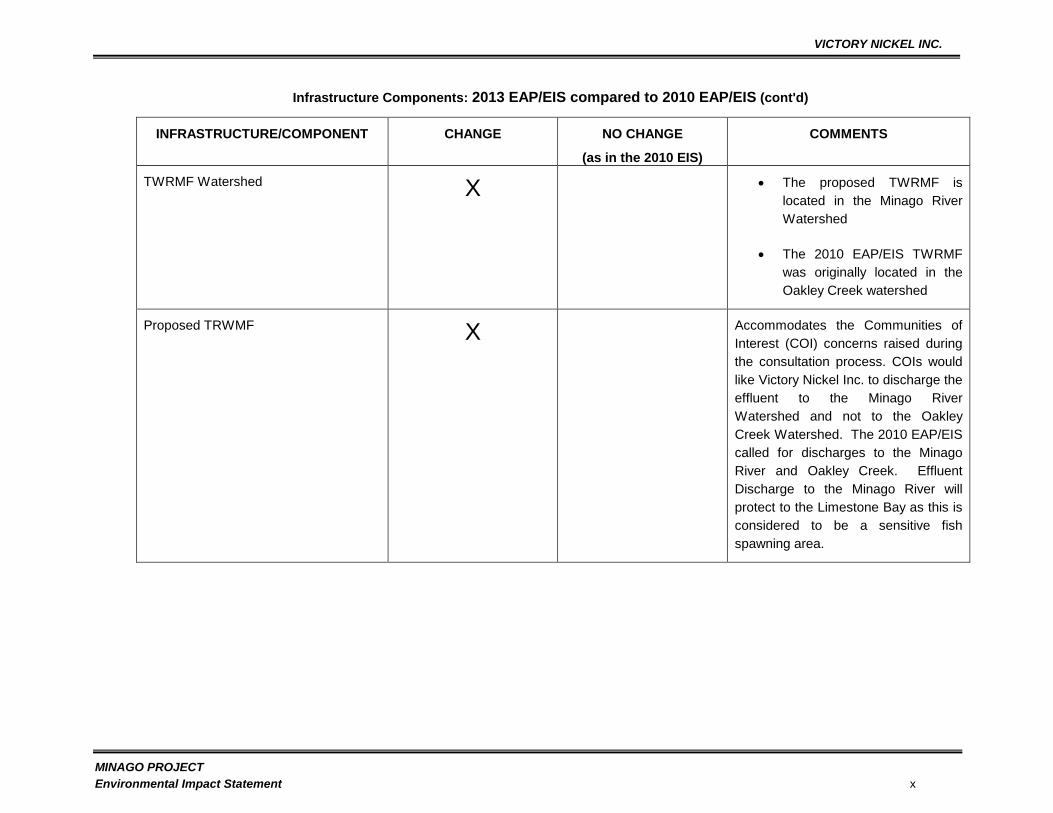
TWRMF Watershed X The proposed TWRMF is
located in the Minago River
Watershed
The 2010 EAP/EIS TWRMF
was originally located in the
Oakley Creek watershed
Proposed TRWMF X Accommodates the Communities of
Interest (COI) concerns raised during
the consultation process. COIs would
like Victory Nickel Inc. to discharge the
effluent to the Minago River
Watershed and not to the Oakley
Creek Watershed. The 2010 EAP/EIS
called for discharges to the Minago
River and Oakley Creek. Effluent
Discharge to the Minago River will
protect to the Limestone Bay as this is
considered to be a sensitive fish
spawning area.

VICTORY NICKEL INC.
MINAGO PROJECT
Environmental Impact Statement
xi
The exisiting TWRMF is lying over a potential ore deposit and as such the company resolved to
relocate the TWRMF to the west part of the property. The TWRMF is proposed to occupy a long,
narrow water saturated muskeg/peat wetland within some forested areas approximately four (4)
kilometres northwest of the proposed pit. This lowland extends approximately 8km from the
southwest to the northeast and is bound on the east and west by sub-parallel dolomite bedrock
ridges, approximately 2.5km apart as shown in the General Site Plan e below. The proposed
TWRMF structures would be oriented between the ridges, and along the lowland. All controlled
discharges from the TWRMF will be directed to the Minago River. The proposed TWRMF is part
of the Minago Project. The relocation of the TWRMF to the proposed location is regarded as a
major alteration to the Environment Act License (EAL) and as such an amendment to the EAL
No.2981 is required. The proposed development, therefore, is subject to to the Manitoba
Environment Act Review Process. The proposed TWRMF will be located in the Minago River
watershed for this EAP and for the 2010 EAP the TWRMF was located in the Oakley Creek
Watershed. Oakley Creek flows into William River which in turn flows to the Limestone Bay into
Lake Winnipeg. Limestone Bay is considered to be a very sensitive fish habitat based on the
comments raised during the 2010 consultations with the various Communities of Interest (COI).
Therefore, relocating the TWRMF to the Minago River watershed is considered as a form of
accommodation.
VICTORY NICKEL INC.
MINAGO PROJECT
Environmental Impact Statement xii
General Site Plan of the Minago Project

VICTORY NICKEL INC.
MINAGO PROJECT
Environmental Impact Statement
xiii
The Minago Property (Property) is located in Manitoba‟s Thompson Nickel belt on Highway 6,
approximately 225 km south of Thompson, Manitoba, Canada. The site is located within the
Nelson River sub-basin, which drains northeast into the southern end of the Hudson Bay. The
basin has two more catchments in the Minago River and the Hargrave River, which enclose the
project site. There are two more tributaries, the William River and the Oakley Creek present at
the periphery of the project area. The catchments of these two tributaries are within the Lake
Winnipeg basin and drain northward into the Nelson River sub-basin. The proposed TWRMF
drainage profile and topograpghy are shown in the figure below (Site Topography and Drainage)

VICTORY NICKEL INC.
MINAGO PROJECT
Environmental Impact Statement
xiv
Site Topography and Drainage
VICTORY NICKEL INC.
MINAGO PROJECT
Environmental Impact Statement
xv
The mine site is situated within a topographically low area of water-saturated peat and forest
terrain. The area is almost entirely swampy muskeg with vegetation consisting of sparse black
spruce and tamarack set in a topographic relief of less than 3 m. Although this low area extends
for significant distances to the north and east, elevated limestone outcrops exist to the south and
west at a distance of 7 to 20 km from the site.
The Minago Project is within the Norway House Cree Nation. Traditional use of the project area is
within Treaty 5.
Victory Nickel Inc. (VNI) has a 100% interest in the mineral claims that comprise the Minago
Project.
The deposit has potential as a large tonnage, low-grade nickel sulphide deposit (31 Mt at 0.43%
nickel (Ni), 0.20% cut-off grade) and contains 14.8 Mt million tons of marketable frac sand. In the
2010 EAP/EIS, the tonnage was 25.4 Mt. The potential of the Property is supported by a recent
metallurgical test program, where very high grade nickel concentrate was produced. The
excellent recoveries for the ore from the open pit mine are substantiated by historical and current
metallurgical testing data.
In addition to the nickel ore concentrating plant, the installation of a frac sand processing plant will
generate further revenues for the project. The financial analysis assumes that critical revenue
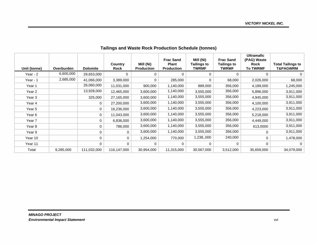
streams will be developed from both the nickel and frac sand resources. The proposed
production schedule by year, for the waste, the nickel ore and the sand is given in the Table
below.
VICTORY NICKEL INC.
MINAGO PROJECT
Environmental Impact Statement xvi
Tailings and Waste Rock Production Schedule (tonnes)
Unit (tonne) Overburden Dolomite
Country
Rock
Mill (Ni)
Production
Frac Sand
Plant
Production
Mill (Ni)
Tailings to
TWRMF
Frac Sand
Tailings to
TWRMF
Ultramafic
(PAG) Waste
Rock
To TWRMF
Total Tailings to
T&PAGWRM
Year - 2 6,600,000 29,653,000 0 0 0 0 0 0 0
Year - 1 2,685,000 41,066,000 3,389,000 0 285,000 0 68,000 2,026,000 68,000
Year 1 26,060,000 11,031,000 900,000 1,140,000 889,000 356,000 4,189,000 1,245,000
Year 2 13,928,000 12,465,000 3,600,000 1,140,000 3,555,000 356,000 5,896,000 3,911,000
Year 3 325,000 27,165,000 3,600,000 1,140,000 3,555,000 356,000 4,945,000 3,911,000
Year 4 0 27,200,000 3,600,000 1,140,000 3,555,000 356,000 4,100,000 3,911,000
Year 5 0 16,236,000 3,600,000 1,140,000 3,555,000 356,000 4,223,000 3,911,000
Year 6 0 11,043,000 3,600,000 1,140,000 3,555,000 356,000 5,218,000 3,911,000
Year 7 0 6,836,000 3,600,000 1,140,000 3,555,000 356,000 4,449,000 3,911,000
Year 8 0 786,000 3,600,000 1,140,000 3,555,000 356,000 613,0000 3,911,000
Year 9 0 0 3,600,000 1,140,000 3,555,000 356,000 0 3,911,000
Year 10 0 0 1,254,000 770,000 1,238,,000 240,000 0 1,478,000
Year 11 0 0 0 0 0 0 0 0
Total 9,285,000 111,032,000 116,147,000 30,954,000 11,315,000 30,567,000 3,512,000 35,659,000 34,079,000
VICTORY NICKEL INC.
MINAGO PROJECT
Environmental Impact Statement
xvii
In the 2010 EAP/EIS, the mine life was estimated to be seven full years and two partial years, with
concentrate production mirroring ore production. In the 2013 EAP/EIS, the mine life is estimated
to be 10 years. The frac sand which is to be mined at the start of mining is produced throughout
the life of the mine and beyond. The first partial year‟s ore production (Year 1) will be processed
pending commissioning of the ore processing plant in Year 1.
The Project features an open pit bulk tonnage mining method, a 3.6 Mt/a nickel ore processing
plant, and 1.5 Mt/a sand processing plant producing various sand products, including 20/40 and
40/70 frac sand, and other finer sized sands. The frac sand mined in Year -2 will be stockpiled
until the frac sand plant is commissioned. The Project will be built over a three year period at a
capital cost of $596.3 million. The nickel ore processing plant is scheduled to come online in the
spring of Year 1 and the frac sand plant to come online in the spring of Year -1.
VNI is committed to the development of an environmentally and socially responsible project, that
optimizes benefits to Manitoba and its people. In order to reduce project-related effects, the
Minago Project has (including the TWRMF, open pit mine, processing plant and all related project
components) been designed to minimize the geographic extent of disturbance and for eventual
permanent, passive closure. The site will be reclaimed in accordance with site-specific criteria in
a planned and timely manner.
The Minago mine site is favorably located close to existing infrastructure, including Manitoba
Provincial Highway 6, a 230 kV high voltage transmission line running directly beside Highway 6
on the east side of the road, the OmniTRAX Canada Railway Line, and the town of Grand Rapids.
The major components of the proposed Minago Project are as follows. The proposed Project will
comprise an open pit mine, an ore concentrating plant, a frac sand plant, and supporting
infrastructure. The supporting infrastructure will be comprised of:
a tailings management facility for the co-deposition of tailings and ultramafic rock or
tailings and waste rock management facility (TWRMF);
Polishing Pond (PP) considered as part of the TWRMF;
waste rock dumps and overburden dump;
an explosives storage facility;
water treatment facilities;
de-watering systems with associated pipelines and pumping stations;
roads and laydown areas;
staff accommodations for 300 people and facilities;
open pit mining equipment, including trucks, shovels, loaders, and drills;
VICTORY NICKEL INC.
MINAGO PROJECT
Environmental Impact Statement
xviii
truck repair and maintenance facilities; and
associated electrical and mechanical systems.
All major components (open pit mine, ore processing plant, frac sand, processing plant and
supporting infrastructure with the excepyion of the proposed TWRMF are permitted under the EAL
No. 2981. All these including the proposed TWRMF are located in the Local Study Area (LSA) as
presented in the 2010 EAP/EIS.
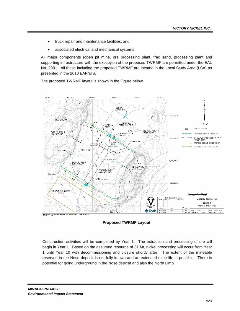
The proposed TWRMF layout is shown in the Figure below.
Proposed TWRMF Layout
Construction activities will be completed by Year 1. The extraction and processing of ore will
begin in Year 1. Based on the assumed resource of 31 Mt, nickel processing will occur from Year
1 until Year 10 with decommissioning and closure shortly after. The extent of the mineable
reserves in the Nose deposit is not fully known and an extended mine life is possible. There is
potential for going underground in the Nose deposit and also the North Limb.

VICTORY NICKEL INC.
MINAGO PROJECT
Environmental Impact Statement
xix
Process water will be reclaimed from the Polishing Pond (PP) and recycled for use in the process
plant. The Polishing Pond will operate in a water surplus requiring daily release of effluent into the
receiving environment. Based on the water balance and contaminant loading assessment, there
will be no Contaminants of Concern (CoC). The effluent meeting MMER Guidelines will be
pumped on a controlled basis into the Minago River. During closure, the pit will be flooded and
the effluent from the Polishing Pond will be discharged to the Minago River. The water quality
downstream from the mixing zones for both the Minago River and Oakley Creek will be monitored
and assessed using CCME and Manitoba Guidelines for the Protection of Aquatic Life.
This EIS addresses the information requirements laid out in the Environment Act Proposal (EAP)
Guidelines prepared by the Manitoba Conservation (2009).
ARCHAELOGICAL AND BIOPHYSICAL ASPECTS
From 2006 to 2011, four consecutive Environmental Baseline Studies (EBS) including
archaeological assessments were performed on Victory Nickel‟s Minago Property including the
proposed TWRMF area. The objective of the EBS was to determine the state of the area prior to
the realization of the project and to identify biophysical elements that should be monitored in order
to ensure an adequate environmental protection. Field campaigns were therefore performed to:
Assess background surface water, groundwater, soil and sediment quality;
Determine the baseline hydrological conditions prevailing within the Oakley Creek and the
Minago River;
Characterize fish and benthic invertebrates communities as well as their habitats;
Map and describe the main plant communities observed on the Property;
List and describe the habitat requirements of the wildlife species encountered as part of
the field program and those who potentially inhabit the area.
Additional information was gathered using existing databases and a weather station was also
installed to provide site-specific data. Moreover, geotechnical and hydrogeological studies were
performed. The EBS included water quality assessment, hydrology, hydrogeology, sediments,
benthos, fisheries, vegetation, wildlife surveys, soil characterization, geochemical characterization,
archaeological impact assessment, geotechnical investigations and social-economic assessment.
The vegetation, wildlife surveys, archaeological assessment, soil and geotechnical investigations
covered the Minago Project including the proposed TWRMF. The proposed TWRMF is located
within the Local Study Area (LSA) as described in the 2010 EAP/EIS. The results of these studies
together with the potential project effects are given in the next sections.
Archeological Impact Assessment
An archaeological impact assessment of the proposed Minago Project development area was
conducted in 2007. The area is located at a considerable distance from lakes or navigable rivers
VICTORY NICKEL INC.
MINAGO PROJECT
Environmental Impact Statement
xx
and access at any time of the year would be very difficult. Any use of this location that may have
occurred would have been during the winter months and most likely related to the fur trade. It
would be impossible to predict where such activity occured as traplines are relocated every year to
accommodate animal movement. Even if resources from this activity were present, they would be
buried deep in the sphagnum moss that covers the area thus making them impossible to locate.
Comprehensive testing in such conditions would prove nearly impossible and the odds of finding
anything using such a technique would be practical.
The Historic Resources Branch of the government of Manitoba reviewed the final report under
Permit A40-08 – Archaeological Impact Assessment of the Minago Mining site and accepted the
report as a fulfillment of the conditions outlined in the permit and have no further concerns or
recommendations. The Historic Resources Branch gave clearance to Victory Nickel Inc. to
proceed with the project as based on the field investigations; no residual adverse project effects
on heritage resources are anticipated. Studies consisting of conventional surificial examination
and subsurface testing were completed at VNI identified areas of potential disturbance.
Outstanding activities at this time consist of consultation with the Communities of Interest (COI)
and input of traditional use information. On the basis of the field investigation the likelihood that
there will be no effects on heritage resources is certain.
Overall, the archaeological field investigations determined that archaeological potential of the
Minago area is extremely low and it is highly improbable that the area was used by inhabitants
prior to the introduction of the fur trade. The possibility of finding any evidence of pre-contact
utilization of the area is next to impossible and likelihood of locating any evidence of Fur Trade or
later use, other than prospecting and mining activities is extremely minimal. Existing information
on First Nations land use, water use, fish and terrestrial wildlife use was reviewed and compiled to
assist in the identification and mitigation of the potential impacts from the project. VNI will not
compromise any aspects of traditional knowledge during any project phases.
Climatic Assessments
Based on the data provided by regional weather stations, the average mean annual temperature
was -0.4 ºC for the 1950 to 2008 period. The coldest and warmest months are January (-21.5 ºC)
and July (17.6 ºC), respectively. Sub-zero temperatures are observed from late October to late
April. The estimated mean annual rainfall, snowfall (water equivalent) and total precipitation for
the Minago Project Area from 1968 to 2008 are 375, 139 and 514 mm, respectively.
Air Quality Assessment
Based on air quality results compiled by Manitoba Conservation over the entire Province,
measurements were respecting all guideline limits, except for ozone, particulate matter and
sulphur dioxide. However, recent measurements performed at the Riverside station in
Thompson, where a larger nickel mining site exists, proved to all respect guideline limits. It is
important to note that the proposed mine development at Minago is smaller than the current
residential and mining related development at Thompson, and therefore air quality measured
there is expected to be lower than is expected for the Minago Project. Still, in order to minimize

VICTORY NICKEL INC.
MINAGO PROJECT
Environmental Impact Statement
xxi
the potential effects of the project on the local and regional air quality, dust suppressant will be
applied to minimize fugitive dust during periods of heavy activity and/or dry periods, activities that
generate large quantities of fugitive dust will be minimized when windy, disturbed areas and
topsoil stockpiles will be reseeded to prevent fugitive dust from wind erosion, waste heat from the
generators will be recovered to heat the process building, assay lab and camp, low sulphur fuels
including diesel fuel with a sulphur content of 15 ppm and propane with negligible sulphur content
will be used, prohibited materials (waste oil, tires) as accelerants will not be used, and applicable
criteria with respect to emission quality on all combustion-related equipment will be respected and
maintenance will be provided according to manufactures specifications.
Terrain and Surficial Assessment
Terrain, surficial materials and soil conditions were compiled, interpreted and supplemented with
field geotechnical investigation programs. The stratigraphic column is essentially composed of a
Quaternary surface cover over an Ordovician dolomitic limestone. The Quaternary surface cover
typically comprises up to 4 m of peat/muskeg that is generally underlain by up to 20 m of low
permeability glacial lacustrine clays. On the other hand, the dolomitic limestone is fine grained,
massive to stratified and varies in colour from creamy white to tan brown to bluish grey. Dolomite
thickness ranges from 42 to 62 m with thickness increasing southward. Approximately 95% of the
project area was classified as „stable‟. The site terrain is low and there are no signs of steep gully
side walls and no side wall slumps. Moreover, ninety-five percent (95%) of the project area was
rated as having a low erosion potential due to the occurrence of low terrain throughout the project
area.
The TWRMF is proposed to occupy a long, narrow water-saturated muskeg/peat wetland with
some forested areas approximately four (4) km northwest of the proposed pit. This lowland
extends approximately 8 km from the southwest to the northeast and is bound on the east and
west by sub-parallel dolomite bedrock ridges, approximately 2.5 km apart. The ridges rise nearly
20 meters above the wetland valley that slopes gently at approximately 0.2% but consistently to
the north-northeast. The proposed TWRMF structures would be oriented between the ridges, and
along the lowland. To make full advantage of the valley, the design of the containment dams has
been integrated with the dolomite bluffs on either side.
To minimize the potential effects of the project on terrain, surficial material and soils, several
mitigation measures will be implemented such as Erosion and Sediment Control Plan and a Site
Water Management Plan. Moreover, among other measures, site clearing will be minimized
during all project phases and timed to minimize soil compaction while all cleared sites will be
cleaned and progressively revegetated with appropriate plant species when no longer use.
Hydrology
The Minago Project Site is located within the Nelson River sub-basin, which drains northeast into
the southern end of the Hudson Bay. The Minago River and Hargrave River catchments,
surrounding the Minago Project Site to the north, occur within the Nelson River sub-basin. The
William River and Oakley Creek catchments at or surrounding the Minago Project Site to the
VICTORY NICKEL INC.
MINAGO PROJECT
Environmental Impact Statement
xxii
south, occur within the Lake Winnipeg sub-basin, which flows northward into the Nelson River
sub-basin. Along with baseline data collected as part of 2006, 2007 and 2008 EBS, regional
hydrometric stations were used to complete the hydrological characterization of the project area.
Flows were then calculated for three periods of time, the spring freshet, which occurs in May, the
summer period, from June to October, and the winter period, from November to April. Flows in
the Minago River were estimated to be 10, 1.9 and 0.8 m³/s in May, during summer and during
winter, respectively. In the Oakley Creek, flows were estimated to be 4, 0.5, and 0 m³/s (frozen
solid) in May, during the summer period and during the winter period, respectively. The main
project effect on surface water hydrology is linked with increased flows in the Minago River due to
Polishing Pond discharges. To mitigate that effect, a Site Water Management Plan will be
implemented as well as an adaptative monitoring program to monitor the effects of the final
effluent on the receiving watercourses.
Water Quality
Overall, the water quality was good in the vicinity of the Minago Project with only some parameters
exceeding Manitoba and/or CCME (Canadian Council of Ministers of the Environment) limits for
the protection of freshwater aquatic life. The most common exceedances of Manitoba water
quality guidelines occurred for aluminum and iron followed by nitrite-N, copper, total dissolved
solids and selenium and silver. According to data gathered as part of the 2006, 2007, 2008 and
2011, EBS, overall, sediments presented low metal content, exception made of chromium which
showed natural moderately high values. Project effects on surface water and sediment quality are
associated with Polishing Pond discharges into Minago River. A Site Water Management Plan
and an Erosion and Sediment Control Plan will therefore be implemented to mitigate those effects
and MMER, CCME and Manitoba Guidelines (Manitoba Water Stewardship, 2011 and CCME,
2011) will be respected during all project phases. Adaptative management measures will also be
implemented.
Hydrogeology
With the Minago deposit situated under muskeg, the Ordovician dolomite and under the
Winnipeg Formation sandstones, the open pit will require dewatering to enable mining.
Therefore, a hydrogeological study was performed to determine the underground flow regime and
hydraulic conductivity of the various geological units that will be affected by mining. Preliminary
pumping tests indicated that the peat and clay were water bearing but at very low yields and low
hydraulic conductivity and thus of limited groundwater producing potential. The Ordovician
limestone and sandstone, however, were found to have significant groundwater producing
potential. The principle stratigraphic units were overburden (peat and clay; OB), shallow
limestone (SLS), limestone (LS), sandstone (SS), and granite (GR). Limestone at Minago is 55 m
(180 ft) thick and consists of shallow limestone with an upper zone of water bearing fractures (up
to 40 m depth) and deep limestone underlying this zone. Underlying the limestone is
approximately 10 m (30 ft) of sandstone, followed by some shale and weathered granite of the
Precambrian Shield. Groundwater quality results compiled from 2006 to 2008 showed to respect
all guideline limits, except in some few cases (total iron, total aluminum, dissolved zinc, turbidity,
dissolved oxygen, iron II and fluoride). The influence of significant hydrogeologic (recharge or

VICTORY NICKEL INC.
MINAGO PROJECT
Environmental Impact Statement
xxiii
zero-flux) boundaries were not identified in the hydraulic response to pumping during the pumping
test program. This is likely because of the distance to the nearest surface water body in contact
with the limestone aquifer (i.e., the Minago River is approximately 10 km from the dewatering
wells) and the limited duration of the pumping test. Oakley Creek, located approximately 1 km
south of the dewatering wells is likely not in direct contact with the limestone aquifer (i.e., its bed
lies in the overburden); therefore, it was not observed to act as a significant hydrogeologic
boundary. Under pre-pumping conditions, the Minago River may be an area of groundwater
discharge. Under sustained groundwater pumping conditions, this river could convert to a source
of groundwater recharge to the limestone aquifer. Limestone outcrops 2 km northwest and 9 km
south of the Site are likely areas where recharge to the limestone aquifer occurs through net
infiltration of precipitation. The overburden was not significantly affected by pumping during the
pumping test, except in the near vicinity (approximately 30 m) of the North Pit Wall zone (HG-7).
A more detailed scope of the hydrogeological programs is described in the 2010 EAP/EIS.
The preliminary hydrogeological program, conducted in 2007, was followed by a comprehensive
hydrogeological characterization of the site in the summer of 2008. The comprehensive
hydrogeological program involved the pumping of four high capacity dewatering wells located
along the perimeter of the proposed open pit mine and monitoring the hydrogeologic response in
these wells and in 24 observation wells. Long-term pumping tests were conducted to lower the
hydraulic heads within the limestone (LS) unit significantly below the limestone-overburden
contact (i.e. allow its conversion from a confined to an unconfined aquifer). Results of the long
duration pumping test program were used to develop a conceptual hydrogeological model of the
Site and a groundwater flow model of the proposed open pit area. The primary focus of the
hydrogeological study was to estimate the configuration of the dewatering well system required for
the operation of the proposed mine pit; to estimate the total required pumping rate for dewatering;
and to estimate the extent of the drawdown cone created during open pit mining. The
hydrogeological study concluded that a total of 12 dewatering wells completed in both the
limestone and sandstone aquifers, at distances of approximately 300 m to 400 m along the crest
of the ultimate pit, will be required to operate simultaneously. The total quantity of groundwater
likely to be generated by these wells is 40,000 m³/day (7,300 USgpm). The average pumping rate
for an individual well is estimated to be 3,300 m³/day (600 USgpm).
Project effects on groundwater are essentially associated with pit dewatering potentially resulting
in groundwater table depression. However, the hydrogeological results have shown that there is
no connection between the Oakley Creek and the underlying limestone and sandstone aquifers,
no effects are expected. Still, based on follow up studies of effects of reduced low flows on fish
habitat, options to reduce groundwater pumping or return more water from the dewatering wells to
Oakley Creek will be evaluated. However, based on the existing information derived from the
hydrogeological investigation, there will be no negative impacts on the Oakley Creek.
Benthic Community Assessment
Overall, analytical results showed that benthic invertebrate communities significantly differ from
one sampling site to another. However, from 2006 to 2008, the same five phyla were dominating
the samples, namely, Sphaeriidae, Chironomidae, Ephemeridae, Tubificidae and Daphniidae.

VICTORY NICKEL INC.
MINAGO PROJECT
Environmental Impact Statement
xxiv
Project effects on benthic communities in Oakley Creek and the Minago River are associated with
Polishing Pond discharges (metals, TSS) and increased benthic productivity in Oakley Creek and
the Minago River from nitrate and ammonia in effluent discharges. To mitigate those potential
effects, a Site Water Management Plan will be implemented and the final effluent will respect
MMER, CCME and Manitoba Guidelines for the Protection of Aquatic Life. Along with monitoring
programs (surface water and sediment quality), an EEM program will be conducted on a 3-year
cycle based on the approved EEM methods.
Fisheries
Overall, three rivers and three lakes were fished as part of the 2006, 2007,2008 and 2011 EBS,
namely the Minago River, the Oakley Creek, the William River, the Hill Lake, the Cross Lake and
the Limestone Bay of Lake Winnipeg. The aim of the fishing and habitat characterization
campaigns was to determine if all the water bodies contained fish and could be considered as fish
habitat. All of them definitely constitute a fish habitat, mostly for Cyprinidae. Two species of
fishing interest for local communities feed and spawn within the area, namely northern pike and
walleye, but have not been observed upstream Highway 6 in both the Oakley Creek and the
Minago River. Mercury concentration in fish flesh varied from 0.06 mg/kg to 1.6 mg/kg, depending
on fish length and type of diet. Four out of twenty (20 %) fishes had mercury concentrations higher
than the Canadian Food Inspection Agency‟s criteria (0.5 mg/kg), with an average concentration
under this criterion (0.38 mg/kg). Fish species which showed higher mercury concentrations were
essentially large northern pike or walleye fished in Hill Lake. No streams or riparian habitats are
located within the boundaries of the mining site and the proposed TWRMF and there are no
culverts or stream crossing contemplated for the Minago Project. Therefore, project effects on
fisheries are essentially associated with potential erosion during site clearing and Polishing Pond
discharge. Therefore, mitigation measures depicted above with regards to effects on surface
water quality will also be used to mitigate effects on fisheries.
Vegetation
Due to a regional gentle relief, large treed bogs are often observed within the Minago Property
area, covering up to 30 % of the regional landscape and representing, both spatially and
ecologically, one of the most important ecosystems in the area. Black spruce is by far the most
abundant vascular species, especially in badly drained environments where it creates the
Sphagnum-spruce forest. This species is also abundant on better drained soils with the jack pine,
a species which is frequently dominating xeric environments. Sites that are well drained consist
mostly of low-elevated plateaus (above 265 m a.s.l.) covered by limestone, tills and fluvio-glacial
sands. These plateaus are usually colonized by the open conifer forest. However, none of the
areas potentially impacted by the Minago Project are located on such plateaus, but are all covered
with Sphagnum-spruce stands sand treed bogs colonizing depressions filled with marine clay and
silt, being covered by peat deposit (up to 4 m thick). Therefore, overall, the Project area contains
vegetation consisting of mostly evergreen trees (primarily black spruce and tamarack) of
intermediate (>3-15 m) to dwarf (3 m) heights. There is a relatively low level of vegetative
biodiversity and without any there are not any vegetation types unique to the area or region. No
rare, threatened, or endangered plant species were found. Projects effects on vegetation are
VICTORY NICKEL INC.
MINAGO PROJECT
Environmental Impact Statement
xxv
linked with site clearing (about 1,300 ha) and to mitigate those effects, an Erosion and Sediment
Control Plan as well as a progressive Site Reclamation Plan (as areas are abandoned and
revegetated) will be implemented.
Wildlife
Among the several wildlife species which are likely to occur in the area, including birds, mammals,
reptiles and amphibians, none has a special status under provincial and/or federal legislations,
with the exception of the woodland caribou. A list of species potentially occurring in the Minago
project Area was completed and it includes 136 birds, 39 mammals, 6 amphibians and 1 reptile.
Among those, 45 birds, 17 mammals, 4 amphibians and 1 reptile were observed during field
campaigns. A low density of furbearers was observed on the Project Site even if many beaver
dams were observed. The Grand Rapids region is well-known for its caves and bat hibernacula;
however, the nearest from the Project Site is located 16 km away. Valued Ecosystem and
Cultural Components (VECCs) were determined for the present assessment and include the
woodland caribou, the moose, which is the only ungulate to have been observed in the Minago
Project Area, the black bear, the beaver, the American Marten, the lynx and the song bird
community. Project effects on those VECCs are essentially associated with 1) increased mortality
risk from collisions, hunting and poaching, 2) disruption to movement patterns from sensory
disturbance, habitat fragmentation or Transportation Corridors, and 3) reduction to seasonal
habitat availability from Transportation Corridors. To mitigate those effects, measures such as
implementing a Wildlife Protection Plan and a Site Waste Management Plan will be put in force.
Moreover, for the entire duration of the project, incidents with problem wildlife and vehicle
collisions will be reported and recorded, as well as black bear signs in and around the mining site.
Some of the aspects of the wildlife management and mitigation measure include the following:
Firearms will not be permitted.
Hunting and fishing will be prohibited at all times on or in the vicinity of the project site.
This restriction will apply to all mine employees, supervisors, managers and contractors. It
will be in effect throughout the life of the project from construction through to closure and
reclamation. Infringement of this policy is to be reported.
Maximum speed limit on all access roads will be set at 60 km/hr.
Any observed wildlife corridors will be signed to alert drivers to potential wildlife crossings.
Any mortality on the access road will be recorded and reported and any modifications to
the mitigation measures will be considered in consultation with Manitoba Conservation, as
required.
Based on the effectiveness of these mitigation measures, effects of the access road on wildlife
mortality during construction, operations and decommissioning are expected to be of low
magnitude and not significant.
VICTORY NICKEL INC.
MINAGO PROJECT
Environmental Impact Statement
xxvi
SOCIAL-ECONOMIC CONTEXT
As part of the environmental impact assessment of the Minago Project, Victory Nickel
Inc.conducted a socio-economic assessment of the neighbouring communities. A series of
meetings and interviews were held with a wide range of key stakeholders to identify their views
and opinions with respect to the Minago Project. The stakeholders included Norway House Cree
Nation (NHCN) and Norway House Community (NHC); Grand Rapids Cree Nation (GRCN) and
Grand Rapids Community (GRC); Cross Lake Band of Indians (CLBI) and Cross Lake Community
(CLC); Moose Lake Cree Nation (MLCN) and Moose Lake Community (MLC); Snow Lake;
Manitoba Métis Federation (MMF); Trapline Owners (TLO); Norway House Resource
Management Board (NHRMB) and Government Agencies. Consultations, community
engagements, and small group and open house meetings were held in the individual
communities. Also, Victory Nickel has signed a Memorandum of Understanding (MoU) with Cross
Lake, Moose Lake and Grand Rapids First Nations‟ Bands. The communities to the Minago
Property include Grand Rapids (GR), Moose Lake (ML), Cross Lake (CL), Snow Lake (SL) and
Norway House (NH). Each community has its own governing infrastructure usually collectively
known as the First Nations in the Northern Region of Manitoba.
The objectives of the Socio-Economic Assessment (SEA) for the Minago Project were to:
Introduce the major components of the Minago Project to a wide range of key
stakeholders.
Inform communities and stakeholders of potential impacts and their relative magnitude on
the communities‟ social and economic well-being.
Provide an opportunity for the integration of diverse community values into the decision
making process for the mine development.
To understand the concerns of the communities and stakeholders to develop potential
mitigative measures that are practical and cost effective.
To provide information for addressing the potential impacts of the Minago Project on the
socio-economic resources of the communities.
The Socio-Economic Assessment examined how the proposed mining project would change the
lives of current and future residents of the surrounding communities socially and economically.
The indicators used to measure the potential social-economic impacts include aspects such as
demographic composition, social well-being, business and services evaluation, occupational skills
availability and capacity gap analysis, public services, and community social structure.
Overall, the issues raised by the Communities of Interest (COI) were positive. However, it should
be noted that there is considerable resentment to development in the area due to adverse past
experience with some companies. Many stakeholders who were aware of the Minago Project and
Victory Nickel Inc. were appreciative of the company‟s consultation process. The COI were
VICTORY NICKEL INC.
MINAGO PROJECT
Environmental Impact Statement
xxvii
interested in potential employment and business opportunities that the Minago Project might bring
to the communities. The other concerns that were brought to Victory Nickel include potential
environmental degradation and social problems that the Project might bring to the communities.
The Minago Feasibility Study has addressed these concerns by incorporating robust
environmental protection measures to minimize exposure.
The various meetings with government agencies, the public, First Nations and Métis consultation
and community engagements on various aspects of the Minago Project occurred during the past
three years (2007-2009). The issues raised by each of these groups during this process have
been documented and are summarized in the Study.
Project Community Engagement and Consultations
The Project is located in the Norway House Resource Management Area. Neighbouring
communities to the Minago Property include Grand Rapids (GR), Moose Lake (ML), Cross Lake
(CL), Snow Lake (SL) and Norway House (NH). With the exception of Snow Lake the other for
communities are members of Treaty 5. The communities outside Treaty 5 have their own
community councils and mayors. The First Nations have their own governing infrastructure
usually collectively known as the First Nations in the Northern Region of Manitoba. Victory Nickel
together with their consultants held a series of meetings and interviews throughout 2007 and 2008
with a wide range of key stakeholders to identify their views and opinions with respect to the
Minago Project. The stakeholders included Norway House Cree Nation (NHCN) and Norway
House Community (NHC); Grand Rapids Cree Nation (GRCN) and Grand Rapids Community
(GRC); Cross Lake Band of Indians (CLBI) and Cross Lake Community (CLC); Moose Lake Cree
Nation (MLCN) and Moose Lake Community (MLC); Snow Lake; Manitoba Metis Federation
(MMF); Trapline Owners (TLO); Norway House Resource Management Board (NHRMB) and
Government Agencies. In addition to the community engagement meetings, the government
together with the Company conducted consultation meetings in Norway House, Grand Rapids,
Cross Lake and Moose Lake. Also consultation meetings were held with the Metis communities
including the Manitoba Metis Federation and the Northern Communities Councils of Norway
House, Cross Lake, Moose Lake and the town of Grand Rapids.
For the proposed TWRMF, a number of community leaders were informed about the project.
These include the Chiefs of Norway House Cree Nation (Chief and its technical advisers), Chief of
Moose Lake and one Councillor of Grand Rapids. The meetings with the community leaders took
place between May and October, 2013. Victory Nickel contacted Cross Lake but in vain. There
were no significant issues raised during these meetings. Additonal meetings with MB government
agencies were held in Winnipeg to discuss the proposed TWRMF.
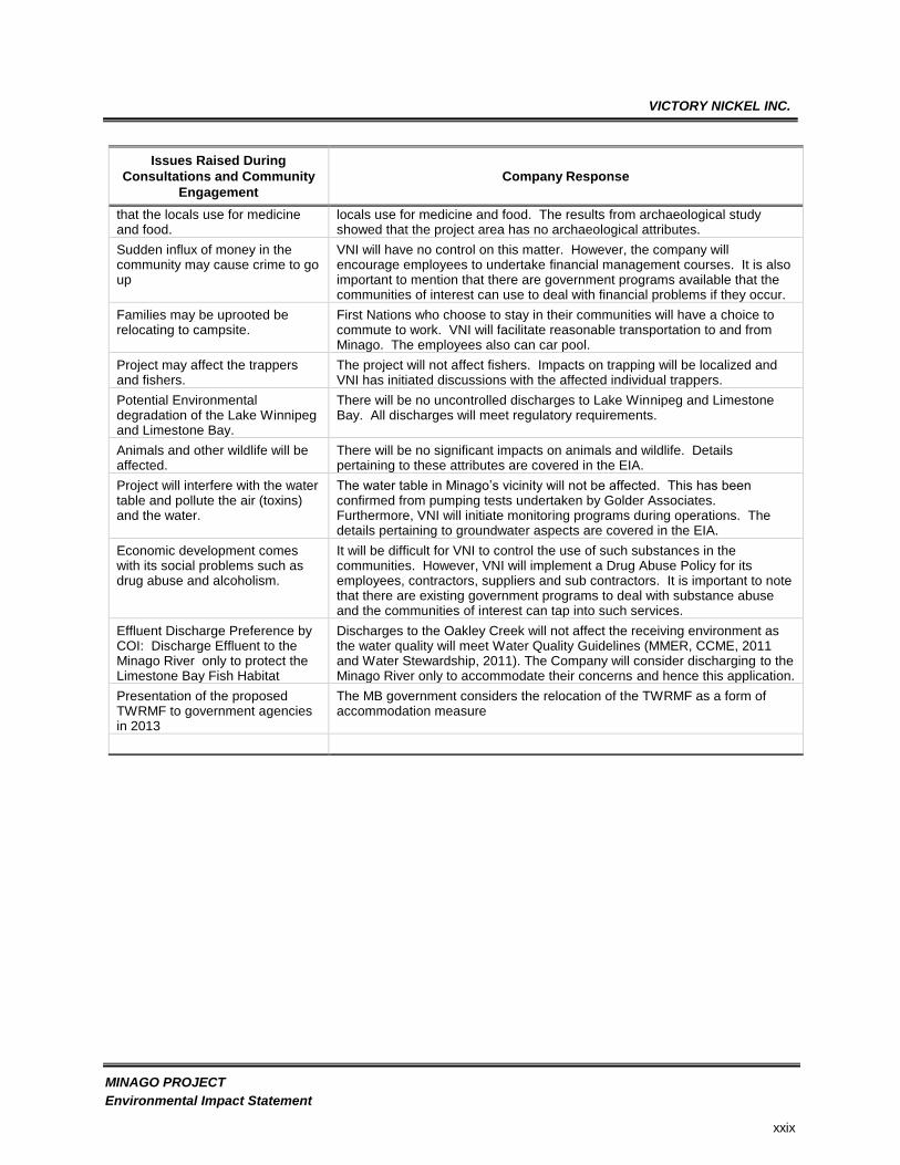
Issues raised by First Nations together with VNI responses are given in the Table below:

VICTORY NICKEL INC.
MINAGO PROJECT
Environmental Impact Statement
xxviii
2007-2008 First Nations Consultation Issues and Responses (2010 EAP/EIS)
Issues Raised During
Consultations and Community
Engagement
Company Response
Wildlife issues:
Elders and Band members were very concerned about wildlife.
VN will initiate an animal sightings log as per Wildlife Management Protection Plan in the Draft EIS.
Overuse of access road:
People using it to come in and hunt moose.
The access road will be gated and will be private and would not be used by any third party, except in emergency situations.
Concerns over the negative impacts on First Nations.
The issue is covered under the environmental assessment including socio-economic agreement.
Use of chemicals at the mine. Few chemicals will be used to process ore. Flotation reagents, explosives and fuels and lubricants are the primary chemicals.
Reclamation of the area:
There should be a requirement for a reclamation bond from the provincial government.
VNI‟s policy is to reclaim disturbed areas in a timely manner.
The requirements for bonding exist under the MB Minerals Act.
There are environmental concerns, which will require more information before the band could support the mine.
The issues will be covered under the environmental impact assessment (EIA).
Fishing, trapping and logging activities may be affected negatively although Minago is located rather far from Grand Rapids.
The project is designed with appropriate control measures not to affect fishing, and logging activities. The measures are detailed in the environmental impact statement. Effect of the project on trapping will be much localized and discussions with the RTL holder from Norway House have been initiated.
The open-pit operations will affect the eco-system: air, water, vegetation, animals, and humans.
All these aspects are taken into consideration when planning and designing the Minago Project. Details pertaining to these environmental attributes are covered in the Environmental Impact Assessment (EIA).
Economic benefits may be outweighed by resulting social problems such as crack and meth abuse.
It will be difficult for VNI to control the use of such substances in the communities. However, VNI will implement a Drug Abuse Policy for its employees, contractors, suppliers and sub contractors. It is important to note that there are existing government programs to deal with substance abuse and the communities of interest can tap into such services when needed.
Spillway from the mine into Minago River will affect trapping and fishing especially in Zone E.
All flows to the Minago River will be controlled discharges. The discharge system design and related monitoring systems are given the EIA.
Currently, drug and alcohol abuse is very serious in the community and the mine may increase the problem.
It will be difficult for VNI to control the use of such substances in the communities. However, VNI will implement a Drug Abuse Policy for its employees, contractors, suppliers and sub contractors. It is important to note that there are existing government programs to deal with substance abuse and the communities of interest can tap into such services.
People have not forgotten the mistreatment by other companies, which did not keep their promises.
VNI will not follow the paths of other companies. VNI should be judged by its own actions and not actions by others. For example, VNI was the first Company to contact the First Nations about the Minago Project and will continue to communicate as the project evolves.
The mine will contaminate herbs
On the basis of the vegetation studies, there are no herbs documented that
VICTORY NICKEL INC.
MINAGO PROJECT
Environmental Impact Statement
xxix
Issues Raised During
Consultations and Community
Engagement
Company Response
that the locals use for medicine and food.
locals use for medicine and food. The results from archaeological study showed that the project area has no archaeological attributes.
Sudden influx of money in the community may cause crime to go up
VNI will have no control on this matter. However, the company will encourage employees to undertake financial management courses. It is also important to mention that there are government programs available that the communities of interest can use to deal with financial problems if they occur.
Families may be uprooted be relocating to campsite.
First Nations who choose to stay in their communities will have a choice to commute to work. VNI will facilitate reasonable transportation to and from Minago. The employees also can car pool.
Project may affect the trappers and fishers.
The project will not affect fishers. Impacts on trapping will be localized and VNI has initiated discussions with the affected individual trappers.
Potential Environmental degradation of the Lake Winnipeg and Limestone Bay.
There will be no uncontrolled discharges to Lake Winnipeg and Limestone Bay. All discharges will meet regulatory requirements.
Animals and other wildlife will be affected.
There will be no significant impacts on animals and wildlife. Details pertaining to these attributes are covered in the EIA.
Project will interfere with the water table and pollute the air (toxins) and the water.
The water table in Minago‟s vicinity will not be affected. This has been confirmed from pumping tests undertaken by Golder Associates. Furthermore, VNI will initiate monitoring programs during operations. The details pertaining to groundwater aspects are covered in the EIA.
Economic development comes with its social problems such as drug abuse and alcoholism.
It will be difficult for VNI to control the use of such substances in the communities. However, VNI will implement a Drug Abuse Policy for its employees, contractors, suppliers and sub contractors. It is important to note that there are existing government programs to deal with substance abuse and the communities of interest can tap into such services.
Effluent Discharge Preference by COI: Discharge Effluent to the Minago River only to protect the Limestone Bay Fish Habitat
Discharges to the Oakley Creek will not affect the receiving environment as the water quality will meet Water Quality Guidelines (MMER, CCME, 2011 and Water Stewardship, 2011). The Company will consider discharging to the Minago River only to accommodate their concerns and hence this application.
Presentation of the proposed TWRMF to government agencies in 2013
The MB government considers the relocation of the TWRMF as a form of accommodation measure

VICTORY NICKEL INC.
MINAGO PROJECT
Environmental Impact Statement
xxx
PROJECT ECONOMIC CONDITION
The Minago Project is located in a geographically isolated and sparsely populated area of
Manitoba and within the Norway House Resource Management Area (RMA). The communities in
the project area include Grand Rapids, Moose Lake, Norway House, Grand Rapids and Snow
Lake. They are linked by PTH 6 and its arteries. With the exception of Grand Rapids and Moose
Lake are serviced by regularly scheduled and charter air services.
The Minago Project will be under construction between Year -2 and Year 1, at a capital cost of
approximately $596 million (2010 EAP/EIS). Construction will require more than 600 people that
will be housed in the camp, located near the mine. Construction workers will be sourced locally
as much as possible.
The direct impact in Manitoba of the construction of the mine will directly increase GDP by $202.6
million. When purchases in Manitoba are accounted for, the province‟s GDP will be increased to
$268.2 million total. Manitoba‟s GDP in year 2008 was approximately $51,000,000,000 (Stats
Canada). The $268.2 million total (direct + indirect, excluding $51 Billion reported in 2008) impact
in Manitoba will therefore, likely account for a 0.5% boost in GDP.
The company will employ 422 workers to operate and maintain the project, in addition to
approximately 220 contract truckers and related maintenance workers.
Overall, construction of the project is estimated to yield $6.3 million in personal income taxes to
governments in Canada and about $4.3 million in personal income taxes to governments in
Manitoba.
Additional information related to the overall project economics is available elsewhere (2010
EAP/EIS).
CLOSURE PLAN
In keeping with high standards for environmental and social responsibility and the Manitoba
Closure Regulation 67/99, Victory Nickel will implement an environmentally sound and technically
feasible decommissioning and closure plan for the Minago Project. The closure planning and
implementation will be undertaken with appropriate environmental care, to meet these Provincial
and Federal laws and regulation, satisfy the interests of the public, and achieve the company‟s
environmental standards. In so doing, Victory Nickel will exercise reasonable efforts to plan,
design, construct and operate the facilities for closure, with a goal of achieving a walk-away
scenario.
In addition to the final closure stage, the decommissioning and closure plan considered
“Temporary Suspension (TS)” and “State of Inactivity (SI)” stages. Temporary Suspension means
that mining and milling production activities have been suspended, while State of Inactivity means

VICTORY NICKEL INC.
MINAGO PROJECT
Environmental Impact Statement
xxxi
that mine production and mining operations have been suspended indefinitely. The Temporary
Suspension may turn into a State of Inactivity, if the suspension period is longer than planned.
Similarly, the State of Inactivity may turn into Permanent Closure, if prevailing conditions for
resumption of operations are not favorable. For each of these closure stages, the respective
decommissioning and closure aspects have been developed.
The determination of mine decommissioning and closure measures involved an assessment of
the key site components that may place the public or environment at risk after mine closure.
The plan was developed to meet the environmental, health and safety objectives including:
Protection of public health and safety;
Implementation of environmental protection measures that prevent adverse environmental
impact;
Ensuring land use commensurate with surrounding lands;
Implementation of progressive reclamation measures during mine operations;
Post-closure monitoring of the Project site to assess effectiveness of closure measures for
the long term; and
Achieving a walk-away post-closure monitoring and management until the mine presents
evidence of long-term compliance with closure criteria.
Mitigation measures were designed to address public safety issues and environmental concerns,
with post-closure monitoring and inspections planned at the commencement of the project to
ensure that closure objectives are met. Once the effectiveness of the mitigation measures is
assured, management of the site can be safely reduced to a level that is consistent with the mine
closure objectives and related measures. Post-closure monitoring has been designed to ensure
that performance objectives are closely monitored and inspected during the initial years following
implementation of closure measures. Victory Nickel anticipates that final determination of the
effectiveness of closure measures for walkway status of the project will be subject to review and
concurrence with regulatory agencies and the public.
Where possible, performance-based criteria have been adopted for the development of the
decommissioning and closure plan. The Metal Mines Effluent Regulations (MMER) end-of-pipe
effluent discharge standards were used as criteria for waters emanating from the final effluent
Polishing Pond. CCME Canadian Water Quality Guidelines for the Protection of Freshwater
Aquatic Life (CCME, 2011) and Manitoba Water Quality Guidelines were used to assess
effectiveness of closure measures to local downstream receiving waters. These same
performance-based criteria will be used to determine the effectiveness of closure measures
during the post-closure phase. Post closure monitoring and inspection results will be reviewed to
ensure that objectives continue to be met well after decommissioning the project. If these
objectives are not met, maintenance or contingency plans will be developed as necessary to
address potential areas requiring further mitigation.

VICTORY NICKEL INC.
MINAGO PROJECT
Environmental Impact Statement
xxxii
The plan calls for progressive reclamation during various project phases. The selection criteria
for candidate areas for progressive reclamation initiatives will take into account the redundant
nature of site components with respect to inherent risks and impacts on the receiving environment
and budgetary constraints. The components that will be required for the ongoing running of the
operations will not be subjected to progressive reclamation. Necessary environmental protection
measures have been adopted in the development of the overall project plan to ensure that a
healthy environment exists after mine closure.
One other aspect that the closure plan considered is reclamation research to develop workable
and field proven reclamation programs. As the company continues to operate and manage the
site, additional information about the site will be gathered to develop an optimal closure plan that
will be cost- effective and environmentally and technologically feasible.
Mill tailings are deemed to be Non Acid Generating (NAG). The ultramafic waste rock is
Potentially Acid Generating (PAG) and is expected to be disposed of under the planned closure
scenario with the tailings under a “wet” closure. This is intended to avoid ARD or ML from the
ultramafic rock stored in the TWRMF. A permanent water cover is proposed in order to keep the
materials saturated. The co-disposal approach has been implemented to seal the ultramafic rock
to mitigate Acid Rock Drainage (ARD) within the non reactive tailings.
Going forward, the company will undertake research studies to develop and optimize the
proposed co-disposal mitigation measures. The areas of studies will include but not be limited to
ARD and Metal Leaching (ML) studies specific to Minago Project mine wastes. This includes
ultramafic waste rock; Site-Specific Water Quality Objectives (SSWQO) investigations specific for
the Minago River watershed to replace the generic guidelines used at the inception of the project.
Typical guidelines are the CCME Canadian Water Quality Guidelines for the Protection of
Freshwater Aquatic Life and the Environmental Effects Monitoring (EEM) program. These steps
will enable a better understanding of the impacts of the discharges on the receiving environment.
In addition, VNI will undertake vegetative trials using local plant species such as green alder for
the reclamation of disturbed areas; undertake hydrological and hydro-geological studies to
optimize the site water balance; and fine-tune the Tailings Waste Rock Management Facility
(TWRMF) operational phase wet cover option to prepare for the closure phase.
All of the above studies will be undertaken during the operational, temporary closure, and state of
inactivity and post-closure phases. If required, Victory Nickel will work with consultants and other
technical groups to address the environmental constraints associated with aspects such as ARD
and/ or ML and overall site issues of concern.
Overall, the closure plan addresses the long-term physical, chemical and biological stability of the
site including reclamation of surface disturbances. A program is presented for site management
and monitoring both during implementation of closure and after decommissioning and reclamation
measures are completed. Although the plan is based on the best information available at this
time, as additional planning information, and/or experience at the site become available, the

VICTORY NICKEL INC.
MINAGO PROJECT
Environmental Impact Statement
xxxiii
details of the plan will be updated and/or altered as necessary. Decommissioning cost estimates
are provided and the financial security requirements reviewed.
During Temporary Suspension and State of Inactivity, VNl intends to be a responsible steward:
By demonstrating a commitment to reopening the site.
By continuing to have the site under the care and maintenance of an on-site caretaker.
By continuing to maintain the main access road in a manner that heavy equipment can be
brought to the site on short notice to deal with any environmental emergency.
By continuing to adequately monitor and maintain buildings and facilities such as the
Tailings and Waste Rock Management Facility (TWRMF) on the site.
By ensuring that major fixed equipment and buildings remain essentially intact on site.
If closure is deemed to be permanent, then implementation of the Decommissioning and Closure
Plan must occur. It is important to note that there may be a need for the development of an
updated closure plan to reflect the state of the site at the time.
The mine closure phase at the Minago Project will commence with cessation of open pit mining
and the milling of ores and stockpiles. Once all mineable ore reserves have been processed, the
mill and concentrator will be flushed out and the buildings and infrastructure will be dismantled,
decommissioned and demolished. The pit will be left to flood, tailings and ultramafic rock
contained in the TWRMF will be submerged under 1-2 metres of water, and the Polishing Pond
will receive discharge from TWRMF and eventually will naturally turn into a wetland.
To identify potential, local and native revegetation species, the established shrub and vascular
herb strata were reviewed in light of succession potential. These succession studies reported in
the literature have identified pioneer vegetation species and their seed dispersal capability,
reproductive capabilities, and timeframes for establishment. The disturbed areas will be
revegetated.
Established shrubs and herbs in the dominant tree and shrub units at the Minago Project were
identified during the vegetation assessment. Based on the baseline study results, green alder
(Alnus crispa), willows (Salix spp.), and potentially paper birch (Betula papyrifera) and/or shrub
birch (Betula glandulosa) appear to be candidates for successful revegetation at Minago Project.
Victory Nickel intends to use green alder and willows to revegetate disturbed areas with
approximate plant density of 0.1 alder per m2 and willows will be planted in isolated islands
amongst the alders to facilitate their establishment and seed dispersal during progressive
revegetation. It is anticipated that there will be approximately one Willow Island per hectare
consisting of 50 stems.
VICTORY NICKEL INC.
MINAGO PROJECT
Environmental Impact Statement
xxxiv
A custom seed mix will also be developed or obtained for Minago Project to seed small areas
prone to erosion or areas for which revegetation with shrubs is not suitable. From the reclamation
point of view, the only permanent vegetation losses will be the areas occupied by the waste rock
dumps, the TWRMF, the pit area and to some extent the overburden dump. The company will
exercise reasonable efforts to revegetate the industrial area, once all buildings have been
decommissioned, the waste rock dumps, and all access roads not required during the post
closure period.
Monitoring programs have been developed for all phases of the project. Operational monitoring
program results will be used to refine the post closure monitoring requirements. The monitoring
program is designed to monitor chemical, biological and physical parameters including the
following:
Monitoring of physical parameters for site structures;
Monitoring of physical water parameters and chemical water quality;
Monitoring of biological aspects as per MMER for a three year period;
Permit requirements;
Analysis of vegetation metal uptake;
Monitoring plant growth, mortality and diversity for the revegetated areas;
Monitoring dam stability review as per CDA and permit requirements; and
Monitoring diversion system‟s physical integrity.
Monitoring reports will be submitted to the regulatory agencies and communities of interest as
required to obtain feedback on the success of the reclamation program.
Costs to decommission, demolish and remove infrastructure; land reclamation and post closure
site management and monitoring were developed using market prices for similar work recently
completed or quoted on other sites. Using rates for the demolition of buildings solicited from local
contractors, typical demolition unit rates were evaluated. Other unit rates for associated work
were also solicited from Contractors with experience on similar projects. The demolition costs
have been estimated assuming that salvaged material is the property of the contractor after the
removal of process equipment. On the basis of the cost estimates, the overall closure cost is
estimated to be Cdn$ 8,036,858 compared to 7,260,590 depicted in the 2010 EAP/EIS.
ENVIRONMENTAL PROTECTION MEASURES
Environment protection has guided project design in several ways:
The open pit mine has been designed to generate different types of waste streams in order
to manage the wastes in an environmentally sound manner.
VICTORY NICKEL INC.
MINAGO PROJECT
Environmental Impact Statement
xxxv
Planning and design of all facilities has been undertaken to minimize effects on the Minago
River and Oakley Creek watersheds.
No contaminated drainage or effluents will be discharged to surface waters in the Oakley
Creek and Minago River drainages.
In order to minimize discharge to surface waters and to reduce process make up water
requirements, the site water balance employs re-circulation of process, mine dewatering
wells water and the Tailings and Waste Rock Management Facility.
Water management system design has been guided by existing surface water quality in
the project area and CCME and Manitoba Tier II Guidelines for Protection of Aquatic Life.
The tailings and waste rock management facility has been designed with abundant storage
capacity (including a 2 metre of freeboard) providing flexibility for seasonal discharges and
minimizing potential environmental effects.
The TWRMF is designed to control the potential for ARD and Metal Leaching of the
ultramafic rock. The design of the TWRMF includes water covers of 0.5 m and 1.5 m for
the operational and closure phases, respectively.
Therefore, tailings and ultramafic waste rock will be permanently stored under water ensuring
effective management of ARD during the operational and closure phases.
Testing of Polishing Pond decant water, as required during project decommissioning; will ensure
protection of surface waters until stabilization is confirmed.