mineral resources of the harquahala mountains wilderness ... · mineral resources of the harquahala...
TRANSCRIPT

2.SOBnH in ntoiOGIGM.
JAN 3 1 1989
Mineral Resources of theHarquahala MountainsWilderness Study Area,La Paz and Maricopa Counties,Arizona
U.S. GEOLOGICAL SURVEY BULLETIN 1701-C


Chapter C
Mineral Resources of theHarquahala MountainsWilderness Study Area,La Paz and Maricopa Counties,Arizona
By ED DE WITT, S.M. RICHARD, J.R. HASSEMER, andW.F. HANNAU.S. Geological Survey
J.R. THOMPSON U.S. Bureau of Mines
U.S. GEOLOGICAL SURVEY BULLETIN 1701
MINERAL RESOURCES OF WILDERNESS STUDY AREAS- WEST-CENTRAL ARIZONA AND PART OF SAN BERNARDINO COUNTY, CALIFORNIA

U. S. GEOLOGICAL SURVEY
Dallas L Peck, Director
UNITED STATES GOVERNMENT PRINTING OFFICE: 1988
For sale by theBooks and Open-File Reports SectionU.S. Geological SurveyFederal CenterBox 25425Denver, CO 80225
Library of Congress Cataloging-in-Publlcatlon Data
Mineral resources of the Harquahala Mountains wilderness study area, La Paz and Maricopa counties, Arizona.
(Mineral resources of wilderness study areas west-central Arizona and part of San Bernardino County, California ; ch. C) (U.S. Geological Survey bulletin ; 1701-C)
Bibliography: p.Supt. of Docs, no.: I 19.3:1701-C1. Mines and mineral resources Arizona Harquahala Mountains
Wilderness. 2. Harquahala Mountains (Ariz.) I. DeWitt, Ed. II. Series. III. Series: U.S. Geological Survey bulletin ; 1701. QE75.B9 no. 1701-C 557.3 s [553'.09791'72] 88-600012 [TN24.A6]

STUDIES RELATED TO WILDERNESS
Bureau of Land Management Wilderness Study Areas
The Federal Land Policy and Management Act (Public Law 94-579, October 21, 1976) requires the U.S. Geological Survey and the U.S. Bureau of Mines to conduct mineral surveys on certain areas to determine the mineral values, if any, that may be present. Results must be made available to the public and be submitted to the President and the Congress. This report presents the results of a mineral survey of a part of the Harquahala Mountains Wilderness Study Area (AZr-020-095), La Paz and Maricopa Counties, Arizona.


CONTENTS
Abstract Cl Summary Cl Introduction C5
Investigations by the U.S. Bureau of Mines C5 Investigations by the U.S. Geological Survey C5
Appraisal of identified resources C6 Mining history C6 Appraisal of sites examined C6 Other types of deposits C7 Mining feasibility C7
Assessment of potential for undiscovered resources CIO Geologic setting CIO Geochemistry C12
Introduction C12 Analytical methods C12 Results of study C13
Geophysics C16 Methods C16 Results of study C16
Mineral and energy resource potential C19Mineralization related to emplacement of gabbro dikes C19 Mineralization related to a buried gabbro pluton C21 Mineralization related to a Miocene detachment fault C22 Oil and gas C22Other commodities and deposit types C23 Recommendations for further study C23
References cited C23 Appendix C29
PLATE
[Plate is in pocket]
1. Mineral resource potential and geologic map of the Harquahala Mountains Wilderness Study Area
FIGURES
1. Summary map showing identified resources and mineral resource potential of the Harquahala Mountains Wilderness Study Area C2
2. Index map showing location of the Harquahala Mountains Wilderness Study Area C4
3. Map showing drainage basins containing highly and moderately anomalous amounts of gold and (or) tungsten in the Harquahala Mountains Wilderness Study Area and adjacent area C15
Contents

4. Bouguer gravity anomaly map for the Harquahala Mountains Wilderness Study Area C17
5. Aeromagnetic anomaly map for the Harquahala Mountains Wilderness Study Area CIS
TABLES
1. Summary of mineralized areas in and near the Harquahala Mountains Wilderness Study Area C8
2. Highly anomalous concentrations of selected elements in various stream-sediment samples C14
3. Summary of areas having mineral resource potential in and adjacent to the Harquahala Mountains Wilderness Study Area C20
VI Contents
MINERAL RESOURCES OF WILDERNESS STUDY AREAS- WEST-CENTRAL ARIZONA AND PART OF SAN BERNARDINO COUNTY, CALIFORNIA
Mineral Resources of theHarquahala Mountains Wilderness Study Area,La Paz and Maricopa Counties, Arizona
By Ed DeWitt, S.M. Richard, J.R. Hassemer, andW.F. HannaU.S. Geological Survey
J.R. Thompson U.S. Bureau of Mines
ABSTRACT
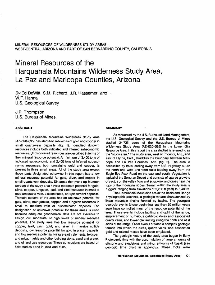
The Harquahala Mountains Wilderness Study Area (AZ-020-095) has identified resources of gold and copper in small quartz-vein deposits (fig. 1). Identified (known) resources include both indicated and inferred subeconomic resources. Undiscovered resources are described in terms of their mineral resource potential. A minimum of 3,400 tons of indicated subeconomic and 2,400 tons of inferred subeco nomic resources, both containing gold and copper, is present in three small areas. All of the study area except those parts designated otherwise in this report has a low mineral resource potential for gold, silver, and copper in small quartz-vein deposits. Six areas that make up fourteen percent of the study area have a moderate potential for gold, silver, copper, tungsten, lead, and zinc resources in small to medium quartz-vein, disseminated, or replacement deposits. Thirteen percent of the area has an unknown potential for gold, silver, manganese, copper, and tungsten resources in small to medium vein or disseminated deposits. The designation of unknown potential for these areas is used because adequate geochemical data are not available to assign low, moderate, or high levels of mineral resource potential. The study area has low resource potential for copper, lead, zinc, gold, and silver in massive sulfide deposits, low resource potential for gold in placer deposits, and low resource potential for rare-earth elements, feldspar, and mica, marble and other building stone, sand and gravel, and oil and gas resources. These conclusions are based on field studies done in 1984 and 1985.
SUMMARY
As requested by the U.S. Bureau of Land Management, the U.S. Geological Survey and the U.S. Bureau of Mines studied 24,735 acres of the Harquahala Mountains Wilderness Study Area (AZ-020-095) in the Lower Gila Resource Area. In this report the area studied is referred to as the "study area." The study area, west of Phoenix, Ariz., and east of Blythe, Calif., straddles the boundary between Mari copa and La Paz Counties, Ariz. (fig. 2). The area is accessible by trails leading away from U.S. Highway 60 on the north and west and from trails leading away from the Eagle Eye Peak Road on the east and south. Vegetation is typical of the Sonoran Desert and consists of sparse growths of cactus on the valley floor and scrub oak and grass near the tops of the mountain ridges. Terrain within the study area is rugged, ranging from elevations of 2,200 ft (feet) to 5,480 ft.
The Harquahala Mountains are in the Basin and Range physiographic province, a geologic terrane characterized by linear mountain chains flanked by basins. The youngest geologic events (those beginning less than 30 million years ago) have controlled most of the resource potential of the area. Those events include faulting and uplift of the range, emplacement of numerous gabbroic dikes and associated quartz veins, and low-angle faulting along the north and east sides of the range. Older events created a complex geologic terrane into which the dikes, quartz veins, and associated gold and related metals have been emplaced.
The geologic history of the study area began in Early Proterozoic time with the accumulation of large amounts of siltstone and sandstone and minor amounts of basalt (see geologic time chart in appendix). These rocks were
Harquahala Mountains Wilderness Study Area Cl

113°25' 113°20' To Aguila
APPROXIMATE BOUNDARY OFHARQUAHALA MOUNTAINSWILDERNESS STUDY AREA
(AZ-020-095)
HARQUALA MOUNTAIN
11M/Di
White Marble Mine 13M/C
\\--_-- * "Road
Figure 1 (above and facing page). Summary map showing identified resources and mineral resource potential of the Harquahala Mountains Wilderness Study Area, La Paz and Maricopa Counties, Ariz.
metamorphosed, deformed, and intruded by at least three types of granitic rocks in Early Proterozoic time. Some of these granitic rocks contain pegmatite dikes that have a low resource potential for rare-earth elements, feldspar, and mica. During Middle Proterozoic time, coarse-grained granitic rocks intruded all the older crystalline rocks.
The Proterozoic rocks remained relatively undisturbed until early Paleozoic time, when they and the older rocks were covered by a sequence of sandstone, limestone, and siltstone that ranges in age from about 550 to about 250 million years. Paleozoic units recognized in the Harquahala Mountains include the Bolsa Quartzite, Abrigo Formation, Martin Formation, Redwall Limestone, Supai Formation, Coconino Sandstone, and Kaibab Limestone. Overlying the Paleozoic rocks are Mesozoic siltstone and sandstone.
Deformation and metamorphism during Mesozoic time converted the Paleozoic and Mesozoic rocks into marble and schist, and, at the same time, placed them upside down beneath the Harquahala thrust fault, a low-angle structure extensively exposed in the study area. Some of this marble
was quarried for dimension and construction stone outside the study area at the White Marble mine and in Sunset Canyon (fig. 1). A large pluton of light-colored granite containing accessory muscovite and garnet intruded the Harquahala thrust fault and much of the northeastern part of the range in Late Cretaceous to early Tertiary time. Pegmatite bodies related to the granite are locally extensive, but they lack rare minerals or large concentrations of feldspar that would enhance the resource potential of the area.
In Tertiary time, volcanic and sedimentary rocks covered the range and a northwest-striking gabbroic dike swarm was emplaced. Gold-bearing quartz veins that contain minor amounts of copper and silver, and trace amounts of lead, tungsten, and other metals, parallel the dikes, form margins of some of the dikes, and cross-cut some dikes. Most of the metallic mineral deposits in the study area are related to emplacement of the dike swarm and creation of mineralized quartz veins. Low-angle faulting along the north and east sides of the range placed the Tertiary volcanic and sedimentary cover rocks against the dike swarm and older rocks along the Eagle Eye Peak
C2 Mineral Resources of Wilderness Study Areas West-Central Arizona and Part of San Bernardino County, California

EXPLANATION
[No geologic terrane having high mineral resource poten tial for any commodity was delineated by this study. Except as designated otherwise below, entire area has low mineral resource potential, with certainty level C, for gold, silver, and copper in small quartz-vein deposits. Entire area also has low mineral resource potential for copper, lead, zinc, gold, and silver in massive sulfide deposits and for peg matite minerals, with certainty level D, and for placer gold, oil and gas, sand and gravel, and marble and other building stone, with certainty level C]
Areas having identified resources Letters refer to areas listed below and in table 1
A. Gold, copper B. Gold, copper C. Gold D. Gold, copper E. Gold, silver F. Gold, silver, copper G. Silver, copper H. Gold, silver, copper I. Gold, silver, copper J. Gold, silver, copper
Geologic terrane having moderate resource potential for commodities listed in table below, with certainty levels B, C, or D Number prefixes refer to areas listed in table below and in table 3. Numbered areas may surround lettered areas; if so, the lettered area has the same resource potential as the numbered area
1 L/D Geologic terrane having low resource poten tial for commodities listed in table below, with certainty level D Number prefixes refer to areas listed in table below and in table 3
10 U/A Geologic terrane having unknown resource potential Number prefixes refer to areas listed below and in table 3
Levels of certainty
A Available data not adequate to estimate potential
B Data indicate geologic environment and sug gest level of resource potential
C Data indicate geologic environment and give good indication of level of resource poten tial, but do not establish activity of re source-forming processes
D Data clearly define geologic environment and level of resource potential and indi cate activity of resource-forming processes in all or part of the area
Summary of areas having mineral resource potential in and adjacent to the Harquahala Mountains Wilderness Study Area
[Level of potential/level of certainty explained below; commodities listed in order of relative importance; commodities not underlined are considered to be byproducts or trace metals that could be recovered if deposits containing gold were mined; where variable sizes of deposits are shown, the most probable size is listed first; size of deposits listed below; <, less than]
top area Name
12
34567t
89
10111213
Dushey CanyonSunshine
Upper Browns Cyn.Crown PrinceBrowns Canyon WashNW. of Sunset PassN. of West Fork
Sunset CanyonNW. of Arrastre Gul.Arras tre GulchN. Harquahala Mtn.Harquahala Mtn.Blue Tank CanyonWhite Marble mine
Resource Level of potential/ , Commodities potential level of certainty (listed in order
of importance)
LowModerateModerateModerateLowUnknownLow
LowUnknownModerateUnknownModerateModerateModerate
L/DM/DM/CM/BL/DU/AL/D
L/DU/AM/DU/AM/DM/CM/C
Au,Au,Au,Au,Au,Au,Au,
Au,Au,Au,Au,Au,Au,Au,
Ag,Ag,Ag,Ag.Ag,Ag,Cu
w,w,Cu,w,Cu,Cu,w,
Cu, ZnCu, ZnCu, Zn
Cu, Pb, ZnMn, Cu
AgAgPb, Zn, Ag
AgAgAg, Pb, Zn
Ag
Size, type of deposit
Smal 1 ,Small,MediumSmall,Small,MediumSmall,
Small,Small,Small,Small,Small,Small,
veinvein
, disseminatedveinvein
, vein or disseminatedvein
veinveinveinvein
. veinvein
Small-medium, skarn or replacement
Small vein deposit - <10,000 tons Medium-size vein deposit - 10,000-250,000 tons Medium-size replacement or skarn deposit - 10,000-500,000
tons
Small replacement or skarn deposit - <10,000 tons Medium-size disseminated deposit - 200,000-10,000,000 tons
Harquahala Mountains Wilderness Study Area C3

Alamo Dam 19 mi 113°30'
34°00' - YAVAPA1 COUNTY
MAR1COPA COUNTY
^/metallic mineral\ district
Sunshine mine
/HARQUAHALA MOUNTAINS '-WILDERNESS STUDY AREA
Harquahala MountaWhite Marble
mine
Aguila metallic district
Bighorn metallic mineral district /
\ LITTLE ^ HARQUAHALA Little Harquahala
MTSr-_^-metallic mineral district
Phoenix, Ariz. 65 mi\
33°45' -
Figure 2. Index map showing location of the Harquahala Mountains Wilderness Study Area, La Paz and Maricopa Counties, Ariz. Names and locations of metallic mineral districts from Keith, Gest, and others (1983) and Keith, Schnabel, and others (1983).
detachment fault. Most of the upper plate of this fault has an unknown potential for gold, silver, manganese, and copper.
The Harquahala Mountains Wilderness Study Area contains three small areas having indicated subeconomic
resources, two of which together contain 3,400 tons of indicated subeconomic resources and an additional 2,400 tons of inferred subeconomic resources in which gold and copper are known. Additionally, seven other small areas located within 0.5 mi (mile) of the boundary contain
C4 Mineral Resources of Wilderness Study Areas West-Central Arizona and Part of San Bernardino County, California

additional indicated and inferred subeconomic resources, primarily gold, copper, and silver.
Six areas wholly or partly inside the study area boundary have a moderate potential for gold, silver, copper, tungsten, lead, and zinc resources in small quartz-vein deposits, medium-size disseminated deposits, or medium- size skarn or replacement deposits related to emplacement of gabbroic dikes (fig. 1; pi. 1). These six areas make up about 5.4 mi2 (square miles), or about 14 percent of the approximately 39-mi2 study area. Areas having an unknown resource potential for gold, silver, copper, manganese, and tungsten make up about 5.1 mi2 , or about 13 percent of the study area. The remaining 28.5 mi2 has a low potential for gold, silver, and copper in quartz-vein deposits and gold in placer deposits.
The entire study area has a low resource potential for oil and gas, for nonmetallic commmodities such as marble and other building stone, sand and gravel, rare-earth elements, feldspar, and mica, and for copper, lead, zinc, gold, and silver in massive sulfide deposits. A north- to northwest- trending magnetic anomaly at the southern boundary of the study area may indicate a gabbroic pluton at depth, which could contain disseminated gold. However, because the pluton appears to be deeply buried and any disseminated metals are of unknown grade, no resource potential related to the buried pluton is assessed for this area.
INTRODUCTION
As requested by the U.S. Bureau of Land Management, the U.S. Geological Survey and the U.S. Bureau of Mines studied 24,735 acres of the Harquahala Mountains Wilderness Study Area (AZr-020-095) in the Lower Gila Resource Area. In this report the area studied is referred to as the "study area."
The Harquahala Mountains Wilderness Study Area, which is west-northwest of Phoenix, Ariz., about 17 mi east of Salome and 12 mi southwest of Aguila (fig. 2; pi. 1), is about 12 mi long and from 3 to 6 mi wide. The study area encompasses much of the northern end of the Harquahala Mountains, a northeast-trending range situated in the Basin and Range province of Arizona. Access is provided by gravel roads leading south from U.S. Highways 60 and 70 and by gravel roads and jeep trails leading north from the Eagle Eye Peak Road. A steep gravel road and jeep trail leads to the top of Harquahala Mountain, elevation 5,681 ft, the highest point in the range and adjacent to the study area (fig. 2). Access within the study area is limited to two or three jeep trails leading to old mining prospects and a few animal trails. The study area ranges in elevation from 2,200 ft near Browns Canyon Wash in the southeast corner to 5,480 ft north of Harquahala Mountain in the west-central part of the area (pi. 1). The study area is characterized by rugged terrain and Sonoran desert flora and fauna; below 3,000 ft there is very little vegetation,
principally cat claw, and barrel, saguaro, and cholla cactus. Above 4,000 ft there are scrub oak and juniper trees and a variety of perennial grasses.
This report presents an evaluation of the mineral endowment (identified resources and mineral resource potential) of the study area and is the product of several separate studies by the U.S. Bureau of Mines (USBM) and the U.S. Geological Survey (USGS). Identified resources are classified according to the system of the USBM and USGS (1980), which is shown in the appendix of this report. Identified resources are studied by the USBM. Mineral resource potential is the likelihood of occurrence of undiscovered metals and nonmetals, industrial rocks and minerals, and of undiscovered energy sources (coal, oil, gas, oil shale, and geothermal sources). It is classified according to the system of Goudarzi (1984), which also is shown in the appendix. Potential for undiscovered resources is studied by the USGS.
Investigations by the U.S. Bureau of Mines
The Harquahala Mountains Wilderness Study Area was examined by the USBM in 1984 (Thompson, 1985). Prior to the field investigation, a detailed literature search was made for pertinent geologic and mining information. U.S. Bureau of Land Management records were checked for locations of patented and unpatented claims and for oil and gas and geothermal leases in and near the study area. No oil and gas or geothermal leases were found for the study area. Field studies by USBM personnel included investigations of mines, prospects, and mineralized areas in and within 1.5 mi of the study area. A total of 343 samples was collected and assayed for gold and silver and analyzed semiquan- titatively for 40 elements. Sample descriptions and analytical results are in Thompson (1985).
Investigations by the U.S. Geological Survey
The earliest studies of western Arizona geology contained reports of mines in the southern Harquahala Mountains (Lee, 1908; Bancroft, 1911). However, prior to the present investigation the only geologic map of the study area and surrounding region was from the reconnaissance work of Wilson (1960) and Wilson and others (1957). To the southwest, Keith and others (1982) mapped an area extending from the White Marble mine into the Socorro Peak area (fig. 2), where Varga (1977) mapped folded Paleozoic rocks. Farther south, in the
Harquahala Mountains Wilderness Study Area C5

Little Harquahala Mountains, Richard (1982, 1983) mapped thrust sheets of Mesozoic, Paleozoic, and Pro- terozoic rocks as originally reported by Reynolds and others (1980). Within the study area, Hardy (1984) mapped a part of the Arrastre Gulch area (fig. 1). Regional geologic summaries that include the study area are those by Rehrig and Reynolds (1980), Reynolds (1980, 1982), Spencer (1984), Reynolds and Spencer (1985), Reynolds and others (1986), and Spencer and Reynolds (1986).
The present geologic map (pi. 1) of the Harquahala Mountains Wilderness Study Area was prepared from field mapping by S.M. Richard and Ed DeWitt in 1984-1985, mainly by S.M. Richard, with contributions by S.J. Reynolds and I.E. Spencer. Sampling for a stream-sediment geochemical survey was done in 1984 by J.R. Hassemer, and the geochemical data were interpreted by Hassemer for this report. Geophysical data gathered during the National Uranium Resource Evaluation (NURE) program of the U.S. Department of Energy for the Phoenix I°x2° quadrangle (LKB Resources, Inc., 1980, 1983) were analyzed by W.F. Hanna.
Acknowledgments. Employees of the Arizona Geological Survey (formerly the Arizona Bureau of Geology and Mineral Technology), especially S.J. Rey nolds and I.E. Spencer, were instrumental in providing regional tectonic information about west-central Arizona and in mapping parts of the study area.
Paul Buff, a geologist with the U.S. Bureau of Land Management in Phoenix, is thanked for his help in the study.
APPRAISAL OF IDENTIFIED RESOURCES
By J.R. Thompson U.S. Bureau of Mines
Mining History
The Harquahala Mountains have been prospected since at least the 1880's, the result being numerous small workings and few moderate- to large-scale mines (Keith, 1978). Mines in and near the study area are widely scattered and not grouped into any organized mining districts. However, the Dushey Canyon and Harquahala metallic mineral districts (Keith, Gest, and others, 1983; Keith, Schnabel, and others, 1983) are within the study area. There are no production records for these mines, but gold, silver, copper, and minor lead were produced from several mines in and near the study area (Keith, Gest, and others, 1983).
Two nearby mining districts, Ellsworth and Aguila, are south of the study area. The Ellsworth district (part of which is contained in the Harquahala metallic mineral district, fig. 2), about 4 mi southwest of the study area, is a lode gold area that was discovered in 1888. The Bonanza, Golden Eagle, Socorro, San Marcos, Hercules, and Hidden Treasure mines in the district yielded more than $2.5 million in gold between 1891 and 1929. Copper, silver, and some lead were also recovered. The gold, silver, copper, and lead are localized in steeply dipping faults cutting granite, hornfels, limestone, quartzite, and conglomerate (Wilson and others, 1934). The geology of the southwestern part of the Harquahala Mountains and much of the Ellsworth district is similar to that in the study area, but the rocks are more extensively fractured and altered than in the study area. Also, the largest mines in the district, the Bonanza and Socorro, are localized along relatively flat structures, not the commonly noted northwest-trending, high-angle dikes and veins of the study area.
In the Aguila district (same as Aguila metallic mineral district), about 3 mi south of the study area, manganese was mined from Tertiary volcanic rocks (fig. 2). About 20 mines are within a 15-mi-long and 4-mi- wide, northeast-trending volcanic belt. The district became active in 1917 and declined after World War I. During this period, 3,496 tons of ore averaging 35.8 percent manganese was shipped. Mines in the district operated intermittently for short periods of time until World War II, when several were operated for about 1 year. Operations were terminated in 1944 and the district remained dormant until the Korean conflict in 1951, when the government purchase program for domestic manganese was announced. About 30,000 tons of low- grade manganese ore was mined between 1951 and 1954 (Farnham and Stewart, 1958). The geology of this district is similar to that in the far southwestern corner of the study area.
In the Dushey Canyon metallic mineral district, the Hawke Gold Mining Company, Ltd., is conducting exploration in the Sunshine mine mineralized area less than 0.5 mi outside the northern boundary of the study area (fig. 2) and is developing sites to heap-leach ore and recover gold.
Appraisal of Sites Examined
Ten mineralized areas were identified in the field study (table 1; fig. 1; pi. 1). Six mineralized areas are wholly or partly inside the study area. The three mineralized areas wholly in the study area are the Northwest (A), North Sunset Canyon (B), and Crown Prince (C) areas. The Sunshine mine (D), Linda mine (E), and Harquahala Mountain areas (J) are partially
C6 Mineral Resources of Wilderness Study Areas West-Central Arizona and Part of San Bernardino County, California

within the study area. The Browns Canyon mineralized area (G) is adjacent to the study area, and Dushey Canyon (F), Arrastre Gulch (H), and Blue Tank Canyon (I) mineralized areas are outside the study area. All mineralized areas contain evidence of previous mining operations, and pertinent information on these areas is summarized in table 1. Indicated and inferred subeco nomic resources are estimated only for those areas entirely within the study area.
The principal deposit type examined by the USBM is a gold-bearing quartz vein, which contains copper in many places. The veins occupy faults in granite and gneiss and commonly are adjacent to gabbroic dikes. The veins are principally massive and drusy quartz and contain minor amounts of hematite, malachite, pyrite, chalcopyrite, and native gold. Normally, the gabbro and country rocks are barren, but at several places are mineralized. Most of the mineralized veins are near the three major northwest-trending normal faults in the Harquahala Mountains (pi. 1) and appear to be in tension fractures related to these faults.
In the Northwest mineralized area (area A, table 1, fig. 1, and pi. 1), about 0.25 mi inside the northwest boundary, gold and copper are present in a fracture zone. An indicated subeconomic resource of 900 tons and an inferred subeconomic resource of 2,400 tons of material having an average grade of 0.03 oz gold per ton and 0.87 percent copper are estimated to be present.
The North Sunset Canyon mineralized area (area B, table 1, fig. 1, and pi. 1), in the north-central part of the study area, is accessible by a jeep trail that has been excluded from the study area. An indicated subeconomic resource of 2,500 tons of ore having an average grade of 0.28 oz gold per ton and 1.03 percent copper is estimated for the North Sunset Canyon mineralized area.
The Crown Prince mineralized area (area C, table 1, fig. 1, and pi. 1), in the east-central part of the study area, contains gold-bearing quartz veins, but because of a lack of development on the veins, no resource can be identified on the basis of data available at this time. The quartz veins require further surface and (or) underground exploration to determine the extent of mineralization.
The mineralized areas that warrant further exploration to determine the extent of mineralization are the Sunshine mine (D), the Linda mine (E), Arrastre Gulch (H), Blue Tank Canyon (I), the southern part of Harquahala Mountain (J), and North Sunset Canyon (B). The Dushey Canyon (F), Browns Canyon (G), Crown Prince (C), northern part of Harquahala Mountain (J), and Northwest (A) mineralized areas are lesser prospects for further exploration. No indicated or inferred reserves are estimated for these areas.
Other Types of DepositsMarble (metamorphosed Paleozoic limestone)
crops out about 0.5 mi south of the study area near Arrastre Gulch and Sunset Canyon and at the White Marble mine, about 0.5 mi west of the study area (pi. 1). Marble from Arrastre Gulch and Sunset Canyon has been used as building stone, and marble from the White Marble mine has been used for terrazo, precasting, roofing granules, stucco, mineral food, and polyester filler (Keith, 1969). Marble was not being mined in Sunset Canyon or Arrastre Gulch at the time of the field investigation (1984). Mining at the White Marble mine is intermittent, according to the present caretaker. Because large amounts of high-quality marble are not present at the surface in the study area, operations at these locations are unlikely to extend into the study area.
Manganese deposits in Tertiary volcanic rocks about 3 mi southeast of the study area in the Aguila metallic mineral district contain pyrolusite, psilomelane, and manganite in veins and fracture zones that strike north and dip steeply west. The district has been extensively prospected by bulldozer trenches; an unknown amount of low-grade manganese ore remains (see Farnham and Stewart, 1958). Tertiary volcanic rocks are present in the southeast corner of the study area, but do not appear to be particularly rich in manganese. The nearest volcanic rocks containing significant amounts of manganese are about 1.5 mi south of the study area (not shown on pi. 1).
Barite and fluorite in northwest-striking fractures in a volcanic agglomerate about 3 mi south of Arrastre Gulch were noted by Stewart and Pfister (1960). About 800 tons of ore averaging about 75 percent barite was shipped from this area. The veins appear to extend northwest for some distance. The barite veins are parallel to, and possibly related to, the northwest-trending normal fault near Blue Tank Canyon. If the barite- and fluorite-bearing veins continue northwest for 6 mi, they are in the study area; if barite is present at depth, it is too deeply buried to be commercial.
Fluorite is present 2 mi south of the Blue Tank Canyon mineralized area (area I, pi. 1) in a fault (not shown) that strikes N. 69° W. and dips steeply to the northeast. Drilling and trenching disclosed some high- purity fluorite and minor barite and pyrite (Denton and Kumke, 1949). This fault is parallel to the northwest- trending normal fault near Blue Tank Canyon (pi. 1) and may be a related structure.
Mining FeasibilityThe principal commodities in the study area are
gold and copper. Silver, present in small amounts, could be recovered as a byproduct if gold and copper were mined. Currently (1987), gold is one of the few mineral
Harquahala Mountains Wilderness Study Area C7

Table 1 . Summary of mineralized areas in and near the Harquahala Mountains Wilderness Study Area, La Paz and Maricopa Counties, Ariz.
[Sample numbers refer to plate 1 of Thompson (1985); letter designations (A-J) refer to areas shown on figure 1 and plate 1 and discussed in the text]
Area (letter designation) Sample Numbers
Description Workings Sample and resource data
Northwest (A) 267-272
Silicified east-striking fracture zone in Middle Proterozoic granite. The fracture zone averages 1.5 ft wide.
Two short adits
North Sunset Canyon (B) Northwest-striking quartz veins 278-333 and silicious zones in
Proterozoic granite and schist. Faults and shear zones trending northwest are parallel to the Sunset Canyon fault. Gabbro dikes are found at veins and faults.
Crown Prince (C) 113-132
North-trending quartz veins and north-west-trending faults cutting the granite of Browns Canyon and gabbro. Quartz vein thickness was about 6-12 in. The faults ranged in thick ness from 6 in. to 4 ft.
Two adits, one shaft, and eight prospect adits and pits. One adit had 350 ft of workings, including extensive stoping on the vein.
Two adits, a shaft, and two prospect pits. The Crown Prince adit contains more than 300 ft of workings.
Six samples from the fracture zone contained as much as 0.13 oz/ton Au and 12.4 percent Cu. An indicated subeconomlc resource of 900 tons and an inferred subeconomic resource on the strike of the vein between adits of 2,400 tons of material averaging 0.03 oz/ton Au and 0.87 copper is estimated.
Sixteen samples of vein quartz contained as much as 0.53 oz/ton Au and 3.9 Cu. Eleven samples of gabbro contained minor Au and Cu. Sixteen samples of fault gouge and shear zone showed minor Ag, Cu, Pb, and Zn. Thirteen samples of country rock were barren. An indicated subeconomic resource of 2,500 tons of material averaging 0.28 oz/ton Au and 1.03 percent Cu is estimated at the 350-ft adit.
Four samples of vein quartz contained as much as 1.32 oz/ton Au, 2.1 oz/ton Ag, and minor Cu, Pb, Zn. Seven granite samples had as much as 0.08 oz/ton Au. A select sample from a shear zone contained 0.15 oz/ton Au and minor Cu, Pb, and Zn. Seven samples of altered gabbro contained minor Cu and Zn.
Sunshine mine (D) 1-26
Linda mine (E) 28-55
Dushey Canyon (F) 64-82
Quartz veins that containabundant hematite are adjacent to gabbro dikes in Precarabrian granite, granite gneiss, and gneiss. Veins occupy fractures that strike east and dip from 35° S. to vertical. Thickness of the veins ranges from 1 to 8 in.
An irregular brecciated contact between phases of the granite of Browns Canyon. The 1- to 5-ft-wide breccia zone trends N. 40° K. and consists of granite fragments in a calcite matrix. The zone is estimated to be about 800 ft long. Tertiary gabbro dikes crop out in this area. Pyrlte was noted in several samples.
An east-trending quartz vein dipping 40° S. in Proterozoic granite and granite gneiss. This vein has roughly the same strike and dip and is in line with the vein at the Sunshine mine mineralized area, 2 mi west. They may be the same vein. Hematite, pyrite, and malachite are present in several areas.
Six shafts, two adits, and five prospect pits. The Sunshine mine consists of an inclined shaft having two working levels.
One large adit, three short adits, two shafts, and five prospect pits. The Linda mine adit is 600 ft long and was barren of mineralized material.
One 100-ft adit, two shafts, and four prospect pits.
Of ten samples of vein quartz, as much as 0.81 troy oz/ton Au and minor Ag, Cu, Zn were detected. One select sample of a quartz stockpile contained 2.17 oz/ton Au. Thirteen samp'les of the gabbro, fault material, and country rocks contained minor amounts of Ag, Cu, and Zn. Three samples of altered granite adjacent to the vein contained as much as 0.10 oz/ton Au, minor Ag and Cu.
Three samples of the breccia zone contained as much as 0.24 oz/ton Au. Three samples of fractured granite had as much as 0.12 oz/ton Au. A select sample of pyritiferous granite from a stockpile yielded 0.83 oz/ton Au. Of nine samples of country rock, as much as 0.23 oz/ton Au was detected. One sample of a gabbro dike contained 0.29 oz/ton Au.
Of ten samples of vein quartz, as much as 0.07 oz/ton Au and minor Cu were detected. Two select samples of stockpiled quartz contained as much as 0.43 oz/ton Au, minor Ag, Cu. Eight samples of country rock had as much as 0.01 oz/ton Au, minor Ag, Cu, Zn. One sample of gabbro and three samples of fault gouge contained trace amounts of Au and minor Cu and Zn.
C8 Mineral Resources of Wilderness Study Areas West-Central Arizona and Part of San Bernardino County, California

Table 1 . Summary of mineralized areas in and near the Harquahala Mountains Wilderness Study Area, La Paz and Maricopa Counties, Ariz. Continued
Area (letter designation) Sample Numbers
Description Workings Sample and resource data
Browns Canyon (G) 83-112
Arrastre Gulch (H) 136-162
Northwest-striking quartz vein adjacent to a gabbro dike, and faulted and altered zones related to the Dushey Canyon fault. Some rocks have been brecciated. Malachite, fluorite, and barite are present in the veins and breccia zones.
Northwest-striking quartz veins that parallel the Sunset Canyon fault. The veins lie along contacts between gabbro dikes and Middle Proterozoic granite and granite gneiss. Marble, inferred to be of early to raid-Paleozoic age, lies tectonically on Proterozoic basement rocks and crops out northeast and southwest of Arrastre Gulch. Gabbro dikes intruded the marble, but quartz veins were not found in or near the dikes, and the marble is not known to be mineralized.
Six bulldozer trenches and two prospect pits. The trenches are as much as 6 ft deep, 20 ft wide, and 180 ft long.
Seven shafts and a prospect pit. One shaft had a working level on the vein and was flooded below the drift.
Of ten samples of country rock, as much as 0.01 oz/ton Au and minor Cu, Pb, Zn were detected. Six samples of brecciated granite contained as much as 1.6 oz/ton Ag and minor Pb, Zn. Five samples of brecciated gabbro and five samples of fault gouge contained trace amounts of Au and minor Ag, minor Cu, Pb, Zn, and Ba. One sample of fluorite contained 23.6 percent CaF~, trace Au, and 1.8 oz/ton Ag. One sample of a quartz vein was barren.
Nine samples of vein quartz in the shaft contained as much as 2.07 oz/ton Au, 1.4 percent Cu, 0.11 percent Pb, and minor Zn. Two samples of gabbro, two samples of epidote-rich material, and one sample of fault gouge from the shaft had trace amounts Au and minor Cu, Pb, and Zn. One sample of gneiss contained 0.01 oz/ton Au and minor Cu and Zn. Five samples of vein quartz from dumps of inaccessible shafts contained as much as 0.24 oz/ton Au and minor Cu, Pb, and Zn. Three samples of gabbro, two samples of granite, and one sample each of epidote-rich material and fault gouge contained minor Cu, Pb, and Zn.
Blue Tank Canyon (I) 174-203
Harquahala Mountain (J) 204-208, 211, 213-234, 237-252
East-striking vertical quartz veins lie adjacent to gabbro dikes and occupy fissures in Middle Proterozoic granite, gabbro, and amphibolite. Northwest-striking veins parallel to the normal fault along Blue Tank Canyon are found on the west slope of the canyon. Veins ranged in thickness from 6 in. to 3 ft.
Northwest-striking quartz veins adjacent to gabbro dikes and in Early Proterozoic granite and gneiss. Northwest-trending faults and silictfied shear zones parallel the normal fault along Blue Tank Canyon. Veins average 2 ft wide.
Three adits, a shaft, two bulldozer trenches, and two prospect pits. The adit and shaft on the east slope of the canyon is 350 ft long and was stoped.
One large bulldozer trench, one shaft, three caved adits, and twelve prospect pits.
From the east-striking veins, thirteen quartz-rich samples contained as much as 0.63 oz/ton Au, 0.7 oz/ton Ag, 6.0 percent Cu, and minor Pb, Zn. A select quartz sample from an ore stockpile contained 0.77 oz/ton Au and 3.3 percent Cu. Six samples of altered granite and gabbro had as much as 0.73 oz/ton Au, 0.3 oz/ton Ag, and 3.2 percent Cu. From the northwest-striking veins, three quartz-rich samples contained as much as 0.04 oz/ton Ag and 5.0 percent Cu. Ten samples of country rock were barren.
Fourteen samples of vein quartz contained as much as 2.15 oz/ton Au, 0.4 oz/ton Ag, and 4.0 percent Cu. Twelve samples of gabbro contained as much as 0.61 oz/ton Au, 0.3 oz/ton Ag, and 0.83 percent Cu. Three samples of gossan zones yielded as much as U.01 oz/ton Au, 0.4 oz/ton Ag, 0.34 percent Cu, and 0.16 percent Pb. Five samples of fault gouge contained as much as 0.01 oz/ton Au, 0.1 oz/ton Ag, and 1.3 percent Cu.
commodities that are actively explored for, and mined in, the Western United States.
Three factors determine if any commodity can be mined profitably: grade and tonnage of ore, cost of production and transportation, and price of the product.
Grade and tonnage of ore have been calculated for some surface and underground workings in the area (see preceding section). The deposits are small and of variable grade. Mineral deposition at the areas is controlled by large-scale faults and related structures. Hence, the
Harquahala Mountains Wilderness Study Area C9

question of continuity of the mineralized structures adds to the uncertainty of mineral development.
A problem for the small company will be finding economic methods of processing the medium-grade, low-tonnage deposits that are economically and environmentally acceptable. Cyanide heap-leaching and portable milling equipment are environmentally sound and require small capital investment (Eveleth, 1980). Gold recovery by heap leaching is generally in the range of 65-80 percent efficient. Other considerations with heap leaching are the presence of deleterious minerals that increase cyanide consumption and some oxidized sulfide minerals, which prevent successful heap percolation. Laboratory tests would be required to determine the amenability of the mineralized material to heap leaching.
Competent wall rock found at most of the mineralized areas allows the open-sloping method of mining to be employed, which is probably one of the cheapest methods for mining a thin vein deposit. The controlling factor for further exploration and development at any of the mineralized areas is the price of gold and copper. For several years the price of copper has remained relatively low, while the price of gold has varied widely.
In summary, partial resources have been calculated on the basis of available data, but drilling on each property, either on the surface or underground, and drifting underground are needed to prove reserves and delineate any ore zones present. Opening up old small mines and producing ore at a profit is very difficult and expensive. Water in the area is scarce, and electricity is nonexistent in the study area. The known veins are thin and of unknown length, and are of insufficient grade and tonnage to attract the interest of a large mining company, but they may be attractive to some small, ambitious mining companies. The Hawke Gold Mining Company, Ltd., was conducting operations in 1984 at the Sunshine and Linda mine mineralized areas; those operations could indicate whether mining in the Harquahala Mountains is economically feasible.
ASSESSMENT OF POTENTIAL FOR UNDISCOVERED RESOURCES
By Ed DeWitt, S.M. Richard, J.R. Hassemer, and W.F. Hanna U.S. Geological Survey
Geologic Setting
The Harquahala Mountains Wilderness Study Area is in the Basin and Range province of Arizona, at the eastern end of a large belt of mylonitic detachment
terranes in west-central Arizona (that is, so-called "metamorphic core complexes") of Tertiary age. The northeast trend of the mountain range is similar to the trend of the Harcuvar, Buckskin, Rawhide, and Whipple Mountains to the west, but is oblique to the general north-south trend of ranges within the Basin and Range province. The northeast trend of these ranges, their distinctive mylonitic fabric on their northeast ends, and the low-angle detachment faults that flank the ranges, especially on the north side, have been interpreted by Davis and others (1983) and Spencer and Reynolds (1986) as evidence of large-scale horizontal transport of the ranges out from under the faulted terrane to the northeast. Prior to Tertiary mylonitization and detach ment faulting, the Harquahala Mountains and the study area were affected by a number of tectonic events in Proterozoic and Mesozoic time.
The oldest rocks in the study area are mica schist (unit Xms, pi. 1), feldspathic gneiss (unit Xgn), and amphibolite (unit Xa) of assumed Early Proterozoic age (about 1,700 Ma (million years before present)). These metamorphic rocks originally were basalt flows and mafic sills that intruded or were interbedded with siltstone, sandstone, and other sedimentary rocks. All the Early Proterozoic rocks were regionally metamorphosed to amphibolite facies (temperature about 500 °C), deformed, and intruded by Early Proterozoic granitic to granodioritic rocks. In the northeastern part of the study area the rocks attained a northeast-trending, steeply dipping foliation similar to the regional foliation in much of central Arizona (Anderson and Blacet, 1972; DeWitt, 1979; Donnelly and Hahn, 1981; Anderson, 1986; Con- way and Karlstrom, 1986). In much of the central and southern part of the study area a northwest-trending, relatively high angle foliation characterizes these rocks; the foliation may be either an Early Proterozoic or Mesozoic fabric. Amphibolite, mica schist, and feldspa thic gneiss make up about 11 percent of the study area.
The metamorphic rocks were intruded by a number of granitic to granodioritic bodies that range from light-colored muscovite granite (unit Xlg) to darker biotite granodiorite (units Xg and Xs). The older parts of these plutonic rocks are intensely foliated, but the younger parts are undeformed and massive. None of these plutonic rocks has been radiometrically dated, but all are assumed to be of Early Proterozoic age (1,600-1,700 Ma) because of their compositional and deformational similarity (DeWitt, 1986) to dated pluto nic rocks in the Prescott (Anderson and others, 1971) and Bagdad (Bryant and Wooden, 1986) areas. Throughout much of the study area the older metamor phic rocks are intermixed with the plutonic rocks to such a degree that large parts of the center of the range could be called migmatite. However, because most of these areas contain more plutonic rocks than metamorphic
C10 Mineral Resources of Wilderness Study Areas West-Central Arizona and Part of San Bernardino County, California

rocks, the areas have been mapped as predominantly granitic to granodioritic rocks. The largest plutonic body recognized in this study has been named the "granodio- rite of Sunset Canyon" (unit Xs). About 21 percent of the bedrock of the study area is Early Proterozoic granitic rock.
Granitic to granodioritic rocks of presumed Middle Proterozoic age (about 1,400 Ma) intrude the Early Proterozoic metamorphic and igneous rocks southwest of Sunset Canyon. The largest body recognized in this study is named the "granodiorite of Harquahala Mountain" (unit Yh); it is extensively exposed along the northwest flank of the range and reappears along the southeastern end of Sunset Canyon. Middle Proterozoic plutonic rocks in Arizona (Anderson, in press; Silver and others, 1977) are typically undeformed unless they have been affected by some Mesozoic or younger defor mation. The granodiorite of Harquahala Mountain is deformed in all exposures, including those in which the Cambrian Bolsa Quartzite (also deformed) unconform- ably overlies the granodiorite. Farther south in the Harquahala Mountains, Richard (1982, and unpub. data, 1986) and Varga (1977) describe a similar plutonic rock, virtually undeformed, that is unconformably overlain by undeformed Paleozoic strata. Therefore, the deforma- tional fabric in the granodiorite of Harquahala Mountain is assumed to be Mesozoic in age. Approximately 22 percent of the study area consists of this rock.
Undeformed granite to granodiorite that is compo- sitionally similar to the granodiorite of Harquahala Mountain intrudes Early Proterozoic metamorphic and plutonic rocks in the southern part of the study area. These granitic rocks (unit Yg) are found only in the upper plate of the Harquahala thrust fault, as compared to the granodiorite of Harquahala Mountain, which is found only in the lower plate of the fault. The granite occupies only about 6 percent of the study area, but is extensively exposed farther south in the Harquahala Mountains (S.M. Richard, unpub. data, 1986).
Paleozoic rocks in the Arrastre Gulch and White Marble mine areas (pi. 1) include the Bolsa Quartzite and Abrigo Formation (unit b), Martin Formation and Redwall Limestone (unit MDu), Supai Formation (unit PPs), Coconino Sandstone (unit PC), and Kaibab Limestone (unit Pk). As described by Varga (1977), Paleozoic strata in the southwestern Harquahala Mountains are about 4,100 ft thick. In the Arrastre Gulch and White Marble mine areas the Paleozoic rocks are highly deformed and tectonically thinned, meta morphosed to greenschist to lower amphibolite facies, and are inverted beneath the Harquahala thrust fault. In many exposures the entire Paleozoic section is less than 800 ft thick. Where the outcrop pattern of individual units is too complex to be shown at the scale of plate 1, the Paleozoic rocks are mapped together (unit P u).
The Paleozoic rocks apparently dipped rather steeply to the southeast (Reynolds and others, 1983; Laubach and others, 1984; Reynolds and others, 1986) before they were overridden by the south-directed upper plate of the Harquahala thrust fault. Paleozoic rocks are probably continuous in the subsurface beneath the Harquahala thrust fault between the White Marble mine and the Arrastre Gulch area. Paleozoic strata account for less than 1 percent of the study area.
Phyllite and schist of inferred Cretaceous and (or) Jurassic age (unit KJs) that once unconformably overlay the Paleozoic rocks are now tectonically beneath the Kaibab Limestone in the upper part of Arrastre Gulch. The phyllite and schist were siltstone and calcareous sandstone that are probably correlative to the McCoy Mountains Formation (Harding and Coney, 1985) or slightly older Mesozoic metasedimentary rocks in the Little Harquahala Mountains (Spencer and others, 1985) and elsewhere in western Arizona (Marshak, 1979). The Mesozoic strata make up less than 1 percent of the study area.
After deposition of the Mesozoic strata, but before emplacement of the granite of Browns Canyon (unit TKb), the Harquahala thrust fault and related low-angle faults were formed. The Harquahala thrust fault places Early and Middle Proterozoic crystalline rocks over a lower plate composed predominantly of Middle Prot erozoic granitic rocks overlain by Paleozoic and Meso zoic strata. Along the southeastern end of Sunset Canyon the lower plate of the thrust fault is composed of Early Proterozoic crystalline rocks. The upper plate of the fault has moved south relative to the lower plate. Units in the upper plate do not appear to have been deformed during thrusting, but rather retain Early Proterozoic structures and fabrics. By comparison, however, units in the lower plate have been extensively deformed and foliated, and Paleozoic and Mesozoic strata have been overturned throughout the central Harquahala Mountains. Thrust faults below the Harquahala thrust, such as the Hercules and Centennial thrusts in the western Harquahala Mountains and Little Harquahala Mountains (Reynolds and others, 1980; Richard, 1982, 1983; Reynolds and others, 1986), are not recognized in the study area, but may underlie the Harquahala Mountains at depth.
The granite of Browns Canyon (unit TKb) and its associated pegmatite bodies (unit TKp) are the major rock unit in the northeastern part of the study area. The granite discordantly intrudes the Harquahala thrust fault, as projected, west of Browns Canyon Wash (pi. 1), and pegmatite bodies discordantly intrude the thrust north of Harquahala Mountain. Many small pegmatite bodies are not shown on plate 1. Muscovite and pink garnet are distinctive accessory minerals in the light-colored biotite granite (unit TKb). Most of the body is undeformed except for local flow foliation and compositional banding;
Harquahala Mountains Wilderness Study Area C11

however, the northwestern part of the granite, north of Sunset Pass, is tectonically foliated. Mylonitic fabric is developed locally in the granite on its northeastern and eastern sides and near the Eagle Eye Peak detachment fault. The granite occupies 25 percent of the study area.
Relatively undeformed granitic bodies (unit TYg) that may be Middle Proterozoic or may be the Eocene or Late Cretaceous age of the granite of Browns Canyon cut the granodiorite of Harquahala Mountain along the northwestern part of the study area. These granitic bodies are important because they discordantly intrude Mesozoic fabric related to the Harquahala thrust fault but are themselves relatively undeformed.
An extensive high-angle mid-Tertiary dike swarm composed of 98 percent fine-grained gabbro (Tgb) and 2 percent rhyolite (Tr) and dacite (Td) trends northwest across the entire Harquahala Mountains. Only about 15 percent of the fine-grained gabbro dikes observable on the ground are shown on plate 1; areas that do not appear on plate 1 to contain dikes actually are cut by as many dikes as areas that are shown to contain dikes. The dikes that are shown are those noted during reconnaissance geologic mapping. Rhyolite and dacite dikes are restricted to the area between Blue Tank Canyon and Sunset Canyon. All dikes average 5-15 ft thick, are rather discontinuous along strike, and are undeformed, except for some dikes that cut marble in the Arrastre Gulch area. These dikes make up as much as 3-4 percent of the study area.
Volcanic and sedimentary rocks of mid-Tertiary age (unit TVS) are present in the upper plate of the Eagle Eye Peak detachment fault along and west of Browns Canyon Wash (pi. 1). These units consist of sandstone and conglomerate, sedimentary breccia, andesite, and minor basalt. Age relations between these units and the northwest-trending mid-Tertiary dike swarm are unknown, except that the bedded units are not cut by the dikes. However, this lack of cross-cutting dikes does not necessarily make the bedded sequence younger than the dike swarm, as large horizontal displacement on the Eagle Eye Peak detachment fault could have juxtaposed the two groups of rocks. The volcanic and sedimentary rocks make up only 1 percent of the study area.
The Eagle Eye Peak detachment fault is a low- angle structure that separates a lower plate of the granite of Browns Canyon and Early Proterozoic granitic rocks from an upper plate of mid-Tertiary volcanic and sedimentary rocks. The fault trends north from Arrastre Gulch along Browns Canyon Wash to the Dushey Canyon fault, where it is offset to the east (outside the area of plate 1). Locally, beneath the fault, the granite of Browns Canyon is mylonitized and contains a distinctive mineral lineation defined by quartz and crushed feldspar augen (eye-like masses) trending N. 60° E. Regionally, rocks in the upper plate strike northwest, have been
normally faulted, and dip south to southwest, as do upper-plate rocks in the Big Horn Mountains to the southeast of the study area (Capps and others, 1985).
Quaternary rocks (unit Qu), predominantly alluvium, windblown sand, colluvium, and boulder conglomerate, surround the Harquahala Mountains and are locally present in large canyons in the range. Quaternary material conceals large parts of the northwest-trending Sunset Canyon and Dushey Canyon normal faults, the Eagle Eye Peak detachment fault, and much of the upper plate of the detachment fault. Quaternary material accounts for about 10 percent of the study area.
Geochemistry
Introduction
A reconnaissance geochemical survey of the Harquahala Mountains Wilderness Study Area was conducted in 1984. This survey included not only the approximately 39-mi2 study area shown on plate 1, but also a 114-mi2 area initially included as part of the study area. A total of 101 sieved stream-sediment samples, 95 nonmagnetic heavy-mineral-concentrate samples, and 101 panned heavy-mineral-concentrate samples were collected in and near the study area at a density of about one site per square mile for the study area and about 1.4 sites per square mile for the larger area. An additional 26 rock samples and 1 water sample were also collected. Also used in the evaluation of the study area were data from 42 sieved stream-sediment samples and 4 water samples from the National Uranium Resource Evaluation (NURE) program (U.S. Department of Energy, 1982). Samples collected in the NURE study were mostly from localities outside the study area, but provide regional geochemical information, especially for uranium and thorium.
Analytical Methods
In both the USGS and the NURE studies, stream- sediment material was sieved through U.S. Standard #100 stainless steel screens. The fine fraction was retained for analysis.
The nonmagnetic heavy-mineral-concentrate sam ples were collected by panning a composite sample of stream sediment to an approximate composition of half dark minerals and half light minerals with a 16-in.- diameter gold pan and standard gold panning techniques. The panned concentrate was then processed through bromoform (specific gravity 2.8) and through a magnetic separator to obtain a nonmagnetic heavy-mineral concentrate for analysis.
C12 Mineral Resources of Wilderness Study Areas-West-Central Arizona and Part of San Bernardino County, California

The panned heavy-mineral concentrate was obtained by panning a composite sample of stream sediment until the sample was reduced to approximately 10 grams of material. In actuality, sample weights ranged between 5 and 33 grams, most samples being between 10 and 15 grams. A small "split" of sample weighing 0.1 grams or less was taken for spectrographic analysis. The remainder of the sample, in its entirety, was analyzed for gold.
Rock samples were crushed, pulverized, and then analyzed.
All samples were analyzed for 31 elements by a semiquantitative six-step, direct-current arc, optical- emission spectrographic method (Grimes and Marran- zino, 1968). Rock samples were also analyzed for arsenic, antimony, bismuth, and cadmium by an atomic- absorption method (Viets, 1978). The minus-100-mesh stream sediments were analyzed for uranium and tho rium by a neutron activation method (Millard and Keaton, 1982). Panned heavy-mineral concentrates were analyzed for gold by atomic-absorption spectroscopy (modification of Thompson and others, 1968).
Water samples were analyzed for major anions (Cl, NO3 , and SO4 ) by ion chromotography, for major cations (Na, Mg, K, and Ca) by atomic-absorption spectroscopy, for uranium (U) by laser-activated fluorometry, and for other characteristics such as alkalinity, specific conduc tance, pH, and temperature by standard methods of water analysis.
Results of Study
Of the 32 elements analyzed, antimony, arsenic, barium, bismuth, cadmium, cobalt, copper, gold, lead, manganese, molybdenum, niobium, silver, thorium, tungsten, uranium, and zinc were all found in anomalous amounts and probably are the best indicators of the types of resources that could be anticipated in the study area. Samples containing highly anomalous concentrations of selected elements are listed in table 2.
On the basis of data from rock samples collected from a few of the mines and prospects in the study area and data from the concentrate samples, three major anomalous metal suites were noted for the Harquahala Mountains. Two of the suites may represent mineral deposits.
The first metal suite consists of gold, silver, bismuth, copper, molybdenum, and lead. Very few heavy- mineral-concentrate samples, however, showed more than three elements of this suite in anomalous concentrations at any given site; also, any combination of two or more metals might be present. Rock samples, on the other hand, generally showed more than three elements of the suite in anomalous amounts, silver and bismuth usually being present. Rock samples also usually
exhibited anomalous amounts of one or more of the following: arsenic, barium, cadmium, cobalt, manganese, antimony, and zinc. However, except for barium, iron, and manganese, these elements were only weakly anomalous in rock samples when detected and were not detected in the concentrate samples. These elements are not considered characteristic of the known deposits and are of little use as pathfinder elements for possible mineral deposits.
Gold was detected in 25 panned heavy-mineral- concentrate samples, a quarter of the samples taken. Stream drainage areas containing moderately and highly anomalous concentrations of gold and tungsten in the study area are shown on figure 3. Gold is present throughout the area surveyed, apparently spatially associated with gabbroic dikes, quartz veins, and the major fault systems. More than half of the samples containing anomalous amounts of gold are in the northeastern end of the Harquahala Mountains.
If the assumption that all of the prospects and mines are genetically similar (that is, similar in age and derived from chemically similar sources) is correct, a geochemical tool for further exploration is implied: any of the major elements of the first metal suite could be a pathfinder element for gold and silver deposits in the area. When this concept is applied to the study area, the results suggest that there may be no part of the study area that has not been affected by the same processes that caused the known gold and silver deposits. Areas that are more intensely mineralized and are at or near the surface can be delineated, however, by using the most anomalous gold values (see fig. 3).
The second suite of metals is barium(?), tungsten, niobium, and thorium (± lanthanum, yttrium, and bismuth(?)) defined by anomalous concentrations in the nonmagnetic heavy-mineral-concentrate samples. Nio bium and thorium appear to be more prevalent south of the normal fault near Blue Tank Canyon. The mineral- ogic source of the niobium was not determined, but barite (barium), scheelite (tungsten), and thorite (tho rium) were recognized in the concentrates and were con firmed by X-ray diffraction analyses (S. Sutley, oral commun., 1986). There are no known deposits of tungsten, niobium, or thorium in or near the study area (although barium is also associated with the first suite of metals) and none of the rock samples exhibited the second suite of metals. One rock sample contained detectable tungsten, but the tungsten may have been in a piece of wallrock included in the composite sample. Because of the reconnaissance nature of a stream- sediment geochemical survey in which individual samples are composed of material derived, from several rock types, it is not known whether these elements are distributed randomly throughout the metamorphic rocks, are restricted to specific horizons in a specific rock unit,
Harquahala Mountains Wilderness Study Area C13

Table 2. Highly anomalous concentrations of selected elements in minus-100-mesh fraction of stream-sediment samples , panned concentrates from stream-sediment samples, and highly concentrated samples from stream-sediment samples, Harquahala Mountains Wilderness Study Area, La Paz and Maricopa Counties, Ariz.
[Concentrations in parts per million; , element not found in anomalous concentration in that sample; >, greater than; <, less than; number in parentheses indicates those concentrations assumed to be highly anomalous in each sample type; all elements in minus- 100-mesh fraction of stream-sediment samples analyzed by six-step spectrographic method by Leon Bradley except U and Th, which were analyzed by neutron activation by Bruce Vaughn; all elements in panned concentrates from stream-sediment samples analyzed by six-step spectrographic methods except U, which was not determined, and Au, which was analyzed by atomic absorption by Carol Gent]
Sample AuNo. (>15.0)
HQO 20 HQ024 HQO 2 5 HQ027 HQ107HQ116
Sample AuNo. O20.0)
HQO 15HQ023 HQO 2 4 HQO 2 5 HQO 27HQ028 HQO 29 HQ034 HQ035HQ036HQO 4 4HQ102HQ115HQ138HQ201 HQ203HQ210HQ212 HQ220
Sample AuNo. (>0.1)
HQO 10HQO 11HQO 12 0.15HQO 13HQO 21 HQ022HQO 2 4 HQO 25HQO 28HQ031HQO 35 4.60HQ036HQO 37HQ043HQ103 22.0HQ107 0.2HQ108 0.1HQ110 1.8HQ112 0.11HQ114 0.5HQ115 0.3HQ116 0.35HQ118HQ201HQ205HQ206 0.15HQ209 1.1HQ219HQ221
Ag W(>0.5) (>50)
Ag W(>1.0) O2000)
2,0002,000
>20,000
10,0005,0005,0002,000
20 2,000
50
5,0002,0003,0002,000
Ag WOl.O) O2000)
S «
2,000
10
Minus-lOO-mesh fraction of stream-sediment samples
Bi Ba U Th La As Mo Pb(>10) 02,000) (>10) (>50) O150) (>700) (>5.0) (>50)
10.1<19.0 <120.016.0 <54.0 17.1 55.3
11.1 15 . 5
Panned concentrates from stream-sediment samples
Bi Ba U Th La As Mo PbO100) (>20,000) Ol.OOO) (>500) (>500) (>150) (>1,000)
__ __ ___ __ __ __ __ __2,000
>5)000 500 500 1,0005,000
500 150500
700100 1,500200 2,000 200 2,000
200
1,500500
200
1,000
Highly concentrated samples from stream-sediment samples
Bi Ba U Th La As Mo PbO100) 010,000) Ol.OOO) (>500) O500) (>200) 01,000)
>10,000
>1 0,000 >1 0,000>10,000
2,000
>10,000
>1 0,000
--- .
>1 0,000
>1 0,000 -
>10,000>1 0,000
Sn Mn(>10) (>1,500)
Sn Mn(>70) (>1,500)
70
70 100
Sn MnO100) (>10,000)
100
> 10, 000
> 10, 000
>10,000
C14 Mineral Resources of Wilderness Study Areas West-Central Arizona and Part of San Bernardino County, California

113°25' 113°20'
APPROXIMATE BOUNDARY OFHARQUAHALA MOUNTAINSWILDERNESS STUDY AREA
(AZ-020-095)
3 MILES
Moderately anomalous concentrations of gold (light stipple), or tungsten (no stipple) Gold greater than 0.05 parts per million in highly concentrated panned samples; tungsten greater than 300 parts per million in panned samples
EXPLANATION
Drainage basin containing anomalous con centrations of gold and (or) tungsten in sediment
Highly anomalous concentrations of gold (light stipple), tungsten (no stipple), or both gold and tungsten (heavy stipple) Gold greater than 0.1 parts per million in highly concentrated panned samples; tungsten greater than 2,000 parts per million in panned samples
Figure 3. Map showing drainage basins containing highly and moderately anomalous amounts of gold and (or) tungsten in the Harquahala Mountains Wilderness Study Area and adjacent area, La Paz and Maricopa Counties, Ariz. Other elements, especially silver, bismuth, barium, molybdenum, and minor amounts of niobium and tin, are associated with gold and tungsten, but are not included in this figure. Highly anomalous concentrations of selected elements are listed in table 2.
or are related to accumulations in some unsampled cross-cutting feature such as a pegmatite or a vein. Interpretation is further confused by overlap with the geochemical signature of the third metal suite.
The third suite of anomalous elements is a barium- tungsten-(thorium?) suite. Barium (at high levels) and tungsten (generally at low levels) are present in nearly all the nonmagnetic heavy-mineral-concentrate samples.
Because they are not characteristic of the fairly widespread quartz veins that contain gold-silver-copper- molybdenum-lead of the first suite, it is suspected that the barium-tungsten anomalies were the result of the redistribution of these elements during one or more of the regional thermal events that affected the area.
Only a few weak, scattered anomalies of uranium were found in sieved stream-sediment samples. Only 12
Harquahala Mountains Wilderness Study Area C15

samples exceeded 10 ppm (parts per million) uranium and none exceeded 20 ppm (Hassemer, unpub. data, 1986). NURE uranium results were similar in that no stream-sediment samples exceeded 10 ppm and water samples did not exceed 5 ppb uranium (U.S. Department of Energy, 1982). Thus, there is no geochemical indication of a uranium-bearing mineral deposit in the study area.
Geophysics
Methods
The Harquahala Mountains Wilderness Study Area is covered by regional gravity surveys (Aiken, 1976; Lysonski and others, 1980a, 1980b; Aiken and others, 1981) and magnetic surveys (Sauck and Sumner, 1970; LKB Resources, Inc., 1980) having sufficient resolution to define anomalies of several square miles in area or larger. Because of the regional scale of available data, the map area considered in geophysical analysis is much larger than the study area itself and is bounded by lat 33°40' N. and 34W N. and long 113°7'30" W. and 113°7'30" W. Contours of complete (corrected for terrain) Bouguer gravity anomalies are defined by about 25 observation points, only one of which falls within the study area (fig. 4). Contours of magnetic anomalies are defined by measurements made along eight east-west flight lines and two north-south tie lines, three of which transect the study area (fig. 5). The flight lines and tie lines are spaced, on the average, about 3 mi and 12 mi apart, respectively, at a nominal altitude of 400 ft above ground (LKB Resources, Inc., 1980).
The aeromagnetic data were reprocessed for purposes of incorporating a more accurate geomagnetic reference field, identifying errors in flight-line locations, and smoothing the effects of these location errors. The total-intensity magnetic data were gridded by means of a minimum-curvature algorithm (Briggs, 1974; Webring, 1981), reduced by subtracting a gridded Definitive Geo magnetic Reference Field (DGRF) updated to the time of the survey (Peddie, 1982; International Association of Geomagnetism and Aeronomy (IAGA) Division I, Working Group I, 1986), and contoured by means of an algorithm for splining under tension (Cline, 1974; Evenden, 1975; Godson and Webring, 1982). The resulting contour map displayed large errors, presumably associated with mislocations of flight lines, which were manifested by linear anomalies along flight lines and inconsistent anomaly patterns where flight lines crossed tie lines. The data were then smoothed by means of an algorithm for error adjustment (Mittal, 1984) imple mented in software developed by W.J. Jones of the U.S. Geological Survey (oral commun., 1987). Although
contours were significantly smoothed by this process, many inconsistencies in anomalies of short wavelength remained in the data. Application of many tests of low-pass filtering implied the need to smooth the data further. The resulting map, generally consistent with, but slightly more detailed than, those previously produced (Sauck and Sumner, 1970; LKB Resources, 1983), was generated by a program using a Fourier filtering algorithm (Hildenbrand, 1983) that passed anomaly wavelengths greater than 10 km (kilometers).
Results of Study
The Bouguer gravity anomaly map (fig. 4) is dominated by a broad high that is associated with the core (Rehrig and Reynolds, 1980) and topographic high of the Harquahala Mountains. This high, caused mainly by relatively dense(?) metamorphic rocks of the core, is bounded by a very steep gradient to the north and a moderately steep gradient to the east of the study area. The gravity low to the north is associated with low-density basin fill attaining a maximum thickness of about 6,500 ft; the low to the east is associated with fill no more than about 800 ft thick (Oppenheimer and Sumner, 1980, 1981). The data, though sparse, do not suggest the presence of a large body of intrusive rock significantly lower in density than the metamorphic rocks, as, for example, observed and modeled in the core complex of the Santa Catalina Mountains and the Rincon Mountains (Holt and others, 1986) about 180 mi to the southeast. Thus, if significant amounts of intrusive rock underlie the Harquahala Mountains, this rock may have the relatively high density of gabbro rather than the lower density of granite.
On the basis of magnetic studies of rock elsewhere in central and southern Arizona, igneous rocks or their metamorphosed equivalents exposed in the study area can be expected to have a variety of contrasting magnetic properties, both in remanent magnetization commonly measured in paleomagnetic studies (Calderone and Butler, 1984) and in induced magnetization or magnetic susceptibility (Klein and Johnson, 1983; Klein and Wynn, 1984). The base of the magnetic crust, interpreted as the position of the Curie-point isotherm corresponding to titanomagnetite-bearing igneous rocks, has been estimated to be about 9 mi below sea level in the vicinity of the study area (Byerly and Stolt, 1977) on the basis of studies of magnetic anomalies and comparisons with seismic P-wave velocities. Among the igneous and meta morphic rocks known to be abundant in the study area and at least weakly magnetic, only the gabbroic rocks of the extensive dike swarm are known to be especially rich in magnetite (DeWitt, unpub. data, 1986). Anomaly- producing rocks in the region appear to have total magnetizations (sum of remanent and induced
CIS Mineral Resources of Wilderness Study Areas West-Central Arizona and Part of San Bernardino County, California

113°07'30"
10 MILES I
Figure 4. Bouguer gravity anomaly map for the Harquahala Mountains Wilderness Study Area, La Paz and Maricopa Counties, Ariz. Contour interval 2 milligals. Circles denote gravity stations. H, gravity high, L, gravity low. Heavy solid line is approximate boundary of wilderness study area. Gravity information from unpublished U.S. Department of Defense data and U.S. Geological Survey.
magnetizations) that are of the same polarity and approximate direction as that of the ambient geomagne tic field, as evidenced by polarization lows that are commonly present northward of magnetic highs.
The magnetic-anomaly map (fig. 5) exhibits a broad northwest-trending high (H) over the southern margin of the study area, a low-amplitude, east-trending high (H) over the northern margin of the study area, lows over the eastern and western margins that are of no interest in the present study, and a saddle-shaped feature separating these pairs of highs and lows in the center of the study area. The spatial relationship of anomalies to mapped geology indicates clearly that the magnetic highs are not caused by (1) subsurface extensions of the granite
of Browns Canyon, the largest of exposed igneous rock bodies in the study area, or (2) the swarm of gabbroic dikes, which constitute less than 5 percent of the mapped area, estimated on the basis of geologic studies. The granite of Browns Canyon does not generate a significant high because it is only weakly magnetic; the gabbroic dikes, though strongly magnetic, do not produce a significant high because of their relatively small volume within the intruded terrane.
The association of the saddle-shaped magnetic feature with the exposed granite and part of the gabbroic dike swarm implies that subsurface rocks more magnetic than the granite are present both north and south of the exposed granite. On the basis of magnetic and gravity
Harquahala Mountains Wilderness Study Area C17

10 MILES
Figure 5. Aeromagnetic anomaly map for the Harquahala Mountains Wilderness Study Area, Contour interval 20 gammas. Light dashed lines indicate flight lines. H, magnetic high; L, magnetic low. Small magnetic high (a 140-gamma anomaly) labeled with heavy H is described in text as possibly being related to buried gabbroic pluton. Heavy solid line is approximate boundary of wilderness study area. Data from LKB Resources, Inc. (1980), reduced and replotted by W.F. Hanna.
anomaly data, the subsurface rock to the north is inferred to be moderately magnetic but relatively low in density, presumably intermediate in composition. The subsurface rock to the south is inferred to be strongly magnetic and relatively high in density, presumably mafic in composition.
The magnetic anomaly data, though sparse and filtered by wavelength, can be used to estimate the depth of burial and areal extent of the upper surface of the regional anomaly source to the south, assuming that the total magnetization of the source is normal and that at least the upper extremity of the source has steep sides. On the basis of several modeling techniques, the buried source is estimated to be at a maximum depth of about
2.5 mi. On the basis of a procedure requiring the making of (1) a pseudogravity-anomaly map based on the error- adjusted DGRF-referenced magnetic-anomaly map, (2) a map of the magnitude of horizontal gradients of pseudogravity anomalies, and (3) a map showing crests of maximums of the gradient map, the areal extent of the upper surface of the source is estimated to be about 50 mi2 .
With regard to mineral resource assessment, the magnetic anomaly of greatest interest is the high over the southern margin of the study area. This feature is important because its inferred source, estimated to be buried at a maximum depth of 2.5 mi, may have magnetization and density properties similar to those of
C18 Mineral Resources of Wilderness Study Areas West-Central Arizona and Part of San Bernardino County, California

gabbro in the dike swarm. If the buried source is gabbro, perhaps in the form of an ancient feeder source now displaced from most dikes of the swarm, it is possible that vein or replacement deposits are spatially associated with the intrusive body, just as the metal-bearing quartz veins are spatially associated with the mapped gabbroic dikes at the surface.
Mineral and Energy Resource Potential
Mineralization Related to Emplacement of Gabbro Dikes
Most of the mines and prospects within and surrounding the study area are localized along quartz veins and shear zones adjacent to gabbro dikes of Mio cene and Oligocene(?) age. The dikes are widespread throughout the Harquahala Mountains, trend northwest, and dip at high angles to the north or south, typically greater than 70°. Most quartz veins either parallel the dikes and form their margins or are oriented at a small angle to the dikes. Some veins are oriented approxi mately east-west, diverging as much as 35° from the trend of most dikes. Veins commonly contain gold and silver in about equal proportions and much lower concentrations of copper. Lead and zinc are trace constituents. Most of the mineral resource potential of the area is controlled by the distribution of gabbro dikes and quartz veins associated with them.
All of the Harquahala Mountains Wilderness Study Area, excluding those numbered and lettered areas that are discussed below and are shown on figure 1 and plate 1, has a low potential (certainty level C) for gold, silver, and copper resources in small quartz-vein deposits (see table 3 for sizes of deposits) similar to those at the Sunshine mine. This assessment is based on the widespread nature of anomalous concentrations of gold, tungsten, and other metals in stream-sediment samples (fig. 3). A low resource potential is indicated by the lack of large quartz veins or altered areas on the surface (excluding those numbered areas discussed below). All stream-sediment samples mentioned below are shown on plate 1.
The mineral resource potential in the Harquahala Mountains Wilderness Study Area is summarized on figure 1 and plate 1. Metals are listed in decreasing order of importance or concentration. Thirteen areas having metallic resources are present. Commodities not underlined in the table on figure 1 and plate 1 are considered to be byproducts or trace metals that could be recovered if deposits containing gold were mined.
Area 1, an elongate area trending northwest parallel to the Dushey Canyon fault (pi. 1), has a low potential (certainty level D) for gold, silver, copper, and
zinc resources in small quartz-vein deposits (table 3) similar to those at the Dushey Canyon and Browns Canyon mineralized areas (see section on appraisal of identified resources). Quartz veins in this area trend predominantly northwest or west, appear to be related to normal displacement on the Dushey Canyon fault (down to the northeast), and contain low grades of gold (about 0.03 oz (ounce) gold per ton). Three stream-sediment samples (HQ102, 107, and 108) in the area contain anomalous concentrations of gold, uranium, lead, or tin (table 2). Most of area 1 is outside the study area, but it cuts the northeastern boundary. The southeastern end of area 1 may have a potential for detachment-related deposits as described in a following section.
Area 2, an oblong area centered on the Sunshine and Linda mines (pi. 1) in the northeastern part of the study area, has a moderate potential (certainty level D) for gold, silver, copper, and zinc resources in small quartz-vein deposits similar to those at the two mines mentioned. Quartz veins containing abundant hematite are parallel to gabbro dikes and trend west to northwest and dip south at the Sunshine mine. Northeast-trending breccia zones at the Linda mine appear to post-date the gabbro dikes. Quartz veins at the Sunshine mine contain about 0.16 oz gold per ton and veins at the Linda mine contain about 0.07 oz gold per ton (Thompson, 1985, and this report). Only trace amounts of copper and zinc were noted at the two mines. Five stream-sediment samples (HQ110, 112, 114, 115, and 116) in the area contain highly anomalous concentrations of gold (table 2). Much of area 2 is outside the study area, but a substantial part is in the study area.
Area 2 also has a moderate potential (certainty level C) for gold, silver, copper, and zinc resources in medium-size disseminated deposits. In such a deposit, not only quartz veins but also adjacent wallrock would contain lower grades of gold but much larger tonnages of ore than in the vein-type deposits. In the southwestern United States, disseminated deposits that are representative of this type include the Mesquite mine (Epler, 1985; Willis, 1986) and the Picacho mine (Van Nort and Harris, 1984; Drobeck and others, 1986) in southeastern California. The possibility of disseminated deposits in this area may be suggested by the large number of stream-sediment samples that contain moderately and highly anomalous concentrations of gold.
Area 3, in the upper part of Browns Canyon, has a moderate potential (certainty level B) for gold and silver resources in small quartz-vein deposits related to gabbro dikes. No mines are known in the area, but one stream- sediment sample (HQ044) contains 50 ppm silver, the highest concentration found in the study area. Because no gold was detected in the sample, the results must be viewed with some reservation. The most obvious structure in the vicinity, a northwest-trending fault (pi.
Harquahala Mountains Wilderness Study Area C19

Table 3. Summary of areas having mineral resource potential in and adjacent to the Harquahala Mountains Wilderness Study Area, La Paz and Maricopa Counties, Ariz.
[Level of potential/level of certainty explained on plate 1; commodities listed in order of relative importance; commodities not underlined are considered to be byproducts or trace metals that could be recovered if deposits containing gold were mined; where variable sizes of deposits are shown, the most probable size is listed first; size of deposits listed below; <, less than]
Map Name area
12
34567
8910111213
Dushey CanyonSunshine
Upper Browns Cyn.Crown PrinceBrowns Canyon WashNW. of Sunset PassN. of West Fork
Sunset CanyonNW. of Arrastre Gul.Arrastre GulchN. Harquahala Mtn.Harquahala Mtn.Blue Tank CanyonWhite Marble mine
Resource Level of potential/ Commodities potential level of certainty (listed in order
of importance)
LowModerateModerateModerateLowUnknownLowLow
UnknownModerateUnknownModerateModerateModerate
L/DM/DM/CM/BL/DU/AL/DL/D
U/A M/D
U/AM/DM/CM/C
Au,Au,Au,Au,Au,Au,Au,Au,
Au,Au,Au,Au,Au,Au,
Ag,Ag,Ag,AS.Ag,Ag,Cuw,
w,Cu,w,Cu,Cu,w,
CuCuCu
CuMn
Ag
AgPb,
AgAgAg,
Ag
ZnZnZn
Pb, ZnCu
Zn, Ag
Pb, Zn
Small,Small,MediumSmall,Small,MediumSmall,Small,
Small,Small,Small,Small,Small,
Size, type of deposit
veinvein
, disseminatedveinvein
, vein or disseminatedveinvein
veinveinveinve i nvein
Small-medium, skarn or replacement
Small vein deposit = <10,000 tonsMedium-size vein deposit = 10,000-250,000 tonsMedium-size replacement or skarn deposit = 10,000-500,000 tons
Small replacement or skarn deposit = <10,000 tons Medium-size disseminated deposit = 200,000-10,000,000 tons
1), does not appear to be the source for mineralized material because stream-sediment samples from drainages along the fault (HQ043 and 045) do not contain anomalous concentrations of precious metals. The potential is given a certainty level of B because of the uncertainty of the geologic and geochemical control of mineralization.
Area 4, near the Crown Prince mine (pi. 1), has a low potential (certainty level D) for gold, silver, copper, lead, and zinc resources in small, low-angle and high- angle quartz veins that trend northwest, parallel to gab- bro dikes. Distribution of gold in the hematite-rich veins is erratic, ranging from a trace to more than 1 oz gold per ton (Thompson, 1985, and this report). Surprisingly, two stream-sediment samples from below the mine (HQ138 and 223) do not contain highly anomalous concentrations of gold and silver, but do contain moderately anomalous amounts of gold (fig. 3). The lack of continuity of the veins, the erratic distribution of gold, and the lack of highly anomalous concentrations of gold in the stream sediments below the mine are three factors that limit the size and grade of possible deposits in this area.
Area 5 is discussed below, in the section on deposits related to a detachment fault.
Area 6, northwest of Sunset Pass (pi. 1), has a low potential (certainty level D) for gold and copper resources in small, northwest-trending quartz-vein deposits and shear zones that parallel gabbro dikes. Grades of gold, silver, and copper are lower here than in any other mineralized area in the study area (Thompson,
1985, and this report). The area is restricted in size by the lack of stream-sediment anomalies to the southeast, the cover by Quaternary colluvium to the northwest, and the lack of stream-sediment samples to the northwest.
Area 7, north of the West Fork of Sunset Canyon (pi. 1), has a low potential (certainty level D) for gold, tungsten, and silver resources in small quartz veins related to gabbro dikes. The area has no known mines, but three stream-sediment samples (HQ203, 206, and 220) contain highly anomalous concentrations of gold and (or) tungsten (table 2). Because tungsten anomalies appear to be restricted to areas underlain by Paleozoic rock units (compare fig. 3 and pi. 1), slivers of Paleozoic limestone may be concealed beneath the Harquahala thrust fault in the southeasternmost part of area 7.
Area 8, north of Arrastre Gulch, along Sunset Canyon, has an unknown potential (certainty level A) for gold, tungsten, and silver resources in small quartz-vein deposits similar to those farther south in Arrastre Gulch (area 9, below). Knowledge of the rock types and structures present in the area is not considered enough, without geochemical control, for an assessment other than that of "unknown potential." Much of area 8 lacks stream-sediment-sample coverage. Other areas within the Harquahala Mountains have been shown to contain highly anomalous concentrations of gold (Hassemer, unpub. data, 1986) even though favorable rock types and structures are not present. Therefore, we consider the geochemical data to be an integral part of the geologic information necessary for an assessment of mineral
C20 Mineral Resources of Wilderness Study Areas West-Central Arizona and Part of San Bernardino County, California

resource potential; without that data we do not feel that an assessment other than "unknown" can be made for this area. One small stream that was sampled (HQ023) contains anomalous concentrations of tungsten and bismuth (table 2), but those metals could be derived from outside area 8.
Area 9, along Arrastre Gulch, has a moderate potential (certainty level D) for gold, copper, lead, zinc, and silver resources in small quartz-vein deposits related to northwest-trending, high-angle gabbro dikes. Gold grades in this area are the highest (0.23 oz gold per ton) of any mineralized area studied by Thompson (1985, and this report). Because much of area 9 is outside the study area, stream-sediment samples were not collected to test the continuity of mineralized material to the southeast.
Area 10, northwest of Harquahala Mountain, has an unknown potential (certainty level A) for gold, tungsten, and silver resources in small quartz-vein deposits related to northwest-trending, high-angle gab bro dikes. The deposits would be similar to those in area 11, discussed below. The designation of "unknown potential" is based on the reasons regarding geochem istry that were stated for area 8.
Area 11, centered on Harquahala Mountain, has a moderate potential (certainty level D) for gold, copper, and silver resources in small, northwest-trending quartz veins and shear zones similar to those exposed in open cuts and adits as described by Thompson (1985, and this report). The grade of ore from open cuts and adits in the area averages about 0.08 oz gold per ton. Stream sediments from the area (HQ024 and 203) contain highly anomalous concentrations of silver, tungsten, uranium, thorium, arsenic, molybdenum, and lead, but only moderately anomalous concentrations of gold. The uranium and thorium in sample HQ024 are probably related to heavy minerals in Middle Proterozoic granitic rocks not present in area 11. Much of area 11 is outside the study area, but the northwestern part of area 11 cuts across the boundary.
Area 12, a narrow, elongate zone extending from Blue Tank Canyon on the southeast to the Northwest mineralized area described by Thompson (1985, and this report), has a moderate potential (certainty level C) for gold, copper, silver, lead, and zinc resources in small quartz veins and shear zones associated with gabbro dikes. Gold and silver grades in known mines and prospects in the Blue Tank mineralized area (0.14 oz gold per ton and 0.14 oz silver per ton) are higher than those in the Northwest mineralized area; conversely, copper grades are somewhat higher in the Northwest mineralized area (2.29 percent) as compared to the Blue Tank area (1.52 percent). Area 12 has the highest copper grades of any mineralized area in the study area. Stream sediments from the area that contain highly anomalous concentrations of metals include HQ024, 028, 035, 036,
209, and 210 (table 2). Metals highly concentrated in the samples include gold, silver, tungsten, bismuth, barium, molybdenum, lead, arsenic, uranium, and thorium; all except the uranium and thorium are believed to be localized in the quartz-vein deposits. Mineralization in area 12 appears to be concentrated near the normal fault (down on the southwest side) on the northeast side of Blue Tank Canyon (pi. 1). Only the northwestern part of area 12 is within the study area.
Area 13, extending from the White Marble mine to Arrastre Gulch (pi. 1), has a moderate potential (certainty level C) for gold, tungsten, and silver resources in small to medium-size replacement or skarn deposits in Paleozoic marble below the Harquahala thrust fault. As shown on figure 3, all highly anomalous concentrations of tungsten are in the southern part of the study area. That area contains Paleozoic rocks, whether those Paleozoic rocks are at the surface or buried. Emplacement of gabbro dikes in the Paleozoic rocks beneath the Harqua hala thrust fault may have resulted in local replacement or skarn orebodies in marble lithologies. These replacement deposits may contain low-grade concen trations of tungsten as suggested by stream-sediment samples HQ015, 024, 027, 028, 029, 034, 035, and 212. Thompson (unpub. data, 1986) analyzed vein and gabbro samples from the Harquahala Mountain, Arrastre Gulch, and Blue Tank Canyon mineralized areas for tungsten, but found none. Apparently, tungsten is not concentrated in the vein deposits that cut Proterozoic rock units, but may be restricted to the deposits formed in Paleozoic marble, now largely beneath the Harquahala thrust fault in area 13. Almost all of area 13 is outside the study area, but the northernmost parts of area 13 cut the study area boundary along its southern margin.
Mineralization Related to a Buried Gabbro Pluton
Because so much of the mineral potential of the study area is associated with Miocene-Oligocene(?) gab bro dikes and quartz veins, the possible presence beneath the Harquahala Mountains of a buried mafic pluton containing disseminated or fracture-controlled gold and silver must be addressed. Evidence for such a pluton may be reflected by a crude metal zonation centered over area 12 and interpreted from the data of Thompson (1985, and this report). A copper-rich (2,000-23,000 ppm) core having the highest gold grades (0.14-0.23 oz gold per ton) in the study area is flanked by a base-metal-deficient zone to the north (copper, lead, and zinc all being less than 200 ppm) having lower gold grades (0.03-0.07 oz gold per ton). Only the deposit at the Sunshine mine does not fit this trend. Data are lacking south of the copper- and gold-rich core zone. A similar association of gold, copper, and silver, and accessory tungsten, is known at the Socorro mine in the southwestern Harquahala
Harquahala Mountains Wilderness Study Area C21

Mountains (Harquahala metallic mineral district of Keith, Gest, and others, 1983) and in a few mid-Tertiary districts in Arizona (Welty and others, 1985).
The gabbro dikes contain about four times as much magnetite (DeWitt, unpub. data, 1986) as the Protero- zoic and Mesozoic crystalline rocks and Paleozoic meta- morphic rocks. Therefore, a gabbroic pluton of signifi cant size beneath the range should be recognizable by an aeromagnetic anomaly. Also, the dikes are more dense than all other rocks, and a compositionally similar pluton should exhibit a gravity high. Available gravity and aero- magnetic data for the study area, as previously discussed, are presented in figures 4 and 5, respectively. Although the magnetic and gravity anomaly data are sparse, the data clearly point to a buried source of strong magnetization and high density fitting the expected physical properties of a gabbro pluton. It may be concluded on the basis of geophysical interpretation that this mafic body has an upper surface that is buried no deeper than 2.5 mi and that has an areal extent of about 50 mi2 . The pluton is centered over the Blue Tank mineralized area and extends both to the southeast and slightly to the north. Because the pluton appears to be deeply buried and any disseminated gold, tungsten, copper, or other metals are of unknown grade, an assessment of resource potential related to such a pluton is not made.
Mineralization Related to a Miocene Detachment Fault
The Tertiary volcanic and sedimentary rocks (unit TVS) west of Browns Canyon Wash (pi. 1) are in the upper plate of the Eagle Eye Peak detachment fault, a low-angle structure that juxtaposes slightly mylonitic rocks in the lower plate and rotated and normally faulted rocks in the upper plate. Throughout much of western Arizona, and especially in the Rawhide and Buckskin Mountains (Spencer and Welty, 1985,1986), a distinctive assemblage of massive hematite, chrysocolla, malachite, gold, and silver is in veins, shear zones, and replacement bodies in upper-plate units, along the detachment fault, and locally in some lower-plate units. Also, potassium metasomatism (enrichment) (Chapin and Lindley, 1986) of upper-plate units, characteristic of this type of mineralization, is noted at the Bullard mine in the Harcuvar Mountains, northeast of the study area (Reynolds and Spencer, 1984; Roddy, 1987). This type of mineralization apparently took place during and slightly after detachment faulting (Wilkins and Heidrick, 1982; Wilkins and others, 1986). Also, bedded and disseminated deposits (whose mineralization may have taken place during sedimentation before detachment faulting) and vein-type manganese mineral deposits are locally abundant in the upper-plate units, as in the
Artillery Mountains (Wilson and Butler, 1930; Lasky and Webber, 1949) and the Big Horn Mountains, southeast of the study area (Farnham and Stewart, 1958; Welty and others, 1985).
Area 5, west of Browns Canyon Wash (pi. 1), in the southeastern part of the study area, has an unknown potential for gold, silver, manganese, and copper resources (certainty level A), in medium-size vein or disseminated deposits genetically related to the Eagle Eye Peak detachment fault. The area has an unknown potential because of the reasons discussed for areas 8 and10 above and because much of the volcanic and sedimentary rocks there (unit TVS) is covered by younger unconsolidated gravel (unit Qu). Stream-sediment samples HQ136, 137, and 224 contain no highly anomalous concentrations of metals, but they were collected from drainage basins predominantly in lower- plate units. The gravel cover is thin, as evidenced by isolated remnants of the underlying volcanic and sedimentary rocks in both Tiger Wash and Browns Canyon Wash, and the cover could be penetrated by shallow drill holes or explored by use of geophysical techniques. The Browns Canyon mineralized area (part of area 1 discussed above) contains only traces of gold, but has the only elevated levels of zinc (1,500 ppm) and lead (4,000 ppm) in the study area (Thompson, 1985, and this report) and is the only area that contains fluorite. This lack of gold and enrichment in lead, zinc, and fluorite is more diagnostic of detachment-style miner alization near the Eagle Eye Peak detachment fault than of vein-style mineralization along gabbroic dikes.
011 and Gas
The Harquahala Mountains contain classic thin- skinned thrust plates, one of many structural features that can trap and concentrate oil and natural gas. Paleo zoic rocks in the thrust plates, especially below the Harquahala thrust fault, could, at one time, have been either possible source or reservoir rocks. However, all Paleozoic units were metamorphosed to greenschist facies or greater (300 °C or more) during Mesozoic time and intruded by granitic rocks in Late Cretaceous or Eocene time, thereby effectively purging any of the Paleozoic section of oil or natural gas. Conceivably, a thrust plate beneath the Harquahala thrust fault (Her cules or Centennial plates of Richard, 1983; Reynolds and others, 1986) might contain unmetamorphosed Mesozoic or Paleozoic strata, but exposures of those rocks in the western Harquahala Mountains and Little Harquahala Mountains indicate that all Mesozoic and Paleozoic rocks also attained greenschist facies temperatures in the Mesozoic. Therefore, the study area has a low potential (certainty level C) for oil and gas resources.
C22 Mineral Resources of Wilderness Study Areas-West-Central Arizona and Part of San Bernardino County, California

Other Commodities and Deposit Types
The study area contains significant amounts of sand and gravel, especially along the northwestern border of the range. This material is very poorly sorted and contains many cobbles and boulders. The area has only a low resource potential (certainty level C) for sand and gravel.
Marble at the White Marble mine, 0.5 mi southwest of the study area, has been used for ornamental stone in the past (Keith, 1969), but none of this marble (Redwall Limestone) is present within the study area. The Permian Kaibab Limestone is meta morphosed to marble north of Arrastre Gulch, but contains impurities including chert and some silicate minerals. Other units have no utility as ornamental stone, although the granite of Browns Canyon is attractive when polished. The study area therefore has a low potential (certainty level C) for marble and other building stone.
Early Proterozoic amphibolite (unit Xa) could be volcanic in origin and part of a volcanogenic suite related to copper-, zinc-, lead-, gold-, and silver-rich massive sulfide deposits exposed near Bagdad (Anderson and others, 1955; Conway and others, 1986) and Prescott (Anderson and Creasey, 1958; Anderson and Nash, 1972; Anderson and Guilbert, 1979; Donnelly and Hahn, 1981; DeWitt, 1983; DeWitt and Waegli, 1986). However, volcanic indicators such as preserved pillow forms are not present in the amphibolite (unit Xa), and related rhyolitic rocks that typically host these massive sulfide deposits are not present in the Harquahala Mountains. Therefore the potential (certainty level D) for copper, lead, zinc, gold, and silver in massive sulfide deposits in the study area is low.
Pegmatite bodies associated both with Early Pro terozoic leucocratic granite (unit Xlg) and the granite of Browns Canyon (unit TKb) are widespread throughout the study area, but do not contain significant concen trations of minerals containing rare-earth elements, feld spar, or mica. Therefore the study area has a low resource potential (certainty level D) for rare-earth elements, feldspar, and mica.
Placer gold deposits derived from weathering of gold-bearing quartz veins could be present in the uncon- solidated material (unit Qu) along the flanks of the range, particularly in the Dushey Canyon area below the Sunshine mine. The resource potential for placer gold deposits in the unconsolidated material is low (certainty level C), however, due to the small size of known gold-bearing veins and the very immature (insufficiently reworked) nature of the sediments in the unconsolidated material.
Recommendations for Further Study
Because so much of the resource mineral potential in the Harquahala Mountains is related to quartz veins
and Miocene-Oligocene(?) gabbro dikes, a better knowledge of the conditions under which the dikes were emplaced and the quartz veins were formed would help us understand the pressure-temperature-fluid chemistry regime during deposition of gold and other metals.
The crude metal zonation centered over area 12 (discussed above) and the available geophysical data are consistent with a gabbroic pluton beneath the southern part of the study area. Clearly, much more detailed geophysical data are needed to identify the size, configuration, and depth to the top of such a pluton. We would need gravity stations along the Blue Tank Canyon road (fig. 3, pi. 1) from the base of the range to Harquahala Mountain and more stations along the south flank of the range. A helicopter-based magnetic survey, supplemented by some ground measurements, should be made of the study area and the southwestern Big Horn Mountains to better characterize the aeromagnetic high discussed above and to better define the covered part of the dike swarm to the north.
The restriction of tungsten anomalies in stream sediments (fig. 3) to the southern part of the area (southwest of Sunset Canyon) could be caused either by scheelite or wolframite in Paleozoic units below the Harquahala thrust fault or by element zonation away from a buried gabbroic pluton. Because data are lacking for mines and prospects south of the study area, this problem cannot be resolved. Additional sampling south of the latitude of the White Marble mine would help to define which process was active in the study area.
The mineral resource potential for detachment- type deposits in Tertiary volcanic and sedimentary rocks west of Browns Canyon Wash needs to be more completely assessed. Additional stream-sediment samples from the area and some shallow drill holes through the surface gravel would provide data to achieve this goal.
REFERENCES CITED
Aiken, C.L.V., 1976, Analysis of gravity anomalies in Arizona: Tucson, University of Arizona, Ph.D. thesis, 127 p.
Aiken, C.L.V., Lysonski, J.C., Sumner, J.S., and Hahman, W.R., 1981, A series of 1:250,000 complete residual Bouguer gravity anomaly maps of Arizona: Arizona Geological Society Digest, v. 13, p. 31-37.
Alien, G.B., 1985, Economic geology of the Big Horn Mountains of west-central Arizona: Tucson, University of Arizona, M.S. thesis, 116 p.
Anderson, C.A., and Blacet, P.M., 1972, Precambrian geology of the northern Bradshaw Mountains, Yavapai County, Arizona: U.S. Geological Survey Bulletin 1336, 82 p.
Anderson, C.A., Blacet, P.M., Silver, L.T., and Stern, T.W., 1971, Revision of the Precambrian stratigraphy in the Prescott-Jerome area, Yavapai County, Arizona: U.S. Geological Survey Bulletin 1324-C, p. C1-C16.
Harquahala Mountains Wilderness Study Area C23

Andersen, C.A., and Creasey, S.C., 1958, Geology and ore deposits of the Jerome area, Yavapai County, Arizona: U.S. Geological Survey Professional Paper 308, 185 p.
Anderson, C.A., and Nash, J.T., 1972, Geology of the massive sulfide deposits at Jerome, Arizona A reinterpretation: Economic Geology, v. 67, p. 845-863.
Anderson, C.A., Scholz, E.A., and Strobell, J.D., Jr., 1955, Geology and ore deposits of the Bagdad area, Yavapai County, Arizona: U.S. Geological Survey Professional Paper 278, 103 p.
Anderson, J.L., in press, Proterozoic anorogenic granites of the southwestern U.S., in Jenny, J.P., and Reynolds, S.J., eds, Geologic evolution of Arizona: Tucson, Arizona Geological Society Digest, v. 17.
Anderson, Phillip, 1986, Summary of the Proterozoic plate tectonic evolution of Arizona from 1900 to 1600 Ma, in Beatty, Barbara, and Wilkinson, P.A.K., eds., Frontiers in geology and ore deposits of Arizona and the Southwest: Arizona Geological Society Digest, v. 16, p. 5-11.
Anderson, Phillip, and Guilbert, J.M., 1979, The Precambrian massive sulfide deposits of Arizona A distinct metallo- genic epoch and province: Nevada Bureau of Mines and Geology Report 33, p. 39-48.
Bancroft, Rowland, 1911, Reconnaissance of the ore deposits in northern Yuma County, Arizona: U.S. Geological Survey Bulletin 451, 130 p.
Briggs, I.C., 1974, Machine contouring using minimum curvature: Geophysics, v. 39, no. 1, p. 39-48.
Bryant, Bruce, and Wooden, J.L., 1986, Early and Middle Proterozoic crustal history of the Poachie Range, Arizona [abs.]: Geological Society of America Abstracts with Programs, v. 18, no. 5, p. 344.
Byerly, P.E., and Stolt, R.H., 1977, An attempt to define the Curie point isotherm in northern and central Arizona: Geophysics, v. 42, no. 7, p. 1394-1400.
Calderone, Gary, and Butler, R.F., 1984, Paleomagnetism of Miocene volcanic rocks from southwestern Arizona- Tectonic implications: Geology, v. 12, no. 10, p. 627-630.
Capps, R.C., Reynolds, S.J., Kortmeier, C.P., Stimac, T.A., Scott, E.A., and Alien, G.B., 1985, Preliminary geologic maps of the eastern Big Horn and Belmont Mountains, west-central Arizona: Arizona Bureau of Geology and Mineral Technology Open-File Report 85-14, 2 sheets, scale 1:24,000.
Chapin, C.E., and Lindley, J.I., 1986, Potassium metasomatism of igneous and sedimentary rocks in detachment terrane and other sedimentary basins Economic implications, in Beatty, Barbara, and Wilkinson, P.A.K., eds., Frontiers in geology and ore deposits of Arizona and the Southwest: Arizona Geological Society Digest, v. 16, p. 118-126.
Cline, A.K., 1974, Scalar- and planar-values curve fitting using splines under tension: Communications of the Association of Computer Machinery, v. 17, no. 4, p. 218-223.
Conway, C.M., and Karlstrom, K.E., 1986, Early Proterozoic geology of Arizona: Arizona Bureau of Geology and Mineral Technology Fieldnotes, v. 16, no. 2, p. 10-11.
Conway, C.W., Connelly, T.J., and Robison, L.C., 1986, An Early Proterozoic volcanic-hydrothermal-exhalative system at Bagdad, Arizona, in Beatty, Barbara, and Wilkinson, P.A.K., eds., Frontiers in geology and ore deposits of Arizona and the Southwest: Arizona Geological Society Digest, v. 16, p. 24-34.
Davis, G.A., Lister, G.S., and Reynolds, S.J., 1983, Interpretation of Cordilleran core complexes as evolving crustal shear zones in an extending orogen [abs.]: Geological Society of America Abstracts with Programs, v. 15, p. 311.
Denton, T.C., and Kumke, C.A., 1949, Investigation of the Snowball fluorite deposit, Maricopa County, Arizona: U.S. Bureau of Mines Report of Investigations 4540, 15 p.
DeWitt, Ed, 1979, New data concerning Proterozoic volcanic stratigraphy and structure in central Arizona and its importance in massive sulfide exploration: Economic Geology, v. 74, p. 1371-1382.
____ 1983, Precious metal content of Proterozoic massive sulfide deposits in Arizona [abs.]: Geological Society of America Abstracts with Programs, v. 15, p. 298.
____ 1986, Geochemistry and tectonic polarity of 1700-1750 Ma plutons, north-central Arizona [abs.]: Geological Society of America Abstracts with Programs, v. 18, p. 351.
DeWitt, Ed, and Waegli, Jerome, 1986, Gold in the United Verde massive sulfide deposit, Jerome, Arizona: U.S. Geological Survey Open-File Report 86-0585, 41 p.
Donnelly, M.E., and Hahn, G.A., 1981, A review of the Precambrian volcanogenic massive sulfide deposits in central Arizona and the relationship to their deposidonal environment, in Dickinson, W.R., and Payne, W.D., eds., Relations of tectonics to ore deposits in the southern Cordillera: Arizona Geological Society Digest, v. 14, p. 11-21.
Drobeck, P.A., Hillemeyer, F.L., Frost, E.G., and Liebler, G.S., 1986, The Picacho mine A gold mineralized detachment in southeastern California, in Beatty Barbara, and Wilkinson, P.A.K., eds., Frontiers in geology and ore deposits of Arizona and the Southwest: Arizona Geological Society Digest, v. 16, p. 187-221.
Epler, Bill, 1985, Gold Fields begins Mesquite mine construction: Intel-mountain Pay Dirt, May 1985, p. 4A-7A.
Eveleth, R.W., 1980, New methods of working an old mine A case history of the Eberle group, Mogollon, New Mexico, in The future of small scale mining: New York, McGraw- Hill, p. 333-339.
Evenden, G.I., 1975, A general purpose contouring system: U.S. Geological Survey Open-File Report 75-317,107 p.
Farnham, L.L., and Stewart, L.A., 1958, Manganese deposits of western Arizona: U.S. Bureau of Mines Information Circular 7843, 87 p.
Godson, R.H., and Webring, M.W., 1982, CONTOUR-A modification of G.I. Evenden's general purpose contouring program: U.S. Geological Survey Open-File Report 82-797, 32 p.
C24 Mineral Resources of Wilderness Study Areas West-Central Arizona and Part of San Bernardino County, California

Goudarzi, G.H., 1984, Guide to preparation of mineral survey reports on public lands: U.S. Geological Survey Open- File Report 84-787, 51 p.
Grimes, D.J., and Marranzino, A.P., 1968, Direct-current arc and alternating-current spark emission spectrographic field methods for the semiquantitative analysis of geologic materials: U.S. Geological Survey Circular 591, 6 p.
Harding, L.E., and Coney, P.J., 1985, The geology of the McCoy Mountains Formation, southeastern California and southwestern Arizona: Geological Society of America Bulletin, v. 96, p. 755-769.
Hardy, J.J., Jr., 1984, The structural geology, tectonics and metamorphic geology of the Arrastre Gulch window, south-central Harquahala Mountains, Maricopa County, Arizona: Flagstaff, Northern Arizona University, M.S. thesis, 99 p.
Hildenbrand, T.G., 1983, FFTFIL A filtering program based on two-dimensional Fourier analysis: U.S. Geological Survey Open-File Report 83-237, 30 p.
Holt, W.E., Chase, C.G., and Wallace, T.C., 1986, Crustal structure from three-dimensional gravity modeling of a metamorphic core complex A model for uplift, Santa Catalina-Rincon Mountains, Arizona: Geology, v. 14, no. 11, p. 927-930.
International Association of Geomagnetism and Aeronomy (IAGA) Division I, Working Group 1, 1986, International Geomagnetic Reference Field revision, 1985: EOS, v. 67, p. 523-524.
Keith, S.B., 1969, Limestone, dolomite and marble, in Mineral and water resources of Arizona: Arizona Bureau of Mines Bulletin 180, p. 385-398.
____ 1978, Index of mining properties in Yuma County, Arizona: Arizona Bureau of Geology and Mineral Technology Bulletin 192, 185 p.
Keith, S.B., Gest, Donald, DeWitt, Ed, Woode-Toll, Netta, and Everson, B.A., 1983, Metallic mineral districts and production in Arizona: Arizona Bureau of Geology and Mineral Technology Bulletin 194, 58 p., 1 sheet, scale 1:1,000,000.
Keith, S.B., Reynolds, S.J., and Richard, S.M., 1982, Preliminary geologic map of the western Harquahala Mountains, west-central Arizona: Arizona Bureau of Geology and Mineral Technology Open-File Report 82-6, scale 1:12,000.
Keith, S.B., Schnabel, Lorraine, DeWitt, Ed, Gest, D.E., and Wilt, Jan, 1983, Map, description, and bibliography of the mineralized areas of the Basin and Range Province in Arizona: U.S. Geological Survey Open-File Report 84-0086, 129 p., 1 sheet, scale 1:500,000.
Kesler, E.J., 1976, Rubidium-strontium geochronology and trace element geochemistry of Precambrian rocks in the northern Hualapai Mountains, Mohave County, Arizona: Tucson, University of Arizona, M.S. thesis, 73 p.
Klein, D.P., and Johnson, G.R., 1983, Density, porosity, and magnetic properties of rock specimens from south western Arizona: U.S. Geological Survey Open-File Report 83-808, 31 p.
Klein, D.P., and Wynn, J.C., 1984, Density, porosity, and magnetic susceptibility of rocks from the Silver City I°x20 quadrangle, Arizona and New Mexico: U.S. Geological Survey Open-File Report 84-017, lip.
Lasky, S.G., and Webber, B.N., 1949, Manganese resources of the Artillery Mountains region, Mohave County, Arizona: U.S. Geological Survey Bulletin 961, 86 p.
Laubach, S.W., Reynolds, S.J., Spencer, J.E., and Marshak, Steve, 1984, Polyphase deformation history of Mesozoic metasedimentary rocks in western Arizona [abs.]: Geological Society of America Abstracts with Programs, v. 16, p. 570.
Lee, W.T., 1908, Geologic reconnaissance of a part of western Arizona: U.S. Geological Survey Bulletin 352, 80 p.
LKB Resources, Inc., 1980, National Uranium Resource Evaluation aerial gamma-ray and magnetic recon naissance survey, Colorado/Arizona area, Salton Sea, El Centre, Phoenix, Ajo, and Lukeville quadrangles Final Report: U.S. Department of Energy Open-File Report GJBX-12(80), 4 vols., 705 p.; available from U.S. Geological Survey, Open-File Services Section, P.O. Box 25425, Denver, CO 80225.
___ 1983, Residual intensity magnetic anomaly contour map, plate 4 of Phoenix quadrangle [Arizona]: U.S. Department of Energy Open-File Map GJM-431(83), scale 1:250,000; available from U.S. Geological Survey, Open-File Services Section, P.O. Box 25425, Denver, CO 80225.
Loghry, J.D., and Heinrichs, W.E., Jr., 1980, Geologic evaluation of uranium in plutonic rocks, northwestern Arizona: U.S. Department of Energy Open-File Report GJBX-213(80), 207 p.; available from U.S. Geological Survey, Open-File Services Section, P.O. Box 25425, Denver, CO 80225.
Lysonski, J.C., Sumner, J.S., Aiken, C.L.V., and Schmidt, J.S., 1980a, Complete residual Bouguer gravity anomaly map of Arizona: Arizona Bureau of Geology and Mineral Technology, scale 1:500,000.
___ 1980b, The complete residual Bouguer gravity anomaly map for Arizona (ISGN 71): Tucson, Laboratory of Geophysics, Department of Geoscience, University of Arizona, scales 1:500,000 and 1:1,000,000.
Marshak, R.S., 1979, A reconnaissance of Mesozoic strata in northern Yuma County, southwestern Arizona: Tucson, University of Arizona, M.S. thesis, 110 p.
Millard, H.T., Jr., and Keaton, B.A., 1982, Precision of uranium and thorium determinations by delayed neutron counting: Radioanalytical Chemistry Journal, v. 72, no. 1-2, p. 89-500.
Mittal, P.K., 1984, Algorithm for error adjustment of potential field data along a survey network: Geophysics, v. 49, no. 4, p. 467-469.
Oppenheimer, J.M., and Sumner, J.S., 1980, Depth to bedrock map, Basin and Range province, Arizona: Tucson, Laboratory of Geophysics, Department of Geoscience, University of Arizona, scale 1:500,000.
___ 1981, Gravity modeling of the basins in the Basin and Range province, Arizona: Arizona Geological Society Digest, v. 13, p. 11-15.
Harquahala Mountains Wilderness Study Area C25

Peddie, N.W., 1982, International Geomagnetic Reference Field The third generation: Journal of Geomagnetism and Geoelectricity, v. 34, p. 309-326.
Rehrig, W.A., and Reynolds, S.J., 1980, Geologic and geochro- nologic reconnaissance of a northwest-trending zone of metamorphic core complexes in southern and western Arizona, in Crittenden, M.D., Jr., Coney, P.T., and Davis, G.H., eds., Cordilleran metamorphic core complexes: Geological Society of America Memoir 153, p. 131-157.
Reynolds, S.J., 1980, Geologic framework of west-central Arizona, in Jenney, J.P., and Stone, Claudia, eds., Studies in western Arizona: Arizona Geological Society Digest, v. 12, p. 1-16.
___ 1982, Multiple deformation in the Harcuvar and Har- quahala Mountains, west-central Arizona, in Frost, E.G., and Martin, D.L., eds., Mesozoic-Cenozoic tectonic evolution of the Colorado River region, California, Arizona, and Nevada: San Diego, Calif., Cordilleran Publishers, p. 137-142.
Reynolds, S.J., Florence, F.P., Currier, D.A., Anderson, A.B., Trapp, R.A., and Keith, S.B., 1985, Compilation of K-Ar age determinations in Arizona: Arizona Bureau of Geology and Mineral Technology Open-File Report 85-8, 320 p.
Reynolds, S.J., Keith, S.B., and Coney, P.J., 1980, Stacked overthrusts of Precambrian crystalline basement and inverted Paleozoic sections emplaced over Mesozoic strata, west-central Arizona, in Jenney, J.P., and Stone, Claudia, eds., Studies in western Arizona: Arizona Geological Society Digest, v. 12, p. 45-51.
Reynolds, S.J., and Spencer, J.E., 1984, Preliminary geologic map of the Aguila Ridge-Bullard Peak area, west-central Arizona: Arizona Bureau of Geology and Mineral Technology Open-File Report 84-4, scale 1:24,000.
___ 1985, Evidence for large-scale transport on the Bullard detachment fault, west-central Arizona: Geology, v. 13, p. 353-356.
Reynolds, S.J., Spencer, J.E., and Richard, S.M., 1983, A field guide to the northwestern Granite Wash Mountains, west-central Arizona: Arizona Bureau of Geology and Mineral Technology Open-File Report 83-23, 9 p.
Reynolds, S J., Spencer, J.E., Richard, S.M., and Laubach, S.E., 1986, Mesozoic structures in west-central Arizona, in Beatty, Barbara, and Wilkinson, P.A.K., eds., Frontiers in geology and ore deposits of Arizona and the Southwest: Arizona Geological Society Digest, v. 16, p. 35-51.
Richard, S.M., 1982, Preliminary report on the structure and stratigraphy in the southern Harquahala Mountains, Yuma County, Arizona, in Frost, E.G., and Martin, D.L., eds., Mesozoic-Cenozoic tectonic evolution of the Colorado River region, California, Arizona, and Nevada: San Diego, Calif., Cordilleran Publishers, p. 235-242.
___ 1983, Structure and stratigraphy of the southern Little Harquahala Mountains, La Paz County, Arizona: Tucson, University of Arizona, M.S. thesis, 154 p.
Roddy, M.S., 1987, K-metasomatism and detachment-related mineralization, Harcuvar Mountains, Arizona: Tucson, University of Arizona, M.S. thesis, 84 p.
Sauck, W.A., and Sumner, J.S., 1970 [1971], Residual aero- magnetic map of Arizona: Tucson, Department of Geo- science, University of Arizona, scale 1:1,000,000.
Shafiqullah, Muhammad, Damon, P.E., Lynch, D.J., Reynolds, S.J., Rehrig, W.A., and Raymond, R.H., 1980, K-Ar geochronology and geologic history of southwestern Arizona and adjacent areas, in Jenney, J.P., and Stone, Claudia, eds., Studies in western Arizona: Arizona Geological Society Digest, v. 12, p. 201-260.
Silver, L.T., Bickford, M.E., Van Schmus, W.R., Anderson, J.L., Anderson, T.H., and Medaris, L.G., Jr., 1977, The 1.4-1.5 by. transcontinental anorogenic plutonic perforation of North America [abs.]: Geological Society of America Abstracts with Programs, v. 9, p. 1176-1177.
Spencer, J.E., 1984, Geometry of low-angle normal faults in west-central Arizona: Arizona Bureau of Geology and Mineral Technology Fieldnotes, v. 14, no. 3, p. 6-9.
Spencer, J.E., and Reynolds, S.J., 1986, Field trip guide to selectedi parts of the Harquahala, Granite Wash, and Buckskin Mountains, west-central Arizona, in Beatty, Barbara, and Wilkinson, P.A.K., eds., Frontiers in geology and ore deposits of Arizona and the Southwest: Arizona Geological Society Digest, v. 16, p. 382-389.
Spencer, J.E., Richard, S.M., and Reynolds, S.J., 1985, Geologic map of the Little Harquahala Mountains: Arizona Bureau of Geology and Mineral Technology Open-file Report 85-9, scale 1:24,000.
Spencer, J.E., and Welty, J.W., 1985, Reconnaissance geology of mines and prospects in parts of the Buckskin, Rawhide, McCracken, and northeast Harcuvar Mountains: Arizona Bureau of Geology and Mineral Technology Open-file Report 85-6, 31 p.
___ 1986, Possible controls of base- and precious-metal mineralization associated with Tertiary detachment faults in the lower Colorado River trough, Arizona and California: Geology, v. 14, p. 195-198.
Stewart, L.A., and Pfister, A.J., 1960, Barite deposits of Arizona: U.S. Bureau of Mines Report of Investigations 5651, 89 p.
Thompson, C.E., Nakagawa, H.M., and VanSickle, G.H., 1968, Rapid analysis for gold in geologic materials, in Geological Survey research 1968: U.S. Geological Survey Professional Paper 600-B, p. B130-B132.
Thompson, J.R., 1985, Mineral resources of the Harquahala Mountains Study Area (AZ-020-095), La Paz and Mari- copa Counties, Arizona: U.S. Bureau of Mines Mineral Land Assessment Open File Report ML A 43-85, 87 p., 1 plate, scale 1:24,000.
U.S. Bureau of Mines and U.S. Geological Survey, 1980, Principles of a resource/reserve classification for minerals: U.S. Geological Survey Circular 831, 5 p.
U.S. Department of Energy, 1982, Hydrogeochemical and stream-sediment reconnaissance basic data for the Phoenix NTMS quadrangle, Arizona: U.S. Department of Energy Open-File Report GJBX-165(82), 16 p.
Van Nort, S.D., and Harris, M., 1984, Geology and miner alization of the Picacho gold deposit, Imperial County, California, in Wilkins, Joe, Jr., ed., Gold and silver
C26 Mineral Resources of Wilderness Study Areas West-Central Arizona and Part of San Bernardino County, California

deposits of the Basin and Range province, western U.S.A.: Arizona Geological Society Digest, v. 15, p. 175-188.
Varga, R.J., 1977, Geology of the Socorro Peak area, western Harquahala Mountains: Arizona Bureau of Geology and Mineral Technology Circular 20, 20 p.
Viets, J.G., 1978, Determination of silver, bismuth, cadmium, copper, lead, and zinc in geologic materials by atomic absorption spectrometry with tricaprylmethylammonium chloride: Analytical Chemistry, v. 50, p. 1097-1101.
Webring, M.W., 1981, MINC A gridding program based on minimum curvature: U.S. Geological Survey Open-File Report 81-1224, 12 p.
Welty, J.W., Spencer, J.E., Alien, G.B., Reynolds, S.J., and Trapp, R.A., 1985, Geology and production of middle Tertiary mineral districts in Arizona: Arizona Bureau of Geology and Mineral Technology Open-File Report 85-1, 88 p.
Wilkins, Joe, Jr., Beane, R.E,. and Heidrick, T.L., 1986, Mineralization related to detachment faults A model, in Beatty, Barbara, and Wilkinson, P.A.K., eds., Frontiers
in geology and ore deposits of Arizona and the Southwest: Arizona Geological Society Digest, v. 16, p. 108-117.
Wilkins, Joe, Jr., and Heidrick, T.L., 1982, Base and precious metal mineralization related to low-angle tectonic features in the Whipple Mountains, California, and Buckskin Mountains, Arizona, in Frost, E.G., and Martin, D.L., eds., Mesozoic-Cenozoic tectonic evolution of the Colorado River region, California, Arizona, and Nevada: San Diego, Calif., Cordilleran Publishers, p. 182-203.
Willis, G.F., 1986, Geology and mineralization of the Mesquite open-pit gold mine: Arizona Geological Society Fall Field Trip [Guidebook], October 17-19, 1986, lip.
Wilson, E.D., 1960, Geologic map of Yuma County, Arizona: Arizona Bureau of Mines, scale 1:375,000.
Wilson, E.D., and Butler, G.M., 1930, Manganese ore deposits in Arizona: Arizona Bureau of Mines Bulletin 179, 34 p.
Wilson, E.D., Cunningham, J.B., and Butler, G.M., 1934, Arizona lode gold mines and gold mining: Arizona Bureau of Mines Bulletin, no. 137, p. 128-134.
Wilson, E.D., Moore, R.T., and Peirce, H.W., 1957, Geologic map of Maricopa County, Arizona: Tucson, Arizona Bureau of Mines, scale 1:375,000.
Harquahala Mountains Wilderness Study Area C27


APPENDIX

DEFINITION OF LEVELS OF MINERAL RESOURCE POTENTIAL AND CERTAINTY OF ASSESSMENT
Definitions of Mineral Resource Potential
LOW mineral resource potential is assigned to areas where geologic, geochemical, and geophysical charac teristics define a geologic environment in which the existence of resources is unlikely. This broad category embraces areas with dispersed but insignificantly mineralized rock as well as areas with few or no indications of having been mineralized.
MODERATE mineral resource potential is assigned to areas where geologic, geochemical, and geophysical characteristics indicate a geologic environment favorable for resource occurrence, where interpretations of data indicate a reasonable likelihood of resource accumulation, and (or) where an application of mineral-deposit models indicates favorable ground for the specified type(s) of deposits.
HIGH mineral resource potential is assigned to areas where geologic, geochemical, and geophysical charac teristics indicate a geologic environment favorable for resource occurrence, where interpretations of data indicate a high degree of likelihood for resource accumulation, where data support mineral-deposit models indicating presence of resources, and where evidence indicates that mineral concentration has taken place. Assignment of high resource potential to an area requires some positive knowledge that mineral-forming processes have been active in at least part of the area.
UNKNOWN mineral resource potential is assigned to areas where information is inadequate to assign low, moderate, or high levels of resource potential.
NO mineral resource potential is a category reserved for a specific type of resource in a well-defined area.
Levels of Certainty
U/A
UNKNOWN
POTENTIAL
H/B
HIGH POTENTIAL
M/B
MODERATE POTENTIAL
L/B
LOW
POTENTIAL
H/C
HIGH POTENTIAL
M/C
MODERATE POTENTIAL
L/C
LOW
POTENTIAL
H/D
HIGH POTENTIAL
M/0
MODERATE POTENTIAL
L/D
LOW POTENTIAL
N/D
NO POTENTIAL
tLUiLUOcc
§
B C
LEVEL OF CERTAINTY
A. Available information is not adequate for determination of the level of mineral resource potential.B. Available information suggests the level of mineral resource potential.C. Available information gives a good indication of the level of mineral resource potential.D. Available information clearly defines the level of mineral resource potential.
Abstracted with minor modifications from:
Taylor, R. B., and Steven, T. A., 1983, Definition of mineral resource potential: Economic Geology,v. 78, no. 6, p. 1268-1270.
Taylor, R. B., Stoneman, R. J., and Marsh, S. P., 1984, An assessment of the mineral resource potentialof the San Isabel National Forest, south-central Colorado: U.S. Geological Survey Bulletin 1638, p.4<M2.
Goudarzi, G. H., compiler, 1984, Guide to preparation of mineral survey reports on public lands: U.S.Geological Survey Open-File Report 84-0787, p. 7, 8.

RESOURCE/RESERVE CLASSIFICATION
ECONOMIC
MARGINALLY
ECONOMIC
SUB-
ECONOMIC
IDENTIFIED RESOURCES
Demonstrated
Measured Indicated
1
Reserves
11
Marginal Reserves
Demonstrated Subeconomic Resources
Inferred
Inferred Reserves
Inferred Marginal Reserves
Inferred Subeconomic
Resources
UNDISCOVERED RESOURCES
Probability Range (or)
Hypothetical i Speculative
1 4-1
I1
Major elements of mineral resource classification, excluding reserve base and inferred reserve base. Modified from U. S. Bureau of Mines and U. S. Geological Survey, 1980, Principles of a resource/reserve classification for minerals: U. S. Geological Survey Circular 831, p. 5.

GEOLOGIC TIME CHART Terms and boundary ages used in this report
EON
Phanerozolc
Proterozoic
Archean
pre-An
ERA
Cenozoic
Mesozoic
Paleozoic
Late Proterozoic
Middle Proterozoic
Early Proterozoic
Late Archean
Middle Archean
Early Archean
:hean*
PERIOD
Quaternary
Tertiary
Neogene
Subperiod
Paleogene Subperiod
Cretaceous
Jurassic
Triassic
Permian
Carboniferous Periods
Pennsylvanian
Mississippian
Devonian
Silurian
Ordovician
Cambrian
3800? -
EPOCH
Holocene
Pleistocene
Pliocene
Miocene
Oligocene
Eocene
Paleocene
Late Early
Late Middle Early
Late Middle Early
Late Early
Late Middle Early
Late Early
Late Middle Early
Late Middle Early
Late Middle Early
Late Middle Early
_
BOUNDARY AGE IN
MILLION YEARS
-0.010
- 1.7 - 5
IP
-55
_ ce
- 96
1 <JO
- 205
-A, 240
Z9VJ
- v 330
- ^fin
- 410
A**C
%/UU
-~ 570'
- 900
1600
v OCAA
-3000
- 3400
1 Rocks older than 570 m.y. also called Precambrian, a time term without specific rank.
1 Informal time term without specific rank.
*U.S. GOVERNMENT PRINTING OFFICE: 1988-0-573-047/66069

DeW
itt an
d o
thers
MIN
ER
AL R
ES
OU
RC
ES
OF
TH
E H
AR
QU
AH
AL
A M
OU
NT
AIN
S W
ILDE
RN
ES
S S
TU
DY
AR
EA
, AR
IZO
NA
U.S
. Ge
olo
gica
l Su
rvey B
ulle
tin 1
70
1-C
I /