mineral, virginia, earthquake illustrates seismicity of a ... · mineral, virginia, earthquake...
TRANSCRIPT

Passive-aggressive margin seismicity revised December 22, 2011
1
Mineral, Virginia, earthquake illustrates seismicity of a passive-aggressive margin
Emily Wolin1, Seth Stein1, Frank Pazzaglia2, Anne Meltzer2, Alan Kafka3
1Department of Earth and Planetary Sciences, Northwestern University Evanston, IL 60208
2Department of Earth and Environmental Sciences, Lehigh University, Bethlehem, PA 18015
3Weston Observatory, Department of Earth and Environmental Sciences, Boston College,
Weston, MA 02493
"Passive-Aggressive behavior is a form of covert abuse. Covert abuse is subtle and veiled or
disguised by actions that appear to be normal.”
[http://divorcesupport.about.com/od/abusiverelationships/a/Pass_Agg.htm]
Abstract
The August 2011 M 5.8 Mineral, Virginia, earthquake that shook much of the northeastern U.S.
dramatically demonstrated that passive continental margins sometimes have large earthquakes.
We illustrate some general aspects of such earthquakes and outline some of the many unresolved
questions about them. They occur both offshore and onshore, reaching magnitude 7, and are
thought to reflect reactivation of favorably-oriented, generally margin-parallel, faults created
during one or more Wilson cycles by the modern stress field. They pose both tsunami and
shaking hazards. However, their specific geologic setting and causes are unclear because large
magnitude events occur infrequently, microseismicity is not well recorded, and there is little, if

Passive-aggressive margin seismicity revised December 22, 2011
2
any, surface expression of repeated ruptures. Thus presently active seismic zones may be areas
associated with higher seismicity over the long term, the present loci of activity that migrates, or
aftershock zones of large prehistoric earthquakes. The stresses causing the earthquakes may
result from platewide driving forces, glacial isostatic adjustment, localized margin stresses,
and/or dynamic topography. The resulting uncertainties make developing cost-effective
mitigation strategies a major challenge. Progress on these issues requires integrating seismic,
geodetic, and geological techniques.
Introduction
On August 23, 2011 residents of the U.S.'s east coast may have felt that the earth had turned
passive-aggressive, when they were surprised by shaking from the M 5.8 Mineral, Virginia
earthquake. Many had assumed that earthquakes large enough to damage structures like the
Washington Monument did not occur in the region. From a tectonic standpoint, their assumption
made sense. Eastern North America is a "passive" continental margin, along which the continent
and seafloor are part of the same plate. The fundamental tenet of plate tectonics, articulated by J.
Tuzo Wilson [1965], is that “plates are not readily deformed except at their edges." Hence if
plates were the ideal rigid entities assumed in many applications, such as calculating plate
motions, passive continental margins should be seismically passive.
In reality, however, large and damaging earthquakes occur along passive margins worldwide
[Stein et al, 1979; 1989; Schulte and Mooney, 2005] (Figure 1). These earthquakes release a
disproportionate share, about 25%, of the net seismic moment release in nominally-stable

Passive-aggressive margin seismicity revised December 22, 2011
3
continental regions [Schulte and Mooney, 2005]. They were recognized even prior to the
formulation of plate tectonics by Gutenberg and Richter [1954], who noted, "Nearly all stable
masses exhibit marginal features which are seismically active." Hence although passive margin
earthquakes are only a very minor component of global seismicity, they are not uncommon, and
can be thought of as analogous to the medical case of a "common rare disease."
However, no comprehensive model exists to explain these earthquakes. We know little about
their causes and the possible hazards they pose, partly because they are relatively rare, due to the
slow deformation at these margins. They are generally thought to reflect reactivation of ancient,
favorably-oriented, faults created by previous continental collision and breakup. This view is
consistent with geological observations that passive margins are often reactivated in compression
(Cloetingth et al., 2008). However, verifying and using this generalization is difficult. Thus our
goal here is to illustrate some general observations about passive margin earthquakes and outline
some of the many unresolved questions about them.
Eastern North America has impressive examples of passive margin seismicity. The best known
in modern times, the 1929 M 7.2 earthquake on the Grand Banks of Newfoundland [Hasegawa
and Kanamori, 1987; Bent, 1995], caused a large (~1011 m3) landslide of thick continental slope
sediments, which cut trans-Atlantic telegraph cables and generated a tsunami. The resulting 28
fatalities are either all or most of Canada's known deaths from earthquakes. The earthquake was
felt as far away as New York and Montreal [http://earthquakescanada.nrcan.gc.ca/histor/20th-
eme/1929/1929-eng.php] and thus gives a useful comparison with the similar intensity
distribution for the largest of the 1811-12 New Madrid earthquake sequence [Hough, 2008].

Passive-aggressive margin seismicity revised December 22, 2011
4
Other notable events include the 1933 M 7.3 Baffin Bay [Bent, 2002], 1755 M ~6 Cape Ann,
Massachusetts [Ebel, 2006], and 1886 M ~7 Charleston [Hough, 2008] earthquakes. Hence the
2011 Virginia earthquake is part of a diffuse seismic zone spanning the continental margin
(Figure 2).
Offshore earthquake hazards
Among the intriguing challenges posed by these earthquakes is assessing their societal hazard.
For this purpose, the offshore and onshore earthquakes differ. For onshore earthquakes, the
primary hazard is shaking. For large offshore earthquakes like the Grand Banks, the primary
hazard can be a resulting tsunami [ten Brink, 2009], because the intensity of strong shaking
decreases rapidly with distance. To assess this hazard, a crucial question is whether the slumps
and tsunamis require an earthquake trigger, or can arise from slope instability alone. In the
former case, the hazard can be assessed using earthquake frequency-magnitude data [Swafford
and Stein, 2007].
Studies of the Grand Banks earthquake, the only well studied tsunamigenic earthquake off
eastern North America, have come to opposing conclusions. Hasegawa and Kanamori [1987]
inferred from first motions and surface wave spectra that the source was a single force, e.g. a
landslide. In contrast, Bent [1995] used waveform modeling to infer a double couple or
earthquake source.
An alternative approach is to consider aftershocks, which result from changes of stress and fault

Passive-aggressive margin seismicity revised December 22, 2011
5
properties induced by the main shock. At plate boundaries, plate motion at rates of tens of mm/yr
quickly reloads a fault after a large earthquake and overwhelms the effects of the main shock
within about a decade. However, faults within continental interiors are reloaded at rates
significantly less than 1 mm/yr, allowing aftershocks to continue, potentially, for hundreds of
years. A model based on laboratory experiments [Dieterich, 1994], which predicts that the length
of aftershock sequences varies inversely with the rate at which faults are loaded, accords with
observations from a range of faults [Stein and Liu, 2009]. For example, aftershocks continue
today from the 1959 Hebgen Lake, Montana, earthquake, and seismicity in the areas of past large
intracontinental earthquakes, including those in New Madrid, Missouri (1811-1812) and
Charlevoix, Quebec (1663) appear to be aftershocks. Many small earthquakes in the eastern U.S.
may be aftershocks of strong earthquakes that took place hundreds or thousands of years ago
[Ebel et al., 2000].
Because a large landslide should not be followed by a long aftershock sequence, studies of
aftershocks could make it possible to distinguish landslides triggered by earthquakes from those
due to slope instability alone. We thus examined the seismicity of the Grand Banks and Baffin
Bay areas between 1920 and 2009 (Figure 3, top). Seismicity in the Grand Banks exhibits a
rough linear trend along the fault plane proposed by Bent [1995], although several of the largest
aftershocks have been fixed at the main shock epicenter. Seismicity in Baffin Bay is more
scattered, either intrinsically or due to location uncertainties [Qamar, 1974; Bent, 2002]. In both
areas, the largest (M~5-6) events occur within 30-40 years of the main shock and within 1-2 fault
lengths of its epicenter.

Passive-aggressive margin seismicity revised December 22, 2011
6
Assuming that these larger events outline the region where most aftershocks occur, we treat as
aftershocks any event in a rectangular region enclosing the main shock and subsequent large
events. Choosing such a region was straightforward near the Grand Banks due to the linear trend
of epicenters. In Baffin Bay, a scattered distribution of the largest earthquakes and an abundance
of recent, small events made selecting an aftershock region more difficult. Our selection was
based on the location of the largest aftershocks in the 40 years after the main shock and the
geometry of the fault plane [Bent, 2002]. The box shown excludes several M~6-6.5 quakes from
1933-1957 as well as the 1963 M 6.3 Baffin Island earthquake. Most of these events occurred
too far from the 1933 epicenter to qualify as aftershocks, although many locations for earlier
events have considerable uncertainty. We discount the 1963 earthquake as an aftershock due to
its thrust mechanism and WNW-striking fault geometry [Stein et al., 1979]. Although selecting
these aftershock regions is subjective, our results are robust to variations in size and location of
the chosen regions.
Figure 3 (bottom) shows event magnitudes versus time for the two regions. Despite the
incomplete and nonuniform catalogs, both show decay characteristic of aftershock sequences.
The Grand Banks experienced a number of aftershocks of variable magnitude in the same year as
the main shock, and several magnitude 5s occur in the next 40 years. In contrast, three
aftershocks of magnitude 6 or greater followed the Baffin Bay earthquake, but seismicity
decreases between 1950 and 1975. Despite these differences, both series show overall decay for
several decades that seems to continue today. This similarity presumably reflects the fact that
the main shocks occurred in similar tectonic settings, have comparable magnitude, and occurred
only four years apart. It thus seems likely that both events were earthquakes.

Passive-aggressive margin seismicity revised December 22, 2011
7
A resulting question is where to map the hazard from similar earthquakes. Figure 4 illustrates
this issue by comparing hazard maps for Canada made in 1985 and 2005. The older map shows
concentrated high hazard bull's-eyes at the sites of the Grand Banks and Baffin Bay earthquakes,
assuming there is something especially hazardous about these locations. The alternative is to
assume that similar earthquakes can occur anywhere along the margin, possibly on faults
remaining from the most recent phase of rifting. This possibility seems more plausible
geologically, and is suggested by the seismicity between the Grand Banks and Baffin Bay, some
of which may be aftershocks of prehistoric earthquakes. The 2005 map makes this assumption,
and thus shows a "ribbon" of high hazard along the coast, while retaining the bull’s-eyes. The
same issues apply to the U.S. coast, where present maps do not consider offshore events.
Onshore earthquake hazard
The hazard due to onshore continental margin earthquakes is illustrated by the 60 deaths caused
by the Charleston earthquake and the damage caused by the 2011 Virginia earthquake. A major
challenge in assessing this hazard is that the tectonic settings and causes of such earthquakes are
unclear.
The focal mechanism and aftershock locations [R. Hermann, pers. comm.] for the Virginia
earthquake are consistent with reverse faulting on a SE-dipping NE-SW striking fault (Figure 5).
The fault trend is roughly parallel to the margin, mapped structures in the Virginia Piedmont
[Hughes, 2011], and the Stafford fault system [Mixon and Newell, 1977]. However, the

Passive-aggressive margin seismicity revised December 22, 2011
8
earthquake occurred on the northern edge of the central Virginia seismic zone (CVSZ), a seismic
trend normal to the fault plane, margin, and associated structures, that has no presently
recognized geologic or geomorphic expression. Moreover, there is no obvious topography
related to faster rock uplift or differential deformation in this or nearby seismic zones than in
adjacent areas that appear largely aseismic.
This observation suggests that the CVSZ and similar seismic zones along the margin may not be
long-lived concentrations of deformation. Instead, they may be the recent loci of seismicity that
migrates [Stein et al., 2009], or aftershock zones of large prehistoric earthquakes. It has been
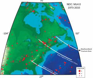
suggested [Sykes, 1978] that seismicity correlates with extensions of Atlantic Ocean fracture
zones. However, the larger subsequent earthquake location dataset indicates that this correlation
is weak (Figure 6).
Causes
The forces driving the seismicity are also unclear. On average, stress indicators for the eastern
U.S. show compression oriented ENE [Zoback, 1992]. This direction is similar to that predicted
by models of intraplate stress due to platewide forces including "ridge push" caused by cooling
oceanic lithosphere [Richardson et al., 1979], mantle flow beneath the continent [Forte et al.,
2007], and combinations of these and other topographic forces [Ghosh and Holt, 2011]. The
observation that seismicity occurs especially along the margins suggests a contribution from
local mechanisms causing approximately margin-normal localized stresses [Stein et al., 1989].
These include "spreading" of lower density continental crust over oceanic lithosphere [Bott,

Passive-aggressive margin seismicity revised December 22, 2011
9
1971], the load of offshore sediment [Walcott, 1972; Turcotte et al., 1977; Cloetingh et al.,
1983], and stresses due to the removal of glacial loads [Stein et al., 1979; 1989; Quinlan, 1984].
The possible role of deglaciation in triggering seismicity by perturbing the background stress
state has been a subject of interest because two of the largest passive margin earthquakes, 1929
Grand Banks and 1933 Baffin Bay, occur along the deglaciated coast. A challenge in assessing
this effect has been that the predicted rates of glacial isostatic adjustment (GIA) and thus the area
over which this effect is significant depend crucially on the assumed viscosity structure. For
example, Wu and Johnston [2000] find that deglaciation may be significant for earthquakes in
the St. Lawrence valley. However, because GIA effects decay rapidly away from the ice margin,
they should have little effect in the New Madrid area, unless the viscosities of the crust and upper
mantle there are an order of magnitude weaker than surrounding areas [Grollimund and Zoback,
2001], which seems not to be the case [McKenna et al., 2007].
The availability of GPS data has recently made it possible to map the rate of GIA [Sella et al.,
2007]. The results (Figure 7) show that these motions are small south of the "hinge line"
[approximately at the latitude of the Great Lakes] separating uplift to the north from subsidence
to the south. In general, seismic moment release decreases southward along the margin,
consistent with the variation in vertical motion rates observed by GPS, suggesting that north of
the hinge line GIA is an important contributor to intraplate seismicity.
However, south of the hinge line, other stress sources should be more significant. The occurrence
of large earthquakes and on other margins that have not been recently glaciated (Figure 1)

Passive-aggressive margin seismicity revised December 22, 2011
10
indicates that GIA cannot be the only mechanism at work. A similar conclusion emerges from
geological observations of other vertical motions. In particular, in the mid-Atlantic region
deformed stratigraphic and geomorphic markers, localized high-relief topography, and rapid
river incision show uplift of the Piedmont and Appalachians relative to the Coastal Plain for the
past 10 Ma, suggesting that the seismicity reflects active and long-term deformation [Pazzaglia
and Gardner, 1994; 2000; Pazzaglia et al., 2010]. These motions may reflect dynamic
topography resulting from mantle flow [Moucha et al., 2008].
Challenges
The Mineral earthquake illustrates our limited knowledge of passive margin earthquakes. The
issue is how forces that we do not understand cause motion on faults that have not been
identified and hazards that we cannot easily assess.
First, we incompletely understand the earthquakes' geologic setting. Most have not yet been
associated with specific structures whose geological and paleoseismic history can be studied.
Similarly, because these earthquakes are relatively rare, the instrumental seismic record is
generally inadequate to map long-lived faults. Thus most of what we know comes from studying
the fault planes and aftershock geometries of recent large magnitude earthquakes, which may
give little insight into future ones.
Second, it is hard to assess the recurrence of large passive margin earthquakes. Except in the
Charleston area [Talwani and Schaeffer, 2001], little paleoseismic data exist [Wheeler, 2006].

Passive-aggressive margin seismicity revised December 22, 2011
11
As a result, one can only use regional frequency-magnitude data.
Third, we are unclear about the force systems loading faults and causing motion on them.
Although various models predict stress directions generally consistent with the inferred stress
field, it is difficult to discriminate between models.
As a result, hazard mappers must chose between drawing high-hazard bull’s-eyes at the locations
of past earthquakes, which are often not useful predictors of future hazard [Swafford and Stein,
2007; Liu et al., 2011; Stein et al., 2011], or mapping a uniform regional hazard. As Figure 4
shows, the different assumptions yield quite different maps, and a long time will be needed to see
which was more useful. As a result, developing a cost-effective mitigation policy is a major
challenge.
Progress on these issues seems most likely to come slowly via an integrated approach using
various techniques. High-precision geodesy can resolve crustal motions as slow as 1 mm/yr
[Calais and Stein, 2009]. GPS and InSAR studies will thus be able to identify regions where
resolvable strain is accumulating to be released in future earthquakes, or show that any strain
accumulation is much slower. Enhancing regional permanent seismological networks and the
EarthScope program's USArray will provide better data on large earthquakes and the locations of
microseismicity. Seismological, gravity, and magnetic data can be used to identify and map
buried and potentially seismogenic faults. Geomorphology and stratigraphy can constrain the
long-term deformation of geomorphic and stratigraphic markers, and paleoseismic studies may
succeed in identifying the locations of past earthquakes. Once enough data are compiled to

Passive-aggressive margin seismicity revised December 22, 2011
12
develop a space-time history of seismicity, modeling studies can explore the dynamics of the
fault systems [Li et al., 2009].
A natural question to ask is whether, given these challenges, passive margin earthquakes are a
minor curiosity about which research is unlikely to yield results commensurate with the effort
involved. Our sense is that the problem is worthy of study precisely because we do not
understand how large earthquakes occur where idealized plate tectonics predicts they should not.
The eastern U.S.'s population density and the need to expand the nation’s energy portfolio,
perhaps via offshore drilling and further development of nuclear power, make understanding
continental margin earthquakes even more significant.
Acknowledgements
We thank editor Eric Calais for inviting this paper and Bill Holt and Sierd Cloetingh for helpful
reviews. We also thank Mark Carter (USGS) and the residents of Lousia County, VA for help in
establishing a seismological and geodetic network to document after-effects of the 2011 Virginia
earthquake.
REFERENCES
Bent, A. L., A complex double-couple source mechanism for the Ms 7.2 1929 Grand Banks
earthquake, Bull. Seismol. Soc. Am., 85, 1003-1020, 1995.

Passive-aggressive margin seismicity revised December 22, 2011
13
Bent, A. L., The 1933 Ms= 7.3 Baffin Bay earthquake, Geophys. J. Int., 150, 724-736, 2002.
Bott, M. H. P., Evolution of young continental margins and formation of shelf basins,
Tectonophysics, 11, 319-327, 1971.
Calais, E., and S. Stein, Time-variable deformation in the New Madrid seismic zone, Science,
5920, 1442, 2009.
Cloetingh, S., M. Wortel, and N. Vlaar, State of stress at passive margins and initiation of
subduction zones, in Studies in Continental Margin Geology, Am. Assoc. Petrol. Geol. Mem. 34,
pp. 717-723, 1983.
Cloetingh, S., F. Beekman, P. Ziegler, J. van Wees, and D. Sokoutis, Post-rift compressional
reactivation potential of passive margins and extensional basins, in Nature and Origin of
Compression in Passive Margins, Geol. Soc. London Spec. Publ. 306, 27-70, 2008.
Dieterich, J. H., A constitutive law for rate of earthquake production and its application to
earthquake clustering, J. Geophys. Res., 99, 2601-2618, 1994.
Ebel, J.E., The Cape Ann, Massachusetts earthquake of 1755, Seismol. Res. Lett., 77, 74-86,
2006.

Passive-aggressive margin seismicity revised December 22, 2011
14
Ebel, J.E., Bonjer, K. and Oncescu, M., Paleoseismicity: seismicity evidence for past large
earthquakes, Seismol. Res. Lett. 71, 283-294, 2000.
Forte, A., J. Mitrovica, R. Moucha, N. Simmons, and S. Grand, Descent of the ancient Farallon
slab drives localized mantle flow below the New Madrid seismic zone, Geophys. Res. Lett., 34,
doi:10.1029/2006GL027895, 2007.
Ghosh, A., and W. E. Holt, Plate motions and stresses from global dynamic models, Science,
submitted, 2011.
Grollimund, B., and M. D. Zoback, Did deglaciation trigger intraplate seismicity in the New
Madrid seismic zone?, Geology, 29, 175-178, 2001.
Gutenberg, B., and C. F. Richter, Seismicity of the Earth, Hafner, New York, 1954.
Hasegawa, H. S., and H. Kanamori, Source mechanism of the magnitude 7.2 Grand Banks
earthquake of November 1929, Bull. Seismol. Soc. Am., 77, 1984-2004, 1987.
Hough, S. E., Large 19th century earthquakes in eastern/central North America, in Historical
seismology, edited by J. Frechet, M. Meghraoui, M. Stucchi and J. Vogt, pp. 351-367, Springer,
Dordrecht, Netherlands, 2008.

Passive-aggressive margin seismicity revised December 22, 2011
15
Hughes, S., Geology of the northern half of the Ferncliff 7.5' quadrangle, USGS EDMAP Open
File Report, 1:24,000 scale, 2011.
Li, Q., M. Liu, and S. Stein, Spatiotemporal complexity of continental intraplate seismicity, Bull.
Seismol. Soc. Am., 99, 52-60, 2009.
Liu, M., S. Stein, and H. Wang, 2000 years of migrating earthquakes in North China,
Lithosphere, 3, doi: 10.1130/L129, 2011.
McKenna, J., S. Stein, and C. A. Stein, Is the New Madrid seismic zone hotter and weaker than
its surroundings?, in Continental intraplate earthquakes, Special Paper 425 edited by S. Stein
and S. Mazzotti, pp. 167-175, GSA, Boulder CO, 2007.
Mixon, R. B., and Newell, W.L., Stafford fault system: structures documenting Cretaceous and
Tertiary deformation along the Fall Line in northeastern Virginia, Geology, 5, 437-440, 1977.
Moucha, R., A.M. Forte, J.X. Mitrovica, D.B Rowley, and S. Quere, Dynamic topography and
long-term sea-level variations, Earth Planet. Sci. Lett., 271, 101-108, 2008.
Pazzaglia, F. J., and T. W. Gardner, Late Cenozoic flexural deformation of the middle U.S.
Atlantic passive margin, J. Geophys. Res., 99, 12,143-12,157, 1994.

Passive-aggressive margin seismicity revised December 22, 2011
16
Pazzaglia, F. J., and T. W. Gardner, Late Cenozoic large-scale landscape evolution of the U.S.
Atlantic passive margin, in Geomorphology and Global Tectonics, edited by M. Summerfield,
pp. 283-302, John Wiley, New York, 2000.
Pazzaglia, F., P. Zeitler, B. Idleman, R. McKeon, C. Berti, E. Enkelmann, J. Laucks, A. Ault, M.
Elasmar, and T. Becker, Tectonics and Topography of the Cenozoic Appalachians, in Tectonics
of the Susquehanna Piedmont, edited by D. Wise and G. Fleeger, 111-126, 2010.
Qamar, A., Seismicity of the Baffin Bay region, Bull. Seismol. Soc. Am., 64, 87-98, 1974.
Quinlan, G., Postglacial rebound and the focal mechanisms of eastern Canadian earthquakes,
Can. J. Earth Sci., 21, 1018-1023, 1984.
Richardson, R., S. Solomon, and N. Sleep, Tectonic stress in the plates, Rev. Geophys. Space
Phys., 17, 981-1019, 1979.
Schulte, S. M., and W. D. Mooney, An updated global earthquake catalogue for stable
continental regions, Geophys. J. Inter., 161, 707-721, 2005.
Sella, G., S. Stein, T. Dixon, M. Craymer, T. James, S. Mazzotti, and R. Dokka, Observations of
glacial isostatic adjustment in stable North America with GPS, Geophys. Res. Lett., 34,
doi:10.1029/2006GL02708, 2007.

Passive-aggressive margin seismicity revised December 22, 2011
17
Stein, S., and M. Liu, Long aftershock sequences within continents and implications for
earthquake hazard assessment, Nature, 462, 87-89, 2009.
Stein, S., N. Sleep, R. Geller, S. Wang, and G. Kroeger, Earthquakes along the passive margin of
eastern Canada, Geophys. Res. Lett., 6, 537-540, 1979.
Stein, S., S. Cloetingh, N. Sleep, and R. Wortel, Passive margin earthquakes, stresses, and
rheology, in Earthquakes at North-Atlantic Passive Margins, edited by S. Gregerson and P.
Basham, pp. 231-260, Kluwer, Dordecht, 1989.
Stein, S., M. Liu, E. Calais, and Q. Li, Midcontinent earthquakes as a complex system, Seismol.
Res. Lett., 80, 551-553, 2009.
Stein, S., R. Geller, and M. Liu, Bad assumptions or bad luck: why earthquake hazard maps need
objective testing, Seismol. Res. Lett., 82, 623-626, 2011.
Swafford, L., and S. Stein, Limitations of the short earthquake record for seismicity and seismic
hazard studies, in Continental Intraplate Earthquakes, Special Paper 425 edited by S. Stein and
S. Mazzotti, pp. 49-58, GSA, Boulder, CO, 2007.
Sykes, L. R., Intraplate seismicity, reactivation of pre-existing zones of weakness, alkaline
magmatism, and other tectonism, Rev. Geophys. Space Phys., 16, 621-688, 1978.

Passive-aggressive margin seismicity revised December 22, 2011
18
Talwani, P., and W. T. Schaeffer, Recurrence rates of large earthquakes in the South Carolina
Coastal Plain based on paleoliquefaction data, J. Geophys. Res., 106, 6621-6642, 2001.
ten Brink, U., Tsunami hazard along the U.S. Atlantic coast, Marine Geology, 264, 1-3, 2009.
Turcotte, D. L., J. L. Ahern, and J. M. Bird, The state of stress at continental margins,
Tectonophysics, 42, 1-28, 1977.
Walcott, R. I., Gravity, flexure, and the growth of sedimentary basins at a continental edge, Geol.
Soc. Am. Bull., 83, 1845-1848, 1972.
Wheeler, R. L., Quaternary tectonic faulting in the eastern United States, Engineering geology,
82, 165-186, 2006.
Wilson, J. T., A new class of faults and their bearing on continental drift, Nature, 207, 343-347,
1965.
Wu, P., and P. Johnston, Can deglaciation trigger earthquakes in North America?, Geophys. Res.
Lett., 27, 1323-1326, 2000.
Zoback, M. L., Stress field constraints on intraplate seismicity in eastern North America, J.
Geophys. Res., 97, 11,761-11,782, 1992.

Passive-aggressive margin seismicity revised December 22, 2011
19
Figure 1: Map of passive continental margin earthquakes. Data from Schulte and Mooney
[2005].
Figure 2: Seismicity of the eastern North American continental margin since 1980 taken from
ANSS and Earthquakes Canada catalogs. Major historical events are also shown. Boxes denote
aftershock areas used in Figure 3.
Figure 3: Aftershock locations and histories for the 1929 Grand Banks and 1933 Baffin Bay
earthquakes.
Figure 4: Comparison of the 1985 and 2005 earthquake hazard maps of Canada. The older map
shows concentrated high hazard bull's-eyes along the east coast at the sites of the 1929 Grand
Banks and 1933 Baffin Bay earthquakes, whereas the new map assumes that similar earthquakes
can occur anywhere along the margin.
Figure 5: Location of the Mineral earthquake and regional seismicity. Focal mechanism from
USGS.
Fig 6: Seismicity of eastern North America compared to extensions of fracture zones proposed
as controlling mechanism by Sykes [1978].
Figure 7: Seismic moment release (1568-2003) from Schulte and Mooney [2005] (blue bars)
compared to vertical GPS velocities (red and yellow arrows) [Sella et al., 2007].