minute man national historical park
TRANSCRIPT

ARCHEOLOGICAL
COLLECTIONS MANAGEMENT
AT
MINUTE MAN
NATIONAL HISTORICAL PARK
MASSACHUSETTS
VOLUME 4
ACMP Series No. 4
Linda A. Towle and Darcie A. MacMahon
Editors
with contributions by
Stephen J. Butler, Sheila Charles,
Donna Gagnon and George H. Stillson
Division of Cultural Resources
North Atlantic Regional Office
National Park Service
U. S. Department of the Interior
Boston, Massachusetts
1986

Collections represent a valuable resource only and if
they are properly documented, conserved, organized in such a manner that their research value is maintained...To maintain their research value, both collections and their associated documentation must be accessible, and they must be protected from deterioration....Without a doubt, there is a crisis in curation (Marquardt et. al. 1982:409, 411).

Editors' Foreword and Acknowled ements
This is the fourth volume of the report on the Archeological Collections Management Project for Minute Man National Historical Park in Concord, Massachusetts (hereafter referred to as the ACMP for MIMA). The size of the report dictated that it be printed in four separate volumes, and this one contains chapters on the collections from sites in the North Bridge area of the Park. We have also included a chapter on miscellaneous collections from non-archeological projects which had been stored at the Park.
The Tables of Contents for Volumes 1 - 3 are included in this volume so that the reader may refer to the appropriate volume for the chapters on other sites' collections. Each chapter was written to be used independently, though an overall introduction to the project and a history of archeology at the Park are provided in Volume 1 (chapters 1 and 2). Volume 1 also includes a chapter (3) detailing the project's methodology, with an appended glossary of artifact definitions. These chapters should be consulted for general information about project goals, methods, and the final disposition of the collections and associated data.
This report is the culmination of three years of work inventorying and reanalyzing the archeological collections at MIMA. It follows three previous ACMPs for other parks in the North Atlantic Region, but differs from them in that its scope was broadened to include further analysis of the collections and evaluation of previous site interpretations to serve as background study for the MIMA Archeological Project, which began fieldwork this summer. We hope that these volumes will serve that function, and that they will aid the Park in the management and interpretation of their archeological sites and collections. We hope also that independent researchers will find the data to be in useful form for their own studies.
The collections discussed in the North Bridge chapters of this volume were inventoried in 1983-84, while the miscellaneous collections were done at the end of the project, in 1985. Most of the North Bridge chapters were drafted in 1984 and reflect our thinking at that point in time.
Many people have contributed to the chapters in this volume. The inventorying of the collections was done by Sheila Charles, Donna Gagnon, Suzanne Spano, Kerry Horn-Clingen, John Cheney, Jeannine Disviscour and Doreen Crowe. Jeannine and Doreen also entered the artifact data into the computer, and helped to tie up the project's many loose ends. Sheila Charles, Donna Gagnon, Steve Butler and George Stillson have all written portions of these chapters, and Donna, Steve and George were responsible for drafting the figures.
v.

During the first two years, this project was managed by
Alan Synenki. In 1985, Alan became the manager of a tmed he MIMA
Archeological Project, and Linda
ssu
responsibility for the ACMP. The ACMP procedures followed for MIMA had been developed under Alan's direction for the ites
ACMwerePs
at other Parks, and all of the North Bridge s inventoried and analyzed under Alan's direction.
Numerous people have helped in word processing this
volume, the most recent of whom are Barbara Kadlec and
Antetta oCoco. Without their hard work, this volume would
noton L have been completed.
George Stillson has also worked diligently to prepare all the artwork in preparation for
printing. We would like to thank all of the above people for their
efforts in bringing this project to a closedetail, ands in
of producing
editing this volume. We have been humbled by the these chapters, and appreciate our fellow workers' tolerance while we were completing this task.
This project could not have succeeded without the support of the staff at Minute Man National Historical Park. Curator Lynne Leopold-Sharp has been extremely helpful of duty and
to us,
continually going above and beyond the call exceeding all of our hopes for cooperation and assistance. We
also ve our gi thanks to Superintendent Robert Nash, who over the years has provided us with his support and constructive
recommendations.
Finally, we extend our gratitude to Frank McManamon, former Chief of the Division of Cultural Resources for the North Atlantic Region of the National Park Service. Frank was instrumental in initiating this project, and has been a major force in seeing it to its conclusion. As an archeologist, he also understood the requirements of dealing with archeological data, particularly data which has been previously excavated,
d,
and provided us with the managerial support necessary for completion of this project.
Linda A. Towle and Darcie A. MacMahon Charlestown, Massachusetts 31 July 1986
vi.

TABLE OF CONTENTS
VOLUME 1
Editors' Foreword and Acknowledgements
Table of Contents
PART I: ARCHEOLOGICAL COLLECTIONS MANAGEMENT AT MINUTE MAN NATIONAL HISTORICAL PARK
Chapter 1: INTRODUCTION Linda A. Towle
Chapter 2: A HISTORY OF ARCHEOLOGY AT MINUTE MAN NHP Alan T. Synenki
Chapter 3: METHODOLOGY Darcie A. MacMahon
REFERENCES CITED
PART II: THE FISKE HILL AREA
Chapter 4:
Chapter 5:
Chapter 6:
THE EBENEZER FISKE SITE Linda A. Towle
THE DAVID FISKE SITE Linda A. Towle
BATTLE ROAD ON FISKE HILL Linda A. Towle
REFERENCES CITED
vii.

TABLE OF CONTENTS
VOLUME 2
Editors' Foreword and Acknowledgements
Table of Contents
PART III: THE NELSON ROAD AREA
7: THE BULL TAVERN SITE Linda A. Towle
THE JACOB WHITTEMORE SITE Linda A. Towle
Chapter 9: THE TABITHA NELSON (THOMAS NELSON SR.) SITE
Chapter 10: THE THOMAS NELSON JR. SITE
Chapter 11: SITE 24
Chapter 12: THE JOSIAH NELSON SITE
Chapter 13: SITES 22 AND 23 Darcie A. MacMahon
REFERENCES CITED
Chapter
chapter 8:
Darcie A. MacMahon
Linda A. Towle
Darcie A. MacMahon
Linda A. Towle

TABLE OF CONTENTS
VOLUME 3
Editors' Foreword and Acknowledgements
Table of Contents
PART IV: THE VIRGINIA ROAD AREA
Chapter 14: THE EPHRAIM HARTWELL TAVERN SITE Darcie A. MacMahon
Chapter 15: THE JOB BROOKS SITE Darcie A. MacMahon
REFERENCES CITED
PART V: THE WAYSIDE AREA
Chapter 16: THE WAYSIDE Darcie A. MacMahon
Chapter 17: THE ELIPHELET FOX HOUSE SITE ("CASEY'S HOUSE") Darcie A. MacMahon
REFERENCES CITED
ix.

TABLE OF CONTENTS
VOLUME 4
Editors' Foreword and Acknowledgements
vii Table of Contents, Volume 1
viii Table of Contents, Volume 2
ix Table of Contents, Volume 3
x Table of Contents, Volume 4
List of Figures, Volume 4
List of Tables, Volume 4
PART VI: THE NORTH BRIDGE AREA
Chapter 18: THE EPHRAIM AND WILLARD BUTTRICK SITES Sheila Charles and Linda A. Towle
Introduction
Provenience and Coding System
Map Construction Stephen J. Butler
Introduction Evaluation of Source Material Map Construction Methodology
Data Problems
Elements of Excavation Problems in Collection Techniques Elements of Curation Missing Artifacts
Site Interpretation
Sources on the History and Archeology of Buttrick Hill Techniques and Results of Abel's Excavations Techniques and Results of Snow's Excavations
xvi
xx
1
19
21
22
22 22 27
32
32 34 34 36
38
38
41
50
x .

ACMP Analysis 53 Problems with Prior Interpretation 53 Synthesis and Reevaluation of Data 58
Management Summary 76
Previous Archeology 76 ACMP Interpretation 76 The Buttrick Sites Collection 77 Public Interpretation of the Buttrick Sites 77
Recommendations 78
Appendix 18.1. ACMP Provenience Codes 80 Appendix 18.2. Missing Artifacts 84 Appendix 18.3. ACMP Artifact Inventory 85 Appendix 18.4. Buttrick Artifacts: Cross
Mended and Cross Matched 94 Appendix 18.5. Zerbey Memorandum,
August 25, 1965 96
Chapter 19: THE ROADS WEST OF THE NORTH BRIDGE Sheila Charles
Introduction 101
Provenience and Coding System 103
Map Construction 105 Stephen J. Butler
Evaluation of Source Material 105 Map Construction Methodology 106
Data Problems 111
Method of Excavation 111 Documentation of the Excavation 111 Artifacts 112
Site Interpretation 113
Documentary Sources 113 Historic Background 114 Abel's Fieldwork 116 Results of Abel's Fieldwork 121 ACMP Site Interpretation 128
Management Summary 132 Linda A. Towle
Previous Archeology 132
xi.

ACMP Interpretation The Abel Collection Public Interpretation
133 133
of the Site 133
Recommendations
135
Appendix 19.1.
Appendix 19.2.
Chapter 20: THE DAVID BROWN Linda A. Towle
Trenches in the Archeological Exploration for Traces of the Historic Roads ACMP Artifact Inventory
SITE
136 143
Introduction
Provenience and coding System
The Tremer Collection The Kitchen Garden Collection The Bleacher Collection
Map Construction Donna Gagnon
Introduction Evaluation of Source Material Methods for Constructing Map
Data Problems
The Tremer Collection 177
The Kitchen Garden Collection 185
The Bleacher Collection 185
Site Interpretation: Architectural Features 186
Tremer's Analysis of House Foundations ACMP Analysis of House Foundations Tremer's Analysis of Barn Complex ACMP Analysis of Barn Complex Wells
186 198 210 213 218
Site Interpretation: Artifact Analysis
Tremer's Analysis 222
Faunal Analysis 223
ACMP Analysis 226
Site Interpretation: Location of the David Brown House and Barn 241
153
156
156 159 162
163
163 163 174
177
222

The Groton Road 241 Written References to the Location of Brown's House 243 The Doolittle Print 245 The Construction of Liberty Street 247 Predicted Location of Brown's House 248 Mapped Locations of Brown's House 249 Summary 259
Management Summary 262
Previous Archeology 262 ACMP Interpretation 262 The Brown Site Collection 263 Public Interpretation of the Brown Site 263
Recommendations 265
Appendix 20.1. Appendix 20.2. Appendix 20.3.
Appendix 20.4.
ACMP Provenience Codes 268 The Rhoades House'and Barn 270 Triangulation of Historic Maps - Stephen J. Butler 275 ACMP Artifact Inventory 280
Chapter 21: THE ELISHA JONES SITE Linda A. Towle
Introduction 289
Provenience and Coding System 290
The Abel Collection 290 The Mahlstedt Collection 291
Map Construction 294 George H. Stillson
Introduction 294 Mahlstedt's Excavations 294 Abel's Excavations 296
Data Problems 299
The Abel Collection 299 The Mahlstedt Collection 303 Architectural Projects 306
Site Interpretation .... 307
Historical Significance 307 Architectural Analysis of the Shed 312 Abel's Analysis 315 Mahlstedt's Analysis 319

ACMP Analysis: The Abel Collection 320 ACMP Analysis: The Mahlstedt Collection 325 ACMP Analysis: Architectural Projects 326 ACMP Analysis of the Elisha Jones Site 327
Management Summary 329
Previous Archeology.. 329 ACMP Interpretation 330 The Jones Site Collections 330 Public Interpretation of the Jones Site 331
Recommendations 332
Appendix 21.1. ACMP Provenience Codes 334 Appendix 21.2. ACMP Artifact Inventory 336
Chapter 22: THE JOHN FLINT SITE Linda A. Towle
Introduction 345
Map Construction 346 George H. Stillson
Introduction 346 Tremer's Excavations 346 Map Construction Methodology 347
Data Problems 350
Site Interpretation 352
Historical Significance 352 Historic Maps 352 Tremer's Excavations 354
Management Summary 357
Previous Archeology 357 ACMP Interpretation 357 The Flint Site Collection 357 Public Interpretation of the Flint Site 357
Recommendations 359
REFERENCES CITED 361
xiv .

PART VII: MISCELLANEOUS COLLECTIONS 369 Chapter 23: MISCELLANEOUS COLLECTIONS
Darcie A. MacMahon
Introduction 371
Provenience and Coding System 372 Interpretation
374
John Buttrick House Collection 374 Monument Square Collection 374 Paul Revere Capture Site Collection 375 Unprovenienced Collection - Minute Man 376 Recommendations 378
Appendix 23.1. ACMP Artifact Inventory 379
xv .

LIST OF FIGURES
VOLUME 4
VI.1. ACMP Base Map of North Bridge Area 3
VI.2. U.S.G.S. Topographic Map, Concord Quadrangle 5
THE EPHRAIM AND WILLARD BUTTRICK SITES
18.1. Bleacher's Photograph of Buttrick Foundations 20
18.2. ACMP Composite Site Map of Excavations by Abel and Snow at the Ephraim-Willard-Stedman Buttrick Site 23
18.3. ACMP Map Showing Structural Features at the Ephraim-Willard-Stedman Buttrick Site
29
18.4. ACMP Map Showing Snow's Proposed Property Boundaries for Willard Buttrick Property 31
18.5. Abel's Photograph of Water Screening for Small Artifacts during 1965 Excavation
42
18.6. Abel's Photograph of Crane Removing Stone Fill from Well During 1965 Excavation
42
18.7. Abel's Photograph of Trenches Dug During 1965 43 Excavation
18.8. Abel's Photograph of Concrete Floor of 19th Century Buttrick Farmhouse
46
18.9. Abel's Photograph of Stone-lined Drain Leading from 18th Century House 47
18.10. Abel's Photograph of Foundation of L-shaped Structure, Looking West 48
18.11. Snow's Photograph of chimney Base of Ephraim 51 Buttrick Structure
18.12. Snow's Photograph of North Side of Chimney Base of Ephraim Buttrick Site During Excavation 52
18.13. Reproduction of Doolittle Print Depicting the Skirmish at the North Bridge
54
18.14. Photograph of 1850 Stedman Buttrick Farmhouse, Taken ca. 1895-1900 61
xvi.

THE ROADS WEST OF THE NORTH BRIDGE
19.1. ACMP Map of Area West of the North Bridge, Showing the Location of Abel's Test Trenches 102
19.2. ACMP Map Showing Location and Results of Abel's Trenches #1-9 108
19.3. ACMP Map Showing the Location and Results of Abel's Trenches #10-15 and #25-27 109
19.4. ACMP Map Showing the Location and Results of Abel's Trenches #16-24 110
19.5. Benjamin Brown Map of North Part of Concord, 1754 117
19.6. ACMP Tracing of Map of Groton Road, Probably Drawn in 1792 118
19.7. ACMP Tracing of Map of Roads in Vicinity of the North Bridge, Probably Drawn in 1792 119
19.8. Abel's Photograph Looking Southwest Across the Exposed Stone Roadbed 123
19.9. Abel's Photograph of the 1750 Causeway After a Thin Layer of Gravel Was Spread Over the Original Gravelled Surface 124
19.10. Abel's Photograph of the Surface of Groton Road 127
THE DAVID BROWN SITE
20.1. Bleacher's Photograph of the Brown Site 154
20.2. Tremer's Artifact List for Area 10 157
20.3. Tremer's Final Site Map of House Area 160
20.4. Tremer's Final Site Map of Barn Area 161
20.5. Tremer's Map of the Base Line and Grid System 164
20.6. ACMP Composite Site Map for the David Brown Site 165
20.7. Tremer's Photograph of Barn Area 167
20.8. MIMA Photograph Looking West Across House Foundation 168
20.9. MIMA Photograph of Southwest Corner of House Foundation 168
20.10. MIMA Photograph of Barn Area Facing Northwest 169
xvii.

20.11. Tremer's Photograph of Area 12 170
20.12. Tremer's Photograph of Room 4, Facing South 172
20.13. Tremer's Photograph of Room 4, Facing North 172
20.14. Tremer's Photograph of Well Interior 173
20.15. Tremer's Photograph of Well 173
20.16. Tremer's Map of Barn Area After First Season of Fieldwork 182
20.17. Tremer's Map Showing His Interpretation of the Structural Features at the House Site 183
20.18. Tremer's Map of House Area After First Season of Fieldwork 187
20.19. Tremer's Illustration of House Foundations with Earthen Chimney Base 189
20.20. Tremer's Illustration of Stairwell Area (Area 13) 190
20.21. Tremer's Illustration of Storage Niches in Chimney Base 192
20.22. Tremer's Illustration of Room 2 Wall Intersections 196
20.23. Tremer's Photograph of Area 10, Facing East 201
20.24. Tremer's Photograph of Storage Niche F-4 203
20.25. Tremer's Photograph of the Storehouse Foundation (Area 12) 205
20.26. Tremer's Photograph of the Barn Area Showing the Two Stone Channels 214
20.27. Tremer's Photograph of Stone Channel 6-3 215
20.28. Tremer's Photograph of Rubble Area 217
20.29. Tremer's Photograph of Features in Barn Area 217
20.30. Photograph Looking Southeast Across House Foundation 219
20.31. Photograph Looking North Across Kitchen Garden to the David Brown Site 220
20.32. Photograph of Tremer's Excavation at the David Brown Site 224

20.33. Tremer's Photograph of Stone Button Mold 231
20.34. Tremer's Photograph of Key 231
20.35. Photograph of the Interior of the Dinner Tent for the Centennial Celebration, April 19, 1875 235
20.36. ACMP Map Showing Locations of Abel's Test Trenches for the Acton Road 242
20.37. Reproduction of Doolittle Print Depicting the Skirmish at the North Bridge 246
20.38. 1830 Plan of Concord 251
20.39. 1852 Map of Concord 252
20.40. 1875 Centennial Map of Concord 253
20.41. ACMP Map Showing Results of Triangulations to Locate the David Brown House 254
20.42. Photograph of celebration Area, 1875 257
20.43. Photograph Showing Dinner Tent on Western Side of Bridge, 1875 258
20.44. Photograph Showing Dinner Tent, 1875 259
20.45. Benjamin Brown Map of North Part of Concord, 1754 276
THE ELISHA JONES SITE
21.1. ACMP Site Map Showing Abel's and Mahlstedt's Excavation Units 295
21.2. ACMP Map Showing Probable Location of Abel's Trenches in the Blacksmith Shop 297
21.3. ACMP Photograph of the Elisha Jones House, 1986 308
21.4. 19th Century Photograph of the Elisha Jones House 312
21.5. Photograph of 1875 Sketch of the 1775 Elisha Jones House and Shed 314
THE JOHN FLINT SITE
22.1. ACMP Map Showing Approximate Location of Tremer's Excavation Units 348
22.2. 19th Century Photograph Showing the 1880 Flint House 353
22.3. ACMP Photograph of the Flint Site, 1986 353
xix.

LIST OF TABLES
VOLUME 4
VI.1. Site Summary, North Bridge Area 6
VI.2. ACMP Summary Artifact Inventory 9
THE EPHRAIM AND WILLARD BUTTRICK SITES
18.1. Sequence of Ownership of the Ephraim and Willard Buttrick Houses 39
18.2. South's Ceramic Dating Formula Results 59
18.3. Harrington-Binford Dating Formula Results 60
THE ROADS WEST OF THE NORTH BRIDGE
19.1. ACMP Provenience Code Definitions 104
THE DAVID BROWN SITE
20.1. Missing Artifacts from the Tremer Collection 179
20.2. Artifact Analysis for the David Brown Site 228
20.3. Ratio of Distances Between Primary Stations 277
20.4. Ratio of Angles Between Primary Stations 278
THE ELISHA JONES SITE
21.1. ACMP Provenience Codes for Architectural Projects 292
21.2. ACMP Provenience Codes for the Mahlstedt Collection
21.3. Missing Artifacts from the Abel Collection
21.4. Mahlstedt Collection Artifact Counts
THE JOHN FLINT SITE
22.1. Artifacts Found at the John Flint Site
xx.

Part VI: The North Bridge Area
The North Bridge area is the westernmost part of Minute Man National Historical Park in Concord, Massachusetts (Figure VI.1). This area is dominated by the Concord River, which meanders northward through the Park. The elevation varies between 120 and 150 ft. above sea level, and the topography ranges from river meadows and floodplain to gently sloping knolls (Figure VI.2).
As early as 1654 the citizens of Concord had built a "north" bridge to join the portion of town on the north side of the Concord River with the center of town. This bridge was the focal point of the events on April 19, 1775. British troops had arrived in Concord to search for hidden military stores and supplies. The Concord Minute Men assembled on the "Muster Field" on the north side of the river, and marched down the road to the Bridge to confront the British. Major John Buttrick and Captain David Brown were among the leaders at the Bridge. Here "the shot heard 'round the world" was fired, the opening volley in the American Revolution. Upon their retreat, the British fired at Elisha Jones, standing in the doorway of his shed.
Several archeological excavations have been conducted at sites around the North Bridge (Table VI.1). Portions of the historic road leading west from the North Bridge have been located, and the house sites of David Brown and Ephraim and Willard Buttrick have been explored. Further east, the site of John Flint's house has been investigated, and excavations have been conducted at the Elisha Jones house, which still stands on the southeast side of the river (Figure VI.1).
The Brown, Buttrick and Flint house sites were discovered by archeological investigations, but questions remain regarding the correct identification of these sites. At the Brown site, a 17th/18th century cellarhole was excavated, but this structure may not have been occupied by David Brown in 1775. The Buttrick foundations which were excavated may represent only one house, either Ephraim's or Willard's. The foundations at the Flint site were not adequately excavated to determine if these were from the 17th or the 19th century Flint house. At the Elisha Jones house, the original location of the shed into which a British bullet was fired has not been found.

The archeological survey of the road west of the North Bridge yielded evidence of a cobblestone roadbed along the river. This was apparently replaced before 1750 with the sand and gravel causeway which was uncovered further from the river. Evidence was not found to determine the route of the west fork of the road which continued to Acton. Some evidence for the east fork, the Groton Road, was found on the hill leading to the Buttricks.
A total of 25,933 artifacts were inventoried from these sites (Table VI.2). Regrettably, the artifact collections from these excavations are limited by poor documentation, lack of stratigraphic control, lack of provenience data, and missing artifacts. However, the archeological investigations have helped to develop a more realistic picture of the cultural landscape surrounding the North Bridge at the time of the Battle.
One additional archeological excavation was undertaken by Linda Towle in 1983 prior to the construction of the comfort station adjacent to the North Bridge Parking Lot on Monument Street. Prehistoric sites were encountered here (Towle 1984). This collection was inventoried and boxed by the ACMP system, so it is not included in the current report.
2


=MI
1000 3030 4000 5000 6000 7000 FEET 0 ICCO 2000
0 1 KILOM ETER
SCALE 1:25 000 0
CONTOUR INTERVAL 10 FEET NATIONAL GEODETIC VERTICAL DATUM OF 1929
705.0 ----------
bl IS
J4
',1111 . 0 / 140 • ,* 0
7
Y
7
. - ek
I C r ■
A /Old ROfth BA
% ' 41( Minutf- an A • 4, Mon ' ... ,,,, 1 0
-7. 92, •
eat ,
Sewage
., Jinn
10 i osr -c 0 !I _.„
--/ r - )
•
4
• .
-QV -4.41
■47,
-enT., •
\ 9,•• • \ "s`k
, /,
. Imp-
,
\S. t?Jo
., . g • 5 A
vow Al .......--.
Bangl
4
.• At:
.-
401 ii• _ '.
\
0s-
' --- lifiE llillriLlikilikh.i
i h amemi reht 130%,
74irr 4Vr-
' 0 0,1% BM
hhT/0 d 12
''' it•
t •
130
, I
• • • '. '...• • . •
*
;
. ell. • • ' .". - f;, *# o
- '\,.
.. \ 0
Ram Sell
0
MI
tl CO
, MII
ON
15%.
_
- / • ' 2 •••12. a (1°
r
20 °
•••••••
k.
ni III
. . laygrouM
Trliiii,
,,_..... ....
•
•
- •
v (
•
„•••
9
k '
.
• 0 . 4,,,, • 2,g,
9 .....
v 8
_ 15 . Pi p T
I
14\
ttat. • .
0
iqhgraisi , ,,,,
U cNA-3-I
- 4 ,.- - :
((t. oIlkffikCo
It'
aldets Pond 7 11 as
CONCORD, MASS. N4222.5—W7115/7.5
1970 1821111-nntsno Cr, n inn
1-
D AND 1979 IATION AT CENTER
28 MILS 'IS
MAGNETIC NORTH .; % - OF SHEET '. , ,
AMS 6788 IV NE-SERIES V814
by
UTM 0 DECLI I
4 1
27'3
410
Figure VI.2. U.S.G.S. Topographic map, Concord quadrangle. The arrow in the center of the map indicates the North Bridge area of the Park.
5

-, N IT en o H H r-I 0:1 I
.1-1 O, cor- al he 0 N O 0 el 1.4
a CO Ms a C a O a) 1{1. 1) rg /15 > 4-1 C 44 el el • 0 a r I) 44 I-I 113 4 Z la
O
N 001 H UN 10 40
I0I ()
ea 0 z 0 co H 4) co z 1.4 hro
Abel 19
65
H
W C 0 0 Z
O H O
NI la Z
ry
C It H 0.) .0
eM
0 • .0
V .0 44 V It fA 1.4 O 0 0 la rd Z Ca
to
CO
ro • C C O 0 Z Cu
0 • ❑ C O 0 Z hh.
M a V Ll el 44el al 10 44 04
fp 14 el 4J al a ,C V el a 11
04 C el 0 v CO E.1 asZOICD
Affi
lia
tio
n
0 H
C
US .04 0 0
0
4 0 Z I-1 14 Z 4
E.) al En 1.4 4-1 Z
O 0 C..) 4-)
•
it
O
•
3 44 0 O c
u)
0
el
•
0 01 a O 44 H 0 0 W a) .0
4 Zv •
Z .4
it 4 4-) Cu III O %
N 0 fa 0 10 0 E a
z
a al O 0 a
CO 9-1 Id N Z
a (-I .1-1)
ca ..-• 0 Co z
w H
0 Z
.0 to 0
H
N
10 H
to H
111
▪
1.0 U1 Lel
M
co 0
al 1.1. co 0 al 0 C 0 oh H 0 C •H .1-1 en 0 E v al
0 el a el 0 H H E.) as a) )..) a) I) 3 4.1 N^ 0 .- 7 E 7 C 0 0 0. n o• IA 0 0 0) 10 el C c •)-1
0 Re
4 -.4.0 v u) C X --- Ca 4-4 401 e
0 44 H • I .0 40 • ••
• 4S ON C 113 O el 04 • CO el
10 .•
it • •3 • a)
o rn 4 El al . ur... •. N. Z i 0 en 0 cn Co a, H el • 0 cn v m v Z • En • 1.4 et
I 0 C-) In 0.) o. $.4 el 14 •. 0 (..) • .0
I/ N • • • ON () •• 0
WE • e a, • a r- 4 ,0 CI CT% • cn 0 I rh4 X on E I a) r- -4.
la ..-I 14 el 5 I-1 I H co el 01 I
FICuElm. 01 Zon E a, al ei r4
-
E or O N N
ON 01 E.) ri
W E O la O 0 a)
Z W )-1
1970-
19
71
>1 01 .0 1.4 04 C
u] 0 0.1 u C el01110
> H H O '•-1 7 H
C 0 E-4 Z C)
)4 .1) E
M .0 UE
Concord
Scho
o
l Stude
nts
19
76-79
Co
bCu
C • C
U WO 13 44 .04 10
Z
W • la E.) 44
el a) > > C 14 C W
01 C)
.0
C 10 a) 0H roan
v 3
> es
en
Ta
ble
V
1.
1
.• ON
ON H
0 0 10 el
c> H 01 N N N ON ON 04 H H H
14 44 la W a) 0 W E W a) 11) )4 h. 14 • El
14-1 .04 414 0 la 141
Ul 0 a as
111 ON
tfl Ul 1/40 a. rn 0101 N
Z Z
0 W
O
•
0 Zr..
6

a 4 • • 1-1 0 • C-1
PC
Pho
tog
rap
hs
a
a
•
4-1
4-1 ON • t ra CO E 4-1 rt.
al C 0 Z
Aug
ust 19
79
Aff
ilia
tio
n
C
Tre
mer
19
73b
.
•
0 m n
44 ON E.. re
w a a o o Z
N
el N
re
0)
4 co 014 m 0 w E 4
C g
.4 Pa0
0.
01 0
4-I C a >- O ha U 0
C
• > 4-1 C
a
PC
4.1
C z
.0
C N
a re
.0
co
en
a,
Z
4). e-1 21 0 CO
V COI el W C 111 4.) C
0 0 0 CuZr..
ti
N in .4 era CO ON ot r-1 re I
Oe • t) w le 41
• C.) m M 0 ..4
a
ti 01 0 el 0
• C • C.■
w X .2
O
6 2 z
OI a 0
4' P,
N
4-1 0 •
.0 '0 Ul .1.1 m 4 > 0 .0 CW .0 .0 4
E., X
C .0 19
WI CO 0 4.1 CO .4•1 el CO 01 /,
7

Table VI.2
ACMP Summary Artifact Inventory for:
The David Brown Site The Ephraim and Willard Buttrick Sites
The Elisha Jones Site The Roads West of the North Bridge
9

NORTH BRIDGE Area
Sites:
HISTORIC CERAMICS Redware
David Buttrick Elisha Roads TOTALS % of Brown Hill Jones West of Historic
N. Bridge Ceramics
Plain 514 310 73 4 901 Lead Glazed, 1 surface 680 486 60 0 1226 Lead Glazed, 2 surface 197 159 16 0 372 Sgraffito 3 0 0 0 3 Trailed Slipware 15 10 1 0 26 Jackfield 2 0 0 0 2
Astbury 0 0 0 1 1
Other 6 3 0 0 9
Total Redware 1417 968 150 5 2540 17.6%
Tin Enameled Delft 79 3 2 0 84 Rouen/Faience 0 0 0 0 0
Other 1 0 0 0 1
Total Tin Enameled 80 3 2 0 85 0.6%
Coarse Buff Body Combed Ware 9 5 1 0 15
Dotted Ware 0 1 0 0 1
N. Devon Gravel 0 0 0 0 0 Mottled 0 5 0 0 5
Other 6 8 0 0 14 15 19 1 0 35 0.2%
Total Coarse Buff Body
Creamware Plain 402 630 97 1 1130
Shell-Edged 1 1 0 0 2 Other Edge Decorated 5 0 0 0 5
Handpainted 1 0 0 0 1
Annular 20 3 0 0 23 Transfer Printed 0 0 2 0 2
Other 2 7 0 0 9 Total Creamware 431 641 99 1 1172 8.1%
Pearlware Plain 412 701 84 1 1198
Shell-Edged 362 184 12 0 558
Other Edge Decorated 35 58 0 0 93
Handpainted 89 41 17 0 147
Annular 33 49 11 1 94
Transfer Printed 310 142 25 2 479
Other 7 25 19 0 51
Total Pearlware 1248 1200 168 4 2620 18.2%
Whiteware Plain 3893 786 246 2 4927
Shell-Edged 6 26 8 0 40
Other Edge Decorated 20 7 1 0 28
Handpainted 23 35 2 0 60
Annular 9 20 15 0 44
Transfer Printed 601 223 53 0 877
Other 316 133 5 73 527
Total Whiteware 4868 1230 330 75 6503 45.2%
10

NORTH BRIDGE Area
Sites:
Other Earthenware
David Buttrick Elisha Roads Brown Hill Jones West of
N. Bridge
TOTALS % of Historic Ceramics
Whieldon 0 0 0 0 0 Lusterware 0 0 0 0 0 Agateware 0 0 0 0 0 Rockingham/Bennington 49 8 6 0 63 Yelloware 261 55 11 0 327 Other 27 6 6 0 39 Total Other Earthen. 337 69 23 0 429 3.0%
Porcelain Undecorated 153 33 174 0 360 Underglaze HP-monochro 52 17 6 34 109 Underglaze HP-polychro 1 0 0 0 1 Overglaze HP-monochrom 1 9 0 0 10 Overglaze HP-polychrom 11 4 10 0 25 Gilted 27 0 1 0 28 Transfer Printed 1 5 0 0 6 Other 22 6 7 5 40 Total Porcelain 268 74 198 39 579 4.0%
Stoneware Nottingham 1 1 7 0 9 0.06% Other English Brown 0 0 1 0 1 0.01% Bellarmine/Frenchen 0 1 0 0 1 0.01% Westerwald/Raeren 2 3 1 0 6 0.04%
White Salt Glazed Plain 18 27 1 0 46 Moulded 0 1 0 0 1 Scratch Blue 1 4 0 0 5 Other 1 4 0 0 5 Total White Salt Glz 20 36 1 0 57 0.4%
Drybody Black Basaltes 0 0 0 0 0 Rosso Antico 0 0 0 0 0 Other 0 0 0 0 0 Total Drybody 0 0 0 0 0 0.0%
Other Utilitarian Import 15 22 2 0 39 Domestic 61 195 26 0 282 Other 4 27 6 0 37 Total Other 80 244 34 0 358 2.5%
Total Stoneware 103 285 44 0 432 3.0%
TOTAL HISTORIC CERAMICS 8767 4489 1015 124 14395 100.0%
% of Total Artifacts 55.5%
1 1

NORTH BRIDGE Area
Sites:
PIPES White Clay
David Brown
Buttrick Elisha Roads Hill Jones West of
N. Bridge
TOTALS % of Total
Artifacts
Bowls 35 11 3 1 50 Stems: 4/64 5 10 3 0 18
5/64 32 27 1 1 61 6/64 19 3 0 0 22 7/64 27 2 0 0 29 8/64 5 0 0 0 5 9/64 1 0 0 0 1 INDT 2 0 0 0 2
TOTAL: 126 53 7 2 188
Red Clay Bowls 0 0 0 0 0 Stems 3 0 0 0 3 TOTAL: 3 0 0 0 3
Other 0 0 0 0 0 TOTAL PIPES 129 70 7 2 208 0.8%
GLASS Bottle Glass Freeblown 127 75 2 0 204 Blown in Mold 187 535 441 0 1163 Auto Machine Made 62 180 38 1 281 Indeterminate 127 19 0 0 146 TOTAL 503 809 481 1 1794 6.9%
Drinking Vessel Freeblown 18 34 0 1 53 Machine blown/pressed 63 63 56 0 182 Indeterminate 96 6 1 0 103 TOTAL 177 103 57 1 338 1.3%
Indet. Curved Glass 0 0 1 0 1 TOTAL GLASS 680 912 539 2 2133 8.2%
BOTTLE CLOSURE Ceramic 0 1 0 1 Glass 6 2 0 8 Metal 4 10 0 14 Weed/Cork 4 1 0 5 Synthetic 2 11 0 13 Other 0 0 0 0 TOTAL BOTTLE CLOSURE 16 25 0 41 0.2%
12

NORTH BRIDGE Area
Sites:
APPAREL
David Buttrick Elisha Roads Brown Hill Jones West of
N. Bridge
TOTALS % of Total
Artifacts
Clothing 0 0 0 0 0 Footwear 1 2 7 0 10 Other 0 0 0 0 0 Indeterminate 0 1 1 0 2 TOTAL APPAREL 1 3 8 0 12 0.05%
BUTTONS, ETC. Button 14 7 9 1 31 Buckle 5 3 4 0 12 Other Fastener 0 2 0 0 2
19 12 13 1 45 0.2% TOTAL BUTTONS, ETC.
HOUSEHOLD & PERSONAL Tableware 11 43 10 0 64 Kitchenware 1 19 31 0 51 Furniture & Hardware 1 4 2 0 7 Lighting Fixtures 41 80 336 0 457 Decorative Objects 2 2 8 0 12 Toiletries 5 5 3 0 13 Stationary 0 0 4 0 4 Coins/Tokens/Medals 0 4 0 0 4 Personal Objects 1 4 4 0 9 Toys 13 7 6 0 26 Other 5 16 13 0 34 Indeterminate 26 54 15 0 95 TOTAL H & P 106 238 432 0 776 3.0%
935 1251 1024 5 3215 12.4% SUBTOTAL.
13

NORTH BRIDGE Area
Sites:
ARCHITECTURAL MATERIAL Window Glass
David Buttrick Elisha Roads Brown Hill Jones West of
N. Bridge
TOTALS % of Total
Artifacts
Crown/Cylinder 256 309 420 0 985 Plate 564 177 17 0 758 Other 0 0 0 0 0 Indeterminate 10 13 2 0 25 TOTAL GLASS 830 499 439 0 1768 6.8%
Nails Handwrought 204 23 116 0 343 Machine Cut I 11 64 348 0 423 Machine Cut II 144 35 861 0 1040 Machine Cut Indet. 2 0 215 0 217 Wire 0 25 506 0 531 Indeterminate 54 732 597 0 1383 TOTAL NAILS 415 879 2643 0 3937 15.2%
Screws Handwrought 0 2 0 0 2 Machine Cut 4 0 29 0 33 Indeterminate 0 5 0 0 5 TOTAL SCREWS 4 7 29 0 40 0.2%
Other Hardware Builders' Hardware 25 11 10 0 46 Window Hardware 18 2 6 0 26 Door Hardware 5 8 17 0 30 Electrical Hardware 0 1 6 0 7 Plumbing Hardware 2 4 3 0 9 Lighting/Heating Hdwr. 0 0 2 0 2 Other 3 35 51 0 89 Indeterminate 56 47 37 0 140 TOTAL OTHER HDWR. 109 108 132 0 349 1.3%
Structural Material Brick 87 85 174 0 346 Mortar/Plaster 9 42 30 0 81 Wood 6 64 9 0 79 Linoleum 1 0 0 0 1 Stone 8 26 3 0 37 Fiber 0 0 0 0 0 Porcelain 0 0 0 0 0 Earthenware/Stoneware 2 94 4 0 100 Synthetic 0 0 2 0 2 Metal 0 8 16 0 24 Other 0 17 0 0 17 TOTAL STRUCTURAL 113 336 238 0 687 2.6%
14

NORTH BRIDGE Area
Sites:
Other Fastening Devices
David Buttrick Elisha Roads Brown Hill Jones West of
N. Bridge
TOTALS % of Total
Artifacts
Staples 1 4 11 0 16 Bolts 2 3 1 0 6 Wood Fasteners 0 0 0 0 0 Other 0 0 3 0 3 TOTAL FASTENING 3 7 15 0 25 0.1%
TOTAL ARCHITECTURAL MATERIALS 1474 1836 3496 0 6806 26.2%
TOMS & HARDWARE Hand Tools 3 0 11 0 14 Machine Parts 2 0 7 0 9 Domestic Animal Gear 3 9 3 0 15 Transportation Objects 0 1 2 0 3 Weaponry/Accoutrements 1 2 1 0 4 Other 5 2 8 0 15 Indeterminate 11 19 42 0 72 TOTAL TOOLS & HDWR 25 33 75 0 133 0.5%
1499 1869 3571 0 6939 26.8% SUBTOTAL
15

NORTH BRIDGE Area
Sites: David Bu ttrick Elisha Roads Brown Hill Jones West of
N. Bridge FUEL & FIRE BYPRODUCTS (Weight in grams)
TOTALS % of 'Dotal
Artifacts
Coal 470.30 13.81 109 0.00 Charcoal 22.53 0.11 0 0.00 Ash/Cinders/Clinkers 40.37 24.33 91 0.00 Wood 14.35 39.53 0 0.00 Slag 10.00 47.41 25 0.00 TOTAL FUEL & FIRE 557.55 125.19 225 0.00
FLORAL & FAUNAL REMAINS Shell (Weight in grams) Bivalves 7.49 191.00 3 0.00 Univalves 0.00 0.00 0 0.00 Indeterminate Shell 0.00 7.00 0 0.00 Other Organic 0.00 3.54 0 0.00
Bone Fish 0 0 0 0 0 Whale 0 0 0 0 0 Human 0 0 0 0 0 Mammal 765 226 19 0 1010 Bird 16 22 6 0 44 Other 0 0 0 0 0 Indeterminate 1 67 1 0 69 TOTAL BONE 782 315 26 0 1123 4.3%
Vegetal Material Seeds/Nuts 5 46 3 0 54 Other Comestibles 0 0 0 0 0 Other vegetal Material 0 0 0 0 0 TOTAL VEGETAL 5 46 3 0 54 0.2%
TOTAL FLORAL & FAUNAL 787 361 29 0 1177 4.5%
LITHICS Fire Cracked Rock 0 0 0 0 0 Unworked Lithic 0 0 0 0 0 Gunflints 0 1 1 0 2
Groundstone Historic 2 1 0 0 3 Prehistoric 0 0 0 0 0 Total Groundstone 2 1 0 0 3
Chipped Stone Point 1 0 0 1 2 Biface 0 0 0 1 1 Other 1 0 0 0 1 Total Chipped Stone 2 0 0 2 4 TOTAL LITHICS 4 2 1 2 9 0.03%
16

NORTH BRIDGE Area
Sites:
SAMPLES
David Brown
Buttrick Elisha Roads TOTALS % of Hill Jones West of Total
N. Bridge Artifacts
Soil 0 0 0 0 0 C-14 0 0 0 0 0 TOTAL SAMPLES 0 0 0 0 0 0.0%
SUBTOTALS 791 363 228 2 1186 4.6%
GRAND TOTALS SUBTOTAL HISTCER 8767 4489 1015 124 14395 SUBTOTAL PIPES 935 1251 1024 5 3215 SUBTOTAL ARCHITEC 1499 1869 3571 0 6939 SUBTOTAL FUELFIRE 791 363 228 2 1384
11992 7972 5838 131 25933
17

CHAPTER 18
THE EPHRAIM AND WILLARD BUTTRICK SITES
Introduction
Northwest of the Concord River overlooking the North Bridge is Buttrick Hill, historically significant as the setting for the battle at the North Bridge, April 19th, 1775. Historic tradition and research by Park historians (Zerbey 1965b:1) indicated eighteenth century occupation of this hill by members of the Buttrick family, a family "associated with more than three centuries of Concord's history" (Luzader 1968a:4).
In 1964 park officials approved a Project Construction Proposal (Zerbey 1968a) calling for archeological investigation to precede the rehabilitation and preservation of the remaining portions of the Ephraim and Willard Buttrick houses, believed to be located on the front lawn of the Buttrick Mansion. The basis for justifying this research was stated as follows in the Project Construction Proposal:
These houses were part of the 1775 scene. The British 10th Light Infantry Company was stationed by one of these houses. They are indicated on the Mackenzie map and one is the prominent house on the Doolittle engraving of the fight at North Bridge. This work is needed for the proper interpretation of the fight at North Bridge (Zerbey 1968a).
Two primary episodes of archeological research occurred to determine the location and extent of the ruins of the Ephraim and Willard Buttrick houses and outbuildings. The first, begun in June 1965, was conducted under the direction of MIMA archeologist Leland J. Abel. The second excavation in 1968 for the purpose of locating the Ephraim Buttrick house site was contracted out (Contract #14-10-5-406-43) to Cordelia Thomas Snow.
These archeological projects were not the only investigations carried out on the site. Over a decade after the excavations, in May 1978, an on-site examination by Denver Service Center Senior Archeologist Jackie W. Powell, Regional Archeologist Frank McManamon, Superintendent Robert Nash and Chief Interpreter Cynthia Kryston determined that the Buttrick site was one of five archeological sites which had deteriorated, and whose historic fabric was "threatened by vegetation, weathering and erosion, and vandalism" (Bleacher 1979:3).
19

Although successful stabilization measures had previously been undertaken at this site [i.e., parts of the southern and western wall of the west foundation had been rebuilt and concrete poured into trenches behind the walls (Bleacher 1979:3)], poor drainage in the western foundation required additional attention. The following stabilization methods were implemented:
Vegetation was removed by hand using kitchen and garden shears. Using wheelbarrows, shovels and rakes, 3/4" stone was placed within the western foundation. The stone is 4 to 6" in depth at the western end where drainage has been the poorest. In the remainder of the foundation, stone is 2 to 3" deep...and approximately 1" below the top of the standing walls at their lowest elevation (Bleacher 1979:12).
Although Bleacher did not record any artifact collection (1979), the foundation reconstruction certainly altered the original site disposition (Figure 18.1).
Figure 18.1. Photograph of Buttrick foundations after stabilization (Bleacher 1979:Roll 3, Frame 2).
20

Provenience and Coding System
The ACMP provenience coding system was designed to retain and include all original provenience information established by the original excavators. Each artifact received a code in this system which indicated the site, excavation unit, feature number, and level from which it was recovered. The format for this information was a 13 digit field in the following format:
AA-BBBB-CCCC-DDD
Where:
AA = Site designation, BBBB = excavation unit designations assigned by original
excavator, CCCC = cultural features encountered during excavation, DDD = level numbers and other stratigraphic designations
used during excavation.
Appendix 18.1 provides a summary of this information by site and indicates the format for coding the provenience information. When the original excavators failed to provide this detailed information or the documents were incomplete in specifying recovery locations, the ACMP avoided making assumptions and utilized more general provenience codes.
Since the original excavators applied many different names (e.g., Buttrick, Buttrick Estate, Buttrick Road, Buttrick Lawn, Buttrick House, Buttrick Mansion, Buttrick House #1, Buttrick House #2, Jonathan Buttrick, Ephraim Buttrick, Willard Buttrick, etc.) to some of the same areas under investigation, seven site designations were developed to mitigate the problems of numerous, ambiguous artifact recovery location descriptions. The site names that appear in Appendix 18.1 were assigned by the ACMP. The excavation unit designations were the analytical units imposed by the archeological investigators, such as test trenches, trenches, and test pits. The "Description" column of Appendix 18.1 presents a complete list of the descriptions used by the original excavators.
21

Map Construction
Introduction
Source maps used in the construction of site maps for the excavation of Buttrick Hill were evaluated according to the ACMP criteria of completeness, accuracy, accessibility of data, readability, physical condition of map and reproducibility (see Chapter 3, Methodology). Sources pertaining to the Ephraim and Willard Buttrick house sites were:
1) The 1965 site map associated with the archeological investigation conducted by Leland J. Abel;
2) Four illustrated diagrams accompanying Cordelia Snow's report involving the excavations on the Jonathan Buttrick farm (1969);
3) A 1965 memorandum from Superintendent Benjamin J. Zerbey concerning Abel's investigation at the Buttrick house site (1965b);
4) Abel's site photographs (MIMA.BWP.BM .40, 43, 48, 52, 57).
Information from these sources was used in the construction of a composite base map (Figure 18.2), a features map (Figure 18.3) and a property boundary map (Figure 18.4).
Evaluation of Source Material
Abel's Site Map: The construction of the 1965 site map was apparently based on an undated plot plan of the Stedman Buttrick Estate drafted by James Purdon of Boston. This plan illustrated the location and dimensions of the Buttrick Estate, including the mansion, the maintenance area, the caretaker's residence, stone walls, and the main and circle drives. It incorporated the use of two foot contour intervals, and indicated the location and identification of various trees and other vegetation. It also included the outlines of three structures labelled "Present Building," one of which was the 1850 foundation of the Stedman Buttrick farmhouse, located 70 feet west of the Buttrick Mansion.
This plot plan and the 1965 site map were compared, and it was determined that they were almost identical. It was apparent that the basic features of the 1965 site map were traced from the Stedman Buttrick plot plan, and then the test trenches, excavated areas, and structural remains were added. The one discrepancy between the two maps was the location of the main driveway that extended from the mansion to Liberty Street. On the plot plan this driveway proceeded in an
22

0 .0
ro
0 C CO
C ro
0
ro C 0
4.41 4.4 0 • O 0 ttl C.) •ri X CO (1)
O t1-1 .6•1 O la
04 0 O CO a
C ro
a) 0 4.1 v co
co
• v 41 .1-1 • r-i O 1-1 04 •6'4 E 0
ro 04 W X 4C U 04
ri.1
Figur
e 18.2.
23

east-west direction along the south side of the 1850 house foundation. The 1965 site map illustrated a driveway that extended in an east-west direction, but formed a series of arches on the north side of the 1850 house foundation.
The 1965 site map depicted the locations and dimensions of:
This latter probably referred to the presence of Groton road at the junction of Liberty Street. The map failed to show the location of the two north-south cross trenches that initially located the two wells and the 1850 house foundation. It also lacked a provenience labelling system within the 75 ft. by 35 ft. excavated area around the structural remains, and the 10 ft. by 10 ft. chimney base was not labelled.
The numbers, letters and symbols were distinct. However the limits of the 75 ft. by 35 ft. excavated area were not clearly defined, probably as a result of fading ink. The two wells were not numbered. A north arrow was drawn but not labelled as true or magnetic north. A linear scale was not included, and the map lacked an original date or name of draftsperson. The 1965 site map was an excessively worn copy, the original of which was not located by the ACMP.
Snow's Diagrams: The diagrams accompanying Snow's 1969 report consisted of:
1) A drawing of the south wall of the Ephraim Buttrick house site, indicating the location of the three rows of flagstones (identified as a chimney base), and the limits of Snow's 1968 excavation on the Buttrick farm (Snow 1969:14);
2) A drawing of the remains of the Willard Buttrick house site with the 10 ft. by 10 ft. chimney base labelled (Snow 1969:15);
3) A diagram of the Ephraim and Willard Buttrick house sites, shown in relation to each other and to the two wells uncovered during Abel's 1965 investigation (Snow 1969:16);
imits of Snow's 1968 excavation on the Buttrick farm (Snow 1969:14);
2) A drawing of the remains of the Willard Buttrick house site with the 10 ft. by 10 ft. chimney base labelled (Snow 1969:15);
3) A diagram of the Ephraim and Willard Buttrick house sites, shown in relation to each other and to the two wells uncovered during Abel's 1965 investigation (Snow 1969:16);
24 24

4) A drawing of the Buttrick grounds as they appeared in 1923, depicting the location of the 1850 house foundation and the original main drive that extended along the north side of the 1850 house. The two wells were labelled #1 and #2. This diagram was based on a planting plan of 1923 (Snow 1969:17).
Each of these diagrams was examined according to the map evaluation criteria. It was determined that the dimensions of the Willard Buttrick foundation, as defined by Snow's diagram, measured 36 ft. by 19 ft.. This conflicted with the 20 ft. by 40 ft. 18th century foundation depicted on the 1965 site map. The flagstone chimney base shown on Snow's diagram of the Ephraim Buttrick house site measured approximately 8.5 ft. by 6.5 ft., also conflicting with the 8 ft. by 10 ft. chimney footing shown on the 1965 site map. It was determined through this comparison that either the scale used on these diagrams was inaccurate, which may have occurred through a photocopying process leading to a certain degree of distortion, or that the measurements of these structural remains were improperly taken.
Though the limits of Snow's excavated area were shown, there was no detailed information concerning the location of test and excavation units.
The diagram of the Ephraim and Willard Buttrick house sites (Snow 1969:16) and the 1923 Buttrick Grounds drawing (Snow 1969:17) were useful in that they both defined well #1 and well #2.
All four diagrams were complete and consistent in terms of numbering, lettering, and symbols. However, their accuracy was questionable based on the apparent distortion of the scales.
Zerbey Memorandum: This memorandum was helpful in that it provided information concerning the dimensions of the various structural remains, as well as certain excavated areas. It was used here primarily to confirm information extracted from the other original sources.
Other Sources: In March 1969, the Design and Construction Division of the Eastern Office of the National Park Service compiled a series of topographic maps and planting plans that were included in a Grounds Report of the Buttrick Estate. In an evolutionary sequence, this series of maps illustrated the landscape and structural changes of the Buttrick Estate from 1911 to 1963. The following discussion will focus on an examination and comparison of these plans in an attempt to present an accurate account of the modifications around the Ephraim and Willard Buttrick house
25

sites between 1911 and 1963, and to add further insight into the level of disturbance in this area.
The 1911 planting plan of the Stedman Buttrick Estate, originally designed by Charles H. Wheeler and then traced in 1963 by Sherman Hollander, was similar in most aspects to the undated plot plan by James Purdon. Both depicted the 1850 house foundation in the same location and presented an identical orientation of the main drive from Liberty Street to the mansion that extended along the south side of the 1850 house. However, this plan by Wheeler included a short, narrow road or path leading into the north side of the main drive, located approximately 80 feet east of Liberty Street.
The 1928 topographical plan of the Buttrick property was drawn to a larger scale than both the 1911 plans, and was revised from a 1923 original. This plan no longer illustrated the 1850 house foundation. The main drive was referred to as a gravel drive with the same short, narrow road now labelled as a wagon road. It also depicted the location of a proposed drive that would include changes to the stone wall bordering Liberty Street to accommodate a new entrance. The location of this drive coincided with the drive shown on the 1965 site map.
Though neither of these maps (1911 and 1928) showed this narrow roadway joining Liberty Street, its location east of Liberty Street coincided with the road described on the 1965 site map as the "Historic Road to Old North Bridge."
Based on a 1960 aerial survey conducted by the Town of Concord and a 1963 plane table survey conducted by the Design and Construction Office, a 1963 topographic plan was prepared clearly indicating that the proposed drive of 1928 was completed, and the original 1911 gravel drive was either removed or remained unused. The entrance or apron of the gravel drive was shown as an addition to the stone wall bordering Liberty Street. The wagon road was no longer depicted. A tennis court had been built approximately 250 feet north of the mansion. This map was also produced as a 1963 Existing Plant Map based on the same sources. It differed from the topographic plan in that the 2 ft. contours were not included.
Not included in this series of plans was a 1969 Preliminary Plan of the Buttrick Estate designed by the same office and based on the 1960 Fairchild Aerial Survey. It detailed the construction requirements and dimensions of the presently existing North Bridge Visitor Center parking lot. The 1928 proposed drive was drawn in with hatched lines and labelled as an existing drive, but has since remained unused. The tennis court located north of the Buttrick Mansion was outlined but not labelled.
26

This compilation of maps was very helpful in
understanding the disturbance processes at the Buttrick Estate, and was considered an excellent reference source.
Map Construction Methodology
Due to the incompleteness, inaccuracies and discrepancies apparent with Abel's 1965 site map and Snow's diagrams, new site maps of the Buttrick Hill excavations were developed.
Buttrick Hill Site Map: First, the 1965 site map was redrafted, and a bar scale added. This was done to preserve the integrity of the original data.
A base map of Buttrick Hill was drafted utilizing the dimensions and locations of structures and features illustrated on the 1969 Preliminary Plan of the Buttrick Estate, the most recent and complete representation of the Buttrick Estate.
The ACMP plotted on the base map the Buttrick Mansion (labelled as the North Bridge Visitor Center), the Visitor Center parking lot, the circle drive, the walkway connecting the parking lot and the circle drive, and a section of Liberty Street and Estabrook Road (Figure 18.2). These were all modern structures and features. The limits of Abel's 1965 and Snow's 1968 excavations were also illustrated.
The dimensions and location of the areas excavated by Abel were taken from his 1965 site map. This included the location and identification of 54 test pits, two wells and the 20 ft. by 40 ft. foundation identified as Willard Buttrick's house. The excavation boundaries of Abel's investigation were also indicated.
The limits of the area excavated by Snow and the dimensions of the Ephraim Buttrick house remains were taken from Snow's diagram entitled "Ephraim Buttrick House Site" (Snow 1969:14). Snow's area of excavation was represented by dotted lines.
Test trench 24 was also included on the site map to illustrate the extent to which the sanded surface of Groton Road, at the junction of Liberty Street, was uncovered by Abel in his investigation for roads west of the North Bridge (1965). This trench represented the archeological evidence of the roadway shown on the 1965 site map and labelled "Historic Road to Old North Bridge." This was probably the road documented on the 1928 topographic plan as a wagon road, and on the 1911 planting plan as an unidentified road or pathway.
27

This suggested that the "Historic Road" was present and in use up until 1928.
The ACMP Buttrick Hill site map should serve as an useful guide for future investigations since it indicates potentially undisturbed, sensitive areas that may contain additional information pertaining to the Ephraim and Willard Buttrick house sites.
Features Map: A map of the Ephraim and Willard Buttrick foundations was drafted by the ACMP (Figure 18.3) illustrating the 18th and 19th century structural features uncovered by Abel and Snow.
Photographs documented the 19th century features associated with the 1850 farmhouse, as well as the 18th century structural remains. The 19th century features included a wooden floor, two brick chimney bases and a concrete floor. Abel also provided photographs of an 18th century stone-lined drain. These photographs were examined with perspective charts to determine the dimensions and locations of these features (see Chapter 3 regarding the use of perspective charts).
The boundaries of Abel's excavation were taken from the 1965 site map, which included the 75 ft. by 35 ft. excavated area and test trenches A, B and C. The two north-south cross trenches were plotted based on information from Snow's report (1969:11-12). The two wells were labelled #1 and #2 according to the diagrams from Snow's report (1969:16-17).
The boundaries of Snow's excavated area and the dimensions of the Ephraim Buttrick house were taken from Snow's diagram entitled "Ephraim Buttrick House Site" (1969:14). This diagram was the only source of information available for the Ephraim Buttrick house site. The chimney base was labelled "Flagstone chimney base." The dimensions of the Willard Buttrick house were taken from the 1965 site map, and that chimney base was labelled "Fireplace Footing."
The location and dimension of the stone-lined drain was determined from Abel's photographs (MIMA.BWP.BM .52 and 48). The location of the wooden floor was taken from two photographs (MIMA.BWP.BM .57 and 40). The two chimney bases and the concrete floor locations were taken from three photographs (MIMA.BWP.BM .43, 40 and 44). The dimensions of the concrete floor were approximately 20 ft. by 20 ft., the brick chimney bases measured 3 ft. by 3 ft., and the wooden floor was approximately 4.5 ft. by 5 ft..
The outline of the 1850 farmhouse was also shown on this map. The location and dimensions of this structure were
28

29

taken from the undated plot plan of the Stedman Buttrick
Estate and confirmed by the 1911 planting plan of the Buttrick
Estate.
This composite map of the Ephraim and Willard Buttrick house foundations presents the relationship between the 18th and 19th century structural remains that were archeologically excavated and identified during the two investigations.
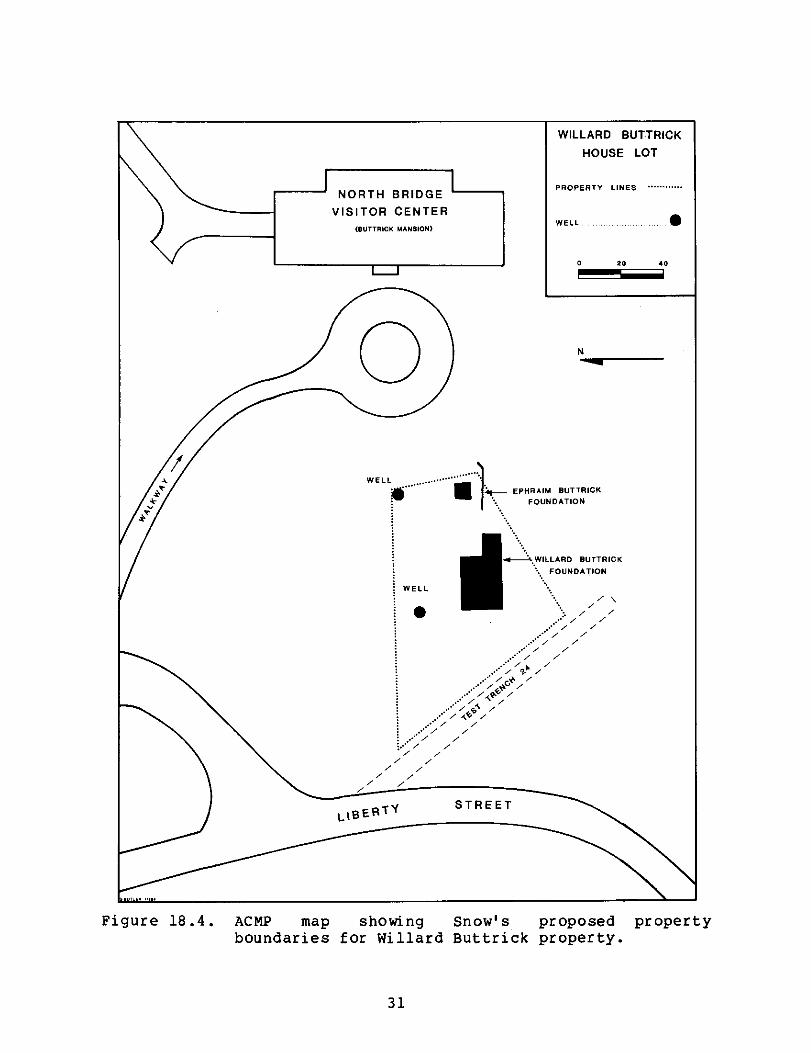
Willard Buttrick Property Map: A map illustrating the property boundaries of the Willard Buttrick house lot was also constructed (Figure 18.4), utilizing the dimensions and locations of structures and features depicted on the 1969 preliminary plan of the Buttrick Estate.
The ACMP plotted on this map the North Bridge Visitor Center, the circle drive, the walkway and a section of Liberty Street. The structural remains of the Ephraim and Willard Buttrick foundations, the two wells and the outline of Abel's test trench 24 were also included.
The dimension and location of the property boundary was determined from the 1786 deed describing the Willard Buttrick house lot (Luzader 1968a:12). The plotting of the property
lines was based on the assumptions that test trench 24 revealed evidence of Groton, or the county, road and that well #1 was the well noted in the deed. From these descriptions, the approximate lengths and orientation of the property lines were determined and illustrated.
30
20 • 0
NORTH BRIDGE
VISITOR CENTER
(BUTTRICK MANSION)
WILLARD BUTTRICK
HOUSE LOT
PROPERTY LINES
WELL •
N
......WELL ......
• ... 111 Ai- EPHRAIM BUTTRICK
FOUNDATION
WELL
f; WILLARD BUTTRICK
FOUNDATION
•
Figure 18.4. RCMP map showing Snow's proposed property boundaries for Willard Buttrick property.
31

Data Problems
The ACMP encountered three general types of data problems. The first concerned elements of excavation; the second, elements of curation; and the third involved the artifacts, especially those that were missing and those which were not previously cataloged. Since future researchers need to be aware of the causes, implications, and when applicable, resolutions of these problems, they are identified and discussed in the following sections.
Elements of Excavation
The problems stemming from the archeological excavations were not provenience specific; instead they were general site-wide problems which need to be carefully considered, assessed, and evaluated before any intra excavation unit comparisons can be made. In addition, future researchers need to be aware that these comparisons may not only be difficult, but in some cases, impossible. This is due to:
1) problems of spatial/horizontal control, 2) problems of stratigraphic/vertical control, 3) lack of detailed information on proveniences which
did not appear on the site map, and 4) problems in collection techniques.
Problems of Spatial/Horizontal Control: Due to the lack of a final report or field map indicating the location of all excavation units, and the numerous, ambiguous artifact recovery location descriptions, the ACMP identified problems of spatial/horizontal control during the Buttrick excavations. This problem made it necessary for the ACMP to generate seven site designations (Appendix 18.1) based on the recovery location descriptions found on the original field artifact bags. Although not mutually exclusive, these site designations facilitated our analysis, and separated the excavation units in known locations (e.g., visible on the map tracing) from those in non-specific areas of the site.
However, other unresolved data problems were caused by the excavator's lack of spatial/horizontal control and/or lack of documentation of this element. There is no way for future researchers to identify different artifact concentrations, especially within the structures. These concentrations may have indicated such things as the location of windows. In addition, it is not known why the chimney base in the structure east of the L-shaped foundation measured 8 ft. by 10 ft. according to Abel (Zerbey 1965b:2), yet 7 1/2 ft. by 8 1/2 ft. according to Snow (1969:9). This discrepancy may have
32

been a result of a subsequent disturbance following the first excavation.
Problems of Stratigraphic/Vertical Control: A second data problem relating to the archeological excavation of the site concerned maintenance and integrity of vertical control. As level information was not routinely provided by either of the two excavators, it was not only impossible to correlate stratigraphic levels between excavation units, but it was also impossible to discover whether the contents of the excavation units were the result of single or multiple dumping episodes. In the area east of the L-shaped structure, Snow excavated a deposit of fill where stratigraphy was thus unimportant. However, the problems concerning stratigraphic/vertical control remained in other areas such as the parking lot and muster field.
Another problem of stratigraphic/vertical control concerned the excavation of wells as units with no arbitrary levels. Thus it was difficult to discover any differences such as density and variety of artifacts in the wells, and it was impossible to determine whether the contents of the wells (ranging between 24 feet and 30 feet deep) were the result of single or multiple dumping episodes.
Lack of Detailed Information on Proveniences: The third data problem may have been less the result of excavation methods and more the result of information loss due to missing field notes, stratigraphic profiles, maps, and reports. Nevertheless, without these documents, detailed provenience information such as the location and dimensions of excavation units could not be determined. The map tracing served as the only means for pinpointing the actual location of the excavation units established by Abel. However, this tracing, mentioned in Zerbey's memorandum, only "shows the location of excavations and tests carried out to August 20" (1965b:1). In addition, the Buttrick Collection contained provenienced artifacts from only three of the units which appeared on this map (TOOB, TP27, and TP54). No map indicated the location of the excavation units established by Snow.
In conclusion, many curation problems resulted from elements of excavation of the Buttrick Estate sites. These problems were not isolated to only one of the archeological projects. Baker correctly concluded that "C. Snow's research is difficult to evaluate since Abel's previous work disturbed much of both sites" (1980:75).
33

Problems in Collection Techniques
Two problems concerned the archeological recovery techniques utilized on the Buttrick Estate. These were general site-wide problems. One problem concerned the lack of detail on artifact field bags describing the specific spatial and stratigraphic recovery location of the collection. The other stemmed from the lack of architectural material which might aid in identifying the type and time of construction for the foundation and wells. It appeared that no standard for sampling architectural remains was established.
Elements of Curation
Two problems were identified concerning elements of the curation of the Buttrick Collection. First, and foremost, was the problem of insufficient documentation. As Snow indicated in regard to Abel's artifact collection, much of the collection was "useless for analytical purposes" because of the lack of provenience detail (1969:6). The extent and significance of the lack and/or loss of the field notes, final maps, profiles, and in some cases reports, should not be underestimated as none of the available sources provided complete detailed descriptions of significant elements of the historic foundations or of the archeological excavations. Without this information, more precise detail on the structures' construction and possible identity could not be determined. It should also be stated that current National Park Service policies require the preservation of "field notes and collections of artifacts and structural features retrieved in the conduct of research in archeology...for the benefit of future investigators and as an aid to continued preservation" (National Park Service 1983:4).
Second, although only 23.4% of the Buttrick artifact collection was cataloged prior to the ACMP, this cataloged assemblage represented approximately 40.6% of the artifacts recovered during Abel's excavation. This cataloging was done at MIMA on National Park Service museum catalog cards by Arlene Wirsig. These forms included the following pertinent artifact data:
1) a two digit accession number, 2) a three to four digit catalog number (from 727 to
1132), 3) an artifact description including the material and/or
artifact type, and 4) the locality or recovery location of the specimens.
The ACMP made use of this catalog in an attempt to ascertain the quantity of missing specimens. Use of the catalog revealed two problems inherent in this system:
34
1) an inexplicable change in the designated accession number, and
2) most significantly, errors and inconsistencies in the artifact descriptions.
Originally, accession number 15 was intended to include artifacts acquired by Abel during the excavation of the "Roads west of old North Bridge," and accession number 16 referred to the artifacts from the Willard Buttrick site. However, the accession number 15 on the original National Park Service museum catalog cards, as well as on the artifacts in the collection, was crossed out and inexplicably changed to #16. Although Snow indicated that "those artifacts that were cataloged can only be presumed to have come from the site" (1969:6), the ACMP did not presume that all accession #16 artifacts were associated solely with the L-shaped foundation previously attributed to the Willard Buttrick house. Instead, most of the cataloged material (72.9%) was recovered in trenches which the ACMP coded as Buttrick Mansion (BM), i.e., concerning excavated areas of Buttrick Hill near the mansion but not in direct association with the remains of the historic structures. Only 16.6% of the cataloged material could be associated with the L-shaped foundation (wB). The remaining portion of the collection contained artifacts associated either with excavations in or near the 1850 Stedman Buttrick farmhouse (SB = 9.4%), or recovered from the vicinity of the Stedman, Willard, and Ephraim Buttrick houses (SWE = 1%) for which exact spatial locations and cultural associations were not known.
of: The most common cataloging errors were misidentification
1) refined earthenwares, i.e. creamware, pearlware, white ware;
2) shell edged wares, fingerpainted wares, annular wares and all hand painted wares as enamel decorated wares;
3) milk glass as porcelain; and 4) bottle glass as window glass.
The first two types of errors indicated a basic misunderstanding of the distinctions between these ceramic varieties and decorative techniques. By noting the artifact class or category consistent with the ACMP classification on the catalog cards, these curation problems were resolved. In addition, these notations were used for assessing whether particular types of artifacts were missing from the present collection.
Another unresolved curation problem was the fact that the catalog cards did not indicate the specific number of artifacts assigned to each catalog number. These NPS catalog cards (form 10-254, May 1957 revision) did not provide a place
35

to record the quantity of artifacts in each catalog lot. It was intended that the quantity be recorded in the Object or Description field on the card, but this was not done for the Buttrick artifacts. For example, the terms "sherd" and "sherds" were used synonomously in reference to ceramic and glass fragments, and represented one or several specimens. Therefore, the ACMP could not quantitatively assess the specific number of missing specimens, but could only indicate the presence or absence of artifacts representing a particular catalog number.
It should be emphasized that although errors and inconsistencies appeared in the artifact descriptions on the catalog cards, the system allowed for much detail on each specimen. After an initial classification
into gross morphological or object categories (e.g., ceramic sherds, glass bottles and sherds, pipe stems, nails, window pane, gunflints, spikes), precise attributes and/or dimensions were given. For example, each description for ceramic sherds may have included as many as seven attributes:
1) body (e.g., earthenware, stoneware, porcelain), 2) hardness of paste (e.g., soft, medium, hard), 3) color of paste (e.g., cream, red, buff, white), 4) type (e.g., redware), 5) glaze (e.g., lead glazed, salt glazed, underglazed,
overglazed), 6) decorative technique (e.g, undecorated, enamel
decorated, transfer printed, molded), 7) color (e.g., fine white, blue and white, polychrome).
Nevertheless, the common errors in identification, the absence of detail on the specific quantity of specimens being cataloged, and the incompleteness of the cataloging project diminished the usefulness of the cataloging system.
Missing Artifacts
The most significant data problem with the collection concerned the loss of cultural material. During the ACMP process of reinventorying artifacts from the site, comparisons were made between the present collection and the original collection as indicated by the catalog cards. These comparisons are summarized in Appendix 18.2. Each catalog number and associated artifact description on these cards was compared with the specimens in the collection. During the cataloging process, notations regarding the accuracy of the information were made on the cards by the ACMP.
Since the data used to generate Appendix 18.2 was derived from the catalog cards, loss was indicated only when there were no artifacts associated with a given assigned catalog
36

number. Nevertheless, this assessment indicated that the present Buttrick Collecton did not contain all of the artifacts recovered during the excavation of the site. This material loss affected four of the seven site designations: SB, WE, BM, and SIC. Although other material types incurred losses, this data problem primarily affected the ceramic assemblage.
In addition to material losses among the cataloged artifacts, there was evidence to suggest that there were losses before the collection was cataloged at MIMA. For example, the 1863 Indianhead penny found near the bottom of Well #2 by Abel (Snow 1969:11) was not present in the collection. In addition, there was no record of artifacts from test trench C I or from 12 of the 14 test pits east of the historic foundations although Abel indicated that "the number of sherds and brick fragments diminish rapidly as one digs eastward" in the area (Zerbey 1965b:2).
One can only speculate as to the causes of these losses. Snow stated that "some of the artifacts recovered from this excavation were discarded by Abel because they were thought to have come from the 1850 occupation of the area" (1969:6). Since Abel denied this (personal communication 1984), these artifacts may have been lost or they may have been discarded by other individuals who had access to the collection. Whatever the cause of the loss, researchers need to be aware of this data problem and evaluate the effects it would have on their analysis. All in all, the disparity between the present collection and the original collection has damaged the collection's research potential.
In summary, this section has discussed the data problems resulting from the initial excavation, curation, and loss of
cultural material. These issues have created unresolvable data problems, resulting in an artifact collection which is not a reliable data source for interpreting the archeology of the Buttrick Estate.
37

Site Interpretation
Sources on the History and Archeology of Buttrick Hill
Before any artifact processing was initiated by the ACMP, documentary sources on the history and archeology of the Buttrick Hill and North Bridge area were located and examined.
The primary sources of information on the history of the Buttrick Hill area were John F. Luzader's historical data sections in the Historic Structures Reports for the Ephraim and Willard Buttrick Houses (1968a) and the Major John Buttrick House (1968b), Ruth Wheeler's "North Bridge Neighbors" (1964), and a recent investigation and report on historic properties at MIMA by Joyce Malcolm (1985a). Using Concord Tax lists and town records, Middlesex County Deeds and probate records, as well as secondary historical accounts such as J.S. Keyes' "Houses in Concord" (1885), the lines of ownership of the Buttrick Hill property have been traced. The sequence of ownership of the Ephraim and Willard Buttrick houses documented by Luzader (1968a, 1968b), Wheeler (1964) and Malcolm (1985a) is briefly summarized in Table 18.1.
In addition to data on the inhabitants, their occupations and activities, these authors provided some information on the structures built and occupied by the Buttricks. It is significant, however, that only Wheeler's historical report would have been available prior to 1965 when Leland Abel began the initial archeological investigations in the area. Several inferences in a Park memorandum with a narrative by Abel suggested that he had access to, and used, historical maps and historical data regarding the hill's occupants, structures and roads (Zerbey 1965b). In contrast, Snow (1969:13) utilized Luzader's report (1968a), Keyes' account (1885) and other park manuscripts (Harris 1966).
In addition to historical literature, documentary sources were used to reconstruct the events of the archeological investigations in the Buttrick Hill area. In the following section and throughout this report, the data pertaining to Abel's excavations will be discussed separately from the data pertaining to Snow's fieldwork.
Two types of sources were utilized for information
regarding Abel's excavations:
1) original documents and information generated by Abel, and
2) secondary sources and accounts of Abel's excavation.
The primary sources of information utilized to
reconstruct Abel's 1965 excavation were:
38

Table 18.1
Sequence of ownership of the Ephraim and Willard Buttrick Houses
EPHRAIM BUTTRICK HOUSE (1 Story) DATE BUILT: ca. 1635 or latter 17th century DATE OF DEMISE: 1814, used for firewood
Date Of Relationship Owner's Name Birth-Death To Ephraim Comments John/Dorothy D. 1662 None ca. 1635 a house Heald built on
property.
Samuel Buttrick, 1655-1726 grandfather ca. 1697 Samuel Sr. inherited land; may have erected
Jonathan Buttrick 1690-1767 father new house.
Ephraim Buttrick 1736-1785 Occupancy also included Ephraim's mother, sister and for a time,
John Buttrick 1731-1791 brother brother Willard.
Jonas Buttrick 1764-1841 nephew Stedman Buttrick, son of Jonas, tore house down in
DATE OF
Willard Buttrick
John Buttrick
1814.
WILLARD BUTTRICK HOUSE (two story) DATE BUILT: Between 1771-5
DEMISE: 1849 to make way for new farmhouse (built 1850, moved 1913)
1746-1813 brother Received land from Ephraim, built house c. 1771-5; sold to John, 1786.
1731-1791 brother
Jonas Buttrick 1764-1841 nephew Sold house in 1836 to son, Stedman.
Stedman Buttrick 1796-1874 grand nephew House torn down in 1849.
39

with Abel (personal 1) telephone conversations communication 1983, 1984);
2) slides, negatives, and photographs taken by Abel and John Cotter in conjunction with a fairly complete photographic record of the excavation;
3) the original field artifact bags with labels
describing the recovery locations; and 4) a copy of a map tracing of the area under
investigation which indicated the location of
numerous excavation units, the wells and the 18th century house foundation attributed to Willard
Buttrick.
Although a significant source of information, this map submitted by Abel (Zerbey 1965b:1) did not reveal the location of all the excavation units dug under Abel's direction. In addition to the absence of a final excavation map, no final report on Abel's investigation of the Buttrick site was ever completed, and the field notes and other field records (e.g. soil profiles) which were turned over to the Park (Leland Abel, personal communication 1983) have been lost.
Secondary sources of information which also proved to be useful included:
1) a 1965 memorandum to the National Park Service Regional Director from MIMA Superintendent Benjamin Zerbey which included a "narrative summary" by Abel on the progress of his archeological investigations through August 25, 1965 (Appendix 18.5),
2) Snow's archeological research report (1969), and 3) the MIMA artifact catalog cards compiled by Arlene
Wirsig in 1966.
Although every one of these sources was valuable in providing additional information on the course or results of Abel's archeological investigations, each was incomplete in providing the detail necessary for a complete understanding of the excavation methods and results achieved. Abel, however, was extremely cooperative in answering questions and recollecting the events pertaining to his excavation and photographic records. Nevertheless, nearly twenty years have elapsed since he directed the project. It is significant that the single most important literary source regarding Abel's excavations was Snow's archeological research report (1969). Her data was derived from conversations with Abel while she worked as his assistant (Cordelia Snow, personal communication 1984).
In regard to Snow's excavations, original
including the archeological research report
photographs taken by David H. Snow, and labe artifact bags were available to the ACMP. Snow was
documents, (1969),
lled field also very
40

receptive to answering questions (personal communication 1984). In addition, the administrative data section in the Historic Structures Report (Zerbey 1968a) described the primary purpose of the archeological investigations. Snow's report (1969) included gross diagrams of the original foundations and chimney bases, a plan of the Buttrick grounds in 1923 showing the location of the former 1850 house and wells, and photographs taken during the course of the field excavations. She also summarized the results of the project. Original documents such as these are invaluable in reconstructing past projects.
In summary, a number of sources were utilized to obtain an understanding of the archeological investigations of the Buttrick Hill area. These sources, however, did not present detailed descriptions of the excavation procedures, strategies, and provenience systems chosen for the investigations. Moreover, the lack of field notes, a complete artifact catalog, and a final excavation map was problematical. The extent and significance of information loss should not be underestimated. This loss not only diminished the archeological data base, it also jeopardized the collection's research value.
Techniques and Results of Abel's Excavations
Although no field notes, final excavation map or report existed describing Abel's work on Buttrick Hill, details on the method and sequence of Abel's archeological investigation were derived and/or deduced from the sources mentioned in the previous section.
Little written detail was available on Abel's method of excavation. However, the photographic record documented some of the excavation techniques. The following hand tools were identified: hoes, shovels, trowels, and pick axes. Hoses and hand screens indicated the technique of water hosing and screening soil in order to recover small artifacts (Figure 18.5). wheelbarrows and a dump truck were used to remove backfill from the area. At the end of the day when work was discontinued, a snow fence was rolled over the open trenches for protective reasons. In at least one instance, in order to remove large stones from a well, a crane was employed (Figure 18.6).
A method of trenching was employed by Abel for horizontal control and subsurface testing (Figure 18.7). The trench, however, was not the only type of excavation unit used. In Zerbey's memorandum (1965b), reference was made to three other excavation units: test pits, tests, and test trenches.
41

Figure 18.5. Water screening for small artifacts during Abel's 1965 excavation (MIMA.BWP.BM .59).
Figure 18.6. Crane removing heavy stone fill from well during Abel's 1965 excavation (MIMA.BWP.BM .6).
42

Figure 18.7. Trenches dug during Abel's 1965 excavation (MIMA.BWP.BM .1).
Whether these constituted different types of units with regard to size, shape, or method of excavation could not be determined, especially in light of the fact that trench sizes were variable. One trench, trench A, extended over 200 feet. In addition, Snow indicated that when Abel became ill during the course of this project, his crew substituted a grid system for the trenching method (1969:6).
Although this suggested the implementation of a different system, there were no field notes or information which could confirm or define the changes made in the excavation methods. None of the proveniences represented by the artifact collection indicated cardinal directions and numerical sequences (e.g., N1W1). The alignment of the test pits on the map tracing, however, suggested a grid network (Figure 18.2). As this technique differed from Abel's usual trenching method, these may represent the crew's excavation strategy.
In addition to these units of excavation, Abel imposed horizontal control by allowing specific structures or elements of structures (e.g., house, well, room, wall, chimney foundation) to serve as units of excavation.
43
In reidentifying the position of these excavation units, the ACMP relied on the text and the map tracing. Neither indicated the assignment of a single datum point. In the text, measurements, when provided, referred to distances from obvious, yet large and imprecise, landmarks such as Liberty Street, the Buttrick Mansion, and the circle drive. The map tracing served as the only means for pinpointing the actual location of the excavation units. However, many artifacts in the collection were recovered from proveniences that were not indicated on the map.
Cultural deposits (e.g., the cellar floor) and
stratigraphy were utilized for vertical control. However, features such as the wells and house foundations were commonly excavated as units with no arbitrary levels, so meticulous vertical control was not maintained. For example, the recovery location of artifacts found in the first well was simply indicated as "Well #1." Depth measurements were rarely recorded as part of the vertical provenience information.
A large part of the excavations were concentrated in and around the front lawn of the Stedman Buttrick Mansion where the remains of the Ephraim, Willard, and Stedman Buttrick farmhouses were believed to be located. Other areas such as those around the house occupied by the Park gardener and around the maintenance buildings were overlooked,
for the hillside was graded down to a considerable depth to provide a level base for the house, and the earth which was removed was moved down the hill to the east to change the grade around the maintenance buildings (Zerbey 1965b:3).
Initially, Park Historian Robert Ronsheim informed Abel that the historical record indicated the presence of two 18th and 19th century structures (Leland Abel, personal communication 1984). The latter was also documented in photographs (Wheeler 1964:70). In June of 1965, Abel attempted "to locate the ruins of the Jonathan Buttrick house" (Zerbey 1965a:1), referred to by the ACMP as the Ephraim Buttrick house. Four inch diameter holes were dug with a post hole digger in the lawns in front of the Buttrick Mansion east from Liberty Street (Leland Abel, personal communication 1984). Very quickly, the excavators encountered portland cement and brick dust. Test trenches were then dug to expose the area.
Zerbey made specific reference to three of the most significant test trenches: Test trench A and two cross or side trenches (Figure 18.3). Test trench A started at the circle drive in front of the 1911 Stedman Buttrick Mansion which is now utilized as the North Bridge Visitor Center
44

(Figure 18.2). "Laid out on a true east-west line from the mansion to Liberty Street" (Zerbey 1965b:1), this trench was excavated down to sterile soil or bedrock. Although it is highly likely that artifacts were encountered during the excavation of this trench, no specimens were identified in the collection.
The two side trenches crossed test trench A (Figure 18.3). When a deposit of brick fragments and sherds was encountered in test trench A, 40 feet west of the circle drive and approximately 100 feet west of the mansion, the first cross trench was established. Artifacts in an original field bag labelled "NS Trench over barn section near driveway," coded as BM-TONS-0000-000, may be artifacts from this excavation unit. The northern extension of this cross trench "revealed a stone lined well, 30' deep, filled to the top with broken bricks, dirt, and rubble" (Zerbey 1965b:1). As the only provenience designation for these artifacts was "Well #1," the well appeared to have been excavated as a unit with no arbitrary controls. Although there was no evidence to indicate when the well was constructed, Snow believed that its location suggested that it was "probably the well mentioned as one of the bounds for the Willard Buttrick house" (1969:11) in the 1786 deed (Middlesex County Registry of Deeds, Book 93:295), indicating the sale of the property to John Buttrick. Snow also concluded that the well "was filled sometime after 1900, possibly when the mansion was built in 1911" (1969:10). The whiteware and blown-in-mold and automatic machine made bottles recovered from the well helped to substantiate this claim.
The second cross trench, extending north and south from another concentration of brick fragments and sherds in test trench A, was located approximately 90 feet from the circle drive and 160 feet from the house (Figure 18.2). Again in the northern extension of this trench, another rubble-filled well was encountered (Figure 18.3). The depth of this well was 24 feet. The vague recovery location of artifacts from this well, designated "Well #2," indicated that it also was excavated as a unit with no arbitrary controls. An 1863 Indianhead penny found near the bottom of this well (Snow 1969:11) served as a terminus post quem to indicate that the well was not filled until after this date. This penny, however, was missing from the collection at the time of the ACMP inventory. Other contents in the well included creamware, constituting 43% of the ceramic collection, pearlware, constituting 19.2%, and whiteware, constituting 10.4% of the collection.
The southern extention of this cross trench also located a significant structure, "the foundations of a large house" (Zerbey 1965b:2) (Figure 18.3). At approximately four feet below the surface, a cement cellar floor, a wooden-floored
45

coal bin and furnace room, and two 24 in. square brick chimney footings were encountered (Figure 18.8). There was little controversy that these were the remains of the Stedman Buttrick farmhouse (designated House #1 by Abel) built in 1850 and moved in 1913 to Monument Street in Concord (Wheeler 1964:80, Snow 1969:5).
The photographs also documented an architectural feature which appeared to relate to this period of occupation. It was a fieldstone-lined drain extending towards the north (Figure 18.9). Due to its depth and location in comparison with the 19th century foundation remains, the drain most likely served to aid drainage of the 19th century foundation rather than the 18th century cellarholes, as Abel believed (MIMA.BWP.BM .50).
As of July 1965, no 17th or 18th century house foundations had been located (Zerbey 1965a). Bowyer, by the
end of August, the mortar cement floors of the Stedman Buttrick farmhouse had been removed and 14 inches below this structure, or 5 ft. 2 in. below the surface, another foundation was encountered. Foundation walls consisting of a
Figure 18.8. Abel's photograph of concrete floor of 19th century Buttrick farmhouse with brick chimney base in foreground, exposed during 1965 excavation (MIMA.BWP.BM .40).
46

Figure 18.9. Top of stone-lined drain in foreground, leading from 18th century house. Brick and concrete are from 19th century house. Looking south across Abel's 1965 excavation (MIMA.BWP.BM .50).
single course of boulders defined an L-shaped structure, 20 ft. by 40 ft., with a 10 ft. by 10 ft. chimney base built of boulders (Figure 18.10). This structure, designated House #2, was identified by Abel as "one of the two eighteenth century Buttrick houses" (Zerbey 1965b:2). Later, Park Historian Robert Ronsheim and Russell Kuene, NPS Architectural Historian, identified this as the Willard Buttrick house (Cordelia Snow, personal communication 1984).
Ten feet east of the eastern foundation wall and 2 ft. 2 in. above the cellar floor of this foundation, another chimney foundation was encountered (Figure 18.3). Abel suggested that the chimney footing, measuring 8 ft. by 10 ft., was in accordance with 18th century standards (Zerbey 1965b:2). Controversy has since surrounded this area. It was heightened by the fact that there were no photographs showing excavation in this area or artifacts with proveniences which clearly related to this area. In the Park memorandum, Abel did not discuss the origin of this chimney base (Zerbey 1965b). Snow, however, concluded that Abel had encountered and excavated the Ephraim Buttrick house foundation (1969:9).
In addition to these three highly significant test trenches, two additional trenches and fourteen test pits were dug east of the historic foundations toward the Buttrick
47

Figure 18.10. Foundation of L-shaped structure, looking west. Chimney base in lower right. From Abel's 1965 excavation (MIMA.BWP.BM .28).
Mansion (Zerbey 1965b:2). These were the excavation units which appeared on the map tracing south of the road which extended east off Liberty Street and formed the circle drive: Test trenches B and C, and test pits 12, 19, 20, 21, 27, 28, 29, 35, 36, 45, 46, 54, 55, and 63 (Figure 18.2).
Although Abel stated that the number of sherds and brick fragments rapidly diminished as he dug eastward (Zerbey 1965b:2), the artifact collection contained only specimens recovered from three of these Buttrick Mansion excavation units (i.e., trench B, test pit 27, and test pit 54). Test pit 54, one of the furthest to the east, contained the most substantial artifact assemblage. Regarding this area, Abel concluded that "it seems improbable that any physical evidences of historic structures will be found nearer than 100 feet from the mansion" (Zerbey 1965b:2).
Another phase of Abel's excavation on Buttrick Hill was concerned with the low ridge north of the drive running from Liberty Street to the Buttrick Mansion. Although there was no
48

traditional or historic evidence to indicate earlier structures, Abel proposed that the ridge "seemed to be a likely area for habitations" (Zerbey 1965b:2). As a result, a series of test pits were dug at 20 foot intervals across the ridge (Figure 18.2). Two areas were excluded. The first contained a concentration of ornamental trees. The second had been modified during construction of the tennis courts for the Buttrick Mansion. On this ridge, the excavators encountered yellow-white sand and a thin layer of humus. Bedrock appeared between a few inches and two to three feet below the surface. As "the ridge proved to be almost completely barren of evidences of human occupation," Abel concluded that "further testing in this area seems unnecessary" (Zerbey 1965b:2-3). Although the map tracing revealed the location of 40 test pits on this ridge (i.e., 65-104), none of the artifacts in the collection were attributed to these units.
Subsequent to fieldwork, some processing of the artifacts was completed. Specimens were washed and, in June of 1966, approximately 40% of the collection was cataloged on NPS catalog cards by Arlene Wirsig, a MIMA employee. This cataloging project was performed for curatorial purposes and not as part of the archeological project. As such, the information on the cards was not always consistent with, or specific enough, for archeological analysis. For example, the specific number of specimens assigned a particular catalog number was not always recorded. A more detailed discussion of the method, its value, and its defects was presented above in the section on "Data Problems."
In summary, Abel's archeological investigation in 1965 partially fulfilled its purpose of identifying and delineating one of the eighteenth century structures on Buttrick Hill which overlooked the 1775 battle at the North Bridge. However, the research techniques employed by Abel in this investigation have been questioned and criticized (Snow 1969, Baker 1980). This criticism was primarily based on three elements:
1) the paucity of 19th and 20th century artifacts, 2) the lack of stringent horizontal and vertical
controls, and 3) the absence of a final written report.
The first problem, regarding the paucity of 19th and 20th century artifacts, does not appear to have been a result of discard practiced by Abel (personal communication 1983) as Snow suggested (1969:6). The second and third problems, however, were not so easily resolved. Since specific detail on the horizontal and vertical provenience of each artifact was not recorded, it appeared that stringent horizontal and vertical controls were not maintained during Abel's excavations. This problem, in conjunction with the lack of a
49

final written report, no doubt stimulated the controversy regarding Abel's archeological techniques and the proper identification of the foundations on the property.
Techniques and Results of Snow's Excavations
No field notes were available to document the sequence of investigation followed by Cordelia Snow in 1968. Nevertheless, her final archeological report (Snow 1969) summarized the results of this project in addition to reviewing the consequences of Abel's investigations.
Information on excavation methods, however, was deduced from original field bags which were filled with unwashed and uncataloged artifacts from Snow's excavations. The labels on these bags indicated that test trenches in conjunction with specific structural elements (e.g., parking lot, walk) served as the primary means for maintaining horizontal control. No detail on the size of the test trenches was available. There was also no evidence indicating the system for maintaining vertical control, especially in the area identified as the Ephraim Buttrick foundation. Only two references were made to excavation levels (i.e., the surface and level 1). This was most likely a result of the lack of stratigraphy and the presence of a fill deposit in this area (Snow 1969:7). Although hand tools similar to those used by Abel were probably employed, this could not be verified.
The purpose of Snow's excavation was to locate "through a combination of historical data and archeological trenching" the Ephraim Buttrick house and to "excavate the foundation down to undisturbed soil, retrieving and cleaning, storing, and cataloguing all artifacts" (Zerbey 1968a:1). In addition, although Snow's excavations were concentrated on locating the Ephraim Buttrick house, she supervised other archeological investigations carried out in conjunction with the construction of the parking lot and pathways northwest of the Buttrick Mansion.
Hoping to encounter the remains of the Ephraim Buttrick house, Snow began her excavation to the east of the L-shaped structure identified as the Willard Buttrick foundation. The foundation was encountered but "it became apparent, almost immediately, that the foundation had been completely uncovered during the 1965 season and backfilled" (Snow 1969:7).
In addition, the north and west walls had been removed when the 1850 .Stedman Buttrick farmhouse was built over this original structure and "one of Abel's trenches had obliterated at least a portion of the eastern wall" (Snow 1969:7), so little of the foundation remained. The remaining 22 foot long southern wall ended just five feet from the eastern wall of
50

the Willard Buttrick house (Figure 18.3), and the four foot long eastern wall consisted of a single course of boulders. Although no traces of mortar were found, these walls averaged 14 in. in height. A chimney base, "indicative of eighteenth century architecture" (Snow 1969:9), was also uncovered at approximately three feet below the surface. The base, measuring 7 1/2 ft. by 8 1/2 ft., consisted of flagstones laid in three parallel rows directly on the cellar floor (Figure 18.11). Mortared to the north side of the chimney base were six handmade bricks (Figure 18.12).
Snow indicated that because the foundation had previously been backfilled with fill and modern trash from another area of the Park, "all artifacts recovered from the 1968 excavations were discarded regardless of date" (1969:7). However, the MIMA Collection did contain artifacts recovered during Snow's excavations. These artifacts, found by the ACMP in their original field bags, most likely represented an oversight.
It was not known whether the other archeological investigations carried out by Snow in 1968 preceded, or occurred during, the construction of the parking lot and paths north of the Buttrick Mansion. Moreover, no detail was available on the method of excavation. Although no historical
Figure 18.11. Chimney base of Ephraim Buttrick structure, with 3 rows of flagstones and brick rubble, from Snow's excavation (MIMA.BWP.BM .8).
51

Figure 18.12. View of north side of chimney base of Ephraim Buttrick site during excavation. The handmade bricks were mortared into place (Snow 1969: Figure 6).
structures were encountered (Snow 1969:11), some cultural material including brick fragments and redware sherds was recovered. Still in their original field collection bags, these specimens had not been washed or cataloged. The labels on these bags of artifacts indicated that:
1) they were collected in April and May of 1968, and 2) only very general recovery locations were recorded.
In summary, Snow fulfilled the requirements of her contract by excavating the foundation of a structure she identified as the Ephraim Buttrick house. Although Zerbey indicated that the archeological research project was to include the "retrieving and cleaning, storing, and cataloguing of all artifacts" (1968a:1), Snow affirmed that she discarded all artifacts "regardless of date" (1969:7). Snow explained this procedure in light of the fact that material was recovered from fill that
had been obtained from another area of the park and contained much modern trash (beer bottles, plastic
52

toys, and a National Park Service sign stating that one should not tamper with government property) (1969:7).
ACMP Analysis
The purpose of the archeological investigations on Buttrick Hill was to identify and expose the extant portions of the Ephraim and Willard Buttrick houses, prominent structures on the landscape on April 19, 1775, when the first military altercation of the American Revolution occurred. Although archeological research by Leland Abel in 1965 and Cordelia Snow in 1968 served to locate and provide useful information about 18th century architectural units on Buttrick Hill, the ACMP questioned the final conclusion stated in Snow's (1969) archeological research report and reiterated in Baker's (1980) archeological overview evaluation: that these two dry-laid cellarholes represented the foundations of the Ephraim and Willard Buttrick houses. In the following sections we will:
1) discuss the problems with this prior interpretation; 2) synthesize and reevaluate the data including the new
information on the archeological collection processed by the ACMP; and
3) present alternatives to the previous interpretation.
Problems with Prior Interpretation
Snow's conclusion that the foundations located on Buttrick Hill represented the Ephraim and Willard Buttrick houses was based on four factors:
1) both houses were shown in their approximate locations in the Doolittle print of the Battle;
2) no other architectural remains had been uncovered on Buttrick Hill;
3) it was known from deeds and local history that the two houses were very close to one another, as were the sites excavated;
4) a well north of the Ephraim Buttrick house was used as a boundary marker for the Willard Buttrick plot. Well #1 fit this description (1969:12).
There were, however, problems relating to each of these four issues. First, too much value was placed on the Doolittle print in identifying the precise location of the Ephraim and Willard Buttrick houses (Figure 18.13). Snow even suggested that "if any restoration is planned the Doolittle print should be used as a guide" (1969:12). The accuracy of this print, however, is questionable because the scale is not
53

4-) C.)
•H 01
rt/
C. -6)
-H 1.4 04
cD
4-1
0 0 0
0
0 0
C.)
V 0 %.4 01 (1)
- -
_ _
_
1
11
ii
1
1 1
i 1
4. I P.
11
■:
.1.,.
t4
tit %
-
tlk,„
„p7„,
''”
_ t terri ltn
,,.il,r011..40 1, ,,,,•. t
jOi 1 ' $ 1
I iiii i, . ,, 4
',' 1.- AM IC,I:LA., 0:41, i,+ ■ , t ,
„,a c ctr.0,.. , lit i ,,
./ ... 1, ,,k r ,,,- -- , ..->
, ‘.1q (els... 1 ) 1 41
. ,\ I, -P.:-.
,;„ .;..
7 ‘
C . ' *41
,—,,
tit
a
t I 1‘
lb 1 Cli
&I li N ,,1
I
4Ij All
f 4
I 1, ) 1 s,
L
10, .
, l it
14/4
' iii
II I 11
t lf410 i 1
i 1
t i
‘11
II i 1 4,1-• fi l
I, v '60
11 k:
'. 4„ CI
14)1M.
I 0
i
I
6 '
i Ty
'r 0- „
11
!lifo.
'1
i
, Al
e rr, r,',; 0,
1
\ 1 ,
\i li
1
(
Q . . !Vit(
1 evip400irprill,::i::7010110:01:4:171,•4411 ilAhrt,i1, 0414
11111M
i' l
0,1 ,41
ill
I i i
1111) 1
I qi i .
110,44P/00;.:1
1 11:1 1,\
irtilre
, , 49 , 1•0
IiiiNc i
N ktfti C
4. 0
e/t0 'en/ il 0 ,Ii 0
,
4,k 1,z 11
\ ) 1
1 L:
l t f l
ift k I i q •
1 (t. bli
74 V/
,/
0 o'ff I i 1 '1
,
c \ '
t; ''''
Vk ' I
I
ill
, 1
el
I
1 1 ,>.
, \ \
2 ik,
_1, II
n "'KKK
'4„
r 1
i'i
I '
I I' 1 [
h 1 I CI
,
, 1
-4.•...
I P
e...-
•
II ...
II ii + ii
11 ---'s
11#
-.- c
. ‘..
Jt.
-
...
) 4
f %lit ‘`.‘”' i - 1.',1, ,, , I
\ lh !
i. --:,
‘ CI
• s .,
Y. 1 11 -:he v..;
,
.4 "---
i• ii
‘ 1,111
1
1/21(ii ' 14
IP
1
io,,
,
i
Vri
,,,
i
I
II
,.
ttj ,
1
I
i‘
1
,
1, I '
et
.k
I I
i
„
4
I
i 1/4 \ 1
d i
C. CI) t \ i
4
' 1/41, ( t
, lii
4
iu .
■
\ 1) ,
\ 11
Atsi
`
I
K1
..1 1, 1 ,
I,
< \
tal fi\
\ I
I 1/4\) I) V4 ;‘,,,,
" ' 0
\
‘,.
it( 1■ •
I 4, , 1\\I 4t; \
S II 1 1 +
!
■I . t" ■ b
V . ‘ grh 4' , \,01‘;;
\ l L. 0
54

precise and the depth perception is distorted. In addition, due to the angle of the view towards the hill and the location of the structures in the scene, there is a controversy over which houses and outbuildings are represented (Joyce Malcolm, personal communication 1984; Orville Carroll, personal communication 1984). The possibilities for the structures on the right include John Buttrick's two story house and outbuildings, the John Flint house, as well as one or both of the Ephraim and Willard Buttrick houses and outbuildings. Malcolm also indicated that the location and appearance of the other structures in the print did not conform to the descriptions in the historical record, e.g., the David Brown house (personal communication 1984). Thus, the correct location and identity of the structures on Buttrick Hill could not be verified using the corresponding scene in the Doolittle print.
Second, although no other pre-nineteenth century architectural remains have been uncovered on Buttrick Hill, the hill has not been systematically surveyed and the possibility exists that additions to these structures, as well as other structures, remain undetected. More discussion of this and the specific areas in which testing should occur follows in this section and the section on recommendations for future work.
Third, although the deeds and the local history of the area suggested that the houses were in close proximity similar to the two excavated structures, the ACMP questioned whether these foundations had been correctly identified as the two structures owned by Ephraim and Willard Buttrick respectively. Deed research indicated that "Ephraim gave his brother Willard a small piece of land immediately to the west of his (Ephraim's) house on which to build another dwlling" (Snow 1969:4).
Assuming the L-shaped structure exposed by Abel to be the Willard Buttrick house, Snow excavated east of the foundation "in hopes of uncovering the foundation of the older Ephraim Buttrick house" (1969:6). However, Snow encountered a disturbed area. She affirmed that during the course of Abel's excavations of the Willard Buttrick house "he also uncovered the Ephraim Buttrick house which was later backfilled" (1969:2). Although reference was made to a second chimney base whose size, 8 ft. by 10 ft., was in accordance with eighteenth century standards, Abel made no conclusion as to its origin (Zerbey 1965b). Nor did Abel recollect encountering a second pre-nineteenth century historical structure (personal communication 1983, 1984). Thus, this chimney base found 10 feet east and 2 ft. 2 in. above the cellar floor of the L-shaped structure (Zerbey 1965b:2) was identified by Snow (1969:6-7) as part of the Ephraim Buttrick house (Figure 18.3) only after reexcavation of an area which
55

had already been disturbed and backfilled by the previous excavator.
In addition, Keyes indicated that Stedman Buttrick told him that a cart could have been driven between the Ephraim and Willard Buttrick houses (1885:72). Although this statement should not be taken literally as an accurate measure of distance, Snow's interpretation directly contradicted this bit of local history. Snow concluded that "unless a cart-width is narrower than five feet, it seems likely that the western wall abutted the southern wall of Ephraim's house at this point" (1969:8). These factors suggested that the foundation east of the L-shaped foundation may not have been a separate house structure, especially since the Ephraim Buttrick house was described as "a large, decrepit house the family had acquired before 1726 from John and Dorothy Heald" (Malcolm 1985a:118).
The last factor which Snow stated to verify her conclusion concerned the citation of a well as one of the boundary markers for the Willard suttrick plot (1969:12). The source of this citation was the 1786 deed (Middlesex County Registry of Deeds, Book 93:295) recording the sale of Willard Buttrick's property to his brother John Buttrick:
One piece of Land with the Dwelling House thereon butted & bounded as followeth beginning at a heap of stones on the County Road about twenty feet South from the Southwestern corner of the said Willard Buttrick House then running Northerly six rods on said road to Heap of Stones from thence running Easterly to a well then running South to the front of the House that belonged to Ephraim Buttrick deceased from thence Westerly to the bound first mentioned. Also another piece of land the half of the Barn & barn yard that belonged to the said Ephraim Buttrick deceased with the Priviledge of passing to and from the said barn. Also the Priviledge of the well near said barn (Luzader
1968a:12).
Figure 18.4 is an approximation of Snow's reconstruction of the Willard Buttrick property lines using Well #1 as the boundary marker (1969:12). Although this approximation of the boundaries of the Willard Buttrick property appeared to conform to the deed transaction description, when scrutinized two questions arose:
1) Was it likely that the Willard Buttrick property lines ran through the Ephraim Buttrick house? and
2) Was Well #1 the only well on the site which could have been referenced in the deed?
56

Prior to 1770, Ephraim lived with his mother, his brother Willard, and three unmarried sisters in the house he inherited from his father, Jonathan, who died in 1767. Although there was no record of the transaction, historical research indicated that sometime after 1771 Ephraim gave Willard a piece of property to build a house for his growing family (Wheeler 1964:10, Malcolm 1985a:120). It is highly unlikely that the property boundaries cut through and included part of the Ephraim Buttrick house.
In regard to the second question, the location of Well #1 "approximately thirty feet north of the chimney base of the Ephraim Buttrick house" was the basis upon which Snow concluded it was the well mentioned in the deed (1969:11). However, the eastern property boundary, the one in question which cut through the house structure, was extended from Well #1. Since another well has been located on the property due west of the first and a systematic site survey has not been undertaken, the possibility exists that Well #1 may not have been the one cited.
In addition, some uncertainty remains regarding the precise route of the historic roads in this area due to the many repair efforts and road realignments. Although the relationship of the L-shaped historic structure to an eight foot wide, hard packed, sanded road surface conformed to the description in the 1786 deed, the precise date of construction and location of this road has not been established (see Chapter 19). The absence of other roadbeds and confirmation of the road identity and alignment on Buttrick Hill would assist in establishing the boundaries of the Willard Buttrick property and the precise location of the southwest corner of his house.
In summary, this discussion has questioned the previous interpretation that the historic structures on Buttrick Hill represented the Ephraim and Willard Buttrick houses. It is possible that the architectural remains delineated one house structure with an addition or outbuilding extending off the main body of the house, which had an L-shaped cellarhole. It should be emphasized that Snow's interpretations were based upon previous identification by Robert Ronsheim, MIMA Park Historian, and Russell Kuene, NPS Architectural Historian (Cordelia Snow, personal communication 1984; Orville Carroll, personal communication 1984) that the L-shaped building was the Willard Buttrick house. It was not her responsibility to reevaluate this interpretation but to excavate "east of the foundation of the Willard Buttrick house in hopes of uncovering the foundation of the older Ephraim Buttrick House" (Snow 1969:6).
57

Synthesis and Reevaluation of Data
If these are the remains of only one house, which house was it? In the following discussion, the data will be presented and reevaluated in light of the hypothesis of one house foundation which has arisen from the reanalysis of the architectural composition of the site and the cataloging of the artifact collection by the ACMP. This collection included artifacts associated with:
1) the foundation of the 1850 Stedman Buttrick farmhouse (SB),
2) the L-shaped foundation previously identified as the Willard Buttrick house (WB),
3) the area between the foundation of the farmhouse and L-shaped foundation (SWB), and
4) the foundation east of the L-shaped structure previously identified as the Ephraim Buttrick house (EB).
In addition, the collection contained specimens which were assigned amibiguous and imprecise recovery locations (SWE), or were recovered from areas of the Buttrick estate which were not in direct association with these historic structures, e.g., artifacts from the parking lot (BE, BM). The name of the excavator and specific provenience codes associated with each of these seven site localities is presented in Appendix 18.1. Appendix 18.3 summarizes the Buttrick Hill artifact collection, which indicates that the collection inventoried by the ACMP included 7,972 artifacts. Historic ceramics comprised the largest proportion of the collection, 56.3%. Architectural materials represented the second most common class of artifacts, 23.0%. Each of the remaining artifact classes comprised less than 15% of the total collection. Appendix 18.3 also indicates the proportion of artifacts from each of the seven site localities. Although artifacts assigned to the Buttrick Mansion site represented the largest proportion of the collection, 34.3%, the ACMP was most concerned with artifacts associated with:
1) the L-shaped foundation (WB), comprising 11.0% of the collection,
2) the foundation east of the L-shaped foundation (EB), comprising 31.2% of the collection, and
3) the foundation of the 1850 Stedman Buttrick farmhouse (SB), comprising 5.3% of the collection.
The collection also contained 327 grams of fuel and fire byproducts, shell, and other organic material.
Appendix 18.3 summarizes the quantity and range of historic ceramics in the collection. In this collection of 4,489 ceramic sherds, the predominant ceramic type was
58

Table 18.2
South's Ceramic Dating Formula Results
ACMP Site Code Designation
Number Ceramics In Sample
% of Ceramic Total
Date Calculated
SB 155 60.1 1804.42
WB 408 73.4 1832.57
SWB 16 72.7 1816.94
EB 403 54.1 1828.89
SWE* 408 53.5 1810.06
BE 28 80.0 1835.39
BM 1656 78.4 1825.87
TOTAL
3064 (ALL SITES = 68.3
4489)
* SWE-0000-WEL1-000 24 11.76 1860.00
(total=204)
SWE-0000-WEL2-000 142 73.58 1804.63 (total=193)
whiteware, constituting 27.4% of the assemblage. Only two other ceramic types comprised more than 20% of the collection:
1) pearlware, constituting 26.7% and 2) redware, constituting 21.6% of the collection.
The datable 17th and early 18th century ceramic varieties, such as delft, coarse-buff body earthenware (e.g., combed ware) and white salt glazed stoneware constituted a mere 1.3% of the collection. Tables 18.2 and 18.3 are summary charts indicating the results of the application of two different dating techniques. South's mean ceramic formula (South 1978) and the Harrington-Binford regression line formula (Binford 1978) were applied to each of the seven assemblages. Although these dating techniques generally prove
59

Table 18.3
Harrington-Binford Dating Formula Results
ACMP Site Code Designation
Number Pipe Stems Mean Bore In Sample Diameter
Date Calculated
SB 4 5.25 1730.98
WB 18 5.00 1740.20
SWB 3 4.33 1766.18
EB 15 5.00 1740.20
SWE 5 5.00 1740.20
BM 14 4.86 1745.91
TOTAL 59
to be reliable analytical tools, the significance of the data presented in these tables is highly suspect due to the data problems involving the artifacts (see section on data problems).
The Harrington-Binford formula, based on the regularity of change in the size of English clay pipe bore diameters and their date of manufacture (Binford 1978:66), produced unreliable results because of the small sample size for each of the seven site localities (Table 18.3).
The manner of recovery, including the lack of stratigraphic control and the poorly documented associations for the artifact assemblages, was one of the significant problems with the use of the mean ceramic date formula. With this formula, data patterns are quantitatively delineated using standardiied factory products with documented periods of manufacture.
In the following discussion, the data and the interpretation of each of the seven localities will be presented separately.
Foundation of the 1850 Stedman Buttrick Farmhouse (SB): Before discussing the identity and composition of the L-shaped historic structure and the small structure to the east, the
60

Figure 18.14. Photograph of 1850 Stedman Buttrick Farmhouse, taken ca. 1895-1900 (courtesy of SPNEA, Boston).
nineteenth century structure which was located directly above these remains warrants discussion. In the past, the remains of this architectural unit have received little attention.
A lighter colored soil attributed to the nineteenth century was encountered beneath a thick layer of dark loam topsoil said to have been spread over the area in 1911, subsequent to the construction of the Buttrick Mansion and the removal of the 1850 farmhouse (Snow 1969:5). Within this deposit the architectural remains of the 1850 farmhouse were found (Figure 18.14). Although the cement mortar cellar floor, wood floor of the coal bin and furnace room, and brick chimneys of the house (Zerbey 1965b) were documented in the photographic record of the excavation (Figure 18.8), no samples of these materials were taken. This 19th century farmhouse stood for 63 years, from 1850-1913. It was moved to Monument Street in Concord where it still stands, although it
61

is "much altered" (Snow 1969:5). The foundation and stone-lined drain associated with it were removed during the archeological excavation to expose the historic structure beneath it.
Only 5.3% of the entire collection, or 420 artifacts, were recovered from the six proveniences associated with the Stedman Buttrick farmhouse foundation (Appendix 18.1). Snow suggested that the paucity of artifacts was due to Abel's discard practice:
Some of the artifacts recovered from this excavation were discarded by Abel because they were thought to have come from the 1850 occupation of the area (Snow 1969:9).
Since Abel denied discarding artifacts (personal communication 1983), the specimens which the ACMP cautiously designated SWE, SWB, or BM (Appendix 18.3) may have been recovered from this area, or the original artifacts may have been discarded by other individuals.
Appendix 18.3 (SB) indicates the variety of cultural material which was, for the most part, collected from above and below a mortar cement floor of the foundation. Although one would expect to encounter a large proportion of architectural objects associated with the foundation, this material class comprised only 13.3% of the Stedman Buttrick collection, and window glass fragments constituted 60.7% of this architectural assemblage. The greatest proportion of this collection (60.9%) was historic ceramics. Redware (32.8%) and pearlware (32.4%) predominated.
Utilizing South's formula (South 1978:36), a mean ceramic date of 1804 was derived for the SB collection (Table 18.2). Although South's mean ceramic formula is considered a highly reliable indicator of the median occupation date of the site, the Stedman Buttrick farmhouse was built in 1850 and moved in 1913. This disparity may be attributed to the intended application of the mean ceramic dating formula to 18th century sites. Due to limited knowledge of 17th century ceramic manufacture dates (South 1978:69) and the paucity of 19th century ceramic types in the formula scheme, only 60% of the ceramics recovered from the Stedman Buttrick foundation could be used in the dating formula. On the other hand, it is also highly probable that, as the date derived from this collection suggested, this assemblage did not relate to the 1850 - 1913 occupation of the Stedman Buttrick farmhouse.
One provenience associated with the Stedman Buttrick foundation which substantiated this possibility was the northeast corner of the stone-lined drain. A small concentration of eighteenth century artifacts was recovered
62

from this area (e.g., eighteenth century ceramics such as a Westerwald fragment (ca. 1700-1775), a white salt glazed stoneware fragment (ca. 1720-1805), 3 combed ware fragments (ca. 1670-1795), 16 creamware fragments (ca. 1762-1820), and 33 pearlware fragments (ca. 1780-1830)). Although these fragments were intermixed with a few nineteenth century artifacts (e.g., a whiteware fragment (ca. 1820-1900+), and fragments of a blown-in-mold cathedral pickle bottle (ca. 1845-1860)), it is probable that this assemblage was derived from the eighteenth century occupation of the area, and possibly related to the historic L-shaped structure located 14 in. below the Stedman Buttrick farmhouse foundation.
L-shaped Foundation (WB): Approximately 5 ft. 2 in. below the ground surface and 14 in. below the mortar cement floor of the Stedman Buttrick farmhouse, an L-shaped foundation was encountered (Zerbey 1965b:2). Subsequent to Abel's excavation of this structure, Park Historian Robert Ronsheim and NPS Architectural Historian Russell Kuene identified these remains as the Willard Buttrick house (Cordelia Snow, personal communication 1984). The following discussion will present:
1) a reanalysis of the architectural composition of the structure,
2) an analysis of artifacts from the site, and 3) a summation and reinterpretation of the site's
identity.
The extant foundation walls represented by a single course of boulders (Snow 1969:10) delineated an L-shaped cellarhole (Figure 18.3). Cummings stated that "at Massachusetts Bay,...fully one half of the houses in the inventories between 1630 and 1660 include cellars, while among the structures themselves there is scarcely a survivor from the seventeenth century without an underground cellar" (1979:29). Since so little of the wall remained, it could not be determined whether the cellar configuration was original or the result of a series of structural additions. As half cellars were commonly constructed under 17th and 18th century houses and are normally located under the eighteenth century houses in the Park (Orville Carroll, personal communication 1984), the latter explanation is most probable.
Although the foundation remains provided evidence of only an L-shaped cellarhole, a 20 ft. by 40 ft. rectangular timber-framed house was probably represented (Zerbey 1965b:2). The central positioning of the chimney base further suggested the favored New England two-room plan with a central chimney to serve both rooms. Cummings noted that this fundamentally English architectural concept "was firmly rooted in East Anglia by the beginning of the seventeenth century and
63

became common throughout several parts of England as the century progressed" (1979:6). The earliest surviving examples of historic houses with similar house plans include the Fairbanks house in Dedham built ca. 1637, and the Blake House in Dorchester built ca. 1650 (Cummings 1979:23, 24).
More common during the colonial period were houses of the two room, central-chimney plan measuring 16 ft. by 31 ft.. The L-shaped foundation on Buttrick Hill, measuring 20 ft. by 40 ft., is large yet comparable to other late seventeenth century structures such as the Blake House (20 ft. 9 in. by 39 ft.), the Williams House, Deerfield ca. 1686 (20 ft. by 42 ft.), and the Captain William Smith House ca. 1693 located in the Park (19 ft. by 40 ft.). Cummings expounded upon two points in his discussion of the dimensions of houses in the seventeenth century with similar floor plans:
1) they are consistently between 16 and 20 feet in width; 2) among 25 surviving examples, "the length is thirty to
thirty-five feet in ten examples...and thirty-six to fifty feet in fifteen examples" (1979:24).
The dimensions of the rooms within the house could also be construed from the outline of the L-shaped foundation. The room on the left side would have been 10 feet wide and 20 feet deep, while the room on the right would have measured approximately 15 feet wide and 20 feet deep. Thus, symmetry was not indicated. Cummings pointed out that "one normally finds some degree of asymmetry through the seventeenth century and even later" (1979:25). The Fairbanks House is another historic residence with an asymmetrical two-room plan. The room to the right measures 13 ft. 2 in. wide and the room on the left measures 11 ft. wide (Cummings 1979:25). Cummings presented "early documentary and actual proof of the dimensioning of rooms to accommodate the functional needs of the occupants" (1979:25).
The chimney base of the L-shaped structure measured 10 ft. by 10 ft. and "was built of large boulders laid directly on the ground" (Snow 1969:10). A conventional ground-level solid stone base such as this, which prepared the hard ground surface to receive the chimney stack, normally dated to the seventeenth and early eighteenth century. In contrast, by the second quarter of the eighteenth century arched chimney foundations which allowed for niches and winter dairies under the central chimney of houses were preferred (Orville Carroll, personal communication 1984).
The size of the chimney base also conformed to seventeenth century standards of depth. Early brick chimneys "could measure as much as ten or more feet in depth at the base in a house of central-chimney plan" (Cummings 1979:120). The width, however, exceeded the standard which Cummings stated "was apt to be about seven feet" (1979:120).
64

As there was no mention of brick or mortar in relation to the chimney base, a full stone chimney may be indicated. However, Cummings stated that:
Stone chimneys can be found rarely and almost entirely in those timber-framed houses erected after 1700 in Middlesex county. Assuming these stone chimneys west of Boston have earlier antecedents, it is more than likely that a traditional preference for the material can be argued among settlers from English counties where stone was commonly used (Cummings 1979:118).
Two pertinent points relate to the placement of the chimney within the house plan. First, there probably was a lobby entrance to the house in front of the chimney stack, which was common in houses with this plan. This area measured approximately 10 feet deep. If the house was two story, ascent would have been on stairs in this area. In addition, access to the cellar "in virtually all seventeenth century houses is by stairs leading down from the hall underneath the main stairs" (Cummings 1979:29).
The position of the chimney stack also suggested that the original house faced south. This was not surprising as a southern, sunny exposure was the perferred orientation in New England (Cummings 1979:38-39). Exceptions occurred, for example, if a house was oriented to a road. However, the Groton Road lay to the south as well.
The second point regarding the placement of the chimney concerned its alignment against the rear (north) wall of the foundation. This orientation indicated that a lean-to was probably attached or could have been attached to the rear of the house. This was the case with the Cooper-Frost-Austin house ca. 1689 in Cambridge. Cummings indicated
that before the end of the [seventeenth] century the lean-to at the rear began to be incorporated as an integral part of the frame of the main house....The practice became increasingly rooted during the first quarter of the eighteenth century (1979:33).
But what did the artifacts contribute to this question of the house's identity? Eight hundred seventy-eight (878) artifacts were recovered from the eleven proveniences attributed to the L-shaped structure (WS). Appendix 18.1 indicates the pertinent provenience codes. Under Abel's direction, it appears that no arbitrary excavation units (e.g., test trenches) were used in this area. Instead, the recovery of artifacts was mainly from or adjacent to elements of the historic structure, i.e., walls, chimney, and
65

fireplace. General levels such as fill and floor level were mentioned. The collection also included one small, insignificant group of artifacts collected east of the chimney base in test trench 1, an excavation unit established by Snow in 1968.
Although architectural material represented 17.5% of the collection, historic ceramics comprised the most significant element of the collection (63.3%). Appendix 18.3 shows the variety of ceramic types present. It is significant to note that eighteenth through twentieth century products were
represented.
The bottle and drinking glass assemblage also reflected this. The presence of twentieth century objects (e.g., automatic machine made bottle glass in association with historic structures which were torn down or moved prior to the end of the 1850s) may have been a result of the data collection method which did not distinguish between the top and bottom of deposits. It may also have resulted from the twentieth century disturbance and landscaping of the area.
When South's mean ceramic dating formula (South 1978) was applied to the sample, a median occupation date of 1832 was derived (Table 18.2). Although of questionable reliability due to the method of excavation mentioned above, this date did fall within the span of time that the Willard Buttrick house was occupied, 1775-1849.
In summary, the L-shaped foundation apparently represented a 20 ft. by 40 ft. two-room, central chimney house (Figure 18.3). It is unfortunate that there was no way to tell from the foundation if the structure had one or two stories, for this would aid in its identification. The Willard Buttrick house was a two story structure while Ephraim Buttrick's is reputed to have been a brown one-story house with a gambrel roof (Malcolm 1985a:118-119). Elements of the L-shaped foundation, however, did not negate the possibility that this structure may have been built prior to 1775, the date the Willard Buttrick house was constructed. In fact, a number of the house's characteristics, such as its solid chimney base and the L-shaped cellarhole configuration, suggested a late seventeenth or early eighteenth century construction rather than the late eighteenth century date of the Willard Buttrick house.
In contrast, the artifacts represented primarily eighteenth and nineteenth century products. However, due to the data problems concerning their manner of recovery and much too general provenience information, the artifacts were considered to be the least reliable data source.
66

In conclusion, the previous excavation and analysis of the L-shaped structure did not confirm its identity as the Willard Buttrick house built ca. 1771-1775. Instead, several architectural features of the structure in addition to its location suggested that the structure could date to the late seventeenth or early eighteenth century. Thus, the structure may represent the Ephraim Buttrick house. The ultimate identification of the site necessitates further examination and analysis.
Area between the Stedman Buttrick Farmhouse Foundation and the L-shaped Foundation (SWB): It could not be determined whether four proveniences (Appendix 18.1) established during the 1965 excavations by Abel were associated with the Stedman Buttrick farmhouse foundation or the historic L-shaped foundation. As such, they received a combination site designation of "SWB" by the ACMP. This collection included artifacts recovered from:
1) a layer of fill between the two foundations, 2) a "side trench to second house, South to wall from
stone platform," and 3) the area "north of chimney, south of cellar floor,
below floor, 150 lat. 30 long."
This artifact collection contained 66 specimens, and comprised only a small part (0.8%) of the entire Buttrick Hill collection. Approximately one third of this assemblage was historic ceramics. No single ceramic type predominated; instead a variety of sherds, generally from eighteenth through the nineteenth century, were represented.
Structure to the East of the L-shaped Structure (EB): During Abel's archeological investigations in 1965, another chimney base was found approximately 10 feet east of the L-shaped house foundation and 2 ft. 2 in. above the cellar floor (zerbey 1965b:2). Assuming the L-shaped structure to be the remains of the Willard Buttrick house, Snow identified this chimney base as part of the foundation of a second structure, the Ephraim Buttrick house (Snow 1969:9).
Similar to the previous discussion of the L-shaped foundation, the following section has three parts:
1) a reanalysis of the architectural composition of the structure,
2) an analysis of artifacts from the site, and 3) a summation and reinterpretation of the site's
identity.
67

This foundation, east of the L-shaped structure, was greatly disturbed by the 1850 Stedman Buttrick farmhouse built over it, and/or by the previous archeological excavations in the area (Snow 1969:7). Therefore, the full size and configuration of the cellarhole could not be determined (Figure 18.3).
Initially, Abel encountered the chimney base at a depth of three feet below the ground surface (Zerbey 1965b:2). It lay 10 feet east of the L-shaped structure and was defined by three parallel, east-west rows of flagstones on the cellar floor (Snow 1969:8-9). Thus, similar to the chimney base in the L-shaped structure, a conventional ground level stone base was indicated. This type of chimney base, popular in the seventeenth and early eighteenth century contrasts with arched chimney foundations such as those attributed to the second quarter of the eighteenth century (Orville Carroll, personal communication 1984).
A discrepancy exists regarding the original size of the chimney base. In a narrative summary submitted by Abel, the base was described as "about 8 x 10" (Zerbey 1965b:2), while Snow indicated that the chimney base she encountered in 1969 measured seven and one-half feet north-south, and eight and one-half feet east-west (1969:8). Although there are numerous possible explanations for this discrepancy, three of the most likely suggest that the diminution was a result of:
1) a disturbance of the feature during Abel's initial archeological excavations;
2) a disturbance of the feature due to backfilling subsequent to Abel's excavation; and
3) a disturbance of the feature during Snow's archeological excavations in the area.
Assuming that the chimney base was originally 8 ft. by 10 ft., the width only slightly exceeded seventeenth century standards of seven feet, and the depth conformed to seventeenth century standards of ten feet or more (Cummings 1979:120). Abel indicated that the chimney footing dimensions also compared favorably to eighteenth century examples, "particularly since it is quite large, about 8 x 10', and nineteenth century chimneys were usually smaller" (Zerbey 1965b:2). On the north side of the chimney base, the six handmade bricks still mortared in place (Snow 1969:8) were evidence of a brick chimney stack (Figure 18.12).
Although no traces of the northern and western cellar walls of the house were uncovered, portions of the southern and eastern walls were represented by a single course of dry-laid boulders, averaging fourteen inches in height (Snow 1969:7). A mere four feet of the eastern wall remained. The southern wall, extending 22 feet in length, was in direct
68

alignment with the north facing wall of the L-shaped structure (Figure 18.3). Although there was approximately a five foot gap between the western end of this southern wall and the east wall of the L-shaped structure, the area was greatly disturbed, and Snow suggested that these walls had abutted (1969:8). Snow's calculation of a 14 foot interior cellar room width from chimney base to south wall "compares favorably with other eighteenth century cellars excavated in the Park" (1969:8).
As the foundation had been excavated and backfilled during 1965 under Abel's direction, Snow stated that "all artifacts recovered from the 1968 excavations were discarded regardless of date" (1969:7). Nevertheless, the Buttrick Hill artifact collection included 2,485 specimens recovered from 11 proveniences established by Snow during the excavation of the foundation east of the L-shaped structure (BB). Appendix 18.1 indicates the pertinent provenience codes. These codes indicated that artifacts were recovered from test trenches and along the north and south walls, presumably of the L-shaped structure which possessed walls in both these cardinal directions. The location of these trenches could not be verified as no final map showed the location of these excavation units. Only a few references were made to the depth or level of recovery; these referred to level one and a floor area.
Appendix 18.3 indicates the range of artifacts present (EB). Architectural objects predominated, comprising 46.3% of the collection, while historic ceramics constituted 30% of the assemblage. The collection included samples of fuel and fire byproducts as well as shell.
A median occupation date of 1828 was obtained with South's mean ceramic dating formula (Table 18.2). This date is tenuous because the origin of these artifacts was questionable. If these proveniences were located solely in the backfilled areas reexcavated by Snow, they had no relation to the structure because the fill was "obtained from another area of the park and contained much modern trash" (Snow 1969:7). It is significant that this assemblage did include a striking range of artifacts, dating from the eighteenth century (e.g., white salt glazed stoneware ca. 1720-1805, creamware ca. 1762-1820, hand wrought nails ca. 1620-1830) to the twentieth century (e.g., wire nails ca. 1885+, automatic machine made bottle glass, and a 1937 liberty dime).
Since the artifacts from this area did not represent a reliable data base, the existing architecture in conjunction with the historical record was the basis for the reinterpretation of the site's identity. If the southern wall of this structure extended and abutted the western wall of the L-shaped structure, then this architectural unit was probably
69

an outbuilding or house addition to the L-shaped structure rather than a separate house structure. Three other factors supported the hypothesis that this structure alone did not represent the Ephraim Buttrick house.
First, there was no evidence to confirm that these architectural remains represented the large house the Buttrick family "had acquired before 1726 from John and Dorothy Heald" (Malcolm 1985a:118). Neither the length of the walls, interior width of the cellar room, nor composition of the architectural remains indicated the presence of a large structure.
Second, the previous excavations did not reveal any evidence that this structure east of the L-shaped structure significantly predated the L-shaped structure. The historical record, however, indicated that the Ephraim Buttrick house may have been built as early as 1635 or certainly soon after 1697 when Samuel Buttrick, Sr., acquired the property. In contrast, the Willard Buttrick house was constructed sometime between 1771 and 1775 (Malcolm 1985a:120).
The third issue also involved the historical record. Keyes reported that Stedman Buttrick told him a cart could have been driven between the Ephraim and Willard Buttrick houses (1885:75). This bit of oral history negates the possibility that the Ephraim Buttrick house abutted the Willard Buttrick house, and supports the hypothesis of two separate foundations.
Stedman, Willard, or Ephraim Buttrick (SWE): The exact spatial locations and/or cultural associations of eleven proveniences (Appendix 18.1) established by Abel in 1965 were not known. It was known, however, that these proveniences were associated with the historic architectural remains on Buttrick Hill. As such, they received a combination site designation of Stedman, Willard, or Ephraim Buttrick (SWE). This collection included a surface collection and artifacts recovered from two wells on the property. In addition, as no structure was designated for the collections found in or above the last room, west room, and the fireplace/chimney, these collections also received this classification. Artifacts from one excavation unit (Trench 3) and three nonspecific levels (the cellar floor, fill, and fill above the floor) were also included in this classification.
A total of 1,150 artifacts, 14.4% of the collection, received this classification. Historic ceramics predominated, comprising 66.3% of the collection (Appendix 18.3). The predominant ceramic types were redware (6.1%), creamware (17.0%), pearlware (26.9%), and stoneware (25.5%). Bottle and drinking glass were also well represented in the collection, comprising 21.1% of the assemblage.
70

Two proveniences, however, deserve separate attention as their location was known and the integrity of the location was reliable:
1) Well #1 (SWE-0000-WEL1-000), and 2) Well #2 (SWE-0000-WEL2-000).
Since no arbitrary controls were established for their excavation, however, the manner of recovery precluded further useful analysis.
Snow believed that Well #1, located approximately 30 feet due north of the chimney base for the structure to the east of the L-shaped foundation (EB), was "the well mentioned as one of the bounds for the Willard Buttrick house" (1969:10) in the 1786 deed of sale for the property (Figure 18.4). Although Abel indicated that this 30 foot stone-lined well was "filled to the top with broken bricks, dirt, and rubble" (Snow 1969:11), the Buttrick artifact collection included only 396 artifacts recovered from well #1. Due to the manner of excavation, there was no information pertaining to the recovery depths of these artifacts within the 30 foot deep well, or the type and date of its construction.
Historic ceramics comprised 51.5% of this assemblage. The domestic stoneware assemblage predominated (88%) and included three one to two gallon salt glazed jugs with interior Albany slips. One exhibited a stamped cobalt blue maker's mark for the New York Stoneware Co. of Fort Edward, New York, and a hand painted cobalt blue leaf design. Stewart and Consentino illustrated a similar vessel and indicated that this company was operated by George Satterlee and Michael Morey from 1861 to 1885 (1977:38-39). Although there was no record of treatment, these jugs were reconstructed. Nearly complete vessels of exhibit quality such as these are rare in the MIMA collection.
Bottle glass also represented a significant component of this collection. Blown-in-mold food and condiment bottles such as "Tournade's kitchen Bouquet" also dated to the second half of the nineteenth century. Abel suggested that "the well yielded evidence to show that it was filled sometime after 1900, possibly when the mansion was built in 1911" (Snow 1969:10).
Well #2 lies northwest of the chimney base of the L-shaped foundation. Abel indicated it was "24' deep, and also filled to the top with rubble" (Snow 1969:11). As a result of the identification of the structure east of the L-shaped foundation as the Ephraim Buttrick house, Well #2 was believed to be "in the wrong location to have been a boundary marker" for the Willard Buttrick house ca. 1786 (Snow
71

1969:11). The hypothesis that these remains are of only one house, however, makes this possibility more plausible. If this well was the boundary marker mentioned in the 1786 deed of sale for the property, the L-shaped structure and eastern addition would be confirmed as the Ephraim Buttrick house and the remains of the Willard Buttrick house may lie, as yet undetected, to the west (Figure 18.4).
The artifact collection from Well #2 included 219 specimens. Again, historic ceramics predominatd, comprising as much as 88.1% of the assemblage. Although a range of ceramic types were represented, creamware dominated comprising 43% of the collection. Although South's mean ceramic dating formula produced a median occupation date of 1804 (Table 18.2), Abel indicated that an 1863 Indianhead penny was found near the bottom of the well (Snow 1969:11). (This penny was missing from the collection at the time of the ACMP inventory.) Nevertheless, the range of material in this well indicated that it may have been filled earlier than Well #1. Abel felt that this was the earlier well (Snow 1969:11).
Buttrick Estate (BE): Two proveniences were assigned a Buttrick Estate site designation. These proveniences included sections of the Stedman Buttrick estate, but not the hill where the historic foundations attributed to Stedman, Willard and/or Ephraim Buttrick were located. Specific locations of the two proveniences were:
1) "Below Muster Field slightly to the west of and north of Causeway" (description on field artifact collection bag), and
2) some sections near the road and causeway on up to Buttrick Hill.
These locations were established under Snow's direction in 1967.
The collection included 239 artifacts, 3% of the Buttrick collection (Appendix 18.3). Architectural materials comprised 56.1% of the assemblage. Historic ceramics constituted 14.6% of this collection, and nearly half of these were whiteware.
Buttrick Mansion (BM): Artifacts collected from the Buttrick Mansion area, whose cultural association was not known, were given the site designation of Buttrick Mansion, "BM." Although this collection included artifacts from 31 proveniences (Appendix 18.1), the specific location of only three were known. These appeared on the map tracing of the area under investigation during Abel's project. Two were located east of the historic foundations (TOOB, TP54), and the other (TP27) was north of the historic foundations and Well
Flagpole original
the way
72

#2. Except for Snow's three excavation units in the parking lot (TOPL) and one excavation unit cut for a walk north of the L-shaped historic foundation (TOOW), it is believed that all other proveniences pertained to the archeological investigation directed by Abel. Some specific detail on stratigraphic levels within these proveniences was known. Seven levels were identified:
1) level 2, 2) topsoil, 3) yellow sandy clay, 4) black layer, 5) black loam, 6) sandy layer, and 7) humus.
Since no soil profiles were available, it could not be determined how these levels corresponded to one another. In addition, it could not be resolved whether each term represented a different level or if some terms were variations indicating the same stratigraphic level. No traces of architecture were found in these areas (Snow 1969:11).
Artifacts classified under the Buttrick Mansion code represented the largest component, 34.2%, of the Buttrick collection (Appendix 18.3). Ceramics comprised 77.2% of the Buttrick Mansion assemblage. The wide range of ceramic types representing eighteenth through twentieth century products reflected both the long term occupation of the hill and the extensive landscaping and filling of the area.
Summary: In the previous sections, each of the seven site designations for the Buttrick archeological collection was discussed. However, it should be emphasized that these collections were not mutually exclusive. A brief attempt by the ACMP at cross matching individual specimens to identify single vessels and objects indicated relationships between artifacts which were classified in different sites (Appendix 18.4). This was not surprising as these site designations were designed to mitigate speculation due to vague and inaccurate descriptions of the artifact recovery locations. Nevertheless, a large portion of the Buttrick artifact collection remains unusable for further research and interpretation without more specific spatial and stratigraphic provenience information. In fact, the artifact collection is considered the least reliable data base due to these unresolved issues.
However, a reanalysis of the architectural component of the archeological sites in the Buttrick Hill collection has proved valuable. This reanalysis has produced a new hypothesis regarding the identity of the architectural remains
73

previously ascertained as the Ephraim and Willard Buttrick houses (Figure 18.3). These remains could represent a 20 ft. by 40 ft. two room, central chimney plan main house with an eastern addition or outbuilding. This addition contained its own chimney and cellar. The date of construction and identity of the structure is still in question. If this was one structure, however, due to the location of the architectural remains, only two possibilities exist:
1) the remains represent the Willard Buttrick house, or 2) the remains represent the Ephraim Buttrick house.
Although a final determination of the site's identity must await further examination and analysis of the property in the form of a systematic archeological survey of the area, three factors lend credence to the identification of the remains as the Ephraim Buttrick house built in the seventeenth century. These factors include:
1) the architectural remains, 2) the historical record, and 3) the past archeological investigations in the
surrounding area.
Although many architectural features such as those of the L-shaped foundation occurred in the 18th as well as the 17th centuries, the L-shaped cellarhole configuration most probably resulted from a series of structural additions to a half cellar, a feature more commonly associated with the seventeenth and early eighteenth centuries. Similarly the ground level, solid stone chimney base is normally associated with seventeenth and early eighteenth century structures (Orville Carroll, personal communication 1984).
In the historic record, the Ephraim Buttrick house was described as large (Malcolm 1985a:118). In addition, specific references were made to distinct westerly and easterly halves of the house. In 1785, the deed of sale for the house to Major John Buttrick left "the easterly end of the dwelling house for Rachel and Sarah Buttrick to dwell in during their life or until marriage" (Wheeler 1964:67).
Subsequently in 1790, John Buttrick (now Colonel) made his will and "reserved the westerly end of the large house to the use of his sister Sarah" (Wheeler 1964:68). It is possible that the westerly half referred to the portion of the structure above the L-shaped cellarhole, and the easterly half of the house referred to the eastern addition. An earlier reference in Jonathan Buttrick's will of 1767 stating the provisions for his widow, Elizabeth, may also relate to the unusual L-shaped cellarhole configuration:
74

And in case She Shall Marry then I give her only one Third Part of my Household goods for her own During her Natural Life and Improvement of the Easterly half part of my Dwelling House to Live in and one Quarter part of the cellar (Luzader 1968a:9).
The final evidence which may support the identification of this structure as the Ephraim Buttrick house is the absence of architectural remains east of this foundation. Abel investigated this area and concluded that "it seems improbable that any physical evidences of historic structures will be found" (Zerbey 1965b:2). Unless the remains of Ephraim's house were obliterated by the twentieth century landscaping or were not detected during the construction of the mansion and roadways, it is not likely that they exist to the east of these excavated remains.
Nevertheless, a systematic site survey is necessary to confirm this hypothesis and negate the possibility that the remains of the Ephraim Buttrick house actually exist elsewhere.
75

Management Summary
The Ephraim and Willard Buttrick houses overlooked the North Bridge on April 19, 1775 (Figure VI.1). The one story Ephraim Buttrick house had been built in the 17th century and stood until 1814. Willard, Ephraim's brother, received land from Ephraim on which he built a newer house between 1771 and 1775. This house stood until 1849.
Previous Archeology
MIMA Park Archeologist Leland Abel conducted the first archeological excavation to locate the foundations of the two Buttrick houses in 1965. The first foundation that he encountered was identified as that of the Stedman Buttrick farmhouse, which had been built in 1850 by the grand nephew of Willard Buttrick (Figure 18.14). This house was moved to Monument Street in 1913. Abel then uncovered an earlier foundation under the 1850 one, which was subsequently identified as the Willard Buttrick house. Only a single course of boulders defined the foundation of an L-shaped structure, 20 ft. by 40 ft., with a 10 ft. by 10 ft. chimney base (Figure 18.10).
In 1968, contract archeologist Cordelia Snow was hired to locate the Ephraim Buttrick foundation. She began excavating east of the site identified by Abel, and immediately encountered another foundation, which she identified as that of Ephraim's house. She reported that this foundation had, however, been uncovered in 1965 and backfilled. It had also been seriously disturbed by the construction of the 1850 farmhouse (Figure 18.3). The extant foundation consisted of an eastern wall, four feet long, and a southern wall, 22 feet long.
Snow also conducted an archeological survey prior to the construction of the parking lot for the North Bridge Visitor Center and paths northwest of the Buttrick Mansion.
In 1979, stabilization of the foundation identified as the Willard Buttrick house was required. This work was conducted by NPS archeologist Joan Bleacher.
ACMP Interpretation
The ACMP reanalyzed the previous excavations and proposed another hypothesis regarding the identity of the excavated foundations. This hypothesis interprets these foundations as one house with an eastern addition or attached outbuilding. If this was one structure, it may have been the Ephraim Buttrick house, in which case the Willard Buttrick site would
76

the excavated house, then the further east,
been seriously
be located further west-northwest. If foundation is that of the Willard Buttrick Ephraim Buttrick foundation would be expected near the Buttrick Mansion, and may have disturbed or destroyed by its construction.
This hypothesis can only be tested by further archeological excavations around the Buttrick foundations. It is also possible that Abel and Snow correctly identified these as separate structures, but because they were seriously disturbed by the construction of the 1850 farmhouse, the archeological evidence is very difficult to interpret.
The Buttrick Sites Collection
The ACMP inventoried 7,972 artifacts Snow excavations at these Buttrick sites. were poorly provenienced, and included many that she had discarded because they were contexts.
from the Abel and These artifacts which Snow stated from disturbed
The construction and occupation of the 1850 Stedman Buttrick farmhouse seriously disturbed the earlier archeological deposits and added to them, although the lack of stratigraphic data from the previous excavations did not allow these various deposits to be separated. Over half of the inventoried artifacts were ceramics, of which 706 (or 15.7%) could have been manufactured during the 18th century. However, 641 of these were creamware sherds. Over half of the ceramics were later pearlware and whiteware sherds.
Another 11% of the collection, including pipe stems, freeblown bottle glass, window glass and hand wrought nails, could date to the 18th century. Unfortunately, the problems with stratigraphic and provenience data seriously diminish the research value of this collection. Many of the artifacts could be used in a type or study collection, and for display of typical historic archeological materials.
Public Interpretation of the Buttrick Sites
The excavated foundations have been filled with gravel and are interpreted for the public in front of the North Bridge Visitor Center. The wayside provides a short description of the events at the Buttrick houses on April 19, 1775. However, the text is confusing and might be revised to explain when these events occurred in relation to the skirmish at the North Bridge.
77
Recommendations
Snow concluded that, "in view of the tremendous amount of landscaping and archeological work already completed, ...further investigation of Buttrick Hill cannot be justified" (1969:11). However, there are research questions left unanswered and potential archeological resources left unexcavated. In order to recreate the landscape of April 19, 1775, further investigation is needed to accurately identify where the houses, outbuildings, and roads on Buttrick Hill were located.
The most significant unanswered research question involves the proper identification of the exposed structures previously identified as the Ephraim and Willard Buttrick houses. The hypothesis that these remains are a single architectural unit generates two important questions:
1) If this is one architectural unit, whose house is represented?
2) If this is one of the Buttrick brothers' houses, where is the other?
The final determination of the site's identity must await further archeological investigation and analysis of Buttrick Hill in the form of a more systematic survey. As the deeds refer to the Groton Road as a boundary of the Willard Buttrick property, one of the keys to correctly identifying these structures is to confirm the alignment and course of the historic Groton Road.
Several factors lend credence to the identification of these architectural remains as the Ephraim Buttrick house built in the seventeenth century. Therefore, future investigation should concentrate to the west and northwest of the exposed historic structure since the historic record indicates that the Willard Buttrick property lay west of Ephraim's house.
However, until confirmed, the possibility remains that the extant foundations represent the remains of the Willard Buttrick house, and:
1) physical evidence of Ephraim's house may exist further east nearer the mansion under several feet of loam fill, or
2) the traces of architecture were not located earlier as they have, in fact, been obliterated by the 20th century landscaping.
It is also possible that both houses are represented by the previously excavated foundations.
78

It should be noted that a number of areas of the site were left unexcavated. Additional information would be gained by returning to these areas. For example, an investigation outside the foundation walls of the historic structure might identify builder's trenches and provide information on the date of the structure's construction. Furthermore, due to the placement of the chimney base against the north wall of the L-shaped foundation, there is reason to believe that the full foundation was not exposed, and that a rear lean-to existed similar to the 10 foot wide lean-to added before 1668 on the ca. 1637 Fairbanks house in Dedham, Massachusetts (Cummings 1979:23, Figure 24). Subsurface testing is needed to confirm any evidence of the existence of a lean-to, possibly 10 feet in width.
In addition to another house structure, additional investigation in the unexcavated areas of the site might locate outbuildings, e.g., the small barn shared by Ephraim and Willard (Malcolm 1985a:118) or the smokehouse used by Jonas Buttrick (1764-1841) (Wheeler 1964:69). Although Snow believed the barn site which lay east of Ephraim's house "in the approximate location of the 1911 mansion" (1969:11) had been destroyed, the reinterpretation of these structures opens the door to other possible barn locations. Malcolm suggested that "Ephraim's barn must have been away from the road, probably on the far other side of Ephraim's house from the road, closer to the family fields" (1985a:120-121).
In summary, additional research in this area is required to complete the purpose of the original project proposal: to locate the Willard and Ephraim Buttrick house sites. Until the location of these structures has been established, the current artifact collection as well as the extant architectural remains in front of the North Bridge Visitor Center will have limited value for interpretive or research purposes.
79

ACMP Provenience Code
Appendix 18.1
ACMP Provenience Codes for Buttrick Hill Sites
Description (From artifact bags or catalog cards)
Excavator
Ephraim Buttrick:
EB-TT00-0000-000 EB-TTO0-ONWL-000
EB-TT01-0000-0FL
EB-TT02-0000-001 EB-TT02-000S-000 EB-TT02-00SE-000
EB-TTON-0000-000 EB-TCNW-0000-000 EB-0000-ONWL-000
EB-0000-ONWL-OFL
EB-0000-0M-000
Willard Buttrick:
WB-TT01-0ECH-000
WB-0000-0SWL-000
WS-0000-05471,-00F
WB-0000-00WL-OOF
WB-0000-0WCH-OFL
WB-0000-0ACH-000
WB-0000-0ACH-00F
WB-0000-0WFP-OFL
WB-0000-SDRN-000
WB-0000-NDRN-000
E.B. TT 7/12/68 MC C. Snow
E.B. TT N. Wall Mike C. Snow
E.B. TT N. Wall 6/21/68
C. Snow E.B. Trench N. Wall west
C. Snow of chimney base 6/5/68 E.B. TT1 Surface-floor C. Snow
7/1/68 Craig E.B. TT2-Level 1 5/6/68 M&K
C. Snow E.B. TT2 S. side 5/7/68
C. Snow E.B. TT2 test pit SE end
C. Snow 5/7/68 E.B. N Test Trench 7/11/68
C. Snow E.B. NW Corner Trench
C. Snow Eph. Buttrick North Wall
C. Snow 7/1/68 MC Buttrick-Eph. North Wall
C. Snow Floor Area Eph. Buttrick South of
C. Snow Southern Wall 7/1/68
W. Buttrick TT #1 E. Chimney C. Snow base 5/6/68 M&R Buttrick House #2 Inside Abel South wall of 2nd house Buttrick Second House Fill Abel South Wall? Buttrick House #2 by wall Abel out 5'N. Buttrick House #2 West of Abel chimney foundation floor level Buttrick House #2 Top of Abel chimney foundation House #2-Fill above chimney Abel foundation Buttrick Second House west of Abel Fireplace 1, west NR. Floor S end of Drain near Corner Abel 140-145
5-15 outside drain Drain from northeast corner Abel
80

Appendix 18.1 (Cont.)
Description (From artifact bags or catalog cards)
Excavator ACMP Proveniece Code
WB-0000-0000-OFL WB-0000-0000-000 WB-9999-9999-999
Stedman Buttrick:
SB-0000-0SRM-BFL
SB-0000-XNRM-000 SB-0000-00NE-BFL SB-0000-HOUS-AFL
Stedman & Willard
Buttrick #2 Floor Level Willard Buttrick May 20, 1965 Buttrick House Pieces from 1-Inside S. Wall of Second House 2-Floor Level Second House 3-Fill by Wall Second House out
5' North
South room below wooden floor level Outside north room Below floor northeast corner 18th & 19th century house West side 150-160 0-10 above cement floor
Buttrick:
Abel Abel Abel
Abel
Abel Abel Abel
SWB-TOOS-000S -000
SWB-BCFL-0000-BFL
SWB-0000-0000-00F
SWB-0000-0000-000
Buttrick Estate:
BE-OBMF-0000-000
BE-0000-0000-000
Buttrick Mansion:
BM-T001-0000-000 BM-T002-0000-000
Buttrick-Side trench to second house, south toward wall from stone platform Between North of "chimney" and south of cement floor, below floor level 150 lat. 30 long. Fill between Buttrick house #1 & #II
Buttrick Estate-Below Muster Field slightly west of flagpole & North of causeway 5/29/67 Causeway on way up to Buttrick 4/28/67 Buttrick Estate near the road? 3/17/67
Trench 1 Trench 2
Abel
Abel
Abel
C. Snow
Unknown
Unknown
Abel Abel
81

BM-T003-0000-000 BM-T003-0000-0TS BM-TO3A-0000-000
BM-T03B-0000-SND
BM-T03B-0000-BLL
BM-TOPL-OFND-000
Appendix 18.1 (Cont.)
Description (From artifact bags or catalog cards)
Trench 3 Trench 3 topsoil Trench 3 0-30' from West end rectangular extension to south along road Trench 3 50' to 75' from Liberty Street, sandy layer 10" to 25" down Trench 3 50' to 75' from Liberty black loam 25" to 30" down Buttrick Trench 3 grid 170 Trench 4-yellow sandy clay Trench 4-black layer Trench 5-Top Soil Trench 5-Layer 3-lower black layer Trench 5-Layer 2-yellow sandy clay Unidentified strata Trenches 3,4,5 Trench 6 Trench 6-Top Soil Trench 6-Level 2 NS trench over barn section near driveway Trench B in front of Buttrick Mansion in top layer of humus Test Trench between White Beech and Knoll Test Pit 27 Test 54 140-160 Lat., 25-40 Long. Buttrick Road Buttrick Sandy Layer Buttrick Lawn cut for Walk North of Willard Buttrick site (south end of cut near junction with "Battle Road") Depth ca. 15" 5/2/68 DHS Buttrick Lawn Parking Area. Foundation? North of Drive 4/23/68
ACMP Provenience Code
BM-TO3G-0000-000 BM-T004-0000-YSC BM-T004-0000-0BL BM-T005-0000-0TS BM-T005-0000-0BL
BM-T005-0000-YSC
BM-T345-0000-999
BM-T006-0000-000 BM-T006-0000-0TS BM-T006-0000-002 BM-TONS-0000-000
BM-TO0B-0000-HUM
BM-TTBK-0000-000
BM-TP27-0000-000 BM-TP54-0000-000 BM-140L-0000-000 BM-00SM-0000-000 BM-0000-0000-SND BM-TO0W-0000-D15
Excavator
Abel Abel Abel
Abel
Abel
Abel Abel Abel Abel Abel
Abel
Abel
Abel Abel Abel Abel
Abel
Abel
Abel Abel Abel Abel Abel C. Snow
C. Snow
82

Abel
Abel
Well #2 Abel Well No. 2
Jno. Buttrick Cellar Abel Floor/West room East room cellar floor Abel Cellar-East room fill Abel above floor Jno. Buttrick-Fill above Abel East Room Fill Above chimney Abel Fill Above West room Abel Buttrick house fill above Abel wall g Spruce Tree 4/14/67 & Unknown 4/28/67 Foundation 4/14/67 Unknown Surface-around & near foundations of Willard Buttrick Site, Spruce Tree Unknown
Trench 3 140-150 lat., 25-35 long; near fireplace Jno. Buttrick The Well J. Buttrick or Jno. Buttrick The Well #1
House Buttrick
Appendix 18.1 (Cont.)
ACMP Provenience Code
BM-TOPL-OFTP-UTS
BM-TOPL-0000-000
BM-0000-0000-SUR BM-0000-0000-000
Stedman, Willard,
SWE-T003-00FP-000
SWE-0000-WEL1-000
SWE-0000-WEL2-000
SWE-0000-0WRM-CFL
SWE-0000-0ERM-CFL SWE-0000-CERM-FAF
SWE-0000-AERM-OOF
SWE-0000-0ACH-OOF SWE-0000-AWRM-OOF SWE-0000-0AWL-00F
SWE-0000-0000-SUR
Description (From artifact bags or catalog cards)
Buttrick-Parking Lot Trench. Fire & Trash pit under Top soil ca. 10" 4/22/68 Buttrick Driveway cut for New Parking lot across Liberty Street from Major J. Buttrick house 4/25/68 DHS Buttrick Mansion surface C. Snow Spring 66 Unknown
or Ephraim Buttrick:
Excavator
C. Snow
C. Snow
83

Catalog Number
Buttrick Material:
Provenience (ACMP Code)
Appendix 18.2
Artifacts
Card
Missing Cataloged
Material Catalog Type Description
739 SB-0000- OSRM-BFL Ceramic
Earthenware Medium paste Cream paste
undecorated, glazed
744 11 Ceramic Earthenware Soft paste
Redware, lead-glazed, trailed slip decorated
757
ou v, ck
SB-0000- XNRM-000
h LI ( o c
Ceramic Earthenware Medium paste Cream paste
transfer print, blue and white
775 SB4O000- 00NE-BFL
Ceramic 11 glazed undecorated
794 WB-0000- NDRN-000
Ceramic It enamel decorated
886 BM-TO3B- 0000-BLL
1/4-1 c
Ceramic Earthenware Soft paste
redware, unglazed, undecorated
918 BM-T005- 0000-0TS
FC 1 LI uk.ti c
Ceramic Earthenware Medium paste Cream paste
enamel decorated (green-edged) molded decoration
987 SWE-0000- CERM-FAF
?//4 I
Clay Toy-marble
C a.
Clay white unglazed marble, green and brown plaid decoration 5/8" diameter
1044 BM-T006- 0000-000
Ceramic Porcelain enamel decorated, fragment has a 1/4" foot about 1/4" from rim
1047 11 Metal - buckle
Metal (Iron?)
buckle 1 3/4" x 1" imperfect
84

Appendix 18.3
ACMP Artifact Inventory
for Accession #16, 355, 356
85

BUTTRICK HILL Sites
Sites: Stedman Willard Butt. (SWB)
HISTORIC CERAMICS Redware Plain Lead Glazed, 1 surface Lead Glazed, 2 surface Sgraffito 0 Trailed Slipware 0 Jackfield 0 Astbury o Other 0 Total Redware 5
Tin Enameled Delft 0 Rouen/Faience 0 Other 0 Total Tin Enameled 0
Coarse Buff Body Combed Ware 0 Dotted Ware 0 N. Devon Gravel 0 Mottled o Other 0 Total Coarse Buff Body 0
Creamware Plain 6 Shell-Edged 0 Other Edge Decorated 0 Handpainted 0 Annular 0 Transfer Printed 0 Other Total Creanware
Pearlware Plain Shell-Edged Other Edge Decorated Handpainted Annular Transfer Printed Other Total Pearlware
Whiteware Plain Shell-Edged Other Edge Decorated Handpainted Annular Transfer Printed Other Total Whiteware
3 1
0 6
Butt. Estate (BE)
1
2 12 0 0 0 0 3 0 5 16
Butt. Willard Ephraim Mansion Butt. Butt. (BM) (WB) (EB)
2 59 63 141
1 196 41 120
0 68 10 46
0 0 0
0 1 2
0 0 0
0 0 0 0
2 1 0
5 325 116 310
0 1 0
0 0 0 0
0 0 0 0
0 1 0
0 1 0 0
0 1 0
0 0 0 0
0 3 0
0 2 1 3
0 7 1
347 54 4
1 0
0 0
0 0
1 2
0 0
5 1
354 57 4
4 354 63 93
3 111 20
0 30 13
0 24 1
1 36 4
1 32 19 55
0 21 1
9 608 121 168
509 103 108
0 23 1
0 0 1
0 22 1
0 8 1 11
3 100 57 34
1 59 58 14
721 222 181
Stedman Stedman Butt. Willard (SB) Ephraim
Butt. (s4E)
15 29
54 71
13 21
0 0 0
3 2 2
0 0 0
0 0
0 0 0
84 123
1 0 1
0 0
0 0
1 0 1
4 0
0 0 0
0 0
0 0 2
0 2
3 4 4
45 130
0 0
0 0
0 0
0 0
0 0
1 0
46 130
44 140
7 10 31
2 7 6
5 6 5
5 1 2
15 20
1 0 2
83 206
7 45
0 1 1
6 0 0
8 3 1
0 0
6 20
0 1
17 68
TOTALS % of Historic Ceramics
310 486 159
0 10 0 0 3
968 21.6%
3 0 0
3 0.1%
5 1 0 5 8
19 0.4%
630 1 0 0 3 0 7
641 14.3%
701 184 58 41 49
142 25
1200 26.7%
786 26 7
35 20
223 133 1230 27.4%
86

BUPPRICK HILL Sites
Sites:
Other Earthenware
Stedman Butt. Willard Estate Butt. (BE) (SWB)
Butt. Willard Ephraim Stedman Stedman Mansion Butt. Butt. Butt. Willard (BM) (WB) (EB) (SB) Ephraim
Butt.
TOTALS % of Historic Ceramics
Whieldon 0 0 0 0 0 0 0 0 Lusterware 0 0 0 0 0 0 0 0 Agateware 0 0 0 0 0 0 0 0 Rockingham/Bennington 0 0 4 3 1 0 0 8 Yelloware 0 0 7 9 11 2 26 55 Other 0 0 0 0 3 0 3 6 Total Other Earthen. 0 0 11 12 15 2 29 69 1.5% Porcelain Undecorated 1 1 13 5 7 2 33. Underglaze HP-monochro 0 1 11 1 1 1 17 Underglaze HP-polychro 0 0 0 0 0 0 0 Overglaze HP-monochrom 0 0 2 1 1 3 9 Overglaze HP-polychrom 0 0 2 1 0 1 4 Gilted 0 0 0 0 0 0 0 Transfer Printed 0 0 5 0 0 0 5 Other 0 0 3 1 2 0 6 Total Porcelain 1 2 36 9 11 7 74 1.6%
Stoneware Nottingham 0 0 0 1 0 0 0 1 0.02% Other English Brown 0 0 0 0 0 0 0 0 0.0% Bellarmine/Frenchen 0 0 0 1 0 0 0 1 0.02% Westerwald/Raeren 0 0 1 1 0 1 0 3 0.1% White Salt Glazed Plain 0 0 9 3 8 7 0 27 Moulded 0 0 0 1 0 0 0 1 Scratch Blue 0 0 2 0 0 1 1 4 Other 0 0 3 1 0 0 0 4 Total White Salt Glz 0 0 14 5 8 8 1 36 0.8%
Drybody Black Basaltes 0 0 0 0 0 0 0 0 Rosso Antico 0 0 0 0 0 0 0 0 Other 0 0 0 0 0 0 0 0 Total Drybody 0 0 0 0 0 0 0 0 0.0%
Other Utilitarian Import 0 0 8 5 2 2 5 22 Domestic 0 0 19 4 1 0 171 195 Other 0 0 7 1 0 1 18 27 Total Other 0 0 34 10 3 3 194 244 5.4%
Total Stoneware 0 0 49 18 11 12 195 285 6.3% TOTAL HISTORIC CERAMICS 22 35 2112 556 745 256 763 4489 100.0% % of Total Artifacts
56.3%
87

BUTTRICK HILL Sites
Sites:
PIPES White Clay Bowls Stems: 4/64
5/64 6/64 7/64 8/64 9/64 INDT
TOTAL:
Red Clay Bowls Stems TOTAL:
Other TOTAL PIPES
GLASS Bottle Glass Freeblown Blown in Mold Auto Machine Made Indeterminate TOTAL
Drinking Vessel Freeblown Machine blown/pressed Indeterminate TOTAL
Indet. Curved Glass TOTAL GLASS
BOTTLE CLOSURE Ceramic Glass Metal Wood/Cork Synthetic Other TOTAL DOME CLCGURE
Stedman Butt. Willard Estate Butt. (BE) (SWB)
1 2 1 0 0 0 0 0 4
0 0 0
0 4
0 3 11 0 0 3 18
0 2 0 2
0 5 18
0 0 0 0 0 0 0
Butt. Willard Mansion Butt. (BM) (WB)
4 4 9 0 1 0 0 0
18
0 0 0 0 0 0 0 0 0
0 0 0 0 18 18
0 29 5
210 46 5 19 11 2 3
261 64
0 9 0 28 12 0 1 0 38 17
0 0
299 81
0 0 0 4 0 0 0 0 0 1 0 0 0 5
Ephraim Stedman Stedman Butt. Butt. Willard (EB) (SB) Ephraim
3 2
3 0
10 4
1 1
1 0
0 0
0 0
0 0
18 7
0 0
0 0
0 0
0 0
18 7
28 6
17 70
126 1 2 4 5
175 82
5 0 0
4 1 0 4 0
8 1
0 0 0
183 83
0 0 4 0 1 0 5
TOTALS % of Total Artifacts
Butt. (owe)
0 11 1 10 3 27 1 3 0 2
0 0
0 0
0 0
5 53
0 0
0 0
0 0
0 0
5 70 0.9%
7 75
178 535
18 180
3 19
206 809 10.1%
20 34
16 63
1 6
37 103 1.3%
0 0
243 912 11.4%
0 0
2 6
0 4
4 4
0 2 0 0 6 16 0.2%
88

BUTTRICK HILL Sites
Sites:
APPAREL
Stedman Butt. Butt. Willard Ephraim Stedman Stedman Willard Estate Mansion Butt. Butt. Butt. Willard Butt. (BE) (BM) (WB) (EB) (SB) Ephraim (Se) Butt.
TOTALS % of Total Artifacts
Clothing 0 0 0 0 0 0 0 0 Footwear 0 0 0 0 0 0 2 2 Other 0 0 0 0 0 0 0 0 Indeterminate 0 0 0 1 0 0 0 1 TOTAL APPAREL 0 0 0 1 0 0 2 3 0.04%
BUTTONS, ETC. Button 1 1 2 0 1 0 2 7 Buckle 0 0 0 0 3 0 0 3 Other Fastener 0 0 0 1 1 0 0 2 TOTAL BUTTONS, ETC. 1 1 2 1 5 0 2 12 0.2%
HOUSEHOLD & PERSONAL Tableware 17 6 4 13 3 43 Kitchenware 0 0 19 0 0 19 Furniture & Hardware 1 0 2 0 1 4 Lighting Fixtures 18 45 15 0 2 80 Decorative Objects 1 1 0 0 0 2 Toiletries 1 0 4 0 0 5 Stationary 0 0 0 0 0 0 Coins/Tokens/Medals 2 0 1 0 1 4 Personal Objects 0 1 1 0 2 4 Toys 0 0 3 1 3 7 Other 1 0 14 0 0 16 Indeterminate 11 10 16 3 6 54 TOTAL H & P 52 63 79 17 18 238 3.0%
SUBTOTAL 13 25 376 164 290 107 276 1251 15.7%
89

BUTTRICK HILL Sites
Sites: Stedman Butt. Butt. Willard Ephraim Stedman Stedman TOTALS % of Willard Estate Mansion Butt. Butt. Butt. Willard Total
Butt. (BE) (BM) (WB) (Es) (SB) Ephraim Artifacts
(SWB) Butt. (SIC)
101 25 29 38 309
26 139 5 7 177
o 0 0 0 0
0 1 0 0 13
127 165 34 45 499 6.3%
ARCHITECTURAL MATERIAL Window Glass Crown/Cylinder 1 4 111 Plate 0 0 0 Other 0 0 0 Indeterminate 0 12 0 TOTAL GLASS 1 16 111
Nails Handwrought 0 0 0 Machine Cut I 1 0 12 Machine Cut II 0 2 6 Machine Cut Indet. 0 0 0 Wire 0 15 0 Indeterminate 3 0 38 TCTAL NAILS 4 17 56
Screws Handwrought 0 0 0 Machine Cut 0 0 0 Indeterminate 0 0 0 TOTAL SCREWS 0 0 0
Other Hardware Builders' Hardware 0 0 8 Window Hardware 0 0 0 Door Hardware 1 0 0 Electrical Hardware 0 0 0 Plumbing Hardware 0 0 0 Lighting/Heating Hdwr. 0 0 0 Other 0 0 3 Indeterminate 0 1 2 =AL OTHER HDWR. 1 1 13
Structural Material Brick 7 8 Mortar/Plaster 1 2 Wood 26 Linoleum 0 Stone 4 Fiber 0 Porcelain 0 Earthenware/Stoneware 1 Synthetic 0 Metal 5 Other 1 2
TOTAL STRUCTURAL 10 48
0 16 5 2 23 1 45 1 4 64 2 24 0 1 35 0 0 0 0 0 0 10 0 0 25
16 640 10 25 732 19 735 16 32 879 11.0%
0 2 0 0 2 0 0 0 0 0
0 3 0 2 5 0 5 0 2 7 0.1%
2 0 1 11
0 2 0 2
4 0 3 8
1 0 0 1
0 0 4 4
0 0 0 0
26 0 6 35
39 1 3 47
72 3 17 108 1.4%
0 5 0 1 85 2 22 1 2 42 1 34 0 2 64 0 0. 0 0 0 1 19 0 1 26 0 0 0 0 0 0 0 0 0 0 3 85 1 4 94 0 0 0 0 0 0 2 1 0 8 0 1 0 0 17 7 168 3 10 336 4.2%
90

BUTTRICK HILL Sites
Sites: Stedman Butt. Butt. Willard Ephraim Stedman Stedman TOTALS % of Willard Estate Mansion Butt. Butt. Butt. Willard Total Butt. (BE) (BM) (WB) (EB) (SB) Ephraim Artifacts
Other Fastening Devices() Butt.
Staples 0 0 0 0 4 0 0 4 Bolts 0 0 1 0 2 0 0 3 Wood Fasteners 0 0 0 0 0 0 0 0 Other 0 0 0 0 0 0 0 0 TOTAL FASTENING 0 0 1 0 6 0 0 7 0.1%
TOTAL ARCHITECTURAL MATERIALS 6 134 229 154 1151 56 106 1836 23.0%
TOOLS & HARDWARE Hand Tools 0 o 0 0 0 Machine Parts 0 0 0 0 0 Domestic Animal Gear 0 1 0 0 9 Transportation Objects 1 0 0 0 1 Weaponry/Accoutrements Other
1 2
1 0
0 0
0 0
2 2
Indeterminate TOTAL TOOLS & HDWR
1 5
18 20
0 0
0 0
19 33 0.4%
SUBTOTAL 14 234 15 1171 56 106 1869 23.4%
91

Stedman Butt. Butt. Willard Ephraim Stedman Stedman TOTALS % of Willard Estate Mansion Butt. Butt. Butt. Willard Total Butt. (BE) (BM) (WB) (EB) (SB) Ephraim Artifacts
(SWB) Butt. )
5.80 0.00 22.03 6.53 26.51 60.87
(Weight in grams) (SWE 0.00 0.01 0.00 0.00 13.81
0.00 0.00 0.00 0.00 0.00
0.00 0.00 0.00 0.00 0.00
0.01 0.00 0.00 10.40 10.42
7.00 0.00 0.00
32.00 7.00
46.00
1.00 0.00 1.00 0.00 0.00 2.00
0.10 0.11
1.30 24.33
1.00 39.53
3.50 47.41 5.90 125.19
BUTTRICK HILL Sites
Sites:
FUEL & FIRE BYPRODUCTS Coal Charcoal Ash/Cinders/Clinkers Wood Slag TOTAL FUEL & FIRE
FLORAL & FAUNAL REMAINS Shell (Weight in grams) Bivalves Univalves Indeterminate Shell Other Organic
0.00 0.00 103.00 1.00 87.00 0.00
0.00 0.00 0.00 0.00 0.00 0.00
0.00 0.00 0.00 0.00 7.00 0.00
0.00 3.00 0.00 0.00 0.54 0.00
0.00 191.00
0.00 0.00
0.00 7.00
0.00 3.54
Bone Fish Whale Human Mammal Bird Other Indeterminate TOTAL BONE
Vegetal Material Seeds/Nuts Other Comestibles Other Vegetal Material TOTAL VEGETAL
LITHICS Fire Cracked Rock .Unworked Lithic Gunflints
Groundstone Historic Prehistoric Total Groundstone
Chipped Stone Point Biface Other Total Chipped Stone TOTAL LITHICS
0 0 0 0 0 0 0 0 0
22 9 4 2 0 0 0 0 0 0 0 0
24 9 4
1 36 1 0 0 0 0 0 0 0 0 0 1 36 1 0
0 0 0 0 0 0 0 0 0 0 1 0
0 0 1 0 0 0 0 0 0 1
0 0 0 0 0 0 0 0 0 0 0 0 0 0 0 0 0 0 2 0
0 0 0 0 0 0 0 0 0 0 0 0
185 1 5 226 20 0 0 22 0 0 0 0
66 0 0 67 271 1 5 315 4.0%
8 0 0 46 0 0 0 0 0 0 0 0 8 0 0 46 0.6%
279 1 5 361 4.5%
0 0 0 0
0 0 0 0
0 0 0 1
0 0 0 1 0 0 0 0
0 0 0 1
0 0 0 0 0 0 0 0 0 0 0 0 0 0 0 0 0 0 0 2 0.03%
TOTAL FLORAL & FAUNAL 25 37 10 4
92

BUTTRICK HILL Sites
Sites:
SAMPLES
Stedman Butt. Willard Estate Butt. (BE) (SWB)
✓
Butt. Willard Ephraim Stedman Stedman TOTALS % of Mansion Butt. Butt. Butt. Willard Total (BM) (WB) (EB) (SB) Ephraim Artifacts
Butt.
„/ ✓ ✓ y/ Soil 0 0 0 0 0 0 0 0 C-14 0 0 0 0 0 0 0 0 TOTAL SAMPLES 0 0 0 0 0 0 0 0 0.0%
SUBTOTALS 25 37 12 4 279 1 5 363 4.6%
GRAND TOTALS SUBTOTAL HISTCER 22 35 2112 556 745 256 763 4489 SUBTOTAL PIPES 13 25 376 164 290 107 276 1251 SUBTOTAL ARCHITEC 6 142 234 154 1171 56 106 1869 SUBTOTAL FUELFIRE 25 37 12 4 279 1 5 363
66 239 2734 878 2485 420 1150 7972
93

Appendix 18.4
Buttrick Artifacts: Cross Mended and Cross Matched
Proveniences Artifact
CROSS-MENDED:
HOUSEHOLD AND PERSONAL
1. SWE-0000-0ERM-CFL Tableware Glass WB-0000-0000-0FL BM-0000-0000-SND
2. BM-0000-0000-SND Indeterminate Glass WB-0000-00WL-OOF
3. WB-0000-NDRN-000 Indeterminate Glass EB-TTOO-ONWL-000 BM-0000-0000-000 WB-0000-0ACH-OOF
4. BM-0000-0000-000 Tableware Glass BM-T002-0000-000
5. BM-T002-0000-000 Lighting Fixture WB-0000-0ACH-OOF
BOTTLE CLOSURE
6. BM-0000-0000-000 SWE-0000-AWRM-OOF
HISTORIC CERAMIC
Glass (Date ca. 1860)
7. BM-TO3B-0000-BLL Hand Painted Pearlware BM-0000-0000-000
8. SB-0000-HOUS-AFL Plain Pearlware Base SWE-0000-0AWL-OOF
9. BM-140L-0000-000 Hand Painted Whiteware BM-0000-0000-000
10. BM-T003-0000-000 Brown Transfer Printed Whiteware BM-TO3G-0000-000 BM-0000-0000-SUR BM-T006-0000-000
94

Appendix 18.4 (Cont.)
11. SB-000-0SRM-BFL
Brown Transfer Printed Whiteware BM-TO3A-0000-000 SWE-T003-00FP-000
EARTHENWARE/STONEWARE STRUCTURAL
12. SWE-0000-WEL2-000 Sewer Pipe SB-0000-HOUS-AFL
CROSS-MATCHED:
HISTORIC CERAMIC
13. BM-140L-0000-000 BM-0000-0000-000
14. BM-TO3G-0000-000 WB-0000-0ACH-000
Hand Painted Whiteware
Stoneware
95

Appendix 18.5
Minute Man National Historical Park Project Post Office Box 160
Concord, Massachusetts - 01742
August 25, 1965
H2215
Memorandum
To: Regional Director, Northeast Region
From: Superintendent, Minute Man NHPP
Subject: Archeological Investigations Information
The following narrative summary and two tracings have been submitted by Archeologist Abel in reply to a memorandum from the Regional Director dated August 4, 1965. The smaller tracing is an overlay for Unit B, Sheet 2, 30.08 of the Minute Man master plan and shows the location of excavations and tests carried out to August 20. The second and more significant tracing shows the location of tests and excavations near the Buttrick mansion. The third tracing shows the route of the roads west of the Old North Bridge, as located by historic maps and by test trenches. Much work must still be done in this area.
Historical tradition, supported by research by the Park historians, indicates that the eighteenth century Jonathan Buttrick and Willard Buttrick houses stood in what is now the front lawn of the Stedman Buttrick mansion, so archeological work has been concentrated in this area. Test trench A, started at the circle drive in front of the mansion, was laid out on a true east-west line from the mansion to Liberty Street and was carried down to undisturbed soil or to bedrock. About 40' west of the drive and 100' or so west of the mansion, quantities of broken bricks and sherds were found, and a cross trench was started north and south from this point. The trench to the north revealed a stone lined well, 30' deep, filled to the top with broken bricks, dirt and rubble. The well yielded evidence to show that it was filled sometime after 1900, possibly when the mansion was built in 1911. There was nothing to indicate when it was dug.
About 90' from the drive (160' from the house) another concentration of broken bricks and sherds was found and side
96

trenches led to another well, 24' deep, and also filled to the top with rubble. This well appears to have been filled earlier, though an 1863 Indianhead penny found near the bottom shows it to have been open at least until that time. The foundations of a large house were found south of the well but this came as no surprise, for we knew that a house, built in 1850 by an earlier Stedman Buttrick, had stood on this site until about 1900 when it was moved away. Evidences of this nineteenth century structure extended over a large area with cement cellar floors, wooden-floored coal bin and furnace room, and the footings for two 24" square brick chimneys. All these were at a depth of about 4' below the present surface. (This structure is not shown on the accompanying tracing.) The cement cellar floors were removed and 14" beneath them, at a depth of about 5'2" below the present ground level, were found the foundations, cellar floor and chimney footing for a 20 x 40' structure, presumably one of the two eighteenth century Buttrick houses. The foundations indicate an L-shaped structure but it is more likely that it was a standard New England 20 x 40' rectangular house with central chimney (ca. 8 x 10'), and that a portion of the cellar was never excavated.
About 10' east of this house foundation another chimney foundation was found but at a higher level, 3' below the present ground level and about 2'2" above the other eighteenth century cellar floor. At present, excavations are continuing around this area. It is possible that this chimney footing may also date from the eighteenth century, particularly since it is quite large, about 8 x 10', and nineteenth century chimneys were usually smaller.
Fourteen test pits and two other test trenches have been dug between these historic evidences and the Buttrick mansion, but these revealed nothing of interest, and the number of sherds and brick fragments diminish rapidly as one digs eastward from the historic foundations. At this stage in the excavations it seems improbable that any physical evidences of historic structures will be found nearer than 100 feet from the mansion.
North of the drive which runs from Liberty Street to the mansion is another low ridge which seemed to be a likely area for habitations though there were no traditions of houses here. A series of test pits were dug at 20' intervals across the ridge; their locations are shown on the accompanying tracing. The ridge proved to be almost completely barren of evidences of human occupation. Only a few stray earthenware sherds were found and there were no traces of walls, roads or other structures. Bedrock extended across the entire ridge at a depth of a few inches to two or three feet, covered by yellow-white sand and a thin layer of humus. From the tracing it can be seen that tests were not conducted across the entire ridge. This was because of concentrations of ornamental tree plantings or, to the east of the test area, because of
97

modification of the surface for construction of the tennis courts. However, further testing in this area seems unnecessary because of the paucity of artifacts found and because of the lack of traditional and historical evidences of structures here.
In the area around the house occupied by the gardener and the area around the maintenance buildings there is no reason for excavation for the hillside was graded down to a considerable depth to provide a level base for the house, and the earth which was removed was moved down the hill to the east to change the grade around the maintenance buildings.
Exploration for the historic roads which ran west from the Old North Bridge began with a study of maps dating from 1754 and 1792. The maps agreed in most details and one of them gave distances, in rods, between turns in the road. The first step in relocating the old roads was to measure the angles of turns in the road and then, with a transit, to retrace the routes from the west end of the Old North Bridge to Liberty Street. The route was staked and test trenches have now been dug across the roads at 50' intervals.
From historic sources it appears that a bridge may have been constructed on the site of the present Old North Bridge as early as 1635, for land west of the river was being distributed at that time. The bridge was rebuilt in 1660 and was in continuous use until 1793 when it was closed and the roads west of the bridge were rerouted over new bridges. One of the roads discovered west of the Old North Bridge is a narrow roadway, about 1 rod wide, constructed of broken pieces of granite and covered by gravel. The other, which overlies it near the bridge, is a wider, raised grade of dirt and gravel, extending from the west end of the bridge to the base of the hill about 500' west of the bridge. This raised grade is probably the road in use at the time of the 1775 skirmish, for in 1750 it was agreed that the road across the swamp west of the bridge should be widened and raised. This work was done in 1751 or '52.
Test trenches show good evidences of both of these roads, to a distance of about 500' from the bridge. Here there was a fork in the road with one branch continuing west along the river, the other climbing the hill toward the Buttrick farms. No archeological work has been done on the section of road running west from the fork but there has been testing along the entire length of the road up the hill. The road shows up on top of the hill as a hard gravel surface about 8 to 10" below the present ground surface but no traces of a road have been found on the hillside. Since the hill has been planted in corn or other crops for more than a century since the road was closed, the road surface was probably cut away by the plows and the gravel distributed through the adjacent soil or
98

washed down the slope. We may have to depend more upon the old maps than upon physical evidences to trace this portion of the road.
(Sgd) Benjamin J. Zerbey
Benjamin J. Zerbey Superintendent
Enclosures
LJA/map
99

CHAPTER 19
THE ROADS WEST OF THE NORTH BRIDGE
Introduction
In the summer of 1964, park officials at Minute Man National Historical Park (MIMA) proposed that archeological investigations be undertaken west of the North Bridge to identify the precise location and manner of construction of the eighteenth century roads in this area. Their interest in these roads derived from the roads' historical significance in the skirmish between the British and colonial forces on April 19, 1775. These roads were not only used by the participants, but "their location governed the conduct of the fight at the bridge" (Abel 1965:1). Knowledge of the routes of these roads is necessary for "the eventual re-creation of the landscape which existed on that momentous occasion" (Malcolm 1985a:ix). It is also the key to locating the historic houses in the North Bridge area, and archeological investigation provided the means for accomplishing this reconstruction.
Fieldwork began in August 1964 and continued in May, June, September and October of 1965 under the direction of MIMA Archeologist, Leland J. Abel. The crew, consisting of no more than six individuals at any one time, included seventeen men. Most were students representing four different schools: Harvard University, Antioch College, Boston College, and the University of California, Berkeley (Abel 1965:2).
This fieldwork, confined to land owned by MIMA, concentrated on two parcels (Figure 19.1): (1) 34 acres of the Buttrick estate, bounded on the east and south by the Concord River, and on the west and north by Liberty Street; and (2) 3.76 acres of the "Muster Field," lying west of Liberty Street and across the road from the Buttrick Mansion (Abel 1965:14).
1 01

Figure 19.1. ACMP map of showing the location of Abel's test trenches (Abel 1965).
area west of the North Bridge,
102

Provenience and Coding System
The ACMP provenience coding system was designed to retain the provenience information established by the original excavators. Ea ch ch code in this system indicated the site, excavation unit, feature number, and/or level from which artifacts were recovered. The format for this 13 digit provenience code was:
NB-AAAA-BBBB-CCC
wher e:
NB = North Bridge (project area), AAAA = analytical excavation units used by Abel, BBBB = cultural features encountered during excavation, CCC = level numbers or other stratigraphic descriptions
recorded during excavation.
Wnen the original excavators did not provide any of this information or the documents were incomplete in specifying the recovery location of artifacts, the ACMP avoided making assumptions and assigned a '0' code designation. Since no detail was provided on the recovery depths or stratigraphic units for the artifacts in the Abel collection, a '000' level code was assigned to all provenience codes.
Only four provenience codes were assigned to artifacts recovered by Abel during the archeological exploration for traces of the roads west of the Nor th Bridge. All of the locational data was recorded on the paper bags in which the artifacts were stored at MIMA. This data and the ACMP codes are listed in Table 19.1.
Although Abel directed the excavation of 27 trenches, the recovery locations for the artifacts in the collection did not reference these units. Instead, the recovery locations noted on the original field artifact bags were distance measurements from the statue of the Minute Man or from the beginning of the "Old Road," presumably the Groton Road. However, based on discussions in the final report, we were able to correlate some artifacts with specific trenches. We believe that: (1) the specimens found 155 feet west of Minute Man statue (NB-155S-SSCW-000) were probably those recovered from trench 4 (Abel 1965:21-22); and (2) the specimens found 200 feet from the beginning of the old road (NB-200R-0000-000) may have been the glass and earthenware recovered fr om trench 16 ( Abel 1965:26). It would also appear that some of the artifacts in this collection were associated with the south side of the Nor th Br idge causeway (i .e . , SSCW in the ACMP provenience codes).
103

Table 19.1
ACMP Provenience Code Definitions
Original Excavators' Description from Bag Label
Found among the stones of the footing of the Old North Bridge Causeway, ca. 1 foot from south side of footing and 155 feet west of the Minute Man statue. Abel 8/26/64.
Found along the south side of the Old North Bridge Causeway 300 feet from the statue mound. Abel August, 1964.
Old Road +200' from beginning.
ACMP Code
NB-155S-SSCW-000
NB-300S-SSCW-000
NB-200R-0000-000
NB-0000-0000-000 North Bridge Roads.
104

Map Construction
This section will discuss the evaluation of source maps used in the construction of three site maps, and discuss the methods and reasons for the construction of these maps.
Evaluation of Sour ce Mater ial
The or iginal illustrated sour ces of information documenting the archeological investigation for the roads west of the Nor th Br idge were examined by the ACMP using the map evaluation criteria of completeness, accuracy, accessibility of data, readability, physical condition of map and reproducibility (see Chapter 3, Methodology ). These sour ces included:
1 ) Abel 's 1965 site map entitled "Roads in the Vicinity of the Great Nor th Br idge in Concord;" and
2) An illustration entitled "Easter n Section of the Great Nor th Br idge Causeway, " included in Abel 's 1965 report.
Abel 's Mae: Abel 's 1965 site map was a 26.5 in. by 22 in. topographical illustration of the Nor th Br idge area, drawn to a scale of 1 inch equals 100 feet. It depicted the locations and dimensions of known structures which included the Elisha Jones House, the Old Manse, the Buttrick Mansion ,
the Maintenance Building, the Major John Buttrick House, Flint 's Br idge, the Nor th Bridge and the statue mound. It showed the pr obable locations of two house sites: Jonathan But tr ick 's House, located 120 feet west of the Buttrick Mansion, and the Abishai Fl int House site, located nor th of the Concord River on the west side of Monument Street. It distinguished the roads in use in 1775 with solid lines, and included Acton Road, Groton Road, the 1750 Causeway, Es tabr ook Road and the nor th section of Liberty Street. Roads built after 1775 were drawn with dashed lines and included Liberty Street and Monument Street. The fir st causeway was incorrectly shown by dashed lines since it was built and abandoned before 1775. The map also showed an accurate orientation of the Concord River and Mill Brook, and established the location of two swamps.
The 27 test trenches were plotted in the area west of the Nor th Bridge, east of Liberty Street and south of the Buttrick Mansion. All the trenches were numbered. The routes of Acton and Groton Roads, and the 1750 and the fir st causeway were drawn through the trenches.
In terms of readability and accessibility of data, this map was considered well constructed, but outdated. Several landscape changes had been completed since its construction.
105

These included the addition of two parking lots: the North Bridge Visitor Center parking lot along Liberty Street, and the North Bridge parking lot on the east side of Monument Street. It also depicted the 1928 driveway that extended from the Buttrick Mansion to Liberty Street, which is no longer in use.
The map utilized a true north arrow and incorporated a 2 foot contour system. However, only two contour lines were numbered. It did not use a linear scale, contained no date nor the name of the draftsperson.
Another problem with this map involved the placement of Groton and Acton Roads, and the 1750 and first causeway through the test trenches. This suggested that every trench revealed archeological evidence of a road. In fact, only 15 of the 27 test trenches had definite remains of a road. The remaining 12 had "indistinct" or "no traces," according to Abel's documentation (Appendix 19.1),
In comparing the mapped dimensions of the road trenches with the measurements documented in Abel's report, it was noted that five of the 27 trenches were not documented. Of the remaining 22 trenches, the measured dimensions compared favorably with documented distances in all but three cases. In those three cases the differences were minor, a maximum of one tenth of an inch on a map with a scale of one inch equals one hundred feet. The ACMP chose to use the documented distances where available, and to estimate from Abel 's original map the distances of the five undocumented trenches.
Abel's Illustration: The second or iginal diagram entitled "Eastern Section of the Great Causeway." It depicted two profiled sections and 4. It showed the two 20 ft. by 18 ft. excava of the pre-1750 or first causeway roadbed, and gravel strip of the 1750 causeway. Using the non-of 3/32 of an inch equals one foot, the width strip measured 26 feet. This width conflicted with 20 foot wide strip identified in trenches 1 through
source was a Nor th Br idge of trenches 1 ted sections indicated the linear scale of the gravel
the 18 to 9 .
The use of the non-linear scale made the extraction of information difficult. The placement of the 210 foot gravel strip was clearly an assumption, since the entire area was not excavated. Due to the inaccuracies an d apparent discrepancies, this diagram was not considered useful in the construction of the new site maps.
Map Construction Methodology
The original 1965 site map was in a state of deterioration.
106

Thus, two tracing was data. On the map was tracing was
tracings of this map were prepared. The first done to preserve the integrity of the original the second tracing, contour lines were excluded and r eletter ed ( Figure 19 .1 ). The purpose of this to serve as a guide for possible future testing.
In an attempt to present an accurate representation of the archeological evidence involving road composition and other remains uncovered during Abel's investigation, three ACMP maps were prepared. They are entitled:
1) The causeway: This includes trenches 1 through 9 (Figure 19.2);
2) Acton Road: This includes trenches 10 through 15, and 25 through 27 (Figure 19.3);
3) Groton Road: This includes trenches 16 through 24 (Figure 19.4).
Each map included a 2 foot contour system labelled at 10 foot intervals. The location of contour lines, structures and other features were extracted from the MIMA 1964 topographic maps.
Test trenches 1 through 9 revealed definite physical evidence of the 1750 and first causeways. The dashed line placed through each trench on both sides of the gravel strip indicates the route of the 1750 causeway.
Limited evidence of Acton Road and the junction of Acton and Groton Road was found in test trenches 10 through 15, and 25 through 27. Abel described these areas as having "indistinct," "indefinite," and "little evidences of a road" (1965:25-26). Trenches 13, 14 and 15 had no traces of a road.
Evidence of Groton Road was represented by a sanded road surface located in trenches 16, 17, 18, 19 and 24. Trenches 22 and 23 had no traces of a road. A dashed line was placed through trenches 16 through 19 on both sides of the sanded road surface to indicate the definite presence of a roadway.
107

THE CAUSEWAY
KEY
001I•LE STONE III
GRAVEL n SANDY CLAY.. 1 CLAY (.ITN ORGANIC sniamat •
0 20 40
FEET
CONCORD
RIVER
Figure 19.2. RCMP map showing location and results of Abel's trenches #1-9, along the causeway.
108

ACTON ROAD KEY
HARD PACKED SURFACE a INDISTINCT TRACES 0 NO TRACES 0
BOULDERS
RO
°7°
0,0
CO +0
4, 40,
Figure 19.3. ACMP map showing the location and results of Abel's trenches #10-15 and #25-27, at the fork of Acton and Groton Roads.
109

GROTON ROAD KEY
SANDED ROAD sunFacE..........n
ROAD EDGE
NO TRACES
FEET
Figure 19.4• ACMP map showing the location and results of Abel's trenches #16-24 on Groton Road.
110

Data Problems
The ACMP encountered three types of data problems. The first pr oblem concerned the methods of excavation, the second involved the documentation of the excavation, while the third pr oblem related to the artifacts. These pr oblems are discussed below since future researcher s need to be aware of them, as well as their causes, implications, and when applicable, their resolutions.
Method of Excavation
A general site-wide pr oblem stemming from the excavation methods employed in this archeological investigation involved the type of spatial and stratigraphic controls established by Abel. Although horizontal control was maintained by a method of trenching, the sizes of the trenches were excessive and variable. Similarly, few re ferences described s tratigraphy (e .g . 1 thicknesses of the roadbed layer s), and it may be that vertical control was not meticulously maintained. Certainly no arbitrary controls, such as 10 cm levels, were established. Inter-site comparisons, such as bulk densities or correlations of the stratigraphic levels in differ ent excavation units, cannot be done. Nor can any artifact analyses be under taken due to the imprecise recovery locations assigned to the artifacts in the field.
The pr imary method for excavating these trenches involved hand tools. The dirt, however, was not screened. This additional recovery technique, although time consuming, is currently considered general practice for most archeological projects. Abel did use screens in other archeological projects at MIMA (e .g. , the Willard Buttr ick site ). This technique was pr obably not employed on the roads because this project concerned a non-domestic site encompassing a very large area. However, the lack of screening may have contributed to the paucity of artifacts in this collection.
Documentation of the Excavation
While researching and organizing the data on the archeological investigation of the roads west of the Nor th Bridge, it became obvious that some information was missing. Although the final report indicated that "mapping in the field was done by John Morey and drawings were completed by the author" (Abel 1965 :2 ) only a tracing of a MIMA master plan showed the location of the excavation units and road routes. In addition, no original field notes, stratigraphic profiles, or other records of the excavation were found, although Abel stated that all documents were left in the MIMA files (per sonal communication 1984) . The extent and significance of
111

this information loss should not be under estimated. None of the available sources provided detailed descriptions of significant elements of the roads such as str atigr aphic composition, spatial patterning of its elements, dimensions or depths of the different roadbed surfaces. Without this information, more precise detail on road construction and identity cannot be determined.
Artifacts
The third data problem involved the artifacts in the MIMA collection. Although no artifact catalog was created by Abel, comparisons were made by the ACMP between the present collection found in labelled paper bags at MIMA and the or iginal collection as described briefly by Abel in the final report. These comparisons indicated a minimal loss of material, involving some oxidized iron pieces believed to be nails (Abel 1965 :21 ). This loss can probably be attributed to the instability and subsequent deter ioration of these specimens. In fact, except for two prehistoric artifacts which were described in detail (Abel 1965 :22) Abel paid little attention to the analysis of artifacts or the paucity of the artifact assemblage.
The artifacts from Abel 's excavations were not accessioned by MIMA except for the two prehistoric artifacts. They were assigned accession number 11 and catalog number s 587-588 . Therefore, there were no MIMA catalog car ds against which to check the collection in the paper bags which the ACMP inventor ied.
112

Site Interpretation
Documentary Sources
Before any artifact processing was initiated by the ACMP, an extensive literature search was undertaken to compile all relevant sources on the archeological investigation of the roads west of the North Bridge. Abel's final site report, "Archeological Exploration for Traces of the Historic Roads West of the Great North Bridge in Concord" (1965), proved to be the single most significant source. His report was a valuable source of data due to four of its major elements:
1) the "excellent use of primary maps to locate and interpret eighteenth-century roads" (Baker 1980:73);
2) the descriptions of excavation strategies and methods; 3) a contour map indicating the locations and dimensions
of the excavation units and the roads; and 4) good quality photographs.
No doubt due to these elements, this research report was well received by Park officials. Benjamin Zerbey, then superintendent of MIMA, described this report as one of Abel's "usual fine pieces of research reporting...[providingj a solid basis from which to work on the important historic restoration work in the vicinity of the North Bridge in Concord" (1966). Park memoranda by George Palmer (1966a, 1966b) and Edwin W. Small (1966) indicated that they concurred with Zerbey and "readily agree that the ostensibly simple archaeological project involved at Old Groton Road became exactingly complex" (Palmer 1966a). The major deficiency noted by the ACMP in Abel's report was the lack of trench profiles and an artifact catalog.
In addition to Abel's final report, a narrative summary by Abel of the archeological investigation through August 1965 was found (Zerbey 1965b). This summary was very brief and did not include any additional information.
Although there was a wealth of historical detail on the route of the North Bridge causeway and the roads which extended from it, Abel's final report and these memoranda were the only references detailing the archeological investigative work. As Abel reported, the historical maps of the area were of great value: "The archeological research on these two parcels of land was aided immeasurably by the discovery of three eighteenth century maps of the Great North Bridge region" (1965:14).
In addition to these project-related documents, contemporary historic resear ch reports by Wheeler (1964), Gross (1976), Malcolm (1985a ) , and Cronon (1983) proved
113

instructive. Due to the paucity of archeological reports on early American non-turnpike roadways, the only comparative archeological information involved the Old Post Road in Greenwich, Connecticut (Kirkorean and zeranski 1981).
Although two decades have passed since the onset of this archeological excavation, Leland Abel was very responsive when contacted by phone, and he provided the ACMP with valuable information and data.
Historic Background
Land was granted in 1639 for the settlement of Concord, the first inland town in Massachusetts (Abel 1965:3). It is not known when the first bridge crossing the Concord River was built, or when the first roads north and west of the River were laid out. However,
Two of these Road, and one Bridge, were first organized the colonists 19, 1775 (Abel
roads, the Acton Road of the bridges, the
to become famous as th military action in the against the British gov
1965:3-4).
and the Groton Great Nor th
e scene of the rebellion of
er nment, Apr il
The North Bridge, at first a simple wooden structure with loose wooden planks on top, existed as early as 1654, and in 1659 Concord citizens petitioned the General Court for aid in its maintenance (Malcolm 1985a:111). Oriented east-west across the Concord River and "only a few feet downstream, or north, of a right-angled bend in the river" (Abel 1965:6), the North Bridge connected the north part of town with Concord center.
Only one road, now called Monument Street, led across the North Bridge from Concord center. A short distance west of the bridge, the road branched. The right arm of the road climbed across the hills, north through Groton. Although the "road from Concord Center to Groton via the Great North Bridge was not formally laid out until 1699" (Abel 1965:5), a road, trail, or path no doubt connected the two inland towns soon after Groton was established in 1665. "Two hundred miles from Concord, it ended at Crown Point, the British citadel on Lake Champlain at the gateway to Quebec" (Gross 1976:7). The left branch of the road remained close to the Concord River bank and led to Acton, which was incorporated in 1735 (Abel 1965:6).
A number of house sites existed west of the North Bridge in 1775. At the top of the hill on the east side of Groton Road were the Ephraim Buttrick house (i.e., the old Jonathan Buttr ick house) and the Willard Buttr ick house. North of Groton Road was John Buttrick's house. At the junction of the
114

Groton and Acton Roads, less than a mile from the bridge, stood the David Brown house.
Since the west bank of the Concord River had a low grade, the roads in this area required frequent repairs due to spring and fall floods. When the first bridge was built, an earthen grade was constructed across the swamp to allow travelers to reach the bridge during flooding episodes. This causeway ran parallel to the west bank of the river and extended from the foot of the bridge to Buttrick Hill (Malcolm 1985a:111).
The first mention of this raised grade or causeway appears in the town records in 1750, when the town negotiated with Captain Jonathan Buttrick for a strip of land to widen the causeway across the swamp. The Captain gave the land to the town on the condition that the town construct a substantial wall (Abel 1965:6).
Presumably the wall, constructed on the north side of the causeway in 1752, was meant to "prevent trespass onto his farm or to prevent his farm animals from straying onto the road" (Abel 1965:34). References to the causeway describe a low, three foot wide cobblestone walkway (Malcolm 1985a:111). In 1770, the town hired David Brown to maintain the bridge and construct a post and single rail fence along the causeway wall to facilitate travelers' use of the wall during flooding episodes (Abel 1965:35).
In 1793, the town decided to make highway improvements which included realigning the roads and replacing the North Bridge with two new bridges, one upstream and the other downstream from the original location (Abel 1965:9). To prevent its further use, the North Bridge was removed from the site and only its stone abutments remained in place. With its abandonment, the roads west of the North Br idge "reverted to the Buttrick family, becoming part of their farmlands" (Abel 1965:10). The road realignment affecting this area involved the creation of a new road called Liberty Street which "was laid out to the north, leading up the hill past the west side of the old Jonathan Buttrick house and then curving eastward past Major John Buttrick's to join Monument Street north of Flint's Bridge" (Abel 1965:10).
The bridge which presently spans the Concord River, believed to be on the original site, represents the fourth restoration, and "comes closest to reproducing the bridge of 1775" (Abel 1965:12). Previous r estorations were lost in the floods of 1888, 1908 and 1955.
The area west of the North Bridge was also impacted by the erection of a monument in 1875. On 1/4 acre of land
115
donated to the town of Concord by Stedman Buttrick, grandson of John Buttrick, a cast bronze statue of a colonial Minute Man was erected. To keep the memorial above the swamp level, a large earthen mound was constructed as a pedestal for the statue. Both the monument and the first restoration of the North Bridge were dedicated in a centennial celebration of the battle on April 19, 1875, attended by President Ulysses S. Grant (Abel 1965:11-12).
Abel's Fieldwork
Although no field notes encountered, details on the archeological investigation for the North Bridge were derived the final report.
or original field maps were method and sequence of Abel's traces of the roads west of (and in some cases deduced) from
Abel's exploration for the historic roads was aided immeasurably by the discovery of three historic eighteenth century maps of the North Bridge area. Abel described the importance of the earliest map drawn in 1754 (Figure 19.5):
While it covers too large an area to be of much assistance in locating the old roads on the site, it is helpful in showing the general plan of roads west of the bridge, and is particularly valuable in showing which houses were in existence at the time and their locations relative to each other and the roads (Abel 1965:14).
The greatest value of the other two historic maps (Figures 19.6 and 19.7), apparently drawn in 1792, was "the notation of distances between turns in the road" (Abel 1965:15). Abel's "first step in relocating the old roads was to measure the angles of turns in the road and then, with a transit, to retrace the routes from the west end of the Old Nor th Br idge to Liberty Street" ( Zer bey 1965 b: 3 ) . In addition, one point of reference needed to be chosen on the property which could be identified on the 1792 maps. The southwestern corner of the North Bridge was selected for the purposes of the road survey and, subsequently with the use of a transit, a second point was located 26 rods or 429 feet west of the bridge. As expected, the first turn of the road was encountered. Thus encouraged, Abel measured the other angles of the road on the maps, and the presumed routes of the roads west of the North Bridge were staked out on the hillside.
An old stone wall forming the southern boundary of the 20th century Buttrick estate also served as an investigative tool during exploration for traces of the Acton Road. Believing that this 320 foot long, 3 1/2 foot high stone wall was built while the Acton Road was still in use, Abel searched
116

;47,rd AarAntor.i.tir -or elite9C f t Id
Oa, Intl irlt` vitic,- ,
sra-A, .firet, • ).Y; „:
•Voc) , ,-L 1/4.::( ik 94
tas:01 e • v.) z; • .. r4..4,- *6 sycleyeis•katc,:fietr6nfi ftw±4.
A t: id?oite;11.e., . r, ,: • A,•
- • • ei,•( 1.€9, 'Across 4t/7,cen.1( 1. ./.1/4 t •
llrl
..„„( cc:, fr. 41,
Uhl et A /J..fid kJ" y /2:1 ;c0 • t_ f4.:17
X
31-nt1, ha- 4 aussa ,
(b: Datkat. of-
ip-4.
;;/ ‘I" ' d
o •••, he
Figure 19 .5 . Map of Nor th Par t of Concord, surveyed by Benjamin Brown, 1754.
117

14 .• •
. • ' • . "
. • • • • 14
G—• cD •
co •
ti •
Mr. Flint'swo..
House • - • -o •
41• . a
• • •)e, co •
Z • • • citzb,
30. •
Mr Buttrick . • •
House &Barn • •
20
• •
•
a •
Widow Buttrick House
•
•
0 13 • • a . •
• • •
0
0. • • .
• . 24 .
• •
1
10 . • • • • •
. • . .•
• •
9 • ix-,e Cia-k
•• • • • . . ' 26 se.' 31
•
1 Co 0
34 (.% 3
• • •
. • • •
Z • 2 • • • .0 19 20
•
21•
Mr. Ripley's OM . • gate post
.. . . • . • ° ° °° ° •
19 '
• °°°° Oa° r•porte •
. 0 0 000 669e .- .0.te *** ***
• .• o Oa t d98 00 00 Ge
• et kot **** a •
:•
Oe nned 't .‘"''' ****
• Pt *** • .•
•000
• o •
• 84: •
• . •
'19
cc
'P. 0
0 C.)
Figure 19.6. ACMP tracing of map of Groton Road, probably drawn in 1792, showing house locations (from Abel 1965:Plate 4). The numbers indicate the distance in rods between various points.
118

Figure 19.7. ACMP tracing of "Map of roads in vicinity of the Great North Bridge, probably drawn in 1792" (from Abel 1965:Plate 3). The numbers indicate the distance in rods between various points.
119

for junctures in the wall which would indicate old roadway openings or gates. One juncture was identified at 170 feet from Liberty Street, and a second was identified 25 feet further along the wall. The space between them had been filled with granite boulders similar to those in the original portions of the wall. Abel placed excavation units parallel to, and north of, these junctures in the stone wall to locate the Acton Road surfaces (Figure 19.1).
In addition, on the chance that the road might not have been where shown on the historic maps" (1965:26), Abel also placed a few trenches west of the presumed route (e.g., trench 15 on Fi gure 19.1).
Much of the area under investigation included swamp and meadow lands covered with bunch grasses towering three to four feet high in some areas. "Mowing machines were used to cut the grass on the causeway to a uniform height of three to four inches effectively exposing its course across the swamp" (Abel 1965:36) before the test trenches were dug. The photographic record also indicated that a backhoe and truck were used to remove the overburden in the Buttr ick meadow covering the colonial road, and a large elm tree in the center of the colonial road south of the Buttrick Mansion.
Excavations began just west of the North Bridge from "a visible portion of the road westward to the buried portions on the hillside" (Abel 1965:17). Although there were no specific references to techniques, the photographic record indicated that hand tools such as shovels, pick axes, and trowels were used.
For subsurface testing and horizontal control, Abel chose to utilize a method of trenching. "Starting at the Park boundary west of the bridge, a series of shallow test trenches were laid out at right angles to the causeway at 50-feet intervals" (Abel 1965:17). In actuality, it was not possible for Abel to maintain the 50-foot interval, which varied from 20 feet to 125 feet between the test trenches. The terrain and the growth of willow trees on the causeway required the different intervals. Appendix 19.1 provides the details on the actual intervals between the 27 test trenches dug in search of traces of the causeway and historic roads.
Trench size was also extremely variable. Details on the length, width and depth of each test trench as well as the results of the excavation (e.g., whether there was evidence of the causeway or a road, its composition, dimensions, and associated artifacts) are also found in Appendix 19.1. All data in this Appendix was derived from Abel's final report (1965).
120

The issue of vertical control was more complicated. Although refer ences to soil composition were made, str atigraphy was not discussed by Abel. Few measurements were provided to indicate trench depths or the recovery locations of artifacts. Trenches appear to have been excavated as units with no arbitrary levels, thus vertical control was not meticulous.
However, Abel did provide general summaries of his strategy and method of excavation:
Because of the apparent uniformity of construction of the causeway along its entire length it seemed unnecessary to cut every test trench through to the base of the grade. Instead, most of the trenches were shallow, cut just below the grass roots in an attempt to determine the width of the road and to determine the composition of its surface if any surface remained. Two trenches were cut completely through the causeway to learn something of its construction (Abel 1965: 17) .
Throughout these excavations a kept for traces of stone walls bordered one or both sides of were noted. Likewise, a careful wa post molds which might indicate of post and rail fences, but none 1965:30).
car eful watch was which might have the road, but none
tch was kept for the former presence were found (Abel
Photographs were taken by Abel with the use of a Rolleifl ex for black and white pictures, and a Lei ca for color transparencies. Some photographs were included in his final report (1965), and others were on file at MIMA.
Results of Abel 's Fieldwork
Abel 's archeological investigation revealed information per taining to the bridge, the causeway leading to the bridge, and the wall along the causeway, as well as the historic Groton and Acton Roads.
The fir st test trenches were established just west of the circular mound created for the Minute Man Statue ( Figure 19 .2) . Her e Abel indicated that a portion of a causeway, which was or iginally constructed to alleviate flood and high water table problems, was visible appr oximately one to two feet above the general swamp level. Most likely, however, the or iginal grade of the causeway was higher than this before the area was subjected to trafficking, plowing, and wind and water erosion. The causeway, identified in test trenches 1 through 9, exhibited two structural elements:
12 1

1) a course yellow sand and gravel center strip at the highest part of the grade and,
2) a black sandy clay subsurface.
The center strip constituted a 20 to 22 foot wide crown for the road. Beneath and along side this yellow sand and gravel strip, the subsurface appeared "very black, stained by decayed organic material from the surface down to a depth of about three feet where the color changed to bright orange due to a lack of organic material at this depth" (Abel 1965:24). The width of the roadway consistently spanned between 48 to 50 feet, suggesting a 3-rod-wide road (Abel 1965:36), certainly wide enough to accommodate several passing carts.
Trench 5 (Figure 19.2) was "dug in an attempt to learn something about the construction of the causeway" (Abel 1965:23). Although the excavation in trench 5 as well as trenches 7 and 9 extended three feet below the surface, no stone base was encountered. Abel concluded that although the black sandy clay subsurface "seems to indicate that the causeway was constructed from earth pulled from borrow pits nearby in the swamp and not hauled in from a distance" (1965:23), the coarse yellow sand and gravel forming the crowned center strip "does not occur naturally in the swamp" (Abel 1965:36).
A portion of a cobblestone roadbed was encountered beyond and below the south edge of the causeway in trenches 3 and 4 (Figure 19.2). Constructed "of granite cobbles and of sharp angular granite spalls varying in size from 2 or 3 to 10 inches in diameter" (Figure 19.8) (Abel 1965:20), the 16 foot wide roadbed exhibited evidence of once being covered by coarse yellow gravel not indigenous to the swamp. Evidence of a roadbed ended in trench 4. Although "test pits were put down at regular intervals beyond the end of the roadbed" (Abel 1965:21), only a 200 foot span stretching toward the southwest, almost parallel to the causeway, was exposed (Figure 19.9). The positioning of the road beneath the causeway suggested that it predated it. Abel suggested that this road was built contemporaneously with the construction of the first North Bridge, for vehicular traffic would have been impossible without the cobblestone roadbed when the river rose (1965:33). Historic references indicated that the bridge certainly existed by the 1650's (Malcolm 1985a:111).
The east end of the roadbed may lie beneath the earthen mound constructed in 1874 for the Minute Man Statue. This mound extended 150 feet west of the foot of the North Bridge (Abel 1965:33). Abel suggested that the western section of the cobblestone roadbed leading to the foot of the hill:
122

Figure 19.8. View to the southwest across an exposed section of a stone roadbed in the swamp west of the North Bridge. This roadbed was probably constructed between 1635 and 1650, and was abandoned in 1750 or '51 when an improved causeway was built alongside it on the north (Abel 1965:Plate 7).
was probably torn up and the stone used elsewhere, perhaps on the base for the later causeway or its bordering walls in 1752, or in the construction of Liberty Street and the walls along it in 1793, or in building the mound for the statue of the Minute Man in 1874 (1965:21).
Certainly the cobblestone roadbed was abandoned and destroyed when the improved causeway was built along its north side.
A small concentration of artifacts was found in association with the south side of the cobblestone roadbed, approximately 155 feet west of the Minute Man statue. Although the "small, elongated pieces of completely oxidized iron which may once have been nails" (Abel 1965:21) were no longer in the collection, the two prehistoric Indian artifacts
123
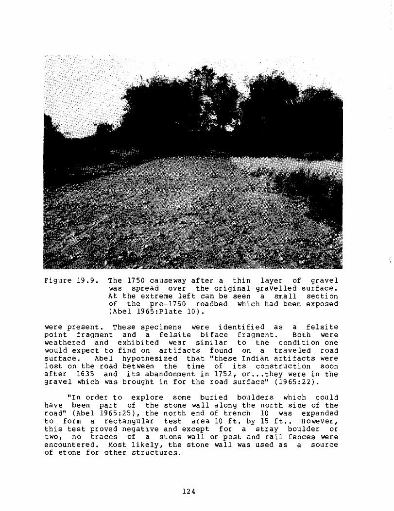
• r."- u-' e , 4.4 -
Figure 19.9. The 1750 causeway after a thin layer of gravel was spread over the original gravelled surface. At the extreme left can be seen a small section of the pre-1750 roadbed which had been exposed (Abel 1965:Plate 10).
were present. These specimens were identified as a felsite point fragment and a felsite biface fragment. Both were weathered and exhibited wear similar to the condition one would expect to find on artifacts found on a traveled road surface. Abel hypothesized that "these Indian artifacts were lost on the road between the time of its construction soon after 1635 and its abandonment in 1752, or...they were in the gravel which was brought in for the road surface" (1965:22).
"In order to explore some buried boulders which could have been part of the stone wall along the north side of the road" (Abel 1965:25), the north end of trench 10 was expanded to form a rectangular test area 10 ft. by 15 ft.. However, this test proved negative and except for a stray boulder or two, no traces of a stone wall or post and rail fences were encountered. Most likely, the stone wall was used as a source of stone for other structures.
124

In summary, there was clear evidence of a causeway running parallel to the west bank of the Concord River, which extended from the foot of the North Bridge to Buttrick Hill. Archeological evidence indicated that the causeway was approximately 600 feet long. From the west end of the bridge, it followed a southwesterly route in a straight line for about 430 feet. it then curved northward until it ended between trenches 9 and 10 (Figure 19.2).
Trenches 11 and 12 (Figure 19.3) were located where the junction of the causeway and the Acton and Groton roads was indicated on the eighteenth century maps (Figure 19.6). However, no evidence of this junction was found. Abel indicated that in trench 12 "some scattered gravel along the first terrace above the river suggested the former presence of the Acton Road" (1965:25). The historic maps indicated that the Acton Road branched off at the west end of the causeway, and proceeded to the southwest along a narrow terrace between the Concord River and the base of the hill (Figure 19.5). Trenches 25, 26, and 27 (Figure 19.3) were positioned across the supposed route of Acton Road, and parallel to the stone wall which formed the southern boundary of the 20th century Buttrick estate. These trenches were located directly north of the two wall junctures which indicated that a 26 foot wide opening or gate had once been located there for the roadway. However, no sand, gravel, or cobble surface was encountered.
Instead, "centered midway between the two wall junctures" (Abel 1965:31) at a depth of 10 inches below the surface, a 22 foot wide hard-packed surface was detected in trench 25. Although only indistinct traces of this surface appeared in trenches 26 and 27, Abel interpreted this surface as evidence of the Acton Road due to: (1) its presence on the narrow terrace; (2) the location adjacent to the wall junctions; and (3) the short distance which existed between the stone wall and the end of the causeway (1965:31-32). The road width of 20 to 22 feet also corresponded with the crown of the causeway. "whether it was ever sanded or graveled could not definitely be determined, for being located on the river's edge it has been flooded many times with resulting erosion" (Abel 1965:38).
Al though these three test trenches extended well beyond either side of the roadway, no evidence of a bordering stone wall or post and rail fence was found. Since "this section of the road was closed in 1793" (Abel 1965:Plate 9), Abel suggested that the opening in the stone wall was subsequently sealed with granite boulders similar to, yet smaller than, those in the original wall.
Although no evidence of the Groton Road was encountered near the Acton-Groton road intersection, some traces of an original historic road surface were found beyond the
125

junction. In a meadow which had been plowed and cultivated for more than a century following the closing of the Groton Road, "there seemed to be little hope that any of the original road surface would have survived, particularly if it had no more durable surface than the causeway, which had only a thin layer of gravel" (Abel 1965:26).
Nevertheless, in trench 16 (Figure 19.4), the road was first encountered 12 inches below the ground surface. It lay beneath a one foot wide, six inch tall section of a dry-masonry building foundation. In addition, Abel indicated that late 19th and early 20th century glass and earthenware sherds were found near the middle of trench 16 (1965:26). It could not be confirmed, however, that any of the artifacts in the collection were those found in trench 16.
In trench 17, 20th century concrete footings intruded into the road in addition to the dry-masonry building foundation (Figure 19.4). Oral history interviews documented by Abel referred to a red barn and other farm structures in this area some 50 years ago (1965:27). The sanded area in trench 17 was followed northward for 50 feet (Figure 19.10) until the extensive root system of a white beech tree interrupted any further excavation. Abel asserted that:
There is no doubt that this is what remained of the road, here buried by the same forces of ploughing and erosion which had washed away all traces of the road on the slopes. H ere the ploughing of the hillside above had loosened the soil and removed its protective cover of grass, and rains had carried it down onto the terrace, burying and preserving the road (1965:27).
In contrast with the soft brown soil along the roadsides, the road surface was composed of a hard-packed, light yellow sand mixed with clay (Abel 1965:30). Unlike the 20 to 22 foot wide road surface southwest of the North Bridge, distinct and relatively straight road edges indicated an eight to nine foot wide sanded road surface (Abel 1965:27). No traces of stone walls or wooden fences were detected bordering the road.
When first identified in trenches 16 and 17, and on the terraced hillside in trenches 18 and 19, the road was well preserved. In contrast, it was poorly preserved in trenches 20 and 21, and not evident on the Buttrick hillside in trenches 22 and 23 (Figure 19.4). Here, all traces of the road had no doubt been eroded by plowing and cultivation in the 1930s, when spacious lawns and garden areas were created for the Buttrick estate. However, in trench 24 on the crest of the hill in front of the Buttrick Mansion (Figure 19.4), the road was found only a few inches below the surface, and exposed "for 136 feet to the hedge and stone fence which
126

Figure 19.10. Excavation northward along the Groton Road from the point where it was discovered in trench 17. The road surface is the light area in the center of the picture (Abel 1965:Plate 8).
border Liberty Street" (Abel 1965:29). Liberty Street, laid out in 1793, was built over the older road. At this point, excavation was discontinued.
In summary, the two features used to identify the Groton roadbed surface structure were:
1) a change in soil color and composition distinct from the surrounding matrix, and
2) a uniform road width of eight to nine feet.
127

Subsequent to the excavation, the issue of site disposition needed to be resolved. This issue was, however, complicated by the problem of how to show these roads to interested park visitors. To identify yet preserve the route of the causeway and its gravelled center strip, "it was decided to spread a thin layer of gravel over the original surface" (Abel 1965:37). The original road surfaces identified as the Groton and Acton Roads were located several inches to several feet below ground, so it was not feasible to grade the area and/or expose the roadways, while insuring the preservation of the surviving portions of the original historic roads. Consequently, Abel directed the backfilling of the trenches and exposed road sections, and then "a thin layer of local gravel was spread on the surface along the routes of the two roads" (1965:38-39). This gravelled walkway now leads from the North Bridge to the Visitor Center.
ACMP Site Interpretation
The purpose of the archeological investigation directed by Leland Abel was to identify the precise location and manner of construction of the roads west of the North Bridge in order to enable Park officials to recreate the 1775 landscape. By retracing the historic routes according to eighteenth century maps, Abel located some surviving sections of three historic roads west of the North Bridge. Abel presumed these to be:
1) the road leading west from the North Bridge, 2) the Acton Road, and 3) the Groton Road.
Two different construction periods were identified for the first of these routes.
The ACMP concurred with Abel th and the adjacent area had "helped written records" (1965:35). Abel pr of a network of historic roads However, any attempts to precisely other supportive evidence (e.g., detailing the manner of construction problematic due to the many realignments in the area.
at excavation of the roads fill some of the gaps in the ovided conclusive evidence west of the North Bridge. date these roads without datable artifacts, documents or road dimensions) was repair efforts and road
Although the archeological evidence indicated that these roads represented the products of different construction techniques, they all shared two basic attributes recorded for early American non-turnpike roadways:
1) a roadbed surface and subsurface structure, often distinctive from the surrounding matrix, and
2) a uniform road width (Kirkorian and Zeranski 1981:6).
128

These features, indicative of human manipulation of the terrain, were visible on the surface and as deep as three feet below the present ground level. No single prevailing road construction concept was indicated by the surviving sections of these roads west of the North Bridge. Instead, various roadbed surfaces and subsurface structures were represented. The cobblestone roadbed of the early causeway leading west off the North Bridge represented one manner of road surface preparation. The sharp angular granite spalls among the cobbles suggested purposeful rock crushing activities (e.g., hammering) (Figure 19.8). Kirkorian and Zeranski commented on this type of road preparation:
The concentration of the stones by size, the unnatural juxtaposition of the variety of the stones and the horizontal bedding of the cobbles and boulders are factors symptomatic of road surface preparation, but are also indicative of a preparation that did not provide the advantages of a cobblestone road, that is, a uniform surface of contiguous, water worn, similarly aligned stones (1981:7).
The addition of gravel over this prepared roadbed surface represented an additional construction measure. coarse yellow gravel, not indigenous to the swamp, was placed on the earthen grade of the causeway, which had been built with the black sandy clay soil from the nearby swamp. The gravel comprised a 20 to 22 foot wide crown. Although Abel proposed that the crown served to facilitate drainage (1965:36), Kirkorian and Zeranski indicated "that as early as 1794 small New England communities were placing crowns on old roads as part of a general repair program" (1981:7).
In contrast, the Groton Road which ascends Buttrick Hill was constructed of hard-packed light yellow sand and clay. It was easily distinguished from the soft brown soil of the surrounding matrix. The most tenuous road identification concerned the Acton Road. No evidence of sanding or gravelling was noted, and only a hard-packed surface in front of a sealed stone wall opening or gate indicated a roadway. Since no known historic records documented when the wall was erected, and there was no other supporting evidence beyond the approximate correct route location, the identity of this road could not be verified.
Road and compos excavation apparent. 48 to 50 contained
width was another element of roadway construction ition that was revealed through this archeological . Again, no prevailing construction concept was The cobblestone roadbed measured 16 feet wide; the foot wide earthen grade of the second causeway a 20 to 22 foot wide raised gravel crown. The
129

hard-packed surface identified by Abel as the Acton Road was 22 feet wide. The Groton Road was determined to be 8 to 9 feet wide. Due to the physical constraints of constructing passable routes on the swampy banks of the Concord River, it is not surprising that the width of the Groton Road was less than the other routes.
J.P.M. Tresaquet's detailed road specifications (Kirkorian and Zeranski 1981:4), which became the model for America's earliest Turnpikes after 1820, recommended an eighteen foot wide carriageway. It appears that the road widths or right of ways in this area were close to this standard. Some colonial roads measured over 100 feet in width, which Cronon indicated was "more than justified since they facilitated moving large herds to market" (1983:140). Travel by carriage, oxcart, and wagon, the typical eighteenth century means of transportation, would have been easily accomplished on the narrower roads. Traces of the Groton Road, although only eight to nine feet in width, would still have provided enough space to permit this vehicular traffic.
In summary, unlike other areas in colonial New England with roads which were "little more than swaths cut through the woods and fields with only the most obtrusive undergrowth, rocks and trees cleared away" (Kirkorian and Zeranski 1981:1), evidence for the roads west of the North Bridge indicated a more prepared land route constructed to improve the quality of sections of the road which were impassable during floods.
It was not surprising that little evidence of roads survived on the slopes of Buttrick Hill, which had been subjected to plowing and rain erosion, or on the terraces and banks of the Concord River which are subjected to floods. However, no trace of the junction of the Acton and Groton Roads was located. This could mean that there was no surviving evidence of this intersection due to the many repairs and alterations of the causeway and connecting roads. Or the exact route was not known, and the intersection simply did not exist at this particular locus.
Stone walls and/or post and rail fences were frequently placed along the borders of roads to demarcate the roadway and property boundaries. The historic record clearly documented the construction of a low, three foot wide cobblestone wall on the north side of the causeway ca. 1752 (Malcolm 1985a:111), and a post and rail fence along its border ca. 1770 (Abel 1965:35). Nevertheless, the archeological investigation revealed no solid evidence of the existence of stone walls or wooden fences on any of the roads. while dry-laid stone walls, as well as cobblestone roadbeds, were easily subject to reuse, wooden fence posts were susceptible to rot and needed repair. Although Abel stated that "a careful watch was kept for traces" of postmolds (1965:30), none were encountered.
130

Several other elements which characterized early American non-turnpike roadways were not found on the roads west of the North Bridge. These included: "evidence of ruts;...evidence of repair efforts;...evidence of gutters;...cultural detritus, concentrated in the gutters" (Kirkorian and Zeranski 1981:6).
The artifacts which were recovered during Abel's fieldwork were not significant. A total of 131 artifacts comprised the collection. The type, quantity, and percentage of artifacts in the collection is presented in Appendix 19.2. The ceramics, which comprised 94.6% of the collection, were primarily late 19th and 20th century materials. These were probably discarded by later inhabitants of the Buttrick estate. The two chipped stone specimens mentioned earlier were not the only prehistoric artifacts found on the Buttrick estate. Abel reported that:
Mr. Abel Christiansen, the gardener for the Buttrick family during the 1930's, '40's and '50's, assembled a collection of several hundred chipped stone artifacts while working around the gardens, and an extensive Indian camp or village site is reported to have existed around the junction of the Sudbury and Assabet Rivers, a short distance to the west (1965:22).
There was no way to confirm that any of these artifacts in the Abel Collection were associated with the roads because the recovery locations were imprecise (see Table 19.1). Although concentrations of artifacts are not as common along roadways as they are on other archeological sites, the paucity of artifacts in this collection was striking. In addition to Abel's recovery techniques, factors such as the erosion of the road due to flooding, the plowing and grounds cultivation by the Buttrick family, and open access to the area for park visitors no doubt contributed to this situation. The poor provenience data in conjunction with the small size of the sample negated the possibility of any meaningful artifact analysis.
131

Management Summary
On April 19, 1775, the Minute Men assembled on the Muster Field on the west side of the North Bridge, and marched down Groton Road to the Bridge to skirmish with the British troops assembled on the other side. The Groton Road and the west branch which led to Acton were replaced by Liberty Street in 1793 when the North Bridge was removed. All evidence of these 17th and 18th century roads was lost during subsequent 19th and 20th century land use.
Previous Archeology
Leland Abel, MIMA Park Archeologist, conducted the only archeological investigation of the 18th century roads on the west side of the North Bridge in 1964-65. His fieldwork successfully located the route of the original cobblestone roadway and the later causeway (ca. 1750) which ran west from the west end of the North Bridge for about 600 ft. (Figure 19.2). At the end of the causeway, Abel located the route of Groton Road, which ran northeastward up the hill past the Buttrick houses (Figure 19.4). Testing to locate the Acton Road, which ran west from the junction at the end of the causeway, was not successful (Figure 19.3).
The cobblestone roadbed was 16 feet wide and constructed "of granite cobbles and of sharp angular granite spalls varying in size from 2 or 3 inches to 10 inches in diameter" (Abel 1965:20) (Figure 19.8). Abel thought it had once been covered with coarse yellow gravel. This roadbed was probably abandoned ca. 1750 when a causeway was built along its north side, which would have been less exposed to flooding by the Concord River.
This causeway gravel crown which alongside this crown total width of th a 3 rod wide road.
consisted of a coarse yellow sand and was 20 to 22 feet wide. Underneath and was a black sandy clay soil, bringing the is causeway to 48 to 50 feet, and suggesting
Evidence for the Groton Road was found in some of the trenches on Buttrick Hill (Figure 19.4). Here the road was eight to nine feet wide, and consisted of hard-packed light yellow sand mixed with clay (Figure 19.10) (Abel 1965:30).
Abel's investigations were important because very little archeological evidence for 17th and 18th century roads had been found. Since Abel's work, other portions of the 1775 Battle Road have been archeologically identified along Nelson Road and on Fiske Hill (Tremer 1972, Synenki 1985). The success of Abel's use of 18th century maps to locate the route
132

of the old road demonstrated the potential of historic maps for identifying 18th century structures as well as roads.
ACMP Interpretation
The ACMP reevaluation of Abel's excavations supported his interpretation of the cobblestone roadway and later causeway leading west from the original North Bridge. We also agreed that he had found evidence of an old road leading northeast from the causeway, which probably was the Groton Road. It is difficult to date old roadbeds, and the artifact collection from Abel's fieldwork provided little evidence by which to date the construction and use of this road.
The Abel Collection
Abel's collection from his excavations along the roads west of the North Bridge contained only 131 artifacts. Since he did not discuss the artifacts in his report and since there was no inventory or catalog of the collection, we did not know if we were missing any significant quantity of artifacts from this collection. Two prehistoric Indian artifacts were recovered during Abel's fieldwork, but the remaining historic artifacts dated primarily to the 19th century, and probably represented later occupation and cultivation of this area.
This collection has little value for research or display with the exception of the two prehistoric stone tools. Although they do not aid in identifying the colonial road, they may represent much earlier use of this area. These are two of the nine prehistoric artifacts which are present in the MIMA Collection.
Public Interpretation of the Site
At the conclusion of Abel's excavations, the cobble roadway on the south side of the causeway was buried, and the causeway was covered with a thin layer of gravel both to protect the original surface and to identify its location for park visitors. The route of Groton Road up Buttrick Hill was significantly lower than the present ground surface, so the excavated areas were backfilled, and the route was covered with gravel.
These roads today serve as the path for visitors between the North Bridge and the Visitor Center. This method of preserving and identifying archeological remains for the general public is strongly recommended since it protects the resource while providing the visitor with a more accurate sense of the 18th century landscape around the North Bridge.
133

Additional waysides could be added along the route of this road explaining how it was identified through the use of historic maps and archeological techniques.
134

Recommendations
Roads are networks which bind people and communities together, reflecting the trade and transportation patterns of the regions they serve. They also influence the settlement patterns of people, commerce and industry. For these reasons, roads should not be treated merely as adjuncts to other human endeavors, but as distinct entities worthy of study in their own right (Kirkorian and Zeranski 1981:1).
The archeological investigation for traces of the roads west of the North Bridge was significant since few early American, non-turnpike roadways have been investigated. This site, however, still has considerable research potential. Although this important network of roads used by the British and colonial forces on April 19, 1775 existed for a significant period of time (ca. 1645-1793), there remains considerable uncertainty about the exact course of these roads. Certainly Abel exposed portions of the historic roadways west of the North Bridge. However, there was no conclusive evidence of the dates of their use due to the many episodes of road construction and repair. In addition, the data base of the archeological collection was very small (131 artifacts) and problematic since precise stratigraphic information was not available for these artifacts.
Although Abel aptly used the eighteenth century historic maps to trace the routes of the historic roads, the potential remains for pinpointing the road routes and neighboring historic house sites by triangulating their location through the use of two other known points on the landscape.
Additional research potential lies in testing these unexcavated areas:
1) around the bridge footings to determine if the stone abutments are original (Abel 1965:12-13);
2) beneath the earthen mound constructed in 1875 under the Minute Man Statue for evidence of the causeway, its stone wall, and the cobblestone roadbed (Abel 1965:12-17);
3) west of the area Abel tested for the junction between
Acton and Groton Roads for this important intersection;
4) the area adjacent to the south face of the stone wall at the southern boundary of the Buttrick estate for traces of the Acton Road (Abel 1965:12);
5) the area where Liberty Street was built over old Groton Road; and
6) the junction of Liberty Street and Estabrook Road for traces of the Groton Road.
135

.4.0 • 1:" co ti ,a 4, ra- In 4 i‘e .4 V eul 41 et et T 03 U
C 0l. , La .7: . i . . 4> „ , : 0 ) 0 . 1 : „,j in 40 ..
1 U M
c..m e r,...4.4 a,
al II 0, 0 , „.. 111.0 V V 0, ...),1,0m11714n3t00'004 wW0
1
.00 - 000^ ibUll 000■ .-- M O W 00.0' 0..104 0.1m
0 . r-1 v 3
".".s., AS au, 0 VI 0 0
O0.C 431 1.1 04ML>V0„,,
V ra al V al al Wu
U W al 0 4 441 0 0
U 0 3 0 and ,,,,
Os Ya w /44 O
.0
4
0 0 ...4 >x .1- 01 0 2 V 0 /4 0 0 m 14
..-i. U ii-I
Z"Vo UV5 f, 10 w .g 21,o ;1 2 g 01
, rA A 0 : .: 3 ,
Art
ifa
cts
App
end
ix 1
9.
1
L V O. 4, 0
0 V M 0 5 4 or/
V
U 10 ,co
V 14 3 O ..1 2 ✓ v; ti W La v Ai- --V
✓ 0 - >. C 5 M 4,01m•-47
O 2 w 0 .04 0 w 5
4 •0 Otag4 Uta3 a IQ liii 0 021gwi m
O 0 3 ;°4 7 10 LH 0 O 0 C 42 13 47 11‘1
0 0 41 41 .4 .0 V 0 0 A
M CJ .41 111 41 -•I g ag e a >...4 s ..., U 4, 1.1 C ie., MI ...I M II 3 0 ...0g 40 0.00,..., 14 41 0. 14 01 em 44 .0 71
O E M X 1 07 lii V 0 0 .... co C iv 0 O../ U u E r-I ..-I 0 C 04 0
C OL
0,0 M 0
42 0 , 4., .-a O. M a/ X W > W M M
✓M
..., 3, 0 O 0 0 I/ 4 le
110314 -4 1 M 41 7 a. a m t v t: 0%. d 09,0,T," . 0 41 O U. V . V c 0 0 .0 01 1./ W 43 4 4
41 O Os CO 4 al ✓ 0
C
ul 4 W a 4 V ,
2 3 0 O
0
a, La In I-1 z W 4 __, e e-/ el .- > M -
a ..0 1 , 00 W 0 ""/ O. fa. N 14 ,C ;,I2 0 4te ..... 4, ..,
4 .0 0 0 w T"- .....C.14 2W.00
O we 0 , - E 0 N > 0 M '0 41
0 o - to to " ..4 C II) > > .0 4° 140 ,00 14 M O 0 7 4°"-I C 01 : W a
Cr0 to C) M 40, ...0 hi 0 M O A ■4 11/ 10 C . 01 U3 N
01 iiii N i•I 0 0 • • to 0 >0 0 >,2 0..g , in
w e 14 .0 Oi 10 O. 0 el 10
a to 0 0 C 0 0 A 0.1 4/ 0
e0 Lel > t) 0 > 41 0 .0 >0-1
ni 1 ,
V
U In V 4) .•
. a i . n0 . ICI - s 4 3. .10 .2 lou a,‘. 2
>-. 13m9!!'!1;111t1::4 v V UCCE3
fa 02 ,31, A,vg >41:1 .._ •-•
iii 41
3 7 0 M 01 ij 41 V 10 0. 4 01 O 0
O 4 0.44200000440
41 E. WOW 04 ttl •-■ 0 .-1 0 V 0 .0 0 if-I C
O
•
a Los 0.41,V3UM CP.
.... U N N
4 4
V I a - C a/ ■
✓ - 0 0 ta .o 0 a. el >I 7 TNC cv 01 fa al A W C ..I .. 0 07 CI 3 0
W .14 • v ..4 C
\OF 20 0T 04 >104
, 10 .-fal.. U WMU,c ,
03 E)„, 0300 O 41+4.41 v0 M>. CO ON 0000
1.4 °1 41t CO C O gl 0 M ,,, O ,14,3,„C3 V ° 44 1:1041°13 5
3 gglE2g ..cm .ao4co.-, mu ,,,,ctfluin .. - 0014C0Z iiil 0 ..-I 0 0 ..-I 0 el 0 r... 44 le 41 0 M ..-I A
, 0 3 01 VI em 130 CC +I .-I .0 Y.. li 41 0 N
ry 01.
136

a. 0
.0
'0
.0 ✓
C •••
E0 0
0 a 4 Y
a .44 44 It 0 /4 • >. //4 ... o 14 0
e 4 3 •-• '0 3
C - • 0 O m 0 o o I..0 o
U C „
Location
o
• C 0 U
0
• -;
C V
a
0 C di
i 0 U
0 44 U
Ati.
A C4 4
0.
0
0
0
0
-11
6' ° a 0 U
14 0
t t
01 DI
1 C 0 ri W
.1 o
E v/
0 > 0 .0 A
..... (4
VI 0
0 a Itt N
I C 0 U
V
.0 V
0 II
-OA
1.4014to,„0o
la
CO
>. • I - V •-■ O. 0 01 in
0 .0 0 C m 1.0 (0 0 o ill a
V .0 C A V .44 ---
0 14 0 6 A w N 14 A A • in T j2
..... i 0 4 a V c. ,1 01 0 ,.., ..., 1 U 4 ..4 , 4.41 0 -a 4 w t1 ..i V , t, 0.4.1 G ,,- v vi , X - - ✓
0 C U 2 0 ri ..
0.1 01
a //4 v ..• it 44 0 4.-1 0 CP
✓ a CO
O3 C
14 .. 0 - .0 0 a N 14
❑ 14 4.
a4 41 u
A , en V C A .... I .0 t ca.LC.00 4 0.. 10 4 .--, a a 0) C l s e - 49 • ow . c' ' 1 , 4 4 - 14 0 4 > ' ch..° .- 1 2 . co i i A, wow 2 uad . . 44 6 ms . 74 : cc° is . ..
C to A. 0 0 0 „ ,,,,, F MO
. oV
t104./ tV00 v m W.) N. 3 ow 0,34,W
04 10100E4/.4 144014-1 „S A D a E >.. ai., 4 0, .IJ 8 cilii0 cd., 0 0 0„000 di g 0.00.0m4J .c w..ii..i ....
VI 01.0 N WU 1/ 0 144/0 14 0
0 1.1 4 a ..4 44 .-1 14 4 0 .0 g V P-1 m 0
4 a
C4 ri : Um 6 .-;. 2 01.1. C 44 Wel U C 4 A 1° 0 .0 C A TIC ow .el .0 4
3 4 V ••
.-1 4-4 • V A 2 .-1 03 2
.0 c N so W o
O N -U 1 ..14 ..., 41 a) I) g LI a co ..1 .-10.1102 1 4.-1
0 .4 One. 0 I+ 4 .0 >C 14 14 .0 0 0
...di 00 00i-I 0 in Rii id >0 dd 0 d.i 4-1 0,1 g o lly 44 LI.CX.0••
1 af 9 0 0 0 0 0, t1 ul te ti an .0 > >.4 CO ...1 al o vo CA tr. so A .0 A I 4 .1 II CA 0 0 .14 .0 ...1 .-4 LIACCOvEll 4 I.
•.. > v 0 V V 4 41 .-1 ..1.4 41.. 0 4 10 34 0 4.1 10
4-1 0 V 4.1 >Ow W 0 .44 II A ..-1 .4 .0 la A 0 E 4 0 TI A Xii ̂1 X 0 ..... 0 II •.1 101100 10,13
A 3., ••11,14.1 .1 4.1 ,0 ,-Is 0.1.1 0 0. C 4 41 IT C.0 g 0 >sea ...I ...I vcvc0/04.1 0 1.. i la 4 4., T 4'1 V a a O. 2 N r4
9 CO N .1-1 CO .CC 1441
Cal 10 1.1 .1 10 10 E V M 1.1 9 O'0
.-. 1.3 V
9 LI 0
.0 14 V ✓ a
0 0 14 C
"-- 14 V
>•a A •-1
Feature
'0C 2M
0 111 0 41 0
C 0'0 a V
V0 C . ..1 7
...1 > 0 14-4
Ca) a 0 00
137

Artifacts
Comments
✓
0. to 0
oa .0 ✓ '0
✓II
14 0 to N d >. 0 N .0 0 1 0
-.4 I V N 14 alto .0
3 U 4 01 U 111 ,0 O N RI 7 c 1,1
44 > .4 O 4
✓ .44 .c 14 O 0 4 0, C d W N 0 ✓ V; C
O M Ul .1 3 Composit
ion of Road
C
✓
1" V. - .T. 0 0 04
M A4e "4 0 '0 040
dd 0
E
✓ M tA a •
✓ cO
V P-4 2,
40C O 0,4
w o w • ffc ea 'cr,--1 w o 3
4.4
N 0 ✓ • 41 /4 Qj ✓ M ✓
70"1 "4 0451 Om 17,
0 .0 U\ t/
11 •4I ✓
E 14 40 a 7 ul to 0'
19.1 (C
ont.
)
4
N N
a
C
.G
II V
••M 41 M 1 4Y T d tr,14 ,n0 140 el 414 2v,,
.„ „my c C- 01023M 14:,
ON d1 M >
N 01 V) x m 0
> v.00%..., a
o
CD U2✓
Jo: cru 10 at .040 0,0 V 0 0
•erl 0 0
0 4-1 E•41VOC.-1 E - 0:14)C7MW7 M > E T.0 U
Location
to w .c
Linj ("0 U 14 V tot 7 0 0 0 U 0 14 7
0 l" 41
W r.:1 ".014 Mad
Ts to
T ti, Q 3 14
11 3
W al G .0 4, w o 3
in in 4
M ✓ D
til 14 n 7 7
01 0 .■4 n3 0,
0,4
IT. a 004 0 0.4
40 >4 0' ✓
.0 411 6-4 m
0. 04
4, z u ea o m
21 .0
4 0 .0 0 ... c
In .G ✓
✓ .-1
L - 4-1
- - N. 0' m In 0 WI C m in m
W 0 1.1 4-I
/1/4 In ✓
r- ca , E. t.0 -.4 E. E, ai
E. .--1 44 144
•
44 .0 .....
0 II I., /.4 3 '0 a, 3 3 c j
3 C 4 ■ 40 P4 ■ CO
on Nr1M in 004 v. 1r-.4 .4. o.-.0,
e El W C O M 4M41 V
-• 1" V 4 00TCm V.-4MW CE.Mx4 O V a
C E ^m700
F0 4 Z
ga SI 4. 4., MOE•10 70000 to 3 140 4 U ✓ q4W0
U
g '0
138

Artifacts
.0 ✓
O
0
C 0 ... .,
. 4.,
4., ...I
g 8 u ch ... E
0 .4 ti
0 ✓ M
14. li fl'-. „4 04 40 4.04 X
7.."' 1 , wftlu. .0
1 acr.°e240:, w occcv.o
00 4W
.04 0 0W
.:-. 1,1,11,...4
0
14 0 a
..4o o.
."' 6°5 a 4.. co.-m.052
u ✓ > en.c 04 4 0 "V0V 14 .
• U 14 0.4 *300 •71,10C.8.0.440.-40
01 :flococ_
0> •16 '4404.243 u4 i 11 U 0 0 0...4004 0/
hiCO3-..1,, , win ... , o (.,, 0 .'Im
4u,w o ... ...wow 4v v u h. 0
.0V>W0,0V O 0 W.000 .13 -4410
4V0V0.0140 43041.00 10 0 ✓ ✓ 0/0>OUZOIDM 0401.0,40 M 1/1 cc
ruCita ZmUsi• U3.4 a 14 110 V 1.1 WA
PO
S
4 . ✓ .
, m a 0 m 0
C M M m .4 m
O m m
a
V 0 W C 03
C 0 tl C 10 .
O ›, 0 WI .04 we 0 .44111 4 aCm 0 3 0S 0
Y A 2 —1 ta z
✓ 0143 0 ..4 .M -c4 OM 00, U .0 mm Om 0 13 0 O am nim 0
a ME. aE44.1 mE ME 30.14
N
4
139

a g C h., a to 1 " uc
I 0, • , . , 0 14 W • '0 >, •
5. i Ln ,,, ,,,,, „ „.....-. xi . in r, g w't L E 2 hi') t 65 .0
'0 '0 C
te o • E 4 „ ,0 X u .0 '14) A .P1 g W iS • 4 1, 9C4•0••18 CO elgOt >1.1•1•••0 12 4 0til a, 04.1 ,,t1 - v a . v ., w .c „,
ol ..10..144'. ...104..1'"wCY"-.- MOt0W)0 "..10, w U 004., 0g0'00,W .01400!?, OtE
;iy4 04V,
0,C.WWW00
MW w - )..1..10WCMMIII' XC aM0C ■4 CLOGIVOw W ,4
.IJ aLU010.0$4• 0>IF,0404.4M..4-AMAN
4 M U I6 DI ON 00E000.14.C., 0.
.C.C ri ) d
PI
C
W 10401 WW° ....
W 0, 0
riii er. 0 el isi N .0
44
ON 7t 4., ae-.1 14 ed 14
..e.,“ a a 6 a
tn v; u; .0 • 4, CO CO CI 1• III .4 .4 •4 0
s u . 0 • a.
cl. 0
v
om o v o; ..c4j 0 c co
cc • .4 CO 4 Air 10
4., "0 44 JI ..,ti 4.4
O 10 a I 1 1 I- 7 11 cm di C
Ca CU m U U WI 4)
0 N U C W
OC 0• M '0 ..I >,
141.11.4 M114., .., CO
14 a V 0 VI
• ...1 .C4J, 14..1 >a) 14 W
✓ w 4, 4 VI V .•1 '0 lii 0161
C 0 to 0 to u 0 0, CU .1 '0 '0 IV 11 '0 11
O E C ..4 Id C Cr .4 a u --* 0 0
U MI 14 el
0 0
a,
4 41 - O 0
.-4 V :ICOIV -0 .4 0 .r. C00 t, .1:9 Or4 OWU
O 0 0 0 u luw -4 HMI'
E.G 'CI
.1 O
t 0
.dgri
C
:40 "C": . " ir, . -!' 1 04 ! 44 41 : 4,1
030,4 ).00„,,
4.3 a ...4 o, 22A4.4a0m
0 ,,,w
,o,
O - - • • al 1I/ 14 .4 ..1
.. .0 :4 >,-- vc m wrs wvo
o.--.ocovc a v e eva.c0,6,0 A WE ,', 04, 44 .1.64W4.4 M•.44W ,I04
a 0 0,
IT ni
a
a •0 CU 0 MCV 14 CO 3
: "" 2; 1 so .2 cn t .... ,T) '
t..° Ow 0 '0 10 41 ..... er ea 0 0 a 0 0 0 ) a . '402 tli, '016.0 ei V .0 • .4 E W •4 ...I C C 0 1.1 0 Al a a 0 Na 0 .- .4
- . W m
0.
0
O
to
.4
CO • ti
140

Artifacts Comments
to • . o
to in 0/ 4 4 ✓ CO
d S 0
0. . 0 C 4) v.. el 10 M 0
00
It I 4
4 'AV00 u la 0 .0
10 O.MA 0C S 0 •-•
W O ✓ T.M Q 0 I, u r4 W in E OCCUJeg .0 M 14 14 om000li —.vox •15 a
.4 01
747.n.
0 cy S. V PO M 01 00 C
E 0 10 CY IT 0.1 0
•"" 0 0 41 0 01 CO ha 0
U71 04 E ✓O #0
Appendix 19
.1
Indistinct traces 0 en
C C 41 M
4 0 01 CY Om 0 od
00 S. C 41 .0 0
7, to
:+11Stc. 0 0 Z OJ No traces
Sandy r
oad
surf ace
G N ✓
- I a .r. . .
4.1 .-. N N A" o .-.1
.0 . ✓ at .0 el N .4 en ri
3
CM 0 N 40 N N e, 0
C qe N N m , 00 'n o >. o el .-1 ..-1 a
01 im M C
0
S C V 01 ME o C
e o 3 o u C a. Ts .0 046 a do o C 104 10 CY t, ....... • III
.-1 4"60 C 04
..., tti/ .0 ..4 mg ". ,0 ; ..... ,,..,... e 2 to
I - .
0 0
U a
t , , ,c . c. ' 2 g 4 01127:1C ... 0 0 la 4., 0.4
4.I 0 00 . - .... 0 0 0 .... ". 0 .., .14 ,r4 w 0 0 Es/ %.,
Of 2 3
t ...0 M u, 0 . 3 .c , 10 ...it., ...1 01 u 1;00,4 0
-coo 0 0 vs
3o
40 n.1 WI .4 C 0 el 0 0 N M ..1 ift N M se/ 01 N N M 0.404 A OM 1-1 C 0 CO Fl N 04 0 ). 0 .0.1 el F TA MI F .0 1TM .4 F .0 0 0 2 st 14 il -.4 0:1
2- 0
141

Artifacts
Comments
TC 44 V w w0w
E VOO 0 .00 1,0
w■ O C c a0 u m,S) 0
.c .9 4
a, N u U c
W p W U w 7 m .00
CIS; .0 0
U 7
•
O7 CO O 3n
V WO
V .4 0.O
cir'4 ,-1 0 U aC241 00S UV3
2 moN 0.6. 0
..i 3O
7 i0C WO .0 VVW —lc MSWOO V a NOT cw Cl. 200 HO
o.
0
a V
In In 4 0 '0 .-4 O u, N N cy, C U u U O wl
Locatio
n
O
N I 0 0 O
.-1
•
0a U 4 0
Ca
Claw .wW4.017 ,1 0.0 -.10..iCm ON oN O 03-43 .-4 E. ^IF
9.1 (Cont.
)
Same as above
Composit
ion of Road
142

Appendix 19.2
ACMP Artifact Inventory
for Accession #11
143

ROADS WEST OF NORTH BRIDGE, MIMA, Accession # 11, Abel Collection
Provenience:
HISTORIC CERAMICS Redware
NB,20OR 0000- 000
NB-155S NB-0000 TOTALS % of SSCW- 0000- Historic 000 000 Ceramics
NB,300S S9CW- 000
Plain 0 4 0 0 4 Lead Glazed, 1 surface 0 0 0 0 0 Lead Glazed, 2 surface 0 0 0 0 0 Sgraffito 0 0 0 0 0 Trailed Slipware 0 0 0 0 0 Jackfield 0 0 0 0 0 Astbury 0 1 0 0 1 Other 0 0 0 0 0 Total Redware 0 5 0 0 5 4.0%
Tin Enameled Delft 0 0 0 0 0 Rouen/Faience 0 0 0 0 0 Other 0 0 0 0 0 Total Tin Enameled 0 0 0 0 0 0.0%
Coarse Buff Body Combed Ware 0 0 0 0 0 Dotted Ware 0 0 0 0 0 N. Devon Gravel 0 0 0 0 0 Mottled 0 0 0 0 0 Other 0 0 0 0 0 Total Coarse Buff Body 0 0 0 0 0 0.0%
Creamware Plain 0 0 0 1 1 Shell-Edged 0 0 0 0 0 Other Edge Decorated 0 0 0 0 0 "- _ea Inted 0 0 0 0 0 Annular 0 0 0 0 0 Transfer Printed 0 0 0 0 0 Other 0 0 0 0 0 Total Creamware 0 0 0 1 1 0.8%
Pearlware Plain 1 0 0 0 1 Shell-Edged 0 0 0 0 0 Other Edge Decorated 0 0 0 0 0 Handpainted 0 0 0 0 0 Annular 1 0 0 0 1 Transfer Printed 0 0 0 2 2 Other 0 0 0 0 0 Total Pearlware 2 0 0 2 4 3.2%
Whiteware Plain 0 2 0 0 2 Shell-Edged 0 0 0 0 0 Other Edge Decorated 0 0 0 0 0 Handpainted 0 0 0 0 0 Annular 0 0 0 0 0 Transfer Printed 0 0 0 0 0 Other 0 1 0 72 73 Total Whiteware 0 3 0 72 75 60.5%
144

ROADS WEST OF NORTH BRIDGE, MIMA, Accession # 11, Abel Collection
Provenience:
Other Earthenware
NB-200R NB-3005 NB-155S NB-0000 TOTALS 0000- SSCW- SSCW- 0000- 000 000 000 000
% of Historic Ceramics
Whieldon 0 0 0 0 0 Insterware 0 0 0 0 0 Agateware 0 0 0 0 0 Rockingham/Bennington 0 0 0 0 0 Yelloware 0 0 0 0 0 Other 0 0 0 0 0 Total Other Earthen. 0 0 0 0 0 0.0%
Porcelain Undecorated 0 0 0 0 0 Underglaze HP-monochro 0 34 0 0 34 Underglaze HP-polychro 0 0 0 0 0 Overglaze HIpmonodhrom 0 0 0 0 0 Overglaze HP-polychrom 0 0 0 0 0 Gilted 0 0 0 0 0 Transfer Printed 0 0 0 0 0 Other 0 5 0 0 5 Total Porcelain 0 39 0 0 39 31.5%
Stoneware Nottingham 0 0 0 0 0 0.0% Other English Brown 0 0 0 0 0 0.0% Bellarmine/Frenchen 0 0 0 0 0 0.0% Westerwald/Paeren 0 0 0 0 0 0.0%
White Salt Glazed Plain 0 0 0 0 0 Moulded 0 0 0 0 0 Scratch Blue 0 0 0 0 0 Other 0 0 0 0 0 Total White Salt Glz 0 0 0 0 0 0.0%
Drybody Black Basaltes 0 0 0 0 0 Rosso Antico 0 0 0 0 0 Other 0 0 0 0 0 TOtal Drybody 0 0 0 0 0 0.0%
Other Utilitarian Import 0 0 0 0 0 Domestic 0 0 0 0 0 Other 0 0 0 0 0 Total Other 0 0 0 0 0 0.0%
Total Stoneware 0 0 0 0 0 0.0%
TOTAL HISTORIC CERAMICS 2 47 0 75 124 100.0%
% of Total Artifacts 94.7%
145

ROADS WEST OF NORTH BRIDGE, MINA, Accession # 11, Abel Collection
Provenience: NB-200R NB-300S NB-155S NB-0000 TOTALS % of 0000- SKW- SSCW- 0000- Total 000 000 000 000 Artifacts
PIPES White Clay Bowls 1 0 0 0 1
Stems: 4/64 0 0 0 0 0
5/64 1 0 0 0 1
6/64 0 0 0 0 0
7/64 0 0 0 0 0
8/64 0 0 0 0 0
9/64 0 0 0 0 0
INDT 0 0 0 0 0
TCTAL: 2 0 0 0 2
Red Clay Bowls 0 0 0 0 0
Stems 0 0 0 0 0
TOTAL: 0 0 0 0 0
Other 0 0 0 0 0
TOTAL PIPES 2 0 0 0 2 1.5%
GLASS Bottle Glass Freeblown 0 0 0 0 0
Blown in Mold 0 0 0 0 0
Auto Machine Made 1 0 0 0 1
Indeterminate 0 0 0 0 0
TOTAL 1 0 0 0 1 0.8%
Drinking Vessel Freeblown 1 0 0 0 1
Machine blown/pressed 0 0 0 0 0
Indeterminate 0 0 0 0 0 TOTAL 1 0 0 0 1 0.8%
Indet. Curved Glass 0 0 0 0 0
TOTAL GLASS 2 0 0 0 2 1.5%
BOTTLE CLOSURE Ceramic 0 0 0 0 0
Glass 0 0 0 0 0
Metal 0 0 0 0 0
Wood/Cork 0 0 0 0 0
Synthetic 0 0 0 0 0
Other 0 0 0 0 0
TOTAL BOTTLE CLOSURE 0 0 0 0 0 0.0%
146

ROADS WEST OF NORTH BRIDGE, MIMA, Accession # 11, Abel Collection
Provenience: NB-200R NB-300S NB-155S NB-0000 TOTALS % of 0000- SSCW SSCW- 0000- Total 000 000 000 000 Artifacts
APPAREL Clothing 0 0 0 0 0 Footwear 0 0 0 0 0 Other 0 0 0 0 0 Indeterminate 0 0 0 0 0 TOTAL APPAREL 0 0 0 0 0 0.0%
BUTTONS, ETC. Button 0 1 0 0 1 Buckle 0 0 0 0 0 Other Fastener 0 0 0 0 0 TOTAL BUTTONS, ETC. 0 1 0 0 1 0.8%
HOUSEHOLD & PERSONAL Tableware o 0 0 0 Kitchenware 0 0 0 0 Furniture & Hardware 0 0 0 0 Lighting Fixtures 0 0 0 0 Decorative Objects 0 0 0 0 Toiletries 0 0 0 0 Stationary 0 0 0 0 Coins/Tokens/Medals o 0 0 0 Personal Objects 0 0 0 0 Toys 0 0 0 0 Other 0 0 0 0 Indeterminate o 0 0 0 TOTAL H & P 0 0 0 0 0.0%
SUBTOTAL 4 1 0 0 5 3.8%
147

ROADS WEST OF NORTH BRIDGE, MIMA, Accession # 11, Abel Collection
Provenience: NB,200R NB-300S NB-155S NB-0000 TOTALS % of 0000- SSCW- SSCW- 0000- Total 000 000 000 000 Artifacts
ARCHITECTURAL MATERIAL Window Glass Crown/Cylinder 0 0 0 0 0
Plate 0 0 0 0 0
Other 0 0 0 0 0
Indeterminate 0 0 0 0 0
TOTAL GLASS 0 0 0 0 0 0.0%
Nails Handwrought 0 0 0 0 0
Machine Cut I 0 0 0 0 0
Machine Cut II 0 0 0 0 0
Machine Cut Indet. 0 0 0 0 0
Wire 0 0 0 0 0
Indeterminate 0 0 0 0 0
TOTAL NAILS 0 0 0 0 0 0.0%
Screws Handwrought 0 0 0 0 0
Machine Cut 0 0 0 0 0
Indeterminate 0 0 0 0 0
TOTAL SCREWS 0 0 0 0 0 0.0%
Other Hardware Builders' Hardware Window Hardware Door Hardware Electrical Hardware Plumbing Hardware Lighting/Heating Hdwr. Other Indeterminate TOTAL OTHER HDWR.
0 0 0 0 0 0 0 0 0
0 0 0 0 0 0 0 0 0
0 0 0 0 0 0 0 0 0
0 0 0 0 0 0 0 0 0 0.0%
Structural Material Brick 0 0 0 0 0
Mortar/Plaster 0 0 0 0 0
Wood 0 0 0 0 0
Linoleum 0 0 0 0 0
Stone 0 0 0 0 0
Fiber 0 0 0 0 0
Porcelain 0 0 0 0 0
Earthenware/Stoneware 0 0 0 0 0
Synthetic 0 0 0 0 0
Metal 0 0 0 0 0
Other 0 0 0 0 0
TOTAL STRUCTURAL 0 0 0 0 0 0.0%
148

ROADS WEST OF NORTH BRIDGE, MINA, Accession # 11, Abel Collection
Provenience:
Other Fastening Devices
NB-2008 NB-300S NB,155S NB-0000 TOTALS % of 0000- SSCW- SSCW- 0000- Total 000 000 000 000 Artifacts
Staples 0 0 0 0 0 Bolts 0 0 0 0 0 Wood Fasteners 0 0 0 0 0 Other 0 0 0 0 0 TOTAL FASTENING 0 0 0 0 0 0.0%
TOTAL ARCHITECTURAL MATERIALS 0 0 0 0 0 0.0%
TOOLS & HARDWARE Hand Tools 0 0 0 0 0 Machine Parts 0 0 0 0 0 Domestic Animal Gear 0 0 0 0 0 Transportation Objects 0 0 0 0 0 Weaponry/Accoutrements 0 0 0 0 0 Other 0 0 0 0 0 Indeterminate 0 0 0 0 0 TOTAL TOOLS & HDWR 0 0 0 0 0 0.0%
SUBTOTAL 0 0 0 0 0 0.0%
149

ROADS WEST OF NORTH BRIDGE, MINA, Accession # 11, Abel Collection
Provenience: NB-200R NB-300S NB-155S NB-0000 TOTALS % of
0000- SSCW- 000 000
FUEL & FIRE BYPRODUCTS (Weight in grams)
SSCW- 000
0000- 000
Total Artifacts
Coal 0.00 0.00 0.00 0.00 0.00 Charcoal 0.00 0.00 0.00 0.00 0.00 Ash/Cinders/Clinkers 0.00 0.00 0.00 0.00 0.00 Wood 0.00 0.00 0.00 0.00 0.00 Slag 0.00 0.00 0.00 0.00 0.00 TOTAL FUEL & FIRE 0.00 0.00 0.00 0.00 0.00
FLORAL & FAUNAL REMAINS Shell (Weight in grams) Bivalves 0.00 0.00 0.00 0.00 0.00 Univalves 0.00 0.00 0.00 0.00 0.00 Indeterminate Shell 0.00 0.00 0.00 0.00 0.00 Other Organic 0.00 0.00 0.00 0.00 0.00
Bone Fish 0 0
Whale 0 0
Human 0 0
Mammal 0 0
Bird 0 0
Other 0 0
Indeterminate 0 0
TOTAL BONE 0 0 0.0%
Vegetal Material Seeds/Nuts Other Comestibles Other Vegetal Material
0 0 0
0 0 0 0 0 0
0 0 0
0 0 0
TOTAL VEGETAL 0 0 0 0 0 0.0%
TOTAL FLORAL & FAUNAL 0 0 0 0 0 0.0%
LITHICS Fire Cracked Rock 0 0 0 0 0
Unworked Lithic 0 0 0 0 0
Gunflints 0 0 0 0 0
Groundstone Historic 0 0 0 0 0
Prehistoric 0 0 0 0 0
Total Groundstone 0 0 0 0 0
Chipped Stone Point Biface
0 0
0 1 0 1
0 0
1 1
Other 0 0 0 0 0 Total Chipped Stone 0 0 2 0 2 TOTAL LITHICS 0 0 2 0 2 1.5%
150

ROADS WEST OF NORTH BRIDGE, MONA, Accession # 11, Abel Collection
Provenience:
SAMPLES
NB-200R NB-300S NB-155S NB-0000 TOTALS % of 0000- SSCW- SSCW- 0000- Total 000 000 000 000 Artifacts
Soil 0 0 0 0 0 C-14 0 0 0 0 0 TOTAL SAMPLES 0 0 0 0 0 0.0%
SUBTOTALS 0 0 0 0 0 0.0%
GRAND TOTALS SUBTOTAL HISTCER 2 47 0 75 124 SUBTOTAL PIPES 4 1 0 0 5 SUBTOTAL ARCHITEC 0 0 0 0 0 SUBTOTAL FUELFIRE 0 0 2 0 2
6 48 2 75 131
151

CHAPTER 20
THE DAVID BROWN SITE
Introduction
Captain David Brown was one of the colonial leaders of the fight at the North Bridge on April 19, 1775. One account of the events stated that:
Captain Brown led his company parallel with the Acton company, on the north side of the causeway, in files two abreast, and equally in front and near to the enemy's force posted at the bridge. There he stood at the head of his men on the birthplace of American liberty, and gave the order if he did not fire "the shot heard round the world." He escaped unwounded,...and if he was not in active service afterwards in the Revolution, it was probably owing to the circumstances of his family (Keyes in Torres-Reyes 1969:3).
Although other accounts of the skirmish credited Colonel James Barrett and Major John Buttrick with leading the Minute Men into the fight (BNHSC 1958:63-64), David Brown was a prominent Concord citizen and a Minute Man. His house was one of those closest to the North Bridge on the west side of the Concord River.
Brown, a native of Concord, was a farmer but he held many other jobs and town offices, including:
Surveyor of Highways, Tythingman, Constable, Fire Warden, Field Driver, Fish officer, and Selectman three years from 1767 to 1770. He was a member of numerous committees which had to do with schools, property assessment, highways and bridges, church affairs, court affairs, minutemen, recruitment of regular troops, regulation of prices and of committees of Safety, Inspection, and Correspondence. Quite frequently he received payment for construction and maintenance work of highways and bridges, especially the Great North Bridge and Old Groton Road (Torres-Reyes 1969:2).
David Brown and his wife, Abigail Munroe Brown, had 10 children, 'some of whom were partially insane and feeble minded' (Keyes in Torres-Reyes 1969:5). They lived in a house on the west bank of the river which had been purchased by David's great grandfather in 1644. Upon David's death in
153

1802, one third of the estate went to his widow, and the other two thirds to his son Joseph.
In 1970, MIMA hired an archeologist, Charles W. Tremer, then of Temple University, to locate the site of David Brown's house. During the first season of fieldwork, Tremer located a house foundation and an area of cobble flooring. At the end of the second season of fieldwork in the summer of 1971, Tremer concluded that he had located the cellarhole of the David Brown house, and that the cobbled area was the floor of the barn which was attached to the west side of the house.
Tremer's two reports, a preliminary (1970a) and a final (1973a), contained very little information about his field methods. He did state that he dug test trenches (1973a:53), but it was only through slides of the fieldwork that we could determine that screens, line levels, and a transit were used during the excavations. His 1970 field season was eight weeks in duration, and he expected to spend six weeks at the site in 1971 (1970a:1). At the end of the fieldwork, the cellarhole of the house had been completely excavated, the walls of attached structures had been exposed, and the cobble area of the barn had been uncovered. MIMA subsequently covered up the barn area, and fenced in the cellarhole as an interpretive site within the North Bridge area of the Park (Figure 20.1).
Figure 20.1• The David Brown site after stabilization by
Bleacher (Bleacher 1979:Roll 3, Frame 5).
154

In 1976, MIMA began an interpretive program with Concord school children which involved planting, tending, and harvesting a colonial kitchen garden. The plot selected for the kitchen garden was in front of the house foundation excavated by Tremer. It was thought that Tremer had tested this area. However, hundreds of artifacts were found in the garden while it was being cultivated. These were saved and washed, and were included with our analysis of the David Brown site.
In 1979, the house foundations which had been left open by MIMA required some stabilization work. This was undertaken by archeologist Joan Bleacher of the Denver Service Center. She discovered that Tremer had not excavated the entire cellarhole of one of the structures. She completed the excavation and recovered a few more artifacts.
In 1985, Joyce Malcolm published an historic grounds study of the 1775 land use of MIMA property (Malcolm 1985a). Her research of the Brown property deeds convinced her that Tremer's excavated cellarhole was not that of the David Brown house. Subsequent research by Malcolm led her to propose that Brown's house was "either directly behind [the excavated cellarhole], and immediately adjacent to the new road, or to its west, again quite close to Liberty Street" (Malcolm 1985b:16).
The ACMP analysis of the David Brown site therefore pursued two avenues of inquiry:
1) a review of Tremer's excavations, interpretations, and artifact collection to determine the date of construction, dates of occupation, and function of the structures which he found; and
2) a review of previous archeological and historical research to determine the correct location of David Brown's house, and to determine if this was the cellarhole excavated by Tremer.
155

Provenience and Coding System
Three collections were inventoried by the ACMP from the David Brown site: the Tremer Collection, which contained nearly 11,000 artifacts; a collection from the kitchen garden excavated by Concord Public School students, which contained over 1,100 artifacts; and Bleacher's collection from the stabilization project, which contained five artifacts.
The Tremer Collection
Charles Tremer was the first archeologist to excavate at the David Brown site. The only available documentation of the artifacts which he recovered from the site was the artifact catalog in his report (Tremer 1973a:70-136). Although many of these artifacts were stored at MIMA, they were not accessioned by the Park until recently. They were assigned accession #359, but they were not cataloged. Some photographs and maps were available, but Tremer's field notes were not.
ACMP Processing: The artifacts from the Tremer
Collection which were stored at MIMA were apparently in various stages of processing when they were given to MIMA. All artifacts had been cleaned, but not all had been labelled with Tremer's artifact number. The majority of the artifacts were stored in sealed white business envelopes from Muhlenburg College (where Tremer was employed at the time). On the front of the envelope was a number which corresponded to a number in Tremer's artifact list. For example, the envelope labelled "10-38" contained the artifacts in Tremer's list from Area 10, item 38 (1973a:109). His list indicated that this item contained "32 Glass pane sherds" (Figure 20.2).
For each of these envelopes, the ACMP inventory procedure
involved:
1) opening each envelope; 2) counting the enclosed artifacts and noting
n
Tremer's list the number of missing or extr
oa
artifacts in the envelope; 3) comparing the artifact description in Tremer's list
to the ACMP classification, and noting on his list any discrepancies in classification; and
4) recording the artifacts on the ACMP coding sheet, preparing the ACMP tags, and bagging the artifacts.
In the case of Tremer's item 10-38 discussed above, the ACMP counted 32 sherds of glass, of which 29 were plate window glass, one was crown/cylinder window glass, and two were bottle glass fragments.
156

AREA 10
10-28 6 HWW trademarks -29 4 HWW h.p. rims
-30 3 HWW h.p. basal sherds -31 2 HWW h.p. body sherds -32 6 Delft body sherds -33 1 Delft rim -34 11 HWW rims -35 15 HWW body sherds -36 1 HWW handle -37
26 Pipe Stems 13 Pipe Bowls
-38 32 Glass pane sherds
-39 17 Glass bottle sherds -40 2 HWW purple t.p. basal sherds -41 1 Delft rim -42 1 Cantonware basal sherd
-43 1 HWW black t.p. rim -44 2 Mottled body sherds -45 3 R Bowl - basal sherds -46 1 S Westerwald basal sherd
-47 1 Porc. Doll's head
-48 1 Sample of Mortar
-49 2 Unidentifiable Metal -50 1 Iron Key 4 1/2"
-51 1 Iron Hook 6 1/2"
-52 1 Metal Tongs 11 1/2" -53 1 Buckle 1 3/4" x 1"
-54 1 Pharmaceutical Bottle rim -55 20 Cut Nails
Figure 20.2. Tremer's Artifact List for Area 10 (Tremer 1973a:110).
The artifacts within each of these Muhlenberg College envelopes were also labelled with a Tremer artifact number, which had the following format:
AAA-BBB-CC
Where:
AAA = excavation unit designation (i.e., Area 10 = 10, Test Trench 1 = TT1),
BBB = number (the purpose and source of this number could not be determined),
CC = year of excavation.
157

The artifacts within the envelope labelled "10-38" included artifact numbers 10-228-71, 10-295-71, 10-331-71, 10-366-71, and 10-368-71, among others. Thus these numbers were not sequential within each excavation unit. If these numbers had any significance, it was not apparent during the ACMP inventory.
Another smaller batch of Tremer artifacts was apparently in an earlier stage of processing when it was turned over to MIMA. These artifacts were in sealed manila envelopes or paper bags on which Tremer's item number (i.e., 10-38) had been written so they could also be matched to Tremer's artifact list as described above. However, these artifacts had not been labelled with Tremer's artifact number.
It would therefore appear that Tremer's artifact processing had included three steps:
1) cleaning the artifacts; 2) inventorying the artifacts, assigning item
and preparing the artifact catalog; and 3) labelling each artifact with a unique
number, and placing all artifacts within each a sealed Muhlenberg College envelope.
All of the Tremer artifacts stored at MIMA had undergone steps 1 and 2, but only some had been completely processed.
The ACMP began inventorying the Tremer Collection from the David Brown site in June 1983. By the end of July, 9300 artifacts had been processed. In November, another batch of David Brown artifacts was discovered at MIMA. These were in a large unmarked box, and Were identified by matching Tremer's item number with the descriptions in the artifact inventory. Most of the artifacts were whiteware sherds from Feature 2 (Sheila Charles, personal communication 1984).
Since Tremer's artifact list included 16,000 artifacts of which only 10,000 could be found at MIMA, Lynne Leopold-Sharp, the Curator at MIMA, contacted Muhlenberg College on the chance that some of the missing artifacts were still there. In January 1984, she received from the Muhlenberg College Archaeology Lab and Museum a small shipment of artifacts which were labelled with Tremer's artifact numbers. Some of these artifacts were identified as belonging to the David Brown site, based on Tremer's artifact number. The processing of this third batch of David Brown artifacts raised the ACMP total for this site to 10,824. This was 5,185 less than the artifacts listed in Tremer's catalog. These missing artifacts will be discussed further in the "Data Problems" section of this report.
numbers,
artifact item in
158

Provenience: Tremer's artifact lists (1973a:70-136) provided the excavation unit in which each artifact was found. This list had 48 proveniences, and the ACMP added a code for no provenience since a few artifacts could not be matched to Tremer's list.
Unfortunately, most of these excavation units could not be identified on Tremer's maps (Figures 20.3, 20.4). Only eleven of the 48 proveniences could be tentatively located from either the text or the maps in Tremer's report (1973a). No stratigraphic data was available except for the one excavation unit which was designated simply "topsoil." These provenience problems will be discussed further in the "Data Problems" section of this report.
The ACMP assigned a 12 digit provenience code to each of Tremer's 48 proveniences. This code had the following format:
DB-XXXX-000-YYY
Where:
DB = David Brown Site, XXXX = Tremer's excavation unit, 000 = Cultural feature within excavation unit, YYY = Stratigraphic level within excavation unit.
A complete list of the ACMP David Brown provenience codes is provided in Appendix 20.1.
The Kitchen Garden Collection
A 20 ft. by 40 ft. area directly in front (south) of the David Brown house site was tilled, hoed, and planted as a kitchen garden in 1976, 1977, 1978, and 1979 by Concord school children. Although it was assumed that Tremer had already excavated there (Marge Hicks, personal communication 1983), over 1,100 artifacts were recovered from the garden area. These artifacts were saved, washed and stored at MIMA in boxes labelled "Kitchen Garden." They were assigned MIMA accession numbers 351 and 365, but they were not cataloged.
Three separate batches of kitchen garden artifacts were found at MIMA, the last of which contained some provenience information. The locational information for artifacts recovered on July 15, 1977, indicated that some spatial control was established (Dig II-A, II-B, etc.), but there was no documentation to explain these locations. The depth at which the artifacts were recovered was also recorded for these proveniences.
159

160
w11111%•••■
Figur
e 20.
3.
MAIN FOUNDATIONS AND DESIGNATED AREAS
Tremer's final site map of house area
(1973a:9)
I
9T- 9
H 0 0 cl-
C
ID a
I eT - 9
0 H
03 a) -4- F-4 i
c4
5 — tE 9 -3
IC
ri 1/4C
VT- 9
DO
r Ndi
H o o

1
nTh I „cc
0)
BA
RN
AR
EA
r i
• It ri r-a■
Trem
er's final
site map of barn area
i I 1
1 1 ixi , m I rq
I . „ I
Figure 20.
4.
161

A list of the ACMP provenience codes and the original provenience information is presented in Appendix 20.1.
The Bleacher Collection
Joan Bleacher, an archeologist from the Denver Service Center, recovered five artifacts from Tremer's Area 12 when stabilization of this foundation was required in 1979. These artifacts were assigned MIMA accession number 299, and Denver Service Center Catalogue Cards were prepared for each artifact. These artifacts were assigned ACMP provenience code DB-AR12-000-00R.
162

Map Construction
Introduction
Source maps used in the construction of site maps for the David Brown site were evaluated according to the ACMP map criteria of completeness, accuracy, accessibility of data, readability, physical condition of map and reproducability (see Chapter 3, Methodology). Tremer's two reports (1970a, 1973a) each contained a diagram showing the baseline (1970a:Diagram 1, 1973a:3a, Figure 20.5) and Area 10 (1970a:Diagram 2, 1973a:9, Figure 20.3). The "West Area" was illustrated in the 1970 report (1970a:West Area, Figure 20.4). Several diagrams of specific walls and niches were illustrated in the later report (1973a:14, 15, 16a, 18a, 19a, 21, 24, 31a, 34). These sources were used in the construction of a composite site map for the David Brown site.
Evaluation of Source Material
The ACMP evaluated the data discussed and illustrated by Tremer in his two reports (1970a, 1973a). This evaluation included: (1) Location of the Baseline; (2) Overall site map and spatial relationships; (3) House Area; (4) Barn Area; (5) Test trenches. Maps included in Tremer's two reports were compared against one another, the accompanying narratives, and the site photographs.
Location of the Base Line: The location of the grid system used in testing the site was illustrated in Diagram 1 of both the preliminary and final site reports. Although the site's location was shown on the 1973 illustration, neither map showed the test areas which were listed on Tremer's inventory lists, and which were used to initially find the site. The ACMP created a composite map (Figure 20.6), combining the information provided by the two illustrations and the artifact lists to show the spatial relationships between (a) the location of the datum and the grid system; (b) the area tested and the Liberty Street wall; and (c) the location of the site and the grid.
Tremer's figure (1973a:3a) suggested that the base line ran parallel to the Liberty Street wall, and all testing was conducted south of the wall. The narrative accompanying this figure stated that "the specific location of the site was related to a datum point established on the southeast corner of a stone gate post" and "southeast of this point, a grid system was established in the field" (Tremer 1973a:3-4). The figure, however, showed the datum point located south of the easternmost stone gate post and the grid system was southwest
163

Tremer's map of the base
line and grid system (
1973a:3a
).
Figur
e 20.5.
DATUM POINT
IBERTY STREET
N 4-) al o o
+. 0' o a) 01 + LC \ • 0 te‘ lC OW a
4-) cn a.) 1 o
t 1 o +O O -a- o -4- H
•
0 + te • CO
LO
LC∎■ J-I
P.11 E
N
-7
0 in 0 + 0 .d-
f•
BASE LINE AND SITE LOC
ATION
0 • 0
+0 in 0
164

ACMP compos
ite sit
e map fo
r the
David Brown site.
Fig
ure 20.6.
165

of the datum. The distance between the stone gate post and the datum was not documented, and that between the datum and the base line was not drawn to the same scale as the distances between grid points. Using the distance between grid points as a scale which was consistent on the figure, the base line was measured in approximately 50 feet south of the Liberty Street wall, and the site about 90 feet from the wall.
The ACMP visited the site and was unable to locate a datum point marker, but the excavated David Brown house site was estimated to be located 30-40 feet south of the Liberty Street wall. The house foundation was southwest of the stone gate post. To resolve the discrepancies among these spatial relationships, the ACMP revisited the site with surveying equipment to attempt to relocate the datum point and base line, and to independently document the relationship between the stabilized foundation of the David Brown house and the south wall of Liberty Street.
Overall Site Map and Spatial Relationships: Both reports contained illustrations of the excavated house and barn areas. The illustrations in each report utilized similar symbols, showed compass orientation and indicated the relationship of the house and barn. Comparison of the illustrations showed discrepancies in several areas. The more highly stylized illustration of the barn area in the 1973 report showed straight walls where rubble was indicated on the earlier drawing, excluded areas of cobble and rubble, and showed less exact excavation limits. Although the indicated relationship to the house was the same in both drawings, the north arrows differed by 14 degrees. The 1973 report drawing was misleading in its depiction of the barn's features as being well defined and easily interpreted. Examination of the available site photographs showed the earlier rendition of the excavated barn area to be a more accurate representation (Figure 20.7).
The highly stylized representation of the house was similar in both reports, the 1973 report showing the completed excavation. Five storage niches located in Area 10 were excluded from both drawings. Like the barn area illustrations, the relationship between the house and the barn matched, but the north arrows were offset five degrees from one another.
Tremer (1973a:40) described the barn area as adhering to the typical architecture of New England house and barn relationships, where "the existence of several rooms linking the house to the barn area" is evidenced. The maps did not clearly exhibit this relationship, but merely alluded to it by the use of a common reference point and wall 6-9, which linked the two structures. Although the positioning and the distance
166

Figure 20.7. Barn area facing southwest (Tremer 1973a:#44).
of wall 6-9 was consistent between drawings, the north arrows varied. Since the original drawing showing the location of the base line from the Liberty Street wall was unresolved, the common reference point could not be accurately located from the wall or the datum point to determine proper orientation of the R35 grid line. Determination of whether the barn was located upslope, downslope or aligned with the house area depends on whether the R35 grid line follows wall 6-9 (either above or below it).
Tremer specifically stated that the barn area "lies to the west of the main house foundations and slightly up the slope. This places it closer to Liberty Street...[which] intrudes upon the northern section of the area" (1973a:40). Neither of the two illustrations showed the site's relationship to the Liberty Street wall, but if the dimensions of the barn were correct and the northern side was approximately 35 feet from the reference point 4+25 R35, the wall was located 30-40 feet from the central portion of the barn area. Photos depicting this relationship (Figure 20.8, 20.9, 20.10) showed wall 6-9 as being less angular, and the barn area as being upslope and very close to the wall. When grid line R35 was plotted from the base line shown in Figure 20.9, and the associated features to reference points 4+50 R35 and 4+25 R35 were drawn proportionately, and the location of Liberty Street was accurately depicted, the resulting
167
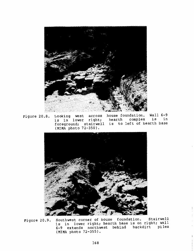
Figure 20.8. Looking west across house foundation. Wall 6-9 is in lower right; hearth complex is in foreground; stairwell is to left of hearth base (MIMA photo 72-350).
Figure 20.9. Southwest corner of house foundation. Stairwell is in lower right; hearth base is on right; wall 6-9 extends northwest behind backdirt piles (MIMA photo 72-355).
168

Figure 20.10. Barn area facing northwest. Cistern is in lower left; stone channel 6-3 is in center; Liberty Street stone wall is at top (MIMA photo 72-362).
relationship illustrated in Figure 20.6 was derived. If Figure 20.5 and 20.6 are compared, the relationship between the location of the site and the Liberty Street wall are radically different.
More detailed drawings of specific structural features were provided in the 1973 text but only schematic drawings showing average wall thicknesses, straight walls and 90 degree angles for the overall site existed. Moreover, stratigraphic information was not documented in photographs or in site illustrations.
House Area: Accompanying the narrative of the 1973 report were a series of illustrations detailing the house foundation and designated feature areas. Those illustrating the vertical structure of the walls with niches were considered by the ACMP to be adequate visual documents. Other drawings showing wall joinings and the composition and
169

configuration of Room 4, Area 12 and the well area were inaccurately depicted in the overall site drawings. The detail provided in each account enabled these features to be added quickly and easily to the ACMP illustration, enhancing its usefulness and accuracy.
Because of the temporal significance of wall joining techniques and associations, the ACMP decided to include these features in the overall site illustration.
Area 12 contained brick rubble interpreted by Tremer to be the remains of the chimney complex (1973a:28-30). A photograph showing the location of the rubble within Area 12 (Figure 20.11) enabled its inclusion on a final site map.
Room 4 was described in the text as having two walls (6-15 and 6-16) which formed an "LH east of wall 6-12 of Area 10. Wall 6-15 was complete but, after a length of ten feet, wall 6-16 tapered off to stone rubble, making it "impossible to ascertain the exact end of the wall" (Tremer 1973a:36). A large stone in the open side opposite wall 6 -15 formed a slight closure but "it is impossible to determine if this was indeed its intended function" (Tremer 1973a:36). Tremer
Figure 20.11. Area 12, showing brick rubble (Tremer 1973a: #23).
170

included photographs which showed this described configuration (Figures 20.12, 20.13). Despite the long narrative dedicated to the accurate description of Room 4, Tremer represented the stone rubble of wall 6-16 and the larger stone in the final site map as being discernible walls.
The well area was described as being located "approximately 35 feet southeast of the main structure foundation" (Tremer 1973a:49). A plan view of the well shaft with surrounding surface stone rubble was accompanied by a descriptive narrative of the well's configuration and composition. Several conflicts arose when the feature was carefully examined.
The exact location of the well in reference to the site and Liberty Street was not provided on any of the site drawings; the north arrow on the plan view was not labelled "magnetic" or "true;" no scale accompanied the drawing; the rocks shown surrounding the shaft did not match those shown in photos (Figures 20.14, 20.15) of the well area and were probably schematic representations; and visitation of the site revealed a preserved unlabelled feature, identified to be the well by park personnel, located 65 feet southeast of the house area. At best, the well area could only be represented approximately.
Barn Area: As mentioned previously, of the two depictions of the barn area, the earlier 1970 rendition was more accurate because it more closely resembled actual excavation photos and the narrative provided by Tremer in his 1973 report. In describing the barn area, he mentioned repeatedly the disturbed condition of the site characterized by badly deteriorated walls and concentrations of rubble (Tremer 1973a:40-48). Despite his recognition of the actual state of the barn area, in his final site report illustration, Tremer chose not to show the concentration of rubble nor to define the "cobble floor" area. Walls 6-6, 6-7 and 6-8 were described as being "in very poor condition" (Tremer 1973a:42), yet were shown as straight, well-defined walls. An area of brick fall associated with the channel 6-3 cover was not illustrated, and a piece of timber associated with channel 6-4 was not shown. All of these features were depicted in the 1970 illustration, with the exception of the timber whose description in the text was not precise enough to plot. A more precise rendering of the barn area would serve as a more accurate and informative record of the actual configuration at the time of archeological investigation.
Test Trenches: Exploratory test trenches which were listed in both reports and whose boundary grid points were plotted on the composite grid system map (Figure 20.5), could not be specifically located and diagrammed. Tremer did not
171

172
Figur
e 20.
12.
4
4C
% a
-
r.
O
CO
•
N
Cn • •
c
rn
T.) T-
M
cf)
4.4 rl
- -4
-44 a)
E
E
a)
O
%a
o Figure
20.
13.

Fig
ure 20.15.
t-- rn
E
N en
Figur
e 20.
14.
173

describe the length and width of the test trenches, nor the difference (if any) in strategy or dimensions between a "test trench" and a "test area."
Methods for Constructing Map
Due to the problems with the source materials mentioned above, the ACMP constructed a composite site map containing the following information: (1) the house area, the barn area, the Liberty Street wall, and the well; (2) more accurate depiction of wall joinings, Area 12, and Room 4 of the house area, of rubble areas, the cobble area, walls 6-6, 6-7, and 6-8, and the area of brick fall of the barn area; and (3) location of exploratory test trenches (Figure 20.6). This map also showed the relationship between the Liberty Street wall, the base line and the site as a comparative guide to Tremer's depiction of these features.
To resolve some of the problems, available documents were examined. In addition, a survey of the site was conducted in 1983 by ACMP staff members to survey and measure extant features.
Site Survey: The intent of the survey was to relocate the datum point and the base line, and to measure the relationship between the house foundation and the Liberty Street stone wall, since Tremer's diagram showing the location of the site relative to the Liberty Street wall was considered inaccurate. The house foundations today are clearly visible and the Liberty Street wall is still standing. The barn area however was covered and landscaped.
To insure comparability with Tremer's original
measurements, the house foundations (including wall thicknesses), internal and external room dimensions, and feature areas were measured. The differences between the measurements recorded in Tremer's 1973 report and the 1983 survey were in most instances less than 1 foot. Variances of more than one foot occurred along walls running east-west, which were parallel with the slope.
To establish the relationship between the house and the wall, three transit stations were arbitrarily chosen to site the angles and distances of 8 points representing the outer dimensions of the main foundation, the center of the well, the two gate posts and 6 points along the wall. The 17 reference
points were identified by the intersection of the three transit siting points, and plotted. The reconstructed house and barn structure from the data provided in Tremer's report were superimposed on the house reference points to construct the final site map. This map represents the most accurate
174

relationship between the location of the site and the wall (Figure 20.6).
Location of the Baseline: As previously stated, Tremer included a map showing the location of the base line and grid (Figure 20.5). On this map, the site was located approximately 90 feet from the Liberty Street wall which was depicted as being parallel with the base line. During the field survey, several attempts were made to relocate the datum and the base line using the information provided. The actual distance between the site and the wall was between 10 and 58 feet. The 100 foot distance between the datum and the base line positioned the base line through the site foundation or below it. Since the exact location of the base line could not be determined, it was not documented on the final site map. Figure 20.6 shows the final site map which contains the most accurate information regarding site composition, dimensions, and spatial relationships, superimposed on Tremer's grid location map using the known location of common reference points 4 + 50 R35 and 4 + 25 R35. The base line intersects the Liberty Street wall, and the primary testing area is north of Liberty Street. The original location of the base line and grid system could not be accurately recreated. However, the dimension, location and orientation of the site relative to the stable landmark, the Liberty Street wall, could be. These are documented on the final site map and are proposed to be as accurate as the available data allows.
Spatial Relationships: The relationship between the house foundation and the Liberty Street wall was established with the information gathered during the 1983 site survey. The placement of the barn area was established by using: the common reference point 4+25 R35; maintaining a linear relationship with the second reference point, 4+50 R35, which existed in the barn area; Tremer's description of the barn area as "slightly upslope" and "the northern section of the area" being intruded upon by Liberty Street; and the available site photographs (Figures 20.8, 20.9 and 20.10) showing its location. it was not intended that the placement be interpreted as exact, but it is our best estimation of its location.
House Area: The house dimensions were established according to measurements provided by Tremer's 1973 site report. wall joinings clearly depicted in the 1973 report were included. The dimensions of brick rubble interpreted as the chimney remains (Tremer 1973a:28-30) were estimated from available field photographs (Tremer 1973a:Figure 23). Wall 6-16 of Room 4 was depicted by Tremer as being approximately 10 feet in length, at which point it tapered off into rubble.
175

The length and width of the rubble was estimated from field photographs (Tremer 1973a:Figures 27, 28). The placement of the boulder was interpreted from those same photographs, and dimensions taken during the 1983 survey were used to depict its size.
The well area was located by the ACMP during the 1983 survey. The plan view of the well and the surrounding rubble (Tremer 1973a:51) was used to determine dimensions of those features.
Barn Area: In comparing the two available illustrations of the barn area, it was decided that the 1970 map was more accurate and it was used.
Test Trenches: The initial exploratory test trenches could not be plotted due to inadequate documentation. The test trench cut to search for the Groton Road was included on the final site map. Tremer reported its exact dimensions, and its location could be estimated from site photographs and the 1973 report description (Tremer 1973a:50).
176

Data Problems
The Tremer Collection
The major problems with the Tremer Collection from the David Brown site were:
1) Over 5,900 artifacts were missing from this collection;
2) Very few of Tremer's provenience designations could be identified on his site maps or in the text of his report;
3) Tremer's field notes were not available; and 4) Some of Tremer's artifact identifications were
incorrect (primarily the ceramic identifications).
Missing Artifacts: The only list of artifacts for the Tremer Collection was the artifact catalog which appeared in Tremer's report (1973a:70-136). This catalog listed 16,009 artifacts. The artifacts from this collection which were inventoried by the ACMP numbered only 10,824, a difference of 5,185 artifacts.
This difference, however, did not accurately reflect the number of artifacts which were missing. This difference included the "extra" artifacts which were found in many of the Muhlenberg College envelopes. The "extra" artifacts were determined by comparing the number given in Tremer's artifact catalog for a specific item # (e.g., 12-9), and the number of artifacts found in the sealed envelope labelled with that item #. In the case of item 12-9, Tremer's inventory stated that "7 R brown g. rims" (1973a:111) (7 brown glazed redware rimsherds) were included in this item. The envelope labelled "12-9" actually contained eight redware sherds (seven rim sherds and one body sherd). Thus, in the difference of 5,185 artifacts, the missing artifacts in the Tremer Collection were offset by these "extra" artifacts.
It was therefore necessary to calculate the missing artifacts separately. These artifacts were identified at the same time that the "extra" artifacts were noted. As each envelope was opened, the artifacts were counted, and the number of missing or extra artifacts for each item was recorded on copies of Tremer's artifact catalog. In this manner, it was determined that 5,905 artifacts were missing from the Tremer Collection at the time of the ACMP inventory.
Although there were a few artifacts missing from almost every provenience, 81.5% of the missing artifacts were from five proveniences:
177

PROVENIENCE TREMER TOTAL MISSING
Test Trench 4A-5A 747 746 Test Trench 6 984 491 Test Trench 6B 536 421 Area 3 954 607 Feature 2 8,211 2,546
11,432 4,811
This suggested that the artifacts from each of these proveniences were probably kept together in envelopes or boxes after processing, and have simply not been located yet. They could still be at MIMA, at Muhlenberg College, at Temple University (where Tremer was employed when he began the David Brown excavation), at Moravian College (where he was employed after Muhlenberg), or in Tremer's possession. Lynne Leopold-Sharp, the Curator at MIMA, contacted all of the institutions involved. She was satisfied that none of the missing artifacts were at Temple University or Moravian College (personal communication 1984). Some artifacts from the David Brown site were found at Muhlenberg College and subsequently inventoried by the ACMP, so perhaps more will be found there.
For site interpretation purposes, it was useful to present the missing artifacts by type (Table 20.1). It should be noted that these artifact types were those assigned by Tremer, and some may not be correct (see "Classification System" below). Over 80% of the missing artifacts were ceramic sherds, and nearly half of these were whiteware. Significant quantities of pearlware and redware were also missing. Smaller but notable categories of missing artifacts included machine cut nails (307), bottle glass sherds (277), and bones (207). Most of these categories of missing artifacts were accounted for in the five proveniences mentioned above.
Baker's Analysis: In 1980, Vernon Baker prepared an evaluation of the previous archeological work which had been done at MIMA. His evaluation included a reanalysis of the artifact collections from each site. His analysis of the Tremer Collection from the David Brown site should have provided a check on the number of artifacts which were present in the collection at MIMA three years before the ACMP began. This should have helped to determine if a significant number of artifacts were never returned to MIMA by Tremer, or if they had been misplaced since 1980.
However, there were serious problems with Baker's analysis. Baker was correct in noting that the David Brown
178

Table 20.1
Tremer Collection, David Brown
Ceramics:
Site:
Total Missing
Missing Artifacts
Missing 5 Balance Proveniences* Missing
Jackfield 1 0 1 Redware 777 502 275 Delft 2 0 2 Yelloware 258 258 0 Other earthenware 9 1 8 Creamware 183 182 1 Pearlware 830 801 29 Whiteware 2,413 2,157 256 Rockingham 144 128 16 Porcelain 120 90 30 Stoneware 219 192 27
4,956 4,311 645 Architectural Materials:
Window glass 32 2 30 Nails: Hand wrought 1 1 0 Machine cut 307 164 143 Structural:
Brick 16 10 6 Mortar 1 0 1
Pipes: 357 177 180
Stems 28 23 5 Bowls 4 0 4
Glass: 32 23 9
Bottle 277 59 218
Buckle: 1 0 1
Household & Personal: Porcelain dolls 3 1 2 Knife 3 1 2 Spoon 1 0 1
7 2 5 Faunal & Floral Remains:
Worked Bone 9 9 0 Bone 297 195 12 Teeth 12 5 7
Metal: 228 209 19
Miscellaneous 15 6 9 Unidentifiable 12 5 7 Strips 6 6 0 Rods 14 13 1
47 30 17
TOTAL MISSING ARTIFACTS 5,905 4,811 1,094
* TT4A5A, TT06, TT6B, AR03, F02.
179

artifacts had not been cataloged by MIMA. He reported that "they have, however, been washed and stored in paper bags on which is written provenience information. These materials are housed at MIMA" (1980:77). A small number of the Brown site artifacts were stored in paper bags when the ACMP received them from MIMA. However, most of the artifacts were stored in manila envelopes and Muhlenberg College envelopes, all of which were sealed when the ACMP received them. The few paper bags were stapled shut. Baker reported that he had prepared his inventory of the Brown site "by analyzing all of the artifactual materials" (1980:77). Although he could have restapled the bags, Baker could not have examined the majority of the artifacts, which were in sealed envelopes. Even if Baker had removed the artifacts from their original containers and put them in new envelopes which were then sealed, he would not have had access to a supply of Muhlenberg College envelopes. These could only have come from Tremer, most likely with the artifacts already sealed inside.
Baker was correct in noting that Tremer's proveniences were written on the artifact bags, and he obviously looked at some of the artifacts since he noted "the misidentification of some ceramic wares. Sherds of pearlware are classified as hardwhite ware and sherds of hardwhite ware are classified as yellow ware" (1980:77). Similar errors were noted by the ACMP (see "Classification System" below).
The ACMP suspected that Baker's inventory of the David Brown artifacts (1980:77-79) was prepared primarily from Tremer's artifact catalog (1973a:70-136), not from analyzing the artifacts themselves. Baker's inventory listed the ceramics by type, number of sherds, and vessel shapes. All of this data was contained in Tremer's artifact catalog, and could have been tabulated by Baker. However, Baker's ceramic total was less than Tremer's by 1,350 sherds. Perhaps Baker did not include those proveniences for which there were no labelled bags or envelopes.
Four artifact classes were conspicuously absent from Baker's analysis: bottle and drinking vessel glass, window glass, and clay pipes. These classes accounted for 1,563 artifacts in Tremer's inventory. We did not know why Baker omitted these from his inventory.
Baker's inventory of the Tremer artifacts included more artifacts than the ACMP inventory, but less than Tremer's:
Tremer Baker ACMP Inventory Inventory Inventory
Total Artifacts 16,009 12,781 10,824
180

However, we felt that Baker's inventory did not provide an accurate report of the artifacts actually present in the collection at MIMA in 1980, so it could not be used to identify any of the currently missing artifacts.
Provenience Problems: Tremer's artifact inventory (1973a:70-136) included 48 proveniences from which he recovered the 16,009 artifacts from this site. Only seven of these proveniences could be located from Tremer's maps and reports, and four others were ambiguous. Three proveniences were identified on Tremer's map of the house foundation in his final report (1973a:9): Room 2, Area 10 and Area 12 (Figure 20.3). These proveniences accounted for only 8% of the artifacts inventoried by the ACMP. Area 13 (Figure 20.6) was identified from illustrations incorporated in the text (Tremer 1973a:20-24), and accounted for less than 1% of the artifacts inventoried. Feature 2 (Figure 20.16) was discussed in Tremer's final report (1973a:42-43) and labelled on a map in his preliminary report (1970a:Appendix). This feature, a cistern or dry well, accounted for half of the artifacts which Tremer recovered from this site. This provenience accounted for 55% of the artifacts inventoried by the ACMP, but another 2,246 artifacts were missing for this feature.
Two test trenches in Tremer's inventory were labelled 6-4 and 6-9. These were the same designations that were given for the two walls on Tremer's map (Figure 20.4). It was assumed that these proveniences referred to trenches dug along these walls. Only 42 artifacts were inventoried from these two proveniences.
Tremer's final report included a copy of a memo he wrote regarding recommendations for interpretation of the David Brown site (1971). This memo included a map of the house area with room numbers that differed from those on any other Tremer maps. This map identified an Area 3, to the south and west of the house area (Figure 20.17), which was not labelled on his other maps. This was tentatively identified by the ACMP as the Area 3 for which artifacts were listed in Tremer's inventory. This was one of the five proveniences which accounted for the majority of the missing artifacts.
Tremer's designation of test trenches and test areas was not explained in his report. One confusing situation was his description of "a test trench...down the slope in front of the main foundations" (Tremer 1973a:50). He illustrated this test trench in a diagram labelled "Area 14-Road Test Trenches" (Tremer 1973a:52). Since he listed artifacts from both test trench 14 and Area 14 in the inventory, it was not clear which provenience referred to the excavation in front of the house. Perhaps they both did.
181

Tremer
's map of
barn area after
fir
st season of fie
ldwork
Figure 20.
16.
182

0
/ /1111/7//
0)
r-I RI
7 4-1
4.)
a) IJ
0
0 -r1
-0 •
▪ 1-1 • r-- 34 ON CD 4-1
C-0 •-•-•
CD
U)
a) • u) • c
o 3 .4 O
(1) CO 4
04
E (CI
&MI IMP IMilp 411■1
— OM.-- -- -
Tremer
's
feature
s
Fig
ure 20.
17.
2 it kti
qt u 4
183

Tremer's provenience called "Top Soil" could have referred to any of the units that he excavated, but he specifically mentioned that "the topsoil in the area around Feature 2 contained a concentration of similar artifacts to those found in the cistern" (1973a:48). It therefore seemed likely that this provenience contained those artifacts found around the cistern.
Tremer listed 21 test trenches as proveniences in his artifact inventory. Of these, only three were tentatively located by the ACMP (TT6-4, TT6-9, and TT14). He did provide the grid coordinates for six test trenches and one test area in his report (1973a:53), but these trenches were not numbered, and these grid coordinates did not appear on his site maps. Therefore, these trenches could not be located or associated with any artifacts in his inventory.
The remaining 37 proveniences given in the artifact inventory could be located only if Tremer's original field maps were found. Baker mentioned that Tremer's report included "maps of the site showing excavation units [which were] very useful" (1980:77). Although Baker could have been referring to maps which were not located by the ACMP, he probably meant the two maps which were included in Tremer's 1973 report (Figures 20.3, 20.4).
These 11 tentatively identified proveniences (including test trench 14 and Area 14) accounted for 7,860 artifacts, or 72.6% of the artifacts which were inventoried by the ACMP. Although this sample would appear to be suitable for analyzing the temporal and functional attributes of this site, nearly 3,500 artifacts from these 11 proveniences were missing. Thus, a significant percentage of the artifacts from these identifiable proveniences were not available for analysis.
Classification System: Although Tremer did not describe the classification system which he used to inventory the artifacts from the David Brown site, most of his ceramic terms were similar to those used in the ACMP classification system. The exceptions to this were his Mocha ware, Flow ware, Cantonware, and Mottled sherds. The ACMP usually coded his Mocha ware sherds as pearlware, the Cantonware as porcelain, and the Mottled sherds as Rockingham/Bennington.
Although Tremer's ceramic terminology was very similar to that of the ACMP, his application of these terms was found to be incorrect in many cases. His most common error involved his HWW (hard white ware) category. Although the ACMP inventory showed that whiteware comprised 55% of the ceramics in this collection, many additional sherds which Tremer classified as HWW were actually pearlwares and creamwares.
184

Tremer's terminology for his non-ceramic artifacts was very straight forward. He did not describe the window, bottle or drinking vessel glass by manufacturing technique, as the ACMP did during the present inventory, which can provide chronological data. He also did not measure the bore diameter of his pipe stems. The nails were described as either hand wrought or cut, and in some cases the dimensions of the nails were given.
The Kitchen Garden Collection
Although the artifacts found in the kitchen garden were not recovered using archeological field techniques, there was provenience data for 7% of the artifacts found within the 20 ft. by 40 ft. area. There was, however, no map or other documentation with which to identify these proveniences within the kitchen garden. Some of the proveniences did include the depth at which the artifacts were found. There was no inventory of the artifacts which were recovered, so we did not know if the 1,163 artifacts inventoried by the ACMP were the complete collection.
It is fortunate that the artifacts were collected, cleaned, and saved in labelled containers since archeology was not one of the purposes of the kitchen garden project.
The Bleacher Collection
Bleacher's report described the five artifacts which she recovered from the rubble fill within Tremer's Area 12 (1979:6-10). All of the artifacts which she found have been inventoried by the ACMP, including the base and spout of a Jackfield teapot.
185

Site Interpretation: Architectural Features
Tremer's Analysis of House Foundations
During the first field season at the David Brown site, Tremer uncovered most of the walls for the main structure (Figure 20.18), and dug trenches to determine the depth of the walls in Area 10. During the second season, he excavated the interior of these walls, and uncovered Room 4 and Area 12 (Figure 20.3).
Tremer believed that these walls were those of the David Brown house, which
consists of a main room approximately 20 x 16 feet, with a large hearth area on one side, plus two smaller "added-on" rooms. An 8 foot by 6 foot rectangular storehouse foundation is located to the northwest of the main section, and ultimately became part of the overall configuration (Tremer 1973a:8).
The Main Room: This room, designated Area 10 (Figure 20.3), was:
basically square in shape, the squareness being altered slightly by the offset of wall 6-11A in the southwest corner [Figure 20.33. The structure contained a hearth area along the western wall, stretching almost the entire length of the western wall, stopping short of south wall 6-11 to allow room for a stairway along the side of the chimney stack.
The structure contained a centrally located door in the south wall. The interior probably consisted of one large room, characteristic of the period. The foundations reach a depth of slightly over five feet, providing a full basement below the structure. The basement itself had a dirt floor, and a unique configuration of several storage niches in the walls.
The overall construction appears well-made, following sound architectural methods and practices (Tremer 1973a:25).
Tremer described the field stone foundation of this original one-room structure as:
constructed of large angularly shaped field stones. The foundation is very well constructed, the stones
186

Figur
e 20.
18.
•
C 0 r- rn
44 1.4 0
V H -H 11-1
as 0
C 0
Co
ro
4-) Co
4-1
€1) -6) 4-1 C
C
CO
0
0
E
Ia a
n:1
t 4 141
r
• • \ti
n-frpft
4
9 0, navy,/
••■■•■•■•
r-
/- — - ----- - -J
/ /
/
1/4 ;49 /
On. •
1
187
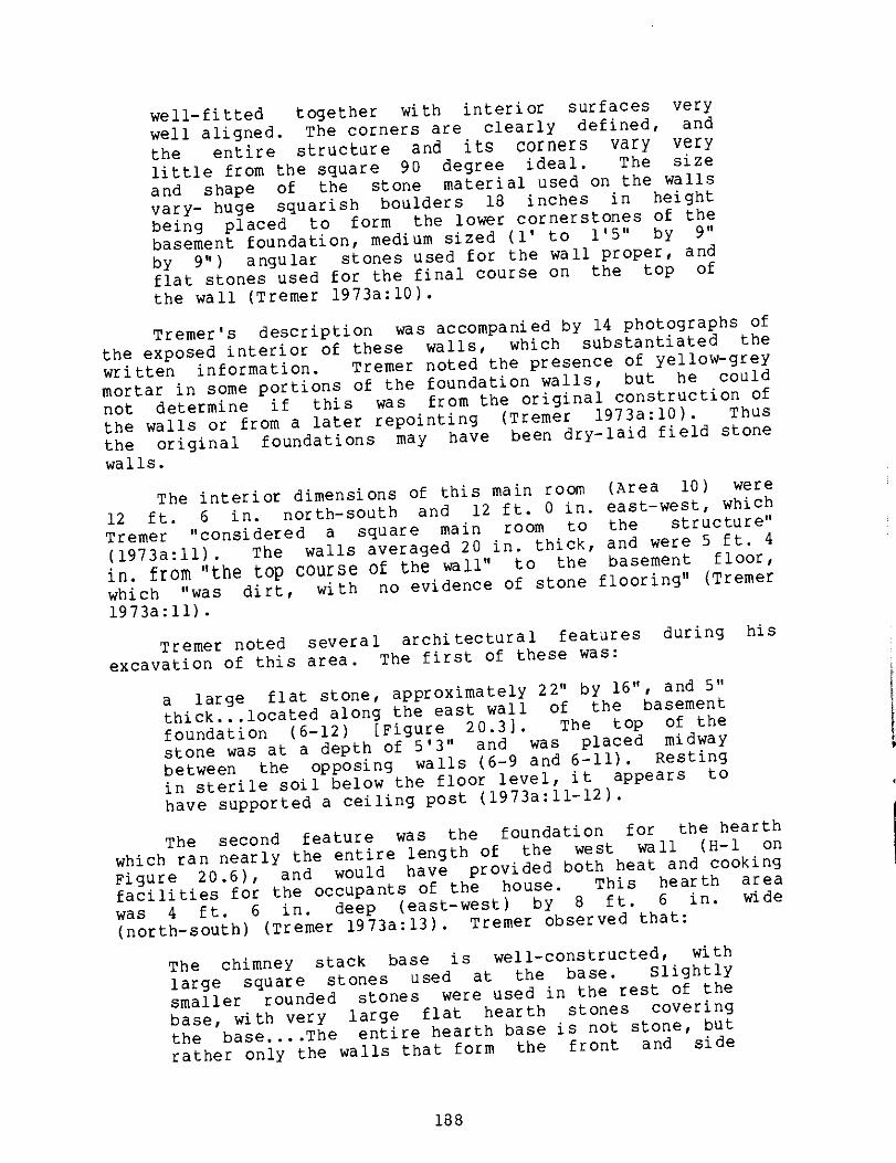
well-fitted together with interior surfaces very well aligned. The corners are clearly defined, and
the entire structure and its corners vary very little from the square 90 degree ideal. The size and shape of the stone material used on the walls vary- huge squarish boulders 18 inches in height being placed to form the lower cornerstones of the basement foundation, medium sized (1' to l'5" by 9" by 9") angular stones used for the wall proper, and flat stones used for the final course on the top of the wall (Tremer 1973a:10).
Tremer's description was accompanied by 14 photographs of the exposed interior of these walls, which substantiated the written information. Tremer noted the presence of yellow-grey mortar in some portions of the foundation walls, but he could not determine if this was from the original construction of the walls or from a later repointing (Tremer 1973a:10). Thus the original foundations may have been dry-laid field stone
walls.
The interior dimensions of this main room (Area 10) were 12 ft. 6 in. north-south and 12 ft. 0 in. east-west, which Tremer "considered a square main room to the structure"
(1973a:11). The walls averaged 20 in. thick, and were 5 ft. 4
in. from "the top course of the wall" to the aseent floor,
which "was dirt, with no evidence of stone f
blooring" (Tremer
1973a:11).
Tremer noted several architectural features during his excavation of this area. The first of these was:
a large flat stone, approximately 22" by 16", and 5" thick...located along the east wall of the basement foundation (6-12) [Figure 20.31. The top of the stone was at a depth of 5'3" and was placed midway between the opposing walls (6-9 and 6-11). Resting in sterile soil below the floor level, it appears to have supported a ceiling post (1973a:11-12).
The second feature was the foundation for the hearth which ran nearly the entire length of the west wall (H-1 on Figure 20.6), and would have provided both heat and cooking facilities for the occupants of the house. This hearth area was 4 ft. 6 in. deep (east-west) by 8 ft. 6 in. wide (north-south) (Tremer 1973a:13). Tremer observed that:
The chimney stack base is well-constructed, with large square stones used at the base. Slightly smaller rounded stones were used in the rest of the base, with very large flat hearth stones covering the base....The entire hearth base is not stone, but rather only the walls that form the front and side
188

of the chimney base are so constructed. In the area inside the point where the top hearth stones rest on these walls, the hearth stones rest on a ground base. In other words, in the construction of the basement area, the entire square basement was not dug out....Rather the original configuration was excavated as it appears now, with the stairwell area notched out [Figure 20.19], and the earth allowed to remain where it would eventually support part of the hearth (Tremer 1973a:13-14).
Earthen chimney base
Mt FOUNDATION WALLS
Figure 20.19. Tremer's illustration of house foundations with earthen base for chimney (Tremer 1973a:14).
Tremer also observed that a ledge ran along the front (east) wall of the hearth foundation, which "was evidently structured to support floor beams running to the opposite wall (6-12)" (Figure 20.3). He did not, however, state whether a corresponding ledge was located on the interior (west) face of wall 6-12.
Tremer interpreted the area south of this hearth foundation as the location of a stairway, with the "stairs leading up and down the sides of the chimney stack to the floors above and below" (Tremer 1973a:13). He described this stairwell as an "alcove...formed between the chimney base and a wall that is an offset of wall 6-11...(designated 6-11A)" (Figure 20.20) (1973a:21). This alcove measured 3 ft. north-south and 4 ft. 6 in. east-west. Tremer explained that wall 6-11A, at the southwest corner of the structure, was offset 12 in. from wall 6-11 (Figure 20.20) because the narrower width of the alcove (3 feet) "would appear to provide more support for wooden stair planks stretching across this width than if the corner were not offset and the width were 4'0""(Tremer 1973a:24).
189

H-1
Area 13
6-11
Figure 20.20. Tremer's illustration of stairwell area (Area 13) in southwest corner of house foundation (Tremer 1973a:21).
The back (west) wall of the alcove sloped inward, and at the base of the wall Tremer encountered an upright timber. It was 3 in. square, 6 in. high, and "located midway between the side walls of the alcove" (Tremer 1973a:22). He interpreted this as being one of the timber support beams for the stairway (1973a:22). Tremer also found "badly deteriorated wood in the area immediately in front of the hearth base and stairwell area" (1973a:12), which could have been stair planks, or perhaps wooden flooring from the first floor. In front of the alcove, on the floor of the cellar, Tremer uncovered "a large, flat stone, obviously placed in position to serve as a bottom step stone" (1973a:22).
Tremer stated that the location of this stairway "at the side of the chimney stack...is characteristic of 17th century New England architecture" (1973a:20). The front door of a structure was usually located at the same corner, with the entrance hall also adjacent to the chimney stack. However, at the Brown house, Tremer found evidence for the front door in the center of the south wall, not in the corner with the stairwell.
The top of the southern wall of the foundation is bisected by a large doorsill stone. The stone itself is 29" long and 23" inches wide. The inside edge is flush with the foundation wall, the exterior edge slightly overhanging the wall thickness. The stone is an average of 5.5" thick and slightly rounded on the top (Tremer 1973a:24-25).
Tremer referred to the location of the door and the stairwell as "another unique feature of the Brown foundations" (1973a:20). The other unique features were storage "niches in the foundations [which] supply a unique characteristic to the structure, not only in the number of niches, five in total number, but also in their varied position both vertically and horizontally" (Tremer 1973a:19).
190

Tremer's written description of the size and construction of these niches was supplemented by photographs and excellent drawings of each niche.
Each niche is approximately the same dimension - 2'0" wide and 1'6" high. Average depth into the wall is approximately 1'3". Except for one place,...all the sides of the niches are constructed of a large flat stone lining the opening. The top is formed by a lintel stone, resting on the vertical side stones. The back wall of the northern niche, F-5, is formed by one large flat stone, placed vertically, while the back of F-8 is formed by several large flat stones placed horizontally (Tremer 1973a:16).
Tremer hypothesized that the locations at which these niches (or cuddies) were constructed related to specific functions. One niche in the south wall (F-7 on Figure 20.3) was located at the bottom of the wall so "the base of the niche is the ground itself. There is no stone laid to form the base under the niche" (Tremer 1973a:18). Tremer suggested that items stored in this niche would be kept at "a constantly cool temperature" by resting directly on the ground, so this niche was for "the particular purpose of storing wine and other liquids that would preferably be stored in a cool place" (Tremer 1973a:18). Its location near the stairwell would also make it easily accessible.
The two niches in the chimney base were located "at different heights above the floor level" (Figure 20.21) (Tremer 1973a:15). Tremer suggested that the reason for constructing them in the chimney base was to utilize the heat, perhaps for curing cheese (1973a:17).
The function of the other two niches, one each in the north and south walls, was not apparent. The niche in the north wall (F-6 on Figure 20.3):
is centrally located between the ground level and the top of the wall...and it is also centrally located between the contiguous wall 6-12 (east wall) and the north wall's intersection with the front of the hearth base....Perhaps it is this centrality itself that implies an all-purpose use for this particular niche (Tremer 1973a:19).
The other niche in the south wall (F-4 on Figure 20.3) was located directly under the front doorsill. The lintel for this niche was the stone which Tremer identified as the doorsill.
Reasons for placement of the niche directly under the doorsill stone-[a] point in the foundation of
191

FACE OF CHIMNEY BASE SHOWING NICHES F-5 AND F-8
F-5
F-8
Figure 20.21. Tremer's illustration of storage niches in chimney base (Tremer 1973a:16a)
direct stress - remains unclear. It can only seemingly be explained by its proximity to the stairwell, thus making articles stored there readily accessible (Tremer 1973a:18).
Tremer also felt that the two niches in the chimney base were constructed:
at the expense of sound architectural practice.,..It would appear that while seemingly excellent architectural techniques and design were utilized throughout most of the structure, that here was evidence of less than perfect construction. The hearthstone area was, due to its weight, an area of stress, and would have been best supported by solid unbroken walls beneath (Tremer 1973a:16).
In addition to uncovering these architectural features within the cellar of the Brown house, Tremer's excavation provided information concerning the post-demolition treatment of the cellarhole.
192

The entire basement area was one containing a consistent type of fill. Yellow-brown clay type soil was consistent from the surface down to the dark mottled level signifying the basement floor. Three huge boulders were located at the bottom of the fill. Other rubble debris was found throughout the fill. There was no evidence of stratification indicating that once the structure had been torn down (1865), the basement area was filled all at one time, with large boulders being pushed into the open foundation to speed up filling the space (Tremer 1973a:12).
The Storehouse: A small rectangular foundation northwest of the main room was interpreted by Tremer to be "a one-story storehouse structure which was later tied into the larger expanding house" (1973a:26). This structure, labelled Area 12 on Tremer's final map (Figure 20.3), was not excavated until Tremer's second field season at this site. The map prepared by Tremer at the end of the first field season (1970a) showed a "Rubble Area" (Figure 20.18) where this structure was later found. In his preliminary report after the 1970 fieldwork season he stated that further work was planned in this area (1970a:9).
Tremer reported that the dimensions of this foundation were 7 ft. 4 in. east-west, and 6 ft. 2 in. north-south. The walls averaged 15-18 inches in thickness,
and are well constructed, the interior surfaces of the stones well-aligned to form a straight vertical surface. The corners of the rectangle are well-constructed, and vary insignificantly from the ideal of 90 degrees (1973a:26).
This descriptive information must have been taken from the north wall which was "relatively intact," while "the south and west walls appear to have had the top courses of stone collapse (or [they] had been pushed) inward" (Tremer 1973a:26-27). The north wall of the foundation was 6 ft. 0 in. deep, at which level "a dark mottled layer" was encountered, which Tremer interpreted as a dirt floor (1973a:27).
One architectural feature, a ledge, was observed on the interior of the east wall foundation.
At a point approximately 2'0" below the top course of stones...the surface of the wall was purposely offset back...a distance of 3'5". The inset runs from the north wall to a point approximately 2'0" heat\ the south wall, where the stones ate flush with
193

the rest of the interior of the wall (Tremer 1973a:28).
Tremer proposed that this ledge was a "support for floor beams running across the area in an east-west direction" (1973a:28). The existence of a comparable ledge on the interior of the west wall could not be determined.
The relatively small size of this structure (6 ft. by 7 1/2 ft.) would not allow for a stairway access to the 6 ft. deep cellar. Tremer proposed that "in all probability then the upper floor contained a trap door opening to a ladder leading down to the basement below" (1973a:30).
Tremer concluded that this structure was built as a one-story storehouse at the same time that the main room of the house (Area 10) was constructed. He cited the following evidence to support their contemporaneity:
1) the foundations and their relative depths nearly coincide;
2) the southern wall of the storehouse is in direct alignment with the north wall of Area 10 (wall 6-9);
3) the construction of the two foundations is the same, utilizing flat, angular stones, well-placed (Tremer 1973a:27).
Tremer interpreted "a concentrated mound of brick rubble, located in the northeast corner and along the northern wall of the foundations" of Area 12 as evidence of the demolition process at this site.
In dismantling the Brown house, and particularly the storehouse area, once the structure itself was removed from above, part of the top of the foundation walls (especially the west and south walls) were pushed or collapsed inward, the stones falling into the basement [of Area 12]. After this occurred, the brick chimney stack was dismantled, and some portion of it pushed over into the basement of Area 12. The relative position of the chimney stack to Area 12 would dictate the bricks being carried against the north wall by the momentum. The foundation stones and brick mound was then covered by dirt fill, filling up the entire basement area (1973a:29).
The Lean-to: Tremer proposed that a lean-to (Room 2 on Figure 20.3) was built along the north wall of the main house and the east wall of the storehouse, and connected these two original structures, creating one large complex (1973a:35).
194

Although the walls of Room 2 were visible on Tremer's 1970 map, his proposal for the 1971 field season included removing "the fill between walls 6-9 and 6-13" (1970a:15). His excavations revealed that the north and east walls were only 2 ft. in height, with the top course of stones forming an irregular surface. The walls varied between 20 in. and 23 in. in thickness, and were constructed of stones "generally smaller than those used in the original foundation" (Tremer 1973a:31).
The north wall "appears to be built into the bank formed by the ground sloping upward to the north of the structure" (Tremer 1973a:32). The western portion of the north wall was also "offset" from the eastern section.
At a point 16'0" from the outside corner of Room 2 there appears in wall 6-13 a 7" offset in the wall, the remaining 7'8" of the wall being placed in alignment 7" to the north. The offset is shown both on the interior and exterior surface of the wall. The top of the offset section is distinctly higher than the rest of the wall 6-13. The top course of stones is approximately 13" above the section to the east of the offset (Tremer 1973a:33).
Tremer offered three possible explanations for this feature, one of which was to allow a wider passageway into the storehouse (Area 12) to which it was attached (Tremer 1973a:33-34).
These walls created "a room having an inside dimension of approximately 22' x 5'" (1973a:31). Tremer argued that this room was joined to the main room at a later date because "the walls of the added-on Room 2 are in less than perfect alignment with the walls of the other foundations" (Tremer 1973a:31). Although this relationship was not apparent from Tremer's final map, it was depicted in illustrations in his report (Figure 20.22) (1973a:31A).
Two other architectural features were noted by Tremer during his excavation of this room. The first was "a small secondary hearth" (H-3 on Figure 20.3), which consisted of a 3 ft. 8 in. by 4 ft. 0 in. platform of stones, about 2 ft. 0 in. in height (Tremer 1973a:32). Although additional rooms, like room 2, often functioned as kitchens in the Colonial period, Tremer suggested that this hearth was too small to "use as a major center for food preparation." He proposed that this feature was a "beehive oven or similar type complex" (1973a:32), which was attached to the large hearth in the main room.
The second architectural feature found in room 2 was a storage niche, similar to those found in the main room
195

6-9
N rI
Room 2
5' le' 6-15
a la OEM AIM=
INTERSECTION OF 6-9 AND 6-17
it 6-13
Area 12 Room 2
INTERSECTION OF 6-13 AND STOREHOUSE
Figure 20.22. Tremer's illustration of Room 2 wall intersections (Tremer 1973a:31A).
196

foundations. It was located in the higher offset portion of the north wall. Although Tremer said that its function "is relatively uncertain," he suggested that it "probably was used to store wood" (1973a:35) for the small hearth in room 2.
Tremer did not find any evidence of a dirt floor in this room, and he concluded "that the added room was constructed with some type of flooring" (1973a:32).
East Shed: A second room, added to the east side of the main room (Room 4 on Figure 20.3), was interpreted by Tremer as "a shed-type addition." He based this on "the absence of a southern wall [which] would indicate an open ended addition" (1973a:37).
The northern wall of this shed (wall 6-15) appeared on Tremer's 1970 site map (Figure 20.18), and he proposed to excavate further in this area in the second season (1970a: 15). The eastern and southern boundaries of the shed were uncovered during the second field season.
The northern, or back, wall of this structure was well made and "remains almost completely intact." It was 18 in. thick, 22 in. high, and the bottom of the wall "is approximately 3 inches below the top of the wall 6-12," the east wall of the main room (Figure 20.3). The north wall of the shed abutted the eastern wall of the lean-to (Figure 20.22), which meant that the shed was added after the lean-to was built.
The eastern wall of the lean-to (wall 6-16 on Figure 20.3) was "of much poorer construction." Approximately 10 feet from its northern end "it tapers off into scattered rubble, and it is impossible to ascertain the exact end of the wall" (Tremer 1973a:36). Tremer could not find any evidence of a wall running across the southern end of this shed, except for one large stone that might have served as a beam support. He estimated that the dimensions of this shed were 6 ft. 9 in. by 8 ft. 7 in. (1973a:36).
Exterior Hearth: The final feature uncovered by Tremer at the Brown house foundations was a small hearth on the exterior of the west wall of the main room (H-2 on Figure 20.3). He uncovered this hearth during the first field season, and he thought it would prove to be part of an additional room added to the main room (1970a:15). However, the second season's excavations revealed "no evidence of additional construction in this area" (Tremer 1973a:38). This hearth was constructed of large, flat stones, and was 53 in. by 44 in.. Tremer stated that it was bounded "on the west by a clearly defined rubble area" (Figure 20.7) (1973a:38).
197

Tremer proposed that this small exterior hearth was "basically used for non-cooking activities such as soap and candle making" (1973a:28).
Summary: Tremer interpreted the foundations which he uncovered at this site as a main room, with a hearth base and stairwell along its west wall, and five unique storage niches built into the foundations. A small storehouse to the northwest of this foundation was built at the same time. Later, a lean-to was added along the north wall of the main room and the east wall of the storehouse, connecting these two structures. Tremer dated this complex as pre-1775 based on the Doolittle print of 1775. This print depicted a house with a lean-to on the north wall, and Tremer believed this was the David Brown house. Tremer proposed that the shed was added on the east wall of the main room sometime after 1775.
ACMP Analysis of House Foundations
The David Brown house foundations are now one of the interpreted sites for visitors at the North Bridge area at MIMA. The area surrounding the foundations has been enclosed with a split rail fence, and the area excavated on the exterior of the foundations has been filled in and planted with grass. The tops of the various walls are exposed so that the configuration of the structure can be understood. Photographs taken in late 1971 and the summer of 1972, after Tremer had completed his fieldwork, showed that the interiors of the foundations had originally been left open.
By 1979, when stabilization work was required for the Area 12 foundations, it was reported that "Area 10 had previously been lined with 3 x 5' plywood and filled with sand topped by stone" (Bleacher 1979:6). During stabilization, which was done by Denver Service Center and MIMA personnel,
Area 12 was filled with 3/4" stone using shovels and wheelbarrows....Additional stone was placed within Area 10 to fill the depressions. Rooms 2 and 4 were partially filled with 2 to 3" of the stone to foster visual continuity with the rest of the main foundation and to provide support for the extant walls (Bleacher 1979:6).
This was the condition of the site when the ACMP began its reanalysis of Tremer's excavation in 1983. Although the tops of the foundation walls were visible, which allowed horizontal measurements to be verified, the interior of the foundations were not visible because the cellarhole was filled with stone. Since subsurface testing was not within the scope
198

of the ACMP, we had to rely on Tremer's descriptions and photographs to evaluate the vertical features of these walls.
Fortunately, the photographs in Tremer's final report (1973a) were of good quality, as were the additional prints and slides which were on file at MIMA. These photographs could not, of course, substitute for a first hand examination of the actual walls.
Documentary research conducted by the ACMP provided very little information about the size and configuration of the Brown house. When David's father's estate was settled, his mother received "the Easterly End of the Dwelling House that is to say the Lower Room and Chamber and also one full Third part of the cellar and Conveniency thereto belonging" (Torres-Reyes 1969:22). Davjd Brown received the rest of the house. David's will left his wife "the westerly end of my now dwelling house in Concord from the top to the bottom of the cellar" (Torres-Reyes 1969:26).
Torres-Reyes deduced from these inventories that the Brown "homestead had a two-story house, with at least four bedrooms, and a cellar" (1969:10). Joyce Malcolm reported that it had a central chimney (1985a:122). Nineteenth century sources referred to it as "the old red house" (Torres-Reyes 1969:7). It would therefore seem that the Brown house consisted of more rooms than those uncovered by Tremer, and probably was built around a central chimney, separating the east and west sides of the house.
The ACMP did remeasure the horizontal dimensions of the house foundations, as described in the "Map Construction" section above. To evaluate the architectural and structural features of this foundation, Orville Carroll, Historical Architect in the North Atlantic Historic Preservation Center, who has worked on several 17th and 18th century structures at MIMA, and Dick Hsu, NARO Regional Archeologist, met with the ACMP author of this report. Carroll and Hsu were asked to evaluate Tremer's interpretation of this site, and to provide their own interpretations, using Tremer's descriptions and photographs.
The Main Room: Tremer's analysis of the construction of the hearth base could not be substantiated from his excavations at this site. He proposed that the earth under the hearth base was not removed when the rest of the cellarhole was excavated. However, this could not be determined unless the exterior of the back wall of the chimney base (wall 6-14 on Figure 20.3) was exposed for its entire depth. If this wall was 5 ft. 4 in., the same height as the other three walls of the foundation, then the entire rectangular cellarhole probably was dug out, and the back wall
199

was built at the same time as the rest of the foundation. Then the base for the hearth was filled in, and the front wall of the hearth base constructed.
If, however, the back wall was much shallower than the other walls, it would have been built solely as a support for the chimney, which would require a less substantial foundation. This shallower wall, with a builder's trench on its exterior, would confirm that the earthen base for the hearth had been left in place when the cellarhole was excavated (Dick Hsu, personal communication 1984).
Tremer did not excavate on the exterior of wall 6-14 to determine its depth or if a builder's trench was present. Although he did not describe his excavations on the exterior of any walls in his report, the accompanying photographs showed that only a foot or so of earth was removed along the exterior of wall 6-14 (Figure 20.23). Therefore, the construction technique of the hearth base could not be determined from Tremer's excavations.
The earthen chimney base was characteristic of 17th
century house construction.
What appears so often on superficial examination to represent a chimney foundation in the cellar is actually a retaining wall of stone which contains the solid unexcavated earth....The arched chimney foundation was not introduced until the last quarter of the seventeenth century (Cummings 1979:118).
This suggested that this foundation predated 1700.
Tremer described the David Brown chimney base as being "rectangular, measuring 4'6" deep by 8'6" wide" (1973a:13). Cummings' research showed that:
In plan the characteristic early brick chimney...was apt to be about seven feet in width and could measure as much as ten or more feet in depth at the base in a house of central-chimney plan. An end chimney, on the other hand, might be no more than three and a half to four feet wide, allowing for only a single fireplace on the ground floor (1979:119-120).
The depth of the chimney base uncovered by Tremer was closer to the size of an end chimney than a central chimney. This suggested that the foundation excavated by Tremer was that of a single room, or half-house, not a central chimney plan house.
Carroll interpreted the main house foundations as those of a half-house, with characteristics which could date to the
200

Figure 20.23. Area 10, facing east (Tremer 1973a:#3).
17th or early 18th century. A half-house implies that another room would have been built later, probably to the west of the chimney and the main room. Cummings observed that:
Among a total of 144 houses erected before 1725 at Massachusetts Bay...eighty-two...were built originally on a one-room or half-house plan, all but a mere handful of which were later enlarged by the addition of one or more rooms, usually in a longitudinal direction (1979:23).
One room plan houses which have been measured were "from twenty-two to twenty-eight feet in length (...including a chimney bay) with a width for the most part of eighteen to twenty feet" (Cummings 1979:22). Tremer reported that the dimensions of the main room were 19 ft. 6 in. long (east-west) and 15 ft. 8 in. wide (north-south) (1973a:11). These dimensions were slightly smaller than Cummings' sample for one room houses, but they were similar to the size of half of a two room, central chimney plan house. Cummings reported that for central chimney plan houses "the width is consistently sixteen to twenty feet, while the length is thirty to thirty-five feet in ten examples...and thirty-six to fifty feet in fifteen examples" (1979:24).
201

Although the size of the foundation might suggest a central chimney plan, Tremer found no evidence of a foundation for another room when he excavated the area west of the main room (1973a:38). It is possible that this was a shallow foundation and that there was no cellar, so the walls have been removed or destroyed in the interim. However, the size of the chimney base and the lack of evidence for another room would suggest that this house was one of the "mere handful" of one room houses which was not expanded to a two room, central chimney plan house. If this was a one room house, it is unlikey that it was the foundation of David Brown's house, since the documentary evidence indicated that his house had a central chimney.
Tremer's interpretation of the stairwell alcove to the south of the hearth base was probably not correct. This alcove probably did contain stairs, but its narrow width (only 3 feet) would not allow for "stairs leading up and down...to the floors above and below" which Tremer proposed (1973a:13). A single flight of stairs probably ran from the cellar floor to an outside door at ground level, adjacent to the chimney. Thus, this may have been a bulkhead entrance to the cellar (Orville Carroll, personal communication 1984).
Tremer thought that the jog in the southwest corner of wall 6-11 (6-11A on Figure 20.20) was designed to narrow the width of the alcove, and provide more support for the stair planks (1973a:24). Such a jog or offset was not typical of early New England house construction, and may not have been the actual configuration of this corner (Orville Carroll, personal communication 1984). Again, it appeared that Tremer did not excavate the exterior of these walls (Figure 20.23) to confirm that this was the actual corner.
As Tremer stated in his report, it was common practice to locate the front door in the corner near the chimney stack, although Tremer felt that the front door of the Brown house was centrally located. Carroll felt that the door was located in the southwest corner in this house, and that the jog in the walls either related to an entryway, or was not the actual corner of the house.
The doorsill stone identified by Tremer in the center of the south wall was probably simply the lintel stone which covered the niche in the south wall (Figure 20.24). Although a test pit in front of this stone, on the exterior of the wall, appeared in Tremer's photographs (Figure 20.23), it was not discussed in his report. We therefore assumed that he did not find any further evidence in this pit for the front door at this location. If the door was at the southwest corner, Tremer's concern that the niche was located directly under a point of stress, the doorway, would be eliminated.
202

Carroll agreed with Tremer's assertion that basement storage niches similar to those in the Brown house foundation "can be found throughout the New England area's collection of 17th century houses, but rarely in such number and variation" (1973a:20). Carroll stated that this foundation had more, larger niches than he had seen in any other house foundation. Their locations, on the floor, in the corner, and at the top of foundation walls, were also unique. Such niches were common in both 17th and 18th century houses, but they are not usually found in houses built after 1800.
The function of these niches has not been documented, although they probably were used for storage (Orville Carroll, personal communication 1984). It is unlikely, however, that these niches were designed for such specialized functions as Tremer suggested.
Although it was not mentioned in his final report, Tremer did recover some in situ diagnostic artifacts from the main room during the first season of fieldwork. "Five wrought nails were found in association with wall 6-12, in fill in builder's trench adjacent to wall" (Tremer 1970a:12). A xeroxed photograph of these in situ nails accompanied his preliminary report. Since he only excavated a trench along
Figure 20.24. Niche F-4, under doorsill (Tremer 1973a:411).
203

the interior walls of the Area 10 foundations during the first season, these nails were found on the interior of the wall, and not in a builder's trench.
In summary, it seems likely that this house was a half-house with an end chimney. Contrary to Tremer's interpretation, this house probably had a front door at the southwest corner (opening from the south wall of the house), and a bulkhead opening at the southwest corner (on the west wall) with stairs leading directly into the cellar. It is unfortunate that Tremer did not excavate along the exterior walls to determine if a builder's trench was present. If so, artifacts found in the trench could have helped to date the initial construction of the house, as well as determine how the hearth base was constructed.
The Storehouse: Although this structure, designated Area 12, was clearly defined with four complete walls on Tremer's final base map (Figure 20.3), the extent of the excavations undertaken here was not adequately explained by Tremer. In his final report, Tremer stated the dimensions of this structure, the depth of the floor, the construction techniques used for walls, and the depth of, and the material underlying, a pile of brick rubble found within the structure (1973a:26-29). The reader received the impression that this area was completely excavated.
It seems, however, that the pile of brick rubble was not excavated by Tremer. In a memo written to the Superintendant of MIMA after the completion of the second and final field season, Tremer made recommendations for stabilizing and interpreting the site. For Area 12, he specifically mentioned the "brick concentration in the corner of the foundation:"
If no effective method of stabilization is found, the concentration should be left as is. If for some reason it is decided that the brick concentration should be removed due to deterioration, the author of this report should be contacted. It is possible that artifactual material remains in the concentration, and it should be excavated with care (Tremer 1971:3c; emphasis added).
Stabilization of the Area 12 foundations was, in fact, required 8 years later. Joan Bleacher, who directed the stabilization project, also thought that Tremer had excavated the entire interior of Area 12:
Prior to initiation of fieldwork in 1979, the author assumed that the fill in Area 12 was the silt deposited after [Tremer's] excavation....As removal of the silt progressed, it became apparent that the
204

size and weight of the artifacts were not consistent with recent erosional deposition. Although Tremer described a concentrated mound of brick rubble in the northeast corner of Area 12 (1973:28), his discussion of the content and stratigraphy of the mound indicated that it was removed during excavation. However,...in the 1971 report Tremer clearly indicates that the mound in...area 12 was not excavated (Bleacher 1979:10; emphasis added).
Several of the photographs which accompanied Tremer's 1973 report showed Area 12, and a pile of rubble could be seen in some of them (Figures 20.11, 20.25). It appeared from these photographs that a deep trench was dug on the interior of the south wall of Area 12, from which Tremer derived all of the data regarding wall construction, the depth and nature of
Figure 20.25. Storehouse foundation, Area 12 (Tremer 1973a:30).
205

the floor, the composition of the pile of rubble, and the nature of the material underlying the rubble (1973a:29). The rubble was piled against the north wall, which Tremer used for several of the depth measurements because its top course of stones was intact (1973a:26, 28), although this wall was apparently never exposed.
Tremer's reports lacked any information regarding excavation methods, which can create a false impression of the data upon which his interpretations were based. Certainly his definitive statements concerning the structural features of Area 12 should have been qualified by the fact that the pile of brick rubble was not excavated from the interior.
Tremer concluded that the storehouse was "built at the same time as area 10 foundations [and it] later played a part in the overall building complex, becoming an integral part of the structure" (1973a:30). In support of the storehouse having been built at the same time as the main room, Tremer offered the following evidence:
1. The foundations and their relative depths nearly coincide. The storehouse basement floor is slightly higher than Area 10, some 9" (1973a:27; emphasis
added).
A difference of nine inches would be significant; however, the depths of each foundation would have been determined by the size and weight of the superstructure, and the need for a cellar. The relative depths would not, therefore, demonstrate contemporaneity of construction.
2. The southern wall of the storehouse is in direct alignment with the north wall of Area 10 (wall 6-9) [Figure 20.3] (Tremer 1973a:27).
This fact in itself did not prove that they were constructed at the same time. If wall 6-9 was a continuously bonded wall from the eastern corner of Area 10 to the western corner of the storehouse, and if the east and west walls of the storehouse were bonded into wall 6-9, then the storehouse and Area 10 would have been constructed together. However, Tremer did not discuss bonded or abutted walls for any of the foundations, and the construction technique for these storehouse walls could not be determined from Tremer's
photographs.
3. The construction of the two foundations is the same, utilizing flat, angular stones, well-placed. In both foundations, larger stones are utilized at the base of the wall, smaller ones toward the top
(Tremer 1973a:27).
206

There is nothing unique or unusual about this style of construction. It was common in 17th and 18th century New England houses with deep foundations and cellars. Therefore, this evidence did not indicate the relative construction dates of these two structures.
The ACMP concluded that Tremer did not recover any structural evidence that could confirm or disprove the contemporaneity of the storehouse with the main room (Area 10). It must be left to either artifactual or documentary evidence to date the construction of these structures.
Tremer's identification of this structure as a storehouse was probably correct, and it may have functioned specifically as the buttery or dairy. The six foot deep cellar would serve to keep dairy products cool year round and prevent them from freezing in winter. Cummings has observed that:
when the lean-to extending the entire length of a central-chimney house was divided into three distinct areas, a large room in the center and two smaller rooms at either end, one of the latter seems to have functioned as a buttery or dairy (1979:31).
The lean-to on this foundation only extended the length of the main room, but the location of the storehouse on one side of the lean-to could have served the same purpose as the smaller rooms in the larger lean-to. Although the buttery was usually located at the northeast corner of the lean-to (Cummings 1979:31), the storehouse at the David Brown site was located on the northwest corner. It was also common for the dairy to be semi-subterranean (Cummings 1979:30-31).
The Lean-to: The small structure which stood along the north wall of area 10 and the east wall of the storehouse (Room 2 on Figure 20.3) was interpreted by Tremer as a lean-to added onto these structures sometime before 1775. The size of this structure, running the length of the main room but only five feet wide, was considerably smaller than typical 17th and 18th century lean-tos. They averaged between 10 and 12 feet wide (Orville Carroll, personal communication 1984). The small size of this structure would have limited its uses, and it seemed unlikely that it served as the kitchen for the house, as Tremer suggested (1973a:32). It may, however, have served as a storage area for cooking utensils to be used in the main room (Cummings 1979:32). This also called into question Tremer's interpretation of the small hearth in this area as a beehive oven (1973a:32).
The proposed passageway at the western end of the lean-to into the storehouse would have been between 1 ft. 3 1/2 in. and 2 ft. wide, if the offset in the north wall was taken into
207

account (Tremer 1973a:31). This was relatively narrow, and suggested that the purpose of the lean-to may not have been to connect the storehouse to the main house.
Tremer's inference that "some type of flooring" (1973a:32) was used in the lean-to was not supported by any evidence for this in the walls. From his report and photographs, it was assumed that he did not excavate this area below the bottom of the shallow foundation walls, although he did not state this. It was possible that a dirt floor in this area was located at a deeper level.
Tremer's contention that this lean-to was built later than the main room and the storehouse was based primarily on the alignment of the lean-to walls. Although Tremer did not state that these walls abutted those of the other areas, this was implied in his illustrations (Figure 20.22). His photographs of these corners were mostly aerial views, and there were none which showed whether these walls were bonded or abutted. On the basis of his illustrations, we assumed these walls abutted those of Area 10 and 12, and therefore were constructed later.
The Shed: Tremer interpreted the walls which he uncovered on the eastern side of area 10 as an open-ended shed (1973a:37). From Tremer's description and the accompanying photographs, we agreed that the southern portion of the east wall and the south wall were difficult to define (Figure 20.13).
The back (north) wall was only 22 in. high, and most of it was above the level of the main room foundations (Figure 20.13). Although Tremer did not report the depth of the excavation in this shed, it was apparent from the photograph that he dug well below the bottom of the foundations. He did not mention finding any evidence of a dirt floor, although one would have been expected at ground level if this was a shed.
According to Tremer's illustration (Figure 20.22), the back (north) wall (6-15) of the shed abutted the wall of the lean-to. Again, Tremer's photographs did not provide the necessary detail of this corner, although in Figure 20.13 wall 6-15 appeared to abut the wall of the main room, not the lean-to.
The small size and the shallow foundations did support Tremer's interpretation of this room as a shed. It could also have been an enclosed lean-to, although it was narrower (6 ft. 9 in.) than the typical lean-to. If the relationship of the walls was correctly illustrated in Figure 20.22, then this shed postdated the lean-to on the north side of the house.
208

Exterior Hearth: Tremer did not find any evidence of another room to the southwest of this hearth (1973a:38), which would mean that this feature was on the exterior of the structure. However, this was not typical of 17th or 18th century houses. From the photographs, it appeared that Tremer only removed the top foot or so of soil in this area. Although no evidence of walls was found at this level, deeper excavation might have uncovered them, or evidence of a cellar. The scant documentary evidence indicated that the Brown house had a central chimney, and evidence of a room west of the chimney should have been found if this was the Brown house foundation.
Summary: Carroll, based upon Tremer's report and photographs, interpreted this foundation as a structure originally built as a half-house, to which a narrow rear shed and small side lean-to were added later. The main room was rectangular, with the door in the west corner of the south wall, and the chimney on the west wall. The method by which the cellarhole was originally excavated, and the construction of the hearth base could not be determined from Tremer's data. A bulkhead entrance on the west wall led directly into the cellar. The overall configuration, including the niches in the cellar walls, was indicative of a 17th or early 18th century structure.
The size of the chimney base suggested that it was built as an end chimney, not a central chimney. The size of the main room also suggested that it may have been a half-house. If a room was not added on the west side of the chimney, then it is unlikely that this foundation was that of the David Brown house.
Although the architectural features of this foundation clearly dated its construction to the 17th or early 18th century, it was difficult to determine relative dates for the construction of the various components from the information available in Tremer's reports and photographs. If Tremer's illustrations were correct, the rear lean-to was built after the main room. The east shed was added even later. It could not be demonstrated that the storehouse was built at the same time as the main room, although it did apparently predate the rear lean-to.
The absolute date for the construction of any of these structures could not be determined from the configuration of the foundations. Tremer's use of the Doolittle print for determining the pre-1775 components of the David Brown house will be discussed in the final section of this report.
It is unfortunate that Tremer did not expose the exterior of the main room and storehouse foundations for their entire
209

depth to determine if a builder's trench was present. Any artifacts found in the trenches could have provided absolute dates for the construction of various components of the house.
Tremer's Analysis of Barn Complex
During his first season of fieldwork at the David Brown site, Tremer uncovered an area to the west of the house foundations, which he identified as "an attached barn-type structure" (1970a:14). Tremer recommended that this area be backfilled at the end of the first season (1970b:1), so apparently no additional work was done there in 1971. In his final report (1973a), Tremer described the five principal features of the barn complex.
Main Cobble Area: This cobble flooring "consists of small to medium (3-5") sized stones, one thick layer. Underlying this top layer of rounded stones lies a deep layer of large stones forming a base" (Tremer 1973a:41).
The limits of this cobble floor were difficult to determine because this portion of the site had been "greatly disturbed" (Tremer 1973a:40). "The fact that the cobble floor ends within a general area can be determined, but the irregularity of the boundaries prohibit a specific line being delineated" (Tremer 1973a:41).
The eastern boundary, which could be located, was defined by wall 6-2 (Figure 20.6). It acted as a retaining wall, and was only slightly higher than the cobble floor (Tremer 1973a:41). The northern limit of the flooring could not be determined because it extended under the present roadbed of Liberty Street (Tremer 1973a:40).
Stone Channels: Tremer uncovered two stone channels which ran across the cobble area from northwest to southeast (Figure 20.6). The larger of the channels, designated feature 6-3, was 25 feet long. It:
is constructed of large stones in alignment to form the sides, and flat stones forming the base of the channel. There is no evidence of mortar between the stones, which are very well fit[ted] together. The average width of the channel is one foot, and the depth from the bottom of the channel to the top of the side walls is 8-10 inches (Tremer 1973a:44).
At one point, about 13 feet from the southeast end of the channel, "there are two large flat stones covering" it. Tremer did not think that the rest of the channel had been
210

covered, since the area was relatively undisturbed, and he proposed that these stones "may have served as a step stone across the channel." The northern end of this channel "ends abruptly, the side stones ending approximately five feet before the base stone" (1973a:44-45).
The smaller channel (6-4 on Figure 20.6) was narrower and more poorly constructed than the first one. It was:
approximately 6 inches wide and 6 inches deep....[It was] made of irregular sized stones in rough alignment, poorly fit[ted] together. No stone base to the channel is evident, except for an area of two feet, where three irregularly shaped flat stones are aligned across the bottom of the channel (Tremer 1973a:45).
Both channels sloped downward from the southeast, where they drained into a cistern (Figure 20.6). For both channels, Tremer observed that "the actual area of the intersection has been disturbed, and the construction of the channel emptying into the cistern is lost" (1973a:44).
The Cistern: This feature was "located in the southeast corner of the rubble area, and apparently out of the rubble configuration itself" (Tremer 1973a:42). It was five feet square, and its walls averaged 1 ft. 6 in. in height.
The walls are at a lower level than the other features in the area, with the upper wall level of the cistern approximately one foot below the cobble floor level....The earth immediately outside and above the stone walls slope down and inward to meet the walls (Tremer 1973a:42-43).
In addition to the downsloping stone channels and the lower level of the cistern walls, Tremer cited the sedimentation in the bottom of the feature as evidence of its function.
[A] very flat grey clay sedimentation layer [is] found at the bottom of the cistern. This level is 2 inches thick, and is perfectly flat in all sections, indicating the existence of liquid that had flowed into the basin and then evaporated (Tremer 1973a:43).
Tremer believed that this cistern was left open after the barn was demolished because the cistern and the topsoil around it contained a large number of 19th century artifacts (Tremer 1973a:43, 48).
211

Walls: Tremer identified five walls in addition to wall 6-2, which he stated was the east wall of the cobble floored structure.
Wall 6-1 (Figure 20.6) was "the most clearly defined wall in the area" (Tremer 1973a:41). It ran north to south for approximately 27 feet. It was 1 ft. 6 in. high with "no depth below the sub-soil level" (Tremer 1973a:41). Tremer interpreted this as the east wall of the rooms which were located east of the barn (1973a:47).
Walls 6-6, 6-7, and 6-8 were described by Tremer as:
rubble concentrations in slight alignment in various sections. There is sufficient evidence to indicate the presence of east-west walls, but certainly these remains do not point to any substantially constructed walls (1973a:42).
Only walls 6-6 and 6-7 were shown on Tremer's map (Figure 20.4). Presumably, wall 6-8 paralelled these two, perhaps at the southern end of wall 6-1.
The fifth wall described by Tremer was wall 6-9, which "is the only definable wall that links the entire configuration - the barn area and the main residence area -together" (1973a:46). This wall, which was the north wall of the main room and the south wall of the storehouse, "was extended,...as additional rooms were added to the west,...and represents the southern wall of the structure" (Tremer 1973a:46). This wall from the storehouse was shallow and in poor condition, and all traces of it disappeared about 4 feet before it joined wall 6-1 (Figure 20.6).
Rubble Areas: Tremer noted that the barn area contained several concentrated areas of stone rubble, similar to the stone used in the walls.
While several of these rubble areas can hypothetically be related to nearby walls, and especially areas in which the walls appear to be missing, it would be over-interpreting if it were to be stated with certainty that these rubble areas represented the walls at specific locations (1973a:46).
There was one concentration of brick rubble, near the two stones which covered channel 6-3. This concentration was about seven feet in diameter, and contained "the older larger variety" of bricks, many of which were complete (Tremer 1973a:45).
212

Construction Date: Tremer arrived at a relative date for the construction of this structure from its relationship to the roadbed of Liberty Street. He stated that "the built-up roadbed under Liberty Street intrudes upon the northern section of the [cobble] area" (1973a:40). He also stated that "the northern extreme of the complex has been...covered by the construction of Liberty Street" (1973a:47; emphasis added). In his summary, however, he contradicted himself by stating:
the foundations of the barn area were built into the roadbed slope under Liberty Street. This would place the construction of the barn after 1793, the date of the road construction (1973a:63; emphasis added).
Since his photographs did not clarify the relationship between the roadbed and the cobble area, we could not attempt to provide an approximate construction date for this complex. Tremer's conclusion that it was built after 1793 would mean that it could have been built by David Brown's son, Joseph, who shared the property with his mother after David's death in 1802.
Summary: Tremer interpreted these remains as:
a complex [that] was added to the original house consisting of a passageway that led to a barn structure. The barn consisted of three rooms on the east side, the southernmost room containing a cistern. Directly west of these rooms was a main barn area, characterized by a stone cobble floor and two water channels bisecting the floor area (1973a:47).
ACM' Analysis of Barn Complex
Tremer's conclusion that "the addition of rooms and passageways leading to the barn area...is characteristic of New England architecture of the period" (1973a:48) was not true for the Concord-Lexington area. Those 17th century barns which have survived are free-standing structures, separate from the house. Later eighteenth and nineteenth century structures often had carriage sheds attached to the house, but the barns were separate, unattached buildings (Orville Carroll, personal communication 1984). The only description of David Brown's barn was in the inventory of his widowed mother's estate. It was described as a 2 part structure, with a "Little Barn adjoyning the western End of the large barn" (Torres-Reyes 1969:22). Malcolm reported that this barn was located to the northwest of the house (1985a:122), but there was no evidence that it was attached to it.
213

For the analysis of this "barn complex," the ACMP had to rely solely on Tremer's reports, maps (1970a, 1973a), and photographs. A few slides of this area were also available in the MIMA files. The difficulty of discerning architectural features in an area of stone rubble is compounded when such interpretations must rely on secondary sources of information.
Stone Channels: It seemed likely that the sloping stone channels which cut into the cobble flooring were drainage channels. Channel 6-4, the smaller of the two, clearly ran into the cistern. However, the extension of channel 6-3, as shown on both Tremer's 1970 (Figure 20.16) and 1973 (Figure 20.4) maps, ran to the northeast of the cistern. It appeared to be aligned with the cistern in one of his photographs, which showed the two channels in relation to the cistern (Figure 20.26). This suggested the minor inaccuracies in Tremer's maps which have led to the bigger problems of the orientation of the site, as discussed in the "Map Construction" section earlier in this report.
It was difficult to evaluate Tremer's interpretation of the two stone slabs which covered a portion of the larger channel (6-3). There apparently were no other similar stones
Figure 20.26. Barn area showing convergence of two channels toward cistern (Tremer 1973a:#38).
214

Figure 20.27. Large channel 6-3 (Tremer 1973a:#42).
in the vicinity of this channel (Figure 20.27) which would have covered it for its entire length. However, Tremer's conclusion that these served as steps across the channel did not explain the concentration of bricks which surrounded these stones.
Although we could not offer a satisfactory explanation for the brick concentration either, these stone slabs could have been the base of the feature which utilized the bricks. An oven or chimney is suggested, which would be plausible if this area was a workshop of some type. David Brown's son Joseph, who inherited the property in 1802, was a hatter (Wheeler 1964:100) and this could have been his shop.
The Cistern: Cisterns are usually built to catch and store rainwater for later use. The relatively shallow depth of the cistern at this site (2 ft. 6 in. total depth below the cobble layer), and Tremer's description of the sedimentation layer in the bottom of it, suggested that it was not intended to store water. Rather, this feature may have served as a dry well for water draining out of the cobble floor area, which was waste water to be disposed of through evaporation. This water may have been runoff groundwater that occasionally
215

entered the cobbled area, which appeared to have been built on a slight slope into the side of the hill. Or it may have been waste water from a process which occurred within the cobbled area.
Walls: Tremer's inferences that the walls were difficult to recognize among the stone rubble was supported by his photographs. Wall 6-1, which he described as "the most clearly defined wall in the area (1973a:41), was recognizable primarily by the absence of stones to the east of it (Figure 20.28). Wall 6-2 appeared to be a single line of larger stones (Figure 20.29). Walls 6-7 and 6-8, which were described as "rubble concentrations in slight alignment" (Tremer 1973a:42), did not appear in any of the photographs. In spite of Tremer's concern about "over-interpreting" the other piles of stone rubble, it would seem that his hypothetical "3 rooms on the east side [of the barn], the southernmost room containing a cistern" (1973a:47) was a liberal intepretation of the rubble designated as walls 6-7 and 6-8.
Tremer's interpretation that the house and barn were connected was based on poor evidence. It seemed as likely that they were not connected, and perhaps not even
contemporaneous. Tremer claimed that wall 6-9 was the connecting link that joined these two structures. He stated that the wall which extended westward from the storehouse "is in poor condition, but clearly definable," and that there was no evidence of this wall for the last four feet before it met wall 6-1 (Figure 20.4) (Tremer 1973a:47). If wall 6-9 did intersect with 6-1, it did so at an obtuse angle (Figure 20.6). Evidence for a second, parallel wall would be expected if this was a connecting passageway from the house. Tremer apparently did not find any evidence of another wall running west from the storehouse, although he excavated along the exterior of the west wall (Figure 20.25).
The lack of a parallel wall for 6-9 suggested that this might have been the north wall of the west room, which was the logical extension of the original half-house. This room would support the evidence that the Brown house had a central chimney, and would explain the location of hearth #2. Although Tremer did not find any evidence for a south wall for such a room, further excavation to the north and south of wall 6-9 might have uncovered some evidence relating to this wall's function.
The configuration of this area did not match the description of the Brown barn which had a smaller structure attached to the west end of the larger barn. Further evidence for arguing that this was not the barn for the Brown house was found in the Concord town records. In 1793, the town voted to
216

Figure 20.28. Rubble area with cistern area in lower right (Tremer 1973a:#37).
Figure 20.29. Barn area, showing cobble area, wall 6-2, and large stone channel (Tremer 1973a:#34).
217

move the North Bridge to the present location of the Monument Street bridge, and build Liberty Street on the west side of the river. This new road ran "southwesterly by a straight line through captain David Brown's land between his house and barn" (Wheeler 1964:33; emphasis added).
The present route of Liberty Street is north of the site, and it does not run between the house foundation and the cobbled area which Tremer called the barn. It is unlikely that it ever did because this would have created a twisting route for the street, and the distance between the two structures would have been too narrow for a road. The layout of Liberty Street would suggest that the remains of the David Brown barn would be found on the north side of the street, or perhaps underneath it, if the roadbed had been widened in the interim.
Summary: On the basis of Tremer's reports and maps, the ACMP could not determine the function of this structure, or its relationship to the house foundation. The two stone channels running through the cobbled area appeared to have been drains leading to a dry well, but the rest of the structural remains were too fragmentary to analyze with any confidence. Tremer's proposed passageway to a barn area with three rooms on the east side could not be confirmed from the excavated remains.
It seemed unlikely that this was the site of the David Brown barn, which was not attached to the house. After 1793, it was separated from the house by Liberty Street, so its remains are probably to the north of, or under, the present street.
Wells
Two wells were discovered during Tremer's excavation of the David Brown site and the plowing of the kitchen garden in front of the site.
Tremer discovered a well "approximately 35 feet to the southeast of the main structure foundations" (1973a:49). The shaft of the well was found within an area of stone rubble approximately 10 feet in diameter (Figure 20.6). The well was constructed with large round stones (Figure 20.14). The interior diameter of the well shaft was 3 feet (Figure 20.15), and it was more than 7 feet deep. Tremer excavated to that depth (Figure 20.30), but the water table prevented further work.
The shaft had been filled with the same type of rubble found around the shaft on the surface,
218

Figure 20.30. Looking southeast across house foundation; tower in upper right may indicate location of well (MIMA slide #23-106).
indicating that when the...upper above-ground part of the...well was torn down, stone rubble was pushed into the well shaft (Tremer 1973a:49).
A well was also uncovered during the preparation of the kitchen garden by Concord school children. The garden covered an area approximately 20 ft. by 40 ft. "directly in front of the David Brown house site" (Marge Hicks, personal communication 1983). There were no maps which precisely located the garden in relation to the house site, although two MIMA slides did show both the fence which enclosed the garden and the fence around the Brown site (Figure 20.31). However, this provided only a relative location.
Our estimated location of the kitchen garden (Figure 20.36) suggested that it would not have included the location of Tremer's well, 35 ft. to the southeast of the site. If this was correct, then a second well was uncovered during the kitchen garden project. Although we had a slide of the well, we could not determine its size and we did not know its
219

Figure 20.31. Looking north across kitchen garden. Split rail fence in background encompasses the David Brown site (MIMA slide #30-C-25).
location within the garden area. Although this well was covered with "a medium-sized rock...to mark its location for others" (Marge Hicks, personal communication 1983), this rock could not be found during a recent walkover of the area.
If the well was located in the southeastern portion of the kitchen garden area, then it was probably the same well that Tremer uncovered. This would mean that the kitchen garden was located further south or east than shown on Figure 20.36.
At least two other probable wells were located during walkovers of the area near the David Brown site. A well was
found during the 1983 ACMP remeasurement of the Brown foundations. This well was 65 feet southeast of the house site. More recently, a circular grate, which apparently covered a well, was found 208 ft. southeast of the site. It seemed unlikely that either of these was the well which Tremer excavated.
The two wells closer to the Brown site, the one found in the kitchen garden and the one 35 feet to the southeast, could
220

have been dug by the occupants of the Brown house. At this time, we have no data by which to date the use of these wells. The two wells which are further away (at 65 feet and 208 feet) may relate to the late 19th century houses which were located on the south side of Liberty Street.
221

Site Interpretation: Artifact Analysis
Tremer's Analysis
Although Tremer included a complete inventory of the 16,000 artifacts which he found at this site in his final report, he devoted less than one page to analyzing these artifacts. His reason for this was that "the only artifact that appeared to be in direct relationship with the [foundations] was the...large colonial type...key found on the step sill in the basement of Area 10" (Tremer 1973a:22, 39). In his preliminary report, he had described "five wrought nails...found in association with wall 6-12, in fill in builder's trench adjacent to wall" (1970a:12). However, these
were not included in his final report.
The paucity of the artifacts in direct relationship to the house was attributed by Tremer to:
the nature of the demise of the structure. The planned demolition of the residence would predicate the removal of all useful and significant objects. Historical references indicate a
complete
utilization of all parts of the dismantled
structure, including the boards and nails. The foundations and the basement areas were immediately filled in, and under such conditions as these, it would appear extremely unlikely that any significant artifactual sample would be found. If the structure had been allowed to collapse of its own accord, the result might have been different (1973a:39).
Although Tremer did not identify the "historical
references" which described the dismantling of the house, we believe these must have been the diaries of George Keyes, who purchased the S. H. Rhodes house in 1867, and recorded its demolition (see Appendix 20.2). The only evidence that Tremer saw these diaries came from a trip report of John Cotter, then Chief of Archeological Investigations for the Northeast Region. He reported that the MIMA Historical Technician "is cooperating with Mr. Henry Keyes who owns the mid-19th century diary of George Keyes which refers to Captain Brown's house. Mr. Tremer will endeavor to interview Mr. Keyes and see the diary" (1971:11).
Tremer described the fill in the cellar foundation as:
yellow-brown clay type soil...consistent from the surface down to the dark mottled level signifying the basement floor....There was no evidence of stratification indicating that once the structure
222

had been torn down (1865), the basement area was filled all at one time (1973a:12-13).
This meant that all but one (the key) of the 930 artifacts which Tremer recovered from within the house foundations (Area 10, Area 12, Area 13, and Room 2) were brought to the site in the fill. An analysis of these artifacts will be presented in the "ACMP Analysis" section below to determine the validity of this assumption.
A significant percentage of the artifacts from this site were found in and around the cistern (or dry well) in the barn area. Tremer believed that this feature was "left open after the structure was torn down, and...subsequently [was] used as a repository for broken pottery and other refuse" (1973a:48).
Thus Tremer believed that only 1 of the 16,000+ artifacts were associated with the Brown house and its occupants. The rest were either introduced to the site as fill for the cellarhole, or as refuse thrown into the dry well after the barn was demolished.
Faunal Analysis
In 1980, Joanne Bowen from Brown University undertook an analysis of the faunal remains from the David Brown site. She analyzed 582 pieces of bone from this site, although the ACMP inventory included 757 pieces. It therefore appeared that Bowen did not analyze the entire collection, although we did not know which bones were omitted.
Bowen felt that the usefulness of this analysis was diminished because Tremer's "excavation techniques had produced faunal remains biased toward large, well preserved bone" (1982:3). She was correct in stating that "the excavation methods were not described in the David Brown house site report" (1982:3). However, her conclusion that "screens do not seem to have been used in the excavation of the David Brown site" (1982:3) was wrong. She based "this inference...on the fact that bones from smaller animals seem to be missing" (1982:3). The ACMP had photographs of Tremer's fieldwork in which screens were clearly visible along the perimeter of the excavations (Figure 20.32). Although the dirt was apparently screened, the smaller pieces of bone may not have been recognized or kept by the crew members.
Bowen argued that "because of the lack of stratigraphic controls" (1982:8) during the excavation, it was not possible to derive relative dates for the deposition of the bone from other artifacts found in association with it. Therefore, she combined all of the bone from the site into one analytical unit (1982:8).
223

Figure 20.32. View of Tremer's excavation at the David Brown site, with screen in foreground (MIMA slide #23-104).
Although we agreed with Bowen that the lack of stratigraphic data hindered the analysis of the bone (as well as other types of artifacts), Tremer's proveniences did provide some horizontal control for the data. Some of the proveniences could be located, and the ACMP was able to analyze the artifacts from three areas within the site: the interior of the house foundations, the exterior of the house foundations, and the barn area. If Bowen had broken the bone down into these smaller units, she might have observed some differences in species or butchering technique among the areas.
More importantly, Bowen would have noticed that at least half of the bone came from one provenience: Feature 2, the cistern (or dry well), which Tremer excavated in the barn area. Tremer believed that this feature had been left open after the barn was removed in 1865, and that it then served as a trash pit. The ACMP supported Tremer's interpretation based upon the large quantity of artifacts (in particular, whiteware sherds) which were recovered from this feature. Thus the bone from this feature probably postdated the occupation of the house.
224

Bowen did attempt to remove the more recent bone by identifying the sawn bone. The use of saws to cut bone began " sometime in the early 19th century" (1982:6). Bowen stated that:
All bone fragments were first identified and the data tabulated. The sawed fragments then were removed from the sample. There was little effect on the total fragment counts, and almost no effect on the...MNI and minimum weight figures (1982:6).
We interpreted this to mean that the numbers presented in Bowen's Table 1 (and quoted below) included both the sawn and cut bone. Bowen cautioned that "even though some of the 19th century bones were removed from the sample to help delimit the 18th century, there are still an undetermined number of 17th and 19th century bones present" (1982:6).
If Bowen had separated the bone into the 3 analytical units used by the ACMP, the sample from the interior of the house foundations would have contained a maximum of 177 pieces. Presumably this sample predated the bone deposited in the dry well, and cut rather than sawn bone might have been more common. A higher percentage of species other than cow might also have been present. The sample from the exterior of the house foundations (a maximum of 33) would have been too small to analyze.
Of the 582 fragments of bone analyzed by Bowen, only 257 (or 44%) could be identified by species. The majority of these were cow bones (57.1%), followed by sheep/goat (16.4%), and pig (14.4%). Domestic goose, domestic chicken, turkey, muskrat, Norway rat, and domestic cat bones were also present. The minimum number of individuals (MNI) represented by the cow bone was 7, while MNI for sheep/goat was 4 and pig was 5 (Bowen 1982:Table 1). Bowen estimated "the minimum number of pounds of useable meat" (1982:10) based on the MNI for each of these species. The cow bones represented at least 2,500 lbs. of beef; the sheep/goat, 140 lbs.; and the pig, 500 lbs. (Bowen 1982:Table 1). Bowen stated that "when compared to the faunal analysis of other colonial New England sites, the relative importance of cow [at the David Brown site] is the highest of any studied" (1982:14). Her report concluded with an interesting review of meat preferences, and slaughtering and preservation practices of colonial New England farmers.
Unfortunately, the results of this analysis added very little to our understanding of the David Brown site. Some, and possibly all, of the identifiable bone came from the dry well. Although Bowen removed the sawn bone from the identifiable sample, she acknowledged that 19th century bone could still be present. Since the archeological evidence
225

suggested that the artifacts from the dry well were deposited after 1865, her sample probably did not reflect the dietary or economic patterns of the 17th and 18th century occupants of the house. Since Bowen's results were not broken down by provenience, we could not remove this more recent sample from her totals. We therefore could not identify that bone which might relate to the early occupants of the house.
ACMP Analysis
Although the ACMP inventoried only 68% of Tremer's collection from this site, our analysis showed that 11% of these artifacts dated to the 17th and 18th centuries. Although it was possible that all of these artifacts were brought to the site as fill for the cellarhole in 1865, this seemed unlikely.
In order to derive the most information from the inventoried artifacts, those proveniences from the house foundations, the area near the exterior of the house foundations, and the barn foundations were analyzed separately.
The House Foundations: Of the 48 proveniences given by Tremer in his artifact inventory, four could be identified as locations within the house foundations. These four proveniences were:
1) Area 10, the interior of the main room (the cellarhole) (Figure 20.3);
2) Area 13, the interior of the stairway alcove, south of the hearth base, and west of the main room (Figure 20.3);
3) Room 2, the narrow room along the north wall of the main room, which Tremer called the lean-to (Figure 20.3);
4) Area 12, the storehouse to the northwest of the main room (Figure 20.3).
A fifth provenience, Test trench 6-9, was probably located along wall 6-9, which Tremer believed connected the house and barn areas. Tremer's inventory listed 1 pipe stem from this provenience (1973a:95), but this artifact was not present in the Tremer Collection at the time of the ACMP inventory.
The 898 artifacts which the ACMP inventoried from these four proveniences included:
453 from Area 10 211 from Room 2 202 from Area 12 32 from Area 13.
226

Since we did not have any stratigraphic or horizontal data for these artifacts (except for the key which was found lying on the step stone in Area 13), we analyzed these artifacts only for the chronological data which they could provide. Ceramic sherds, bottle glass sherds, pipe stems, window glass and nails were the artifact types which provided the best temporal information.
The 443 ceramic sherds from the house foundations represented 49% of the ACMP artifacts from this area (Table 20.2). Seventeenth and eighteenth century ceramic types which were present in this assemblage included Trailed Slipware (1670-1795), Combed ware (1670-1795), Sgrafitto (1650-1710), cobalt blue and polychrome Delft (1600-1800), Westerwald stoneware (1700-1775) and Creamware (1760-1820) (Table 20.2). These 76 sherds accounted for 17% of the ceramic assemblage from the house foundations. Early 19th century sherds included Pearlware (1780-1840) and Porcelain (1800-1830).
Another fifty-five percent of the ceramic assemblage from the house foundations was redware sherds. Although these could not be dated as precisely, many of them could date to the 17th and 18th centuries. The most recent ceramic type, whiteware, represented only 14% of the assemblage.
Window glass accounted for another 17% of the artifacts from the house foundations (Table 20.2). It was significant that 95% of the 155 sherds were crown or cylinder glass, which could have been manufactured during the 17th and 18th centuries. Over half of this window glass was found in Room 2 (the lean-to), and none was found in Area 13 (the stairwell).
Unfortunately, only three nails were recovered from the house foundations. They were all early machine cut nails manufactured after 1795. This dearth of nails would support Tremer's interpretation that the house was dismantled with "complete utilization of all parts..., including the boards and nails" (1973a:39). By 1865, however, the reuse of nails was not as common as it had been during the 17th and 18th centuries, when nails were in short supply and therefore expensive.
Five nails, which were among the unprovenienced artifacts in the Tremer Collection, were described by Tremer in his preliminary report. They were hand "wrought nails...found in association with wall 6-12, in fill in builder's trench adjacent to wall" (1970a:12). They were found on the interior of the east wall of the main room, and thus were not in a builder's trench. However, they were apparently associated with the wall, and indicated that some portion of the structure was probably built before 1795, when machine cut nails became available. These additional in situ artifacts were not mentioned in Tremer's final report.
227

Artifact Analy
sis
U) C O r4 JJ
ro C
O
•
o
• N
o E 0 0
Ca
• N •-•" r-1
David Brown Site
H tf) r1 Q1 ri 01 OH 01 MH CO CO CO H N H 01 H r-- NN N co
4-) 0 H
H N 1/40VMMV1/401/40 PI N CO N e-4
ri c0 1/40 N CO 1/4.4) N r-1
U) CU
CT C.) C
CD X, CV VD ri Cr 0 i-1 0 NCO ifl r- in in N o cm r-i ko H VD r- ri 0 M C Pl H ON N OD cl, r-- rn MN a NHH
C 1/40 N ,--1 .:11 r-- PI CC1 N E 4) 0 R4
r:14
C . 10 0 C
C CU r-1 00•00c1•0000.41 NN 8-100V4 In 0 t.o CO 010 i121 H CCI M CO 01 MN .4, a 0
14 V a) 0 N ri cf) H 00 C 0-1 U)
01 0 0
Li o r1
... ..
PI xl, C^
r-1 .W C RI X' .Z CU CU CD H 0'O N0008-100OHN. ul PI to co In a H CD011OOD OD H In CO
-LI 14 CU E-1 -1-) LI r.1 H N r- N'' en r-1 10 r-1 ill X X 0:4 Li E-I H CO PI N LO N rx) `-' < C.D H
1/40 111 V' r-1 OD CZ) CO Or-1 r. H M 1/40 0 81 CO H M 10 N H •rr H l0
C 0
V -I-) CD CD tri V H C a) V M
Cl) H •H s., 0) Z $.1 CD 0 ra N V C) ra E C3 aS H (1) 4) S af W 0 H 0 0 M 04 0 CO a) ID (7 Z H C
- 1-1 w ■......c C .0 H H E 4) I) S C 0 E
0 CO V C (1) CIJ 4 W 0) a) C fel ri re H CD 0 -1-4 0 4 4.-/ H •.-i fa .4 al 4 sa $4 •r4 .0 OS 03 34 tH Z a)
W 4) V (1) H V 0 t71 14 al r0 ni al Cn S .0 CO al •• .0 C 4-1 •• 4 •r-i a) •H rOWS0 SSSHCwC) S W (1) 3 o a) U) fts LH H 144 .0 41 a) H o H w E cu (1) H a) 4) w cu .--1 CD 0 4.-I V
C.) S 0 •,-1 Y 14-1 (1) .0 4-3 H _se W 0 4 4) C.) -0 4•) 0 4.) C 4-1 Sa H C 0
-r-I •a 4 ni C.) H .0 E -1-) H C.) .0 W 0 •••I 4 1) ca %.1 •.-i 0 •• 4) Cu CD < H E a) to 4 ra a) 4.) 0 0 W 0 4) 4 a) .0 0 0 a) C) .0 -0 co 0 M R4 crIFIfrp000z>iaorial3 111 Z S U) S U) a) 01 }-1 M W H
C_.) C.,
228

u1UD VD N 0 N
Table 20.
2
Chri UD Ch OD OD 01 VIA
V,
cr cr cr rl VD CDC r- CO un v) CV LO ON
CD ri C 0 co on C4 rl 01
01 Ch Cl N crICh
el CO Cq ul 01
r- U1 fri •i el
C4 01 ,4 •i C) CV ON CD 01 cr VD lel NO CD U1 Or
i N Ch N C 01 ON Cl 01 CO Ul ri VD
ON
Cs/ U1 ulna U1 cl 04 CD CI CA C3 01 CD CV ul el 0 0 LC1 0 CO kor
_Loco rl re) Z cr V ON
cr C cr CD 1/40
4-3 C 0
NC 01U1 ri CD 0- 01 ONO01l0 'V CD cr, CO W CO ul .-I Ce) 1-1
OM CO CO •--1
el Ch r
a) V) 01
MD CN C) el CD CD C) ri CD CN CO to r- CD OD CD C4 err (c) tn
CM r■ Iri ch (1) a) N
,-I
0 , ,.....
el 0 1/411 c0 u1 c0
el.. -I CO CO CO 1 r-I .--1 CO .-I 0 I I CO C CO CS ln 0
-1-1 10 01 <14 4-I 0
-,I n:I
4 ,--1 r- co 0) hi ."°. rl ri
7 •0
E di
.-•, rt:f
.. 4-) 0 0 *---• --0 a) 0 r0 4.) 4.) 4.)
0 4
C: 4-) a)
.--1 e a) £ •• t it •C a..I -0 ai CI. r-I E CD 3 4-1 CO -ri C 71 7 7 C .. >1 41 CO CO 0 rd .--i co .--i --i 7 CI C.) -.-1 CO CO LI .41 W W r-I C ni 7 >I E 0 E W 0 7 7 W C CO -.-1 $.4 H 0 4 u, a) a) 4 04 CI) ri Z 0 > 3 E 7 Cri%., W 3 t C 0) •.-1 LI ILI 0)
0 CD 4 -1.) 0 0) .6, -.4 c-I 4-3 a. •el at C al I-I 0 CD 0 3 3 4-1 cl) .• r0 .0 ..0 CD 0 )4 ELI t21 7 C A -1-I 4.) CU 0 0 7 r0 W C C.) 0 Sa •0 as _se 0 to in .-1 w .-1
-.A W 4 $3) 4) to 14 rl c ,-1 al to to -4 z 0 -1) c) .-i E as .--, r-i cl) r0 r-I ...sc W CI rtf •r-I C c.) 74 ri ..-1 X E Z Z I-1 •1-1 sa C.) 3 01 ro w c a) a)
- rl rx.1 E I-I C.) 5 Z 01 Z A Ca Ul W 7 Ci) CO Cn W %.1 4 0 7 10 •-1 0 4 El rz4 rx• E
N CO
rl
229

Pipe bowl and stem fragments accounted for only 7% of the artifacts inventoried from the house foundations, but some chronolgical data was derived from the stem bore diameters. Using Binford's formula for pipe stem dating (1978), a mean date of 1675 was produced for the sample of 35 pipe stem fragments. The majority of these stems were found in the main room.
The fifth type of artifact useful for dating, bottle and drinking vessel glass, was poorly represented in this sample (Table 20.2). Only 36 sherds (3.9% of the house foundation sample) were inventoried. Sixteen of these sherds were freeblown vessels, and nine sherds were from automatic machine made bottles. Almost all of the freeblown glass was found in the main room.
Two other individual artifacts provided some chronological information. One was a stone button mold found in Room 2 (Figure 20.33). Although colonial button and bullet molds were more commonly made of iron and brass,
mention must also be made of those fashioned from stone (usually steatite) and also from pottery....Steatite (soapstone) examples have been found on eighteenth-century colonial sites, though not as yet in very closely dated contexts; they are known to have continued in use well through the nineteenth century (Noel Hume 1980:222).
The Native Americans in Massachusetts were also known to have "cast buttons and other small ornaments in one-piece molds which they made of slate or other suitable stone" (Willoughby 1973:243). The button mold from the Brown site was made of slate, and two prehistoric Indian artifacts were found in the kitchen garden. However, since the button mold was recovered within an area that had previously been excavated to build the foundations, we assumed that it related to the colonial occupation of the house, and dated to the 18th or 19th centuries.
The other datable artifact was the key which Tremer found at the bottom of the stairwell in Area 13. Tremer described it as "a large colonial type key" (1973a:22). He believed this was the only in situ artifact at the site (1973a:39). Although the web of this key was simple, the shank was solid (Figure 20.34). Early keys had a hollow shank so the key could pivot on a pin in the lock. The shank on this key suggested a late 18th or early 19th century key (Dick Hsu, personal communication 1984). Thus the key could have been associated with the Brown house, although probably with its later (post-1775) occupation.
230

Figure 20.33. Stone button mold (Tremer 1973a:#47).
11111 MN OM Figure 20.34. Key (Tremer 1973a:#54).
231

Since we did not inventory the entire Tremer Collection from the Brown site, it was useful to look at the artifacts which we were missing from the house foundation proveniences. According to Tremer's artifact inventory (1973a:100, 108-113), the missing ceramics included 18th century Westerwald, tin glazed earthenware, and mottled ware, all from Room 2. The majority of the missing ceramics from Areas 10 and 12 were redwares, with some porcelain and shell-edged pearlware. Fifty cut nails (1795-1885) were also found in Areas 10 and 13. These missing artifacts would therefore not change the 18th to early 19th century date indicated by the inventoried
artifacts.
The artifacts which were found by the Denver Service Center personnel during the stabilization of Area 12 were also used to date the structure. The five artifacts found in the unexcavated pile of brick rubble included a heavily corroded L-shaped latch, and the base and spout of a Jackfield ware teapot (Bleacher 1979:10). This type of ware was manufactured between 1740 and 1780.
Tremer believed that the pile of brick rubble was pushed into the storehouse area during the demolition of the house.
Once the [storehouse] structure itself was removed from above, part of the top of the foundation walls (especially the west and south walls) were pushed or collapsed inward, the stones falling into the basement area. After this occurred, the brick chimney stack was dismantled, and some portion of it pushed over into the basement of Area 12. The relative position of the chimney stack to area 12 would dictate the bricks being carried against the north wall by momentum. The foundation stones and brick mound was then covered by dirt fill, filling up the entire basement area (1973a:29).
Since Tremer had excavated the 1865 fill, the artifacts
which Bleacher found must have been in the mound of stone and brick rubble. Thus the Jackfield ware was from either the foundations of the storehouse or the chimney in area 10. This
sherd was therefore considered an artifact definitely
associated with the foundations of the house.
In summary, the assemblage from the house foundation contained 18th and 19th century ceramics, 18th and 19th century window glass, 17th and 18th century pipe stems and some 18th century bottle glass. Although it was possible that the fill for the cellarhole was removed from another 18th century house or dump site, it was equally possible that the artifacts were associated with the foundations within which they were found. Tremer's first hand observation that the fill in the cellarhole was one homogeneous layer could not be
232

restudied by the ACMP. However, several inches of debris would be expected above the dirt floor of a cellar used for over 200 years. Even if the house was dismantled, the debris in the cellar would not have been removed. Additional unwanted material from the house would probably have been tossed into the cellar, thereby reducing the amount of fill needed to cover over the cellarhole. It therefore seemed likely that some layering should have been apparent during Tremer's excavation of the cellarhole. Since he did not inventory the artifacts by level (if he even
assigned arbitrary levels during excavation), we could not identify those artifacts which were recovered near the floor.
If we relied only on the 7 artifacts which were in direct association with the foundations, the 5 hand wrought nails adjacent to wall 6-12 gave a probable pre-1795 construction date for the main room. The sherd of the Jackfield teapot indicated a post-1740 deposition within the structure. The key probably dated to the late 1700's or early 1800's, while the button mold dated to the 18th or 19th century.
These artifacts, in conjunction with the architectural analysis of the foundations, suggested a possible 17th and probable 18th century occupation of this structure.
The Barn Foundation: Three proveniences in Tremer's artifact inventory were identified within the area of the barn foundations. They were:
1) Feature 2, the Cistern (or dry well), which was located near the southeast corner of the structure (Figure 20.4);
2) Topsoil, which we assumed referred to "the topsoil in the area around feature 2 [that] contained a concentration of similar artifacts to those found in the cistern" (Tremer 1973a:48);
3) Test Trench 6-4, which probably referred to a trench along the smaller stone channel, designated 6-4 (Figure 20.4).
A fourth provenience, test trench 6-9, may have been located along wall 6-9 which Tremer believed connected the house and barn areas. Tremer's inventory listed only 1 pipe stem from this provenience (1973a:95), but it was missing from the Tremer Collection at the time of the ACMP inventory.
The 6,099 artifacts inventoried from these barn foundation proveniences included:
5,961 from Feature 2 96 from the topsoil 42 from test trench 6-4.
233
Tremer believed that the cistern was:
obviously...left open after the structure was torn down and...subsequently used as a repository...for ceramic sherds, metal, nails, glass and some brick debris. The date of the ceramic sample is exclusively the second half of the 19th century. The metal artifacts agreed with this date (1973a:43,
48).
Tremer felt that the artifacts which he recovered from the topsoil around the cistern "had been spread out from that point by the action of the plow" (1970a:11). Tremer therefore interpreted the 8,312 artifacts which were listed in his inventory of feature 2 and the surrounding topsoil (1973a:72, 126-131) as postdating the occupation of the Brown house and
barn.
The ACMP analysis of the 6,057 artifacts which we inventoried from feature 2 and the topsoil supported Tremer's interpretation that this feature (probably a dry well) served as a dump, probably after the barn was torn down. Our agreement with Tremer was based on the large number of 19th century whiteware sherds (3,481) found here in comparison to the rest of the site area. This feature produced 79% of all the whiteware found in the entire site. Since the mean date for hard whiteware is 1860, it is very unlikely that such a large amount of it would accumulate at the site priori to tie house'shouse's demolition in 1865. One intriguing possblty that this whiteware, which consisted of large pieces of dinner plates and serving dishes, could have come from the Centennial Celebration held in this area in 1875. The dinner tent was was reportedly erected over the David Brown house site, and set up to serve 4,400 people (Figure 20.35). "Sixty tables, each seating seventy persons, were placed in rows parallel to the platform and on both sides of it. Tables for 200 distinguished guests filled the platform" (Little 1974:26). Unfortunately, no description of the dinner ware for this event has been found to compare with the whiteware sherds from
the dry well.
The largest quantity of pearlware (1795-1840) at the site was also found in feature 2. Three broken but restorable vessels were also found in the dry well. They included two stoneware crocks and an ale bottle, all dating to the miTremer
d-19th
century. One gun lock and trigger assembly which identified as a flintlock (1970a:12) was found in the topsoil around the dry well. This assembly actually came from a later percussion cap gun, which was manufactured from ca. 1840-1870 (Dick Hsu, personal communication 1984).
234

Figure 20.35. Print from a stereopticon slide of the interior of the dinner tent for the Centennial Celebration, April 19, 1875 (Concord Free Public Library).
The cistern and topsoil also contained small quantities of 18th and early 13th century ceramics, including Trailed Slipware, Delft, Nottingham (1700-1810), and white salt glazed stoneware. It is possible that these artifacts accumulated in the dry well prior to, or during, the demolition of the barn. The mean ceramic date for these earlier sherds (excluding the whiteware) was 1802. Two wig curlers of kaolin clay were also found in the dry well and surrounding topsoil. These dated to the 18th century, although it does not seem likely that many Concord colonists wore wigs.
The cistern also contained the largest amount of plate glass at the site (431 sherds). This post-1900 glass was obviously refuse from another site which was deposited in the 20th century. The largest quantity of blown-in-mold bottle and drinking vessel glass was also found here, although some freeblown glass sherds were also present. Final evidence that this cistern was used for refuse disposal was the fact that 60% of the bone from the site was recovered here.
The artifacts which were missing from feature 2 and the topsoil included hundreds of whiteware, pearlware and redware
235

sherds. These missing artifacts were consistent with the assemblage which we inventoried.
Since the bulk of the artifacts from feature 2 and the topsoil appeared to be more recent refuse, it was necessary to analyze the artifacts from test trench 6-4 to date the use of the barn structure. Unfortunately, these 42 artifacts provided little chronological information. The three sherds of white salt glazed stoneware and one pipe stem were the only 18th century artifacts present. If a large amount of more recent refuse in the cistern was ignored, a small amount of 18th century material was recovered from the barn area. However, this sample was not large enough to provide any dates for the initial construction of the structure, or to determine its possible function.
Exterior of House Foundations: Four proveniences were included in this unit, but there were questions about the integrity of all of them. These proveniences were:
1) Area 3, the area to the west of the main room and south of the storehouse. The only reference to this Area was on the map which accompanied a 1971 memo which Tremer wrote regarding the stabilization and interpretation of the site (Figure 20.17). Unfortunately, the labels on this map contradicted those used on his other maps and in his reports (Figure 20.3 and 20.18). On the 1971 map, Area 10 was labelled Room 1, Room 4 was labelled Room 3, and Area 12 was labelled Room 4. We could not, therefore, be certain that Area 3 on this map was the same as that used during his fieldwork and in his artifact inventory.
2) Area 14, the 10 ft. by 90 ft. test trench which Tremer excavated "down the slope in front of the main foundations" (1973a:50) in an attempt to locate the old road. This Area was labelled in Tremer's illustration of the trench (1973a:52) and in his 1971 memo (Figure 20.17).
3) Test trench 14, which we believed was the number of the test trench which Tremer dug in Area 14. In his report, he described this as a test trench (1973a:50, 52), and on his 1971 map, he labelled it as a test trench (Figure 20.17). We therefore assumed that Area 14 and test trench 14 were the same location.
4) The kitchen garden, which was cultivated by the
Concord school children. This 20 ft. by 40 ft. area
was located in front (south) of the house foundations, and therefore must have overlapped a
236

portion of Tremer's Area 14/test trench 14 (Figure 20.36). This location had been chosen for the garden because it was thought that Tremer had excavated the entire area, and therefore they would not be disturbing the site (Marge Hicks, personal communication 1983).
The 2,026 artifacts from these proveniences included:
1,163 from the kitchen garden 364 from Area 3 317 from Area 14 182 from test trench 14.
Since these proveniences were all on the exterior of the house foundations, the artifacts recovered from here should have been in undisturbed context.
Area 3, to the west of the chimney base, was the logical location of a second room if the original structure (Area 10) had been built as a half-house. Tremer's excavations in this area failed to produce any structural evidence of such a room (1973a:38). Over 48% of the ceramic sherds from this area were redware, including two broken but reconstructable glazed storage pots. These dated to the mid-19th century (Dick Hsu, personal communication 1984). The rest of the redware sherds could date to the 17th, 18th or 19th centuries. The mean ceramic date for the remaining sherds, which included some whiteware, was 1813. This was somewhat later than the dates for the main room, primarily because pearlware accounted for 31% of the assemblage.
The small sample of bottle glass (27 sherds) from Area 3 was predominately freeblown glass. The remainder was from blown-in-mold bottles. The window glass consisted of both crown/cylinder glass and plate glass sherds. Three pipe stems found in this area dated between 1680 and 1750. If these stems were found near the walls of Area 10 or 12, they could have come from builder's trenches, and could provide approximate dates for the construction of either structure. One 18th century wig curler was also found in this area.
In general, the assemblage from Area 3 appeared to be more recent than that from within the house foundations, dating to the early part of the 19th century. This may indicate that another, more recent, room did exist on this side of the main chimney. This assemblage could also represent debris from the demolition of the house.
The trench which Tremer designated Area 14 did not encounter any evidence of a road within 90 feet south of the house foundations (1973a:50). Unfortunately, we did not know where along the 90 foot trench the 317 artifacts were found. If they were at the north end of the trench, near the front of
237

the house, they could have related to the occupation of that structure. The ceramic artifacts, which accounted for 68% of the assemblage, produced a mean ceramic date of 1793 without the whiteware sherds. These accounted for 25% of the ceramics, and raised the mean date to 1822. Another 40% of the assemblage were redware sherds, which represent 17th, 18th or 19th century occupation.
The sample of 22 pipe stems produced a mean date of 1699. If these were associated with a builder's trench along the front of the main room, they would indicate a ca. 1700 construction date for the original structure.
The only artifacts found in test trench 14 were nails. If test trench 14 was located in front of the house, and if the nails came from the end of the trench near the house, they could also have come from the builder's trench. The nails included 180 hand wrought (1620-1830) and two machine cut (1795-1850). These would also support a ca. 1700 construction date.
The largest assemblage of artifacts from the exterior of the house were recovered in the kitchen garden area. Since this area apparently included Tremer's 10 ft. wide trench in Area 14 (which should have been sterile), the remaining 30 ft. by 20 ft. garden area produced twice as many artifacts as Tremer's 90 ft. by 10 ft. trench. Sixty-six percent of the kitchen garden artifacts were ceramics, of which 60% were whiteware sherds. This ceramic assemblage produced a mean date of 1841, the most recent at the site (except for Feature 2)
The earliest artifacts from the kitchen garden were 80 sherds of crown/cylinder window glass, which could date from the 17th to the 19th century, three hand wrought nails (pre-1795), and five pipe stems dating between 1710 and 1800. All of the bottle glass was blown-in-mold or automatic machine made, postdating 1750.
Two prehistoric Indian artifacts were also recovered from the kitchen garden, indicating much earlier use of this area. One of these artifacts, a broken projectile point, resembled an Otter Creek point. These points dated to the Late Archaic period, ca. 6,000-4,500 years ago (MHC 1984:76-77). The other prehistoric artifact was a large flake of dark grey felsite. These artifacts probably related to the recorded prehistoric site (19-MD-90) which was located on this hillside, south of Liberty Street. Archeologist Abel also found two prehistoric Indian artifacts while he was testing along the causeway west of the North Bridge (1965:21-22). These artifacts were in the MIMA collection. It was reported on the MHC site form (19-MD-90) that Tremer threw out Indian artifacts which he recovered while digging historic sites in this area (probably
238
the David Brown site). This information was originally obtained from MIMA personnel (Shirley Blancke, personal communication 1983), and the ACMP could not determine the veracity of this information.
Artifacts With Unidentified Proveniences: The remaining 25% of the artifacts which had proveniences which could maps, or in the text of his
the ACMP inventoried from this site not be located on any of Tremer's reports. These proveniences were:
Test Trench
11
1 3
Area 4 o 7 Feature 7
9 4 " 8 10 4A5A 9 11 4B 15 12 5 " 16 6 " 17 6A /I 1 8 6B " 19 11 6c " 20 6D " 21 6E ' 30 6F " 31 7 9
11
Although these 2,964 artifacts could not aid in dating the house or barn specifically, a brief analysis of them may be useful. Eighty percent (80%) of these artifacts were ceramic sherds, of which whiteware, peariware and redware comprised 77% of the sample (Table 20.2). A mean ceramic date for this assemblage, without the whiteware, was 1789. The whiteware raised the mean date to 1831. The mean date for the 25 pipe stem fragments was 1730, and over half of the glass sherds were from freeblown vessels, of possible 18th century manufacture.
The architectural materials were more recent however. Most of the window glass was plate glass, postdating 1900, and most of the nails were later machine cut nails, manufactured between 1840 and 1885.
Summary: Of the 16,009 artifacts excavated by Tremer at the David Brown site, 7,860 of them with identifiable proveniences were inventoried by the ACMP. Nearly 6,000 of these were from the dry well which was apparently left open after the barn was removed.
The artifacts recovered from within the house foundations indicated a possible 17th century and probable 18th century
239

occupation of the house. The sample from the barn area, excluding the dry well, was too small to analyze. The artifacts from the exterior areas of the house foundations were generally more recent, dating to the 19th century. The exceptions to this were the concentration of hand wrought nails and the 18th century pipe stems found in the test trench in front of the house.
The artifactual evidence, in conjunction with the architectural analysis, indicated that the house was standing by at least 1800, and probably by the early 18th century. It is possible that it was built prior to 1644, and could therefore be the David Brown house. The artifact sample from the barn area was too small to determine its date of construction or use.
240

Site Interpretation: Location of the David Brown House and Barn
The ACMP research to determine the correct location of the David Brown house was best summarized by Malcolm's statement that, although "the general location of his farm is certain, the precise location of his house and barn is still in doubt" (1985a:121). We believe that the location of the Brown house can only be identified by further archeological survey.
The Groton Road
The key to determining the location of David Brown's house and barn is locating the west fork of the Groton Road. His house stood near the fork in this road which led from the North Bridge (Malcolm 1985a:121).
A bridge had been constructed across the Concord River in this location by 1654. A cobblestone causeway ran on the west side "parallel to the river and extended from the foot of the bridge to the hill upon which the Buttrick houses stood" (Malcolm 1985a:111). A fifty foot section of this causeway was uncovered by Archeologist Leland Abel during fieldwork in 1964-65.
The cobblestone roadbed was a slightly elevated grade, one rod wide, leading from the western end of the North Bridge across the swamp to the foot of the hill....Without this stone-based road, the North Bridge would have been useless during a considerable part of each year for at every rise in the level of the river the swamp is inundated and vehicular traffic across it would be impossible (Abel 1965:33).
By 1752, the town had widened the causeway by acquiring a strip of land from Jonathan Buttrick. He required that a wall be built along the north side of the causeway "to protect his property from passing traffic" (Malcolm 1985a:111). second causeway, located to the north of the cobble road= was also uncovered by Abel. This causeway extended "from the western end of the bridge southwestward in a straight line for about 430 feet where it curve[d] toward the north, ending at the foot of the hill," for a total length of about 600 feet (Abel 1965:35). No trace of the stone wall on the north side was found by Abel.
The west fork of the Groton Road (also called the Acton Road) "branched off from the Groton Road a short distance west of the end of the causeway and continued upstream along the river's edge" (Abel 1965:30). Unfortunately, the 1792 maps which Abel had used to determine the distances and angles of
241

David Brown Site (Excavated Area) 15
Kitchen
Garden
Figure 20.36. ACMP map showing locations of Abel's test
trenches for the Acton Road.
242

Groton Road did not show the complete route of Acton Road. Test trenches dug in the expected location of the junction "failed to expose indisputable road evidences" (Abel 1965:30).
About 400 yards southwest of the junction, where the Acton Road must have gone, a stone wall stretched the entire distance between Liberty Street and the river. Abel felt that this wall was "quite ancient, being tumbled down in some places and heavily overgrown with mosses and lichens and with vines and trees" (1965:30). Abel located a 25 foot wide section of this wall which had originally been open, but later filled in. Three test trenches on the eastern side of the opening in the wall (Figure 20.36) produced "only indistinct traces of a hard packed road surface." Abel believed that this was the route of Acton Road, which seemed likely because the topography would not allow it to be closer to the river, and it probably skirted, rather than climbed, the hill to the north. Unfortunately, Abel could not test on the northwest side of the wall to follow the road because the property did not belong to MIMA at that time.
It is interesting to note that one of Abel's trenches (#26 on Figure 20.36) almost hit the foundations that Tremer would excavate five years later and identify as the David Brown site.
In 1764 or 1765, a change in the route of Groton Road was made. "The 'old Road or trodden Path under the Hill' was discontinued and a new road was laid out through the land of David Brown" (Malcolm 1985a:112). "Brown was paid for building 'two walls through his pasture upon the new laid out way in the north part of the town'" (Torres-Reyes 1969:9). It was unclear exactly were this new road was located although Malcolm proposed that it was "between the property of the Buttricks and the Browns with the former on its eastern side, the latter on the west" (1985a:112). It is likely that the route for both branches of the Groton Road changed many times, and that most of these changes were not documented.
Written References to the Location of Brown's House
The only 18th century written references to the location of David Brown's house were found in the property inventories of his father's and mother's estates, dated 1750, 1752, and 1768. In the 1752 inventory, David's mother, Hannah, received her widow's one-third of his father's estate. This included:
[11 The Easterly Side of the Homestead Containing about Ten Acres and one Quarter being Twenty Rods wide at the Northerly End and about Twenty Two Rods wide at the Southerly End....
243

[2] Also the Easterly End of the Dwelling House that is to say the Lower Room and Chamber and also one full Third part of the Cellar and Conveniency thereto belonging.
[3] Also the Little Barn adjoyning the westerly End of the Large Barn and the yard before it Eight paces wide to the High way and
[4] also one Third part of the yard or Lane before the House to the High way and Liberty of Drawing water out of the well (Torres-Reyes 1969:21-22).
David Brown received the other two-thirds of the estate.
Upon Hannah Brown's death, her one-third reverted to David. The 1768 inventory of her estate paraphrased the 1752 inventory, with more detail on boundary definitions:
[5] About Ten Acres and one Quarter of Land Lying on the Easterly Side of the Homestead of the sd deceased bounding at the Southerly End about Twenty two Rods on a highway and Easterly
on a highway...the Northerly end being Twenty Rods wide westerly on David Brown's land
[6] Also a Small Barn and a piece of land being Eight Paces wide at a Southerly end bounding on a highway...Northerly and Easterly sd David Brown's land
[7] Also one Third Part of the yard or Lain from where the old House stood to the Highway and the Liberty of Drawing water out of the well as set forth in the former inventory (Torres-Reyes 1969:23; emphasis added).
The most intriguing piece of information in these descriptions was the suggestion that there may have been two houses on the David Brown property. In the 1752 inventory, Hannah Brown was given "one Third part of the yard or Lane before the House to the High way" (item #4 above). Sixteen years later, this was described as "one Third Part of the yard or Lain from where the old House stood to the Highway" (item #7 above). Did David Brown build himself a new house between 1752 and 1768? If so, where was it located? In 1756, David married Abigail Munroe, and it is possible that he built a new house at that time. During the next 12 years, several of their 11 children were born (Wheeler 1964:95), and this may have necessitated the construction of a new, larger house prior to 1768. Malcolm proposed that the old house was located between the second house and the road (1985a:122). There was no other evidence that David Brown's property
244

included two houses, but this possibility should not be ignored.
All of the previous researchers (Torres-Reyes 1969, Tremer 1973a, and Malcolm 1985a) have interpreted the "High way" mentioned in these inventories as the Acton Road. Tremer interpreted the above descriptions as locating the Brown house "one pace to the north" (1973a:57) of the road. Malcolm did not support this interpretation, since she believed the "old" house was located between David's house and the road (1985a:122).
From these descriptions, it was apparent that the barn with the attached smaller barn was located northwest of the house (Malcolm 1985a:122). These inventories also contained the only descriptions of the house, apparently the "old" house (if there were two). From these documents, Torres-Reyes concluded that it was "a two-story house, with at least four bedrooms, and a cellar" (1969:10). Malcolm included a central chimney in her interpretation (1985a:122).
Therefore, from these inventories, it would appear that the Brown house faced south onto the Acton Road, which ran near the front of the house. The barn was northwest of the house and 8 paces from the road, with a small barn attached to the western end of the larger barn. Although this locational information is less precise than we would like, it is the best that has been found to date.
The Doolittle Print
Four paintings depicting the events of April 19, 1775 were produced within a few weeks of the event by Ralph Earl, a primitive portrait painter. One of these showed the events at the North Bridge. Earl and Amos Doolittle were soldiers in the Connecticut Militia who were stationed in Cambridge for a few weeks in the spring of 1775 (BNHSC 1958:189). Doolittle, who posed for Earl's paintings, later transferred Earl's images to engravings. These prints were offerred for sale in December, 1775 (Smithsonion Press 1969).
This print depicted the exchange of gunshots between the British regulars and the "provincials" at the bridge (Figure 20.37). Regrettably, they did not label the houses which appear in this print. Most analysts have assumed that the houses on the right side of the bridge were those of Ephraim and Willard Buttrick, and some historians have suggested that the house on the left side of the picture was the David Brown house (Torres-Reyes 1969:10-11). Tremer used the architectural features of this house to prove that the foundations which he excavated were those of the Brown house (1973a:58).
245
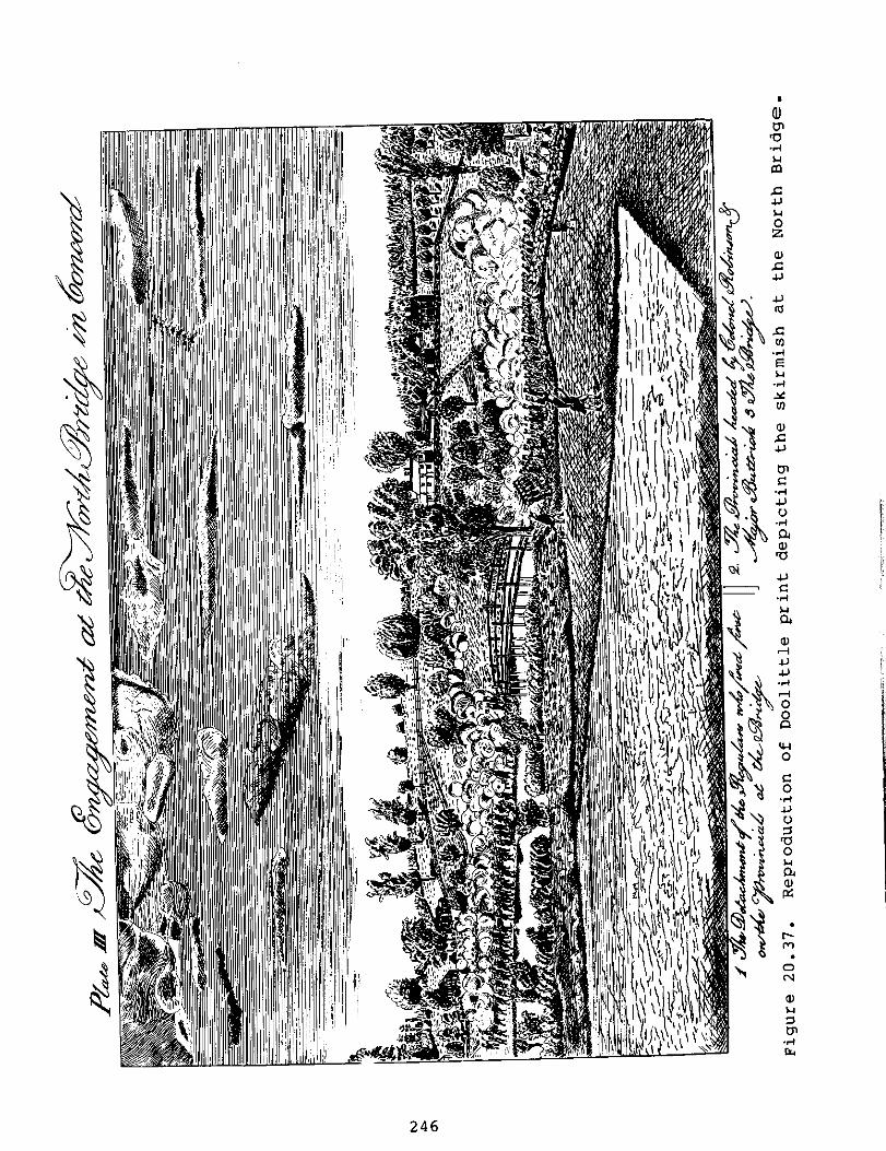
246

However, Malcolm and the ACMP questioned this interpretation of the print. It was apparently "sketched from somewhere on the southwest bank of the river" (Torres-Reyes 1969:10), and its orientation makes it difficult to determine which of the extant 1775 houses were shown. The house shown on the left side of the print did not conform to certain features which we know about Brown's house from the inventories. In the print, the end chimney appeared to be located on the west side of the house, not in the center as in the Brown house. The location of the front door was obscured by shrubs, but a story and a half lean-to was shown on the back (north) wall. Although Tremer claimed that the lean-to on the foundations which he excavated predated 1775 because of this print, it was not apparent from the Brown probate inventories that the Brown house had a lean-to.
The configuration and location of the barns in the print differed significantly from those described in the inventories. These indicated that the barn was located to the northwest of the house, while it appeared to be northeast of it in the print. The barn described in the inventory was a "little barn adjoining the westerly end of the large barn" (Torres-Reyes 1969:22). In the print, two smaller barns were attached to the east of the larger one.
Unfortunately, it was not possible to discern the location of either the east or west fork of Groton Road in this print, and the stone walls and fences did not help in defining property boundaries. The edge of another structure appeared on the left margin of the print (Figure 20.37), which might have been the David Brown house. Perhaps the house shown in the print was the "old house" on Brown's property.
In summary, the ACMP felt that it has not been demonstrated that the Doolittle print depicted the David Brown house. It was difficult to identify any of the structures, except the North Bridge, shown in the print. We therefore did not include the print in our further discussion of the David Brown site.
The Construction of Liberty Street
By 1793, the continual flooding of the causeway and the maintenance of the North Bridge caused the townspeople of Concord to build two new bridges, north and south of the location of the original North Bridge. The northern bridge was built across the river near the Flint homestead, which necessitated the northern extension of Monument Street. This route is still used today. The southern was constructed further south, and the new road joinedbridge the Acton Road near the Hunt houses.
247

The roads on the western side of the North Bridge were replaced by present day Liberty Street, which ran from above the Flint house to the Buttrick houses, and from there "southwesterly a straight line through Capt. David Brown's land between his house and barn" (Wheeler 1964:33). It then connected with the Acton Road near the new south bridge. By 1882, when Edward Jarvis wrote about the houses extant in Concord between 1810 and 1820, he reported that the old Brown "house was on the south or river side of the road [Liberty Street] with its back to the road. The old road of the last century ran in front and lead to the north bridge" (1882:180).
Predicted Location of Brown's House
We therefore predicted that remains of the David Brown house were located south of present day Liberty Street. The foundations were probably very near the edge of the street, which has apparently not been widened significantly over the last two centuries (Malcolm 1985b:15). The barns were located north of the original Liberty Street, and their remains may be along the north edge of the present street, or under it, depending on the extent of the widening. The Acton Road ran in front (south) of the barns, at a distance of 8 paces. Although this is an imprecise measurement, we estimated this distance by assuming that 1 pace equals 30 to 36 in., an average stride. Eight paces would be equivalent to 20 to 24 feet. We therefore estimated that the barns were located 20 to 24 feet north of Acton Road, and north of Liberty Street. The house would have been located in front of the barnS to the southeast, probably within 5 or 10 feet of the old road, and south of Liberty Street.
The location of the foundations which Tremer excavated did not match our predicted location for the Brown house and barns. Although the house foundations were located south of Liberty Street, they were much further north than any of the projected routes for the Acton Road. Although we recognized the tenuous nature of our data, Tremer also recognized that these foundations did not fit the expected location of the Brown house. He tested for evidence of the road, which he expected to find at a distance of one pace south of the house foundations.
A test trench was dug 10 ft. wide a distance of 90 ft. down the slope in front of
the main foundations. No evidence of the existance of a road or roadbed was found....DeeP profile trenches were dug every ten feet, with no positive results....The results of the test excavation were almost predictable. The road of Brown's day was probably little more than a carriage path, with no appreciable road bed preparation. Therefore, little
248

if any evidence would remain (Tremer 1973a:50; emphasis added).
Although Tremer was correct that evidence of early roads can be difficult to detect archeologically, some evidence for 17th and 18th century roads was found by Abel for the east fork of the Groton Road (1965), by Tremer for the route of Battle Road over Fiske Hill in Lexington (1972), and by Synenki on Nelson Road (1985). In the present case, the lack of evidence for the road probably meant that it was not located within 90 feet of the south side of the excavated house foundations, and that these were not the Brown house foundations.
The excavated house foundation was located on the south side of Liberty Street, but the Brown barn foundations should have been located on the north side of the street, not adjacent to the house. There was no indication in the deeds or inventories that any outbuildings were attached to the west side of the Brown house. Therefore, although the house foundation was in the predicted location in reference to Liberty Street, the excavated barn foundations and the Acton Road did not conform to`the predicted location of the Brown homestead.
The ACMP therefore reviewed other sources to answer two questions: Where are the remains of David Brown's house and barns located?; and what were the foundations which Tremer excavated?
Mapped Locations of Brown's House
Historic survey maps which identified David Brown's house were researched and collected through the State Archives Museum, the Middlesex County Court House, the MIMA Library and the Concord Public Library.
Maps selected for this project included:
1) Town Plan of Concord, surveyed by John G. Hales, 1830 (Figure 20.38);
2) Town of Concord, surveyed by H.F. Walling, 1852 (Figure 20.39);
3) Centennial map of Concord, from surveys by H.W. Blaisdell, 1875 (Figure 20.40).
In an attempt to locate the remains of the David Brown house, the surveying technique of triangulation was applied to the North Bridge area using these historic survey maps. This method involved the construction of a three-sided central point polygon, containing a system of three triangles, using the John Buttrick house, the Old Manse and the Hunt-Hosmer
249

house as the primary triangulation stations, and the David Brown house site as the central point.
Construction of the three-sided polygons was first completed on each of the historic survey maps and then superimposed on a base map of the North Bridge area. The line between the John Buttrick house and the Old Manse served as a base line for the historic maps. All other lines and angles were then calculated from these two primary triangulation stations. The lines and angles of the secondary triangles were then plotted on the base map exactly as they were extracted from the historic maps, and the central points established. To take into account the differences between the distances of the primary stations on the base map and the historic maps, a circle was drawn around each central point. These circles indicate the areas within which the location of the David Brown house can be predicted (Figure 20.41). A complete explanation of the triangulation procedures is presented in Appendix 20.3.
The accuracy of the survey maps used for this project was difficult to assess due to the changing course of Groton Road, the construction of Liberty Street and the constant exchange of landholdings within this area through the past two hundred years. However, all the maps were documented as surveyor's maps.
Map #1: The 1830 Town Plan of Concord, surveyed by John G. Hales, did not specifically indicate a location for the Brown house (Figure 20.38). Torres-Reyes stated that the structure next to the H. Hunt house was David Brown's (1969:Map No. 3). ACMP measurements constructed from this map would place this structure between the Hunt and Bateman house sites on the base map, suggesting that this structure was probably part of the group of house sites associated with the Hunt family, and not the David Brown house.
However, two other unlabelled structures were apparent on the ACMP photostat of this map, which was made at the Massachusetts State Archives. These structures were obscured by writing on Torres-Reyes' copy. One structure was located to the south of Liberty Street, on a road from the former location of the North Bridge. This road was presumably the Acton Road. The second structure was northwest of the first structure and to the north of Liberty Street. Using the linear scale accompanying this map, the two structures were approximately 165 feet apart. These structures were shown at the junction of Acton Road and Liberty Street. The location of these two structures closely matched our predicted location for the David Brown house and barn.
250

-MP 'rt.- el • alr mom'
k :4
• •• • • " a' ice` a
1/40 prifts
..; • . ' • ' .. .0.„.
•
I • 4 , < 4. es. 4. •
• PLAN 0.1;" 7777? TOWN - OF
CO.TTCOIt3D . , fins I • f
—s.•■•••■
• • • 17 )..% 3 • S , . 7 ..4... • • - O• :... • . . kn.., .• ', '• fr, • • $ • til. , .. 5 ... . „kg, • vi., At, , ,i .I c
• • % . S • :1,
jaw'
.,Tr•z-.2) SE _b; t •
• 1, 5.•s r rit:”• ky • . • 's • . I • s •
•
Figure 20.38. Town Plan of Hales, 1830.
Concord, surveyed by John G.
251

;
TUC "N IIF
_11. 11,1/fra .11_) N C Pt ••
MIDDLESEX COUNTY MASS •
Surveyed by Author -Ilya the Town.
uP.IVALLING OPM ENG!
Mull'ea•r•••• ∎••• 4 of
4 Kr fe
I a
arrel/
jp7115-man
8 ihrint
tri)err.•
Figure 20.39. Town of Concord, surveyed by H.F. walling, 1852.
252

1875. Figure 20.40. Centennial map of Concord,
us... et ftiond
• 011)PIMATASSIIT MILL y11010 POSITION or AM In ICAMS 6 A.M.
S MT •
41;?:?•, •
1,1,C ;:j1 1 A
•
1.4- • 4.htaili f rousts to( nom Of vivn ^M111111GA61
io
..0.L..1 by* is. 4 , / /c
Nt
171 ,,
/a OAT T •0
AMERICjr:
1111
• tar 177$ -csvp..Arr .. ‘„),, 0... ... ?Y.
4,0 LA Mei
1
.7tal It S COMO POS. ...%•.j
PA.
1
„J.
...**.* SLEEPY KEIL
■ %
j°4 ErC• 04...,
• 1,041; strons'
• • ;
253

cc w
CO
NCO
RD
ri 4.3
co %a •
en co C •el 0
0 .0 CO
0 04 $-1 co co E
S ro
KO
C)
Its
0
0
4-3
to
C
O
C
0
-/-1
(1
15
8
-1
Figure
20.
41.
254

If this was the former David Brown property, it would have been owned by Samuel Hoar in 1830. Since he leased it to various tenants, it would not be unusual for the owner not to be identified on the map.
The structure south of Liberty Street was used as the central point of one of the polygons constructed from this map. When it was superimposed on the base map, it was located approximately 160 feet southeast of the David Brown site (#1 on Figure 20.41). Using the structure north of Liberty Street as a central point, it was located 50 feet southwest of the David Brown site (Figure 20.41). The distances between these two central points on the base map is 160 feet.
If our predicted location of Brown's house and barn was correct, the house would be located within the circle nearest the river, presumably just north of the Acton Road. The barn would be in the circle to the northwest of the first, probably under or just north of present day Liberty Street.
Map #2: The 1852 map of the town of Concord, surveyed by H.F. Walling, did not identify a structure as the David Brown house (Figure 20.39). However, Torres-Reyes stated that a structure "north of Liberty Street" (1969:Map No. 5) was David Brown's. He may have been referring to the unlabelled structure between H. Hunt and S. Brown. "S. Brown" was Simon Brown's house, which was built in 1847 and is still standing. Neither of these structures fits the location of David Brown's house.
Of more interest, however, was the structure on the south side of Liberty Street labelled "S.H. Rhoades" (Figure 20.39). Samuel H. Rhoades owned some, if not all, of the former David Brown property from 1849 to 1867. Upon David Brown's death in 1802, his son Joseph inherited the property, including the house which he was required to share with his widowed mother. Joseph died in 1821, and the farm had to be sold at auction to provide an income for his mother, who lived until 1832 (Wheeler 1964:100). The Brown farm was purchased by Nathan Brooks, John Keyes, and Samuel Hoar (Middlesex County Deeds 244:24-26, 258:127-8). Both of these deeds included "a dwelling house" and "other buildings." The earlier deed mentioned a barn while the latter said "two barns." Hoar apparently became the sole owner of this property in 1828 (Wheeler. 1964:100), although we were unable to locate the deed for this transaction.
By 1849 when Hoar sold property to Rhoades, the description and the abutters had changed (Middlesex County Deeds 575:23-24), so that further deed research is required to determine whether Rhoades bought all of the former David Brown farm. This is critical in determining whether Rhoades' house
255

was the David Brown house of 1775. Unfortunately there was no mention of buildings on the property that Hoar sold to Rhoades, although we know that the Rhoades property contained a red house and a yellow barn when it was sold to George Keyes in 1867. Was this red house the David Brown house?
If it was, we have a detailed description of the demolition of David Brown's house. George Keyes and his father-in-law, Simon Brown, dismantled Rhoades' house during the winter of 1867-68, and sold the frame of it. Appendix 20.2 of this chapter contains a description of the demolition
taken from Simon Brown's diaries.
If Rhoades' house was the Brown house, the 1852 map should be the key to locating the David Brown site. Using the S.H. Rhoades structure as the central point of the polygon, its location on the base map would be 10 feet south of Liberty Street, and approximately 220 feet southwest of the site excavated by Tremer (#2 on Figure 20.41). This is much closer to the projected route of Acton Road, which agreed with our predicted location of the Brown house. it therefore seemed likely that the Rhoades' house and the Brown house were one and the same. Recent walkover surveys by ACMP staff have identified some possible foundations within this
area,
probably relating to the structure identified as S.H. Rhoades.
Map #3: The Centennial Map of Concord, surveyed in 1875, was used by Tremer in identifying the David Brown site
(1973a:56). Torres-Reyes explained that the "documentary evidence suggests very strongly that the...centennial map...has the correct location of Brown's house" (1969:12). This map indicated that the dinner tent used for the Centennial Celebration of 1875 was placed over the David Brown house site (Figure 20.40).
This was the basis on which Tremer identified his site as the David Brown house (1973a:56). However, by referring to the legend accompanying the Centennial Map, it was clear that this map was based on other surveys conducted by H.W. Blaisdell, and not derived from a direct observation. Other historic survey maps by Blaisdell have not been located. This further suggested that this map, designed for the Centennial Celebration, was intended to depict the relationship between the structures and roads that existed in 1775 and those present in 1875. It also indicated that the house identified as Capt. David Brown's was not a standing structure by 1875.
The ACMP used the structure identified as the Capt. David Brown house on this map as the central point. This placed the house 200 feet southwest of the site excavated by Tremer (#3 on Figure 20.41), on the west side of the stone wall.
256

Tremer utilized a stereopticon slide of the 1875 Centennial Celebration to prove that the foundations which he excavated were those of the David Brown house. He interpreted the slide (Figure 20.42) as follows:
The view on the slide was taken from the center of the bridge span, pointing toward the Minuteman statue and monument. In the background, slightly to the right of the monument, is the dinner tent. In the back of the tent, slightly further up the slope can be seen George Keyes house. This photographic alignment coincides exactly with the centennial map. The Brown foundations are located exactly in the spot depicted by the slide and map (1973a:56).
The ACMP located additional stereopticon slides which demonstrated that Tremer was incorrect in his identification of the dinner tent. Two of these slides showed the tents which were erected in the field west of the North Bridge (Figures 20.43, 20.44). Although these views were from different perspectives, the large -size and prominent appearance of these tents is apparent. The large tent in Figure 20.44 was labelled as the dining tent on the back of the stereopticon card. This tent was 410 feet long, 85 feet wide, and 40 feet high (Little 1974:25-26). No such large
Figure 20.42. Stereopticon slide of celebration area 1875 (Tremer 1973a:#1).
257

Figure 20.43. Stereopticon slide showing dinner tent on western side of bridge (courtesy of SPNEA, Boston).
white tent was visible in Tremer's slide (Figure 20.42). Tremer's slide was labelled "Centennial Views," as were the slides we used. The smaller white pointed object to the left of the statue in Tremer's slide may have been one of the smaller tents, suggesting that this slide was taken just before the other tents were erected or after they were removed. This object might also have been a haystack.
The structure which Tremer incorrectly identified as the dinner tent appeared to be an outbuilding or small barn, rather than a house. This structure was not located at the spot where Tremer excavated, but further west. This was determined by its relationship to George Keyes' house in the background (which Tremer correctly identified). Some possible
258

foundations have been identified by the ACMP staff across Liberty Street from the former Keyes' house, which is still standing. These foundations probably belonged to the structure shown in this slide.
Summary
Although it is possible that these three maps were identifying the same structure and that the discrepancy in measurements could be accounted for in the accuracy of the maps, it is also possible that at least 2 structures were present.
Figure 20.44. Stereopticon slide showing dinner tent, from Liberty Street looking southwest (courtesy of The Society for the Preservation of New England Antiquities, Boston).
259
The hypothetical second house, which would have been occupied by Brown in 1775, may be the structure identified on the 1852 map as S.H. Rhoades (#2 on Figure 20.41). Further documentary research is needed to be certain that the house purchased by Rhoades was the same one occupied by David Brown. When Simon Brown dismantled the Rhoades' house in 1867-68, he commented on the age of the materials used in constructing the house, and he found a 1736 coin in the walls (Appendix 20.2). It seems very likely that the Rhoades' house was the Brown house. The 1852 map placed the Rhoades' house 220 feet southwest of Tremer's cellarhole, which would indicate a second, separate structure. This location is west of the stone wall, and closer to the expected junction of the Acton Road and Liberty Street. This area has never been archeologically tested.
The Centennial map, which also located the house to the west of the stone wall, was a composite of earlier surveys, not an original survey. We were unable to find any other written references that substantiated the purposeful placement of the dinner tent over the David Brown house site.
The precise location of the David Brown house cannot be determined from written sources, and it will only be identified from further archeological fieldwork. Another attempt to locate the Acton Road must be made, as this is the key to locating David Brown's house. Although Abel and Tremer both tested between Tremer's foundation and the river (Figure 20.36), several possible locations for Brown's house have not been tested. The land west of the stone wall has never been archeologically surveyed. The junction of the Acton Road and Liberty Street must have been located within this area. This junction also has high potential as the site of David Brown's house. If Liberty Street did run between his house and barn, and the barn was only eight paces from the old road, the house must have been close to the junction of these two roads.
Further documentary research must be conducted prior to any archeological fieldwork. This research would have three
purposes:
1) to identify all structures which have been built on the land west of the stone wall over the last 350 years. This will allow the archeologists to predict the foundations they will encounter, and identify those which are colonial and those of more recent date;
2) to thoroughly research all of the deeds for David Brown's property from 1752 to the 1960's. This is particularly important for the triangle of land south of Liberty Street and west of the stone wall. This land was not included in Samuel Rhoades' property.
2 60

If David Brown's house was located to the west of the stone wall, it could not have been Rhoades' old red house, which was torn down by George Keyes and Simon Brown in 1867. An analysis of Samuel Hoar's property transactions between his 1823 purchase of Joseph Brown's estate and his 1849 sale to Rhoades would clarify these property boundaries;
3) to determine the route of Liberty Street when it was laid out in 1793, and all major changes in its route over the last two hundred years. Its original width and type of roadbed, and the location of its junction with Acton Road should be determined. Any additional maps of Liberty Street could contain references to the David and Joseph Brown or Rhoades' house.
This documentary research has recently been completed by Joyce Malcolm as background for the MIMA Archeological Project which will begin in the summer of 1986 (Malcolm 1985b). Her results will be published in the forthcoming Project report.
The ACMP feels quite certain that the foundations which Tremer excavated were not those of the David Brown house. However, architectural analysis (from Tremer's descriptions and photographs) indicates that this house foundation was built before 1750. Artifactual analysis of the Tremer Collection also indicates occupation of this house during the mid-18th century, and perhaps earlier.
If this 18th century structure was not the David Brown house, what was it? The only other structure suggested by the documentary sources is the "old house" alluded to in the 1768 inventory of Hannah Brown's estate. Perhaps Tremer excavated the foundation of that house.
261

Management Summary
The David Brown house was one of four houses which overlooked the North Bridge in 1775 (Figure VI.1). It was reportedly located on the north side of the Acton Road, just west of where it forked at the end of the causeway. The muster field where the Minute Men assembled on the morning of April 19, 1775, was owned by David Brown, and he was one of the leaders of the skirmish at the Bridge.
Previous Archeology
The site of David Brown's house was excavated by
archeologist Charles Tremer in 1970-71. Tremer uncovered the cellarhole and chimney base of a house, and an area of cobble flooring which he identified as a barn. He also identified a small storehouse and a lean-to at the rear of the house (Figure 20.6). Tremer believed that these architectural remains matched one of the houses in the Doolittle print of the skirmish at the North Bridge (Figure 20.37), which he identified as the David Brown house.
From 1976 to 1979, Concord school children planted a colonial kitchen garden in front of the excavated cellarhole of the David Brown house. Although archeology was not one of the purposes of this project, a large quantity of artifacts were found in this garden, and they were included in the ACMP analysis of this site.
In 1979, stabilization of the house foundations was undertaken by NPS archeologist Joan Bleacher. At that time, a portion of the storehouse which had not been excavated by Tremer was investigated by Bleacher.
ACMP Interpretation
The ACMP undertook an architectural reanalysis of the house and barn remains in addition to an archeological analysis of the artifacts and features encountered by Tremer. The architectural elements of the cellarhole and chimney base indicate that this structure was probably a half-house with another room added to the west side of the chimney at a later date. The cellar was under the eastern, or original, half of the house, which probably had a second story. A narrow lean-to was apparently added along the rear wall of the half-house, and a smaller room, possibly a storehouse as Tremer suggested, was attached at the northwest corner of the half-house. Another lean-to or shed was built along the east wall of the half-house.
262

It was not possible to determine a construction date or function for the cobble floored area that Tremer excavated. However, it is unlikely that it was an attached barn as Tremer suggested because 17th and 18th century barns were not usually attached to the house. It may have been a shop of some type.
During a review of wills and probate inventories for the Brown family, it was noted that reference was made to an "old" house in 1768. This suggested that David Brown may have built himself a new house between 1752 and 1768. If so, there would have been two houses built on the Brown property west of the North Bridge before 1775, although the older house may not have been standing by then. Perhaps the cellarhole which Tremer excavated was that of the old Brown house and David's house has not yet been located. Further documentary research has been undertaken to explore this hypothesis, and further archeological fieldwork is planned in 1986 during the MIMA Archeological Project in an attempt to locate another Brown foundation.
The Brown Site Collection
The ACMP inventoried 11,992 artifacts from this site, 90% of which were recovered during Tremer's excavations. Unfortunately, there were two significant problems with the Tremer Collection: over 5900 artifacts were missing from Tremer's original collection at the time of the ACMP inventory; and very few of Tremer's proveniences could be identified within the excavated area. These problems were compounded by the lack of field notes from Tremer's excavations, and the apparent lack of stratigraphic levels within his excavation units. Although these problems diminish the value of the Tremer Collection for research purposes, the ACMP attempted to obtain the maximum information possible from the collection.
Nearly three quarters of the artifacts in the Tremer Collection were ceramics. However, only 6% of these could have been manufactured in the 17th and 18th centuries. Creamware (431 sherds) and Delft (79 sherds) were the most common of these earlier ceramics. Over half of the ceramics (4,868 sherds) were whiteware, most of which came from a cistern. It is possible that these whiteware sherds are from the 1875 Centennial Celebration since the dinner tent, which fed 4,000 people, was reportedly located on the site of the former David Brown house. Some of the early ceramic sherds have been mended and have display potential.
Public Interpretation of the Brown Site
The David Brown cellarhole excavated by Tremer is presently one of the interpreted sites in the North Bridge
263

area of the Park. The cobbled area which Tremer excavated has been covered over, and the cellarhole has been filled with crushed stone and enclosed within a split rail fence. A wayside in front of the cellarhole presents a very brief description of Brown's civic activities and mentions the ten children which he raised here. A diagram of the structural features which Tremer uncovered presents specific functions for the rooms, and pre- and post-1775 construction dates.
Although space is limited on such waysides, perhaps more emphasis should be placed on Brown's activities as they relate to the North Bridge area and April 19, 1775. For example, Brown's house was the closest to the Bridge on the west side of the river. Brown was paid by the town to maintain the North Bridge and pedestrian walkway on the wall along the causeway. He also owned the land which was used as the muster field by the colonials on the morning of the skirmish. Less emphasis should be placed on the house itself since it may not have been the one in which Brown raised his ten children, and the functions of the rooms and the date of their construction are not definitely known.
tl
264
Recommendations
The identification of the correct location of David Brown's house in 1775 will be accomplished only by further documentary research and by further archeological fieldwork.
The documentary research must precede the fieldwork. This research should include:
1) locating all maps of Concord which show the routes of Acton Road, and Liberty Street from its construction in 1793 to the present;
2) reviewing the Concord Town Records for all references to the width, maintenance, and location of Acton Road, and Liberty Street from 1793 to the present;
3) reviewing all deeds and wills for the David Brown landholdings from 1775 to the present. The emphasis should be on the land to the south of Liberty Street and east of the old route of Lowell Street. All references to buildings that once stood in this area must be carefully noted;
4) further review of Simon possession of Judy Keyes) the Concord Public Library) location of the Rhoades' Keyes bought in 1867.
The results of this documentary research will provide the archeologists with the best possible information regarding land use in this area over the last 200 years. The research design for further archeological fieldwork to locate the David Brown site must include:
1) a survey to find any traces of the Acton Road, the west fork of the Groton Road. If the documentary research fails to uncover any new information regarding the location of this road, the survey will have to begin where Abel believed the fork occurred. Testing on the east side of the wall should be more extensive than Abel's in case the road did not relate to the opening in the stone wall (Figure 20.36). The area to the west of the wall has never been tested, and the junction of Acton Road and Liberty Street must have been located here. Testing should identify both the course of the road and the junction;
2) testing of the apparently man-made disturbances which have been found on the west side of the stone wall. Documentary research should provide the approximate
Brown's diaries (in the and J.S. Keyes' diaries (at for information about the house and barn which George
265

date of construction and type of structure for these remains;
3) systematic testing along the north side of the Acton Road to find the location of the Brown house. If the road has not been identified by fieldwork, a systematic survey of the entire area between the causeway from the North Bridge, the Concord River, and Liberty Street must be undertaken.
Additional survey work to locate the barn could be undertaken once the Brown house foundations have been located. The barn foundations were predicted to be on the north side of present day Liberty Street, or possibly under it. However, MIMA does not own most of the land on the north side of Liberty Street, and therefore the remains of Brown's barn may be located on private property. The feasibility and necessity of excavating these remains should be evaluated after the David Brown house foundations are located.
The ACMP analysis indicated that the cellarhole excavated by Tremer was probably not that of David Brown's house. However, the architectural features of the foundation and the artifact assemblage from the site indicated that the house was probably built prior to 1750, and was occupied during the 18th, and possibly the 17th century. This may be the "old" house alluded to in the 1768 inventory of David Brown's mother's estate.
Further archeological work is required around this foundation to clarify questions raised by Tremer's work. This should include:
1) excavation on the exterior of the walls of the house foundation to locate any builder's trenches. Artifacts recovered from these trenches would date the construction of the adjacent walls;
2) excavation in the expected location of the southwest corner of a predicted room on the west side of the chimney (area 3 in Figure 20.6);
3) excavation on the south, west and north sides of the barn area extending the limits of Tremer's excavation (Figure 20.6). It was not clear that he defined the limits of the cobble area, and there was confusion about the northern edge of the feature, along Liberty Street;
4) further survey around the structures to locate privies, and to identify all the nearby wells. Consideration should be given to excavating any wells which are found relatively close to the house.
266
Any artifacts found during future excavations around
Tremer's foundations wouldl provideinTr some emerr' stastigraphic contTrhese
ol,
which was completelylacking fieldwork.
artifacts would provide a check ton recovered from the interior of the cellarhole, tn
o determine if those could have
bee introduced as fill. These artifacts could also confirm
ourn chronological interpretation
of Tremer's collection, and
the occupation of the house. The documentary and archeological research which the ACMP
recommende for the David Brown site was subsequently undertakend within the scope of the MIMA Archeological project, which ben in 986 (Malcolm 1985b). We would expect that the
fieldworkga 1 which we have recommended would result in the
identification of Acton Road and the David Brown house site, both of which could be developed as interpreted sites for the public. We would also expect the survey to correctly identify the foundations excavated by Tremer.

Tremer's Provenience
Top Soil Test Trench 1
3
4A-5A 4-B 4-C 4 5
PI 6
/I 6-A 6-B 11 6-C 6-D 6-E 6-F 6-G 6-4
11 6-9
/I 7 9 11 14
Room 2 Area 3 " 4 II 7 • 8 II 9 • 10 • 12 " 13 " 14 " 15
16 " 17 • 18 • 19 • 20 " 21 • 30 " 31
Feature 2 7
It 8 9
10
I
ACMP Provenience Codes for The David Brown Site ACMP Provenience Code
DB-000 0-000-0TS DB- TT0 1-000-000 DB-TT03-000-000 DB-4A5A-000-000 DB-TT4B-000-000 DB- TT4C-000-000 DB-TT04-000-000 DB- TT05-000-000 DB-TT06-000-000 DB- TT6A-000-000 DB-TT6B-000-000 DB- TT6C-000-000 DB-TT6D-000-000 DB- TT6E-000-000 DB-TT6F-000-000 DB- TT6G-000-000 DB-TT64-000-000 DB- TT69-000-000 DB-TT07-000-000 DB- TT09-000-000 DB-TT11-000-000 DB- TT14-000-000
DB-RMO2-000-000 DB-AR03-000-000 DB-AR04-000-000 DB-AR07-000-000 DB-AR08-000-000 DB-AR09-000-000 DB-AR10-000-000 DB-AR12-000-000 DB-AR13-000-000 DB-AR14-000-000 DB-AR15-000-000 DB-AR16-000-000 DS-AR17-000-000 DB-AR18-000-000 DB-AR19-000-000 DB-AR20-000-000 DB-AR21-000-000 DS-AR30-000-000 DB-AR31-000-000
DB-0000-002-000 DB-0000-007-000 DB- 0000-008-000 DB-0000-009-000 DB-0000-010-000

Appendix 20.1 (Cont.)
DB-0000-011-000
Feature 11 DB-0000-012-000
12 DB-9999-999-999
No Provenience
Kitchen Garden Collection
DB-00KG-000-000 1976-1978 DB-00KG-000-079 1979 DB-00KG-001-010 Dig #1, 13 July 1977, near
Capt. David Brown Site, found 10 cm down
DB-00KG-IIA-000 Dig II A, 15 July 77, near Capt. David Brown Site
DB-00KG-IIB-002 Dig II-B, 15 July 77, D. Brown Site, 2 cm down
DB-00KG-IIC-SUR Dig II-C, 15 July 1977, Surface
DB-00KG-IIC-005 Dig II-C, 15 July 1977, 5 cm down
DB-00KG-IIC-007 Dig II-C, 15 July 1977, 6-7 cm down
DB-00KG-IIC-010 Dig II-C, 15 July 77, 10 cm down
DB-00KG-IIC-015 Dig II-C, 15 July 77, 15 cm
DB-00KG-IIC-016 Dig II-C, 15 July 77, 15 - 16 cm down
DB-00KG-IID-014 Dig II-D, 15 July 77, 14 cm
DB-00KG-IID-029 Dig II-D, 15 July 1977, 20 cm, 29 cm
DB-00KG-877-004 found Aug. 18, 1977, 4", Teg Cosgriff
DB-00KG-877-007 group #2, 8-19-1977, 7 inches
DB-00KG-000-OCT 10/30 DB-00KG-OSW-001 1 inch below the S.W.
Stake (W 5 inches, S 6 inches)
DB-00KG-000-008 19 S, 16 W, 7 d DB-00KG-000-006 6 inches DB-00KG-000-008 Group 1, about 8 inches
deep DB-00KG-000-009 Group #3, 9" down, Julie
McCall DB-00KG-000-013 #3, 13", Kate Cosgriff DB-00KG-000-00# (artifact # on artifact) DB-00KG-UNK-000 "without writing"
Bleacher Collection
DB-AR12-000-00R Area 12, Rubble
269

Appendix 20.2
The Rhoades House and Barn
The David Brown farm of 1775 was subsequently owned by Samuel H. Rhoades, from 1840 to 1867. Although we were not certain that he owned all of Brown's 1775 property, it seemed likely that the Rhoades' house was the former David Brown house.
In 1867, George Keyes bought the Rhoades' farm. Keyes lived with his father-in-law, Simon Brown, in Brown's house north of Liberty Street. Simon Brown was not related to the Browns of Concord. He was born in Newburyport, Massachusetts, and moved to Concord in 1848 after working in the office of the clerk of the House of Representatives in Washington, D.C. He was also the Lt. Governor of Massachusetts, and served as Concord's legislative representative during 1859-60. He served as editor of the New England Farmer for most of the years he lived in Concord (Wheeler 1964:114). Brown kept detailed diaries which are now in the possession of Mrs. Judy Keyes, whose husband is the great-grandson of George Keyes. Brown's diaries provided the little information that we have about the Rhoades' property.
On April 11, 1867, Brown recorded that they (actually George Keyes) "purchased Mr. Rhoades farm." On April 22 of the same year, Brown recorded that "Mr. Rhoades had an auction," where George Keyes bought a desk which had been used by Rev. Samuel Robbins. On April 25, Brown "plowed in Rhoades piece below the road," (south of Liberty Street). The first mention of the Rhoades' house is on May 11, 1867:
Mr. Rhoades' family left the old red house today. The poor old dog went with them, but returned in an hour or two & wandered over the fields, but finding no familiar face, laid down on the grass in front of the house then was absent for some time. But just tonight I saw him once more in his accustomed place.
The house apparently stood vacant over the summer. On September 7, Brown's men began "the demolition of the Old Red House, by taking down a portion of the chimney." However, the demolition was intended to be a winter project since the fall was taken up with harvesting the crops. In December of 1867 they began to work steadily on the house:
Dec. 13 - Tim has been at work 2 or 3 days taking down the chimney in the old red house and cleaning the bricks.
Dec. 14 - In the afternoon began to tear out the inside of the Old red house, and chop and saw some of the wood which we had stored away in it.
270

Jan. 2, 1868 - In the forenoon, at work in the Old Red House, cutting wood awhile and then taking the laths and plaster from some of the walls. Old as the house is, when built it was made up, in considerable part, of old materials, for many of the timbers have old mortices, and on taking off the laths I found some of the weather boards painted, and others entirely rotten. Some of the lathes are white oak, shaved, others thin boards, split, and others, still, old clapboards, and pieces of thin pine! (emphasis in original).
Entries for January 8, 13, and 14 indicate that they continued removing lathes and plaster. On January 17, Brown worked "in front of old red house, where I was taking nails out of the boards." On January 28, they
worked in the Red House. Tim found an English coin there in the form of an old-fashioned cents. It was dated 1736, one hundred and thirty-two years ago (emphasis in original).
By the end of March 1868, the superstructure of the house had been removed:
Feb. 8 - Tim got down the frame of the back part of Old Red House today.
March 14 - He has been stripping the roof and boards from the old House today, and now the frame is ready to be taken down. Mr. Canton (?) has purchased it for $15.00.
March 23 - Mr. Canton purchased the frame of the old house for $15.00 and commenced taking it down today.
The cellarhole apparently stood open over the summer while Brown was busy with other aspects of the farm. On October 16, 1868:
We began to fill the cellar over which the old Red House stood, yesterday, & continued working upon it today. Plowed around it for several hours with oxen.
The final mention of the house site was the next spring. On April 22, 1869, the "men cleared up over the Old Rhoades house cellar, manured it, and got it ready for sowing." Thus disappeared all visible remains of Rhoades' old red house.
Although Brown's diaries contained many useful details about the old red house, it was unfortunate that Brown did not give any references to its location. This, of course, did not seem important to him because its location was commonly known.
271

It is interesting to note that much of the architectural material was saved: the bricks were cleaned, and the nails were removed. It is unclear whether the lathes, boards and roofing material were salvaged. The frame which was dismantled on "the back part of the Old Red House" may have been that of a lean-to which was added to the original structure. The appearance of a 1736 coin within the walls of the house was good evidence that it, or some part of it, was built after that date, most likely while such coins were still in circulation.
Edward Jarvis, who lived in Concord during the 1800's, recorded that:
the house of Mr. Joseph Brown [son of David], hatter,...was on the south or river side of the road with its back to the road. The old road of the last century ran in front and lead to the north bridge. Many years ago Mr. Hoar bought this farm and let it to a succession of tenants. Forty years ago or more, he sold it to G.H. Rhoades who later sold it to George Keyes. He took the house down (1882:180).
We knew from Simon Brown's diaries that Jarvis was correct in stating that George Keyes (with his father-in-law Brown) took down the Rhoades' house. If Jarvis was correct that this was also Joseph (and thus David) Brown's house, then Simon Brown's diaries provided a detailed description of the demolition of David Brown's house.
Tremer reported that:
Historical references indicate utilization of all parts of structure, including the boards foundations and the basement areas filled in (1973a:39).
a complete
the dismantled and nails. The were immediately
Tremer did not identify these "historical references," and the ACMP did not find any documents, except Brown's diaries, which described the demolition of the Rhoades/Brown house. These diaries were in the possession of Henry Keyes until about 12 years ago, when he moved from Liberty Street. At that time, Keyes gave them to his daughter-in-law, Judy Keyes. Mrs. Keyes never showed them to Tremer, and she doubted that her father-in-law did (personal communication 1984). However, Cotter's memo indicated that Tremer would "endeavor...to see the diary" (1971:11), and we have assumed that he did. There were, however, some discrepancies between Tremer's accounts and the data contained in Keyes' diaries.
Tremer reported that the house was demolished in 1865 (1973a:55), which was the date Wheeler listed for the sale of
272

the property from Rhoades to Keyes (1964:102). However, the deed for this transaction was dated 1867 (Middlesex County Deeds 1003:68-69), and Simon Brown's diaries recorded the demolition of the house during 1867 and 1868.
Simon Brown's diaries did confirm Tremer's description of the demolition of the house, with the utilization of the boards and nails. However, he was not correct about the cellarhole being filled in immediately. Brown's diaries indicated that the cellarhole was not filled in until October 1868 although the frame had been removed the previous March. This would have allowed the cellarhole to serve as a refuse pit for a few months.
Tremer believed that the cellar had been filled in all at one time, and that the artifacts in the fill did not relate to the occupation of the house. However, Brown's description that they filled the cellar by "plow[ing] around it for several hours with oxen" suggested that the surrounding earth was plowed into the hole, probably along with some of the upper courses of the foundation. This would mean that the artifacts plowed into the cellarhole came from the area surrounding the house, and that they would relate to, and date, the occupation of it.
If Tremer excavated the foundations of the Rhoades' house, and if this was the David Brown house of 1775, then the artifacts in Tremer's collection were from the David Brown house site.
Simon Brown's diaries also described a yellow barn on the Rhoades property in 1867. J.S. Keyes (George's brother) had reported that George Keyes had moved Simon Brown's barn "and the Rhoades barn north to the hill, & made a twin double barn of them" (1885:75). Since this twin double barn is still standing on the property of Judy and Jonathon Keyes at 91 Liberty Street, the ACMP was able to examine the old Rhoades barn to determine if it could have been David Brown's barn.
Simon Brown recorded the process of moving the Rhoades barn. On May 3, 1867, the workmen began "digging a trench for laying" the foundations for the yellow barn. On May 24, the yellow barn was at its destination, and he mentioned a ledge which runs through the foundations of the right (east) wing of the twin barn (Judy Keyes, personal communication 1984). On April 10, 1869, Brown recorded that the other barn, from in front of his house, was moved, with shoes and rollers, to its new foundation as the west wing of the twin barn.
This twin barn is large. The east and west wings, which were originally the separate barns, measure 30 feet wide by 65 feet long. They are two-story barns with cellars, and are connected by a long, narrow carriage shed. Orville Carroll
273

inspected these barns to determine an approximate construction date for the Rhoades' barn. Yellow paint was found on the original exterior boards of the east barn, which confirmed that this was Rhoades' yellow barn. Carroll estimated that this barn was probably built after 1820, based on its size and architecture (personal communication 1984). Therefore, it would postdate David Brown's ownership of the property.
274

Appendix 20.3
Triangulation of Historic Maps
Methodology
To ascertain the correct location of the David Brown house, a triangulation method was applied to three historic survey maps (Figures 20.38, 20.39, 20.40). This method involved measuring the distances and angles between structures identified on the historic maps. Triangulation is a system of triangles in which one side of one triangle must be measured. Through the measurement of angles, all other sides, or the distances between points are calculated using plane trigonometry (Breed and Hosmer 1958:382, Kissam 1978:13).
A triangulation system is established when the control or principal points of a survey are located by triangulation. This system can be composed of: 1) a chain of triangles, 2) a chain of quadrilaterals, or 3) a chain of polygons each having an interior station (Breed and Hosmer 1958:3-4).
The success of this system depends on the accuracy of the historic maps used. By applying the principles of these methods to the historic survey maps, the location of points presently unknown can be predicted. This is assuming that the historic maps were accurately surveyed and the location of structures and areas were faithfully plotted and identified.
Using the three historic survey maps, a triangulation system was developed. Three existing structures were selected to serve as the control points or primary triangulation stations. These points were the Hunt-Hosmer house, the Old Manse, and the John Buttrick house. These are currently standing structures which could be identified on the three historic maps. These structures were also the only three points that are so positioned to form a nearly equilateral triangle around the David Brown site. The formation of an equilateral triangle gives greater accuracy to a triangulating system (Kissim 1978:128). Benjamin Brown's 1754 map of this area (Figure 20.45) could not be used because the Old Manse was not standig at the time, and therefore the three control points could not be established.
The line between the two primary stations, the John Buttrick house and the Old Manse, served as a base line. The length of this line was determined through the linear scales accompanying each map. Angles of the primary stations were measured and adjusted with a protractor. The lengths of the two other sides of the triangles were calculated by trigonometric formulas.
275

ArtC'i,„:1,;,: e• c.c. At0 1% •
P;11(%ed);,..106:Sile :..iti,sed AV!,•)/..r,.. %kir: nicest (l ei
ov el iitilo,..' 1
ro e
j
is\
." ( b!...-aelekii.04% 4 (;t,„ nt ), .,45c. •e14 .-.
c,• 0.1 e% II. s , 9 . 1:11 el • ,
•17/0 .71 /-/Xit•if /key 1; 6J
X.41, -Peat 4 CSatial ,
Un7Dlithigt. 4- Cailii4.1.) 1754•
St; e)? . 2ik,, e•;:, • ) :••/t• € en. a• et . kn.(• ?,
44 - /it( ‘1*/
...fryft://r r- • IL.
•f
4!.1. 4C)" : I ikt ittt;(0, • •
rid et kJ . v y: An') rs) :; "r4•Ab■
'17el;Cen. er/glenni- ailiciren r. . . .
• '‘.4:10-;: -. int 1;•/ ., I 1 4. a n
7 '45-
Figure 20.45. Map of North Part of Concord, surveyed by Benjamin Brown, 1754.
276

Lengths were then drawn from the primary stations to the points possibly identified as the David Brown house. This procedure formed three secondary triangles and produced a plane figure that has been referred to as a three-sided central point polygon (Breed and Hosmer 1958:3-4). The three known points (the Hunt-Hosmer house, the Old Manse and the John Buttrick house) formed the primary triangle. The David Brown house served as the central point.
In order to evaluate the accuracy of the historic survey maps, the distances and angles of the primary triangles from each historic map were compared to a modern, photogrammetric map of the North Bridge area (the 1964 MIMA topographic map), hereafter referred to as the base map.
To obtain distances, a ratio of the distances between primary stations and the mean (x) ratio of these distances was established (Table 20.3).
Table 20.3
Ratio of Distances Between Primary Stations
Primary Stations
1830
Maps
1875 1852
John Buttrick - Old Manse .98 .96 1.1 John Buttrick - Hunt-Hosmer .96 .92 .93 Hunt-Hosmer - Old Manse .95 .97 .89
Mean Ratio .96 .95 .97 Range .03 .05 .21
Although this data set was small, the following interpretations are offered.
First, the mean (x) ratios demonstrated the average error in distance between the three stations, and indicated that the distances on the 1830 map would fall within 4% of the true distances of the base map. The 1852 map would fall within 5%, and the 1875 map within 3%. The range between ratios was used to measure the accuracy of each map. Because the 1830 map had a range of .03, it was interpreted as being the most accurate, in terms of distance, of the three historic maps.
Second, to assess the accuracy of the positioning of the triangulation stations, the angles of the primary triangles on each historic map were compared to those of the base map, again using ratios (Table 20.4).
277

Table 20.4
Ratios of Angles Between Primary Stations
Primary Stations Maps
1830 1852 1875
Old Manse 1.0 .96 .94 John Buttrick .97 1.07 .94 Hunt-Hosmer 1.0 .92 1.13
Mean Ratio (x) .99 .98 1.0 Range .03 .15 .19
When compared to the base map, the spatial positioning of the primary stations on the 1830 and 1875 maps both fell within 1% of the actual location on the base map, whereas the 1852 map locations fell within 2%.
Results
These comparisons between the historic and base maps provided data indicating the error within each historic survey map. The results of these data were then used to correct the errors and to accurately predict the location of the David Brown house.
First, the angles of the primary triangulation stations from each historic map were calculated to form mean (x) values. For example: the angle of the primary station at the John Buttrick House was 76° on the 1830 map, 69° on the 1852 map, and 78° on the 1875 map. These figures produced a mean (x) of 75°. The same procedure was completed for the primary stations at the Old Manse and the Hunt-Hosmer house. These mean values were then used to produce one uniform primary triangle on the base map. This triangle connected the three primary triangulation stations and conformed to the true angles of the base map.
When the historic and base maps were compared, the spatial positioning of the primary stations differed, on the average, only 1 to 2%. Thus, this adjustment of the angles of the primary stations was completed to comply to the actual spatial relationships of the structures, as they were represented on the base map. The amount of adjustment required to meet the true angles ranged from 0 to 6°.
The lines and angles of the secondary triangles were then plotted on the base map exactly as they were extracted from
278

the historic maps, and the central points were established. To take into account the differences between the distances of the primary stations on the base map and the historic maps, a circle was drawn around each central point (Figure 20.41). For example, the average difference between the 1830 map and the base map was 4%. Four percent of the distances of the secondary triangles were calculated and a mean value of 50.3 ft. was then drawn around the central point representing the 1830 map (#1 on Figure 20.41). This represented the possible error between the two maps. The circle indicates the area within which the 1830 house would have been located.
The mean value of the 1852 map was 64.3 feet. The 1875 map was 36.6 feet. Circles were drawn around each central point using the mean values as the radii. These circles indicate the areas within which the location of the David Brown house can be predicted. A discussion of these predicted locations was presented in the main body of this chapter in the section entitled "Mapped Locations of Brown's House."
279

Appendix 20.4
ACMP Artifact Inventory
for Accession #359, 365, 351, 299
280

DAVID BROWN Site Area
Accession #: 359 365,351 299 TOTALS % of Historic Ceramics
HISTORIC CERAMICS Redware Plain 479 35 0 514 Lead Glazed, 1 surface 644 36 0 680 Lead Glazed, 2 surface 179 18 0 197 Sgraffito 3 0 0 3 Trailed Slipware 15 0 0 15 Jackfield 1 0 1 2 Astbury 0 0 0 0 Other 6 0 0 6 Total Redware 1327 89 1 1417 16.2%
Tin Enameled Delft 79 0 0 79 Rouen/Faience 0 0 0 0 Other 1 0 0 1 Total Tin Enameled 80 0 0 80 0.9%
Coarse Buff Body Combed Ware 9 0 0 9 Dotted Ware 0 0 0 0 N. Devon Gravel 0 0 0 0 Mottled 0 0 0 0 Other 4 2 0 6 Total Coarse Buff Body 13 2 0 15 0.2%
Creamware Plain 354 48 0 402 Shell-Edged 1 0 0 1 Other Edge Decorated 5 0 0 5 Handpainted 0 1 0 1 Annular 19 1 0 20 Transfer Printed 0 0 0 0 Other 2 0 0 2 Total Creamware 381 50 0 431 4.9%
Pearlware Plain 353 59 0 412 Shell-Edged 348 14 0 362 Other Edge Decorated 31 4 0 35 Handpainted 84 5 0 89 Annular 30 3 0 33 Transfer Printed 291 19 0 310 Other 7 0 0 7 Total Pearlware 1144 104 0 1248 14.2%
Whiteware Plain 3623 270 0 3893 Shell-Edged 1 5 0 6 Other Edge Decorated 20 0 0 20 Handpainted 13 10 0 23 Annular 6 3 0 9 Transfer Printed 496 105 0 601 Other 249 67 0 316 Total Whiteware 4408 460 0 4868 55.5%
281

DAVID BROWN Site Area
Accession #: 359 365,351 299 TOTALS % of Historic Ceramics
Other Earthenware 0 0 0 0 Whieldon
Lusterware 0 0 0 0 Agateware 0 0 0 0 Rockingham/Bennington 46 3 0 49 Yelloware 245 16 0 261 Other 24 3 0 27 Total Other Earthen. 315 22 0 337 3.8%
Porcelain Undecorated 140 13 0 153 Underglaze HP-monochro 45 7 0 52 Underglaze HP -polychro 1 0 0 1 Overglaze HP-monochrom 1 0 0 1 Overglaze HP -polychrom 10 1 0 11 Gilted 26 1 0 27 Transfer Printed 1 0 0 1 Other 17 5 0 22 Total Porcelain 241 27 0 268 3.1%
Stoneware Nottingham 1 0 0 1 0.01% Other English Brown 0 0 0 0 0.0% Bellarmine/Frenchen 0 0 0 0 0.0% Westerwald/Raeren 2 0 0 2 0.02%
White Salt Glazed Plain 11 7 0 18 Moulded 0 0 0 0 Scratch Blue 1 0 0 1 Other 1 0 0 1 Total White Salt Glz 13 7 0 20 0.2%
Drybody Black Basaltes 0 0 0 0 Rosso Antico 0 0 0 0 Other 0 0 0 0 Total Drybody 0 0 0 0 0.0%
Other Utilitarian Import 12 3 0 15 Domestic 57 4 0 61 Other 2 2 0 4 Total Other 71 9 0 80 0.9%
Total Stoneware 87 16 0 103 1.2%
TOTAL HISTORIC CERAMICS 7996 770 1 8767 100.0%
% of Total Artifacts 73.1%
282

DAVID BROWN Site Area
Accession #: 359 365,351 299 TOTALS % of Total
Artifacts PIPES White Clay Bowls 35 0 0 35 Stems: 4/64 3 2 0 5
5/64 30 2 0 32 6/64 19 0 0 19 7/64 27 0 0 27 8/64 5 0 0 5 9/64 1 0 0 1 INDT 1 1 0 2
TOTAL: 121 5 0 126
Red Clay Bowls 0 0 0 0 Stems 3 0 0 3 TOTAL: 3 0 0 3
Other 0 0 0 0 TOTAL PIPES 124 5 0 129 1.1%
GLASS Bottle Glass Freeblown 127 0 0 127 Blown in Mold 151 36 0 187 Auto Machine Made 33 29 0 62 Indeterminate 124 3 0 127 TOTAL 435 68 0 503 4.2%
Drinking Vessel Freeblown 18 0 0 18 Machine blown/pressed 60 3 0 63 Indeterminate 96 0 0 96 TOTAL 174 3 0 177 1.5%
Indet. Curved Glass 0 0 0 0 TOTAL GLASS 609 71 0 680 5.7%
BOTTLE CLOSURE Ceramic 0 0 0 Glass 0 0 0 Metal 0 0 0 Wood/Cork 0 0 0 Synthetic 0 0 0 Other 0 0 0 TOTAL BOTTLE CLOSURE 0 0 0 0.0%
283

DAVID BROWN Site Area
Accession #: 359 365,351 299 TOTALS % of Total
Artifacts APPAREL Clothing 0 0 0 0 Footwear 0 1 0 1 Other 0 0 0 0 Indeterminate 0 0 0 0 TOTAL APPAREL 0 1 0 1 0.01%
BUTTONS, ETC. Button 11 3 0 14 Buckle 5 0 0 5 Other Fastener 0 0 0 0 TOTAL BUTTONS, ETC. 16 3 0 19 0.2%
HOUSEHOLD & PERSONAL Tableware 7 4 0 11 Kitchenware 1 0 0 1 Furniture & Hardware 0 1 0 1 Lighting Fixtures 24 17 0 41 Decorative Objects 0 2 0 2 Toiletries 5 0 0 5 Stationary 0 0 0 0 Coins/Tokens/Medals 0 0 0 0 Personal Objects 1 0 0 1 Toys 7 6 0 13 Other 5 0 0 5 Indeterminate 23 3 0 26 TOTAL H & P 73 33 0 106 0.9%
SUBTOTAL 822 113 0 935 7.8%
284

DAVID BROWN Site Area
Accession #:
ARCHITECTURAL MATERIAL Window Glass
359 365,351 299 TOTALS % of Total
Artifacts
Crown/Cylinder 174 80 2 256 Plate 555 9 0 564 Other 0 0 0 0 Indeterminate 4 6 0 10 TOTAL GLASS 733 95 2 830 6.9%
Nails Handwrought 201 3 0 204 Machine Cut I 5 6 0 11 Machine Cut II 144 0 0 144 Machine Cut Indet. 0 2 0 2 Wire 0 0 0 0 Indeterminate 45 9 0 54 TOTAL NAILS 395 20 0 415 3.5%
Screws Handwrought 0 0 0 0 Machine Cut 2 2 0 4 Indeterminate 0 0 0 0 TOTAL SCREWS 2 2 0 4 0.03%
Other Hardware Builders' Hardware 24 1 25 Window Hardware 18 0 18 Door Hardware 3 1 5 Electrical Hardware 0 0 0 Plumbing Hardware 2 0 2 Lighting/Heating Hdwr. 0 0 0 Other 1 2 3 Indeterminate 53 3 56 TOTAL OTHER HDWR. 101 7 109 0.9%
Structural Material Brick 5 82 0 87 Mortar/Plaster 5 4 0 9 wood 0 6 0 6 Linoleum 0 1 0 1 Stone 0 8 0 8 Fiber 0 0 0 0 Porcelain 0 0 0 0 Earthenware/Stoneware 1 1 0 2 Synthetic 0 0 0 0 Metal 0 0 0 0 Other 0 0 0 0 TOTAL STRUCTURAL 11 102 0 113 0.9%
285

DAVID BROWN Site Area
Accession #: 359 365,351 299 TOTALS % of Total
Artifacts
Other Fastening Devices Staples 0 1 0 1
Bolts 0 2 0 2 Wood Fasteners 0 0 0 0 Other 0 0 0 0 TOTAL FASTENING 0 3 0 3 0.03%
TOTAL ARCHITECTURAL MATERIALS 1242 229 3 1474 12.3%
TOOLS & HARDWARE Hand Tools 0 3 0 3
Machine Parts 0 2 0 2 Domestic Animal Gear 1 2 0 3 Transportation Objects 0 0 0 0
Weaponry/Accoutrements 1 0 0 1
Other 1 3 1 5
Indeterminate 3 8 0 11
TOTAL TOOLS & HDWR 6 18 1 25 0.2%
SUBTOTAL 1248 247 4 1499 12.5%
286

DAVID BROWN Site Area
Accession #: 359 365,351 299 TOTALS % of Total
Artifacts FUEL & FIRE BYPRODUCTS (Weight in grams) Coal 0.00 470.30 0.00 470.30 Charcoal 10.53 12.00 0.00 22.53 Ash/Cinders/Clinkers 0.00 40.37 0.00 40.37 Wood 14.35 0.00 0.00 14.35 Slag 0.00 10.00 0.00 10.00 TOTAL FUEL & FIRE 24.88 532.67 0.00 557.55
FLORAL & FAUNAL REMAINS Shell (Weight in grams) Bivalves 1.49 6.00 0.00 7.49 Univalves 0.00 0.00 0.00 0.00 Indeterminate Shell 0.00 0.00 0.00 0.00 Other Organic 0.00 0.00 0.00 0.00
Bone Fish 0 0 0 Whale 0 0 0 Human Mammal
0 740
0 25
0 765
Bird 16 0 16 Other 0 0 0 Indeterminate 1 0 1 TOTAL BONE 757 25 782 6.5%
Vegetal Material Seeds/Nuts 0 5 0 5 Other Comestibles 0 0 0 0 Other Vegetal Material 0 0 0 0 TOTAL VEGETAL 0 5 0 5 0.04%
TOTAL FLORAL & FAUNAL 757 30 0 787 6.6%
LITHICS Fire Cracked Rock 0 0 0 0 Unworked Lithic 0 0 0 0 Gunflints 0 0 0 0
Groundstone Historic 1 1 0 2 Prehistoric 0 0 0 0 Total Groundstone 1 1 0 2
Chipped Stone Point 0 1 0 1 Biface 0 0 0 0 Other 0 1 0 1 Total Chipped Stone 0 2 0 2 TOTAL LITHICS 1 3 0 4 0.03%
287

DAVID BROWN Site Area
Accession I: 359 365,351 299 TOTALS % of Total
Artifacts
SAMPLES Soil 0 0 0 0 C-14 0 0 0 0 TOTAL SAMPLES 0 0 0 0 0.0%
SUBTOTALS 758 33 0 791 6.6%
GRAND TOTALS SUBTOTAL HISTCER 7996 770 1 8767 SUBTOTAL PIPES 822 113 0 935 SUBTOTAL ARCHITEC 1248 247 4 1499 SUBTOTAL FUELFIRE 758 33 0 791
10824 1163 5 11992
288

CHAPTER 21
THE ELISHA JONES SITE
Introduction
The Elisha Jones house, located on the east side of present day Monument Street in Concord, witnessed the events of April 19, 1775 at the North Bridge. Elisha Jones did not participate in the skirmish, but tradition holds that a retreating British soldier fired at Jones as he stood in the door of his shed. This has earned the house its nickname, the Bullet Hole House.
Documentary sources indicate that the shed is not in the same location as it was in 1775, although its former location has not been found. Two archeological surveys have been conducted at the Jones house, one specifically to test possible locations of the 1775 shed.
Leland Abel was the first archeologist to conduct fieldwork at the Jones site. In July 1965, Abel spent two days investigating the well in front of the house and shed (1967a:2). In October of that year, he spent three weeks investigating the area north of the shed, where he encountered the remains of an 18th century blacksmith shop which was later converted to a barn. He also tested a flat topped mound east of the barn (Abel 1967a:4-7). In March and April of 1966, he returned to test around the present location of the shed (1967a:8-10).
In 1979, Thomas Mahlstedt conducted an archeological survey behind the Jones house and shed prior to the landscaping of this area.
289

Provenience and Coding System
The artifacts which the ACMP inventoried from the Elisha Jones site were from three different sources:
1) The archeological fieldwork conducted by Leland Abel during 1965 and 1966;
2) the archeological testing Mahlstedt in 1979; and
3) various architectural and conducted by MIMA on the shed 1966 and 1979.
The Abel Collection
Abel's reports showing the location of his artifacts provenience data descriptions written were stored at MIMA.
(1967a, 1967b) did not include any maps of his excavation units, nor an inventory
by provenience. Therefore, the only for this collection came from the on the paper bags in which the artifacts
Twenty-two unique proveniences were recorded from these bags, some of which could be correlated to test trenches described in Abel's report. Three of the proveniences were actually from architectural projects conducted at the Jones house, and were not part of the Abel Collection.
Some of Abel's proveniences were assigned the same ACMP provenience code because they appeared to identify the same excavation unit. Two additional provenience codes were assigned to unprovenienced artifacts. The ACMP provenience code is a 13 digit number with the following format:
EJ-AAAA-BBBB-CCC
where:
EJ = Elisha Jones site, AAAA = Excavation unit, BBBB = Cultural feature within excavation unit, CCC = Stratigraphic level within excavation unit.
A list of these provenience codes, with the proveniences given on the artifact bags, is presented in Appendix 21.1.
The three proveniences which were not from Abel's excavations were related to the architectural analysis of the Jones shed conducted in 1966 (Carroll 1973), the installation of a new heating system in the Jones house in 1967 (Carroll
conducted
by Thomas
landscaping projects and the house between
290

1967), and landscaping behind the house and shed in 1979 (Carroll 1979). Additional artifacts were also inventoried which had apparently been saved during the restoration of the shed in 1974 (Carroll 1975). The proveniences and ACMP codes for the artifacts found during these projects are listed in Table 21.1.
The Mahlstedt Collection
Mahlstedt's report included a detailed artifact inventory for the three one meter squares and five shovel test pits which he excavated during his survey at the Elisha Jones house (1979:Appendix A). His report also included a map on which each of the excavation units was clearly identified (1979:Figure 1).
After Mahlstedt completed his report, the artifacts were mistakenly stored with Cape Cod Archeological Survey (CACO) artifacts. The ACMP was able to locate Mahlstedt's artifacts at the Eastern Archeological Field Laboratory (EAFL), and reincorporate them into the MIMA collection. The ACMP site numbers, the EAFL excavation unit code, and Mahlstedt's proveniences are presented in Table 21.2.
291
Table 21.1
ACMP Provenience Codes for Architectural Projects for the
Elisha Jones Site
ACMP Code
EJ-0000-0000-000
EJ-0000-ESCS-000
EJ-0000-ORYD-000
EJ-0000-ESNE-000
EJ-0000-SHED-UFL
EJ-0000-NWBH-000
EJ-0000-WSBH-000
EJ-0000-NRMS-UFL
EJ-0000-EWBS-SUB
EJ-0398-0000-000
Provenience
Found during investigative work on Elisha Jones shed, 9/2/66
From crawl space under east study, Room 104, E. Jones House, March 1967
Elisha Jones (Bullet Hole) House, Rear yard, Aug. 29 -Sept. 4, 1979
Found on East side of shed (north end)
Found under floor in shed, 5/30/74
Bullet House, north wall
Removed from match board sheathing, west side of house, 6/19/74
Under floor in north room of shed, 5/28/74
Found in soil at east wall of Bullet House shed, 5/23/74
Unprovenienced
292

Table 21.2
ACMP Provenience Codes for The Mahlstedt Collection from the Elisha Jones Site
ACMP Code EAFL Excavation
Unit Code Mahlstedt's Provenience
EJ-TP0A-0000-001 EJ-TPOA-0000-010
001-00-000 001-00-010
TP A, TP A,
0-10 cm 10-20 "
EJ-TPOB-0000-001 002-00-000 TP B, 1-10 ' EJ-TP0B-0000-010 002-00-010 TP B, 10-20 " EJ-TP0B-0000-020 002-00-020 TP B, 20-30 "
EJ-TPOC-0000-001 003-00-000 TP C, 1-10 " EJ-TP0C-0000-010 003-00-010 TP C, 10-20 "
EJ-TP0D-0000-001 004-00-000 TP D, 0-10 " EJ-TPOD-0000-010 004-00-010 TP D, 10-20 " EJ-TPOD-0000-020 004-00-020 TP D, 20-30 "
EJ-TPOE-0000-001 005-00-000 TP E, 0-10 " EJ-TPOE-0000-010 005-00-010 TP E, 10-20 " EJ-TPOE-0000-020 005-00-020 TP E, 20-30 "
EJ-TPOF-0000-000 006-00-000 TP F
EJ-TPOG-0000-000 007-00-000 TP G
EJ-TPOH-0000-000 008-00-000 TP H
293

Map Construction
Introduction
Source maps used in the construction of ACMP maps and illustrations of the Elisha Jones house site were evaluated according to the criteria of completeness, accuracy, accessibility of data, readability, physical condition of map and reproducibility (see Chapter 3, Methodology). Of the two archeologists working at the Elisha Jones house site, Leland Abel in 1965-1966 and Thomas Mahlstedt in 1979, only Mahlstedt included a site map in his final report (1979:10). No maps of Abel's excavations, by far the more extensive of the two excavations, were found by the ACMP. The ACMP constructed two maps of the excavations, one a composite map of Mahlstedt's and Abel's excavations in the area of the house and shed (Figure 21.1), and one of Abel's excavation in the area of the blacksmith shop.
Mahlstedt's Excavations
Mahlstedt's map was labelled "Schematic Map, Test Pit Locations, ELISHA JONES HOUSE." The map contained a North arrow but did not contain a scale. Although it was not so stated, it was apparent that the North arrow was oriented roughly to magnetic north. Since the Elisha Jones house and grounds as they appeared on the map represented an accurate plan view, it was apparent that they were taken from a previously existing map. The ACMP determined the scale of Mahlstedt's map using known measurements from the Elisha Jones house.
Mahlstedt reported that his test pits were one meter square and that the distance between them was 3.5 meters. He also stated that his test pit B "was situated equidistant between the screen door on the porch and the steps in the retaining wall" (Mahlstedt 1979:4). Using the reconstructed scale it was determined that the test pits on the map were not drawn to scale. They appeared larger than the stated one meter. The distance between them was not 3.5 meters, but a somewhat shorter interval. It was assumed that the test pits were drawn larger than they were for the purpose of visibility on the map. The ACMP placed the test pits on the new map (Figure 21.1) in accordance with their textual descriptions (Mahlstedt 1979:4).
No such textual descriptions existed for the shovel test pits. Their size was not documented in Mahlstedt's report and the only textual information provided was their
294

ABEL SURVEY
MAHLSTEDT SURVEY o feet 16.4
ONE METER SQUARE EXCAVATION UNIT
Cr meters 5
• SHOVEL TEST PIT
BKSM
(SEE FIGURE 21.2)
ELISHA JONES HOUSE
Figure 21.1. ACMP draft of Mahlstedt's site map (1979:10 , to which Abel's excavation units have been added.
295

Spacing of "3.5 to 4 meters distant from one another" (Mahlstedt 1979:4). Since Mahlstedt's map was the sole source of information about their horizontal placement, they were drawn in the same relative position to the house on the ACMP map as on the original. Their size was assumed by the ACMP to be 50 by 50 cm, the standard size for shovel test pits.
In summary, the Mahlstedt map, although only intended as a schematic map, was considered by the ACMP to be generally accurate. The map was constructed using an accurate plan view of the Elisha Jones house and grounds. The test pits could be located exactly through use of the map and the textual descriptions, and the shovel test pits could be located within an area of one to one and a half square meters. The map was redrafted by the ACMP to both improve its accuracy and reproducibility, and to use it as a composite of both excavators' work at the Elisha Jones house.
Abel's Excavations
As stated above, there were no maps included by Leland Abel in his report and no field maps were found by the ACMP. It was neccessary, therefore, for the ACMP to reconstruct his excavations from the textual descriptions included in his report. Fortunately, most of Abel's excavation areas could be tied into presently existing structures or features. Abel excavated in the area of the house and in another area which he called the blacksmith shop. His excavations in the area of the house and shed were combined with the redrafted map of Mahlstedt's excavations to make a composite map of the archeological work in that area (Figure 21.1). His excavations in the area of the blacksmith shop were drawn on a separate map at a smaller scale (Figure 21.2). Abel's excavations around the Elisha Jones house and shed and the blacksmith shop were labelled on the ACMP maps with the feature portion of the ACMP provenience code. These areas will be discussed separately.
Eight excavation areas around the house and shed (representing eleven proveniences) could be located with a high degree of certainty from textual descriptions in Abel's report (1967a:3,8-10). These were indicated on Figure 21.1 and included all of Abel's units with the exception of the units indicated by the codes SECS and ORWL. For a discussion of these more ambiguous units, reference may be made to the following section of this report. The units mapped on Figure 21.1 were by no means a complete representation of Abel's excavations. Seven other proveniences were considered too ambiguous or impossible to place with any degree of certainty. These are also discussed in the following section of this report.
296

ELISHA JONES HOUSE
BLACKSMITH SHOP AREA
0 5
FEET
PRESENTLY STANDING STONE WALL
• MIUMMWM ff171111IMPIIMMIIIIIIIIIMIWWWWWWWWIIM1111111WM
GRANITE
MIMI/ WIII.11110 11/11✓11111 Mill IIIIIP M11,111111101111 W1011111,11111111
!,f:AMa 1111117/171illffil
MINIM 11111171111,wm Ull1011111111111 BIM W111.111110 mu
D OORSILL "•' Org
..;•;n7, >1.,o
PROBABLE LOCATION OF ABEL'S TRENCHES
102 NNW
MACADAM
FLOOR
1 0
ARCHEOLOGICALLY DISCOVERED GRANITE FOUNDATION
ARCHEOLOGICALLY DISCOVERED BRICK PARTITION
Figure 21.2. ACMP reconstruction of Abel's trenches in the blacksmith shop.
297

The other major area excavated by Abel was the so-called blacksmith shop (Figure 21.2). The provenience BKSM refers to the whole area investigated. A stone wall which stands today formed the north and east foundations of either the blacksmith shop or a later barn, or both, and textual descriptions referred to these extant features (Abel 1967a:4-8). To find the west wall, Abel ran a trench diagonally from northwest to southeast. Although Abel did not document where this trench started or ended, its length, or at what bearing it ran, we reconstructed it hypothetically to demonstrate the point at which it intersected the archeologically discovered west wall, as described in the text (Abel 1967a:5). This wall was apparently excavated along its entire length as its measurements were given in the text of the report (Abel 1967a:5).
The position of the other trench, which was dug to trace the limits of the brick partition encountered during excavation of the west wall, was described in the text (Abel 1967a:5). Abel's determination that the north portion of the structure contained a macadam floor (and the south an earthen one) was apparently made by inference from what he found in this trench on either side of the brick partition. Although we were able to determine the length of the north-south and east-west trenches, we did not know the width of any of the trenches. Their size apparently depended on what, if anything, was found in them.
In summary, Abel's excavations of the blacksmith shop, with the exception of his first diagonal trench, were better documented for mapping considerations than those around the house and shed. Although we had a fair idea of where he excavated in the shop area, there may have been a good deal of archeological disturbance around the house and shed which could not be reconstructed by the ACMP.
298

Data Problems
The Abel Collection
The only documentation which was available from Abel's excavations at the Jones site were his two reports (1967a, 1967b). The second, supplemental report (1967b) was a three page summary of the ten page report (1967a). Neither report contained a map of his excavation units nor an inventory of the artifacts which he recovered. There were no photographs of his fieldwork, and his field notes have not been located.
The Abel artifacts collected during the 1965 field season were assigned accession number 19 by MIMA, and the artifacts recovered during 1966 were assigned accession number 374. However, none of the artifacts were cataloged, so there were no MIMA catalog cards to document the size of the collection when it was acquired by MIMA.
Missing Artifacts: The ACMP inventoried 3,283 artifacts from the Abel Collection (Appendix 21.2). The only means of identifying artifacts which were missing from this collection was from the text of Abel's report (1967a). Table 21.3 contains a list of the artifacts which Abel described, and the status of these artifacts in the ACMP inventory.
The section of the wooden pump which Abel removed from the well could not be located. He reported that it had been stored in the Neville barn in Lincoln (1967a:3), which burned in 1974. Many of the architectural materials which had been stored in the barn were destroyed (Orville Carroll, personal communication 1984), so it is likely that the pump from the Jones well was also destroyed.
It would appear from Table 21.3 that we were missing primarily recent or modern artifacts from the Abel Collection, such as the light bulb base and tin can lids. Since we had most of the ceramic and window glass sherds, it is possible that Abel did not save the more recent artifacts because he did not feel that they were archeologically or historically significant. This would suggest that they were never acquired by MIMA, and therefore, are not likely to be found there in the future.
Provenience Problems: The Abel Collection artifacts were stored in brown paper bags at MIMA. The only provenience data for the artifacts was written on the outside of the bags. The ACMP assigned 21 codes to these proveniences (Appendix 21.1),
299

Table 21.3
Missing Artifacts from The Abel Collection
Artifacts Described in Abel's Report
Waterlogged section of wooden pump (8' 9 1/2" long x 9" diameter), octagonal in cross section (1967 a:3)
was "only thing found" 2 artifacts (1967a:3)
"quite a number of 158 artifacts (10/25-11/15/65) artifacts...Most including
were worn-out nails gardening tools of metal, & iron & other leather discarded material" (1967a:6); "apparently filled with trash before being covered...to make a garden"(1967a:7)
Provenience
Well 1) (7/28-29/65)
2)
Blacksmith Shop 1)
ACMP Inventory
Missing (was stored in Neville barn)
2) wood ash with many artifacts (S side of interior partition wall, W of doorway): a) Large iron pieces such as
6 or 8 scythe blades b) 12 or 14 horseshoes c) pieces of chain d) hub boxings e) other iron f) few broken bottle sherds g) pieces of dishes (1967a:7)
3) N of doorway in SE corner of N room: 48 sections of un-glazed red earthen-ware drainage tiles (1967a:7)
Flat top mound 1) only few artifacts a) base of electric
light bulb b) male electrical plug c) 2 tin can lids (1967a:8)
Missing Missing Missing Missing Missing 1 sherd Missing
Missing
Missing Missing Missing
300

Table 21.3 (cont.)
Provenience Artifacts ACMP Inventory
At the House 1) rear wall of carriage (3-4/66) shed:
a) few artifacts 145 artifacts b) concentration of 71 sherds
window glass (1967 a:8-9)
2) under wooden floors in 3 ground floor rooms: a) few pieces broken dishes
(blue feather-edged)
b) Child's miniature pitcher of lead-glazed red earthen-ware
c) window glass (1967a: 9-10)
3) trench 3'6" wide along rear of shed portion of house, 20' N from SE corner a) no early artifacts
b) "several 100 sherds from broken dishes" none earlier than 1800, most post-1850 (1967a:10)
21 sherds, including 1 blue feather edged Pearlware
Present
28 sherds
361 sherds
301

and inventoried the artifacts by these numbers.
Since there were no maps showing the location of Abel's excavation units, the only source for locating these proveniences was the text of Abel's report (1967a).
Eleven of the 21 proveniences could be located with a high degree of certainty. These proveniences were:
EJ-0000-0WEL-000 Well
EJ-0000-BKSM-000
Blacksmith Shop
EJ-0000-CRMS-UFL and
Under floor, Center Room, Shed EJ-0000-CRMS-000
EJ-0000-ONWS-000
Inside corner, Northwest side near bullet hole (10/25/65)
EJ-0000-GWSR-000
Garage, rear, west of rear wall
EJ-0000-GESR-000
Garage, rear, east side of rear wall
EJ-T000-ORWL-000 and EJ-0000-ORWL-000
1) Trench 3.5' wide along rear of B.H. house (10/25/65)
2) Trench 3.5' wide along rear of house
3) Trench along rear wall 3.5' wide
4) Trench, rear wall
EJ-TONS-ONWC-000 and
1) North side trench 4' wide 5' EJ-0000-TONS-000
long at NW corner 2) N side trench at NW corner
Their locations are shown on Figure 21.1.
One provenience inside the shed, "fill in Milk cellar," could not be located, and six proveniences outside of the shed were ambiguous. These were:
EJ-TPOO-ORHS-000 and
Test Pit against rear of EJ-0000-TP00-000
house, 20' from NE corner
EJ-TOOE-SECS-000
Trench east from SE corner of shed
EJ-0000-TSTN-000 Test north of shed
302

(MHC) where it was assigned site number 19-MD-356. The artifacts were then deposited at the NPS's Eastern Archeological Field Laboratory (EAFL) in Charlestown, Massachusetts (Thomas Mahlstedt, personal communication 1984).
During the winter of 1980, these artifacts were inventoried by EAFL personnel using their inventory system. Each of Mahlstedt's proveniences was assigned an excavation unit code (Table 21.2), and each artifact was labelled with a unique artifact number. Descriptive information for every artifact was coded on EAFL inventory sheets. The artifacts were placed in plastic bags and labelled with site #19-MD-356. Eventually, these artifacts were boxed with artifacts for site #19-BN-356, a site excavated by the CACO Survey. The EAFL inventory sheets for the Elisha Jones artifacts were stored at the North Atlantic Regional Office.
When the ACMP began its inventory of artifacts from the Elisha Jones site, the location of the Mahlstedt Collection was not known. During the inventory of the Abel Collection, the artifacts were found by CACO staff, and turned over to the ACMP. The inventory sheets were located a short time later. We therefore had three separate inventories of the Mahlstedt artifacts to provide a check on the interpretation of the collection, and on the integrity of the artifacts which are presently in the collection. When the Mahlstedt artifacts were located, they were assigned MIMA accession number 368.
Missing Artifacts: The quantity of artifacts present in the Mahlstedt Collection during each inventory is presented in Table 21.4. The number inventoried by Mahlstedt and EAFL were very close. This would be expected given the short time lag between the two inventories. The ACMP inventory included more artifacts than the earlier ones (900). However, this total included proveniences for which we had fewer artifacts than Mahlstedt as well as those for which we had more.
A comparison of Mahlstedt's and the ACMP's inventories revealed that we were missing 24 identifiable artifacts: 7 ceramic sherds, 1 clay pipe stem, 11 pieces of miscellaneous metal, and 5 pieces of coal or slag. These artifacts would not significantly alter the interpretation of the Jones site. We had 83 "extra" artifacts: 2 buttons, 1 screw, 1 piece of metal, 2 pieces of bone, and 77 nails. It was obvious from these numbers, as well as from the artifacts themslves, that the bulk of these extra artifacts were simply e
rusty nails which had broken during storage. Many of the nail fragments did not have EAFL artifact numbers on them, suggesting that these pieces had broken off in the four years since they were labelled. We were therefore satisfied that the ACMP had inventoried all but a few artifacts in the Mahlstedt
304

EJ-TSTN-LRWL - 00 0
EJ-0000-ORHS- 0 00
Test north of shed along line of rear wall
Rear of house
The first of these may have been the same as the 3.5 foot wide trench along the rear of the house (EJ-T000-ORWL -0 00 ).
Abel described this trench as running "for a distance of 20 feet north from [the shed's] southeast corner" (1967a:10). Although provenience EJ-TPOO-ORHS-000 may actually refer to a trench rather than a test pit, which ran from the southeast rather than the northeast corner of the shed, we have assignedtwo it a separate provenience in case they were actually separate excavation units.
The second ambiguous provenience was the "trench east
from SE corner of shed." Although this was tentaely
located on Figure 21.1, its width, length, and corr
tivect
location were not known. A similar situation existed with the third ambiguous provenience, "Test north of shed along line of rear wall." It was unclear whether this excavation unit extended north from the original rear wall of the shed or from the present rear wall of the lean-to. The length and width of this unit, and whether it was a pit or trench, were not known. The last provenience, "rear of house," was too vague
to locate.
Three separate ACMP codes were assigned to unprovenienced artifacts in the Abel Collection. The first of which
theswase,
EJ-0000-ABEL-000, referred to a bag of artifacts labelled only "Abel 1965." This bag contained 2 bricks, 1 handmade and 1 machine pressed. Since Abel excavated at the blacksmith shop during the fall of 1965, and since he reported fining handmade bricks in the base of the rear wall (Abel
1967ad :6), it is likely that these bricks came from the
blacksmith shop excavations.
Another 768 artifacts in the Abel Collection did not have any provenience data. These artifacts were stored in paper bags and boxes, and were given separate ACMP provenience codes (EJ-0000-0000-00A and EJ-0000-0000-00B respectively) in case provenience information is discovered for them in the future.
The Mahlstedt Collection
This collection is one of the best documented collections from MIMA. Mahlstedt's report contained a complete inventory of the 841 artifacts which he recovered from his eight excavation units at the Elisha Jones house (1979:Appendix A). The artifacts were saved and inventoried by 10 cm levels in all three of his 1 meter squares, and in two of his five shovel test pits. Upon completion of his survey, Mahlstedt reported the site to the Massachusetts Historical Commission
303

Table 21.4
Mahlstedt Inventory
Mahlstedt Collection Artifact Counts
ACMP Inventory
EAFL Inventory
TPA 0-10 71 78 71 10-20 42 40 43
TPB 0-10 80 102 82 10-20 44 56 63 20-30 14 14 0
TPC 0-10 84 87 80 10-20 88 94 87
TPD 0-10 32 33 33 10-20 108 111 104 20-30 42 42 43
TPE 0-10 42 46 41 10-20 30 31 31 20-30 5 5 6
TPF 4 4 5 TPG 28 35 30 TPH 127 122 129
841 900 848
Collection, and that this collection had retained its integrity for interpretive purposes.
Differences in Classification Systems: The major differences among the three classification systems (Mahlstedt's, EAFL's, and ACMP's) occurred in the identification of ceramics. Although creamwares were consistently identified in all three systems, pearlwares and whitewares were not. Mahlstedt identified 31 sherds as pearlware, while we inventoried 61. Conversely, Mahlstedt identified 79 sherds of whiteware, while we had only 42. It was within these two categories that we were missing the seven sherds of ceramics. Pearlware sherds can be as much as a century older than whiteware sherds, and this misidentification could significantly affect the interpretation of this site. The EAFL inventory identified even more pearlware and less whiteware than the ACMP (87 and 27 sherds respectively).
The other major discrepancy among the three systems was in classifying glass sherds. Window glass was correctly identified in all three inventories, but lamp chimney glass was consistently classified as bottle or drinking vessel glass by both Mahlstedt and the EAFL.
305

Provenience Data: All eight of Mahlstedt's excavation units were clearly labelled on the map which accompanied his report. This map was the basis for Figure 21.1 of the present report. His artifact inventory was broken down by level within excavation unit (except for three shovel test pits). During the EAFL inventory, the artifacts were labelled and stored in bags on which were written both the MHC site number and the EAFL catalog number. Thus there were no provenience problems with this collection. The artifacts were easily identified as coming from the Elisha Jones site, and the locations from which they came were accurately known.
Architectural Projects
An additional 1,655 artifacts were found during various renovation projects at the Elisha Jones house and shed. These projects included the architectural analysis of the shed, conducted by Historical Architect Orville Carroll in 1966 (Carroll 1973), the installation of a new heating system in the house in 1967 (Carroll 1967), the restoration of the shed in 1974 (Carroll 1975), and landscaping of the yard behind (east of) the house and shed in 1979 (Carroll 1979). These artifacts were assigned accession numbers 383, 382, 398, and 381 respectively. Only 3 artifacts were collected during the first two projects, but it is not known who collected these artifacts (Orville Carroll, personal communication 1984).
Several boxes of artifacts were found in the Elisha Jones shed by Superintendent Robert Nash, and they were turned over to the ACMP. Various labels in these boxes carried dates of May and June 1974, the time during which the shed was being restored to its 1865 appearance' by Orville Carroll. Although Carroll did not recall saving any artifacts during that project (Orville Carroll, personal communication 1986), the descriptions matched the areas in which the restoration crew was working. It therefore seemed likely that these 1,490 artifacts were collected during that project.
The remaining 162 artifacts were stored in bags labelled "Elisha Jones (Bullet Hole) House, Rear Yard, Aug. 29 - Sept. 4, 1979." These were the dates of the landscaping work which was done in the rear of the Jones house to correct drainage problems (Carroll 1979). This was the project prior to which Mahlstedt's survey was conducted at the house. Neither Carroll nor Mahlstedt recalled that any artifacts were found or saved during the landscaping work. We therefore did not know who collected these artifacts, and the only provenience was limited to the area of the landscaping work.
None of these artifacts were cataloged by MIMA, so we did not know if we were missing any artifacts.
306

Site Interpretation
Historical Significance
The Elisha Jones house, which still stands on the east side of Monument Street (Figure 21.3), was a witness to the events at the North Bridge on the morning of April 19, 1775. Although the British troops had stopped to drink from the well in front of the house prior to the skirmish at the Bridge, the main event at the house occurred when the British were retreating. The following account, written in the mid-1800s, is believed to be the first recorded account of the events at the Jones house, although many of the details were no doubt added by Judge Keyes to make the story more "real."
Mr. Jones had prudently taken his wife and babies down cellar, where they cowered in fear and trembling in the dark corners, while he stood guard over the barrels of beef....Then the silence was broken by the volleys of musketry at the bridge. He could stand it no longer, but rushing up from the cellar followed by his wife and crying children, they saw the regulars retreating in confusion back to the village, bearing their wounded....It was a shocking sight to the oldest child, a girl of four years, which she remembered to her old age, and often described. To her father it lent new excitement and patriotic rage; he pointed his gun out of the bedroom window on the north-west corner of the house, determined to have one raking shot at the foe. His wife clung to his arm, begging him not to risk their burning the house if he fired from it, and succeeded in preventing his purpose and getting the gun away. Then he went to the door of the shed, and stood there looking at the retreating soldiers in scorn and triumph. One of the rear guard who may have seen his attempt to shoot, or "misliked his look," drew up as they passed the house, and fired a "British musket ball" at Elisha. It was a well-pointed shot considering that the red coats fired from the hip, and not from the shoulder with a sight along the gun barrel, as the Yankees did. The ball struck at the height of Jones' head about three feet to the right, and passing through the boarding, glanced from an oak joist, and out through the back side into the ground behind. The hole in the front board still remains, to be seen of "pilgrims and strangers"....Whether, after this narrow escape, Mr. Jones joined in the pursuit to Charlestown, or remained at home to care for his frightened family, tradition does not tell (Keyes in Wheeler 1964:11).
307

Figure 21.3. The Elisha Jones House, 1986.
There are several problems with the events surrounding this incident:
1) This report was based on the memories of Mary Jones, who was only 4 years old in 1775;
2) Keyes moved the shed in which the bullet hole is located in 1865, and the 1775 location of the shed is not known; and
3) The size of the bullet hole in the shed is smaller than the British musket balls in use in 1775.
NPS historian John Luzader, in his 1968 report on the Jones site, questioned the authenticity of Mary Jones' account. "She died in 1853, and apparently some time toward the end of her life told the story to Judge Keyes, who published [it] more than a decade after her death" (Luzader 1968c:15). Although there may be valid questions about the recollections of a four year old, Ruth Wheeler reported that "the oldest daughter, Mary,...described many times the events of the Nineteenth and the firing of the bullet at her father" (1964:8). It seems likely that there is some historical basis for the story of the bullet hole, although the actual events were probably embellished by the family members over the years, and the account that was finally recorded after Mary's death should be viewed as local tradition.
308

The second problem, of where the shed was located in 1775, has not been resolved. Judge John Shepard Keyes purchased the former Elisha Jones house in 1863, and made extensive changes to the house and outbuildings. Although he became one of Concord's most prolific amateur historians, he completely destroyed the historic fabric of the Jones house even as he documented these changes in great detail. Fortunately, he recorded the fact that he
moved the old shed that held the quintals of fish in 1775, up to and joined it to the main house, raised the roof so as to get a chamber over it for clutter and a place for a bowling alley for the children (Keyes in Luzader 1968c:13).
It is therefore clear that the shed was not in its present location when the bullet was fired into it. It was probably located near the house since Keyes did not mention a major move. However, as Luzader remarked:
This meant that Elisha would have had to leave the shelter of his house and go an unspecified distance to the door of the shed to look 'at the soldiers in scorn and triumph,' something that he could have done more readily from the door of his house (1968c:15-16).
The third problem, the size of the bullet hole in the shed, is even more difficult to reconcile with the story of April 19, 1775. A British musket ball of 1775 varied between 0.65 and 0.70 of an inch in diameter (Luzader 1968c:16, Abel 1967a:1), and "a British pistol ball measured 50/100 of an inch in diameter" (Abel 1967a:2). The bullet hole in the Jones shed is 60/100 of an inch in diameter, smaller than a musket ball and larger than a pistol ball. The timber in which the hole is located does not show any evidence of splitting as would be expected from the impact of the bullet.
Luzader reviewed these problems when the former Elisha Jones house was acquired by MIMA and concluded that:
The Bullet Hole House and its shed do not merit restoration and interpretation....The main portion of the house has been so thoroughly rebuilt that it contains little of the 18th century fabric, and the remodeling has destroyed the architectural evidence upon which an accurate reconstruction could be based....The shed in its present state is not a 1775 structure, although it may contain some framing members from a house of that vintage. There is no documentary evidence that identifies the shed as one belonging to Elisha Jones in 1775....The story of the bullet hole is so highly suspect that it should not be perpetuated (Luzader 1968c:17).
309

Benjamin J. Zerbey, then MIMA Superintendent, supported Luzader's recommendations regarding the Jones house in his Administrative Data Section of the Historic Structures Report (1968b), and the Jones house now serves as housing for the Park Superintendent, not for public interpretation of the events of April 19th. The shed has also been restored to its 1865 appearance based upon Historical Architect Orville Carroll's evaluation of the extant structure (1973). The bullet hole, which had been encased in glass when Keyes renovated the shed in 1865, is still visible.
Of less importance to the events of 1775, but of more importance to any archeological investigation of the Jones site, is the earlier history of the house and outbuildings. Ruth Wheeler (1964), MIMA Historian Robert Ronsheim (1965), John Luzader (1968c), and Joyce Malcolm (1985a) have all reviewed the earlier deeds for the Elisha Jones property, and these details will not be repeated here. However, there are some significant questions regarding the age of the house, the location in which it was constructed, and the location of the 1775 outbuildings which have not been adequately resolved.
The consensus is that the original one or two room core of the house was built by John Smedley, one of the original settlers of Concord, sometime in the mid-17th century. This house stood on the west side of the road leading to the North Bridge (Luzader 1968c:2), although the Jones house now stands on the east side of Monument Street. This raises the question of whether the original house was moved to the other side of the road, or whether the road was moved to the other side of the house. Judge Keyes,
while not completely convinced, believed that the road may have originally run east of the line of Monument street. At other times, the Judge inclined toward the opinion that the road alignment was never changed and that John Smedley's house had been moved from the western to the eastern side of the road (Luzader 1968c:2).
Ruth Wheeler reported that "Monument Street, or the Road over the Great Bridge, or the Road to Groton, as it was variously called, originally kept to higher ground than at present" (1964:7). This would place the original road further east on the ridge that runs behind (east•of) the Jones house. Unfortunately, Wheeler did not provide any reference for this information. Malcolm did not mention the question of the alignment of the road in 1775 (1985a:124), which may imply that it was following the present course of Monument Street by that time.
Of equal archeological concern are the locations of Jones shed, barn, and blacksmith shop in 1775. As previously
310

mentioned, Keyes moved the shed in 1865, but he did not record its former location. Malcolm, in her map of the reconstructed 1775 landscape, showed the shed attached to the north side of the house, in its present location. The only mention of a barn on the Jones property in 1775 occurred in Malcolm, where she located it on the west side of Monument Street, on an 8 acre parcel that stretched west to the Concord River (1985a:124).
Elisha Jones was a blacksmith, and Wheeler reported that his shop "was at first across the road, but he built a brick shop on the corner of Ripley Hill Road" (1964:8). Her source for this information was Keyes. Ripley Hill Road is located at the southeast corner of the present Jones yard. Malcolm, in her report, stated that Elisha's blacksmith shop was located "just south of his house, its foundation dug into the hill behind the house" (1985a:124), and her map showed the shop to the south of the house. Abel, however, reported that "It is known from historic sources that a blacksmith shop once stood north of the Elisha Jones house at the base of the hill and near the street" (1967a:4; emphasis added). Unfortunately, Abel did not cite these historic sources. He added that "It is also known that this building [the blacksmith shop] was not erected until about 1779....The blacksmith shop was later converted to a barn which occupied the site until after 1900" (1967a:4). Again, we did not know Abel's source for the construction date of the shop.
Perhaps there were two blacksmith shops, one standing in 1775 to the south of the house, and a second one built ca. 1779 on the north side. The location of the 19th century barn was known (Figure 21.4), and it was the area in which Abel excavated.
In summary, the Elisha Jones house was a witness to the events at the North Bridge on April 19, 1775. Jones was a Lieutenant or Captain in the Militia, and
he received of the military stores sent to Concord in 1775, fifty-five bbls of beef and 100 quintals (17,000 lbs.) of salt-fish, to be stored in his cellar and shed (Keyes in Wheeler 1964:10).
The British who stopped to drink at the Jones well on the morning of the skirmish did not suspect that these supplies were hidden there, although their purpose in coming to Concord was to look for just such illegal storehouses. Since the house was located along the main route from the North Bridge to Concord and Boston, it also witnessed the retreat of the British after the battle, regardless of the veracity of the bullet hole story. As such, the Jones site derives its historic significance as part of the scene in 1775.
311

Figure 21.4. 19th century photograph of the Elisha Jones house, showing house after Keyes' restoration. The 19th century barn is on the left of the house (MIMA 63-137; original at SPNEA, Boston).
Architectural Analysis of The Shed
An architectural analysis of the shed at the Elisha Jones house was conducted by NPS Historical Architect Orville Carroll in April 1966. The purpose of this investigation was to determine what portion, if any, of the original shed remained following the major renovations which Judge Keyes had undertaken in 1865. By removing the 1865 clapboards from the north and west walls, any original framing members would be visible.
Carroll reported that "the frame of the shed was originally constructed of approximately 245 pieces. Of this total, 86 pieces remain intact or 40 per cent of the original structure" (1973:11). Carroll observed that the original building "could pre-date April 19, 1775" (Carroll 1973:1). Based upon his investigation, Carroll reconstructed the plan of the original shed.
The shed of ca. 1775 proved to be a rectangular building measuring 14'-1" x 46'-1". From studies
312

made, it appears that it was built with four rooms, one of which was the end chaise stall. The shed did not have a 2nd floor except the chaise stall which might have had loose boards laid above the ceiling girts for storage purposes (1973:12).
When the clapboards were removed from the exterior of the west wall of the shed, the locations of the original door and window openings were exposed (Carroll 1973:11). These were "practically identical" (Carroll 1973:2) to the locations shown in a sketch of the Jones house and shed depicting the events of April 19, 1775 (Figure 21.5). This sketch, which appeared in Harper's New Monthly Magazine in May 1875, was apparently drawn in 1875, 10 years after Judge Keyes had moved the shed and remodeled it. Although it is possible that Keyes described the original (i.e., pre-1865) appearance of the shed to the artist, the authenticity of the shed's appearance in the sketch cannot be verified.
This sketch showed the shed on the north side of the house, with "a one-story gable roof wing" (Carroll 1973:13) connecting the shed and the house. This connecting wing appeared to be about 9 ft. 6 in. in length (Carroll 1973:20). If this sketch accurately portrayed the pre-1865 shed, then Keyes must have removed the wing connecting the shed and the house, and "moved the old shed...up to and joined it to the main house" (Keyes in Luzader 1968c:13). This suggested that the foundations for the original north wall of the shed should be located 9 ft. 6 in. north of, and parallel to, the present north wall of the shed.
It is unclear whether there would have been room for the 1775 shed ten feet north of its present position. A pre-1887 photograph showed the ground sloping upward from the present north end of the shed (Carroll 1973:25). It is not known whether this area was filled in during the 1865 renovations, or whether this was the natural slope of the ground. If this was the original slope, there would not have been enough level ground for the shed to extend ten feet further north (Orville Carroll, personal communication 1985).
Carroll's evaluation of the interior of the south wall of the shed suggested "that this wall was originally open between the braces or had a wide center door or double doors" (1973:17). Perhaps this was where the connecting wing was attached to the shed.
Carroll recommended two alternatives as a result of his analysis of the shed. The first alternative was to restore the shed to its 1775 appearance "on the assumption that the sketch of 1875 represents an accurate view of the Elisha Jones House in 1775" (1973:19). The second alternative recommended "rehabilitating the shed in its present location to the
313

“Kit.i i,b vok, t
\i' k., liet it I 1, '14
a N II \I
IC.-. -141 ti dk-
4.1
THE CONCORD FIGHT.
HALT OF TROOPS NEAR MASER JoNES'S HOUSE.
Figure 21.5. Sketch from 1875 issue of Harper's New Monthly Magazine, showing the 1775 Elisha Jones house and shed (Concord Free Public Library).
appearance of 1865 when both the house and shed were remodeled” (Carroll 1973:25). Carroll observed that "we have more documentation for the rehabilitation of the shed than for its reconstruction" (1973:26). The Historic Structures Report for the Elisha Jones house, written in 1968, had recommended that the shed be treated separately from the main house and restored to its 1775 appearance (Zerbey 1968b:1). However,
In 1973 the decision was made to restore the shed to its 1865 appearance. This year correspond[ed] to the proposed cut-off date for the restoration of the house as recommended in the approved Master Plan of 1967. Restoration work started in the Spring of 1974 and by Patriot's Day on April 19, 1975, it was far enough along to present a satisfactory appearance to the visiting public (Carroll 1975:3).
This restoration work involved some subsurface disturbance which would negate any future archeological work. Carroll reported that:
The foundation work was limited to the removal of a concrete block underpinning along the north wall of the Shed and replacing it with a stone foundation. This same stone work was extended under the north
314

wall and east wall sills of the lean-to. The ground was excavated along the entire length of the east, west and north walls of the Shed about 15 inches deep and a four-inch porous-wall concrete drain pipe was placed in gravel to provide surface drainage. The pipe was extended eastward through the stone retaining wall of the 1865 barn site (1975:5).
Abel's Analysis
Abel conducted fieldwork at four locations around the Elisha Jones house: the well in the front yard, two areas north of the house, and around the present location of the shed. The purpose of Abel's excavations was "to locate the site of the shed in 1775" (Abel 1967a:2), prior to its relocation by Judge Keyes in 1865.
The Well: The well in the front yard of the Jones house was shown in an engraving of the events of April 19, 1775. This engraving was not made until after 1865, so there is no documentary evidence that this well existed in 1775 (Abel 1967a:2). Abel therefore decided that the well "should be cleaned out on the chance that there might be artifacts at the bottom which might be clues to its age" (1967a:3).
Abel spent two days in July 1965 working on the well. There were no photographs of Abel's work at this site, so we know very little about the methods used in investigating the well. Abel did mention that an electric pump was used to keep the well dry during his work (1967a:3). He reported that:
the well proved disappointing insofar as artifacts were concerned. The only thing found was a waterlogged section of a wooden pump which was removed and placed for storage in the Neville Barn on Nelson Road in Lincoln....The pump section...is complete, is octagonal in cross section, 8 feet 9 1/2 inches in length, and 9 inches in diameter across its flat sides (1967a:3).
Abel compared this pump to two well pumps found in Philadelphia and North Carolina which dated to the eighteenth and early nineteenth centuries respectively (1967a:3). He did not, however, reach any conclusions about the age of the pump from the Jones well, nor about the age of the well itself.
The Blacksmith Shop: Abel excavated an area north of the Jones house where he believed the brick blacksmith shop had been built ca. 1779.
315

The only reason for excavating or testing this area was to determine if the shed portion of the house might have stood on the site prior to the erection of the blacksmith shop. It did not seem essential that the entire site be excavated, for only the corners were needed to determine the size of the blacksmith shop, and a few tests down to undisturbed soil should indicate whether another structure stood there earlier (Abel 1967a:4).
Abel did not prepare a map of his excavations, which were conducted between October 25 and November 15, 1965. From Abel's description of his trenches and the features that were encountered (1967a:5-7), the ACMP constructed a map (Figure 21.2) showing the probable location of his excavations.
Abel reported that the structure he uncovered measured "about 30 by 48 feet inside and 32 by 50 feet outside. The shed, by comparison, measured 46 feet 3 inches by 14 feet 2 inches outside" (1967a:5). Abel believed that he had uncovered the remains of the blacksmith shop,
which appears to have been divided into two rooms. At a point 35 feet 6 inches from the northwest interior corner of the front wall, a brick wall was found butted against the inner (east) face of the front wall....Inside the north room thus formed, the floor was macadam. The floor of the south room was earth (1967a:5).
Large granite blocks formed the base of the front (west) wall, while at the southwest corner, granite blocks "served only as a base or foundation for a brick wall, and this may once have been true of the entire front--a brick wall resting on a granite foundation" (1967a:6). The base of the rear (east) wall was made "of old, handmade bricks set in lime mortar, with a granite wall resting on top of it. The brick footing for the granite wall is 10 courses, or about 2 feet high" (Abel 1967a:6). Abel uncovered portions of this wall which stood up to four feet high. The wall also served as a retaining wall for the cut into the hillside, which slopes upward to the east of this foundation.
The partition which divided the shop into two rooms was also made of brick, and was tied into the rear brick wall, so these two walls were constructed at the same time. The partition wall abutted the front, granite-based wall, which indicated that the front wall was constructed after the brick walls.
Abel apparently concluded that this was the blacksmith shop because of the brick walls. The blacksmith shop "was
316

later converted to a barn [which] had been a frame building" (Abel 1967a:4). Since the barn and shop were apparently built on the same location, exposure of more of the foundations would have helped to differentiate the remains of the two structures. Abel apparently assumed that the 18th century blacksmith shop was the same size as the 19th century barn which was moved onto its foundation.
Abel apparently did not think the clarification of these structures was important, since he concluded that:
Excavations were carried on down to undisturbed soil in the trenches that were opened, and at no place were there any indications of a structure earlier than the blacksmith shop, so the shed portion of the house apparently did not stand on this site (1967a:7).
This result was not unexpected by Abel who observed that "had the shed been located here it would have had to be moved twice, once between 1775 and 1779 when the blacksmith shop was built, and again in 1865 to attach it to the house" (1967b:3).
The artifacts which Abel recovered from the area of the blacksmith shop did not help to date the construction or use of this building. Abel reported that "quite a number of artifacts were found," but he felt that most of these were trash that had been used to fill the area after the barn was demolished ca. 1900 (1967a:6-7). He described one concentration of artifacts which was found in "great quantities of wood ash...along the south side of the interior partition wall west of the doorway." These included large iron farm implements, bottles and dishes. "Forty eight sections...of unglazed red earthenware drainage tiles" were found stacked "north of the doorway in the southwest corner of the north room" (1967a:7). Abel did not provide any chronological interpretation of these materials.
Flat-topped Mound: Abel observed that there was "a rectangular mound with a flat top" about 30-50 feet eastsof the blacksmith shop/barn foundation. He thought that it looked artificially levelled, and could have been the site of another building (1967a:7). One trench across this area revealed "no signs of foundations and only a few artifacts, all of them recent" (1967a:8).
The Shed: In March and April of 1966, Abel tested on the interior and exterior of the current location of the shed. Abel explained his rationale for this work:
317

Since Judge Keyes noted in 1865 that he had moved the shed from some other site and attached it to the house, there seemed little point in spending a great amount of time digging around or under the shed, but some testing was done on the chance that the shed was moved only a few feet and that earlier foundations might be discovered near its present site. Insofar as this hope was concerned, the results were negative (1967a:8).
Abel tested in all three ground floor rooms and the carriage shed which comprise the current shed. The carriage shed had been lengthened in recent years to accomodate larger cars, and Abel uncovered the foundation for the original back (east) wall of the shed. Although he found few artifacts, a concentration of window glass suggested that there may have been a window in this wall before it was rebuilt (Abel 1967a:9).
There was no foundation across the "8 foot 10 inch wide carriage door [in the west wall], indicating that the wide door has been there at least from the time the shed was moved to the site" (Abel 1967a:9). Abel did encounter "the butt of a locust post about 8 inches in diameter." He believed that this once "served as a bumper in the center of the doorway against which the double doors were closed" (1967a:9).
Abel removed the wooden floors in the other three rooms of the shed and excavated down to undisturbed subsoil. All of the dirt was screened, but "the results were disappointing" (Abel 1967a:9). The artifacts included ceramic and window glass sherds.
The only test unit which Abel described on the exterior of the shed was "a trench 3 feet 6 inches wide...along the rear of the shed...for a distance of 20 feet north from its southeast corner" (1967a:10). This trench was excavated to undisturbed subsoil, which was as deep as 2 feet 6 inches in some places. Although Abel found "several hundred sherds from broken dishes, none could be dated earlier than 1800 and most of them were made after 1850" (1967a:10).
Abel concluded that although
the older, shed portion of the Elisha Jones house is rumored to have been built as early as 1644, no archeological proof was found for this early date for the structure, at least on this site. This is not to say that the shed could not be this early, but if so it stood in some other location (1967a:10).
318

Abel proposed that the shed may have originally stood on the other side of the road, based upon "studies of old tax records and other documents" (1967a:10) which he did not reference. Although he stated that this research would be published in another report, this was apparently never done.
Mahlstedt's Analysis
In September 1979, Thomas Mahlstedt undertook an archeological survey at the Elisha Jones house in compliance with Section 106 of the Historic Preservation Act. This act requires that an archeological survey be undertaken prior to any construction project on Federal property. A landscaping project had been proposed for the backyard of the Jones house to alleviate drainage problems, which would result in subsurface disturbance to a depth of 13 inches (Mahlstedt 1979:1).
Mahlstedt excavated three 1 meter squares and five shovel test pits, most of which were located behind the main portion of the house (Figure 21.1). Only two shovel test pits were located behind the shed, in the vicinity of Abel's earlier trenches. Mahlstedt's rationale for the placement of the 3 meter squares was to test for "any historic midden which may have been located in association with the former kitchen door at the rear of the original portion of the house" (1979:3). It was possible, however, that any midden had been destroyed by the addition of the piazza which had been built by Judge Keyes in 1865 (Mahlstedt 1979:3).
Mahlstedt's field methodology was explicitly stated:
Three one-meter-square excavation units were excavated in this area at a regular interval of 3 1/2 meters apart....The remaining sampling units were shovel tests also located 3 1/2 - 4 meters distant from one another....Lacking knowledge of the stratigraphy and artifact densities, excavation of the initial test unit (TPB) was undertaken in 10 cm. levels. The soils were screened and materials bagged according to 10 cm. units. This method along with the large test pit size, one meter squares, was chosen because of the control and maximum visibility it provides for an unknown area (1979:4).
Mahlstedt's testing indicated that the yard behind the house had been extensively disturbed. He noted that "Test pits B and C contained large quantities of artifactual materials while Test Pit A contained little cultural material" (1979:4). The reason for this disturbance was uncovered in test pit D where,
319

at a depth of 26 cm. below the surface, two ceramic drain pipes were encountered....In shovel test pit E at approximately 25 cm. another clay drainage pipe was revealed....The drain pipes identified in the test units aligned themselves with downspouts which extend from the roof and run down the back wall of the house to the patio at which point they disappear under the ground surface (Mahlstedt 1979:5).
Mahlstedt concluded that "the backyard had at some time in the past been criss-crossed with trenches for the laying of drain pipes" (1979:7), and that "though there do exist quantities of cultural material,...they are of little utility for analysis" (1979:8). He therefore recommended that "the proposed landscaping project will have no effect on significant archeological resources" (1979:8).
Artifact Analysis: Due to the disturbed context in which the artifacts were recovered, Mahlstedt did not undertake an extensive analysis of the collection. He did, however, provide an inventory of the assemblage in Appendix A of his report (1979).
The earliest datable artifact which he recovered was one sherd of trailed slipware, dating to the late 17th and early 18th century (Mahlstedt 1979:5). Two glazed bricks were the most unusual artifacts from this site. One brick, from test pit E, had "five exterior sides which feature a glaze similar to salt-glaze, while the specimen from TPB is only partially glazed" (Mahlstedt 1979:6). Glazed bricks were not common historically in the northeast, and Mahlstedt hypothesized that these bricks might have come from the remains of a local ceramic kiln, and used in the construction of the house or other structure (1979:6). He also commented on the large quantity of building materials in the assemblage, and proposed that they could have been deposited during the renovations undertaken by Keyes in 1865 (1979:7).
ACMP Analysis: The Abel Collection
The ACMP inventoried 3,283 artifacts from Abel's excavations at the Elisha Jones site, of which 23% were unprovenienced. The known proveniences were divided into six analytical units: the blacksmith shop, the well, the interior of the shed, the exterior of the rear (east) wall of the shed, the yard behind (east of) the shed, and the area north of the shed.
The Blacksmith Shop: One hundred fifty eight (158) artifacts were inventoried by the ACMP from the one
320

provenience which Abel called the blacksmith shop. Two bricks collected by Abel in 1965 probably came from this area also.
The majority of the artifacts from the blacksmith shop were architectural materials, 62% of which were nails. The majority of these were later machine cut, manufactured after 1840 although some earlier hand wrought and machine cut nails were also present. Nearly one third of the artifacts were unidentifiable metal and leather pieces which may have come from farm machinery or animal gear. Some of the leather had been stitched, thus dating after 1850 (Anderson 1968:59). No ceramics were inventoried from this provenience, and only 1 piece of blown-in-mold bottle glass was found.
With the exception of a few nails, none of the artifacts from this provenience date to the ca. 1779 construction date of the blacksmith shop. Most of the artifacts were 19th century in date, and probably came from the barn which was moved onto the site in 1864 by Judge Keyes.
The Well: Although Abel remarked that the only artifact found in the well was the wooden pump (1967a:3), the ACMP inventory included two undiagnostic artifacts from the well provenience.
Inside the Shed: Nearly 500 artifacts were inventoried by the ACMP from Abel's six proveniences inside the shed. Over 75% of these artifacts were architectural materials, primarily nails. The largest concentration of nails was found in the provenience on the northwest side of the shed, near the bullet hole. Half of these nails could not be identified by type because of their poor condition, but another one third were machine cut, postdating 1795. A few of the identifiable nails were hand wrought.
One quarter of the architectural materials were sherds of window glass. These were found mainly in two trenches, one on each side of the original back wall of the chaise stall. The stall had been enlarged to accomodate automobiles, but Abel located the original foundation. The concentration of crown and cylinder glass led Abel to speculate that:
there may once have been a window here. This would correspond to the placement of the window above the garage door on the west side of the shed and to the window on the second story, east side (Abel 1967a:9).
This window was probably removed when a lean-to was added to the north end of the east wall ca. 1865 (Carroll 1973:16). This glass could have come from a structure built prior to 1775.
321

Very few ceramic sherds were inventoried from the interior of the shed. Nearly half of the 37 sherds were whiteware, postdating 1820. Seven creamware sherds, manufactured after 1760, were the earliest diagnostic sherds inventoried. A similar number of bottle glass sherds were inventoried, the majority of which were blown-in-mold, and probably manufactured after 1750. It is possible that some of the earlier ceramic and glass artifacts were deposited before 1865, perhaps in the earlier shed if it was located here.
Exterior of Shed: Over one third of the artifacts in the Abel Collection came from the four proveniences on the exterior of the rear (east) wall of the shed. Once again, the majority of these artifacts were architectural materials, 94% of which were nails. Thirty percent of the 813 nails were early machine cut, postdating 1795. Another 10% were machine cut, but they could not be dated because of their deteriorated condition. Only 7% of the nails were hand wrought.
One third of the artifacts recovered during the 1974 restoration project were "found on East side of shed (north end)," and complemented the Abel Collection from the exterior of the shed. Fifty per cent of the 501 artifacts from this provenience were nails, of which 10% were early machine cut, postdating 1795. Another 25% were later machine cut, postdating 1840, while 34% were machine cut nails which could not be dated because of their deteriorated condition. Only 2% of the nails were hand wrought.
If this shed was built prior to 1775, it would have been constructed with hand wrought nails. Carroll observed that hand wrought nails were present in the original boards which he uncovered during the analysis of the shed (Orville Carroll, personal communication 1985). Although some were found around the shed, the large number of early machine cut nails suggested that a major renovation occurred, or an addition was put on the shed, after 1795. These machine cut nails were discarded during the renovations made to the shed by Keyes and subsequent owners after the shed was moved to its present location. The later machine cut nails date to the period of Keyes' renovations (1865). However, these artifacts did not help in determining if the shed was in its current location prior to 1865.
Ceramics represented only 12% of the artifacts inventoried from Abel's trench along the rear wall of the shed. The earliest datable ceramics were one sherd of Delft and three of creamware, but the largest quantity of sherds were whiteware, postdating 1820. Nearly one third of the sherds were undecorated, undiagnostic porcelain. The few sherds of bottle glass were either blown-in-mold or automatic
322

machine made. Several pieces of lamp chimney glass were also inventoried.
Ceramics comprised 18% of the collection from the renovation work on the east wall of the shed. These included four sherds of creamware, but the majority of the sherds were whiteware. Another 10 sherds of undecorated porcelain were also recovered. The remainder of the artifacts from this provenience consisted of glass and metal, primarily dating to the late 19th or 20th century.
The Rear Yard: Two of Abel's proveniences were apparently located in the yard behind the shed (Figure 21.1). Only 151 artifacts were inventoried from these proveniences, but the artifact types were significantly different from those recovered closer to, and inside, the shed. Only six nails were found in the yard in contrast to the large quantities recovered around the shed.
Ceramics constituted 78% of the collection from the rear yard, a significantly higher percentage than around the shed. Two thirds of these ceramics were 19th century pearlware and whiteware sherds. The earliest datable ceramics were 16 sherds of creamware. The higher percentage of ceramics was probably attributable to the decrease of architectural remains further from the shed and house, and the use of the rear yard for disposing of household trash, of which ceramics would be a common component.
North of Shed: Four of Abel's proveniences referred to test units north of the shed. Although we were not certain of the exact location of two of these, they probably were located between the north wall of the present shed and the retaining wall north of it (Figure 21.1).
Architectural materials were the most common artifact type, correlating to the fact that these units were adjacent to the shed. Over half of these materials were sherds of crown or cylinder glass which were recovered at the northwest corner of the shed. Ninety-nine nails were inventoried, the majority of which were later machine cut nails, postdating 1840. A dozen hand wrought nails and 15 wire nails were also inventoried.
The second largest artifact category was glass, of which 113 sherds were recovered, including one sherd of freeblown bottle glass. This was the only one in the Abel Collection. The majority of the glass was blown-in-mold, although automatic machine made glass was also present. One hundred twenty eight sherds of lamp chimney glass were also found.
323

One sherd of English Brown stoneware (manufactured between 1690 and 1775) and 14 creamware sherds (1760-1820) were the earliest ceramics. Whiteware and redware were the most common types.
It was unfortunate that these artifacts could not clarify the questions surrounding the changes in ground surface on the north side of the present shed. The previous owners of the Jones property removed the ground to the north of the shed and built the present retaining wall (Orville Carroll, personal communication 1985), thus creating the ground surface below which Abel excavated in 1966. Unfortunately, we did not know the depth below this surface at which Abel recovered these artifacts. It seemed likely that the earlier materials (the English Brown stoneware, creamware, and the earlier bottle glass) were deposited prior to 1865. It was possible that this area was the dirt floor of the chaise stall of the shed if it was located 10 feet further north before 1865.
Carroll suggested that Keyes may have filled the area to the north of the shed after his renovations in 1865 (1973:25). If he did, then these artifacts would have been deposited before 1865, and the 20th century work would have removed the fill_deposited by Keyes. If the slope to the north of the shed shown in the late 19th century photographs was manmade, then it is possible that the original ground surface was level, and the shed could have originally been located 10 feet north of its present site.
Unprovenienced Artifacts: The remaining 768 artifacts (or 23%) of the Abel Collection were unprovenienced. Nearly half of these artifacts were bottles and drinking vessels. They included 65% of all the bottle glass found by Abel, but more significantly, these were primarily large pieces or whole bottles. This concentration of nearly complete bottles suggested that either Abel had encountered a dump associated with the house, or that he had removed the bottles from the proveniences in which they were found for analysis or display purposes. The latter event is more likely since Abel did not mention finding a large quantity of bottles in any one excavation unit.
Ninety-five percent of these bottles were blown-in-mold, probably manufactured after th, mid-18th century. The remaining vessels dated after 1860. It was unfortunate that Abel did not analyze these bottles since many of them have maker's marks and labels embossed on them. Although they would not add to our understanding of the events in 1775, it is an interesting 19th century bottle collection. It is remarkable that Abel did not mention in his report that he had recovered such a large number of bottles.
324

Nearly 20% of the unprovenienced artifacts were ceramics, of which two thirds were undecorated porcelain. A concentration of similar porcelain sherds had been noted in one of the proveniences along the exterior of the shed. Perhaps these unprovenienced sherds also came from this provenience. One sherd of 18th century Westerwald stoneware was inventoried, but since it is unprovenienced it was of little analytical value.
Several of the ceramics were large, nearly complete vessels. This again suggested that either they were retrieved from a household dump, or purposely selected by Abel for display.
Only a small percentage of the unprovenienced artifacts were architectural materials. However, all of it was crown or cylinder window glass. Concentrations of window glass had been noted in the proveniences inside of, and north of, the shed.
ACMP Analysis: The Mahlstedt Collection
The ACMP inventoried 900 artifacts from Mahlstedt's survey at the Elisha Jones house. Mahlstedt reported that his survey was conducted during September 1979 prior to the landscaping work (1979:1). However, the landscaping occurred between August 28 and September 5, 1979 (Carroll 1979:2), so this survey must have actually occurred in August 1979.
Six of Mahlstedt's excavation units were located behind the main part of the Jones house, an area which was not tested by Abel. Two of his test pits were behind the shed (Figure 21.1), and may have been in the same area as Abel's trench in the rear yard. For analytical purposes, Mahlstedt's artifacts were combined with the 162 artifacts recovered from the rear yard during the landscaping work (EJ-0000-ORYD-000).
Nearly half of the artifacts recovered during the landscaping projects (the survey and the landscaping itself) were architectural materials. Over half of these were nails, the majority of which could not be identified by type because of their deteriorated condition. A few hand wrought and wire nails were found, but the majority of the identifiable ones were machine cut. This assemblage was similar to that found in many of Abel's proveniences.
The largest quantities of nails were found in test pits A and B (Figure 21.1), near the southern end of the house. Test pit B was close to the piazza which Keyes had added in 1865. As Mahlstedt had observed, these artifacts were totally mixed, with hand wrought and wire nails in the top 10 cm and machine cut nails in the lower levels.
325

One difference between the Abel and Mahlstedt collections was the quantity of brick recovered during the landscaping projects. Two hundred eighty-nine bricks or fragments were recovered by Mahlstedt. These were found in every test pit, but one third of them came from test pits C and D, behind the house. The ACMP agreed with Mahlstedt's interpretation of these architectural materials:
The large quantities of building materials are likely to have been related to the extensive renovations undertaken in 1865. At this time, having removed such structural elements as the old brick chimney and rotting portions of the rear of the structure, the rubble may have been incorporated into the soils during 19th century landscaping efforts (1979:8).
The next largest category of artifacts from the landscaping projects was ceramics, which constituted 31% of the collection. Among the 324 sherds were three of the earliest recovered from the Jones site: 1 sherd of trailed slipware (manufactured between 1670 and 1795), 1 combed ware sherd (1690-1795), and 1 white salt glazed stoneware sherd (1720-1800). The sherds of trailed slipware and combed ware came from the top level of test pit A, the southernmost of Mahlstedt's pits (Figure 21.1). Although this area was disturbed, further testing to the south of the house might reveal more artifacts related to the earlier occupation of the site.
Creamwares constituted 15% of the ceramics, but pearlwares and whitewares were the most common, constituting over 50% of the sherds recovered. Only a small quantity of bottle glass was recovered in comparison to the Abel Collection, but one freeblown base was found in the rear yard provenience. Quantities of coal and ash were recovered by Mahlstedt from every excavation unit.
As Mahlstedt had observed, the extensive disturbance from the drain pipes in the backyard prevented any useful interpretation of the artifacts recovered during his survey.
ACMP Analysis: Architectural Projects
Three additional artifacts were found during the installation of the heating system in the Jones house and Carroll's architectural analysis of the shed. One bottle with a patent date of 1877 was found in the crawl space under the east room of the Jones house, and two fireplace spits were recovered from the shed. None of these artifacts related to the 18th century occupation of the site.
326

During the 1974 renovation of the shed, 1490 artifacts were recovered, of which 54% were unprovenienced. Eighty-five percent of these artifacts were nails, all but one of which were machine cut. The unprovenienced ceramics consisted of whiteware and undecorated porcelain, similar to Abel's assemblages from around the shed. The remainder of the assemblage consisted of bottle glass and miscellaneous objects, including two pieces of paper with the name of the former owner of the house, Henry H. Fay, written on them.
One provenience from the renovation consisted entirely of nails. These had been "removed from match board sheathing, west side of house." Carroll recollected that the match boards had been found under the clapboards where the shed presently abuts the house (personal communication 1986). All but 13 of the 177 nails were wire, indicating that the match board had been installed after 1885. Carroll believed it had been repaired in the 1950s by the Fays (personal communication 1986).
The remaining four proveniences from the 1974 renovation contained six artifacts, none of which were diagnostic.
ACMP Analysis of the Elisha Jones Site
Unfortunately, the two previous archeological projects at the Jones house did not provide any new information regarding 17th and 18th century structures on the property.
The location of the 19th century barn which Keyes moved onto the site from across the road was known from a photograph (Figure 21.4). Abel's excavations in the foundation of the barn found evidence which he interpreted as the remains of the 18th century blacksmith shop which supposedly stood in the same location. However, it is not certain that the blacksmith shop was located here, and some researchers have located it on the south side of the Jones house, an area which has never been archeologically investigated.
Abel's testing around and inside the alleged 18th century shed which contains the bullet hole also did not provide conclusive proof that the shed stood in this area in 1775. It is unclear whether the original landscape to the north of the shed would have provided room for it to extend another 10 feet further north, as suggested by the 1875 sketch of the 1775 Jones house.
The ACMP review of the documentary and archeological evidence from the Jones shed suggested that the 1775 sketch presented one reasonable hypothesis for the 18th century location of the shed. However, it does not seem likely that
327

any further evidence for this hypothesis could be obtained from additional archeological work around the shed. Abel's extensive testing and the disturbed nature of the ground surrounding the shed has left no undisturbed area in which in situ artifacts could be found.
The best evidence that the shed was not located here in 1775 will be the identification of the original shed foundations in another area, such as the former Jones property on the west side of present day Monument Street.
328

Management Summary
The Elisha Jones house still stands today on the road from Concord center to the North Bridge. On April 19, 1775, it witnessed the advance of the British troops, who stopped to drink from the well in the front yard. The British, who were looking for illegal stores of food and ammunition, did not search the Jones cellar and shed where quantities of salt fish and beef were hidden. After the skirmish at the Bridge, a retreating British soldier allegedly fired a shot at Elisha who was standing in the door of his shed. Although the veracity of this story cannot be determined, a "bullet hole" is visible in the frame of the shed door today.
Previous Archeology
The first archeological work at the Jones site was conducted by Leland Abel, MIMA Park Archeologist, in 1965 and 1966. His excavations focused on the well, the location of the 18th century blacksmith shop, and the original location of the shed, which had been moved in 1865 by the owner, Judge John S. Keyes.
Abel's excavations in the well Jones house produced a portion of unable to date it or the use of Abel's excavations on the north foundations which he identified blacksmith shop.
in the front a wooden pump the well wi side of the as the ca.
yard of the , but Abel was th certainty. house located 1779 brick
Abel also tested under the floor of the existing shed and around the exterior of the shed to determine if the earlier foundations could be found in the vicinity of the present shed. He found no evidence of them and concluded that the shed had not originally stood in this location. He also tested the level area to the northeast of the present shed, but he found no evidence that the shed had ever been located there.
In 1979, archeologist Thomas Mahlstedt conducted a survey of the backyard area of the Jones house prior to its relandscaping to eliminate drainage problems. This survey was required for compliance with Section 106 of the !Historic Preservation Act. His survey demonstrated that the backyard of the house had already been extensively disturbed by the installation of drain pipes.
Various non-archeological projects around and inside the Elisha Jones house and shed have produced artifacts which were included in the ACMP analysis of the Jones site. The most important of these projects was Orville Carroll's architectural analysis of the Jones shed in 1966. When the
329

clapboards were removed from the exterior of the shed, the original door and window locations could be identified. They were almost identical to an 1875 sketch of the shed as it supposedly looked in 1775. If this sketch did present an accurate picture of the 1775 shed, it would have been connected to the north end of the Jones house by a one story wing which is no longer there. If this wing was removed by Keyes in 1865, the shed would have been moved about 10 feet closer to the house. Unfortunately, Abel's excavations on the north end of the present shed did not locate any foundations 10 feet further north.
ACMP Interpretation
Although Abel claimed that he had found the foundations of the brick blacksmith shop, a barn was built in the same place in the 19th century, and it is not certain that Abel in fact found the remains of the earlier structure. There is documentary evidence which suggests that the Jones blacksmith shop was actually located on the south side of the house, near the corner of Ripley Hill Road. This area has never been archeologically tested.
The location of Elisha Jones shed in 1775 has not been determined by the previous archeology at this site. If the 1875 sketch does identify the 1775 location of the shed, then the original foundations have been completely disturbed by subsequent activities to the north of the present shed. If the sketch is not accurate, then the 1775 location of the shed remains to be found. It may have been located behind the Jones house or on the west side of Monument Street, where Jones' 18th century barn reportedly stood. However, either of these locations would probably invalidate the story of the bullet hole, since tradition holds that Jones went from the house-to the shed, presumably not crossing in front of the retreating troops. If the shed was located behind the house, it probably would not have been visible from the street.
The Jones Site Collections
The ACMP inventoried 5,838 artifacts from this site, the majority of which came from Abel's excavations. Nearly 60% of these artifacts were architectural materials, with nails comprising 45% of the entire Jones site collection. Although these materials are useful in addressing questions about the date of construction of specific structures, they have little additional research value beyond that which has been done by the ACMP. An interesting collection of nearly complete 19th century bottles was recovered by Abel, but we do not know the proveniences within which they were found. These bottles do warrant further analysis and have potential for display, but
330

they do not relate to the 18th century interpretive focus of the Park. There are very few artifacts (other than nails and window glass) in this collection which date to the 18th century.
Public Interpretation of the Jones Site
The Elisha Jones house is one of the extant 18th century structures owned by the Park. It was extensively modified by Judge Keyes in 1865, and the house and shed have been restored to their mid-19th century appearance by the Park. The house is presently used as the Superintendent's residence, and is not one of the interpreted sites for visitors.
The story of the bullet hole cannot be verified, and should be considered local tradition, not historic fact. The bullet hole, which can be seen in the door frame of the shed, does not match the size of an 18th century British musket or pistol ball, and therefore may not actually have been created by a bullet.
Since the house is located close to the North Bridge, its presence could be noted in the interpretive literature for Park visitors. However, unless definite 18th century remains are uncovered in future archeological excavations, the house would not warrant further interpretation.
331

Recommendations
There are three unanswered questions concerning the Elisha Jones site which warrant further archeological testing:
1) Was the oldest (original) portion of this house
originally located on the west side of Monument Street?
2) Where was the shed located in 1775, before Keyes "brought up the shed and attached it to the house" (Abel 1967a:2)?
3) Was the blacksmith shop, built ca. 1779, located south of the house?
At the time of Abel's excavations, the land on the west side of Monument Street was not owned by MIMA. This was part of an 8 acre parcel which Jones had owned, "opposite his house which stretched from the road to Mill Brook and the river. His barn stood on this parcel" (Malcolm 1985a:124). This land is now owned by MIMA and warrants archeological testing.
Abel "found documentary evidence that a shed or barn, or both, stood on the west side of Monument Street opposite the Elisha Jones house in the seventeenth and eighteenth centuries" (1967b:3), and suggested that the bullet hole shed might have been located there before Keyes moved it. Additional background research must be undertaken to verify these historical sources, and to determine the more recent use of this property. A house was standing on this property when it was acquired by MIMA (Robert Nash, personal communication 1985), and it must be determined what portions of this property remain undisturbed.
Archeological testing on the west side of Monument Street could encounter the foundations of the original house and the 18th century Jones shed and barn. In addition to possibly clarifying the location of the shed in 1775, very few 18th century farmsteads in New England have been studied archeologically. Structural and artifactual remains found here could add to our understanding of the economy and lifeways of pre-revolutionary Concord citizens.
The second area recommended for archeological testing is the southern corner of the Jones property on the east side of Monument Street at the junction with Ripley Hill Road (Figure VI.1). Malcolm and Wheeler both reported that the blacksmith shop was originally located on this portion of the property. A walkover of this area by the author revealed a large gradual depression sloping southwesterly toward Ripley Hill Road. Although this may be natural, it also fits Malcolm's description of the shop with "its foundation dug into the hill
332

behind the house" (1985a:124). Additional background research is needed to determine the sources which Abel used in locating the blacksmith shop on the north side of the house.
The architectural fabric of the 18th century Elisha Jones house was effectively destroyed by Judge Keyes' renovations in 1865, and the original appearance of the shed with the bullet hole cannot be ascertained. Although the ground along the east, north, and west sides of the shed and house has been disturbed, the Jones property does still have archeological potential.
The area to the south of the house has apparently not been disturbed by 20th century activities, and may contain the remains of another 18th century structure. The property on the west side of Monument Street, which was part of the 18th century Jones farmstead, has never been archeologically investigated. Although it may not be possible to obtain any further information about the house and shed, it is very likely that more information about the 18th century farmstead layout and outbuildings could be recovered on the west side of the street.
333

Appendix 21.1 ACMP Provenience Codes for
the Abel Collection from the Elisha Jones Site
ACMP Code
EJ-0000-0WEL-000
EJ-0000-BKSM-000
EJ-0000-CRMS-UFL EJ-0000-CRMS-000
EJ-0000-0MCL-OOF
EJ-0000-ONWS-000
EJ-0000-GWSR-000
EJ-0000-GESR-000
EJ-T000-ORWL-000 EJ-0000-ORWL-000
EJ-TPO0-ORHS-000 EJ-0000-TP00-000
EJ-0000-ORHS-000
EJ-TOOE-SECS-000
EJ-TONS-ONWC-000 EJ-0000-T0NS-000
Provenience
Well
Blacksmith Shop
Under Floor, Center Room, Shed
Inside Shed, Fill in Milk Cellar
Inside corner, Northwest side near bullet hole (10/25/65)
Garage, rear, west side of rear wall
Garage, rear, east side of rear wall
1) Trench 3.5' wide along rear of B. H. house (10/25/65)
2) Trench 3.5' wide along rear of house
3) Trench along rear wall 3.5' wide
4) Trench, rear wall
Test Pit against rear of house, 20' from NE corner
Rear of house
Trench east from SE corner of shed
1) North side trench 4' wide 5' long at NW corner
2) N side trench at NW corner
Test north of shed
Test north of shed along line of rear wall
EJ-0000-TSTN-000
EJ-TSTN-LRWL-000
334

Appendix 21.1 (Cont.)
ACMP Code
Provenience
EJ-0000-ABEL-000
Abel 1965
EJ-0000-0000-00A
Unprovenienced, in bags
EJ-0000-0000-00B
Unprovenienced, in boxes
335

Appendix 21.2
ACMP Artifact Inventory
for Accession #19, 374, 368, 381, 382, 383, 398
336
ELISHA JONES Site Area
Accession #:
HISTORIC CERAMICS Redware
368 19,374 381,382 TOTALS % of 383,398 Historic
Ceramics
Plain 31 40 2 73 Lead Glazed, 1 surface 26 28 6 60 Lead Glazed, 2 surface 5 8 3 16 Sgraffito 0 0 0 0 Trailed Slipware 1 0 0 1 Jackfield 0 0 0 0 Astbury 0 0 0 0 Other 0 0 0 0 Total Redware 63 76 11 150 14.8%
Tin Enameled Delft 0 1 1 2 Rouen/Faience 0 0 0 0 Other 0 0 0 0 Total Tin Enameled 0 1 1 2 0.2%
Coarse Buff Body Combed Ware 1 0 0 1 Dotted Ware 0 0 0 0 N. Devon Gravel 0 0 0 0 Mottled 0 0 0 0 Other 0 0 0 0 Total Coarse Buff Body 1 0 0 1 0.1%
Creamware Plain 23 42 32 97 Shell-Edged 0 0 0 0 Other Edge Decorated 0 0 0 0 Handpainted 0 0 0 0 Annular 0 0 0 0 Transfer Printed 0 2 0 2 Other 0 0 0 0 Total Creamware 23 44 32 99 9.8%
Pearlware Plain 33 23 28 84 Shell-Edged 4 2 6 12 Other Edge Decorated 0 0 0 0 Handpainted 8 4 5 17 Annular 5 4 2 11 Transfer Printed 7 12 6 25 Other 4 11 4 19 Total Pearlware 61 56 51 168 16.6%
Whiteware Plain 38 145 63 246 Shell-Edged 0 4 4 8 Other Edge Decorated 0 1 0 1 Handpainted 1 0 1 2 Annular 0 13 2 15 Transfer Printed 3 24 26 53 Other 0 2 3 5 Total Whiteware 42 189 99 330 32.5%
337

ELISHA JONES Site Area
Accession #:
Other Earthenware
368 19,374 381,382 TOTALS % of 383,398 Historic
Whieldon 0 0 0 0 Lusterware 0 0 0 0 Agateware 0 0 0 0 RockinghamVBennington 1 3 2 6 Yelloware 2 5 4 11 Other 0 1 5 6 Total Other Earthen. 3 9 11 23 2.3%
Porcelain Undecorated 0 139 35 174 Underglaze HP-monochro 0 4 2 6 Underglaze HP -polychro 0 0 0 0 Overglaze HP-monochrom 0 0 0 0 Overglaze HP -polychrom 0 9 1 10 Gilted 0 1 0 1 Transfer Printed 0 0 0 0 Other 0 0 7 7 Total Porcelain 0 153 45 198 19.5%
Stoneware Nottingham 0 0 7 7 0.7% Other English Brown 0 1 0 1 0.1% Bellarmine/Frenchen 0 0 0 0 0.0% Westerwald/Raeren 0 1 0 1 0.1%
White Salt Glazed Plain 0 0 1 1 Moulded 0 0 0 0 Scratch Blue 0 0 0 0 Other 0 0 0 0 Total White Salt Glz 0 0 1 1 0.1%
Drybody Black Basaltes 0 0 0 0 Rosso Antico 0 0 0 0 Other 0 0 0 0 Total Drybody 0 0 0 0 0.0%
Other Utilitarian Import 0 2 0 2 Domestic 1 15 10 26 Other 0 6 0 6 Total Other 1 23 10 34 3.3%
Total Stoneware 1 25 18 44 4.3%
TOTAL HISTORIC CERAMICS 194 553 268 1015 100.0%
% of Total Artifacts 17.3%
338

ELISHA JCNES Site Area
Accession #: 368 19,374 381,382 TOTALS % of 383,398 Total
PIPES Artifacts
White Clay Bowls 1 2 0 3 Stems: 4/64 0 3 0 3
5/64 1 0 0 1 6/64 0 0 0 0 7/64 0 0 0 0 8/64 0 0 0 0 9/64 0 0 0 0 INDT 0 0 0 0 TOTAL: 2 5 0 7
Red Clay Bowls 0 0 0 0 Stems 0 0 0 0 TOTAL: 0 0 0 0
Other 0 0 0 0 TOTAL PIPES 2 5 0 7 0.1%
GLASS Bottle Glass Freeblown 0 1 1 2 Blown in Mold 9 420 12 441 Auto Machine Made 1 18 19 38 Indeterminate 0 0 0 0 TOTAL 10 439 32 481 8.2%
Drinking Vessel Freeblown 0 0 0 0 Machine blown/Pressed 2 49 5 56 Indeterminate 0 1 0 1 TOTAL 2 50 5 57 1.0%
Indet. Curved Glass 0 0 1 1 TOTAL GLASS 12 489 38 539 9.2%
BOTTLE CLOSURE Ceramic 0 0 1 1 Glass 0 0 2 2 Metal 0 10 0 10 Wood/Cork 0 0 1 1 Synthetic 0 9 2 11 Other 0 0 0 0 TOTAL BOTTLE CLOSURE 0 19 6 25 0.4%
339

ELISHA JONES Site Area
Accession #: 368 19,374 381,382 TOTALS % of 383,398 Total
Artifacts
APPAREL Clothing 0 0 0 0
Footwear 1 6 0 7
Other 0 0 0 0
Indeterminate 0 0 1 1
TOTAL APPAREL 1 6 1 8 0.1%
BUTTONS, ETC. Button 1 2 6 9
Buckle 1 3 0 4
Other Fastener 0 0 0 0
TOTAL BUTTONS, ETC. 2 5 6 13 0.2%
HOUSEHOLD & PERSONAL Tableware 0 8 2 10
Kitchenware 0 8 23 31
Furniture & Hardware 0 0 2 2
Lighting Fixtures 8 323 5 336
Decorative Objects 0 4 4 8
Toiletries 0 2 1 3
Stationary 2 2 0 4
Coins/Tokens/Medals 0 0 0 0
Personal Objects 0 3 1 4
Toys 1 3 2 6
Other 1 0 12 13
Indeterminate 1 13 1 15 7.4%
TOTAL H & P 13 366 53 432
suarorta, 30 890 104 1024 17.5%
340

ELISHA JONES Site Area
Accession I: 368 19,374 381,382 TOTALS % of 383,398 Total
Artifacts
ARCHITECTURAL MATERIAL Window Glass Crown/Cylinder 37 378 5 420 Plate 9 1 7 17 Other 0 0 0 0 Indeterminate 0 2 0 2 TOTAL GLASS 46 381 12 439 7.5%
Nails Handwrought 13 97 6 116 Machine Cut I 28 285 35 348 Machine Cut II 36 277 548 861 Machine Cut Indet. 0 114 101 215 Wire 13 126 367 506 Indeterminate 199 341 57 597 TOTAL NAILS 289 1240 1114 2643 45.3%
Screws Handwrought 0 0 0 0 Machine Cut 1 11 17 29 Indeterminate 0 0 0 0 TOTAL SCREWS 1 11 17 29 0.5%
Other Hardware Builders' Hardware 1 9 0 10 Window Hardware 0 6 0 6 Door Hardware 0 4 13 17 Electrical Hardware 1 4 1 6 Plumbing Hardware 0 2 1 3 Lighting/Heating Hdwr. 0 0 2 2 Other 4 1 46 51 Indeterminate 4 31 2 37 TOTAL OTHER HDWR. 10 57 65 132 2.3%
Structural Material Brick 162 11 1 174 Mortar/Plaster 11 9 10 30 Wood 0 0 9 9 Linoleum 0 0 0 0 Stone 0 2 1 3 Fiber 0 0 0 0 Porcelain 0 0 0 0 Earthenware/Stoneware 2 0 2 4 Synthetic 1 0 1 2 Metal 0 6 10 16 Other 0 0 0 0 TOTAL STRUCTURAL 176 28 34 238 4.1%
341

ELISHA JCNES Site Area
Accession t: 368 19,374 381,382 TOTALS % of 383,398 Total
Artifacts
Other Fastening Devices Staples 1 6 4 11 Bolts 0 0 1 1 Wood Fasteners 0 0 0 0 Other 0 0 3 3 TOTAL FASTENING 1 6 8 15 0.3%
TOTAL ARCHITECTURAL MATERIALS 523 1723 1250 3496 59.9%
TOOLS & HARDWARE Hand Tools 0 3 8 11 Machine Parts 0 6 1 7 Domestic Animal Gear 0 2 1 3 Transportation Objects 0 1 1 2 Weaponry/Accoutrements 0 1 0 1 Other 0 2 6 8 Indeterminate 0 41 1 42
0 57 18 75 1.3% TOTAL TOOLS & HDWR
SUBTOTAL 523 1780 1268 3571 61.2%
342

ELISHA JONES Site Area
Accession #: 368 19,374 381,382 TOTALS % of 383,398 TOtal
Artifacts FUEL & FIRE BYPRODUCTS COal 106 3 0 109 Charcoal 0 0 0 0 Ash/Cinders/Clinkers 35 54 2 91 Wood 0 0 0 0 Slag 0 0 25 25 TOTAL FUEL & FIRE 141 57 27 225 3.9%
FLORAL & FAUNAL REMAINS Shell (Weight in grahs) Bivalves 0 0 3 3 Univalves 0 0 0 0 Indeterminate Shell 0 0 0 0 Other Organic 0 0 0 0
Bone Fish 0 0 0 0 Whale 0 0 0 0 Human. 0 0 0 0 Mammal 9 2 8 19 Bird 0 0 6 6 Other 0 0 0 0 Indeterminate 1 0 0 1 TOTAL BONE 10 2 14 26 0.4%
Vegetal Material Seeds/Nuts 2 0 1 3 Other Comestibles 0 0 0 0 Other Vegetal Material 0 0 0 0 TOTAL VEGETAL 2 0 1 3 0.1%
TOTAL FLORAL & FAUNAL 12 2 15 29 0.5%
LITHICS Fire Cracked Rock 0 0 0 0 Unworked Lithic 0 0 0 0 Gunflints 0 1 0 1
Groundstone Historic 0 0 0 0 Prehistoric 0 0 0 0 Total Groundstone 0 0 0 0
Chipped Stone Point 0 0 0 0 Biface 0 0 0 0 Other 0 0 0 0
0 0 0 0 Ibtal Chipped Stone TOTAL LITHICS 0 1 0 1 0.02%
343

ELISHA JONES Site Area
368 19,374 381,382 TOTALS % of 383,398 Total
Artifacts
Accession #:
SAMPLES Soil 0 0 0 0 C-14 TOTAL SAMPLES 0 0 0 0 0.0%
SUBTOTALS 153 60 15 228 3.9%
GRAND TOTALS SUBTOTAL HISTCER 194 553 268 1015 SUBTOTAL PIPES 30 890 104 1024 SUBTOTAL ARCHITEC 523 1780 1268 3571 SUBTOTAL FUELFIRE 153 60 15 228
900 3283 1655 5838
A c« s; 4 c_c_ Q e, e_. . 6),1
lq -
344

CHAPTER 22
THE JOHN FLINT SITE
Introduction
Charles Tremer prepared a report describing his archeological testing of the 1775 site of John Flint's farmstead (Figure VI.1). The report, dated July 28, 1973, did not state when his fieldwork was conducted. Although he mentioned finding 17th through 20th century artifacts, we were unable to locate any of these artifacts at MIMA.
It was decided to include this site in the ACMP report because archeological work had been done at this site, and the artifacts might be found in the future.
345

Map Construction
Introduction
Source maps used in the construction of ACMP maps and illustrations of the Flint site were evaluated according to the criteria of completeness, accuracy, accessibility of data, readability, physical condition of map and reproducibility (see Chapter 3, Methodology). The only excavator who worked at the Flint site was Charles Tremer, who reported on his excavations in 1973 (Tremer 1973b). Tremer's report contained a site map (1973b:6), plan view drawings of three trenches (1973b:8, 10) and seven photographs (1973b:17-18). The ACMP constructed a site map based on the map, photographs and documentation presented in Tremer's report, and data obtained when the ACMP visited the site and surveyed using tape and transit.
Tremer's Excavations
The site map included in Tremer's report (1973b:6) did not contain a North arrow or scale. A note on the map stated that it was "not to scale." Based on measurements of trenches of known length, the scale of the map varied from one inch equals 29.4 feet to one inch equals 12 feet. Nowhere in Tremer's report did he mention the width of his trenches. The trenches drawn on the map were not consistent with one another so we could not determine from the map the distances from one trench to another, or their configuration except in a most general way. An arrow pointing in a roughly easterly direction said "To 1818-1823(?) Flint House."
Orientation of the trenches was another problem area. Several trenches were drawn either perpendicular (trenches 1, 3, 10 and 11) or parallel (trenches 2, 8 and 9) to Monument Street (trench 4 was square). Monument Street is oriented 23 degrees West of true North, or 337 degrees. This is 8 degrees west of magnetic North in this area so these trenches were probably aligned with the orientation of Monument Street, not based on compass readings of magnetic North. Test trench 8 was described as "parallel to and near Monument Ave [Street]" (1973b:11). Test Trenches 5 and 7 were drawn on the map at an angle of 120 degrees with the trenches parallel to Monument Street, giving them a compass orientation of 217 degrees.
Tremer's map also showed the opening in the stone wall and the position of six trees which still stand today.
346

Map Construction Methodology
Due to the problems inherent in the site map included in Tremer's report, the ACMP decided to construct a map (Figure 22.1) which would be as accurate as possible based on Tremer's documentation and the data obtained from a survey of the site by the ACMP staff. The purpose of this survey was to shoot in the location of the opening in the stone wall, the six trees drawn on the map and the relationship of each of these points to one another.
Tremer did not mention the width of his trenches. Based on measurements taken off the plan views, the width was two feet. This was assumed to be the width for all the trenches on this map unless otherwise stated. No measurements were given at all for test trenches 1, 2 and 3. These trenches were the farthest from the opening in the stone wall and from any of the trees drawn on the map, so their placement on Figure 22.1 was the most subject to error of any of the trenches. Test trench 4, which was the location of a well, was stated by Tremer to be 3 feet by 3 feet square. The ACMP located a depression in roughly the area indicated by Tremer (based on its proximity to one of the trees), and this was the location drawn on the ACMP map for this trench. Test trench 5 was stated by Tremer to be 45 feet long (1973b:7). An extension, trench 5A, was drawn on the map but not described by Tremer in his report. No measurements were given for test trench 6.
Tremer stated that test trench 7 was 32 feet in length overall (1973b:9). Test trench 7B was reported to be cut into the eastern end of test trench 7, and was 3 feet 6 inches square (1973b:9). Tremer did not indicate whether the overall 32 feet included the 3 feet 6 inch length of test trench 7B. Based on the measurement of the test trench 7 plan view in the report (1973b:10) and assuming a 2 foot width for the trench, the ACMP concluded that the overall 32 feet did include test trench 7B. Test trench 7A was stated by Tremer to be four feet by five feet, dug at a point 11 feet from the western end of test trench 7 (1973b:9).
Test trench 8 was described as 39 feet long (1973b:11). Measurements for test trenches 9 and 10 were not given. Their locations were determined by proximity to two trees (TT9) or to the opening in the stone wall (TTIO). Measurements for test trench 11 were not given. It is believed that the stone wall which was found by test trench 11 (1973b:12) is still visible, and this area was surveyed by the ACMP.
Orientation for the test trenches represented as parallel or perpendicular to Monument Street on Tremer's map was reproduced on the ACMP map (Figure 22.1). Orientation for test trenches 5, 5A, 6, 7, 7A and 7B was checked by
347

Figure 22.1. ACMP map showing approximate location of
Tremer's excavation units (from Tremer 1973b:6).
348

examination of a photo included in Tremer's report (1973b:Figure 6). This photo was taken looking straight down the length of test trench 7. The split rail fence around the site and the John Flint house across the street were visible in the background. During the survey, the ACMP team was able to identify the approximate location where the photographer stood when the photo was taken. This angle was surveyed with the transit, and the trenches were aligned on the ACMP map according to this orientation.
349

Data Problems
Tremer's report did not include an inventory of the artifacts which he recovered from his excavation at the John Flint site. Table 22.1 lists the artifacts which Tremer mentioned in the text of his report. It is possible that he discarded the more recent materials, but it is likely that he kept "the most significant (and earliest) sample" which he felt came from the 17th century Flint house (Tremer 1973b:12).
At the other sites which Tremer excavated at MIMA, his artifacts were labelled with a catalog number with the following format:
00 - a 2 digit number which apparently referred to the site,
AAAA - a 3 or 4 digit code which referred to the excavation unit (his common designations are TT = Test Trench, F = Feature, followed by a numerical designation),
000 - a 2 or 3 digit number which apparently was the artifact number,
00 - a 2 digit number referring to the year in which the excavation was done.
We did not know what number Tremer assigned to the Flint site. We had a list of excavation units from his report, all of which were test trenches (TT). They were numbered 1 to 11 including TTSA, TT7A and TT7B (Tremer 1973b:5-12). We assumed that his fieldwork was conducted in 1973. Therefore, we predicted that the artifacts from the Flint site would have an artifact number such as:
00-TT7A-00-73.
In 1980, when Baker conducted his overview of the collections at MIMA, the artifacts from the Flint site were not available (Baker 1980:65), so they were probably never turned over to MIMA by Tremer.
Tremer's report was the only documentation which we had of his fieldwork. His report included a map showing the locations of all his trenches (1973b:6) and some photographs, but no field notes were found.
350

Table 22.1
Artifacts Found at the
John Flint Site
Provenience
TT4 (well)
TT7A
TT7B
Topsoil
Artifact Description
20th century artifactual debris and a large number of brick fragments, both early and more recent (Tremer 1973b:7).
scattered artifactual material throughout topsoil and fill above brick rubble;
17th century green diamond - shaped window glass found in the brick rubble and below it (Tremer 1973b:9).
small ceramic debris found throughout fill;
17th century diamond-shaped window glass found at 28 inches b.se;
below 28 inches "no material from a later date" was found (Tremer 1973b:11).
ceramics, pipe stems, bone refuse, glass, and brick fragments (Tremer 1973b:12).
351

Site Interpretation
Historical Significance
The John Flint house was built prior to 1655, when Thomas Flint died and left it to his son, John (Wheeler 1964:46). During King Philip's War in 1675 it was a garrison house where neighbors could seek protection during Indian raids (Wheeler 1964:47). A century later, at the time of the skirmish at the North Bridge, it was occupied by John Flint, the grandson of the first John. John, his wife, and six of their children occupied the house on April 19, 1775 (Wheeler 1964:54).
The elder John Flint left his farm to his son Abashai Flint in 1792. When Abashai's widow's dower was set off in 1818, the property included a dwelling house, shop, wood house, barn, shed and cooper shop (Wheeler 1964:52). Some or all of these buildings would have been standing in 1775.
According to Malcolm, a second Flint house stood next to the John Flint house. This was a house built by John Flint, Jr., who was 24 in 1775 (1985a:118).
Between 1807 and 1818, Abashai's son John built a house on the east side of Monument Street, across from his father's house. This house is still standing.
In 1880, Lewis Flint, the great-grandson of the elder John Flint, tore down the house which stood in 1775, and built a new farmhouse with connected outbuildings on the site of the original house (Figure 22.2). Stedman Buttrick purchased this property in 1924, and moved the 1880 Flint house to Carr Road in Concord (Wheeler 1964:52). The land where the Flint houses stood is now a pasture (Figure 22.3), but the construction of the 1880 house (apparently on the same spot as the 17th century house) may have severely disturbed or destroyed evidence of the earlier structure.
Historic Maps
The ACMP conducted a brief review of early Concord maps to determine if accurate locational data was available for the 17th century John Flint house. The earliest map, drawn in 1754 by Benjamin Brown, included a house labelled "John Flint," to the east of the two Buttrick houses. However, neither the exact location of the house nor its configuration could be determined from this source.
By the time of the next map, prepared by John G. Hales in 1830, Monument Street had been built to the east of the original Flint house, and Abashai's son, John, had built the
352

Figure 22.2. Photograph showing the "1880 house built about on the site of the old John Flint house by Lewis Flint. Across the road the early nineteenth century house built by John Flint, son of Abashai and Patty Flint" (wheeler 1964:53) (Concord Free Public Library).
Figure 22.3. ACMP photograph of the Flint site, 1986.
353

house on the east side of Monument Street. However, neither the 17th century nor the 19th century houses were shown on this map.
The 1852 and 1856 maps by H. F. Walling both showed a J. Flint house on the east side of Monument Street, which would be the house built by John between 1807 and 1818. Neither of these maps showed a Flint house on the west side of Monument Street, although the documentary sources indicated that it stood until 1880.
The 1875 Centennial Map by H. W. Blaisdell showed a house on the west side of Monument Street, labelled "Flint." This should have been the 17th century house. The Flint house on the east side of the street was shown, but it was not labelled.
The 1889 map from the Walker Atlas, drawn after Lewis Flint had removed the 17th century house and built a new one in 1880, showed a house with attached outbuilding on the west side of the street, labelled "L. Flint." The configuration of this structure resembles the photograph of the 1880 farmstead (Figure 22.2).
Since the 17th century Flint house was not consistently shown on these earlier maps, it was not possible to accurately determine its location. None of these maps showed another house near the 17th century Flint house, which Malcolm thought was occupied by John Flint, Jr., in 1775 (1985a:118).
Tremer's Excavations
Tremer excavated 11 test trenches of varying sizes, and encountered a well, a possible cellarhole, and a stone wall.
The well was found in trench 4 (Figure 22.1). The shaft was about 30 inches in diameter, and Tremer excavated to a depth of 3 ft. 6 in.. He reported that the top 18 in. of the well was disturbed but the lower portion was intact. He observed that the stone rubble at the upper part of the well was mixed with 20th century artifacts, and suggested that the shaft had been filled when the old house was torn down in 1880 (Tremer 1973b:7). However, it is also possible that the well was used with the newer house, and not filled until that house was moved in 1924.
Trenches 7 and 8 revealed evidence of a probable historic feature. A concentration of brick and stone rubble was encountered in trench 7A, associated with "17th century green diamond-shaped window glass" (Tremer 1973b:9). The eastern portion of this unit contained "dark fill and debris" which continued below the four feet that Tremer excavated (Tremer 1973b:9). Trench 7B also contained a layer of stone rubble,
354

but without the brick found in 7A. Diamond-shaped window glass was found at approximately the same depth in this trench, which also contained the dark fill to an undetermined depth (Tremer 1973b:11). Tremer determined that "the area between TT7A and TT7B consists of dark brown fill...below the topsoil" (1973b:11).
Trench 8, which extended north from trench 7 (Figure 22.1), contained the same dark fill for the first 20 feet. North of this fill Tremer encountered a possible cobble floor area, and further north he uncovered the possible "remains of a loosely constructed wall." North of this possible wall was a 1 1/2 foot thick layer of debris (1973b:12).
Tremer concluded that the fill, which was more than four feet deep, represented a cellarhole. He interpreted this as the 1880 Flint house, based on the artifacts in the fill and topsoil (1973b:13). The area of fill which Tremer uncovered was about 20 by 20 feet, and probably was a backfilled cellarhole. Tremer proposed that:
the original 17th century homestead appears to be indicated by a sub-stratum under the 19th century level. This early stratum is supported by the presence of structural debris (bricks, stones) and artifactual evidence (glass, ceramics) (1973b:13).
Since the concentration of glass which Tremer considered 17th century occurred at 24 to 28 in. below the surface in fill that was more than four feet deep, it was difficult to understand how 17th century materials would have been deposited near the top of a 19th century cellarhole which was filled in the 20th century. If the 19th century house was built on the foundations of the 17th century one, remains from the earlier house would be expected on the floor of the original cellar. However, Tremer apparently did not reach the cellar floor, and the 17th century glass must have been pushed into the cellarhole from the surrounding area or brought to the site from somewhere else. If the glass came from the immediate vicinity, the earlier house may have been located near, but not directly under, the later house.
Another cultural feature which Tremer encountered was a possible stone wall in trench 5 (Figure 22.1). A thin layer of gray ash extended westward from this possible wall, which Tremer thought was "in the vicinity of the barn complex of the 1880" Flint homestead (Tremer 1973b:7).
Tremer located another stone wall in trench 11 (Figure 22.1). This wall was approximately 1 1/2 feet thick, and contained mortar. Tremer proposed that "this wall represents the foundations of a shed that was part of the late 19th century homestead complex" (1973b:12).
355

Trenches 1, 2, 3, 6, 9, and 10 contained no cultural materials (Figure 22.1) (Tremer 1973b:5, 7, 12).
Tremer concluded that his excavations had supported the historical research that indicated the 19th century Flint house has been placed directly upon the earlier [17th century] foundations" (1973b:14), and recommended that an
extensive excavation of the site be undertaken in 1974 (1973b:15).
356

Management Summary
The John Flint house was one of four houses overlooking the North Bridge on April 19, 1775. The house had been built prior to 1655, and had served as a garrison house during King Philip's War in 1675.
Previous Archeology
Only one attempt has been made to locate the site of the house occupied by John Flint in 1775. Archeological fieldwork was conducted at the presumed location of the 17th century Flint house by Charles Tremer of Muhlenberg College prior to July 1973. Although Tremer did encounter a well, a stone wall and a possible cellarhole, it could not be determined whether these features were part of the 17th century Flint homestead or the later 19th century Flint farm. Tremer concluded that the 19th century house had been constructed on the foundations of the earlier Flint house, which was built prior to 1655.
ACMP Interpretation
During our reevaluation of Tremer's fieldwork, we were unable to determine whether the features which he encountered related to the earlier Flint house. It did appear that Tremer excavated in the location of the 19th century Flint house, but we were unable to determine from historic maps if the earlier house was located further west, or whether it would have been impacted by the construction of the later house.
There is very little information regarding the appearance of the 18th century Flint house. Wheeler reported that "it was of the saltbox type, with thick walls in the lower story" (1964:47).
The Flint Site Collection
Although Tremer mentioned artifacts in his report, he did not include an inventory of them, and none were stored at MIMA. Therefore, it was not possible to date any of the features which Tremer found by the artifact assemblage. If this collection is located in the future, further analysis should be undertaken.
Public Interpretation of the Flint Site
The presumed location of the Flint site is not presently marked for visitors. Since the 17th century Flint house was
357

one of four houses overlooking the North Bridge, the identification of this site could add to the interpretive presentation in the North Bridge area. The presumed foundations of the other three houses (David Brown, Ephraim and Willard Buttrick) are presently interpreted for visitors.
Although the foundations of the Flint house have not been located with certainty yet, the land owned by the Flints in the 17th and 18th centuries could be identified on maps and in exhibits at the North Bridge Visitor Center. If future archeology at this site should locate the physical remains of the 17th century Flint house, this area could be added to the circuit of sites to be visited in the North Bridge area of the Park.
358

Recommendations
Tremer's excavations at the Flint site probably located one of the cellarholes of the Flint houses which occupied the site. Tremer felt that the 17th century and 19th century houses had been built on the same spot, and that he had found evidence of it. It is unfortunate that the "17th century green diamond-shaped window glass" (Tremer 1973b:9) which he found was not avaliable for analysis to be certain that it was correctly identified.
Fortunately, Tremer did only sample the site, and further testing is possible. Additional excavation units near Tremer's trenches 7 and 8 are recommended to determine that this was a filled cellarhole, to determine its size and depth, and the techniques employed in the construction of the foundations.
The area from this fill to trench 5 should be tested further. If this was the 19th century Flint house, evidence should be found for the foundations of the connected outbuildings shown in the late 19th century photograph (Figure 22.2). Further testing to the west, near trench 11, should also disclose the date and function of the stone wall which Tremer encountered in this trench.
A systematic survey should be undertaken to the south of Tremer's trenches, toward the Concord River; further west, toward the brook that drains into the river; and to the northwest. If the 17th century Flint house was not directly under the later house, some evidence of it should be found during such a survey. Very few 17th century garrison houses have been studied, and the investigation of such a site would contribute to our understanding of the early settlement of the interior towns.
Further research should be conducted in the 17th and 18th century records to determine if more precise information is available concerning the location of the 1775 John Flint house, and if a house had been constructed by his son before that date. John Flint's probate (#7969, dated November 8, 1808) should be checked to determine if the buildings which comprised his widow's 1/3 were described by location or size (Wheeler 1964:52).
Several of the recommendations which Tremer made in 1973 are still valid today. The site is an important part of the North Bridge area since it overlooked the bridge in 1775, and could be developed as an interpreted site in conjunction with the North Bridge, the David Brown site, and the Ephraim and Willard Buttrick sites. In addition:
359

the location of the site would provide, during excavations, a showcase of archeological research to the Park visitor. The site could be used to show how the NPS conducts research and excavation of the various historic sites and structures within the Park (Tremer 1973b:16).
360

REFERENCES CITED
Abel, Leland J. 1965 Archaeological Explorations for Traces of the
Historic Roads west of the Great North Bridge in Concord. Ms. on file, Minute Man National Historical Park, Concord, MA.
1967a Historic Structures Report: Part II, Archeological Data Section on Elisha Jones House. Ms. on file, Division of Cultural Resources, North Atlantic Regional Office, National Park Service, Boston.
1967b Historic Structures Report: Part II (Supplement), Archeological Data Section on the Elisha Jones House. Ms. on file, Division of Cultural Resources, North Atlantic Regional Office, National Park Service, Boston.
1983 Personal Communication.
1984 Personal Communication.
Anderson, Adrienne 1968 The Archaeology of Mass-Produced Footwear.
Historical Archaeology 2:56-65.
Baker, Vernon G. 1980 Archeological Overview and Evaluation, Minute Man National Historical Park. Cultural Resources Management Study No. 2. Division of Cultural
Resources, North Atlantic Regional Office, National Park Service, Boston.
Binford, Lewis R. 1978 A New Method of Calculating Dates from Kaolin Pipe
Stem Samples. In Historical Archaeology: A Guide to Substantive and Theoretical Contributions, edited by Robert L. Schuyler, pp. 66-67. Haywood Publishing Co., Inc., Farmingdale, New York.
Blancke, Shirley 1983 Personal Communication.
Bleacher, Joan M. 1979 Stabilization Measures at Five Archeological Sites in
Minute Man National Historical Park. Ms. on file, Division of Cultural Resources, North Atlantic Regional Office, National Park Service, Boston.
361

Boston National Historic Sites Commission
1958 The Lexington - Concord Battle Road, Interim Report. Ms. on file, Division of Cultural Resources, North Atlantic Regional Office, National Park Service, Boston.
Bowen, Joanne
1982 The Analysis of Faunal Remains from the David Brown House. Ms. on file, Division of Cultural Resources, North Atlantic Regional Office, National Park Service, Boston.
Breed, Charles B.
1971 Surveying. John Wiley & Sons, Inc., New York.
Breed, Charles B. and George L. Hosmer
1958 The Principal and Practice of Surveying, Vol. II: Higher Surveying. John Wiley and Sons, Inc., New
York.
Carroll, Orville W.
1967 Historic Structures Report: Part III, Architectural Data Section on Elisha Jones House. Ms. on file, Minute Man National Historical Park, Concord, MA.
1973 Historic Structures Report: Part II, Architectural Data Section on the Shed, Elisha Jones House. Ms. on file, Division of Cultural Resources, North Atlantic Regional Office, National Park Service, Boston.
1975 Historic Structure Report: Architectural Data Section, Completion Report on The Shed, Elisha Jones House. Ms. on file, Division of Cultural Resources, North Atlantic Regional Office,
National Park
Service, Boston.
1979 Completion Report: Landscaping at Elisha Jones
(Bullet Hole) House. Ms. on file, Division of Cultural Resources, North Atlantic Regional Office, National Park Service, Boston.
1984 Personal Communication.
1985 Personal Communication.
1986 Personal Communication.
Charles, Sheila 1984 Personal Communication.
362

Cotter, John L. 1971 Memo to Chief, Office of History and Historic Architecture. Ms. (Memorandum) on file,
Administrative Papers on the History of Archeology at MIMA, Minute Man National Historical Park, Concord, MA.
Cronon, William 1983 Changes In the Land. Hill and Wang, New York.
Cummings, Abbott Lowell 1979 The Framed Houses of Massachusetts Bay, 1625-1725.
Harvard University Press, Cambridge, MA.
Gross, Robert A. 1976 The Minutemen and Their World. Hill and Wang, New York.
Harris, Mary 1966 Buttrick Family and Lands. Ms. on file, Minute Man
National Historical Park, Concord, MA.
Hicks, Marge 1983 Personal Communication.
Hsu, Dick 1984 Personal Communication.
Jarvis, Edward 1882 Houses and People in Concord: 1810-1820. Ms. on file, Concord Public Library, Concord, MA.
Keyes, John S. 1885 Houses in Concord. Annotated by Adams Tolman (1915). Ms. on file, Concord Public Library, Concord, MA.
Keyes, Judy 1984 Personal Communication.
Kirkorian, Cecelia S. and Joseph D. Zeranski 1981 Investigations of a Colonial New England Roadway.
Northeast Historical Archaeology 10:1-10.
Kissam, Philip 1978 Surveying Practice, the Fundamentals of Surveying.
McGraw Hill Book Company, New York.
Leopold-Sharp, Lynne 1984 Personal Communication.
Little, David 1974 America's First Centennial Celebration 1775-1875. Houghton Mifflin, Boston.
363
Luzader, John F. 1968a Ephraim and Willard Buttrick Houses.
Historic Structures Report, Part 1. Ms. on file, Division of Cultural Resources, North Atlantic Regional Office, National Park Service, Boston.
1968b Historic Structures Report: Part I, Major John Buttrick House. Ms. on file, Division of Cultural Resources, North Atlantic Regional Office, National Park Service, Boston.
1968c Historic Structures Report: Part II, Historical
Data Section for the Elisha Jones or Bullet Hole House. Ms. on file, Division of Cultural Resources, North Atlantic Regional Office, National
Park
Service, Boston.
Mahlstedt, Thomas F. 1979 Archeological Impact Assessment: Elisha Jones House. Ms. on file, Division of Cultural Resources, North
Atlantic Regional Office, National Park Service, Boston.
1984 Personal Communication.
Malcolm, Joyce Lee 1984 Personal Communication.
1985a The Scene of the Battle, 1775. Historic Grounds Report, Minute Man National Historical Park. Cultural Resources Management Study No. 15. Division of Cultural Resources, North Atlantic Regional Office, National Park Service, Boston.
1985b Historical Investigation of the Jonas Bateman and David Brown Homesteads. Ms. on file, Eastern Archeological Field Laboratory, Charlestown, MA.
Marquardt, William H., Anta Montet-White and Sandra C. Scholtz
1982
Resolving the Crisis in Archaeological Collections Curation. American Antiquity 47:409-418.
Massachusetts Historical Commission 1984 Guide to Prehistoric Site
Files and Artifact
Classification System. Boston.
Middlesex County Deeds n.d. Registry of Deeds.
Middlesex County Courthouse,
Cambridge, MA.
Nash, Robert 1985 Personal Communication.
364

National Park Service 1983 National Park Service Management Policies: A Digest
of Curatorial Policies. V-8/2-78, Curatorial Services Division, National Park Service, Washington.
Noel Hume, Ivor 1980 A Guide to Artifacts of Colonial America. Alfred A.
Knopf, New York.
Palmer, George 1966a Memorandum to Superintendent, Minute Man, Feb 14,
1966, on report: Archeological Exploration for Traces of the Historic Roads West of the Great North Bridge in Concord, by Leland J. Abel. Ms. (Memorandum) on file, Division of Cultural Resources, North Atlantic Regional Office, National Park Service, Boston.
1966b Memorandum to Chief, EODC, Feb 14, 1966, on research report: Archeological Exploration for Traces of the Historic Roads West of the Great North Bridge in Concord, by Leland J. Abel. Ms. (Memorandum) on file, Division of Cultural Resources, North Atlantic Regional Office, National Park Service, Boston.
Ronsheim, R. D. 1965 Historic Structures Report: Part I, Historic Data
Section, Elisha Jones House (Bullet Hole), Building #39. Ms. on file, Division of Cultural Resources, North Atlantic Regional Office, National Park Service, Boston.
Small, Edwin W. 1966 Memorandum to Superintendent, Minute Man, Feb 18, 1966, on: Archeological Research Report for Traces
of the Historic Roads West of the Great North Bridge in Concord. Ms. (Memorandum) on file, Division of Cultural Resources, North Atlantic Regional Office, National Park Service, Boston.
Smithsonian Press 1969 American Printmaking: The First 150 Years. Washington, D.C.
Snow, Cordelia Thomas 1969 Excavations on the Jonathan Buttrick Farm, Concord,
Massachusetts: The Ephraim and Willard Buttrick Houses. Ms. on file, Minute Man National Historical Park, Concord, MA.
1984 Personal Communication.
365

South, Stanley 1978 Evolution and Horizon as Revealed in Ceramic Analysis
in Historical Archaeology. In Historical Archaeology: A Guide to Substantive and Theoretical Contributions, edited by Robert L. Schuyler, pp. 68-82. Baywood Publishing Co., Inc., New York.
Stewart, Regina and Geraldine Consentino 1977 Stoneware. Golden Press, New York.
Synenki, Alan T. 1985 Archeological Investigations of Nelson Road.
Ms. on file, Division of Cultural Resources, North Atlantic Regional Office, National Park Service, Boston.
Torres-Reyes, Ricardo 1969 Captain Brown's House, Historic Data.
Ms. on file,
Division of Cultural Resources, North Atlantic
Regional Office, National Park Service, Boston.
Towle, Linda A. 1984 Quartz Flakes and Turtle Bone:
The North Bridge Site. Ms. on file, Division of Cultural Resources, North Atlantic Regional Office, National Park Service, Boston.
Tremer, Charles W. 1970a David Brown Site, Preliminary
Report for
Archaeological Excavations, Summer 1970. Ms. on
file, Minute Man National Historical Park, Concord, MA.
1970b Letter to Benjamin Zerbey, Superintendent, MIMA,
October 15. Ms. (Memorandum) on file, Administrative Papers on the History of Archeology at MIMA, Minute Man National Historical Park, Concord, MA.
1971 Memorandum to Superintendent, Minute Man N.H.P., July 27, 1971, on Recommendations Pertaining to the David Brown Site Upon Completion of
Archaelogical
Excavations-1971. Ms. (Memorandum) on file, Minute Man National Historical Park, Concord, MA.
1972 Archaeological Investigation of Battle Roa. Ms. on
file, Minute Man National Historical Park, Concord,
MA.
1973a David Brown Site. Ms. on file, Minute Man National Historical Park, Concord, MA.
1973b Archaeological Investigation of the Location of the Thomas Flint Homestead. Ms. on file, Minute Man National Historical Park, Concord, MA.
366
1966 Memorandum to Regional Director, Northeast Region, Jan. 27, 1966, on Archeological Research Report, Roads West of North Bridge in Concord. Ms. (Memorandum) on file, Division of Cultural Resources, North Atlantic Regional Office, National Park Service, Boston.
Wheeler, Ruth R. 1964 North Bridge Neighbors. Ms. on file, Minute Man
National Historical Park, Concord, MA.
Willoughby, Charles C. 1973 Antiquities of the New England Indians with Notes on
the Ancient Cultures of the Adjacent Territory. AMS Press, Inc., New York.
Zerbey, Benjamin J. 1965a Memorandum to Regional Director, Northeast Region,
July 1, 1965, on Archeological Analysis and Review for Fiscal Year 1965. Ms. (Memorandum) on file, Minute Man National Historical Park, Concord, MA.
1965b Memorandum to Regional Director, Northeast Region, August 25, 1965, on Archeological Investigations Information. Ms. (Memorandum) on file, Minute Man National Historical Park, Concord, MA.
1968a Historic Structures Report: Part I, Administrative Data Section for the Ephraim and Willard Buttrick House Sites. Ms. on file, Division of Cultural Resources, North Atlantic Regional Office, National Park Service, Boston.
1968b Historic Structures Report: Part I, Administrative Data Section for the Elisha Jones or Bullet Hole House. Ms. on file, Division of Cultural Resources, North Atlantic Regional Office, National Park Service, Boston.
367

Part VII: Miscellaneous Collections
369

CHAPTER 23
MISCELLANEOUS COLLECTIONS
Introduction
During the course of the ACMP, several miscellaneous collections were retrieved from the storage area at Minute Man National Historical Park (MIMA). These collections contained archeological materials, and in three out of four cases were identified by site of origin: the John Buttrick house, Monument Square, and the Paul Revere Capture site. Further provenience information was for the most part unavailable, nor was it clear whether actual archeological work had been conducted or who had made the collections. The fourth collection was created for all unprovenienced artifacts found in the MIMA storage area.
Given the nature of these miscellaneous collections, there is very little that can be done with them from an analytical or interpretive standpoint. They have been inventoried by the ACMP, and this chapter will provide a summary of what is known about each collection.
371

Provenience and Coding System
Each of the four miscellaneous collections were recently given a MIMA accession number, but none of the materials had been cataloged. For inventory purposes, the ACMP assigned provenience codes to the collections, appearing as follows:
Provenience Code
1) MJB-364-00-0000
2) MS-372-00-000S
MS-372-00-0000
3) PR-397-00-0000
4) MIMA-389-UNK-#
MIMA-389-TT6-0
MIMA-389-DOT- 0
MIMA-389-0-0
Provenience Description
(Major) John Buttrick House, Miscellaneous 11/77.
Monument Square, Concord, Surface 7/4/67.
Monument Square, Concord.
Paul Revere Capture Site.
Minute Man - Unprovenienced with unknown artifact numbers.
Minute Man - Unprovenienced bones stored in a box labelled "T Trench 6."
Minute Man - Unprovenienced bones marked only with a blue dot.
Minute Man - Unprovenienced.
Note that two of the collections, Monument Square and Unprovenienced materials, were granted multiple provenience codes. These retained some slightly more specific provenience information which was available for portions of these
collections. The Monument Square "Surface" information was recorded on a paper bag which contained some of the
artifacts. The four "Unprovenienced" subgroups will be further discussed in the following section.
Note also that the dates of collection were available for two of the proveniences, but were not incorporated into the provenience codes. The full descriptions were provided above for the record.
The ACMP has inventoried all four collections, and found the total assemblage counts to be as follows:
372

Collection Accession Number Total Count
John Buttrick 364 9 Monument Square 372 319 Paul Revere Capture 397 1 Unprovenienced 389 1645
Total Miscellaneous 1974
Further summary of the collections will be provided in the following section.
373

Interpretation
There is much that remains unknown about the Miscellaneous Collections, the methods used to retrieve them, the purpose of collection, the precise recovery locations or provenience origins, and the individuals or projects responsible for making the collections. These unknowns largely prevent the use of the collections for site interpretation. This section will offer an evaluation of the collection contents and their potential for further use.
John Buttrick House Collection (Accession #364)
This collection contained only 9 artifacts, five of which were whole bottles. The bottles were semi-automatic and fully-automatic machine made, dating to the late 19th and the 20th centuries. Three of the bottles had intact paper labels and embossing indicating contents (bourbon and pharmaceutical products) and various Boston distributors. All bottles still
retained their corks. A jar lid was also present and bore a maker's mark dating to the period 1920-1964. The materials were thus relatively recent in date. Other than a collection date of 11/77, no further provenience information was known.
Whole specimens such as these bottles, with intact paper labels and cork closures, would be highly unusual in an archeological context. It is possible that the artifacts were recovered from the basement of the Buttrick house, as the house is still standing across Liberty Street from the North Bridge Visitor Center. MIMA personnel have resided in this house, and used it for work space as well. It would be reasonable to assume that these individuals recovered the materials and incorporated them into the Park's collections.
The bottles in this collection are good examples of the manufacturing techniques used to make them as well as the way the specific contents and makers were advertised. They could potentially be of interest to researchers studying the distribution of such goods at the time, and might be of interest for future Park exhibits. However, the collection has little archeological research potential.
Monument Square Collection (Accession #372)
It should first be noted that Monument Square is located in the center of the town of Concord, and the property does not belong to the Park. It is thus surprising that the materials were stored with Park collections. The bags which originally contained the artifacts were dated July of 1967. Presumably they were either recovered and turned over to the Park, or the archeologist working at the Park (at that time
374

Cordelia Snow) was requested to monitor or undertake activity in the Square and subsequently stored the artifacts at MIMA. There is no evidence, however, that an archeologist or any Park personnel were involved in the collection's recovery.
Two provenience codes were assigned to this collection. The materials labelled "Surface" included primarily ferrous architectural materials and a few mammal bones. Those items which lacked further provenience information included a wider range of materials, including ceramics, pipe fragments, bottle glass, window glass, and other materials resembling typical archeological assemblages from historic sites (see inventory, Appendix 23.1). It seemed likely that this latter provenience represented materials recovered from a subsurface, or archeological, context.
The Monument Square diagnostic materials ranged in date from the 18th to the 20th century. Ceramics, for example, included tin enameled wares, redwares, and later refined wares such as creamware, pearlware, whiteware and yelloware. Bottle glass ranged from freeblown to automatic machine made manufacture.
Unfortunately there were no stratigraphic distinctions for the materials other than those found on the surface and those found, presumably, subsurface. Further analysis is thus hindered, as is the utility of the collection for comparative purposes. However, the presence of these materials in the Concord common is interesting and potentially significant data, particularly if further archeological research were ever undertaken in the Square. As this is not MIMA property, the Park would not initiate such research. Nonetheless, the ACMP recommends that the Park note the presence of this collection at MIMA, and that the information be referred to individuals interested in Monument Square.
Paul Revere Capture Site Collection (Accession #397)
A single artifact constituted this collection: the upper portion of a stoneware jug with an Albany slip interior and a cobalt blue maker's mark for S. W. Ropes & Co., Federal St., Boston. The provenience origin of this artifact was completely unknown. The Paul Revere Capture Site is located on the north side of Rte. 2A in Lincoln, and is demarcated by a stone marker adjacent to a wayside pullout for stopping cars. It is not known whether the stoneware jug was retrieved from the actual demarcated location or from nearby fields or former house sites. Although the artifact has no real archeological value, it might be effectively used in Park exhibits.
375

Unprovenienced Collection - Minute Man (Accession #389)
The ACMP divided the unprovenienced materials into four groupings: artifacts which exhibited numerical labels (MIMA-389-UNK-#); a group of bones which was stored in a box labelled "T Trench 6" (MIMA-389-TT6 -0); a group of bones marked with blue dots (MIMA-389-D0T-0); and artifacts which were entirely unassociated with any additional information.
The first unprovenienced subgroup was a collection of artifacts which were labelled with two or three digit numbers of unknown significance. The numbers appeared to be item based catalog numbers, and resembled those which appeared on the artifacts from Vincent Foley's Ebenezer Fiske excavations. it may be that these 47 unprovenienced artifacts were actually a part of Foley's Fiske Site materials, but had since been separated from the original collection. However, no positive association could be established. The ACMP retained them in the Unprovenienced collection, but under a separate provenience code in case such a link were ever established.
This first unprovenienced collection contained only
ceramic sherds and pipe fragments, with diagnostic materials including late 18th and 19th century items. The research
utility of these artifacts would be increased if these materials were ever linked to the Ebenezer Fiske collection.
The second unprovenienced subgroup consisted of 11 bones stored in a"T Trench 6" box. Each bone was also marked with a red dot. The meaning of this dot, and the site of origin for "T Trench 6," could not be determined. The trench designation may have been an abbreviation for "Test" Trench 6, a provenience numbering system which was commonly used by Charles Tremer in his excavations at MIMA. However, this speculation and any possible
association with Tremer's
excavations could not be substantiated.
An additional group of 20 bones had been marked with a blue dot applied to the surface of each bone. These were stored in an unlabelled box, and lacked further provenience information. The ACMP inventoried these bones under a separate provenience code (MIMA-389-D0T-0).
It is possible that the bones with blue dots originated from the same site as those with red dots, but the significance of this labelling system remains unkown.
The remaining unprovenienced collection consisted of all archeological materials which were stored at MIMA, typically within the collections storage area, but which lacked any form of site or provenience identification. At times these artifacts were stored in proximity to materials from specific
376

sites, but due to storage ambiguities and lack of close association, Park Curator Lynne Leopold-Sharp and the ACMP regarded these as unprovenienced materials. There is little doubt that many of these artifacts were originally part of larger MIMA collections. Unfortunately, it is a rather sizeable collection of materials, totalling 1567 artifacts.
A large range of artifact types constituted this latter collection (Appendix 23.1). Ceramic sherds composed 46.1% of the total assemblage, and ranged in date from 17th to 19th century wares. Similarly, other diagnostic artifact classes, such as bottle glass, represented a wide chronological spectrum. These materials have little analytical utility given the lack of provenience information. However, they could serve well as a basis for an artifact type collection or for Park exhibit purposes.
377

Recommendations
The ACMP inventoried four miscellaneous collections from MIMA. Three of these were associated with specific sites, but lacked any detailed provenience information or clues as to who was responsible for their recovery. The fourth collection contained artifacts retrieved from the MIMA storage area which had no provenience data. These collections have very little utility for analytical or site interpretive purposes, given the minimal amount of associated information. Without additional data, they may best serve as materials for type collections or for exhibit purposes. However, if additional archeological research were to be conducted on these sites, the collections could potentially provide comparative data for site interpretation. Finally, materials such as the bottles from the John Buttrick house might provide information on consumer products and their distribution for researchers interested in such questions.
The Monument Square collection (Accession #372) was apparently retrieved from non-Park property in Concord center. The reason for storage of this collection at MIMA is unknown. The ACMP recommends that the Park note the presence of this collection, and if future archeological research is ever undertaken in Concord center, that the individuals involved be referred to this data.
It should also be noted that if these collections were recovered from ground disturbing activities on the sites, either archeological or otherwise, future archeologists may run across these site disturbances. Unfortunately, such possible disturbances cannot be identified. The site most likely affected, considering collection size and contents, would be Monument Square, which is not on Park property. The ACMP recommends that an eye be kept out for possible memoranda or correspondence which might have mentioned any of the miscellaneous collections. Such information would increase the value of these materials for interpretive purposes.
378
Appendix 23.1
ACMP Artifact Inventory
for Accession #364, 372, 397, 389
379

MISCELLANEOUS COLLECTIONS Summary
Accession #:
HISTORIC CERAMICS Redware
364 372 397 389 TOTALS % of Historic Ceramics
Plain 0 24 0 62 86 Lead Glazed, 1 surface 0 35 0 39 74 Lead Glazed, 2 surface 0 26 0 18 44 Sgraffito 0 0 0 0 0 Trailed Slipware 0 0 0 3 3 Jackfield 0 0 0 0 0 Astbury 0 0 0 0 0 Other 0 3 0 0 3 Total Redware 0 88 0 122 210 22.0%
Tin Enameled Delft 0 1 0 6 7 Rouen/Faience 0 2 0 0 2
Other 0 0 0 0 0 Total Tin Enameled 0 3 0 6 9 0.9%
Coarse Buff Body Combed Ware 0 0 0 3 3 Dotted Ware 0 0 0 0 0
N. Devon Gravel 0 0 0 0 0 Mottled 0 0 0 0 0
Other 0 0 0 0 0 Total Coarse Buff Body 0 0 0 3 3 0.3%
Creamware Plain 0 58 0 50 108 Shell-Edged 0 0 0 0 0
Other Edge Decorated 0 0 0 0 0 Handpainted 0 0 0 0 0
Annular 0 0 0 1 1
Transfer Printed 0 0 0 0 0
Other 0 0 0 0 0
Total Creamware 0 58 0 51 109 11.4%
Pearlware Plain 0 3 0 32 35
Shell-Edged 0 2 0 4 6
Other Edge Decorated 0 0 0 6 6
Handpainted 0 3 0 60 63
Annular 0 3 0 7 10
Transfer Printed 0 1 0 11 12
Other 0 0 0 0 0
Total Pearlware 0 12 0 120 132 13.8%
Whiteware Plain 0 14 68 82 Shell-Edged 0 0 2 2
Other Edge Decorated 0 0 0 0
Handpainted 0 1 36 37
Annular 0 0 26 26
Transfer Printed 0 5 40 45
Other 0 0 18 18
Total Whiteware 0 20 190 210 22.0%
380

MISCELLANEOUS COLLECTIONS Summary
Accession If:
Other Earthenware
364 372 397 389 TOTALS % of Historic Ceramics
Whieldon 0 0 0 5 5 Lusterware 0 0 0 0 0 Agateware 0 0 0 0 0 Rockingham/Bennington 0 0 0 1 1 Yelloware 0 1 0 23 24 Other 3 0 0 13 16 Total Other Earthen. 3 1 0 42 46 4.8%
Porcelain Undecorated 0 2 0 12 14 Underglaze HP-monochro 0 0 0 64 64 Underglaze HP-polychro 0 0 0 1 1 Overglaze HP-monochrom 0 0 0 4 4
0 0 0 9 9 Overglaze HP-polychrom Gilted 0 0 0 1 1 Transfer Printed 0 0 0 4 4 Other 0 0 0 28 28 Total Porcelain 0 2 0 123 125 13.1%
Stoneware Nottingham 0 0 0 1 1 Other English Brown 0 0 0 0 0 Bellarmine/Frenchen 0 0 0 0 0 Westerwald/Raeren 0 0 0 1 1
White Salt Glazed Plain 0 0 0 18 18 Moulded 0 0 0 1 1 Scratch Blue 0 0 0 0 0 Other 0 0 0 11 11 Total White Salt Glz 0 0 0 30 30
Drybody Black Basaltes 0 0 0 0 0 Rosso Antico 0 0 0 0 0 Other 0 0 0 2 2 Total Drybody 0 0 0 2 2
Other Utilitarian Import 0 0 0 6 6 Domestic 0 0 1 62 63 Other 0 0 0 7 7 Total Other 0 0 1 75 76
Total Stoneware 0 0 1 109 110 11.5%
TOTAL HISTORIC CERAMICS 3 184 1 766 954 100.00%
% of TOTAL ARTIFACTS 48.3%
381

MISCELLANEOUS COLLECTIONS Summary
Accession #:
PIPES White Clay
364 372 397 389 TOTALS % of TOTAL
Artifacts
Bowls 0 1 0 4 5 Stems: 4/64 0 2 0 1 3
5/64 0 5 0 5 10 6/64 0 1 0 0 1
7/64 0 0 0 0 0 8/64 0 0 0 0 0 9/64 0 0 0 0 0 INDT 0 3 0 0 3
TOTAL: 0 12 0 10 22 1.1%
Red Clay Bowls 0 0 0 0 0 Stems 0 0 0 0 0 TOTAL: 0 0 0 0 0 0.0%
Other 0 0 0 0 0 TOTAL PIPES 0 12 0 10 22 1.1%
GLASS Bottle Glass Freeblown 0 2 0 77 79 Blown in Mold 0 1 0 164 165 Auto Machine Made 5 2 0 216 223 Indeterminate 0 0 0 7 7 aurAL 5 5 0 464 474 24.0%
Drinking Vessel Freeblown 0 0 0 0 0 Machine blown/pressed 0 1 0 8 9 Indeterminate 0 0 0 0 0 TOTAL 0 1 0 8 9 0.0%
Indet. Curved Glass 0 3 0 0 3 TOTAL GLASS 5 9 0 472 486 24.6%
BOTTLE CLOSURE Ceramic 0 0 0 0 0 Glass 0 0 0 0 0 Metal 0 0 0 6 6 Wood/Cork 0 0 0 1 1 Synthetic 0 0 0 0 0 Other 0 0 0 0 0 TOTAL BOTTLE CLOSURE 0 0 0 7 7 0.4%
382

MISCELLANEOUS COLLECTIONS Summary
Accession #:
APPAREL Clothing Footwear Other Indeterminate TOTAL APPAREL
BUTTONS, ETC. Button Buckle Other Fastener TOTAL BUTTONS, ETC.
HOUSEHOLD & PERSCNAL Tableware Kitchenware Furniture & Hardware Lighting Fixtures Decorative Objects Toiletries Stationary Coins/Tokens/Medals Personal Objects Toys Other Indeterminate TOTAL H & P
SUBTOTAL
364 372
o o o o o
0 0 0 0
0 0 0 2 0 0 0 0 0 0 0 2 4
25
397
0 0 0 0 0
0 0 0 0
0 0 0 0 0 0 0 0 0 0 0 0 0
0
389
0 1 0 0 1
3 0 0 3
7 42 0 19 9 0 0 0 1 0
16 2
96
589
TOTALS % of TOTAL
Artifacts
0 1 0 0 1 0.1%
3 0 0
3 0.2%
7 43 0 21 9 0 0 0 1 0
16 4
101 5.1%
620 31.4%
383

MISCELLANEOUS COLLECTIONS Summary
Accession #:
ARCHITECTURAL MATERIAL Window Glass
364 372 397 389 TOTALS % of TOTAL
Artifacts
Crown/Cylinder 0 3 0 5 8 Plate 0 33 0 30 63 Other 0 0 0 0 0 Indeterminate 0 0 0 0 0 TOTAL GLASS 0 36 0 35 71 3.6%
Nails Handwrought 0 0 0 4 4 Machine Cut I 0 0 0 5 5 Machine Cut II 0 0 0 10 10 Machine Cut Indet. 0 7 0 28 35 Wire 0 0 0 3 3 Indeterminate 0 3 0 24 27 TOTAL NAILS 0 10 0 74 84 4.3%
Screws Handwrought 0 0 0 0 0 Machine Cut 0 0 0 0 0 Indeterminate 0 0 0 1 1 TOTAL SCREWS 0 0 0 1 1 0.1%
Other Hardware Builders' Hardware 0 0 0 0 0 Window Hardware 0 0 0 0 0 Door Hardware 0 0 0 1 1 Electrical Hardware 0 0 0 0 0 Plumbing Hardware 0 0 0 1 1 Lighting/Heating Hdwr. 0 0 0 0 0 Other 0 0 0 11 11 Indeterminate 0 37 0 73 110 TOTAL OTHER HDWR. 0 37 0 86 123 6.2%
Structural Material Brick 0 5 5 Mortar/Plaster 3 1 4 Wood 0 1 1 Linoleum 0 0 0 Stone 0 3 3 Fiber 0 0 0 Porcelain 0 0 0 Earthenware/Stoneware 14 9 23 Synthetic 0 0 0 Metal 0 1 1 Other 0 0 0 TOTAL STRUCTURAL 17 20 37 1.9%
384

MISCELLANEOUS COLLECTIONS Summary
Accession #:
Other Fastening Devices
364 372 397 389 TOTALS % of TOTAL
Artifacts
Staples 0 0 0 0 0 Bolts 0 0 0 0 0 Wood Fasteners 0 0 0 0 0 Other 0 0 0 1 1 TOTAL FARMWIFE 0 0 0 1 1 0.1%
TOTAL ARCHITECTURAL MATERIALS 0 100 0 217 317 16.1%
TOOLS & HARDWARE Hand Tools 0 0 0 0 0 Machine Parts 0 0 0 1 - 1 Domestic Animal Gear 0 1 0 5 6 Transportation Objects 0 0 0 0 0 Weaponry/Accoutrements 0 0 0 0 0 Other 0 0 0 0 0 Indeterminate 0 0 0 0 0 TOTAL TOOLS & HDWR 0 1 0 6 7 0.4%
SUBTOTAL 0 101 0 223 324 16.4%
385

MISCELLANEOUS COLLECTION Summary
Accession #: 364 372 397 389 TOTALS % of TOTAL
Artifacts FUEL & FIRE BYPRODUCTS (Weight in grams) Coal 0.00 0.00 0.00 0.00 0.00 Charcoal 0.00 0.00 0.00 3.16 3.16 Ash/Cinders/Clinkers 0.00 0.00 0.00 0.00 0.00 Wood 0.00 0.00 0.00 0.00 0.00 Slag 0.00 0.00 0.00 0.00 0.00 TOTAL FUEL & FIRE 0.00 0.00 0.00 3.16 3.16 0.2%
FLORAL & FAUNAL REMAINS Shell (Weight in grams) Bivalves 0.00 0.00 0.00 40.72 40.72 Univalves 0.00 0.00 0.00 0.00 0.00 Indeterminate Shell 0.00 0.00 0.00 0.79 0.79 Other Organic 0.00 0.00 0.00 0.00 0.00
Bone Fish 0 0 0 Whale 0 0 0 Human 0 0 0 Mammal 5 58 63 Bird 0 7 7 Other 0 0 0 Indeterminate 0 0 0 TOTAL BONE 5 65 70 3.5%
Vegetal Material Seeds/Nuts Other Comestibles Other Vegetal Material
0 0 0
0 0 0
0 0 0 0 0 0
0 0 0
TOTAL VEGETAL 0 0 0 0 0 0.0%
TOTAL FLORAL & FAUNAL 0 5 0 65 70 3.5%
LITHICS Fire Cracked Rock 0 0 0 0 0 Unworked Lithic 0 4 0 2 6 Gunflints 0 0 0 0 0
Groundstone Historic 0 0 0 0 0
Prehistoric 0 0 0 0 0
Total Groundstone 0 0 0 0 0 0.0%
Chipped Stone Point Biface Other
0 0 0
0 0 0
0 0 0 0 0 0
0 0 0
Total Chipped Stone 0 0 0 0 0 TOTAL LITHICS 0 4 0 2 6 0.3%
386

MISCELLANEOUS COLLECTIONS Summary
Accession #:
SAMPLES
364 372 397 389 TOTALS % of TOTAL
Artifacts
Soil 0 0 0 0 0 C-14 0 0 0 0 0 TOTAL SAMPLES 0 0 0 0 0 0.0%
SUBTOTALS 0 9 0 67 76 3.9%
GRAND TOTALS SUBTOTAL HISTCER 3 184 1 766 954 SUBTOTAL PIPES 6 25 0 589 620 SUBTOTAL APCHITEC 0 101 0 223 324 SUBTOTAL FUELFIRE 0 9 0 67 76
9 319 1 1645 1974
* U. S. GOVERNMENT PRINTING OFFICE: 986-602-192-70,066
387