mississauga rd - grange central - peel region€¦ · this site has high biodiversity of plants and...
TRANSCRIPT
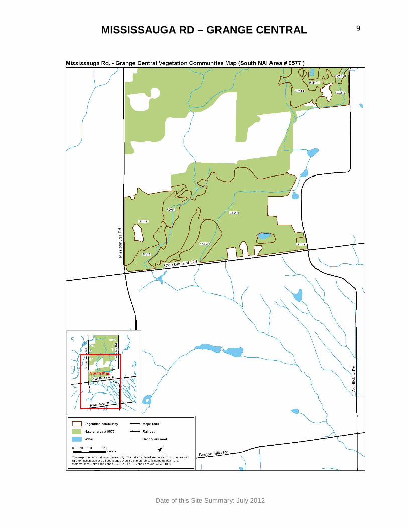
MISSISSAUGA RD – GRANGE CENTRAL
Date of this Site Summary: July 2012
1
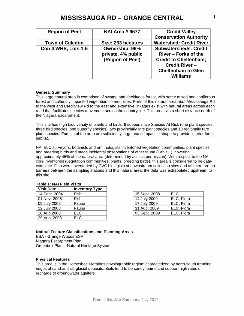
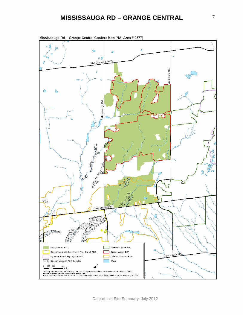
Region of Peel NAI Area # 9577 Credit Valley Conservation Authority
Town of Caledon Size: 263 hectares Watershed: Credi t River Con 4 WHS, Lots 1-5 Ownership: 96%
private, 4% public (Region of Peel)
Subwatersheds: Credit River – Forks of the
Credit to Cheltenham; Credit River –
Cheltenham to Glen Williams
General Summary This large natural area is comprised of swamp and deciduous forest, with some mixed and coniferous forest and culturally impacted vegetation communities. Parts of this natural area abut Mississauga Rd to the west and Creditview Rd to the east and extensive linkages exist with natural areas across each road that facilitates species movement across the countryside. This area sits a short distance north of the Niagara Escarpment. This site has high biodiversity of plants and birds. It supports five Species At Risk (one plant species, three bird species, one butterfly species), two provincially rare plant species and 13 regionally rare plant species. Forests of the area are sufficiently large and compact in shape to provide interior forest habitat. NAI ELC surveyors, botanists and ornithologists inventoried vegetation communities, plant species and breeding birds and made incidental observations of other fauna (Table 1), covering approximately 45% of the natural area (determined by access permission). With respect to the NAI core inventories (vegetation communities, plants, breeding birds), this area is considered to be data-complete. Fish were inventoried by CVC biologists at downstream collection sites and as there are no barriers between the sampling stations and this natural area, the data was extrapolated upstream to this site. Table 1: NAI Field Visits Visit Date Inventory Type 14 Sept. 2004 Fish 01 Nov. 2006 Fish 05 July 2008 Fauna 12 July 2008 Fauna 28 Aug.2008 ELC 29 Aug. 2008 ELC
15 Sept. 2008 ELC 14 July 2009 ELC, Flora 17 July 2009 ELC, Flora 31 Aug. 2009 ELC, Flora 03 Sept. 2009 ELC, Flora
Natural Feature Classifications and Planning Areas ESA - Grange Woods ESA Niagara Escarpment Plan Greenbelt Plan – Natural Heritage System Physical Features This area is in the Horseshoe Moraines physiographic region; characterized by north-south trending ridges of sand and silt glacial deposits. Soils tend to be sandy loams and support high rates of recharge to groundwater aquifers.
MISSISSAUGA RD – GRANGE CENTRAL
Date of this Site Summary: July 2012
2
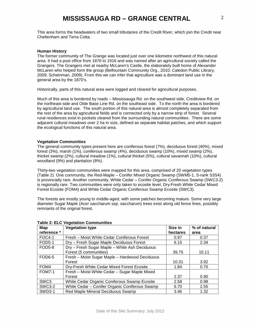
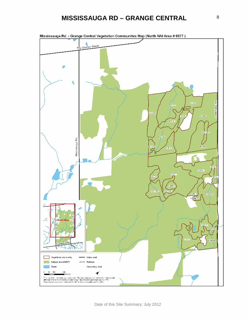
This area forms the headwaters of two small tributaries of the Credit River, which join the Credit near Cheltenham and Terra Cotta. Human History The former community of The Grange was located just over one kilometre northwest of this natural area. It had a post office from 1876 to 1916 and was named after an agricultural society called the Grangers. The Grangers met at nearby McLaren’s Castle, the elaborately built home of Alexander McLaren who helped form the group (Belfountain Community Org., 2010; Caledon Public Library, 2009; Scheinman, 2009). From this we can infer that agriculture was a dominant land use in the general area by the 1870’s. Historically, parts of this natural area were logged and cleared for agricultural purposes. Much of this area is bordered by roads – Mississauga Rd. on the southwest side, Creditview Rd. on the northeast side and Olde Base Line Rd. on the southeast side. To the north the area is bordered by agricultural land use. The south portion of this natural area is almost completely separated from the rest of the area by agricultural fields and is connected only by a narrow strip of forest. Several rural residences exist in pockets cleared from the surrounding natural communities. There are some adjacent cultural meadows over 2 ha in size, defined as separate habitat patches, and which support the ecological functions of this natural area. Vegetation Communities The general community types present here are coniferous forest (7%), deciduous forest (40%), mixed forest (3%), marsh (1%), coniferous swamp (4%), deciduous swamp (10%), mixed swamp (2%), thicket swamp (2%), cultural meadow (1%), cultural thicket (5%), cultural savannah (10%), cultural woodland (9%) and plantation (8%). Thirty-two vegetation communities were mapped for this area, comprised of 20 vegetation types (Table 2). One community, the Red-Maple – Conifer Mixed Organic Swamp (SWM5-1, S-rank S3S4) is provincially rare. Another community, White Cedar – Conifer Organic Coniferous Swamp (SWC3-2) is regionally rare. Two communities were only taken to ecosite level, Dry-Fresh White Cedar Mixed Forest Ecosite (FOM4) and White Cedar Organic Coniferous Swamp Ecosite (SWC3). The forests are mostly young to middle-aged, with some patches becoming mature. Some very large diameter Sugar Maple (Acer saccharum ssp. saccharum) trees exist along old fence lines, possibly remnants of the original forest. Table 2: ELC Vegetation Communities Map reference *
Vegetation type Size in hectares
% of natural area
FOC4-1 Fresh – Moist White Cedar Coniferous Forest 0.97 0.37 FOD5-1 Dry – Fresh Sugar Maple Deciduous Forest 6.15 2.34 FOD5-8 Dry – Fresh Sugar Maple – White Ash Deciduous
Forest (5 communities) 39.75 15.11 FOD6-5 Fresh – Moist Sugar Maple – Hardwood Deciduous
Forest 10.31 3.92 FOM4 Dry-Fresh White Cedar Mixed Forest Ecosite 1.84 0.70 FOM7-1 Fresh – Moist White Cedar – Sugar Maple Mixed
Forest 2.37 0.90 SWC3 White Cedar Organic Coniferous Swamp Ecosite 2.58 0.98 SWC3-2 White Cedar – Conifer Organic Coniferous Swamp 6.70 2.55 SWD3-1 Red Maple Mineral Deciduous Swamp 3.46 1.32
MISSISSAUGA RD – GRANGE CENTRAL
Date of this Site Summary: July 2012
3
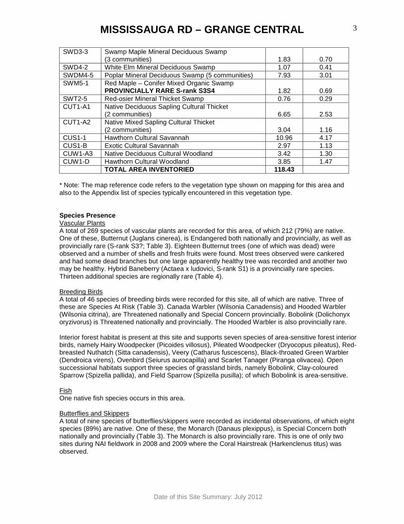
SWD3-3 Swamp Maple Mineral Deciduous Swamp (3 communities) 1.83 0.70
SWD4-2 White Elm Mineral Deciduous Swamp 1.07 0.41 SWDM4-5 Poplar Mineral Deciduous Swamp (5 communities) 7.93 3.01 SWM5-1 Red Maple – Conifer Mixed Organic Swamp
PROVINCIALLY RARE S-rank S3S4 1.82 0.69 SWT2-5 Red-osier Mineral Thicket Swamp 0.76 0.29 CUT1-A1 Native Deciduous Sapling Cultural Thicket
(2 communities) 6.65 2.53 CUT1-A2 Native Mixed Sapling Cultural Thicket
(2 communities) 3.04 1.16 CUS1-1 Hawthorn Cultural Savannah 10.96 4.17 CUS1-B Exotic Cultural Savannah 2.97 1.13 CUW1-A3 Native Deciduous Cultural Woodland 3.42 1.30 CUW1-D Hawthorn Cultural Woodland 3.85 1.47 TOTAL AREA INVENTORIED 118.43
* Note: The map reference code refers to the vegetation type shown on mapping for this area and also to the Appendix list of species typically encountered in this vegetation type. Species Presence Vascular Plants A total of 269 species of vascular plants are recorded for this area, of which 212 (79%) are native. One of these, Butternut (Juglans cinerea), is Endangered both nationally and provincially, as well as provincially rare (S-rank S3?; Table 3). Eighteen Butternut trees (one of which was dead) were observed and a number of shells and fresh fruits were found. Most trees observed were cankered and had some dead branches but one large apparently healthy tree was recorded and another two may be healthy. Hybrid Baneberry (Actaea x ludovici, S-rank S1) is a provincially rare species. Thirteen additional species are regionally rare (Table 4). Breeding Birds A total of 46 species of breeding birds were recorded for this site, all of which are native. Three of these are Species At Risk (Table 3). Canada Warbler (Wilsonia Canadensis) and Hooded Warbler (Wilsonia citrina), are Threatened nationally and Special Concern provincially. Bobolink (Dolichonyx oryzivorus) is Threatened nationally and provincially. The Hooded Warbler is also provincially rare. Interior forest habitat is present at this site and supports seven species of area-sensitive forest interior birds, namely Hairy Woodpecker (Picoides villosus), Pileated Woodpecker (Dryocopus pileatus), Red-breasted Nuthatch (Sitta canadensis), Veery (Catharus fuscescens), Black-throated Green Warbler (Dendroica virens), Ovenbird (Seiurus aurocapilla) and Scarlet Tanager (Piranga olivacea). Open successional habitats support three species of grassland birds, namely Bobolink, Clay-coloured Sparrow (Spizella pallida), and Field Sparrow (Spizella pusilla); of which Bobolink is area-sensitive. Fish One native fish species occurs in this area. Butterflies and Skippers A total of nine species of butterflies/skippers were recorded as incidental observations, of which eight species (89%) are native. One of these, the Monarch (Danaus plexippus), is Special Concern both nationally and provincially (Table 3). The Monarch is also provincially rare. This is one of only two sites during NAI fieldwork in 2008 and 2009 where the Coral Hairstreak (Harkenclenus titus) was observed.
MISSISSAUGA RD – GRANGE CENTRAL
Date of this Site Summary: July 2012
4
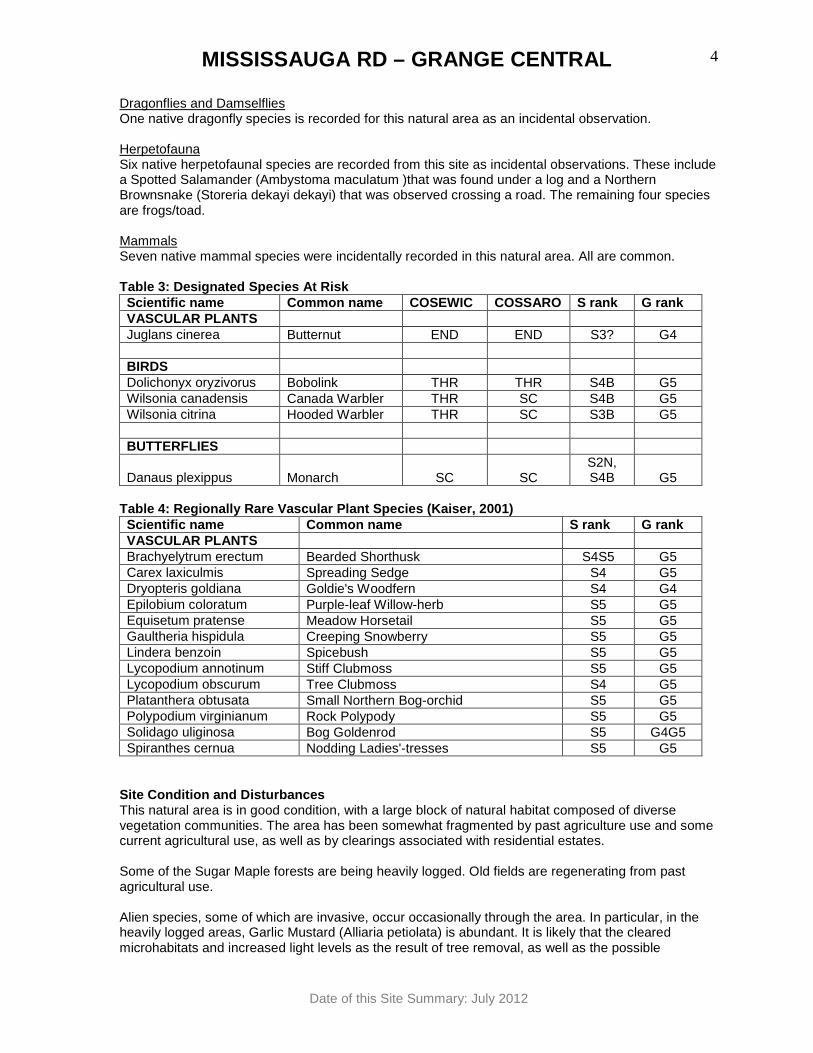
Dragonflies and Damselflies One native dragonfly species is recorded for this natural area as an incidental observation. Herpetofauna Six native herpetofaunal species are recorded from this site as incidental observations. These include a Spotted Salamander (Ambystoma maculatum )that was found under a log and a Northern Brownsnake (Storeria dekayi dekayi) that was observed crossing a road. The remaining four species are frogs/toad. Mammals Seven native mammal species were incidentally recorded in this natural area. All are common. Table 3: Designated Species At Risk Scientific name Common name COSEWIC COSSARO S rank G rank VASCULAR PLANTS Juglans cinerea Butternut END END S3? G4 BIRDS Dolichonyx oryzivorus Bobolink THR THR S4B G5 Wilsonia canadensis Canada Warbler THR SC S4B G5 Wilsonia citrina Hooded Warbler THR SC S3B G5 BUTTERFLIES
Danaus plexippus Monarch SC SC S2N, S4B G5
Table 4: Regionally Rare Vascular Plant Species (Ka iser, 2001) Scientific name Common name S rank G rank VASCULAR PLANTS Brachyelytrum erectum Bearded Shorthusk S4S5 G5 Carex laxiculmis Spreading Sedge S4 G5 Dryopteris goldiana Goldie's Woodfern S4 G4 Epilobium coloratum Purple-leaf Willow-herb S5 G5 Equisetum pratense Meadow Horsetail S5 G5 Gaultheria hispidula Creeping Snowberry S5 G5 Lindera benzoin Spicebush S5 G5 Lycopodium annotinum Stiff Clubmoss S5 G5 Lycopodium obscurum Tree Clubmoss S4 G5 Platanthera obtusata Small Northern Bog-orchid S5 G5 Polypodium virginianum Rock Polypody S5 G5 Solidago uliginosa Bog Goldenrod S5 G4G5 Spiranthes cernua Nodding Ladies'-tresses S5 G5
Site Condition and Disturbances This natural area is in good condition, with a large block of natural habitat composed of diverse vegetation communities. The area has been somewhat fragmented by past agriculture use and some current agricultural use, as well as by clearings associated with residential estates. Some of the Sugar Maple forests are being heavily logged. Old fields are regenerating from past agricultural use. Alien species, some of which are invasive, occur occasionally through the area. In particular, in the heavily logged areas, Garlic Mustard (Alliaria petiolata) is abundant. It is likely that the cleared microhabitats and increased light levels as the result of tree removal, as well as the possible
MISSISSAUGA RD – GRANGE CENTRAL
Date of this Site Summary: July 2012
5
transportation of Garlic Mustard seeds on logging equipment, is responsible for its increased abundance in these places. Disturbance from the invasion of Common Buckthorn (Rhamnus cathartica) is light and localized in scattered patches. Ecological Features and Functions This area forms part of the Grange Woods ESA. The wetlands of this area are part of the Grange Woods Wetland Complex (not provincially significant). With forest communities greater than 4 ha, wetlands over 0.5 ha in size, cultural meadow and cultural savannah totalling over 10 ha, this natural area has the potential to support and sustain biodiversity, healthy ecosystem functions and to provide long-term resilience for the natural system. By containing a relatively high number of habitat types, this natural area has the potential for high biodiversity function, particularly for species that require more than one habitat type for their life needs. This natural area contains a provincially rare vegetation community and a regionally rare community and thus has the potential to support additional biodiversity above and beyond that found in common community types. This natural area had broad bands of connectivity to the northeast, southwest and southeast linking with other natural areas across relatively quiet country roads (Mississauga Rd. is busier but not like a highway or city road). This connectivity effectively links this area with the major Niagara Escarpment corridor. The relatively close proximity of other areas of natural habitat creates above-average potential for wildlife movement between natural areas, species dispersal and recovery from disturbance, creating additional resilience for the ecosystem. This natural area contains one provincially rare community, one regionally rare community, five Species At Risk (one plant species, three bird species, one butterfly species), two provincially rare plant species and 13 regionally rare plant species. The interior forest habitat present in this area supports seven species of area-sensitive forest interior birds. The successional open country habitat present at this site is sufficiently large enough to support the breeding of one species of area-sensitive grassland bird and two other grassland bird species. Wetlands of this area support amphibian breeding. Based on the above features, this area should be evaluated to determine if significant wildlife habitat is present in accordance with the Provincial Policy Statement, Region of Peel Official Plan, and area municipal Official Plan. Opportunities A corridor could be developed between this natural area and the natural area to the south by widening an existing treed fencerow. The upland deciduous woods are being managed with dead trees and the understory being removed. Retention of at least some dead trees, particularly larger cavity trees, as well as retention of underbrush and woody debris on the ground is desirable. Habitat structural complexity provides for increased biodiversity. This area has the potential to support more uncommon birds including Canada Warbler and Hooded Warbler if the understory was left intact. Retention of woody debris on the ground provides habitat for woodland salamanders and allows ecosystem processes, such as the recycling of nutrients and the retention of moisture.
MISSISSAUGA RD – GRANGE CENTRAL
Date of this Site Summary: July 2012
6
Invasive species could be monitored, especially along natural area edges which are often their entry point into a natural area. Invasive species controls might be considered. Common Buckthorn, which is highly invasive, could be removed now while its numbers are still low. The health of the Butternut trees in this area could be assessed by a Butternut Assessor to determine whether any of the individuals at this site are candidates for inclusion in the Butternut recovery program. A large section of this natural area was not inventoried. If permission to access additional private properties can be obtained in the future, they should be surveyed. Data gaps exist for mammals, butterflies and dragonflies/damselflies. Additional inventories targeting these groups may be productive, given the high biodiversity of other groups of this area. This natural area has one mature forest community and it could be checked for old-growth forest characteristics. Literature Cited Belfountain Community Organization. 2010. Who’s Who in Belfountain. Available at http://www.belfountain.ca/ Last Accessed 17 December 2010. Caledon Public Library. 2009. Caledon’s History . Available at http://www.caledon.library.on.ca/ Last Accessed 18 November 2010 Kaiser, J. 2001. The Vascular Plant Flora of the Region of Peel and the Credit River Watershed . Prepared for: Credit Valley Conservation, the Regional Municipality of Peel, Toronto and Region Conservation Authority. Scheinman, A. 2009. Town of Caledon Cultural Heritage Landscapes Invent ory . Envision – The Hough Group.
MISSISSAUGA RD – GRANGE CENTRAL
Date of this Site Summary: July 2012
7
MISSISSAUGA RD – GRANGE CENTRAL
Date of this Site Summary: July 2012
8
MISSISSAUGA RD – GRANGE CENTRAL
Date of this Site Summary: July 2012
9