mobile map
TRANSCRIPT
8/6/2019 Mobile Map
http://slidepdf.com/reader/full/mobile-map 1/25
Mobile Map
8/6/2019 Mobile Map
http://slidepdf.com/reader/full/mobile-map 2/25
Abstract
� Communication support is a serious limitation for Latin American firefighterswhen they deal with emergency situations.
� The insufficient number of radio channels and the impossibility to deliver digital
information affect the time required to take control of an emergency, and also
affect the evolution of the crisis situation.
� Communication Solutions are expensive.� Mobile Map is a low-cost mobile collaborative application, which may be used
in emergency situations to overcome most of the firefighters¶ communication
problems.
� It allows ad hoc communication, decisions support and collaboration among
firefighters in the field using mobile devices.
8/6/2019 Mobile Map
http://slidepdf.com/reader/full/mobile-map 3/25
Introduction
� Firefighters are typically volunteers in many Latin American countries.� No Salary .
� Less Support from governmental agencies .
� Carry a radio receiver/transmitter to receive a call to participate in
emergency relief operations .
� A special firefighting unit (Command Center) is in charge of delivering thealarms ,assigning resources to an emergency situation and coordinating the
response efforts.
� The firefighting community is composed of a command center and its
depending fire companies.
� Examples of urban emergencies are fires , car accidents, gas leakages,collapses, and chemical/water spills.
8/6/2019 Mobile Map
http://slidepdf.com/reader/full/mobile-map 4/25
Limitation of Radio-based Communications
� Taking control of an urban emergency requires quick and accurateinformation about:
� The dangers of the situation
� The affected resources
� The emergency location & the surrounding key resources to inspect
and to use and� The status of the response process
� Digital representations of this information which cannot be delivered or
shared in a radio system.
� Another problem is insufficient number of channels available to support the
response processes.� Delay in receiving/sending the information.
� Disturbance in the Channel because of two messages in the same interval.
8/6/2019 Mobile Map
http://slidepdf.com/reader/full/mobile-map 5/25
Mobile Map
� It help¶s overcome most of these limitations.
� Helps fire trucks to arrive quickly.
� Helps firemen to retrieve information on the go.
� Helps the firefighting organization to record/collect
information about the response process.
� Runs on handheld devices.
� Uses Wi-Fi and GSM networks.
� Also runs on laptops, netbooks etc.
8/6/2019 Mobile Map
http://slidepdf.com/reader/full/mobile-map 6/25
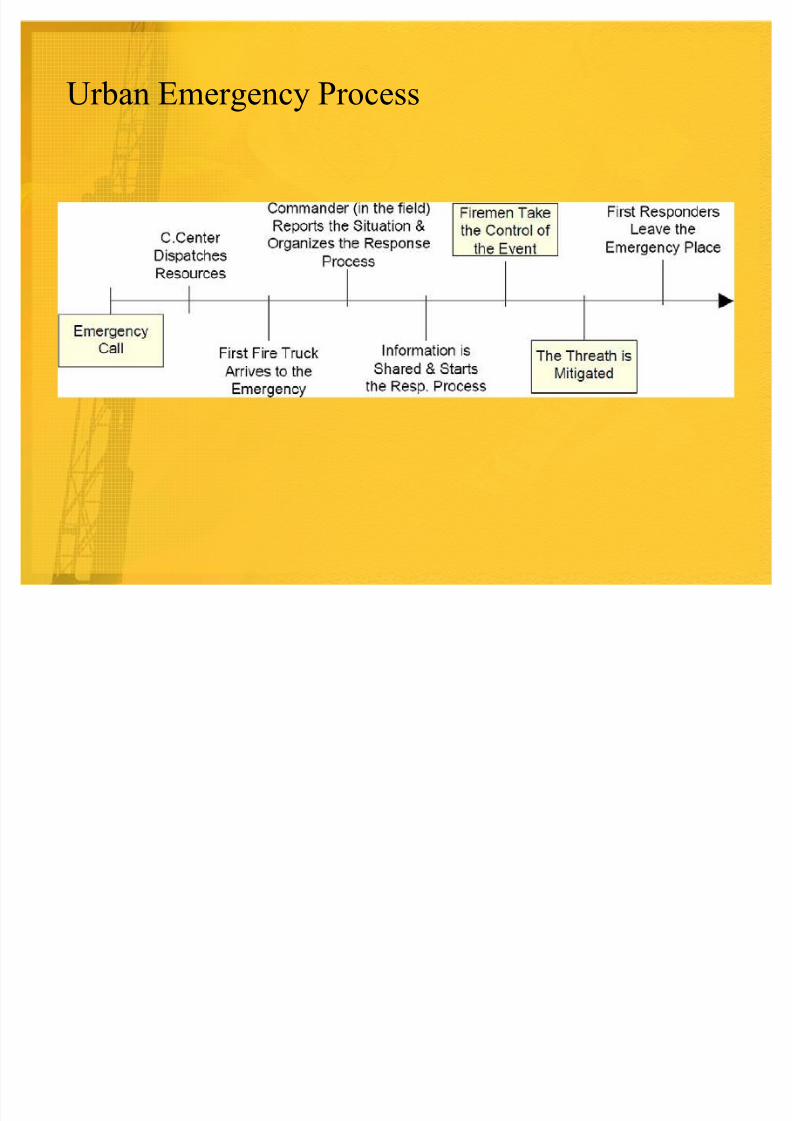
Urban Emergency Process
8/6/2019 Mobile Map
http://slidepdf.com/reader/full/mobile-map 7/25
Mobile Map: Front End Functionality
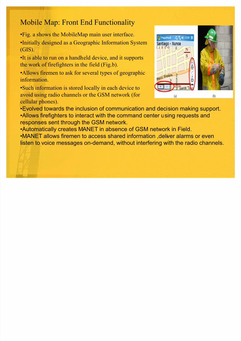
�Fig. a shows the MobileMap main user interface.
�Initially designed as a Geographic Information System(GIS).
�It is able to run on a handheld device, and it supports
the work of firefighters in the field (Fig.b).
�Allows firemen to ask for several types of geographic
information.
�Such information is stored locally in each device to
avoid using radio channels or the GSM network (for
cellular phones).
�Evolved towards the inclusion of communication and decision making support.
�Allows firefighters to interact with the command center using requests and
responses sent through the GSM network.
�Automatically creates M ANET in absence of GSM network in Field.
�M ANET allows firemen to access shared information ,deliver alarms or even
listen to voice messages on-demand, without interfering with the radio channels.
8/6/2019 Mobile Map
http://slidepdf.com/reader/full/mobile-map 8/25
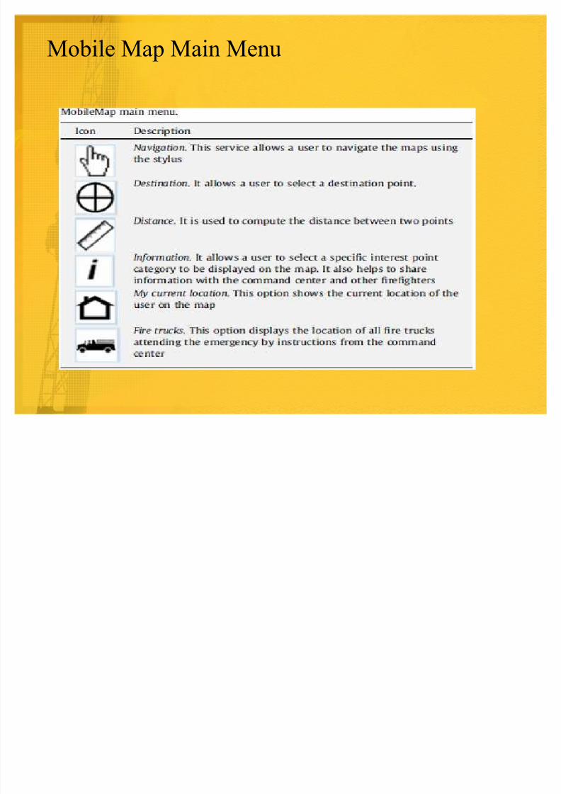
Mobile Map Main Menu
8/6/2019 Mobile Map
http://slidepdf.com/reader/full/mobile-map 9/25
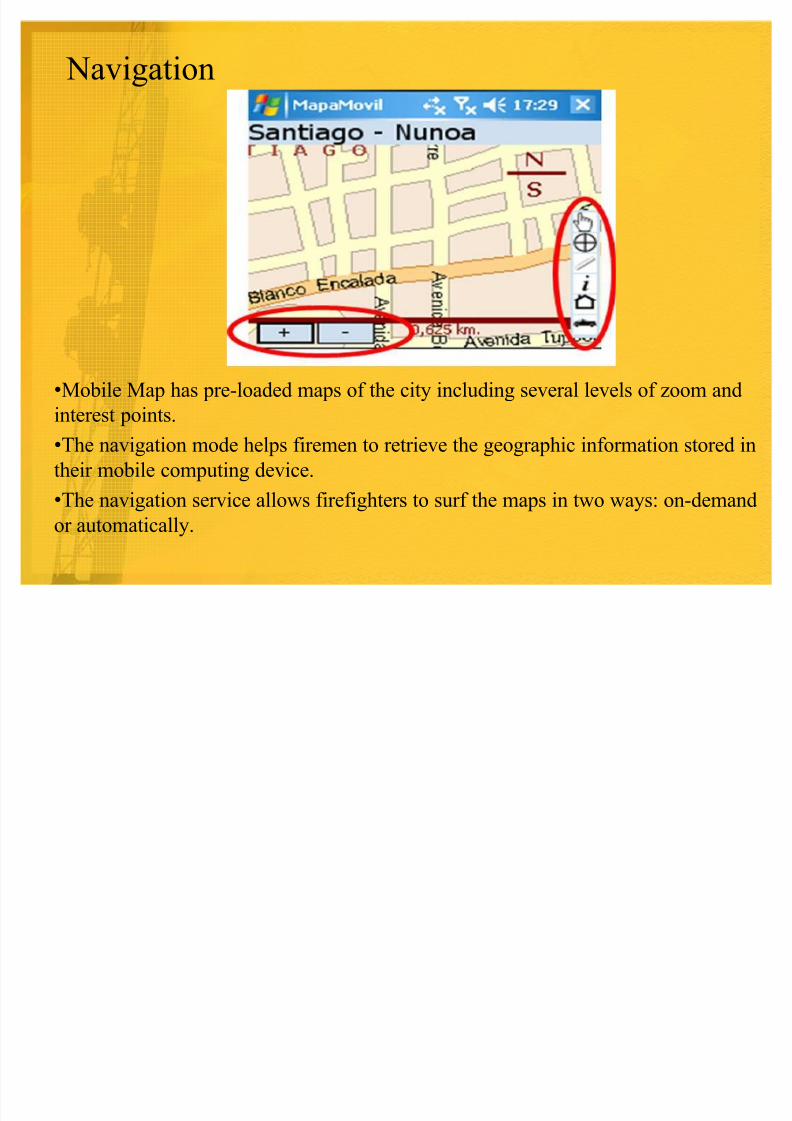
Navigation
�Mobile Map has pre-loaded maps of the city including several levels of zoom and
interest points.�The navigation mode helps firemen to retrieve the geographic information stored in
their mobile computing device.
�The navigation service allows firefighters to surf the maps in two ways: on-demand
or automatically.
8/6/2019 Mobile Map
http://slidepdf.com/reader/full/mobile-map 10/25
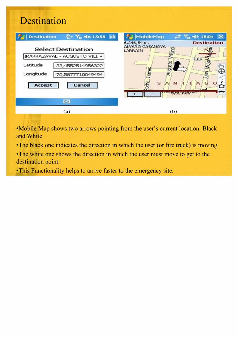
Destination
�Mobile Map shows two arrows pointing from the user¶s current location: Black
and White.
�The black one indicates the direction in which the user (or fire truck) is moving.
�The white one shows the direction in which the user must move to get to the
destination point.
�This Functionality helps to arrive faster to the emergency site.
8/6/2019 Mobile Map
http://slidepdf.com/reader/full/mobile-map 11/25
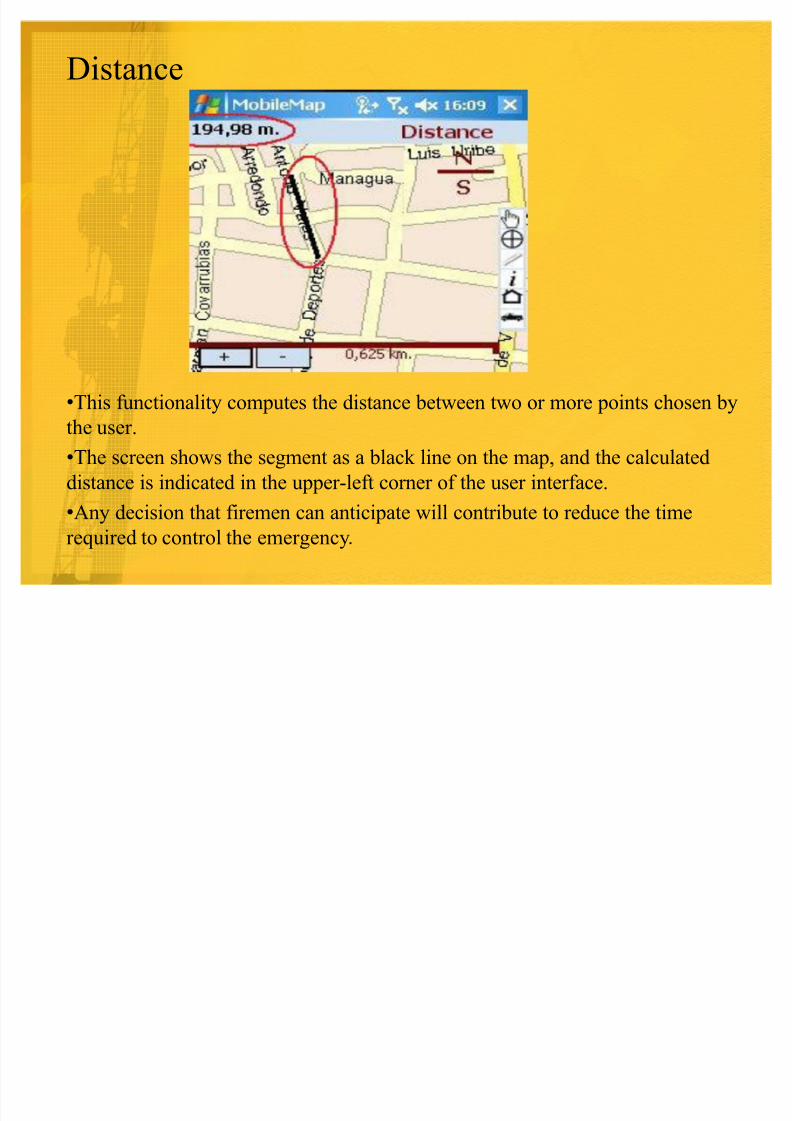
Distance
�This functionality computes the distance between two or more points chosen by
the user.
�The screen shows the segment as a black line on the map, and the calculated
distance is indicated in the upper-left corner of the user interface.
�Any decision that firemen can anticipate will contribute to reduce the time
required to control the emergency.
8/6/2019 Mobile Map
http://slidepdf.com/reader/full/mobile-map 12/25
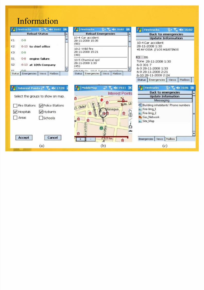
Information
8/6/2019 Mobile Map
http://slidepdf.com/reader/full/mobile-map 13/25
My Current Location
� This function reloads the map and the information deployed on it, centering
the image on the user¶s current location.
8/6/2019 Mobile Map
http://slidepdf.com/reader/full/mobile-map 14/25
Fire Trucks
� Deploys the current location of fire trucks attending each emergency
situation.
� Updates about Vehicle Location.
� Using GPS.
� Informs about the current location once it has changed in at least 100m.
� The handheld belonging to a truck stores the list of instruments tools
available in such vehicle to support emergency relief activities.
� This list is reported to the command center.
8/6/2019 Mobile Map
http://slidepdf.com/reader/full/mobile-map 15/25
Mobile Map: Back End Functionality
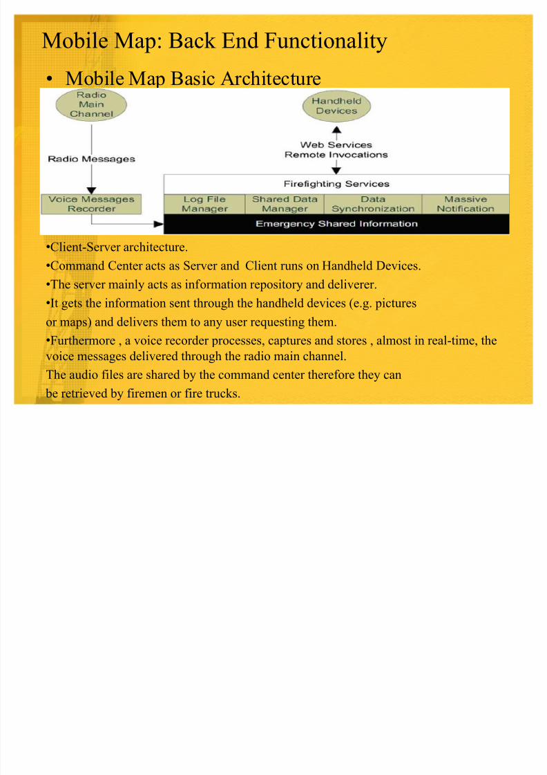
� Mobile Map Basic Architecture
�Client-Server architecture.
�Command Center acts as Server and Client runs on Handheld Devices.
�The server mainly acts as information repository and deliverer.�It gets the information sent through the handheld devices (e.g. pictures
or maps) and delivers them to any user requesting them.
�Furthermore , a voice recorder processes, captures and stores , almost in real-time, the
voice messages delivered through the radio main channel.
The audio files are shared by the command center therefore they can
be retrieved by firemen or fire trucks.
8/6/2019 Mobile Map
http://slidepdf.com/reader/full/mobile-map 16/25
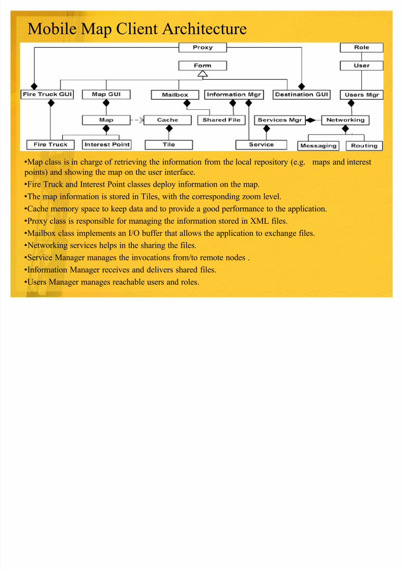
Mobile Map Client Architecture
�Map class is in charge of retrieving the information from the local repository (e.g. maps and interest
points) and showing the map on the user interface.
�Fire Truck and Interest Point classes deploy information on the map.
�The map information is stored in Tiles, with the corresponding zoom level.
�Cache memory space to keep data and to provide a good performance to the application.�Proxy class is responsible for managing the information stored in XML files.
�Mailbox class implements an I/O buffer that allows the application to exchange files.
� Networking services helps in the sharing the files.
�Service Manager manages the invocations from/to remote nodes .
�Information Manager receives and delivers shared files.
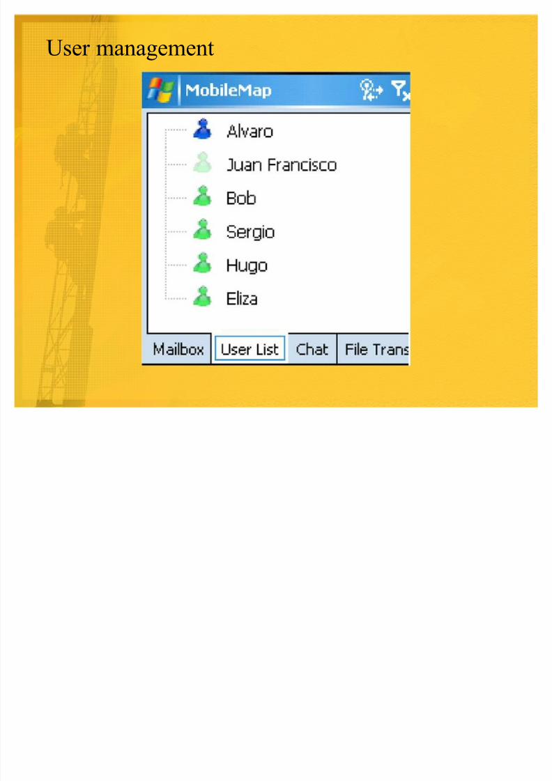
�Users Manager manages reachable users and roles.
8/6/2019 Mobile Map
http://slidepdf.com/reader/full/mobile-map 17/25
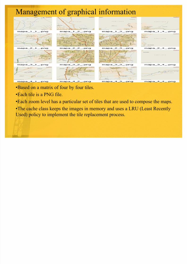
Management of graphical information
�Based on a matrix of four by four tiles.
�Each tile is a PNG file.
�Each zoom level has a particular set of tiles that are used to compose the maps.
�The cache class keeps the images in memory and uses a LRU (Least Recently
Used) policy to implement the tile replacement process.
8/6/2019 Mobile Map
http://slidepdf.com/reader/full/mobile-map 18/25
Networking issues
� MobileMap has two processes to manage the networking issues
� GSM:� Allows exchange of information between a handheld device
and the command center.
� Pictures are sent from the emergency place to the command
center.
� The picture is serialized, transmitted through the network.� Wi-Fi network
� Used if the GSM network is not available.
� Provides services to support communication among firemen in
the field.
� Assigns an IP address to the handheld device.� This networking process detects peers at a one-hop of distance
and automatically forms a MANET.
8/6/2019 Mobile Map
http://slidepdf.com/reader/full/mobile-map 19/25
8/6/2019 Mobile Map
http://slidepdf.com/reader/full/mobile-map 20/25
Log file record and processing� The client and server components of MobileMap record a log file in a
distributed way.� Stores information related to interactions in which the node was involved
during the emergency.
� Information is stored in a local XML file, and it includes a timestamp for
each recorded interaction.
� The processing of the log file involves three steps� Information recording
� Integration and
� Analysis
� This will allow firemen to learn from past experiences and get lessons for
the future.
8/6/2019 Mobile Map
http://slidepdf.com/reader/full/mobile-map 21/25
Implementation issues
� This application was developed using C# and the .NET Compact
Framework, version 3.5.� The tool is able to run on computing devices using WindowsXP or
Windows Mobile 5.0 or higher.
� Most of the supporting files, such as the users list of a MANET, are
represented as XML files.
� MobileMap has been used on PDAs, smart phones, netbooks and laptopswith MS Windows as operating system.
8/6/2019 Mobile Map
http://slidepdf.com/reader/full/mobile-map 22/25
Result� The application helped to reduce the arrival time to the emergency sites
particularly in the periphery of the city, where the street names are usuallyunknown to the Fire truck Drivers.
� The improvement in the arrival time could make a great difference on the
consequences of many emergency situations.
� Decision makers in the command center just monitored the activities of the
firemen using MobileMap.� Number of exchanged messages was 30% lower than in similar
emergencies in which Mobile-Map was not used.
� Firemen felt more confident and safer knowing they were able to deliver a
general alarm through the application.
� The operational cost of this solution in Chile is about US$ 10 per fire truck per month, and US$ 50 for the command center per month, which is
acceptable for their budgets.
� It costs less for firemen as this application can be run on their mobile
phone.
� These solutions can provide communication support similar to the radiosystems, transmit digital information.
8/6/2019 Mobile Map
http://slidepdf.com/reader/full/mobile-map 23/25
Conclusion� Mobile Map was initially designed to help firefighters to arrive faster to the
emergency site, to allow them to exchange digital information during
emergency response processes and to reduce the need for radiocommunication.
� The next steps in this initiative
� To evaluate MobileMap in daily emergencies, involving several fire
companies, using a more formal evaluation approach.
� The authors plan to spread this solution as much as possible to obtainfeedback from several sources. For example, the tool could be tested
in public health services.
� A long term goal of this initiative is to enhance MobileMap in order to
propose it as a replacement of the current radio systems.
� The authors think that advanced telecommunication networks such as LTE(Long Term Evolution), also known as 4G would allow MobileMap to
provide an improved support to firefighting.
8/6/2019 Mobile Map
http://slidepdf.com/reader/full/mobile-map 24/25
� The Mobile Map Application helps the fireman in the emergencysituations.
� The application was mainly designed to reduce the time to reach the
emergency field. It can reduce more time if it includes information about
the routes on the map which are crowded or having more traffic in that
particular route and showing a route by which the Fire truck can reacheasily without getting struck in traffic.
� It needs assistance for the truck driver to operate this device. If it
recognizes voice transmission, then it can reduce the work of another
person.
� Live voice transmission in the field makes much easier to communicate between two firefighters than passing the messages through mailbox.
My Views : Mobile Map
8/6/2019 Mobile Map
http://slidepdf.com/reader/full/mobile-map 25/25
THANK YOU