mobilizing local knowledge in local disaster risk
TRANSCRIPT

The University of Sydney Page 1
Mobilizing Local
Knowledge in Local
Disaster Risk Reduction
Strategies
Aaron Opdyke PhD, PE
Lecturer | Humanitarian Engineering
School of Civil Engineering
Faculty of Engineering

The University of Sydney Page 2
What is a Local Disaster Risk Reduction Strategy?
“A local disaster risk reduction and resilience strategy is the planning tool to integrate and mainstream a DRR approach within local development, and to guide and make coherent local plans and actions.”
Why are they important?
Disaster risk is context specific; it is experienced in particular places and times, in ways that shape local patterns of exposure, vulnerability, adaptive capacities and resilience.
UNDRR (2018). Implementation guide for local disaster risk reduction and resilience strategies: A companion for implementing the Sendai Framework target E.

The University of Sydney Page 3
Sendai Framework Progress
Target (e): Substantially increase the number of countries with national and local disaster risk reduction strategies by 2020
Indicator E-2: Percentage of local governments that have adopted and implemented local disaster risk reduction strategies in line with national strategies
As of 2018, 60% of local governments have adopted local strategies in 32 (of 195) countries reporting

The University of Sydney Page 4
RA 10121 – DRRM Act (2010)
At subnational levels, the Disaster Risk Reduction and Management Act mandates:
1) the establishment of a Disaster Risk Reduction and Management Office (DRRMO) in every province, city and municipality;
2) the creation of a Barangay Disaster Risk Reduction and Management Committee (BDRRMC) in every barangay (the smallest administrative division); and
3) the development of Local Disaster Risk Reduction and Management Plans (LDRRMPs). Mandated establishment of Municipal Disaster Risk Reduction and Management Office(MDRRMOs)

The University of Sydney Page 5
Case Study: Municipality of Carigara (Philippines)
Sasakawa Award Nominee 2018

The University of Sydney Page 6
Base Mapping
Population
54,084 people surveyed
Buildings
16,971 structures
Roads and Pathways
31,085 meters
Land Cover
12,703 hectares
Waterways
36,715 meters
Administrative Boundaries
49 barangays
BEFORE

The University of Sydney Page 7
Base Mapping
Population
54,084 people surveyed
Buildings
16,971 structures
Roads and Pathways
31,085 meters
Land Cover
12,703 hectares
Waterways
36,715 meters
Administrative Boundaries
49 barangays
AFTER

The University of Sydney Page 8

The University of Sydney Page 9

The University of Sydney Page 10
Flood Map (Before – DOST)

The University of Sydney Page 11
Flood Map (After – Community)

The University of Sydney Page 12
Flood Map (After – Community)

The University of Sydney Page 13
Example Flood Hazard Map
The University of Sydney Page 14
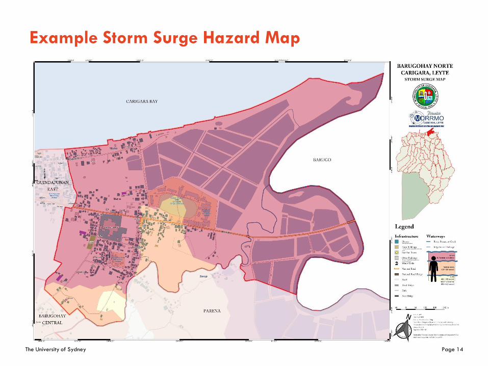
Example Storm Surge Hazard Map

The University of Sydney Page 15
Example Landslide Hazard Map

The University of Sydney Page 16
Mobilizing Local Knowledge in DRR
Local Institutions
Local Knowledge

The University of Sydney Page 17
Mainstreaming DRR in Development Planning
Master Drainage
Planning

The University of Sydney Page 18
Lessons Learned
– Define who is responsible for disaster risk
Important to define accountability in places of administrative boundary disputes
– Leverage open-source technologies
Use of freely available technologies (e.g. OpenStreeMap, QGIS, Field Papers) acted as tool to institutionalize local knowledge
– Find opportunities to integrate DRR efforts
Identify priority issues facing local communities and use these as an entry point to institutional planning

The University of Sydney Page 19
Conclusions
How can we leverage the knowledge
embedded in local DRR strategies in the
decade ahead?
1. Utilise community-led data
collection as a multiplier
2. Emphasise process over product
3. Focus not only on risk reduction but
also halt disaster risk creation

The University of Sydney Page 20
Questions?
Aaron Opdyke PhD, PE
Lecturer | Humanitarian Engineering
@aaronopdyke