model subdivision ordinance - minnesota pollution control ... · minor subdivision procedures....
TRANSCRIPT

Adapting a MODEL SUBDIVISION ORDINANCE
To meet your community’s water quality goals
Produced forNorthland Non-point Education for Municipal Officials (NEMO) Program
Ordinance Language addressing: Street Design and Impervious Surface
Lot LayoutGreen Infrastructure
Project funded through Minnesota Department of Natural Resources Central Region Community Assistance Program and the Coastal Zone Management Act, by NOAA’s Office of Ocean and Coastal Resource Management, in cooperation with Minnesota’s Lake Superior Coastal Program

Incorporating MODEL SUBDIVISION LANGUAGE To meet your community’s water quality goals
Produced for
Northland Non-point Education for Municipal Officials (NEMO) Program
Ordinance Language addressing: Street design and impervious surface
Lot layout Green infrastructure
Prepared by: CR Planning, Inc. 2634 Vincent Avenue North Minneapolis, MN 55411 612-588-4904
Desotelle Consulting P.O. Box 3220 Duluth, MN 55803 612-728-1228
Minnesota Erosion Control Association P.O. Box 17 Lake Elmo, MN 55042 651-351-0630

Model Subdivision Language Page 1 Northland NEMO Project
Subdivision and Platting of Land Standards Section XX of Model Community Subdivision Ordinance X.01 General Provisions; Policy and Purpose. Model Community adopts this Ordinance, Subdivision and Platting of Land, to safeguard the best interests of Model Community and to assist developers and subdividers of land in harmonizing their interests with those of the Community. The community has determined that each new subdivision of land in the Community becomes a permanent unit in the basic structure of the community, to which the community will be forced to adhere, and piecemeal planning of subdivisions creates an undesirable, disconnected patchwork of land uses, poor circulation of traffic, and inadequate protection of natural features and water quality. Subdivision of land must therefore be consistent with the unified scheme of community interests as presented in the community’s adopted Comprehensive Plan and Water Plan. All subdivisions of land hereafter submitted for approval to the Planning Commission shall comply with the regulations hereinafter set forth in this Ordinance. This Ordinance makes certain regulations and requirements for the platting of land within the Community pursuant to the authority contained in Minnesota Statutes, Section 462.351 to 462.365, as amended, which regulations the Model Community Council deems necessary for the health, safety and general welfare of the citizens of the Community. These regulations are also deemed necessary to implement Comprehensive Plan and Water Plan policies and goals. X.03 Application. Every plat of land proposed within the Community shall be prepared, presented for approval and recorded as prescribed in this Section. This Section applies to the subdivision of a lot, tract or parcel of land into two or more lots, tracts or other division of land for the purpose of sale or of building development, whether immediate or future, including the resubdivision or replatting of land or lots, except as allowed in X.03 A.
A. Minor subdivisions partially exempted. The provisions of the Subdivision Ordinance are relaxed for minor subdivisions. Minor subdivisions must meet all the following criteria: 1. The division of the property must include the entire property, meet the requirements of
the Zoning Code for division of property, and such division must be achieved by an approved and recordable plat.
2. The individual parcels resulting from such a plat shall be for single family residential use only and each such parcel shall be of such size, configuration and topographical quality as to be capable of accommodating a single family residential structure.
This ordinance is based on structure and language from the Subdivision Ordinance of the City of Plymouth. A community’s subdivision ordinance includes a number of provisions outlining when and how the subdividing of lots is allowed. The subdivision ordinance identifies the threshold size where the subdivision regulations are applicable, the information required to be compiled by the applicant for review by the local government, site plan review procedures, and other requirements. This ordinance does not provide language for an entire subdivision ordinance. The following language does, however, address several aspects of how subdivision regulation can affect a community’s water quality goals, and how to implement NEMO concepts in local regulation. The general provisions describe the goals of the subdivision ordinance and its policy reliance on the comprehensive plan and water plan. The general provisions also reference the enabling legislation for municipalities. The corresponding statutes for counties is Section 394. Most subdivisions in developing communities are leading to commercial or residential development, and will use the procedures described in sections X.05- X.07 (for major subdivisions). The information is critical for the community to ensure that development is proceeding consistent with the community’s land use plan and ordinances. Many ordinances will For small, or minor, subdivisions the

Model Subdivision Language Page 2 Northland NEMO Project
3. The individual parcels must meet the requirements of the ISTS Ordinance. 4. The individual parcels resulting from such a plat shall be no more than five in number,
including any parcel retained by the owner or subdivider. 5. The requirements of this Section relating to the platting of land shall be applicable to any
such division of lands and properties. 6. Lands and properties abutting land and property being so divided shall themselves have
previously been platted and divided, it being the intent of Model Community not to waive the requirements of this Subsection with respect to land.
7. The estimated market value of each parcel as determined by Model Community Assessor following such division of land and property must exceed the amount of special assessments previously levied and allocated to each parcel, including the amount of assessments estimated to be levied against each such parcel as a result of the improvements required to be installed in accordance with this Subsection by reason of such division of land and property.
B. Minor Subdivision procedures. Applications for minor subdivision approval must provide the
following information to ensure that the community’s land use and water quality goals are met, and must receive written approval from the designated community representative. 1. All information identified in X.07A. of this ordinance. 2. Locations of existing buildings and ISTS drainfields, delineated wetlands, open water,
and any easements. 3. Locations of proposed buildings, drainfields, and easements. 4. All information required in the community’s Shoreland Ordinance, if any portion of the
property lies in a designated shoreland district. 5. A pre-application meeting must be held between the applicant and the designated
community representative to determine which of the following additional information items must be provided. a. A topographic survey showing 2 foot contour intervals. b. Location and size, in square feet, of all wetlands c. Preliminary review by Surveyor d. Individual sewage treatment system site evaluation e. Individual sewage treatment system design submitted with this application f. Other information identified in Section X.07 of this ordinance.
information requirements in X.05 – X.07 would be burdensome and largely unjustified. The community should, however, recognize that the development goals are the same for large as for small developments, and should not eliminate regulatory oversight for minor subdivisions. The cumulative effect on water quality of many small subdivisions can be just as damaging as a single large subdivision. How the community draws the line between major and minor subdivisions will depend on the existing character of the community and the level of development pressure. Communities may draw a threshold based on the number of lots, the total acreage, whether or not a new road is created, the proposed land use (residential, commercial, mixed) or different combinations of these or other elements. The important point is to retain some regulatory control over all lot splits, while recognizing that the regulatory oversight for minor splits should be less stringent than major subdivides. Section X.03B. provides some basic language for a minor subdivision application and approval.

Model Subdivision Language Page 3 Northland NEMO Project
X.05 Procedures. A. Application. Any person desiring to subdivide land lying within Model Community must file the
following with Model Community Clerk: X.07 Preliminary Plats; Data Required. A. Identification and description. The following data regarding identification and description of the
preliminary plat shall be provided by the applicant: 1. Proposed name of subdivision, which name shall not duplicate the name of any plat heretofore
recorded in the County. 2. Location by section, township and range, or by other appropriate legal description. 3. Names and addresses of all owners and subdividers having control of the lands included in the
preliminary plat, the designer of the plat and the surveyor. 4. A graphic scale, of not less than one inch to 100 feet. 5. North point. 6. Date of preparation.
B. Existing conditions . The following data regarding existing conditions shall be provided by the applicant: 1. A boundary line survey, including measured distances and angles, which shall close by latitude
and departure with an error of closure not exceeding one foot in 7,500 feet. 2. Total acreage computed to one-tenth of an acre. 3. Location and names of existing or platted streets or other public ways, parks and other public
open spaces, permanent buildings and structures, easements and section and corporate lines within the tract and to a distance of 100 feet beyond the tract of land identified in the plat.
4. Where the proposed subdivision is a rearrangement or a replat of any former plat, the lot and block arrangement of the original plat along with its original names shall be indicated by dotted or dashed lines; any revised or vacated roadways of the original plat shall be indicated.
5. Location and size of existing paved streets, railroads, sewers, water mains, gravel pits, culverts or other underground facilities within the tract and to a distance of 100 feet beyond the tract, together with data relating to grades, invert elevations and the location of catch basins, manholes and hydrants.
The application procedures for a subdivision approval will vary considerably among different communities. Larger urban communities with more complex zoning and land use regulation will need to ask for different kinds of information than a rural community. Urban subdivisions should, for instance, include a Phase I brownfield assessment to ensure that the development is not disturbing contaminated soils. Communities with sensitive natural resources may need to set standards for when an Environmental Assessment Worksheet will be required, such as when a subdivision will require a rezoning of an agricultural or forested area. The list of data required for preliminary and final plat filing will also vary considerably among community types. The principal to keep in mind is that subdividers should provide sufficient information to test the proposal against all policies and goals in the Comprehensive Plan and Water Plan.

Model Subdivision Language Page 4 Northland NEMO Project
6. The boundary lines of adjoining platted or unplatted land within 100 feet of the tract, and the owner's names of such adjoining land.
7. A natural resources inventory based upon a topographic map, with contour intervals not greater than 2 feet, to be superimposed on the preliminary plat. The inventory shall include but not be limited to the following features:
i. Existing vegetation areas including forests and woodlands; ii. Wetlands and wetland vegetation; iii. Subwatershed boundaries and receiving waters iv. Geologic features such as rock outcrops; v. Slopes, soil, and ground water characteristics; vi. Existing lakes, streams, ponds, drainage swales, run-off settling areas; and, vii. All land within Flood Plain, Shoreland Management, and Natural Area overlay
districts.
8. The percentage of land covered with impervious surfaces. 9. All other existing condition information required under the community’s Shoreland, Stormwater,
Floodplain, and other ordinances.
C. Development design. The following data regarding proposed development design features of the preliminary plat shall be provided by the applicant: 1. Layout of proposed streets, showing right-of-way widths and proposed names of streets. All
street names shall conform to the street name system established pursuant to this Code. 2. Locations and right-of-way widths of alleys, pedestrian ways and utility easements. 3. Plans or written statements regarding the width of all types of pavement; the location, size and
type of sanitary or other sewerage disposal facilities; water mains and hydrants and other utilities; storm water drainage facilities, green infrastructures, and other proposed improvements such as walks, plantings, park facilities; and the proposed grading of lots and blocks.
4. Proposed center line grades of all new streets and alleys, and a complete set of profiles showing both existing and proposed grade lines.
5. Layout, numbers and approximate dimensions of lots and the number or letter of each block. 6. The location, size and proposed improvements for proposed parks, playgrounds, churches or
school sites or other special uses of land to be considered for dedication to public use, or to be dedicated by deed or covenant for the use of all property owners in the subdivision and any conditions of such dedication or reservation.
Section C. requires that the subdivider provide detailed information on the proposed lot placement, location of infrastructure, changes to grade and water flow, and other information.

Model Subdivision Language Page 5 Northland NEMO Project
7. A vicinity sketch, at a legible scale, to show the relation of the plat to its surroundings and surrounding zoning districts.
8. The location of minimum front and side street building setback lines. 9. For developments with one and two family dwellings, the location on each lot of an attached or
detached garage containing at least one parking stall, which could be built in addition to the dwelling within ordinance setback standards.
10. An analysis of the natural resources and mass grading indicating the relationship of the proposed use with the existing natural condition; which natural features and areas will be preserved, and the location of all proposed conservation easements; changes that affect viewshed or physical impacts to adjoining land; and, indicating what soil erosion and sedimentation controls are to be employed. New landscaping features including plantings and berming shall be clearly and accurately described.
11. An analysis showing the amount of post-construction impervious surface.
D. Additional requirements. Surveys, plans and supporting data set forth in this Subsection shall be prepared in accordance with rules and regulations established by Model Community Engineer, approved by the Council and on file in the office of Model Community Clerk.
X.09 Final Plats; Data Required. The final plat shall contain the following information and shall be in the form set forth in this subsection: A. The final plat shall be in recordable form in accordance with provisions of State law and County
regulations. B. All information, except topographical data and sewer locations, required by the County Registrar of
Titles and County Recorder. C. Municipal, township, county or section lines accurately tied to the lines of the subdivision by
distance and angles. X.11 Final Plats; Certification. The final plat shall contain the following certifications: A. Notarized certification by owner, and by any mortgage holder of record, of the adoption of the plat
and the dedication of streets and other public areas. B. Notarized certification by a registered land surveyor to the effect that the plat represents a survey
made by the surveyor and that monuments and markers shown therein exist as located and that all dimensional and geodetic details are correct.

Model Subdivision Language Page 6 Northland NEMO Project
C. Certification showing that all taxes and special assessments or fees imposed in lieu thereof, due on the property, have been paid in full.
D. Space for certificates of approval to be filled in by the signatures of Model Community officials, including the Engineer and Clerk.
E. Private restrictions and trusteeships and their duration; should such restrictions and trusteeships be of such length as to make the lettering of same on the plat impracticable, and thus necessitate the preparation of a separate instrument. Reference to such instrument shall be made on the plat and the book and page number referring to the instrument shall be added to the plat after the restrictions or trusteeship have been recorded.
F. The form for approval of County authorities as required. X.13 Subdivisions; Design Standards; General Requirements. A. Streets and public lands . The Planning Commission in its review of a preliminary plat will take into
consideration the requirements of Model Community and the best use of the land as identified in the Comprehensive Plan, and the consequences of land use decisions as described in the Water Plan. Particular attention will be given to the arrangement, location and widths of streets, the methods of minimizing impervious surfaces and other management of stormwater and the maintenance of watershed functions, lot size configuration, and general consistency with Comprehensive Plan and Water Plan goals and policies.
B. Adjoining land. The preliminary plat must cover all of the owner's contiguous land, even those portions not proposed for development or subdivision. The plat must also show the existing land uses, existing zoning, and Comprehensive Plan designations for adjoining land.
C. Large tracts . Where the parcel is subdivided into larger tracts than for building lots, such parcels shall be divided so as to allow for the opening of major streets and the ultimate extension of adjacent minor streets. This subpart can be waived only if adjacent parcels are permanently protected under conservation easements.
D. Unplatted strips/private easements. Subdivisions showing unplatted strips or private easements controlling access to public ways shall not receive approval.
E. Conservation and preservation of natural environment. All developers are required to retain and maintain the features of the natural environment as much as possible by such measures as the preservation of native trees, shrubs and grasses; existing undisturbed land forms; and wetlands, lakes, rivers, and ponding areas. The Planning Commission shall require measures to preserve or to mitigate the impacts upon sensitive natural features and water quality, and to the compliance, where

Model Subdivision Language Page 7 Northland NEMO Project
applicable, with the requirements of the Natural Area overlays, Shoreland areas, and Floodplain areas. The Commission shall consider the degree to which a maximum reasonable effort has been demonstrated to preserve and conserve the natural features, including mitigation measures, and the degree to which minimum adverse impact upon the natural environment will be realized as the result of the proposed development.
F. Compliance with zoning map and zoning code and other ordinances. Subdivisions shall be consistent with the Model Community Zoning Map and the Zoning Ordinance, the Stormwater Ordinance, the Shoreland Ordinance, the Floodplain Ordinance, the ISTS Ordinance, and all other applicable ordinances.

Model Subdivision Language Page 8 Northland NEMO Project
X.15 Design Standards; Streets and Alleys. A. Collector streets and Thoroughfares. The arrangement of thoroughfares and collector streets shall
facilitate staged development patterns consistent with Comprehensive Plan preferred land uses. Thoroughfare and collector streets shall connect with streets already dedicated in adjoining or adjacent subdivisions, or provide for future connections to adjoining unsubdivided tracts. The arrangement of thoroughfares and collector streets shall be considered in relation to the reasonable circulation of traffic, to the need for multi-modal transportation to topographic conditions, to minimizing impervious surfaces and run-off of storm water, to public convenience and safety, and in appropriate relation to the proposed use of the area to be served. A number of options are available for meeting the varied goals of this ordinance, provided in the Model Community Street Design Manual.
B. Minor Streets. Minor streets should be so planned as to discourage through traffic, to encourage pedestrian and non-motorized modes of travel, and to allow connectivity. Minor streets shall use traffic calming techniques, narrow traffic lanes or queuing lanes, and pedestrian-oriented curb return radii. Examples of appropriate low-volume minor streets are provided in the Model Community Street Design Manual. Dead-end streets are prohibited.
C. Cul-de-sacs. Cul-de-sacs are discouraged, but will be permitted where topography, design or other identifiable conditions prevent the use of loop roads or traditional grid patterns, and the cul-de-sacs meet the community’s design standards. 1. Each cul-de-sac shall have a terminus of nearly circular shape with a minimum right-of-way
diameter of 100 feet and a minimum outside roadway diameter of 70 feet. The property line at the intersection of the turn-around and the straight portion of the street shall be rounded as a radius of not less than 20 feet. Landscaped islands in the terminus are encouraged. Cul-de-sacs in low-density residential areas, serving no more than ten residences, may consider alternative turn arounds such as ‘hammerheads.”
Subdivision ordinances frequently control the design of new streets, alleys, trails, and sidewalks that are built in new developments. The design of streets, right-of-ways (ROWs), sidewalks, and the treatment of stormwater runoff from these impervious surfaces can greatly affect the water quality of the community’s lakes, rivers, and wetlands. Streets are impervious surfaces not included or addressed in impervious surface limitations on building lots. In some dense areas streets account for 20 – 30 percent of the land area - the “degraded” NEMO designation ( watersheds with 25% impervious coverage) can be exceeded before any buildings are considered. Minimizing impervious street surface is a function of two dimensions – the total length of streets and the width of streets. Length can be reduced through careful layout of lots and by strategically planning for interconnectivity. Street width can be safely limited if vehicle speeds are similarly limited, and by enhancing interconnectivity (allowing for two access routes to any given location). This model ordinance references the Community Street Design Manual (in both Section A. and B.). Rather than include specific street designs in the ordinance text, this model language allows for a separate manual that includes acceptable street design options for developers to consider. Some examples of alternative street designs that enhance water quality goals are provided in this model for demonstration purposes. Ideally, the community would create the separate manual with road and street designs appropriate for their community’s terrain, traffic patterns, and

Model Subdivision Language Page 9 Northland NEMO Project
2. Cul-de-sac streets exceeding 500 feet in length, measured along the center line from the intersection of origin to the end of the right-of-way, shall be permitted only if through streets cannot be provided due to topography or surrounding development, and shall meet the following additional standards: a. adequate provision shall be made for looping utility systems; and b. the street design shall incorporate features such as curves, signage and/or additional turn-
arounds sufficient to minimize traffic backtracking, limit speeding and provide for convenient turning of services vehicles; and
c. the cul-de-sac does not prevent connectivity to adjacent lands that are designated in the Comprehensive Plan or zoning ordinance for future staged growth.
3. Emergency access lanes shall be provided for any cul-de-sac street upon the determination that a
secondary access is necessary to protect the public health, safety and welfare, based on a review of the following factors: a. fire and building code requirements; b. existing and proposed access routes for emergency service vehicles; c. the width of the street and the likelihood of obstruction of the street in the event of a disaster;
and d. the type of construction proposed and the number of dwelling units served by the street.
4. When required, emergency access lanes shall normally be designed to be 12 feet in width and paved to support 7 tons, unless an alternative is approved by Model Community.
D. Right-of-Way width. For all public ways hereafter dedicated and accepted, the minimum right-of-
way widths for streets and thoroughfares shall encourage multimodal traffic as appropriate for each street’s functional classification and preferred adjacent land use, allow necessary space for snow storage, and incorporate stormwater management and conveyance systems consistent with the Stormwater Ordinance and the community’s water quality goals. The minimum dimensions for each classification as follows:
Thoroughfare 75 feet Collector street 55 feet Minor street 45 feet Marginal access street 40 feet
natural resource base. Detailed information on specific street designs that limit risk to water quality can be found in “Better Site Design: A Handbook for Changing Development Rules in Your Community” published by the Center for Watershed Protection. Section C. discusses when and under what conditions cul-de-sacs will be allowed. Cul-de-sacs are poor performers when judged by the amount of impervious surface created., both in terms of the street widths required and the lack of connectivity to the next stage of development on adjoining lands. The community can requires the use of loop roads except where demonstrated to be unfeasible, and allow the use of very low-volume alternatives such as hammerheads. Rural and remote subdivisions may have distinct needs in regard to limiting interconnectivity of streets. Conservation subdivisions, for instance, should not be designed to enhance connectivity of adjoining land, since the purpose of the subdivision is to protect the adjoining land. While having two point of access is still preferable to a cul-de-sac, interconnectivity goals are likely to be contrary to the conservation goals. Subdivision ordinances frequently set minimum right-of-way (ROW) widths for different road classifications. Communities should set minimum standards as minimums, rather than using an average or ‘typical’ ROW width for the minimum standard. Large ROWs can, however, accommodate alternative stormwater infrastructure such as vegetated swales other options to avoid curb

Model Subdivision Language Page 10 Northland NEMO Project
Alley 20 feet Pedestrian way 10 feet Right-of-ways at or near the minimum standards must incorporate traffic calming measures consistent with the Model Community Street Design Manual. Where existing or anticipated traffic on thoroughfares warrants greater widths of right-of-way, or where stormwater management requires larger ROW widths, such widths shall be required.
and gutter stormwater infrastructure. The ordinance provides a schematic for swale designs that can be used in place of curb and gutter conveyance systems in suburban or ex-urban subdivisions, and provide better stormwater management and fewer nuisances than roadside ditches.
Model Subdivision Language Page 11 Northland NEMO Project
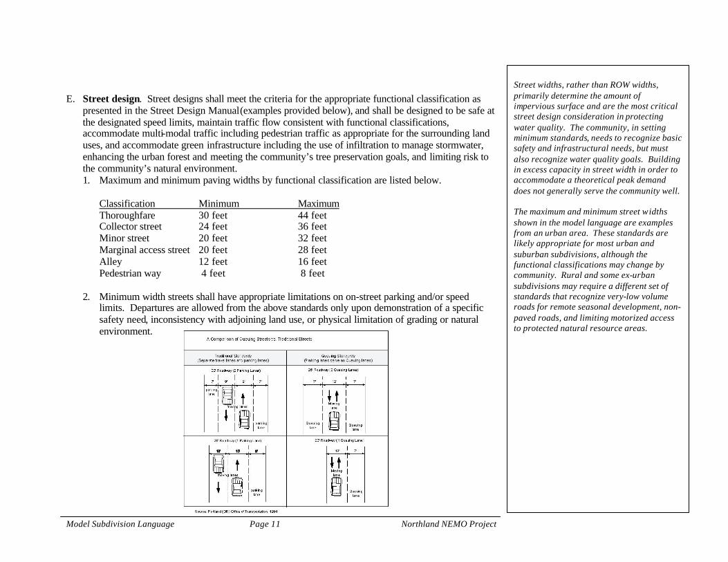
E. Street design. Street designs shall meet the criteria for the appropriate functional classification as
presented in the Street Design Manual (examples provided below), and shall be designed to be safe at the designated speed limits, maintain traffic flow consistent with functional classifications, accommodate multi-modal traffic including pedestrian traffic as appropriate for the surrounding land uses, and accommodate green infrastructure including the use of infiltration to manage stormwater, enhancing the urban forest and meeting the community’s tree preservation goals, and limiting risk to the community’s natural environment. 1. Maximum and minimum paving widths by functional classification are listed below.
Classification Minimum Maximum Thoroughfare 30 feet 44 feet Collector street 24 feet 36 feet Minor street 20 feet 32 feet Marginal access street 20 feet 28 feet Alley 12 feet 16 feet Pedestrian way 4 feet 8 feet
2. Minimum width streets shall have appropriate limitations on on-street parking and/or speed limits. Departures are allowed from the above standards only upon demonstration of a specific safety need, inconsistency with adjoining land use, or physical limitation of grading or natural environment.
Street widths, rather than ROW widths, primarily determine the amount of impervious surface and are the most critical street design consideration in protecting water quality. The community, in setting minimum standards, needs to recognize basic safety and infrastructural needs, but must also recognize water quality goals. Building in excess capacity in street width in order to accommodate a theoretical peak demand does not generally serve the community well. The maximum and minimum street widths shown in the model language are examples from an urban area. These standards are likely appropriate for most urban and suburban subdivisions, although the functional classifications may change by community. Rural and some ex-urban subdivisions may require a different set of standards that recognize very-low volume roads for remote seasonal development, non-paved roads, and limiting motorized access to protected natural resource areas.

Model Subdivision Language Page 12 Northland NEMO Project
F. Grades. The grades in all streets, thoroughfares, collector streets and minor streets in any subdivision shall not be greater than the maximum grades for each classification as follows:
Thoroughfare 5% Collector street 6% Minor street 7%
1. There shall be a minimum grade on all streets and thoroughfares of not less than four-tenths of 1%, and wherever possible grades within 30 feet of minor street intersections with thoroughfares and collector streets shall not exceed 3%.
2. All streets with a grade exceeding 3% shall incorporate specific design elements to divert stormwater from the street. Designs that divert stormwater into pervious surfaces, rain gardens, or other means of using infiltration are encouraged.
G. Deflecting streets . Where horizontal street lines within a block deflect from each other at any one
point more than ten degrees, there shall be a connecting curve with a radius adequate to insure a sight distance of not less than 200 feet for minor and collector streets, and of such greater radii as the Planning Commission shall determine for thoroughfare and other special cases. A tangent of at least 100 feet shall be introduced between reverse curves on arterial and collector streets and 50 feet on other streets.
H. Differing gradients. Differing connecting street gradients shall be connected with vertical parabolic curves. Minimum length, in feet, of these curves for thoroughfare streets shall be 15 times the algebraic difference in the percent of grade of the two adjacent slopes. For minor and collector streets, the minimum length shall be seven and one-half times the algebraic difference in the percent of the two adjacent slopes.
I. Square corners . Under normal conditions, streets shall be laid out so as to intersect as nearly as possible at right angles, except where topography or other conditions justify variations. The minimum angle of intersection of streets shall be 80 degrees. Street intersection jogs with an offset of less than 125 feet shall be avoided.
J. Access roads . Wherever the proposed subdivision contains or is adjacent to the right-of-way of a thoroughfare or limited access highway, provision shall be made for a marginal access street approximately parallel and adjacent to the boundary of such right-of-way, or for a street at a distance suitable for the appropriate use of land between such street and the right-of-way of the thoroughfare or limited access highway. Such distance shall be determined with due consideration of the minimum
Steep grades require additional stormwater mitigation in order to control the velocity, and rate, of runoff. The community should consider ordinance language that requires street design on steep grades to deflect stormwater from the street into pervious areas for infiltration every 100 to 150 feet of street length, or an equivalent design that mitigates for runoff rate. The specific designs will vary greatly by community and by the terrain on the subdivision.

Model Subdivision Language Page 13 Northland NEMO Project
distance required for approach connections to future grade separations, grade crossings or for lot depths.
K. Half streets . Dedication of half streets will not be approved, except where it is essential to the reasonable development of the subdivision and in conformity with the other requirements of these regulations, where it is found that it will be practical to require the dedication of the other half when the adjoining property is subdivided, or where it becomes necessary to acquire the remaining half by condemnation so it may be improved in the public interest.
L. Provision for future division. When a tract is subdivided into larger than building lots or parcels, as set forth in the Zoning Code, such lots or parcels shall be so arranged as to permit the logical location and openings of future streets and appropriate resubdivision, with provision for adequate utility connections for such resubdivisions.
M. Street connectivity. The community requires that subdivisions incorporate designs to increase connectivity to nearby destinations, arterial transportation corridors, and future stages of development. 1. Public right-of-way connections shall be made in the direction of an existing or planned
arterial/collector street, school, employment center, commercial area, or similar neighborhood activity center.
2. A public street connection shall be provided to any existing or approved public street or right-of-way stub abutting the subdivision.
3. Public right-of-way shall be extended to adjacent undeveloped or partially developed land in locations that will not prevent the adjoining property from developing consistent with applicable standards. Adjoining land protected by conservation easement or other permanent protection is exempt from this requirement.
N. Alleys . Alleys shall be allowed for special permit only and when allowed, shall be at least 20 feet wide in areas zoned for residential use, and at least 25 feet wide in other areas. Model Community may require alleys where adequate off-street loading space is not available. Alley intersections and sharp changes in alignment shall be avoided, but where necessary, corners shall be cut off sufficiently to permit safe vehicular movement. Dead-end alleys are prohibited.

Model Subdivision Language Page 14 Northland NEMO Project
X.17 Design Standards; Blocks. A. Block length. In general, intersecting streets, determining block lengths, shall be provided at such
intervals as to serve cross-traffic adequately and to meet existing streets. Where no existing plats control, the blocks in residential subdivisions shall normally not exceed 900 feet in length, except where topography or other conditions justify a departure from this standard. In blocks longer than 900 feet, pedestrian ways or easements through the block are required. The width and location of such pedestrian ways shall be approved by the Planning Commission. Blocks for business or industrial use should normally not exceed 600 feet in length.
B. Block width. The width of the block shall normally be sufficient to allow two tiers of lots of appropriate depth. Blocks intended for business or industrial use shall be of such width as to be considered most suitable for their respective use, including adequate space for off-street parking and deliveries.
X.19 Design Standards; Lots. A. Minimum size , setback. The minimum lot area, width, depth, and street setbacks shall not be less
than that established by the Zoning Code or the Shoreland Ordinance where required. B. Side lines. Side lines of lots shall be approximately at right angles to street lines or radial to curved
street lines. C. Double fronts . Double frontage lots shall be avoided except where lots back on a thoroughfare or
other arterial street, or where topographic or other conditions render subdividing otherwise unreasonable. Such double frontage lots shall have an additional depth of at least 20 feet in order to allow space for screen planting along the back lot line.
D. Frontage . All lots must have at least the minimum required frontage on a public dedicated street, except as set forth in the Zoning Code.
E. Width. All lots must have a minimum of 30 feet in width at the rear lot line. F. Side lot lines. Side lot lines shall be substantially at right angles or radial to the street line. G. Abutting water. Lots abutting on a water course, drainage way, channel, stream or pond shall have
additional depth or width, as required, to assure house sites that are not subject to flooding, that have appropriate stormwater management and vegetated buffer areas, and shall meet all provisions of the Floodplain, Shoreland, and Stormwater ordinances.
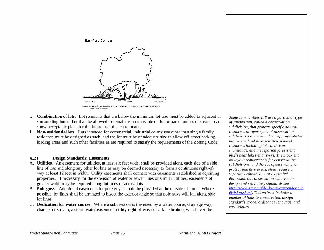
H. Grade and drainage . Lots shall be platted to allow adequate buffers and infiltration of stormwater runoff consistent with the pre-development drainage patterns and soil types. Where one lot drains to another lot consideration shall be made to mitigating stormwater flow across lots and provide sufficient areas for infiltration. An example is provided in the figure below.
Design standards of blocks and lots can affect the community’s water quality by encouraging interconnectivity (reduction of street length) and by accommodating natural topography and natural resources. The standards in this model are urban and suburban in design. Rural and remote communities have additional physical and infrastructural limitations, and have a different character in terms of lot size and block size. Lot layout, in order to address non-point pollution considerations, must incorporate topography, drainage patterns, and the pre-development pattern of buffers and water detention systems that reduce stormwater energy and sediment loads. The backyard corridor figure is an appropriate technique for suburban and ex-urban subdivisions. Higher density urban communities should consider different on-site options for stopping or slowing runoff, such as raingardens serving several lots. In all cases, on-lot areas designated for stormwater control should be protected through easements or covenants. Such an easement requirement is included in Section X.21 below.
Model Subdivision Language Page 15 Northland NEMO Project
I. Combination of lots . Lot remnants that are below the minimum lot size must be added to adjacent or
surrounding lots rather than be allowed to remain as an unusable outlot or parcel unless the owner can show acceptable plans for the future use of such remnants.
J. Non-residential lots. Lots intended for commercial, industrial or any use other than single family residence must be designed as such, and the lot must be of adequate size to allow off-street parking, loading areas and such other facilities as are required to satisfy the requirements of the Zoning Code.
X.21 Design Standards; Easements. A. Utilities. An easement for utilities, at least six feet wide, shall be provided along each side of a side
line of lots and along any other lot line as may be deemed necessary to form a continuous right-of-way at least 12 feet in width. Utility easements shall connect with easements established in adjoining properties. If necessary for the extension of water or sewer lines or similar utilities, easements of greater width may be required along lot lines or across lots.
B. Pole guys . Additional easements for pole guys should be provided at the outside of turns. Where possible, lot lines shall be arranged to bisect the exterior angle so that pole guys will fall along side lot lines.
C. Dedication for water course. Where a subdivision is traversed by a water course, drainage way, channel or stream, a storm water easement, utility right-of-way or park dedication, whichever the
Some communities will use a particular type of subdivision, called a conservation subdivision, that protects specific natural resources or open space. Conservation subdivisions are particularly appropriate for high-value land near sensitive natural resources including lake and river shorelands, and the riparian forests and bluffs near lakes and rivers. The block and lot layout requirements for conservation subdivisions, and the use of easements to protect sensitive areas, often require a separate ordinance. For a detailed discussion on conservation subdivision design and regulatory standards see http://www.sustainable.doe.gov/greendev/subdivision.shtml. This website includes a number of links to conservation design standards, model ordinance language, and case studies.

Model Subdivision Language Page 16 Northland NEMO Project
Planning Commission may deem the most appropriate, conforming substantially with the lines of such water courses shall be provided, together with such further width or construction, or both, as will be adequate for the management of stormwater consistent with the Stormwater Ordinance and the most recent version of the Minnesota Pollution Control Agency’s publication Protecting Water Quality in Urban Areas.
D. Stormwater infiltration and management. Stormwater easements corresponding with lot lines shall be provided where necessary to enhance infiltration and management of stormwater. Such easements shall be not less than 40 feet in width, and shall include a vegetated swale.

Model Subdivision Language Page 17 Northland NEMO Project
X.23 Green Infrastructure Dedication. A. Purpose and findings. Model Community has determined that the health, safety, and general
welfare of the community requires that sufficient land in any new development be dedicated to green infrastructure, including parks, trails, open space, wetlands, habitat, and watershed protection areas. Minnesota Statutes Section 462.358, Subd. 2b provides that municipal subdivision regulations may require that a reasonable portion of any proposed subdivision be dedicated to the public or preserved for conservation purposes or for public use as parks, playgrounds, trails, wetlands, or open space, and that the municipality may alternatively accept an equivalent amount in cash. The community therefore requires that any subdivision of land include a dedication to green infrastructure. Specifically, Model Community finds that: 1. The preservation and development of parks, playgrounds, open space areas, and areas managed
for habitat and watershed protection within Model Community are essential to maintaining a healthy and desirable environment for residents and persons employed within Model Community. Further, the value and attractiveness of residential and commercial/industrial developments to landowners, developers, purchasers, employers, and employees is significantly enhanced by the presence of such green infrastructure.
2. New developments place a burden upon Model Community’s parks and open space system. New facilities must be developed concurrently with development in order to maintain the current level of service and the quality of the environment for all. Therefore, new developments shall be required to contribute toward Model Community’s park system in rough proportion to the relative burden they will place upon the park system, in order to maintain the existing level of service to the community.
3. Development of land for schools creates additional demand on the community’s park and recreational land and facilities, to the extent that the school serves students who do not live within Model Community.
B. Dedication required. The community has determined that dedication of land or other resources for
the community’s green infrastructure is a necessary component of subdividing and developing land. 1. At the time of subdivision, the developer shall dedicate land for public use as parks, playgrounds,
recreation facilities, trails, habitat, public open space, or watershed protection in an amount equal to the development’s proportional share of Model Community’s park and green infrastructure system. Any land dedicated shall be in a location and of a character consistent with and suitable for meeting the green infrastructure needs identified by Model Community’s Comprehensive Plan and Water Plan. Generally, land located within flood plains or wetlands and stormwater detention
New development in a community offers both the benefits and drawbacks of growth. Parks, trails, natural areas, wetlands, buffer areas, and other green infrastructure are public assets that are used more heavily when land is subdivided and developed. Theses public assets can, however be supplemented by requiring a dedication of land or other resources at the time of the subdivision. Such dedications are often called park dedication. This ordinance language takes a broader perspective on the dedication and refers to it as a green infrastructure dedication. The purpose and finding lays out the statutory basis for requiring a dedication , and includes the policy basis, consistent with the community’s comprehensive plan, upon which the dedication requirement is based. The dedication formula, identifying a reasonable amount of land to dedicate, can differ among communities but should be based on maintaining a quantifiable level of service. The community needs to identify a clear and fair method of assigning proportional responsibility to new developments.

Model Subdivision Language Page 18 Northland NEMO Project
ponds shall not be accepted to meet the proportional share of required land dedication. Permanently protected (using conservation easements) buffer areas outside of wetlands or floodplains, watershed protection areas, and stormwater rain gardens, shall generally be accepted.
2. If Model Community determines that land is not needed in the area of the proposed subdivision, the community may alternatively accept payment of an equivalent amount in cash. Any such cash payment shall be used solely for the acquisition and improvement of land for parks, playgrounds, trails, public open space, watershed protection, or as otherwise provided by statute. The undeveloped land value shall be used to determine the cash payment required in lieu of land dedication up to a maximum cash payment of $_____ per dwelling unit for residential development or $_____ per acre for commercial/industrial development or schools.
3. If Model Community Council determines that land is needed in the development, but in a lesser amount than the required proportionate share, the Council may require payment of cash in lieu of land dedication based on a pro-rata share of the land dedication that otherwise would be required.
4. The dedication requirements based on the development’s proportional share of Model Community park system are presumptively appropriate. A developer may request a deviation from the presumptive requirements based upon the anticipated impact of that particular subdivision. The request must be made to Model Community Council as part of an application for final plat approval.
X.25 Tree Preservation. A. Purpose, intent, and scope . It is the policy of Model Community to recognize and protect the
integrity of the natural environment of the community through the preservation, protection, and planting of trees. Model Community Council has found it necessary and desirable to establish requirements for the preservation of trees on new development sites. The objectives of this ordinance shall include, but are not limited to: 1. the perpetuation of the existing tree canopy through root protection by eliminating or reducing
compaction, filling or excavation; 2. prevention of soil erosion and sedimentation; 3. reduced storm water runoff; 4. improved air quality; 5. reduced noise pollution; 6. energy conservation through natural insulation and shading; 7. control of the urban heat island effect; 8. increased property values;
The community has at its discretion the option of requiring a cash payment in lieu of a land dedication, as noted in Section X.23B.2. The cash dedication must, however, be segregated from general funds and clearly be used meet green infrastructure requirements. Tree cover has a distinctively beneficial impact on water quality in the community. In addition to reducing the volume of runoff by absorbing rain, trees shade impervious surface and reduce the temperature of runoff, increase the surface area for rain to collect (on leaves and branches), and increase local transpiration. The model subdivision ordinance therefore includes basic language for tree preservation in the subdivision and development process. The specific standards through which communities will require trees to be preserved during development will vary considerably among communities, and are not therefore included here. Generally, native trees have a higher value than non-
Model Subdivision Language Page 19 Northland NEMO Project
9. protection of privacy by establishing and maintaining buffers between conflicting land uses; 10. providing habitat for wildlife; 11. conservation and enhancement of Model Community's unique natural ecosystem; and 12. to provide an ecosystem approach to planning and development.
native species, and older trees have a higher value than younger trees. Communities can also assess value of existing forest cover from a landscape perspective, where stands with a mix of trees meets the ecological standards for the area. The methods for tree preservation should also include provisions for mitigation, as inevitably some high value trees or stands will need to be removed to allow for road or home construction.

Model Subdivision Language Page 20 Northland NEMO Project
X.27 Basic Improvements Required in Developments. A. Policy. As soon as practicable after approval of the proposed plat the developer shall arrange for the
installation of telephone, electrical and natural gas service and for the installation of all of the following improvements within the subdivision: 1. sanitary sewage disposal; 2. street grading and paving; 3. stormwater management and conveyance systems; 4. boulevard sodding; 5. drainage; 6. water. 7. sidewalks, if required.
B. Supervision. Except for telephone, electrical and natural gas service, the installation of the above improvements shall be under the control and supervision of Model Community Engineer who shall specify the manner in which such installations shall be made.
C. Monuments . No final plat shall be approved by the Council unless the owner or subdivider shall have placed the installed survey monuments of a permanent character at all points as shown on the final plat as required by the Engineer and the County Surveyor. All United States, state, county or other official bench marks, monuments or triangulation stations in or adjacent to the property shall be preserved in precise position.
X.29 Erosion Control. A. Required erosion control plan. Prior to commencing any earth disturbing activity in a subdivision,
the subdivider shall prepare and submit to Model Community Engineer an erosion control plan consistent with NPDES Phase II requirements and the community’s Erosion and Sediment Control Ordinance. Development shall not proceed without approval from the Engineer. The plan shall be approved if it complies with the Zoning, Subdivision, Erosion and Sediment Control, and Stormwater ordinances.
X.31 Subdivision contract. In order to effectuate the provisions of this Section, the owner or subdivider shall enter into a subdivision contract with Model Community providing for the installation of the improvements required by this Section. The subdivision contract shall provide for, among other
The final sections included in the model subdivision ordinance describe infrastructural requirements for all developments, consistency with the erosion control standards in local, state, and federal law, and the conditions under which variances to this ordinance can be granted.

Model Subdivision Language Page 21 Northland NEMO Project
things, security to Model Community in the form of a surety bond, or cash in lieu thereof, in such amount as Model Community Engineer shall deem to be adequate to insure the satisfactory completion of the improvements. The subdivision contract shall be satisfactory in form and substance to Model Community Attorney. X.33 Variances. A. General conditions . The Planning Commission may recommend a variance from the provisions of
this Section as to specific properties when, in its judgment, an unusual hardship on the land exists. In granting a variance, the Commission must prescribe conditions necessary or desirable in the public interest to ensure that the community’s goals and policies are still met. In making its findings, as required below, the Commission shall consider the nature of the proposed use of the land and the existing use of land in the vicinity, the number of persons to reside or work in the proposed subdivision, and the probable effect of the proposed subdivision upon traffic conditions and water quality. No variance shall be granted unless the Commission finds: 1. That there are special circumstances or conditions affecting the specific property such that the
strict application of the provisions of this Section would deprive the applicant of the reasonable use of the land.
2. That the variance is necessary for the preservation and enjoyment of a substantial property right of the applicant. Economic hardship does not constitute the infringement of a substantial property right.
3. That the granting of the variance will not be detrimental to the public welfare or injurious to other property in the territory in which the property is situated.
4. That the variance can be conditioned such that the communities goals and policies, as elucidated in the community’s ordinances, Comprehensive Plan, and Water Plan, are still met.
The Commission findings in granting or denying a variance shall be in writing and filed with Model Community Clerk.
B. Application required. Applications for any variance under this Subsection shall be submitted in
writing by the owner or subdivider at the time the preliminary plat is filed for consideration by the Planning Commission, and shall state all facts relied upon by the applicant, and shall be supplemented with maps, plans or other additional data which may aid the Commission in the analysis of the

Model Subdivision Language Page 22 Northland NEMO Project
proposed project. The plans for such development shall include such covenants, restrictions or other legal provisions necessary to guarantee the full achievement of the plan for the proposed project.
C. Public meeting. A public meeting shall be scheduled before the Planning Commission on all applications for any variance under this Subsection so that the public has an opportunity to express its views on a proposed variance. At least ten days before the date of the meeting, a written notice shall be mailed to the applicant and to all owners of property located within one hundred (100) feet of the boundaries of the property that is the subject of the application.