modeling the spatial distribution of stegomyia
TRANSCRIPT

Master´s Thesis
Geography
Development Geography
MODELING THE SPATIAL DISTRIBUTION OF CULEX AND STEGOMYIA
MOSQUITOES COLLECTED IN THE TAITA HILLS, KENYA IN 2016,
WITH NOTES ON OTHER GENERA
Ruut Uusitalo
2017
Supervisors: Mika Siljander, Petri Pellikka, Lorna Culverwell, Kristian Forbes
UNIVERSITY OF HELSINKI
DEPARTMENT OF GEOSCIENCES AND GEOGRAPHY
DIVISION OF GEOGRAPHY
P.O. Box 64 (Gustaf Hallstromin katu 2a)
FI-00014 University of Helsinki Finland

2
Tiedekunta/Osasto Fakultet/Sektion – Faculty
Faculty of Science Laitos/Institution– Department
Department of Geosciences and Geography Tekijä/Författare – Author
Ruut Uusitalo Työn nimi / Arbetets titel – Title
Modeling the spatial distribution of Culex and Stegomyia mosquitoes collected in the Taita Hills, Kenya in 2016, with
notes on other genera Oppiaine /Läroämne – Subject
Development geography
Työn laji/Arbetets art – Level
Master´s Thesis Aika/Datum – Month and year
May 2017 Sivumäärä/ Sidoantal – Number of pages
103 pp. + appendices Tiivistelmä/Referat – Abstract
Mosquitoes are arguably amongst the most economically and socially important animals on the planet due to their ability to act as
vectors for pathogens, including parasites and viruses, from animals to humans, or between humans. Mosquito-borne diseases (MBDs),
are contracted following infection by one or more mosquito borne viruses (MBVs) or parasites, including dengue virus (DENV),
chikungunya virus (CHIKV), Zika virus (ZIKV), West Nile virus (WNV), yellow fever virus (YFV) and malaria, and annually cause
more than one million human deaths (WHO 2016). MBDs are contracted after an infected mosquito transfers one or more pathogens in
the course of blood feeding from one host to another. Three important genera which act as vectors for many pathogens are Anopheles,
Culex and Stegomyia and they are most problematic in the tropical and subtropical regions of Asia, South America and Africa (WHO
2016).
Among vector-borne diseases (VBDs), MBDs have the strongest dependence on environmental factors. These factors have either direct
or indirect impact on mosquito presence and abundance as mosquitoes are dependent on habitat suitability (Franklin & Miller 2010;
Rasheed et al. 2013). This study will utilize species distribution modeling (SDM) to investigate the relationship between environmental,
anthropogenic and distance factors on the occurrence of mosquito species. It forms part of an ongoing Wildlife screening project, led by
Prof. Olli Vapalahti, which aims to screen mosquitoes, rodents and bats for new and known viruses in Kenya. The absence of previous
studies of the geographical distribution and habitat suitability patterns of mosquito species over the Taita Hills region in southeastern
Kenya, justifies the need for this research.
This project has three main objectives: 1) to investigate which mosquito genera are distributed in the Taita Hills, and how they are
distributed, 2) to examine which factors best explain the presence of Culex and Stegomyia mosquitoes, 3) to test whether any of the
available statistical regression models can reliably estimate the distribution of Culex and Stegomyia mosquitoes, and to build predictive
maps for estimations created by the most reliable models.
Biological, Geographic Information Systems (GIS) and statistical methods were combined in the study. Data consists of occurrence,
environmental, anthropogenic, distance and biological data. The specimens were collected from 122 locations from January–March
2016 throughout the Taita Hills. Environmental, anthropogenic and distance data were acquired from the satellite and aerial imagery
and produced in ArcMap. The biomod2 package, intended for ensemble forecasting of species distributions in R, was used to generate
models.
After multicollinearity of the environmental, anthropogenic and distance factors was pruned, the best estimating predictor variables
were selected. The factors that best estimated the distribution of Culex were slope, human population density, NDVI, distance to roads
and elevation. This resulted in six reliable models with accurate estimation values. Multivariate adaptive regression splines (MARS) resulted area under the curve (AUC)- value of 0.806, and a traditional Generalized linear model(GLM) brought an AUC- value of 0.730
with high statistical significance rates, both above the value for a good model fit (AUC ≥0.7); thus ensuring a reliable estimation.
Five environmental, anthropogenic and distance factors best estimated the distribution of Stegomyia: mean radiation in January–March,
human population density, NDVI, distance to roads and mean temperature in January–March. By these predictors, biomod2 resulted in
highest AUC- values for generalized boosted model (hereafter GBM) and random forest (RF) with AUC- value of 0.708 for each. Hence, reliable estimations resulted for both Culex and Stegomyia, which are visualized by the probability of presence maps in the
Results chapter. The results may be used as a guide for public health officials in the Taita region regarding the distribution, favorable
habitats and prevention strategies of Culex and Stegomyia mosquitoes, which are capable of transmitting mosquito-borne infections. Avainsanat – Nyckelord – Keywords
species distribution modeling, mosquito-borne diseases, biomod2, predictive maps, mosquitoes, ecological statistical
modelling
Säilytyspaikka – Förvaringställe – Where deposited
University of Helsinki, Kumpula Science Library Muita tietoja – Övriga uppgifter – Additional information

3
Tiedekunta/Osasto Fakultet/Sektion – Faculty
Matemaattis-luonnontieteellinen tiedekunta
Laitos/Institution– Department
Geotieteiden ja maantieteen laitos Tekijä/Författare – Author
Ruut Uusitalo Työn nimi / Arbetets titel – Title
Modeling the spatial distribution of Culex and Stegomyia mosquitoes collected in the Taita Hills, Kenya in 2016, with
notes on other genera
Oppiaine /Läroämne – Subject
Maantiede Työn laji/Arbetets art – Level
Pro gradu Aika/Datum – Month and year
Toukokuu 2017 Sivumäärä/ Sidoantal – Number of pages
103 + liitteet Tiivistelmä/Referat – Abstract
Hyttyset ovat yksi taloudellisesti ja sosiaalisesti merkittävimmistä eläinlajeista planeetallamme, sillä ne kykenevät välittämään taudinaiheuttajia, kuten loisia tai viruksia, eläimistä ihmisiin ja ihmisistä toisiin. Hyttysten levittämät taudit syntyvät yhden tai useamman
hyttysen levittämän viruksen tai loisen aiheuttamana tartuntana. Tällaisia tartuntatauteja ovat dengue virus (DENV), chikungunya virus
(CHIKV), Zika virus (ZIKV), malaria, Länsi-Niilin virus ja keltakuume, jotka ovat aiheuttaneet vuosittain yli miljoona kuolemaa maailmanlaajuisesti (WHO 2016). Hyttysten levittämät sairaudet syntyvät, kun tartunnan saanut hyttynen siirtää yhden tai useamman
taudinaiheuttajan isännästä toiseen veren imemisen aikana. Kolme hyttyssukua; Anopheles, Culex ja Stegomyia (Aedes), toimivat
merkittävimpinä taudinaiheuttajien välittäjinä synnyttäen ongelmallisimman tilanteen erityisesti Aasian, Etelä-Amerikan ja Afrikan trooppisilla ja subtrooppisilla alueilla (WHO 2016).
Vektorien välittämistä taudeista, hyttysten levittämät taudit ovat läheisimmin yhteydessä ihmistoimintaan liittyviin tekijöihin sekä
ympäristötekijöihin. Ympäristötekijöillä on joko suora tai epäsuora vaikutus hyttysten esiintymiseen, sillä hyttyset ovat riippuvaisia
suotuisasta elinympäristöstä (Franklin & Miller 2010; Rasheed et al. 2013). Tämä tutkimus hyödyntää lajilevinneisyysmallinnusta hyttyshavaintojen, ympäristömuuttujien ja ihmistoimintaan liittyvien muuttujien välisten suhteiden tarkastelussa. Tämä tutkimus on osa
prof. Olli Vapalahden luotsaamaa Villieläinten seulonta-projektia, jonka tavoitteena on löytää uusia lajeja ja etsiä mahdollisia viruksia
jyrsijöistä, lepakoista ja hyttysistä Keniassa. Hyttyslajien maantieteelliseen levinneisyyteen ja elinympäristöyhteyksiin liittyvien aiempien tutkimusten puuttuminen vahvistaa tarvetta lisätutkimukselle Taita Hillsin alueella Kaakkois-Keniassa.
Tutkimuksella on kolme päätavoitetta: 1) tutkia, mitä hyttyssukuja Taita Hillsin alueella esiintyy, ja miten kerättyjen hyttyssukujen levinneisyys sijoittuu alueellisesti 2) tarkastella, mitkä tekijät selittävät parhaiten Culex ja Stegomyia hyttysten levinneisyyttä, 3) antaa
vastaus hypoteesiin; voiko jokin tilastollinen malli ennustaa uskottavasti Culex ja Stegomyia hyttysten levinneisyyttä. Mahdollisten
luotettavien mallien avulla on lisäksi tarkoitus ennustaa hyttyslajien levinneisyyttä ennustekartoin.
Tässä tutkimuksessa yhdistettiin biologisia, tilastollisia, ja paikkatietojärjestelmiin perustuvia tutkimusmetodeita. Tutkimusaineisto
sisältää havaintoaineiston, ympäristöaineiston, ihmistoimintaan ja etäisyyksiin perustuvan aineiston sekä biologisen aineiston. Näytteitä kerättiin yhteensä 122 sijainnista Taita Hillsin alueella tammi-maaliskuussa 2016. Ympäristöaineisto sekä ihmistoimintaan ja etäisyyksiin
perustuvat aineistot saatiin satelliitti- ja ilmakuvista, ja ne tuotettiin ja muokattiin ArcMap- ohjelmassa. Analyysissä käytettiin biomod2-
ohjelmapakettia, joka on lajilevinneisyyden ennustamiseen tarkoitettu alusta R-ohjelmointiympäristössä.
Selittävien muuttujien eli ennustemuuttujien korrelaatioiden testauksen jälkeen parhaiten ennustavat muuttujat valittiin lopulliseen
malliin. Parhaiten Culexin levinneisyyttä ennustavia tekijöitä olivat rinnekaltevuus, asukastiheys, NDVI, etäisyys tiehen sekä korkeus. Tämä tuotti 6 luotettavaa ennustemallia korkeilla ennustearvoilla. Multivariate adaptive regression splines (MARS) tuotti AUC(Area
under curve)-arvon 0.806, ja perinteinen yleistetty lineaarinen malli(GLM) tuotti AUC-arvon 0.730 tilastollisesti merkitsevillä arvoilla.
Kumpikin malli sai hyvän mallin sovittamisen ylittävän AUC-arvon (AUC ≥0.7), ja tuotti näin luotettavan ennusteen Culex ja Stegomyia hyttysten lajilevinneisyydelle.
Stegomyia- hyttysten levinneisyyttä ennusti parhaiten viisi ennustemuuttujaa mukaan lukien keskisäteily, asukastiheys, NDVI, etäisyys tiehen sekä keskilämpötila. Näillä muuttujilla, korkeimmat AUC-arvot tuotti yleistetty luokittelupuumenetelmä (GBM) ja satumetsä(RF),
AUC-arvoilla 0.708. Kummallekin hyttyssuvulle, Culexille ja Stegomyialle syntyi luotettavia levinneisyysennusteita, jotka esitetään
todennäköisyyskarttoina Results-osiossa. Tutkimuksen tuloksia voidaan hyödyntää terveysviranomaisten ohjenuorana hyttysperäisiä tauteja levittävien Culex ja Stegomyia hyttysten suotuisten elinympäristöjen kartoittamisessa, sekä niiden esiintymiseen ja tautien
ehkäisyyn liittyvien strategioiden tukena Taita Hillsin alueella. Avainsanat – Nyckelord – Keywords
Lajilevinneisyysmallinnus, SDM, hyttysten levittämät taudit, biomod2, ennustekartat, hyttyset, ekologinen tilastollinen
mallinnus Säilytyspaikka – Förvaringställe – Where deposited
Helsingin yliopisto, Kumpulan tiedekirjasto Muita tietoja – Övriga uppgifter – Additional information

4
Contents
1. Introduction
2. Research objectives
3. Theoretical background
3.1 Mosquitoes
3.1.1 Culex and Stegomyia
3.1.2 Culex and Stegomyia as vectors of viruses
3.1.3 Other mosquito genera collected in the Taita Hills
3.1.4 Changing habitats
3.2 Methodological framework
3.2.1 The species distribution modeling process
3.2.2 Factors affecting mosquito distribution
3.2.3 Possible advantages in the use of species distribution modeling
4. Study area
5. Materials
5.1 Sampling design
5.2 Occurrence data
5.2.1 Mosquito collections
5.2.2 Species processing and identification
5.3 Environmental, anthropogenic and distance data
5.3.1 Mean precipitation, mean temperature and mean relative humidity
5.3.2 Land cover and Normalized difference vegetation index (NDVI)
5.3.3 Elevation, slope and mean radiation
5.3.4 Human population density and distance variables
5.3.5 Building design

5
6. Analysis and modeling methods
6.1 Modeling process
6.2 Data preparation and compilation
6.2.1 Multicollinearity
6.2.2 Spatial autocorrelation (SAC)
6.3 Model fitting
6.3.1 Generalized linear model (GLM)
6.3.2 Generalized additive model (GAM)
6.3.3 Classification tree analysis (CTA)
6.3.4 Artificial neural networks (ANN)
6.3.5 Multivariate adaptive regression splines (MARS)
6.3.6 Generalized boosted regression model (GBM)
6.3.7 Random forest (RF)
6.3.8 Maximum entropy model (Maxent)
6.4 Model selection and prediction
6.5 Model evaluation
7. Results
7.1 Observed mosquito genera and their distribution in the Taita Hills
7.2 The multicollinearity of environmental, anthropogenic and distance variables
7.3 Variable contributions in estimations of Culex and Stegomyia distributions
7.4 Evaluating the best model to estimate Culex and Stegomyia distributions
7.5 Predictive maps of potential Culex and Stegomyia distributions
8. Discussion and conclusions
8.1 Differences in the use of presence-only and presence-absence data
8.2 Uncertainties relating to the collections and the modeling process
8.2.1 Conditions in field work

6
8.2.2 Spatial autocorrelation (SAC) of predictor variables
8.2.3 Other uncertainties in model development
8.3 Notes about the mosquito genera of the Taita Hills
8.4 Influential factors for Culex and Stegomyia
8.5 A potential new predictor for modeling mosquito distributions
8.6 Model validity or incompetence
8.7 Potential distribution of Culex and Stegomyia in the Taita Hills
8.8 Conclusion
Acknowledgements
References
Abbreviations

7
List of Figures
Figure 1. Culex (1.) and Stegomyia (2.) females. Culex mosquitoes are frequently unicolorous,
brown species, while Stegomyia are dark mosquitoes with white scale patches. ..................... 18
Figure 2. Five genera in addition to Culex to Stegomyia were confirmed from Taita. 1.
Anopheles. 2. Aedimorphus. 3. Uranotaenia. 4. Eretmapodites. Lutzia tigripes is absent in the
photos. ...................................................................................................................................... 21
Figure 3. A. A collection environment, where a high amount of Culex larvae and adults, were
detected. The pond was located at an altitude of 1700 meters close to Yale, the second highest
top in the Taita Hills. B. This tree hole situated in the Ngangao montane forest. Tree holes are
potential occurrences of unrecognized mosquito species. C. Stegomyia aegypti larvae were
found in old car tyres filled with water..................................................................................... 23
Figure 4. The SDM process is introduced stepwise (Franklin & Miller 2010). Occurrence,
environmental, anthropogenic and distance data in each collection site are combined to the
same data matrix. Afterwards, highly correlated explanatory variables are removed and
models are run, resulting in response curves and maps for estimating the species distributions.
.................................................................................................................................................. 25
Figure 5. The Taita Hills is located 150 kilometers from Mombasa and is surrounded by the
plains in southeastern Kenya. ................................................................................................... 28
Figure 6A. Stegomyia aegypti larvae which have been mounted on a microscope slide to aid
their identification. Note that the last few segments of each specimen have been removed in
order to best view the necessary characters from the side, and mounted away from the rest of
the specimen. B. Larvae were reared to adults in zip lock bags filled with water from the
collection habitats. .................................................................................................................... 31
Figure 7. Occurrence data includes 122 collection points over the Taita Hills mainly following
the sampling method where collection sites were located within an altitude range of 100
meters from one another. .......................................................................................................... 33
Figure 8. A. A microscope was vital to sort mosquitoes by their appearance and by sex. B.
The procedure of specimen processing. Mosquitoes were initially sorted by sex and
appearance, and subsequently they were placed into either a tube of RNA-later with the
purpose of virus isolation, into a tube of ethanol with the purpose of DNA extraction
(Culverwell, pers.comm), and a small number were mounted onto cardboard points and
pinned for morphological examination. Males of some species also had genitalia removed and
dissected onto a microscope slide, to facilitate species identification. ..................................... 35

8
Figure 9. A. Mean precipitation (mm) in January–March in the study area varies between 20–
120 mm per month. The mountain areas receive the highest precipitation rates. B. Mean
temperature varies from 14 C° up to 25 C°. Temperature is highest on the plateau and lowest
in the mountain areas. C. Mean relative humidity ranges between 71 and 97 per cent being
greatest at high altitudes. .......................................................................................................... 39
Figure 10. A. The most common land cover types in Taita are cropland and woodland.
Broadleaved forest occur in the biodiversity hotspots. B. NDVI values range between -1 and
1. Greenest area in the north is in Ngangao broadleaved forest and greenest area in the south
is Chawia broadleaved forest. The areas with poor vegetation are located on the plateau. ..... 40
Figure 11.A. In Taita, the altitude ranges between 670 meters and 2200 meters. The
surrounding area is characterized by plateau. B. The mountain areas can be recognized by the
values of slope angles. C. Solar radiation values are highest on the plateau and lowest in the
forestall areas. ........................................................................................................................... 42
Figure 12. A. Locations of the largest villages in Taita can be recognized by the highest
population densities. B. The locations with more than 300 meters to nearest house are situated
either in the forestall area or in the national parks, such as Tsavo West national park in the
west and Lumo national park in the southwest. C. The forestal areas are the longest distance
(800–1800m) from the nearest roads. ....................................................................................... 43
Figure 13. A. A traditional house built by clay in Kishushe in the Taita Hills. B. EPS panels or
cement, have become popular building materials in the area. .................................................. 45
Figure 14. Houses built by modern design in the collection locations, were mainly located
close to villages, and traditional huts were primarily located in remote areas. ........................ 46
Figure 15. Culex mosquitoes were collected at varying altitudes both on the plains and in the
mountainous area. ..................................................................................................................... 58
Figure 16. Stegomyia was detected in a variety of habitats all over the Taita Hills. ................ 59
Figure 17. Five genera other than Culex or Stegomyia were found in the Taita Hills. Lutzia
was found across the Taita. Anopheles was found only in a few locations. Aedimorphus was
collected from Chawia montane forest. .................................................................................... 61
Figure 18. Population density and NDVI were influential factors to Culex estimations in GLM
model. ....................................................................................................................................... 65

9
Figure 19. The response curves for Culex estimations by GLM model. We can notice that
only population density and NDVI influence the probability of presence values in the GLM.
The tick marks on the x-axis imply observations. .................................................................... 65
Figure 20. Population density was a major factor also in GAM model, but other predictors
were also influential.................................................................................................................. 66
Figure 21. Response curves of predictors for Culex estimations by GAM model. Each
predictor variable responds to the probability of presence of Culex mosquitoes. The black tick
marks on the x-axis mean observations. ................................................................................... 67
Figure 22. Population density and temperature were the only influential factors in the GBM
model when distance to roads, NDVI and mean radiation were not important........................ 68
Figure 23. Population density and NDVI were major factors also in the random forest model,
but other predictors were also influential. ................................................................................ 69
Figure 24. The response curves of predictors for Stegomyia estimations in generalized boosted
model. Only human population density and mean temperature responded to the probability of
presence for Stegomyia. The black tick marks on the x-axis imply observations. ................... 70
Figure 25. The response curves of predictors for Stegomyia estimations in random forest
model. Each predictor variable responded to the probability of presence of Stegomyia. The
black tick marks on the x-axis imply observations................................................................... 71
Figure 26. An influence of NDVI and human population density factors can be recognized in
the GLM-based prediction map. ............................................................................................... 74
Figure 27. A GAM model estimated well the presence of Culex. The probability of Culex
presence was highest (80–100%) in the central and southern Taita Hills. The lowest
likelihoods for presence occurred on the surrounding plateaus. .............................................. 75
Figure 28. A GBM model estimated the presence of Stegomyia. The probability of presence
was highest (60–80%) on the plateau. The lowest likelihoods for presence (0–20%) occurred
at the high elevations. ............................................................................................................... 76
Figure 29. The random forest model estimated the presence of Stegomyia. The probability of
presence was highest (80–100%) in many fragmented locations. This phenomenon verifies the
Stegomyia´s ability to adapt to new habitats. ........................................................................... 77

10
Figure 30. Spatial autocorrelation of slope, population density, NDVI, distance to roads and
elevation. Population density and elevation were highly autocorrelated variables in the short
distances but not in the longer distances. Slope was slightly autocorrelated for short distances
as well as NDVI and distance to roads. Red rounds indicated the significant p-value (p <0.05)
and were located at distances where variable was autocorrelated. ........................................... 80
Figure 31. Spatial autocorrelation of mean radiation, population density, NDVI, distance to
roads and mean temperature. Population density and temperature were highly autocorrelated
in the short distances but not for the longer distances. Mean radiation was very little
autocorrelated for short distances. Distance to roads and NDVI were slightly autocorrelated
for short distances. Red rounds indicated the significant p-value (p<0.05) and were located at
distances where variable is autocorrelated. .............................................................................. 81
Figure 32. A. The distribution of prediction accuracy for Culex. A majority of the models
accurately estimated (AUC ≥0.7 or κ ≥0.4 or TSS ≥0.4) the distribution of Culex apart from
few residuals. B. The division of prediction accuracy for Stegomyia differs from the left
Figure, as a majority of models didn´t estimate Stegomyia accurately (AUC ≤0.7) apart from
generalized boosted regression model and random forest model. ............................................ 86
Figure 33. The number of observed mosquitoes in each building design. The majority of large
collections were implemented in modern buildings. Buildings with traditional design were not
favorable occurrence sites for mosquitoes................................................................................ 87

11
List of tables
Table 1. The range of values in explanatory variables in the collection sites, the data source
and description. ......................................................................................................................... 37
Table 2. The classification of AUC, Kappa and TSS (Mason & Graham 2002; Cohen 1960;
Peirce 1884). ............................................................................................................................. 55
Table 3. Selected Culex predictors were mainly not highly correlated. Correlation (r) between
NDVI and elevation was higher than 0.5 but NDVI was retained in the model. ..................... 62
Table 4. Selected Stegomyia predictors were not highly correlated apart from NDVI and mean
temperature which obtained r > -0.5. Nevertheless, they were included the model. ................ 63
Table 5. Variable importance presented in each model for Culex estimations. Overall, human
population density was the most influential predictor. Elevation had surprisingly little effect
on Culex distributions. .............................................................................................................. 64
Table 6. Variable contributions of Stegomyia predictors are introduced by each model.
Overall, population density was the most influential predictor, but other predictors were also
important. .................................................................................................................................. 68
Table 7. AUC-, Kappa- and TSS values of all resulted models for Culex are shown below. .. 72
Table 8. AUC-, Kappa- and TSS values of all resulted models for Stegomyia are shown
below. ....................................................................................................................................... 72

12
Abbreviations
AIC Akaike information criterion
An. Anopheles
ANN Artificial neural networks
AUC Area under the curve
CDC Centers for Disease Control and Prevention
CHIKV Chikungunya virus
CTA Classification tree analysis
Cx Culex
DEM Digital elevation model
DENV Dengue virus
GAM Generalized additive model
GARP Hybrid methods
GBM Generalized boosted model
GLM Generalized linear model
GIS Geographic information systems
GPS Global positioning systems
Lt Lutzia
MARS Multiple adaptive regression splines
Maxent Maximum entropy modeling
MBD Mosquito-borne disease
MODIS Moderate Resolution Imaging Spectroradiometer
MTI Mosquito Taxonomic Inventory
NDVI Normalized difference vegetation index
RF Random forest
RMSE Root mean squared error

13
ROC Receiver operating characteristic
SAC Spatial autocorrelation
SDM Species distribution modeling
SPOT Satellite Pour l'Observation de la Terre
St. Stegomyia
ZIKV Zika virus
YFV Yellow Fever virus
VBD Vector-borne disease
WHO World Health Organization
WNV West Nile virus

14
1. Introduction
Mosquitos (Diptera: Culicidae) are important vectors for numerous potentially deadly
diseases, which cause millions of deaths each year. The most deadly of these are
chikungunya, West Nile virus, malaria, yellow fever, Zika virus and dengue virus of which
malaria alone caused 438 000 deaths worldwide in 2015 (WHO 2016a). Additionally, the
incidence of dengue has risen 30-fold in the past three decades (WHO 2016c). It is estimated
that 390 million dengue cases occur each year, of which 96 million are present with clinical
symptoms (Bhatt et al. 2013).
The Afrotropical region is at high risk of many mosquito-borne diseases and Sub-Saharan
Africa carries high share of the global malaria burden with 88% of total cases and 90% of
deaths (WHO 2016a). Recently, new outbreaks of mosquito-borne diseases have been
reported in many African countries; in Angola, Uganda and the Democratic Republic of the
Congo new Yellow fever outbreaks were reported in 2016 (WHO 2016b). In addition to this,
Africa is the second most affected continent for Dengue fever, with 16% of global dengue
infections, thus, Southeastern African countries including Kenya, have been identified as risk
areas for dengue infections (CDC 2012).
The first laboratory-confirmed dengue outbreak occurred in Kenya in the early 1980s (CDC
2012). An outbreak of non–malarial illness was reported in 2013, it was estimated that 13 %
of participants were actually infected with dengue virus but were diagnosed with malaria
(Sharp 2015). In Kenya, as elsewhere in Africa, dengue is commonly misdiagnosed as malaria
based on the lack of laboratory- based diagnostic testing (Attaway et al. 2014). In 2016, the
Ministry of Health of Kenya alerted the WHO of an outbreak of chikungunya virus in
Mandera East in northern Kenya (WHO 2016b). These events call for improved medical tests
and diagnoses, and also the geographical association of disease vectors in Kenya.
One way to estimate disease risk, is by utilizing the species distribution modeling (hereafter
SDM) for vector species (Franklin & Miller 2010). Among vector-borne diseases (hereafter
VBDs), mosquito-borne diseases (hereafter MBDs) have the strongest correlation with
environmental factors (Rasheed et al. 2013). Habitat suitability has both a direct and indirect
impact on mosquito presence and abundance (Franklin & Miller 2010). Environmental and

15
anthropogenic disturbances such as climate change, urbanization, deforestation and pollution
represent crucial factors in the emergence of both mosquito species and MBDs. Studying
mosquitoes through SDM has many advantages. When the species whose potential habitat is
predicted are of medical or veterinary importance, the results of SDM may serve public health
goals and support epidemiological studies (Franklin & Miller 2010). Public health officials in
the Taita Hills may find the species- environment concentration useful when planning
interventions, to indicate the areas where the virus vectors are likely to be found, or where
they will potentially spread to in the near future.
This study is a part of ongoing multidisciplinary Wildlife screening- project led by Professor
Olli Vapalahti from the Department of Virology at the University of Helsinki, and
implemented by researchers with biological and virological backgrounds. The purpose of the
project is to investigate the prevalence and distribution of Dengue virus in mosquito and
human hosts in the Taita Hills in southeastern Kenya. The thesis has an interdisciplinary
background linked to public health concern, ecological gradient analysis and biogeography in
addition to GIS. Data collections were implemented in January-March in 2016 resulting in a
sample size of approximately 4000 mosquitoes. Specimens were analyzed at the University of
Helsinki. As part of the project, my thesis study focuses on estimating the distribution of virus
vectors Culex and Stegomyia.
Several studies have used SDM when modeling the distribution of mosquito species. Recent
SDM mosquito studies have mostly used Maximum entropy model (Maxent) as a model
algorithm (Mughini-Gras et al. 2014; Sallam et al. 2016; Fatima et al. 2016; Larson et al.
2010; Conley et al. 2014). Additionally, in a few mosquito studies, the random forest model
has been used to estimate the distributions of mosquito species (Ibañez-Justicia et al. 2015;
Kwon et al. 2015). In this study, presence-absence data of genus observations was used in the
biomod2 package, an ensemble platform for SDM in R statistical computing software
(Thuiller et al. 2016). Biomod2 has been used in several studies, including modeling eastern
mosquitofish (Gambusia affinis) distributions and distributions of invasive freshwater bivalve
species (Murphy et al. 2015; Gama et al. 2016). Biomod2 has not been previously used in
modeling mosquito distributions, therefore this study may demonstrate additional applications
in this research area.

16
2. Research objectives
The primary aim of this study is to determine which mosquito genera are present over the
Taita Hills in southeastern Kenya. The purpose is to estimate the distribution of Culex and
Stegomyia mosquitoes and to find environmental, anthropogenic and distance factors, which
are linked to their distribution. Statistical and GIS tools enable a more detailed assessment
between these factors and mosquito presences. The main questions posed by this study are:
1) Which mosquito genera are present in the Taita Hills and how are they distributed?
2) Which environmental, anthropogenic and distance factors have the strongest influence
on the presence of Culex and Stegomyia mosquitoes?
3) Can any of the statistical models reliably estimate the distribution of Culex and
Stegomyia mosquitoes? H0= Models cannot estimate the distribution of Culex and
Stegomyia accurately. H1=Models are able to reliably estimate Culex and Stegomyia
distributions.
The first objective of the study is to investigate which mosquito genera were present in the
Taita Hills and how are their presence and absence distributed. The second objective is to
investigate which environmental, anthropogenic and distance factors have the strongest effect
on the distribution of Culex and Stegomyia mosquitoes. Based on these factors, the statistical
models will be created. The third objective of the study is to approve or reject the null
hypothesis; whether any of the statistical models run by using biomod2 are valid to estimate
Culex and Stegomyia distributions. The models that result in the highest prediction accuracy
values with statistical significance rates are selected for best assessing the presence of Culex
and Stegomyia. The third objective aims to estimate favorable habitats where Culex and
Stegomyia mosquitoes may potentially be spreading to and to present them by predictive
maps. Predictive distribution maps are produced for specific areas by a method of
interpolation, consisting of areas where mosquitoes haven´t been collected.

17
3. Theoretical background
This chapter gives more accurate perspective of mosquitoes, role as vectors of viruses and
parasites and their habitat characteristics. Due to the scientific diversity of this study, themes
from biology, ecology, GIS and virology are combined. This chapter goes through the reasons
why it is important to study mosquitoes and their distributions and introduces the key
concepts of the study.
3.1 Mosquitoes
At time of writing, 3554 species of mosquitoes are recognized, worldwide (MTI 2017). They
are distinguished from the other true flies (those which have one pair of wings) by their
specially adapted mouthpart, the proboscis, which enables the females of many species to feed
on blood and all individuals to feed on plant saps (AMCA 2014). Only female mosquitoes are
able to suck blood, therefore, the females are in focus when discovering and examining
MBDs (AMCA 2014). The life cycle, the existence as a virus vector, the taxonomy and the
habitat suitability of mosquitoes all play a significant role when understanding their activity
and effect on their habitats and on humans.
The mosquito life cycle is broken down into four stages. The first stage is as an egg, which
hatches into a larva, which then goes through four larval instars (Becker et al. 2010). The
larval stage is followed by pupal stage and final transformation occurs from a pupa into an
adult mosquito (Becker et al. 2010). Adult mosquitoes then lay eggs, which continue the life
cycle. The larval stage is significant as well as the adult stage, since the habitats that larvae
are adapted to develop within, or conditions that they are adapted to tolerate, directly impact
the possible distribution of mosquito species.
Each species has its own habitat or so-called niche, which consists of a unique, n-
dimensional array of environmental tolerances and resource needs (Drew et al. 2011). The
suitable area for mosquito species habitat varies and change based on many factors. In
addition to study the potential mosquito habitats, it is imperative to identify the main
characters, activity and life cycle of mosquitoes. A minimum of seven mosquito genera were
collected in the Taita region during the fieldtrip, but only Culex and Stegomyia are modelled

18
by spatial distribution. In the following, the main characteristics and activities of these genera
are introduced.
3.1.1 Culex and Stegomyia
Culex (Linnaeus 1758) is a large and important genus of mosquitoes including 770 species
divided into 26 subgenera, which tend to hibernate over the cold months and to breed during
the summer months (Figure 1; MTI 2017; Mosquito World 2017b). They are unicolorous
mosquitoes but some species have markings on the legs and pale spots on the wings (MTI
2017). Eggs are laid as rafts on the surface of standing water such as in ground water but they
also can be found in leaf axils, tree-holes, rock-holes and crab-holes (MTI 2017). After Culex
mosquitoes hatch, they stay close and do not travel more than a few hundreds of meters from
the location (Mosquito World 2017b).
Figure 1. Culex (1.) and Stegomyia (2.) females. Culex mosquitoes are frequently unicolorous, brown species,
while Stegomyia are dark mosquitoes with white scale patches.
Adult Culex mosquitoes mainly bite at night and are aggressive biters, feeding on humans and
animals, including birds and reptiles (MTI 2017). Female Culex mosquitoes need the protein
obtained from blood meals in order to develop eggs (Mosquito World 2017b). Culex
mosquitoes are amongst the most ubiquitous species on the planet, occurring in the tropics to
cool temperate regions in all zoogeographical regions excluding the extreme northern
latitudes (MTI 2017).

19
Mosquito taxonomy is a contested subject, with two schools of thought as to the placement of
many genera that are frequently referred to as “Aedes”. This thesis follows the classification
of Reinert et al. (2009), which considers Stegomyia Theobald 1901 as a separate genus from
Aedes Meigen 1818, rather than as a subgenus, which has been put forward several times for
convenience. Thus Stegomyia is a moderately sized genus with 128 species divided among 8
subgenera (MTI 2017). Immature Stegomyia hatch in small collections of water including
rock and tree holes, bamboo internodes, leaf axils and, artificial containers (MTI 2017).
Mating of Stegomyia species occurs in the immediate vicinity of the larval habitats and adults
usually fly an average of 400 m, which indicates that people are moving the virus within and
between communities (MTI 2017; WHO 2017b). They are mainly diurnal mosquitoes, thus
are more active biters during the day rather than at night, and will feed on a number of
species, including humans.
Stegomyia albopicta is originally a forest species but has become adapted to rural, suburban
and urban human environments (WHO 2017c). It has spread from Asia to Africa, the
Americas, and Europe, mainly aided by the international trade in used car tyres, where eggs
are deposited when containing rainwater (WHO 2017c). Stegomyia may occur also at high
elevations from the tropics to the arctic worldwide (MTI 2017).
3.1.2 Culex and Stegomyia as virus vectors
Many species belonging to Culex and Stegomyia are well-known disease vectors (WHO
2017). Species of Culex transmit West Nile virus, Japanese encephalitis, bird malaria and
filarial worms, amongst other things (WHO 2017c). The most prevalent species is Culex
pipiens, which is also the main carrier of West Nile virus (Mosquito World 2017b). West Nile
Virus is found worldwide, excluding the northern latitudes in the continents of North
America, West Asia, The Middle East, Europe and Africa (WHO 2017c).
Species of Stegomyia genus are capable of transmitting yellow fever, dengue and helminths
causing Brugian and Bancroftian filariasis (MTI 2017). A mosquito acquires the virus or
parasite when feeding on the blood of an infected person (WHO 2017b). The virus infects the
mosquito mid-gut spreading to the salivary glands over an incubation period of 8- 12 days,
after which the virus can be transmitted to humans during feeding (WHO 2017b). Stegomyia

20
aegypti is a vector of urban yellow fever and dengue fever viruses and is widely distributed
through the tropical and subtropical regions worldwide (MTI 2017). Other important vectors
of Stegomyia are St. africanus and St. bromeliae which transmit yellow fever virus in Africa,
and also St. albopictus which transmits dengue virus in the Americas, Europe and Africa
(MTI 2017). In addition to Culex and Stegomyia, several other mosquito genera were
collected in the Taita Hills, which are briefly introduced in the next chapter.
3.1.3 Other mosquito genera collected in Taita
More than five other mosquito genera were collected from the study area including
Anopheles, Aedimorphus, Uranotaenia, Eretmapodites and Lutzia. Issues with the available
mosquito keys meant that a lot of species belonging to the tribe Aedini were not identified in
time for inclusion herein. Each genus has its own specific characteristics, activities and
connections to mosquito-borne infections.
Anopheles includes a total of 475 species, of which 30–40 species transmit malaria (MTI
2017; CDC 2012). Most Anopheles are crepuscular, being active at dawn and dusk, or
nocturnal, being active at night (CDC 2012). They prefer temperate, subtropical or tropical
areas at elevations from coastal areas to mountain terrains, and are distributed worldwide
excluding the majority of the Pacific Islands and Antarctica (MTI 2017; CDC 2012).
Anopheles mosquitoes are the sole vectors of human malarial parasites in addition to which
they are also vectors of microfilariae and encephalitis viruses (MTI 2017). The primary
malaria vectors in Africa, Anopheles gambiae and An. funestus, are two of the most efficient
malaria vectors in the world (CDC 2012).
Aedimorphus Theobald 1903 consists of 66 species which inhabit temporary and semi-
permanent fresh-water ground pools as well as swamps, artificial containers, wells, puddles,
rock holes and animal footprints (Figure 2; MTI 2017). Some female Aedimorphus prefer
feeding on humans or on non-human hosts either during the daytime or at night (MTI 2017).
Many Aedimorphus species transmit pathogens causing diseases such as Japanese encephalitis
virus, Rift Valley fever or West Nile virus in humans and animals (MTI 2017). Most
Aedimorphus species occur in the Afrotropical Region, but they are also found in Australasian
and Oriental Regions, Central America and the Papuan area (MTI 2017).

21
Figure 2. Five genera in addition to Culex to Stegomyia were confirmed from Taita. 1. Anopheles. 2.
Aedimorphus. 3. Uranotaenia. 4. Eretmapodites. Lutzia tigripes is absent in the photos.
Uranotaenia Lynch Arribálzaga 1891 includes 270 species divided into two subgenera
(Peyton 1972). They are small, delicate mosquitoes whose larvae live in a range of habitats
such as ground waters, rock holes, leaf axils or artificial containers (MTI 2017). Female
Uranotaenia rarely feed on humans but has connections to potential transmission of
pathogens that cause Flaviviruses including West Nile virus (WNV) and nounané virus
(NOUV) (Pachler et al. 2014; Junglen et al. 2009). Many Uranotaenia species are attracted to
light and rarely rest inside houses (MTI 2017). They occur in the Afrotropical and Oriental
Regions, Australia, Europe and the Middle East and in the Americas (MTI 2017).
Eretmapodites Theobald 1901 include 48 species, and they are mainly forest mosquitoes, but
they may occur in banana plantations (MTI 2017). The larvae inhabit water contained in snail
shells, containers, tree-holes and in bamboo stumps (MTI 2017). Eretmapodites can attack
humans even if they prefer other hosts, and they are able to transmit pathogens causing

22
diseases such as Rift Valley fever virus or yellow fever virus (MTI 2017). Eretmapodites are
distributed only in the Afrotropical Region (MTI 2017).
Lutzia Theobald 1903 is a genus of large mosquitoes including eight species (MTI 2017). The
larvae are mainly found in ground-water habitats, but also elsewhere, such as in tree holes and
in artificial containers (MTI 2017). Lutzia females feed upon animals and occasionally
humans, but there is no evidence of connection to transmission of the pathogens (MTI 2017).
Members of Lutzia occur in the Neotropical, Australasian and Afrotropical Regions and in
Japan (MTI 2017). Only one species of Lutzia, Lt. tigripes, is known from the Afrotropical
region, thus all mention of Lutzia in this study refers to this species.
In addition to these seven genera, 300 mosquitoes were collected from the Taita Hills, but
have not yet been identified to genus. Thus, they are removed from the further modeling
process. As land-use changes worldwide, mosquitoes are forced to adapt to their new
environment. Understanding preferred habitats for mosquitoes gives us more ideas on how the
species react to changes in environment. In the next chapter, we discuss this phenomenon
from a global point of view.
3.1.4 Changing habitats
All mosquitoes need an aquatic habitat which they can use as a breeding site (Figure 3).
Larvae mainly inhabit stagnant water bodies such as tanks, water deposits and containers,
flower pots, swimming pools, pet bowls, drains, leaf axils, tree holes and gutters due to the
high nutritional level of water (MTI 2017; WHO 2017c) The rise in human population
densities and mean temperature has led to increasing global changes in land-use, and suitable
breeding sites for the mosquitoes are becoming more common. This phenomenon mainly
occurs in the developing world, but can also be observed in developed countries in Europe
and in the Americas.
In Pakistan, one of the major reasons for the distribution of mosquitoes into new areas is
proved to be urbanization and the developing infrastructure such as new road networks
(Fatima et al. 2016). When a country is developing, the mobility of people and goods via
roads and other infrastructure increases; this opens up a possibility for mosquitoes to spread

23
into new areas. In Kenya, dengue transmission is facilitated by the humid and rainy climate on
the coast and by expanding road and rail transportation networks, which are favorable
opportunities for mosquitoes (Attaway et al. 2014). The same phenomenon can also be
observed in Europe. In The Netherlands, mosquito breeding sites are shifting even more and
more from forest environments to unforested environments (Ibañez-Justicia et al. 2015). This
fact brings new challenges for monitoring and controlling mosquito species distributions and
thus, mosquito-borne infections in Europe.
Figure 3 A. Large numbers of Culex larvae and adults, were collected from open water environments. The pond
was located at an altitude of 1700 m close to Yale, the second highest top in the Taita Hills. B. A tree hole
situated in the Ngangao montane forest. C. Stegomyia aegypti larvae were found in old car tyres filled with
water.
In order to understand which factors are playing significant role in the distribution of different
mosquito species to new areas, we can model the spatial distributions of species of which we
have biological and occurrence data. In the following sections, the focus is on describing the
characteristics of the SDM process and the environmental, anthropogenic and distance factors
on which the distribution of mosquitoes are dependent.

24
3.2 Methodological framework
Species distribution models are great tools when studying suitable species habitats, as they
discover connections between environmental factors and the distribution of a plant or an
animal species (Franklin & Miller 2010). SDM is closely linked to habitat selection theory,
which suggests that animals behave ideally and that they can identify the best quality habitats
which are available (Drew et al. 2011). The theory expects that as population size increases in
the habitat, the quality of habitat decreases, as low-quality areas are more likely to be used as
population density increases (Drew et al. 2011). Thus, it is assumed that temporal variation in
habitat use will be further in low- quality habitats which are only occupied at high population
densities (Drew et al. 2011).
SDM uses statistical associations, which are seen as empirical models optimizing precision
and reality (Kienast et al. 2012). They are based on observed data which can be affected by
biotic interactions, disturbances and dispersal limitations (Franklin & Miller 2010). Based on
the statistically built model, SDM extrapolates species distribution data both in space and time
(Franklin & Miller 2010). This enables prediction of the spatial distributions of species
without any biological data because environmental factors are spatially auto-correlated (Drew
et al. 2011).
The principle of SDM is to construct a response variable and a set of predictor variables in
such a way that the relations between variables are exposed (Guisan et al. 2006). By applying
ecological techniques to SDMs, vector-borne diseases can be modeled as the insect vectors
transmitting diseases such as dengue virus are strongly influenced by environmental
conditions (Drew et al. 2011). When constructing a species distribution model, it is important
to pay attention to 1) the selection of either presence-only or presence-absence data, 2) the
modeling process steps, 3) the selection of a suitable model algorithm and 4) the selection of
appropriate environmental data (Drew et al. 2011).
3.2.1 The species distribution modeling process
In Figure 4, the process of SDM is performed stepwise by Franklin & Miller (2010). When
building a predictive distribution model, the first stages are to assume a conceptual model of
the expected species- environment relationships (Guisan et al. 2006). Later on, model fitting

25
and validation are conducted by assessment of response functions and model parameters
(Guisan et al. 2006).
Figure 4. The SDM process is introduced stepwise (Franklin & Miller 2010). Occurrence, environmental,
anthropogenic and distance data in each collection site are combined to the same data matrix. Afterwards, highly
correlated explanatory variables are removed and models are run, resulting in response curves and maps for
estimating the species distributions.
The processing steps include data compilation and model creation, calibration and validation.
Both occurrence data and environmental data from each collection point are compiled to the
same dataset (Franklin & Miller 2010). Occurrence data consists of the observations regarding
the mosquito species locations. Satellite and aerial images are used to derive the explanatory
variables including mean precipitation in January–March, land cover, mean temperature in
January–March, mean radiation in January–March, mean relative humidity in January–March,
building design, human population density, distance to houses and distance to roads,
normalized difference vegetation index (NDVI), slope, and elevation variables.
After occurrence, environmental, anthropogenic and distance data have been aggregated,
model analysis methods are selected and response functions or model parameters are
validated in R. Some of modeling methods can merely be applied to binary (presence-
absence) response variables, including generalized linear model (GLM) and generalized

26
additive model (GAM) (Franklin & Miller 2010). On the contrary, maximum entropy
modeling (Maxent) is represented as a model algorithm using presence-only data (Smith
2012). Afterwards, model parameters are validated and model coefficients and rules are
applied to environmental data. By predictive maps produced by R- statistical computing
software, the models can be visualized and the hypothesis is tested.
3.2.2 Factors affecting the distribution of mosquitoes
Several factors control the distribution of mosquito species. Based on results from a
regression study (Austin 1971), indirect and direct factors are either proximal (causal), having
more importance as predictors under more optimal conditions for the species; or distal
(surrogate), being important close to the limits of a species distribution (Austin 2002). Distal
factors are resources of regulators which are correlated with species distributions and thus are
easier to observe than proximal factors (Austin 2002).
Environmental gradients that affect the occurrence of species includes direct, indirect and
resource factors (Austin 1980). Direct factors are those gradients that have a direct
physiological effect on species presence such as temperature and precipitation (Austin 1980).
In contrast, an indirect factor has no direct effect on species occurrence; being a distal
variable such as elevation, it affects species occurrence as a result of location-specific
correlations (Franklin & Miller 2010; Austin 1980).
The variation of insect populations may be detected on a small scales due to their small size as
well as their sensitivity to environmental gradients. As environment and population size
change, species distribution may vary over time. Environmental gradients such as wind and
water flow or the presence of unsuitable patches can constrain the direction of mosquito
population spread (Schowalter 2011). The directions in which mosquito populations can
spread are restricted by gradients in moisture, in chemical concentrations and in temperature
(Schowalter 2011).
This study focuses on discovering connections between species distribution of mosquitoes
and human population density, building design, distance to houses, distance to roads, land

27
cover, precipitation, elevation, temperature, relative humidity, slope, NDVI and radiation. The
importance of these factors is due to their direct or indirect impact on mosquito survival,
reproduction and development, which have a great influence on mosquito presence and
abundance (CDC 2012).
3.2.3 Possible advantages in the use of SDM
There are two main purposes for producing predictive maps. At first, maps which estimate
potential species distributions are used to interpolate or to fill in the gaps in geographical
information about where a species occurs, for those species whose distribution is in
equilibrium with environmental conditions (Franklin & Miller 2010). Furthermore, the maps
are used to extrapolate or estimate suitable environmental conditions compatible with survival
in the areas where the species could be present, based on known locations in the present or the
past (Franklin & Miller 2010).
Additionally, a considerable advantage of SDM is its ability to interpolate or extrapolate from
point observations over space and forecast the occurrence of a species for locations which
lack survey data (Franklin & Miller 2010). The relationship between a species and its abiotic
and biotic environment based on observations can be realized using SDM (Franklin & Miller
2010). In this study, modeling mosquito species distributions is implemented by the biomod2
package of R, which aims at ensemble forecasting of species distributions where
methodological uncertainties in models and species-environment relationships are taken into
account (Thuiller et al. 2016).
4. Study area
This chapter aims to introduce the study area in the geographic and climatic context. Kenya is
located on the equator in eastern Africa between Somalia and Tanzania, and has 45.9 million
residents (CIA 2016). The Kenyan climate varies from tropical on the coast to arid in the
interior (CIA 2016). There are two annual wet and dry seasons, and the total rainfall varies
greatly across the country (Kaplan et al.1976: vii).

28
Figure 5. The Taita Hills is located 150 kilometers from Mombasa and is surrounded by the plains in
southeastern Kenya.
The Taita Hills (03°20’S, 38°15’E), is a part of the Taita–Taveta county in southeastern
Kenya (Figure 5). This district covers an area of 1000 square kilometers. The study area is
286 km² and covers mainly mountainous parts of the region, but also part of the surrounding
plains. The Taita Hills region is located about 150 kilometers inland from the Indian Ocean,
therefore is part of the Eastern Arc Mountains which begin in eastern Tanzania and end in
southeastern Kenya (Salminen 2004).
The altitude of the Taita Hills varies from 600–900 meters up to 2200 meters above sea level,
constituting the first barrier for the moist winds blowing from the Indian Ocean (Salminen
2004). Thus, the Taita Hills receive a high levels of rainfall (on average 1330–1910 mm/a),
which create many forming a suitable habitats for mosquito species to take advantage of,
particularly on the southern and eastern where the most of the rain falls (Salminen 2004). The

29
Hills are located in the inter-tropical convergence zone, with long rains occurring from
March–May and short rains in November and -December (Maeda 2011).
The demographic patterns have changed during recent decades and the population across the
entyre Taita–Taveta county is approximately 300 000 people (Msagha 2004). The main
source of livelihood in the area is intensive agriculture, which is simultaneously a major
reason for deforestation (Soini 2005). Approximately half of the montane forests in the Taita
Hills have been converted to agricultural land between 1955 and 2004 (Pellikka et al. 2009).
The Taita Hills is isolated from the surrounding mountainous areas by the Tsavo plains at
elevation of 700 meters (Salminen 2004). Dengue and Zika virus vectors Stegomyia aegypti
and St. albopicta are often thought to be a problem merely on the plains and on the coastal
areas in Kenya (Attaway et al. 2014). This study justifies the argument that these virus
vectors have spread westward from coastal Kenya to the Taita Hills, which is located in the
middle of developing infrastructure between new railway and road constructions.
Development of these infrastructures may, open up favorable opportunities for mosquitoes to
expand their distributions.
5. Materials
Constructing SDM data requires several steps; defining the study area, selecting the relevant
sampling method, and selecting and editing occurrence and environmental data were all
crucial parts of creating the models. The quality and accuracy of each step is important and
affects the results. This chapter concentrates on considering the materials and data used and
produced in the modeling process including study area, sampling method, occurrence data and
environmental, anthropogenic and distance data.
5.1 Sampling design
Spatial sampling design is closely linked to the occurrence data, as the purpose is to evaluate
the population mean of a variable such as abundance or biomass (Franklin & Miller 2010).
The sampling evaluates the extent of a variable in space or its value at unmeasured locations

30
in spatial interpolation process, estimating the value of an unsampled location as an average
of its neighbors weighted by their inverse distance from the new location (Franklin & Miller
2010). In this study, the measurement scale of the sampling was categorical and continuous,
as the amount of species was calculated for each location.
The sampling method of this study has a systematic background. Systematic samples produce
better data than random samples for evaluating SDMs regarding their species-environment
relationships (Franklin & Miller 2010). In addition, it is emphasized that a reliable sampling
method results in a more accurate SDM production for the specific research goals (Barnhart et
al. 2014). The collections consisted of six transects of roads that all lead to Werugha village at
an elevation of 1700m. The sampling sites were chosen within an altitude range of 100 meters
from one another. This sampling method enables more reliable results in spatial interpolation,
as systematic samples minimize the distance from any point in the study area to a sample
point (Franklin & Miller 2010). Additionally, the collection locations with absence points
were registered into occurrence data. Other mosquito data collected during the first two weeks
of February 2016 (without a systematic sampling method), was added to the occurrence data,
as the collection locations included the study area.
5.2 Occurrence data
The occurrence data proposes either detection or non-detection of a species throughout a
study region (Drew et al. 2011). Occurrence of so-called biological data is measured at
nominal (e.g. presence/absence), ordinal (e.g. ranked abundance) and ratio (e.g. abundance,
richness) levels, and that affects the types of model algorithms to use and the measurement
level of the SDM product e.g. probability or suitability of occurrence (Franklin & Miller
2010). In this study, nominal level was used, as both presence and absence data were
recorded.
5.2.1 Mosquito collections
At each of the collection locations the procedure was identical; locations of the mosquito
collections were saved as GPS points (Garmin Map 64S) and the basic habitat information

31
was filled manually into a pre-made collection sheet at every collection site. This provided
georeferenced data for the mosquito species and their habitats.
The characteristics of collections sites and equipment used for the collections varied
depending on whether adults or larvae were collected in the locations. Both adult and
immature mosquito life stages were collected from each location, where possible. Adults were
collected by using commercially available prokopacks (manufactured by The John W. Hock
Company), which consist of an aspirator attached to a 12 V battery, and collection cups which
trap the mosquitoes that have been aspirated into them during use. Collection cups were
monitored by eye so that they held a minimum of around 10 specimens, to a maximum
number that meant the specimen quality was not compromised by overcrowding in the cups.
Once full, a lid was placed over the collection cup and then it was transferred into a cool box
lined with ice blocks in order to prevent excess stress, and therefore mosquitoes from dying or
knocking into each other, before arriving at the laboratory. Other equipment used for adult
collections were light traps, which collected mosquitoes overnight (The John W. Hock
Company). Adults were mainly collected from inside houses; around toilets, bathrooms and in
the septic tanks, and also resting on vegetation, including banana plants.
Figure 6 A. Stegomyia aegypti larvae which have been mounted on a microscope slide to aid their identification.
Note that the last few segments of each specimen have been removed in order to best view the necessary
characters from the side, and mounted away from the rest of the specimen. B. Larvae were reared to adults in zip
lock bags filled with water from the collection habitats.
Immature life stages (Figure 6) were collected with a dipper and aquarium net and sorted
using a cut off pipette and a water bowl. Larvae were stored in zip lock bags, which facilitated

32
transport to the research station. They were frequently found in water tanks and septic tanks
containing dark water rich in nutrients. Larvae were also collected from the forests and
plantation fields from vegetation such as three-holes and banana plants. Large numbers of
larvae were recovered from small stagnant ponds or in discarded tyres filled with rain–water.
Moreover, ditches located in the shade were popular locations for larvae. In contrast, direct
sunshine proved to be unsuitable for larvae, so few collections were made in open pools. Both
larvae and adults were collected in each location, with larvae being more rarely collected than
adult mosquitoes. Therefore, fewer larval collections were made in comparison to adult
collections. After field collections, the next step was to process the specimens in the
laboratory.
Mosquitoes were collected over the course of seven weeks in different locations in the Taita
Hills during the dry season. During the first collection period, two weeks in February 2016
when collections were made with others from the research group, the aim was to collect
competent dengue and Zika vectors, namely Stegomyia aegypti and other members of the
genus. During this collection period, mosquitoes were collected from the forests and banana
plantations, and from the villages and city centres. While collection–methods remained
constant throughout the project, the collection locations during this time were chosen at
random rather than along a specified transect.
During the second collection period in February and -March 2016, the sampling method was
developed to ensure compatibility with model development. Suitable habitats for a variety of
species, including some mosquitoes, are typically roadsides, as they are attracted by human
activity and air pollution caused by vehicles (Schowalter 2011). Therefore, mosquitoes were
collected mainly from dwellings next to roads. We drove to the location and walked from
house to house as far as mosquito adults or larvae were observed.
Collection locations were determined systematically, resulting in 122 collection sites
including both larvae and adult collections (Figure 7). Excluding the northeastern part of the
Taita Hills, the mountain area was well represented in the aggregation of mosquito collection
locations. The final sample size consisted of 3130 mosquitoes including 73 presence locations
of Culex, 28 of Stegomyia, nine of Lutzia, four of Anopheles, 2 two of Aedimorphus, two of

33
Eretmapodites and one of Uranotaenia. In some studies, it is proposed that 30–100 locations
of species presence are needed for achieving acceptable efficiency in species distribution
models (Franklin & Miller 2010). Thus, only Culex and Stegomyia genera are used for
modelling in this study.
Figure 7. Occurrence data includes 122 collection points over the Taita Hills mainly following the sampling
method where collection sites were located within an altitude range of 100 meters from one another.
5.2.2 Species processing and identification
After collecting the mosquitoes, it was essential to process mosquitoes in the proper way,
using specific steps. The early sorting of mosquitoes was performed by PhD- student Lorna

34
Culverwell from the Department of Virology. A myriad of subtle differences in the shape,
coloring and ratio of morphological structures were crucial when differentiating species. At
first, the different species were sorted from each other by using a low-powered stereo
dissecting microscope (Figure 8).While some structures were easily visible, others required a
more powerful microscope to see clearly, so some specimens had to be left for later
identification. So far as possible the specimens were sorted by genera, subgenera and species
on return to the University of Helsinki in Finland, but some remain to be identified.
Following collection, adults were sorted into tubes of 80% ethanol, for later DNA and
morphological examination, and then stored first at -20ºC and subsequently at -70 ºC before
being transported to Finland for species identifications. Immature collections were split so
that some of them were killed by dropping them into sub-boiling water, and transferring them
into 80% ethanol, while others were link-reared from a larva through to adult, keeping the
exuviae (skin) that remained following the transition from larva to pupa for each specimen
and then again from pupa to adult. These exuviae and whole adults were then slide mounted,
to facilitate adult identification. Identifications were made following available keys for the
region (Service 1991; Huang 2000; Huang 2004).
Adult mosquitoes were processed individually, while the larvae were reared to adults in the
laboratory in the research center. Adult mosquitoes were frozen for 20 minutes before further
processing using a stereo microscope. Mosquitoes were stored either in ethanol (80% or 100%
(Abs)) or RNA-later to preserve the RNA or DNA, as necessary. Absolute ethanol was used
for mosquitoes that were intended to be used for DNA study. RNA-later was used for the
mosquitoes intended for virus isolation (Figure 8).
Females that had recently had a blood meal were of particular interest due to the heightened
possibility that they would be carrying one or more parasite or virus, which will be screened
for at a later point. Most adult female mosquitoes were processed using one of two methods,
depending on their intended purpose: 1. Mosquitoes for virus detection were placed in
individual 0.5 ml tubes containing RNA-later and crushed with a toothpick. Most of the
blood-fed and gravid females were intended for virus detection due to the increased
significance in the boarder study of virus detection, than species identification. 2. Other

35
mosquitoes were placed into a tube containing 100% of ethanol in order to preserve DNA.
Neither method is perfect for morphological examination at a later point, since storing
mosquitoes in any reagent increases the chance that scales present on the surface of the body
are rubbed off, which complicates later identification.
Figure 8. A. A microscope was vital to sort mosquitoes by their appearance and by sex. B. The procedure of
specimen processing. Mosquitoes were initially sorted by sex and appearance, and subsequently they were
placed into either a tube of RNA-later with the purpose of virus isolation, into a tube of ethanol with the purpose
of DNA extraction (Culverwell, pers.comm), and a small number were mounted onto cardboard points and
pinned for morphological examination. Males of some species also had genitalia removed and dissected onto a
microscope slide, to facilitate species identification.
In collections with high numbers of mosquitoes of the same species, first 10 males and
females were placed in individual tubes containing ethanol in order to be identified and
analyzed later and acted as vouchers for the rest of that sex/species in the collection.
Thereafter, pools of 20 males and females (but not mixed sexes), of the same species were
crushed in 1.5 ml eppendorf tubes containing RNA-later and then stored at -20ºC. Each tube
was labeled and recorded on the relevant collection form. The specimens in RNA- later
required a continuous freezing chain, so were stored at -20ºC initially, during transportation to
University of Nairobi, specimens were stored in a cool box with a freezer block, and then
stored at -70 C° before transportation to Finland, where they were also stored at -70 C° before
further processing.
The specimens in ethanol were identified using the earlier stated keys, and the specimens in
RNA-later were further pooled, had RNA extracted and were screened by polymerase chain

36
reaction (PCR) for viruses in spring 2017 (Service 1991; Huang 2000; Huang 2004).
Specimens were identified by Lorna Culverwell during autumn 2016 and spring 2017.
Mosquitoes can be identified to various taxonomic levels, the main ones being Family,
Subfamily, Tribe, Genus, Subgenus and Species, from the broader to the more specific levels,
respectively (MTI 2017). The aim was to identify the specimens as accurately as possible;
however, for modeling purposes, genus level identifications were used due to time restraints
for more specific identifications. The identification keys that are available for this region are
out of date and do not include all species, so the extra work required for species level
identification was not possible before the end of the deadline period. Identifications from the
mosquitoes from the Taita Hills revealed seven named genera, with several others visible but
as yet not identified. Culex and Stegomyia will be used in the modeling process, which will be
introduced next.
5.3 Environmental, anthropogenic and distance data
In this chapter, both environmental and other variables related to modeling are explained
more precisely. Explanatory variables including environmental, anthropogenic and distance
data were obtained either straight from the satellite and aerial imagery or by creating them
from the satellite imagery in ArcMap (Version 10.3.1). There were 12 environmental and
other variables explicating the connections between variables. All 12 variables obtained from
different data sources are represented in Table 1. The selection of these variables to predict
mosquito distributions was based on the literature or selected by observation in the field such
as building design.
As mosquito collections were implemented during January–March 2016, we used the
environmental data of the same time of year if available. Environmental variables included
mean precipitation (January–March), mean relative humidity (January–March), land cover
and normalized difference vegetation index (NDVI), mean temperature (January–March),
mean radiation (January–March), digital elevation model (DEM), and slope. Other variables
consisted of human population density, distance to houses, distance to roads, and building
material of the houses, all of which provide important background information for the
species–habitat relationship. The data were derived from either satellite or aerial imagery and
the values for each collection point were received by using the Extract Multi-Values to

37
Points- tool in ArcMap. This way, the data matrix was filled with the values of environmental
and other data for each collection point.
Table 1. The range of values in explanatory variables in the collection sites, the data source and description.
Environmental, anthropogenic
or distance factor
Min Max Avg Description of data
Distance to houses (m) 0 1270 52 Mean Euclidean distance to houses
derived by ArcMap from the building
data (Heiskanen et al. 2015).
Elevation (m) 694 2079 1330 Mean elevation was obtained from DEM.
DEM was acquired from a SPOT satellite
image for the year 2003, which utilized a
20 metre planimetric resolution (Clark et
al. 2005).
Distance to roads (m) 0 927 127 Mean Euclidean distance to roads. Road
data obtained from University of Helsinki
(Broberg et al. 2004).
Mean precipitation (mm) 20 113 47 Mean precipitation was obtained from
long-term mean precipitation grids, which
were interpolated from monthly available
meteorological data and surrounding
areas using ANUSPLIN software
(Hutchinson 1995; Erdogan et al. 2011).
Mean radiation (kWh/m²) 176 228 216 Irradiance, solar radiation energy
received on a given surface area in a
given time (kWh/m²), was calculated
from the DEM using an ArcInfo AML
macro (shortwavc.aml) (Esri Inc.,
Redlands, CA, USA) (Kumar
et al. 1997, Zimmermann 2000).
Mean relative humidity (%) 71 94 77 Mean monthly relative humidity derived
from Virtanen (2015).
Mean temperature (C°) 15 25 21 Mean monthly temperature in derived
from Virtanen (2015).
Slope (°) 0 43 11 Mean slope degree derived from DEM.
Human population
density (persons/km²)
0 9090 1260 Derived from Heiskanen et al. (2015) and
modified by digitizing more houses in the
study area in QGIS. Used 6 habitants per
house as Msagha, J. (2004) in Pellikka et
al. (2004).
NDVI -0.4 0.2 -0.2 NDVI derived from Sentinel-2A satellite
imagery (2016).
Land cover - - - Derived from the SPOT 4 image from
October 2011 and identified by
Heikinheimo (2015).
Building design - - - Obtained by digitizing the houses of
mosquito collection sites in QGIS and by
classifying houses by observation at field
and by Google Earth.

38
5.3.1 Mean precipitation, mean temperature and mean relative humidity
Precipitation, temperature and relative humidity all affect the spread and reproduction of
mosquitoes. Mosquito larval habitats always require water and moisture, which is why a large
number of mosquitoes are found in locations with high precipitation or humidity, if the other
required habitat conditions are suitable (Mosquito World 2017a). For instance, Stegomyia
aegypti responded well to variations in rainfall, presenting high variability in precipitation–
facilitated species spread (Fatima et al. 2016). In this study, precipitation was obtained from
long-term mean precipitation grids, which were interpolated from monthly available
meteorological data and surrounding areas using ANUSPLIN software (Hutchinson 1995;
Erdogan et al. 2011). Temperature and relative humidity data were obtained from Virtanen
(2015). Mean precipitation, mean temperature and mean relative humidity for each collection
point from January–March was calculated by using the Field Calculator- tool in ArcMap and
by inserting values into the data matrix with the Extract Multi-Values to Points- tool.
Data collection was scheduled for the period immediately after the rainy season, thus not the
period of highest precipitation. Average precipitation at all collection points during January to
-March was 46.72 mm per month (Figure 9). Additionally, temperature is seen to be an
important variable in the reproduction of mosquitoes, with daytime temperature range
affecting mosquito presence and cold winter temperatures affecting mosquito mortality
(Fatima et al. 2016).
Regarding the longevity and the standing variety of temperatures for Stegomyia aegypti and
St. albopicta species, St. albopicta has a greater longevity than St. aegypti (Fatima et al.
2016). Nevertheless, it was estimated that St. aegypti tolerated a wider range of temperatures;
the optimal survival temperature of St. aegypti was 21°C, while St. albopicta was seen to have
much wider range for optimal survival, between 20–30°C (Brady et al. 2013). Among the
collection locations in the Taita Hills, the average temperature from January–March was
21°C, which also justifies the suitable habitat of these two virus vectors (Brady et al. 2013).
The Taita Hills is a mountainous area where humid wind raises the relative humidity. The
average relative humidity in the mosquito collection locations in January–March was 77%,
which is proportionally high.

39
Figure 9. A. Mean precipitation (mm) in January–March in the study area varies between 20–120 mm per month.
The mountain areas receive the highest precipitation rates. B. Mean temperature varies from 14 C° up to 25 C°.
Temperature is highest on the plateau and lowest in the mountain areas. C. Mean relative humidity ranges
between 71 and 97 per cent being greatest at high altitudes.
5.3.2 Land cover and normalized difference vegetation index (NDVI)
Land cover and vegetation are assessed to be important factors influencing the occurrence of
mosquitoes. If land-use changes occur due to the urbanization and deforestation, it may
positively affect the mosquito species richness. According to Fatima et al. (2016), long-term
modifications to landscape and rising temperatures have affected the dengue vector,
Stegomyia aegypti´s range shift. The primary focus of discovering land cover and NDVI data
in this study was to concentrate on finding water surfaces and locations with rich vegetation
that create suitable conditions for mosquito habitats.
Land cover data were derived from the SPOT satellite image from October 2011 and
identified by Heikinheimo (2015). Land cover is an important factor in explaining species–
habitat relationship. Ten different land cover types exist in Taita including cropland,
scrubland, thicket, woodland, plantation and broadleaved forest, bare soil and built up areas,
as well as bare rock and water areas. The most general land cover type in the collection
locations was cropland, which is characterized by cultivated terrestrial area (Figure 10).

40
Figure 10. A. The most common land cover types in Taita are cropland and woodland. Broadleaved forest occurs
in the biodiversity hotspots. B. NDVI values range between -1 and 1. Greenest area in the north is in Ngangao
broadleaved forest and greenest area in the south is Chawia broadleaved forest. The areas with poor vegetation
are located on the plateau.
As land cover variable is a classification-graded variable and models do not always accept a
classification-graded variable being a part of the model, NDVI was instead used in the
modeling. NDVI was derived from Sentinel-2A satellite imagery (2016) by using Image
Analysis Tool in ArcMap and the NDVI values of each collection point were inserted to the
data matrix (Tucker 1979). Mean NDVI value of all collection points was -0.2 (Figure 10).
NDVI is a measure of plant greenness and the values range between -1 and 1. As value 1 is an
indicator of maximum amount of green plants and -1 is an indicator of minimum amount of
greenness, we can conclude that most collection points were not covered by high amounts of
green plants (Tucker 1979). The collection locations with the highest NDVI values were
clearly visible in the data being Ngangao and Chawia forests, which are identified as the
hotspots of the biodiversity in Taita.

41
5.3.3 Elevation, slope and mean radiation
Topographical aspects and solar radiation are indirect factors affecting mosquito distributions.
Behind these indirect factors are other factors such as precipitation, temperature and wind,
which are the main influencing factors in mosquito presence and absence. In some studies,
mosquito species richness has been highest on plateaus but decreased towards foothills, low-
montane and mid-range montane habitats, while increasing again in montane areas at high
elevations (Eisen et al. 2008). Thus, it has been justified that some species reach their “cool
end” in low montane and mid- range montane habitats and, on the contrary, some mosquito
species are cold-adapted (Eisen et al. 2008). In this study, mosquito collections were
conducted within an altitude range of 670 m up to 2208 m (the top of Vuria). Similar findings
were observed as some mosquito species were not collected above 1000 meters. Contrarily,
some mosquito species which were collected above 1500 meters were not found at lower
altitudes.
Topographical factors, elevation and slope, were used as explanatory factors in the species
distribution model. Elevation and slope angles were obtained from a DEM dataset, which
consists of an ordered array of grids representing distribution of elevations in a landscape
(Franklin & Miller 2010). DEM was acquired from a SPOT satellite image for the year 2003,
which utilized a 20 meter planimetric resolution (Clark et al. 2005). DEM was obtained from
scanned Survey of Kenya 1:50 000 scale topographic map from which the contours lines were
digitized and Topo to Raster function in ArcGIS 10.3.1 (Clark et al. 2005). Many
topographical variables are derived from DEM, such as; slope, slope aspect, specific
catchment area, slope curvature and hillslope position (Franklin & Miller 2010). Mean
elevation was obtained from DEM dataset. Elevation was calculated for each collection point
from DEM by the Extract Multi-Values to Points-tool in ArcMap. Average elevation of all
collection points was 1328 meters, which indicates that the area is highly mountainous
(Figure 11). Slope was derived from DEM by the Slope-tool in ArcMap, and the value of
slope angle at each collection point was added to the data matrix. Average slope angle of all
collection points was 11 degrees (Figure 11).

42
Figure 11.A. In Taita, the altitude ranges between 670 meters and 2200 meters. The surrounding area is
characterized by plateau. B. The mountain areas can be recognized by the values of slope angles. C. Solar
radiation values are highest on the plateau and lowest in the forestall areas.
In additional to topographical variables, radiation influence is essential to the mosquito
habitats. Mean radiation data were obtained from shortwave calculation program
(SHORTWAVC.AML) (Kumar et al. 1997). Mean radiation for January–March was
calculated by the Field Calculator from the satellite imagery and values were added to the
mosquito data matrix in the same way as elevation and slope variables. The average mean
radiation in January–March was 216 kWh/m² (Figure 11). Furthermore, non-environmental
drivers also influence mosquito presence and abundance.
In addition to environmental variables, there exist anthropogenic and distance factors which
influence the habitat suitability of mosquitoes. Anthropogenic drivers affect mosquito
abundance when mosquitoes use humans and animals as their primary hosts, positioning
human and animal health at risk for mosquito-borne diseases. Anthropogenic and distance
data consists of variables of human population density, distance to houses, distance to roads,
and building design, which will be introduced next.
5.3.4 Human population density and distance variables
It is established that areas with high population density, carry a high dengue risk;
nevertheless, many high-density population regions may have a low risk for dengue (Attaway

43
et al. 2014). Partly based on this interest, we took anthropogenic and other factors into the
model process, including variables of human population density, distance to houses, distance
to roads and building material of houses. Through genetic markers, it was justified that
humans have formed the evolutionary distribution and history of Stegomyia aegypti across
time and space (Brown et al. 2014). This study aims at presenting the influence of human
population density (persons/km²) and distance from homes and roads (m) on the observation
of specific mosquito species. Furthermore, the interest of these predictor variables is based on
the dependence of specific species observations in large human settlements.
Adding the human population density variable to the model brought an interesting aspect to
the study, due to disease control patterns in the Taita Hills area. General human population
density data were obtained from the University of Helsinki, from an earlier study about
predictive modeling of human population distribution in Kenya (Heiskanen et al. 2015). Data
were modified by digitizing more houses in the study area in QGIS and by giving the value of
6 for each house, as that has been stated to be the average number of residents per house in
the Taita Hills (Broberg et al. 2004). Subsequently, the human population density was
calculated for each collection point by using the Spatial Analyst Extention- and Kernel
Density-tools in ArcMap. The average human population density of collection points was
1258 residents per km² (Figure 12).
Figure 12. A. Locations of the largest villages in Taita can be recognized by the highest population densities. B.
The locations with more than 300 meters to nearest house are situated either in the forestall area or in the
national parks, such as Tsavo West national park in the west and Lumo national park in the southwest. C. The
forestal areas are the longest distance (800–1800m) from the nearest roads.

44
Moreover, distance to houses and distance to roads were thought to be crucial factors for
mosquito presence or absence, as mosquito prevalence is affected by infrastructure and human
settlements. In other studies, these variables are not used as explanatory variables, and this
adds to the interest to study their influence on the occurrence.
Distance to roads values were obtained from road data derived from University of Helsinki
and calculated with the Mean Euclidean Distance-tool in ArcMap. Distance to houses values
were obtained from the building data (Heiskanen et al. 2015) and calculated by mean
Euclidean distance tool in ArcMap. An additional raster dataset for variables distance to
houses and distance to roads were created. The tool calculated average distance from each
collection site to houses or roads in meters. Finally, with the Extract Multi-Values to Points-
tool, exact average distance values from collection points were added to the data matrix.
Average distance to houses from each collection point was 52 meters and average distance to
roads from each collection location was 127 meters (Figure 12). This implies that mosquito
collections were mainly implemented among human settlements, but collections were only to
some extent affected by road locations.
5.3.5 Building design
During the fieldtrip, we made an interesting observation relating to the building design and
mosquito habitat suitability. In Taita, building design is manifested in two different types
either cabins and huts built using traditional methods with tiles and mud, or modern buildings
built using modern design or material, including cement or by EPS panels (Figure 13; Nduire
2016).
There are structural differences between two building designs, as traditionally designed
buildings have more air holes than modernly built houses. Moist air does not stay inside the
buildings, but evaporates away due to the air gaps. On the contrary, in more modern
buildings, moisture remains inside the structures because there are neither air holes nor a
developed ventilation system. As the moisture remains inside the building, it can condense
and form for example a small puddle constituting a breeding site for mosquitoes. This was
experienced especially in bathrooms where moist air could not circulate and often resulted in
collections with high numbers of mosquitoes. Thus, a majority of mosquitoes collected from

45
inside buildings were located in modern- style houses, and a minority were located in the
traditionally built houses. Mosquitoes were not frequently found in traditionally built houses
or huts.
Figure 13. A. A traditional house built by clay in Kishushe in the Taita Hills. B. EPS panels or cement, have
become popular building materials in the area.
The connection between building design and the abundance of mosquitoes in developing
countries has not been studied so far. However, similar observations among bat roosts were
observed, as colonies were detected in the modern- style buildings and only isolated bats were
observed in the traditional cabins (López-Baucells et al. 2017). Building design varied
depending on the location where mosquitoes were found (Figure 14). In remote locations,
building design was usually a hut built using wattle and daub or a traditional straw hut.
Modern building design mainly occurred close to larger villages.
Building design data were obtained by digitizing the houses in mosquito collection sites in
QGIS and by classifying houses by observation in the field and by Google Earth in QGIS.
The basic information of the houses in the collection location was filled in the collection
sheet. Additionally, we used Google satellite map in QGIS and checked each building where
mosquitoes were collected. Afterwards, building design data were inserted from QGIS into
ArcMap.

46
Figure 14. Houses built by modern design in the collection locations, were mainly located close to villages, and
traditional huts were primarily located in remote areas.
These 12 introduced variables are representing the factors which may influence the presence
and absence of mosquitoes. In R-statistical computing software, the biomod2-package enables
prediction with a maximum of 6 to 8 explanatory variables. Multicollinearity of the predictor
variables was calculated in order to eliminate correlations between variables and other
predictor variables. The final predictor (explanatory) variables which are taken into account in
the final distribution model will be introduced later, in the Results chapter.

47
6. Analysis and modeling methods
Themes such as data preparation, model creation, selection and evaluation were important
parts of model process. It was evident to understand the characteristics of different statistical
models and to learn differences in the use of them. Model evaluation tested the reliability and
validity of the models, and therefore, resulted in ideas how good estimations the models
produced. These points, among others, will be introduced more accurately in the next
sections.
6.1 Modeling process
The SDM is used here to analyze and describe the dependence of selected variables on the
spread of Culex and Stegomyia and to estimate their distribution to new areas by interpolation
methods (Franklin & Miller 2010). In this study, the BIOMOD computation framework
(Thuiller 2003) was used for fitting species distribution models. Fitting was implemented in
the biomod2 package (Thuiller et al. 2016) in R (Version 3.0.3) which enables improved
treatment of uncertainties in the models (Thuiller et al. 2016). Models were processed mainly
using the default settings of biomod2 for the models in the R environment. The aim of
biomod2 is to maximize the predictive accuracy of current species distributions and the
reliability of future potential distributions using different types of statistical modeling
methods (Thuiller 2003). Biomod2 is able to model species distribution using several
techniques, to test a model with several approaches, and to project species occurrences into
different environmental conditions and into dispersal functions (Thuiller et al. 2016).
Biomod2 is also useful when assessing species temporal turnover, plotting species response
curves, and testing the strength of species interactions with predictor variables, among others
(Thuiller et al. 2016).
The process involved data preparation and compilation, model creation and calibration,
validation, and evaluation. In the next sections, the modeling process of mosquito species is
described stepwise. First, data preparation and compilation are introduced and different
models are explained. Then, spatial autocorrelation, model calibration, validation and
selection are the followed themes. At the end of this chapter, we focus on spatial prediction
and model evaluation, which represent the final parts of SDM process.

48
6.2 Data preparation and compilation
When preparing the data, the quality and accuracy of data was important due to “the garbage
in, garbage out rule”, which refers to a computers` ability to process whatever type of data
provided regardless of its quality or suitability (Drew et al. 2011). Therefore, it was necessary
to pay attention to data quality from the very beginning of the modeling process. In this
section, the data preparation and compilation processes and multicollinearity of predictor
variables are described. Mosquito data were first modified in Excel and then inserted into
ArcMap, as environmental and other explanatory variables of each collection point were
added to the data matrix. When the dataset was finalized, it was saved as a .csv file, ready for
insertion into the R- software.
The process began by transferring the GPS data for each sampling location from the GPS-
receiver and entering it into Excel. Excel data were then inserted into ArcMap software,
where environmental and other attributes of each sampling point were extracted after adding
raster datasets and clipping all the predictor layers to the same spatial extent, geographic
coordinate system and cell size or resolutions as those of the study area layer.
Next, geographic coordinate system, resolution and study extent were defined to the study
area. Geographic coordinate system was defined to WGS 1984 UTM Zone 37S, which is
commonly used in Kenya and Eastern Africa. Resolution for each environmental,
anthropogenic and distance dataset was set to 20 meters x 20 meters. The extent of the study
area defined the extent values of environmental and other layers. Clipping these aspects for
each attribute was implemented by Extract by Mask-tool in ArcMap.
The compiled data consisted of species occurrence or non-occurrence and environmental and
other data of each sampling point. This enabled starting the modeling process in R, as the
basic settings was same in each layer. Occurrence data were saved as a .csv file in Excel and
each raster dataset representing an explanatory variable was changed to an ASCII file in
ArcMap, as biomod2 requires raster files to be in as .asc- format before inserting explanatory
variables to the program. In R, biomod2 and raster packages were installed and all the
required libraries were loaded so that inserting data were enabled. Then, data were assessed

49
relating to the multicollinearity of variables, so that the predictor variables used in the final
model were confirmed. After that, the study proceeded to model creation.
6.2.1 Multicollinearity
In order for the model to produce as reliable and accurate results as possible, there exist a few
methods to reduce errors and misinterpretation. In multiple regression, with the presence of
correlated explanatory variables, a phenomenon called multicollinearity should be taken into
account (Franklin & Miller 2010). Multicollinearity can render variables that may be causal or
proximal to be insignificant or reverse the sign of the coefficient (Franklin & Miller 2010).
Multicollinearity was implemented in R with the command which seeks correlations between
predictor variables using the Pearson correlation coefficient. Multicollinearity was
investigated between predictor variables, resulting in the observation that many predictor
variables were correlated with each other. Original environmental and anthropogenic data
consisted of 12 variables, but only 8 were used after elimination of highly correlated
variables. Highly correlated variables (r ≥0.9) were mean precipitation, mean relative
humidity, mean radiation, elevation and mean temperature. Only one of these variables was
selected for the final modeling process. The others were removed. On the contrary, variables
which have independent relevance, have to be retained in the model (Dormann et al. 2013).
Thus, the distance to houses, distance to roads, slope, elevation, population density, land
cover, building design and NDVI -variables were not highly correlated and were retained in
the model process.
6.2.2 Spatial autocorrelation (SAC)
Autocorrelation relates to data or model residuals which are correlated with each other rather
being independent (Drew et al. 2011). In order for appropriate results to be achieved, it was
obvious to pay attention to this phenomenon on response variables. Spatial autocorrelation
(hereafter SAC) refers to the covariation of properties with space, so that values of a variable
are positively or negatively related as a function of proximity or distance (Cressie 1991;
Legendre 1993; Anselin et al. 2004). SAC arises either from endogenous or exogenous
processes; endogenous processes refer to the processes generated by the response variable of
interest such as dispersal or competition, and exogenous processes refer to the processes

50
which occur independently of the variable of interest, such as disturbance or historical barriers
to dispersal. Spatially correlated patterns in the study data of this research is measured by
Moran´s Index (Moran 1950).
If spatial autocorrelation is not noticed before model creation, it may cause challenges in the
development and implementation of appropriate statistical analyses (Drew et al. 2011). Some
consequences of spatial autocorrelation are e.g. decreased precision of coefficients, shift
towards models with more predictors, and variable selection predisposed towards more
strongly autocorrelated predictors (Drew et al. 2011; Lennon 2002; Diniz- Filho et al. 2003).
Solutions to the problems of spatial autocorrelation could be implemented e.g. by removing
the spatial structure from the data by first mapping residuals for interpreting potential causes
of spatially structured errors, or by accepting coefficients as significant even if they might not
be. In this study, SAC of predictor variables of Culex and Stegomyia were tested.
6.3 Model fitting
Model fitting was implemented in biomod2 package after data were prepared and compiled.
The biomod2 package uses regression techniques and modern machine learning methods,
which have greater performance for nonlinear relationships (Elith 2009). These methods aim
at predictive species distribution modeling. Predictive statistical models can be categorized as
statistical, machine learning, classification and distance methods (Franklin & Miller 2010).
The biomod2 package enables model comparison by accuracy and reliability assessment
(Thuiller et al. 2016).
In biomod2, eight of its total ten available statistical models were used to estimate species
distribution in this study. Generalized linear model (GLM), generalized additive model
(GAM) and generalized boosted model (GBM) are introduced as statistical methods,
classification tree analysis (CTA) represents the classification methods, and artificial neural
networks (ANN), multivariate adaptive regression splines (MARS), random forest (RF) and
maximum entropy modeling (Maxent) includes in machine-learning methods. These all
methods were used in this study. In the following sections, models are explained in detail.

51
6.3.1 Generalized linear model (GLM)
Generalized linear model (GLM) is a traditional statistical modeling method which is an
extension of the classical linear regression method, where a dependent variable is transformed
based on the so-called link-function, describing mathematically the way the dependent
variable is transformed relative to its mean value (Kienast et al. 2012). GLM can be used for
binary data such as presence-absence data, and for being coping with non-normal distribution
of response variable (Drew et al. 2011; Franklin & Miller 2010). Flexibility in GLM can be
achieved by including additional transformations of predictors such as polynomial terms, as
well as by including link-functions in the commands in R (Franklin & Miller 2010; Kienast et
al. 2012). GLM is a limited model but has clear parametric shapes, contrary to generalized
additive model which will be introduced next (Kienast et al. 2012).
6.3.2 Generalized additive model (GAM)
Generalized additive model (GAM) is a non-parametric extension of GLMs, and is a flexible
and automated approach to identify and describe non-linear relationships between predictors
and response (Yee et al. 1991). GAM lets the data find the best solution to the shape by
adding a selection of local smoothing functions along the gradients of predictor variables,
which affects flexibility (Kienast et al. 2012). The degree of freedom of a smooth fit is
usually a real number, quite often either 3 or 4 (Drew et al. 2011). The fit of GAM is
evaluated by testing non-linearity of the predictor variable by comparing a model with a linear
fit for that predictor against non-parametric fit (Drew et al. 2011). According to Kienast et al.
(2012), GAM models may result in more accurate predictions if calibration data is used to test
the data.
6.3.3 Classification tree analysis (CTA)
CTA results in highly independent data, and being an iterative optimization algorithm, it
seeks to optimize a dichotomous decision key in order to explain the dependent variable from
a set of independent predictors (Kienast et al. 2012). With CTA, it is easy to interpret and
address data interacting in a non-linear or hierarchical manner (Breiman et al. 1983; De’ath
2000; Rogan et al. 2008). In CTA, additional predictors can be virtually searched, until each
data point is split and explained in an enormous tree (Kienast et al. 2012). Even if CTA can
bring about almost perfect prediction results, it is prone to overfitting and a goal must be

52
simplifying these overfittings (Kienast et al. 2012). This can be done e.g. through cross-
validation, where full data sets are split to classes and re-fit to the tree (Kienast et al. 2012).
6.3.4 Artificial neural networks (ANN)
Artificial neural networks (ANNs) are machine-learning methods which first have been
developed for the human brain (Benediktsson et al. 1993). The basic step in ANNs is realized
in deriving features that are linear combinations of predictors, then modeling the output
(response) as a non-linear function of those features (Drew et al. 2011). In ANNs, overfitting
training data using a large network is avoided by limiting the number of iterations of
estimation, using the same method as in CTA, cross-validation. Thus, there exist large group
of models classifying classes where there are units in the output layer (Moisen et al. 2006).
6.3.5 Multivariate adaptive regression splines (MARS)
Multivariate adaptive regression splines (MARS) is a form of stepwise linear regression
which produces continuous models with continuous derivatives, and has more power and
flexibility to model relationships which are nearly additive or involving interactions
(Friedman 1991). MARS is able to model non- linearity, and introduce itself as a flexible
regression modeling of high-dimensional data, taking the form of an expansion in product
spline basis functions (Friedman 1991). The number of basic functions and parameters
associated with each one are automatically determined by the data (Friedman 1991).
6.3.6 Generalized boosted model (GBM)
GBM is an extension of MARS which accepts non-linear transformations and interactions and
treats missing values without filling in values or removing observations (Heikkinen et al.
2006; Ridgeway 2007). It is a more flexible regression model but can also result in over-fitted
data. Boosting estimates classifiers iteratively by using a base learning algorithm, e.g. a
decision tree, which systematically varies the training data with the aim of improved
prediction accuracy (Heikkinen et al. 2006). The final prediction is based on an accuracy-
weighted vote across the estimated classifiers (Heikkinen et al. 2006).

53
6.3.7 Random forest (RF)
Machine-learning methods also include tree-based methods, which include classification and
regression trees, and so-called decision trees (DT) e.g. Random forest (RF), whose goal is to
partition data into subgroups that are homogenous (Drew et al. 2011). A single split results in
a tree with nested binary decision thresholds, dichotomous key (Drew et al. 2011).
Partitioning is stopped when a resulting split doesn´t achieve some defined level of
homogeneity, or if resulting subsets would have less than some minimum number of members
(Drew et al. 2011). Advantages of these decision trees are that they can also handle
categorical predictors and characterize hierarchical interactions (Drew et al. 2011). Moreover,
threshold responses are presented and resulting outputs are informative and can also handle
missing data and classify new data (Drew et al. 2011). Disadvantages include the fact that
decision trees or RF can be unstable and over-fitted, as well as data-driven (Drew et al. 2011).
6.3.8 Maximum entropy model (Maxent)
Other machine-learning methods include Maxent which is a general-purpose machine-
learning model (Phillips et al. 2013). The idea of Maxent lies in the fact that it estimates a
target probability distribution by seeking the probability distribution of maximum entropy
(Phillips et al. 2013). Previous discussions have defined Maxent as evaluating a distribution
across the geographical space, but according to Elith et al. (2011), there exists a new pattern
of Maxent which compares probability densities in covariate space through a correlate range
of variables. The importance of Maxent is based on the fact that it minimizes the relative
entropy between two probability densities defined in the feature space (Elith et al. 2011).
However, it was argued that maximum entropy modeling has the problems of developing
unrealistic and misleading habitat suitability maps when predicting species distributions in
both contemporary environments and making future projections (Barnhart et al. 2014). It has
a simple and precise mathematical formulation and is well-suited to model species
distributions using presence-only data, as absence data is not always available for all species
(Phillips et al. 2013). Some drawbacks of Maxent are that it is not as mature a statistical
method as GLM or GAM, and there exist less established guidelines for use (Phillips et al.
2013). Also, Maxent uses an exponential model for probabilities, which gives very large
predicted values for environmental conditions outside the range present in the study area
(Phillips et al. 2013).

54
6.4 Model selection and prediction
In the model process, an obvious step was to pay attention to the calibration of the model.
When evaluating data, it is necessary to divide data into one portion to use to calibrate the
model, so-called training data, and another portion to validate the predictions, so-called
testing data (Franklin & Miller 2010; Fielding & Bell 1997). Thus, we split our data into
training data which consisted of 70% of the total samples, and into test data which included
30% of total samples.
Moreover, it was important to determine explanatory factors which had the strongest
influence on the dependent variable. Before continuing to the analysis of variable importance,
it was important to ensure that predictor variables were not correlated. This was important in
order that interpretation of variable importance would be clear and straight forward (Murray
et al. 2009). There exist many indices which measure variable importance in statistical models
including zero-order correlations, partial correlations, semipartial correlations, standardized
regression coefficients, Akaike weights and independent effects (Murray et al. 2009). All of
these mentioned indices are useful when assessing the relative importance of variables. A
relative importance of the predictor variables was assessed in this study and resulted in the
factors which were most influential in estimating the mosquito occurrence. The variable
contributions will be introduced in the chapter Results.
Data validation represents an important part of modeling process. Validation refers to the fact
that a model must meet specified performance requirements to be accepted for its intended
use (Rykiel 1996). Validating data prevents prediction errors which distort the results.
Prediction errors may result from data errors or errors in model specification (Barry & Elith
2006). In data outputs, prediction errors were measured by R², proportion of variance
explained, by RMSE (root mean square error) or by D², explained deviance (Drew et al.
2011). In calibration, the model is verified if predictions of 0.6 have a 60% chance of being
occupied, and if these predictions are twice as likely to be occupied or as suitable as
predictions of 0.3 (Vaughan & Ormerod 2005).
All models aim for high predictive accuracy and precision; and currently, there is a higher
need for robust accuracy assessment of all models (Drew et al. 2011). There exist several
methods for selecting the best models to the prediction. The Akaike Information Criterion

55
(AIC) presents a statistic used in an information –theoretic approach to model selection, and is
the measure of goodness of fit that pays attention to the number of parameters (Burnham et al.
1998). AIC was used here in order to measure goodness of our resulted model fits.
Each of the earlier introduced 8 models was run for every mosquito species. These models
were compared regarding the goodness and reliability of fit, and spatial predictions were
obtained on the occurrence data. Predictive modeling of species distributions has two main
objectives. The first objective of prediction is called model-based interpolation to unsampled
locations, where new sites in the sampled area are sampled by the training data within the
same general time frame as the species which have been sampled (Elith & Leathwick 2009).
The second objective of prediction is extrapolation, which means that species occurrences are
predicted to new and unsampled areas outside the study area, or to future climates (Elith &
Leathwick 2009). In our study, we concentrated on the first objective of predictive modeling;
to interpolate unsampled locations inside the study area in order to produce estimations for
areas of potential distribution of Culex and Stegomyia.
6.5 Model evaluation
We evaluated the predictive power of models using the area under the receiver operating
characteristic (ROC) curve (AUC), Cohen´s kappa (κ) (Cohen 1960) and the true skill statistic
(TSS) (Peirce 1884). The classifications of each are shown in Table 2. However, we mainly
focused on evaluating models by AUC (Mason and Graham 2002), which is a measure of
rank-collection describing how well the model explains the correlation of selected predictor
and explanatory variables (Hijmans & Elith 2016). Those models which had highest AUC-
values (0.7<AUC>1.0) with significant statistical rates (p≤0.05), were taken into account in
the prediction.
Table 2. The classification of AUC, Kappa and TSS (Mason & Graham 2002; Cohen 1960; Peirce 1884).
AUC Kappa TSS
0.9-1.0 Excellent 0.7-1.0 Excellent 0.7-1.0 Excellent
0.8-0.9 Good 0.4-0.7 Good-moderate 0.4-0.7 Good-moderate
0.7-0.8 Moderate 0.0-0.4 Poor 0.0-0.4 Poor
0.6-0.7 Poor
0.5-0.6 Failed

56
In AUC, ROC-curve indicates sensitivity plotted against [1- specificity] where sensitivity
refers to the proportion of true positives and specificity to the proportion of false negatives
(Drew et al. 2011). In unbiased data, a high AUC value indicates that the prediction is
accurate and that the produced predictive species map has sites with high predicted suitability
values, which tend to be areas of known presence; locations with lower model prediction
values tend to be areas where the species is not known to be present (Hijmans & Elith 2016).
The AUC value can vary between 0 and 1, and a value of 0.5 implies that model is as good as
a random prediction (Heikkinen et al. 2006). Values below 0.5 indicate systematically wrong
estimations (Kienast et al. 2012). In ecological modeling, 0.7 is minimum AUC value for
reliable estimations and a score of 1 indicates a perfect prediction (Drew et al. 2011). In order
to receive the highest possible prediction accuracy values, we compared the different sets and
orders of predictor variables.
Depending on the strength of relationship to response, we selected the best combination of
predictors to include in a model. We also compared the variable contributions in the models in
order to define the most powerful environmental, anthropogenic or distance factors, and their
relative magnitude and order in the share. In this study, we concentrated on analyzing the
models with best accuracy which obtained AUC value of 0.7 at minimum.
7. Results
Results from the mosquito identifications provided an answer to our first study question;
namely; which mosquito genera are present around the Taita Hills and how they are
distributed. The modeling outputs responded to two other study questions; which
environmental, anthropogenic and distance factors influenced in Stegomyia and Culex
presence most and whether any of the models can reliably estimate the distribution of Culex
and Stegomyia mosquitoes. More than seven mosquito genera were collected from the Taita
Hills, of which only two genera, Culex and Stegomyia, obtained a sufficient number of
observations for modeling (approx. 30 locations of presence).

57
The models predicted an increasing probability of Culex in the locations with high human
population densities and with moderate NDVI values at minimum. The probabilities and most
influencing variables of estimations for Stegomyia were quite different from those of Culex.
The locations with high solar radiation values and high temperature were favorable for
Stegomyia presence, and highly-populated locations were revealed to be an unsuitable
condition. However, anthropogenic factors had high influence in both Culex and Stegomyia
presence, and of the environmental drivers, topographic and temperature factors had the
greatest impact. In this study, all statistical significance values (p-values), are marked as
follows: statistically highly significant *** = <0.001, statistically significant ** = <0.01,
statistically significant *= <0.05 and ns = not statistically significant.
7.1 Observed mosquito genera and their distribution in the Taita Hills
The seven named mosquito genera were collected in the Taita Hills during the fieldtrip,
included Culex, Stegomyia, Uranotaenia, Aedimorphus, Eretmapodites, Anopheles and
Lutzia. The largest collections were of Culex (73 locations) with 2600 mosquitoes and
Stegomyia (28 locations) with 180 mosquitoes. Other genera Uranotaenia, Aedimorphus,
Eretmapodites, Anopheles and Lutzia tigripes were collected from fewer than 10 locations
and each collection consisted of fewer than 40 mosquitoes; for this reason, they were not used
in the modeling process. Furthermore, altogether 300 mosquitoes in 19 locations were not
recognized within the timeframe for inclusion, so; were not included in the model process.
Culex mosquitoes, potential WNV vectors, were collected from 73 of the 122 locations, from
over 2600 individuals, which suggests that in a majority of collection locations, Culex
mosquitoes were present. This is not an uncommon outcome, as it is one of the largest
mosquito genera in the world (Figure 15) and at least three subgenera populated the
collections; Culex (Culex), Cx. (Culiciomyia) and Cx. (Eumelanomyia). Large collections
were made around the Taita Hills, and they were widely distributed across the region. The
largest number of Culex mosquitoes was collected from primary and secondary schools and
from septic tanks. They were found in the villages as well as in forests and national parks.
High elevation was not an obstacle for Culex occurrence, as they were collected both on the
plains at an elevation of 600 m and in the mountains at an elevation of 2000 m.

58
Figure 15. Culex mosquitoes were collected at varying altitudes both on the plains and in the mountainous area.
The second most abundant genus in the region was Stegomyia with 180 mosquitoes (Figure
16). Like Culex, Stegomyia was also observed across the study area, including high-elevation
areas (≥1500 m). Both adults and larvae of Stegomyia were collected close to human
settlements. Larvae were found in water tanks and small ponds, and adults were collected
mainly biting in roadside homes or homes in the villages.
Stegomyia aegypti was recognized in the collections without the need for molecular
identification. St. aegypti has been labeled as the most dangerous mosquito species in the

59
world, in addition to St. albopicta, as they both are capable of transmitting over 22 different
viruses (WHO 2017c). A large amount of St. aegypti larvae were found in water tanks in
Paranga Primary School, and also in water tanks in Makyambu and Kishushe in northern
Taita.
Figure 16. Stegomyia were collected from a variety of habitats all over the Taita Hills.
Another great collection of St. aegypti larvae were found in car tyres in Mwatate village. All
of these collection sites were located at an elevation below 900 m. Nevertheless, St. aegypti
adults were also collected whilst biting at Taita research station at an elevation of 1360 m
above sea level. Furthermore, many as yet unidentified Stegomyia individuals were found at a
variety of elevations in the Taita Hills, also in Ngangao montane forest, which is located at

60
over 1800 meters elevation. These mosquitoes will be identified in due course. Originally
members of the genus Stegomyia were forest species, but it´ s suitability to inhabit a variety of
habitats has driven this genus to new areas especially, where the land use is changing (MTI
2017). This was confirmed in the Taita collections since Stegomyia mosquitoes were mainly
collected close to humans, but were also collected in Ngangao montane forest.
In addition to Culex and Stegomyia, several other genera were observed in the study region
with much lower collection rates. The distributions of these genera, Uranotaenia,
Aedimorphus, Eretmapodites, Anopheles and Lutzia tigripes are given in (Figure 17).
Uranotaenia was collected as adults in the dry river close to research station in Wundanyi.
Uranotaenia mosquitoes were resting in banana plants and were collected at night.
Only a few Eretmapodites mosquitoes were collected from the Taita Hills. These collections
occurred in the mountain areas both at the Taita research station and in the Mlondo market in
the village of Werugha. Eretmapodites was collected as larvae from a turkey baster at the
station, and as adults resting in vegetation close to the Mlondo market. As with Eretmapodites
and Uranotaenia, Aedimorphus also had a very low collection rate in the Taita Hills.
Aedimorphus was only found in the Chawia montane forest. They were collected as larvae in
a rut filled with rain water.
Lutzia tigripes had the third highest collection rate after Culex and Stegomyia, as it was
collected at 9 variable locations across the Taita Hills from 40 mosquitoes. Immature staged
were found in the water tanks in roadside homes in Mgambonyi and Paranga villages, and
from the waste water well at the Taita research station in Wundanyi, as well as from the
puddle in Chawia montane forest. As adults, Lutzia tigripes was collected both resting on
water surface of a water tank. They were also collected resting in a well in downtown
Mwatate. Even though Lt. tigripes were aggressive biters, they have not been linked to
transmission of pathogens (MTI 2017).
A surprising outcome was, that the major malaria vector in Africa, Anopheles, was only
collected at four locations with a total of 25 mosquitoes in the collections which were mainly
found as larvae. In the mountainous area, Anopheles was collected as immature from a ground

61
pool in a cultivated field close to the research station in Wundanyi and also from a ditch in a
cultivated field in Josa. Other locations for occurrence situated on the plateau, which is not
astonishing, as Anopheles prefer plain areas for survival. Anopheles larvae were found at an
elevation of 300 m in a dam in savanna located at Lumo national park. The only adult
Anopheles was found resting in a toilet in Timbila Primary Board close to the Voi-Taveta
main road between Mwatate and Bura villages. Low collection rates of Anopheles in the Taita
region was an interesting observation considering that high densities are found in other
regions of Kenya.
Figure 17. Five genera other than Culex or Stegomyia were found in the Taita Hills. Lutzia was found across
Taita. Anopheles was found only in a few locations. Aedimorphus was collected from Chawia montane forest.

62
7.2 The multicollinearity of environmental, anthropogenic and distance
variables
Regarding the multicollinearity of predictor variables, correlations between variables were run
by the Pearson correlation coefficient. The variables NDVI, one of either variables of
elevation, mean precipitation, mean temperature or mean relative humidity, either variable of
slope or mean radiation, building design, land cover, distance to roads, distance to houses, and
human population density were not highly correlated and were retained in the model process.
Elevation, mean precipitation, mean temperature and mean relative humidity were highly
positively or negatively correlated (r ≥0.9 or r ≥-0.9); thus only one of these variables was
retained in the model in order to avoid bringing errors or misinterpretation in the study results.
Slope and mean radiation were also highly negatively correlated (r ≥-0.75), and thus, only the
other one was retained in the model. Other environmental, anthropogenic and distance
variables did not result in high correlations.
The best (resulting in highest evaluation values) combination of non-correlating variables was
run in order to obtain the models with high evaluation value and reliable estimations for Culex
and Stegomyia mosquitoes. Environmental, anthropogenic and distance factors which best
estimated the presence and absence of Culex were slope, population density, NDVI, distance
to roads and elevation. These factors resulted in the best set of predictors to produce reliable
models to estimate Culex distributions (Table 3). The correlation graphs for Culex and
Stegomyia predictors are shown in Appendices 1 to 10.
Table 3. Selected Culex predictors were mainly not highly correlated. Correlation (r) between NDVI and
elevation was higher than 0.5 but NDVI was retained in the model.
Variable Slope NDVI Population
density
Distance
to roads
Elevation
Slope 0.115ns -0.294** 0.172ns 0.279**
NDVI 0.115ns -0.226* 0.391*** 0.557***
Population density -0.294** -0.226* -0.26** -0.313***
Distance to roads 0.172ns 0.391*** -0.26** 0.143ns
Elevation 0.279** 0.557*** -0.313*** 0.143ns

63
The predictors which were not highly correlated and resulted in the best models for estimating
the distributions of Stegomyia were mean radiation, NDVI, human population density,
distance to roads and mean temperature. The highest correlation with significant p-value
occurred between mean temperature and NDVI (r = -0.54), but that did not hinder the model
process, as biomod2 can manage with intermediate correlations (Table 4). All other predictors
resulted low correlations (r ≤0.4) with significant p-values being suitable for estimations.
Table 4. Selected Stegomyia predictors were not highly correlated apart from NDVI and mean temperature
which obtained r > -0.5. Nevertheless, they were included the model.
Variable Mean
radiation
NDVI Population
density
Distance
to roads
Mean
temperature
Mean radiation -0.04ns 0.312*** -0.12ns 0.10ns
NDVI -0.04ns -0.226* 0.391*** -0.543***
Population density 0.313*** -0.226* -0.26** 0.286**
Distance to roads -0.12ns 0.391*** -0.26** -0.12ns
Mean temperature 0.10ns -0.543*** 0.286** -0.12ns
7.3 Variable contributions in estimations of Culex and Stegomyia
distributions
The influence of each variable in all eight models was consistent for variables that were very
strong or moderate predictors. Human population density had the greatest effect on the
distributions of both Culex and Stegomyia in all models, but its importance in each model
varied. Moderately explaining variables, NDVI, slope, distance to roads and elevation were
not ranked consistently in the models. The influential variables for both Culex and Stegomyia
mosquitoes were NDVI and distance to roads, these resulted in moderate influences.
Elevation was a surprisingly poor predictor in all models for Culex, and it was not included in
the set of predictors for Stegomyia either.
Anthropogenic and distance variables generally were good predictors compared to
environmental drivers. From the environmental variables, only mean temperature, mean
radiation, elevation, slope and NDVI were influential factors in the models. Most of them

64
indirectly affect the distributions of Culex and Stegomyia; thus, they had little effect on model
performance. Only mean temperature and NDVI are direct factors affecting the distributions
of Culex and Stegomyia. At first, we concentrate on studying the variable contributions of
Culex estimations, followed by the variable contributions of predictors in Stegomyia
estimations. We begin with an overall review of variable contributions in each model.
Afterwards, we focus on considering variable contributions in GLM and GAM models by
response curves in Culex estimations; later, we examine variable contributions in GBM and
RF models estimating Stegomyia distributions. Finally, we consider the response curves of
each mentioned models. Overall, human population density was a highly important variable
explaining the Culex estimations in each model (Table 5). The contribution of population
density varied from 43% up to 100% in the models. Other variables were slightly significant.
NDVI, slope and elevation were intermediate predictors with contribution from 4% to 45%.
Elevation had a surprisingly low effect on Culex presence as it obtained low contributions
(<10%) in all models apart from Maxent (44%).
Table 5. Variable importance presented in each model for Culex estimations. Overall, human population density
was the most influential predictor. Elevation had surprisingly little effect on Culex distributions.
Variable GLM GAM GBM CTA ANN MARS RF Maxent
Slope 0 0.147 0.078 0 0.147 0.385 0.200 0.432
Population density 0.658 0.764 0.678 1 0.773 0.702 0.429 0.513
NDVI 0.261 0.165 0.088 0 0 0 0.114 0.382
Distance to roads 0 0.179 0.039 0 0.092 0 0.064 0.453
Elevation 0 0.028 0.006 0 0.097 0 0.030 0.436
The most important predictor for Culex in the GLM model was human population density,
which had a relative influence of 66% (Figure 18). In the GLM model, only human
population density and NDVI (26%) were influential when estimating Culex distributions.
Slope, distance to roads and elevation did not have any impact in GLM.

65
0
0.658
0.261
0
0
0 0.1 0.2 0.3 0.4 0.5 0.6 0.7
Slope
Population density
NDVI
Distance to roads
Elevation
Variable importance in GLM
GLM
Figure 18. Population density and NDVI were influential factors to Culex estimations in GLM model.
According to the GLM model, it is rarer to find Culex in the locations with low human
population density than in the locations with higher population densities (Figure 19). In the
locations, where human population density is lower than 1500 people per km², the probability
of Culex presence is less than 50%. When the amount of people increased to 2000 persons per
square kilometer, the probability of observing Culex rose to 80%. Thus, villages and towns
are more favorable areas for Culex than remote areas.
Figure 19. The response curves for Culex estimations by GLM model. We can notice that only population
density and NDVI influence the probability of presence values in the GLM. The tick marks on the x-axis imply
observations.

66
The trend is quite similar with the NDVI variable in the GLM model. Culex receives lower
presence estimations (less than 25%) for NDVI with a value of -0.4 or less. The areas with
moderate NDVI values (-0.2 ≤ NDVI ≥ 0.2) prove to be the most favorable areas for Culex,
according to GLM estimation. When NDVI values rise up to 0.2, it seems that the probability
of finding Culex decreases. This assumption would strengthen the link between Culex
presence and population density and imply that Culex mosquitoes thrive in the vicinity of
people. Hence, moderately green areas are more suitable habitat for Culex than areas with
poor vegetation or extremely green areas.
GAM estimations for Culex presence differed fairly from those of GLM. The variable
contributions varied more in GAM (Figure 20). As well as in GLM, human population density
responded well to the presence of Culex. Even if human population density had high
contribution (76%) in GAM, other predictor variables were also influential. Slope (15%),
elevation (3%), distance to roads (18%) and NDVI (17%) had moderate or low, but
significant, contributions when assessing Culex distributions.
0.147
0.764
0.165
0.179
0.028
0 0.2 0.4 0.6 0.8 1
Slope
Population density
NDVI
Distance to roads
Elevation
Variable importance in GAM
GAM
Figure 20. Population density was a major factor also in GAM model, but other predictors were also influential.
Each of these five predictors responded quite well to the estimations of the presence of Culex
mosquitoes (Figure 21). With moderate slope angles (0°–35°), the estimations were really
high (80%) for Culex presence. When slope angle obtained values greater than 35°, the
likelihood of observing Culex quickly decreased. Thus, steep locations were not favorable for
Culex mosquitoes.

67
Human population density in GAM differed from the contribution in GLM. Suitable locations
for finding Culex (≥80%) were locations with population density between 500–2000 persons
per km² and locations with population density of ≥6000 persons per km². However, the
locations with low population density (≤ 500 persons/km²) were not the most favorable areas
to Culex occurrence (≤ 40%). A surprising gap occurs in the locations with the population
density between 2500 persons/ km² and 5000 persons/km². According to GAM, there is not a
huge variability for different NDVI values between -0.4 and 0.2. The probability to locate
Culex is just slightly lower (≤80%) in the locations with NDVI ≤ -0.4 than in the locations
with -0.4≤ NDVI ≥0.2 (≥80%).
The probability for Culex to be present is high (≥80%) when distance to roads is 500 meters
or less. This also affirms the presumption that several Culex species are dependent on humans
and their activity in the vicinity. When distance to roads from the location increases (≥500 m),
the probability of observing Culex decreases quickly to less than 20%. According to GAM,
elevation responds quite similarly to the presence of Culex between elevations of 800 and
2000 meters (≥80%).
Figure 21. Response curves of predictors for Culex estimations by GAM model. Each predictor variable
responds to the probability of presence of Culex mosquitoes. The black tick marks on the x-axis mean
observations.

68
Stegomyia estimations differed greatly from the Culex estimations. Variable importance of
Stegomyia predictors in each model ranged considerably (Table 6). As in the estimations of
Culex distributions, population density was the most influential factor in each model. All the
other predictors were less than 40% influential in the models. Only the generalized boosted
model and random forest provided high enough AUC- values for reliable estimations. Next,
we focus on considering more variable contributions in both GBM and RF models.
Table 6. Variable contributions of Stegomyia predictors are introduced by each model. Overall, population
density was the most influential predictor, but other predictors were also important.
Variable GLM GAM GBM CTA ANN MARS RF Maxent
Mean radiation - 0.041 0 0 0.289 - 0.059 0.176
Population density - 0.575 0.680 0.966 1 - 0.206 0.357
NDVI - 0.388 0 0 0 - 0.210 0.291
Distance to roads - 0.337 0 0 0.215 - 0.087 0.028
Mean temperature - 0 0.358 0 0.081 - 0.089 0.026
When further studying GBM, we can note that only two predictors were influential, when
modeling Culex by GLM (Figure 22). Population density (68%) and mean temperature (36%)
were the most influential factors in Stegomyia estimations. Mean radiation, distance to roads
and NDVI had no contribution at all when estimating Stegomyia presence by GBM.
0
0.68
0
0
0.358
0 0.2 0.4 0.6 0.8
Mean radiation
Population density
NDVI
Distance to roads
Mean temperature
Variable importance GBM
GBM
Figure 22. Population density and temperature were the only influential factors in the GBM model when distance
to roads, NDVI and mean radiation were not important.

69
Compared to GBM, random forest resulted in more contributions for each predictor (Figure
23). NDVI (21%) obtained even higher contributions than human population density (20%)
and was an even more important factor in random forest. Mean temperature, distance to roads
and mean radiation, also have an effect on Stegomyia presence, but they obtain only low
contributions (≥10%).
0.059
0.206
0.21
0.087
0.089
0 0.05 0.1 0.15 0.2 0.25
Mean radiation
Population density
NDVI
Distance to roads
Mean temperature
Variable importance Random forest
RF
Figure 23. Population density and NDVI were major factors also in the random forest model, but other predictors
were also influential.
When focusing on assessing the GBM model and the response curves which show how
predictor variables respond to Stegomyia estimations, we can make a few observations (Figure
24). Mean radiation, NDVI and distance to roads were not responding to Stegomyia presence,
as they were not influential variables in GBM. A surprising observation was that when
population density was between 0 and 1000 persons per km², the probability of observing
Stegomyia was higher (40–65%). However, as human population density increased over 1000
persons per km², the likelihood of observing Stegomyia decreased to less than 40%.
According to this observation, high population density would not be a prerequisite for the
presence of Stegomyia species.
Stegomyia is also affected by changes in mean temperature in GBM model. The locations
with temperatures between 20º and 23 Cº were not suitable for Stegomyia, as the probability
of their presence decreases (less than 40%). Nevertheless, when mean temperature in the
locations remains between 15º and 20 Cº, or if it rises (≥ 23 Cº), the conditions are more
favorable to Stegomyia and the probability of observing them increases to over 40%.

70
Figure 24. The response curves of predictors for Stegomyia estimations in generalized boosted model. Only
human population density and mean temperature responded to the probability of presence for Stegomyia. The
black tick marks on the x-axis imply observations.
In the random forest model, all predictors responded varyingly to the presence of Stegomyia
(Figure 25). When mean radiation is at value of 220 Wh/m² or less, the probability of
observing Stegomyia is low (≥20%). A surprising remark is when the rate of solar radiation
rises (≥230 Wh/m²), the probability of observing Stegomyia increases, even up to 80%. This
finding may imply something about the species and its capability to adapt to warm and dry
conditions.
Similar findings to GBM are observed regarding the human population density factor. The
locations with less than 1000 persons per km² are more favorable locations for Stegomyia (40-
80%) than the locations with more than 1000 persons/km² (40%). Stegomyia is originally a
forest species, but has later spread to human settlements. Stegomyia is more likely (80%) to be
found in locations which are relatively poor in vegetation (NDVI ≤ -0.2) or with moderate
vegetation (NDVI ≥0.1). In the locations where NDVI is between -0.2 and 0.1, Stegomyia is
hardly detected (20%).

71
Figure 25. The response curves of predictors for Stegomyia estimations in random forest model. Each predictor
variable responded to the probability of presence of Stegomyia. The black tick marks on the x-axis imply
observations.
The variability of distance to roads had little influence on the probability of Stegomyia. In all
distances between 0 and 600 meters from roads, Stegomyia could be detected with less than
30% probability. The changes in mean temperature slightly affect the probability of
Stegomyia presence. Similarly to GBM, the most favorable locations for Stegomyia were
those with temperature between 15Cº and 20 Cº, and over 23 Cº (≥ 30%). The areas with
temperatures between 20 Cº and 23 Cº are not suitable locations for Stegomyia, as the
probability of their presence decreases to less than 30%.
7.4 Evaluating the best model to estimate Culex and Stegomyia distributions
The aim of this study was to find the best model to estimate Culex and Stegomyia presence.
First we will focus on evaluating the models estimating Culex distributions run by GLM and
GAM models. Later, we concentrate on evaluating the GBM and RF models, which were best
at estimating Stegomyia distributions.

72
In Culex estimations, the statistical models with highest AUC-value with significant p-values
were GAM (AUC=0.791) and MARS (AUC=0.806) (Table 7). Altogether six of the total
eight models proved reliable estimations (AUC≥0.7). Only CTA and Maxent resulted in
models with poor AUC values (AUC≤ 0.7), and are as effective at estimating the presence of
Culex as at random. In this case, we will focus on investigating GLM (AUC=0.730) and
GAM models, as the former represents a traditional statistical model and the latter is a model
utilizing more smoothing functions.
Table 7. AUC-, Kappa- and TSS values of all resulted models for Culex are shown below.
Model AUC Kappa TSS
GLM 0.730 0.455 0.479
GAM 0.791 0.570 0.594
GBM 0.750 0.363 0.370
CTA 0.620 0.247 0.239
ANN 0.764 0.462 0.482
MARS 0.806 0.539 0.591
RF 0.729 0.363 0.352
Maxent 0.585 0.168 0.170
In Stegomyia estimations, only two models of eight resulted in a higher evaluation value than
random (AUC ≥0.7). These were GBM and RF models, which are highly over-fitting models
using smoothing functions (Table 8). A traditional GLM did not produce estimations at all, so
they cannot be compared. GBM and RF both resulted in an AUC- value of 0.708, which is
sufficient to produce reliable estimations for Stegomyia presence. Other models resulted in an
AUC-value less than 0.7, indicating that they were assessing Stegomyia presence as
effectively as at random.
Table 8. AUC-, Kappa- and TSS values of all resulted models for Stegomyia are shown below.
Model AUC Kappa TSS
GLM - - -
GAM 0.643 0.239 0.304
GBM 0.708 0.362 0.411
CTA 0.616 0.217 0.179
ANN 0.612 0.165 0.250
MARS - - -
RF 0.708 0.409 0.500
Maxent 0.690 0.362 0.411

73
Furthermore, the most important parameters for the models were assessed. The GLM model
for Culex predictions resulted in a deviance explained value (D²) of 11%, which is not very
high. GLM resulted in an Akaike information criterion (AIC) - value of 110.16. The GAM
model resulted in D²- value of 31%, which is more than twice higher than to that of GLM. A
maximum degree of freedom value for the GAM model was -1, which indicates that fit was
highly traditional, and not affected by overfitting. The important parameters for GLM, GAM
and for RF models are more accurately introduced in Appendices (see Appendix 11, 12 &13).
7.5 The predictive maps of potential Culex and Stegomyia distributions
By utilizing the models described earlier, predictive maps for both Culex and Stegomyia were
created. The predictive maps estimate the probability of presence of these genera over the
study area. We first introduce predictive maps for Culex created by a traditional GLM model
and GAM, which uses smoothing functions. A predictive map for Culex created by MARS
model, which produced the highest AUC-value, is introduced in Appendix 14. Here, we also
introduce predictive maps produced by GBM and RF models for Stegomyia distributions.
In the GLM model, the values of slope, population density, NDVI, distance to roads and
elevation in the observed presence and absence points were interpolated to the entyre study
area (Figure 26). In GLM estimation overall, the probabilities of detecting Culex in the Taita
Hills were higher in mountainous areas than on the surrounding plateaus.
The probability of Culex presence were highest (80–100%) in the central Taita Hills and
lowest in the surrounding plains (0–60%). The influence of two important predictors, human
population density and NDVI, can be recognized on the map. The probability for Culex
detection was higher (60–100%) close to the towns and villages of Mgange, Mwatate and
Wundanyi. Contrarily, remote northern and western areas characterized by national parks and
cropland were not the most favorable locations for Culex, according to the GLM model. In
these locations, the probability of detecting Culex was less than 20%.

74
Figure 26. An influence of NDVI and human population density factors can be recognized in the GLM-based
prediction map.
A GAM model produced a similar predictive map for Culex presence as GLM, but with a
slightly different appearance (Figure 27). The gaps in the area probabilities were stronger in
GAM. The village areas, forestall regions and the central mountainous Taita were shown as
the areas with high probability rates for Culex detection (80–100%). In the Taita Hills, the

75
high-elevation locations also, were suitable habitats for Culex. On the plateaus apart from
Mwatate village in the South, the probability of detecting Culex was only 0–20%. The
moderate probabilities (20–60%) for Culex presence occurred in the remote areas close to the
roads in both mountainous areas and on the plateau.
Figure 27. A GAM model estimated well the presence of Culex. The probability of Culex presence was highest
(80–100%) in the central and southern Taita Hills. The lowest likelihoods for presence occurred on the
surrounding plateaus.
From now on, we concentrate on analyzing the estimations for Stegomyia distributions in the
Taita Hills. The estimations for Stegomyia presence in Taita differed widely from the areas

76
with high probability of Culex presence. A GBM model produced a predictive map which
shows that the probability of detecting Stegomyia varied greatly in the study area (Figure 28).
Figure 28. A GBM model estimated the presence of Stegomyia. The probability of presence was highest (60–80%) on the plateau. The lowest likelihoods for presence (0–20%) occurred at the high elevations.
On the plateau and close to main roads or railway, the probability of detecting Stegomyia was
highest (60–80%). On the contrary, the lowest probability (≤20%) of finding Stegomyia
occurred in deep forestal areas, such as in Ngangao and Chawia montane forests, and in Tsavo
West national park. Furthermore, the probability of finding Stegomyia at high elevations
(≥1800 m) was lower (0–60%) than on the plateau even though they were still favorable areas
for occurrence.

77
Figure 29. The random forest model estimated the presence of Stegomyia. The probability of presence was
highest (80–100%) in many fragmented locations. This phenomenon verifies the Stegomyia´s ability to adapt to
new habitats.
The predictive map produced by the random forest model differed considerably from GBM-
based prediction. The locations with different probabilities vary highly (Figure 29). The
locations where the probability of detecting Stegomyia is 80–100% mainly occurred in the
villages on the plateau and close to the roads. The areas with moderate probability (40–80%)
were situated sporadically. Wundanyi town center and national parks were the areas where the
probability of Stegomyia presence was minimal (0–20%).

78
8. Discussion and conclusions
It was a great opportunity to model mosquito distributions over the Taita Hills, as it is a new
location for such research. As a recognized hotspot of biodiversity in Kenya, it is also a
potential source of unrecognized mosquito species. Furthermore, the outbreaks of mosquito-
borne infections, mainly transmitted by Culex, Stegomyia and Anopheles mosquitoes, are
currently topical in Kenya and in southeastern Africa in general (WHO 2016). The results of
studying Culex and Stegomyia distribution gave us a greater understanding of the potential
suitable habitats for these, and ideas how they react to the environment. This study could
produce basic information that health officials can utilize in order to prevent diseases in the
Taita Hills. In this chapter, we discuss the uncertainties relating to the study process and the
possible explanations for the results. We also discuss the study achievements of this research
and the possibilities for future studies on this subject.
8.1 Differences in the use of presence-only and presence-absence data
In our study, we used presence-absence data for statistical modeling. Advantages and
disadvantages exist both in the use of presence-only and presence-absence data. Presence-
only data is commonly used in models estimating species distributions. Absences are usually
strong signs of biotic interactions, dispersal constraints and disturbances in order to preclude
modeling of potential distributions (Svenning et al. 2004). The presence points often indicate
many of the factors affecting absences, that are revealed e.g. in the situation when a species is
absent from an environmentally suitable habitat because of past disturbances (Elith et al.
2011). Also, species prevalence can´ t be identified from presence-only data (Ward et al.
2009). In addition, sample selection bias has a stronger effect on presence-only models than
on presence-absence models, when some areas are sampled more intensively than others
(Elith et al. 2011). Due to these drawbacks of presence-only data, presence-absence data were
used in this study. Recording true absence events adds to the depth and the breadth of insights
gained from predictive modeling efforts (Drew et al. 2011). However, data on true absences is
difficult to obtain, because surveys must be closed to individual movement and conducted
such a way that no individual escapes detection (Drew et al. 2011). For example, wind
conditions and temperature during collection may have affected in the situation of an absence
event in this study.

79
8.2 Uncertainties relating to the collections and model process
Data uncertainties should be always incorporated in model predictions as environmental
covariates affect the results and species distribution data proposes special challenges to all
model types using observed data (Beale et al. 2011). There may be weather and other
conditions affecting the results in the field, as well as uncertainties in the study process.
8.2.1 Conditions in fieldwork
Weather or climatic conditions are usually the major reasons for data biases in the field. Early
on in the data collection, there was some uncertainty regarding the reasoning for the absence
data. In some locations, mosquitoes were not collected, even after hours of searching for
them. The reasons for their absence may include the wrong time of the day due to the heat, or
temporary weather conditions such as a strong wind, localized differences in rain fall or
humidity which may affect larval habitats, or the time of the year. In addition to this,
collections was begun daily at 1 pm and generally finished after darkness at 7 pm. The
afternoons were characterized by hot sunshine, which was a reason for not collecting adults
during the first few hours. Nevertheless, it was possible to collect larvae were despite the heat.
As the collection day progressed, more adult mosquitoes were observed. Despite there being
more mosquitoes in the evening, we had to stop the collections for practical reasons as it was
not appropriate to visit homes after darkness without arousing suspicions.
Seasonal dynamics of vector populations and the frequency of blood feeding are also
dependent on temperature and precipitation (Drew et al. 2011). Two rainy seasons and two
dry seasons occur annually in Kenya. Long rains occur from March until July and short rains
from October to December. According to the residents in Taita, mosquitoes are prevalent
almost everywhere during the rainy season. Mosquitoes were collected from late January until
mid-March (the dry season), with only a few rainy days. Thus, an earlier timeframe could
have enabled a much larger collection, which may have positively affected the sample size. If
collections would have been implemented for example over a five year period twice a year
during both rainy and dry seasons, the results may be more reliable, and therefore, more
significant for public health decisions.

80
8.2.2 Spatial autocorrelation (SAC) of predictor variables
Spatial autocorrelation (hereafter SAC) was tested through predictor variables of Culex and
Stegomyia. Moran´s Index was used to verify the potential spatial autocorrelation. Among
both Culex and Stegomyia predictors, environmental, anthropogenic and distance variables
were autocorrelated to some extent. Fifteen spatial distance classes were selected in order to
reveal distances where variables are autocorrelated spatially.
At first, the SAC of Culex predictors was tested. This proved that human population density
and elevation were highly autocorrelated (Moran´s I ≥ 0.8) with significant p-values (<0.05)
for short distances (Figure 30). For longer distances, population density and elevation were no
longer autocorrelated. NDVI and distance to roads were moderately autocorrelated (Moran´s I
≤0.6) for short distances from the collection sites. Slope was the only predictor of Culex,
which resulted in only slight autocorrelation in space.
Figure 30. Spatial autocorrelation of slope, population density, NDVI, distance to roads and elevation.
Population density and elevation were highly autocorrelated variables in the short distances but not in the longer
distances. Slope was slightly autocorrelated for short distances as well as NDVI and distance to roads. Red
rounds indicated the significant p-value (p <0.05) and were located at distances where variable was
autocorrelated.

81
Secondly, we focused on analyzing the potential spatial autocorrelation of Stegomyia
predictor variables (Figure 31). As mentioned earlier, human population density was highly
autocorrelated in short distances but not in longer distances. In addition, mean temperature
resulted in high Moran`s I values (≥0.8) in short distances, but autocorrelation totally
vanished when distance was on the increase. NDVI and distance to roads were moderately
autocorrelated (Moran´s I = 0.6) in short distances, but spatial autocorrelation decreased when
distance increased. Mean radiation was hardly autocorrelated (Moran´s I ≤ 0.25) for both
short and long distances from the occurrence location.
According to these findings, we can state that all other predictor variables of Culex and
Stegomyia resulted in either moderate or high positive autocorrelation values at very short
distances, apart from slope and mean radiation variables. Only these two variables indicated
that they were not spatially dependent on each other either at short distances or long distances
from the collection locations.
Figure 31. Spatial autocorrelation of mean radiation, population density, NDVI, distance to roads and mean
temperature. Population density and temperature were highly autocorrelated in the short distances but not for the
longer distances. Mean radiation was very little autocorrelated for short distances. Distance to roads and NDVI
were slightly autocorrelated for short distances. Red rounds indicated the significant p-value (p<0.05) and were
located at distances where variable is autocorrelated.
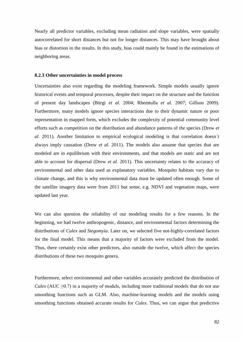
82
Nearly all predictor variables, excluding mean radiation and slope variables, were spatially
autocorrelated for short distances but not for longer distances. This may have brought about
bias or distortion in the results. In this study, bias could mainly be found in the estimations of
neighboring areas.
8.2.3 Other uncertainties in model process
Uncertainties also exist regarding the modeling framework. Simple models usually ignore
historical events and temporal processes, despite their impact on the structure and the function
of present day landscapes (Bürgi et al. 2004; Rhemtulla et al. 2007; Gillson 2009).
Furthermore, many models ignore species interactions due to their dynamic nature or poor
representation in mapped form, which excludes the complexity of potential community level
efforts such as competition on the distribution and abundance patterns of the species (Drew et
al. 2011). Another limitation to empirical ecological modeling is that correlation doesn´t
always imply causation (Drew et al. 2011). The models also assume that species that are
modeled are in equilibrium with their environments, and that models are static and are not
able to account for dispersal (Drew et al. 2011). This uncertainty relates to the accuracy of
environmental and other data used as explanatory variables. Mosquito habitats vary due to
climate change, and this is why environmental data must be updated often enough. Some of
the satellite imagery data were from 2011 but some, e.g. NDVI and vegetation maps, were
updated last year.
We can also question the reliability of our modeling results for a few reasons. In the
beginning, we had twelve anthropogenic, distance, and environmental factors determining the
distributions of Culex and Stegomyia. Later on, we selected five not-highly-correlated factors
for the final model. This means that a majority of factors were excluded from the model.
Thus, there certainly exist other predictors, also outside the twelve, which affect the species
distributions of these two mosquito genera.
Furthermore, select environmental and other variables accurately predicted the distribution of
Culex (AUC ≥0.7) in a majority of models, including more traditional models that do not use
smoothing functions such as GLM. Also, machine-learning models and the models using
smoothing functions obtained accurate results for Culex. Thus, we can argue that predictive

83
maps give quite reliable estimations for Culex distributions. For Stegomyia however, often
only highly overfitting models (GBM and RF) resulted in AUC scores high enough for
reliable prediction. GLM didn´t obtain reliable AUC values for Stegomyia, so we could not
compare the model outputs.
In addition to the potential uncertainties stated earlier, there also exist questions regarding the
use of results as a straight linkage to the estimations of MBD distributions. Regarding
modeling for virus patterns by the distributions of virus vectors Culex and Stegomyia, we
cannot make very reliable predictions for dengue, West Nile virus or chikungunya
distributions in the Taita Hills for several reasons. Culex and Stegomyia include hundreds of
subgenera and dozens of species of which only some are vectors of mosquito-borne
infections. Furthermore, even if the estimations for Culex and Stegomyia distributions are
reliable, not all mosquitoes of those vector species are carriers of viruses.
8.3 Notes about the mosquito genera of the Taita Hills
We confirmed seven mosquito genera from the Taita Hills, including three main MBD vectors
Culex, Stegomyia and Anopheles in addition to other genera, Uranotaenia, Eretmapodites,
Lutzia and Aedimorphus. Only Culex and Stegomyia resulted in large enough collections for
modeling purposes. Culex was collected from a variety of environments, which strengthens
its´ characteristics as a widely distributed mosquito genus, in general.
Stegomyia is linked to transmission of a large number of mosquito-borne viruses. In the Taita
Hills, a great amount of St. aegypti larvae were observed in high numbers in car tyres in
Mwatate village. This is an interesting observation, because car tyres are one of the main
methods of Stegomyia dispersal worldwide. They mainly spread from Asia in used car tyres
via international transportation, and are capable of withstanding extremely dry and warm
conditions for years (WHO 2017c). Stegomyia is not often found at high-elevations as it has
temperature-based limits to survival. In temperatures below 14°C, St. aegypti suffers from
reduced mobility and capability to suck blood (Brady et al. 2013). In the Taita Hills,
Stegomyia was collected at surprisingly high-elevations, above 1700 meters. Even though
Stegomyia originated in tropical forests, we found both Stegomyia adults and larvae in the

84
Ngangao montane forest at an elevation of 1800 meters. These mosquitoes found in Ngangao,
have not yet been identified to species, but will be in due course.
Lutzia tigripes is not known to act as a vector of known parasites or viruses, thus is
considered to be harmless to humans. On the contrary, Aedimorphus, Eretmapodites and
Uranotaenia are potential vectors transmitting Rift Valley fever virus, West Nile virus or
yellow fever virus. Aedimorphus and Eretmapodites did not result great collection size during
the fieldtrip; thus we can note that they may not be widely spread in the Taita region.
In addition to these observations mentioned earlier, we can note a few findings of Anopheles.
Anopheles, although it is a genus containing the only human malaria vector, resulted in four
occurrence locations from our total 122 collection sites in the Taita Hills. This is an extremely
low number of observations, and was a rather unexpected outcome. The majority of
Anopheles collections occurred in the plateau areas which strengthens the assumption that
highlands with low temperatures are not favorable habitats for their eggs to survive (Afrane et
al. 2012). Nevertheless, a few small collections were found in the mountain area in
Wundanyi. This outcome may confirm why health officials have not diagnosed malaria cases;
instead, they have diagnosed positive samples of chikungunya and dengue viruses from the
antibodies of patients in Taita, as currently on-going research will explore.
Based on the collections, Uranotaenia, Eretmapodites and Aedimorphus were not widely
distributed in the Taita Hills; thus these are not the highest threat regarding the transmission
of MBDs in the area. The greatest risk of spreading MBDs is caused by Culex and Stegomyia
genera in the Taita Hills. The 300 unrecognized mosquito specimens from 19 locations are of
continuing interest to other researchers, since these specimens may result in new mosquito
distributions to the area, and there is always a chance to find species as yet unknown to
science from remote areas which have previously not been studied.
8.4 Influential factors for Culex and Stegomyia
Anthropogenic and distance factors appeared to be even more important factors than
environmental drivers for Culex and Stegomyia distributions in a majority of models. This
strengthens the fact that they are capable of adapting to new habitats modified by humans and

85
human activity, such as land use changes and urbanization. Culex mosquitoes prefer locations
with high population densities located at close to roads and the locations with moderate NDVI
values and low slope angles. The distribution of Culex was not dependent on elevation, which
is an interesting outcome and may explain part of its widespread distribution. In contrast,
Stegomyia prefer sites with lower human population densities and higher distances to roads,
as well as high temperatures and solar radiation, in addition to either very poor or rich
vegetation. These outcomes tell something of its origin as a forest species, and this finding
may also strengthen the assumption of its amazing capability to stand hot and dry weather
conditions for survival (Brady et al. 2013).
Human population density, mean temperature and NDVI were direct factors affecting Culex
and Stegomyia presence. Slope, distance to roads, solar radiation and elevation presented as
indirect factors affecting Culex and Stegomyia distributions. For example, in locations with
high slope angles (º), weather conditions are usually windier than in locations with low slope
angles. In this case, wind is the main factor affecting the presence and absence of mosquitoes.
Also, elevation is indirect factor, as at high elevations, factors of precipitation and
temperature are the main influential drivers in mosquito presence and absence.
Environmental factors, along with the variable of human population density, have widely
been used as predictors in the studies related to mosquito distribution modeling (Ibañez-
Justicia et al. 2015; Sallam et al.2016; Fatima et al.2016) We included additional variables,
distance to houses and distance to roads in the models; of these, distance to roads was
influential factor almost in all models in both Culex and Stegomyia estimations. This is an
important driver to pay attention to in potential further research, as the distribution of Culex
and Stegomyia are strongly affected by human mobility.
8.5 Model validity or incompetence
Our results affirm the utility and reliability of the use of the biomod2 package in R as a valid
modeling method for species distributions. Several models accurately estimated (AUC ≥0.7)
the distribution of both Culex and Stegomyia (Figure 32).

86
An inclusion of GLM, GAM, GBM and RF models gave different perspectives on modeling
and predictive map performances. Our results reject the null hypothesis regarding the
unusability of these algorithms to model mosquito distributions, since the models with these
four techniques had very good accuracy on their AUC scores. Different environmental and
anthropogenic variable contributions easily resulted high AUC scores for Culex; however,
only a model with contributions of mean radiation, NDVI, distance to roads, human
population density and mean temperature resulted AUC scores high enough to produce
accurrate estimations for Stegomyia. The reason for this may also be a different number of
presence and absence points in the occurrence data as the Culex model was run with 73
observed presence and 49 true absences, while the Stegomyia model was run with 28 observed
presence and 42 true absence points.
Figure 32. A. The distribution of prediction accuracy for Culex. A majority of the models accurately estimated
(AUC ≥0.7 or κ ≥0.4 or TSS ≥0.4) the distribution of Culex apart from few residuals. B. The division of
prediction accuracy for Stegomyia differs from the left Figure, as a majority of models didn´t estimate Stegomyia
accurately (AUC ≤0.7) apart from generalized boosted regression model and random forest model.
8.6 A potential new predictor for mosquito distribution modeling
We recognized a potential new predictor variable influencing the presence of mosquitoes. A
distinction occurred in the abundance of mosquitoes in different building designs (Figure 33).
A majority of large mosquito collections were found in schools or in other buildings of
modern design. In general, mosquitoes were rarely collected in houses built by traditional

87
methods. Modern, airtight buildings appear to be favorable breeding sites for mosquitoes, as
the humidity remains inside the buildings where no appropriate ventilation system exists. On
the contrary, in the buildings built by traditional methods, air gaps exist from which moisture
can evaporate away.
Figure 33. The number of observed mosquitoes in each building design. The majority of large collections were
implemented in modern buildings. Buildings with traditional design were not favorable occurrence sites for
mosquitoes.
Mosquitoes and their association with building design has not yet been investigated, but a
study on a similar theme was conducted in southwestern USA. A contrary argument to our

88
finding exists concerning the detection of Stegomyia aegypti eggs in the old houses. Higher
numbers of St. aegypti eggs were observed in older homes than in modern houses, according
to Walker et al. (2011). Thus, the older homes were asserted to be associated with St. aegypti
abundance. Even if the main study perspective is similar, we cannot compare their study
results to ours for several reasons. First, climate in southeastern Africa differs from the
climate in southwestern USA. Also, the classification of older homes and modern houses is
also totally different than that in Kenya. Furthermore, even though the houses mentioned in
the study are old, there may have been modern air conditioning systems, which was not the
case in Kenya.
Because the Taita Hills region is characterized by a humid and warm climate, it provides
suitable conditions for mosquitoes to breed inside modern buildings, where humidity lingers
due to the lack of air gaps or the absence of ventilation system. This fact should be taken into
account in the prevention of mosquito-borne infections.
8.7 Potential distributions of Culex and Stegomyia in the Taita Hills
In the Taita Hills, the distribution of the West Nile virus vector Culex is widespread,
excluding the surrounding savannas located at the national parks and the croplands in north.
Culex were collected at all elevations in Taita, and particularly in the Wundanyi town and
Mwatate village, which are the largest population centers in the region. This confirms that
humans are important hosts for Culex species, and explains why the probabilities to find them
in national parks are lower than in villages.
The distribution of the dengue virus and chikungunya virus vector Stegomyia is fragmented in
the Taita Hills. Especially the main roads of Taita and Mwatate region are possible locations
for observing Stegomyia. The northern and southern plateau areas are also suitable locations
for Stegomyia, with high temperatures and solar radiation values as well as intermediate
population densities. The Wundanyi town area is not a suitable area for Stegomyia
distribution, and neither are the areas in Taita which are located at high elevations, unlike with
Culex.

89
8.8 Conclusion
The importance of studying distribution modeling of mosquitoes lies in the fact that more
outbreaks of mosquito-borne infections have been revealed around in the world, including in
Africa. Our results proved that mosquito distributions can reliably be modeled by the
biomod2 package in R, resulting in an insight into vector-ecological interactions on local,
regional and global scale. By defining the suitable habitat and potential distributions of
vectors of mosquito-borne diseases, brings more ideas of where and how to concentrate on the
disease intervention strategies. An important finding was the link between building design
and abundance of mosquitoes. This argument still requires further study, but this
consideration could be utilized in the prevention of mosquito-borne infections, already in the
construction phase of buildings.
With our study results, general assumptions can be made about the distribution of main West
Nile virus, dengue virus, Zika virus and chikungunya vectors Culex and Stegomyia in the
Taita Hills. After molecular identification is completed, thus exact species will be recognized,
and virus isolations will be completed, it is possible to more accurately model the distribution
of virus vectors over the Taita Hills. Additional interest lies among unrecognized mosquito
collections, which may result in new mosquito species being discovered. These issues, among
others, may bring new opportunities for future research.

90
Acknowledgements
I gratefully thank everybody who participated to this extremely interesting study process. I
express my gratitude to Mika Siljander, who was a great supervisor, always ready to help and
advice in all the issues regarding the thesis. I thank prof. Petri Pellikka, who opened up this
opportunity for me to participate in the project. I am thankful for the other supervisor; Lorna
Culverwell, from the Department of Virology, who taught me so much more about
mosquitoes and other virus vectors, their morphology, habitats and the public health concern.
I also thank Kristian Forbes for being my supervisor; encouraging and supporting me,
particularly, with the public health concern. I am thankful to everybody involved in the
Wildlife screening-project in Kenya and Finland; Essi Korhonen, Kristian Forbes, Lorna
Culverwell, Joni Uusitalo, Olli Vapalahti, Masika Moses and Eili Huhtamo, who taught me a
plenty of new matters about rodents, mosquitoes and bats, and about their biology and
connections to virus transmission. I really loved to work with them. Also, I would like to
thank prof. Miska Luoto, who organized the course regarding the spatial analysis and
modeling in R, which brought me the skills to model mosquito distributions using R. I am
thankful to Juha Aalto, who gave me final advice for the use of biomod2 methods. Moreover,
I would like to thank Sakari Keipi who helped me with the language, and Sakari Äärilä and
Ninna Malinen who were my mental and technical support at the university. I am so grateful
to them for their company and all the advice they gave me. Finally, I also would like to thank
my family for all the support and encouragement they gave me during the study process. All
of them, had a significant impact on this process.

91
References
Afrane1, Y., Githeko1, A. & Y. Guiyun (2012). The Ecology of Anopheles Mosquitoes under
Climate Change: Case Studies from the Effects of Environmental Changes in
East Africa Highlands. Annals of the New York Academy of Sciences 1249: 204–
210.
AMCA (2014). American Mosquito Control Association. Mosquito info. 15.4.2016.
<http://www.mosquito.org/mosquito-info>
Anselin, L., Florax, R., & S. Rey (2004). Advances in Spatial Econometrics: Methodology,
Tools and Applications.
Ara´ujo, M. & M. New (2007). Ensemble forecasting of species distributions. Trends in
Ecology & Evolution 22: 42–47.
Attaway, D., Jacobsen, K., Falconer, A., Manca, G., Bennett, L. & N. Waters (2014).
Mosquito habitat and dengue risk potential in Kenya: alternative methods to
traditional risk mapping techniques. Geospatial health 9(1): 119-130.
Austin, M. (1971). Role of regression analysis in plant ecology. The Proceedings of the
Ecological Society of Australia 6: 63-75.
Austin, M. (1980). Searching for a model for use in vegetation analysis. Vegetatio 42: 11–21.
Austin, M. (2002). Spatial prediction of species distribution: an interface between ecological
theory and statistical modeling. Ecological Modeling 157: 101–118.
Barnhart, P. & E.Gillam (2014). The impact of sampling method on maximum entropy
species distribution modeling for bats. BioOne. Acta Chiropterologica 16(1):
241-248.
Barry, S. & J. Elith (2006). Error and uncertainty in habitat models. Journal of Applied
Ecology 43: 413–423.
Beale, M. & J., Lennon (2011). Incorporating uncertainty in predictive species distribution
modeling. Philosophical Transactions of the Royal Society 367: 247–258.

92
Becker, N., Petric, D., Zgomba, M., Boase, C., Madon, M., Dahl, C. & A. Kaiser (2010).
Mosquitoes and Their Control. The biology of mosquitoes. 2nd edition, 565 p.
Benediktsson, J., Swain, P. & O. Ersoy (1993). Conjugate-gradient neural networks in
classification of multisource and very-high-dimensional remote sensing data.
International Journal of Remote Sensing 14: 2883–2903.
Bhatt, S., Gething, P., Brady, O., Messina, J., Farlow, A. & C. Moyes (2013). The global
distribution and burden of dengue. Nature 496: 504-507.
Brady, O., Johansson, M., Guerra, C., Bhatt, S., Golding, N., Pigott, D., Delatte, H., Grech,
M., Leisnham, P., Maciel-de-Freitas, R., Styer, L. & D. Smith (2013). Parasites
& Vectors 6: 351.
Breiman, L., Friedman, J., Olshen, R., & C. Stone (1983). Classification and regression trees.
Wadsworth, London.
Broberg, A., Salminen, H., Tolvanen, R. & J.Ylhäisi (2004). Werugha - village in the heart of
the Taita Hills. p.108-113. In: Pellikka, P., J. Ylhäisi & B. Clark (eds.) Taita
Hills and Kenya, 2004 –seminar, reports and journal of a field excursion to
Kenya. Expedition reports of the Department of Geography. University of
Helsinki. 148 pp.
Brown. J., Evans, B., Zheng, W., Obas, V., Barrera- Martinez, L., Egizi, A., Zhao, H.,
Caccone, A. & J. Powell (2014). Human impacts have shaped historical and
recent evolution in Stegomyia aegypti, the dengue and yellow fever mosquito.
Evolution 68(2): 514–525.
Burnham, K. & D. Anderson (1998). Model Selection and Multimodel Inference: A Practical
Information – Theoretic Approach. New York, USA.
Bürgi, M., Hersperger, M., & N. Schneeberger (2004). Driving forces of landscape change –
current and new directions. Landscape Ecology 19: 857–868.

93
CIA (2016). Central Intelligence Agency. Kenya. The World Factbook October 2016.
20.4.2016.<https://www.cia.gov/library/publications/the-world-
factbook/geos/ke.html>
CDC (2012). Centers for Disease Control and Prevention. Dengue and Climate. 27.9.2016.
<//www.cdc.gov/dengue/entomologyEcology/climate.html>
Cohen, Jacob (1960). A coefficient of agreement for nominal scales. Educational and
Physiological Measurement XX: 1.
Clark, B. & P. Pellikka (2005). The development of a land use change detection
methodology for mapping the Taita Hills, South-East Kenya. Proceedings of the
31st International Symposium of Remote Sensing of the Environment. 20-24
June 2005. St. Petersburg, Russia. CD-Rom publication.
Conley, A., Fuller, D., Haddad, N., Hassan, A., Gad, A. & J. Beier (2014). Modeling the
distribution of the West Nile and Rift Valley Fever vector Culex pipiens in arid
and semi-arid regions of the Middle East and North Africa. Parasites & Vectors
7: 289.
Cressie, N. (1991). Statistics for Spatial Data. New York: John Wiley and Sons. 920 pp.
Culverwell, Lorna (2016). Personal Communication. Mosquito Protocol.
De’ath, G. & K. Fabricius (2000). Classification and regression trees: a powerful yet simple
technique for ecological data analysis. Ecology 81: 3178–3192.
Diniz- Filho, J., Bini, L. & B. Hawkins (2003). Spatial autocorrelation and red herrings in
geographical ecology. Global Ecology & Biogeography 12: 53–64.
Dormann, C., Purschke, O., Garc´ıa-Marquez, J., Lautenbach, S. & B. Schroder
(2008).Components of uncertainty in species distribution analysis: a case study
of the Great Grey Shrike. Ecology 89: 3371–3386.
Drew, C., Wiersma, Y. & F. Huettmann (2011). Predictive Species and Habitat Modeling in
Landscape Ecology. 319 p. The United States.

94
Elith, J. & J. Leathwick (2009). Species distribution models: ecological explanation and
prediction across space and time. Annual Review of Ecology, Evolution, and
Systematics 40: 677–697.
Eisen, L., Bolling, B., Blair, C., Beaty, B. & C. Moore (2008). Mosquito Species Richness,
Composition, and Abundance along Habitat-Climate-Elevation Gradients in the
Northern Colorado Front Range. Journal of Medical Entomology 45(4):800-811.
Elith, J., Phillips, S., Hastie, T., Dudik, M., Chee, Y. & C. Yates (2011). A statistical
explanation of MaxEnt for ecologists. Diversity and Distributions 17: 43–57.
Environment Systems Research Institute (ESRI) (1991). ARC/INFO User’s guide. Cellbased
modelling with GRID. Analysis, Display and Management (Redlands, CA:
ESRI).
Erdogan, E.H., Pellikka, P. & B. Clark (2011). Modelling the impact of land-cover change on
potential soil loss in the Taita Hills, Kenya, between 1987 and 2003 using
remote-sensing and geospatial data. International Journal of Remote Sensing, to
be published.
Fatima, S., Atif, S., Rasheed, S., Zaidi, F. & E. Hussain (2016). Species distribution modeling
of Aedes aegypti in two dengue-endemic regions of Pakistan. Tropical Medicine
and International Health 21: 427-436.
Fielding, A. & J. Bell (1997). A review of methods for the assessment of prediction errors in
conservation presence/ absence models. Environmental Conservation 24: 38–49.
Franklin, J. & J. Miller (2010). Statistical methods – modern regression. In: Franklin, J.(ed.)
Mapping species distribution: spatial inference and prediction. Cambridge:
Cambridge University Press. 340 p.
Friedman, J (1991). Invited paper: Multivariate adaptive regression splines. The Annals of
Statistics 19(1):1-141.

95
Gamaa, M., Crespo, D., Dolbeth, M. & P. Anastácioa (2016). Predicting global habitat
suitability for Corbicula fluminea using species distribution models: The
importance of different environmental datasets. Ecological Modeling 319: 163–
169.
Gillson, L. (2009). Landscapes in time and space. Landscape Ecology 24:149–155.
Guisan, A., Lehmann, A., Ferrier, S., Austin, M., Overton, J., Aspinall, R. & T. Hastie (2006).
Making better biogeographical predictions of species. Journal of Applied
Ecology 43: 386-392.
Guisan, A. & W. Thuiller (2005). Predicting species distribution: offering more than simple
habitat models. Ecology Letters 8: 993-1009.
Heikinheimo,Vuokko (2015). Impact of land change on aboveground carbon stocks in the
Taita Hills. Master thesis. Geography. Geoinformatics. University of Helsinki.
Heikkinen, R., Luoto,M., Araújo, M., Virkkala,R., Thuiller, W. & M.Sykes (2006). Methods
and uncertainties in bioclimatic envelope modeling under climate change.
Progress in Physical Geography 30 (6): 751–777.
Heiskanen, J., Korhonen,L., Hietanen, J., Heikinheimo, V., Schöfer, E. & P. Pellikka (2015).
Comparison of field and airborne laser scanning based crown cover estimates
across land cover types in Kenya. The International Archives of the
Photogrammetry. Remote Sensing and Spatial Information Sciences: XL-7/W3.
Hijmans, R. & J. Elith (2016). Species Distribution Modeling with R. January 2016.
<https://cran.r-project.org/web/packages/dismo/vignettes/sdm.pdf>
Hijmans, R. & J. Elith (2016). Species distribution modeling with R. 79 p.
Huang, Yiau-Min (2001). A pictorial key for the identification of the subfamilies of
Culicidae, genera of Culicinae, and subgenera of Aedes mosquitoes of the
Afrotropical Region (Diptera: Culicidae). Proceedings of the Entomological
Society of Washington 103: 1-53.

96
Huang, Yiau-Min (2004). The subgenus Stegomyia of Aedes in the Afrotropical Region with
keys to the species (Diptera: Culicidae). Zootaxa 700(1): 1-120.
Hutchinson, M. (1995). Interpolating mean rainfall using thin plate smoothing splines.
International Journal of Geographical Information Science 9: 305–403.
Ibañez- Justicia, A. & D. Cianci (2015). Modeling the spatial distribution of the nuisance
mosquito species Anopheles plumbeus (Diptera: Culicidae) in the Netherlands.
Parasites & Vectors 8:258.
Junglen, S., Kopp, A., Kurth, A., Pauli, G., Ellerbrok, H., & F. Leendertz (2009). A New
Flavivirus and a New Vector: Characterization of a Novel Flavivirus Isolated
from Uranotaenia Mosquitoes from a Tropical Rain Forest. Journal of Virology
83(9): 4462–4468.
Kadmon, R., Farber, O. & A. Danin (2004). Effect of roadside bias on the accuracy of
predictive maps produced by bioclimatic models. Ecological Applications
14:401–413.
Kaplan, I., Dobert, M.K., Marvin, B.J., McLaughlin, J.L. & D.P. Whitaker (1976). Area
Handbook for Kenya. 472 p. Foreign Area Studies (FAS).The American
University, Washington D.C., U.S.A.
Kienast. F., Bolliger, J. & N.E. Zimmermann (2012). Species Distribution Modeling (SDM)
with GLM, GAM and CART. Advanced Landscape Ecology 1-16. 31.12.2012.
Kumar, L., Skidmore, A.K. and Knowles, E., 1997. Modelling topographic variation in solar
radiation in a GIS environment. International Journal for Geographical
Information Science 11(5): 475-497.
Kwon, Y., Bae, M., Chung, N., Lee, Y., Hwang, S., Kim, S., Choi, Y. & Y. Park (2015).
Modeling Occurrence of Urban Mosquitos Based on Land Use Types and
Meteorological Factors in Korea. International Journal of Environmental
Research and Public Health 12: 13131-13147.

97
Larson, S., DeGroote, J., Bartholomay, L. & R.Sugumaran (2009). Ecological niche modeling
of potential West Nile virus vector mosquito species in Iowa. Journal of Insect
Science 10:110.
Lautenbach (2013). Collinearity: a review of methods to deal with it and a
simulation study evaluating their performance. Ecography 36: 27–46.
Legendre, P. (1993). Spatial autocorrelation: problem or new paradigm. Ecology 74: 1659–
1673.
Lennon, J. (2002). Red shifts and red herrings in geographical ecology. Ecography 23: 101–
113.
López- Baucells, A., Rocha, R., Andriatafika,Z., Tojosoa, T., Kemp, J., Forbes, K.A. & M.
Cabeza (2017). Roost selection by synanthropic bats in rural Madagascar: what
makes non-traditional 2 structures so tempting? To be published.
Maeda, E. (2011). Agricultural expansion and climate change in the Taita Hills, Kenya: an
assessment of potential environmental impact. Academic dissertation.
University of Helsinki.
Mason, S & N. Graham (2002). Areas beneath the relative operating characteristics (ROC)
and relative operating levels (ROL) curves: Statistical significance and
interpretation. Quarterly Journal of the Royal Meteorological Society 128:
2145–2166.
Miller, J. (2010). Species Distribution Modeling. Geography Compass 4(6): 490-509.
Moisen, G., Freeman, E., Blackard, J., Frescino, T., Zimmermann, N. & T. Edwards Jr.
(2006). Predicting tree species presence and basal area in Utah: a comparison of
stochastic gradient boosting, generalized additive models and tree-based
methods. Ecological Modeling 199: 176–187.
Moran, P (1950). Notes on continuous stochastic phenomena. Biometrika 37:17–23.
Mosquito World (2017a). Mosquito Habitats. 15.2.2017.
<http://www.mosquitoworld.net/about-mosquitoes/habitats/>

98
Mosquito World (2017b). Mosquito Species. 15.2.2017.
<http://www.mosquitoworld.net/about-mosquitoes/habitats/>
Msagha, Johanna (2004). Population development in Taita Hills, Kenya. Published in In:
Pellikka, P., J. Ylhäisi & B. Clark (eds.) Taita Hills and Kenya, 2004 – seminar,
reports and journal of a field excursion to Kenya. Expedition reports of the
Department of Geography. University of Helsinki 40, 39-46. Helsinki 2004,
ISBN 952- 10-2077-6, 148 pp.
MTI (2017). The mosquito taxonomic inventory. Anopheles; Culex; Stegomyia. 5.4.2017.
< http://mosquito-taxonomic-inventory.info/simpletaxonomy/term/8577>
Mughini-Gras, L., Mulatti, P., Severini, F., Boccolini,D., Romi, R., Bongiorno,G., Khoury,
C., Bianchi, R., Montarsi, F., Patregnani, T., Bonfanti, L., Rezza, G., Capelli, G.
& L. Busani (2014). Ecological Niche Modeling of Potential West Nile Virus
Vector Mosquito Species and Their Geographical Association with Equine
Epizootics in Italy. EcoHealth 11: 120–132.
Murphy, C., Grenouillet, G. & E.García-Berthou (2015). Natural abiotic factors more than
anthropogenic perturbation shape the invasion of Eastern Mosquitofish
(Gambusia holbrooki). Freshwater Science 34(3):965–974.
Murray, K. & M. Conner (2009). Methods to quantify variable importance: implications for
the analysis of noisy ecological data. Ecology 90(2): 348-355.
Naimi, B. & M. B. Araújo (2016). Sdm: a reproducible and extensible R platform for species
distribution modeling Ecography 39: 368–375.
Nduire, John (2016). Common types of building materials in Kenya. Construction Business
Review. 20.4.2017. < http://www.constructionkenya.com/1599/building-
materials-in-kenya/>
Neteler, M., Roiz, D., Rocchini, D., Castellani, C. & A. Rizzoli (2011). Terra and Aqua
satellites track tiger mosquito invasion: modeling the potential distribution of
Stegomyia albopictus in north-eastern Italy. International Journal of Health
Geographics 10:49.

99
Pachler, K., Lebl, K., Berer, D., Rudolf, I., Hubalek, Z. & N. Nowotny (2014). Putative New
West Nile Virus Lineage in Uranotaenia unguiculata Mosquitoes, Austria,
2013. Emerging Infectious Diseases 20(12): 2119-2122.
Peirce, C (1884). The Numerical Measure of the Success of Predictions. Science 4:93: 453-
454.
Pellikka, P., Lötjönen, M., Siljander, M. & L. Lens (2009). Airborne remote sensing of
spatio-temporal change (1955-2004) in indigenous and exotic forest cover in the
Taita Hills, Kenya. International Journal of Applied Earth Observations and
Geoinformation 11(4): 221-232.
Peyton, E. (1972). A subgeneric classification of the Genus Uranotaenia Lynch Arribalzaga,
with a Historical Review and Notes on Other Categories. The mosquito
taxonomic inventory.<http://mosquito-taxonomic-inventory.info/sites/mosquito-
taxonomicinventory.info/files/Peyton%201972.pdf>
Phillips S., Anderson R. & R. Schapire (2013). Maximum entropy modeling of species
geographic distribution. Ecological Modeling 190: 231-259.
Phillips, S (2004). A Maximum Entropy Approach to Species Distribution Modeling.
Proceedings of the Twenty-First International Conference on Machine Learning.
p. 655-662.
Platts P., Omeny P. & R. Marchant (2015). AFRICLIM: high-resolution climate projections
for ecological applications in Africa. African Journal of Ecology 53: 103-108.
Rasheed, S., Boots, M., Frantz, A. & R. Butlin (2013). Population structure of the mosquito
Stegomyia aegypti (Stegomyia aegypti) in Pakistan. Medical and Veterinary
Entomology 27: 430-440.
Rhemtulla, J., Mladenoff, D. & M. Clayton (2007). Regional land-cover conversion in
the U.S. upper Midwest: magnitude of change and limited recovery (1850–
1935–1993). Landscape Ecology 22: 57–75.
Ridgeway, G (2007). Generalized Boosted Models: A guide to the gbm package. 1-12.

100
Rogan, J., Franklin, J., Stow, D., Miller, J., Woodcock, C. & D. Roberts (2008). Mapping
landcover modification over large areas: a comparison of machine learning
algorithms. Remote Sensing of Environment 112: 2272–2283.
Rykiel, E., Jr. (1996). Testing ecological models: the meaning of validation. Ecological
Modeling 90: 229–244.
Sallam, M., Xue, R., Pereira, R. & P. Koehler (2016). Ecological niche modeling of mosquito
vectors of West Nile virus in St. John’s County, Florida, USA. Parasites &
Vectors 9:371.
Salminen, H. (2004). A geographic overview of The Taita Hills, Kenya. Expedition reports of
the Department of Geography. University of Helsinki 40, 31-38.
Schowalter, T., (2011). Insect Ecology: An Ecosystem Approach. 3rd edition, 633 p. Elsevier.
Sharp, T (2015). Unveiling the Burden of Dengue in Africa. Published in the blog of Centers
for Disease Control and Prevention. 28.7.2015.
<https://blogs.cdc.gov/publichealthmatters/2015/07/unveiling-the-burden-of-
dengue-in-africa/>
Smith, A. (2012). An Introduction to Best Practices in SDM. Kansas State University.
<http://www.earthskysea.org/!ecology/sdmShortCourseKState2012/sdmShortCo
urse_kState.pdf>
Service, M. (1991). Mosquito Ecology: Field sampling methods.2nd edition, 988 p. Elsevier.
Sharp, T (2015). Unveiling the burden of dengue in Africa. Centers for Disease Control and
Prevention, CDC. 24.10.2016.
Siljander, M., Clark, B. & P. Pellikka (2011). A predictive modelling technique for human
population distribution and abundance estimation using remotesensing and
geospatial data in a rural mountainous area in Kenya. International Journal of
Remote Sensing. iFirst: 1–27.
Soini, Eija (2005). Livelihood capital, strategies and outcomes in the Taita Hills of Kenya.
ICRAF Working Paper no. 8. Nairobi, Kenya: World Agroforestry Centre.

101
Svenning, J. & F. Skov (2004). Limited filling of the potential range in European tree species.
Ecology Letters 7: 565–573.
Swets, K. (1988). Measuring the accuracy of diagnostic systems. Science 240: 1285–1293.
Thuiller, W., Georges, D., Engler, R. & F. Breiner (2016). Package “biomod2”. Ensemble
platform for species distribution modeling. Version 3.3-7.
<https://cran.r-project.org/web/packages/biomod2/biomod2.pdf>
Thuiller,W., Ara´ujo, M. & S. Lavorel (2003). Generalized models vs. classification tree
analysis: Predicting spatial distributions of plant species at different scales.
Journal of Vegetation Science 14: 669–680.
Thuiller, W., Lavorel, S., Sykes, M. & M. Ara´ujo (2006). Using niche-based modeling to
assess the impact of climate change on tree functional diversity in Europe.
Diversity and Distributions 12: 49–60.
Thuiller, Wilfried (2003). BIOMOD – optimizing predictions of species distributions and
projecting potential future shifts under global change. Global Change Biology
9:1353–1362.
Tucker, Compton (1979). Red and photographic infrared linear combinations for monitoring
vegetation. Remote Sensing of Environment 8: 127–150.
University of Helsinki (2003-2009). The Taita Hills. 22.4.2016.
<www.helsinki.fi/science/taita/taitahills.html>
Vaughan, I. & S. Ormerod (2005). The continuing challenge of testing species distribution
models. Journal of Applied Ecology 42: 720–730.
Virtanen, Elina (2015). Fine-resolution climate grids for species studies in data-poor regions.
Master´s Thesis. University of Helsinki.
Walker, K., Joy, T., Ellers-Kirk, C. & F. Ramberg (2011). Human and environmental factors
affecting Stegomyia aegypti distribution in an arid urban environment. Journal
of the American Mosquito Control Association 27(2): 135–141.

102
Ward, G., Hastie, T., Barry, S., Elith, J. & J. Leathwick (2009). Presence-only data and the
EM algorithm. Biometrics 65: 554–563.
WHO (2016a). The World Health Organization. Vector-borne diseases. February 2016.
Fact sheets. 20.10.2016.<http://www.who.int/mediacentre/factsheets/fs387/en/>
WHO (2016b). The World Health Organization. Chikungunya- Kenya. Disease outbreak
news. August 2016. 20.4.2017.
<http://www.who.int/csr/don/09-august-2016-chikungunya-kenya/en/>
WHO (2016c). World health Organization. Dengue and severe dengue. Fact sheets July
2016. 20.10.2016. <www.who.int/mediacentre/factsheets/fs117/en/>
WHO (2017a). The World Health Organization. Zika virus. 5.4.2017.
<http://who.int/emergencies/zika-virus/mediacentre/en/>
WHO (2017b). The World Health Organization. Dengue control: The mosquito. 5.4.2017.
<http://www.who.int/denguecontrol/mosquito/en/>
WHO (2017c). The World Health Organization. Neglected tropical diseases: Mosquito-
borne diseases. 5.4.2017.
<http://www.who.int/neglected_diseases/vector_ecology/mosquito-borne-
diseases/en/>
Yee, T. & N. Mitchell (1991). Generalized additive models in plant ecology.
Journal of Vegetation Science 2: 587–602.
Zimmermann, N.E. (2000). Shortwavc.aml. Available online at: http://www.wsl.ch/staff/
niklaus.zimmermann/programs/aml1_1.html (accessed 01 January 2009).

103
Appendices
Appendix 1. Correlations of Culex predictors are introduced here; elevation and other variables.

104
Appendix 2. Correlations of Culex predictors are introduced here; distance to roads and other variables.

105
Appendix 3. Correlations of Culex predictors are introduced here; slope and other variables.

106
Appendix 4. Correlations of Culex predictors are introduced here; human population density and other variables.

107
Appendix 5. Correlations of Stegomyia predictors are introduced here; distance to roads and other variables.

108
Appendix 6. Correlations of Stegomyia predictors are introduced here; distance to roads and other variables.

109
Appendix 7. Correlations of Stegomyia predictors are introduced here; NDVI and other variables.

110
Appendix 8. Correlations of Stegomyia predictors are introduced here; human population density and other
variables.

111
Appendix 9. Correlations of Stegomyia predictors are introduced here; mean temperature and other variables.

112
Appendix 10. Correlations of Stegomyia predictors are introduced here; mean radiation and other variables.

113
Appendix 11.The most important parameters of GLM model that predicted Culex distributions.

114
Appendix 12. The most important parameters of the GAM model that predicted Culex distributions.

115
Appendix 13. The most important parameters of the random forest model that predicted Culex distributions.

116
Appendix 14. A MARS model for Culex estimations resulted in AUC-value of 0.806.