module 4 educator’s guide investigation 3 - nasa 4 educator’s guide investigation 3. 3 tracks...
TRANSCRIPT
1
Paths—Usual orunusual?Investigation OverviewNASA images can introduce students
to some unusual natural and human-
made paths. These include ancient camel
caravan tracks, lava flows, ship channels, and
smoke paths. The investigation introduces the idea
of one-way and two-way paths. It provides an opportunity for students to
work together to study images and to pose and answer many questions
about paths. They record their observations and draw conclusions about
the origins and nature of these pathways. They also match the images
with descriptions of the paths and use maps to gather more information
about the environments illustrated in the images.
Time required: One 45-minute session
Materials/ResourcesNASA images (make overhead transparencies and one copy for each
group of students):
Figure 1: Mozambique
Figure 2: Ubar
Figure 3: Teide volcano, Canary Islands
Figure 4: Mississippi River delta
Log 1: Looking at new paths
Log 2: Reading about the images
Atlases (or wall maps showing world vegetation and landform patterns)
Content PreviewPaths come and paths go. Some paths are visible from space but not from
the ground. Geographers and other scientists use remote sensing to learn
about different paths because they affect people and their activities. Paths
also give clues about past places and peoples. This technology is espe-
cially useful in remote regions of the world or to see paths that extend over
long distances. Detailed descriptions of images of Mozambique, Ubar, the
Teide volcano, and the Mississippi River delta show paths that are signifi-
cant for a variety of human endeavors.
Classroom ProceduresBeginning the Investigation1. If the class has done Investigation 1, review the list of paths that
students developed in Log 1. If they have not done Investigation 1,
begin this investigation by talking about the various kinds of paths and
making such a list on the chalkboard. (See Investigation 1, Begin-ning the Investigation.)
2. Look at the list of paths and ask the following questions:
• Can paths disappear, and what would make them disappear?
(Rivers change courses, rainwater or snow may cover paths, natural
Geography Standards
Standard 1: The World inSpatial Terms
How to use maps and othergeographic representations,tools, and technologies toacquire, process, and reportinformation from a spatialperspective
• Identify and describe the
characteristics and purposes of
geographic representations,
tools, and technologies.
Standard 15: Environmentand Society
How physical systems affecthuman systems
• Identify ways in which human
activities are constrained by
physical environment.
Geography SkillsSkill Set 2: Acquiring Geo-graphic Information
• Make and record observations
about the physical and human
characteristics of places.
Skill Set 4: Analyzing Geo-graphic Information
• Use texts, photographs, and
documents to observe and interpret
geographic trends and relation-
ships.
Skill Set 5: Answering Geo-graphic Questions
• Use methods of geographic inquiry
to acquire geographic information,
draw conclusions, and make
generalizations.
Module 4 Educator’s Guide Investigation 3
2
disasters can obliterate paths, people may nolonger use pathways and they may becomeovergrown, etc.)
• Can images from space tell us what happened
to pathways that existed long ago? (Yes,pathways that seem obscure on the ground canbe more apparent from a distance.)
• Why would we be interested in knowing about
these pathways? (To learn about people andtheir movements in the past and how they havechanged.)
• What kinds of pathways could more easily be
studied in images from space than on the
ground? (Paths that are in remote places orextend over long distances.)
Developing the Investigation3. Tell students that they will work in small groups to
look for some unusual paths in images taken from
the Space Shuttle.
4. Form groups of three or four students. Give each
group a copy of Log 1. Go over the directions.
Project transparencies of Figures 1-4 and give
each group a copy of each image. Note that the
number of each image should correspond to the
numbers on the worksheet.
Use information in Background to tell the class
enough about each image so that they will be able
to figure out the answers. When showing Figure 1,
explain that this is a photograph taken by an
astronaut. Explain that Figures 2-4 were produced
by radar signals from a sensor on the Space
Shuttle. Explain that radar signals can go through
clouds and darkness. The signals give information
about the ground to computers that use it to create
images. These images can look like photographs.
Scientists determine the colors shown in the image
according to what will help them interpret it.
5. Have students work together in their groups after
completing the first image together as a class.
6. After the groups have completed the task, show
each image again and have the groups report what
they have observed.
7. Distribute Log 2 and have the groups decide which
description in Log 2 goes with each image, in
Figures 1 to 4. Have students read the descrip-
tions that match the images. Share additional
information in the Background section with the
students. Ask students to point out the pathways
and features that are mentioned.
8. Find the locations of the images on a world map or
in atlases. Describe the physical features of the
locations.
Concluding the Investigation9. Show the images again and discuss the signifi-
cance of the pathways in each image.
• Smoke paths: People downwind may beaffected by the smoke in adverse ways.
• Camel tracks: Old caravan tracks show themovement of people across the desert in ancienttimes. They can lead archeologists to ancientsettlement sites that might otherwise be difficultto find.
• Lava flow path: Historic flow patterns may helppredict future volcanic activity, indicating areasof danger to human settlements.
• Mississippi River delta paths: Sediment depos-its change the delta and affect river traffic.
Background: ImagesFigure 1: Mozambique <http://eol.jsc.nasa.gov/
newsletter/smoke/page1.htm>. The image STS070-
717-027 shows bush fires in southern Mozambique
in Africa. The easterly winds from the Mozambique
Channel blow the smoke from many large fires into
the country of Zimbabwe on the African plateau.
This image shows winter, the dry season in southern
Africa. People set fires to hasten the greening of the
grass shoots for cattle grazing.
Figure 2: Ubar <http://observe.ivv.nasa.gov/nasa/
exhibits/ubar/ubar_3.html> This is a radar image of
the region around the site of the lost city of Ubar in
southern Oman, on the Arabian Peninsula. The
ancient city was discovered in 1992 with the aid of
remotely sensed data. Archeologists believe Ubar
existed from about 2800 B.C. to about 300 A.D. It
was a remote desert outpost where caravans
assembled to transport frankincense across the
desert. Frankincense is a sweet-smelling incense
used as a fragrance, for medicinal purposes, and
for embalming. This image was acquired by the
Space Shuttle Endeavour on April 13, 1994. The
image covers an area about 50 by 100 kilometers.
The prominent magenta-colored area is a region of
large sand dunes. The prominent green areas are
rough limestone rocks, which form a rocky desert
floor. A major wadi, or dry stream bed, runs across
the middle of the image and is shown largely in
white. The actual site of the fortress of the lost city
of Ubar, currently under excavation, is near the
wadi close to the center of the image. The fortress
is too small to be detected in this image. However,
Module 4 Educator’s Guide Investigation 3
3
tracks leading to the site, and surrounding tracks,
appear as prominent, but diffuse, reddish streaks.
These tracks have been used in modern times, but
field investigations show many of these tracks
were in use in ancient times as well. Mapping of
these tracks on regional remote sensing images
was a key to recognizing the site as Ubar in 1992.
This image, and ongoing field investigations, will
help shed light on a little-known early civilization.
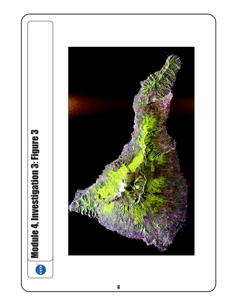
Figure 3: Teide volcano, Canary Islands <http://
southport.jpl.nasa.gov/volcanopic.html> This radar
image shows the Teide volcano on the island of
Tenerife in the Canary Islands. The Canary
Islands, part of Spain, are located in the eastern
Atlantic Ocean off the coast of Morocco. Teide is
the third highest volcano on Earth. Teide erupted
only once in the 20th century, in 1909, but is
considered potentially threatening due to its
proximity to the city of Santa Cruz de Tenerife,
shown in this image as the purple and white area
on the lower right edge of the island. The summit
crater of Teide, clearly visible in the left center of
the image, contains lava flows of various ages and
roughnesses that appear in shades of green and
brown. Color enhancement of the image makes it
easier to see the lava flows and the vegetation.
Different vegetation zones, both natural and
agricultural, are shown as areas of purple, green,
and yellow on the volcano’s flanks. Scientists are
using images such as this to understand the
evolution of the structure of Teide, especially the
formation of the summit caldera and the potential
for collapse of the flanks. The volcano is one of 15
identified by scientists as potentially hazardous to
local populations, as part of the international
“Decade Volcano” program. The image was
acquired onboard the Space Shuttle Endeavour on
October 11, 1994.
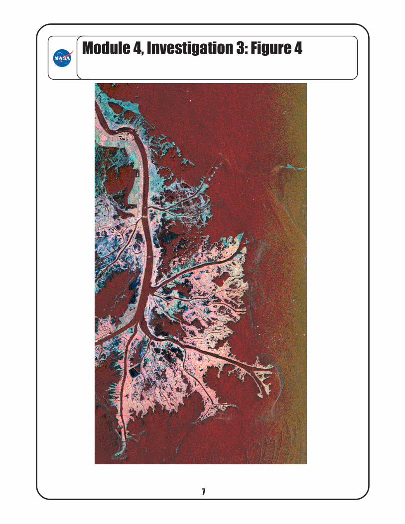
Figure 4: Mississippi River delta <http://
southport.jpl.nasa.gov/pio/srl2/sirc/srl2-delta.gif>
This is a radar image of the Mississippi River delta
where the river enters into the Gulf of Mexico along
the coast of Louisiana. The main shipping channel
of the Mississippi River is the broad red stripe
running northwest to southeast down the left side
of the image. The bright spots within the channel
are ships. This image was acquired aboard the
Space Shuttle Endeavour on October 2, 1995. The
image is centered on latitude 29.3 degrees North
latitude and 89.28 degrees West longitude. The
area shown is approximately 63 kilometers by 43
kilometers. North is towards the upper right of the
image. As the river enters the Gulf of Mexico, the
water slows down and dumps the sediment that it
has eroded from the land. This sediment accumu-
lates over the years and forms new land in the
delta. Most of the delta in the image consists of
mud flats and marsh lands. There is little human
settlement in this area due to the instability of the
sediment.
Background: One- and Two-Way PathsOne-way paths are ones in which movement is over-
whelmingly in one direction. For example, rivers and
glaciers flow downhill, and prevailing or constant winds
and currents such as the jet stream and gulf stream
flow in a consistent direction. Movement on two-way
paths can be in either direction. There are many
human examples such as roads and railroads. Animal
paths, bird flyways, and some environmental flows (for
instance land breeze/sea breeze patterns), or flows in
tidal channels, are examples of two-way paths.
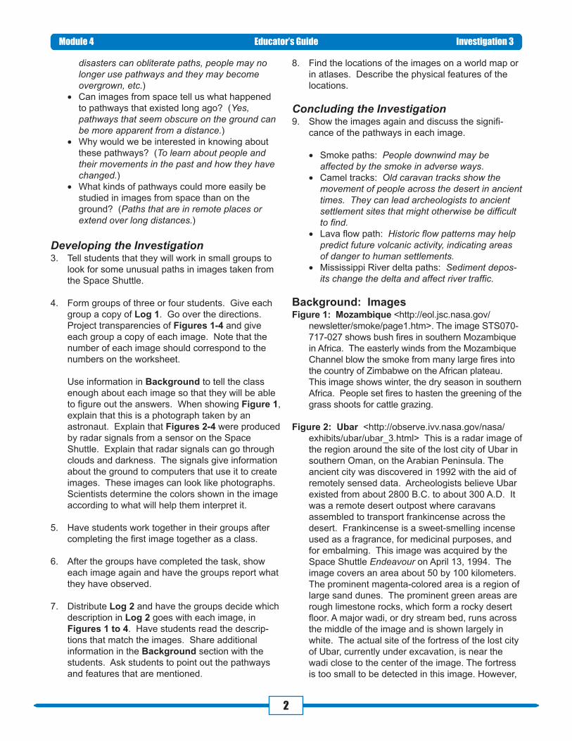
Evaluation*Log 1
*Log 21. Ubar
2. Teide volcano
3. Mozambique
4. Mississippi River delta
Module 4 Educator’s Guide Investigation 3
Related Resourceshttp://observe.ivv.nasa.gov/nasa/ootw/1999/ootw_990512/
ob990512_more7.html Japan, good images of lava flows
What arethe paths inthe image?
Made bynaturalforces,
people, oranimals?
One-wayor
two-waypath?
Can itchange?
How/why?
1. smoke
2. caravan
routes
3. lava
flows
4. river
channel
natural/
people
people/
animals
natural
natural
1
2
1
1
yes, wind
changes
yes, people
change
routes
yes, lava
erupts
elsewhere
yes, channels
change
course
4
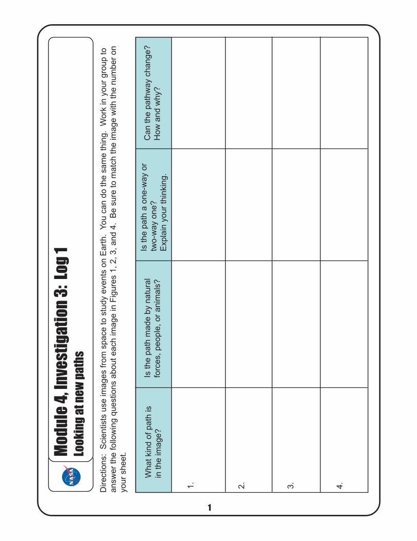
Directions:
Scie
ntists
use im
ages f
rom
space t
o s
tudy e
vents
on E
art
h.
You c
an d
o t
he s
am
e t
hin
g.
Work
in y
our
gro
up t
o
answ
er
the follo
win
g q
uestions a
bout each im
age in F
igure
s 1
, 2, 3, and 4
. B
e s
ure
to m
atc
h the im
age w
ith the n
um
ber
on
your
sheet.M
odul
e 4,
Inve
stig
atio
n 3:
Log
1Lo
okin
g at
new
pat
hs
1
1.
2.
3.
4.
What
kin
d o
f path
is
in t
he im
age?
Is th
e p
ath
made b
y n
atu
ral
forc
es,
people
, or
anim
als
?
Is t
he p
ath
a o
ne-w
ay o
r
two-w
ay o
ne?
Expla
in y
our
thin
kin
g.
Can t
he p
ath
way c
hange?
How
and w
hy?
5
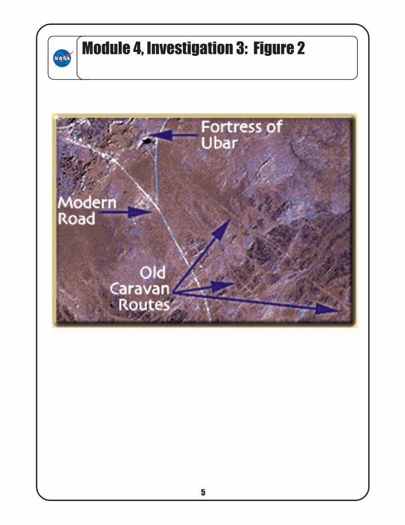
1. This is an image of ancient camel caravan paths. The paths lead to a place where
there was once a city called Ubar. The ancient city was discovered in 1992 with the
aid of images from space. For years, archaeologists have looked for the lost city of
Ubar. Ubar is believed to have been in southern Oman, on the Arabian Peninsula.
Archaeologists believe Ubar disappeared about 1700 years ago. Ubar probably was
a desert outpost where caravans met while they were carrying goods across the
desert. Frankincense was an important trade item. Frankincense was used as a
medicine, as perfume, and in preserving dead bodies.
The fortress is too small to be seen in this image. However, ancient camel tracks
leading to the site, and surrounding tracks, appear as reddish streaks. This image
and field investigations will help us to learn more about this little-known early civiliza-
tion.
2. This is an image of the pathways of lava. This volcano is called Teide and is located
on the island of Tenerife in the Canary Islands. The Canary Islands, part of Spain,
are located in the eastern Atlantic Ocean off the coast of Morocco. This is the third
highest volcano on Earth. Teide last erupted in 1909. The city of Santa Cruz de
Tenerife may be damaged by lava flows.
Scientists are using images like this one to understand how Teide developed and
what paths future lava flows might take. The volcano is one of fifteen that scientists
have listed as possibly dangerous for local populations.
2
Module 4, Investigation 3: Log 2Reading about the images
6
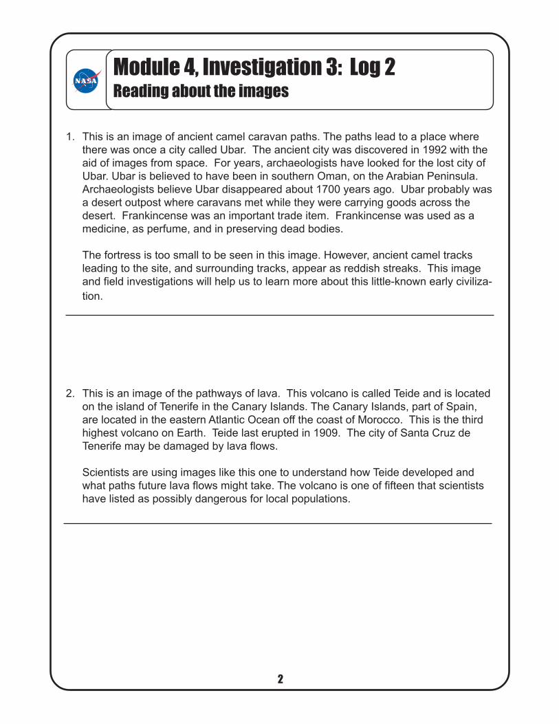
3. This is an image of the pathway of smoke. The image is from Mozambique in Africa.
Winter is the dry season in southern Africa. Many cattle are raised in this area.
Fires are set to speed up the greening of the grass shoots for cattle grazing.
The easterly winds from the Mozambique Channel blow the smoke from these many
large fires. The smoke is carried by the wind to the southern part of this island. The
wind carries the smoke into the country of Zimbabwe.
4. This is an image of the Mississippi River Delta on the Louisiana coast. It shows the
channels that ships take through the delta as they enter or leave the river. The main
shipping channel of the Mississippi River is the broad red stripe.
As the river enters the Gulf of Mexico, it dumps most of the sediment (mainly mud,
clay, and sand) that it has eroded from the land. This sediment can pile up over the
years, adding new land to the delta and making the channels find new paths as the
old ones become clogged.
Most of the land in the delta is made up of mud flats and marsh lands. There is little
human settlement in this area because it is not safe to build on sediment that keeps
shifting.
3
Module 4, Investigation 3: Log 2Reading about the images
74
Module 4, Investigation 3: Figure 1
85
Module 4, Investigation 3: Figure 2
96
Mod
ule
4, In
vest
igat
ion
3: F
igur
e 3
107
Module 4, Investigation 3: Figure 4