module 6 - npsi.gov.aunpsi.gov.au/files/pages/2613/module-6-project-management-and... · module 6:...
TRANSCRIPT

www.nlwra.gov.au
Building capacity to implement natural resources information management sys-tems.
MODULE 6: Project Management and Justification - Lessons Learnt, Pitfalls and Best Practice Procedures
MO
DU
LE 6

Promoting Best Practice in Spatial Data and Information Management
Module 6: Project management and justification – lessons learnt, pitfalls and best practice procedures Page i
Table of Contents
Guide for managers..................................................................................................................iii Context ......................................................................................................................................iii Actions.......................................................................................................................................iii Acknowledgements ................................................................................................................. iv Guide to symbols ...................................................................................................................... v
6.1 Background.............................................................................................................................1
6.2 Pitfalls, lessons learnt and best practice in managing IT and GIS projects .................1
6.3 Introduction .............................................................................................................................2 6.3.1 Poor Planning ...........................................................................................................2
6.3.1.1 Feasibility Study Planning.................................................................................................. 3 6.3.1.2 What is this project all about?............................................................................................ 3 6.3.1.3 Should we do this project?................................................................................................. 3 6.3.1.4 Project Implementation Planning....................................................................................... 6 6.3.1.5 Project Planning Summary ................................................................................................ 7
6.3.2 Lack of corporate management support ...............................................................8 6.3.3 Poor project management........................................................................................9
6.3.3.1 Software Development Process........................................................................................ 9 6.3.3.2 The Role and Responsibilities of the Project Manager................................................... 10
6.3.4 Lack of customer focus and end user participation ..............................................12 6.3.5 Summary.................................................................................................................13 6.3.6 References..............................................................................................................13
6.4 Being consistent in managing IT and GIS projects ........................................................13
6.5 Project justification...............................................................................................................15
6.6 Project management guidelines, methods and project justification support ............17 6.5.2 University of Tasmania project management guidelines......................................18 6.5.3 Setting up for Success: A guide for designing, managing and evaluating projects.19 6.5.4 NSW information to support sustainable management of natural resources – Information Management Framework ...................................................................................19 6.5.5 Project justification support.....................................................................................19 6.5.6 Additional resources and project management associations...............................19 6.5.7 Monitoring and evaluation for NRM projects.........................................................20 6.5.8 Regional NRM support services ............................................................................20
6.7 Developing a risk management plan.................................................................................21 Attachment 6–1 ...................................................................................................................................22 Attachment 6–2 ...................................................................................................................................31
Product Number: PN21205
ISBN: 978-0-642-37155-3

Promoting Best Practice in Spatial Data and Information Management
Module 6: Project management and justification – lessons learnt, pitfalls and best practice procedures Page iii
Guide for managers
Context
Many organisations throughout the world have invested heavily in SIS software and data capture
programs. However, in many cases the implementation processes have not operated in an
effective or efficient manner, and the anticipated benefits have not been realised. Many projects
have run over budget or not delivered on time. Considerable knowledge of the reasons for failure is
becoming increasingly available to assist managers in the design and implementation of projects.
It is acknowledged that each state and territory jurisdiction has its own implementation
arrangements for NRM projects. The intent of this guideline is to provide an overview of lessons
learnt from previous GIS and IT projects, along with resource material that supports ‘best practice’
for project management, e.g. the development of regional NRM plans, and monitoring and
evaluation activities. It is hoped that such material will be generic enough to be useful to all NRM
projects.
Actions
Managers should be aware of the experiences and lessons learnt from other organisations to
ensure their projects are designed and implemented to achieve maximum benefit. There are many
examples where an integrated management solution has been successful in NRM projects,
however, there are also examples of projects that have failed to return any measurable benefit to
the organisation.
Following are a number of tips for the successful implementation of SIS projects:
■ Understand the problem before jumping to a solution.
■ Always include key stakeholders in the feasibility process.
■ Carefully assess internal development capabilities.
■ Define requirements clearly.
■ Distinguish the problem from the symptoms surrounding it.
■ Resolve political issues.
■ Anticipate change during the life of a project and put systems in place to manage it
including a risk management plan.
■ Make sure effort invested in project management fits the budget, duration and
complexity of the project.
■ Evaluate the project at various stages, and at the end, to make refinements and help
future project implementation.
The key to justifying expenditure on spatial information management processes and projects is to
be clearly focused on the benefits to your organisation or NRM body. Where possible these

Promoting Best Practice in Spatial Data and Information Management
Module 6: Project management and justification – lessons learnt, pitfalls and best practice procedures Page iv
benefits should be considered positive outputs, however they can also include potential risks and/or
costs to the organisation or NRM body if investment is not made in its spatial information
infrastructure.
Managers should also refer to material provided in the following guidelines:
■ Module 1: Information management and the sustainable development of natural
resources
■ Module 2: Data management principles.
Acknowledgements
This module draws heavily on an article produced by Mr David Hamil which has been included with
his permission. Additional material has been sourced by the State Government of Tasmania, the
University of Tasmania and the NSW Government Natural Resources Information Management
Strategy and other NSW Government Department guidelines. Selected material has also been
sourced from the ANZCLIC – Local Government Toolkit. These sources are duly acknowledged.

Promoting Best Practice in Spatial Data and Information Management
Module 6: Project management and justification – lessons learnt, pitfalls and best practice procedures Page v
Guide to symbols
The following symbols are used throughout the Toolkit as a guide to users, and draw attention to
important issues and information.
Information which readers should take particular note of
Best practice information
Tips for readers—based on experience and aimed at saving time and resources
Caution—readers are advised that particular care should be taken or that the subject issue may be complex
Additional information
Capability raising—used to show a signpost to a higher capability level
Bold Text
Used to highlight a particular issue
Boxed Text
Highlighting of issues specifically related to ANZLIC or the Audit

Promoting Best Practice in Spatial Data and Information Management
Module 6: Project management and justification – lessons learnt, pitfalls and best practice procedures Page 1
6.1 Background Many organisations throughout the world have invested heavily in GIS software and data capture
programs. However, in many cases the implementation processes have not operated in an
effective or efficient manner, and the anticipated benefits have not been realised. Projects often run
over budget, or are not delivered on time. An understanding of why such failures occur is becoming
increasingly available to assist managers in the design and implementation of spatial information
projects of all sizes, budgets and complexity.
In most cases the software was not the problem, but rather some of the essential ingredients that
comprise an integrated management solution were not addressed in the correct manner, e.g.
leadership, management, planning, etc.
Fortunately, considerable literature is now available on the implementation and management of
GIS projects, and a stand-alone guideline on Information Management and the Sustainable
Development of Natural Resources has been prepared as part of this Toolkit series.
The intent of this module is to provide an overview of some of the pitfall and lessons learnt (best
practice) from previous experiences in implementing GIS projects, plus support material on project
management and best practice procedures for regional natural resource projects.
6.2 Pitfalls, lessons learnt and best practice in managing IT and GIS projects
The following material, included with the permission of Mr. David Hamil, provides a clear overview
of the pitfalls and issues in managing GIS and IT projects.
Your Mission, Should You Choose To Accept It: Project Management Excellence
BY David L. Hamil, PMP, MESA Solutions, Inc.
Project failure is endemic in the geo-spatial information systems (GIS) industry. A recent study
performed by KPMG Information Technology, a Toronto-based professional services company,
showed that of the projects that failed, 87% went more than 50% over budget, 45% failed to
produce the expected benefits, and 86-92% went over schedule. Do you know why 85% of all
projects fail to meet all of their critical measures of success? Do you know how to avoid the pitfalls
and mistakes that can cripple your projects and derail your career? If you answered no to either of
these questions, then your projects may be in trouble. This paper presents the top 4 factors that
have a direct bearing on the success or failure of a GIS project, and the strategy for substantially
achieving project management excellence.
Web Link – This article is available at http://spatialnews.geocomm.com/features/mesa1/

Promoting Best Practice in Spatial Data and Information Management
Module 6: Project management and justification – lessons learnt, pitfalls and best practice procedures Page 2
6.3 Introduction Technology projects worldwide are costing companies billions of dollars more than they budgeted
for, and almost half don't live up to the clients' expectations. Newspapers and business dailies
trumpet few project successes but a massive number of failures. As projects grow larger and more
complex with every passing year, their outcomes - both successes and failures - become fodder for
the media and our competition. Unfortunately, project failures tend to predominate as they not only
make sensational stories but also are far more common.
What are the odds that your next information systems/information technologies (IS/IT) project will
be delivered on time, within budget, and to user expectations? Pretty grim, unfortunately, if you
dwell on the news propagated by IS industry analysts. META Group estimates that half of all new
United States software projects will go way over budget (META Group, 2000). The Standish group
says 53% of IS projects overrun their schedules and budgets, 31% are cancelled, and only 16%
are completed on time and on budget (Standish Group, 2000).
The mismanagement of projects to develop the geographic information systems that companies
use to run their businesses has been going on for years and the situation has not improved. "The
management of projects is still treated in a very amateurish way," said Nigel Kelly, a partner in
KPMG's IT practices.
For its study, KPMG surveyed the chief executive officers of 1,450 public and private sector
organizations across the U.S. and Canada, and analysed more than 100 failed IT projects. A
project is considered a failure, according to IS industry analysts, if it was cancelled or deferred
because it wasn't delivering its planned benefits, or if it had a budget or schedule overrun of more
than 30 per cent. Bottom line is that there is an astonishing waste of money here. The GIS sector of
the IS/IT arena is no exception - project failure, sadly to say is as prevalent in our business, also.
Wow, what a project "horror scope" for you and I. However, the real message for you and I is not
that a project fails, but rather why it fails. In analysing these cautionary tales, business leaders can
draw on these "lessons learned" to prevent similar fates in their own project ventures. An analysis
of project failures, both publicized and unpublicized, shows that the principal causes for project
failure can be distilled down to 4 fundamental reasons: 1.) Poor planning, 2.) Lack of corporate
management support, 3.) Poor project management, and 4) Lack of customer focus and end-user
participation.
6.3.1 Poor Planning
GIS evangelists frequently tout the cost savings, improvements in productivity and services, and
market-share increases that GIS can bring to an organization. Why then, have some organizations
that have gone down the GIS road found the process frustrating and the benefits elusive. According
to Dr. Roger Tomlinson, who is widely recognized as the "father of GIS," "one culprit is often to
blame - poor planning (Tomlinson, 2001)."

Promoting Best Practice in Spatial Data and Information Management
Module 6: Project management and justification – lessons learnt, pitfalls and best practice procedures Page 3
Proper planning is a key project driver for success. The success of any organization's GIS
implementation depends on thoughtful planning. Dr. Tomlinson states," without such planning, a
GIS implementation can easily run over budget and still not provide any measurable benefits to the
organization." Thus the formula for a successful GIS is to focus on strategic business needs and
know, going into it, what you want to get out of your GIS.
GIS project planning must occurs at two distinct times - at feasibility study time and during project
implementation time.
6.3.1.1 Feasibility Study Planning
A feasibility study typically is the response to some client-identified problem or opportunity. It
reveals what is required to build a solid business case, allowing management to make an informed
decision about funding or cancelling the project. "To be, or not to be?" is the primary question a
feasibility study answers. This primary question can be decomposed in three supporting questions:
What is this project all about? Should we do this project? How should we go about this project?
6.3.1.2 What is this project all about?
One primary reason for project restarts, or outright failure, is the lack of a project mission, which at
this early point means a careful analysis of the problems or opportunities and their possible impact
on the organization. Team members, customers, and other stakeholders need a good
understanding of the project's fundamental components - goals, objectives, scope, problem
statement, constraints, and vision.
A good test of whether or not a project is understood is to walk around and ask various participants
what they think it's all about. A crisp, business-oriented, non-technical answer usually means the
project's groundwork is well established. The answer could be what we refer to as a project
objective statement: a short, concise, high-level summary of the project. For example, 'To identify
and deliver a production-ready, state-of-the-art geographic information system to include online
service provisioning and assurance subsystems by July 9, 2002."
6.3.1.3 Should we do this project?
The second major question answered by a good feasibility study is whether or not the project
should proceed. The very name "feasibility" indicates one possible outcome is not to proceed. A
significant portion of the multi-billion losses on software projects comes from projects that should
never have gotten past the feasibility stage, but got caught up in corporate egos and politics. Once
the problems and opportunities have been identified, the next task of the feasibility study is to define
the criteria for an acceptable solution. Feasibility (acceptability) incorporates political, economic,
technical, and organizational components. For example, if the senior vice president of engineering
demands that a particular project to be done, why spend weeks coming up with a detailed
cost/benefit analysis? In this case, the "should" question is fairly easy to answer. It is more effective
to spend the remaining time answering the other feasibility questions.

Promoting Best Practice in Spatial Data and Information Management
Module 6: Project management and justification – lessons learnt, pitfalls and best practice procedures Page 4
The second phase of answering the "should" question is to identify the alternatives and recommend
one. The alternative of not continuing the project should always be thoroughly considered. Table 1
shows key signs of an unfeasible project.
Table 6-1 Signs of an Unfeasible Project
Reasons "Not to Be" (Signs of an Unfeasible Project)
1. Major political issues are unresolved by the feasibility study.
2. Key stakeholders won't participate in the feasibility study (and therefore the project).
3. Risks (probability of adverse consequences) are too high (technical, economic, organizational).
4. Cost and benefit ratio isn't favourable enough, especially when benefits are "soft."
5. Internal staff's experience and training is insufficient for the project.
6. Requirements are unclear, or keep changing radically during the feasibility study.
7. Risk and reward ratio is unfavourable. High risks usually need a high reward to be worthwhile.
8. Clients (in a multidisciplinary project) can't agree on exactly what the problems or objectives are.
9. No executive wants to be the project's sponsor.
iii. How should we go about this project?
A good feasibility study says more than "do it." In addition to defining the project objectives and
deciding whether or not to proceed, it provides a broad outline of how to proceed. This involves
preparing an initial, high-level project plan that provides a gross project sizing, identifies major
milestones, and estimates resource needs. A plan of action serves two purposes: it gives the
follow- up team a direction, and it forces the feasibility study team into thinking about critical
implementation issues up front. Figure 6-1 depicts six simple steps for feasibility analysis.

Promoting Best Practice in Spatial Data and Information Management
Module 6: Project management and justification – lessons learnt, pitfalls and best practice procedures Page 5
The success or failure of a project is often decided very early. To pull off an effective feasibility
study, you must have the right attitude and the right approach. Having a good feasibility study
process without the proper commitment from management and staff to listen to the answers
doesn't work well - it results in substance without form. Having a commitment to listen, but without
the substance of a reasonable feasibility study process isn't much better. Doing a feasibility study
takes time up front, and it will likely result in a later start date for a software project. The potential
benefit you'll receive from starting slow, however, is a quality product finished on time and within
budget. Table 6-2 shows several tips for a successful study.

Promoting Best Practice in Spatial Data and Information Management
Module 6: Project management and justification – lessons learnt, pitfalls and best practice procedures Page 6
Table 6-2 Tips for a Successful Study
Tips for a Successful Study
1. Understand the problem before jumping to a solution.
2. Always include key stakeholders in the feasibility process.
3. Carefully assess internal development capabilities.
4. Define requirements clearly.
5. Distinguish the problem from the symptoms surrounding it.
6. Resolve political issues.
6.3.1.4 Project Implementation Planning
The solution to successful project implementation planning is to develop an understanding of the
full scope of the GIS project. Using the results of the feasibility study as a basis, you must achieve
answers to the following questions: What you're building? Why you're building it? What are your
requirements? Who your customer is? Who's in charge of the project and who are the key or
required staff? What are the risks? What are the benefits? What are the major milestones and
target dates for each? And of course, it's also important to understand what your project isn't. A
project that tries to meet everyone's objectives likely will please no one.
The answers to the above questions, along with many others, should be documented in a formal,
approved document, called the "Project Plan," which is used to manage and control project
execution. The project plan is a single document or collection of documents that should be
expected to change over time - a "living" document - as more information becomes available about
the project. A solid project plan is a blueprint, or a game plan, that charts the entire project's course.
For example, the risk assessment portion of the plan should help to minimize the cost of rework by
anticipating and addressing problems early in the project. According to the Project Management
Institute (PMI, 2000), "there are many ways to organize and present the project plan, but it
commonly includes all of the following:
■ project description and overview
■ a description of the project management approach or strategy
■ scope statement, which includes the project deliverables and the project objectives
■ work breakdown structure ("WBS") to the level at which control will be exercised

Promoting Best Practice in Spatial Data and Information Management
Module 6: Project management and justification – lessons learnt, pitfalls and best practice procedures Page 7
■ cost estimates, scheduled start dates, and responsibility assignments to the level of
the WBS at which control will be exercised
■ performance measurement baselines for schedule and cost
■ definition of project success criteria
■ major milestones and target dates for each
■ subsidiary management plans, including:
risk management plan that identifies key risks, including constraints and
assumptions, and planned responses for each
resource management plan
schedule management plan
cost management plan
quality assurance/quality control plan
communications plan.
6.3.1.5 Project Planning Summary
The fundamental premise of achieving excellence in project management states that the project
manager's greatest challenge is effectively balancing (or juggling) the components of time, cost,
scope, quality, and the expectations for each. Figure 6-2 shows the project diamond, which
signifies this balance.

Promoting Best Practice in Spatial Data and Information Management
Module 6: Project management and justification – lessons learnt, pitfalls and best practice procedures Page 8
The components of the project diamond have a symbiotic relationship. For example, when a user
requests an additional report that wasn't agreed on in the requirement specifications, the project's
scope and quality change. This will change the other project components as well. As a result, the
diamond's shape will be skewed, graphically depicting a project out of control. The challenge is
managing change while keeping the diamond's shape intact. Project planning defines the diamond,
while effective and efficient change and expectation management lets you manage it throughout
the project's life cycle.
Effective project planning is not conducted in a vacuum. It must be carried out in coordination and
cooperation with all appropriate stakeholders. The project manager must manage their
expectations throughout the process. The project manager must constantly look for opportunities to
create win- win relationships by negotiating work that must be accomplished. A project manager
who declares, "this can't be done in the time frame allotted" will meet with stiff resistance from client
management. On the other hand, a project manager who can defend this statement with a solid
understanding of the project's scope, backed by a logical work breakdown structure; thoughtful
estimate and project schedule; and concise risk analysis will be met with a response like, "Maybe
you're right. Help me to understand what you understand." This is effective expectation
management and proper development of win-win relationships. Once your project plan is in place,
it's much easier to manage your project diamond.
6.3.2 Lack of corporate management support
Does your project have the full cooperation and support of corporate management? If not, then
you're project is likely doomed to cancellation or cutbacks. Your project is not the only game in
town. Make sure you have a dedicated sponsor who will support your project from its inception to
completion, such as a project manager who communicates resource needs early and often to his or
her senior management.
A project succeeds only when senior leadership makes it a top priority and broadly communicates
their sponsorship across the organization. Organizations respond when leadership emphatically
communicates their commitment to the project. All levels, from the bottom through the middle to the
top, must remain sensitive to the needs and priorities of the project.
Without the commitment of our upper management, then our projects may suffer in any one or
more of the following areas:
■ Inadequate Staffing - Your team cannot set and maintain direction if key positions are
left unfilled or inadequately filled for a long period. This is where the inner-company
politics come into play. The project manager must aggressively seek out talent. They
must identify the critical skills and characteristics needed for success in an open
position. They must organize a selection process that leaves little question about what
team members can do and how they would fit within the project team.

Promoting Best Practice in Spatial Data and Information Management
Module 6: Project management and justification – lessons learnt, pitfalls and best practice procedures Page 9
■ A project manager is only as good as his or her team; don't let your ego distract you
from your project's goal. Work with your senior management to assemble a talented
team, provide resources and ground rules, and let the players take ownership of the
target solution. You've probably heard the statement, "80% of management is picking
the right people, and the other 20% is getting out of their way." A good project
manager must create an environment where the "right people" can perform optimally.
You have to work hard to fail if you have the best people.
■ Unfulfilled Commitments - The project manager should always engage in good-faith
commitments with customers and managers about what is realistically achievable. In
spite of this, if the project manager loses, or never fully obtains support from his or her
senior management, then even such commitments as funding, staffing availability,
and hardware and software needs may be unachievable.
■ Inadequate Funding - It almost goes without saying that a project is "dead" if funding
is insufficient or if funding is cut. Corporate management will put their money where
they believe they will receive the most benefits. If you, as the project manager, truly
believe in your project and can communicate both its short- and long-term benefits,
then you must be that "champion for the cause" to keep your project funded.
6.3.3 Poor project management
Project management can be subdivided into two categories - the software development process,
and the role and responsibilities of the project manager.
6.3.3.1 Software Development Process
GIS projects, like a project for constructing an automobile, must have an ordered set of steps for
taking what started as a concept in someone's mind to a real product that is usable by the client.
Without a sound software development process, GIS projects can easily run astray. Many
organizations that undertake a GIS project do not fully embrace a defined, repeatable, and
predictable software development process. The consequence of this behaviour usually is a
significantly increased risk to the project in predicting and controlling the critical factors of schedule,
cost, scope, and quality.
According to Neal Whitten, a world-renowned project management author and lecturer, "an
organization may have currently defined processes, but those processes are ineffective for one or
more of the following reasons (Whitten, 1995):
■ not comprehensive enough: they do not already define all of the activities that apply to
all new projects,
■ overly complex: they require too much time and skill to comprehend and apply,
■ not flexible: they are not easily tailored to meet the unique needs of new projects,
■ not "owned": there is weak or no buy-in from the project's members,

Promoting Best Practice in Spatial Data and Information Management
Module 6: Project management and justification – lessons learnt, pitfalls and best practice procedures Page 10
■ not continuously improved: lessons learned from past projects are not used to
improve the current processes, and
■ not enforced: the guidelines are there, but the project leadership lacks the discipline to
enforce them.
Even worse is the situation where a software development process is not followed because a
process has never been defined and documented fully. Having no software development process,
or not following a defined process, is indicative of an organization that, albeit perhaps
unintentionally, lacks the vision and discipline to become or maintain a world-class position in the
fiercely competitive software industry. A software development process offers a framework from
which to plan a new project, avoid repeating mistakes of past projects and improve on things that
went well. Whitten defined eight steps to define a software development process (Whitten, 1995).
The top three of these steps are:
1. Identify the software model - The first step in defining a software development process is
deciding on the software process model that best fits the needs of your organization and
the type of project you are implementing. There are numerous models and variations of
models from which to choose. Most models are derived, at least in part, from one or more
of the following basic models: Code-and-Fix Model, Waterfall Model, Incremental Model,
and Iterative Model.
2. Identify the Activities - Once the software model has been selected, the next step is to
identify the primary activities that need to be implemented to satisfy it. A representative list
is as follows: Requirements Definition, Functional Design, Detail Design, Test
Plans/Procedures, Code, Unit Testing and Incremental Deliveries, Integration Testing,
Regression Testing, System Acceptance Testing, Software Packaging and Delivery,
Training Plans/Procedures and Training
3. Identify the Relationships Among Activities - With the activities defined, now identify the
relationship between related activities. This can be achieved by listing the entry and exit
conditions for each activity
Let's look at the entry and exit conditions for the Functional Design activity.
Entry Conditions: The approved requirements, as set forth during the Requirements
Definition, are distributed for review.
Exit Condition: The GIS functional specifications are reviewed and approved prior to
proceeding on to the Detail Design activity.
6.3.3.2 The Role and Responsibilities of the Project Manager
KPMG's Kelly stated, "The management of projects is still treated in a very amateurish way."
Although some of the blame can be placed on the software development process, or a lack thereof,

Promoting Best Practice in Spatial Data and Information Management
Module 6: Project management and justification – lessons learnt, pitfalls and best practice procedures Page 11
the primary place to "point is finger" when poor project management comes into play is a failure by
the project manager to "manage the project."
Simply put, the project manager is "the" individual with the responsibility for managing the project.
To get results, the project manager must relate well to: the people to be managed, the tasks to be
accomplished, the tools available, the organizational structure, and the organizational environment,
including the customer community.
I have identified six key competencies of a "top gun" project manager:
1. Education and Experience in Project Management - Organizations that undertake the
management of very diverse projects must possess thorough knowledge of project
management and implementation. Along with up to date formal training, the project
manager should be an apprentice "on the job" before he or she is placed solely in control
of managing a project. Remember, project management and implementation is a craft, not
a science - you can't quantify all of it. At some point, you'll have to rely on your own intuition
and experience to substantially ensure success.
All in all, the project manager must possess the skill set to be able to manage their project,
from inception to completion, using the organization's software development process.
2. Negotiation and Communication Skills - Another of the key competencies of a "top gun"
project manager are his or her ability to effectively negotiate and communicate with senior
management, direct reports on the project team, the client, supporting organizations, and
other stakeholders who have a vested interest in the success of the project.
3. Planning and Organization Skill - Recall the number 1 reason for project failure is poor
planning. The project manager has direct control over this and can setup the necessary
measures to "build the proper foundation" that will be a stepping-stone to project success.
Coupled with proper planning, the project manager must be a good ringleader who
minimally organizes the following: meetings, schedules, deliveries, financial statements,
and various other plans to substantially ensure his or her project is targeted for success.
4. Effective Problem Solver - Due to the complexity and diversity that may exist within a
project (e.g., a GIS data migration project), the project manager is often called on to
analyse problems and make timely, strategic decisions that can have a profound affect on
the project - whether good or bad. The project manager should be skilled at being able to
isolate the root cause of a problem at any given moment in a project, and if necessary
enlist the help of his or her project team to "buy into" the solution.
5. Leadership Ability - The best leaders spend much of their time just watching and taking
it all in. They avoid jumping to conclusions or leaping to premature judgments. They try to
understand what is needed and why. They are constantly learning from minute to minute
as well as from year to year.

Promoting Best Practice in Spatial Data and Information Management
Module 6: Project management and justification – lessons learnt, pitfalls and best practice procedures Page 12
Never forget that every leader is always being watched. Set the standard with your own
attitude and performance. If you demand thoroughness, practice it. If you expect openness
to new ideas, listen and consider. If you want to promote teamwork, be a team player. If
you want good communication, communicate well. Sure it's obvious, but it can be darned
hard at times to practice what you preach.
6. Aims for Excellence in All Work - Although I believe much of how a project manager
functions in his or her daily work is characteristic of their very nature, the project manager
can learn to aim for no less than the best. The project manager, of all people on the project
team, must strive for excellence in "all" project work, and expect no less than the same
from his or her project team. Achieving excellence in a couple of areas, but missing the
mark in others is not acceptable. For example, if the team meets a particular software
delivery date and kept the expenditures within budget, but what the team delivered does
not meet the quality expectations, as defined by the client, then we have missed the mark
on achieving overall project excellence. It's a tall order, but one that we should strive for.
All in all, seasoned project managers are good ringleaders. They know they must balance
four elements of expectations - quality, schedule, cost and scope - at all times. Quality
shouldn't be sacrificed to adhere to a rigid schedule or a tight budget. Nor should a
schedule be tossed aside because of an obsessive focus on quality. Yet in even the most
well managed project, sometimes it makes sense to ease up on a deadline, a budget or a
quality-control process. But these slips shouldn't simply happen. They should come from
conscious decisions made by project managers who understand their objectives and know
that project management is a balancing act.
6.3.4 Lack of customer focus and end user participation
Are your users involved in the system requirements definition process, the system design process,
and throughout the project's implementation and testing phases? If the customer loses focus or is
never fully engaged in the project, then you’re faced with the situation where the project
deliverables likely will not meet the client's expectations.
User involvement is a key driver for a successful project. It is absolutely imperative that the
customer, including the end-user of the GIS, be proactively involved throughout all lifecycle phases
of the project. The end users are powerful and are only becoming more so. Their power can work
for you, or against you. To have their power work for you then make sure the client's users are a
part of the project team, and that you involve them during requirements gathering, application
design, prototyping, testing, and incremental acceptance. If you, as the project manager, do not
include the very users who will be using the GIS, then you may not achieve buy-in to the new
system. Far too often, lack of buy-in by the true GIS users causes the system to be "shelved." Oh
yes, the system may satisfy every requirement, pass every acceptance test procedure, and receive

Promoting Best Practice in Spatial Data and Information Management
Module 6: Project management and justification – lessons learnt, pitfalls and best practice procedures Page 13
signoff by the client's project manager. However, it could fail to pass the most important test - user
acceptance.
The client involvement, and in particular the end-user participation, can "make" a project. Reminder,
the end users are probably the most powerful organism in the client's organization. Let's ensure
that they're playing on our team.
6.3.5 Summary
Considering that billions is spent each year on IT software development in the U.S. and Canada
alone, the KPMG and Standish findings painted an alarming picture of project mismanagement in
both private and government sectors. There's a buyer beware message to the extent that the
clients need to understand what they want, what they are getting, and go after it with a vengeance.
Clients need to be able to quantify and qualify project benefits, have it planned initially, managed
properly, and its status monitored early, often and closely.
Remember, all software projects run into snags - no project is immune from failure. The potential
troubles are well known: missed deadlines, blown budgets, unmet expectations, and internal
resistance - the list goes on and on. How teams respond to problems determines the project's
eventual success or failure. Avoid past mistakes by responding effectively to problems as they
arise. The trick is to manage a project in a proactive way, preventing some problems and
minimizing the effects of others. With proper planning, support of senior management, sound
project management, and active client involvement, a GIS team can bypass many common
mistakes.
While there are essentially 4 principal reasons why projects fail, as I have documented here, it only
takes one of them to make the difference between success and failure. While avoiding the mistakes
of the past, never forget to stop and celebrate successes, even the small ones. GIS technology is
taking organizations places they've never gone before. So when you get somewhere that you've
never been, be sure to have your team "pull over" to take in the view. Then push on together.
6.3.6 References
META Group. 2000, http://www.metagroup.com/, META Group, Stamford.
Standish Group, 2000, http://www.pm2go.com/, The Standish Group International, West Yarmouth.
Tomlinson, R. 2001, Planning for a GIS, Environmental Systems Research Institute, Redlands.
Whitten, N. 1995, Managing Software Development Projects, John Wiley & Sons, New York.
6.4 Being consistent in managing IT and GIS projects
Many of the pitfalls and lessons learned outlined in the previous section can be addressed by using
a consistent approach to managing IT and GIS projects. Many organisations, including local
governments, state/territory and Australian government agencies and private companies, now

Promoting Best Practice in Spatial Data and Information Management
Module 6: Project management and justification – lessons learnt, pitfalls and best practice procedures Page 14
employ full-time staff or hire consultants to set up and run a project office. A project office is the
centre of excellence within the organisation to provide support for those involved in projects
(including project managers, members of steering committees or those involved in a project team)
to better understand their roles and responsibilities.
The good news is that all organisations and NRM regional bodies can benefit from the consistency
in approach to project management used by those in the project offices of large organisations.
Some of these resources include:
■ PRINCE (Projects IN Controlled Environments)—developed and extensively used
by the UK government and widely recognised and used in the private sector, both in
the UK and internationally. PRINCE, the method, is publicly available and offers non-
proprietary best-practice guidance on project management.
■ Government of Tasmania Project Management Guidelines—structured set of
tools, techniques and support resources for managing all kinds of projects in
government. The resource has been constantly evolving since 1996 and now
provides a consistent approach to managing all projects, including IT and GIS
projects, in Tasmania and beyond.
■ Australian Standards on Project Management (AS 4915-2002)—formal set of
approaches used in some federal government agencies.
1 2
Use one of the standardised project management approaches for selected projects
with formalised project documentation and process. Link these selected projects
with individual/departmental level business cases.
These approaches, along with most other structured project management methods, focus on:
■ a controlled and organised start (initiation), middle (management) and end
(finalisation)
■ regular reviews of progress against the project plan and what the project is meant to
achieve
■ telling management when projects are forecast to exceed pre-defined tolerances (like
time and/or cost)
■ good communication channels between those working on a project, its managers and
senior staff.
For example, the phases and key elements of the Tasmanian approach is shown in Figure 6–3.

Promoting Best Practice in Spatial Data and Information Management
Module 6: Project management and justification – lessons learnt, pitfalls and best practice procedures Page 15
Figure 6–3 Tasmanian State Government generic life of a project
The Tasmanian State Government project management approach is currently being used by
numerous organisations including NRM regional bodies and local government.
An important part of these project management methodologies is that they allow the development
of a common language within an organisation. What can seem like a daunting set of project
management jargon can quickly become broken down into a simple, useable lexicon, e.g. the
Tasmanian approach has an online glossary. So being consistent can mean ensuring that many
projects within one local government are managed consistently, or that single IT and GIS projects
can be managed in a way consistent with project management best practice. Thus, specialised GIS
projects, which often only happen once every few years, or have never happened before, can have
a much better chance of success.
6.5 Project justification One of the major benefits of following a consistent approach to project management within an
organisation is that staff begin to talk a ‘common project management language’. Technical and
managerial staff can then use this common language to talk about the requirements for new spatial
information projects (including upgrades) and ongoing recurrent expenditure requirements as part
of an organisation’s or NRM regional body’s funding and programming cycle. More importantly,
project justification is streamlined within standard business processes—project management
should be viewed within this context.
For example, the Tasmanian State Government project management system defines a Project
Business Case as:
A one-off, start-up document used by corporate management to assess the
justification of a proposed project, or to assess the development options for a project
that has already received funding. If approved, it confirms corporate management
support and/or funding for a recommended course of action.
The Tasmanian system uses two different styles of business case documents, for small and large
projects, that can be downloaded from their website (see Section 6.5).

Promoting Best Practice in Spatial Data and Information Management
Module 6: Project management and justification – lessons learnt, pitfalls and best practice procedures Page 16
Importantly, when defining justifications to support the development of spatial information projects,
there are some specific issues to consider. For example, Geldermans and Hoogenboom (2001)
believe:
The content of the GIS business case is in general the same as those of usual
information and communications technology projects. However, for a few aspects the
GIS business case is fundamentally different, in particular in the field of assessing the
long-term value of the GIS data, which must be seen as the enabler of any GIS.
Elements of a GIS business case include:
■ What is it about? (purpose of project, description of functionality of application)
■ What are the costs? (people, data and software)
■ What is the financial impact? (decrease of costs, increase of profits, and improvement
of market position)
■ How long will it take to develop the system?
■ How long will it take to gain advantages?
■ What is required to make any of the advantages permanent?
By addressing these six issues the management of the organisation is able to make an educated
decision on the viability of a GIS initiative. Furthermore, the description ensures that the short-term
investments are put into perspective with the long-term benefits and the required intermediate
improvements of the GIS to keep it up to date. In fact, the GIS business case is one of the key
documents describing not only the first implementation of a particular GIS, but also the expected
lifecycle of the GIS. This point, the lifecycle description of a GIS, is a key issue in the GIS business
case, as GIS initiatives are seldom a one-time-only thing and any benefit from a GIS
implementation will evaporate over time if not upgraded periodically.
The critical component of the project justification is to clearly state what the benefits are for the
required expenditure. Put simply, what do we get for our money? This can be a very complex
question to answer, especially if the benefits are not concrete (or tangible) as is often the case with
spatial information projects. Generally there are two approaches to this issue: first is to attempt to
develop economic cost/benefit arguments; and second is to develop qualitative assessments of
benefits, often by comparing the benefits in relation to one another. This distinction is used in the
Tasmanian State Government guidelines with large projects requiring cost benefit analysis, while
small projects require relative assessment of the benefits of different project options.
For example, budget planning and project justification within the City of Perth is integral to the
organisational planning cycle. When planning new projects it is important to anchor your projects
into the business unit’s business plan and ensure sufficient funds are available. The earlier the
planning the more chance it has of being assessed within a timely manner. For the City of Perth the
budget cycle commences in October with the preparation of pre-budget submissions and four-year
forecasts for inclusion in the business plan, together with draft capital expenditure proposals. The
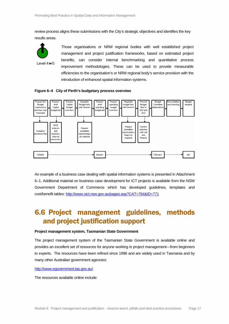
Promoting Best Practice in Spatial Data and Information Management
Module 6: Project management and justification – lessons learnt, pitfalls and best practice procedures Page 17
review process aligns these submissions with the City’s strategic objectives and identifies the key
results areas.
Level 4 5
Those organisations or NRM regional bodies with well established project
management and project justification frameworks, based on estimated project
benefits, can consider internal benchmarking and quantitative process
improvement methodologies. These can be used to provide measurable
efficiencies to the organisation’s or NRM regional body’s service provision with the
introduction of enhanced spatial information systems.
Figure 6–4 City of Perth’s budgetary process overview
An example of a business case dealing with spatial information systems is presented in Attachment
6–1. Additional material on business case development for ICT projects is available from the NSW
Government Department of Commerce which has developed guidelines, templates and
cost/benefit tables: http://www.oict.nsw.gov.au/pages.asp?CAT=764&ID=771
6.6 Project management guidelines, methods and project justification support
Project management system, Tasmanian State Government
The project management system of the Tasmanian State Government is available online and
provides an excellent set of resources for anyone working in project management—from beginners
to experts. The resources have been refined since 1996 and are widely used in Tasmania and by
many other Australian government agencies:
http://www.egovernment.tas.gov.au/.
The resources available online include:

Promoting Best Practice in Spatial Data and Information Management
Module 6: Project management and justification – lessons learnt, pitfalls and best practice procedures Page 18
■ Tasmanian Government project management guidelines—includes the key elements
of project management that need to be considered, regardless of the size or
complexity of a project
■ project management glossary—explains project management terminology
■ project management templates—to support the Tasmanian Government project
management guidelines which are available through this website. The templates
include instructions on the 'what',' why', 'when' and 'how' applicable to each
document. A registration process is required each time a template is downloaded
■ project management knowledge base—a collection of examples from Tasmanian
State Government agencies, reference material and related links
■ project management fact sheets
■ project management frequently asked questions (FAQs)
■ proformas—a collection of useful tools for managing a project
■ project management roles and resources—a self-directed learning tool
■ project management resource kits for managing small projects (including fact sheets
for members)
■ an internet mailing list for sharing ideas and experiences about project management
■ interactive project sizing calculator
■ booklet—a quick guide to project management
■ project management forum presentations
■ project services newsletters
■ project management games, crosswords and cartoons.
6.5.2 University of Tasmania project management guidelines
The University of Tasmania’s project office has developed a range of documents (guidelines and templates) to assist university staff in their management of projects, drawing on the Tasmanian Government resources outlined above. The guidelines have been tailored to the university context but are nevertheless useful for local governments and are constantly reviewed and updated. They are available at:
http://www.utas.edu.au/major_projects/.

Promoting Best Practice in Spatial Data and Information Management
Module 6: Project management and justification – lessons learnt, pitfalls and best practice procedures Page 19
6.5.3 Setting up for Success: A guide for designing, managing and evaluating projects
This guide has been developed by the National Landcare Program Evaluation Coordinators and is available from the Australian Government Department of Agriculture, Forests and Fisheries website at:
http://www.daff.gov.au/natural-resources/landcare/publications/setting_up_for_success.
6.5.4 NSW information to support sustainable management of natural resources – Information Management Framework
The Information Management Framework focuses on the delivery of useable content (business-driven data modelling, information integration, business intelligence, information compliance, data quality) to ensure a comprehensive and consistent approach to the management of information resources consistent with recognised standards and international best practice. This is a comprehensive site containing guidelines, templates and forms:
http://nrims.nsw.gov.au/policies/imf/index.shtml.
6.5.5 Project justification support
Justification for Spatial Information Systems—considerable justification support information is now
available related to the introduction of spatial information systems.
For example:
Packaging the GIS Business Case for the Board Room:
http://www.directionsmag.com/article.php?article_id=2013&trv=1
Measuring the Benefits of GIS: http://www.esri.com/industries/localgov/roi/roi_index.html
A Roadmap to Implementing an Enterprise GIS:
http://gis.esri.com/library/userconf/proc01/professional/papers/pap315/p315.htm
Project Management System—Tasmanian State Government to download business case
templates for small and large projects: http://www.egovernment.tas.gov.au/
An example of a GIS Project Business Case is presented at Attachment 6–1.
6.5.6 Additional resources and project management associations
See the official PRINCE2 website UK Office of Government Commerce to download project
management templates, source training in Australia and where to purchase manuals and other
resources: http://www.ogc.gov.uk/PPM_Resources_prince_2_c2.asp
The Australian Institute of Project Management has chapters in all states and territories:
http://www.aipm.com.au

Promoting Best Practice in Spatial Data and Information Management
Module 6: Project management and justification – lessons learnt, pitfalls and best practice procedures Page 20
The Project Management Institute has chapters in Canberra, Melbourne, Sydney, Brisbane,
Adelaide and Western Australia:
http://www.pmichapters-australia.org.au/home.asp
6.5.7 Monitoring and evaluation for NRM projects
Throughout Australia all state, territory and Commonwealth goverments, along with industry,
community groups and landholders, are investing considerable funds to improve the sustainable
management of natural resources.
A number of documents and guidelines have been prepared as part of monitoring and evaluation
programs for NRM programs, including a ‘Framework for Natural Resource Management
Standards and Targets’, and a ‘National Natural Resource Management Monitoring and Evaluation
Framework’. In addition, a ‘Users Guide’ has been developed providing background information to
assist in the interpretation of the national frameworks. Additional information and the actual
documents are available from the Australian Government Department of Environment and Water
Resources (DEW) website: http://www.nrm.gov.au/me/index.html.
Note: Each state and territory jurisdiction is responsible for developing its own monitoring and
evaluation implementation plans.
6.5.8 Regional NRM support services
A number of jurisdictions have established support service facilities for NRM projects. The following
is a list of such websites.
Queensland: http://www.regionalnrm.qld.gov.au/index.html plus
http://www.nrw.qld.gov.au/. In addition the Queensland Regional Groups Collective also
maintains a website providing NRM support:
http://www.regionalgroupscollective.com.au/default.asp
Western Australia:
New South Wales: The NSW Information Management Framework:
http://nrims.nsw.gov.au/policies/imf/storage.shtml
Tasmania: http://www.dpiw.tas.gov.au/inter.nsf/Home/1?Open
ACT:
Victoria:
Northern Territory:
South Australia: http://www.nrm.sa.gov.au/
Contact details for facilitators and coordinators

Promoting Best Practice in Spatial Data and Information Management
Module 6: Project management and justification – lessons learnt, pitfalls and best practice procedures Page 21
A listing of state and territory facilitators and coordinators for NRM programs is maintained
on the NRM web site: http://www.nrm.gov.au/contacts/agnrm.html#contacts
6.7 Developing a risk management plan There are always risks associated with a project. The purpose of risk management is to ensure
levels of risk and uncertainty are properly managed so the project is successfully completed. It
enables those involved to identify possible risks, the manner in which they can be contained and
the likely cost of countermeasures. Material presented in Attachment 6–2 is taken from the
Tasmanian Government Project Management Fact Sheet to provide background information on
developing a risk management plan. Additional material, including templates, checklists and
prompts is available from the NSW Department of Commerce, Chief Information Office:
http://www.oict.nsw.gov.au/docs/Project_Risk_Man_0904.pdf

Promoting Best Practice in Spatial Data and Information Management
Module 6: Project management and justification – lessons learnt, pitfalls and best practice procedures Page 22
Attachment 6–1
Sample GIS Business Case Document

Promoting Best Practice in Spatial Data and Information Management
Module 6: Project management and justification – lessons learnt, pitfalls and best practice procedures Page 23
Sourced form the internet on 1st June 2007 https://www.derbyshire.gov.uk/Images/content/DemocraticServices/Reports/DSNet/Cabinet/130503CAB6962.pdf
Derbyshire Partnership Forum Report of the Programme Manager Business Proposal for Spatial and Geographical Information for the Derbyshire
1.1 Background
Information about an object that is geographically located is known as geo-spatial information or
“spatial referencing”.
A location can mean many things – an address, postcode, administrative area or perhaps an
ordnance survey grid reference. The vast proportion of national and local government information
can be related to a location and therefore a map.
A GIS is used for capturing, storing, checking, integrating, analysing and displaying spatially
referenced information. That is to say any person, place or thing can be displayed at it’s location
on a digital map and it’s position analysed against any other information on the map.
The key to a successful GIS implementation therefore is the quality and accessibility of datasets,
and addressing the collection, conversion and long term management of the geo-spatial data
must be a high priority within any implementation proposal.
It is feasible to present comprehensive information from Geographic Information Systems
(GIS) to the public by way of publishing through the World Wide Web, and this is a key element
in the partnership strategy for “joined-up” working. However this objective does require both
improved ways of managing the technical information, and additional software functionality.
The local authorities and other organisations comprising the Derbyshire Partnership utilise a
number of disparate back office systems, including GIS. In order to deliver
'joined up' GIS services and 'joined up' GIS information, there are two fundamental technical
options available for the Partnership.
The first option is to re-engineer all the partner back office GIS systems to provide a fully
unified ICT approach, so that each organisation would rely on a central GIS system and
equipment.
A second option is to allow participating organisations to use their existing GIS locally to match
their own internal service delivery needs, and setting their own pace of development.
However there would be a need to set county-wide standards for managing and
distributing datasets between partners, which would require a key co- ordination role to be created
by the Partnership. The information would then be made available to partners through a web-
based front end either via individual web sites or a “Partnership portal”.

Promoting Best Practice in Spatial Data and Information Management
Module 6: Project management and justification – lessons learnt, pitfalls and best practice procedures Page 24
Such an approach would require the Partnership, or more specifically one authority in the
Partnership, to take a lead role in managing the necessary technical architecture and data
protocols to enable disparate datasets to be accessed through a standard web front end for
public access.
1.2 GIS Benefits
The most difficult question to answer with respect to this project is “Why should you do it?” The
business case for this type of project is often initially based around provision of service to the
customer with the potential for internal cost savings or business benefits to follow.
1. The ODPM have mandated (through BVPI 157) that 100% of all services that can be made electronic will be made available by 2005. BVPI 157 specifically mentions Provision of information and Application for Services. Some of this information and services can either only be delivered, or can be significantly enhanced, by the use of visualisation of data on a map base. Examples include:
■ Planning history and constraints, where information cannot be shown accurately
without the plotting of the planning extents onto a map base or
■ Reporting of pot holes, street lights, abandoned vehicles, fly tipping, etc where
information accuracy and hence improved service can be delivered via allowing users
to show position directly on a map
These examples show that there are potentially a number of existing services where
visualisation of the information, via partners web sites, on a map base will be an integral part
of the service delivery.
2. Providing these services integrated with the CRM and A-Z projects will result in a
greater number of enquires being answered at the first point of call, especially on split
responsibilities such as planning. This will reduce the need for “Back Office” functions
and will provide a more focussed service for the customer.
Such benefits are linked to the Business Case for the E-forms project. The services and information
with a spatial nature are to be considered as subset of the overall services and information
delivered and can be seen as an essential building block.
3. Provide new services and information by linking up data that currently exists within
the partner organisations. Spatial data is currently held in separate databases within
individual organisations and cannot be presented together. By linking up this spatial
information across internal council departments, across other local authorities and to
other local organisations (e.g. Health, Fire, Police, etc) the Partnership can provide
new services that will be of significant value to the citizens of Derbyshire and to
council staff. For example, footpath diversion application and tree preservation order
consent.

Promoting Best Practice in Spatial Data and Information Management
Module 6: Project management and justification – lessons learnt, pitfalls and best practice procedures Page 25
These new services could be based around Life Events, for example, if someone is visiting or
moving to the Derbyshire area they may want to know the location of local schools, location
of doctors surgeries, where the bus stops are (as they might not have transport), location
of council services (Libraries, Recycling sites, etc). Then to be able to combine this
information so that they can see, for example, if the doctor’s surgery is close to a bus route
that will take them to this location.
4. Partnership members though could, by pooling the information they hold and using
GIS, improve strategic planning and ensure that resources are located in the best
place to ensure that the needs of local people are met in the most
efficient and effective way. Examples could include the location and number of units of
sheltered accommodation, location and risk assessment of potential fire or other
hazards.
5. The main provider of GIS data to Local Authorities is the Ordnance Survey. Under the
latest Local Authority Services Level Agreement data can be freely exchanged with
other local authorities signed up to this agreement. Therefore, a central repository of
large data sets, such as Master Map, should be created and would benefit the partners
in the rapid delivery of data and would centralise maintenance of this data.
The partnership must, in providing new services and information, be careful that they do not
just provide information that is available elsewhere, without adding to its value by combining it
with other information. There is no case for provision of information where it can be obtained
from other commercial sources or government organisations.
1.3 What can this look like to local people?
Wiltshire and Swindon Pathfinder – Where’s my nearest?
This implementation provides users with the ability to find a number of features within a radius of
a particular location. Features provided include schools, libraries, recycling points, etc.
The site can be seen at www.wiltshire.gov.uk/environmental

Promoting Best Practice in Spatial Data and Information Management
Module 6: Project management and justification – lessons learnt, pitfalls and best practice procedures Page 26
Example screenshot
Kinston upon Thames – ISIS
This site was a SOCITM award winner in 2002. It mainly focuses on planning
history information but also has a “Tell me what’s near” function that shows location
of local facilities.
The site can be seen at http://isis.kingston.gov.uk
Example screenshot

Promoting Best Practice in Spatial Data and Information Management
Module 6: Project management and justification – lessons learnt, pitfalls and best practice procedures Page 27
London Borough of Wandsworth
This site has a mixture of local information and planning data. The site can
take a considerable amount of time to load when first entering the site.
The site can be seen at: www.wandsworth.gov.uk/gis/map/mainmap.aspx
Example screenshot
Similar screenshots to the above could be made available to call centre operators to enable them
to deal efficiently with calls requesting information or services.
1.4 Creating an infrastructure
Derbyshire County Council and a number of the other Partnership authorities predominately utilise the MapInfo product range, it is therefore appropriate to consider a data publishing operation based on the MapInfo products.
In order to handle the substantial volumes of spatial information (e.g. MasterMap, digital aerial photography, and many hundreds of thousands of polygons and associated records), a resilient database will be required to support the data and user queries.
The use of solutions based upon MapInfo proprietary files and Microsoft Access is totally inappropriate for the level of use envisaged, and it is therefore proposed to utilise a major commercial database to provide the solution. It is proposed to make use of Oracle database, which is widely recognised as the leading database for managing geo-spatial data.
In terms of the web deployment of geo-spatial data, a number of solutions are possible :
1 In-house software development using standard programming languages
2 In-house software development using MapInfo’s web mapping software development tool - MapXtreme
3 Use of third party web mapping solutions

Promoting Best Practice in Spatial Data and Information Management
Module 6: Project management and justification – lessons learnt, pitfalls and best practice procedures Page 28
Options 1 and 2 will require the creation of a development team specifically to create a web front
end, which will need to have specialist skills in MapXtreme.
For Option 3, a number of third party technical products are available from a company
known as GDC (the leading MapInfo reseller to local government in the UK). These include:
■ PlanWeb - GDC's Intranet based web deployment, which makes use of
MapXtreme
■ PlanAccess- GDC's Internet based web deployment for public access
which makes use of MapXtreme
■ GeoStore - GDC's implementation of an Oracle 9i spatial database
Products such as PlanWeb and PlanAccess are tools which both simplify the creation and
reduce the time to create and modify the GIS front end displays and navigation. Without this
investment the Partnership will have to create a development team.
It is suggested that purchasing the tools PlanWeb and PlanAccess as outlined in Option 3,
is the most effective solution for cost and time. PlanAccess will also be available for partners
to utilise, linking in to Web sites and back office systems.
1.5 Technical Architecture
A fundamental element in the strategy is the creation of a data warehouse facility, which
would coordinate and supply all geo-spatial information to the web front end, and would provide
a common source of data that was up-to-date and not duplicated. It is proposed that this data
warehouse should be Oracle based, and utilise the data management capabilities of GeoStore.
The architecture to facilitate Option 3 (See Diagram) will require two servers - one to run the
GeoStore Oracle 9I database, and a web server running PlanWeb and Plan Access, enabling
access by the public through a standard web browser. It is suggested that the servers
be operated from County Hall on behalf of the Partnership, which will enable them to
have security and disaster recovery facilities from the forthcoming Storage Area Network.
This project proposes that data will initially be transferred to the Data Warehouse utilising a
Batch process over slow network connections or dial up facility. The Partners could obtain
further benefits by investing in high-speed links to the County, where upon partners can utilise
the Data warehouse via their intranet for a wide variety of internal GIS applications.(e.g.
NLPG)
(See attached diagram Appendix A)
1.6 Organisational Issues
The public would have access to the mapping facility directly or via each partner’s web-site. It
would have a consistent look and feel and the public would not automatically distinguish
changes between partner boundaries (except when the OS watermark changes).

Promoting Best Practice in Spatial Data and Information Management
Module 6: Project management and justification – lessons learnt, pitfalls and best practice procedures Page 29
Change Only Updates would be transferred between each partner and the data warehouse
on a daily basis making use of XML/GML schemas, which will have to be developed and agreed
to support each dataset published.
The rate of developing GIS by each partner will be entirely of their choosing. The model
proposed involves the Partnership providing the technical architecture and resources to
implement the core system, including the provision of Ordnance Survey, MasterMap and aerial
photography, with other datasets being provided by each partner once available to an
agreed schema.
The lead partner for GIS is the County Council, and it is proposed that the County
Council offers this service on behalf of the Partnership. A degree of supplier &
consultancy support will be required in the early days of specification, procurement and
configuration. A full time in-house resource will be required to configure the solution, to
process and manage the updates to GeoStore and to manage updates from GeoStore to
partner systems, and to deal with access & security arrangements.
1.7 Cost Estimates
The following table identifies the potential implementation and maintenance costs associated
with the proposed architecture:
Table has been excluded but available in internet version see
https://www.derbyshire.gov.uk/Images/content/DemocraticServices/Reports/DSNet/Cabinet/13050
3CAB6962.pdf
1.8 Background Papers
Approved County GIS Business Case - Derbyshire County Council
Successful Bid for LGOL Partnership Grant
1.9 Recommendations
The Management Board is asked to approve the following recommendations: -
1. The Partnership supports the principle of a co-ordinated approach to geo- spatial data
management and web publishing as proposed in this report.
2. Jeff Wheatley is assigned Project Management responsibility reporting to the
Management Board through the Programme Manager.
3. A Project Executive is nominated from the Management Board members.
4. The County Council is nominated to provide the GIS service for the Partnership
subject to an approved Service Level Agreement between the County and the
Partnership members.

Promoting Best Practice in Spatial Data and Information Management
Module 6: Project management and justification – lessons learnt, pitfalls and best practice procedures Page 30
5. It is agreed that a data management regime is implemented based upon Oracle and
GeoStore technologies.
6. The budgets and financial costs as described in the report are approved including
the recurring revenue charge.
7. The apportionment of the ongoing revenue charge is agreed.

Promoting Best Practice in Spatial Data and Information Management
Module 6: Project management and justification – lessons learnt, pitfalls and best practice procedures Page 31
Attachment 6–2
Developing a Risk Management Plan

Promoting Best Practice in Spatial Data and Information Management
Module 6: Project management and justification – lessons learnt, pitfalls and best practice procedures Page 32
Attachment 6–2: Developing a Risk Management Plan
Sourced from the Tasmanian Government Project Management website.
http://www.egovernment.tas.gov.au/__data/assets/word_doc/18512/pman-temp-open-risk-
register.doc
What is a Risk Management Plan?
A Risk Management Plan summarises the proposed risk management approach for the project and
is usually included as a section in the Project Business Plan. It is dependant upon the
establishment of a Risk Register. The Risk Management Plan describes:
■ the process which will be used to identify, analyse and manage risks both initially and
throughout the life of the project
■ how often risks will be reviewed, the process for review and who will be involved
■ who will be responsible for which aspects of risk management;
■ how Risk Status will be reported and to whom
■ the initial snapshot of the major risks, current gradings, planned strategies for
reducing likelihood and seriousness of each risk (mitigation strategies) and who will
be responsible for implementing them (these are usually included as an Appendix in
the Risk Register).
What is a Risk Register?
The Risk Register records details of all the risks identified at the beginning and during the life of the
project, their grading in terms of likelihood of occurring and seriousness of impact on the project,
initial plans for mitigating each high level risk and subsequent results.
It usually includes:
■ a unique identifier for each risk
■ a description of each risk and how it will affect the project
■ an assessment of the likelihood it will occur and the possible seriousness/impact if it
does occur (low, medium, high)
■ a grading of each risk according to a risk assessment table (see Table 1)
■ who is responsible for managing the risk
■ an outline of proposed mitigation actions (preventative and contingency)
■ in larger projects, costings for each mitigation strategy.

Promoting Best Practice in Spatial Data and Information Management
Module 6: Project management and justification – lessons learnt, pitfalls and best practice procedures Page 33
This Register should be kept throughout the project, and will change regularly as existing risks are
re-graded in the light of the effectiveness of the mitigation strategy and new risks are identified. In
smaller projects the Risk Register is often used as the Risk Management Plan.
Why would you develop a Risk Management Plan and Risk Register?
A Risk Management Plan and Risk Register are developed to:
■ provide a useful tool for managing and reducing the risks identified before and during
the project
■ document risk mitigation strategies being pursued in response to the identified risks
and their grading in terms of likelihood and seriousness
■ provide the Project Sponsor, Steering Committee/senior management with a
documented framework from which risk status can be reported upon
■ ensure the communication of risk management issues to key stakeholders
■ provide a mechanism for seeking and acting on feedback to encourage the
involvement of the key stakeholders
■ identify the mitigation actions required for implementation of the plan and associated
costings.
When would you develop a Risk Management Plan?
Initial risks must be identified and graded according to likelihood and seriousness very early in the
project. This initial risk assessment will form part of the Project Proposal/Brief or Project Business
Case for the project. Once the project is approved the Risk Management Plan and Risk Register
should be fully developed. In the case of smaller projects the Risk Register may serve both
purposes.
What you need before you start:
■ knowledge and understanding of the project
■ knowledge and understanding of the Key Stakeholders
■ knowledge and understanding of appropriate types of risk management activities, or
where to obtain them
■ any of the following optional documents – Project Proposal/Brief, Project Business
Case, or Project Business Plan.
Optional:
■ Departmental Project Management Guidelines
■ Corporate/Business Plan for the Department/Business Unit
How do you develop a Risk Management Plan?

Promoting Best Practice in Spatial Data and Information Management
Module 6: Project management and justification – lessons learnt, pitfalls and best practice procedures Page 34
The following is one way to develop your plan. It consists of a series of steps that become iterative
throughout the life of your project. Firstly:
Step 1: Identify the risks
Before risks can be properly managed, they need to be identified. One useful way of doing this is
defining categories under which risks might be identified. For example, categories might include
Corporate Risks, Business Risks, Project Risks and System Risks. These can be broken down
even further into categories such as environmental, economic, human, etc. Another way is to
categorise in terms of risks external to the project and those that are internal.
(Refer to generic sources of risk as described in the Australian Standard for Risk Management
AS/NZS 4360: 1999, Appendix D)
For a medium to large project, start by conducting a number of meetings or brainstorming sessions
involving (as a minimum) the Project Manager, Project Team members, Steering Committee
members and external key stakeholders. It is often advisable to use an outside facilitator for this.
Preparation may include an environmental scan, seeking views of key stakeholders etc. One of the
most difficult things is ensuring that all major risks are identified. For a small project, the Project
Manager may develop the Risk Register perhaps with input from the Project Sponsor/Senior
Manager and colleagues, or a small group of key stakeholders.
The results of this exercise should be documented in a Risk Register for the project. For larger
projects, if an outside facilitator is used, it would be expected that they would develop the initial
documentation.
Step 2: Analyse and evaluate the Risks
Once you have identified your risks you should analyse them by determining how they might affect
the success of your project.
Risks can result in four types of consequences:
■ benefits are delayed or reduced
■ timeframes are extended
■ outlays are advanced or increased
■ output quality (fitness for purpose) is reduced.
Risks should be analysed and evaluated in terms of likelihood of occurring and seriousness of
impact if they do occur. Firstly, assess the likelihood of the risk occurring and give this a rating of
Low (L), Medium (M) or High (H) likelihood. Once you have rated the likelihood, assess the
seriousness of the impact of the risk if it did occur and rate at Low (L), Medium (M) or High (H)
seriousness.

Promoting Best Practice in Spatial Data and Information Management
Module 6: Project management and justification – lessons learnt, pitfalls and best practice procedures Page 35
Using your ratings for likelihood and seriousness you can then determine a current grading for each
risk that in turn provides a measure of the project risk exposure at the time of the evaluation.
Table 1 provides a standard method for calculating a grading for each risk based upon the
combination of the likelihood and seriousness ratings.
Grade: Combined effect of Likelihood/Seriousness
Seriousness
low medium high
low E D C
medium D C B Likelihood
high C B A
Table 1: Risk matrix for grading risks
So what this means in practice is:
Id Description of Risk Likelihood Seriousness Grade Change
1.1 Inadequate funding to complete the project
medium medium C ↑
1.2 Lack of technical skills in Client Business Unit
high high A NEW
Key:
Change to Grade since last assessment
NEW New risk ↓ Grading decreased
— No change to Grade ↑ Grading increased
In the case of larger or more complex projects, the matrix should be expanded to ensure an
A Grading is automatically assigned to any risks defined as extremely high seriousness.
Grade: Combined effect of Likelihood/Seriousness
Seriousness
low medium high EXTREME
low E D C A
medium D C B A Likelihood
high C B A A

Promoting Best Practice in Spatial Data and Information Management
Module 6: Project management and justification – lessons learnt, pitfalls and best practice procedures Page 36
Depending upon the size and nature of the project, some choose to use numerical scales for this
analysis and evaluation.
The resulting grades of risk help the project team to focus on treating the most important risks, once
evaluated and prioritised, and to mitigate them before the project progresses much further into the
MANAGE Phase.
Step 3: How will you manage or ‘treat’ the Risks?
Using the Grading Table in Step 3, for your entire Grade A and B risks and those rated Extreme it is
really important to have identified mitigation strategies very early in your project. Risk mitigation strategies reduce the chance that a risk will be realised and/or reduce the seriousness of a risk if it is realised. Grade C Risks should be continually monitored and have planned mitigation
strategies ready to be implemented if appropriate. These plans need to be recorded on your Risk
Register.
There are two broad types of risk mitigation strategies:
■ Preventative - planned actions to reduce the likelihood a risk will occur, and the
seriousness if it does occur. In other words, what should you do now?
■ Contingency - planned actions to reduce the seriousness of the risk if it does occur. In
other words, what should you do if?
Once a risk has occurred, recovery actions to allow you to move on should be built into the work
breakdown structure for your project. In other words, what should you do when?
For each action in the Risk Register, it is necessary to specify:
■ Who will be responsible for implementing each action?
■ When the action must be implemented?
■ What are the costs associated with each action (for larger projects in particular)?
Your Risk Register may now look something like this:
Id Description of Risk
L S G Change
Date Action Who Cost WBS
1.1 Inadequate funding to complete the project
M M C ↑ Re-scope project focussing on time and resourcing
PM $$$
1.2 Lack of technical skills in Client Business Unit
H H A NEW Develop training plan
Consultant
$$$

Promoting Best Practice in Spatial Data and Information Management
Module 6: Project management and justification – lessons learnt, pitfalls and best practice procedures Page 37
This example is in brief and more detail would be added as required. For example, in larger projects separate documentation might be developed for each major risk providing much more detail regarding mitigation strategies and costings.
(Refer to the Project Management Knowledge Base for examples of a Risk Register)
Step 4: Monitor and review risks
The Risk Register should be visited fortnightly with re-evaluation of the risks occurring on a monthly
basis. If your prevention strategies are being effective, some of your Grade A and B Risks should
be able to be downgraded fairly soon into the project. Risk Status should be reported to the
Steering Committee or Project Sponsor/Senior Manager on an agreed regular basis and form part
of the Project Status reporting processes.
(Refer to the Project Status Report template available on www.projectmanagement.tas.gov.au)
Remember - Risk Management is an iterative process that should be built into the management
processes for your project. It is closely linked with your Issues Management processes, as
untreated issues may become significant risks.
Also remember: Communicate and Consult
Even though you may have done this really well at the beginning and involved your key
stakeholders in the identification, analysis and evaluation of risks, it is important to remember to
keep the communication going. The communication strategy for your project should build this into
the activities.
Who is responsible?
Many people involved in a project will have some responsibility for project risk management,
including the project team members, Steering Committee, Project Sponsor, potential business
owners and working groups. It is important that they know what they are watching out for, and
reporting potential risks is a significant part of their role.
The Project Manager is responsible for monitoring and managing all aspects of the risk
management process, such as:
■ the development of the Risk Management Plan and Risk Register
■ the continual monitoring of the project to identify any new or changing risks
■ continual monitoring of the effectiveness of the risk management strategies
■ regular reports to the Project Sponsor and Steering Committee.
In large projects, the Project Manager may choose to assign risk management activities to a
separate Risk Manager, but they should still retain responsibility. It should be noted that large
projects are a risk in themselves, and the need for the Project Manager to reassign this integral
aspect of project management may be an indication that the project should be re-scoped, or
divided into several sub-projects overseen by a Project Director.

Promoting Best Practice in Spatial Data and Information Management
Module 6: Project management and justification – lessons learnt, pitfalls and best practice procedures Page 38
Who has ultimate accountability?
While the Project Manager is responsible for the management of risks, the Project Sponsor/Senior
Manager has ultimate responsibility to ensure that an effective Risk Management Plan for the
project is in place.
Who approves the Risk Management Plan?
Generally, the Risk Management Plan would be approved or endorsed by the Steering
Committee/Project Sponsor or Senior Manager, depending upon the size of the project.
Once the Risk Management Plan has been approved, it is important to:
■ add the actions into the Project Plan with the appropriately assigned resource(s)
■ add the costs for the actions into the Project Budget.
Where to Get Additional Help
1. Refer to the Risk Register template.
2. The Tasmanian Government Project Management Guidelines.
3. The Project Management Knowledge Base.
4. Contact Project Services on email [email protected]
5. Further details and examples are available at:
http://www.projectmanagement.tas.gov.au