monitoring of a landslide in vorarlberg/austria · monitoring of a landslide in vorarlberg/austria...
TRANSCRIPT

MONITORING OF A LANDSLIDE IN VORARLBERG/AUSTRIA
Claudia Depenthal, Günter Schmitt
University of Karlsruhe, Geodetic Institute,Englerstrasse 7, 76128 Karlsruhe, Germany
Abstract
Landslides and rock falls are disastrous processes of mass movements in alpine regions.Monitoring slowly creeping movements and their velocity variations enables the prediction offuture risks. An interdisciplinary research-project located at Ebnit (Vorarlberg/Austria) dealswith the combination of geologic, hydrologic and geodetic examinations. The project-partnersneed the topical kinematic behaviour of the slope to refine or to adjust the mechanical modelwithin an interactive procedure. In summer 1995 a combined deformation network based onGPS and terrestrial measurements was installed and observed nearly quarterly. Until the end ofthe project in December 2001 fifteen epochs had been measured. The analysis results show asignificant behaviour of the movements towards the valley. Another interesting result is theseasonal dependence of the movement direction in the wooded area of the slope.
1. Introduction
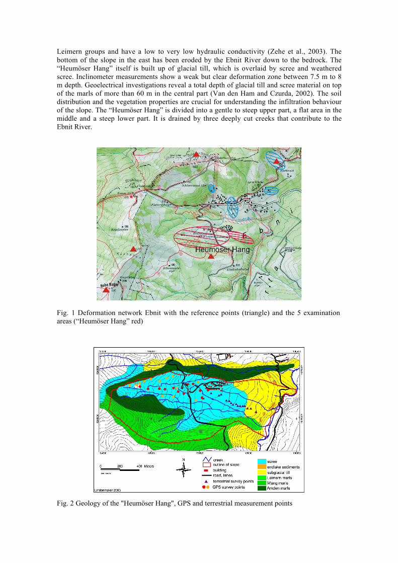
The Alps are a region where very often disastrous processes of mass movements take place suchas landslides or rock falls. Particularly the fast movements mostly cause considerable damage topersons or objects. Slowly creeping movements are not so interesting for the general public, butoften they are the preliminary stage of such disasters. An example for such a slow movement isthe village Ebnit in Vorarlberg/Austria. Ebnit is situated about 10 km south of Dornbirn in aheight of approximately 1100 m. Slopes with various geological characteristics and a differenthazard surround this place.In the framework of an interdisciplinary research-project a lot of geologic, hydrologic andgeodetic examinations were realised. The aim of the geodetic project was to get the bestpossible information about the actual kinematic behaviour of the slope. Our project-partners usethis three-dimensional geometric information to refine or to adjust the mechanical model withinan interactive procedure. The examinations on this slope might also be used as a model for othercreeping slopes in the alpine regions.In summer 1995 the observations started with a combined deformation network in the form ofGPS measurements and terrestrial measurements in the wooded area. After the implementationof the network by permanent point marks, the network was measured in time intervals of threemonths in summer and six months in winter. Until the end of the project in December 2001fifteen epochs had been measured. The examination field has been divided into 5 different areas(Fig. 1). The “Heumöser Hang” as the largest hazard area is the object of this paper.
2. Characteristics of the “Heumöser Hang”
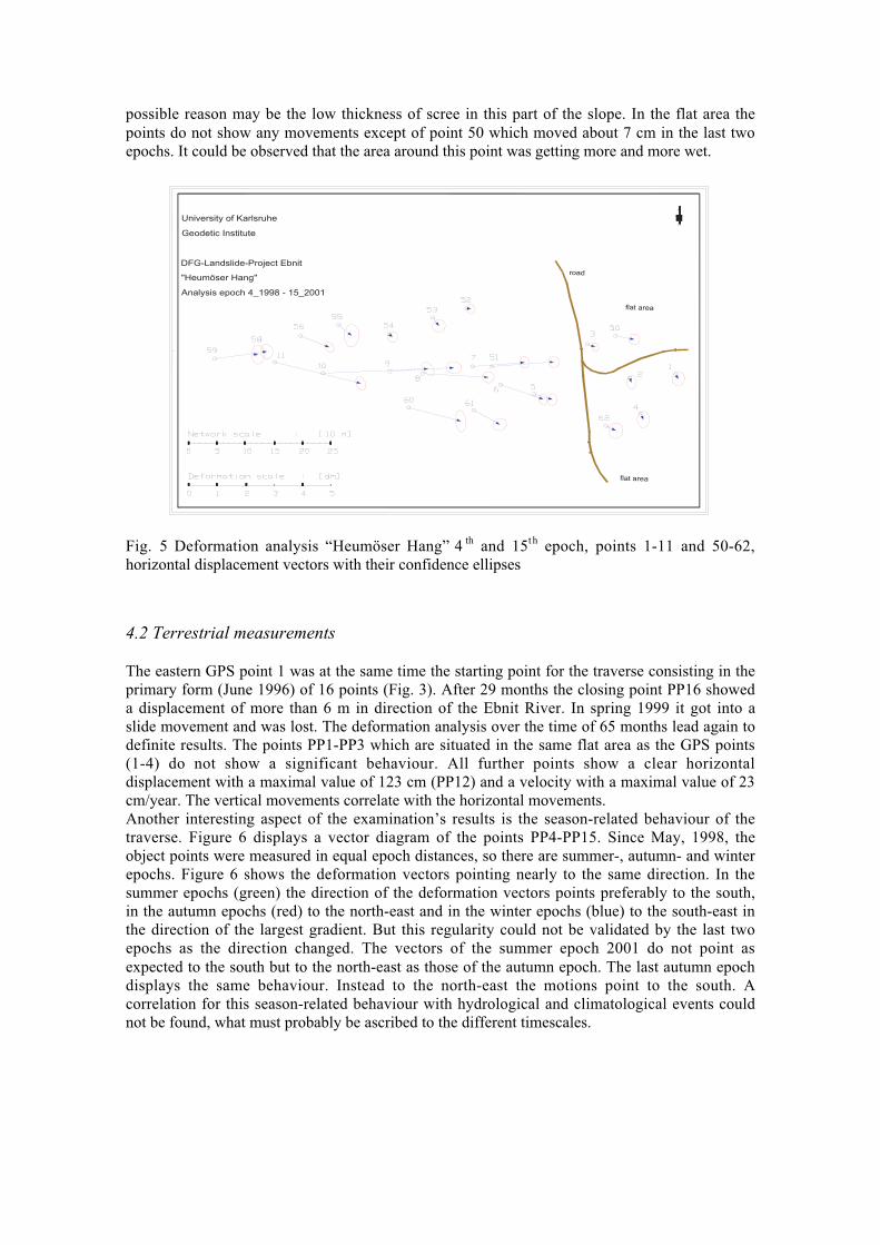
The west-east orientated “Heumöser Hang” has an extension of about 1800 m in east-westdirection, 500 m in north-south direction and an altitude difference of about 400 m. Twobuildings and a small holiday village as well as a skiing lift are situated on the slope. Thesurrounding bedrock and also the top area of the “Heumöser Hang” consist of upper cretaceoussediments, mainly marls and limy marls (Fig. 2). These layers belong to the Amden, Wang and
Proceedings, 11th FIG Symposium on Deformation Measurements, Santorini, Greece, 2003.
Leimern groups and have a low to very low hydraulic conductivity (Zehe et al., 2003). Thebottom of the slope in the east has been eroded by the Ebnit River down to the bedrock. The“Heumöser Hang” itself is built up of glacial till, which is overlaid by scree and weatheredscree. Inclinometer measurements show a weak but clear deformation zone between 7.5 m to 8m depth. Geoelectrical investigations reveal a total depth of glacial till and scree material on topof the marls of more than 60 m in the central part (Van den Ham and Czurda, 2002). The soildistribution and the vegetation properties are crucial for understanding the infiltration behaviourof the slope. The “Heumöser Hang” is divided into a gentle to steep upper part, a flat area in themiddle and a steep lower part. It is drained by three deeply cut creeks that contribute to theEbnit River.
Fig. 1 Deformation network Ebnit with the reference points (triangle) and the 5 examinationareas (“Heumöser Hang” red)
Fig. 2 Geology of the "Heumöser Hang", GPS and terrestrial measurement points

3. Geodetic network
In the beginning, the GPS deformation network consisted of 5 reference points which had beenplaced on the surrounding mountains (Fig. 1) and 11 object points on the “Heumöser Hang”. In1996 the network was completed by a traverse with 16 points in the wooded area and in 1998 by13 GPS points (Fig. 3). The traverse was observed by classical geodetic survey techniques. TheGPS points were marked by suitable rocks or concrete blocks with special centering devices.The traverse points were marked by tubes. The reference network was observed in the staticmode and the object points in stop and go mode in at least 3 sessions (Howind and Schmitt,2001). Between 1998 and 2001 the network was measured at regular intervals in May, Augustand November.The point coordinates were calculated for different epochs by least-squares adjustments (Mierloand Illner, 1998). In all epochs the achieved accuracies for the GPS coordinates areapproximately 6 mm in the plane component and 10 mm in the height component. The achievedaccuracies for the traverse coordinates range from 8 mm to 30 mm for both components. Thesedifferences had been caused by the bad soil conditions as the wooded area around the traverse isvery humid most time of the year.
Fig. 3 “Heumöser Hang” with GPS and traverse points (source: Orthophoto, Bundesamt fürEich- und Vermessungswesen, 1990)
4. Results of the deformation analysis
The deformation analysis has been carried out separately for plane coordinates and heights. Forthe deformation analysis between the epochs the institute’s coordinate-related softwarepackages CODEKA1D resp. CODEKA2D had been used (Nkuite, G. and Jäger, R.). Within thedeformation analysis the so-called object points in the moving area had to be distinguished fromthe points in the surrounding area which could be considered as being stable.

0,0
10,0
20,0
30,0
40,0
50,0
60,0
Aug95
Jun96
Nov96
Jun98
Aug98
Nov98
May99
Aug99
Nov99
May00
Aug00
Nov00
May01
Aug01
Nov01
Time
Def
orm
atio
n [
cm]
1 2 3 4 5 6 7 8 9 10 11
Fig. 4 Deformation analysis “Heumöser Hang” points 1-11, all epochs, horizontal displacements
4.1 GPS measurements
Between August 1995 and November 2001 fifteen epochs of measurements were taken. So thepoints 1–11 were observed about a total period of 75 months. These points represent themovement behaviour of the slope from the top to the holiday village (Fig. 3). The deformationanalysis lead to a classification in 3 groups of horizontal motions (Fig. 4). The points 1–5 werelocated in the flat area of the slope between the road and the holiday village and they do notshow any significant movement. This becomes evident by an average velocity of 1.5 cm/year. Aconstant increasing of 5.5 cm/year could be observed for the points 5–9. These points correlatewith the topography of the western part of the slope which is gentle to steep. An irregular pointmovement can be seen at points 10 and 11 (Fig. 4) which are situated in the upper steep part ofthe slope (Fig. 3). However, it is not easy to find out a reason for this different behaviour as aresult of rainfall events and soil distribution. In May, 1999, the highest rainfall event has beennoticed since the beginning of recording (Zehe et al., 2003). This event may explain theincreasing displacement within the measurement of August 1999 (Fig. 4). But there has notbeen an explanation for the increasing displacement in winter period of November 2000 to May2001 until yet.The results of the vertical movements showed considerably smaller displacements than therespective horizontal movements. The points 4 and 1 do not show any significant displacementswhereas point 11 represents the maximal value with 18 cm.To get more extensive information about the movement in April 1998 the points 50-62 wereadded to the object points (Fig. 3). Figure 5 displays the results of the deformation analysisbetween the fourth and the last epoch. The horizontal displacements are represented bydifference vectors with confidence ellipses at their ends. The horizontal motions correlate againwith the direction of the largest slope gradient. On the northern part of the “Heumöser Hang”the points 52-55 do not show a significant displacement. This seems to be in context with a veryhigh stableness of the steep north exposed slopes (Schneider, 1999). Another conspicuousbehaviour was recognized at point 58, which also had no significant displacement in horizontaland vertical movements although this point was placed in the steep area. In this connection a
possible reason may be the low thickness of scree in this part of the slope. In the flat area thepoints do not show any movements except of point 50 which moved about 7 cm in the last twoepochs. It could be observed that the area around this point was getting more and more wet.
flat area
flat area
University of Karlsruhe
Geodetic Institute
DFG-Landslide-Project Ebnit
"Heumöser Hang"
Analysis epoch 4_1998 - 15_2001
road
Fig. 5 Deformation analysis “Heumöser Hang” 4 th and 15t h epoch, points 1-11 and 50-62,horizontal displacement vectors with their confidence ellipses
4.2 Terrestrial measurements
The eastern GPS point 1 was at the same time the starting point for the traverse consisting in theprimary form (June 1996) of 16 points (Fig. 3). After 29 months the closing point PP16 showeda displacement of more than 6 m in direction of the Ebnit River. In spring 1999 it got into aslide movement and was lost. The deformation analysis over the time of 65 months lead again todefinite results. The points PP1-PP3 which are situated in the same flat area as the GPS points(1-4) do not show a significant behaviour. All further points show a clear horizontaldisplacement with a maximal value of 123 cm (PP12) and a velocity with a maximal value of 23cm/year. The vertical movements correlate with the horizontal movements.Another interesting aspect of the examination’s results is the season-related behaviour of thetraverse. Figure 6 displays a vector diagram of the points PP4-PP15. Since May, 1998, theobject points were measured in equal epoch distances, so there are summer-, autumn- and winterepochs. Figure 6 shows the deformation vectors pointing nearly to the same direction. In thesummer epochs (green) the direction of the deformation vectors points preferably to the south,in the autumn epochs (red) to the north-east and in the winter epochs (blue) to the south-east inthe direction of the largest gradient. But this regularity could not be validated by the last twoepochs as the direction changed. The vectors of the summer epoch 2001 do not point asexpected to the south but to the north-east as those of the autumn epoch. The last autumn epochdisplays the same behaviour. Instead to the north-east the motions point to the south. Acorrelation for this season-related behaviour with hydrological and climatological events couldnot be found, what must probably be ascribed to the different timescales.

University of Karlsruhe
Geodetic Institute
DFG-Landslide-Project Ebnit
"Heumöser Hang"
Traverse vector diagramm June 1996 - November 2001
(without PP1 - PP3)
Fig. 6 Deformation analysis traverse (PP4-PP15), 14 epochs, horizontal displacements, vectordiagram
-20,0
0,0
20,0
40,0
60,0
80,0
100,0
120,0
140,0
11
10 9 8 7 6 5 4 3 2 1
PP
1
PP
2
PP
3
PP
4
PP
5
PP
6
PP
7
PP
8
PP
9
PP
10
PP
11
PP
12
PP
13
PP
14
PP
15
Point numbers
Def
orm
atio
n [
cm]
Nov 96 May 98 Aug 98 Nov 98 May 99 Aug 99 Nov 99May 00 Aug 00 Nov 00 May 01 Aug 01 Nov 01
Fig. 6 Horizontal deformation characteristics of “Heumöser Hang”, 14 epochs, GPS points (1-11) and the traverse
5. Conclusion
It could be shown that the aim of the geodetic monitoring system, to identify accelerations inlandslide movements, could be reached. The achievable accuracies were sufficient to verify thepoint movements. With the available data a confident and significant result could also beobtained. The deformation analysis has shown that the “Heumöser Hang” is separated in 3 kinds

of movements. Figure 7 displays an overview of the horizontal movements of all epochs fromthe top to the bottom of the slope. The structure of the slope can be clearly seen. Themovements in the upper area show mean values while the flat area around the holiday villagecan be seen as relatively stable. In the eastern part the movements accumulate to nearly a triplevalue of the upper slope points. It could also be demonstrated that there is a constant behaviourduring all epochs.Even though the flat area around the holiday village can be seen as stable, a possible hazardshould not be neglected. This might be indicated by the already existing building damages interms of cracks and broken water pipes, for example. Due to the erosive effect of the EbnitRiver the edge of avulsion could move to the west and - combined with sliding mass movementfrom the western slope - hazard the holiday village.It has become evident that it is not sufficient only to collect and analyze movement rates, butthat a cooperation of different disciplines can help to provide a disaster prevention.
Acknowledgement
The present paper shows the geodetic results of the bundle project “Hydrologische undkinematische Prozesse bei Großhangbewegungen in bindigen Sedimenten”, which wassponsored by the Deutsche Forschungsgemeinschaft (DFG). This is gratefully acknowledged bythe authors.
References
Howind, J. and Schmitt, G. (2001). Geodätische Überwachung einer Großhangbewegung inEbnit/Vorarlberg. Zeitschrift für Vermessungswesen 126, 1-5.
Mierlo, J. Van and Illner, M. (1998). Statistische Grundlagen und Modelle für die Weiterverar-beitung von GPS-Ergebnissen. Mitteilungen des DVW-Landesvereins Baden-Württemberg, Heft 2, 84-108.
Nkuite, G. and Jäger, R. (1994). External accuracy modelling in a coordinate-referred approachand its impact on sensitivity and deformation analysis. Proceedings Perelmuter Workshopon Dynamic Deformation Models, 29.08-01.09.1994, Haifa, Israel, 303-315.
Schneider, U. (1999). Untersuchungen zur Kinematik von Massenbewegungen im ModellgebietEbnit (Vorarlberger Helvetikum). Dissertation, Schriftenreihe Angewandte GeologieKarlsruhe Nr.57.
Van den Ham, G. and Czurda, K. (2002). Numerical modelling of a slowly deforming slope inthe Vorarlbergian Alps, Austria. Proceedings of the 27th Assembly of the EuropeanGeophysical Society,Nice, 21-26 April, Abstracts, Volume 4.
Zehe, E., Lindenmaier. F., and Ihringer, J. (2003). Large scale hill creep in cohesive sediments:a field and model study. Proceedings of the international conference from experimentalevidence towards numerical modelling of unsaturated soils, 18.09.-19.09.2003, Bauhaus-Universität Weimar, submitted