monroe lake - property map - in.gov · bd c rek dutch ridge lookout u.s.f.s hardin ridge rec. area...
TRANSCRIPT
46
37
446
446
4646
135
37
446
69
SANDERS
SMITHVILLESMITHVILLE
HANDY
MAUMEEMAUMEE
ELKINSVILLE
STORY
BROWN CO.
Hickory Ridge Lookout
MO
NR
OE
CO
.M
ON
RO
E C
O.
JAC
KS
ON
CO
.JA
CK
SO
N C
O.
BLACKWELL REC. AREA
BLACKWELL REC. AREA
Terril CemeteryTerril CemeteryTerril Cemetery
HICKORY GROVE
REC.AREA
JACKSON CO.
LAWRENCE CO.
Cornett Cemetery
Mi tche l lCemeter y
Rhorer RdRhorer Rd
Har
rell
Rd
Har
rell
Rd
Moore’s Creek Rd
PINE GROVE
REC. AREA
Gross Rd
Lampkin’ Ridge RdLampkin’ Ridge Rd
PAYNETOWNREC. AREA
Moffat LnMoffat Ln
Stipp Rd
Handy RdPaynetown Rd
MOORE’S CREEK
REC. AREA
MOORE’S CREEK
REC. AREACUTRIGHTREC. AREACUTRIGHTREC. AREA
Ramp Creek
Permanent PoolElev. 538.0
DamCrest Elev. 574.0
Spi l lwayElev. 556.0
FAIRFAXREC. AREA
FAIRFAXREC. AREA
Mt. Ebal Rd
Fairfax Rd
CHAPELHILL
CHAPELHILL
CHAPELHILL
Kno
b Creek
Dutch Ridge
Lookout
Dutch Ridge
Lookout
U.S.F.SHARDIN RIDGE
REC. AREA
MONROE CO.LAWRENCE CO.
MO
NR
OE
CO
.
BR
OW
N C
O.
T.C. STEELEHISTORIC SITE
Crooked Creek Lake
CROOKED CREEK REC. AREA
MIDDLEFORKWATERFOWL
RESTING AREAClosed Oct. 1-April 1
YELLOWWOOD STATE FOREST
Kent RdStillwater Marsh
Stillwater Marsh
Flood Control Pool Elev. 556.0
BELMONTBELMONTLower Schooner Creek
CorpsOffice
SALT CREEKREC.AREA
Co
mb
s C
ree
k
Rd
Ro ad v e r y r
ou
gh
or
clo
sed s
eas
o na
l ly.
CROOKED CREEK MARSHES
JACKSON CO.
BROWN CO.
MONROE CO.MONROE CO.
RobertsonCemetery
Old 446
Creek Rd
Creek Rd
Allen’s Creek
Chapel Hi l l
Rd
Smith ville Rd
Littl
e B
lue
Cre
ek
FriendshipCemetery
Swar
tz R
d
Office &Visitors Center
McG
ow
e n Rd
CLEAR CREEKCLEAR CREEK
BLOOMINGTONBLOOMINGTON
Knights of Pythias
Cemetery
Knights of Pythias
Cemetery
HA
RR
OD
SB
UR
GH
AR
RO
DS
BU
RG
Cle
ar Creek S
tra
in R
idg
e R
d
Litt
le C
lear
Cre
ek
Guthrie Rd
Tower Ridge Rd
Middle Fork
Salt Creek
Tower Ridge R
d
W 1000 N
Fairfax Rd
PIPELI
NE
ALLEN’S CREEKREC. AREA
Panthe r Cre
ek
Deer Lick Rd
Hunte
r Cre
ek
Rd
Friendship Rd
Monroe Lake
Monroe Lake
Monroe Lake
SOUTHFORK MARSH
SOUTHFORK MARSH
NORTHFORKWATERFOWL
RESTING AREAClosed Oct. 1-April 15
65
To Brown County State Park and
Fleener Rd
Bir
die
Ga
lyan
Rd
2
2
2
2
1
1
1
1
3
4
5
4
5
2
Please carry out all trash you produce in order to keep your park clean and beautiful for others to enjoy.
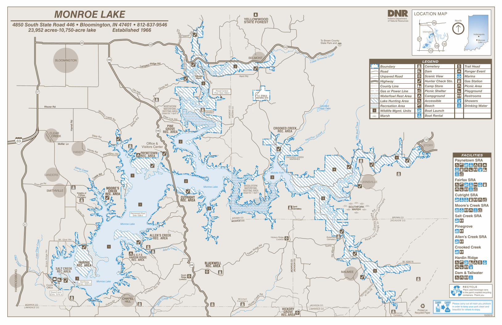
FACILITIES
Paynetown SRA
Salt Creek SRA
Pinegrove
Allen’s Creek SRA
Crooked Creek
Hardin Ridge
Dam & Tailwater
Fairfax SRA
Cutright SRA
LEGEND
Boundary
Road
Unpaved Road
Highway
County Line
Gas or Power Line
Waterfowl Rest Area
Lake Hunting Area
Recreation Area
Wildlife Mgmt. Units
Marsh
Cemetery
Dam
Scenic View
Hunter Check Stn.
Camp Store
Picnic Shelter
Campground
Accessible
Beach
Boat Launch
Boat Rental
1
Trail Head
Ranger Event
Marina
Gas Station
Picnic Area
Playground
Restrooms
Showers
Drinking Water
Moore’s Creek SRA
LOCATION MAP
Monroe Lake
Indianapolis
50
135
Information
37
446
46Bloomington
North
4850 South State Road 446 • Bloomington, IN 47401 • 812-837-954623,952 acres-10,750-acre lake Established 1966
MONROE LAKE
10/2019
statep
arks
.IN.gov
ACTIVITIES AND FACILITIESBEACH—Swimming is available during open hours from Memorial Day through Labor Day at
the beaches in Paynetown and Fairfax recreation areas. Modern bathhouses at both locations provide showers, dressing facilities and restrooms. Swimming during unguarded times from sunrise to sunset is at your own risk. No swimming from sunset to sunrise.
BOAT RAMPS—Available at nine locations. Boat launch ramps are not marked on the map but are
listed under the facilities for the State Recreation Areas on the map side.
CAMPING—A total of 312 campsites are available consisting of 222 electric sites with
electricity, modern restrooms and showers, picnic table and grills; 90 non-electric sites. Occupancy limited to 14 consecutive nights. Reservations available through the Central Reservation System.
FISHING—Bass, bluegill, catfish, crappie, walleye and hybrid stripers provide the most
activity for fishermen. State license required and available at lake office.
HIKING—Easy to moderate marked trails are available for hiking all year. Off-road uses of
vehicles, bicycles and horses are not permitted.
HUNTING—All hunters are required to register at check-in stations daily. Hunting in Waterfowl
Resting Areas by special permit only. Deer, grouse, turkey, squirrels, doves and rabbits are the primary game species. Excellent waterfowl hunting is available during the season. Waterfowl hunting information available at Paynetown visitors center. Read and obey all signs.
INTERPRETIVE NATURALIST SERVICE—Explore the world of natural resources while
enjoying interpretive and recreational programs. Program schedules are available at InterpretiveServices.IN.gov or call 812-837-9967.
MARINA—Seasonal mooring on docks or buoys is available at Paynetown, Moore’s Creek,
Cutright and Fairfax Recreation areas. Other services provided at Fairfax, Cutright and Paynetown marinas include fuel, food concessions and rental boats. Paynetown and Fairfax provide pump-out stations.
PICNIC AREAS—Picnicking is available in a number of areas, most containing tables, grills,
toilet facilities, a playfield and shelter. Reservations for shelters are available through the Central Reservation System.
Monroe
Take a step back in time and visit the unique town of Nashville, known for its fine artists and craftsmen, or drive into Bloomington and experience the Indiana University campus.
Limestone quarries, abundant in the area south of Monroe, provide building stone worldwide and offer a different type of tourist attraction. The entire area, with its rolling topography, bluffs, scenic streams, and heavily wooded sections offer outstanding scenic vistas as well as numerous recreational opportunities.
PURPOSE AND PROJECT HISTORYMonroe Lake is operated primarily for flood control
and low-flow augmentation in the Salt Creek and White River watersheds. The project also forms an integral unit of the comprehensive flood-control plan for the Ohio and Mississippi rivers. The lake is maintained at or near permanent pool level except when flood waters are stored for flood control.
The main functions of the property include resource management, recreation and water supply to surrounding communities. The lake area was developed in accordance with a long-range program and provides for a beneficial use of reservoir lands, fish-and-wildlife resources, and an opportunity for outdoor activities associated with large bodies of water.
Monroe Lake was selected for construction under the general authorization for flood control in an Act of Congress approved July 3, 1958. The lake was constructed by the U.S. Army Corps of Engineers. The State of Indiana contributed 54.1 percent of the project’s cost.
The project was dedicated in October 1964, and opened in 1966.
Monroe Lake and environs cover a total of 23,952 acres. Of this amount, 23,508 acres are leased to the State of Indiana for management with the remaining 444 acres owned by the state. At the summer pool level of 538 feet above sea level, 10,750 acres of water form the lake. The land areas, consisting of 13,202 acres in Monroe, Brown and Jackson counties, are managed for wildlife and recreational uses. More than 1.5 million visitors come to Monroe Lake annually.
RULES AND REGULATIONS• No person shall conduct or participate in a fishing
tournament on a reservoir property administered by the Division of State Parks, except under a license.
• No person shall launch, dock, or moor a watercraft or other floating device, except for approved periods and at sites designated by the department for those purposes. No person shall leave watercraft unattended in a courtesy dock.
• Any firearm, BB gun, air gun, CO2 gun, bow and arrow or paint gun must be unloaded or un-nocked and stored in a case or locked within a vehicle except in accordance with the terms of a one-day hunting permit and record card obtained from a hunter sign-in station and possessed by the person in the field for a specified date.
• A person who possesses a pet must attend it at all times and keep the animal caged or on a leash no more than 6 feet long.
• Vending or advertising without permission of the DNR is prohibited.
• Camping is permitted only in designated camping areas. Youth groups must be under adult supervision.
• Fires shall be built only in designated places.• Comply with the Carry In/Carry Out trash policy in all
day-use areas. Overnight guests must put waste in receptacles provided for that purpose.
• Motorists shall observe posted speed limits and park only in designated areas (25 mph maximum).
• No person shall possess or consume an alcoholic beverage at a swimming beach.
• Drinking water should be taken only from pumps, hydrants or fountains provided for that purpose. This water is tested regularly for purity.
• Report lost or found articles to the property office.• Feeding of wildlife is prohibited.• SCUBA by permit only.• Metal detector use is by permit only.
For a complete list of rules and regulations, inquire at property office.
THIS IS YOUR LAKEVisitors shall observe the rules, which are designed
to fulfill the purposes for which the state operates reservoir properties, namely, to manage these areas for the enhancement of wildlife and for the public’s use and enjoyment.
The largest body of water in Indiana, Monroe Lake offers a wide range of multiple-use recreational and seasonal opportunities.
The lake is nestled in the rolling hills and woodlands of south central Indiana, about 10 miles southeast of Bloomington. The dam is on Salt Creek, a tributary of the East Fork of White River. Most of the lake area lies in Monroe County, with a smaller area in Brown and Jackson counties.
The lake is accessible from state roads 37, 46, 446 and 50 by way of many local roads.
A number of other state and federal recreational areas surround the property, including Morgan-Monroe, Yellowwood and Jackson-Washington state forests.
Hoosier National Forest, including Deam Wilderness Area, surrounds a large part of the area. Minutes away lie Brown County, Spring Mill and McCormick’s Creek state parks, which attract thousands of visitors each year during the fall foliage season.
CENTRAL RESERVATION SYSTEM
CENTRAL RESERVATION SYSTEMCAMP.
Reservations for all types of camping, family cabins, and shelters at state parks, reservoirs and forests can be made online or by calling toll-free.Call: 1-866-6campIN (1-866-622-6746)Online: camp.IN.gov
Reservations for the Indiana State Park Inns and Inn-operated cabins can be made online or by phone.
Call: 1-877-lodges1 (1-877-563-4371)Online: IndianaInns.com
FOR MORE INFORMATIONWrite: Monroe Lake
Paynetown Visitors Center 4850 South State Road 446 Bloomington, IN 47401
Call: 812-837-9546 Online: on.IN.gov/monroelake
SPECIAL NOTEReceipts from admission and service charges are used to help defray the operation and maintenance costs of the lake. List of fees available in the main office.
DESCRIPTION OF HIKING TRAILS TRAIL & DESCRIPTIONDISTANCEDIFFICULTYBlue Bird Trail1.25 milesModerateForest and field in Paynetown State Recreation Area.
Tree Trek Trail.5 milesEasyForest Ecosystem interpretive trail in Paynetown State Recreation Area.
Turkey Trot Trail1.75 milesModerateHike-In/Boat-In Camping Area in Allen’s Creek State Recreation Area.
Whitetail Trail1 mileModerate
Access trail for walk-in visitors at Paynetown State Recreation Area.
Big Oak Trail1 mileModerateThis trail is a one-mile wooded hike with moderate difficulty located at Fairfax SRA.
PLEASE STAY ON MARKED TRAILS.
Please let wild animals remain wild. Feeding deer is prohibited. Feeding of wild animals can result in harm to both animals and people. Animals who depend on handouts become a nuisance to visitors and a danger to themselves. Please lock up all food and coolers inside cars or campers. Roll up car windows tightly.
For a list of park events, visitinterpretiveservices.IN.gov
Please carry out all trash you produce in order to keep your park clean and beautiful for others to enjoy!
© 1
1/20
18 In
dian
a D
epar
tmen
t of N
atur
al R
esou
rces
@ INdnrstateparks andreservoirs @indianadnr @INDNRstateparks
Subscribe to Outdoor Indiana magazine today, Visit OutdoorIndiana.org or call 317-233-3046.
See everything Indiana State Parks has to offer at stateparks.IN.gov.
The programs, services, facilities, and activities of the Indiana Department of Natural Resources are available to everyone. DNR prohibits discrimination on the basis of race, color, national origin, age, sex, or disability. If you believe that you have been discriminated against in any program, activity, or facility as described above, or if you desire further information please write to: Department of Natural Resources, Executive Office, 402 W. Washington Street, W256, Indianapolis, IN 46204, (317) 232-4020.
MORGAN-MONROE STATE FOREST—boating, boat ramps, camping, fishing, hiking trails, hunting,
picnicking, shelter house, group camp, trapping
Pick up an Indiana Recreation Guide for more information.
DNR PROPERTIES NEARBY
BROWN COUNTY STATE PARK—bridle trails, cabins, camping, fishing, hiking trails, Inn, interpretive
services, interpretive center, mountain biking, picnicking, play/sports area
YELLOWWOOD STATE FOREST—camping, mountain bike trails, bridle trails, hiking trails, wildlife
viewing, picnic area, playground, fishing, ice fishing, hunting, trapping, shelterhouse, boat launch, boat rentals