monroe power plant bottom ash impoundment idfc archive
TRANSCRIPT

AECOM 248.204.5900 tel 27777 Franklin Road, Suite 2000 Southfield, MI 48034
1
April 12, 2018
Mr. Robert Lee DTE Electric Company One Energy Plaza Detroit, MI 48226 RE: CCR Impoundment Inflow Design Flood Control System Plan: Inactive Bottom Ash
Impoundment (Area 15), Monroe Power Plant, DTE Energy, Monroe, Michigan
The purpose of this Inflow Design Flood Control System Plan is to document how the inflow design flood control system has been designed and constructed to meet the requirements of 40 C.F.R. § 257.82 for the Monroe Power Plant Inactive Bottom Ash Impoundment (Area 15). The hydrologic and hydraulic (H&H) analysis must assess if the basin storage capacity and hydraulic outlet structures are sufficient to pass the Inflow Design Flood Event, in a safe and non-erosive manner without overtopping the embankment.
1.0 DESIGN INPUTS
Inputs for H&H analysis include:
Design storm based on the CCR Hazard Classification Basin configurations Basin outlet conditions Basin hydrology; and Basin stage-storage.
2.0 METHODOLOGY
H&H modeling and supporting calculations were conducted using accepted practices and models. An evaluation was made of the hydraulic capacity of the outlet structures. H&H calculations for the analysis were performed using methodologies presented in:
SCS Unit Hydrograph Method, (TR-20); “Urban Hydrology of Small Watersheds: Technical Release No. 55” (TR-55); “Earth Dams and Reservoirs: Technical Release No. 60” (TR-60); and NOAA Atlas 14 Point Precipitation Frequency Estimates.
The computer program HydroCAD (Version 10.0) was used to perform the H&H calculations. The existing conditions for the basin were obtained from best available reports and topographic data.
3.0 BASIN CONFIGURATION
Area 15 is an inactive CCR surface impoundment as defined by 40 CFR §257.53. It consists of a bottom ash impoundment bordered by Lake Erie to the east and the Plant cooling water discharge channel to the west, which discharges cooling water from the Monroe coal power plant to the lake. The impoundment is separated from the cooling water discharge channel and Lake Erie by a perimeter dike. The southern boundary of the ash pond is formed by an earthen divider berm constructed of aggregate material, which separates the ash pond from the process waste and stormwater basin to the south. The two basins are hydraulically connected via two 36 inch diameter

2
corrugated plastic pipes (shielded by a boom curtain) and a low section of the berm to serve as an auxiliary spillway. The normal water surface elevation of Area 15 is approximately 574.40 ft (Plant Datum) and normal/average annual high water surface elevation of Lake Erie/the cooling water discharge channel is 571.76 ft (Plant Datum). Industrial process water and storm water discharge from Area 15 into the cooling water discharge channel via an overflow weir. The overflow weir consists of a 203 foot long sharp crested weir which discharges onto a riprap apron and then into the cooling water discharge channel. The following table provides information on the existing conditions for the basin.
Existing Basin Conditions
Basin Characteristic Basin Dike Crest Elevation (ft) 576.00 Basin Surface Area (acres) 104.48 Initial Pool Elevation (ft) 574.40 Contributing Watershed Area (acres)
313.43
Est. Curve Number (CN) 90 Time of Concentration (min) 35.2
Spillway Characteristic Length (ft) 203 Material Steel Elevation (ft) 574.31 Outlet Type Weir Basin Discharge Receiving Waterbody/Watershed
cooling water discharge channel
(Lake Erie) Note: Elevations presented in table above are based on Plant Datum. Add 0.84 to convert elevations from Plant Datum to NAVD88.
4.0 BASIN STAGE-STORAGE
The available storage for the basin was calculated from the assumed initial water elevations to the dike crest. The storage was calculated using the irregular volume calculation method with elevation, surface area, and perimeter input data. The storage volumes were calculated from available topographic data for the basin.
5.0 INFLOW DESIGN STORM EVENT
Area 15 has a Hazard Potential Classification of Significant. Therefore, the minimum Inflow Design Flood Event for this basin is the 1,000-year event.
6.0 CONCLUSION
The hydrologic and hydraulic analysis and modeling indicate the basin storage capacity and hydraulic outlet structure are sufficient to pass the Inflow Design Flood Event, in a safe and non-erosive manner without overtopping the embankment. The calculated results for the H&H model are as follows:

3
Results Area 15
Maximum Water Elevation (ft) 575.23
Dike Crest Elevation (ft) 576.00
The model results are provided as an attachment. Values presented for Contributing Watershed Area and Est. Curve Number have been separated for informational purposes.
7.0 AMENDMENTS TO THE PLAN
The owner or operator of the CCR unit may amend the written inflow design flood control system plan at any time provided the revised plan at any time provided the revised plan is placed in the facility’s operating record as required by §257.105(g)(4). The owner or operator must amend the written inflow design flood control plan whenever there is a change in conditions that would substantially affect the written plan in effect.


2S
Area 15 Pond - Direct Runoff
3S
Area 15 CCR/Land
5S
PWSB - Direct Runoff
6S
Coal Pile
8S
Industrial Developed Area
9S
Chem Waste Ditch Watershed
10R
Chem Waste Ditch
1P
Area 15 Pond
4P
PWSB Pond
7P
Coal Pile Pond
5L
Cooling Water Discharge (Normal High
WSE)
Routing Diagram for DTE MONPP Area 15 Closure - ExistingPrepared by AECOM, Printed 3/29/2018
HydroCAD® 10.00-14 s/n 05502 © 2015 HydroCAD Software Solutions LLC
Subcat Reach Pond Link

DTE MONPP Area 15 Closure - Existing Printed 3/29/2018Prepared by AECOM
Page 2HydroCAD® 10.00-14 s/n 05502 © 2015 HydroCAD Software Solutions LLC
Area Listing (all nodes)
Area(acres)
CN Description(subcatchment-numbers)
16.137 84 50-75% Grass cover, Fair, HSG D (6S)27.140 80 Bottom Ash (3S)80.685 86 Coal (6S)10.400 96 Gravel surface, HSG D (2S, 3S)27.140 71 Meadow, non-grazed, HSG C (3S)25.190 98 Paved parking, HSG A (9S)28.680 98 Unconnected pavement, HSG A (8S)10.758 98 Unconnected roofs, HSG A (6S)87.300 98 Water Surface, HSG A (2S, 5S)
313.430 90 TOTAL AREA

Type II 24-hr 1000 year Rainfall=7.49"DTE MONPP Area 15 Closure - Existing Printed 3/29/2018Prepared by AECOM
Page 3HydroCAD® 10.00-14 s/n 05502 © 2015 HydroCAD Software Solutions LLC
Time span=0.00-48.00 hrs, dt=0.01 hrs, 4801 points x 3Runoff by SCS TR-20 method, UH=SCS, Weighted-CN
Reach routing by Dyn-Stor-Ind method - Pond routing by Dyn-Stor-Ind method
Runoff Area=53.300 ac 94.18% Impervious Runoff Depth=7.25"Subcatchment 2S: Area 15 Pond - Direct Flow Length=2,392' Tc=2.2 min CN=98 Runoff=640.28 cfs 32.204 af
Runoff Area=61.580 ac 0.00% Impervious Runoff Depth=4.92"Subcatchment 3S: Area 15 CCR/Land Flow Length=2,500' Slope=0.0400 '/' Tc=35.2 min CN=78 Runoff=236.07 cfs 25.256 af
Runoff Area=37.100 ac 100.00% Impervious Runoff Depth=7.25"Subcatchment 5S: PWSB - Direct Runoff Flow Length=1,650' Tc=2.6 min CN=98 Runoff=440.91 cfs 22.416 af
Runoff Area=107.580 ac 10.00% Impervious Runoff Depth=5.84"Subcatchment 6S: Coal Pile Flow Length=4,600' Tc=19.0 min UI Adjusted CN=86 Runoff=695.11 cfs 52.337 af
Runoff Area=28.680 ac 100.00% Impervious Runoff Depth=7.25"Subcatchment 8S: Industrial Developed Flow Length=1,892' Slope=0.0100 '/' Tc=25.1 min CN=98 Runoff=178.06 cfs 17.329 af
Runoff Area=25.190 ac 100.00% Impervious Runoff Depth=7.25"Subcatchment 9S: Chem Waste Ditch Flow Length=2,147' Slope=0.0100 '/' Tc=27.7 min CN=98 Runoff=147.37 cfs 15.220 af
Avg. Flow Depth=3.26' Max Vel=2.32 fps Inflow=165.46 cfs 86.997 afReach 10R: Chem Waste Ditchn=0.025 L=2,800.0' S=0.0005 '/' Capacity=425.28 cfs Outflow=124.70 cfs 86.105 af
Peak Elev=575.23' Storage=17,066,417 cf Inflow=1,200.99 cfs 235.646 afPond 1P: Area 15 Pond Primary=600.47 cfs 235.628 af Secondary=0.00 cfs 0.000 af Outflow=600.47 cfs 235.628 af
Peak Elev=574.93' Storage=4,926,172 cf Inflow=440.91 cfs 22.416 afPond 4P: PWSB Pond Primary=22.69 cfs 22.407 af Secondary=0.00 cfs 0.000 af Outflow=22.69 cfs 22.407 af
Peak Elev=579.28' Storage=317,582 cf Inflow=695.11 cfs 52.337 afPond 7P: Coal Pile Pond Outflow=682.90 cfs 52.345 af
Inflow=600.47 cfs 235.628 afLink 5L: Cooling Water Discharge (Normal High WSE) Primary=600.47 cfs 235.628 af
Total Runoff Area = 313.430 ac Runoff Volume = 164.763 af Average Runoff Depth = 6.31"51.53% Pervious = 161.502 ac 48.47% Impervious = 151.928 ac

Type II 24-hr 1000 year Rainfall=7.49"DTE MONPP Area 15 Closure - Existing Printed 3/29/2018Prepared by AECOM
Page 4HydroCAD® 10.00-14 s/n 05502 © 2015 HydroCAD Software Solutions LLC
Summary for Subcatchment 2S: Area 15 Pond - Direct Runoff
Runoff = 640.28 cfs @ 11.92 hrs, Volume= 32.204 af, Depth= 7.25"
Runoff by SCS TR-20 method, UH=SCS, Weighted-CN, Time Span= 0.00-48.00 hrs, dt= 0.01 hrsType II 24-hr 1000 year Rainfall=7.49"
Area (ac) CN Description50.200 98 Water Surface, HSG A
3.100 96 Gravel surface, HSG D53.300 98 Weighted Average
3.100 5.82% Pervious Area50.200 94.18% Impervious Area
Tc Length Slope Velocity Capacity Description(min) (feet) (ft/ft) (ft/sec) (cfs)
2.2 2,392 17.94 Lake or Reservoir, LakeMean Depth= 10.00'
Subcatchment 2S: Area 15 Pond - Direct Runoff
Runoff
Hydrograph
Time (hours)484644424038363432302826242220181614121086420
Flo
w (
cfs)
700
650
600
550
500
450
400
350
300
250
200
150
100
50
0
Type II 24-hr1000 year Rainfall=7.49"
Runoff Area=53.300 acRunoff Volume=32.204 af
Runoff Depth=7.25"Flow Length=2,392'
Tc=2.2 minCN=98
640.28 cfs

Type II 24-hr 1000 year Rainfall=7.49"DTE MONPP Area 15 Closure - Existing Printed 3/29/2018Prepared by AECOM
Page 5HydroCAD® 10.00-14 s/n 05502 © 2015 HydroCAD Software Solutions LLC
Summary for Subcatchment 3S: Area 15 CCR/Land
Runoff = 236.07 cfs @ 12.31 hrs, Volume= 25.256 af, Depth= 4.92"
Runoff by SCS TR-20 method, UH=SCS, Weighted-CN, Time Span= 0.00-48.00 hrs, dt= 0.01 hrsType II 24-hr 1000 year Rainfall=7.49"
Area (ac) CN Description27.140 71 Meadow, non-grazed, HSG C
* 27.140 80 Bottom Ash7.300 96 Gravel surface, HSG D
61.580 78 Weighted Average61.580 100.00% Pervious Area
Tc Length Slope Velocity Capacity Description(min) (feet) (ft/ft) (ft/sec) (cfs)35.2 2,500 0.0400 1.19 Lag/CN Method,
Subcatchment 3S: Area 15 CCR/Land
Runoff
Hydrograph
Time (hours)484644424038363432302826242220181614121086420
Flo
w (
cfs)
260250240230220210200190180170160150140130120110100
908070605040302010
0
Type II 24-hr1000 year Rainfall=7.49"
Runoff Area=61.580 acRunoff Volume=25.256 af
Runoff Depth=4.92"Flow Length=2,500'
Slope=0.0400 '/'Tc=35.2 min
CN=78
236.07 cfs
Type II 24-hr 1000 year Rainfall=7.49"DTE MONPP Area 15 Closure - Existing Printed 3/29/2018Prepared by AECOM
Page 6HydroCAD® 10.00-14 s/n 05502 © 2015 HydroCAD Software Solutions LLC
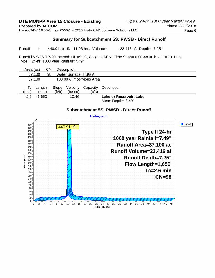
Summary for Subcatchment 5S: PWSB - Direct Runoff
Runoff = 440.91 cfs @ 11.93 hrs, Volume= 22.416 af, Depth= 7.25"
Runoff by SCS TR-20 method, UH=SCS, Weighted-CN, Time Span= 0.00-48.00 hrs, dt= 0.01 hrsType II 24-hr 1000 year Rainfall=7.49"
Area (ac) CN Description37.100 98 Water Surface, HSG A37.100 100.00% Impervious Area
Tc Length Slope Velocity Capacity Description(min) (feet) (ft/ft) (ft/sec) (cfs)
2.6 1,650 10.46 Lake or Reservoir, LakeMean Depth= 3.40'
Subcatchment 5S: PWSB - Direct Runoff
Runoff
Hydrograph
Time (hours)484644424038363432302826242220181614121086420
Flo
w (
cfs)
480460440420400380360340320300280260240220200180160140120100
80604020
0
Type II 24-hr1000 year Rainfall=7.49"
Runoff Area=37.100 acRunoff Volume=22.416 af
Runoff Depth=7.25"Flow Length=1,650'
Tc=2.6 minCN=98
440.91 cfs
Type II 24-hr 1000 year Rainfall=7.49"DTE MONPP Area 15 Closure - Existing Printed 3/29/2018Prepared by AECOM
Page 7HydroCAD® 10.00-14 s/n 05502 © 2015 HydroCAD Software Solutions LLC
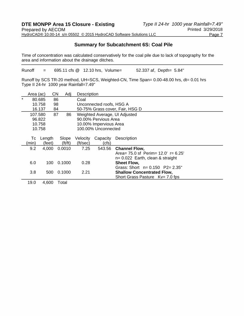
Summary for Subcatchment 6S: Coal Pile
Time of concentration was calculated conservatively for the coal pile due to lack of topography for the area and information about the drainage ditches.
Runoff = 695.11 cfs @ 12.10 hrs, Volume= 52.337 af, Depth= 5.84"
Runoff by SCS TR-20 method, UH=SCS, Weighted-CN, Time Span= 0.00-48.00 hrs, dt= 0.01 hrsType II 24-hr 1000 year Rainfall=7.49"
Area (ac) CN Adj Description* 80.685 86 Coal
10.758 98 Unconnected roofs, HSG A16.137 84 50-75% Grass cover, Fair, HSG D
107.580 87 86 Weighted Average, UI Adjusted96.822 90.00% Pervious Area10.758 10.00% Impervious Area10.758 100.00% Unconnected
Tc Length Slope Velocity Capacity Description(min) (feet) (ft/ft) (ft/sec) (cfs)
9.2 4,000 0.0010 7.25 543.56 Channel Flow, Area= 75.0 sf Perim= 12.0' r= 6.25'n= 0.022 Earth, clean & straight
6.0 100 0.1000 0.28 Sheet Flow, Grass: Short n= 0.150 P2= 2.35"
3.8 500 0.1000 2.21 Shallow Concentrated Flow, Short Grass Pasture Kv= 7.0 fps
19.0 4,600 Total

Type II 24-hr 1000 year Rainfall=7.49"DTE MONPP Area 15 Closure - Existing Printed 3/29/2018Prepared by AECOM
Page 8HydroCAD® 10.00-14 s/n 05502 © 2015 HydroCAD Software Solutions LLC
Subcatchment 6S: Coal Pile
Runoff
Hydrograph
Time (hours)484644424038363432302826242220181614121086420
Flo
w (
cfs)
750
700
650
600
550
500
450
400
350
300
250
200
150
100
50
0
Type II 24-hr1000 year Rainfall=7.49"Runoff Area=107.580 ac
Runoff Volume=52.337 afRunoff Depth=5.84"Flow Length=4,600'
Tc=19.0 minUI Adjusted CN=86
695.11 cfs

Type II 24-hr 1000 year Rainfall=7.49"DTE MONPP Area 15 Closure - Existing Printed 3/29/2018Prepared by AECOM
Page 9HydroCAD® 10.00-14 s/n 05502 © 2015 HydroCAD Software Solutions LLC
Summary for Subcatchment 8S: Industrial Developed Area
Runoff = 178.06 cfs @ 12.18 hrs, Volume= 17.329 af, Depth= 7.25"
Runoff by SCS TR-20 method, UH=SCS, Weighted-CN, Time Span= 0.00-48.00 hrs, dt= 0.01 hrsType II 24-hr 1000 year Rainfall=7.49"
Area (ac) CN Description28.680 98 Unconnected pavement, HSG A28.680 100.00% Impervious Area28.680 100.00% Unconnected
Tc Length Slope Velocity Capacity Description(min) (feet) (ft/ft) (ft/sec) (cfs)25.1 1,892 0.0100 1.26 Lag/CN Method,
Subcatchment 8S: Industrial Developed Area
Runoff
Hydrograph
Time (hours)484644424038363432302826242220181614121086420
Flo
w (
cfs)
190
180
170
160
150
140
130
120
110
100
90
80
70
60
50
40
30
20
10
0
Type II 24-hr1000 year Rainfall=7.49"
Runoff Area=28.680 acRunoff Volume=17.329 af
Runoff Depth=7.25"Flow Length=1,892'
Slope=0.0100 '/'Tc=25.1 min
CN=98
178.06 cfs

Type II 24-hr 1000 year Rainfall=7.49"DTE MONPP Area 15 Closure - Existing Printed 3/29/2018Prepared by AECOM
Page 10HydroCAD® 10.00-14 s/n 05502 © 2015 HydroCAD Software Solutions LLC
Summary for Subcatchment 9S: Chem Waste Ditch Watershed
Runoff = 147.37 cfs @ 12.20 hrs, Volume= 15.220 af, Depth= 7.25"
Runoff by SCS TR-20 method, UH=SCS, Weighted-CN, Time Span= 0.00-48.00 hrs, dt= 0.01 hrsType II 24-hr 1000 year Rainfall=7.49"
Area (ac) CN Description25.190 98 Paved parking, HSG A25.190 100.00% Impervious Area
Tc Length Slope Velocity Capacity Description(min) (feet) (ft/ft) (ft/sec) (cfs)27.7 2,147 0.0100 1.29 Lag/CN Method,
Subcatchment 9S: Chem Waste Ditch Watershed
Runoff
Hydrograph
Time (hours)484644424038363432302826242220181614121086420
Flo
w (
cfs)
160
150
140
130
120
110
100
90
80
70
60
50
40
30
20
10
0
Type II 24-hr1000 year Rainfall=7.49"
Runoff Area=25.190 acRunoff Volume=15.220 af
Runoff Depth=7.25"Flow Length=2,147'
Slope=0.0100 '/'Tc=27.7 min
CN=98
147.37 cfs

Type II 24-hr 1000 year Rainfall=7.49"DTE MONPP Area 15 Closure - Existing Printed 3/29/2018Prepared by AECOM
Page 11HydroCAD® 10.00-14 s/n 05502 © 2015 HydroCAD Software Solutions LLC
Summary for Reach 10R: Chem Waste Ditch
Baseflow is 9.32 cfs plus maximum oil/water separator storm event flow of 8.77 cfs.
Inflow Area = 25.190 ac,100.00% Impervious, Inflow Depth > 41.44" for 1000 year eventInflow = 165.46 cfs @ 12.20 hrs, Volume= 86.997 af, Incl. 18.09 cfs Base FlowOutflow = 124.70 cfs @ 12.38 hrs, Volume= 86.105 af, Atten= 25%, Lag= 10.3 min
Routing by Dyn-Stor-Ind method, Time Span= 0.00-48.00 hrs, dt= 0.01 hrs / 3Max. Velocity= 2.32 fps, Min. Travel Time= 20.1 minAvg. Velocity = 1.36 fps, Avg. Travel Time= 34.4 min
Peak Storage= 150,538 cf @ 12.38 hrsAverage Depth at Peak Storage= 3.26'Bank-Full Depth= 6.00' Flow Area= 132.0 sf, Capacity= 425.28 cfs
10.00' x 6.00' deep channel, n= 0.025 Earth, clean & straightSide Slope Z-value= 2.0 '/' Top Width= 34.00'Length= 2,800.0' Slope= 0.0005 '/'Inlet Invert= 574.50', Outlet Invert= 573.00'
Reach 10R: Chem Waste Ditch
InflowOutflow
Hydrograph
Time (hours)484644424038363432302826242220181614121086420
Flo
w (
cfs)
180
170
160
150
140
130
120
110
100
90
80
70
60
50
40
30
20
10
0
Inflow Area=25.190 acAvg. Flow Depth=3.26'
Max Vel=2.32 fpsn=0.025
L=2,800.0'S=0.0005 '/'
Capacity=425.28 cfs
165.46 cfs
124.70 cfs

Type II 24-hr 1000 year Rainfall=7.49"DTE MONPP Area 15 Closure - Existing Printed 3/29/2018Prepared by AECOM
Page 12HydroCAD® 10.00-14 s/n 05502 © 2015 HydroCAD Software Solutions LLC
Summary for Pond 1P: Area 15 Pond
Storage between 576 and 577 is artificial. Should not allow water level to rise above 576, as dike will begin overtopping near the existing weir.
All model elevations are in Plant Datum. Add 0.84 to convert from Plant Datum to NAVD88.
Weir dimensions/elevation based on historical drawing 6C695-270 (weir #2). Although the drawing indicates the invert to be 574.00', this was conservatively adjusted to 574.31' to calibrate with the surveyed water elevation of 574.40' and average base flow rate of 18.09 cfs.
[62] Hint: Exceeded Reach 10R OUTLET depth by 1.39' @ 0.00 hrs[80] Warning: Exceeded Pond 4P by 0.36' @ 12.46 hrs (31.50 cfs 4.654 af) [80] Warning: Exceeded Pond 4P by 0.36' @ 12.46 hrs (54.38 cfs 2.666 af) [80] Warning: Exceeded Pond 7P by 0.03' @ 3.89 hrs (3.92 cfs 0.767 af)
Inflow Area = 313.430 ac, 48.47% Impervious, Inflow Depth > 9.02" for 1000 year eventInflow = 1,200.99 cfs @ 12.16 hrs, Volume= 235.646 afOutflow = 600.47 cfs @ 12.49 hrs, Volume= 235.628 af, Atten= 50%, Lag= 20.0 minPrimary = 600.47 cfs @ 12.49 hrs, Volume= 235.628 afSecondary = 0.00 cfs @ 0.00 hrs, Volume= 0.000 af
Routing by Dyn-Stor-Ind method, Time Span= 0.00-48.00 hrs, dt= 0.01 hrs / 3Starting Elev= 574.40' Surf.Area= 1,866,358 sf Storage= 15,337,583 cfPeak Elev= 575.23' @ 12.49 hrs Surf.Area= 2,293,761 sf Storage= 17,066,417 cf (1,728,834 cf above start)Flood Elev= 576.00' Surf.Area= 2,756,436 sf Storage= 18,997,118 cf (3,659,535 cf above start)
Plug-Flow detention time= (not calculated: initial storage exceeds outflow)Center-of-Mass det. time= 46.8 min ( 1,082.5 - 1,035.8 )
Volume Invert Avail.Storage Storage Description#1 555.00' 21,753,554 cf Custom Stage Data (Irregular) Listed below (Recalc)

Type II 24-hr 1000 year Rainfall=7.49"DTE MONPP Area 15 Closure - Existing Printed 3/29/2018Prepared by AECOM
Page 13HydroCAD® 10.00-14 s/n 05502 © 2015 HydroCAD Software Solutions LLC
Elevation Surf.Area Perim. Inc.Store Cum.Store Wet.Area(feet) (sq-ft) (feet) (cubic-feet) (cubic-feet) (sq-ft)
555.00 77,623 1,651.3 0 0 77,623556.00 177,260 1,877.2 124,061 124,061 141,078557.00 230,132 2,314.1 203,122 327,183 286,813558.00 321,306 3,197.8 274,454 601,637 674,434559.00 464,061 4,003.1 390,503 992,140 1,135,909560.00 545,591 4,074.9 504,276 1,496,417 1,182,240561.00 595,521 4,154.9 570,374 2,066,790 1,234,794562.00 637,571 4,217.1 616,426 2,683,217 1,276,444563.00 674,537 4,282.6 655,967 3,339,184 1,320,951564.00 710,097 4,354.8 692,241 4,031,425 1,370,765565.00 747,174 4,428.2 728,557 4,759,982 1,422,254566.00 790,902 4,569.0 768,934 5,528,916 1,523,163567.00 844,886 4,408.8 817,745 6,346,662 1,637,703568.00 879,663 4,506.1 862,216 7,208,878 1,706,874569.00 915,793 4,610.7 897,667 8,106,545 1,782,897570.00 970,583 4,701.2 943,055 9,049,600 1,850,120571.00 1,078,279 5,020.2 1,023,959 10,073,559 2,096,948572.00 1,557,607 7,568.3 1,310,618 11,384,178 4,649,543573.00 1,624,363 7,481.1 1,590,868 12,975,046 4,754,244574.00 1,682,124 7,570.5 1,653,159 14,628,205 4,861,589575.00 2,160,656 12,380.1 1,916,405 16,544,610 12,497,404576.00 2,756,436 17,581.0 2,452,508 18,997,118 24,897,548577.00 2,756,436 17,581.0 2,756,436 21,753,554 24,915,129
Device Routing Invert Outlet Devices#1 Primary 574.31' 203.0' long Sharp-Crested Rectangular Weir 2 End Contraction(s)
6.0' Crest Height #2 Secondary 576.00' Uncontrolled Overtopping Dike, Cv= 2.62 (C= 3.28)
Head (feet) 0.00 1.00 Width (feet) 100.00 460.00
Primary OutFlow Max=600.46 cfs @ 12.49 hrs HW=575.23' TW=571.76' (Dynamic Tailwater)1=Sharp-Crested Rectangular Weir (Weir Controls 600.46 cfs @ 3.20 fps)
Secondary OutFlow Max=0.00 cfs @ 0.00 hrs HW=574.40' TW=571.76' (Dynamic Tailwater)2=Uncontrolled Overtopping Dike ( Controls 0.00 cfs)

Type II 24-hr 1000 year Rainfall=7.49"DTE MONPP Area 15 Closure - Existing Printed 3/29/2018Prepared by AECOM
Page 14HydroCAD® 10.00-14 s/n 05502 © 2015 HydroCAD Software Solutions LLC
Pond 1P: Area 15 Pond
InflowOutflowPrimarySecondary
Hydrograph
Time (hours)484644424038363432302826242220181614121086420
Flo
w (
cfs)
1,300
1,200
1,100
1,000
900
800
700
600
500
400
300
200
100
0
Inflow Area=313.430 acPeak Elev=575.23'
Storage=17,066,417 cf
1,200.99 cfs
600.47 cfs600.47 cfs
0.00 cfs

Type II 24-hr 1000 year Rainfall=7.49"DTE MONPP Area 15 Closure - Existing Printed 3/29/2018Prepared by AECOM
Page 15HydroCAD® 10.00-14 s/n 05502 © 2015 HydroCAD Software Solutions LLC
Summary for Pond 4P: PWSB Pond
Hydraulically connected to Area 15 Pond.
[87] Warning: Oscillations may require smaller dt or Finer Routing (severity=1)
Inflow Area = 37.100 ac,100.00% Impervious, Inflow Depth = 7.25" for 1000 year eventInflow = 440.91 cfs @ 11.93 hrs, Volume= 22.416 afOutflow = 22.69 cfs @ 16.06 hrs, Volume= 22.407 af, Atten= 95%, Lag= 247.7 minPrimary = 22.69 cfs @ 16.06 hrs, Volume= 22.407 afSecondary = 0.00 cfs @ 0.00 hrs, Volume= 0.000 af
Routing by Dyn-Stor-Ind method, Time Span= 0.00-48.00 hrs, dt= 0.01 hrs / 3Starting Elev= 574.40' Surf.Area= 1,448,059 sf Storage= 4,159,426 cfPeak Elev= 574.93' @ 13.83 hrs Surf.Area= 1,460,108 sf Storage= 4,926,172 cf (766,746 cf above start)
Plug-Flow detention time= (not calculated: initial storage exceeds outflow)Center-of-Mass det. time= 533.3 min ( 1,268.0 - 734.7 )
Volume Invert Avail.Storage Storage Description#1 571.00' 9,495,902 cf Custom Stage Data (Irregular) Listed below (Recalc)
Elevation Surf.Area Perim. Inc.Store Cum.Store Wet.Area(feet) (sq-ft) (feet) (cubic-feet) (cubic-feet) (sq-ft)
571.00 455,392 5,928.0 0 0 455,392572.00 1,284,243 4,716.0 834,793 834,793 1,481,997573.00 1,386,039 4,883.0 1,334,817 2,169,611 1,609,653574.00 1,438,953 4,846.0 1,412,413 3,582,024 1,638,709575.00 1,461,773 4,832.0 1,450,348 5,032,372 1,650,527576.00 1,475,756 4,875.0 1,468,759 6,501,131 1,684,095577.00 1,504,611 4,986.0 1,490,160 7,991,291 1,771,338578.00 1,504,611 4,986.0 1,504,611 9,495,902 1,776,324
Device Routing Invert Outlet Devices#1 Primary 572.40' 36.0" Round CPP_Round 36" X 2.00
L= 39.0' CPP, projecting, no headwall, Ke= 0.900 Inlet / Outlet Invert= 572.40' / 572.40' S= 0.0000 '/' Cc= 0.900 n= 0.020 Corrugated PE, corrugated interior, Flow Area= 7.07 sf
#2 Secondary 575.00' Custom Weir/Orifice, Cv= 2.62 (C= 3.28) Head (feet) 0.00 1.00 Width (feet) 140.00 220.00
Primary OutFlow Max=22.69 cfs @ 16.06 hrs HW=574.87' TW=574.63' (Dynamic Tailwater)1=CPP_Round 36" (Outlet Controls 22.69 cfs @ 2.48 fps)
Secondary OutFlow Max=0.00 cfs @ 0.00 hrs HW=574.40' TW=574.40' (Dynamic Tailwater)2=Custom Weir/Orifice ( Controls 0.00 cfs)

Type II 24-hr 1000 year Rainfall=7.49"DTE MONPP Area 15 Closure - Existing Printed 3/29/2018Prepared by AECOM
Page 16HydroCAD® 10.00-14 s/n 05502 © 2015 HydroCAD Software Solutions LLC
Pond 4P: PWSB Pond
InflowOutflowPrimarySecondary
Hydrograph
Time (hours)484644424038363432302826242220181614121086420
Flo
w (
cfs)
450
400
350
300
250
200
150
100
50
0
Inflow Area=37.100 acPeak Elev=574.93'
Storage=4,926,172 cf
440.91 cfs
22.69 cfs22.69 cfs
0.00 cfs

Type II 24-hr 1000 year Rainfall=7.49"DTE MONPP Area 15 Closure - Existing Printed 3/29/2018Prepared by AECOM
Page 17HydroCAD® 10.00-14 s/n 05502 © 2015 HydroCAD Software Solutions LLC
Summary for Pond 7P: Coal Pile Pond
[58] Hint: Peaked 0.28' above defined flood level
Inflow Area = 107.580 ac, 10.00% Impervious, Inflow Depth = 5.84" for 1000 year eventInflow = 695.11 cfs @ 12.10 hrs, Volume= 52.337 afOutflow = 682.90 cfs @ 12.13 hrs, Volume= 52.345 af, Atten= 2%, Lag= 1.8 minPrimary = 682.90 cfs @ 12.13 hrs, Volume= 52.345 af
Routing by Dyn-Stor-Ind method, Time Span= 0.00-48.00 hrs, dt= 0.01 hrs / 3Starting Elev= 574.40' Surf.Area= 12,851 sf Storage= 2,570 cfPeak Elev= 579.28' @ 12.13 hrs Surf.Area= 283,177 sf Storage= 317,582 cf (315,012 cf above start)Flood Elev= 579.00' Surf.Area= 200,000 sf Storage= 250,600 cf (248,030 cf above start)
Plug-Flow detention time= 17.7 min calculated for 52.268 af (100% of inflow)Center-of-Mass det. time= 16.3 min ( 815.1 - 798.8 )
Volume Invert Avail.Storage Storage Description#1 574.00' 600,600 cf Custom Stage Data (Prismatic) Listed below (Recalc)
Elevation Surf.Area Inc.Store Cum.Store(feet) (sq-ft) (cubic-feet) (cubic-feet)
574.00 0 0 0575.00 32,127 16,064 16,064576.00 32,127 32,127 48,191577.00 39,065 35,596 83,787578.00 47,281 43,173 126,960579.00 200,000 123,641 250,600580.00 500,000 350,000 600,600
Device Routing Invert Outlet Devices#1 Primary 572.00' 48.0" Round Culvert
L= 100.0' CMP, projecting, no headwall, Ke= 0.900 Inlet / Outlet Invert= 572.00' / 572.00' S= 0.0000 '/' Cc= 0.900 n= 0.021 Corrugated metal, Flow Area= 12.57 sf
#2 Primary 579.00' Custom Weir/Orifice, Cv= 2.62 (C= 3.28) Head (feet) 0.00 1.00 Width (feet) 1,000.00 3,000.00
Primary OutFlow Max=682.44 cfs @ 12.13 hrs HW=579.28' TW=575.00' (Dynamic Tailwater)1=Culvert (Inlet Controls 98.74 cfs @ 7.86 fps)2=Custom Weir/Orifice (Weir Controls 583.71 cfs @ 1.65 fps)

Type II 24-hr 1000 year Rainfall=7.49"DTE MONPP Area 15 Closure - Existing Printed 3/29/2018Prepared by AECOM
Page 18HydroCAD® 10.00-14 s/n 05502 © 2015 HydroCAD Software Solutions LLC
Pond 7P: Coal Pile Pond
InflowPrimary
Hydrograph
Time (hours)484644424038363432302826242220181614121086420
Flo
w (
cfs)
750
700
650
600
550
500
450
400
350
300
250
200
150
100
50
0
Inflow Area=107.580 acPeak Elev=579.28'
Storage=317,582 cf
695.11 cfs682.90 cfs

Type II 24-hr 1000 year Rainfall=7.49"DTE MONPP Area 15 Closure - Existing Printed 3/29/2018Prepared by AECOM
Page 19HydroCAD® 10.00-14 s/n 05502 © 2015 HydroCAD Software Solutions LLC
Summary for Link 5L: Cooling Water Discharge (Normal High WSE)
Average annual high water surface elevation of Lake Erie (thus cooling water discharge also) per USGS' Circular 1311 (Lake-Level Variability and Water Availability in the Great Lakes, 2007)
Inflow Area = 313.430 ac, 48.47% Impervious, Inflow Depth > 9.02" for 1000 year eventInflow = 600.47 cfs @ 12.49 hrs, Volume= 235.628 afPrimary = 600.47 cfs @ 12.49 hrs, Volume= 235.628 af, Atten= 0%, Lag= 0.0 min
Primary outflow = Inflow, Time Span= 0.00-48.00 hrs, dt= 0.01 hrs
Fixed water surface Elevation= 571.76'
Link 5L: Cooling Water Discharge (Normal High WSE)
InflowPrimary
Hydrograph
Time (hours)484644424038363432302826242220181614121086420
Flo
w (
cfs)
650
600
550
500
450
400
350
300
250
200
150
100
50
0
Inflow Area=313.430 ac600.47 cfs
600.47 cfs