moray wind energy landscape capacity … wind energy landscape capacity study ... scottish natural...
TRANSCRIPT
MORAY WIND ENERGY LANDSCAPE CAPACITY STUDY
Updated and Revised Final Appendix Report July 2016
Carol Anderson Landscape Associates

1
CONTENTS
APPENDIX A: REFERENCES
APPENDIX B: REVIEW OF SNH 2015 LANDSCAPE CHARACTER ASSESSMENT
APPENDIX C: DETAILED SENSITIVITY TABLES
APPENDIX D: SITING AND DESIGN GUIDANCE FOR SMALLER TURBINES
APPENDIX E: WIND FARM REPOWERING STUDY ‐ ZTV MAPPING AND VISUALISATIONS
APPENDIX F: LANDMARK HILLS

2

Appendix A: References Grant, A. 2010. Landscape Capacity Studies in Scotland – a review and guide to good practice. Scottish Natural Heritage Commissioned Report No 385. Historic Scotland (website). Inventory of Designed Landscapes, Moray (Darnaway, Cullen House, Brodie Castle, Innes House, Gordon Castle, Gordonstoun, Pluscarden and Relugas. The Landscape Institute and the Institute of Environmental Management and Assessment, Guidelines for Landscape and Visual Impact Assessment, 3rd Edition, 2013 Scottish Government, June 2014. Scottish Planning Policy and online resource Onshore Wind – Some Questions Answered. Scottish Government 2020 Routemap for Renewable Energy (and 2015 Update) Scottish Natural Heritage Visual Representation of Wind Farms Version 2.1 (December 2014) Scottish Natural Heritage, Assessing the cumulative impacts of onshore wind energy developments (2012) Scottish Natural Heritage. Siting and Designing windfarms in the landscape (version 2), May 2014. Scottish Natural Heritage, June 2015, Spatial Planning for Onshore Wind Energy Developments – Natural Heritage Considerations Scottish Natural Heritage. Map of Wild Land Areas and Non-Technical Description of Methodology, June 2014 Swanwick, C. and Land Use Consultants, 2002. Landscape Character Assessment: Guidance for England and Scotland. Countryside Agency and Scottish Natural Heritage. Swanwick, C, University of Sheffield and Land Use Consultants 2005. Landscape Character Assessment Guidance for England and Scotland – Topic Paper 6: Techniques and Criteria for Judging Capacity and Sensitivity. The Countryside Agency and Scottish Natural Heritage.
Various Environmental Statements for wind farm developments including those for the Dorenell, Meikle Hill, Hill of Glaschyle, Aultmore and Kellas wind farms
3
Appendix B: Review of SNH updated landscape character assessment
Background The 1998 SNH Moray and Nairn Landscape Assessment
This study formed part of the national programme of landscape character assessment commissioned by SNH in partnership with local authorities. It identifies 10 landscape character types across Moray and Nairn. Local authority boundaries have since been redrawn with the Nairn area allocated to Highland Council. The south- western boundary shown in the Moray and Nairn landscape assessment has also changed with the new Moray boundary extending further up the Spey Valley to include Ben Rinnes to the Avon Valley which forms the boundary with the Cairngorms National Park.
Baseline characterisation used in the 2012 Moray Wind Energy Landscape Capacity Study (MWELCS) The 1998 Moray and Nairn landscape assessment informed the definition of more detailed character areas for the sensitivity assessment undertaken as part of the 2012 MWELCS. The original names of the broad character types defined in the 1998 landscape assessment were adopted although sub-divisions of character types were introduced to better reflect key characteristics and the specific landscape context of landscapes which would potentially be sensitive to wind farm and turbine development. New characterisation was undertaken in 2012 following field assessment to fill ‘gaps’ where boundary changes had occurred. Some boundaries were also altered to better reflect landscape features seen on the ground. The table below sets out how each of the landscape character types identified in the 1998 Moray Landscape Character Assessment formed the basis for the detailed sensitivity assessment undertaken as part of the 2012 MWELCS:
No Character type Approach adopted for assessment 1. Soft Coastal Shore This character type has been amalgamated with the
‘Hard Coastal Shore’ (2) and much of the ‘Coastal
Forest’ (3) and a single sensitivity assessment undertaken.
2. Hard Coastal Shore As above
3 Coastal Forest As above
4 Coastal Farmland A sub-division of this character type has been defined to the east and is called the ‘Coastal
Farmland with Rolling Hills’ (4a). This area has a more rolling landform and greater extent of woodland than the main type; it also lies in close proximity to
the ‘Broad Forested Hills within Upland Farmland’
4

(8a). Separate sensitivity assessments have been undertaken for the main type (4) and this sub-type
(4a)
5 Rolling Farmlands and Forest Two sub-divisions of this character type have been
defined; the ‘Rolling Farmlands and Forest with Valleys’ (5a) and the ‘Rolling Farmlands and Forest with Low Hills’ (5b) to the west. The narrow band of
rolling hill fringes found between the Spey and Lossie valleys has been retained as ‘Rolling Farmlands and Forest’ (5). Separate sensitivity assessments have
been undertaken for the main type (5) and for sub-types (5a) and (5b).
6 Narrow Wooded Valley This character type has been largely retained in the sensitivity assessment but with some minor amendments made to the boundaries
7 Broad Farmed Valley This character type has been extended to include the Rinnes and Fiddich valleys and Ben Aigan which lies
between these valleys and forms a key landmark feature.
8 Upland Farmland The broad farmland centred on the shallow valley of the Isla and its northern tributaries has been retained as ‘Upland Farmland’ (8). Two sub-types have
additionally been defined within this character type, the ‘Broad Forested Hills within Upland Farmland’ (8a) and the ‘Valleys within Upland Farmland’ (8b)
9 Upland Moorland and Forestry This character type has been largely retained but with some amendments made to the southern
boundary to exclude the settled hill fringes at the transition with the Spey Valley and to the northern boundary to exclude the settled valley of the Upper
Lossie.
10 Open Uplands The western part of this character type is retained as
‘Open Uplands’ (10). The eastern area of this character type has been sub-divided into the ‘Open Uplands with Settled Valleys’ (10a) and the ‘Open
Uplands with Steep-sided Slopes’ (10b).
The SNH revised Moray and Nairn Landscape Character Assessment (2015) A review was undertaken of the 1998 Moray and Nairn Landscape Assessment in 2014/15 by Deb Munro Landscape Architect. This review also considered adjacent landscape character assessments and the character areas defined in the 2012 MWELCS. The review has resulted in the amendment of detailed boundaries of the of landscape character types within the original 1998 assessment so that they better reflect landscape features on the ground. The following more major changes to character classification have also been made:
5
A reduction in area of the Narrow River Valleys landscape character type
covering the River Findhorn with broader shoulders of densely forested land sitting above the incised valley defined as Rolling Farmlands and Forest and Upland Moorlands and Forestry.
Definition of Valley in Open Upland and Valley in Upland Farmland character types covering the upper Deveron in the east and Glen Rinnes in the south-west of Moray. The review report does not provide any description of character for these areas. The Deveron valley extends into the adjoining Aberdeenshire area within the revised draft 2015 Aberdeenshire Landscape Character Assessment. (Glen Rinnes is defined as Broad Farmed Valley in the 2012 MWELCS while the Deveron is defined as 8b Valleys within Upland Farmland).
Extension of the Rolling Farmlands and Forest (5) landscape character type to include Quarry Wood on the north-western edge of Elgin.
Extension of the southern boundary of Upland Moorlands and Forestry (10) into the Broad Farmed Valley (7) which covers the Spey Valley.
Creation of a new landscape character type Upland Farmed Valleys and Forested Hills (9) covering the upper Isla valley/Drummuir/Hill of Towie and Dufftown area. This area currently comprises Upland Farmland in the 1998 LCA and is also largely Upland Farmland (and related sub-types) in the 2012 MWELCS.
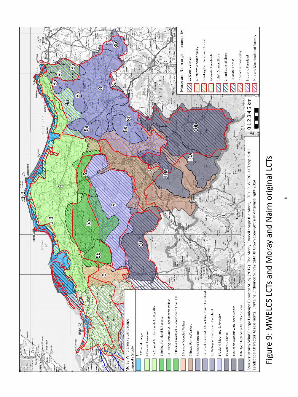
Figure 9 (taken from the SNH 2014/15 final draft review of the Moray and Nairn
landscape character assessment and included at the end of this appendix) shows the relationship between the 1998 Moray and Nairn landscape character assessment and the 2012 MWELCS. Recommendations for baseline landscape characterisation for the updated 2015 Moray wind capacity study
It is proposed to adopt all the changes made to the boundaries of landscape character types 1-6, 8, 11-12 in the revised SNH LCA. There are some key differences with the 2012 MWELCS that cause some concern however. These comprise the definition of the new character type Upland Farmed Valleys and Forested Hills (9) in the Hill of Towie/Dufftown area, the classification of Glen Rinnes, the Deveron and the Deskford Valleys and changes made to the southern boundary of the Upland Moorlands and Forestry (10). Sub-division of some of the main 12 landscape character types identified in the 2014/15 SNH review will also still be required given the variation which occurs in key characteristics and context, therefore influencing sensitivity to wind energy development. The following baseline characterisation for the purposes of the sensitivity assessment to be undertaken as part of the 2016 revised MWELCS is proposed:
Retain the amalgamation of the Soft/Hard Coastal Shore (1/2) and Coastal Forest (3) character types and adopt all boundary revisions.
6

Retain the sub-division of the Coastal Farmland (4) in the east and a renamed sub-division Rolling Coastal Farmland (4a) to cover the less expansive areas of coastal farmland backing Buckie and Cullen and covering the Deskford valley (the latter area formerly defined as Valleys within Upland Farmland 8b in the 2012 MWELCS). All boundary revisions to be adopted.
Adopt the boundary changes to the Narrow Wooded Valley (6) and Rolling Farmlands and Forestry (5) landscape character types but retain the sub-divisions of LCT 5 into 5a Rolling Farmland and Forests with Valleys and 5b Rolling Farmland and Forests with Low Hills set out in the 2012 MWELCS. The area of Rolling Farmland and Forests (5) which would then occur within Moray to the west of the Findhorn Valley (the Darnaway Forest area) should be included in sub-type 5b Rolling Farmland and Forests with Low Hills. It will be necessary to highlight the importance of the wooded policies within the western part of this landscape in providing the setting and backdrop to rare open views from the Findhorn and Dorback valleys.
The SNH 2014/15 revised LCA extends the southern boundary of the Upland Moorland and Forestry into the Broad Farmed Valley (7) covering the Spey Valley to include Monahoudie Moss and the spur of wooded higher ground which forms a ‘pinch-point’ to the north-west of Telford Bridge at Craigellachie. Although these comprise more densely wooded areas within the wider Spey Valley, they are lower and much less extensive in scale than the Upland Moorland and Forestry (10) LCT and also include some settlement/farmland. It was agreed with the Steering Group that the increased sensitivity of these outer upland edges should be stressed in the revised 2016 MWELCS.
Adopt the revised boundary of the Upland Farmland (8) but define a sub-type Broad Forested Hills within Upland Farmland (8a) as in the 2012 MWELCS. It was agreed with the Steering Group that the Valley in Upland Farmland (River Deveron in the far eastern part of Moray) and the Valley in Open Farmland covering Glen Rinnes/Deveron should be amalgamated with the upper Isla, Rinnes and Fiddich valleys (lying within the new LCT 9 in the revised SNH LCA) to form a new landscape character type called Narrow Farmed Valley (13)
The new Upland Farmed Valleys and Forested Hills LCT 9 will be adopted in part but with the upland areas of this character type being classified as the Rolling Forested Hills (9) and the valleys incorporated into the new character type Narrow Farmed Valleys (13).
All changes made to the classification and boundaries for landscape character type 11 Open Rolling Upland (which essentially follows the approach taken in the 2012 MWELCS) will be adopted.
Landscape character type 12 Open Upland and Farmed Valleys will be sub-divided as done for the 2012 MWELCS into Open Uplands with Steep Slopes (12a) and Open Uplands with Settled Glens (12b). These character sub-types and the proposed new Narrow Farmed Valleys character type covering Glen Rinnes will be extended to the Cairngorms National Park boundary (the 2014/15 SNH LCA review does not include all of the Moray area).
7
Figu
re 9
: MW
ELC
S LC
Ts a
nd
Mo
ray
and
Nai
rn o
rigi
nal
LC
Ts
Fig
ure
9: M
WEL
CS
LCTs
an
d M
ora
y an
d N
airn
ori
gin
al L
CTs
8

Appendix C: Detailed Sensitivity Tables
9

Cha
ract
er T
ype
1-3:
Coa
stal
Mar
gin
– Se
nsiti
vity
ass
essm
ent f
or la
rge
and
med
ium
typo
logi
es
To
pic
S
um
mar
y d
escr
ipti
on
A
sses
smen
t o
f la
rge
typ
olo
gy
(80m
-130
m)
Sen
siti
vity
ra
tin
g
Ass
essm
ent
of
med
ium
ty
po
log
y (5
0m-8
0m)
Sen
siti
vity
ra
tin
g
Lan
dsc
ape
con
text
Thi
s ch
arac
ter
type
form
s a
very
na
rrow
coa
stal
mar
gin
larg
ely
defin
ed
by th
e lo
w c
liff o
f a r
aise
d be
ach
in th
e ea
st a
nd a
dis
tinct
rid
ge b
etw
een
Loss
iem
outh
and
Bur
ghea
d. T
he
char
acte
r ty
pe is
wid
er to
the
wes
t w
here
it in
clud
es th
e co
asta
l for
ests
, th
e m
ost e
xten
sive
of t
hese
bei
ng
Cul
bin.
Thi
s la
ndsc
ape
lies
adja
cent
to
the
Coa
stal
Far
mla
nd (
4) a
lthou
gh
inte
r-vi
sibi
lity
betw
een
the
two
is o
ften
rest
ricte
d by
land
form
and
fore
stry
. T
here
is g
reat
er in
ter-
visi
bilit
y of
thes
e tw
o ch
arac
ter
type
s ea
st o
f the
Riv
er
Spe
y du
e to
the
abse
nce
of s
cree
ning
fe
atur
es.
The
nar
row
ness
of t
his
char
acte
r ty
pe in
crea
ses
sens
itivi
ty in
term
s of
ef
fect
s on
adj
oini
ng la
ndsc
apes
. Thi
s ty
polo
gy is
like
ly to
hav
e a
sign
ifica
nt
impa
ct o
n th
e C
oast
al F
arm
land
(4)
, w
hich
alth
ough
ext
ensi
ve a
nd
rela
tivel
y si
mpl
e in
term
s of
its
land
form
and
land
cov
er, i
s w
ell
settl
ed a
nd v
ery
open
. T
urbi
nes
of th
is s
ize
coul
d de
trac
t fr
om th
e la
ndm
ark
hill
of th
e B
in o
f C
ulle
n an
d th
e se
tting
to C
ulle
n H
ouse
, with
in th
e C
oast
al F
arm
land
(4
) if
site
d in
the
east
ern
part
of t
his
char
acte
r ty
pe.
Hig
h-m
ediu
m
The
nar
row
ness
of t
his
char
acte
r ty
pe in
crea
ses
sens
itivi
ty in
term
s of
effe
cts
on a
djoi
ning
land
scap
es.
Thi
s ty
polo
gy is
like
ly to
hav
e a
sign
ifica
nt im
pact
on
the
Coa
stal
F
arm
land
(4)
, whi
ch a
lthou
gh
exte
nsiv
e an
d re
lativ
ely
sim
ple
in
term
s of
its
land
form
and
land
co
ver,
is w
ell s
ettle
d an
d ve
ry o
pen.
T
urbi
nes
of th
is s
ize
coul
d de
trac
t fr
om th
e la
ndm
ark
hill
of th
e B
in o
f C
ulle
n an
d th
e se
tting
to C
ulle
n H
ouse
, with
in th
e C
oast
al F
arm
land
(4
) if
site
d in
the
east
ern
part
of t
his
char
acte
r ty
pe.
Hig
h-m
ediu
m
Sca
le a
nd
o
pen
nes
s
The
Mor
ay F
irth
give
s a
sens
e of
ex
pans
iven
ess
to th
e ov
eral
l se
asca
pe. L
ong
even
bea
ches
are
m
ore
open
alth
ough
mor
e in
tric
ate
sect
ions
of r
ocky
inde
nted
coa
stlin
e,
narr
ow r
aise
d be
ache
s an
d ex
tens
ive
dune
sys
tem
s al
so o
ccur
and
thes
e ar
eas
have
a s
mal
ler
scal
e. D
ispe
rsed
bu
ildin
gs a
re r
are
alth
ough
a r
egul
ar
patte
rn o
f sm
all s
ettle
men
ts is
a
char
acte
ristic
of t
his
coas
t. F
ores
ts a
nd
encl
osed
farm
land
als
o pr
ovid
e sc
ale
refe
renc
es.
Alth
ough
this
typo
logy
cou
ld r
elat
e to
th
e sc
ale
of m
ore
open
, lon
g ev
en
sect
ions
of c
oast
line
and
the
wid
er
Mor
ay F
irth,
are
as o
f mor
e co
mpl
ex
inde
nted
coa
stlin
e, th
e lo
w r
elie
f of
the
shor
elin
e, r
aise
d be
ache
s an
d lo
w c
liffs
wou
ld b
e hi
ghly
sen
sitiv
e in
te
rms
of c
ompa
rison
s of
sca
le to
tu
rbin
es o
f thi
s si
ze.
Sm
all s
ettle
men
ts a
nd o
ther
feat
ures
w
ould
als
o be
dw
arfe
d by
this
ty
polo
gy.
Hig
h A
lthou
gh th
is ty
polo
gy c
ould
rel
ate
to th
e sc
ale
of m
ore
open
, lon
g ev
en s
ectio
ns o
f coa
stlin
e an
d th
e w
ider
Mor
ay F
irth,
are
as o
f mor
e co
mpl
ex in
dent
ed c
oast
line,
the
low
re
lief o
f the
sho
relin
e, r
aise
d be
ache
s an
d lo
w c
liffs
wou
ld b
e hi
ghly
sen
sitiv
e in
term
s of
co
mpa
rison
s of
sca
le to
turb
ines
of
this
siz
e.
Sm
all s
ettle
men
ts a
nd o
ther
fe
atur
es w
ould
als
o be
dw
arfe
d by
th
is ty
polo
gy.
Hig
h
10

Lan
dfo
rm
A
div
erse
and
ofte
n co
mpl
ex la
ndfo
rm
with
long
san
dy a
nd b
anke
d st
ony
beac
hes
back
ed b
y co
mpl
ex s
and
dune
s, s
pits
and
oth
er tr
ansi
ent
geom
orph
olog
ical
feat
ures
in th
e C
ulbi
n, F
indh
orn
and
Spe
y es
tuar
y ar
ea. T
he c
oast
is m
ore
inde
nted
and
ro
cky
to th
e ea
st a
nd b
etw
een
Loss
iem
outh
and
Bur
ghea
d, fe
atur
ing
smal
l cov
es, p
rom
onto
ries
and
occa
sion
al c
ragg
y is
lets
. A r
aise
d be
ach
plat
form
and
ass
ocia
ted
low
clif
f oc
curs
bet
wee
n B
ucki
e an
d C
ulle
n.
The
com
plex
form
of d
une
syst
ems
and
mor
e in
tric
ate
coas
tal f
eatu
res
wou
ld b
e hi
ghly
sen
sitiv
e to
this
ty
polo
gy.
Alth
ough
turb
ines
of t
his
size
wou
ld r
elat
e be
tter
to th
e m
ore
sim
ple
stre
tche
s of
coa
st a
nd th
e ge
ntly
slo
ping
imm
edia
te h
inte
rland
pr
esen
t in
som
e ar
eas,
they
cou
ld
detr
act f
rom
nea
rby
mor
e co
mpl
ex
land
form
app
reci
ated
in lo
ng v
iew
s al
ong
the
coas
t.
The
abr
upt e
dges
of c
liff t
ops,
the
low
, nar
row
rid
ge b
etw
een
Loss
iem
outh
and
Bur
ghea
d an
d sk
ylin
es o
verlo
okin
g th
e co
ast w
ould
be
par
ticul
arly
sen
sitiv
e to
this
ty
polo
gy.
Hig
h T
he c
ompl
ex fo
rm o
f dun
e sy
stem
s an
d m
ore
intr
icat
e co
asta
l fea
ture
s w
ould
be
high
ly s
ensi
tive
to th
is
typo
logy
. A
lthou
gh tu
rbin
es o
f thi
s si
ze w
ould
rel
ate
bette
r to
the
mor
e si
mpl
e st
retc
hes
of c
oast
and
the
gent
ly s
lopi
ng im
med
iate
hin
terla
nd
pres
ent i
n so
me
area
s, th
ey w
ould
de
trac
t fro
m n
earb
y m
ore
com
plex
la
ndfo
rm a
ppre
ciat
ed in
long
vie
ws
alon
g th
e co
ast.
T
he a
brup
t edg
es o
f clif
f top
s, th
e lo
w, n
arro
w r
idge
bet
wee
n Lo
ssie
mou
th a
nd B
urgh
ead
and
skyl
ines
ove
rlook
ing
the
coas
t w
ould
be
part
icul
arly
sen
sitiv
e to
th
is ty
polo
gy.
Hig
h
Lan
dsc
ape
pat
tern
Cul
tivat
ed fi
elds
, ofte
n en
clos
ed b
y st
one
wal
ls, s
lope
gen
tly d
own
to th
e lo
w c
liffs
of r
aise
d be
ache
s in
the
east
. G
orse
y sc
rub
colo
nise
s cl
iff to
ps a
nd
smal
l kno
lls o
n se
awar
d fa
cing
slo
pes
and
rock
y kn
olls
. Ext
ensi
ve p
ine
fore
sts
plan
ted
on d
unes
and
poo
rer
soils
and
gra
vels
bac
k th
e co
ast i
n pl
aces
and
are
par
ticul
arly
ext
ensi
ve to
th
e w
est.
Man
y of
thes
e fo
rest
s ar
e m
anag
ed fo
r th
eir
recr
eatio
n an
d co
nser
vatio
n va
lue
and
are
ofte
n di
vers
e. M
udfla
ts a
nd s
altm
arsh
form
co
mpl
ex p
atte
rns
with
in th
e tid
al
Fin
dhor
n B
ay a
nd S
pey
estu
ary.
Gol
f co
urse
s ar
e oc
casi
onal
feat
ures
clo
se
to th
e co
asta
l edg
e.
Thi
s ty
polo
gy w
ould
det
ract
from
the
ofte
n di
vers
e ve
geta
tion
patte
rn
whi
ch is
clo
sely
ass
ocia
ted
with
the
land
form
of t
he C
oast
al M
argi
n. M
ore
unifo
rm fo
rest
ry a
nd le
ss s
tron
gly
encl
osed
farm
land
wou
ld b
e le
ss
sens
itive
.
Hig
h-m
ediu
m
Thi
s ty
polo
gy w
ould
det
ract
from
th
e of
ten
dive
rse
vege
tatio
n pa
ttern
w
hich
is c
lose
ly a
ssoc
iate
d w
ith th
e la
ndfo
rm o
f the
Coa
stal
Mar
gin
. M
ore
unifo
rm fo
rest
ry a
nd le
ss
stro
ngly
enc
lose
d fa
rmla
nd w
ould
be
less
sen
sitiv
e.
Hig
h-m
ediu
m
11

Bu
ilt
envi
ron
men
t
The
re is
a s
tron
g id
entit
y to
the
settl
emen
ts w
hich
are
reg
ular
ly s
pace
d al
ong
the
coas
t. M
any
are
of h
isto
ric
and
arch
itect
ural
inte
rest
. Lo
ssie
mou
th a
nd B
urgh
ead
are
dist
inct
ivel
y si
ted
on p
rom
onto
ries
abov
e sh
elte
red
harb
ours
whi
le th
e pl
anne
d fis
hing
por
ts to
the
east
are
tu
cked
bel
ow c
liffs
on
narr
ow r
aise
d be
ache
s.
Par
ts o
f the
imm
edia
te h
inte
rland
are
m
ore
deve
lope
d, fo
r ex
ampl
e be
twee
n Lo
ssie
mou
th a
nd B
urgh
ead,
Fin
dhor
n an
d ea
st o
f the
Spe
y w
ith M
OD
de
velo
pmen
t, go
lf co
urse
s an
d ca
rava
n pa
rks.
The
ligh
thou
se w
est o
f Lo
ssie
mou
th fo
rms
a la
ndm
ark
feat
ure.
Thi
s ty
polo
gy w
ould
dom
inat
e th
e se
tting
of a
rchi
tect
ural
ly d
istin
ctiv
e se
ttlem
ents
if s
ited
near
by a
nd/o
r on
co
ntai
ning
sky
lines
. Tur
bine
s of
this
si
ze, a
nd p
artic
ular
ly m
ultip
le
turb
ines
, cou
ld d
isru
pt th
e re
gula
r pa
ttern
of l
arge
ly c
ompa
ct
settl
emen
ts, o
ften
clea
rly a
ssoc
iate
d w
ith r
iver
mou
ths
or s
helte
red
natu
ral
harb
ours
set
alo
ng th
e co
ast b
y fil
ling
gaps
of o
pen
land
bet
wee
n. T
he
light
hous
e w
est o
f Los
siem
outh
w
ould
be
sens
itive
to tu
rbin
es s
ited
near
by.
Hig
h-m
ediu
m
Thi
s ty
polo
gy w
ould
dom
inat
e th
e se
tting
of a
rchi
tect
ural
ly d
istin
ctiv
e se
ttlem
ents
if s
ited
near
by a
nd/o
r on
con
tain
ing
skyl
ines
. Tur
bine
s of
th
is s
ize,
and
par
ticul
arly
mul
tiple
tu
rbin
es, c
ould
dis
rupt
the
regu
lar
patte
rn o
f lar
gely
com
pact
se
ttlem
ents
, ofte
n cl
early
as
soci
ated
with
riv
er m
outh
s or
sh
elte
red
natu
ral h
arbo
urs
set
alon
g th
e co
ast b
y fil
ling
gaps
of
open
land
bet
wee
n. T
he li
ghth
ouse
w
est o
f Los
siem
outh
wou
ld b
e se
nsiti
ve to
turb
ines
site
d ne
arby
.
Hig
h-m
ediu
m
Per
cep
tual
q
ual
itie
s T
he c
oast
al e
dge
has
dist
inct
ive
natu
ral q
ualit
ies
and
a se
nse
of
rem
oten
ess
can
also
be
expe
rienc
ed
away
from
roa
ds a
nd s
ettle
men
t, w
here
the
hint
erla
nd is
less
vis
ible
.
Tur
bine
s of
this
sca
le c
ould
intr
ude
on th
e se
nse
of s
eclu
sion
and
na
tura
lnes
s ex
perie
nced
alo
ng p
arts
of
the
coas
tline
.
Hig
h-m
ediu
m
Tur
bine
s of
this
sca
le c
ould
intr
ude
on th
e se
nse
of s
eclu
sion
and
na
tura
lnes
s ex
perie
nced
alo
ng
part
s of
the
coas
tline
.
Hig
h-m
ediu
m
Vis
ual
am
enit
y
The
Coa
stal
Mar
gin
is w
ell s
ettle
d an
d th
e fo
rest
s an
d co
ast a
re h
ighl
y va
lued
fo
r re
crea
tiona
l use
. T
here
are
ope
n vi
ews
acro
ss th
e M
oray
Firt
h to
the
dist
ant S
uthe
rland
co
ast a
nd h
ills.
Vie
ws
betw
een
the
Mor
ay c
oast
and
hin
terla
nd, i
nclu
ding
th
e ad
jace
nt C
oast
al F
arm
land
(4)
, are
sc
reen
ed b
y la
ndfo
rm a
nd fo
rest
ry in
pl
aces
alth
ough
inte
r-vi
sibi
lity
alon
g th
e co
ast a
nd th
e w
ider
Mor
ay
land
scap
e is
incr
ease
d al
ong
mor
e
Thi
s si
ze o
f tur
bine
wou
ld b
e hi
ghly
vi
sibl
e fr
om r
oads
, set
tlem
ent a
nd
beac
hes
with
in th
is c
hara
cter
type
w
here
it w
ould
form
a d
omin
ant
feat
ure.
T
urbi
nes
of th
is s
ize
wou
ld a
lso
be
prom
inen
t in
view
s fr
om th
e C
oast
al
Far
mla
nd (
4) a
nd fr
om th
e no
rth-
faci
ng s
ettle
d sl
opes
of t
he R
ollin
g F
arm
land
s an
d F
ores
t with
Val
leys
(5
a) a
nd th
e R
ollin
g C
oast
al
Far
mla
nd (
4a).
Hig
h T
his
size
of t
urbi
ne w
ould
be
high
ly
visi
ble
from
roa
ds, s
ettle
men
t and
be
ache
s w
ithin
this
cha
ract
er ty
pe
whe
re it
wou
ld fo
rm a
dom
inan
t fe
atur
e.
Tur
bine
s of
this
siz
e w
ould
als
o be
pr
omin
ent i
n vi
ews
from
the
Coa
stal
F
arm
land
(4)
and
from
the
nort
h-fa
cing
set
tled
slop
es o
f the
Rol
ling
Far
mla
nds
and
For
est w
ith V
alle
ys
(5a)
and
the
Rol
ling
Coa
stal
F
arm
land
(4a
).
Hig
h
12

open
, lon
g an
d ev
en s
ectio
ns o
f coa
st.
Bin
n H
ill is
pro
min
ent i
n th
ese
view
s.
Cu
mu
lati
ve
effe
cts
The
sm
all g
roup
of t
urbi
nes
at
Fin
dhor
n ar
e vi
sibl
e in
the
wes
tern
par
t of
this
cha
ract
er ty
pe. T
he o
pera
tiona
l R
othe
s I a
nd II
and
Hill
of T
owie
win
d fa
rms
are
visi
ble
nort
h an
d ea
st o
f E
lgin
see
n on
the
skyl
ine
of th
e di
stan
t up
land
s of
the
Upl
and
Moo
rland
and
F
ores
try
(10)
and
Bro
ad F
ores
ted
Hill
s w
ithin
Upl
and
Far
mla
nd (
8a)
but a
t di
stan
ces
of o
ver
18km
. B
oynd
ie w
ind
farm
is lo
cate
d cl
ose
to
the
coas
t in
neig
hbou
ring
Abe
rdee
nshi
re.
Cum
ulat
ive
effe
cts
with
exi
stin
g w
ind
farm
s si
ted
with
in th
e up
land
la
ndsc
apes
to th
e so
uth
are
unlik
ely
to b
e si
gnifi
cant
due
to th
e di
stan
ces
invo
lved
, the
inte
rmitt
ent n
atur
e of
op
en v
iew
s to
the
hint
erla
nd a
nd th
e ex
tens
iven
ess
of v
iew
s w
hich
le
ssen
s vi
sual
impa
ct.
Thi
s si
ze o
f tur
bine
site
d in
the
wes
tern
par
t of t
his
char
acte
r ty
pe
wou
ld h
ave
cum
ulat
ive
effe
cts
with
th
e sm
alle
r F
indh
orn
turb
ines
but
al
so w
ith o
ther
bui
ldin
gs a
nd
infr
astr
uctu
re a
ssoc
iate
d w
ith M
OD
de
velo
pmen
t at K
inlo
ss.
Cum
ulat
ive
effe
cts
on v
iew
s fr
om k
ey
coas
tal r
oute
s m
ay o
ccur
with
win
d fa
rm d
evel
opm
ents
site
d in
A
berd
eens
hire
alth
ough
vie
ws
wou
ld
be m
ore
likel
y to
be
sequ
entia
l due
to
the
scre
enin
g pr
ovid
ed b
y rid
ges
and
hills
on
the
Mor
ay b
ound
ary.
Med
ium
-low
C
umul
ativ
e ef
fect
s w
ith e
xist
ing
win
d fa
rms
site
d w
ithin
the
upla
nd
land
scap
es to
the
sout
h ar
e un
likel
y to
be
sign
ifica
nt d
ue to
the
dist
ance
s in
volv
ed, t
he in
term
itten
t na
ture
of o
pen
view
s to
the
hint
erla
nd a
nd th
e ex
tens
iven
ess
of
view
s w
hich
less
ens
visu
al im
pact
. T
his
size
of t
urbi
ne s
ited
in th
e w
este
rn p
art o
f thi
s ch
arac
ter
type
w
ould
hav
e cu
mul
ativ
e ef
fect
s w
ith
the
smal
ler
Fin
dhor
n tu
rbin
es b
ut
also
with
oth
er b
uild
ings
and
in
fras
truc
ture
ass
ocia
ted
with
MO
D
deve
lopm
ent a
t Kin
loss
. C
umul
ativ
e ef
fect
s on
vie
ws
from
ke
y co
asta
l rou
tes
may
occ
ur w
ith
win
d fa
rm d
evel
opm
ents
site
d in
A
berd
eens
hire
alth
ough
vie
ws
wou
ld b
e m
ore
likel
y to
be
sequ
entia
l due
to th
e sc
reen
ing
prov
ided
by
ridge
s an
d hi
lls o
n th
e M
oray
bou
ndar
y.
Med
ium
-low
13

Cha
ract
er T
ype
1-3:
Coa
stal
Mar
gin
– Se
nsiti
vity
ass
essm
ent f
or s
mal
l-med
ium
and
sm
all t
ypol
ogie
s T
op
ic
Su
mm
ary
des
crip
tio
nA
sses
smen
to
f sm
all-
med
ium
ty
po
log
y (3
5m-5
0m)
Sen
siti
vity
ra
tin
g
Ass
essm
ent
of
smal
ltyp
olo
gy
(20m
-35m
) S
ensi
tivi
ty
rati
ng
L
and
scap
e co
nte
xt
Thi
s ch
arac
ter
type
form
s a
very
na
rrow
coa
stal
mar
gin
larg
ely
defin
ed
by th
e lo
w c
liff o
f a r
aise
d be
ach
in th
e ea
st a
nd a
dis
tinct
rid
ge b
etw
een
Loss
iem
outh
and
Bur
ghea
d. T
he
char
acte
r ty
pe is
wid
er to
the
wes
t w
here
it in
clud
es th
e co
asta
l for
ests
, th
e m
ost e
xten
sive
of t
hese
bei
ng
Cul
bin.
Thi
s la
ndsc
ape
lies
adja
cent
to
the
Coa
stal
Far
mla
nd (
4) a
lthou
gh
inte
r-vi
sibi
lity
betw
een
the
two
is o
ften
rest
ricte
d by
land
form
and
fore
stry
. T
here
is g
reat
er in
ter-
visi
bilit
y of
thes
e tw
o ch
arac
ter
type
s ea
st o
f the
Riv
er
Spe
y du
e to
the
abse
nce
of s
cree
ning
fe
atur
es.
Thi
s ty
polo
gy c
ould
be
site
d w
ithin
br
oade
r se
ctio
ns o
f the
Coa
stal
M
argi
n (1
-3)
to m
inim
ise
effe
cts
on
the
Coa
stal
Far
mla
nd (
4) a
lthou
gh
thes
e ar
eas
are
larg
ely
fore
sted
and
ot
her
sens
itivi
ties
wou
ld th
eref
ore
com
e in
to p
lay.
T
urbi
nes
of th
is s
ize
coul
d de
trac
t fr
om th
e la
ndm
ark
Bin
of C
ulle
n an
d th
e se
tting
to C
ulle
n H
ouse
if s
ited
near
by o
r in
key
vie
ws.
Med
ium
S
mal
ler
turb
ines
wou
ld h
ave
less
of
an e
ffect
on
the
adjo
inin
g C
oast
al
Far
mla
nd (
4) c
hara
cter
type
. The
re
are
incr
ease
d op
port
uniti
es to
site
tu
rbin
es to
war
ds th
e lo
wer
hei
ght
band
of t
his
typo
logy
to m
inim
ise
effe
cts
on a
djoi
ning
sen
sitiv
e la
ndm
ark
hills
and
pol
icie
s.
Med
ium
-low
Sca
le a
nd
o
pen
nes
s
The
Mor
ay F
irth
give
s a
sens
e of
ex
pans
iven
ess
to th
e ov
eral
l se
asca
pe. L
ong
even
bea
ches
are
m
ore
open
alth
ough
mor
e in
tric
ate
sect
ions
of r
ocky
inde
nted
coa
stlin
e,
narr
ow r
aise
d be
ache
s an
d ex
tens
ive
dune
sys
tem
s al
so o
ccur
and
thes
e ar
eas
have
a s
mal
ler
scal
e. D
ispe
rsed
bu
ildin
gs a
re r
are
alth
ough
a r
egul
ar
patte
rn o
f sm
all s
ettle
men
ts is
a
char
acte
ristic
of t
his
coas
t. F
ores
ts a
nd
encl
osed
farm
land
als
o pr
ovid
e sc
ale
refe
renc
es.
Tur
bine
s of
this
siz
e co
uld
rela
te to
th
e sc
ale
of m
ore
open
, lon
g ev
en
sect
ions
of c
oast
line
and
expa
nsiv
e fla
t hin
terla
nd a
reas
. Sm
all s
cale
sh
orel
ine
feat
ures
suc
h as
the
very
na
rrow
rai
sed
beac
hes,
dun
es a
nd
low
clif
fs w
ould
how
ever
be
high
ly
sens
itive
to th
is ty
polo
gy. T
urbi
nes
of
this
siz
e co
uld
over
whe
lm th
e sc
ale
of s
mal
l set
tlem
ents
if s
ited
near
by.
Hig
h-m
ediu
m
Tur
bine
s of
this
siz
e co
uld
rela
te to
th
e sc
ale
of m
ore
open
, lon
g ev
en
sect
ions
of c
oast
line
and
wou
ld
have
less
of a
dom
inan
t effe
ct o
n m
ore
sens
itive
are
as p
rovi
ded
turb
ines
wer
e lo
cate
d w
ell a
way
fr
om s
hore
line
feat
ures
suc
h as
the
very
nar
row
rai
sed
beac
hes,
dun
es
and
low
clif
fs.
Hig
h-m
ediu
m
Lan
dfo
rm
A d
iver
se a
nd o
ften
com
plex
land
form
T
he c
ompl
ex fo
rm o
f dun
e sy
stem
s H
igh-
The
com
plex
form
of d
une
syst
ems
Hig
h-
14

w
ith lo
ng s
andy
and
ban
ked
ston
y be
ache
s ba
cked
by
com
plex
san
d du
nes,
spi
ts a
nd o
ther
tran
sien
t ge
omor
phol
ogic
al fe
atur
es in
the
Cul
bin,
Fin
dhor
n an
d S
pey
estu
ary
area
. The
coa
st is
mor
e in
dent
ed a
nd
rock
y to
the
east
and
bet
wee
n Lo
ssie
mou
th a
nd B
urgh
ead,
feat
urin
g sm
all c
oves
, pro
mon
torie
s an
d oc
casi
onal
cra
ggy
isle
ts. A
rai
sed
beac
h pl
atfo
rm a
nd a
ssoc
iate
d lo
w c
liff
occu
rs b
etw
een
Buc
kie
and
Cul
len.
and
mor
e in
tric
ate
coas
tal f
eatu
res
wou
ld b
e se
nsiti
ve to
this
typo
logy
al
thou
gh th
is ty
polo
gy w
ould
rel
ate
bette
r to
sim
ple
sect
ions
of e
ven
coas
tline
, fla
tter
area
s of
ope
n hi
nter
land
and
mor
e ge
ntly
slo
ping
la
nd. T
he a
brup
t edg
es o
f clif
f top
s,
the
low
, nar
row
rid
ge b
etw
een
Loss
iem
outh
and
Bur
ghea
d an
d sk
ylin
es o
verlo
okin
g th
e co
ast w
ould
be
par
ticul
arly
sen
sitiv
e.
med
ium
an
d m
ore
intr
icat
e co
asta
l fea
ture
s in
clud
ing
estu
arie
s an
d ba
sins
w
ould
be
sens
itive
eve
n to
this
sm
all t
ypol
ogy
alth
ough
ther
e ar
e in
crea
sed
oppo
rtun
ities
to r
elat
e tu
rbin
es o
f thi
s si
ze to
mor
e ev
en
sect
ions
of c
oast
line
and
mor
e ge
ntly
und
ulat
ing
slop
ing
land
w
ithou
t det
ract
ing
from
adj
acen
t m
ore
com
plex
are
as o
f lan
dfor
m.
The
abr
upt e
dges
of c
liff t
ops,
the
low
, nar
row
rid
ge b
etw
een
Loss
iem
outh
and
Bur
ghea
d an
d sk
ylin
es o
verlo
okin
g th
e co
ast
wou
ld b
e pa
rtic
ular
ly s
ensi
tive.
med
ium
Lan
dsc
ape
pat
tern
Cul
tivat
ed fi
elds
, ofte
n en
clos
ed b
y st
one
wal
ls, s
lope
gen
tly d
own
to th
e lo
w c
liffs
of r
aise
d be
ache
s in
the
east
. G
orse
y sc
rub
colo
nise
s cl
iff to
ps a
nd
smal
l kno
lls o
n se
awar
d fa
cing
slo
pes
and
rock
y kn
olls
. Ext
ensi
ve p
ine
fore
sts
plan
ted
on d
unes
and
poo
rer
soils
and
gra
vels
bac
k th
e co
ast i
n pl
aces
and
are
par
ticul
arly
ext
ensi
ve to
th
e w
est.
Man
y of
thes
e fo
rest
s ar
e m
anag
ed fo
r th
eir
recr
eatio
n an
d co
nser
vatio
n va
lue
and
are
ofte
n di
vers
e. M
udfla
ts a
nd s
altm
arsh
form
co
mpl
ex p
atte
rns
with
in th
e tid
al
Fin
dhor
n B
ay a
nd S
pey
estu
ary.
Gol
f co
urse
s ar
e oc
casi
onal
feat
ures
clo
se
to th
e co
asta
l edg
e.
Thi
s ty
polo
gy w
ould
det
ract
from
the
ofte
n di
vers
e ve
geta
tion
patte
rn
whi
ch is
clo
sely
ass
ocia
ted
with
the
land
form
of t
he C
oast
al M
argi
n. M
ore
unifo
rm fo
rest
ry a
nd o
pen
farm
land
w
ould
be
less
sen
sitiv
e.
Med
ium
T
here
is in
crea
sed
scop
e to
loca
te
this
typo
logy
to a
void
impa
ct o
n m
ore
dive
rse
vege
tatio
n pa
ttern
.
Med
ium
-low
Bu
ilt
envi
ron
men
t
The
re is
a s
tron
g id
entit
y to
the
settl
emen
ts w
hich
are
reg
ular
ly s
pace
d T
his
typo
logy
wou
ld d
omin
ate
the
setti
ng o
f arc
hite
ctur
ally
dis
tinct
ive
Hig
h-m
ediu
m
Thi
s ty
polo
gy c
ould
dom
inat
e th
e se
tting
of a
rchi
tect
ural
ly d
istin
ctiv
e M
ediu
m
15

al
ong
the
coas
t. M
any
are
of h
isto
ric
and
arch
itect
ural
inte
rest
. Lo
ssie
mou
th a
nd B
urgh
ead
are
dist
inct
ivel
y si
ted
on p
rom
onto
ries
abov
e sh
elte
red
harb
ours
whi
le th
e pl
anne
d fis
hing
por
ts to
the
east
are
tu
cked
bel
ow c
liffs
on
narr
ow r
aise
d be
ache
s.
Par
ts o
f the
imm
edia
te h
inte
rland
are
m
ore
deve
lope
d, fo
r ex
ampl
e be
twee
n Lo
ssie
mou
th a
nd B
urgh
ead,
Fin
dhor
n an
d ea
st o
f the
Spe
y w
ith M
OD
fa
cilit
ies,
gol
f cou
rses
and
car
avan
pa
rks.
The
ligh
thou
se w
est o
f Lo
ssie
mou
th fo
rms
a la
ndm
ark
feat
ure.
settl
emen
ts if
site
d ne
arby
and
/or
on
cont
aini
ng s
kylin
es. M
ultip
le tu
rbin
es
of th
is s
ize
coul
d di
srup
t the
reg
ular
pa
ttern
of l
arge
ly c
ompa
ct
settl
emen
ts, o
ften
clea
rly a
ssoc
iate
d w
ith r
iver
mou
ths
or s
helte
red
natu
ral h
arbo
urs
set a
long
the
coas
t by
filli
ng g
aps
of o
pen
land
bet
wee
n th
em. T
he li
ghth
ouse
wes
t of
Loss
iem
outh
wou
ld b
e se
nsiti
ve to
tu
rbin
es s
ited
near
by.
settl
emen
ts if
site
d ne
arby
and
/or
on c
onta
inin
g sk
ylin
es.
Mul
tiple
turb
ines
cou
ld d
isru
pt th
e re
gula
r pa
ttern
of l
arge
ly c
ompa
ct
settl
emen
ts a
lthou
gh th
ere
is m
ore
scop
e to
acc
omm
odat
e th
ese
smal
ler
turb
ines
to m
inim
ise
effe
cts
on s
ettle
men
t pat
tern
and
set
ting.
T
he li
ghth
ouse
wes
t of
Loss
iem
outh
wou
ld b
e se
nsiti
ve to
tu
rbin
es s
ited
near
by.
Per
cep
tual
q
ual
itie
s T
he c
oast
al e
dge
has
dist
inct
ive
natu
ral q
ualit
ies
and
a se
nse
of
rem
oten
ess
can
also
be
expe
rienc
ed
away
from
roa
ds a
nd s
ettle
men
t, w
here
the
hint
erla
nd is
less
vis
ible
.
Tur
bine
s of
this
sca
le c
ould
intr
ude
on th
e se
nse
of s
eclu
sion
and
na
tura
lnes
s ex
perie
nced
alo
ng p
arts
of
the
coas
tline
.
Hig
h-m
ediu
m
Tur
bine
s of
this
siz
e co
uld
intr
ude
on th
e se
nse
of s
eclu
sion
and
na
tura
lnes
s ex
perie
nced
alo
ng
part
s of
the
coas
tline
alth
ough
ther
e is
incr
ease
d sc
ope
for
smal
ler
turb
ines
to b
e se
t bac
k fr
om th
e m
ore
sens
itive
coa
stal
edg
e an
d th
us m
inim
ise
impa
cts
on
perc
eptu
al q
ualit
ies.
Med
ium
Vis
ual
am
enit
y
The
Coa
stal
Mar
gin
is w
ell s
ettle
d an
d th
e fo
rest
s an
d co
ast a
re h
ighl
y va
lued
fo
r re
crea
tiona
l use
. T
here
are
ope
n vi
ews
acro
ss th
e M
oray
Firt
h to
the
dist
ant S
uthe
rland
co
ast a
nd h
ills.
Vie
ws
betw
een
the
Mor
ay c
oast
and
hin
terla
nd, i
nclu
ding
th
e ad
jace
nt C
oast
al F
arm
land
(4)
, are
sc
reen
ed b
y la
ndfo
rm a
nd fo
rest
ry in
pl
aces
alth
ough
inte
r-vi
sibi
lity
alon
g
Thi
s ty
polo
gy w
ould
be
intr
usiv
e fr
om
road
s, s
ettle
men
ts a
nd a
reas
use
d fo
r re
crea
tion
if si
ted
on th
e ed
ge o
f be
ache
s, b
etw
een
the
coas
t and
the
A94
2 or
site
d on
rid
ge to
ps a
nd
with
in n
arro
w r
aise
d be
ache
s an
d on
th
e ab
rupt
edg
e of
clif
fs. T
urbi
nes
of
this
siz
e co
uld
also
be
prom
inen
t in
view
s fr
om th
e C
oast
al F
arm
land
(4)
an
d fr
om th
e no
rth-
faci
ng s
ettle
d
Hig
h E
ven
turb
ines
of t
his
size
wou
ld b
e
intr
usiv
e fr
om r
oads
, set
tlem
ents
an
d ar
eas
used
for
recr
eatio
n,
part
icul
arly
if s
ited
on th
e ed
ge o
f be
ache
s, b
etw
een
the
coas
t and
th
e A
942
or s
ited
on r
idge
tops
and
w
ithin
nar
row
rai
sed
beac
hes
and
on th
e ab
rupt
edg
e of
clif
fs.
Thi
s ty
polo
gy w
ould
, how
ever
, be
less
lik
ely
to b
e pr
omin
ent i
n vi
ews
from
Hig
h-m
ediu
m
16

the
coas
t and
the
wid
er M
oray
la
ndsc
ape
is in
crea
sed
alon
g m
ore
open
, lon
g an
d ev
en s
ectio
ns o
f coa
st.
Bin
n H
ill is
pro
min
ent i
n th
ese
view
s.
slop
es o
f the
Rol
ling
Far
mla
nds
and
For
est w
ith V
alle
ys (
5a)
and
the
Rol
ling
Coa
stal
Far
mla
nd (
4a).
the
Coa
stal
Far
mla
nd (
4) a
nd fr
om
the
nort
h-fa
cing
set
tled
slop
es o
f th
e R
ollin
g F
arm
land
s an
d F
ores
t w
ith V
alle
ys (
5a)
and
the
Rol
ling
Coa
stal
Far
mla
nd (
4a).
C
um
ula
tive
ef
fect
s T
he s
mal
l gro
up o
f tur
bine
s at
F
indh
orn
are
visi
ble
in th
e w
este
rn p
art
of th
is c
hara
cter
type
. The
ope
ratio
nal
Rot
hes
I and
II a
nd H
ill o
f Tow
ie w
ind
farm
s ar
e vi
sibl
e no
rth
and
east
of
Elg
in s
een
on th
e sk
ylin
e of
the
dist
ant
upla
nds
of th
e U
plan
d M
oorla
nd a
nd
For
estr
y (1
0) a
nd B
road
For
este
d H
ills
with
in U
plan
d F
arm
land
(8a
) bu
t at
dist
ance
s of
ove
r 18
km. T
he
cons
ente
d ex
tens
ion
to th
e R
othe
s w
ind
farm
will
ext
end
the
num
bers
of
turb
ines
vis
ible
on
the
skyl
ine
in th
ese
view
s.
Cum
ulat
ive
issu
es w
ith e
xist
ing
win
d fa
rms
site
d w
ithin
the
upla
nd
land
scap
es to
the
sout
h w
ould
not
be
sign
ifica
nt d
ue to
the
dist
ance
s in
volv
ed, t
he v
ery
inte
rmitt
ent n
atur
e of
ope
n vi
ews
to th
e hi
nter
land
and
th
e ex
tens
iven
ess
of v
iew
s w
hich
le
ssen
s th
eir
visu
al im
pact
. T
his
size
of t
urbi
ne s
ited
in th
e w
este
rn p
art o
f thi
s ch
arac
ter
type
w
ould
be
mor
e co
mpa
tible
in s
ize
with
the
exis
ting
Fin
dhor
n tu
rbin
es
but c
ould
incr
ease
the
clut
ter
of b
uilt
MO
D in
fras
truc
ture
in th
e K
inlo
ss
area
, pot
entia
lly a
ffect
ing
view
s fr
om
mor
e se
nsiti
ve b
each
es.
Seq
uent
ial e
ffect
s on
vie
ws
from
key
co
asta
l rou
tes
may
occ
ur w
ith w
ind
farm
dev
elop
men
ts s
ited
in
Abe
rdee
nshi
re.
Low
C
umul
ativ
e is
sues
with
exi
stin
g w
ind
farm
s si
ted
with
in th
e up
land
la
ndsc
apes
to th
e so
uth
wou
ld n
ot
be s
igni
fican
t due
to th
e di
stan
ces
invo
lved
, the
ver
y in
term
itten
t na
ture
of o
pen
view
s to
the
hint
erla
nd a
nd th
e ex
tens
iven
ess
of
view
s w
hich
less
ens
thei
r vi
sual
im
pact
. T
his
size
of t
urbi
ne w
ould
be
smal
ler
than
the
oper
atio
nal
Fin
dhor
n tu
rbin
es a
nd c
ould
res
ult
in c
umul
ativ
e ef
fect
s if
site
d cl
ose-
by. T
hey
coul
d al
so e
xace
rbat
e th
e cl
utte
r of
bui
lt in
fras
truc
ture
in th
e K
inlo
ss a
rea.
Tur
bine
s of
this
siz
e w
ould
be
unlik
ely
to h
ave
sign
ifica
nt
cum
ulat
ive
effe
cts
with
coa
stal
op
erat
iona
l dev
elop
men
ts in
A
berd
eens
hire
.
Low
17

Cha
ract
er T
ype
4: C
oast
al F
arm
land
– S
ensi
tivity
ass
essm
ent f
or la
rge
and
med
ium
typo
logi
es
To
pic
S
um
mar
y d
escr
ipti
on
Ass
essm
ent
of
larg
e ty
po
log
y (8
0m-1
30m
) S
ensi
tivi
ty
rati
ng
A
sses
smen
t o
f m
ediu
mty
po
log
y (5
0m-8
0m)
Sen
siti
vity
ra
tin
g
Lan
dsc
ape
con
text
Thi
s ch
arac
ter
type
is g
eogr
aphi
cally
ex
tens
ive
apar
t fro
m a
t its
eas
tern
end
w
here
it n
arro
ws
betw
een
the
coas
t an
d th
e no
rthe
rn e
dge
of B
road
F
ores
ted
Hill
s w
ithin
Upl
and
Far
mla
nd
(8a)
and
Rol
ling
Coa
stal
Far
mla
nd
(4a)
. A
low
but
dis
tinct
rid
ge fo
rms
a bo
unda
ry b
etw
een
this
cha
ract
er ty
pe
and
the
Coa
stal
Mar
gin
(1-
3) b
etw
een
Loss
iem
outh
and
Bur
ghea
d an
d th
is,
toge
ther
with
the
coas
tal f
ores
ts
plan
ted
on m
ore
low
-lyin
g ar
eas,
re
stric
ts c
lose
vie
ws
inla
nd to
this
ch
arac
ter
type
from
the
coas
t. T
here
is
grea
ter
inte
r-vi
sibi
lity
betw
een
thes
e tw
o ch
arac
ter
type
s ea
st o
f the
Spe
y du
e to
the
abse
nce
of s
cree
ning
fe
atur
es.
The
sm
alle
r sc
ale
land
scap
es o
f the
R
ollin
g C
oast
al F
arm
land
(4a
) an
d th
e R
ollin
g F
arm
land
s an
d F
ores
t (5)
and
th
e pr
omin
ent r
idge
of H
eldo
n H
ill
with
in th
e R
ollin
g F
arm
land
s an
d F
ores
t with
Val
leys
(5a
) st
rong
ly
cont
rast
with
the
expa
nsiv
e lo
w-ly
ing
plai
n of
this
cha
ract
er ty
pe.
The
ext
ensi
vene
ss o
f thi
s ch
arac
ter
type
wou
ld g
ener
ally
lim
it im
pact
on
adjo
inin
g ch
arac
ter
type
s. S
ensi
tivity
in
crea
ses
tow
ards
the
east
how
ever
w
here
this
ban
d of
Coa
stal
Far
mla
nd
(4)
cons
tric
ts a
nd w
here
ther
e is
m
ore
inte
r-vi
sibi
lity
with
the
Coa
stal
M
argi
n (1
-3).
T
his
typo
logy
cou
ld d
etra
ct fr
om th
e la
ndm
ark
feat
ure
of th
e B
inn
of
Cul
len
with
in th
e B
road
For
este
d H
ills
with
in U
plan
d F
arm
land
(8a
) in
th
is e
aste
rn a
rea.
T
urbi
nes
of th
is s
ize
site
d to
war
ds
the
sout
hern
bou
ndar
ies
of th
is
char
acte
r ty
pe c
ould
impa
ct o
n sm
alle
r sc
ale
adjo
inin
g la
ndsc
apes
(4
a) a
nd (
5) a
nd a
lso
detr
act f
rom
the
prom
inen
t rid
ge o
f Hel
don
Hill
with
in
the
Rol
ling
Far
mla
nds
and
For
est
with
Val
leys
(5a
).
Med
ium
T
he e
xten
sive
ness
of t
his
char
acte
r ty
pe w
ould
gen
eral
ly li
mit
impa
ct o
n ad
join
ing
char
acte
r ty
pes.
Sen
sitiv
ity in
crea
ses
tow
ards
th
e ea
st h
owev
er w
here
this
ban
d of
Coa
stal
Far
mla
nd (
4) c
onst
ricts
an
d w
here
ther
e is
mor
e in
ter-
visi
bilit
y w
ith th
e C
oast
al M
argi
n (1
-3)
. T
his
typo
logy
cou
ld d
etra
ct fr
om th
e la
ndm
ark
feat
ure
of th
e B
inn
of
Cul
len
with
in th
e B
road
For
este
d H
ills
with
in U
plan
d F
arm
land
(8a
) in
th
is e
aste
rn a
rea.
T
urbi
nes
of th
is s
ize
site
d to
war
ds
the
sout
hern
bou
ndar
ies
of th
is
char
acte
r ty
pe c
ould
impa
ct o
n sm
alle
r sc
ale
adjo
inin
g la
ndsc
apes
(4
a) a
nd (
5) a
nd a
lso
detr
act f
rom
th
e pr
omin
ent r
idge
of H
eldo
n H
ill
with
in th
e R
ollin
g F
arm
land
s an
d F
ores
t with
Val
leys
(5a
).
Med
ium
Sca
le a
nd
o
pen
nes
s
A g
ener
ally
ope
n an
d ex
pans
ive
coas
tal p
lain
but
with
mor
e ro
lling
la
ndfo
rm, o
ccas
iona
l out
crop
hill
s an
d
Alth
ough
this
typo
logy
cou
ld r
elat
e to
th
e sc
ale
of th
e la
ndfo
rm, s
ettle
men
t an
d ot
her
land
cov
er fe
atur
es w
ould
Hig
h-m
ediu
m
Tur
bine
s to
war
ds th
e lo
wer
hei
ght
band
of t
his
typo
logy
cou
ld r
elat
e to
br
oade
r lo
w-ly
ing
basi
ns w
here
Hig
h-m
ediu
m
18

woo
dlan
ds p
rovi
ding
con
tain
men
t in
som
e ar
eas.
A lo
wer
lyin
g lin
ear
shal
low
bas
in e
xten
ding
sou
th/w
est t
o no
rth/
east
is la
rger
in s
cale
and
pa
rtic
ular
ly o
pen.
Thi
s la
ndsc
ape
is
wel
l set
tled
with
a r
egul
ar p
atte
rn o
f fa
rms,
hou
ses
and
settl
emen
ts
prov
idin
g re
ady
scal
e re
fere
nces
.
be d
omin
ated
by
thes
e ve
ry ta
ll tu
rbin
es.
If si
ted
on o
r ne
arby
the
smal
l ou
tcro
p hi
lls w
hich
are
land
mar
k fe
atur
es w
ithin
this
land
scap
e,
turb
ines
of t
his
size
wou
ld o
verw
helm
th
eir
low
ver
tical
sca
le.
Are
as o
f mor
e ro
lling
land
form
si
mila
rly h
ave
a sm
alle
r sc
ale
whi
ch
wou
ld b
e do
min
ated
by
turb
ines
of
this
siz
e.
settl
emen
t is
spar
ser
alth
ough
this
ty
polo
gy in
gen
eral
wou
ld a
ppea
r ve
ry la
rge
in r
elat
ion
to b
uild
ings
an
d w
oodl
ands
. If
site
d on
or
near
by th
e sm
all
outc
rop
hills
whi
ch a
re la
ndm
ark
feat
ures
with
in th
is la
ndsc
ape,
tu
rbin
es o
f thi
s si
ze w
ould
ov
erw
helm
thei
r lo
w v
ertic
al s
cale
. A
reas
of m
ore
rolli
ng la
ndfo
rm
sim
ilarly
hav
e a
smal
ler
scal
e w
hich
w
ould
be
dom
inat
ed b
y tu
rbin
es o
f th
is s
ize.
L
and
form
Thi
s la
ndsc
ape
has
a pr
edom
inan
tly
subt
ly u
ndul
atin
g la
ndfo
rm b
ut w
ith
som
e oc
casi
onal
land
mar
k hi
lls a
nd
ridge
s in
clud
ing
Hill
of S
pyni
e cl
ose
to
Elg
in a
nd T
appo
ch a
nd B
inn
Hill
clo
ser
to th
e co
ast.
Poc
kets
of m
ore
com
plex
ro
lling
land
form
occ
ur in
the
Urq
uhar
t an
d Lh
anbr
yde
area
and
sm
all k
nolly
hi
lls N
E o
f Elg
in. T
he b
road
floo
dpla
ins
of th
e S
pey
and
Loss
ie a
nd a
ban
d of
ve
ry lo
w-ly
ing
drai
ned
land
bet
wee
n Lo
ssie
mou
th a
nd K
inlo
ss h
ave
a pa
rtic
ular
ly s
impl
e la
ndfo
rm.
The
gen
eral
ly s
impl
e ge
ntly
un
dula
ting
to fl
at la
ndfo
rm o
f thi
s ch
arac
ter
type
red
uces
sen
sitiv
ity
alth
ough
this
typo
logy
wou
ld d
etra
ct
from
the
prom
inen
t hill
s an
d rid
ges
and
smal
l are
as o
f mor
e co
mpl
ex
rolli
ng la
ndfo
rm if
site
d on
or
near
by
them
.
Med
ium
-low
T
he g
ener
ally
sim
ple
gent
ly
undu
latin
g la
ndfo
rm o
f thi
s ch
arac
ter
type
red
uces
sen
sitiv
ity
alth
ough
this
typo
logy
wou
ld d
etra
ct
from
the
prom
inen
t hill
s an
d rid
ges
and
smal
l are
as o
f mor
e co
mpl
ex
rolli
ng la
ndfo
rm if
site
d on
or
near
by
them
.
Med
ium
-low
Lan
dsc
ape
pat
tern
A s
impl
e la
nd c
over
pat
tern
of l
arge
ar
able
fiel
ds in
ters
pers
ed w
ith s
mal
l bl
ocks
of c
onife
rs. S
ome
larg
er
coni
fero
us p
lant
atio
ns o
ccur
clo
se to
th
e co
ast a
nd th
e S
pey
Val
ley.
S
mal
l poc
kets
of m
ore
dive
rse
land
co
ver
patte
rn a
re a
ssoc
iate
d w
ith th
e po
licie
s of
mix
ed s
helte
rbel
ts, p
arkl
and
Thi
s ty
polo
gy c
ould
rel
ate
to th
e si
mpl
e an
d ge
nera
lly o
pen
char
acte
r of
farm
land
alth
ough
pol
icy
feat
ures
an
d m
ore
natu
ral v
eget
atio
n co
ver
wou
ld b
e m
ore
sens
itive
.
Med
ium
-low
T
his
typo
logy
cou
ld r
elat
e to
the
sim
ple
and
gene
rally
ope
n ch
arac
ter
of fa
rmla
nd a
lthou
gh
polic
y w
oodl
ands
and
mor
e na
tura
l ve
geta
tion
cove
r w
ould
be
mor
e se
nsiti
ve.
Med
ium
-low
19

and
aven
ues
of In
nes
Hou
se, G
ordo
n C
astle
, Bro
die
Cas
tle a
nd
Gor
dons
toun
, the
mor
e na
tura
listic
m
oss
and
woo
dlan
d of
the
Bau
ds o
f C
ulle
n an
d S
pyni
e M
oss
and
broa
dlea
ved
woo
dlan
ds, s
crub
and
w
etla
nds
alon
g th
e S
pey.
B
uilt
en
viro
nm
ent
RA
F a
ir fie
lds
and
asso
ciat
ed b
uild
ings
an
d in
fras
truc
ture
incl
udin
g ta
ll m
asts
ar
e co
ncen
trat
ed in
the
Kin
loss
, Lo
ssie
mou
th a
nd B
urgh
ead
area
. D
ispe
rsed
farm
s, h
ouse
s, s
mal
l and
la
rger
set
tlem
ents
and
occ
asio
nal
hist
oric
al b
uild
ings
incl
udin
g th
e O
ld
Cas
tle o
f Duf
fus,
Pal
ace
of S
pyni
e an
d gr
and
hous
es/c
astle
s w
ith d
esig
ned
land
scap
es a
s w
ell a
s ch
urch
spi
res
form
land
mar
k fe
atur
es.
Larg
er
war
ehou
ses,
mal
tings
and
som
e qu
arry
ing
and
land
fill s
ites
form
oc
casi
onal
feat
ures
and
ther
e is
a w
ell-
deve
lope
d ne
twor
k of
roa
ds a
nd s
ome
tran
smis
sion
line
s.
Thi
s ty
polo
gy w
ould
dom
inat
e th
e se
tting
of s
mal
l set
tlem
ents
, far
ms
and
hous
es in
this
wel
l set
tled
land
scap
e. H
isto
ric b
uilt
feat
ures
w
ould
als
o be
sen
sitiv
e to
intr
usio
n on
thei
r se
tting
alth
ough
thes
e fe
atur
es a
re w
idel
y di
sper
sed.
T
he p
rese
nce
of s
ome
infr
astr
uctu
re
and
indu
stria
l dev
elop
men
t in
this
la
ndsc
ape
redu
ces
sens
itivi
ty to
an
exte
nt, a
lthou
gh th
e in
trod
uctio
n of
la
rge
turb
ines
wou
ld a
ccen
tuat
e th
is
aspe
ct o
f lan
dsca
pe c
hara
cter
. M
ultip
le d
evel
opm
ents
of s
ingl
e an
d sm
all g
roup
s of
turb
ines
cou
ld
sign
ifica
ntly
incr
ease
the
clut
ter
of
disp
arat
e el
emen
ts in
this
la
ndsc
ape.
Hig
h-m
ediu
m
Thi
s ty
polo
gy w
ould
dom
inat
e th
e se
tting
of s
mal
l set
tlem
ents
, far
ms
and
hous
es in
this
wel
l set
tled
land
scap
e. H
isto
ric b
uilt
feat
ures
w
ould
als
o be
sen
sitiv
e to
intr
usio
n on
thei
r se
tting
alth
ough
thes
e fe
atur
es a
re w
idel
y di
sper
sed.
T
he p
rese
nce
of s
ome
infr
astr
uctu
re a
nd in
dust
rial
deve
lopm
ent i
n th
is la
ndsc
ape
redu
ces
sens
itivi
ty to
an
exte
nt,
alth
ough
the
intr
oduc
tion
of la
rge
turb
ines
wou
ld a
ccen
tuat
e th
is
aspe
ct o
f lan
dsca
pe c
hara
cter
and
(p
artic
ular
ly if
mul
tiple
de
velo
pmen
ts o
f sin
gle
and
smal
l gr
oups
of t
urbi
nes
occ
urre
d) c
ould
si
gnifi
cant
ly in
crea
se th
e cl
utte
r of
di
spar
ate
elem
ents
in th
is
land
scap
e.
Hig
h-m
ediu
m
Per
cep
tual
q
ual
itie
s T
his
is a
wel
l-set
tled
and
high
ly
man
aged
land
scap
e w
ith n
o se
nse
of
wild
ness
or
othe
r st
rong
per
cept
ual
qual
ities
.
Sen
sitiv
ity is
red
uced
due
to th
e ab
senc
e of
sen
sitiv
e pe
rcep
tual
qu
aliti
es.
Low
S
ensi
tivity
is r
educ
ed d
ue to
the
abse
nce
of s
ensi
tive
perc
eptu
al
qual
ities
.
Low
Vis
ual
am
enit
y
Thi
s la
ndsc
ape
can
be v
ery
open
in
plac
es w
ith e
xten
sive
and
uni
mpe
ded
view
s po
ssib
le fr
om m
ajor
roa
ds s
uch
Thi
s si
ze o
f tur
bine
wou
ld b
e hi
ghly
vi
sibl
e fr
om r
oads
and
set
tlem
ent
with
in th
is o
pen
land
scap
e w
here
it
Hig
h T
his
size
of t
urbi
ne w
ould
be
high
ly
visi
ble
from
roa
ds a
nd s
ettle
men
t w
ithin
this
ope
n la
ndsc
ape.
The
re
Hig
h
20

as th
e A
96 a
nd fr
om th
e de
nse
netw
ork
of m
inor
roa
ds w
hich
cris
s-cr
oss
this
cha
ract
er ty
pe. F
ores
try
and
subt
le r
idge
s lim
it th
e ex
tent
of v
iew
s in
ot
her
area
s. T
he p
rom
inen
t hill
s of
B
inn
Hill
and
Tap
poch
form
foca
l fe
atur
es in
vie
ws
acro
ss th
is
land
scap
e.
The
re a
re v
iew
s to
the
upla
nds
of
Mor
ay to
the
sout
h fr
om th
is a
rea,
with
B
en R
inne
s, B
en A
igan
and
Bro
wn
Mui
r hi
lls fo
rmin
g ke
y fe
atur
es. T
he
Mor
ay F
irth
and
dist
ant S
uthe
rland
co
ast a
lso
feat
ure
in v
iew
s to
the
nort
h.
Infr
astr
uctu
re a
nd b
uild
ings
ass
ocia
ted
with
the
RA
F a
re h
ighl
y vi
sibl
e as
are
th
e w
ind
turb
ines
at F
indh
orn
and
mas
ts in
the
wes
tern
par
t of t
his
land
scap
e to
war
ds th
e co
ast.
Clo
se v
iew
s to
this
land
scap
e ar
e lim
ited
from
the
Coa
stal
Mar
gin
(1-
3)
due
to s
cree
ning
pro
vide
d by
fore
sts
and
land
form
to th
e w
est o
f the
Spe
y.
Som
e in
ter-
visi
bilit
y be
twee
n th
e co
ast
and
this
land
scap
e oc
curs
eas
t of t
he
Spe
y ho
wev
er. T
he n
orth
-fac
ing
settl
ed s
lope
s of
Hel
don
Hill
with
in th
e R
ollin
g F
arm
land
and
For
est w
ith
Val
leys
(5a
), th
e R
ollin
g F
arm
land
and
F
ores
t (5)
and
the
Rol
ling
Coa
stal
F
arm
land
(4a
) ha
ve o
pen
and
elev
ated
vi
ews
acro
ss th
is la
ndsc
ape
and
over
th
e M
oray
Firt
h.
coul
d co
mpe
te w
ith th
e fo
ci o
f pr
omin
ent h
ills
and
wou
ld b
e lik
ely
to
form
a d
omin
ant f
eatu
re.
Tur
bine
s of
this
siz
e w
ould
als
o be
hi
ghly
vis
ible
from
the
ofte
n w
ell-
settl
ed n
orth
-fac
ing
slop
es o
f ad
jace
nt c
hara
cter
type
s. A
lthou
gh
clos
e vi
ews
from
the
Coa
stal
Mar
gin
(1
-3)
are
likel
y to
be
scre
ened
by
fore
st a
nd a
coa
sta
l rid
ge w
est o
f the
S
pey,
this
typo
logy
wou
ld b
e vi
sibl
e fr
om s
ectio
ns o
f the
coa
st e
ast o
f the
S
pey
and
they
wou
ld a
lso
be s
een
in
long
er a
nd m
ore
open
vie
ws
alon
g th
e co
ast f
rom
pro
mon
torie
s an
d ba
ys w
here
the
hint
erla
nd is
mor
e vi
sibl
e.
may
be
mor
e sc
ope
to s
ite tu
rbin
es
tow
ards
the
low
er h
eigh
t of t
his
typo
logy
to m
inim
ise
effe
cts
on
exis
ting
foci
.
Tur
bine
s of
this
siz
e w
ould
be
high
ly v
isib
le fr
om th
e of
ten
wel
l-se
ttled
nor
th-f
acin
g sl
opes
of
adja
cent
cha
ract
er ty
pes.
Alth
ough
cl
ose
view
s fr
om th
e C
oast
al
Mar
gin
(1-3
) ar
e lik
ely
to b
e sc
reen
ed b
y fo
rest
and
a c
oast
al
ridge
wes
t of t
he S
pey,
this
ty
polo
gy w
ould
be
mor
e vi
sibl
e fr
om
sect
ions
of t
he c
oast
eas
t of t
he
Spe
y an
d th
ey w
ould
als
o be
see
n in
long
er a
nd m
ore
open
vie
ws
alon
g th
e co
ast f
rom
pro
mon
torie
s an
d ba
ys w
here
the
hint
erla
nd is
m
ore
visi
ble.
Cu
mu
lati
ve
The
gro
up o
f sm
all w
ind
turb
ines
at
Cum
ulat
ive
issu
es w
ith w
ind
farm
s M
ediu
m-lo
w
Cum
ulat
ive
issu
es w
ith w
ind
farm
s M
ediu
m-lo
w
21
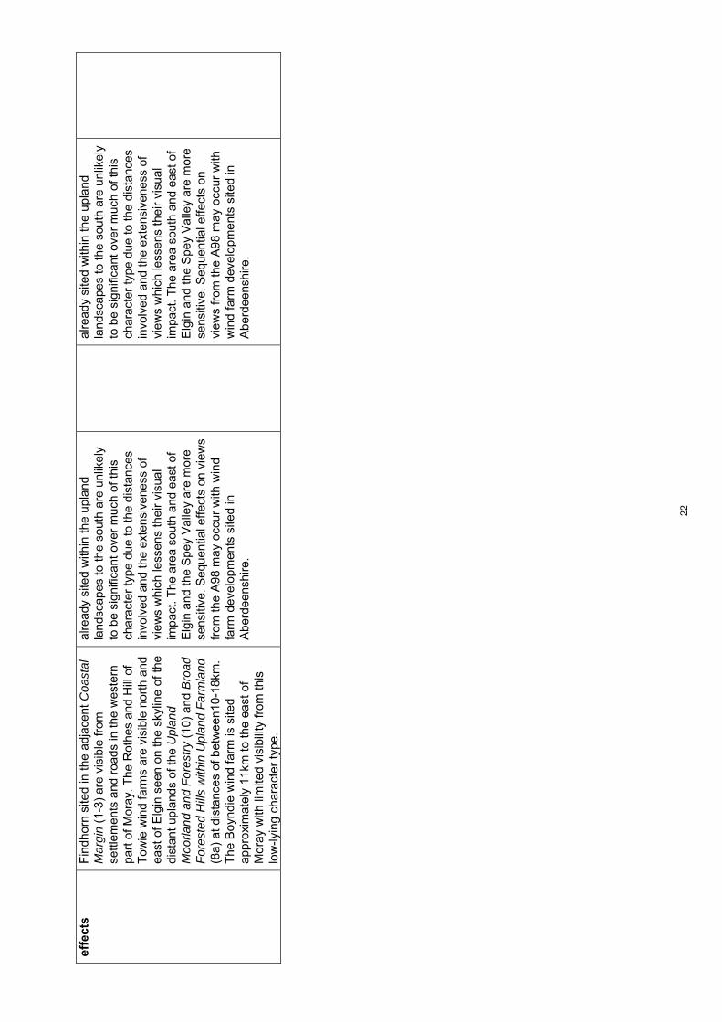
effe
cts
Fin
dhor
n si
ted
in th
e ad
jace
nt C
oast
al
Mar
gin
(1-3
) ar
e vi
sibl
e fr
om
settl
emen
ts a
nd r
oads
in th
e w
este
rn
part
of M
oray
. The
Rot
hes
and
Hill
of
Tow
ie w
ind
farm
s ar
e vi
sibl
e no
rth
and
east
of E
lgin
see
n on
the
skyl
ine
of th
e di
stan
t upl
ands
of t
he U
plan
d M
oorla
nd a
nd F
ores
try
(10)
and
Bro
ad
For
este
d H
ills
with
in U
plan
d F
arm
land
(8
a) a
t dis
tanc
es o
f bet
wee
n10-
18km
. T
he B
oynd
ie w
ind
farm
is s
ited
appr
oxim
atel
y 11
km to
the
east
of
Mor
ay w
ith li
mite
d vi
sibi
lity
from
this
lo
w-ly
ing
char
acte
r ty
pe.
alre
ady
site
d w
ithin
the
upla
nd
land
scap
es to
the
sout
h ar
e un
likel
y to
be
sign
ifica
nt o
ver
muc
h of
this
ch
arac
ter
type
due
to th
e di
stan
ces
invo
lved
and
the
exte
nsiv
enes
s of
vi
ews
whi
ch le
ssen
s th
eir
visu
al
impa
ct. T
he a
rea
sout
h an
d ea
st o
f E
lgin
and
the
Spe
y V
alle
y ar
e m
ore
sens
itive
. Seq
uent
ial e
ffect
s on
vie
ws
from
the
A98
may
occ
ur w
ith w
ind
farm
dev
elop
men
ts s
ited
in
Abe
rdee
nshi
re.
alre
ady
site
d w
ithin
the
upla
nd
land
scap
es to
the
sout
h ar
e un
likel
y to
be
sign
ifica
nt o
ver
muc
h of
this
ch
arac
ter
type
due
to th
e di
stan
ces
invo
lved
and
the
exte
nsiv
enes
s of
vi
ews
whi
ch le
ssen
s th
eir
visu
al
impa
ct. T
he a
rea
sout
h an
d ea
st o
f E
lgin
and
the
Spe
y V
alle
y ar
e m
ore
sens
itive
. Seq
uent
ial e
ffect
s on
vi
ews
from
the
A98
may
occ
ur w
ith
win
d fa
rm d
evel
opm
ents
site
d in
A
berd
eens
hire
.
22

Cha
ract
er T
ype
4: C
oast
al F
arm
land
– S
ensi
tivity
ass
essm
ent f
or s
mal
l-med
ium
and
sm
all t
ypol
ogie
s T
op
ic
Su
mm
ary
des
crip
tio
nA
sses
smen
to
f sm
all-
med
ium
ty
po
log
y (3
5m-5
0m)
Sen
siti
vity
ra
tin
g
Ass
essm
ent
of
smal
ltyp
olo
gy
(20m
-35m
) S
ensi
tivi
ty
rati
ng
L
and
scap
e co
nte
xt
Thi
s ch
arac
ter
type
is g
eogr
aphi
cally
ex
tens
ive
apar
t fro
m a
t its
eas
tern
end
w
here
it n
arro
ws
betw
een
the
coas
t an
d th
e no
rthe
rn e
dge
of B
road
F
ores
ted
Hill
s w
ithin
Upl
and
Far
mla
nd
(8a)
and
Rol
ling
Coa
stal
Far
mla
nd(4
a).
A lo
w b
ut d
istin
ct r
idge
form
s a
boun
dary
bet
wee
n th
is c
hara
cter
type
an
d th
e C
oast
al M
argi
n (
1-3)
bet
wee
n Lo
ssie
mou
th a
nd B
urgh
ead
and
this
, to
geth
er w
ith th
e co
asta
l for
ests
pl
ante
d on
mor
e lo
w-ly
ing
area
s,
rest
ricts
clo
se v
iew
s in
land
to th
is
char
acte
r ty
pe fr
om th
e co
ast.
The
re is
gr
eate
r in
ter-
visi
bilit
y be
twee
n th
ese
two
char
acte
r ty
pes
east
of t
he S
pey
due
to th
e ab
senc
e of
scr
eeni
ng
feat
ures
. T
he s
mal
ler
scal
e la
ndsc
apes
of t
he
Rol
ling
Coa
stal
Far
mla
nd (
4a)
and
the
Rol
ling
Far
mla
nds
and
For
est (
5) a
nd
the
prom
inen
t rid
ge o
f Hel
don
Hill
w
ithin
the
Rol
ling
Far
mla
nds
and
For
est w
ith V
alle
ys (
5a)
stro
ngly
co
ntra
st w
ith th
e ex
pans
ive
low
-lyin
g pl
ain
of th
is c
hara
cter
type
.
The
re w
ould
be
incr
ease
d sc
ope
for
this
typo
logy
to b
e si
ted
with
in th
is
exte
nsiv
e la
ndsc
ape
to a
void
si
gnifi
cant
impa
ct o
n ad
join
ing
mor
e se
nsiti
ve s
mal
ler
scal
e la
ndsc
apes
. S
ensi
tive
skyl
ines
see
n fr
om th
e le
ss
built
up
sect
ions
of c
oast
with
in th
e C
oast
al M
argi
n (
1-3)
wou
ld s
till n
eed
to b
e av
oide
d an
d tu
rbin
es o
f thi
s si
ze c
ould
als
o st
ill d
etra
ct fr
om k
ey
land
mar
k fe
atur
es if
site
d ne
arby
.
Med
ium
-low
T
his
size
of t
urbi
ne w
ould
hav
e m
inim
al e
ffect
s on
adj
oini
ng s
mal
ler
scal
e la
ndsc
apes
and
ther
e is
sc
ope
also
to s
ite th
em o
n ge
ntle
r lo
wer
slo
pes
of th
e m
ore
pron
ounc
ed h
ills
and
ridge
s.
Sen
sitiv
e sk
ylin
es s
een
from
the
less
bui
lt up
sec
tions
of c
oast
with
in
the
Coa
stal
Mar
gin
(1-
3) w
ould
stil
l ne
ed to
be
avoi
ded
how
ever
.
Low
Sca
le a
nd
o
pen
nes
s
A g
ener
ally
ope
n an
d ex
pans
ive
coas
tal p
lain
but
with
mor
e ro
lling
la
ndfo
rm, o
ccas
iona
l out
crop
hill
s an
d w
oodl
ands
pro
vidi
ng c
onta
inm
ent i
n
Thi
s ty
polo
gy c
ould
rel
ate
to b
road
er
low
-lyin
g ba
sins
whe
re s
ettle
men
t is
spar
ser
alth
ough
turb
ines
of t
his
size
w
ould
stil
l app
ear
larg
e in
rel
atio
n to
Med
ium
T
here
are
incr
ease
d op
port
uniti
es
to a
ccom
mod
ate
the
smal
ler
turb
ines
of t
his
typo
logy
to m
inim
ise
scal
e ef
fect
s on
sm
alle
r sc
ale
Med
ium
-low
23

som
e ar
eas.
A lo
wer
lyin
g lin
ear
shal
low
bas
in e
xten
ding
sou
th/w
est t
o no
rth/
east
is la
rger
in s
cale
and
pa
rtic
ular
ly o
pen.
Thi
s la
ndsc
ape
is
wel
l set
tled
with
a r
egul
ar p
atte
rn o
f fa
rms,
hou
ses
and
settl
emen
ts
prov
idin
g re
ady
scal
e re
fere
nces
.
build
ings
and
woo
dlan
ds a
nd a
lso
to
the
smal
ler
prom
inen
t hill
s (w
hich
do
not r
ise
abov
e 10
0m)
and
smal
ler
scal
e ro
lling
land
form
.
feat
ures
suc
h as
woo
dlan
ds a
nd
build
ings
.
Lan
dfo
rm
T
his
land
scap
e ha
s a
pred
omin
antly
su
btly
und
ulat
ing
land
form
but
with
so
me
occa
sion
al la
ndm
ark
hills
and
rid
ges
incl
udin
g S
pyni
e R
idge
clo
se to
E
lgin
and
Tap
poch
and
Bin
n H
ill c
lose
r to
the
coas
t. P
ocke
ts o
f mor
e co
mpl
ex
rolli
ng la
ndfo
rm o
ccur
in th
e U
rquh
art
and
Lhan
bryd
e ar
ea a
nd s
mal
l kno
lly
hills
NE
of E
lgin
. The
bro
ad fl
oodp
lain
s of
the
Spe
y an
d Lo
ssie
and
a b
and
of
very
low
-lyin
g dr
aine
d la
nd b
etw
een
Loss
iem
outh
and
Kin
loss
hav
e a
part
icul
arly
sim
ple
land
form
.
The
gen
eral
ly s
impl
e ge
ntly
un
dula
ting
land
form
of t
his
char
acte
r ty
pe r
educ
es s
ensi
tivity
alth
ough
this
ty
polo
gy w
ould
det
ract
from
the
prom
inen
t hill
s an
d rid
ges
and
smal
l ar
eas
of m
ore
com
plex
rol
ling
land
form
if s
ited
on o
r ne
arby
them
.
Med
ium
-low
T
he g
ener
ally
sim
ple
gent
ly
undu
latin
g la
ndfo
rm o
f thi
s ch
arac
ter
type
red
uces
sen
sitiv
ity
alth
ough
eve
n th
ese
smal
ler
turb
ines
wou
ld d
etra
ct fr
om th
e pr
omin
ent h
ills
and
ridge
s an
d sm
all a
reas
of m
ore
com
plex
rol
ling
land
form
if s
ited
on h
ill o
r rid
ge to
ps
alth
ough
ther
e m
ay b
e so
me
limite
d sc
ope
to s
ite tu
rbin
es to
war
ds th
e lo
wer
hei
ght b
and
of th
is ty
polo
gy
on lo
wer
less
pro
min
ent s
lope
s.
Low
Lan
dsc
ape
pat
tern
A s
impl
e la
nd c
over
pat
tern
of l
arge
ar
able
fiel
ds in
ters
pers
ed w
ith s
mal
l bl
ocks
of c
onife
rs. S
ome
larg
er
coni
fero
us p
lant
atio
ns o
ccur
clo
se to
th
e co
ast a
nd th
e S
pey
Val
ley.
Sm
all
pock
ets
of m
ore
dive
rse
land
cov
er
patte
rn a
re a
ssoc
iate
d w
ith th
e po
licie
s of
mix
ed s
helte
rbel
ts, p
arkl
and
and
aven
ues
of In
nes
Hou
se, G
ordo
n C
astle
, Bro
die
Cas
tle a
nd
Gor
dons
toun
, the
mor
e na
tura
listic
m
oss
and
woo
dlan
d of
the
Bau
ds o
f C
ulle
n an
d br
oadl
eave
d w
oodl
ands
, sc
rub
and
wet
land
s ag
ains
t the
Spe
y.
Thi
s ty
polo
gy c
ould
rel
ate
to th
e si
mpl
e an
d ge
nera
lly o
pen
char
acte
r of
farm
land
alth
ough
pol
icy
feat
ures
an
d m
ore
natu
ral v
eget
atio
n co
ver
wou
ld b
e m
ore
sens
itive
.
Med
ium
-low
T
here
is in
crea
sed
scop
e to
loca
te
this
sm
alle
r ty
polo
gy to
avo
id
effe
cts
on p
olic
y fe
atur
es a
nd a
reas
w
ith a
mor
e na
tura
listic
veg
etat
ion
cove
r.
Low
24

Bu
ilt
envi
ron
men
t
RA
F a
ir fie
lds
and
asso
ciat
ed b
uild
ings
an
d in
fras
truc
ture
incl
udin
g ta
ll m
asts
ar
e co
ncen
trat
ed in
the
Kin
loss
, Lo
ssie
mou
th a
nd B
urgh
ead
area
. D
ispe
rsed
farm
s, h
ouse
s, s
mal
l and
la
rger
set
tlem
ents
and
occ
asio
nal
hist
oric
al b
uild
ings
incl
udin
g th
e O
ld
Cas
tle o
f Duf
fus,
Pal
ace
of S
pyni
e an
d gr
and
hous
es/c
astle
s w
ith d
esig
ned
land
scap
es a
nd c
hurc
h sp
ires
form
la
ndm
ark
feat
ures
. La
rger
w
areh
ouse
s, m
altin
gs a
nd s
ome
quar
ryin
g an
d la
ndfil
l site
s fo
rm
occa
sion
al fe
atur
es a
nd th
ere
is a
wel
l-de
velo
ped
netw
ork
of r
oads
and
som
e tr
ansm
issi
on li
nes.
Thi
s ty
polo
gy w
ould
dom
inat
e th
e se
tting
of s
mal
l set
tlem
ents
, far
ms
and
hous
es in
this
wel
l set
tled
land
scap
e if
site
d ne
arby
. H
isto
ric b
uilt
feat
ures
wou
ld a
lso
be
sens
itive
to in
trus
ion
on th
eir
setti
ng
alth
ough
thes
e fe
atur
es a
re w
idel
y di
sper
sed
and
ther
e m
ay b
e in
crea
sed
scop
e to
site
this
typo
logy
to
min
imis
e ef
fect
s on
thei
r se
tting
. T
his
typo
logy
cou
ld a
ccen
tuat
e in
dust
rial c
hara
cter
and
clu
tter
in
part
s of
this
land
scap
e. S
ingl
e tu
rbin
es to
war
ds th
e lo
wer
hei
ght
band
of t
his
typo
logy
and
clo
sely
re
late
d to
exi
stin
g in
dust
rial
deve
lopm
ent,
wou
ld h
ave
a be
tter
scal
e re
latio
nshi
p to
thes
e bu
ildin
gs
and
wou
ld m
inim
ise
the
spre
ad o
f bu
ilt in
fras
truc
ture
.
Med
ium
The
re is
incr
ease
d sc
ope
to s
ite th
e sm
alle
r tu
rbin
es o
f thi
s ty
polo
gy to
m
inim
ise
effe
cts
on th
e se
tting
of
settl
emen
t and
land
mar
k hi
stor
ical
fe
atur
es. T
he m
ore
frag
men
ted
char
acte
r of
dis
para
te b
uilt
stru
ctur
es c
ould
be
exac
erba
ted
in
plac
es a
lthou
gh th
ere
are
oppo
rtun
ities
to s
ite th
is s
ize
of
turb
ine
so th
ey a
re v
isua
lly
asso
ciat
ed w
ith e
xist
ing
built
de
velo
pmen
t thu
s re
duci
ng
wid
espr
ead
clut
ter.
Med
ium
-low
Per
cep
tual
q
ual
itie
s T
his
is a
wel
l-set
tled
and
high
ly
man
aged
land
scap
e w
ith n
o se
nse
of
wild
ness
or
othe
r st
rong
per
cept
ual
qual
ities
.
Sen
sitiv
ity is
red
uced
due
to th
e ab
senc
e of
thes
e pe
rcep
tual
qu
aliti
es.
Low
S
ensi
tivity
is r
educ
ed d
ue to
the
abse
nce
of th
ese
perc
eptu
al
qual
ities
.
Low
Vis
ual
am
enit
y
Thi
s la
ndsc
ape
can
be v
ery
open
in
plac
es w
ith e
xten
sive
and
uni
mpe
ded
view
s po
ssib
le fr
om m
ajor
roa
ds s
uch
as th
e A
96 a
nd fr
om th
e de
nse
netw
ork
of m
inor
roa
ds w
hich
cris
s-cr
oss
this
cha
ract
er ty
pe. F
ores
try
and
subt
le r
idge
s lim
it th
e ex
tent
of v
iew
s in
ot
her
area
s. T
he p
rom
inen
t hill
s of
B
inn
Hill
and
Tap
poch
form
foca
l fe
atur
es in
vie
ws
acro
ss th
is
Thi
s si
ze o
f tur
bine
wou
ld b
e hi
ghly
vi
sibl
e fr
om r
oads
and
set
tlem
ent
with
in th
is o
pen
land
scap
e al
thou
gh
ther
e w
ould
be
incr
ease
d sc
ope
to
site
this
typo
logy
to m
inim
ise
effe
cts
on e
xist
ing
foci
.
Tur
bine
s of
this
siz
e w
ould
als
o be
vi
sibl
e fr
om th
e of
ten
wel
l-set
tled
nort
h-fa
cing
slo
pes
of a
djac
ent
char
acte
r ty
pes
alth
ough
they
wou
ld
Hig
h-m
ediu
m
Alth
ough
turb
ines
of t
his
size
wou
ld
gene
rally
be
talle
r th
an w
oodl
ands
, th
ey w
ould
be
unlik
ely
to b
e vi
sual
ly
prom
inen
t pro
vidi
ng th
ey w
ere
care
fully
site
d to
avo
id h
ill a
nd r
idge
to
ps. T
here
wou
ld b
e gr
eate
r sc
ope
to a
ccom
mod
ate
mul
tiple
turb
ines
of
this
siz
e to
min
imis
e ef
fect
s on
vi
ews.
Med
ium
25

land
scap
e. T
here
are
vie
ws
to th
e up
land
s of
Mor
ay to
the
sout
h fr
om th
is
area
, with
Ben
Rin
nes,
Ben
Aig
an a
nd
Bro
wn
Mui
r hi
lls fo
rmin
g ke
y fe
atur
es.
The
Mor
ay F
irth
and
dist
ant S
uthe
rland
co
ast a
lso
feat
ure
in v
iew
s to
the
nort
h.
Infr
astr
uctu
re a
nd b
uild
ings
ass
ocia
ted
with
the
RA
F a
re h
ighl
y vi
sibl
e as
are
th
e w
ind
turb
ines
at F
indh
orn
and
mas
ts in
the
wes
tern
par
t of t
his
land
scap
e to
war
ds th
e co
ast.
In te
rms
of v
iew
s to
this
land
scap
e fr
om th
e su
rrou
ndin
g ar
ea, c
lose
vie
ws
are
limite
d fr
om th
e C
oast
al M
argi
n (
1-3)
due
to s
cree
ning
pro
vide
d by
fore
sts
and
land
form
to th
e w
est o
f the
Spe
y.
Som
e in
ter-
visi
bilit
y be
twee
n th
e co
ast
and
this
land
scap
e oc
curs
eas
t of t
he
Spe
y ho
wev
er. T
he n
orth
-fac
ing
settl
ed s
lope
s of
Hel
don
Hill
with
in th
e R
ollin
g F
arm
land
and
For
est w
ith
Val
leys
(5a
), th
e R
ollin
g F
arm
land
and
F
ores
t (5)
and
the
Rol
ling
Coa
stal
F
arm
land
(4a
) ha
ve o
pen
and
elev
ated
vi
ews
acro
ss th
is la
ndsc
ape
and
over
th
e M
oray
Firt
h.
be le
ss p
rom
inen
t tha
n la
rger
ty
polo
gies
. Thi
s ty
polo
gy w
ould
be
visi
ble
from
sec
tions
of t
he c
oast
eas
t of
the
Spe
y an
d m
ay a
lso
be s
een
in
long
er a
nd m
ore
open
vie
ws
alon
g th
e co
ast f
rom
pro
mon
torie
s an
d ba
ys w
here
the
hint
erla
nd is
mor
e vi
sibl
e al
thou
gh, a
gain
, the
y w
ould
be
less
pro
min
ent t
han
the
larg
er
typo
logi
es in
thes
e ex
pans
ive
view
s.
Cu
mu
lati
ve
effe
cts
The
sm
all g
roup
of t
urbi
nes
at
Fin
dhor
n si
ted
in th
e C
oast
al M
argi
n
(1-3
) ar
e vi
sibl
e fr
om s
ettle
men
ts a
nd
road
s in
the
wes
tern
par
t of M
oray
. T
he R
othe
s an
d H
ill o
f Tow
ie w
ind
farm
s ar
e vi
sibl
e no
rth
and
east
of
Elg
in s
een
on th
e sk
ylin
e of
the
dist
ant
upla
nds
of th
e U
plan
d M
oorla
nd a
nd
Cum
ulat
ive
issu
es w
ith e
xist
ing
win
d fa
rms
site
d w
ithin
the
upla
nd
land
scap
es to
the
sout
h ar
e un
likel
y to
be
sign
ifica
nt o
ver
muc
h of
this
ch
arac
ter
type
due
to th
e di
stan
ces
invo
lved
and
the
exte
nsiv
enes
s of
vi
ews
whi
ch le
ssen
s th
eir
visu
al
impa
ct.
Low
C
umul
ativ
e is
sues
with
exi
stin
g w
ind
farm
s si
ted
with
in th
e up
land
la
ndsc
apes
to th
e so
uth
are
unlik
ely
to b
e si
gnifi
cant
ove
r m
uch
of th
is
char
acte
r ty
pe d
ue to
the
dist
ance
s in
volv
ed a
nd th
e ex
tens
iven
ess
of
view
s w
hich
less
ens
thei
r vi
sual
im
pact
.
Low
26

For
estr
y (1
0) a
nd B
road
For
este
d H
ills
with
in U
plan
d F
arm
land
(8a
) at
di
stan
ces
of b
etw
een
10 a
nd18
km.
The
Boy
ndie
win
d fa
rm is
site
d ap
prox
imat
ely
11km
to th
e ea
st o
f M
oray
with
lim
ited
visi
bilit
y fr
om th
is
low
-lyin
g ch
arac
ter
type
.
Seq
uent
ial e
ffect
s on
vie
ws
from
the
A98
may
occ
ur w
ith w
ind
farm
de
velo
pmen
ts s
ited
in A
berd
eens
hire
al
thou
gh th
e sm
alle
r si
ze o
f thi
s ty
polo
gy w
ould
be
likel
y to
red
uce
cum
ulat
ive
impa
cts.
Seq
uent
ial e
ffect
s as
soci
ated
with
w
ind
farm
dev
elop
men
t with
in
Abe
rdee
nshi
re w
ould
not
be
sign
ifica
nt.
27
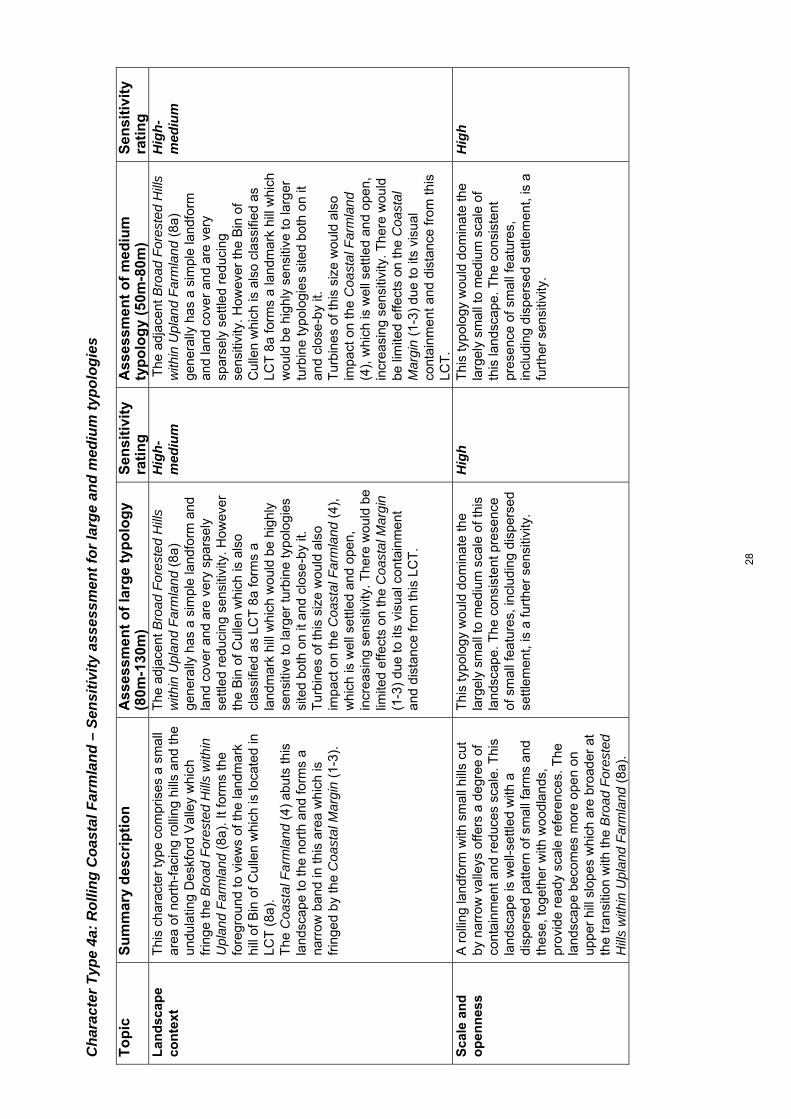
Cha
ract
er T
ype
4a: R
ollin
g C
oast
al F
arm
land
– S
ensi
tivity
ass
essm
ent f
or la
rge
and
med
ium
typo
logi
es
To
pic
S
um
mar
y d
escr
ipti
on
Ass
essm
ent
of
larg
e ty
po
log
y (8
0m-1
30m
) S
ensi
tivi
ty
rati
ng
A
sses
smen
t o
f m
ediu
mty
po
log
y (5
0m-8
0m)
Sen
siti
vity
ra
tin
g
Lan
dsc
ape
con
text
Thi
s ch
arac
ter
type
com
pris
es a
sm
all
area
of n
orth
-fac
ing
rolli
ng h
ills
and
the
undu
latin
g D
eskf
ord
Val
ley
whi
ch
frin
ge th
e B
road
For
este
d H
ills
with
in
Upl
and
Far
mla
nd (
8a).
It fo
rms
the
fore
grou
nd to
vie
ws
of th
e la
ndm
ark
hill
of B
in o
f Cul
len
whi
ch is
loca
ted
in
LCT
(8a
).
The
Coa
stal
Far
mla
nd (
4) a
buts
this
la
ndsc
ape
to th
e no
rth
and
form
s a
narr
ow b
and
in th
is a
rea
whi
ch is
fr
inge
d by
the
Coa
stal
Mar
gin
(1-
3).
The
adj
acen
t Bro
ad F
ores
ted
Hill
s w
ithin
Upl
and
Far
mla
nd (
8a)
gene
rally
has
a s
impl
e la
ndfo
rm a
nd
land
cov
er a
nd a
re v
ery
spar
sely
se
ttled
red
ucin
g se
nsiti
vity
. How
ever
th
e B
in o
f Cul
len
whi
ch is
als
o cl
assi
fied
as L
CT
8a
form
s a
land
mar
k hi
ll w
hich
wou
ld b
e hi
ghly
se
nsiti
ve to
larg
er tu
rbin
e ty
polo
gies
si
ted
both
on
it an
d cl
ose-
by it
.
Tur
bine
s of
this
siz
e w
ould
als
o im
pact
on
the
Coa
stal
Far
mla
nd (
4),
whi
ch is
wel
l set
tled
and
open
, in
crea
sing
sen
sitiv
ity. T
here
wou
ld b
e lim
ited
effe
cts
on th
e C
oast
al M
argi
n (1
-3)
due
to it
s vi
sual
con
tain
men
t an
d di
stan
ce fr
om th
is L
CT
.
Hig
h-m
ediu
m
The
adj
acen
t Bro
ad F
ores
ted
Hill
s w
ithin
Upl
and
Far
mla
nd (
8a)
gene
rally
has
a s
impl
e la
ndfo
rm
and
land
cov
er a
nd a
re v
ery
spar
sely
set
tled
redu
cing
se
nsiti
vity
. How
ever
the
Bin
of
Cul
len
whi
ch is
als
o cl
assi
fied
as
LCT
8a
form
s a
land
mar
k hi
ll w
hich
w
ould
be
high
ly s
ensi
tive
to la
rger
tu
rbin
e ty
polo
gies
site
d bo
th o
n it
and
clos
e-by
it.
T
urbi
nes
of th
is s
ize
wou
ld a
lso
impa
ct o
n th
e C
oast
al F
arm
land
(4
), w
hich
is w
ell s
ettle
d an
d op
en,
incr
easi
ng s
ensi
tivity
. The
re w
ould
be
lim
ited
effe
cts
on th
e C
oast
al
Mar
gin
(1-3
) du
e to
its
visu
al
cont
ainm
ent a
nd d
ista
nce
from
this
LC
T.
Hig
h-m
ediu
m
Sca
le a
nd
o
pen
nes
s
A r
ollin
g la
ndfo
rm w
ith s
mal
l hill
s cu
t by
nar
row
val
leys
offe
rs a
deg
ree
of
cont
ainm
ent a
nd r
educ
es s
cale
. Thi
s la
ndsc
ape
is w
ell-s
ettle
d w
ith a
di
sper
sed
patte
rn o
f sm
all f
arm
s an
d th
ese,
toge
ther
with
woo
dlan
ds,
prov
ide
read
y sc
ale
refe
renc
es. T
he
land
scap
e be
com
es m
ore
open
on
uppe
r hi
ll sl
opes
whi
ch a
re b
road
er a
t th
e tr
ansi
tion
with
the
Bro
ad F
ores
ted
Hill
s w
ithin
Upl
and
Far
mla
nd (
8a).
Thi
s ty
polo
gy w
ould
dom
inat
e th
e la
rgel
y sm
all t
o m
ediu
m s
cale
of t
his
land
scap
e. T
he c
onsi
sten
t pre
senc
e of
sm
all f
eatu
res,
incl
udin
g di
sper
sed
settl
emen
t, is
a fu
rthe
r se
nsiti
vity
.
Hig
h T
his
typo
logy
wou
ld d
omin
ate
the
larg
ely
smal
l to
med
ium
sca
le o
f th
is la
ndsc
ape.
The
con
sist
ent
pres
ence
of s
mal
l fea
ture
s,
incl
udin
g di
sper
sed
settl
emen
t, is
a
furt
her
sens
itivi
ty.
Hig
h
28

Lan
dfo
rm
S
mal
l rou
nded
inte
rlock
ing
hills
are
cut
by
nar
row
inci
sed
burn
s –
the
Des
kfor
d V
alle
y is
bro
ader
but
with
und
ulat
ing
slop
es. L
andf
orm
is g
ener
ally
mor
e co
mpl
ex o
n th
e lo
wer
slo
pes
with
br
oade
r, m
ore
even
gra
dien
ts o
n up
per
slop
es a
nd o
ccas
iona
l sm
all f
latte
r ar
eas.
Bro
ader
upp
er h
ill s
lope
s an
d sm
all
area
s of
flat
ter
grou
nd a
re li
mite
d in
ex
tent
red
ucin
g sc
ope
to
acco
mm
odat
e m
ultip
le tu
rbin
es o
f th
is s
ize.
The
pat
tern
of m
ore
com
plex
rol
ling
land
form
and
nar
row
va
lleys
is a
furt
her
sens
itivi
ty.
Hig
h
Bro
ader
upp
er h
ill s
lope
s an
d sm
all
area
s of
flat
ter
grou
nd a
re li
mite
d in
ex
tent
red
ucin
g sc
ope
to
acco
mm
odat
e m
ultip
le tu
rbin
es o
f th
is s
ize.
The
pat
tern
of m
ore
com
plex
rol
ling
land
form
and
na
rrow
val
leys
is a
furt
her
sens
itivi
ty.
Hig
h
Lan
dsc
ape
pat
tern
Cul
tivat
ed fi
elds
alte
rnat
e w
ith
woo
dlan
ds. W
oodl
ands
are
ofte
n di
vers
e co
mpr
isin
g m
ixed
con
ifers
and
br
oadl
eave
s in
val
leys
and
form
ing
the
polic
ies
of L
ette
rfou
rie, C
ulle
n an
d C
airn
field
Hou
ses
set o
n lo
wer
hill
sl
opes
.
Thi
s ty
polo
gy c
ould
impa
ct o
n m
ore
dive
rse
woo
dlan
ds a
nd p
arkl
and
asso
ciat
ed w
ith d
esig
ned
land
scap
es
alth
ough
mor
e ex
tens
ive
upla
nd
past
ures
on
uppe
r hi
ll sl
opes
wou
ld
be le
ss s
ensi
tive.
Hig
h-m
ediu
m
Thi
s ty
polo
gy c
ould
impa
ct o
n m
ore
dive
rse
woo
dlan
ds a
nd p
arkl
and
asso
ciat
ed w
ith d
esig
ned
land
scap
es a
lthou
gh m
ore
exte
nsiv
e up
land
pas
ture
s on
upp
er
hill
slop
es w
ould
be
less
sen
sitiv
e.
Hig
h-m
ediu
m
Bu
ilt
envi
ron
men
t
Thi
s la
ndsc
ape
is w
ell-s
ettle
d w
ith a
re
gula
r pa
ttern
of d
ispe
rsed
farm
s an
d ho
uses
and
sm
all s
ettle
men
ts s
uch
as
Dry
brid
ge a
nd C
loch
an tu
cked
dow
n on
low
er h
ill s
lope
s. P
ublic
roa
ds a
re
gene
rally
ver
y na
rrow
and
win
ding
.
Mor
e sp
arse
ly s
ettle
d up
per
hill
slop
es w
ould
be
less
sen
sitiv
e in
te
rms
of a
void
ing
impa
ct o
n th
e im
med
iate
set
ting
of s
ettle
men
ts a
nd
othe
r bu
ilt fe
atur
es a
lthou
gh tu
rbin
es
of th
is s
ize
wou
ld b
e lik
ely
to b
e se
en
in r
elat
ive
prox
imity
to b
uilt
feat
ures
gi
ven
settl
emen
t den
sity
and
the
limite
d ex
tent
of t
he c
hara
cter
type
.
Nar
row
roa
ds c
ould
res
ult i
n la
ndsc
ape
and
visu
al e
ffect
s as
soci
ated
with
acc
ess
impr
ovem
ents
for
vehi
cles
req
uire
d to
tran
spor
t thi
s ty
polo
gy.
Hig
h M
ore
spar
sely
set
tled
uppe
r hi
ll sl
opes
wou
ld b
e le
ss s
ensi
tive
in
term
s of
avo
idin
g im
pact
on
the
imm
edia
te s
ettin
g of
set
tlem
ents
an
d ot
her
built
feat
ures
alth
ough
tu
rbin
es o
f thi
s si
ze w
ould
be
likel
y to
be
seen
in r
elat
ive
prox
imity
to
built
feat
ures
giv
en s
ettle
men
t de
nsity
and
the
limite
d ex
tent
of t
he
char
acte
r ty
pe.
N
arro
w r
oads
cou
ld r
esul
t in
land
scap
e an
d vi
sual
effe
cts
asso
ciat
ed w
ith a
cces
s im
prov
emen
ts fo
r ve
hicl
es r
equi
red
to tr
ansp
ort t
his
typo
logy
.
Hig
h
Per
cep
tual
q
ual
itie
s T
his
is a
wel
l-set
tled
and
high
ly
man
aged
land
scap
e w
ith li
ttle
sens
e of
w
ildne
ss o
r ot
her
stro
ng p
erce
ptua
l qu
aliti
es.
Sen
sitiv
ity is
red
uced
due
to th
e ab
senc
e of
thes
e pe
rcep
tual
qu
aliti
es.
Low
S
ensi
tivity
is r
educ
ed d
ue to
the
abse
nce
of th
ese
perc
eptu
al
qual
ities
.
Low
29

Vis
ual
am
enit
y
The
re is
a d
egre
e of
vis
ual
cont
ainm
ent o
ffere
d by
the
rolli
ng
land
form
, inc
ised
val
leys
and
w
oodl
ands
whe
n tr
avel
ling
on th
e na
rrow
roa
ds w
ithin
this
cha
ract
er
type
. The
Bro
ad F
ores
ted
Hill
s w
ithin
U
plan
d F
arm
land
(8a
) fo
rms
an e
ven
and
pred
omin
antly
woo
ded
low
sky
line
to th
is la
ndsc
ape
and
also
lim
its lo
ng
view
s fr
om r
oads
and
set
tlem
ent.
The
A
98 a
nd B
9018
offe
r cl
ose
view
s of
th
is la
ndsc
ape
and
the
nort
hern
slo
pes
are
visi
ble
from
wel
l set
tled
coas
tal
area
s.
Thi
s si
ze o
f tur
bine
wou
ld b
e hi
ghly
vi
sibl
e fr
om m
ore
open
roa
ds a
nd
elev
ated
set
tlem
ent w
ithin
this
la
ndsc
ape.
T
his
typo
logy
wou
ld a
lso
be h
ighl
y vi
sibl
e fr
om th
e w
ell-s
ettle
d C
oast
al
Far
mla
nd (
4) a
nd th
e C
oast
al M
argi
n
(1-3
) an
d co
uld
impa
ct o
n ke
y vi
ews
to th
e B
in o
f Cul
len
if si
ted
on lo
wer
hi
ll sl
opes
. Tur
bine
s of
this
siz
e m
ay
also
be
seen
on
the
skyl
ine
from
the
Upl
and
Far
mla
nd (
8) to
the
sout
h al
thou
gh w
ould
be
likel
y to
per
ceiv
ed
as b
eing
ass
ocia
ted
Bro
ad F
ores
ted
Hill
s w
ithin
Upl
and
Far
mla
nd(8
a)
whi
ch fo
rms
a fa
irly
unifo
rm fo
rest
ed
skyl
ine
in th
ese
view
s.
Hig
h T
his
size
of t
urbi
ne w
ould
be
high
ly
visi
ble
from
mor
e op
en r
oads
and
el
evat
ed s
ettle
men
t with
in th
is
land
scap
e.
Thi
s ty
polo
gy w
ould
als
o be
hig
hly
visi
ble
from
the
wel
l-set
tled
Coa
stal
F
arm
land
(4)
and
the
Coa
stal
M
argi
n (1
-3)
and
coul
d im
pact
on
key
view
s to
the
Bin
of C
ulle
n if
site
d on
low
er h
ill s
lope
s. T
urbi
nes
of th
is s
ize
may
als
o be
see
n on
the
skyl
ine
from
the
Upl
and
Far
mla
nd
(8)
to th
e so
uth
alth
ough
wou
ld b
e lik
ely
to p
erce
ived
as
bein
g as
soci
ated
Bro
ad F
ores
ted
Hill
s w
ithin
Upl
and
Far
mla
nd(8
a) w
hich
fo
rms
a fa
irly
unifo
rm fo
rest
ed
skyl
ine
in th
ese
view
s.
Hig
h
Cu
mu
lati
ve
effe
cts
The
con
sent
ed A
ultm
ore
win
d fa
rm w
ill
be v
isib
le in
clo
se p
roxi
mity
from
par
ts
of th
is L
CT
.
Sig
nific
ant c
umul
ativ
e ef
fect
s w
ould
be
like
ly to
occ
ur w
ith c
onse
nted
w
ind
farm
dev
elop
men
t site
d in
the
adja
cent
Bro
ad F
ores
ted
Hill
s w
ithin
U
plan
d F
arm
land
(8a
).
Hig
h S
igni
fican
t cum
ulat
ive
effe
cts
wou
ld
be li
kely
to o
ccur
with
con
sent
ed
win
d fa
rm d
evel
opm
ent s
ited
in th
e ad
jace
nt B
road
For
este
d H
ills
with
in U
plan
d F
arm
land
(8a
).
Hig
h
30
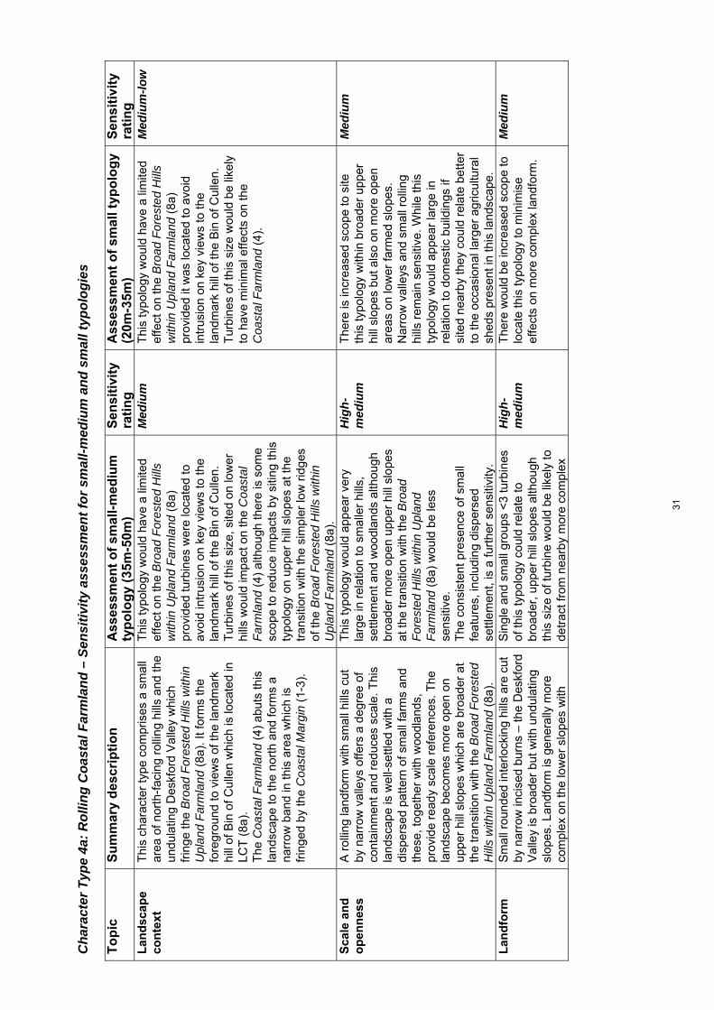
Cha
ract
er T
ype
4a: R
ollin
g C
oast
al F
arm
land
– S
ensi
tivity
ass
essm
ent f
or s
mal
l-med
ium
and
sm
all t
ypol
ogie
s T
op
ic
Su
mm
ary
des
crip
tio
nA
sses
smen
to
f sm
all-
med
ium
ty
po
log
y (3
5m-5
0m)
Sen
siti
vity
ra
tin
g
Ass
essm
ent
of
smal
ltyp
olo
gy
(20m
-35m
) S
ensi
tivi
ty
rati
ng
L
and
scap
e co
nte
xt
Thi
s ch
arac
ter
type
com
pris
es a
sm
all
area
of n
orth
-fac
ing
rolli
ng h
ills
and
the
undu
latin
g D
eskf
ord
Val
ley
whi
ch
frin
ge th
e B
road
For
este
d H
ills
with
in
Upl
and
Far
mla
nd (
8a).
It fo
rms
the
fore
grou
nd to
vie
ws
of th
e la
ndm
ark
hill
of B
in o
f Cul
len
whi
ch is
loca
ted
in
LCT
(8a
).
The
Coa
stal
Far
mla
nd (
4) a
buts
this
la
ndsc
ape
to th
e no
rth
and
form
s a
narr
ow b
and
in th
is a
rea
whi
ch is
fr
inge
d by
the
Coa
stal
Mar
gin
(1-
3).
Thi
s ty
polo
gy w
ould
hav
e a
limite
d ef
fect
on
the
Bro
ad F
ores
ted
Hill
s w
ithin
Upl
and
Far
mla
nd (
8a)
prov
ided
turb
ines
wer
e lo
cate
d to
av
oid
intr
usio
n on
key
vie
ws
to th
e la
ndm
ark
hill
of th
e B
in o
f Cul
len.
T
urbi
nes
of th
is s
ize,
site
d on
low
er
hills
wou
ld im
pact
on
the
Coa
stal
F
arm
land
(4)
alth
ough
ther
e is
som
e sc
ope
to r
educ
e im
pact
s by
siti
ng th
is
typo
logy
on
uppe
r h
ill s
lope
s at
the
tran
sitio
n w
ith th
e si
mpl
er lo
w r
idge
s of
the
Bro
ad F
ores
ted
Hill
s w
ithin
U
plan
d F
arm
land
(8a
).
Med
ium
T
his
typo
logy
wou
ld h
ave
a lim
ited
effe
ct o
n th
e B
road
For
este
d H
ills
with
in U
plan
d F
arm
land
(8a
) pr
ovid
ed it
was
loca
ted
to a
void
in
trus
ion
on k
ey v
iew
s to
the
land
mar
k hi
ll of
the
Bin
of C
ulle
n.
Tur
bine
s of
this
siz
e w
ould
be
likel
y to
hav
e m
inim
al e
ffect
s on
the
Coa
stal
Far
mla
nd (
4).
Med
ium
-low
Sca
le a
nd
o
pen
nes
s
A r
ollin
g la
ndfo
rm w
ith s
mal
l hill
s cu
t by
nar
row
val
leys
offe
rs a
deg
ree
of
cont
ainm
ent a
nd r
educ
es s
cale
. Thi
s la
ndsc
ape
is w
ell-s
ettle
d w
ith a
di
sper
sed
patte
rn o
f sm
all f
arm
s an
d th
ese,
toge
ther
with
woo
dlan
ds,
prov
ide
read
y sc
ale
refe
renc
es. T
he
land
scap
e be
com
es m
ore
open
on
uppe
r hi
ll sl
opes
whi
ch a
re b
road
er a
t th
e tr
ansi
tion
with
the
Bro
ad F
ores
ted
Hill
s w
ithin
Upl
and
Far
mla
nd (
8a).
Thi
s ty
polo
gy w
ould
app
ear
very
la
rge
in r
elat
ion
to s
mal
ler
hills
, se
ttlem
ent a
nd w
oodl
ands
alth
ough
br
oade
r m
ore
open
upp
er h
ill s
lope
s at
the
tran
sitio
n w
ith th
e B
road
F
ores
ted
Hill
s w
ithin
Upl
and
Far
mla
nd (
8a)
wou
ld b
e le
ss
sens
itive
. T
he c
onsi
sten
t pre
senc
e of
sm
all
feat
ures
, inc
ludi
ng d
ispe
rsed
se
ttlem
ent,
is a
furt
her
sens
itivi
ty.
Hig
h-m
ediu
m
The
re is
incr
ease
d sc
ope
to s
ite
this
typo
logy
with
in b
road
er u
pper
hi
ll sl
opes
but
als
o on
mor
e op
en
area
s on
low
er fa
rmed
slo
pes.
N
arro
w v
alle
ys a
nd s
mal
l rol
ling
hills
rem
ain
sens
itive
. Whi
le th
is
typo
logy
wou
ld a
ppea
r la
rge
in
rela
tion
to d
omes
tic b
uild
ings
if
site
d ne
arby
they
cou
ld r
elat
e be
tter
to th
e oc
casi
onal
larg
er a
gric
ultu
ral
shed
s pr
esen
t in
this
land
scap
e.
Med
ium
Lan
dfo
rm
S
mal
l rou
nded
inte
rlock
ing
hills
are
cut
by
nar
row
inci
sed
burn
s –
the
Des
kfor
d V
alle
y is
bro
ader
but
with
und
ulat
ing
slop
es. L
andf
orm
is g
ener
ally
mor
e co
mpl
ex o
n th
e lo
wer
slo
pes
with
Sin
gle
and
smal
l gro
ups
<3
turb
ines
of
this
typo
logy
cou
ld r
elat
e to
br
oade
r, u
pper
hill
slo
pes
alth
ough
th
is s
ize
of tu
rbin
e w
ould
be
likel
y to
de
trac
t fro
m n
earb
y m
ore
com
plex
Hig
h-m
ediu
m
The
re w
ould
be
incr
ease
d sc
ope
to
loca
te th
is ty
polo
gy to
min
imis
e ef
fect
s on
mor
e co
mpl
ex la
ndfo
rm.
Med
ium
31

broa
der,
mor
e ev
en g
radi
ents
on
uppe
r sl
opes
and
occ
asio
nal s
mal
l fla
tter
area
s.
land
form
if s
ited
on s
mal
l are
as o
f fla
tter
grou
nd o
n lo
wer
slo
pes.
Lan
dsc
ape
pat
tern
C
ultiv
ated
fiel
ds a
ltern
ate
with
w
oodl
ands
. Woo
dlan
ds a
re o
ften
dive
rse
com
pris
ing
mix
ed c
onife
rs a
nd
broa
dlea
ves
in v
alle
ys a
nd fo
rmin
g th
e po
licie
s of
Let
terf
ourie
, Cul
len
and
Cai
rnfie
ld H
ouse
s se
t on
low
er h
ill
slop
es.
Tur
bine
s of
this
siz
e co
uld
also
im
pact
on
mor
e di
vers
e w
oodl
ands
an
d pa
rkla
nd a
ssoc
iate
d w
ith
desi
gned
land
scap
es a
lthou
gh m
ore
exte
nsiv
e up
land
pas
ture
s on
upp
er
hill
slop
es w
ould
be
less
sen
sitiv
e.
Hig
h-m
ediu
m
Alth
ough
des
igne
d la
ndsc
ape
feat
ures
wou
ld b
e se
nsiti
ve to
all
deve
lopm
ent t
ypol
ogie
s si
ted
with
in
thei
r bo
unda
ries,
turb
ines
tow
ards
th
e lo
wer
hei
ght b
and
of th
is
typo
logy
wou
ld b
e le
ss li
kely
to
impa
ct o
n th
ese
feat
ures
if s
ited
near
by, h
elpe
d by
the
part
ial
scre
enin
g lik
ely
to b
e pr
ovid
ed b
y la
ndfo
rm a
nd w
oodl
ands
.
Med
ium
Bu
ilt
envi
ron
men
t
Thi
s la
ndsc
ape
is w
ell-s
ettle
d w
ith a
re
gula
r pa
ttern
of d
ispe
rsed
farm
s an
d ho
uses
and
sm
all s
ettle
men
ts s
uch
as
Dry
brid
ge a
nd C
loch
an tu
cked
dow
n on
low
er h
ill s
lope
s. P
ublic
roa
ds a
re
gene
rally
ver
y na
rrow
and
win
ding
.
Mor
e sp
arse
ly s
ettle
d up
per
hill
slop
es w
ould
be
less
sen
sitiv
e in
te
rms
of a
void
ing
impa
ct o
n th
e im
med
iate
set
ting
of s
ettle
men
ts a
nd
othe
r bu
ilt fe
atur
es.
Hig
h-m
ediu
m
The
re is
incr
ease
d sc
ope
to s
ite th
e sm
alle
r tu
rbin
es o
f thi
s ty
polo
gy to
m
inim
ise
effe
cts
on th
e se
tting
of
settl
emen
t.
Med
ium
Per
cep
tual
q
ual
itie
s T
his
is a
wel
l-set
tled
and
high
ly
man
aged
land
scap
e w
ith li
ttle
sens
e of
w
ildne
ss o
r ot
her
stro
ng p
erce
ptua
l qu
aliti
es.
Sen
sitiv
ity is
red
uced
due
to th
e ab
senc
e of
thes
e pe
rcep
tual
qu
aliti
es.
Low
S
ensi
tivity
is r
educ
ed d
ue to
the
abse
nce
of th
ese
perc
eptu
al
qual
ities
.
Low
Vis
ual
am
enit
y
The
re is
a d
egre
e of
vis
ual
cont
ainm
ent o
ffere
d by
the
rolli
ng
land
form
, inc
ised
val
leys
and
w
oodl
ands
whe
n tr
avel
ling
on th
e na
rrow
roa
ds w
ithin
this
cha
ract
er
type
. The
Bro
ad F
ores
ted
Hill
s w
ithin
U
plan
d F
arm
land
(8a
) fo
rms
an e
ven
and
pred
omin
antly
woo
ded
low
sky
line
to th
is la
ndsc
ape
and
also
lim
its lo
ng
view
s fr
om r
oads
and
set
tlem
ent.
The
A
98 a
nd B
9018
offe
r cl
ose
view
s of
Alth
ough
this
siz
e of
turb
ine
wou
ld b
e vi
sibl
e fr
om m
ore
open
roa
ds a
nd
elev
ated
set
tlem
ent w
ithin
this
la
ndsc
ape,
ther
e w
ould
be
incr
ease
d sc
ope
to s
ite th
em to
avo
id p
rom
inen
t sk
ylin
e lo
catio
ns.
Thi
s ty
polo
gy w
ould
not
be
visi
ble
from
the
Upl
and
Far
mla
nd (
8) to
the
sout
h al
thou
gh it
cou
ld im
pact
on
view
s to
the
land
mar
k hi
ll of
the
Bin
of
Cul
len
if si
ted
on lo
wer
hill
slo
pes.
Hig
h-m
ediu
m
Thi
s ty
polo
gy (
and
part
icul
arly
tu
rbin
es to
war
ds th
e lo
wer
hei
ght
band
of <
25m
) w
ould
be
mor
e lik
ely
to b
e pa
rtia
lly s
cree
ned
by
coal
esci
ng w
oodl
ands
and
land
form
in
vie
ws
from
with
in th
is la
ndsc
ape
and
from
the
Coa
stal
Far
mla
nd (
4),
limiti
ng th
eir
visu
al in
trus
ion.
Med
ium
32

this
land
scap
e an
d th
e no
rthe
rn s
lope
s ar
e vi
sibl
e fr
om w
ell s
ettle
d co
asta
l ar
eas.
Tur
bine
s w
ould
be
likel
y to
form
pr
omin
ent f
eatu
res
in v
iew
s fr
om th
e w
ell-s
ettle
d C
oast
al F
arm
land
(4)
al
thou
gh in
trus
ion
coul
d be
lim
ited
by
care
ful s
iting
bel
ow th
e sk
ylin
e.
Cu
mu
lati
ve
effe
cts
The
con
sent
ed A
ultm
ore
win
d fa
rm w
ill
be v
isib
le in
clo
se p
roxi
mity
from
par
ts
of th
is L
CT
.
Sig
nific
ant c
umul
ativ
e ef
fect
s co
uld
be a
void
ed b
y si
ting
this
siz
e of
tu
rbin
e aw
ay fr
om lo
wer
slo
pes
dire
ctly
bel
ow th
e A
ultm
ore
win
d fa
rm.
Med
ium
T
here
are
like
ly to
be
few
pot
entia
l cu
mul
ativ
e ef
fect
s as
soci
ated
with
th
is s
mal
l typ
olog
y al
thou
gh th
ey
shou
ld a
lso
be s
ited
away
from
sl
opes
dire
ctly
bel
ow th
e A
ultm
ore
win
d fa
rm.
Med
ium
-low
33

Cha
ract
er T
ype
5: R
ollin
g Fa
rmla
nd a
nd F
ores
ts –
Sen
sitiv
ity a
sses
smen
t for
larg
e an
d m
ediu
m ty
polo
gies
T
op
ic
Su
mm
ary
des
crip
tio
nA
sses
smen
to
f la
rge
typ
olo
gy
(80m
-130
m)
Sen
siti
vity
ra
tin
g
Ass
essm
ent
of
med
ium
typ
olo
gy
(50m
-80m
) S
ensi
tivi
ty
rati
ng
L
and
scap
e co
nte
xt
Thi
s la
ndsc
ape
form
s a
narr
ow fr
inge
of
sm
all r
ollin
g h
ills
and
slop
es
betw
een
the
high
er h
ills
of th
e U
plan
d M
oorla
nd a
nd F
ores
try
(10)
and
the
low
-lyin
g co
asta
l pla
in o
f the
Coa
stal
F
arm
land
s (4
). W
hile
its
wel
l-set
tled
and
farm
ed c
hara
cter
dis
tinct
ly
cont
rast
s w
ith (
10)
it m
erge
s m
ore
grad
ually
with
(4)
. The
ste
ep-s
ided
la
ndm
ark
hill
of B
row
n M
uir
loca
ted
with
in th
e U
plan
d M
oorla
nd a
nd
For
estr
y (1
0) p
rovi
des
a pr
omin
ent
back
drop
to th
is c
hara
cter
type
.
The
nar
row
ness
of t
his
land
scap
e m
eans
that
turb
ines
of t
his
size
w
ould
impa
ct o
n ad
jace
nt la
ndsc
apes
w
ith im
pact
s m
ore
likel
y to
occ
ur o
n th
e C
oast
al F
arm
land
s (4
) w
hich
, al
thou
gh e
xten
sive
and
ope
n, is
als
o w
ell-s
ettle
d th
us r
educ
ing
scal
e.
Alth
ough
the
Upl
and
Moo
rland
and
F
ores
try
(10)
has
a m
ore
expa
nsiv
e sc
ale
bette
r ab
le to
acc
omm
odat
e th
is ty
polo
gy, t
urbi
nes
of th
is s
ize
coul
d im
pact
on
the
land
mar
k hi
ll of
B
row
n M
uir
whi
ch p
rovi
des
a pr
omin
ent b
ackd
rop
to th
e R
ollin
g F
arm
land
and
For
ests
(5)
but
als
o th
e C
oast
al F
arm
land
(4)
.
Hig
h-m
ediu
m
The
nar
row
ness
of t
his
land
scap
e m
eans
that
turb
ines
of t
his
size
w
ould
impa
ct o
n ad
jace
nt
land
scap
es w
ith im
pact
s m
ore
likel
y to
occ
ur o
n th
e C
oast
al F
arm
land
s (4
) w
hich
, alth
ough
ext
ensi
ve a
nd
open
, is
also
wel
l-set
tled
thus
re
duci
ng s
cale
. Alth
ough
the
Upl
and
Moo
rland
and
For
estr
y (1
0)
has
a m
ore
expa
nsiv
e sc
ale
bette
r ab
le to
acc
omm
odat
e th
is ty
polo
gy,
turb
ines
of t
his
size
cou
ld im
pact
on
the
land
mar
k hi
ll of
Bro
wn
Mui
r w
hich
pro
vide
s a
prom
inen
t ba
ckdr
op to
the
Rol
ling
Far
mla
nd
and
For
ests
(5)
but
als
o th
e C
oast
al
Far
mla
nd (
4).
Hig
h-m
ediu
m
Sca
le a
nd
o
pen
nes
s
The
land
form
is q
uite
rol
ling
in p
lace
s lim
iting
sca
le a
nd th
is, t
oget
her
with
fa
irly
exte
nsiv
e w
oodl
and
cove
r,
redu
ces
open
ness
. T
his
land
scap
e is
w
ell-s
ettle
d w
ith a
dis
pers
ed p
atte
rn o
f sm
all f
arm
s (a
num
ber
of a
band
oned
fa
rm b
uild
ings
on
uppe
r ea
ster
n sl
opes
) an
d m
any
new
hou
ses
whi
ch,
toge
ther
with
enc
lose
d fie
lds
and
smal
l w
oodl
ands
, pro
vide
rea
dy s
cale
re
fere
nces
. Sca
le in
crea
ses
at th
e tr
ansi
tion
with
the
Upl
and
Moo
rland
an
d F
ores
try
(10)
whe
re s
ettle
men
t is
Thi
s ty
polo
gy w
ould
dom
inat
e th
e la
rgel
y sm
all t
o m
ediu
m s
cale
of t
his
land
scap
e. T
he c
onsi
sten
t pre
senc
e of
sm
all f
eatu
res,
incl
udin
g di
sper
sed
settl
emen
t, is
a fu
rthe
r se
nsiti
vity
.
Hig
h T
his
typo
logy
wou
ld d
omin
ate
the
larg
ely
smal
l to
med
ium
sca
le o
f th
is la
ndsc
ape.
The
con
sist
ent
pres
ence
of s
mal
l fea
ture
s,
incl
udin
g di
sper
sed
settl
emen
t, is
a
furt
her
sens
itivi
ty.
Hig
h
34

spar
ser
and
hill
slop
es b
road
er.
Lan
dfo
rm
T
his
land
scap
e ha
s a
very
var
ied
land
form
com
pris
ing
gent
ly u
ndul
atin
g hi
lls s
lope
s w
ith o
ccas
iona
l mor
e ro
unde
d sm
all h
ills
whi
ch r
ise
grad
ually
to
the
Upl
and
Moo
rland
and
For
estr
y (1
0) to
the
sout
h. P
ocke
ts o
f mor
e kn
olly
land
form
occ
ur a
nd n
arro
w
valle
ys a
re fi
lled
with
sm
all w
ater
bo
dies
at M
illbu
ies
and
Bla
ckhi
lls.
Bro
ader
gen
tly u
ndul
atin
g hi
ll sl
opes
co
uld
mor
e ea
sily
acc
omm
odat
e th
is
typo
logy
alth
ough
turb
ines
of t
his
size
wou
ld d
etra
ct fr
om th
e m
ore
com
plex
land
form
of k
nolls
, nar
row
va
lleys
with
sm
all w
ater
bod
ies
and
occa
sion
al s
mal
l rou
nded
hill
s.
Hig
h-m
ediu
m
Bro
ader
gen
tly u
ndul
atin
g hi
ll sl
opes
cou
ld m
ore
easi
ly
acco
mm
odat
e th
is ty
polo
gy
alth
ough
turb
ines
of t
his
size
wou
ld
detr
act f
rom
the
mor
e co
mpl
ex
land
form
of k
nolls
, nar
row
val
leys
w
ith s
mal
l wat
er b
odie
s an
d oc
casi
onal
sm
all r
ound
ed h
ills.
Hig
h-m
ediu
m
Lan
dsc
ape
pat
tern
Alm
ost e
qual
pro
port
ions
of p
astu
re
and
arab
le fi
elds
inte
rspe
rsed
with
sm
all c
onife
rous
woo
dlan
ds. F
arm
land
is
mor
e m
argi
nal a
nd th
e co
nife
rous
pl
anta
tions
bec
ome
mor
e ex
tens
ive
at
the
tran
sitio
n w
ith th
e U
plan
d M
oorla
nd
and
For
estr
y (1
0). S
mal
l poc
ket o
f po
licy
woo
dlan
d oc
cur
at B
lack
hills
al
thou
gh g
ener
ally
this
land
scap
e ha
s lim
ited
dive
rsity
and
few
land
mar
k fe
atur
es.
Sen
sitiv
ity is
red
uced
due
to th
e re
lativ
ely
sim
ple
patte
rns
of fo
rest
co
ver
and
farm
land
alth
ough
this
ty
polo
gy c
ould
det
ract
from
sm
all
pock
ets
of p
olic
y w
oodl
and
if si
ted
clos
e-by
.
Med
ium
-low
S
ensi
tivity
is r
educ
ed d
ue to
the
rela
tivel
y si
mpl
e pa
ttern
s of
fore
st
cove
r an
d fa
rmla
nd a
lthou
gh th
is
typo
logy
cou
ld d
etra
ct fr
om s
mal
l po
cket
s of
pol
icy
woo
dlan
d if
site
d cl
ose-
by.
Med
ium
-low
Bu
ilt
envi
ron
men
t
Thi
s la
ndsc
ape
is w
ell-s
ettle
d w
ith a
re
gula
r pa
ttern
of d
ispe
rsed
farm
s an
d ho
uses
and
als
o so
me
smal
l se
ttlem
ents
, inc
ludi
ng la
rger
dis
tille
ry
build
ings
. Set
tlem
ent i
s sp
arse
r at
the
tran
sitio
n w
ith th
e ad
jace
nt U
plan
d M
oorla
nd a
nd F
ores
try
(10)
alth
ough
th
ere
are
pock
ets
of r
ecen
t res
iden
tial
deve
lopm
ent.
Pub
lic r
oads
are
ge
nera
lly v
ery
narr
ow a
nd w
indi
ng.
Mor
e sp
arse
ly s
ettle
d up
per
hill
slop
es w
ould
be
less
sen
sitiv
e in
te
rms
of a
void
ing
impa
ct o
n th
e im
med
iate
set
ting
of s
ettle
men
ts a
nd
othe
r bu
ilt fe
atur
es a
lthou
gh tu
rbin
es
of th
is s
ize
wou
ld b
e lik
ely
to b
e se
en
in r
elat
ive
prox
imity
to b
uilt
feat
ures
gi
ven
settl
emen
t den
sity
and
pat
tern
ac
ross
this
land
scap
e.
Nar
row
roa
ds c
ould
res
ult i
n la
ndsc
ape
and
visu
al e
ffect
s as
soci
ated
with
acc
ess
impr
ovem
ents
for
vehi
cles
req
uire
d
Hig
h-m
ediu
m
Mor
e sp
arse
ly s
ettle
d up
per
hill
slop
es w
ould
be
less
sen
sitiv
e in
te
rms
of a
void
ing
impa
ct o
n th
e im
med
iate
set
ting
of s
ettle
men
ts
and
othe
r bu
ilt fe
atur
es a
lthou
gh
turb
ines
of t
his
size
wou
ld b
e lik
ely
to b
e se
en in
rel
ativ
e pr
oxim
ity to
bu
ilt fe
atur
es g
iven
set
tlem
ent
dens
ity a
nd p
atte
rn a
cros
s th
is
land
scap
e.
Nar
row
roa
ds c
ould
res
ult i
n la
ndsc
ape
and
visu
al e
ffect
s as
soci
ated
with
acc
ess
Hig
h-m
ediu
m
35
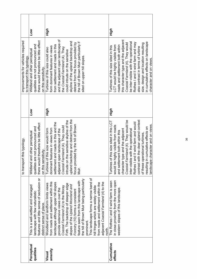
to tr
ansp
ort t
his
typo
logy
. im
prov
emen
ts fo
r ve
hicl
es r
equi
red
to tr
ansp
ort t
his
typo
logy
. P
erce
ptu
al
qu
alit
ies
Thi
s is
a w
ell-s
ettle
d an
d m
anag
ed
land
scap
e w
ith fe
w n
atur
alis
tic
feat
ures
and
littl
e se
nse
of s
eclu
sion
or
dist
inct
sen
se o
f pla
ce.
Wild
land
and
oth
er p
erce
ptua
l qu
aliti
es a
re n
ot p
rono
unce
d an
d th
ere
wou
ld th
eref
ore
be li
ttle
effe
ct
on th
is s
ensi
tivity
.
Low
W
ildla
nd a
nd o
ther
per
cept
ual
qual
ities
are
not
pro
noun
ced
and
ther
e w
ould
ther
efor
e be
littl
e ef
fect
on
this
sen
sitiv
ity.
Low
Vis
ual
am
enit
y
Woo
dlan
d an
d la
ndfo
rm li
mits
vie
ws
from
roa
ds a
nd s
ettle
men
t with
in th
is
land
scap
e al
thou
gh u
pper
hill
slo
pes
prov
ide
exte
nsiv
e vi
ews
over
the
Coa
stal
Far
mla
nd (
4) to
the
Mor
ay
Firt
h. T
he b
ackd
rop
of s
teep
er e
dge
slop
es o
f the
Upl
and
Moo
rland
and
F
ores
try
(10)
form
s a
cons
iste
nt
feat
ure
seen
from
this
land
scap
e w
ith
the
hill
of B
row
n M
uir
bein
g pa
rtic
ular
ly
prom
inen
t.
Thi
s la
ndsc
ape
form
s a
narr
ow b
and
of
hill
frin
ges
whi
ch a
re w
idel
y vi
sibl
e fr
om r
oads
and
set
tlem
ent w
ithin
the
adja
cent
Coa
stal
Far
mla
nd (
4) to
the
nort
h.
Tur
bine
s of
this
siz
e w
ould
form
do
min
ant f
eatu
res
in v
iew
s fr
om
settl
emen
t and
roa
ds in
this
and
the
adja
cent
ope
n la
ndsc
ape
of th
e C
oast
al F
arm
land
(4)
. The
y co
uld
intr
ude
on th
e se
nsiti
ve s
kylin
e of
the
upla
nd b
ackd
rop
and
detr
act f
rom
the
focu
s pr
ovid
ed b
y th
e hi
ll of
Bro
wn
Mui
r.
Hig
h T
urbi
nes
of th
is s
ize
coul
d al
so
form
dom
inan
t fea
ture
s in
vie
ws
from
set
tlem
ent a
nd r
oads
in th
is
and
the
adja
cent
ope
n la
ndsc
ape
of
the
Coa
stal
Far
mla
nd (
4). T
hey
coul
d in
trud
e on
the
sens
itive
sk
ylin
e of
the
upla
nd b
ackd
rop
and
detr
act f
rom
the
focu
s pr
ovid
ed b
y th
e hi
ll of
Bro
wn
Mui
r pa
rtic
ular
ly if
si
ted
on u
pper
hill
slo
pes.
Hig
h
Cu
mu
lati
ve
effe
cts
The
Rot
hes
I and
II w
ind
farm
is s
een
in c
lose
pro
xim
ity fr
om th
e m
ore
open
w
este
rn s
lope
s of
this
land
scap
e.
Tur
bine
s of
this
siz
e si
ted
in th
is L
CT
w
ould
be
high
ly v
isib
le fr
om r
oads
an
d se
ttlem
ent b
oth
with
in th
is
char
acte
r ty
pe a
nd th
e ad
jace
nt
Coa
stal
Far
mla
nd (
4). T
hey
wou
ld b
e in
ter-
visi
ble
with
the
oper
atio
nal
Rot
hes
I and
II w
ind
farm
and
wou
ld
cont
rast
with
the
clea
r up
land
con
text
of
thes
e op
erat
iona
l tur
bine
s,
resu
lting
in c
umul
ativ
e ef
fect
s on
la
ndsc
ape
char
acte
r an
d on
vie
ws.
Hig
h T
urbi
nes
of th
is s
ize
site
d in
this
LC
T w
ould
be
high
ly v
isib
le fr
om
road
s an
d se
ttlem
ent b
oth
with
in
this
cha
ract
er ty
pe a
nd th
e ad
jace
nt
Coa
stal
Far
mla
nd (
4). T
hey
wou
ld
be in
ter-
visi
ble
with
the
oper
atio
nal
Rot
hes
I and
II w
ind
farm
and
may
al
so c
ontr
ast i
n te
rms
of tu
rbin
e si
ze, d
esig
n an
d lo
catio
n re
sulti
ng
in c
umul
ativ
e ef
fect
s on
land
scap
e ch
arac
ter
and
on v
iew
s.
Hig
h
36

Cha
ract
er T
ype
5: R
ollin
g Fa
rmla
nd a
nd F
ores
ts –
Sen
sitiv
ity a
sses
smen
t for
sm
all-m
ediu
m a
nd s
mal
l typ
olog
ies
To
pic
S
um
mar
y d
escr
ipti
on
Ass
essm
ent
of
smal
l-m
ediu
m
typ
olo
gy
(35m
-50m
) S
ensi
tivi
ty
rati
ng
A
sses
smen
t o
f sm
allt
ypo
log
y (2
0m-3
5m)
Sen
siti
vity
ra
tin
g
Lan
dsc
ape
con
text
Thi
s la
ndsc
ape
form
s a
narr
ow fr
inge
of
sm
all r
ollin
g h
ills
and
slop
es
betw
een
the
high
er h
ills
of th
e U
plan
d M
oorla
nd a
nd F
ores
try
(10)
and
the
low
-lyin
g co
asta
l pla
in o
f the
Coa
stal
F
arm
land
s (4
). W
hile
its
wel
l-set
tled
and
farm
ed c
hara
cter
dis
tinct
ly
cont
rast
s w
ith (
10)
it m
erge
s m
ore
grad
ually
with
(4)
. The
ste
ep-s
ided
la
ndm
ark
hill
of B
row
n M
uir
loca
ted
with
in th
e U
plan
d M
oorla
nd a
nd
For
estr
y (1
0) p
rovi
des
a pr
omin
ent
back
drop
to th
is c
hara
cter
type
.
Tur
bine
s of
this
siz
e w
ould
hav
e le
ss
of a
n im
pact
on
adja
cent
land
scap
es
due
to th
eir
incr
ease
d co
mpa
tibili
ty
with
the
scal
e of
the
Coa
stal
F
arm
land
(4)
. The
land
mar
k hi
ll of
B
row
n M
uir
wou
ld s
till b
e se
nsiti
ve to
tu
rbin
es s
ited
near
by h
owev
er.
Med
ium
W
ith c
aref
ul s
iting
, thi
s sm
alle
r ty
polo
gy w
ould
be
likel
y to
hav
e m
inim
al im
pact
s on
the
land
mar
k hi
ll of
Bro
wn
Mui
r. E
ffect
s on
the
Coa
stal
Far
mla
nd (
4) w
ould
als
o be
re
duce
d du
e to
the
rela
tivel
y sm
all
size
of t
urbi
nes
and
thei
r co
mpa
tibili
ty w
ith th
e in
crea
sed
scal
e of
this
adj
oini
ng la
ndsc
ape.
Med
ium
-low
Sca
le a
nd
o
pen
nes
s
The
land
form
is q
uite
rol
ling
in p
lace
s lim
iting
sca
le a
nd th
is, t
oget
her
with
fa
irly
exte
nsiv
e w
oodl
and
cove
r,
redu
ces
open
ness
. T
his
land
scap
e is
w
ell-s
ettle
d w
ith a
dis
pers
ed p
atte
rn o
f sm
all f
arm
s (a
num
ber
of a
band
oned
fa
rm b
uild
ings
on
uppe
r ea
ster
n sl
opes
) an
d m
any
new
hou
ses
whi
ch,
toge
ther
with
enc
lose
d fie
lds
and
woo
dlan
ds, p
rovi
de r
eady
sca
le
refe
renc
es. S
cale
incr
ease
s at
the
tran
sitio
n w
ith th
e U
plan
d M
oorla
nd
and
For
estr
y (1
0) w
here
set
tlem
ent i
s sp
arse
r an
d hi
ll sl
opes
are
bro
ader
.
Thi
s ty
polo
gy w
ould
app
ear
larg
e in
re
latio
n to
the
scal
e of
land
form
, w
oodl
ands
, lan
d co
ver
patte
rn a
nd
settl
emen
t with
in th
is la
ndsc
ape
alth
ough
impa
cts
on s
mal
ler
scal
e el
emen
ts c
ould
be
redu
ced
if tu
rbin
es
wer
e as
soci
ated
with
mor
e ex
pans
ive
uppe
r hi
ll sl
opes
.
Hig
h-m
ediu
m
Tur
bine
s of
this
siz
e w
ould
hav
e a
bette
r sc
ale
rela
tions
hip
to th
is
land
scap
e al
thou
gh s
mal
ler
scal
e la
ndfo
rms
wou
ld s
till b
e se
nsiti
ve.
Med
ium
Lan
dfo
rm
G
ently
und
ulat
ing
hills
slo
pes
with
oc
casi
onal
mor
e ro
unde
d sm
all h
ills
rise
grad
ually
to th
e U
plan
d M
oorla
nd
Bro
ader
gen
tly u
ndul
atin
g hi
ll sl
opes
co
uld
mor
e ea
sily
acc
omm
odat
e th
is
typo
logy
alth
ough
turb
ines
of t
his
Med
ium
T
here
are
incr
ease
d op
port
uniti
es
to a
ssoc
iate
this
siz
e of
turb
ine
with
le
ss e
xten
sive
slo
pes,
sm
all n
atur
al
Med
ium
-low
37

and
For
estr
y (1
0) to
the
sout
h. P
ocke
ts
of m
ore
knol
ly la
ndfo
rm o
ccur
and
na
rrow
val
leys
are
fille
d w
ith s
mal
l w
ater
bod
ies
at M
illbu
ies
and
Bla
ckhi
lls.
size
wou
ld d
etra
ct fr
om th
e m
ore
com
plex
land
form
of k
nolls
, nar
row
va
lleys
with
sm
all w
ater
bod
ies
and
occa
sion
al s
mal
l rou
nded
hill
s.
terr
aces
and
the
side
of s
mal
l hill
s.
The
y w
ould
stil
l det
ract
from
mor
e co
mpl
ex k
nolls
and
nar
row
val
leys
an
d th
e to
ps o
f sm
all r
ound
ed h
ills
wou
ld a
lso
be s
ensi
tive.
L
and
scap
e p
atte
rn
Alm
ost e
qual
pro
port
ions
of p
astu
re
and
arab
le fi
elds
inte
rspe
rsed
with
sm
all c
onife
rous
woo
dlan
ds. F
arm
land
is
mor
e m
argi
nal a
nd th
e co
nife
rous
pl
anta
tions
bec
ome
mor
e ex
tens
ive
at
the
tran
sitio
n w
ith th
e U
plan
d M
oorla
nd
and
For
estr
y (1
0). S
mal
l poc
ket o
f po
licy
woo
dlan
d oc
cur
at B
lack
hills
al
thou
gh g
ener
ally
this
land
scap
e ha
s lim
ited
dive
rsity
and
few
land
mar
k fe
atur
es.
Sen
sitiv
ity is
red
uced
due
to th
e re
lativ
ely
sim
ple
patte
rns
of fo
rest
co
ver
and
farm
land
alth
ough
this
ty
polo
gy c
ould
det
ract
from
sm
all
pock
ets
of p
olic
y w
oodl
and
if si
ted
clos
e-by
.
Med
ium
-low
S
ensi
tivity
is r
educ
ed d
ue to
the
rela
tivel
y si
mpl
e pa
ttern
s of
fore
st
cove
r an
d fa
rmla
nd a
lthou
gh th
is
typo
logy
cou
ld d
etra
ct fr
om s
mal
l po
cket
s of
pol
icy
woo
dlan
d if
site
d cl
ose-
by.
Med
ium
-low
Bu
ilt
envi
ron
men
t
Thi
s la
ndsc
ape
is w
ell-s
ettle
d w
ith a
re
gula
r pa
ttern
of d
ispe
rsed
farm
s an
d ho
uses
and
als
o so
me
smal
l se
ttlem
ents
, inc
ludi
ng la
rger
dis
tille
ry
build
ings
. Set
tlem
ent i
s sp
arse
r at
the
tran
sitio
n w
ith th
e ad
jace
nt U
plan
d M
oorla
nd a
nd F
ores
try
(10)
alth
ough
th
ere
are
pock
ets
of r
ecen
t res
iden
tial
deve
lopm
ent.
Pub
lic r
oads
are
ge
nera
lly v
ery
narr
ow a
nd w
indi
ng.
Mor
e sp
arse
ly s
ettle
d up
per
hill
slop
es w
ould
be
less
sen
sitiv
e in
te
rms
of a
void
ing
impa
ct o
n th
e im
med
iate
set
ting
of s
ettle
men
ts a
nd
othe
r bu
ilt fe
atur
es a
lthou
gh tu
rbin
es
of th
is s
ize
wou
ld b
e lik
ely
to b
e se
en
in r
elat
ive
prox
imity
to b
uilt
feat
ures
gi
ven
settl
emen
t den
sity
and
pat
tern
ac
ross
this
land
scap
e.
Hig
h-m
ediu
m
Thi
s ty
polo
gy w
ould
hav
e le
ss o
f an
effe
ct o
n th
e se
tting
of s
ettle
men
ts.
The
y co
uld
be s
ited
rela
tivel
y cl
ose
to d
istil
lery
bui
ldin
gs a
lthou
gh
wou
ld n
eed
to b
e se
t bac
k fr
om
smal
ler
build
ings
to a
void
con
flict
s of
sca
le a
nd e
ffect
s on
set
ting.
Med
ium
Per
cep
tual
q
ual
itie
s T
his
is a
wel
l-set
tled
and
man
aged
la
ndsc
ape
with
few
nat
ural
istic
fe
atur
es a
nd li
ttle
sens
e of
sec
lusi
on o
r di
stin
ct s
ense
of p
lace
.
Wild
land
and
oth
er p
erce
ptua
l qu
aliti
es a
re n
ot p
rono
unce
d an
d th
ere
wou
ld th
eref
ore
be li
ttle
effe
ct
on th
is s
ensi
tivity
.
Low
W
ildla
nd a
nd o
ther
per
cept
ual
qual
ities
are
not
pro
noun
ced
and
ther
e w
ould
ther
efor
e be
littl
e ef
fect
on
this
sen
sitiv
ity.
Low
Vis
ual
am
enit
y
Woo
dlan
d an
d la
ndfo
rm li
mits
vie
ws
from
roa
ds a
nd s
ettle
men
t with
in th
is
land
scap
e al
thou
gh u
pper
hill
slo
pes
prov
ide
exte
nsiv
e vi
ews
over
the
Tur
bine
s of
this
siz
e w
ould
form
hi
ghly
vis
ible
feat
ures
in c
lose
vie
ws
from
set
tlem
ent a
nd r
oads
in th
is
land
scap
e an
d pa
rts
of th
e ad
jace
nt
Hig
h-m
ediu
m
Tur
bine
s of
this
siz
e w
ould
be
less
vi
sual
ly p
rom
inen
t in
view
s fr
om
settl
emen
t and
roa
ds in
this
ch
arac
ter
type
and
wou
ld b
e lik
ely
Med
ium
38

Coa
stal
Far
mla
nd (
4) to
the
Mor
ay
Firt
h. T
he b
ackd
rop
of s
teep
er e
dge
slop
es o
f the
Upl
and
Moo
rland
and
F
ores
try
(10)
form
s a
cons
iste
nt
feat
ure
seen
from
this
land
scap
e w
ith
the
hill
of B
row
n M
uir
bein
g pa
rtic
ular
ly
prom
inen
t.
Thi
s la
ndsc
ape
form
s a
narr
ow b
and
of
hill
frin
ges
whi
ch a
re w
idel
y vi
sibl
e fr
om r
oads
and
set
tlem
ent w
ithin
the
adja
cent
Coa
stal
Far
mla
nd (
4) to
the
nort
h.
open
land
scap
e of
the
Coa
stal
F
arm
land
(4)
. The
y co
uld
how
ever
be
site
d to
avo
id in
trus
ion
on th
e se
nsiti
ve s
kylin
e of
the
upla
nd
back
drop
and
to a
void
det
ract
ing
from
the
focu
s pr
ovid
ed b
y th
e hi
ll of
B
row
n M
uir.
to h
ave
min
imal
effe
cts
on v
iew
s fr
om th
e C
oast
al F
arm
land
(4)
pr
ovid
ing
they
avo
ided
sm
all h
ill
tops
and
wer
e ba
ck-c
loth
ed b
y ris
ing
grou
nd.
Cu
mu
lati
ve
effe
cts
The
Rot
hes
I and
II w
ind
farm
is s
een
in c
lose
pro
xim
ity fr
om th
e m
ore
open
w
este
rn s
lope
s of
this
land
scap
e.
The
re is
som
e lim
ited
scop
e to
site
tu
rbin
es o
f thi
s si
ze to
min
imis
e cu
mul
ativ
e ef
fect
s w
ith th
e op
erat
iona
l Rot
hes
I and
II w
ind
farm
as
inte
r-vi
sibi
lity
betw
een
deve
lopm
ents
from
clo
se v
iew
s w
ould
be
likel
y to
red
uce
furt
her
east
. T
he m
ore
open
upp
er h
ill s
lope
s of
th
e w
este
rn p
art o
f thi
s la
ndsc
ape
are
mor
e se
nsiti
ve d
ue to
the
clos
er
prox
imity
to o
pera
tiona
l win
d fa
rm
deve
lopm
ent a
nd a
lso
the
tran
smis
sion
line
whe
re th
ey c
ould
ex
acer
bate
the
visu
al c
lutte
r of
di
spar
ate
stru
ctur
es in
the
land
scap
e.
Hig
h-m
ediu
m
The
re is
incr
ease
d sc
ope
to s
ite
turb
ines
of t
his
size
to a
void
si
gnifi
cant
cum
ulat
ive
impa
cts
alth
ough
the
mor
e op
en u
pper
hill
sl
opes
of t
he w
este
rn p
art o
f thi
s la
ndsc
ape
rem
ain
sens
itive
due
to
the
prox
imity
of o
pera
tiona
l win
d fa
rm d
evel
opm
ent a
nd a
lso
the
tran
smis
sion
line
whe
re th
ey c
ould
ex
acer
bate
the
visu
al c
lutte
r of
di
spar
ate
stru
ctur
es in
the
land
scap
e.
Med
ium
39

Cha
ract
er T
ype
5a: R
ollin
g Fa
rmla
nd a
nd F
ores
ts w
ith V
alle
ys –
Sen
sitiv
ity a
sses
smen
t for
larg
e an
d m
ediu
m ty
polo
gies
T
op
ic
Su
mm
ary
des
crip
tio
nA
sses
smen
to
f la
rge
typ
olo
gy
(80m
-130
m)
Sen
siti
vity
ra
tin
g
Ass
essm
ent
of
med
ium
typ
olo
gy
(50m
-80m
) S
ensi
tivi
ty
rati
ng
L
and
scap
e co
nte
xt
Thi
s la
ndsc
ape
com
pris
es th
e br
oad
valle
ys o
f Plu
scar
den
and
the
uppe
r Lo
ssie
and
the
two
ridge
s w
hich
div
ide
them
. It e
xten
ds n
orth
war
ds to
incl
ude
the
low
hill
of Q
uarr
y W
ood
whi
ch
wra
ps a
roun
d E
lgin
. It
form
s a
tran
sitio
n be
twee
n th
e hi
gher
hill
s of
th
e U
plan
d M
oorla
nd a
nd F
ores
try
(10)
an
d th
e lo
w-ly
ing
coas
tal p
lain
of t
he
Coa
stal
Far
mla
nds
(4).
Thi
s la
ndsc
ape
is d
istin
ct fr
om a
djoi
ning
cha
ract
er
type
s w
ith th
e no
rthe
rn r
idge
of H
eldo
n H
ill fo
rmin
g a
prom
inen
t bac
kdro
p to
th
e se
ttled
Coa
stal
Far
mla
nds
(4)
and
the
Rol
ling
Far
mla
nds
and
For
est w
ith
Low
Hill
s (5
b) a
nd th
e se
ttled
upp
er
Loss
ie v
alle
y co
ntra
stin
g w
ith th
e m
ore
open
upl
ands
of t
he U
plan
d M
oorla
nd
and
For
estr
y (1
0) to
the
sout
h. T
he
ridge
s ar
e al
so p
rom
inen
t fro
m th
e R
ollin
g F
arm
land
and
For
est (
5) to
the
east
.
The
pro
min
ence
of t
he d
istin
ct r
idge
s of
this
land
scap
e, to
geth
er w
ith th
e re
lativ
ely
smal
l ext
ent o
f thi
s la
ndsc
ape
type
, lim
its s
cope
to
acco
mm
odat
e th
is ty
polo
gy w
ithou
t it
impa
ctin
g on
adj
acen
t lan
dsca
pes
(and
par
ticul
arly
the
Coa
stal
F
arm
land
(4)
whe
re v
iew
s ar
e m
ore
open
). T
he v
alle
ys a
re m
ore
self-
cont
aine
d w
ith v
iew
s in
to th
em fr
om
surr
ound
ing
area
s lim
ited.
Hig
h-M
ediu
m
The
pro
min
ence
of t
he d
istin
ct
ridge
s of
this
land
scap
e, to
geth
er
with
the
rela
tivel
y sm
all e
xten
t of
this
land
scap
e ty
pe, l
imits
sco
pe to
ac
com
mod
ate
this
typo
logy
with
out
it im
pact
ing
on a
djac
ent l
ands
cape
s (a
nd p
artic
ular
ly th
e C
oast
al
Far
mla
nd (
4) w
here
vie
ws
are
mor
e op
en).
The
val
leys
are
mor
e se
lf-co
ntai
ned
with
vie
ws
into
them
from
su
rrou
ndin
g ar
eas
limite
d.
Hig
h-M
ediu
m
Sca
le a
nd
o
pen
nes
s
The
nor
ther
n rid
ge o
f Hel
don
Hill
(w
hich
is m
ost p
rom
inen
t fro
m th
e C
oast
al F
arm
land
(4)
) on
ly r
ises
to
arou
nd 2
30m
whi
le th
e so
uthe
rn r
idge
is
slig
htly
hig
her
at 3
00m
. The
cur
ving
rid
ge o
f Qua
rry
Woo
d w
hich
wra
ps
arou
nd E
lgin
is v
ery
low
des
pite
its
prom
inen
ce. T
he v
alle
ys a
re s
tron
gly
Thi
s si
ze o
f tur
bine
wou
ld d
etra
ct
from
the
rela
tivel
y lo
w r
elie
f of t
he
nort
hern
rid
ge. I
t wou
ld a
lso
dom
inat
e th
e lim
ited
exte
nt o
f the
op
en v
alle
y flo
or. T
he p
rese
nce
of
smal
ler
scal
e fe
atur
es w
ithin
the
valle
ys in
crea
ses
sens
itivi
ty to
this
ty
polo
gy.
Hig
h T
his
size
of t
urbi
ne w
ould
hav
e a
bette
r sc
ale
rela
tions
hip
with
the
relie
f of t
he h
ighe
r rid
ges.
It w
ould
ho
wev
er s
till b
e lik
ely
to d
omin
ate
the
limite
d ex
tent
of o
pen
valle
y flo
ors.
The
pre
senc
e of
sm
alle
r sc
ale
feat
ures
with
in th
e va
lleys
in
crea
ses
sens
itivi
ty to
this
Hig
h-m
ediu
m
40
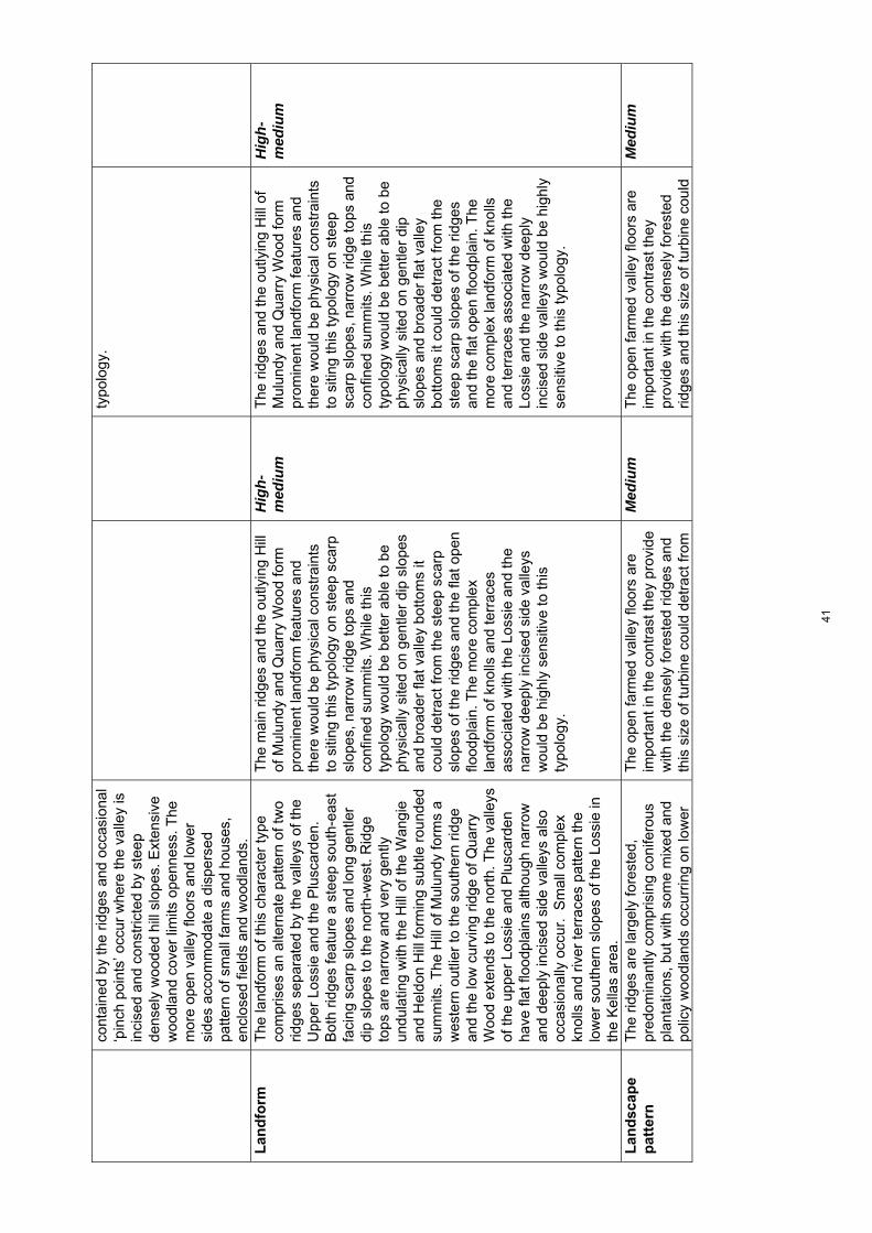
cont
aine
d by
the
ridge
s an
d oc
casi
onal
‘p
inch
poi
nts’
occ
ur w
here
the
valle
y is
in
cise
d an
d co
nstr
icte
d by
ste
ep
dens
ely
woo
ded
hill
slop
es. E
xten
sive
w
oodl
and
cove
r lim
its o
penn
ess.
The
m
ore
open
val
ley
floor
s an
d lo
wer
si
des
acco
mm
odat
e a
disp
erse
d pa
ttern
of s
mal
l far
ms
and
hous
es,
encl
osed
fiel
ds a
nd w
oodl
ands
.
typo
logy
.
Lan
dfo
rm
T
he la
ndfo
rm o
f thi
s ch
arac
ter
type
co
mpr
ises
an
alte
rnat
e pa
ttern
of t
wo
ridge
s se
para
ted
by th
e va
lleys
of t
he
Upp
er L
ossi
e an
d th
e P
lusc
arde
n.
Bot
h rid
ges
feat
ure
a st
eep
sout
h-ea
st
faci
ng s
carp
slo
pes
and
long
gen
tler
dip
slop
es to
the
nort
h-w
est.
Rid
ge
tops
are
nar
row
and
ver
y ge
ntly
un
dula
ting
with
the
Hill
of t
he W
angi
e an
d H
eldo
n H
ill fo
rmin
g su
btle
rou
nded
su
mm
its. T
he H
ill o
f Mul
undy
form
s a
wes
tern
out
lier
to th
e so
uthe
rn r
idge
an
d th
e lo
w c
urvi
ng r
idge
of Q
uarr
y W
ood
exte
nds
to th
e no
rth.
The
val
leys
of
the
uppe
r Lo
ssie
and
Plu
scar
den
have
flat
floo
dpla
ins
alth
ough
nar
row
an
d de
eply
inci
sed
side
val
leys
als
o oc
casi
onal
ly o
ccur
. S
mal
l com
plex
kn
olls
and
riv
er te
rrac
es p
atte
rn th
e lo
wer
sou
ther
n sl
opes
of t
he L
ossi
e in
th
e K
ella
s ar
ea.
The
mai
n rid
ges
and
the
outly
ing
Hill
of
Mul
undy
and
Qua
rry
Woo
d fo
rm
prom
inen
t lan
dfor
m fe
atur
es a
nd
ther
e w
ould
be
phys
ical
con
stra
ints
to
siti
ng th
is ty
polo
gy o
n st
eep
scar
p sl
opes
, nar
row
rid
ge to
ps a
nd
conf
ined
sum
mits
. Whi
le th
is
typo
logy
wou
ld b
e be
tter
able
to b
e ph
ysic
ally
site
d on
gen
tler
dip
slop
es
and
broa
der
flat v
alle
y bo
ttom
s it
coul
d de
trac
t fro
m th
e st
eep
scar
p sl
opes
of t
he r
idge
s an
d th
e fla
t ope
n flo
odpl
ain.
The
mor
e co
mpl
ex
land
form
of k
nolls
and
terr
aces
as
soci
ated
with
the
Loss
ie a
nd th
e na
rrow
dee
ply
inci
sed
side
val
leys
w
ould
be
high
ly s
ensi
tive
to th
is
typo
logy
.
Hig
h-m
ediu
m
The
rid
ges
and
the
outly
ing
Hill
of
Mul
undy
and
Qua
rry
Woo
d fo
rm
prom
inen
t lan
dfor
m fe
atur
es a
nd
ther
e w
ould
be
phys
ical
con
stra
ints
to
siti
ng th
is ty
polo
gy o
n st
eep
scar
p sl
opes
, nar
row
rid
ge to
ps a
nd
conf
ined
sum
mits
. Whi
le th
is
typo
logy
wou
ld b
e be
tter
able
to b
e ph
ysic
ally
site
d on
gen
tler
dip
slop
es a
nd b
road
er fl
at v
alle
y bo
ttom
s it
coul
d de
trac
t fro
m th
e st
eep
scar
p sl
opes
of t
he r
idge
s an
d th
e fla
t ope
n flo
odpl
ain.
The
m
ore
com
plex
land
form
of k
nolls
an
d te
rrac
es a
ssoc
iate
d w
ith th
e Lo
ssie
and
the
narr
ow d
eepl
y in
cise
d si
de v
alle
ys w
ould
be
high
ly
sens
itive
to th
is ty
polo
gy.
Hig
h-m
ediu
m
Lan
dsc
ape
pat
tern
The
rid
ges
are
larg
ely
fore
sted
, pr
edom
inan
tly c
ompr
isin
g co
nife
rous
pl
anta
tions
, but
with
som
e m
ixed
and
po
licy
woo
dlan
ds o
ccur
ring
on lo
wer
The
ope
n fa
rmed
val
ley
floor
s ar
e im
port
ant i
n th
e co
ntra
st th
ey p
rovi
de
with
the
dens
ely
fore
sted
rid
ges
and
this
siz
e of
turb
ine
coul
d de
trac
t fro
m
Med
ium
T
he o
pen
farm
ed v
alle
y flo
ors
are
impo
rtan
t in
the
cont
rast
they
pr
ovid
e w
ith th
e de
nsel
y fo
rest
ed
ridge
s an
d th
is s
ize
of tu
rbin
e co
uld
Med
ium
41

slop
es o
n th
e ed
ge o
f the
val
leys
and
w
ithin
dee
ply
inci
sed
side
val
leys
. Fla
t va
lley
floor
s an
d lo
wer
slo
pes
are
farm
ed a
nd g
ently
und
ulat
ing
past
ures
oc
cur
on th
e no
rth-
wes
t fac
ing
long
dip
sl
opes
of t
he r
idge
s an
d at
the
tran
sitio
n w
ith th
e U
plan
d M
oorla
nd
and
For
estr
y (1
0).
this
and
from
occ
asio
nal p
olic
y fe
atur
es. T
he m
ore
unifo
rm
coni
fero
us fo
rest
cov
er is
gen
eral
ly
less
sen
sitiv
e.
detr
act f
rom
this
and
from
oc
casi
onal
pol
icy
feat
ures
. The
m
ore
unifo
rm c
onife
rous
fore
st
cove
r is
gen
eral
ly le
ss s
ensi
tive.
Bu
ilt
envi
ron
men
t
The
val
leys
are
wel
l set
tled
and
feat
ure
a re
gula
r pa
ttern
of s
mal
l far
ms,
co
ttage
s an
d sm
all s
ettle
men
ts s
uch
as D
alla
s an
d R
affo
rd. T
here
are
a
num
ber
of h
isto
ric h
ouse
s w
ith
asso
ciat
ed d
esig
ned
land
scap
es, t
he
‘land
mar
k’ fe
atur
e of
Plu
scar
den
Abb
ey a
nd a
rcha
eolo
gica
l fea
ture
s.
Pub
lic r
oads
are
ver
y na
rrow
and
pr
ivat
e tr
acks
are
ofte
n st
eep
with
in
the
fore
sted
rid
ges.
Set
tlem
ent i
s fo
cuss
ed w
ithin
the
valle
ys a
nd th
is s
ize
of tu
rbin
e w
ould
de
trac
t fro
m th
e se
tting
of
settl
emen
ts, h
isto
ric h
ouse
s,
Plu
scar
den
Abb
ey a
nd
arch
aeol
ogic
al fe
atur
es if
site
d w
ithin
th
ese
area
s. S
pars
ely
settl
ed u
pper
hi
ll sl
opes
wou
ld b
e le
ss s
ensi
tive
in
term
s of
avo
idin
g im
pact
on
the
imm
edia
te s
ettin
g of
set
tlem
ents
and
ot
her
built
feat
ures
alth
ough
turb
ines
of
this
siz
e w
ould
be
likel
y to
be
seen
in
rel
ativ
e pr
oxim
ity to
bui
lt fe
atur
es
give
n se
ttlem
ent d
ensi
ty a
nd p
atte
rn
acro
ss th
is la
ndsc
ape.
N
arro
w r
oads
and
ste
ep te
rrai
n co
uld
resu
lt in
land
scap
e an
d vi
sual
effe
cts
asso
ciat
ed w
ith a
cces
s im
prov
emen
ts fo
r ve
hicl
es r
equi
red
to tr
ansp
ort t
his
typo
logy
.
Hig
h S
ettle
men
t is
focu
ssed
with
in th
e va
lleys
and
this
siz
e of
turb
ine
wou
ld d
etra
ct fr
om th
e se
tting
of
settl
emen
ts, h
isto
ric h
ouse
s,
Plu
scar
den
Abb
ey a
nd
arch
aeol
ogic
al fe
atur
es if
site
d w
ithin
thes
e ar
eas.
Spa
rsel
y se
ttled
up
per
hill
slop
es w
ould
be
less
se
nsiti
ve in
term
s of
avo
idin
g im
pact
on
the
imm
edia
te s
ettin
g of
se
ttlem
ents
and
oth
er b
uilt
feat
ures
. N
arro
w r
oads
and
ste
ep te
rrai
n co
uld
resu
lt in
land
scap
e an
d vi
sual
ef
fect
s as
soci
ated
with
acc
ess
impr
ovem
ents
for
vehi
cles
req
uire
d to
tran
spor
t thi
s ty
polo
gy.
Hig
h-m
ediu
m
Per
cep
tual
q
ual
itie
s A
lthou
gh th
e va
lleys
are
str
ongl
y co
ntai
ned
and
can
feel
sec
lude
d in
so
me
plac
es, t
hey
are
gene
rally
wel
l-se
ttled
. Ext
ensi
ve fo
rest
ry a
nd a
lso
win
d fa
rm d
evel
opm
ent a
nd a
tr
ansm
issi
on li
ne v
isib
le fr
om th
e
Thi
s ty
polo
gy c
ould
affe
ct th
e se
nse
of s
eclu
sion
and
the
hist
oric
al
dim
ensi
on fe
lt in
par
ts o
f thi
s la
ndsc
ape
alth
ough
in g
ener
al
wild
land
qua
litie
s ar
e no
t pr
onou
nced
.
Med
ium
T
his
typo
logy
cou
ld a
ffect
the
sens
e of
sec
lusi
on a
nd th
e hi
stor
ical
di
men
sion
felt
in p
arts
of t
his
land
scap
e al
thou
gh in
gen
eral
w
ildla
nd q
ualit
ies
are
not
pron
ounc
ed.
Med
ium
42
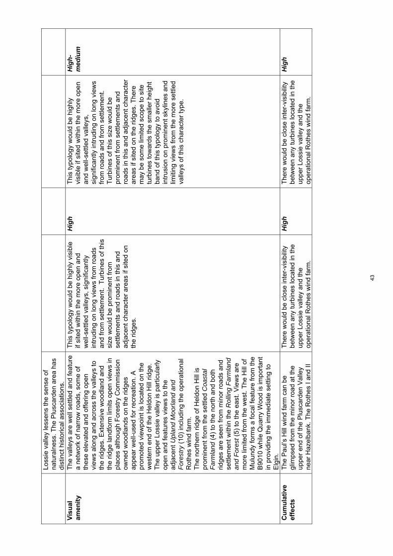
Loss
ie v
alle
y le
ssen
s th
e se
nse
of
natu
raln
ess.
The
Plu
scar
den
area
has
di
stin
ct h
isto
rical
ass
ocia
tions
.
Vis
ual
am
enit
y
The
val
leys
are
wel
l set
tled
and
feat
ure
a ne
twor
k of
nar
row
roa
ds, s
ome
of
thes
e el
evat
ed a
nd o
fferin
g op
en
view
s al
ong
and
acro
ss th
e va
lleys
to
the
ridge
s. E
xten
sive
woo
dlan
d an
d th
e rid
ge la
ndfo
rm li
mits
ope
n vi
ews
in
plac
es a
lthou
gh F
ores
try
Com
mis
sion
ow
ned
woo
dlan
ds o
n th
e rid
ges
appe
ar w
ell-u
sed
for
recr
eatio
n. A
pr
omot
ed v
iew
poin
t is
loca
ted
on th
e w
este
rn e
nd o
f the
Hel
don
Hill
rid
ge.
The
upp
er L
ossi
e va
lley
is p
artic
ular
ly
open
and
feat
ures
vie
ws
to th
e ad
jace
nt U
plan
d M
oorla
nd a
nd
For
estr
y (1
0) in
clud
ing
the
oper
atio
nal
Rot
hes
win
d fa
rm.
The
nor
ther
n rid
ge o
f Hel
don
Hill
is
prom
inen
t fro
m th
e se
ttled
Coa
stal
F
arm
land
(4)
to th
e no
rth
and
both
rid
ges
are
seen
from
min
or r
oads
and
se
ttlem
ent w
ithin
the
Rol
ling
Far
mla
nd
and
For
est (
5) to
the
east
. Vie
ws
are
mor
e lim
ited
from
the
wes
t. T
he H
ill o
f M
ulun
dy fo
rms
a fo
cal f
eatu
re fr
om th
e B
9010
whi
le Q
uarr
y W
ood
is im
port
ant
in p
rovi
ding
the
imm
edia
te s
ettin
g to
E
lgin
.
Thi
s ty
polo
gy w
ould
be
high
ly v
isib
le
if si
ted
with
in th
e m
ore
open
and
w
ell-s
ettle
d va
lleys
, sig
nific
antly
in
trud
ing
on lo
ng v
iew
s fr
om r
oads
an
d fr
om s
ettle
men
t. T
urbi
nes
of th
is
size
wou
ld b
e pr
omin
ent f
rom
se
ttlem
ents
and
roa
ds in
this
and
ad
jace
nt c
hara
cter
are
as if
site
d on
th
e rid
ges.
Hig
h T
his
typo
logy
wou
ld b
e hi
ghly
vi
sibl
e if
site
d w
ithin
the
mor
e op
en
and
wel
l-set
tled
valle
ys,
sign
ifica
ntly
intr
udin
g on
long
vie
ws
from
roa
ds a
nd fr
om s
ettle
men
t.
Tur
bine
s of
this
siz
e w
ould
be
prom
inen
t fro
m s
ettle
men
ts a
nd
road
s in
this
and
adj
acen
t cha
ract
er
area
s if
site
d on
the
ridge
s. T
here
m
ay b
e so
me
limite
d sc
ope
to s
ite
turb
ines
tow
ards
the
smal
ler
heig
ht
band
of t
his
typo
logy
to a
void
in
trus
ion
on p
rom
inen
t sky
lines
and
lim
iting
vie
ws
from
the
mor
e se
ttled
va
lleys
of t
his
char
acte
r ty
pe.
Hig
h-m
ediu
m
Cu
mu
lati
ve
effe
cts
The
Pau
l’s H
ill w
ind
farm
can
be
glim
psed
from
the
min
or r
oad
at th
e up
per
end
of th
e P
lusc
arde
n V
alle
y ne
ar H
azel
bank
. The
Rot
hes
I and
II
The
re w
ould
be
clos
e in
ter-
visi
bilit
y be
twee
n an
y tu
rbin
es lo
cate
d in
the
uppe
r Lo
ssie
val
ley
and
the
oper
atio
nal R
othe
s w
ind
farm
.
Hig
h T
here
wou
ld b
e cl
ose
inte
r-vi
sibi
lity
betw
een
any
turb
ines
loca
ted
in th
e up
per
Loss
ie v
alle
y an
d th
e op
erat
iona
l Rot
hes
win
d fa
rm.
Hig
h
43
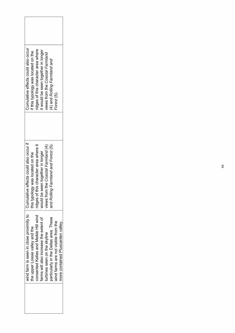
win
d fa
rm is
see
n in
clo
se p
roxi
mity
to
the
uppe
r Lo
ssie
val
ley
and
the
cons
ente
d K
ella
s an
d M
eikl
e H
ill w
ind
farm
s w
ill a
lso
incr
ease
the
exte
nt o
f tu
rbin
es s
een
on th
e sk
ylin
e pa
rtic
ular
ly in
the
Dal
las
area
. The
se
win
d fa
rms
are
not v
isib
le fr
om th
e m
ore
cont
aine
d P
lusc
arde
n va
lley.
Cum
ulat
ive
effe
cts
coul
d al
so o
ccur
if
this
typo
logy
was
loca
ted
on th
e rid
ges
of th
is c
hara
cter
are
a w
here
it
wou
ld b
e se
en to
geth
er in
long
er
view
s fr
om th
e C
oast
al F
arm
land
(4)
an
d R
ollin
g F
arm
land
and
For
est (
5).
Cum
ulat
ive
effe
cts
coul
d al
so o
ccur
if
this
typo
logy
was
loca
ted
on th
e rid
ges
of th
is c
hara
cter
are
a w
here
it
wou
ld b
e se
en to
geth
er in
long
er
view
s fr
om th
e C
oast
al F
arm
land
(4
) an
d R
ollin
g F
arm
land
and
F
ores
t (5)
.
44
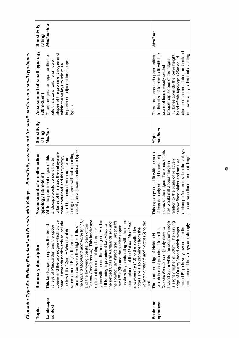
Cha
ract
er T
ype
5a: R
ollin
g Fa
rmla
nd a
nd F
ores
ts w
ith V
alle
ys –
Sen
sitiv
ity a
sses
smen
t for
sm
all-m
ediu
m a
nd s
mal
l typ
olog
ies
To
pic
S
um
mar
y d
escr
ipti
on
Ass
essm
ent
of
smal
l-m
ediu
m
typ
olo
gy
(35m
-50m
) S
ensi
tivi
ty
rati
ng
A
sses
smen
t o
f sm
allt
ypo
log
y (2
0m-3
5m)
Sen
siti
vity
ra
tin
g
Lan
dsc
ape
con
text
Thi
s la
ndsc
ape
com
pris
es th
e br
oad
valle
ys o
f Plu
scar
den
and
the
uppe
r Lo
ssie
and
the
two
ridge
s w
hich
div
ide
them
. It e
xten
ds n
orth
war
ds to
incl
ude
the
low
hill
of Q
uarr
y W
ood
whi
ch
wra
ps a
roun
d E
lgin
. It
form
s a
tran
sitio
n be
twee
n th
e hi
gher
hill
s of
th
e U
plan
d M
oorla
nd a
nd F
ores
try
(10)
an
d th
e lo
w-ly
ing
coas
tal p
lain
of t
he
Coa
stal
Far
mla
nds
(4).
Thi
s la
ndsc
ape
is d
istin
ct fr
om a
djoi
ning
cha
ract
er
type
s w
ith th
e no
rthe
rn r
idge
of H
eldo
n H
ill fo
rmin
g a
prom
inen
t bac
kdro
p to
th
e se
ttled
Coa
stal
Far
mla
nds
(4)
and
the
Rol
ling
Far
mla
nds
and
For
est w
ith
Low
Hill
s (5
b) a
nd th
e se
ttled
upp
er
Loss
ie v
alle
y co
ntra
stin
g w
ith th
e m
ore
open
upl
ands
of t
he U
plan
d M
oorla
nd
and
For
estr
y (1
0) to
the
sout
h. T
he
ridge
s ar
e al
so p
rom
inen
t fro
m th
e R
ollin
g F
arm
land
and
For
est (
5) to
the
east
.
Whi
le th
e pr
omin
ent r
idge
s of
this
la
ndsc
ape
wou
ld b
e se
nsiti
ve to
tu
rbin
es o
f thi
s si
ze, t
he v
alle
ys a
re
mor
e co
ntai
ned
and
this
typo
logy
co
uld
be lo
cate
d on
mor
e in
war
d fa
cing
dip
slo
pes
with
out i
mpa
ctin
g vi
sual
ly o
n ad
jace
nt la
ndsc
ape
type
s.
Med
ium
T
here
are
gre
ater
opp
ortu
nitie
s to
si
te th
is s
ize
of tu
rbin
e on
low
er
slop
es o
f the
pro
min
ent r
idge
s an
d w
ithin
the
valle
ys to
min
imis
e im
pact
s on
adj
acen
t lan
dsca
pe
type
s.
Med
ium
-low
Sca
le a
nd
o
pen
nes
s
The
nor
ther
n rid
ge o
f Hel
don
Hill
(w
hich
is m
ost p
rom
inen
t fro
m th
e C
oast
al F
arm
land
(4)
) on
ly r
ises
to
arou
nd 2
30m
whi
le th
e so
uthe
rn r
idge
is
slig
htly
hig
her
at 3
00m
. The
cur
ving
rid
ge o
f Qua
rry
Woo
d w
hich
wra
ps
arou
nd E
lgin
is v
ery
low
des
pite
its
prom
inen
ce. T
he v
alle
ys a
re s
tron
gly
Thi
s ty
polo
gy c
ould
fit w
ith th
e sc
ale
of le
ss d
ense
ly s
ettle
d br
oade
r di
p sl
opes
of t
he r
idge
s. T
urbi
nes
of th
is
size
wou
ld s
till a
ppea
r la
rge
in
rela
tion
to th
e sc
ale
of r
elat
ivel
y na
rrow
floo
d pl
ains
and
sm
alle
r la
ndsc
ape
feat
ures
with
in th
e va
lleys
su
ch a
s w
oodl
ands
and
bui
ldin
gs.
Hig
h-m
ediu
m
The
re a
re in
crea
sed
oppo
rtun
ities
fo
r th
is s
ize
of tu
rbin
e to
fit
with
the
scal
e of
less
den
sely
set
tled
broa
der
dip
slop
es o
f the
rid
ges.
T
urbi
nes
tow
ards
the
low
er h
eigh
t ba
nd o
f thi
s ty
polo
gy <
25m
cou
ld
also
be
acco
mm
odat
ed o
n fa
rmla
nd
on lo
wer
val
ley
side
s (b
ut a
void
ing
Med
ium
45

cont
aine
d by
the
ridge
s an
d oc
casi
onal
‘p
inch
poi
nts’
occ
ur w
here
the
valle
y is
in
cise
d an
d co
nstr
icte
d by
ste
ep
dens
ely
woo
ded
hill
slop
es. E
xten
sive
w
oodl
and
cove
r lim
its o
penn
ess.
The
m
ore
open
val
ley
floor
s an
d lo
wer
si
des
acco
mm
odat
e a
disp
erse
d pa
ttern
of s
mal
l far
ms
and
hous
es,
encl
osed
fiel
ds a
nd w
oodl
ands
.
the
open
floo
dpla
in)
Lan
dfo
rm
T
he la
ndfo
rm o
f thi
s ch
arac
ter
type
co
mpr
ises
an
alte
rnat
e pa
ttern
of t
wo
ridge
s se
para
ted
by th
e va
lleys
of t
he
Upp
er L
ossi
e an
d th
e P
lusc
arde
n.
Bot
h rid
ges
feat
ure
a st
eep
sout
h-ea
st
faci
ng s
carp
slo
pes
and
long
gen
tler
dip
slop
es to
the
nort
h-w
est.
Rid
ge
tops
are
nar
row
and
ver
y ge
ntly
un
dula
ting
with
the
Hill
of t
he W
angi
e an
d H
eldo
n H
ill fo
rmin
g su
btle
rou
nded
su
mm
its. T
he H
ill o
f Mul
undy
form
s a
wes
tern
out
lier
to th
e so
uthe
rn r
idge
an
d th
e lo
w c
urvi
ng r
idge
of Q
uarr
y W
ood
exte
nds
to th
e no
rth.
The
val
leys
of
the
uppe
r Lo
ssie
and
Plu
scar
den
have
flat
floo
dpla
ins
alth
ough
nar
row
an
d de
eply
inci
sed
side
val
leys
als
o oc
casi
onal
ly o
ccur
. S
mal
l com
plex
kn
olls
and
riv
er te
rrac
es p
atte
rn th
e lo
wer
sou
ther
n sl
opes
of t
he L
ossi
e in
th
e K
ella
s ar
ea.
The
rid
ges
form
pro
min
ent l
andf
orm
fe
atur
es a
nd th
ere
wou
ld b
e ph
ysic
al
cons
trai
nts
to s
iting
this
typo
logy
on
stee
p sc
arp
slop
es, n
arro
w r
idge
tops
an
d co
nfin
ed s
umm
its. T
he g
entle
r di
p sl
opes
and
bro
ader
flat
val
ley
botto
ms
wou
ld b
e le
ss s
ensi
tive
to
this
typo
logy
pro
vidi
ng tu
rbin
es w
ere
site
d to
avo
id d
etra
ctin
g on
key
vie
ws
to th
e st
eep
scar
p sl
opes
and
the
flat
flood
plai
n of
the
valle
ys. T
he m
ore
com
plex
land
form
of k
nolls
and
te
rrac
es a
ssoc
iate
d w
ith th
e Lo
ssie
an
d th
e na
rrow
dee
ply
inci
sed
side
va
lleys
wou
ld b
e hi
ghly
sen
sitiv
e ho
wev
er.
Med
ium
T
urbi
nes
of th
is s
ize
(and
pa
rtic
ular
ly th
ose
tow
ards
the
low
er
heig
ht b
and
of th
is ty
polo
gy)
wou
ld
be li
kely
to h
ave
less
of a
det
ract
ive
effe
ct o
n ke
y la
ndfo
rm fe
atur
es.
The
pro
min
ent r
idge
tops
, ste
ep
scar
p sl
opes
and
mor
e co
mpl
ex
land
form
feat
ures
wou
ld s
till b
e se
nsiti
ve to
any
turb
ine
site
d on
th
ese
feat
ures
or
near
by th
em.
Med
ium
Lan
dsc
ape
pat
tern
The
rid
ges
are
larg
ely
fore
sted
, pr
edom
inan
tly c
ompr
isin
g co
nife
rous
pl
anta
tions
, but
with
som
e m
ixed
and
po
licy
woo
dlan
ds o
ccur
ring
on lo
wer
The
ope
n fa
rmed
val
ley
floor
s ar
e im
port
ant i
n th
e co
ntra
st th
ey p
rovi
de
with
the
dens
ely
fore
sted
rid
ges
and
this
siz
e of
turb
ine
coul
d de
trac
t fro
m
Med
ium
T
here
is m
ore
oppo
rtun
ity to
site
th
e sm
alle
r tu
rbin
es o
f thi
s ty
polo
gy
to m
inim
ise
effe
cts
on m
ore
nota
ble
land
cov
er. T
he o
pen
farm
ed v
alle
y
Med
ium
-low
46

slop
es o
n th
e ed
ge o
f the
val
leys
and
w
ithin
dee
ply
inci
sed
side
val
leys
. Fla
t va
lley
floor
s an
d lo
wer
slo
pes
are
farm
ed a
nd g
ently
und
ulat
ing
past
ures
oc
cur
on th
e no
rth-
wes
t fac
ing
long
dip
sl
opes
of t
he r
idge
s an
d at
the
tran
sitio
n w
ith th
e U
plan
d M
oorla
nd
and
For
estr
y (1
0).
this
and
from
occ
asio
nal p
olic
y fe
atur
es. T
he m
ore
unifo
rm
coni
fero
us fo
rest
cov
er is
gen
eral
ly
less
sen
sitiv
e.
floor
and
pol
icy
feat
ures
wou
ld s
till
be s
ensi
tive
to a
ny tu
rbin
e de
velo
pmen
t how
ever
.
Bu
ilt
envi
ron
men
t
The
val
leys
are
wel
l set
tled
and
feat
ure
a re
gula
r pa
ttern
of s
mal
l far
ms,
co
ttage
s an
d sm
all s
ettle
men
ts s
uch
as D
alla
s an
d R
affo
rd. T
here
are
a
num
ber
of h
isto
ric h
ouse
s w
ith
asso
ciat
ed d
esig
ned
land
scap
es a
nd
the
‘land
mar
k’ fe
atur
e of
Plu
scar
den
Abb
ey. P
ublic
roa
ds a
re v
ery
narr
ow
and
priv
ate
trac
ks a
re o
ften
stee
p w
ithin
the
fore
sted
rid
ges.
Set
tlem
ent i
s fo
cuss
ed w
ithin
the
valle
ys a
nd th
is s
ize
of tu
rbin
e w
ould
de
trac
t fro
m th
e se
tting
of
settl
emen
ts, h
isto
ric h
ouse
s an
d P
lusc
arde
n A
bbey
if s
ited
with
in
thes
e ar
eas.
Spa
rsel
y se
ttled
upp
er
hill
slop
es w
ould
be
less
sen
sitiv
e in
te
rms
of a
void
ing
impa
ct o
n th
e im
med
iate
set
ting
of s
ettle
men
ts a
nd
othe
r bu
ilt fe
atur
es.
Med
ium
W
hile
the
setti
ng o
f key
his
toric
and
ar
chae
olog
ical
bui
lt fe
atur
es w
ould
st
ill b
e hi
ghly
sen
sitiv
e to
intr
usio
n,
this
typo
logy
wou
ld h
ave
less
of a
n ef
fect
on
othe
r bu
ilt fe
atur
es i
f site
d ei
ther
with
in le
ss w
ell-s
ettle
d ar
eas
or if
they
com
pris
ed tu
rbin
es
tow
ards
the
low
er h
eigh
t ban
d <
25m
.
Med
ium
-low
Per
cep
tual
q
ual
itie
s A
lthou
gh th
e va
lleys
are
str
ongl
y co
ntai
ned
and
can
feel
sec
lude
d in
so
me
plac
es, t
hey
are
gene
rally
wel
l-se
ttled
. Ext
ensi
ve fo
rest
ry a
nd a
lso
win
d fa
rm d
evel
opm
ent a
nd a
tr
ansm
issi
on li
ne v
isib
le fr
om th
e up
per
Loss
ie v
alle
y le
ssen
s th
e se
nse
of
natu
raln
ess.
The
Plu
scar
den
area
has
di
stin
ct h
isto
rical
ass
ocia
tions
.
Wild
land
qua
litie
s ar
e no
t pr
onou
nced
and
turb
ines
of t
his
size
w
ould
be
unlik
ely
to h
ave
a si
gnifi
cant
effe
ct o
n th
is, a
nd o
ther
pe
rcep
tual
qua
litie
s, p
rovi
ded
they
w
ere
care
fully
site
d.
Low
W
ildla
nd q
ualit
ies
are
not
pron
ounc
ed a
nd tu
rbin
es o
f thi
s si
ze w
ould
be
unlik
ely
to h
ave
a si
gnifi
cant
effe
ct o
n th
is, a
nd o
ther
pe
rcep
tual
qua
litie
s, p
rovi
ded
they
w
ere
care
fully
site
d.
Low
Vis
ual
am
enit
y
The
val
leys
are
wel
l set
tled
and
feat
ure
a ne
twor
k of
nar
row
roa
ds, s
ome
of
thes
e el
evat
ed a
nd o
fferin
g op
en
view
s al
ong
and
acro
ss th
e va
lleys
to
the
ridge
s. E
xten
sive
woo
dlan
d an
d th
e rid
ge la
ndfo
rm li
mits
ope
n vi
ews
in
plac
es a
lthou
gh F
ores
try
Com
mis
sion
Thi
s ty
polo
gy w
ould
be
high
ly v
isib
le
if si
ted
with
in th
e m
ore
open
and
w
ell-s
ettle
d va
lleys
and
cou
ld in
trud
e on
long
vie
ws
from
roa
ds a
nd fr
om
settl
emen
t alth
ough
ther
e is
in
crea
sed
scop
e to
site
turb
ines
of
this
siz
e in
less
wel
l-set
tled
area
s to
Hig
h-m
ediu
m
Tur
bine
s of
this
siz
e w
ould
hav
e a
redu
ced
effe
ct o
n vi
ews
as th
ey
coul
d be
site
d on
low
er h
ill s
lope
s to
avo
id in
trus
ion
on lo
ng v
iew
s fr
om r
oads
alig
ned
thro
ugh
the
valle
ys. E
ven
turb
ines
of t
his
size
w
ould
be
intr
usiv
e ho
wev
er if
site
d
Med
ium
47
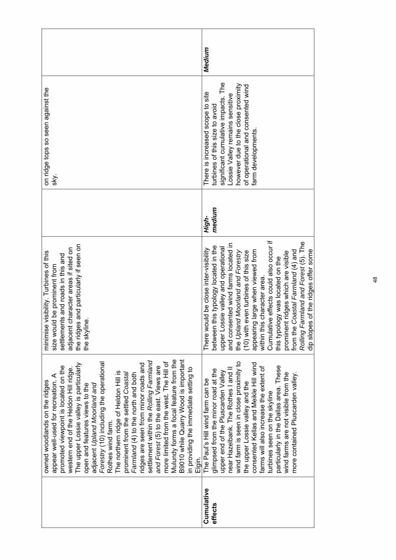
owne
d w
oodl
ands
on
the
ridge
s ap
pear
wel
l-use
d fo
r re
crea
tion.
A
prom
oted
vie
wpo
int i
s lo
cate
d on
the
wes
tern
end
of t
he H
eldo
n H
ill r
idge
. T
he u
pper
Los
sie
valle
y is
par
ticul
arly
op
en a
nd fe
atur
es v
iew
s to
the
adja
cent
Upl
and
Moo
rland
and
F
ores
try
(10)
incl
udin
g th
e op
erat
iona
l R
othe
s w
ind
farm
. T
he n
orth
ern
ridge
of H
eldo
n H
ill is
pr
omin
ent f
rom
the
settl
ed C
oast
al
Far
mla
nd (
4) to
the
nort
h an
d bo
th
ridge
s ar
e se
en fr
om m
inor
roa
ds a
nd
settl
emen
t with
in th
e R
ollin
g F
arm
land
an
d F
ores
t (5)
to th
e ea
st. V
iew
s ar
e m
ore
limite
d fr
om th
e w
est.
The
Hill
of
Mul
undy
form
s a
foca
l fea
ture
from
the
B90
10 w
hile
Qua
rry
Woo
d is
impo
rtan
t in
pro
vidi
ng th
e im
med
iate
set
ting
to
Elg
in.
min
imis
e vi
sibi
lity.
Tur
bine
s of
this
si
ze w
ould
be
prom
inen
t fro
m
settl
emen
ts a
nd r
oads
in th
is a
nd
adja
cent
cha
ract
er a
reas
if s
ited
on
the
ridge
s an
d pa
rtic
ular
ly if
see
n on
th
e sk
ylin
e.
on r
idge
tops
so
seen
aga
inst
the
sky.
Cu
mu
lati
ve
effe
cts
The
Pau
l’s H
ill w
ind
farm
can
be
glim
psed
from
the
min
or r
oad
at th
e up
per
end
of th
e P
lusc
arde
n V
alle
y ne
ar H
azel
bank
. The
Rot
hes
I and
II
win
d fa
rm is
see
n in
clo
se p
roxi
mity
to
the
uppe
r Lo
ssie
val
ley
and
the
cons
ente
d K
ella
s an
d M
eikl
e H
ill w
ind
farm
s w
ill a
lso
incr
ease
the
exte
nt o
f tu
rbin
es s
een
on th
e sk
ylin
e pa
rtic
ular
ly in
the
Dal
las
area
. The
se
win
d fa
rms
are
not v
isib
le fr
om th
e m
ore
cont
aine
d P
lusc
arde
n va
lley.
The
re w
ould
be
clos
e in
ter-
visi
bilit
y be
twee
n th
is ty
polo
gy lo
cate
d in
the
uppe
r Lo
ssie
val
ley
and
oper
atio
nal
and
cons
ente
d w
ind
farm
s lo
cate
d in
th
e U
plan
d M
oorla
nd a
nd F
ores
try
(10)
with
eve
n tu
rbin
es o
f thi
s si
ze
appe
arin
g la
rge
whe
n vi
ewed
from
w
ithin
this
cha
ract
er a
rea.
C
umul
ativ
e ef
fect
s co
uld
also
occ
ur if
th
is ty
polo
gy w
as lo
cate
d on
the
prom
inen
t rid
ges
whi
ch a
re v
isib
le
from
the
Coa
stal
Far
mla
nd (
4) a
nd
Rol
ling
Far
mla
nd a
nd F
ores
t (5)
. The
di
p sl
opes
of t
he r
idge
s of
fer
som
e
Hig
h-m
ediu
m
The
re is
incr
ease
d sc
ope
to s
ite
turb
ines
of t
his
size
to a
void
si
gnifi
cant
cum
ulat
ive
impa
cts.
The
Lo
ssie
Val
ley
rem
ains
sen
sitiv
e ho
wev
er d
ue to
the
clos
e pr
oxim
ity
of o
pera
tiona
l and
con
sent
ed w
ind
farm
dev
elop
men
ts.
Med
ium
48
scop
e to
acc
omm
odat
e th
is ty
polo
gy
prov
ided
they
cou
ld b
e si
ted
to a
void
im
pact
s on
sen
sitiv
e sk
ylin
es.
49

Cha
ract
er T
ype
5b: R
ollin
g Fa
rmla
nd a
nd F
ores
ts w
ith L
ow H
ills
– Se
nsiti
vity
ass
essm
ent f
or la
rge
and
med
ium
typo
logi
es
To
pic
S
um
mar
y d
escr
ipti
on
Ass
essm
ent
of
larg
e ty
po
log
y (8
0m-1
30m
) S
ensi
tivi
ty
rati
ng
A
sses
smen
t o
f m
ediu
mty
po
log
y (5
0m-8
0m)
Sen
siti
vity
ra
tin
g
Lan
dsc
ape
con
text
Thi
s la
ndsc
ape
form
s a
tran
sitio
n be
twee
n th
e hi
gher
hill
s of
the
Upl
and
Moo
rland
and
For
estr
y (1
0) a
nd th
e C
oast
al F
arm
land
s (4
). T
he u
ndul
atin
g la
ndfo
rm a
nd e
xten
sive
woo
dlan
d lim
it in
ter-
visi
bilit
y w
ith a
djac
ent l
ands
cape
ty
pes,
alth
ough
this
land
scap
e fo
rms
low
woo
ded
skyl
ines
to th
e N
arro
w
Woo
ded
Val
leys
(6)
of t
he F
indh
orn
and
Dor
back
/Div
ie B
urns
. T
he w
ider
vis
ual p
rom
inen
ce o
f R
omac
h H
ill is
an
exce
ptio
n, a
s it
form
s a
prom
inen
t ‘la
ndm
ark’
hill
whi
ch
is e
asily
rec
ogni
sabl
e ou
twith
the
area
an
d is
vis
ible
mor
e w
idel
y ac
ross
w
este
rn M
oray
. It a
lso
prov
ides
a
visu
al ‘b
uffe
r’ be
twee
n th
e lo
wla
nd
land
scap
es a
nd th
e U
plan
d M
oorla
nd
and
For
estr
y (1
0) to
the
sout
h fr
om
som
e lo
wer
vie
wpo
ints
incl
udin
g pu
blic
ro
ads.
T
he r
elat
ivel
y sm
all s
cale
of h
ill fo
rms
and
spac
es c
ontr
asts
with
larg
er h
ill
form
s an
d bo
lder
pat
tern
of e
xten
sive
fo
rest
and
ope
n m
oorla
nd to
the
sout
h.
Thi
s la
ndsc
ape
type
is r
elat
ivel
y sm
all
in e
xten
t.
The
sm
all e
xten
t of t
his
land
scap
e ty
pe li
mits
sco
pe to
acc
omm
odat
e th
is ty
polo
gy w
ithou
t it i
mpa
ctin
g on
th
e ad
jace
nt N
arro
w W
oode
d V
alle
y (6
) to
the
wes
t or
Rol
ling
Far
mla
nd
and
For
ests
with
Val
leys
(5a
) to
the
east
. R
omac
h H
ill is
a la
ndm
ark
hill,
eas
ily
reco
gnis
able
and
vis
ible
in v
iew
s ou
twith
this
LC
T. I
t is
a se
nsiti
ve
feat
ure
beca
use
of it
s w
ide
visi
bilit
y an
d st
raeg
ic r
ole
as a
vis
ual
fore
grou
nd to
mor
e ex
tens
ive
upla
nd
area
s. O
ther
wis
e, th
is la
ndsc
ape
char
acte
r ty
pe is
rel
ativ
ely
self-
co
ntai
ned,
with
vie
ws
into
it li
mite
d by
th
e hi
lly la
ndfo
rm a
nd w
oodl
and.
Hig
h-M
ediu
m
The
sm
all e
xten
t of t
his
land
scap
e ty
pe li
mits
sco
pe to
acc
omm
odat
e th
is ty
polo
gy w
ithou
t it i
mpa
ctin
g on
th
e ad
jace
nt N
arro
w W
oode
d V
alle
y (6
) to
the
wes
t or
Rol
ling
Far
mla
nd a
nd F
ores
ts w
ith V
alle
ys
(5a)
to th
e ea
st.
Rom
ach
Hill
is a
land
mar
k hi
ll,
easi
ly r
ecog
nisa
ble
and
visi
ble
in
view
s ou
twith
this
LC
T. I
t is
a se
nsiti
ve fe
atur
e be
caus
e of
its
wid
e vi
sibi
lity
and
stra
egic
rol
e as
a
visu
al fo
regr
ound
to m
ore
exte
nsiv
e up
land
are
as. O
ther
wis
e, th
is
land
scap
e ch
arac
ter
type
is
rela
tivel
y se
lf- c
onta
ined
, with
vie
ws
into
it li
mite
d by
the
hilly
land
form
an
d w
oodl
and.
Hig
h-M
ediu
m
Sca
le a
nd
o
pen
nes
s
Ver
y sm
all s
cale
, und
ulat
ing
and
hum
moc
ky la
ndfo
rm s
kirt
ing
arou
nd
the
base
of R
omac
h H
ill a
nd e
xten
ding
Thi
s si
ze o
f tur
bine
wou
ld im
pact
on
the
smal
l sca
le o
f muc
h of
this
ch
arac
ter
type
. In
part
icul
ar, t
his
Hig
h T
his
size
of t
urbi
ne w
ould
impa
ct o
n th
e sm
all s
cale
of m
uch
of th
is
char
acte
r ty
pe. I
n pa
rtic
ular
, thi
s
Hig
h
50
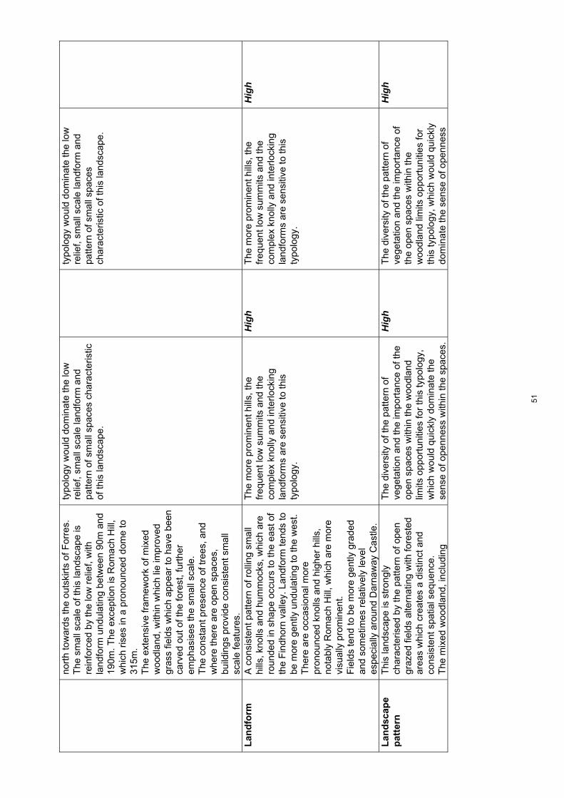
nort
h to
war
ds th
e ou
tski
rts
of F
orre
s.
The
sm
all s
cale
of t
his
land
scap
e is
re
info
rced
by
the
low
rel
ief,
with
la
ndfo
rm u
ndul
atin
g be
twee
n 90
m a
nd
190m
. The
exc
eptio
n is
Rom
ach
Hill
, w
hich
ris
es in
a p
rono
unce
d do
me
to
315m
. T
he e
xten
sive
fram
ewor
k of
mix
ed
woo
dlan
d, w
ithin
whi
ch li
e im
prov
ed
gras
s fie
lds
whi
ch a
ppea
r to
hav
e be
en
carv
ed o
ut o
f the
fore
st, f
urth
er
emph
asis
es th
e sm
all s
cale
. T
he c
onst
ant p
rese
nce
of tr
ees,
and
w
here
ther
e ar
e op
en s
pace
s,
build
ings
pro
vide
con
sist
ent s
mal
l sc
ale
feat
ures
.
typo
logy
wou
ld d
omin
ate
the
low
re
lief,
smal
l sca
le la
ndfo
rm a
nd
patte
rn o
f sm
all s
pace
s ch
arac
teris
tic
of th
is la
ndsc
ape.
typo
logy
wou
ld d
omin
ate
the
low
re
lief,
smal
l sca
le la
ndfo
rm a
nd
patte
rn o
f sm
all s
pace
s ch
arac
teris
tic o
f thi
s la
ndsc
ape.
Lan
dfo
rm
A
con
sist
ent p
atte
rn o
f rol
ling
smal
l hi
lls, k
nolls
and
hum
moc
ks, w
hich
are
ro
unde
d in
sha
pe o
ccur
s to
the
east
of
the
Fin
dhor
n va
lley.
Lan
dfor
m te
nds
to
be m
ore
gent
ly u
ndul
atin
g to
the
wes
t.
The
re a
re o
ccas
iona
l mor
e pr
onou
nced
kno
lls a
nd h
ighe
r hi
lls,
nota
bly
Rom
ach
Hill
, whi
ch a
re m
ore
visu
ally
pro
min
ent.
F
ield
s te
nd to
be
mor
e ge
ntly
gra
ded
and
som
etim
es r
elat
ivel
y le
vel
espe
cial
ly a
roun
d D
arna
way
Cas
tle.
The
mor
e pr
omin
ent h
ills,
the
freq
uent
low
sum
mits
and
the
com
plex
kno
lly a
nd in
terlo
ckin
g la
ndfo
rms
are
sens
itive
to th
is
typo
logy
.
Hig
h
The
mor
e pr
omin
ent h
ills,
the
freq
uent
low
sum
mits
and
the
com
plex
kno
lly a
nd in
terlo
ckin
g la
ndfo
rms
are
sens
itive
to th
is
typo
logy
.
Hig
h
Lan
dsc
ape
pat
tern
Thi
s la
ndsc
ape
is s
tron
gly
char
acte
rised
by
the
patte
rn o
f ope
n gr
azed
fiel
ds a
ltern
atin
g w
ith fo
rest
ed
area
s w
hich
cre
ates
a d
istin
ct a
nd
cons
iste
nt s
patia
l seq
uenc
e.
The
mix
ed w
oodl
and,
incl
udin
g
The
div
ersi
ty o
f the
pat
tern
of
vege
tatio
n an
d th
e im
port
ance
of t
he
open
spa
ces
with
in th
e w
oodl
and
limits
opp
ortu
nitie
s fo
r th
is ty
polo
gy,
whi
ch w
ould
qui
ckly
dom
inat
e th
e se
nse
of o
penn
ess
with
in th
e sp
aces
.
Hig
h T
he d
iver
sity
of t
he p
atte
rn o
f ve
geta
tion
and
the
impo
rtan
ce o
f th
e op
en s
pace
s w
ithin
the
woo
dlan
d lim
its o
ppor
tuni
ties
for
this
typo
logy
, whi
ch w
ould
qui
ckly
do
min
ate
the
sens
e of
ope
nnes
s
Hig
h
51

broa
dlea
ves
and
mix
ed c
onife
rs a
s w
ell a
s oc
casi
onal
pol
icy-
type
mix
es,
and
wid
e ra
nge
of a
ge s
truc
ture
, offe
rs
dive
rsity
whi
ch is
furt
her
enha
nced
by
the
rang
e of
woo
dlan
d –
exte
ndin
g fr
om s
mal
l clu
mps
of t
rees
to m
ore
exte
nsiv
e fo
rest
. T
he o
pen
spac
es a
re fr
eque
ntly
irr
egul
ar a
nd o
ften
‘org
anic
’ in
shap
e,
incr
easi
ng th
e se
nse
of in
terlo
ck. M
ore
exte
nsiv
e fa
rmla
nd a
nd p
arkl
and
is
asso
ciat
ed w
ith D
arna
way
Cas
tle.
Occ
asio
nal w
ater
bod
ies,
incl
udin
g th
e de
ep tr
ough
of t
he R
omac
h Lo
ch, a
re
feat
ures
with
in th
is la
ndsc
ape.
The
inte
grity
of t
he d
esig
ned
land
scap
e ar
ound
Dar
naw
ay C
astle
an
d A
ltyre
Hou
se is
an
addi
tiona
l se
nsiti
vity
.
with
in th
e sp
aces
. T
he in
tegr
ity o
f the
des
igne
d la
ndsc
ape
arou
nd D
arna
way
Cas
tle
and
Alty
re H
ouse
is a
n ad
ditio
nal
sens
itivi
ty.
Bu
ilt
envi
ron
men
t
Thi
s la
ndsc
ape
is n
ot h
eavi
ly s
ettle
d,
with
farm
s, h
ouse
s an
d ev
en s
mal
l cr
ofts
gen
eral
ly lo
cate
d at
the
edge
of
the
open
spa
ces
over
look
ing
the
field
s.
Dar
naw
ay C
astle
, Alty
re H
ouse
and
th
eir
asso
ciat
ed d
esig
ned
land
scap
es,
as w
ell a
s oc
casi
onal
his
toric
al a
nd
arch
aeol
ogic
al fe
atur
es, i
nclu
ding
ch
urch
es a
nd d
istil
lery
bui
ldin
gs a
dd to
th
e di
vers
ity o
f the
bui
lt en
viro
nmen
t w
ithin
this
land
scap
e.
Bot
h pu
blic
and
priv
ate
road
s ar
e ve
ry
narr
ow.
The
sm
all s
ize
of m
any
of th
e ho
uses
an
d fa
rms
are
a co
nstr
aint
as
this
ty
polo
gy is
like
ly to
dom
inat
e th
e sm
all s
ize
of th
e bu
ilt fe
atur
es.
Thi
s la
ndsc
ape
type
is h
owev
er n
ot
wel
l set
tled,
alth
ough
the
settl
emen
t is
focu
ssed
on
exis
ting
open
spa
ces,
m
ore
exte
nsiv
e w
oode
d ar
eas
may
th
eref
ore
be le
ss s
ensi
tive
even
to
this
siz
e of
typo
logy
in te
rms
of
avoi
ding
impa
ct o
n th
e im
med
iate
se
tting
of s
ettle
men
ts. H
isto
ric
build
ings
and
des
igne
d la
ndsc
apes
w
ould
be
high
ly s
ensi
tive
to tu
rbin
es
of th
is s
ize
whi
ch im
pact
ed o
n th
eir
setti
ng.
T
he n
arro
wne
ss a
nd w
indi
ng
char
acte
r of
the
road
net
wor
k is
like
ly
to b
e co
mpr
omis
ed b
y im
prov
emen
ts
Hig
h-m
ediu
m
The
sm
all s
ize
of m
any
of t
he
hous
es a
nd fa
rms
are
a co
nstr
aint
as
this
typo
logy
is li
kely
to d
omin
ate
the
smal
l siz
e of
the
built
feat
ures
. T
his
land
scap
e ty
pe is
how
ever
not
w
ell s
ettle
d, a
lthou
gh th
e se
ttlem
ent
is fo
cuss
ed o
n ex
istin
g op
en
spac
es, m
ore
exte
nsiv
e w
oode
d ar
eas
may
ther
efor
e be
less
se
nsiti
ve e
ven
to th
is s
ize
of
typo
logy
in te
rms
of a
void
ing
impa
ct
on th
e im
med
iate
set
ting
of
settl
emen
ts. H
isto
ric b
uild
ings
and
de
sign
ed la
ndsc
apes
wou
ld b
e hi
ghly
sen
sitiv
e to
turb
ines
of t
his
size
whi
ch im
pact
ed o
n th
eir
setti
ng.
T
he n
arro
wne
ss a
nd w
indi
ng
char
acte
r of
the
road
net
wor
k is
Hig
h-m
ediu
m
52

to a
ccom
mod
ate
the
larg
e ve
hicl
es
requ
ired
to tr
ansp
ort t
his
typo
logy
. lik
ely
to b
e co
mpr
omis
ed b
y im
prov
emen
ts to
acc
omm
odat
e th
e la
rge
vehi
cles
req
uire
d to
tran
spor
t th
is ty
polo
gy.
Per
cep
tual
q
ual
itie
s T
he s
elf c
onta
ined
cha
ract
er o
f thi
s la
ndsc
ape
incr
ease
s th
e se
nse
of
secl
usio
n in
a la
ndsc
ape
whi
ch,
beca
use
of th
e de
gree
of e
nclo
sure
, ca
n qu
ickl
y fe
el ‘s
et a
part
’ fro
m th
e re
st
of M
oray
. Thi
s is
rei
nfor
ced
by th
e sp
arse
net
wor
k of
pub
lic r
oads
, with
op
port
uniti
es to
exp
lore
the
fore
sts
larg
ely
limite
d to
non
-veh
icul
ar a
cces
s.
Tra
velli
ng th
roug
h th
e w
ell d
efin
ed
spat
ial s
eque
nce
is a
par
ticul
ar
expe
rient
ial c
hara
cter
istic
of t
his
land
scap
e w
hich
is s
tron
gly
linke
d to
its
iden
tity.
Thi
s ty
polo
gy c
ould
affe
ct th
e se
nse
of s
eclu
sion
in th
is la
ndsc
ape.
T
he p
atte
rn o
f spa
ces
is a
par
ticul
ar
qual
ity o
f thi
s la
ndsc
ape,
and
this
ty
polo
gy c
ould
eas
ily d
omin
ate
and
redu
ce th
e co
ntra
st o
f the
ope
n sp
aces
to th
e fo
rest
ed a
reas
.
Hig
h-M
ediu
m
Thi
s ty
polo
gy c
ould
affe
ct th
e se
nse
of s
eclu
sion
in th
is la
ndsc
ape.
T
he p
atte
rn o
f spa
ces
is a
par
ticul
ar
qual
ity o
f thi
s la
ndsc
ape,
and
this
ty
polo
gy c
ould
eas
ily d
omin
ate
and
redu
ce th
e co
ntra
st o
f the
ope
n sp
aces
to th
e fo
rest
ed a
reas
.
Hig
h-M
ediu
m
Vis
ual
am
enit
y
Vie
ws
with
in th
is la
ndsc
ape
area
are
ve
ry li
mite
d an
d ar
e of
ten
inte
rmitt
ent
due
to th
e en
clos
ure
crea
ted
by b
oth
land
form
and
woo
dlan
d.
The
low
hill
s an
d w
oodl
and
ofte
n sc
reen
par
ts o
f thi
s la
ndsc
ape,
so
that
vie
ws
from
the
road
s, fo
r ex
ampl
e, a
re in
term
itten
t.
How
ever
, the
hei
ght o
f thi
s ty
polo
gy
mea
ns th
at it
is li
kely
to a
ppea
r ab
ove
man
y of
thes
e sm
alle
r fe
atur
es a
nd m
ay b
e re
lativ
ely
wid
ely
and
cons
iste
ntly
vis
ible
.
Hig
h-M
ediu
m
The
low
hill
s an
d w
oodl
and
ofte
n sc
reen
par
ts o
f thi
s la
ndsc
ape,
so
that
vie
ws
from
the
road
s, fo
r ex
ampl
e, a
re in
term
itten
t.
The
sm
alle
r he
ight
of t
his
typo
logy
m
eans
that
whi
le it
is li
kely
to
appe
ar a
bove
man
y of
thes
e sm
alle
r fe
atur
es a
nd m
ay b
e re
lativ
ely
wid
ely
and
cons
iste
ntly
vi
sibl
e, b
ut le
ss s
o th
an th
e ‘L
arge
’ ty
polo
gy.
Med
ium
Cu
mu
lati
ve
effe
cts
Vie
ws
of o
pera
tiona
l win
d fa
rms
loca
ted
in L
CT
s 10
and
11
are
limite
d fr
om w
ithin
this
enc
lose
d la
ndsc
ape.
T
he fo
ur tu
rbin
es a
t Fin
dhor
n in
the
Coa
stal
farm
land
(4)
can
be
seen
from
The
re is
lim
ited
inte
r-vi
sibi
lity
betw
een
this
typo
logy
and
win
d fa
rm
deve
lopm
ents
in n
eigh
bour
ing
LCT
s al
thou
gh c
umul
ativ
e ef
fect
s co
uld
occu
r on
sen
sitiv
e sk
ylin
es a
bove
the
Med
ium
T
here
is li
mite
d in
ter-
visi
bilit
y be
twee
n th
is ty
polo
gy a
nd w
ind
farm
dev
elop
men
ts in
nei
ghbo
urin
g LC
Ts
alth
ough
cum
ulat
ive
effe
cts
coul
d oc
cur
on s
ensi
tive
skyl
ines
Med
ium
53

som
e lo
catio
ns a
nd th
e co
nsen
ted
Hill
of
Gla
schy
le w
ind
farm
loca
ted
in th
e U
plan
d M
oorla
nd a
nd F
ores
try
(10)
will
be
vis
ible
from
mor
e op
en a
reas
.
Nar
row
Woo
ded
Val
ley
(6)
with
the
cons
ente
d H
ill o
f Gla
schy
le w
ind
farm
.
abov
e th
e N
arro
w W
oode
d V
alle
y (6
) w
ith th
e co
nsen
ted
Hill
of
Gla
schy
le w
ind
farm
.
54
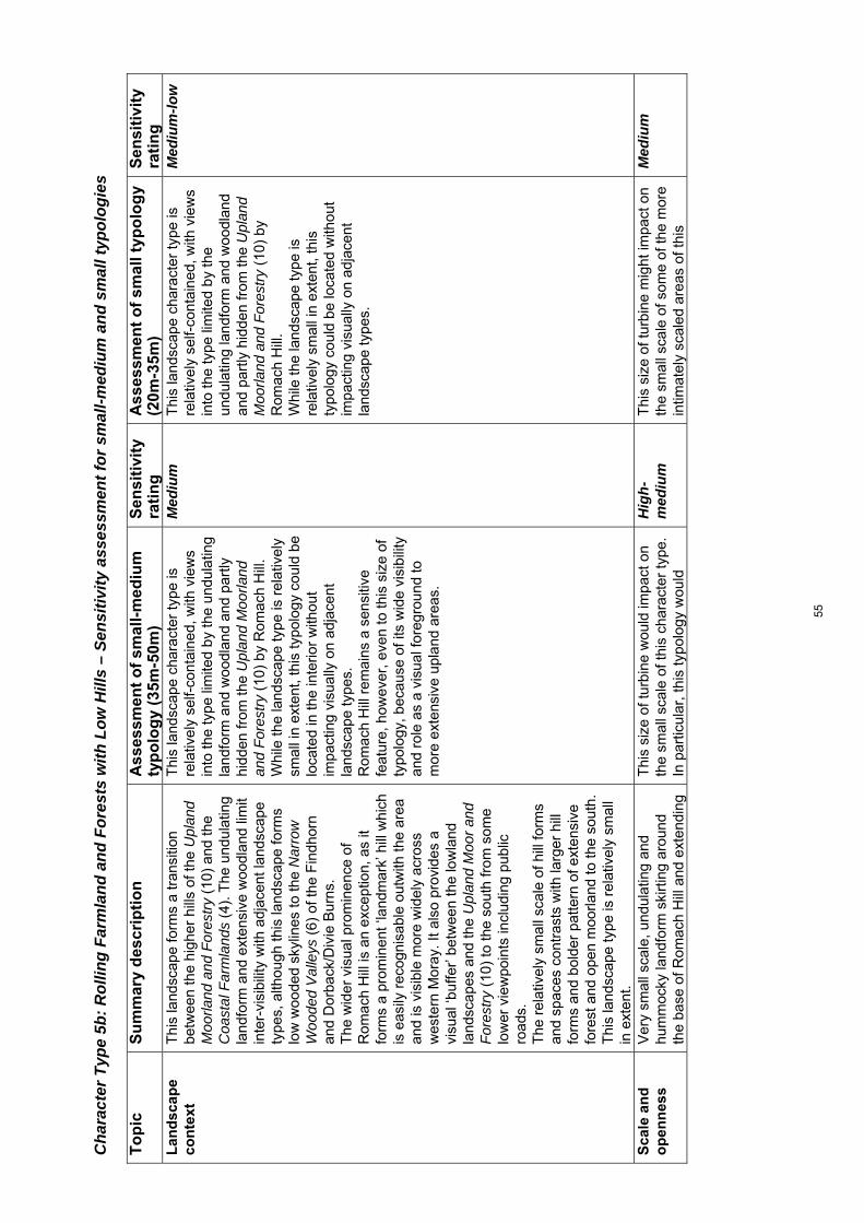
Cha
ract
er T
ype
5b: R
ollin
g Fa
rmla
nd a
nd F
ores
ts w
ith L
ow H
ills
– Se
nsiti
vity
ass
essm
ent f
or s
mal
l-med
ium
and
sm
all t
ypol
ogie
s T
op
ic
Su
mm
ary
des
crip
tio
nA
sses
smen
to
f sm
all-
med
ium
ty
po
log
y (3
5m-5
0m)
Sen
siti
vity
ra
tin
g
Ass
essm
ent
of
smal
ltyp
olo
gy
(20m
-35m
) S
ensi
tivi
ty
rati
ng
L
and
scap
e co
nte
xt
Thi
s la
ndsc
ape
form
s a
tran
sitio
n be
twee
n th
e hi
gher
hill
s of
the
Upl
and
Moo
rland
and
For
estr
y (1
0) a
nd th
e C
oast
al F
arm
land
s (4
). T
he u
ndul
atin
g la
ndfo
rm a
nd e
xten
sive
woo
dlan
d lim
it in
ter-
visi
bilit
y w
ith a
djac
ent l
ands
cape
ty
pes,
alth
ough
this
land
scap
e fo
rms
low
woo
ded
skyl
ines
to th
e N
arro
w
Woo
ded
Val
leys
(6)
of t
he F
indh
orn
and
Dor
back
/Div
ie B
urns
. T
he w
ider
vis
ual p
rom
inen
ce o
f R
omac
h H
ill is
an
exce
ptio
n, a
s it
form
s a
prom
inen
t ‘la
ndm
ark’
hill
whi
ch
is e
asily
rec
ogni
sabl
e ou
twith
the
area
an
d is
vis
ible
mor
e w
idel
y ac
ross
w
este
rn M
oray
. It a
lso
prov
ides
a
visu
al ‘b
uffe
r’ be
twee
n th
e lo
wla
nd
land
scap
es a
nd th
e U
plan
d M
oor
and
For
estr
y (1
0) to
the
sout
h fr
om s
ome
low
er v
iew
poin
ts in
clud
ing
publ
ic
road
s.
The
rel
ativ
ely
smal
l sca
le o
f hill
form
s an
d sp
aces
con
tras
ts w
ith la
rger
hill
fo
rms
and
bold
er p
atte
rn o
f ext
ensi
ve
fore
st a
nd o
pen
moo
rland
to th
e so
uth.
T
his
land
scap
e ty
pe is
rel
ativ
ely
smal
l in
ext
ent.
Thi
s la
ndsc
ape
char
acte
r ty
pe is
re
lativ
ely
self-
cont
aine
d, w
ith v
iew
s in
to th
e ty
pe li
mite
d by
the
undu
latin
g la
ndfo
rm a
nd w
oodl
and
and
part
ly
hidd
en fr
om th
e U
plan
d M
oorla
nd
and
For
estr
y (1
0) b
y R
omac
h H
ill.
Whi
le th
e la
ndsc
ape
type
is r
elat
ivel
y sm
all i
n ex
tent
, thi
s ty
polo
gy c
ould
be
loca
ted
in th
e in
terio
r w
ithou
t im
pact
ing
visu
ally
on
adja
cent
la
ndsc
ape
type
s.
Rom
ach
Hill
rem
ains
a s
ensi
tive
feat
ure,
how
ever
, eve
n to
this
siz
e of
ty
polo
gy, b
ecau
se o
f its
wid
e vi
sibi
lity
and
role
as
a vi
sual
fore
grou
nd to
m
ore
exte
nsiv
e up
land
are
as.
Med
ium
T
his
land
scap
e ch
arac
ter
type
is
rela
tivel
y se
lf-co
ntai
ned,
with
vie
ws
into
the
type
lim
ited
by th
e un
dula
ting
land
form
and
woo
dlan
d an
d pa
rtly
hid
den
from
the
Upl
and
Moo
rland
and
For
estr
y (1
0) b
y R
omac
h H
ill.
Whi
le th
e la
ndsc
ape
type
is
rela
tivel
y sm
all i
n ex
tent
, thi
s ty
polo
gy c
ould
be
loca
ted
with
out
impa
ctin
g vi
sual
ly o
n ad
jace
nt
land
scap
e ty
pes.
Med
ium
-low
Sca
le a
nd
o
pen
nes
s
Ver
y sm
all s
cale
, und
ulat
ing
and
hum
moc
ky la
ndfo
rm s
kirt
ing
arou
nd
the
base
of R
omac
h H
ill a
nd e
xten
ding
Thi
s si
ze o
f tur
bine
wou
ld im
pact
on
the
smal
l sca
le o
f thi
s ch
arac
ter
type
. In
par
ticul
ar, t
his
typo
logy
wou
ld
Hig
h-m
ediu
m
Thi
s si
ze o
f tur
bine
mig
ht im
pact
on
the
smal
l sca
le o
f som
e of
the
mor
e in
timat
ely
scal
ed a
reas
of t
his
Med
ium
55

nort
h to
war
ds th
e ou
tski
rts
of F
orre
s.
The
sm
all s
cale
of t
his
land
scap
e is
re
info
rced
by
the
low
rel
ief,
with
la
ndfo
rm u
ndul
atin
g be
twee
n 90
m a
nd
190m
. The
exc
eptio
n is
Rom
ach
Hill
, w
hich
ris
es in
a p
rono
unce
d do
me
to
315m
. T
he e
xten
sive
fram
ewor
k of
mix
ed
woo
dlan
d, w
ithin
whi
ch li
e im
prov
ed
gras
s fie
lds
whi
ch a
ppea
r to
hav
e be
en
carv
ed o
ut o
f the
fore
st, f
urth
er
emph
asis
es th
e sm
all s
cale
. T
he c
onst
ant p
rese
nce
of tr
ees,
and
w
here
ther
e ar
e op
en s
pace
s,
build
ings
pro
vide
con
sist
ent s
mal
l sc
ale
feat
ures
.
appe
ar ta
ll co
mpa
red
to th
e lo
w r
elie
f an
d sm
alle
r op
en s
pace
s ch
arac
teris
tic o
f thi
s la
ndsc
ape.
T
he c
onsi
sten
t pre
senc
e of
sm
all
feat
ures
– in
clud
ing
tree
s an
d bu
ildin
gs –
wou
ld m
ake
it di
fficu
lt to
ac
com
mod
ate
this
siz
e of
typo
logy
w
ithou
t it a
ppea
ring
muc
h la
rger
than
th
ese
feat
ures
. M
ore
open
, lar
ger
spac
es a
ssoc
iate
d w
ith r
isin
g gr
ound
and
alo
ng th
e lo
wer
slo
pes
of la
rger
hill
s of
fer
mor
e po
tent
ial f
or th
is ty
polo
gy.
The
sm
alle
r tu
rbin
es in
this
typo
logy
ra
nge
wou
ld h
ave
less
impa
ct o
n sc
ale.
char
acte
r ty
pe.
The
re is
like
ly to
be
mos
t sco
pe to
ac
com
mod
ate
turb
ines
of t
his
type
in
the
larg
er o
pen
spac
es, a
long
the
low
er s
lope
s of
larg
er h
ills,
with
tu
rbin
es to
war
ds th
e lo
wer
hei
ght
band
of t
his
typo
logy
hav
ing
the
leas
t pot
entia
l im
pact
.
Lan
dfo
rm
A
con
sist
ent p
atte
rn o
f rol
ling
smal
l hi
lls, k
nolls
and
hum
moc
ks, w
hich
are
ro
unde
d in
sha
pe o
ccur
s to
the
east
of
the
Fin
dhor
n va
lley.
Lan
dfor
m te
nds
to
be m
ore
gent
ly u
ndul
atin
g to
the
wes
t.
The
re a
re o
ccas
iona
l mor
e pr
onou
nced
kno
lls a
nd h
ighe
r hi
lls,
nota
bly
Rom
ach
Hill
, whi
ch a
re m
ore
visu
ally
pro
min
ent.
F
ield
s te
nd to
be
mor
e ge
ntly
gra
ded
and
som
etim
es r
elat
ivel
y le
vel
espe
cial
ly a
roun
d D
arna
way
Cas
tle.
The
mor
e pr
omin
ent h
ills,
the
freq
uent
low
sum
mits
and
the
com
plex
kno
lly a
nd in
terlo
ckin
g la
ndfo
rms
are
sens
itive
to th
is
typo
logy
. Lo
ng e
venl
y gr
aded
and
gen
tle
slop
es w
ith o
ccas
iona
l ter
race
s ar
e lik
ely
to o
ffer
mor
e po
tent
ial t
han
area
s of
intr
icat
e an
d co
mpl
ex
land
form
.
Hig
h-M
ediu
m
The
mor
e pr
omin
ent h
ills,
the
freq
uent
low
sum
mits
and
the
com
plex
kno
lly a
nd in
terlo
ckin
g la
ndfo
rms
are
sens
itive
to th
is
typo
logy
. Lo
ng e
venl
y gr
aded
and
gen
tle
slop
es w
ith o
ccas
iona
l ter
race
s ar
e lik
ely
to o
ffer
mor
e po
tent
ial t
han
area
s of
intr
icat
e an
d co
mpl
ex
land
form
. The
re is
like
ly to
be
addi
tiona
l pot
entia
l to
acco
mm
odat
e th
is ty
polo
gy o
n th
e si
de s
lope
s of
gen
tle, l
ess
prom
inen
t low
hill
s.
Med
ium
Lan
dsc
ape
p
atte
rn
Thi
s la
ndsc
ape
is s
tron
gly
char
acte
rised
by
the
patte
rn o
f ope
n gr
azed
fiel
ds a
ltern
atin
g w
ith fo
rest
ed
area
s w
hich
cre
ates
a d
istin
ct a
nd
The
div
ersi
ty o
f the
pat
tern
of
vege
tatio
n an
d th
e im
port
ance
of t
he
open
spa
ces
with
in th
e w
oodl
and
limits
opp
ortu
nitie
s fo
r th
is ty
polo
gy,
Med
ium
T
he d
iver
sity
of t
he p
atte
rn o
f ve
geta
tion
and
the
impo
rtan
ce o
f th
e op
en s
pace
s w
ithin
the
woo
dlan
d lim
its o
ppor
tuni
ties
for
Med
ium
-low
56

cons
iste
nt s
patia
l seq
uenc
e.
The
mix
ed w
oodl
and,
incl
udin
g br
oadl
eave
s an
d m
ixed
con
ifers
as
wel
l as
occa
sion
al p
olic
y-ty
pe m
ixes
, an
d w
ide
rang
e of
age
str
uctu
re, o
ffers
di
vers
ity w
hich
is fu
rthe
r en
hanc
ed b
y th
e ra
nge
of w
oodl
and
– ex
tend
ing
from
sm
all c
lum
ps o
f tre
es to
mor
e ex
tens
ive
fore
st.
The
ope
n sp
aces
are
freq
uent
ly
irreg
ular
and
ofte
n ‘o
rgan
ic’ i
n sh
ape,
in
crea
sing
the
sens
e of
inte
rlock
. Mor
e ex
tens
ive
farm
land
and
par
klan
d is
as
soci
ated
with
Dar
naw
ay C
astle
. O
ccas
iona
l wat
er b
odie
s, in
clud
ing
the
deep
trou
gh o
f the
Rom
ach
Loch
, are
fe
atur
es w
ithin
this
land
scap
e.
whi
ch c
ould
dom
inat
e th
e se
nse
of
open
ness
with
in th
e sp
aces
. T
he in
tegr
ity o
f the
des
igne
d la
ndsc
ape
arou
nd A
ltyre
Hou
se is
an
addi
tiona
l sen
sitiv
ity.
Mor
e op
en a
nd s
impl
e la
nd c
over
, es
peci
ally
mor
e ex
tens
ive
graz
ing,
m
ay p
rovi
de s
ome
scop
e fo
r th
is
typo
logy
.
this
typo
logy
, whi
ch c
ould
dom
inat
e th
e se
nse
of o
penn
ess
with
in th
e sp
aces
. T
he in
tegr
ity o
f the
des
igne
d la
ndsc
ape
arou
nd A
ltyre
Hou
se is
an
add
ition
al s
ensi
tivity
. M
ore
open
and
sim
ple
land
cov
er,
espe
cial
ly m
ore
exte
nsiv
e gr
azin
g is
like
ly to
pro
vide
sco
pe fo
r th
is
typo
logy
. T
his
size
of t
ypol
ogy
is le
ss li
kely
to
inte
rrup
t or
frag
men
t the
land
cove
r pa
ttern
than
talle
r ty
polo
gies
Bu
ilt
envi
ron
men
t
Thi
s la
ndsc
ape
is n
ot h
eavi
ly s
ettle
d,
with
farm
s, h
ouse
s an
d ev
en s
mal
l cr
ofts
gen
eral
ly lo
cate
d at
the
edge
of
the
open
spa
ces
over
look
ing
the
field
s.
Dar
naw
ay C
astle
, Alty
re H
ouse
and
th
eir
asso
ciat
ed d
esig
ned
land
scap
es,
as w
ell a
s oc
casi
onal
his
toric
al a
nd
arch
aeol
ogic
al fe
atur
es, i
nclu
ding
ch
urch
es a
nd d
istil
lery
bui
ldin
gs a
dd to
th
e di
vers
ity o
f the
bui
lt en
viro
nmen
t w
ithin
this
land
scap
e.
Bot
h pu
blic
and
priv
ate
road
s ar
e ve
ry
narr
ow.
The
sm
all s
ize
of m
any
of th
e ho
uses
an
d fa
rms
are
a co
nstr
aint
as
this
ty
polo
gy is
like
ly to
dom
inat
e th
e sm
all s
ize
of th
e bu
ilt fe
atur
es.
Thi
s la
ndsc
ape
type
is h
owev
er n
ot
wel
l set
tled,
alth
ough
the
settl
emen
t is
focu
ssed
on
exis
ting
open
spa
ces,
th
eref
ore
ther
e is
like
ly to
be
oppo
rtun
ities
to s
ite th
is s
ize
of
typo
logy
with
out i
mpa
ctin
g on
the
setti
ng o
f set
tlem
ents
. T
here
is li
kely
to b
e sc
ope
to s
ite th
is
typo
logy
whe
re it
doe
s no
t rel
ate
to
the
smal
l siz
e of
the
build
ings
.
Med
ium
-low
T
he s
mal
l siz
e of
man
y of
the
ho
uses
and
farm
s ar
e a
cons
trai
nt
as th
is ty
polo
gy is
like
ly to
dom
inat
e th
e sm
all s
ize
of th
e bu
ilt fe
atur
es.
Thi
s la
ndsc
ape
type
is h
owev
er n
ot
wel
l set
tled,
alth
ough
the
settl
emen
t is
focu
ssed
on
exis
ting
open
sp
aces
, the
refo
re th
ere
is li
kely
to
be o
ppor
tuni
ties
to s
ite th
is s
ize
of
typo
logy
with
out i
mpa
ctin
g on
the
setti
ng o
f set
tlem
ents
. T
he h
eigh
t of t
his
typo
logy
is li
kely
to
rel
ate
to la
rger
farm
bui
ldin
gs
and
ther
e is
like
ly to
be
scop
e to
si
te th
is ty
polo
gy w
here
it d
oes
not
rela
te to
the
size
of s
mal
ler
build
ings
.
Low
57
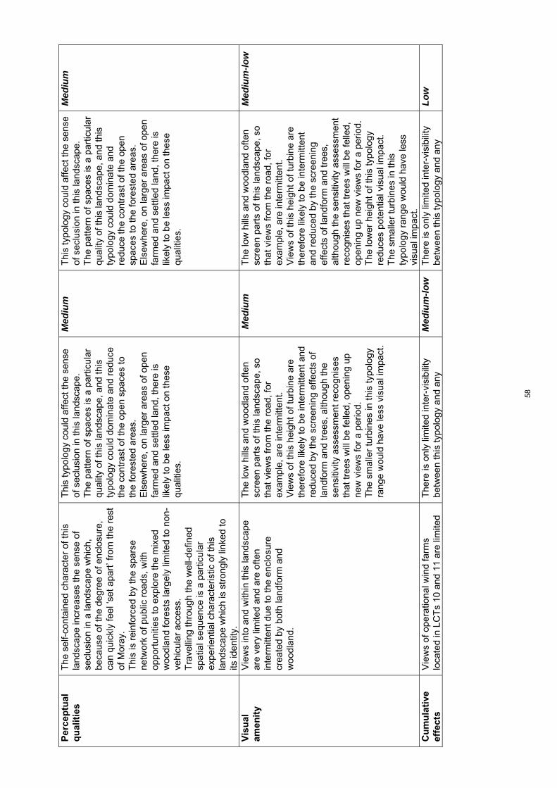
Per
cep
tual
q
ual
itie
s T
he s
elf-
cont
aine
d ch
arac
ter
of th
is
land
scap
e in
crea
ses
the
sens
e of
se
clus
ion
in a
land
scap
e w
hich
, be
caus
e of
the
degr
ee o
f enc
losu
re,
can
quic
kly
feel
‘set
apa
rt’ f
rom
the
rest
of
Mor
ay.
Thi
s is
rei
nfor
ced
by th
e sp
arse
ne
twor
k of
pub
lic r
oads
, with
op
port
uniti
es to
exp
lore
the
mix
ed
woo
dlan
d fo
rest
s la
rgel
y lim
ited
to n
on-
vehi
cula
r ac
cess
. T
rave
lling
thro
ugh
the
wel
l-def
ined
sp
atia
l seq
uenc
e is
a p
artic
ular
ex
perie
ntia
l cha
ract
eris
tic o
f thi
s la
ndsc
ape
whi
ch is
str
ongl
y lin
ked
to
its id
entit
y.
Thi
s ty
polo
gy c
ould
affe
ct th
e se
nse
of s
eclu
sion
in th
is la
ndsc
ape.
T
he p
atte
rn o
f spa
ces
is a
par
ticul
ar
qual
ity o
f thi
s la
ndsc
ape,
and
this
ty
polo
gy c
ould
dom
inat
e an
d re
duce
th
e co
ntra
st o
f the
ope
n sp
aces
to
the
fore
sted
are
as.
Els
ewhe
re, o
n la
rger
are
as o
f ope
n fa
rmed
and
set
tled
land
, the
re is
lik
ely
to b
e le
ss im
pact
on
thes
e qu
aliti
es.
Med
ium
T
his
typo
logy
cou
ld a
ffect
the
sens
e of
sec
lusi
on in
this
land
scap
e.
The
pat
tern
of s
pace
s is
a p
artic
ular
qu
ality
of t
his
land
scap
e, a
nd th
is
typo
logy
cou
ld d
omin
ate
and
redu
ce th
e co
ntra
st o
f the
ope
n sp
aces
to th
e fo
rest
ed a
reas
. E
lsew
here
, on
larg
er a
reas
of o
pen
farm
ed a
nd s
ettle
d la
nd, t
here
is
likel
y to
be
less
impa
ct o
n th
ese
qual
ities
.
Med
ium
Vis
ual
am
enit
y
Vie
ws
into
and
with
in th
is la
ndsc
ape
are
very
lim
ited
and
are
ofte
n in
term
itten
t due
to th
e en
clos
ure
crea
ted
by b
oth
land
form
and
w
oodl
and.
The
low
hill
s an
d w
oodl
and
ofte
n sc
reen
par
ts o
f thi
s la
ndsc
ape,
so
that
vie
ws
from
the
road
, for
ex
ampl
e, a
re in
term
itten
t.
Vie
ws
of th
is h
eigh
t of t
urbi
ne a
re
ther
efor
e lik
ely
to b
e in
term
itten
t and
re
duce
d by
the
scre
enin
g ef
fect
s of
la
ndfo
rm a
nd tr
ees,
alth
ough
the
sens
itivi
ty a
sses
smen
t rec
ogni
ses
that
tree
s w
ill b
e fe
lled,
ope
ning
up
new
vie
ws
for
a pe
riod.
T
he s
mal
ler
turb
ines
in th
is ty
polo
gy
rang
e w
ould
hav
e le
ss v
isua
l im
pact
.
Med
ium
T
he lo
w h
ills
and
woo
dlan
d of
ten
scre
en p
arts
of t
his
land
scap
e, s
o th
at v
iew
s fr
om th
e ro
ad, f
or
exam
ple,
are
inte
rmitt
ent.
V
iew
s of
this
hei
ght o
f tur
bine
are
th
eref
ore
likel
y to
be
inte
rmitt
ent
and
redu
ced
by th
e sc
reen
ing
effe
cts
of la
ndfo
rm a
nd tr
ees,
al
thou
gh th
e se
nsiti
vity
ass
essm
ent
reco
gnis
es th
at tr
ees
will
be
felle
d,
open
ing
up n
ew v
iew
s fo
r a
perio
d.
The
low
er h
eigh
t of t
his
typo
logy
re
duce
s po
tent
ial v
isua
l im
pact
. T
he s
mal
ler
turb
ines
in th
is
typo
logy
ran
ge w
ould
hav
e le
ss
visu
al im
pact
.
Med
ium
-low
Cu
mu
lati
ve
effe
cts
Vie
ws
of o
pera
tiona
l win
d fa
rms
loca
ted
in L
CT
s 10
and
11
are
limite
d T
here
is o
nly
limite
d in
ter-
visi
bilit
y be
twee
n th
is ty
polo
gy a
nd a
ny
Med
ium
-low
T
here
is o
nly
limite
d in
ter-
visi
bilit
y be
twee
n th
is ty
polo
gy a
nd a
ny
Low
58

from
with
in th
is e
nclo
sed
land
scap
e.
The
four
turb
ines
at F
indh
orn
in th
e C
oast
al fa
rmla
nd (
4) c
an b
e se
en fr
om
som
e lo
catio
ns a
nd th
e co
nsen
ted
Hill
of
Gla
schy
le w
ind
farm
loca
ted
in th
e U
plan
d M
oorla
nd a
nd F
ores
try
(10)
will
be
vis
ible
from
mor
e op
en a
reas
.
deve
lopm
ent i
n ne
ighb
ourin
g LC
Ts.
C
umul
ativ
e ef
fect
s w
ith th
e co
nsen
ted
Hill
of G
lasc
hyle
win
d fa
rm c
ould
be
avoi
ded
by c
aref
ul
sitin
g.
deve
lopm
ent i
n ne
ighb
ourin
g LC
Ts
– th
is s
ize
of tu
rbin
e w
ould
be
less
lik
ely
to in
cur
cum
ulat
ive
effe
cts
with
any
vis
ible
win
d fa
rms
site
d w
ithin
adj
acen
t lan
dsca
pes.
59

Cha
ract
er T
ype
6: N
arro
w W
oode
d Va
lleys
– S
ensi
tivity
ass
essm
ent f
or la
rge
and
med
ium
typo
logi
es
To
pic
S
um
mar
y d
escr
ipti
on
Ass
essm
ent
of
larg
e ty
po
log
y (8
0m-1
30m
) S
ensi
tivi
ty
rati
ng
A
sses
smen
t o
f m
ediu
mty
po
log
y (5
0m-8
0m)
Sen
siti
vity
ra
tin
g
Lan
dsc
ape
con
text
The
se n
arro
w d
eepl
y in
cise
d va
lleys
ar
e re
lativ
ely
self-
cont
aine
d. T
he
Rol
ling
Far
mla
nd a
nd F
ores
ts w
ith L
ow
Hill
s (5
b) fo
rms
the
imm
edia
te s
kylin
e ei
ther
sid
e of
thes
e va
lleys
whi
le th
e U
plan
d M
oorla
nd a
nd F
ores
try
(10)
an
d O
pen
Rol
ling
Upl
ands
(11
) al
so
abut
the
sout
h-ea
ster
n co
rner
of t
his
land
scap
e.
Thi
s LC
T, e
spec
ially
to th
e so
uth,
is
over
look
ed fr
om h
igh
poin
ts, i
nclu
ding
th
e K
nock
of B
raem
oray
and
is in
ter-
visi
ble
with
the
low
wes
tern
hill
s of
the
Upl
and
Moo
rland
and
For
estr
y (1
0).
The
woo
ded
char
acte
r of
this
la
ndsc
ape
mer
ges
with
the
adja
cent
R
ollin
g F
arm
land
and
For
ests
with
Low
H
ills
(5b)
, and
the
valle
y its
elf e
xten
ds
into
nei
ghbo
urin
g N
airn
. Thi
s la
ndsc
ape
form
s a
key
‘gat
eway
’ to
Mor
ay fr
om th
e so
uth
expe
rienc
ed
from
the
A94
0 w
hich
ext
ends
ove
r th
e dr
amat
ic o
pen
expa
nse
of th
e D
ava
Moo
r be
fore
des
cend
ing
into
the
richl
y w
oode
d va
lleys
of t
he D
orba
ck B
urn
and
Fin
dhor
n.
Thi
s la
ndsc
ape
char
acte
r ty
pe is
re
lativ
ely
self-
cont
aine
d, w
ith v
iew
s in
to th
is ty
pe fr
om n
eigh
bour
ing
LCT
s lim
ited
by w
oodl
and,
alth
ough
hig
her
hills
on
adja
cent
type
s to
the
sout
h ov
erlo
ok th
is lo
w-ly
ing
char
acte
r ty
pe. T
he s
mal
l ext
ent o
f thi
s ch
arac
ter
type
wou
ld b
e qu
ickl
y do
min
ated
by
this
typo
logy
. T
urbi
nes
of th
is s
ize
wou
ld a
lso
impa
ct o
n th
e ap
proa
ch a
nd s
ense
of
arriv
al to
Mor
ay.
Hig
h-M
ediu
m
Thi
s la
ndsc
ape
char
acte
r ty
pe is
re
lativ
ely
self-
cont
aine
d, w
ith v
iew
s in
to th
is ty
pe fr
om n
eigh
bour
ing
LCT
s lim
ited
by th
e w
oodl
and,
al
thou
gh h
ighe
r hi
lls o
n ad
jace
nt
type
s to
the
sout
h ov
erlo
ok th
is lo
w-
lyin
g ch
arac
ter
type
. The
sm
all
exte
nt o
f thi
s ty
pe w
ould
be
quic
kly
dom
inat
ed b
y th
is ty
polo
gy.
Tur
bine
s of
this
siz
e w
ould
als
o im
pact
on
the
appr
oach
and
sen
se
of a
rriv
al to
Mor
ay.
Hig
h-M
ediu
m
Sca
le a
nd
o
pen
nes
s
The
sca
le o
f the
land
form
bec
omes
pr
ogre
ssiv
ely
smal
ler
as th
e un
dula
tions
bec
ome
mor
e co
mpl
ex
and
the
valle
y be
com
es n
arro
wer
and
Thi
s si
ze o
f tur
bine
wou
ld im
pact
on
the
smal
l sca
le o
f muc
h of
this
ch
arac
ter
type
. In
part
icul
ar, t
his
typo
logy
wou
ld d
omin
ate
the
low
Hig
h T
his
size
of t
urbi
ne w
ould
impa
ct o
n th
e sm
all s
cale
of m
uch
of th
is
char
acte
r ty
pe. I
n pa
rtic
ular
, thi
s ty
polo
gy w
ould
dom
inat
e th
e lo
w
Hig
h
60

mor
e en
clos
ed, c
lose
r to
the
river
s.
The
med
ium
to s
mal
l sca
le o
f the
to
pogr
aphy
is r
einf
orce
d by
the
low
re
lief,
with
land
form
gen
eral
ly
undu
latin
g be
twee
n 10
0m a
nd 1
50m
in
elev
atio
n, a
lthou
gh it
is lo
wer
to th
e no
rth.
Woo
dlan
d cr
eate
s co
nsid
erab
le
cont
ainm
ent r
educ
ing
the
scal
e of
the
expe
rienc
e of
this
land
scap
e an
d op
en
area
s of
farm
land
with
in w
oodl
and
are
smal
l. T
rees
and
bui
ldin
gs p
rovi
de
cons
iste
nt r
efer
ence
poi
nts
agai
nst
whi
ch s
ize
of tu
rbin
es c
an b
e ju
dged
.
relie
f, th
e sm
all s
cale
land
form
and
th
e op
en s
pace
s w
ithin
this
la
ndsc
ape.
T
he c
onsi
sten
t pre
senc
e of
sm
all
feat
ures
– in
clud
ing
tree
s an
d bu
ildin
gs –
wou
ld m
ake
it di
fficu
lt to
ac
com
mod
ate
this
siz
e of
typo
logy
w
ithou
t it d
omin
atin
g th
ese
feat
ures
.
relie
f, th
e sm
all s
cale
land
form
and
th
e op
en s
pace
s w
ithin
this
la
ndsc
ape.
T
he c
onsi
sten
t pre
senc
e of
sm
all
feat
ures
– in
clud
ing
tree
s an
d bu
ildin
gs –
wou
ld m
ake
it di
fficu
lt to
ac
com
mod
ate
this
siz
e of
typo
logy
w
ithou
t it d
omin
atin
g th
ese
feat
ures
.
Lan
dfo
rm
La
ndfo
rm is
par
ticul
arly
com
plex
at t
he
conj
unct
ion
of th
e riv
ers
and
trib
utar
ies
with
ste
ep s
lope
s an
d in
cise
d ro
cky
gorg
es. V
alle
y si
des
are
undu
latin
g bu
t, in
pla
ces
inte
rlock
ing
and
com
plex
, with
occ
asio
nal m
ore
gent
ly
slop
ing
field
s on
the
shou
lder
s of
the
valle
y.
The
irre
gula
r an
d sm
all s
cale
la
ndfo
rms
and
stee
p si
ded
river
va
lleys
and
thei
r im
med
iate
set
ting
are
all s
ensi
tive
to th
is ty
pol
ogy.
La
rger
turb
ines
wou
ld d
etra
ct fr
om
com
plex
and
dra
mat
ic la
ndfo
rm
feat
ures
eve
n if
site
d on
mor
e ge
ntly
sl
opin
g up
per
slop
es.
Hig
h T
he ir
regu
lar
and
smal
l sca
le
land
form
s an
d st
eep
side
d riv
er
valle
ys a
nd th
eir
imm
edia
te s
ettin
g ar
e al
l sen
sitiv
e to
this
typ
olog
y.
Larg
er tu
rbin
es w
ould
det
ract
from
co
mpl
ex a
nd d
ram
atic
land
form
fe
atur
es e
ven
if si
ted
on m
ore
gent
ly s
lopi
ng u
pper
slo
pes.
Hig
h
Lan
dsc
ape
pat
tern
Thi
s la
ndsc
ape
is s
tron
gly
char
acte
rised
by
the
varie
ty o
f w
oodl
and,
whi
ch r
ange
s fr
om
exte
nsiv
e pi
ne fo
rest
of d
iffer
ent a
ges,
to
rip
aria
n w
oodl
and
and
polic
ies.
T
he w
oodl
and
alte
rnat
es w
ith
culti
vate
d an
d gr
azed
fiel
ds, s
ome
of
whi
ch a
re r
elat
ivel
y sm
all p
ocke
ts a
nd
som
e of
whi
ch a
re la
rger
mor
e ex
tens
ive
area
s of
ope
n fie
lds.
T
hese
ope
n sp
aces
are
freq
uent
ly
irreg
ular
in s
hape
, inc
reas
ing
the
sens
e of
inte
rlock
. The
riv
ers
are
a
The
div
ersi
ty o
f the
pat
tern
of
vege
tatio
n an
d th
e im
port
ance
of t
he
open
spa
ces
with
in th
e w
oodl
and
limits
opp
ortu
nitie
s fo
r th
is ty
polo
gy,
whi
ch w
ould
qui
ckly
dom
inat
e th
e se
nse
of o
penn
ess
with
in th
e sp
aces
. T
he in
tegr
ity o
f the
pol
icy
woo
dlan
d,
and
the
setti
ng o
f the
dra
mat
ic
gorg
es a
nd th
eir
woo
ded
surr
ound
ings
is a
dditi
onal
ly s
ensi
tive.
Hig
h T
he d
iver
sity
of t
he p
atte
rn o
f ve
geta
tion
and
the
impo
rtan
ce o
f th
e op
en s
pace
s w
ithin
the
woo
dlan
d lim
its o
ppor
tuni
ties
for
this
typo
logy
, whi
ch w
ould
qui
ckly
do
min
ate
the
sens
e of
ope
nnes
s w
ithin
the
spac
es.
The
inte
grity
of t
he p
olic
y w
oodl
and,
and
the
setti
ng o
f the
dr
amat
ic g
orge
s an
d th
eir
woo
ded
surr
ound
ings
is a
dditi
onal
ly
sens
itive
.
Hig
h
61

part
icul
ar fe
atur
e, fo
rmin
g si
nuou
s an
d w
ell-d
efin
ed g
orge
s w
ith s
teep
sid
es
clot
hed
with
bro
adle
aved
woo
dlan
d.
Fea
ture
tree
s ar
e as
soci
ated
with
so
me
of th
e po
licy
woo
ds a
nd
desi
gned
land
scap
es.
Bu
ilt
envi
ron
men
t
Thi
s la
ndsc
ape
is n
ot e
xten
sive
ly
settl
ed, w
ith fa
rms
and
hous
es
gene
rally
loca
ted
at th
e ed
ge o
f the
op
en s
pace
s ov
erlo
okin
g th
e fie
lds.
H
isto
ric h
ouse
s –
such
as
Logi
e an
d R
elug
as a
re s
tron
gly
asso
ciat
ed w
ith
the
river
val
leys
, ofte
n lo
cate
d to
ov
erlo
ok d
ram
atic
str
etch
es o
f gor
ge.
The
re a
re a
dditi
onal
bui
ldin
gs a
nd b
uilt
feat
ures
ass
ocia
ted
with
thes
e es
tate
s,
incl
udin
g th
e br
idge
at R
elug
as.
The
mai
n A
940
exte
nds
thro
ugh
the
east
ern
side
of t
his
char
acte
r ty
pe, i
n pl
aces
ove
rlook
ing
the
stee
p si
ded
river
val
ley.
Som
e of
the
publ
ic a
nd
priv
ate
road
s ar
e na
rrow
and
win
ding
.
The
sm
all s
ize
of m
any
of th
e ho
uses
an
d fa
rms
are
a co
nstr
aint
as
this
ty
polo
gy is
like
ly to
dom
inat
e th
e sm
all s
ize
of th
e bu
ilt fe
atur
es.
The
his
toric
bui
ldin
gs a
nd th
eir
setti
ngs
are
an a
dditi
onal
sen
sitiv
ity.
Thi
s la
ndsc
ape
type
is h
owev
er n
ot
exte
nsiv
ely
settl
ed a
nd th
ere
may
be
oppo
rtun
ities
to s
ite e
ven
this
siz
e of
tu
rbin
e w
ithou
t im
pact
ing
on th
e im
med
iate
set
ting
of s
ettle
men
ts.
T
he c
hara
cter
of s
ome
of th
e ro
ad
netw
ork
is li
kely
to b
e co
mpr
omis
ed
by im
prov
emen
ts to
acc
omm
odat
e la
rge
vehi
cles
req
uire
d to
tran
spor
t th
is ty
polo
gy. I
t is
also
unl
ikel
y th
at
larg
e ve
hicl
es c
ould
neg
otia
te th
e hi
stor
ic b
ridge
s.
Hig
h-m
ediu
m
The
sm
all s
ize
of m
any
of t
he
hous
es a
nd fa
rms
are
a co
nstr
aint
as
this
typo
logy
is li
kely
to d
omin
ate
the
smal
l siz
e of
the
built
feat
ures
. T
he h
isto
ric b
uild
ings
and
thei
r se
tting
s ar
e an
add
ition
al
sens
itivi
ty.T
his
land
scap
e ty
pe is
ho
wev
er n
ot e
xten
sive
ly s
ettle
d an
d th
ere
may
be
oppo
rtun
ities
to s
ite
even
this
siz
e of
turb
ine
with
out
impa
ctin
g on
the
imm
edia
te s
ettin
g of
set
tlem
ents
. T
he c
hara
cter
of
som
e of
the
road
net
wor
k is
like
ly to
be
com
prom
ised
by
impr
ovem
ents
to
acc
omm
odat
e la
rge
vehi
cles
re
quire
d to
tran
spor
t thi
s ty
polo
gy.
It is
als
o un
likel
y th
at la
rge
vehi
cles
co
uld
nego
tiate
the
hist
oric
brid
ges.
Hig
h-m
ediu
m
Per
cep
tual
q
ual
itie
s T
he m
ore
exte
nsiv
e w
oodl
and
crea
tes
a se
nse
of s
eclu
sion
in th
is la
ndsc
ape
beca
use
of th
e de
gree
of e
nclo
sure
. T
his
is r
einf
orce
d by
the
spar
se
netw
ork
of p
ublic
roa
ds, w
ith
oppo
rtun
ities
to e
xplo
re th
e fo
rest
s la
rgel
y lim
ited
to n
on-v
ehic
ular
acc
ess.
T
he m
ost s
trik
ing
feat
ures
are
the
stee
p-si
ded
river
val
leys
, whi
ch a
re
dram
atic
and
nat
ural
istic
in c
hara
cter
.
Thi
s ty
polo
gy c
ould
affe
ct th
e se
nse
of s
eclu
sion
in th
is la
ndsc
ape,
and
th
e se
nse
of n
atur
alne
ss a
nd d
ram
a as
soci
ated
with
the
river
gor
ges.
T
he s
eque
ntia
l pat
tern
of s
pace
s is
a
qual
ity o
f thi
s la
ndsc
ape
and
this
ty
polo
gy c
ould
eas
ily d
omin
ate
the
open
spa
ces
and
redu
ce th
e co
ntra
st
betw
een
the
open
spa
ces
and
the
fore
sted
are
as
Hig
h-m
ediu
m
Thi
s ty
polo
gy c
ould
affe
ct th
e se
nse
of s
eclu
sion
in th
is la
ndsc
ape,
and
th
e se
nse
of n
atur
alne
ss a
nd
dram
a as
soci
ated
with
the
river
go
rges
. T
he s
eque
ntia
l pat
tern
of s
pace
s is
a
qual
ity o
f thi
s la
ndsc
ape
and
this
ty
polo
gy c
ould
eas
ily d
omin
ate
the
open
spa
ces
and
redu
ce th
e co
ntra
st b
etw
een
the
open
spa
ces
Hig
h-m
ediu
m
62

Tra
velli
ng th
roug
h th
e se
quen
ce o
f op
en s
pace
s an
d w
oodl
and
is a
key
ex
perie
nce
of th
is c
hara
cter
.
an
d th
e fo
rest
ed a
reas
.
Vis
ual
am
enit
y
The
woo
dlan
d lim
its w
ide
visi
bilit
y,
alth
ough
ther
e ar
e vi
ews
from
ope
n sp
aces
to th
e hi
gher
gro
und
in th
e ad
jace
nt U
plan
d M
oorla
nd a
nd
For
estr
y (1
0). T
he o
ccas
iona
l lon
g vi
ews,
esp
ecia
lly to
the
pron
ounc
ed
hills
of O
pen
Rol
ling
Upl
ands
(11
) an
d th
e K
nock
of B
raem
oray
, a la
ndm
ark
hill,
at t
he s
outh
ern
end
of th
e va
lley,
ar
e un
expe
cted
and
rev
elat
ory.
V
iew
s w
ithin
this
land
scap
e ty
pe a
re
part
ly li
mite
d an
d ar
e of
ten
inte
rmitt
ent
due
to th
e en
clos
ure
crea
ted
prim
arily
by
woo
dlan
d, b
ut a
lso
cont
ainm
ent
crea
ted
by la
ndfo
rm a
long
the
spin
e of
th
e riv
er v
alle
ys.
Vie
ws
alon
g th
e riv
ers;
from
brid
ges
and
acce
ss r
oute
s; to
and
from
the
hist
oric
bui
ldin
gs; a
nd fr
om th
e A
940,
in
clud
ing
the
arriv
al in
to M
oray
, are
all
impo
rtan
t.
The
woo
dlan
d of
ten
scre
ens
part
s of
th
is la
ndsc
ape,
so
that
vie
ws
from
th
e A
940,
for
exam
ple,
are
in
term
itten
t.
How
ever
, the
hei
ght o
f thi
s ty
polo
gy
mea
ns th
at it
is li
kely
to a
ppea
r ab
ove
man
y of
thes
e sm
alle
r fe
atur
es, o
r en
croa
ch u
pon
the
setti
ng o
f key
vis
ual f
eatu
res
and
may
be
rela
tivel
y w
idel
y an
d co
nsis
tent
ly v
isib
le.
Hig
h-M
ediu
m
The
woo
dlan
d of
ten
scre
ens
part
s of
this
land
scap
e, s
o th
at v
iew
s fr
om th
e A
940,
for
exam
ple,
are
in
term
itten
t.
How
ever
, the
hei
ght o
f thi
s ty
polo
gy
mea
ns th
at it
is li
kely
to a
ppea
r ab
ove
man
y of
thes
e sm
alle
r fe
atur
es, o
r en
croa
ch u
pon
the
setti
ng o
f key
vis
ual f
eatu
res
and
may
be
rela
tivel
y w
idel
y an
d co
nsis
tent
ly v
isib
le.
Hig
h-M
ediu
m
Cu
mu
lati
ve
effe
cts
A s
mal
l sin
gle
turb
ine
is lo
cate
d at
Lo
gie.
The
ope
ratio
nal w
ind
farm
of
Ber
ry B
urn
is p
artia
lly v
isib
le (
at s
ome
dist
ance
) fr
om s
ome
elev
ated
ope
n ar
eas
of th
is c
hara
cter
type
. The
co
nsen
ted
Hill
of G
lasc
hyle
win
d fa
rm
will
als
o be
vis
ible
from
sim
ilar
open
ar
eas
but s
een
at m
uch
clos
er
dist
ance
s.
Cum
ulat
ive
effe
cts
wou
ld p
rinci
pally
ar
ise
on v
iew
s fr
om o
pen
farm
land
an
d on
vie
ws
from
the
A94
0 w
hich
fo
rms
an im
port
ant s
ceni
c ap
proa
ch
to M
oray
. The
lim
ited
exte
nt o
f thi
s ch
arac
ter
type
and
pre
senc
e of
op
erat
iona
l and
con
sent
ed
deve
lopm
ents
see
n on
con
tain
ing
skyl
ines
are
key
con
stra
ints
to th
e la
rge
turb
ines
of t
his
typo
logy
.
Hig
h C
umul
ativ
e ef
fect
s w
ould
prin
cipa
lly
aris
e on
vie
ws
from
ope
n fa
rmla
nd
and
on v
iew
s fr
om th
e A
940
whi
ch
form
s an
impo
rtan
t sce
nic
appr
oach
to
Mor
ay. T
he p
rese
nce
of
oper
atio
nal a
nd c
onse
nted
win
d fa
rm d
evel
opm
ents
, see
n on
co
ntai
ning
sky
lines
, are
key
co
nstr
aint
s to
the
larg
er tu
rbin
es o
f th
is ty
polo
gy.
Hig
h
63

Cha
ract
er T
ype
6: N
arro
w W
oode
d Va
lley
– Se
nsiti
vity
ass
essm
ent f
or s
mal
l-med
ium
and
sm
all t
ypol
ogie
s T
op
ic
Su
mm
ary
des
crip
tio
nA
sses
smen
to
f sm
all-
med
ium
ty
po
log
y (3
5m-5
0m)
Sen
siti
vity
ra
tin
g
Ass
essm
ent
of
smal
ltyp
olo
gy
(20m
-35m
) S
ensi
tivi
ty
rati
ng
L
and
scap
e co
nte
xt
The
se n
arro
w d
eepl
y in
cise
d va
lleys
ar
e re
lativ
ely
self-
cont
aine
d. T
he
Rol
ling
Far
mla
nd a
nd F
ores
ts w
ith L
ow
Hill
s (5
b) fo
rms
the
imm
edia
te s
kylin
e ei
ther
sid
e of
thes
e va
lleys
whi
le th
e U
plan
d M
oorla
nd a
nd F
ores
try
(10)
an
d O
pen
Rol
ling
Upl
ands
(11
) al
so
abut
the
sout
h-ea
ster
n co
rner
of t
his
land
scap
e.
Thi
s LC
T, e
spec
ially
to th
e so
uth,
is
over
look
ed fr
om h
igh
poin
ts, i
nclu
ding
th
e K
nock
of B
raem
oray
and
is in
ter-
visi
ble
with
the
low
wes
tern
hill
s of
the
Upl
and
Moo
rland
and
For
estr
y (1
0).
The
woo
ded
char
acte
r of
this
la
ndsc
ape
mer
ges
with
the
adja
cent
R
ollin
g F
arm
land
and
For
ests
with
Low
H
ills
(5b)
, and
the
valle
y its
elf e
xten
ds
into
nei
ghbo
urin
g N
airn
. Thi
s la
ndsc
ape
form
s a
key
‘gat
eway
’ to
Mor
ay fr
om th
e so
uth
expe
rienc
ed
from
the
A94
0 w
hich
ext
ends
ove
r th
e dr
amat
ic o
pen
expa
nse
of th
e D
ava
Moo
r be
fore
des
cend
ing
into
the
richl
y w
oode
d va
lleys
of t
he D
orba
ck B
urn
and
Fin
dhor
n.
Thi
s la
ndsc
ape
char
acte
r ty
pe is
re
lativ
ely
self-
cont
aine
d, w
ith v
iew
s in
to th
is ty
pe fr
om n
eigh
bour
ing
LCT
s lim
ited
by e
xten
sive
woo
dlan
d.
Whi
le th
e la
ndsc
ape
type
is r
elat
ivel
y sm
all i
n ex
tent
, thi
s ty
polo
gy c
ould
be
loca
ted
in th
e in
terio
r w
ithou
t im
pact
ing
visu
ally
on
adja
cent
la
ndsc
ape
type
s, h
owev
er th
e ap
proa
ch a
nd s
ense
of a
rriv
al to
M
oray
rem
ains
a k
ey c
onte
xtua
l se
nsiti
vity
.
Hig
h-m
ediu
m
Thi
s la
ndsc
ape
char
acte
r ty
pe is
re
lativ
ely
self-
cont
aine
d, w
ith v
iew
s in
to th
is ty
pe fr
om n
eigh
bour
ing
LCT
s lim
ited
by th
e w
oodl
and.
W
hile
the
land
scap
e ty
pe is
re
lativ
ely
smal
l in
exte
nt, t
his
typo
logy
cou
ld b
e lo
cate
d in
the
inte
rior
with
out i
mpa
ctin
g vi
sual
ly
on a
djac
ent l
ands
cape
type
s. T
here
ar
e so
me
oppo
rtun
ities
to s
ite th
is
smal
l typ
olog
y to
min
imis
e im
pact
on
vie
ws
from
the
A94
0.
Med
ium
Sca
le a
nd
o
pen
nes
s
The
sca
le o
f the
land
form
bec
omes
pr
ogre
ssiv
ely
smal
ler
as th
e un
dula
tions
bec
ome
mor
e co
mpl
ex
and
the
valle
y be
com
es n
arro
wer
and
Thi
s si
ze o
f tur
bine
wou
ld im
pact
on
the
smal
l sca
le o
f muc
h of
this
ch
arac
ter
type
. In
par
ticul
ar, t
his
typo
logy
wou
ld
Hig
h T
his
size
of t
urbi
ne m
ight
impa
ct o
n th
e sm
all s
cale
of s
ome
of th
e m
ore
intim
atel
y sc
aled
are
as o
f thi
s ch
arac
ter
type
.
Hig
h-m
ediu
m
64
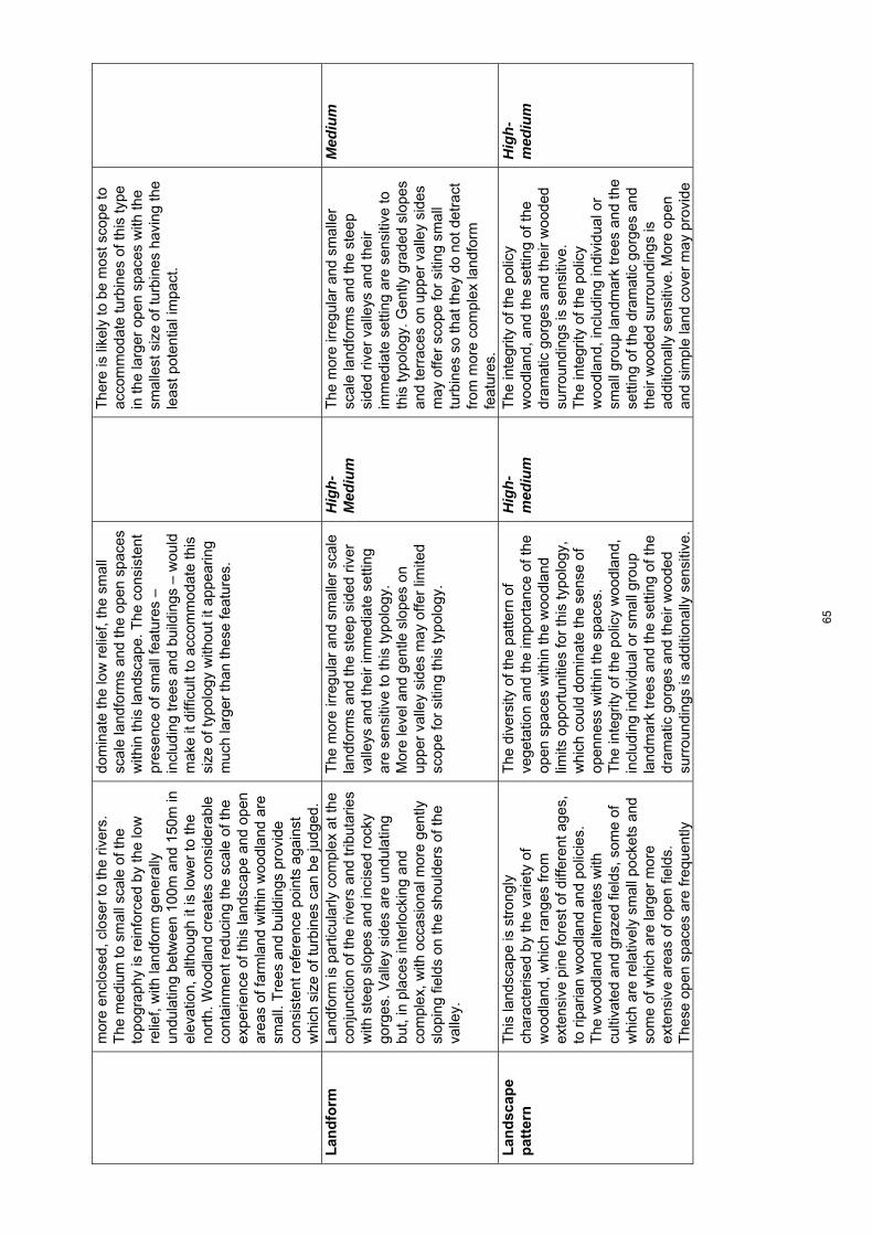
mor
e en
clos
ed, c
lose
r to
the
river
s.
The
med
ium
to s
mal
l sca
le o
f the
to
pogr
aphy
is r
einf
orce
d by
the
low
re
lief,
with
land
form
gen
eral
ly
undu
latin
g be
twee
n 10
0m a
nd 1
50m
in
elev
atio
n, a
lthou
gh it
is lo
wer
to th
e no
rth.
Woo
dlan
d cr
eate
s co
nsid
erab
le
cont
ainm
ent r
educ
ing
the
scal
e of
the
expe
rienc
e of
this
land
scap
e an
d op
en
area
s of
farm
land
with
in w
oodl
and
are
smal
l. T
rees
and
bui
ldin
gs p
rovi
de
cons
iste
nt r
efer
ence
poi
nts
agai
nst
whi
ch s
ize
of tu
rbin
es c
an b
e ju
dged
.
dom
inat
e th
e lo
w r
elie
f, th
e sm
all
scal
e la
ndfo
rms
and
the
open
spa
ces
with
in th
is la
ndsc
ape.
The
con
sist
ent
pres
ence
of s
mal
l fea
ture
s –
incl
udin
g tr
ees
and
build
ings
– w
ould
m
ake
it di
fficu
lt to
acc
omm
odat
e th
is
size
of t
ypol
ogy
with
out i
t app
earin
g m
uch
larg
er th
an th
ese
feat
ures
.
The
re is
like
ly to
be
mos
t sco
pe to
ac
com
mod
ate
turb
ines
of t
his
type
in
the
larg
er o
pen
spac
es w
ith th
e sm
alle
st s
ize
of tu
rbin
es h
avin
g th
e le
ast p
oten
tial i
mpa
ct.
Lan
dfo
rm
La
ndfo
rm is
par
ticul
arly
com
plex
at t
he
conj
unct
ion
of th
e riv
ers
and
trib
utar
ies
with
ste
ep s
lope
s an
d in
cise
d ro
cky
gorg
es. V
alle
y si
des
are
undu
latin
g bu
t, in
pla
ces
inte
rlock
ing
and
com
plex
, with
occ
asio
nal m
ore
gent
ly
slop
ing
field
s on
the
shou
lder
s of
the
valle
y.
The
mor
e irr
egul
ar a
nd s
mal
ler
scal
e la
ndfo
rms
and
the
stee
p si
ded
river
va
lleys
and
thei
r im
med
iate
set
ting
are
sens
itive
to th
is ty
polo
gy.
Mor
e le
vel a
nd g
entle
slo
pes
on
uppe
r va
lley
side
s m
ay o
ffer
limite
d sc
ope
for
sitin
g th
is ty
polo
gy.
Hig
h-M
ediu
m
The
mor
e irr
egul
ar a
nd s
mal
ler
scal
e la
ndfo
rms
and
the
stee
p si
ded
river
val
leys
and
thei
r im
med
iate
set
ting
are
sens
itive
to
this
typo
logy
. Gen
tly g
rade
d sl
opes
an
d te
rrac
es o
n up
per
valle
y si
des
may
offe
r sc
ope
for
sitin
g sm
all
turb
ines
so
that
they
do
not d
etra
ct
from
mor
e co
mpl
ex la
ndfo
rm
feat
ures
.
Med
ium
Lan
dsc
ape
pat
tern
Thi
s la
ndsc
ape
is s
tron
gly
char
acte
rised
by
the
varie
ty o
f w
oodl
and,
whi
ch r
ange
s fr
om
exte
nsiv
e pi
ne fo
rest
of d
iffer
ent a
ges,
to
rip
aria
n w
oodl
and
and
polic
ies.
T
he w
oodl
and
alte
rnat
es w
ith
culti
vate
d an
d gr
azed
fiel
ds, s
ome
of
whi
ch a
re r
elat
ivel
y sm
all p
ocke
ts a
nd
som
e of
whi
ch a
re la
rger
mor
e ex
tens
ive
area
s of
ope
n fie
lds.
T
hese
ope
n sp
aces
are
freq
uent
ly
The
div
ersi
ty o
f the
pat
tern
of
vege
tatio
n an
d th
e im
port
ance
of t
he
open
spa
ces
with
in th
e w
oodl
and
limits
opp
ortu
nitie
s fo
r th
is ty
polo
gy,
whi
ch c
ould
dom
inat
e th
e se
nse
of
open
ness
with
in th
e sp
aces
. T
he in
tegr
ity o
f the
pol
icy
woo
dlan
d,
incl
udin
g in
divi
dual
or
smal
l gro
up
land
mar
k tr
ees
and
the
setti
ng o
f the
dr
amat
ic g
orge
s an
d th
eir
woo
ded
surr
ound
ings
is a
dditi
onal
ly s
ensi
tive.
Hig
h-m
ediu
m
The
inte
grity
of t
he p
olic
y w
oodl
and,
and
the
setti
ng o
f the
dr
amat
ic g
orge
s an
d th
eir
woo
ded
surr
ound
ings
is s
ensi
tive.
T
he in
tegr
ity o
f the
pol
icy
woo
dlan
d, in
clud
ing
indi
vidu
al o
r sm
all g
roup
land
mar
k tr
ees
and
the
setti
ng o
f the
dra
mat
ic g
orge
s an
d th
eir
woo
ded
surr
ound
ings
is
addi
tiona
lly s
ensi
tive.
Mor
e op
en
and
sim
ple
land
cov
er m
ay p
rovi
de
Hig
h-m
ediu
m
65
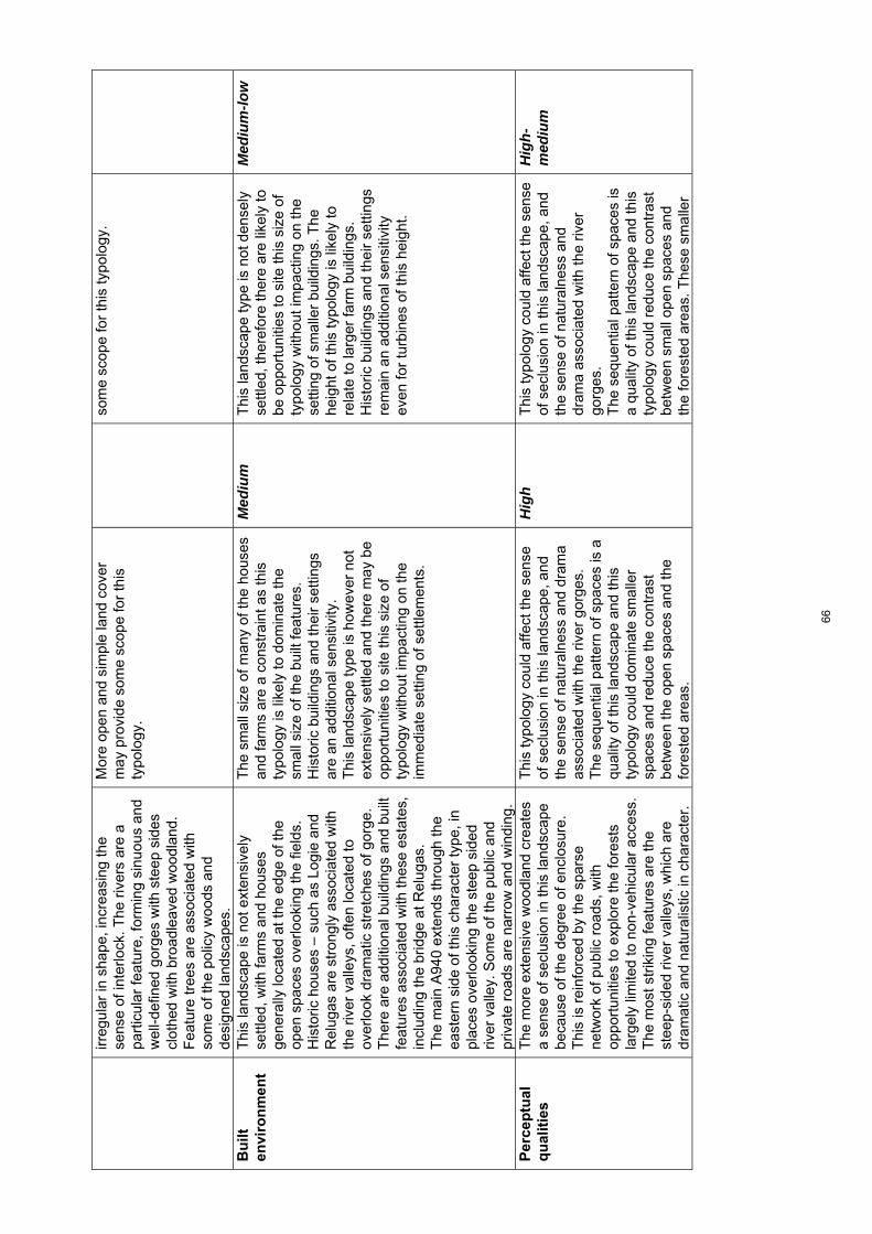
irreg
ular
in s
hape
, inc
reas
ing
the
sens
e of
inte
rlock
. The
riv
ers
are
a pa
rtic
ular
feat
ure,
form
ing
sinu
ous
and
wel
l-def
ined
gor
ges
with
ste
ep s
ides
cl
othe
d w
ith b
road
leav
ed w
oodl
and.
F
eatu
re tr
ees
are
asso
ciat
ed w
ith
som
e of
the
polic
y w
oods
and
de
sign
ed la
ndsc
apes
.
Mor
e op
en a
nd s
impl
e la
nd c
over
m
ay p
rovi
de s
ome
scop
e fo
r th
is
typo
logy
.
som
e sc
ope
for
this
typo
logy
.
Bu
ilt
envi
ron
men
t
Thi
s la
ndsc
ape
is n
ot e
xten
sive
ly
settl
ed, w
ith fa
rms
and
hous
es
gene
rally
loca
ted
at th
e ed
ge o
f the
op
en s
pace
s ov
erlo
okin
g th
e fie
lds.
H
isto
ric h
ouse
s –
such
as
Logi
e an
d R
elug
as a
re s
tron
gly
asso
ciat
ed w
ith
the
river
val
leys
, ofte
n lo
cate
d to
ov
erlo
ok d
ram
atic
str
etch
es o
f gor
ge.
The
re a
re a
dditi
onal
bui
ldin
gs a
nd b
uilt
feat
ures
ass
ocia
ted
with
thes
e es
tate
s,
incl
udin
g th
e br
idge
at R
elug
as.
The
mai
n A
940
exte
nds
thro
ugh
the
east
ern
side
of t
his
char
acte
r ty
pe, i
n pl
aces
ove
rlook
ing
the
stee
p si
ded
river
val
ley.
Som
e of
the
publ
ic a
nd
priv
ate
road
s ar
e na
rrow
and
win
ding
.
The
sm
all s
ize
of m
any
of th
e ho
uses
an
d fa
rms
are
a co
nstr
aint
as
this
ty
polo
gy is
like
ly to
dom
inat
e th
e sm
all s
ize
of th
e bu
ilt fe
atur
es.
His
toric
bui
ldin
gs a
nd th
eir
setti
ngs
are
an a
dditi
onal
sen
sitiv
ity.
Thi
s la
ndsc
ape
type
is h
owev
er n
ot
exte
nsiv
ely
settl
ed a
nd th
ere
may
be
oppo
rtun
ities
to s
ite th
is s
ize
of
typo
logy
with
out i
mpa
ctin
g on
the
imm
edia
te s
ettin
g of
set
tlem
ents
.
Med
ium
T
his
land
scap
e ty
pe is
not
den
sely
se
ttled
, the
refo
re th
ere
are
likel
y to
be
opp
ortu
nitie
s to
site
this
siz
e of
ty
polo
gy w
ithou
t im
pact
ing
on th
e se
tting
of s
mal
ler
build
ings
. The
he
ight
of t
his
typo
logy
is li
kely
to
rela
te to
larg
er fa
rm b
uild
ings
. H
isto
ric b
uild
ings
and
thei
r se
tting
s re
mai
n an
add
ition
al s
ensi
tivity
ev
en fo
r tu
rbin
es o
f thi
s he
ight
.
Med
ium
-low
Per
cep
tual
q
ual
itie
s T
he m
ore
exte
nsiv
e w
oodl
and
crea
tes
a se
nse
of s
eclu
sion
in th
is la
ndsc
ape
beca
use
of th
e de
gree
of e
nclo
sure
. T
his
is r
einf
orce
d by
the
spar
se
netw
ork
of p
ublic
roa
ds, w
ith
oppo
rtun
ities
to e
xplo
re th
e fo
rest
s la
rgel
y lim
ited
to n
on-v
ehic
ular
acc
ess.
T
he m
ost s
trik
ing
feat
ures
are
the
stee
p-si
ded
river
val
leys
, whi
ch a
re
dram
atic
and
nat
ural
istic
in c
hara
cter
.
Thi
s ty
polo
gy c
ould
affe
ct th
e se
nse
of s
eclu
sion
in th
is la
ndsc
ape,
and
th
e se
nse
of n
atur
alne
ss a
nd d
ram
a as
soci
ated
with
the
river
gor
ges.
T
he s
eque
ntia
l pat
tern
of s
pace
s is
a
qual
ity o
f thi
s la
ndsc
ape
and
this
ty
polo
gy c
ould
dom
inat
e sm
alle
r sp
aces
and
red
uce
the
cont
rast
be
twee
n th
e op
en s
pace
s an
d th
e fo
rest
ed a
reas
.
Hig
h T
his
typo
logy
cou
ld a
ffect
the
sens
e of
sec
lusi
on in
this
land
scap
e, a
nd
the
sens
e of
nat
ural
ness
and
dr
ama
asso
ciat
ed w
ith th
e riv
er
gorg
es.
The
seq
uent
ial p
atte
rn o
f spa
ces
is
a qu
ality
of t
his
land
scap
e an
d th
is
typo
logy
cou
ld r
educ
e th
e co
ntra
st
betw
een
smal
l ope
n sp
aces
and
th
e fo
rest
ed a
reas
. The
se s
mal
ler
Hig
h-m
ediu
m
66
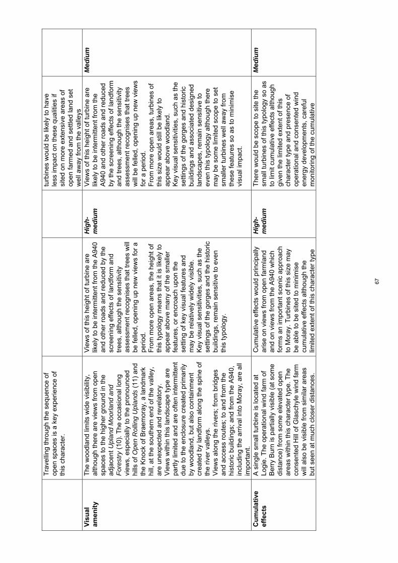
Tra
velli
ng th
roug
h th
e se
quen
ce o
f op
en s
pace
s is
a k
ey e
xper
ienc
e of
th
is c
hara
cter
.
tu
rbin
es w
ould
be
likel
y to
hav
e le
ss im
pact
on
thes
e qu
aliti
es if
si
ted
on m
ore
exte
nsiv
e ar
eas
of
open
farm
ed a
nd s
ettle
d la
nd s
et
wel
l aw
ay fr
om th
e va
lleys
V
isu
al
amen
ity
The
woo
dlan
d lim
its w
ide
visi
bilit
y,
alth
ough
ther
e ar
e vi
ews
from
ope
n sp
aces
to th
e hi
gher
gro
und
in th
e ad
jace
nt U
plan
d M
oorla
nd a
nd
For
estr
y (1
0). T
he o
ccas
iona
l lon
g vi
ews,
esp
ecia
lly to
the
pron
ounc
ed
hills
of O
pen
Rol
ling
Upl
ands
(11
) an
d th
e K
nock
of B
raem
oray
, a la
ndm
ark
hill,
at t
he s
outh
ern
end
of th
e va
lley,
ar
e un
expe
cted
and
rev
elat
ory.
V
iew
s w
ithin
this
land
scap
e ty
pe a
re
part
ly li
mite
d an
d ar
e of
ten
inte
rmitt
ent
due
to th
e en
clos
ure
crea
ted
prim
arily
by
woo
dlan
d, b
ut a
lso
cont
ainm
ent
crea
ted
by la
ndfo
rm a
long
the
spin
e of
th
e riv
er v
alle
ys.
Vie
ws
alon
g th
e riv
ers;
from
brid
ges
and
acce
ss r
oute
s; to
and
from
the
hist
oric
bui
ldin
gs; a
nd fr
om th
e A
940,
in
clud
ing
the
arriv
al in
to M
oray
, are
all
impo
rtan
t.
Vie
ws
of th
is h
eigh
t of t
urbi
ne a
re
likel
y to
be
inte
rmitt
ent f
rom
the
A94
0 an
d ot
her
road
s an
d re
duce
d by
the
scre
enin
g ef
fect
s of
land
form
and
tr
ees,
alth
ough
the
sens
itivi
ty
asse
ssm
ent r
ecog
nise
s th
at tr
ees
will
be
felle
d, o
peni
ng u
p ne
w v
iew
s fo
r a
perio
d.
Fro
m m
ore
open
are
as, t
he h
eigh
t of
this
typo
logy
mea
ns th
at it
is li
kely
to
appe
ar a
bove
man
y of
the
smal
ler
feat
ures
, or
encr
oach
upo
n th
e se
tting
of k
ey v
isua
l fea
ture
s an
d m
ay b
e re
lativ
ely
wid
ely
visi
ble.
K
ey v
isua
l sen
sitiv
ities
, suc
h as
the
setti
ngs
of th
e go
rges
and
the
hist
oric
bu
ildin
gs, r
emai
n se
nsiti
ve to
eve
n th
is ty
polo
gy.
Hig
h-m
ediu
m
Vie
ws
of th
is h
eigh
t of t
urbi
ne a
re
likel
y to
be
inte
rmitt
ent f
rom
the
A94
0 an
d ot
her
road
s an
d re
duce
d by
the
scre
enin
g ef
fect
s of
land
form
an
d tr
ees,
alth
ough
the
sens
itivi
ty
asse
ssm
ent r
ecog
nise
s th
at tr
ees
will
be
felle
d, o
peni
ng u
p ne
w v
iew
s fo
r a
perio
d.
Fro
m m
ore
open
are
as, t
urbi
nes
of
this
siz
e w
ould
stil
l be
likel
y to
ap
pear
abo
ve w
oodl
and.
K
ey v
isua
l sen
sitiv
ities
, suc
h as
the
setti
ngs
of th
e go
rges
and
his
toric
bu
ildin
gs a
nd a
ssoc
iate
d de
sign
ed
land
scap
es, r
emai
n se
nsiti
ve to
ev
en th
is ty
polo
gy a
lthou
gh th
ere
may
be
som
e lim
ited
scop
e to
set
sm
alle
r tu
rbin
es w
ell a
way
from
th
ese
feat
ures
so
as to
min
imis
e vi
sual
impa
ct.
Med
ium
Cu
mu
lati
ve
effe
cts
A s
ingl
e sm
all t
urbi
ne is
loca
ted
at
Logi
e. T
he o
pera
tiona
l win
d fa
rm o
f B
erry
Bur
n is
par
tially
vis
ible
(at
som
e di
stan
ce)
from
som
e el
evat
ed o
pen
area
s w
ithin
this
cha
ract
er ty
pe. T
he
cons
ente
d H
ill o
f Gla
schy
le w
ind
farm
w
ill a
lso
be v
isib
le fr
om s
imila
r ar
eas
but s
een
at m
uch
clos
er d
ista
nces
.
Cum
ulat
ive
effe
cts
wou
ld p
rinci
pally
ar
ise
on v
iew
s fr
om o
pen
farm
land
an
d on
vie
ws
from
the
A94
0 w
hich
fo
rms
an im
port
ant s
ceni
c ap
proa
ch
to M
oray
. Tur
bine
s of
this
siz
e m
ay
be a
ble
to b
e si
ted
to m
inim
ise
cum
ulat
ive
effe
cts
alth
ough
the
limite
d ex
tent
of t
his
char
acte
r ty
pe
Hig
h-m
ediu
m
The
re w
ould
be
scop
e to
site
the
smal
l tur
bine
s of
this
typo
logy
so
as
to li
mit
cum
ulat
ive
effe
cts
alth
ough
gi
ven
the
limite
d ex
tent
of t
his
char
acte
r ty
pe a
nd p
rese
nce
of
oper
atio
nal a
nd c
onse
nted
win
d en
ergy
dev
elop
men
ts, c
aref
ul
mon
itorin
g of
the
cum
ulat
ive
Med
ium
67

and
pres
ence
of o
pera
tiona
l and
co
nsen
ted
deve
lopm
ents
see
n on
co
ntai
ning
sky
lines
are
key
co
nstr
aint
s to
mul
tiple
dev
elop
men
ts
situ
atio
n is
nec
essa
ry.
68

Land
scap
e ch
arac
ter t
ype
7: B
road
Far
med
Val
ley
– Se
nsiti
vity
ass
essm
ent f
or la
rger
typo
logi
es
To
pic
S
um
mar
y d
escr
ipti
on
Lar
ge
scal
e ty
po
log
y as
sess
men
t (8
0-13
0m)
Sen
siti
vity
ra
tin
g
Med
ium
sca
le t
ypo
log
y as
sess
men
t (5
0-80
m)
Sen
siti
vity
ra
tin
g
Lan
dsc
ape
con
text
T
his
char
acte
r ty
pe is
vis
ually
co
ntai
ned
by a
djac
ent u
plan
ds,
limiti
ng it
s in
fluen
ce o
n th
e w
ider
la
ndsc
ape.
How
ever
, whe
re th
ese
upla
nds
form
dis
tinct
ive
high
hill
s w
ith s
teep
slo
pes,
this
can
cre
ate
high
ly s
ceni
c la
ndsc
apes
in th
eir
juxt
apos
ition
and
con
tras
t with
the
richl
y pa
ttern
ed s
ettle
d la
ndsc
apes
of
this
val
ley.
Thi
s no
tabl
y oc
curs
w
here
the
uppe
r S
pey
is b
ack-
drop
ped
by B
en A
igan
, Ben
Rin
nes
and
Pau
l’s H
ill w
hich
all
form
key
‘la
ndm
ark’
feat
ures
.
Alth
ough
the
Bro
ad F
arm
ed V
alle
y (7
) ha
s re
lativ
ely
limite
d in
fluen
ce
on s
urro
undi
ng la
ndsc
apes
, tu
rbin
es o
f thi
s si
ze s
ited
with
in th
is
char
acte
r ty
pe c
ould
det
ract
from
th
e se
tting
of a
djac
ent l
andm
ark
hills
, wou
ld b
e vi
sibl
e fr
om
surr
ound
ing
high
er h
ills
and
coul
d di
min
ish
the
visu
al c
ompo
sitio
n in
ar
eas
whe
re a
ric
h sc
enic
ju
xtap
ositi
on o
ccur
s be
twee
n th
ese
valle
ys a
nd th
e up
land
s.
The
rel
ativ
ely
smal
l ext
ent o
f som
e va
lleys
is a
n ad
ditio
nal s
ensi
tivity
fo
r th
is ty
polo
gy a
s tu
rbin
es o
f thi
s si
ze c
ould
hav
e a
grea
ter
impa
ct o
n ad
jace
nt u
plan
d ch
arac
ter
type
s, fo
r ex
ampl
e th
e st
eep
scar
p sl
opes
of
the
Ope
n U
plan
ds w
ith S
teep
S
lope
s (1
2a)
seen
from
Gle
n R
inne
s.
Med
ium
A
lthou
gh th
e B
road
Far
med
Val
ley
(7)
has
rela
tivel
y lim
ited
influ
ence
on
surr
ound
ing
land
scap
es, t
urbi
nes
of
this
siz
e si
ted
with
in th
is c
hara
cter
ty
pe c
ould
det
ract
from
the
setti
ng o
f ad
jace
nt la
ndm
ark
hills
, wou
ld b
e vi
sibl
e fr
om s
urro
undi
ng h
ighe
r hi
lls
and
coul
d di
min
ish
the
visu
al
com
posi
tion
in a
reas
whe
re a
ric
h sc
enic
juxt
apos
ition
occ
urs
betw
een
thes
e va
lleys
and
the
upla
nds.
T
he r
elat
ivel
y sm
all e
xten
t of s
ome
valle
ys is
an
addi
tiona
l sen
sitiv
ity fo
r th
is ty
polo
gy a
s tu
rbin
es o
f thi
s si
ze
coul
d ha
ve a
gre
ater
impa
ct o
n ad
jace
nt u
plan
d ch
arac
ter
type
s, fo
r ex
ampl
e th
e st
eep
scar
p sl
opes
of t
he
Ope
n U
plan
ds w
ith S
teep
Slo
pes
(12a
) se
en fr
om G
len
Rin
nes.
Med
ium
Sca
le a
nd
o
pen
nes
s
The
Spe
y va
lley
is s
tron
gly
cont
aine
d in
pla
ces
by s
teep
and
pr
edom
inan
tly w
oode
d si
de s
lope
s al
thou
gh it
ope
ns o
ut to
form
a
broa
d flo
odpl
ain
nort
h of
C
raig
ella
chie
. It i
s al
so b
road
er a
nd
mor
e op
en s
outh
-wes
t of A
berlo
ur
whe
re u
ndul
atin
g si
de s
lope
s m
erge
m
ore
grad
ually
with
adj
acen
t up
land
s. T
he S
pey
Val
ley
is w
ell-
woo
ded
and
settl
ed w
ith a
reg
ular
pa
ttern
of f
arm
s an
d ot
her
build
ings
Thi
s ty
polo
gy w
ould
dom
inat
e th
e sm
all t
o m
ediu
m s
cale
of m
uch
of
this
land
scap
e in
clud
ing
the
mor
e op
en fl
at fl
oodp
lain
of t
he S
pey.
The
ev
en d
ispe
rsal
of b
uild
ings
and
ot
her
smal
l fea
ture
s ac
ross
this
w
ell-s
ettle
d la
ndsc
ape
incr
ease
s se
nsiti
vity
to t
urbi
nes
of th
is s
ize.
Hig
h T
his
typo
logy
wou
ld d
omin
ate
the
smal
l to
med
ium
sca
le o
f muc
h of
this
la
ndsc
ape
incl
udin
g th
e m
ore
open
fla
t flo
odpl
ain
of th
e S
pey.
Alth
ough
tu
rbin
es o
f thi
s si
ze c
ould
rel
ate
to
broa
der
sect
ions
of t
he S
pey
Val
ley
on m
ore
open
upp
er v
alle
y si
des
at
the
tran
sitio
n w
ith a
djac
ent u
plan
d ch
arac
ter
type
s, th
e ev
en d
ispe
rsal
of
build
ings
and
oth
er s
mal
l fea
ture
s ac
ross
this
wel
l-set
tled
land
scap
e in
crea
ses
sens
itivi
ty.
Hig
h
69

cont
ribut
ing
to it
s sm
all s
cale
. S
cale
incr
ease
s on
bro
ader
upp
er
slop
es a
t the
tran
sitio
n w
ith th
e U
plan
d M
oorla
nd a
nd F
ores
try
(10)
w
here
set
tlem
ent i
s le
ss d
ense
and
th
e la
nd c
over
pat
tern
mor
e ex
tens
ive.
L
and
form
The
Spe
y V
alle
y ha
s a
flat o
pen
flood
plai
n to
the
nort
h w
hich
the
river
mea
nder
s ac
ross
. The
flo
odpl
ain
narr
ows
in th
e up
per
reac
hes
of th
e S
pey
and
is
occa
sion
ally
con
tain
ed b
y st
eep
scar
p sl
opes
. Rol
ling
low
er s
lope
s st
ep u
p to
a b
road
er m
ore
gent
ly
undu
latin
g el
evat
ed te
rrac
e in
the
Arc
hies
tow
n ar
ea a
nd a
num
ber
of
trib
utar
ies
cut n
arro
w v
alle
ys in
the
uppe
r S
pey
area
. S
mal
l, ro
unde
d hi
lls o
ccur
on
the
edge
of t
he S
pey
Val
ley
and
frin
ging
th
e br
oade
r up
land
LC
Ts
(9),
(10
) an
d (1
1).
Thi
s ty
polo
gy w
ould
det
ract
from
m
ore
dist
inct
ive
land
form
feat
ures
in
clud
ing
mor
e de
eply
inci
sed
sect
ions
of t
he S
pey,
ste
ep s
carp
sl
opes
and
mor
e co
mpl
ex r
ollin
g la
ndfo
rm c
omm
only
foun
d w
ithin
the
valle
y flo
or a
nd lo
wer
slo
pes
of th
e up
per
Spe
y. T
urbi
nes
of th
is s
ize
wou
ld a
lso
detr
act f
rom
the
stro
ng
cont
rast
that
occ
urs
betw
een
the
open
flat
floo
dpla
in a
nd s
teep
co
ntai
ning
sid
e sl
opes
in th
e lo
wer
re
ache
s of
the
Spe
y.
Mor
e ge
ntly
und
ulat
ing
uppe
r sl
opes
at t
he tr
ansi
tion
with
the
Upl
and
Moo
rland
and
For
estr
y (1
0)
wou
ld b
e le
ss s
ensi
tive.
Hig
h-m
ediu
m
Thi
s ty
polo
gy w
ould
det
ract
from
m
ore
dist
inct
ive
land
form
feat
ures
in
clud
ing
mor
e de
eply
inci
sed
sect
ions
of t
he S
pey,
ste
ep s
carp
sl
opes
and
mor
e co
mpl
ex r
ollin
g la
ndfo
rm c
omm
only
foun
d w
ithin
the
valle
y flo
or a
nd lo
wer
slo
pes
of th
e up
per
Spe
y. T
urbi
nes
of th
is s
ize
wou
ld a
lso
detr
act f
rom
the
stro
ng
cont
rast
that
occ
urs
betw
een
the
open
flat
floo
dpla
in a
nd s
teep
co
ntai
ning
sid
e sl
opes
in th
e lo
wer
re
ache
s of
the
Spe
y.
Mor
e ge
ntly
und
ulat
ing
uppe
r sl
opes
at
the
tran
sitio
n w
ith th
e U
plan
d M
oorla
nd a
nd F
ores
try
(10)
wou
ld b
e le
ss s
ensi
tive.
Hig
h-m
ediu
m
Lan
dsc
ape
pat
tern
Thi
s la
ndsc
ape
is c
hara
cter
ised
by
encl
osed
farm
land
(w
ith s
mal
ler
field
s on
low
er s
lope
s), b
road
leav
ed
and
coni
fero
us w
oodl
ands
incl
udin
g di
stin
ctiv
e m
ixed
pol
icy
plan
tings
in
plac
es. T
he o
ften
dive
rse
vege
tatio
n pa
ttern
rei
nfor
ces
the
smal
l sca
le o
f th
is la
ndsc
ape.
Thi
s ty
polo
gy w
ould
det
ract
from
ar
eas
with
a m
ore
dive
rse
land
co
ver
patte
rn a
lthou
gh s
impl
er a
nd
mor
e ex
tens
ive
past
ures
on
uppe
r sl
opes
wou
ld b
e le
ss s
ensi
tive.
Med
ium
T
his
typo
logy
wou
ld d
etra
ct fr
om
area
s w
ith a
mor
e di
vers
e la
nd c
over
pa
ttern
alth
ough
sim
pler
and
mor
e ex
tens
ive
past
ures
on
uppe
r sl
opes
w
ould
be
less
sen
sitiv
e.
Med
ium
Bu
ilt
envi
ron
men
t
A w
ell-s
ettle
d la
ndsc
ape
with
a
regu
lar
patte
rn o
f sm
all t
owns
site
d ne
xt to
the
Spe
y in
clud
ing
Cha
rlest
own
of A
berlo
ur,
Cra
igel
lach
ie a
nd R
othe
s an
d w
ith
Tur
bine
s of
this
siz
e co
uld
affe
ct th
e se
tting
of s
ettle
men
ts a
nd o
ther
hi
stor
ic b
uilt
feat
ures
, inc
ludi
ng
char
acte
ristic
dis
tille
ry b
uild
ings
w
hich
ref
lect
the
regi
on’s
iden
tity.
Hig
h T
urbi
nes
of th
is s
ize
coul
d af
fect
the
setti
ng o
f set
tlem
ents
and
oth
er
hist
oric
bui
lt fe
atur
es a
lthou
gh
sens
itivi
ty w
ould
be
redu
ced
to
turb
ines
tow
ards
the
low
er h
eigh
t
Hig
h-m
ediu
m
70

occa
sion
al s
mal
ler
settl
emen
ts o
n up
per
hill
slop
es a
nd s
ide
valle
ys.
His
toric
hou
ses,
cas
tles,
brid
ges
and
trad
ition
al d
istil
lery
bui
ldin
gs
ofte
n fo
rm r
epea
ted
land
mar
k fe
atur
es w
ithin
thes
e va
lleys
. S
ome
mor
e re
cent
dis
tille
ry
build
ings
hav
e a
mor
e in
dust
rial
appe
aran
ce.
band
of t
his
typo
logy
if s
ited
on le
ss
wel
l-set
tled
uppe
r va
lley
side
s an
d aw
ay fr
om k
ey v
iew
s to
set
tlem
ents
an
d la
ndm
ark
built
feat
ures
.
Per
cep
tual
q
ual
itie
s
Alth
ough
ther
e is
no
pron
ounc
ed
sens
e of
wild
ness
in th
ese
wel
l-se
ttled
and
farm
ed v
alle
ys, a
dis
tinct
se
nse
of p
lace
may
be
asso
ciat
ed
with
the
prod
uctio
n of
whi
sky.
Larg
e tu
rbin
es c
ould
affe
ct th
e se
nse
of p
lace
ass
ocia
ted
with
th
ese
valle
ys a
nd th
eir
whi
sky
herit
age.
Med
ium
La
rge
turb
ines
cou
ld a
ffect
the
stro
ng
sens
e of
pla
ce a
ssoc
iate
d w
ith th
e S
pey
Val
ley
and
its w
hisk
y he
ritag
e.
Med
ium
Vis
ual
am
enit
y
Thi
s is
a w
ell-s
ettle
d la
ndsc
ape
with
a
netw
ork
of r
oads
loca
ted
with
in
the
valle
y flo
or a
nd a
lso
on th
e br
oade
r va
lley
side
s of
the
uppe
r S
pey.
Thi
s va
lley
is w
ell w
oode
d an
d th
is c
an o
ften
scre
en v
iew
s fr
om lo
wer
roa
ds s
uch
as th
e A
95
alth
ough
vie
ws
alon
g th
e va
lley
floor
s fr
om th
e A
941
and
B90
15 a
re
mor
e op
en. T
he S
pey
Val
ley
is
part
icul
arly
attr
activ
e fo
r to
uris
ts a
nd
peop
le e
ngag
ed in
rec
reat
iona
l ac
tiviti
es in
clud
ing
fishi
ng, c
yclin
g an
d w
alki
ng. T
he S
peys
ide
Way
lo
ng d
ista
nce
foot
path
is a
ligne
d th
roug
h th
is c
hara
cter
type
. T
he im
med
iate
sky
line
form
ed b
y up
per
valle
y si
des
and
the
oute
r ed
ge h
ills
and
slop
es o
f the
ad
jace
nt u
plan
d la
ndsc
apes
are
pr
omin
ent f
rom
the
valle
y flo
or b
ut
mor
e ex
pans
ive
view
s ar
e po
ssib
le
from
mor
e el
evat
ed s
ettle
men
ts,
Tur
bine
s of
this
siz
e w
ould
be
high
ly v
isib
le in
vie
ws
acro
ss a
nd
alon
g th
ese
valle
ys fr
om r
oads
and
se
ttlem
ent.
The
y w
ould
als
o be
se
en in
rel
ativ
e pr
oxim
ity f
rom
mor
e el
evat
ed v
iew
s fr
om p
opul
ar h
ill
wal
king
rou
tes
and
also
from
se
ctio
ns o
f the
Spe
ysid
e W
ay. T
he
wel
l-set
tled
natu
re o
f thi
s va
lley
and
its p
opul
arity
for
tour
ism
and
re
crea
tion
incr
ease
s vi
sual
se
nsiti
vity
.
Hig
h T
urbi
nes
of th
is s
ize
wou
ld b
e hi
ghly
vi
sibl
e in
vie
ws
acro
ss a
nd a
long
th
ese
valle
ys fr
om r
oads
and
se
ttlem
ent.
The
y w
ould
als
o be
see
n in
rel
ativ
e pr
oxim
ity fr
om m
ore
elev
ated
vie
ws
from
pop
ular
hill
w
alki
ng r
oute
s an
d al
so fr
om s
ectio
ns
of th
e S
peys
ide
Way
. The
wel
l-set
tled
natu
re o
f thi
s va
lley
and
its p
opul
arity
fo
r to
uris
m a
nd r
ecre
atio
n in
crea
ses
visu
al s
ensi
tivity
.
Hig
h
71
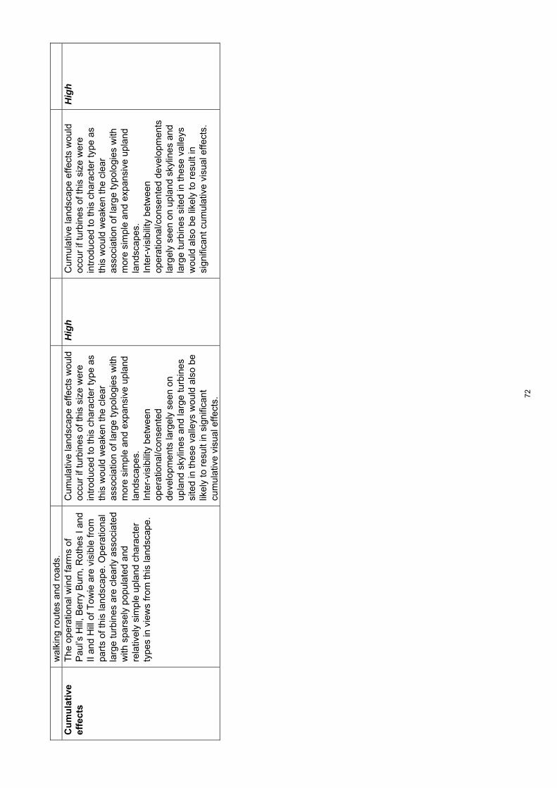
wal
king
rou
tes
and
road
s.
Cu
mu
lati
ve
effe
cts
The
ope
ratio
nal w
ind
farm
s of
P
aul’s
Hill
, Ber
ry B
urn,
Rot
hes
I and
II
and
Hill
of T
owie
are
vis
ible
from
pa
rts
of th
is la
ndsc
ape.
Ope
ratio
nal
larg
e tu
rbin
es a
re c
lear
ly a
ssoc
iate
d w
ith s
pars
ely
popu
late
d an
d re
lativ
ely
sim
ple
upla
nd c
hara
cter
ty
pes
in v
iew
s fr
om th
is la
ndsc
ape.
Cum
ulat
ive
land
scap
e ef
fect
s w
ould
oc
cur
if tu
rbin
es o
f thi
s si
ze w
ere
intr
oduc
ed to
this
cha
ract
er ty
pe a
s th
is w
ould
wea
ken
the
clea
r as
soci
atio
n of
larg
e ty
polo
gies
with
m
ore
sim
ple
and
expa
nsiv
e up
land
la
ndsc
apes
. In
ter-
visi
bilit
y be
twee
n op
erat
iona
l/con
sent
ed
deve
lopm
ents
larg
ely
seen
on
upla
nd s
kylin
es a
nd la
rge
turb
ines
si
ted
in th
ese
valle
ys w
ould
als
o be
lik
ely
to r
esul
t in
sign
ifica
nt
cum
ulat
ive
visu
al e
ffect
s.
Hig
h C
umul
ativ
e la
ndsc
ape
effe
cts
wou
ld
occu
r if
turb
ines
of t
his
size
wer
e in
trod
uced
to th
is c
hara
cter
type
as
this
wou
ld w
eake
n th
e cl
ear
asso
ciat
ion
of la
rge
typo
logi
es w
ith
mor
e si
mpl
e an
d ex
pans
ive
upla
nd
land
scap
es.
Inte
r-vi
sibi
lity
betw
een
oper
atio
nal/c
onse
nted
dev
elop
men
ts
larg
ely
seen
on
upla
nd s
kylin
es a
nd
larg
e tu
rbin
es s
ited
in th
ese
valle
ys
wou
ld a
lso
be li
kely
to r
esul
t in
sign
ifica
nt c
umul
ativ
e vi
sual
effe
cts.
Hig
h
72

Land
scap
e ch
arac
ter t
ype
7: B
road
Far
med
Val
ley
– Se
nsiti
vity
ass
essm
ent f
or s
mal
ler t
ypol
ogie
s To
pic
S
um
mar
y d
escr
ipti
on
Sm
all-
med
ium
sca
le t
ypo
log
y as
sess
men
t (3
5-50
m)
Sen
siti
vity
ra
tin
g
Sm
all
scal
e ty
po
log
y as
sess
men
t (2
0-35
m)
Sen
siti
vity
ra
tin
g
Lan
dsc
ape
con
text
T
his
char
acte
r ty
pe is
vis
ually
co
ntai
ned
by a
djac
ent u
plan
ds,
limiti
ng it
s in
fluen
ce o
n th
e w
ider
la
ndsc
ape.
How
ever
, whe
re th
ese
upla
nds
form
dis
tinct
ive
high
hill
s w
ith s
teep
slo
pes,
this
can
cre
ate
high
ly s
ceni
c la
ndsc
apes
in th
eir
juxt
apos
ition
and
con
tras
t with
the
richl
y pa
ttern
ed s
ettle
d la
ndsc
apes
of
this
val
ley.
Thi
s no
tabl
y oc
curs
w
here
the
uppe
r S
pey
is b
ack-
drop
ped
by B
en A
igan
, Ben
Rin
nes
and
Pau
l’s H
ill w
hich
all
form
key
‘la
ndm
ark’
feat
ures
.
Tur
bine
s of
this
siz
e co
uld
detr
act
from
the
setti
ng o
f adj
acen
t la
ndm
ark
hills
and
vis
ual
com
posi
tion
in a
reas
whe
re a
ric
h sc
enic
juxt
apos
ition
occ
urs
with
the
mor
e dr
amat
ic s
teep
-sid
ed h
ills
of
the
Ope
n R
ollin
g U
plan
ds (
11).
T
his
typo
logy
wou
ld h
ave
less
of a
n ef
fect
in te
rms
of la
ndsc
ape
cont
ext
whe
re th
e va
lley
is b
road
er a
nd
back
ed b
y m
ore
gent
ly u
ndul
atin
g up
land
are
as.
Med
ium
T
his
typo
logy
cou
ld b
e m
ore
easi
ly
acco
mm
odat
ed to
min
imis
e ef
fect
s on
m
ore
dram
atic
sce
nery
and
on
land
mar
k hi
lls.
Med
ium
-low
Sca
le a
nd
o
pen
nes
s
The
Spe
y V
alle
y is
str
ongl
y co
ntai
ned
in p
lace
s by
ste
ep a
nd
pred
omin
antly
woo
ded
side
slo
pes
alth
ough
it o
pens
out
to fo
rm a
br
oad
flood
plai
n no
rth
of
Cra
igel
lach
ie. I
t is
also
bro
ader
and
m
ore
open
sou
th-w
est o
f Abe
rlour
w
here
und
ulat
ing
side
slo
pes
mer
ge
mor
e gr
adua
lly w
ith a
djac
ent
upla
nds.
The
Spe
y V
alle
y is
wel
l-w
oode
d an
d se
ttled
with
a r
egul
ar
patte
rn o
f far
ms
and
othe
r bu
ildin
gs
cont
ribut
ing
to it
s sm
all s
cale
. S
cale
incr
ease
s on
bro
ader
upp
er
slop
es a
t the
tran
sitio
n w
ith th
e U
plan
d M
oorla
nd a
nd F
ores
try
(10)
w
here
set
tlem
ent i
s le
ss d
ense
and
th
e la
nd c
over
pat
tern
mor
e ex
tens
ive.
Thi
s ty
polo
gy w
ould
app
ear
very
la
rge
in r
elat
ion
to th
e sm
all s
cale
of
low
er s
lope
s an
d na
rrow
er v
alle
y flo
ors
and
the
smal
l bui
ldin
gs w
hich
ar
e ev
enly
dis
pers
ed a
cros
s m
uch
of th
is la
ndsc
ape.
The
bro
ader
se
ctio
ns o
f the
Spe
y V
alle
y an
d le
ss
dens
ely
settl
ed u
pper
slo
pes
at th
e tr
ansi
tion
with
the
adja
cent
upl
and
area
s w
ould
be
less
sen
sitiv
e to
tu
rbin
es o
f thi
s si
ze h
owev
er.
Hig
h-m
ed
The
sm
all s
cale
of l
ower
slo
pes
and
narr
ower
and
inci
sed
valle
y flo
ors
wou
ld b
e se
nsiti
ve e
ven
to tu
rbin
es o
f th
is s
ize.
The
re a
re g
reat
er
oppo
rtun
ities
to s
ite th
e sm
alle
r tu
rbin
es o
f thi
s ty
polo
gy w
ithin
this
ch
arac
ter
type
pro
vide
d th
ey w
ere
set
back
from
sm
all b
uild
ings
on
valle
y si
des
and
with
in m
ore
exte
nsiv
e ar
eas
of fa
rmla
nd.
Med
ium
73

Lan
dfo
rm
T
he S
pey
Val
ley
has
a fla
t ope
n flo
odpl
ain
to th
e no
rth
whi
ch th
e riv
er m
eand
ers
acro
ss. T
he
flood
plai
n na
rrow
s in
the
uppe
r re
ache
s of
the
Spe
y an
d is
oc
casi
onal
ly c
onta
ined
by
stee
p sc
arp
slop
es. R
ollin
g lo
wer
slo
pes
step
up
to a
bro
ader
mor
e ge
ntly
un
dula
ting
elev
ated
terr
ace
in th
e A
rchi
esto
wn
area
and
a n
umbe
r of
tr
ibut
arie
s cu
t nar
row
val
leys
in th
e up
per
Spe
y ar
ea.
Sm
all,
roun
ded
hills
occ
ur o
n th
e ed
ge o
f the
Spe
y V
alle
y an
d fr
ingi
ng
the
broa
der
upla
nd L
CT
s (9
), (
10)
and
(11)
.
Bro
ader
, mor
e ge
ntly
und
ulat
ing
valle
y si
des
at th
e tr
ansi
tion
with
the
Upl
and
Moo
rland
and
For
estr
y (1
0)
wou
ld b
e le
ss s
ensi
tive
to th
is
typo
logy
. M
ore
deep
ly in
cise
d se
ctio
ns o
f the
S
pey,
ste
ep s
carp
slo
pes
and
the
com
plex
rol
ling
land
form
com
mon
ly
foun
d w
ithin
the
valle
y flo
or a
nd
low
er s
lope
s of
the
uppe
r S
pey
rem
ain
sens
itive
how
ever
.
Med
ium
B
road
er, m
ore
gent
ly u
ndul
atin
g va
lley
side
s at
the
tran
sitio
n w
ith th
e U
plan
d M
oorla
nd a
nd F
ores
try
(10)
w
ould
be
less
sen
sitiv
e to
this
ty
polo
gy.
Mor
e de
eply
inci
sed
sect
ions
of t
he
Spe
y, s
teep
sca
rp s
lope
s an
d th
e co
mpl
ex r
ollin
g la
ndfo
rm c
omm
only
fo
und
with
in th
e va
lley
floor
and
low
er
slop
es o
f the
upp
er S
pey
rem
ain
sens
itive
how
ever
. A
lthou
gh th
is s
ize
of tu
rbin
e co
uld
rela
te to
the
sim
ple
flat o
penn
ess
of
flood
plai
n ar
eas,
they
wou
ld d
etra
ct
from
the
scen
ic c
ontr
ast t
hese
are
as
prov
ide
with
ofte
n st
eep-
side
d w
ell
woo
ded
or r
ollin
g fa
rmed
val
ley
side
s.
Med
ium
Lan
dsc
ape
pat
tern
Thi
s la
ndsc
ape
is c
hara
cter
ised
by
encl
osed
farm
land
(w
ith s
mal
ler
field
s on
low
er s
lope
s), b
road
leav
ed
and
coni
fero
us w
oodl
ands
incl
udin
g di
stin
ctiv
e m
ixed
pol
icy
plan
tings
in
plac
es. T
he o
ften
dive
rse
vege
tatio
n pa
ttern
rei
nfor
ces
the
smal
l sca
le o
f th
is la
ndsc
ape.
Thi
s ty
polo
gy w
ould
det
ract
from
ar
eas
with
a m
ore
dive
rse
land
co
ver
patte
rn a
lthou
gh s
impl
er a
nd
mor
e ex
tens
ive
past
ures
on
uppe
r sl
opes
wou
ld b
e le
ss s
ensi
tive.
Med
ium
S
mal
ler
turb
ines
of t
his
typo
logy
cou
ld
fit w
ithin
mor
e co
mpl
ex a
reas
of l
and
cove
r w
ithou
t det
ract
ing
from
them
.
Med
ium
-low
Bu
ilt
envi
ron
men
t
A w
ell-s
ettle
d la
ndsc
ape
with
a
regu
lar
patte
rn o
f sm
all t
owns
site
d ne
xt to
the
Spe
y in
clud
ing
Cha
rlest
own
of A
berlo
ur,
Cra
igel
lach
ie a
nd R
othe
s an
d w
ith
occa
sion
al s
mal
ler
settl
emen
ts o
n up
per
hill
slop
es a
nd s
ide
valle
ys.
His
toric
hou
ses,
cas
tles,
brid
ges
and
trad
ition
al d
istil
lery
bui
ldin
gs
ofte
n fo
rm r
epea
ted
land
mar
k fe
atur
es w
ithin
thes
e va
lleys
. S
ome
mor
e re
cent
dis
tille
ry
The
re a
re s
ome
limite
d op
port
uniti
es to
site
turb
ines
of t
his
size
on
less
wel
l-set
tled
uppe
r va
lley
side
s at
the
tran
sitio
n w
ith
adja
cent
upl
and
area
s an
d aw
ay
from
key
vie
ws
to s
ettle
men
ts a
nd
land
mar
k bu
ilt fe
atur
es.
Hig
h-m
ed
The
re a
re in
crea
sed
oppo
rtun
ities
to
site
turb
ines
of t
his
size
on
less
wel
l-se
ttled
upp
er v
alle
y si
des
and
away
fr
om k
ey v
iew
s to
set
tlem
ents
and
la
ndm
ark
built
feat
ures
.
Med
ium
74
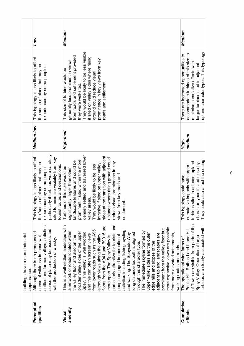
build
ings
hav
e a
mor
e in
dust
rial
appe
aran
ce.
Per
cep
tual
q
ual
itie
s
Alth
ough
ther
e is
no
pron
ounc
ed
sens
e of
wild
ness
in th
ese
wel
l-se
ttled
and
farm
ed v
alle
ys, a
dis
tinct
se
nse
of p
lace
may
be
asso
ciat
ed
with
the
prod
uctio
n of
whi
sky.
Thi
s ty
polo
gy is
less
like
ly to
affe
ct
the
‘sen
se o
f pla
ce’ t
hat m
ay b
e ex
perie
nced
by
som
e pe
ople
pa
rtic
ular
ly if
turb
ines
wer
e ca
refu
lly
site
d to
min
imis
e vi
sibi
lity
from
key
to
uris
t rou
tes
and
dest
inat
ions
.
Med
ium
-low
T
his
typo
logy
is le
ss li
kely
to a
ffect
th
e se
nse
of p
lace
that
may
be
expe
rienc
ed b
y so
me
peop
le.
Low
Vis
ual
am
enit
y
Thi
s is
a w
ell-s
ettle
d la
ndsc
ape
with
a
netw
ork
of r
oads
loca
ted
with
in
the
valle
y flo
or a
nd a
lso
on th
e br
oade
r va
lley
side
s of
the
uppe
r S
pey.
Thi
s va
lley
is w
ell w
oode
d an
d th
is c
an o
ften
scre
en v
iew
s fr
om lo
wer
roa
ds s
uch
as th
e A
95
alth
ough
vie
ws
alon
g th
e va
lley
floor
s fr
om th
e A
941
and
B90
15 a
re
mor
e op
en. T
he S
pey
Val
ley
is
part
icul
arly
attr
activ
e fo
r to
uris
ts a
nd
peop
le e
ngag
ed in
rec
reat
iona
l ac
tiviti
es in
clud
ing
fishi
ng, c
yclin
g an
d w
alki
ng. T
he S
peys
ide
Way
lo
ng d
ista
nce
foot
path
is a
ligne
d th
roug
h th
is c
hara
cter
type
. T
he im
med
iate
sky
line
form
ed b
y up
per
valle
y si
des
and
the
oute
r ed
ge h
ills
and
slop
es o
f the
ad
jace
nt u
plan
d la
ndsc
apes
are
pr
omin
ent f
rom
the
valle
y flo
or b
ut
mor
e ex
pans
ive
view
s ar
e po
ssib
le
from
mor
e el
evat
ed s
ettle
men
ts,
wal
king
rou
tes
and
road
s.
Tur
bine
s of
this
siz
e w
ould
be
sign
ifica
ntly
larg
er th
an o
ther
la
ndsc
ape
feat
ures
and
cou
ld b
e pr
omin
ent i
f site
d w
ithin
the
mor
e de
nsel
y se
ttled
and
trav
erse
d lo
wer
va
lley
area
s.
The
y w
ould
be
likel
y to
be
less
in
trus
ive
if si
ted
on u
pper
val
ley
side
s at
the
tran
sitio
n w
ith a
djac
ent
upla
nds
whe
re r
isin
g gr
ound
cou
ld
redu
ce v
isua
l pro
min
ence
in k
ey
view
s fr
om k
ey r
oads
and
se
ttlem
ent.
Hig
h-m
ed
Thi
s si
ze o
f tur
bine
wou
ld b
e ge
nera
lly le
ss p
rom
inen
t in
view
s fr
om r
oads
and
set
tlem
ent p
rovi
ded
they
wer
e w
ell-s
ited.
T
hey
wou
ld b
e lik
ely
to b
e le
ss v
isib
le
if si
ted
on v
alle
y si
des
whe
re r
isin
g gr
ound
cou
ld r
educ
e vi
sual
pr
omin
ence
in k
ey v
iew
s fr
om k
ey
road
s an
d se
ttlem
ent.
Med
ium
Cu
mu
lati
ve
effe
cts
The
ope
ratio
nal w
ind
farm
s of
P
aul’s
Hill
, Rot
hes
I and
II a
nd H
ill
of T
owie
are
vis
ible
from
par
ts o
f the
S
pey
Val
ley.
Ope
ratio
nal l
arge
tu
rbin
es a
re c
lear
ly a
ssoc
iate
d w
ith
Thi
s ty
polo
gy c
ould
hav
e cu
mul
ativ
e im
pact
s w
ith la
rger
tu
rbin
es s
ited
in a
djac
ent u
plan
d ch
arac
ter
type
s if
site
d cl
ose-
by.
The
y co
uld
also
affe
ct th
e se
tting
Hig
h-m
ediu
m
The
re a
re in
crea
sed
oppo
rtun
ities
to
acco
mm
odat
e tu
rbin
es o
f thi
s si
ze to
m
inim
ise
cum
ulat
ive
effe
cts
with
la
rger
turb
ines
site
d in
adj
acen
t up
land
cha
ract
er ty
pes.
Thi
s ty
polo
gy
Med
ium
75
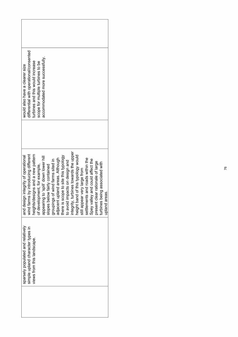
spar
sely
pop
ulat
ed a
nd r
elat
ivel
y si
mpl
e up
land
cha
ract
er ty
pes
in
view
s fr
om th
is la
ndsc
ape.
and
desi
gn in
tegr
ity o
f ope
ratio
nal
win
d fa
rms
by in
trod
ucin
g di
ffere
nt
heig
hts/
desi
gns
and
a ne
w p
atte
rn
of d
evel
opm
ent,
for
exam
ple,
ap
pear
ing
to ‘s
pill’
dow
n lo
wer
hill
sl
opes
bel
ow fa
irly
cont
aine
d gr
oupi
ngs
of w
ind
farm
s si
ted
in
adja
cent
upl
and
area
s. A
lthou
gh
ther
e is
sco
pe to
site
this
typo
logy
to
avo
id im
pact
s on
des
ign
and
inte
grity
, tur
bine
s to
war
ds th
e up
per
heig
ht b
and
of th
is ty
polo
gy w
ould
st
ill a
ppea
r ve
ry la
rge
from
se
ttlem
ents
and
roa
ds w
ithin
the
Spe
y va
lley
and
coul
d af
fect
the
pres
ent c
lear
rat
iona
le o
f lar
ge
turb
ines
bei
ng a
ssoc
iate
d w
ith
upla
nd a
reas
.
wou
ld a
lso
have
a c
lear
er s
ize
diffe
rent
ial w
ith o
pera
tiona
l/con
sent
ed
turb
ines
and
this
wou
ld in
crea
se
scop
e fo
r m
ultip
le tu
rbin
es to
be
acco
mm
odat
ed m
ore
succ
essf
ully
.
76

Land
scap
e ch
arac
ter t
ype
8: U
plan
d Fa
rmla
nd –
Sen
sitiv
ity a
sses
smen
t for
larg
er ty
polo
gies
To
pic
S
um
mar
y d
escr
ipti
on
Lar
ge
scal
e ty
po
log
y as
sess
men
t (8
0-13
0m)
Sen
siti
vity
ra
tin
g
Med
ium
sca
le t
ypo
log
y as
sess
men
t (5
0-80
m)
Sen
siti
vity
ra
tin
g
Lan
dsc
ape
con
text
T
his
char
acte
r ty
pe is
con
tain
ed b
y th
e hi
gher
gro
und
of th
e ad
jace
nt
Bro
ad F
ores
ted
Hill
s w
ithin
Upl
and
Far
mla
nd (
8a)
char
acte
r ty
pe a
nd
ther
efor
e ha
s lim
ited
inte
r-vi
sibi
lity
and
influ
ence
on
wid
er la
ndsc
ape
char
acte
r, in
clud
ing
neig
hbou
ring
Abe
rdee
nshi
re. A
lthou
gh L
CT
8a
is
gene
rally
spa
rsel
y se
ttled
and
de
nsel
y fo
rest
ed, t
hus
limiti
ng v
iew
s to
the
Upl
and
Far
mla
nd (
8), i
t in
clud
es th
e la
ndm
ark
hills
of t
he
Bin
of C
ulle
n an
d M
eikl
e B
allo
ch
whi
ch a
re p
opul
ar fo
r re
crea
tion.
Thi
s la
ndsc
ape
has
little
influ
ence
on
sur
roun
ding
land
scap
es.
Tur
bine
s of
this
siz
e w
ould
how
ever
ap
pear
to d
imin
ish
the
vert
ical
sca
le
and
detr
act f
rom
mor
e di
stin
ctiv
e de
fined
land
mar
k hi
lls w
ithin
the
Bro
ad F
ores
ted
Hill
s w
ithin
Upl
and
Far
mla
nd (
8a)
if si
ted
clos
e-by
.
Med
ium
T
his
land
scap
e ha
s lit
tle in
fluen
ce o
n su
rrou
ndin
g la
ndsc
apes
. Tur
bine
s of
th
is s
ize
wou
ld h
owev
er a
ppea
r to
di
min
ish
the
vert
ical
sca
le a
nd d
etra
ct
from
mor
e di
stin
ctiv
e de
fined
la
ndm
ark
hills
with
in th
e B
road
F
ores
ted
Hill
s w
ithin
Upl
and
Far
mla
nd
(8a)
if s
ited
clos
e-by
.
Med
ium
Sca
le a
nd
o
pen
nes
s
The
gen
tly u
ndul
atin
g sh
allo
w
valle
ys o
f thi
s la
ndsc
ape
are
expa
nsiv
e an
d op
en a
lthou
gh th
e pr
esen
ce o
f a r
egul
ar p
atte
rn o
f sm
all f
arm
s an
d ho
uses
pro
vide
re
ady
scal
e re
fere
nces
and
red
uce
the
over
all s
cale
of t
he la
ndsc
ape.
S
ome
narr
ower
and
mor
e co
ntai
ned
valle
ys o
ccur
in p
lace
s an
d a
num
ber
of s
mal
l wel
l-def
ined
hill
s ar
e oc
casi
onal
feat
ures
.
Alth
ough
this
typo
logy
cou
ld r
elat
e to
the
broa
d sc
ale
of th
e ge
nera
lly
gent
ly u
ndul
atin
g la
ndfo
rm, i
t wou
ld
dom
inat
e sm
all h
ouse
s an
d fa
rms
whi
ch a
re e
venl
y di
sper
sed
acro
ss
this
land
scap
e. T
he m
ore
cont
aine
d va
lley
floor
s, in
clud
ing
the
valle
y of
th
e R
iver
Isla
and
the
rela
tivel
y sm
all h
ills
whi
ch o
ccas
iona
lly o
ccur
, w
ould
add
ition
ally
be
sens
itive
to
this
typo
logy
.
Hig
h-m
ediu
m
Alth
ough
this
typo
logy
cou
ld r
elat
e to
th
e br
oad
scal
e of
the
gene
rally
gen
tly
undu
latin
g la
ndfo
rm, i
t wou
ld
dom
inat
e sm
all h
ouse
s an
d fa
rms
whi
ch a
re e
venl
y di
sper
sed
acro
ss
this
land
scap
e. T
he m
ore
cont
aine
d va
lley
floor
s, in
clud
ing
the
valle
y of
th
e R
iver
Isla
and
the
rela
tivel
y sm
all
hills
whi
ch o
ccas
iona
lly o
ccur
, wou
ld
addi
tiona
lly b
e se
nsiti
ve to
this
ty
polo
gy.
Hig
h-m
ediu
m
Lan
dfo
rm
T
his
gent
ly u
ndul
atin
g la
ndsc
ape
enco
mpa
sses
the
flat-
botto
med
va
lley
of th
e R
ive
r Is
la, t
he b
road
sl
opes
whi
ch p
rovi
de it
s w
ider
se
tting
and
the
shal
low
val
leys
of
visu
ally
insi
gnifi
cant
trib
utar
ies
runn
ing
from
the
nort
h w
hich
are
di
vide
d by
long
, low
rid
ges
with
Thi
s ty
polo
gy c
ould
rel
ate
to th
e ge
nera
lly s
impl
e la
ndfo
rm o
f thi
s ch
arac
ter
type
alth
ough
they
wou
ld
sign
ifica
ntly
det
ract
from
Kno
ck H
ill
and
from
the
smal
ler,
yet
dis
tinct
ive,
hi
lls a
nd r
idge
s if
site
d on
or
clos
e-by
them
.
Med
ium
T
his
typo
logy
cou
ld r
elat
e to
the
gene
rally
sim
ple
land
form
of t
his
char
acte
r ty
pe a
lthou
gh th
ey w
ould
si
gnifi
cant
ly d
etra
ct fr
om K
nock
Hill
an
d fr
om th
e sm
alle
r, y
et d
istin
ctiv
e,
hills
and
rid
ges
if si
ted
on o
r cl
ose-
by
them
.
Med
ium
77

gent
le a
nd s
moo
th s
lope
s.
Occ
asio
nal w
ell-d
efin
ed s
mal
l hill
s an
d rid
ges
occu
r -
the
mos
t di
stin
ctiv
e of
thes
e be
ing
the
land
mar
k hi
ll of
Kno
ck H
ill o
n th
e bo
rder
with
Abe
rdee
nshi
re. T
he
smal
l hill
s of
Mul
derie
, Cai
rds
Woo
d, G
allo
w H
ill a
nd th
e rid
ge o
f S
illye
an W
ood
also
sta
nd o
ut w
ithin
th
e ge
nera
lly g
ently
und
ulat
ing
land
form
of t
his
land
scap
e.
Lan
dsc
ape
pat
tern
Thi
s la
ndsc
ape
has
a si
mpl
e la
nd
cove
r of
larg
e fie
lds
of p
astu
re a
nd
som
e ar
able
land
. Sm
all g
eom
etric
co
nife
rous
she
lterb
elts
and
woo
ds
patte
rn th
e fa
rmla
nd a
lthou
gh it
ge
nera
lly h
as a
n op
en a
nd s
impl
e pa
ttern
.
The
sim
ple
land
cov
er p
atte
rn o
f th
is la
ndsc
ape
redu
ces
sens
itivi
ty to
th
is ty
polo
gy.
Med
ium
-low
T
he s
impl
e la
nd c
over
pat
tern
of t
his
land
scap
e re
duce
s se
nsiti
vity
to th
is
typo
logy
.
Med
ium
-low
Bu
ilt
envi
ron
men
t
Kei
th, s
ited
eith
er s
ide
of th
e R
iver
Is
la, i
s th
e on
ly s
izea
ble
settl
emen
t w
ithin
this
land
scap
e al
thou
gh th
ere
is a
n ev
en d
ispe
rsal
of f
arm
s ac
ross
th
is c
hara
cter
type
. The
re a
re fe
w
obvi
ous
arch
aeol
ogic
al o
r hi
stor
ic
feat
ures
whi
ch m
ake
a st
rong
co
ntrib
utio
n to
land
scap
e ch
arac
ter.
E
xist
ing
tall
win
d tu
rbin
es a
re
situ
ated
in th
e no
rth-
east
ern
part
of
this
land
scap
e ch
arac
ter
type
and
hi
gh v
olta
ge tr
ansm
issi
on li
nes
and
larg
e su
bsta
tion
are
high
ly v
isib
le
feat
ures
in th
e ar
ea a
roun
d K
eith
.
Tur
bine
s of
this
siz
e w
ould
ex
acer
bate
the
disc
orda
nt c
lutte
r of
tr
ansm
issi
on li
nes
in th
e ar
ea
arou
nd K
eith
, fur
ther
dim
inis
hing
its
land
scap
e se
tting
. The
set
ting
of
smal
ler
settl
emen
ts a
nd in
divi
dual
bu
ildin
gs c
ould
als
o be
affe
cted
, pa
rtic
ular
ly b
y m
ultip
le tu
rbin
es a
nd
this
is c
onsi
dere
d fu
rthe
r un
der
‘cum
ulat
ive
effe
cts’
.
Med
ium
T
urbi
nes
of th
is s
ize
wou
ld
exac
erba
te th
e di
scor
dant
clu
tter
of
tran
smis
sion
line
s in
the
area
aro
und
Kei
th, f
urth
er d
imin
ishi
ng it
s la
ndsc
ape
setti
ng. T
he s
ettin
g of
sm
alle
r se
ttlem
ents
and
indi
vidu
al
build
ings
cou
ld a
lso
be a
ffect
ed,
part
icul
arly
by
mul
tiple
turb
ines
and
th
is is
con
side
red
furt
her
unde
r ‘c
umul
ativ
e ef
fect
s’.
Med
ium
Per
cep
tual
q
ual
itie
s
The
re is
no
sens
e of
wild
ness
or
a st
rong
sen
se o
f pla
ce a
ssoc
iate
d w
ith th
is la
ndsc
ape.
The
re w
ould
be
no s
igni
fican
t effe
ct
on th
is s
ensi
tivity
.
Low
T
here
wou
ld b
e no
sig
nific
ant e
ffect
on
this
sen
sitiv
ity.
Low
78

Vis
ual
am
enit
y
Thi
s is
a v
ery
open
land
scap
e w
ith
long
vie
ws
poss
ible
from
roa
ds a
nd
elev
ated
set
tlem
ent a
cros
s m
uch
of
the
char
acte
r ty
pe.
The
dis
tinct
ive
sum
mits
of K
nock
H
ill, M
eikl
e B
allo
ch, B
in o
f Cul
len
and
Lurg
Hill
(th
e m
ajor
ity o
f the
se
loca
ted
in th
e ad
jace
nt B
road
F
ores
ted
Hill
s w
ithin
Upl
and
Far
mla
nd (
8a))
and
the
dist
ant B
en
Rin
nes
form
key
foci
in th
ese
view
s.
The
sha
llow
val
leys
nor
th o
f the
R
iver
Isla
are
mor
e co
ntai
ned,
lim
iting
vie
ws
from
the
B90
18 a
nd
B90
17 to
som
e ex
tent
.
Tur
bine
s of
this
hei
ght w
ould
be
high
ly v
isib
le w
ithin
this
ope
n la
ndsc
ape
and
wou
ld b
e se
en in
cl
ose
prox
imity
to s
ettle
men
t and
ro
ads
incr
easi
ng p
oten
tial i
mpa
ct.
Tur
bine
s of
this
siz
e co
uld
inte
rrup
t ke
y vi
ews
to fo
cal h
ills
with
in th
is
char
acte
r ty
pe a
nd th
e la
ndm
ark
hills
with
in th
e B
road
For
este
d H
ills
with
in U
plan
d F
arm
land
(8a
).
Hig
h T
urbi
nes
of th
is h
eigh
t wou
ld b
e hi
ghly
vis
ible
with
in th
is o
pen
land
scap
e an
d w
ould
be
seen
in c
lose
pr
oxim
ity to
set
tlem
ent a
nd r
oads
in
crea
sing
pot
entia
l im
pact
. Tur
bine
s of
this
siz
e co
uld
inte
rrup
t key
vie
ws
to fo
cal h
ills
with
in th
is c
hara
cter
type
an
d th
e la
ndm
ark
hills
with
in th
e B
road
For
este
d H
ills
with
in U
plan
d F
arm
land
(8a
).
Hig
h
Cu
mu
lati
ve
effe
cts
Fou
r op
erat
iona
l lar
ge tu
rbin
es (
70-
92m
hig
h) a
nd th
e un
der
cons
truc
tion
Edi
ntor
e w
ind
farm
lo
cate
d in
this
cha
ract
er ty
pe a
nd
the
cons
ente
d A
ultm
ore
win
d fa
rm
site
d in
the
Bro
ad F
ores
ted
Hill
s w
ithin
Upl
and
Far
mla
nd (
8a)
are/
will
be
wid
ely
visi
ble
acro
ss th
is o
pen
land
scap
e. T
he H
ill o
f Tow
ie w
ind
farm
loca
ted
in th
e R
ollin
g F
ores
ted
Hill
s (9
) is
als
o pr
omin
ent o
n th
e sk
ylin
e in
vie
ws
from
this
land
scap
e.
Exi
stin
g an
d co
nsen
ted
deve
lopm
ents
of l
arge
r tu
rbin
es
site
d in
this
land
scap
e ha
ve
incu
rred
sig
nific
ant l
ands
cape
and
vi
sual
impa
cts
and
conf
lict w
ith th
e pr
edom
inan
t pat
tern
with
in M
oray
of
larg
er ty
polo
gies
bei
ng a
ssoc
iate
d w
ith m
ore
expa
nsiv
e an
d si
mpl
e up
land
land
scap
es. O
pera
tiona
l and
co
nsen
ted
win
d fa
rms
loca
ted
in
adja
cent
cha
ract
er ty
pes
also
st
rong
ly in
fluen
ce c
hara
cter
and
vi
ews.
Add
ition
al tu
rbin
es o
f thi
s si
ze s
ited
in th
e U
plan
d F
arm
land
(8
) w
ould
exa
cerb
ate
thes
e im
pact
s.
Hig
h E
xist
ing
and
cons
ente
d de
velo
pmen
ts
of la
rger
turb
ines
site
d in
this
la
ndsc
ape
have
incu
rred
sig
nific
ant
land
scap
e an
d vi
sual
impa
cts
and
conf
lict w
ith th
e pr
edom
inan
t pat
tern
w
ithin
Mor
ay o
f lar
ger
typo
logi
es
bein
g as
soci
ated
with
mor
e ex
pans
ive
and
sim
ple
upla
nd la
ndsc
apes
. O
pera
tiona
l and
con
sent
ed w
ind
farm
s lo
cate
d in
adj
acen
t cha
ract
er
type
s al
so s
tron
gly
influ
ence
ch
arac
ter
and
view
s. A
dditi
onal
tu
rbin
es o
f thi
s si
ze s
ited
in th
e U
plan
d F
arm
land
(8)
wou
ld
exac
erba
te th
ese
impa
cts.
Hig
h
79

Land
scap
e ch
arac
ter t
ype
8: U
plan
d Fa
rmla
nd –
Sen
sitiv
ity a
sses
smen
t for
sm
alle
r typ
olog
ies
To
pic
S
um
mar
y d
escr
ipti
on
S
mal
l-M
ediu
m s
cale
typ
olo
gy
asse
ssm
ent
(35-
50m
) S
ensi
tivi
ty
rati
ng
S
mal
l sc
ale
typ
olo
gy
asse
ssm
ent
(20-
35m
) S
ensi
tivi
ty
rati
ng
L
and
scap
e co
nte
xt
Thi
s ch
arac
ter
type
is c
onta
ined
by
the
high
er g
roun
d of
the
adja
cent
B
road
For
este
d H
ills
with
in U
plan
d F
arm
land
(8a
) ch
arac
ter
type
and
th
eref
ore
has
limite
d in
ter-
visi
bilit
y an
d in
fluen
ce o
n w
ider
land
scap
e ch
arac
ter,
incl
udin
g ne
ighb
ourin
g A
berd
eens
hire
. Alth
ough
LC
T 8
a is
ge
nera
lly s
pars
ely
settl
ed a
nd
dens
ely
fore
sted
, thu
s lim
iting
vie
ws
to th
e U
plan
d F
arm
land
(8)
, it
incl
udes
the
land
mar
k hi
lls o
f the
B
in o
f Cul
len
and
Mei
kle
Bal
loch
w
hich
are
pop
ular
for
recr
eatio
n.
Tur
bine
s of
this
siz
e co
uld
still
de
trac
t fro
m th
e la
ndm
ark
hills
w
ithin
the
adja
cent
Bro
ad F
ores
ted
Hill
s w
ithin
Upl
and
Far
mla
nd (
8a)
if si
ted
near
by a
lthou
gh th
ere
are
incr
ease
d op
port
uniti
es fo
r th
is
typo
logy
to a
void
suc
h im
pact
s.
Med
ium
-low
T
urbi
nes
of th
is s
ize
wou
ld b
e lik
ely
to
have
littl
e ef
fect
on
the
land
mar
k hi
lls
with
in th
is c
hara
cter
type
and
the
Bro
ad F
ores
ted
Hill
s w
ithin
Upl
and
Far
mla
nd (
8a)
prov
idin
g th
ey w
ere
site
d w
ell a
way
from
them
.
Low
Sca
le a
nd
o
pen
nes
s
The
gen
tly u
ndul
atin
g sh
allo
w
valle
ys o
f thi
s la
ndsc
ape
are
expa
nsiv
e an
d op
en a
lthou
gh th
e pr
esen
ce o
f a r
egul
ar p
atte
rn o
f sm
all f
arm
s an
d ho
uses
pro
vide
re
ady
scal
e re
fere
nces
and
red
uce
the
over
all s
cale
of t
he la
ndsc
ape.
S
ome
narr
ower
and
mor
e co
ntai
ned
valle
ys o
ccur
in p
lace
s an
d a
num
ber
of s
mal
l wel
l-def
ined
hill
s ar
e oc
casi
onal
feat
ures
.
Thi
s ty
polo
gy w
ould
stil
l app
ear
very
larg
e in
rel
atio
n to
sm
all
hous
es a
nd fa
rms
in th
is la
ndsc
ape.
T
he e
ven
disp
ersa
l of b
uild
ings
ac
ross
this
wel
l-set
tled
land
scap
e in
crea
ses
sens
itivi
ty a
lthou
gh m
ore
spar
sely
set
tled
area
s at
the
tran
sitio
n w
ith th
e B
road
For
este
d H
ills
with
in U
plan
d F
arm
land
(8a
) pr
ovid
e so
me
oppo
rtun
ities
to s
ite
turb
ines
of t
his
size
.
Med
ium
T
his
size
of t
urbi
ne w
ould
hav
e le
ss o
f an
impa
ct o
n th
e sc
ale
of s
mal
l far
ms
and
hous
es a
nd th
ere
are
cons
eque
ntly
incr
ease
d op
port
uniti
es
to a
ccom
mod
ate
this
typo
logy
.
Med
ium
-low
Lan
dfo
rm
T
his
gent
ly u
ndul
atin
g la
ndsc
ape
enco
mpa
sses
the
flat-
botto
med
va
lley
of th
e R
ive
r Is
la, t
he b
road
sl
opes
whi
ch p
rovi
de it
s w
ider
se
tting
and
the
shal
low
val
leys
of
visu
ally
insi
gnifi
cant
trib
utar
ies
runn
ing
from
the
nort
h w
hich
are
Thi
s ty
polo
gy c
ould
rel
ate
to th
e ge
nera
lly s
impl
e la
ndfo
rm o
f thi
s ch
arac
ter
type
alth
ough
mor
e co
ntai
ned
valle
y flo
ors
and
smal
l w
ell-d
efin
ed h
ills
rem
ain
sens
itive
.
Med
ium
-low
T
his
typo
logy
cou
ld r
elat
e to
the
gene
rally
sim
ple
land
form
of t
his
char
acte
r ty
pe.
Low
80

divi
ded
by lo
ng, l
ow r
idge
s w
ith
gent
le a
nd s
moo
th s
lope
s.
Occ
asio
nal w
ell-d
efin
ed s
mal
l hill
s an
d rid
ges
occu
r -
the
mos
t di
stin
ctiv
e of
thes
e be
ing
the
land
mar
k hi
ll of
Kno
ck H
ill o
n th
e bo
rder
with
Abe
rdee
nshi
re. T
he
smal
l hill
s of
Mul
derie
, Cai
rds
Woo
d, G
allo
w H
ill a
nd th
e rid
ge o
f S
illye
an W
ood
also
sta
nd o
ut w
ithin
th
e ge
nera
lly g
ently
und
ulat
ing
land
form
of t
his
land
scap
e.
Lan
dsc
ape
pat
tern
Thi
s la
ndsc
ape
has
a si
mpl
e la
nd
cove
r of
larg
e fie
lds
of p
astu
re a
nd
som
e ar
able
land
. Sm
all g
eom
etric
co
nife
rous
she
lterb
elts
and
woo
ds
patte
rn th
e fa
rmla
nd a
lthou
gh it
ge
nera
lly h
as a
n op
en a
nd s
impl
e pa
ttern
.
The
sim
ple
land
cov
er o
f thi
s la
ndsc
ape
redu
ces
sens
itivi
ty to
this
ty
polo
gy.
Med
ium
-low
T
he s
impl
e la
nd c
over
of t
his
land
scap
e re
duce
s se
nsiti
vity
to th
is
typo
logy
. Thi
s si
ze o
f tur
bine
wou
ld
be le
ss li
kely
to d
etra
ct fr
om a
reas
w
ith a
mor
e di
stin
ct fi
eld
encl
osur
e or
w
oodl
and
patte
rn.
Low
Bu
ilt
envi
ron
men
t
Kei
th, s
ited
eith
er s
ide
of th
e R
iver
Is
la, i
s th
e on
ly s
izea
ble
settl
emen
t w
ithin
this
land
scap
e al
thou
gh th
ere
is a
n ev
en d
ispe
rsal
of f
arm
s ac
ross
th
is c
hara
cter
type
. The
re a
re fe
w
obvi
ous
arch
aeol
ogic
al o
r hi
stor
ic
feat
ures
whi
ch m
ake
a st
rong
co
ntrib
utio
n to
land
scap
e ch
arac
ter.
E
xist
ing
tall
turb
ines
are
situ
ated
in
the
nort
h-ea
ster
n pa
rt o
f thi
s la
ndsc
ape
char
acte
r ty
pe a
nd h
igh
volta
ge tr
ansm
issi
on li
nes
and
larg
e su
bsta
tion
are
high
ly v
isib
le fe
atur
es
in th
e ar
ea a
roun
d K
eith
.
Tur
bine
s of
this
siz
e w
ould
ex
acer
bate
the
disc
orda
nt c
lutte
r of
tr
ansm
issi
on li
nes
in th
e ar
ea
arou
nd K
eith
, fur
ther
dim
inis
hing
its
land
scap
e se
tting
. The
set
ting
of
smal
ler
settl
emen
ts a
nd in
divi
dual
bu
ildin
gs c
ould
als
o be
affe
cted
, pa
rtic
ular
ly b
y m
ultip
le tu
rbin
es a
nd
this
is c
onsi
dere
d fu
rthe
r un
der
‘cum
ulat
ive
effe
cts’
.
Med
ium
T
urbi
nes
of th
is s
ize
are
less
like
ly to
af
fect
the
setti
ng o
f ind
ivid
ual
settl
emen
ts a
nd fa
rms.
Mul
tiple
tu
rbin
es o
f thi
s ty
polo
gy, a
nd
part
icul
arly
turb
ines
tow
ards
the
low
er
heig
ht o
f 20m
, wou
ld h
ave
less
of a
n im
pact
on
the
setti
ng o
f set
tlem
ent.
Med
ium
-low
Per
cep
tual
q
ual
itie
s T
here
is n
o se
nse
of w
ildne
ss o
r a
stro
ng s
ense
of p
lace
ass
ocia
ted
with
this
land
scap
e.
The
re w
ould
be
no e
ffect
on
this
se
nsiti
vity
. Lo
w
The
re w
ould
be
no e
ffect
on
this
se
nsiti
vity
. Lo
w
81

Vis
ual
am
enit
y
Thi
s is
a v
ery
open
land
scap
e w
ith
long
vie
ws
poss
ible
from
roa
ds a
nd
elev
ated
set
tlem
ent a
cros
s m
uch
of
the
char
acte
r ty
pe.
The
dis
tinct
ive
sum
mits
of K
nock
H
ill, M
eikl
e B
allo
ch, B
in o
f Cul
len
and
Lurg
Hill
(th
e m
ajor
ity o
f the
se
loca
ted
in th
e ad
jace
nt B
road
F
ores
ted
Hill
s w
ithin
Upl
and
Far
mla
nd (
8a))
and
the
dist
ant B
en
Rin
nes
form
key
foci
in th
ese
view
s.
The
sha
llow
val
leys
nor
th o
f the
R
iver
Isla
are
mor
e co
ntai
ned,
lim
iting
vie
ws
from
the
B90
18 a
nd
B90
17 to
som
e ex
tent
.
Tur
bine
s of
this
hei
ght w
ould
stil
l be
prom
inen
t with
in th
is la
ndsc
ape.
M
ultip
le tu
rbin
es o
f thi
s si
ze
asso
ciat
ed w
ith a
num
ber
of la
nd
hold
ings
cou
ld h
ave
sign
ifica
nt
cum
ulat
ive
effe
cts
on v
iew
s as
this
la
ndsc
ape
is o
pen
and
high
ly v
isib
le
from
set
tlem
ent a
nd m
ajor
roa
ds.
Tur
bine
s of
this
siz
e co
uld
inte
rrup
t ke
y vi
ews
to fo
cal h
ills
with
in L
CT
8a
.
Hig
h-m
ediu
m
Tur
bine
s of
this
hei
ght w
ould
be
less
pr
omin
ent w
ithin
this
ope
n la
ndsc
ape
and
wou
ld b
e un
likel
y to
impa
ct o
n ke
y vi
ews
to la
ndm
ark
hills
.
Med
ium
Cu
mu
lati
ve
effe
cts
Fou
r op
erat
iona
l lar
ge tu
rbin
es (
70-
92m
hig
h) lo
cate
d in
this
cha
ract
er
type
, the
und
er c
onst
ruct
ion
Edi
ntor
e w
ind
farm
and
the
cons
ente
d A
ultm
ore
win
d fa
rm s
ited
in th
e B
road
For
este
d H
ills
with
in
Upl
and
Far
mla
nd (
8a)
are/
will
be
wid
ely
visi
ble
acro
ss th
is o
pen
land
scap
e. T
he H
ill o
f Tow
ie w
ind
farm
loca
ted
in th
e R
ollin
g F
ores
ted
Hill
s (9
) is
als
o pr
omin
ent o
n th
e sk
ylin
e in
vie
ws
from
this
land
scap
e.
Thi
s ty
polo
gy c
ould
hav
e cu
mul
ativ
e im
pact
s w
ith la
rger
tu
rbin
es s
ited
in a
djac
ent u
plan
d ch
arac
ter
type
s if
site
d cl
ose-
by.
Tur
bine
s to
war
ds th
e up
per
heig
ht
band
of t
his
typo
logy
wou
ld s
till
appe
ar v
ery
larg
e fr
om s
ettle
men
ts
and
road
s w
ithin
this
land
scap
e an
d co
uld
exac
erba
te c
umul
ativ
e ef
fect
s in
som
e pa
rts
of th
is la
ndsc
ape.
Hig
h-m
ediu
m
The
re a
re in
crea
sed
oppo
rtun
ities
to
acco
mm
odat
e tu
rbin
es o
f thi
s si
ze to
m
inim
ise
cum
ulat
ive
effe
cts
with
la
rger
turb
ines
site
d in
adj
acen
t up
land
cha
ract
er ty
pes.
Thi
s ty
polo
gy
wou
ld h
ave
a cl
eare
r si
ze d
iffer
entia
l w
ith o
pera
tiona
l/con
sent
ed tu
rbin
es
and
this
wou
ld in
crea
se s
cope
for
mul
tiple
turb
ines
to b
e ac
com
mod
ated
m
ore
succ
essf
ully
.
Med
ium
-low
82

Land
scap
e ch
arac
ter t
ype
8a: B
road
For
este
d H
ills
with
in U
plan
d Fa
rmla
nd –
Sen
sitiv
ity a
sses
smen
t for
larg
er ty
polo
gies
To
pic
S
um
mar
y d
escr
ipti
on
Lar
ge
scal
e ty
po
log
y as
sess
men
t (8
0-13
0m)
Sen
siti
vity
ra
tin
g
Med
ium
sca
le t
ypo
log
y as
sess
men
t (5
0-80
m)
Sen
siti
vity
ra
tin
g
Lan
dsc
ape
con
text
T
he e
leva
tion
of th
is c
hara
cter
sub
-ty
pe in
crea
ses
its v
isua
l inf
luen
ce
on a
djac
ent l
ands
cape
s. T
his
char
acte
r ty
pe in
clud
es n
arro
wer
rid
ges
as w
ell a
s br
oade
r pl
atea
ux
alth
ough
in g
ener
al th
ese
upla
nd
area
s ar
e no
t ext
ensi
ve. T
hese
up
land
are
as a
re im
port
ant i
n fo
rmin
g a
sim
ple
back
drop
to m
ore
com
plex
sm
alle
r sc
ale
settl
ed
land
scap
es in
clud
ing
the
Upl
and
Far
mla
nd (
8), B
road
Far
med
Val
ley
(7),
Rol
ling
Coa
stal
Far
mla
nd (
4a)
and
the
Coa
stal
Far
mla
nd (
4). I
n ge
nera
l how
ever
the
sim
pler
pla
teau
an
d br
oade
r rid
ges
mak
e a
less
er
cont
ribut
ion
to w
ider
sce
nic
char
acte
r th
an th
e pa
rtic
ular
ly
dist
inct
ive
‘land
mar
k’ h
ills
of B
in o
f C
ulle
n an
d M
eikl
e B
allo
ch w
hich
al
so p
rovi
de a
n im
port
ant b
ackd
rop
to th
e M
oray
Coa
st a
nd
neig
hbou
ring
Abe
rdee
nshi
re. T
he
dens
ely
woo
ded
Whi
teas
h H
ill is
ad
ditio
nally
impo
rtan
t in
prov
idin
g th
e se
tting
to G
ordo
n C
astle
de
sign
ed la
ndsc
ape
and
to
Foc
habe
rs.
Tur
bine
s of
this
siz
e w
ould
be
likel
y to
hav
e a
grea
ter
impa
ct o
n ad
jace
nt la
ndsc
apes
par
ticul
arly
w
here
the
upla
nd a
rea
is le
ss
exte
nsiv
e or
if s
ited
on o
r ne
arby
th
e la
ndm
ark
hills
of B
in o
f Cul
len
and
Mei
kle
Bal
loch
or
in th
e W
hite
ash
Hill
are
a.
Hig
h-m
ediu
m
Thi
s ty
polo
gy w
ould
be
likel
y to
hav
e a
redu
ced
impa
ct o
n ad
jace
nt
land
scap
es p
artic
ular
ly if
site
d w
ithin
th
e co
re o
f mor
e ex
tens
ive
upla
nd
plat
eaux
. Tur
bine
s si
ted
on o
r ne
arby
th
e la
ndm
ark
hills
or
the
Whi
teas
h H
ill
area
wou
ld h
ave
a si
gnifi
cant
effe
ct
on a
djoi
ning
land
scap
es.
Med
ium
Sca
le a
nd
o
pen
nes
s
The
mor
e ex
pans
ive
plat
eaux
and
br
oad
ridge
s ha
ve a
larg
e sc
ale
alth
ough
sca
le is
red
uced
whe
re
ridge
s ar
e na
rrow
er a
nd w
here
hill
s ha
ve m
ore
defin
ed s
umm
its a
nd a
re
Thi
s ty
polo
gy c
ould
rel
ate
to th
e sc
ale
of m
ore
exte
nsiv
e pl
atea
ux
but w
ould
dom
inat
e th
e na
rrow
, low
rid
ges,
occ
asio
nal s
ettle
d ar
eas
and
the
mor
e de
fined
sum
mits
of t
he
Hig
h-m
ediu
m
The
re is
incr
ease
d sc
ope
to s
ite
turb
ines
of t
his
size
to r
educ
e ef
fect
s on
sca
le a
lthou
gh m
ore
defin
ed h
ills
rem
ain
sens
itive
.
Med
ium
83

gene
rally
sm
alle
r in
ext
ent.
la
ndm
ark
hills
. L
and
form
Thi
s la
ndsc
ape
gene
rally
feat
ures
sm
ooth
gen
tly g
rade
d sl
opes
and
su
btly
rou
nded
indi
stin
ct h
ill to
ps
with
in b
road
er p
late
aux.
How
ever
, m
ore
dist
inct
ive
hills
with
ste
eper
sl
opes
and
def
ined
sum
mits
als
o oc
cur
and
incl
ude
Lurg
Hill
and
the
land
mar
k co
nica
l hill
s of
Bin
of
Cul
len
and
Mei
kle
Bal
loch
.
Thi
s ty
polo
gy c
ould
rel
ate
to th
e ge
nera
lly s
impl
e la
ndfo
rm o
f muc
h of
this
cha
ract
er ty
pe a
lthou
gh
turb
ines
of t
his
size
wou
ld d
etra
ct
from
mor
e de
fined
hill
s w
hich
form
la
ndm
ark
feat
ures
with
in th
is
land
scap
e if
site
d on
or
clos
e-by
th
em.
Med
ium
T
his
typo
logy
cou
ld r
elat
e to
the
gene
rally
sim
ple
land
form
of m
uch
of
this
cha
ract
er ty
pe a
lthou
gh tu
rbin
es
of th
is s
ize
wou
ld d
etra
ct fr
om m
ore
defin
ed h
ills
whi
ch fo
rm la
ndm
ark
feat
ures
with
in th
is la
ndsc
ape
if si
ted
on o
r cl
ose-
by th
em.
Med
ium
Lan
dsc
ape
pat
tern
Thi
s la
ndsc
ape
has
a si
mpl
e la
nd
cove
r of
ext
ensi
ve c
onife
rous
fo
rest
ry w
ith s
ome
smal
l are
as o
f m
oorla
nd o
n th
e su
mm
its o
f mor
e de
fined
hill
s. S
emi-i
mpr
oved
fiel
ds
of p
astu
re o
ccur
on
low
er s
lope
s at
th
e tr
ansi
tion
with
the
Upl
and
Far
mla
nd (
8).
The
gen
eral
ly s
impl
e la
nd c
over
of
this
land
scap
e re
duce
s se
nsiti
vity
to
this
typo
logy
.
Low
T
he g
ener
ally
sim
ple
land
cov
er o
f th
is la
ndsc
ape
redu
ces
sens
itivi
ty to
th
is ty
polo
gy.
Low
Bu
ilt
envi
ron
men
t
A s
pars
ely
settl
ed la
ndsc
ape
with
fe
w p
rom
inen
t arc
haeo
logi
cal a
nd
hist
oric
bui
lt fe
atur
es e
vide
nt.
The
spa
rsel
y se
ttled
nat
ure
of th
is
land
scap
e re
duce
s se
nsiti
vity
in
rela
tion
to th
e se
tting
of s
ettle
men
ts
and
othe
r bu
ilt fe
atur
es.
Med
ium
-low
T
he s
pars
ely
settl
ed n
atur
e of
this
la
ndsc
ape
redu
ces
sens
itivi
ty in
re
latio
n to
the
setti
ng o
f set
tlem
ents
an
d ot
her
built
feat
ures
.
Med
ium
-low
Per
cep
tual
q
ual
itie
s
Alth
ough
par
ts o
f thi
s la
ndsc
ape
may
feel
sec
lude
d aw
ay fr
om
adjo
inin
g se
ttled
land
scap
es, t
he
pres
ence
of e
xten
sive
com
mer
cial
fo
rest
ry a
nd w
ind
farm
dev
elop
men
t in
som
e ar
eas
limits
any
sen
se o
f w
ildne
ss.
The
re w
ould
be
no s
igni
fican
t ef
fect
s on
this
sen
sitiv
ity.
Lo
w
The
re w
ould
be
no s
igni
fican
t effe
cts
on th
is s
ensi
tivity
. Lo
w
Vis
ual
am
enit
y
Vie
ws
from
with
in th
is la
ndsc
ape
are
rest
ricte
d du
e to
the
exte
nsiv
e co
nife
rous
fore
st c
over
ing
muc
h of
th
ese
upla
nd a
reas
but
als
o be
caus
e fe
w r
oads
and
set
tlem
ent
are
pres
ent.
The
exc
eptio
n to
this
is
som
e of
the
hills
like
ly to
be
popu
lar
with
wal
kers
, inc
ludi
ng B
in o
f Cul
len
Tur
bine
s w
ould
be
high
ly in
trus
ive
if si
ted
on m
ore
defin
ed h
ills
whi
ch
are
likel
y to
be
popu
lar
with
wal
kers
an
d al
so fo
rm k
ey fo
ci in
vie
ws.
Thi
s ty
polo
gy w
ould
be
likel
y to
be
prom
inen
t in
view
s fr
om r
oads
and
se
ttlem
ent i
n su
rrou
ndin
g ch
arac
ter
type
s in
clud
ing
the
Coa
stal
Hig
h T
urbi
nes
site
d in
thes
e up
land
are
as
wou
ld b
e pa
rtic
ular
ly in
trus
ive
if si
ted
on m
ore
defin
ed h
ills
whi
ch a
re li
kely
to
be
popu
lar
with
wal
kers
and
als
o fo
rm k
ey fo
ci in
vie
ws.
Tur
bine
s of
this
si
ze w
ould
be
likel
y to
hav
e le
ss o
f a
visu
al im
pact
pro
vide
d th
ey w
ere
set
wel
l bac
k w
ithin
the
core
of m
ore
Hig
h-m
ediu
m
84

and
Mei
kle
Bal
loch
. Thi
s ch
arac
ter
type
gen
eral
ly fo
rms
low
eve
n fo
rest
ed s
kylin
es s
een
from
su
rrou
ndin
g se
ttled
and
farm
ed
land
scap
es –
the
exce
ptio
n to
this
be
ing
the
land
mar
k hi
lls.
Far
mla
nd (
4), U
plan
d F
arm
land
(8)
an
d N
arro
w F
arm
ed V
alle
ys (
13)
ex
tens
ive
fore
sted
pla
teau
x.
Cu
mu
lati
ve
effe
cts
The
con
sent
ed A
ultm
ore
win
d fa
rm
will
occ
upy
one
of th
e br
oade
r pl
atea
u-lik
e hi
lls w
ithin
this
ch
arac
ter
area
. The
ope
ratio
nal H
ill
of T
owie
win
d fa
rm is
loca
ted
in th
e ne
arby
Rol
ling
For
este
d H
ills
(9)
and
a nu
mbe
r of
larg
e tu
rbin
es a
nd
the
unde
r co
nstr
uctio
n E
dint
ore
win
d fa
rm a
re a
lso
loca
ted
in th
e ad
jace
nt U
plan
d F
arm
land
(8)
.
The
re a
re fe
w u
ndev
elop
ed a
reas
of
this
land
scap
e ch
arac
ter
type
re
mai
ning
with
out m
ajor
land
scap
e an
d vi
sual
con
stra
ints
(la
ndm
ark
hills
, set
ting
to F
ocha
bers
etc
). T
he
exte
nt o
f ope
ratio
nal a
nd c
onse
nted
w
ind
farm
dev
elop
men
ts v
isib
le o
n hi
lls im
med
iate
ly s
urro
undi
ng th
e U
plan
d F
arm
land
(8)
incr
ease
s th
e lik
elih
ood
of s
igni
fican
t cum
ulat
ive
effe
cts
bein
g as
soci
ated
with
ad
ditio
nal d
evel
opm
ents
in th
is
land
scap
e. T
hese
effe
cts
wou
ld
prin
cipa
lly a
ffect
vie
ws
from
roa
ds
and
settl
emen
t in
near
by w
ell-
settl
ed la
ndsc
apes
and
als
o fr
om
recr
eatio
nal r
oute
s on
hill
s.
Hig
h-m
ediu
m
The
re a
re fe
w u
ndev
elop
ed a
reas
of
this
land
scap
e ch
arac
ter
type
re
mai
ning
with
out m
ajor
land
scap
e an
d vi
sual
con
stra
ints
(la
ndm
ark
hills
, se
tting
to F
ocha
bers
etc
). T
he e
xten
t of
ope
ratio
nal a
nd c
onse
nted
win
d fa
rm d
evel
opm
ents
vis
ible
on
hills
im
med
iate
ly s
urro
undi
ng th
e U
plan
d F
arm
land
(8)
incr
ease
s th
e lik
elih
ood
of s
igni
fican
t cum
ulat
ive
effe
cts
bein
g as
soci
ated
with
add
ition
al
deve
lopm
ents
in th
is la
ndsc
ape.
T
hese
effe
cts
wou
ld p
rinci
pally
affe
ct
view
s fr
om r
oads
and
set
tlem
ent i
n ne
arby
wel
l-set
tled
land
scap
es a
nd
also
from
rec
reat
iona
l rou
tes
on
near
by h
ills.
The
sm
alle
r tu
rbin
es o
f th
is ty
polo
gy c
ould
als
o ap
pear
di
scor
dant
with
larg
er c
onse
nted
and
op
erat
iona
l win
d tu
rbin
es if
site
d ne
arby
Hig
h-m
ediu
m
85
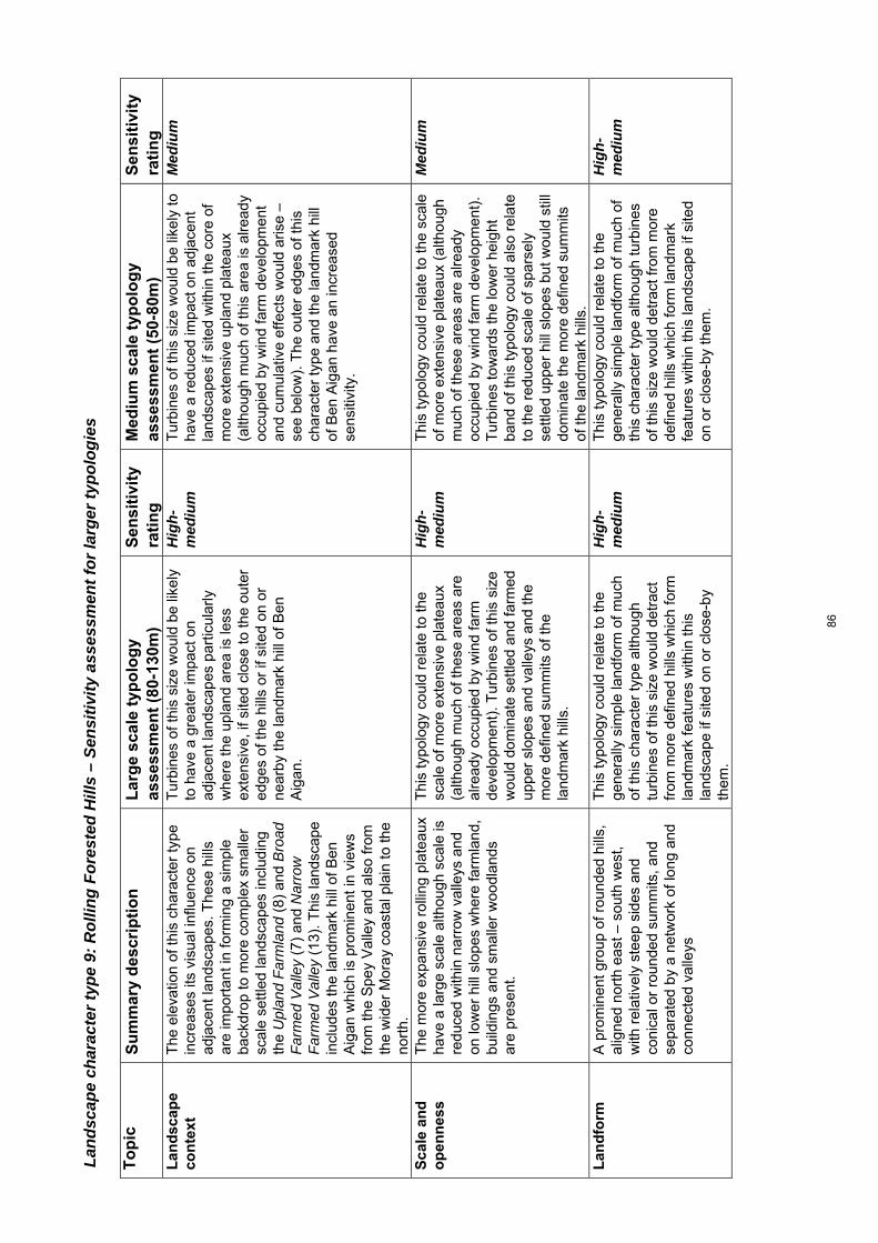
Land
scap
e ch
arac
ter t
ype
9: R
ollin
g Fo
rest
ed H
ills
– Se
nsiti
vity
ass
essm
ent f
or la
rger
typo
logi
es
To
pic
S
um
mar
y d
escr
ipti
on
L
arg
e sc
ale
typ
olo
gy
asse
ssm
ent
(80-
130m
) S
ensi
tivi
ty
rati
ng
M
ediu
m s
cale
typ
olo
gy
asse
ssm
ent
(50-
80m
) S
ensi
tivi
ty
rati
ng
L
and
scap
e co
nte
xt
The
ele
vatio
n of
this
cha
ract
er ty
pe
incr
ease
s its
vis
ual i
nflu
ence
on
adja
cent
land
scap
es. T
hese
hill
s ar
e im
port
ant i
n fo
rmin
g a
sim
ple
back
drop
to m
ore
com
plex
sm
alle
r sc
ale
settl
ed la
ndsc
apes
incl
udin
g th
e U
plan
d F
arm
land
(8)
and
Bro
ad
Far
med
Val
ley
(7)
and
Nar
row
F
arm
ed V
alle
y (1
3). T
his
land
scap
e in
clud
es th
e la
ndm
ark
hill
of B
en
Aig
an w
hich
is p
rom
inen
t in
view
s fr
om th
e S
pey
Val
ley
and
also
from
th
e w
ider
Mor
ay c
oast
al p
lain
to th
e no
rth.
Tur
bine
s of
this
siz
e w
ould
be
likel
y to
hav
e a
grea
ter
impa
ct o
n ad
jace
nt la
ndsc
apes
par
ticul
arly
w
here
the
upla
nd a
rea
is le
ss
exte
nsiv
e, if
site
d cl
ose
to th
e ou
ter
edge
s of
the
hills
or
if si
ted
on o
r ne
arby
the
land
mar
k hi
ll of
Ben
A
igan
.
Hig
h-m
ediu
m
Tur
bine
s of
this
siz
e w
ould
be
likel
y to
ha
ve a
red
uced
impa
ct o
n ad
jace
nt
land
scap
es if
site
d w
ithin
the
core
of
mor
e ex
tens
ive
upla
nd p
late
aux
(alth
ough
muc
h of
this
are
a is
alre
ady
occu
pied
by
win
d fa
rm d
evel
opm
ent
and
cum
ulat
ive
effe
cts
wou
ld a
rise
– se
e be
low
). T
he o
uter
edg
es o
f thi
s ch
arac
ter
type
and
the
land
mar
k hi
ll of
Ben
Aig
an h
ave
an in
crea
sed
sens
itivi
ty.
Med
ium
Sca
le a
nd
o
pen
nes
s
The
mor
e ex
pans
ive
rolli
ng p
late
aux
have
a la
rge
scal
e al
thou
gh s
cale
is
redu
ced
with
in n
arro
w v
alle
ys a
nd
on lo
wer
hill
slo
pes
whe
re fa
rmla
nd,
build
ings
and
sm
alle
r w
oodl
ands
ar
e pr
esen
t.
Thi
s ty
polo
gy c
ould
rel
ate
to th
e sc
ale
of m
ore
exte
nsiv
e pl
atea
ux
(alth
ough
muc
h of
thes
e ar
eas
are
alre
ady
occu
pied
by
win
d fa
rm
deve
lopm
ent)
. Tur
bine
s of
this
siz
e w
ould
dom
inat
e se
ttled
and
farm
ed
uppe
r sl
opes
and
val
leys
and
the
mor
e de
fined
sum
mits
of t
he
land
mar
k hi
lls.
Hig
h-m
ediu
m
Thi
s ty
polo
gy c
ould
rel
ate
to th
e sc
ale
of m
ore
exte
nsiv
e pl
atea
ux (
alth
ough
m
uch
of th
ese
area
s ar
e al
read
y oc
cupi
ed b
y w
ind
farm
dev
elop
men
t).
Tur
bine
s to
war
ds th
e lo
wer
hei
ght
band
of t
his
typo
logy
cou
ld a
lso
rela
te
to th
e re
duce
d sc
ale
of s
pars
ely
settl
ed u
pper
hill
slo
pes
but w
ould
stil
l do
min
ate
the
mor
e de
fined
sum
mits
of
the
land
mar
k hi
lls.
Med
ium
Lan
dfo
rm
A
pro
min
ent g
roup
of r
ound
ed h
ills,
al
igne
d no
rth
east
– s
outh
wes
t, w
ith r
elat
ivel
y st
eep
side
s an
d co
nica
l or
roun
ded
sum
mits
, and
se
para
ted
by a
net
wor
k of
long
and
co
nnec
ted
valle
ys
Thi
s ty
polo
gy c
ould
rel
ate
to th
e ge
nera
lly s
impl
e la
ndfo
rm o
f muc
h of
this
cha
ract
er ty
pe a
lthou
gh
turb
ines
of t
his
size
wou
ld d
etra
ct
from
mor
e de
fined
hill
s w
hich
form
la
ndm
ark
feat
ures
with
in th
is
land
scap
e if
site
d on
or
clos
e-by
th
em.
Hig
h-m
ediu
m
Thi
s ty
polo
gy c
ould
rel
ate
to th
e ge
nera
lly s
impl
e la
ndfo
rm o
f muc
h of
th
is c
hara
cter
type
alth
ough
turb
ines
of
this
siz
e w
ould
det
ract
from
mor
e de
fined
hill
s w
hich
form
land
mar
k fe
atur
es w
ithin
this
land
scap
e if
site
d on
or
clos
e-by
them
.
Hig
h-m
ediu
m
86
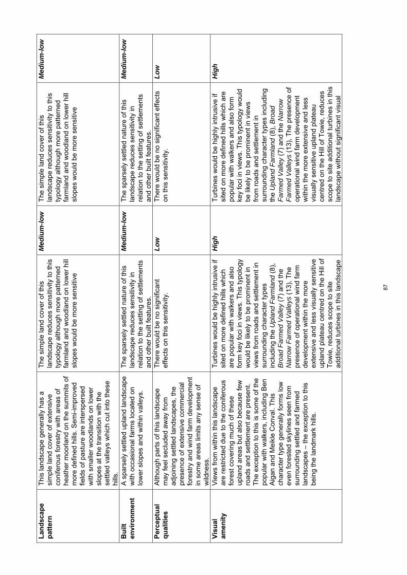
Lan
dsc
ape
pat
tern
Thi
s la
ndsc
ape
gene
rally
has
a
sim
ple
land
cov
er o
f ext
ensi
ve
coni
fero
us fo
rest
ry w
ith a
reas
of
heat
her
moo
rland
on
the
sum
mits
of
mor
e de
fined
hill
s. S
emi-i
mpr
oved
fie
lds
of p
astu
re a
re in
ters
pers
ed
with
sm
alle
r w
oodl
ands
on
low
er
slop
es a
t the
tran
sitio
n w
ith th
e se
ttled
val
leys
whi
ch c
ut in
to th
ese
hills
.
The
sim
ple
land
cov
er o
f thi
s la
ndsc
ape
redu
ces
sens
itivi
ty to
this
ty
polo
gy a
lthou
gh m
ore
patte
rned
fa
rmla
nd a
nd w
oodl
and
on lo
wer
hill
sl
opes
wou
ld b
e m
ore
sens
itive
Med
ium
-low
T
he s
impl
e la
nd c
over
of t
his
land
scap
e re
duce
s se
nsiti
vity
to th
is
typo
logy
alth
ough
mor
e pa
ttern
ed
farm
land
and
woo
dlan
d on
low
er h
ill
slop
es w
ould
be
mor
e se
nsiti
ve
Med
ium
-low
Bu
ilt
envi
ron
men
t
A s
pars
ely
settl
ed u
plan
d la
ndsc
ape
with
occ
asio
nal f
arm
s lo
cate
d on
lo
wer
slo
pes
and
with
in v
alle
ys.
The
spa
rsel
y se
ttled
nat
ure
of th
is
land
scap
e re
duce
s se
nsiti
vity
in
rela
tion
to th
e se
tting
of s
ettle
men
ts
and
othe
r bu
ilt fe
atur
es.
Med
ium
-low
T
he s
pars
ely
settl
ed n
atur
e of
this
la
ndsc
ape
redu
ces
sens
itivi
ty in
re
latio
n to
the
setti
ng o
f set
tlem
ents
an
d ot
her
built
feat
ures
.
Med
ium
-low
Per
cep
tual
q
ual
itie
s
Alth
ough
par
ts o
f thi
s la
ndsc
ape
may
feel
sec
lude
d aw
ay fr
om
adjo
inin
g se
ttled
land
scap
es, t
he
pres
ence
of e
xten
sive
com
mer
cial
fo
rest
ry a
nd w
ind
farm
dev
elop
men
t in
som
e ar
eas
limits
any
sen
se o
f w
ildne
ss.
The
re w
ould
be
no s
igni
fican
t ef
fect
s on
this
sen
sitiv
ity.
Lo
w
The
re w
ould
be
no s
igni
fican
t effe
cts
on th
is s
ensi
tivity
. Lo
w
Vis
ual
am
enit
y
Vie
ws
from
with
in th
is la
ndsc
ape
are
rest
ricte
d du
e to
the
coni
fero
us
fore
st c
over
ing
muc
h of
thes
e up
land
are
as b
ut a
lso
beca
use
few
ro
ads
and
settl
emen
t are
pre
sent
. T
he e
xcep
tion
to th
is is
som
e of
the
popu
lar
with
wal
kers
, inc
ludi
ng B
en
Aig
an a
nd M
eikl
e C
onva
l. T
his
char
acte
r ty
pe g
ener
ally
form
s lo
w
even
fore
sted
sky
lines
see
n fr
om
surr
ound
ing
settl
ed a
nd fa
rmed
la
ndsc
apes
– th
e ex
cept
ion
to th
is
bein
g th
e la
ndm
ark
hills
.
Tur
bine
s w
ould
be
high
ly in
trus
ive
if si
ted
on m
ore
defin
ed h
ills
whi
ch
are
popu
lar
with
wal
kers
and
als
o fo
rm k
ey fo
ci in
vie
ws.
Thi
s ty
polo
gy
wou
ld b
e lik
ely
to b
e pr
omin
ent i
n vi
ews
from
roa
ds a
nd s
ettle
men
t in
surr
ound
ing
char
acte
r ty
pes
incl
udin
g th
e U
plan
d F
arm
land
(8)
, B
road
Far
med
Val
ley
(7)
and
the
Nar
row
Far
med
Val
leys
(13
), T
he
pres
ence
of o
pera
tiona
l win
d fa
rm
deve
lopm
ent w
ithin
the
mor
e ex
tens
ive
and
less
vis
ually
sen
sitiv
e up
land
pla
teau
cen
tred
on
the
Hill
of
Tow
ie, r
educ
es s
cope
to s
ite
addi
tiona
l tur
bine
s in
this
land
scap
e
Hig
h T
urbi
nes
wou
ld b
e hi
ghly
intr
usiv
e if
site
d on
mor
e de
fined
hill
s w
hich
are
po
pula
r w
ith w
alke
rs a
nd a
lso
form
ke
y fo
ci in
vie
ws.
Thi
s ty
polo
gy w
ould
be
like
ly to
be
prom
inen
t in
view
s fr
om r
oads
and
set
tlem
ent i
n su
rrou
ndin
g ch
arac
ter
type
s in
clud
ing
the
Upl
and
Far
mla
nd (
8), B
road
F
arm
ed V
alle
y (7
) an
d th
e N
arro
w
Far
med
Val
leys
(13
), T
he p
rese
nce
of
oper
atio
nal w
ind
farm
dev
elop
men
t w
ithin
the
mor
e ex
tens
ive
and
less
vi
sual
ly s
ensi
tive
upla
nd p
late
au
cent
red
on th
e H
ill o
f Tow
ie, r
educ
es
scop
e to
site
add
ition
al tu
rbin
es in
this
la
ndsc
ape
with
out s
igni
fican
t vis
ual
Hig
h
87
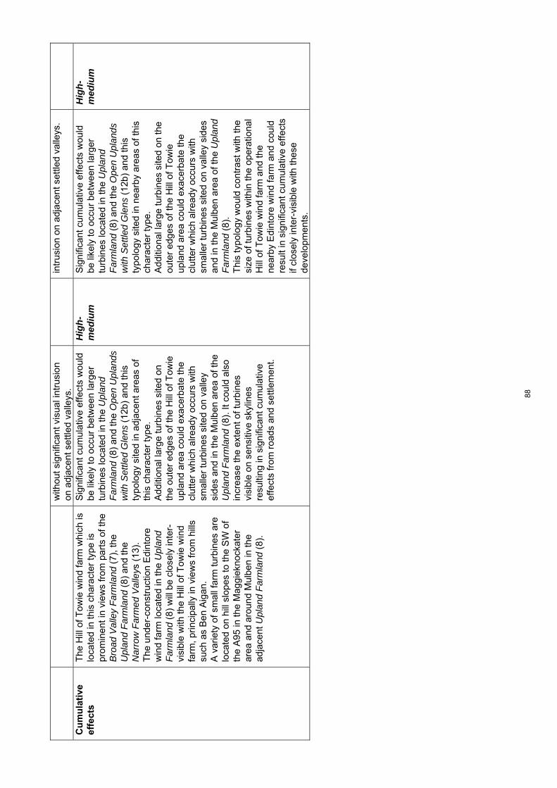
with
out s
igni
fican
t vis
ual i
ntru
sion
on
adj
acen
t set
tled
valle
ys.
intr
usio
n on
adj
acen
t set
tled
valle
ys.
C
um
ula
tive
ef
fect
s T
he H
ill o
f Tow
ie w
ind
farm
whi
ch is
lo
cate
d in
this
cha
ract
er ty
pe is
pr
omin
ent i
n vi
ews
from
par
ts o
f the
B
road
Val
ley
Far
mla
nd (
7), t
he
Upl
and
Far
mla
nd (
8) a
nd th
e N
arro
w F
arm
ed V
alle
ys (
13).
T
he u
nder
-con
stru
ctio
n E
dint
ore
win
d fa
rm lo
cate
d in
the
Upl
and
Far
mla
nd (
8) w
ill b
e cl
osel
y in
ter-
visi
ble
with
the
Hill
of T
owie
win
d fa
rm, p
rinci
pally
in v
iew
s fr
om h
ills
such
as
Ben
Aig
an.
A v
arie
ty o
f sm
all f
arm
turb
ines
are
lo
cate
d on
hill
slo
pes
to th
e S
W o
f th
e A
95 in
the
Mag
giek
nock
ater
ar
ea a
nd a
roun
d M
ulbe
n in
the
adja
cent
Upl
and
Far
mla
nd (
8).
Sig
nific
ant c
umul
ativ
e ef
fect
s w
ould
be
like
ly to
occ
ur b
etw
een
larg
er
turb
ines
loca
ted
in th
e U
plan
d F
arm
land
(8)
and
the
Ope
n U
plan
ds
with
Set
tled
Gle
ns (
12b)
and
this
ty
polo
gy s
ited
in a
djac
ent a
reas
of
this
cha
ract
er ty
pe.
Add
ition
al la
rge
turb
ines
site
d on
th
e ou
ter
edge
s of
the
Hill
of T
owie
up
land
are
a co
uld
exac
erba
te th
e cl
utte
r w
hich
alre
ady
occu
rs w
ith
smal
ler
turb
ines
site
d on
val
ley
side
s an
d in
the
Mul
ben
area
of t
he
Upl
and
Far
mla
nd (
8). I
t cou
ld a
lso
incr
ease
the
exte
nt o
f tur
bine
s vi
sibl
e on
sen
sitiv
e sk
ylin
es
resu
lting
in s
igni
fican
t cum
ulat
ive
effe
cts
from
roa
ds a
nd s
ettle
men
t.
Hig
h-m
ediu
m
Sig
nific
ant c
umul
ativ
e ef
fect
s w
ould
be
like
ly to
occ
ur b
etw
een
larg
er
turb
ines
loca
ted
in th
e U
plan
d F
arm
land
(8)
and
the
Ope
n U
plan
ds
with
Set
tled
Gle
ns (
12b)
and
this
ty
polo
gy s
ited
in n
earb
y ar
eas
of th
is
char
acte
r ty
pe.
Add
ition
al la
rge
turb
ines
site
d on
the
oute
r ed
ges
of th
e H
ill o
f Tow
ie
upla
nd a
rea
coul
d ex
acer
bate
the
clut
ter
whi
ch a
lread
y oc
curs
with
sm
alle
r tu
rbin
es s
ited
on v
alle
y si
des
and
in th
e M
ulbe
n ar
ea o
f the
Upl
and
Far
mla
nd (
8).
T
his
typo
logy
wou
ld c
ontr
ast w
ith th
e si
ze o
f tur
bine
s w
ithin
the
oper
atio
nal
Hill
of T
owie
win
d fa
rm a
nd th
e ne
arby
Edi
ntor
e w
ind
farm
and
cou
ld
resu
lt in
sig
nific
ant c
umul
ativ
e ef
fect
s if
clos
ely
inte
r-vi
sibl
e w
ith th
ese
deve
lopm
ents
.
Hig
h-m
ediu
m
88

Land
scap
e ch
arac
ter t
ype
10: U
plan
d M
oorla
nd a
nd F
ores
try
– Se
nsiti
vity
ass
essm
ent f
or la
rger
typo
logi
es
To
pic
S
um
mar
y d
escr
ipti
on
Lar
ge
scal
e ty
po
log
y as
sess
men
t (8
0-13
0m)
Sen
siti
vity
ra
tin
g
Med
ium
sca
le t
ypo
log
y as
sess
men
t (5
0-80
m)
Sen
siti
vity
ra
tin
g
Lan
dsc
ape
con
text
T
his
land
scap
e fo
rms
a re
lativ
ely
low
bac
kdro
p of
ext
ensi
vely
fore
sted
an
d op
en h
ills
to th
e m
ore
richl
y pa
ttern
ed a
nd s
mal
ler
scal
e hi
ll fr
inge
s of
LC
Ts
5, 5
a, 5
b an
d 6
to
the
nort
h an
d w
est a
nd to
LC
T 7
to
the
sout
h. T
hese
upl
ands
are
see
n as
a d
ista
nt lo
ng lo
w r
idge
from
the
wel
l-set
tled
Coa
stal
Far
mla
nds
(4)
to th
e no
rth.
V
isib
ility
into
the
inte
rior
of th
ese
upla
nds
is li
mite
d fr
om th
ese
surr
ound
ing
land
scap
es. T
he m
ore
defin
ed h
ills
of M
ill B
uie,
Bro
wn
Mui
r an
d C
arn
na C
allic
he s
tand
out
as
easi
ly r
ecog
nisa
ble
and
freq
uent
ly
visi
ble
‘land
mar
k’ h
ills
on th
e ed
ge
of th
is c
hara
cter
type
. T
his
char
acte
r ty
pe is
rel
ativ
ely
exte
nsiv
e, a
cha
ract
eris
tic w
hich
is
rein
forc
ed w
here
it a
djoi
ns R
ollin
g O
pen
Upl
ands
(11
), w
hich
has
a
sim
ilar
vege
tatio
n pa
ttern
.
Larg
er tu
rbin
es s
ited
on th
e oc
casi
onal
mor
e pr
onou
nced
hill
s su
ch a
s B
row
n M
uir
and
Mill
Bui
e w
ould
affe
ct th
e ba
ckdr
op p
rovi
ded
to w
ell-s
ettle
d la
ndsc
apes
to th
e no
rth
as th
ey a
re la
ndm
ark
hills
vi
ews
of w
hich
rec
ur a
cros
s th
ese
low
land
cha
ract
er ty
pes.
Sm
alle
r sc
ale
valle
ys s
uch
as th
e Lo
ssie
V
alle
y, w
hich
is p
artic
ular
ly d
iver
se
in it
s up
per
reac
hes,
cou
ld a
lso
be
dom
inat
ed b
y la
rge
turb
ines
loca
ted
on th
e ou
ter
hills
of t
his
char
acte
r ty
pe. T
he o
utw
ard-
faci
ng h
ill s
lope
s an
d th
e la
ndm
ark
hill
of C
arn
na
Cal
liche
see
n fr
om th
e B
road
Val
ley
Far
mla
nd (
7) o
f the
Spe
y V
alle
y w
ould
als
o be
sen
sitiv
e to
turb
ines
of
this
siz
e.
In g
ener
al h
owev
er, t
he
exte
nsiv
enes
s of
this
cha
ract
er ty
pe
redu
ces
sens
itivi
ty p
rovi
ded
deve
lopm
ent w
ere
loca
ted
with
in
the
‘inte
rior’
of th
e up
land
s an
d se
t w
ell b
ack
from
mor
e se
nsiti
ve h
ill
tops
and
slo
pes
on th
e fr
inge
s of
th
is c
hara
cter
type
to m
inim
ise
effe
cts
on a
djoi
ning
sm
alle
r sc
ale
land
scap
es.
Med
ium
La
rger
typo
logi
es s
ited
on th
e oc
casi
onal
mor
e pr
onou
nced
hill
s su
ch a
s B
row
n M
uir
and
Mill
Bui
e w
ould
affe
ct th
e ba
ckdr
op p
rovi
ded
to
wel
l-set
tled
land
scap
es to
the
nort
h as
they
are
land
mar
k hi
lls v
iew
s of
w
hich
rec
ur a
cros
s th
ese
low
land
ch
arac
ter
type
s. S
mal
ler
scal
e va
lleys
su
ch a
s th
e Lo
ssie
Val
ley,
whi
ch is
pa
rtic
ular
ly d
iver
se in
its
uppe
r re
ache
s, c
ould
als
o be
dom
inat
ed b
y la
rge
turb
ines
loca
ted
on th
e ou
ter
hills
of t
his
char
acte
r ty
pe.
The
out
war
d-fa
cing
hill
slo
pes
and
the
land
mar
k hi
ll of
Car
n na
Cal
liche
see
n fr
om th
e B
road
Val
ley
Far
mla
nd (
7)
wou
ld a
lso
be s
ensi
tive
to tu
rbin
es o
f th
is s
ize.
In
gen
eral
how
ever
, the
ex
tens
iven
ess
of th
is c
hara
cter
type
re
duce
s se
nsiti
vity
pro
vide
d de
velo
pmen
t wer
e lo
cate
d w
ithin
the
‘inte
rior’
of th
e up
land
s an
d se
t wel
l ba
ck fr
om m
ore
sens
itive
slo
pes
on
the
frin
ges
of th
is c
hara
cter
type
. T
here
may
be
incr
ease
d sc
ope
to
acco
mm
odat
e th
e sm
alle
r tu
rbin
es o
f th
is ty
polo
gy to
min
imis
e ef
fect
s on
ad
join
ing
mor
e se
nsiti
ve la
ndsc
apes
.
Med
ium
-low
Sca
le a
nd
o
pen
nes
s
A la
rge
scal
e ge
ntly
und
ulat
ing
upla
nd p
late
au r
isin
g to
bet
wee
n 30
0-40
0m. S
light
ly lo
wer
hill
s oc
cur
on th
e no
rthe
rn e
dge
of th
is
Thi
s ty
polo
gy c
ould
rel
ate
to th
e ex
pans
iven
ess
and
relie
f of t
he
inte
rior
plat
eau,
alth
ough
turb
ines
of
this
siz
e w
ould
dom
inat
e sm
alle
r
Med
ium
-low
T
his
typo
logy
cou
ld r
elat
e to
the
expa
nsiv
enes
s of
the
inte
rior
plat
eau.
T
urbi
nes
of th
is s
ize
wou
ld h
ave
less
of
an
effe
ct o
n th
e re
lativ
ely
low
rel
ief
Med
ium
-low
89

char
acte
r ty
pe. S
cale
is r
educ
ed
with
in o
ccas
iona
l nar
row
gle
ns s
uch
as th
e G
len
of R
othe
s an
d at
the
tran
sitio
n w
ith th
e up
per
Loss
ie
Val
ley
whe
re la
ndfo
rm is
mor
e co
mpl
ex.
glen
s an
d hi
lls.
of s
mal
ler
edge
hill
s bu
t wou
ld s
till
dom
inat
e th
e sc
ale
of n
arro
w g
lens
Lan
dfo
rm
T
hese
upl
ands
form
a s
impl
e un
dula
ting
plat
eau
with
bro
ad g
entle
sl
opes
, sha
llow
bas
ins
and
roun
ded
sum
mits
. Lan
dfor
m is
mor
e co
mpl
ex
at th
e tr
ansi
tion
with
the
Rol
ling
Far
mla
nd a
nd F
ores
ts w
ith V
alle
ys
(5a)
to th
e so
uth-
wes
t of D
alla
s w
here
inci
sed
valle
ys, m
ore
knol
ly
topo
grap
hy a
nd lo
chan
s oc
cur.
The
na
rrow
inci
sed
Gle
n of
Rot
hes
and
stee
p-si
ded
and
pron
ounc
ed h
ills
of
Mill
Bui
e, B
row
n M
uir
and
Car
n na
C
ailli
che
form
land
mar
k fe
atur
es.
Thi
s ty
polo
gy c
ould
rel
ate
to th
e pr
edom
inan
tly s
impl
e la
ndfo
rm o
f th
is g
ently
und
ulat
ing
plat
eau.
T
urbi
nes
of th
is s
ize
wou
ld d
etra
ct
from
the
land
mar
k hi
lls o
f Bro
wn
Mui
r, M
ill B
uie
and
Car
n na
C
ailli
che,
the
deep
trou
gh o
f the
G
len
of R
othe
s an
d po
cket
s of
mor
e co
mpl
ex la
ndfo
rm, i
f site
d on
or
near
by th
ese
feat
ures
.
Med
ium
T
his
typo
logy
cou
ld r
elat
e to
the
pred
omin
antly
sim
ple
land
form
of t
his
gent
ly u
ndul
atin
g pl
atea
u. T
urbi
nes
of
this
siz
e w
ould
det
ract
from
the
land
mar
k hi
lls o
f Bro
wn
Mui
r, M
ill B
uie
and
Car
n na
Cai
llich
e, th
e de
ep
trou
gh o
f the
Gle
n of
Rot
hes
and
pock
ets
of m
ore
com
plex
land
form
, if
site
d on
or
near
by th
ese
feat
ures
.
Med
ium
Lan
dsc
ape
pat
tern
Ext
ensi
ve c
onife
rous
fore
stry
and
gr
ass/
heat
her
moo
rland
with
oc
casi
onal
bog
gy b
asin
s be
twee
n hi
lls.
Thi
s ty
polo
gy c
ould
fit w
ith th
e si
mpl
e la
nd c
over
foun
d w
ithin
the
upla
nd in
terio
r of
this
cha
ract
er
type
.
Low
T
his
typo
logy
cou
ld fi
t with
the
sim
ple
land
cov
er fo
und
with
in th
e up
land
in
terio
r of
this
cha
ract
er ty
pe.
Low
Bu
ilt
envi
ron
men
t
A v
ery
spar
sely
set
tled
land
scap
e w
ith is
olat
ed fa
rms
loca
ted
with
in
the
Gle
n of
Rot
hes
and
on h
ill
slop
es a
bove
the
Bro
ad F
arm
land
V
alle
y (7
) an
d th
e R
ollin
g F
arm
land
s an
d F
ores
t (5)
. The
A
941
and
a na
rrow
min
or r
oad
cros
s th
is la
ndsc
ape
alth
ough
ac
cess
is r
estr
icte
d ge
nera
lly w
ithin
th
e up
land
cor
e.
The
ope
ratio
nal R
othe
s I a
nd II
win
d fa
rm, m
asts
and
pow
er li
nes
are
loca
ted
with
in th
is c
hara
cter
type
.
The
rel
ativ
ely
spar
se s
ettle
men
t an
d pr
esen
ce o
f exi
stin
g w
ind
farm
de
velo
pmen
t and
oth
er b
uilt
infr
astr
uctu
re r
educ
es s
ensi
tivity
.
Low
T
he r
elat
ivel
y sp
arse
set
tlem
ent a
nd
pres
ence
of e
xist
ing
win
d fa
rms
and
othe
r bu
ilt in
fras
truc
ture
red
uces
se
nsiti
vity
.
Low
Per
cep
tual
A
lthou
gh a
cces
s is
rel
ativ
ely
Alth
ough
in p
lace
s se
clud
ed,
Med
ium
-low
A
lthou
gh in
pla
ces
secl
uded
, M
ediu
m-lo
w
90
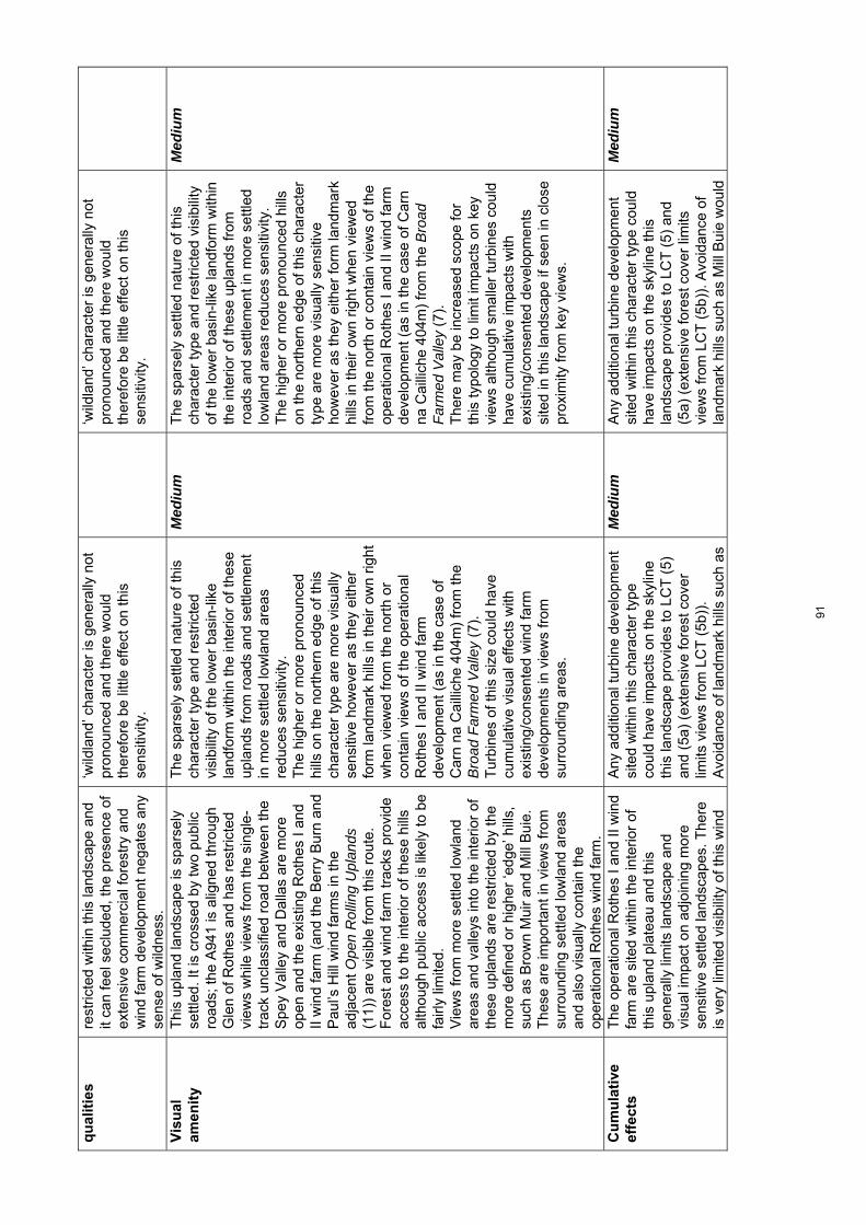
qu
alit
ies
rest
ricte
d w
ithin
this
land
scap
e an
d it
can
feel
sec
lude
d, th
e pr
esen
ce o
f ex
tens
ive
com
mer
cial
fore
stry
and
w
ind
farm
dev
elop
men
t neg
ates
any
se
nse
of w
ildne
ss.
‘wild
land
’ cha
ract
er is
gen
eral
ly n
ot
pron
ounc
ed a
nd th
ere
wou
ld
ther
efor
e be
littl
e ef
fect
on
this
se
nsiti
vity
.
‘wild
land
’ cha
ract
er is
gen
eral
ly n
ot
pron
ounc
ed a
nd th
ere
wou
ld
ther
efor
e be
littl
e ef
fect
on
this
se
nsiti
vity
.
Vis
ual
am
enit
y
Thi
s up
land
land
scap
e is
spa
rsel
y se
ttled
. It i
s cr
osse
d by
two
publ
ic
road
s; th
e A
941
is a
ligne
d th
roug
h G
len
of R
othe
s an
d ha
s re
stric
ted
view
s w
hile
vie
ws
from
the
sing
le-
trac
k un
clas
sifie
d ro
ad b
etw
een
the
Spe
y V
alle
y an
d D
alla
s ar
e m
ore
open
and
the
exis
ting
Rot
hes
I and
II
win
d fa
rm (
and
the
Ber
ry B
urn
and
Pau
l’s H
ill w
ind
farm
s in
the
adja
cent
Ope
n R
ollin
g U
plan
ds
(11)
) ar
e vi
sibl
e fr
om th
is r
oute
. F
ores
t and
win
d fa
rm tr
acks
pro
vide
ac
cess
to th
e in
terio
r of
thes
e hi
lls
alth
ough
pub
lic a
cces
s is
like
ly to
be
fairl
y lim
ited.
V
iew
s fr
om m
ore
settl
ed lo
wla
nd
area
s an
d va
lleys
into
the
inte
rior
of
thes
e up
land
s ar
e re
stric
ted
by th
e m
ore
defin
ed o
r hi
gher
‘edg
e’ h
ills,
su
ch a
s B
row
n M
uir
and
Mill
Bui
e.
The
se a
re im
port
ant i
n vi
ews
from
su
rrou
ndin
g se
ttled
low
land
are
as
and
also
vis
ually
con
tain
the
oper
atio
nal R
othe
s w
ind
farm
.
The
spa
rsel
y se
ttled
nat
ure
of th
is
char
acte
r ty
pe a
nd r
estr
icte
d vi
sibi
lity
of th
e lo
wer
bas
in-li
ke
land
form
with
in th
e in
terio
r of
thes
e up
land
s fr
om r
oads
and
set
tlem
ent
in m
ore
settl
ed lo
wla
nd a
reas
re
duc
es s
ensi
tivity
. T
he h
ighe
r or
mor
e pr
onou
nced
hi
lls o
n th
e no
rthe
rn e
dge
of th
is
char
acte
r ty
pe a
re m
ore
visu
ally
se
nsiti
ve h
owev
er a
s th
ey e
ither
fo
rm la
ndm
ark
hills
in th
eir
own
right
w
hen
view
ed fr
om th
e no
rth
or
cont
ain
view
s of
the
oper
atio
nal
Rot
hes
I and
II w
ind
farm
de
velo
pmen
t (as
in th
e ca
se o
f C
arn
na C
ailli
che
404m
) fr
om th
e B
road
Far
med
Val
ley
(7).
T
urbi
nes
of th
is s
ize
coul
d ha
ve
cum
ulat
ive
visu
al e
ffect
s w
ith
exis
ting/
cons
ente
d w
ind
farm
de
velo
pmen
ts in
vie
ws
from
su
rrou
ndin
g ar
eas.
Med
ium
T
he s
pars
ely
settl
ed n
atur
e of
this
ch
arac
ter
type
and
res
tric
ted
visi
bilit
y of
the
low
er b
asin
-like
land
form
with
in
the
inte
rior
of th
ese
upla
nds
from
ro
ads
and
settl
emen
t in
mor
e se
ttled
lo
wla
nd a
reas
red
uce
s se
nsiti
vity
. T
he h
ighe
r or
mor
e pr
onou
nced
hill
s on
the
nort
hern
edg
e of
this
cha
ract
er
type
are
mor
e vi
sual
ly s
ensi
tive
how
ever
as
they
eith
er fo
rm la
ndm
ark
hills
in th
eir
own
right
whe
n vi
ewed
fr
om th
e no
rth
or c
onta
in v
iew
s of
the
oper
atio
nal R
othe
s I a
nd II
win
d fa
rm
deve
lopm
ent (
as in
the
case
of C
arn
na C
ailli
che
404m
) fr
om th
e B
road
F
arm
ed V
alle
y (7
).
The
re m
ay b
e in
crea
sed
scop
e fo
r th
is ty
polo
gy to
lim
it im
pact
s on
key
vi
ews
alth
ough
sm
alle
r tu
rbin
es c
ould
ha
ve c
umul
ativ
e im
pact
s w
ith
exis
ting/
cons
ente
d de
velo
pmen
ts
site
d in
this
land
scap
e if
seen
in c
lose
pr
oxim
ity fr
om k
ey v
iew
s.
Med
ium
Cu
mu
lati
ve
effe
cts
The
ope
ratio
nal R
othe
s I a
nd II
win
d fa
rm a
re s
ited
with
in th
e in
terio
r of
th
is u
plan
d pl
atea
u an
d th
is
gene
rally
lim
its la
ndsc
ape
and
visu
al im
pact
on
adjo
inin
g m
ore
sens
itive
set
tled
land
scap
es. T
here
is
ver
y lim
ited
visi
bilit
y of
this
win
d
Any
add
ition
al tu
rbin
e de
velo
pmen
t si
ted
with
in th
is c
hara
cter
type
co
uld
have
impa
cts
on th
e sk
ylin
e th
is la
ndsc
ape
prov
ides
to L
CT
(5)
an
d (5
a) (
exte
nsiv
e fo
rest
cov
er
limits
vie
ws
from
LC
T (
5b))
. A
void
ance
of l
andm
ark
hills
suc
h as
Med
ium
A
ny a
dditi
onal
turb
ine
deve
lopm
ent
site
d w
ithin
this
cha
ract
er ty
pe c
ould
ha
ve im
pact
s on
the
skyl
ine
this
la
ndsc
ape
prov
ides
to L
CT
(5)
and
(5
a) (
exte
nsiv
e fo
rest
cov
er li
mits
vi
ews
from
LC
T (
5b))
. Avo
idan
ce o
f la
ndm
ark
hills
suc
h as
Mill
Bui
e w
ould
Med
ium
91

farm
from
the
Bro
ad V
alle
y F
arm
land
(7)
of t
he S
pey
Val
ley
alth
ough
it is
mor
e vi
sibl
e in
vie
ws
from
the
nort
h w
ithin
LC
Ts
(4),
(5)
an
d (5
a). T
he c
onse
nted
Kel
las
and
Mei
kle
Hill
win
d fa
rms
will
incr
ease
th
e ex
tent
, and
in s
ome
area
s, a
lso
the
prom
inen
ce o
f lar
ge tu
rbin
es
clos
e to
the
Loss
ie V
alle
y in
the
Dal
las
area
. C
lose
vie
ws
of th
e op
erat
iona
l R
othe
s I a
nd II
win
d fa
rm
deve
lopm
ent o
ccur
from
the
uncl
assi
fied
road
bet
wee
n th
e S
pey
Val
ley
and
Dal
las
and
thes
e de
velo
pmen
ts a
re s
een
with
the
Pau
l’s H
ill a
nd B
erry
Bur
n op
erat
iona
l win
d fa
rms
site
d in
the
adja
cent
Ope
n R
ollin
g U
plan
ds (
11)
from
this
rou
te.
Ope
ratio
nal w
ind
farm
s ar
e ge
nera
lly s
et b
ack
from
th
is r
oad
(par
ticul
arly
thos
e de
velo
pmen
ts in
the
Ope
n R
ollin
g U
plan
ds (
11))
alth
ough
the
cons
ente
d de
velo
pmen
t of M
eikl
e H
ill w
ill b
e si
ted
muc
h cl
oser
to th
is
road
.
Mill
Bui
e w
ould
lim
it cu
mul
ativ
e im
pact
s by
con
tain
ing
and
sepa
ratin
g w
ind
farm
de
velo
pmen
ts.
Cum
ulat
ive
effe
cts
coul
d oc
cur
if de
velo
pmen
t enc
roac
hed
clos
er o
n bo
th s
ides
of t
he u
ncla
ssifi
ed r
oad
betw
een
Spe
y V
alle
y an
d D
alla
s,
crea
ting
a do
min
ant c
orrid
or e
ffect
of
larg
e tu
rbin
es a
ffect
ing
view
s an
d th
e ex
perie
nce
of tr
avel
ling
on th
is
rem
ote
and
scen
ic r
oute
. C
umul
ativ
e ef
fect
s co
uld
occu
r fr
om
the
Dav
a W
ay T
rail
whe
re w
ind
farm
s in
LC
T 1
1 an
d th
is la
ndsc
ape
wer
e se
en s
imul
tane
ousl
y or
se
quen
tially
from
this
rec
reat
iona
l ro
ute.
limit
cum
ulat
ive
impa
cts
by c
onta
inin
g an
d se
para
ting
win
d fa
rm
deve
lopm
ents
. C
umul
ativ
e ef
fect
s co
uld
occu
r if
deve
lopm
ent e
ncro
ache
d cl
oser
on
both
sid
es o
f the
unc
lass
ified
roa
d be
twee
n S
pey
Val
ley
and
Dal
las,
cr
eatin
g a
dom
inan
t cor
ridor
effe
ct o
f la
rge
turb
ines
affe
ctin
g vi
ews
and
the
expe
rienc
e of
trav
ellin
g on
this
rem
ote
and
scen
ic r
oute
. C
umul
ativ
e ef
fect
s co
uld
occu
r fr
om
the
Dav
a W
ay T
rail
whe
re w
ind
farm
s in
LC
T 1
1 an
d th
is la
ndsc
ape
wer
e se
en s
imul
tane
ousl
y or
seq
uent
ially
fr
om th
is r
ecre
atio
nal r
oute
.
92

Land
scap
e ch
arac
ter t
ype
11: O
pen
Rol
ling
Upl
ands
– S
ensi
tivity
ass
essm
ent f
or la
rger
typo
logi
es
To
pic
S
um
mar
y d
escr
ipti
on
Lar
ge
scal
e ty
po
log
y as
sess
men
t (8
0-13
0m)
Sen
siti
vity
ra
tin
g
Med
ium
sca
le t
ypo
log
y as
sess
men
t (5
0-80
m)
Sen
siti
vity
ra
tin
g
Lan
dsc
ape
con
text
T
his
upla
nd la
ndsc
ape
has
a si
mila
r ch
arac
ter
to th
e ad
jace
nt u
plan
ds
with
in H
ighl
and
Cou
ncil
area
to th
e so
uth
and
wes
t. T
he e
xten
sive
ness
of
this
land
scap
e al
so in
crea
ses
whe
re it
adj
oins
the
Upl
and
Moo
rland
and
For
estr
y (1
0) to
the
east
and
nor
th. W
ithin
Mor
ay, t
his
land
scap
e fo
rms
a ba
ckdr
op o
f pr
edom
inan
tly o
pen
and
shap
ely
hills
to th
e m
ore
richl
y pa
ttern
ed a
nd
smal
ler
scal
e hi
ll fr
inge
s of
the
Bro
ad F
arm
ed V
alle
y (7
) of
the
Spe
y V
alle
y to
the
sout
h. T
hese
up
land
s al
so fo
rm a
dis
tant
long
rid
ge s
een
from
the
wel
l-set
tled
Coa
stal
Far
mla
nds
(4)
to th
e no
rth.
T
he m
ore
defin
ed h
ills
of K
nock
of
Bra
emor
ay, R
oy’s
Hill
and
the
coni
cal p
eak
of C
arn
Kitt
y st
and
out
in v
iew
s fr
om s
urro
undi
ng
land
scap
es a
lthou
gh v
isib
ility
into
th
e in
terio
r of
thes
e up
land
s is
fairl
y lim
ited.
The
hill
s on
the
sout
hern
ed
ge o
f thi
s la
ndsc
ape
prov
ide
a di
stan
t bac
kdro
p to
the
Cai
rngo
rms
Nat
iona
l Par
k w
hile
thos
e on
the
wes
tern
bou
ndar
y of
Mor
ay fo
rm a
pr
omin
ent ‘
edge
’ to
the
expa
nsiv
e ba
sin
of D
ava
Moo
r an
d Lo
chin
dorb
w
ithin
the
Hig
hlan
d C
ounc
il ar
ea.
Larg
er ty
polo
gies
site
d on
the
mor
e pr
onou
nced
hill
s w
hich
lie
on th
e ou
ter
edge
s of
this
cha
ract
er ty
pe
wou
ld a
ffect
the
back
drop
pro
vide
d to
the
Bro
ad F
arm
ed V
alle
y (7
),
dom
inat
ing
this
adj
acen
t set
tled
and
smal
ler
scal
e la
ndsc
ape.
T
he la
ndm
ark
hill
of K
nock
of
Bra
emor
ay is
als
o pr
omin
ent i
n vi
ews
acro
ss D
ava
Moo
r,
Loch
indo
rb a
nd fr
om th
e N
arro
w
Woo
ded
Val
ley
(6)
and
part
s of
the
coas
tal p
lain
of M
oray
. The
lim
ited
visi
bilit
y of
the
low
er-ly
ing
inte
rior
of
thes
e up
land
s re
duce
s ef
fect
s on
ad
join
ing
land
scap
es a
lthou
gh
oper
atio
nal w
ind
farm
dev
elop
men
t is
alre
ady
acco
mm
odat
ed w
ithin
th
is a
rea.
T
his
typo
logy
site
d on
the
high
er
sout
hern
hill
s co
uld
affe
ct v
iew
s fr
om th
e C
airn
gorm
s N
atio
nal P
ark
and
its w
ider
land
scap
e se
tting
.
Hig
h-m
ediu
m
Larg
er ty
polo
gies
site
d on
the
mor
e pr
onou
nced
hill
s w
hich
lie
on th
e ou
ter
edge
s of
this
cha
ract
er ty
pe
wou
ld a
ffect
the
back
drop
pro
vide
d to
th
e B
road
Far
med
Val
ley
(7),
do
min
atin
g th
is a
djac
ent s
ettle
d an
d sm
alle
r sc
ale
land
scap
e.
The
land
mar
k hi
ll of
Kno
ck o
f B
raem
oray
is a
lso
prom
inen
t in
view
s ac
ross
Dav
a M
oor
and
from
the
Nar
row
Woo
ded
Val
ley
(6)
and
part
s of
the
coas
tal p
lain
of M
oray
. The
lim
ited
visi
bilit
y of
the
low
er-ly
ing
inte
rior
of th
ese
upla
nds
how
ever
re
duce
s ef
fect
s on
adj
oini
ng
land
scap
es a
lthou
gh o
pera
tiona
l win
d fa
rm d
evel
opm
ent i
s al
read
y ac
com
mod
ated
in th
is a
rea.
T
his
typo
logy
site
d on
the
high
er
sout
hern
hill
s co
uld
affe
ct v
iew
s fr
om
the
Cai
rngo
rms
Nat
iona
l Par
k an
d its
w
ider
land
scap
e se
tting
.
Hig
h-m
ediu
m
Sca
le a
nd
o
pen
nes
s A
larg
e sc
ale
gent
ly u
ndul
atin
g up
land
pla
teau
with
rou
nded
hill
s T
his
typo
logy
cou
ld r
elat
e to
the
expa
nsiv
enes
s an
d re
lief o
f the
M
ediu
m
Thi
s ty
polo
gy c
ould
rel
ate
to th
e ex
pans
iven
ess
of th
e in
terio
r pl
atea
u.
Med
ium
-low
93
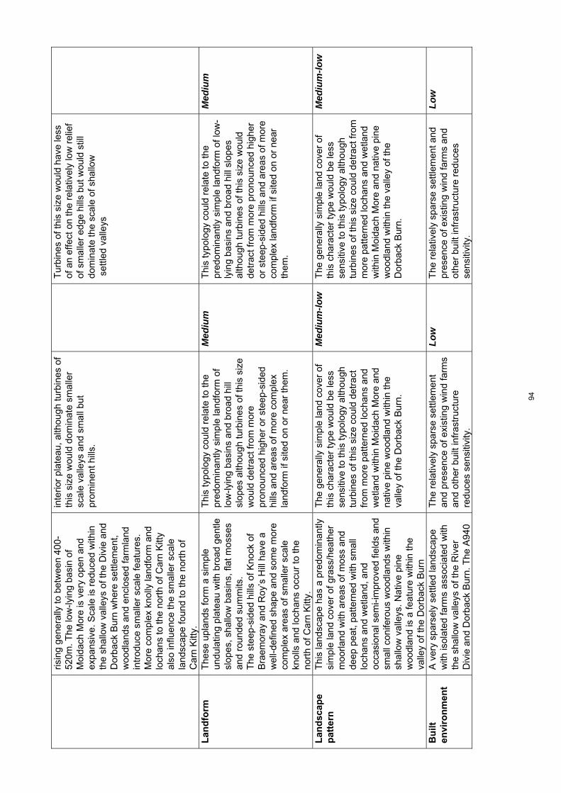
ris
ing
gene
rally
to b
etw
een
400-
520m
. The
low
-lyin
g ba
sin
of
Moi
dach
Mor
e is
ver
y op
en a
nd
expa
nsiv
e. S
cale
is r
educ
ed w
ithin
th
e sh
allo
w v
alle
ys o
f the
Div
ie a
nd
Dor
back
Bur
n w
here
set
tlem
ent,
woo
dlan
ds a
nd e
nclo
sed
farm
land
in
trod
uce
smal
ler
scal
e fe
atur
es.
Mor
e co
mpl
ex k
nolly
land
form
and
lo
chan
s to
the
nort
h of
Car
n K
itty
also
influ
ence
the
smal
ler
scal
e la
ndsc
ape
foun
d to
the
nort
h of
C
arn
Kitt
y.
inte
rior
plat
eau,
alth
ough
turb
ines
of
this
siz
e w
ould
dom
inat
e sm
alle
r sc
ale
valle
ys a
nd s
mal
l but
pr
omin
ent h
ills.
Tur
bine
s of
this
siz
e w
ould
hav
e le
ss
of a
n ef
fect
on
the
rela
tivel
y lo
w r
elie
f of
sm
alle
r ed
ge h
ills
but w
ould
stil
l do
min
ate
the
scal
e of
sha
llow
s
ettle
d va
lleys
Lan
dfo
rm
T
hese
upl
ands
form
a s
impl
e un
dula
ting
plat
eau
with
bro
ad g
entle
sl
opes
, sha
llow
bas
ins,
flat
mos
ses
and
roun
ded
sum
mits
. T
he s
teep
-sid
ed h
ills
of K
nock
of
Bra
emor
ay a
nd R
oy’s
Hill
hav
e a
wel
l-def
ined
sha
pe a
nd s
ome
mor
e co
mpl
ex a
reas
of s
mal
ler
scal
e kn
olls
and
loch
ans
occu
r to
the
nort
h of
Car
n K
itty.
Thi
s ty
polo
gy c
ould
rel
ate
to th
e pr
edom
inan
tly s
impl
e la
ndfo
rm o
f lo
w-ly
ing
basi
ns a
nd b
road
hill
sl
opes
alth
ough
turb
ines
of t
his
size
w
ould
det
ract
from
mor
e pr
onou
nced
hig
her
or s
teep
-sid
ed
hills
and
are
as o
f mor
e co
mpl
ex
land
form
if s
ited
on o
r ne
ar th
em.
Med
ium
T
his
typo
logy
cou
ld r
elat
e to
the
pred
omin
antly
sim
ple
land
form
of l
ow-
lyin
g ba
sins
and
bro
ad h
ill s
lope
s al
thou
gh tu
rbin
es o
f thi
s si
ze w
ould
de
trac
t fro
m m
ore
pron
ounc
ed h
ighe
r or
ste
ep-s
ided
hill
s an
d ar
eas
of m
ore
com
plex
land
form
if s
ited
on o
r ne
ar
them
.
Med
ium
Lan
dsc
ape
pat
tern
Thi
s la
ndsc
ape
has
a pr
edom
inan
tly
sim
ple
land
cov
er o
f gra
ss/h
eath
er
moo
rland
with
are
as o
f mos
s an
d de
ep p
eat,
patte
rned
with
sm
all
loch
ans
and
wet
land
, and
oc
casi
onal
sem
i-im
prov
ed fi
elds
and
sm
all c
onife
rous
woo
dlan
ds w
ithin
sh
allo
w v
alle
ys. N
ativ
e pi
ne
woo
dlan
d is
a fe
atur
e w
ithin
the
valle
y of
the
Dor
back
Bur
n
The
gen
eral
ly s
impl
e la
nd c
over
of
this
cha
ract
er ty
pe w
ould
be
less
se
nsiti
ve to
this
typo
logy
alth
ough
tu
rbin
es o
f thi
s si
ze c
ould
det
ract
fr
om m
ore
patte
rned
loch
ans
and
wet
land
with
in M
oida
ch M
ore
and
nativ
e pi
ne w
oodl
and
with
in th
e va
lley
of th
e D
orba
ck B
urn.
Med
ium
-low
T
he g
ener
ally
sim
ple
land
cov
er o
f th
is c
hara
cter
type
wou
ld b
e le
ss
sens
itive
to th
is ty
polo
gy a
lthou
gh
turb
ines
of t
his
size
cou
ld d
etra
ct fr
om
mor
e pa
ttern
ed lo
chan
s an
d w
etla
nd
with
in M
oida
ch M
ore
and
nativ
e pi
ne
woo
dlan
d w
ithin
the
valle
y of
the
Do
rbac
k B
urn.
Med
ium
-low
Bu
ilt
envi
ron
men
t
A v
ery
spar
sely
set
tled
land
scap
e w
ith is
olat
ed fa
rms
asso
ciat
ed w
ith
the
shal
low
val
leys
of t
he R
iver
D
ivie
and
Dor
back
Bur
n. T
he A
940
The
rel
ativ
ely
spar
se s
ettle
men
t an
d pr
esen
ce o
f exi
stin
g w
ind
farm
s an
d ot
her
built
infr
astr
uctu
re
redu
ces
sens
itivi
ty.
Low
T
he r
elat
ivel
y sp
arse
set
tlem
ent a
nd
pres
ence
of e
xist
ing
win
d fa
rms
and
othe
r bu
ilt in
fras
truc
ture
red
uces
se
nsiti
vity
.
Low
94
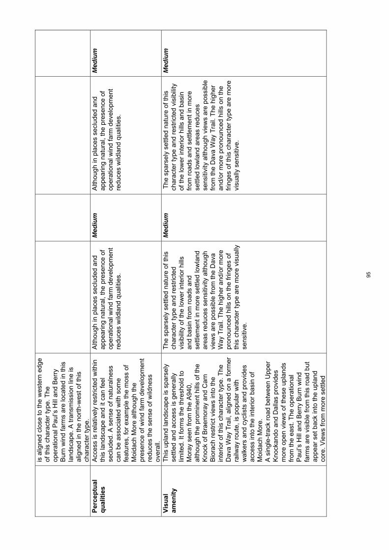
is a
ligne
d cl
ose
to th
e w
este
rn e
dge
of th
is c
hara
cter
type
. The
op
erat
iona
l Pau
l’s H
ill a
nd B
erry
B
urn
win
d fa
rms
are
loca
ted
in th
is
land
scap
e. A
tran
smis
sion
line
is
alig
ned
in th
e no
rth-
wes
t of t
his
char
acte
r ty
pe.
Per
cep
tual
q
ual
itie
s
Acc
ess
is r
elat
ivel
y re
stric
ted
with
in
this
land
scap
e an
d it
can
feel
se
clud
ed. A
sen
se o
f nat
ural
ness
ca
n be
ass
ocia
ted
with
som
e fe
atur
es, f
or e
xam
ple
the
mos
s of
M
oida
ch M
ore
alth
ough
the
pres
ence
of w
ind
farm
dev
elop
men
t re
duce
s th
e se
nse
of w
ildne
ss
over
all.
Alth
ough
in p
lace
s se
clud
ed a
nd
appe
arin
g na
tura
l, th
e pr
esen
ce o
f op
erat
iona
l win
d fa
rm d
evel
opm
ent
redu
ces
wild
land
qua
litie
s.
Med
ium
A
lthou
gh in
pla
ces
secl
uded
and
ap
pear
ing
natu
ral,
the
pres
ence
of
oper
atio
nal w
ind
farm
dev
elop
men
t re
duce
s w
ildla
nd q
ualit
ies.
Med
ium
Vis
ual
am
enit
y
Thi
s up
land
land
scap
e is
spa
rsel
y se
ttled
and
acc
ess
is g
ener
ally
lim
ited.
It fo
rms
the
thre
shol
d to
M
oray
see
n fr
om th
e A
940,
al
thou
gh th
e pr
omin
ent h
ills
of th
e K
nock
of B
raem
oray
and
Car
n B
iora
ch r
estr
ict v
iew
s in
to th
e in
terio
r of
this
cha
ract
er ty
pe. T
he
Dav
a W
ay T
rail,
alig
ned
on a
form
er
railw
ay r
oute
, is
popu
lar
with
w
alke
rs a
nd c
yclis
ts a
nd p
rovi
des
acce
ss in
to th
e in
terio
r ba
sin
of
Moi
dach
Mor
e.
A s
ingl
e-tr
ack
road
bet
wee
n U
pper
K
nock
ando
and
Dal
las
prov
ides
m
ore
open
vie
ws
of th
ese
upla
nds
from
the
east
. The
ope
ratio
nal
Pau
l’s H
ill a
nd B
erry
Bur
n w
ind
farm
s ar
e vi
sibl
e fr
om th
is r
oad
but
appe
ar s
et b
ack
into
the
upla
nd
core
. Vie
ws
from
mor
e se
ttled
The
spa
rsel
y se
ttled
nat
ure
of th
is
char
acte
r ty
pe a
nd r
estr
icte
d vi
sibi
lity
of th
e lo
wer
inte
rior
hills
an
d ba
sin
from
roa
ds a
nd
settl
emen
t in
mor
e se
ttled
low
land
ar
eas
redu
ces
sens
itivi
ty a
lthou
gh
view
s ar
e po
ssib
le fr
om th
e D
ava
Way
Tra
il. T
he h
ighe
r an
d/or
mor
e pr
onou
nced
hill
s on
the
frin
ges
of
this
cha
ract
er ty
pe a
re m
ore
visu
ally
se
nsiti
ve.
Med
ium
T
he s
pars
ely
settl
ed n
atur
e of
this
ch
arac
ter
type
and
res
tric
ted
visi
bilit
y of
the
low
er in
terio
r hi
lls a
nd b
asin
fr
om r
oads
and
set
tlem
ent i
n m
ore
settl
ed lo
wla
nd a
reas
red
uces
se
nsiti
vity
alth
ough
vie
ws
are
poss
ible
fr
om th
e D
ava
Way
Tra
il. T
he h
ighe
r an
d/or
mor
e pr
onou
nced
hill
s on
the
frin
ges
of th
is c
hara
cter
type
are
mor
e vi
sual
ly s
ensi
tive.
Med
ium
95

low
land
are
as a
nd v
alle
ys in
to th
e in
terio
r of
thes
e up
land
s ar
e re
stric
ted
by th
e m
ore
defin
ed o
r hi
gher
‘edg
e’ h
ills
incl
udin
g K
nock
of
Bra
emor
ay a
nd R
oy’s
Hill
and
thes
e hi
lls a
re a
lso
impo
rtan
t in
view
s fr
om
surr
ound
ing
settl
ed lo
wla
nd a
reas
an
d al
so v
isua
lly c
onta
in o
pera
tiona
l w
ind
farm
dev
elop
men
ts.
V
iew
s fr
om m
ore
settl
ed la
ndsc
apes
to
the
nort
h ar
e re
duce
d by
the
‘buf
fer’
prov
ided
by
the
Upl
and
Moo
rland
and
For
estr
y (1
0) w
hich
di
rect
ly a
buts
the
Rol
ling
Far
mla
nds
and
For
est w
ith V
alle
ys (
5a).
C
um
ula
tive
ef
fect
s T
he o
pera
tiona
l Pau
l’s H
ill a
nd
Ber
ry B
urn
win
d fa
rms
are
loca
ted
in th
is c
hara
cter
type
. The
Pau
l’s
Hill
win
d fa
rm is
prin
cipa
lly v
isib
le
from
the
Bro
ad F
arm
ed V
alle
y (7
) of
th
e S
pey
Val
ley.
The
Ber
ry B
urn
win
d fa
rm h
as a
rel
ativ
ely
limite
d ex
tent
of v
isib
ility
alth
ough
dis
tant
vi
ews
are
poss
ible
from
the
Loch
indo
rb a
rea
to th
e w
est w
hich
ha
s a
dist
inct
sen
se o
f wild
ness
. T
he R
othe
s I a
nd II
win
d fa
rm a
nd
the
cons
ente
d M
eikl
e H
ill w
ind
farm
ar
e lo
cate
d in
the
adja
cent
Upl
and
Moo
rland
and
For
estr
y (1
0). T
hese
w
ind
farm
s ar
e pr
inci
pally
see
n to
geth
er fr
om th
e m
inor
roa
d be
twee
n U
pper
Kno
ckan
do a
nd
Dal
las.
Pot
entia
l cum
ulat
ive
effe
cts
incl
ude
thos
e af
fect
ing
the
desi
gn in
tegr
ity
of th
ese
win
d fa
rms
as w
ell a
s ef
fect
s on
vie
ws
from
the
Bro
ad
Far
med
Val
ley
(7),
the
sens
itive
Lo
chin
dorb
and
Dav
a M
oor
area
, th
e D
ava
Way
Tra
il an
d m
inor
roa
d be
twee
n U
pper
Kno
ckan
do a
nd
Dal
las.
Hig
h-m
ediu
m
Pot
entia
l cum
ulat
ive
effe
cts
incl
ude
thos
e af
fect
ing
the
desi
gn in
tegr
ity o
f th
ese
win
d fa
rms
as w
ell a
s ef
fect
s on
vi
ews
from
the
Bro
ad F
arm
ed V
alle
y (7
), th
e se
nsiti
ve L
ochi
ndor
b an
d D
ava
Moo
r ar
ea, t
he D
ava
Way
Tra
il an
d m
inor
roa
d be
twee
n U
pper
K
nock
ando
and
Dal
las.
Tur
bine
s of
th
is s
ize
wou
ld b
e lik
ely
to b
e cl
osel
y in
ter-
visi
ble
with
exi
stin
g la
rge
turb
ines
(gi
ven
land
scap
e an
d vi
sual
co
nstr
aint
s in
the
rem
aini
ng
unde
velo
ped
area
s o
f thi
s la
ndsc
ape)
an
d co
uld
resu
lt in
clu
tter
and
unac
cept
able
vis
ual c
onfu
sion
.
Hig
h
96
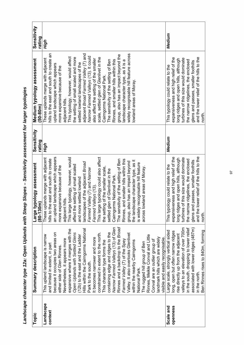
Land
scap
e ch
arac
ter t
ype
12a:
Ope
n U
plan
ds w
ith S
teep
Slo
pes
– Se
nsiti
vity
ass
essm
ent f
or la
rger
typo
logi
es
To
pic
S
um
mar
y d
escr
ipti
on
Lar
ge
typ
olo
gy
asse
ssm
ent
(80-
130m
) S
ensi
tivi
ty
rati
ng
M
ediu
m t
ypo
log
y as
sess
men
t (5
0-80
m)
Sen
siti
vity
ra
tin
g
Lan
dsc
ape
con
text
T
his
upla
nd la
ndsc
ape
is n
arro
w
and
limite
d in
ext
ent,
in p
art
beca
use
it oc
cupi
es tw
o ar
eas
on
eith
er s
ide
of G
len
Rin
nes.
N
ever
thel
ess,
it a
ppea
rs m
ore
expa
nsiv
e w
here
it m
erge
s w
ith th
e O
pen
Upl
ands
with
Set
tled
Gle
ns
(12b
) to
the
east
and
the
Ladd
er
Hill
s w
ithin
the
Cai
rngo
rms
Nat
iona
l P
ark
to th
e so
uth.
It
beco
mes
nar
row
er a
nd m
ore
cons
trai
ned
in e
xten
t to
the
nort
h.
Thi
s ch
arac
ter
type
form
s th
e co
ntai
ning
edg
e an
d rid
ges
to th
e N
arro
w F
arm
ed V
alle
ys (
13)
of G
len
Rin
nes
and
a ba
ckdr
op to
the
Bro
ad
Far
med
Val
ley
(7)
of th
e S
pey
Val
ley.
It a
lso
over
look
s G
lenl
ivet
w
ithin
the
near
by C
airn
gorm
s N
atio
nal P
ark.
T
he r
ugge
d hi
ll gr
oup
of B
en
Rin
nes,
Mei
kle
Con
val a
nd L
ittle
C
onva
l are
an
outli
er g
roup
of
land
mar
k hi
lls w
hich
are
wid
ely
visi
ble
and
easi
ly r
ecog
nisa
ble.
The
se u
plan
ds m
erge
with
adj
acen
t hi
lls to
the
east
and
sou
th to
cre
ate
an u
plan
d la
ndsc
ape
whi
ch a
ppea
rs
mor
e ex
pans
ive
beca
use
of th
e ad
jace
nt h
ills.
T
his
larg
e ty
polo
gy, h
owev
er, w
ould
af
fect
the
setti
ng o
f sm
all s
cale
d an
d m
ore
settl
ed lo
wla
nd
land
scap
es o
f the
adj
acen
t Bro
ad
Far
med
Val
ley
(7)
and
Nar
row
F
arm
ed V
alle
ys (
13).
T
his
larg
e ty
polo
gy c
ould
als
o af
fect
th
e se
tting
of t
he s
mal
ler
scal
e,
settl
ed g
len
of G
lenl
ivet
in th
e C
airn
gorm
s N
atio
nal P
ark.
T
he s
ensi
tivity
of t
he s
ettin
g of
Ben
R
inne
s, a
nd s
mal
ler
hills
with
in th
is
grou
p, a
lso
has
an im
pact
bey
ond
the
land
scap
e ch
arac
ter
type
, as
it is
wid
ely
reco
gnis
able
hill
feat
ure
acro
ss lo
wla
nd a
reas
of M
oray
.
Hig
h T
hese
upl
ands
mer
ge w
ith a
djac
ent
hills
to th
e ea
st a
nd s
outh
to c
reat
e an
up
land
land
scap
e w
hich
app
ears
m
ore
expa
nsiv
e be
caus
e of
the
adja
cent
hill
s.
Thi
s ty
polo
gy, h
owev
er, w
ould
affe
ct
the
setti
ng o
f sm
all s
cale
d an
d m
ore
settl
ed lo
wla
nd la
ndsc
apes
of t
he
adja
cent
Bro
ad F
arm
ed V
alle
y (7
) an
d N
arro
w F
arm
ed V
alle
ys (
13).
It c
ould
al
so a
ffect
the
setti
ng o
f the
sm
alle
r sc
ale,
set
tled
glen
of G
lenl
ivet
in th
e C
airn
gorm
s N
atio
nal P
ark.
T
he s
ensi
tivity
of t
he s
ettin
g of
Ben
R
inne
s, a
nd s
mal
ler
hills
with
in th
is
grou
p, a
lso
has
an im
pact
bey
ond
the
land
scap
e ch
arac
ter
type
, as
it is
a
wid
ely
reco
gnis
able
hill
feat
ure
acro
ss
low
land
are
as o
f Mor
ay.
Hig
h
Sca
le a
nd
o
pen
nes
s
Larg
e sc
ale,
str
ongl
y ve
rtic
al s
ided
lo
ng, o
pen
but o
ften
narr
ow r
idge
s ris
e di
rect
ly u
p fr
om th
e ad
jace
nt
valle
ys to
an
elev
atio
n of
ove
r 70
0m
in th
e so
uth,
dro
ppin
g to
low
er r
elie
f as
soci
ated
with
low
er r
idge
s (4
87m
) in
the
nort
h.
Ben
Rin
nes
rises
to 8
40m
, for
min
g
Thi
s ty
polo
gy c
ould
rel
ate
to th
e ex
pans
iven
ess
and
high
rel
ief o
f the
lo
ng r
idge
s an
d op
en h
ills,
alth
ough
tu
rbin
es o
f thi
s si
ze w
ould
dom
inat
e th
e na
rrow
rid
gelin
es, t
he e
nclo
sed
glen
s an
d pa
sses
, sm
alle
r fo
othi
lls
and
the
low
er r
elie
f of t
he h
ills
to th
e no
rth.
Med
ium
T
his
typo
logy
cou
ld r
elat
e to
the
expa
nsiv
enes
s an
d hi
gh r
elie
f of t
he
long
rid
ges
and
open
hill
s, a
lthou
gh
turb
ines
of t
his
size
wou
ld d
omin
ate
the
narr
ow r
idge
lines
, the
enc
lose
d gl
ens
and
pass
es, s
mal
ler
foot
hills
an
d th
e lo
wer
rel
ief o
f the
hill
s to
the
nort
h.
Med
ium
97

the
high
est p
oint
of a
n ou
tlyin
g gr
oup
of s
teep
sid
ed o
pen
hill
sum
mits
. S
cale
is r
educ
ed b
y in
crea
sed
cont
ainm
ent c
reat
ed b
y na
rrow
gl
ens
and
pass
es.
Woo
dlan
d an
d sm
alle
r to
pogr
aphi
cal f
eatu
res,
incl
udin
g sm
alle
r st
and-
alon
e hi
lls w
hich
pr
ovid
e th
e ba
ck d
rop
to D
uffto
wn,
al
so r
educ
e th
e sc
ale
alon
g th
e tr
ansi
tion
betw
een
thes
e sl
opes
and
ad
jace
nt v
alle
ys.
Lan
dfo
rm
T
hese
upl
ands
form
long
, slo
ping
bu
t rel
ativ
ely
even
rid
gelin
es to
the
east
of G
len
Rin
nes.
T
he r
ugge
d pr
ofile
form
ed b
y m
ore
com
plex
gra
dien
ts r
ise
to th
e pr
onou
nced
sum
mit
of B
en R
inne
s to
the
wes
t.
The
cha
ract
er ty
pe is
dom
inat
ed b
y st
eep
slop
es, w
ith o
nly
occa
sion
al
area
s of
mor
e ge
ntle
gra
dien
ts.
Mor
e co
mpl
ex la
ndfo
rm, i
nclu
ding
sm
alle
r hi
lls, o
ccur
at t
he n
orth
ern
end
of G
len
Rin
nes.
The
mor
e co
mpl
ex la
ndfo
rms
and
stee
per
slop
es a
re s
ensi
tive
to th
is
typo
logy
, alth
ough
it c
ould
rel
ate
to
the
sim
ple
land
form
of l
ong
ridge
s an
d th
e oc
casi
onal
mor
e ge
ntle
sl
opes
and
gra
dien
ts.
Tra
cks
and
plat
form
s si
ted
on th
e st
eepe
r sl
opes
are
like
ly to
req
uire
ex
tens
ive
eart
h w
orks
.
Hig
h-M
ediu
m
The
mor
e co
mpl
ex la
ndfo
rms
and
stee
per
slop
es a
re s
ensi
tive
to th
is
typo
logy
, alth
ough
it c
ould
rel
ate
to
the
sim
ple
land
form
of l
ong
ridge
s an
d th
e oc
casi
onal
mor
e ge
ntle
sl
opes
and
gra
dien
ts.
Tra
cks
and
plat
form
s si
ted
on th
e st
eepe
r sl
opes
are
like
ly to
req
uire
ex
tens
ive
eart
h w
orks
.
Hig
h-M
ediu
m
Lan
dsc
ape
pat
tern
Thi
s la
ndsc
ape
has
a pr
edom
inan
tly
sim
ple
land
cov
er o
f hea
ther
m
oorla
nd a
cros
s th
e up
per
slop
es
and
sum
mits
, with
occ
asio
nal
impr
oved
gra
ssla
nd fi
elds
alo
ng th
e lo
wer
hill
slo
pes.
The
se b
lend
se
amle
ssly
with
gra
ss fi
elds
with
in
the
farm
ed lo
w-ly
ing
land
. C
onife
rous
woo
dlan
ds, s
ome
of
whi
ch a
re q
uite
ext
ensi
ve, a
nd
smal
ler
shel
ter
woo
ds a
re to
be
The
gen
eral
ly s
impl
e la
nd c
over
of
this
cha
ract
er ty
pe w
ould
be
less
se
nsiti
ve to
turb
ines
of t
his
size
.
Med
ium
-low
T
he g
ener
ally
sim
ple
land
cov
er o
f th
is c
hara
cter
type
wou
ld b
e le
ss
sens
itive
to tu
rbin
es o
f thi
s si
ze.
Med
ium
-low
98

foun
d al
ong
the
low
er s
lope
s.
Bu
ilt
envi
ron
men
t
A v
ery
spar
sely
set
tled
land
scap
e w
ith is
olat
ed fa
rms
asso
ciat
ed w
ith
the
occa
sion
al s
helte
red
valle
y on
th
e pe
riphe
ry o
f thi
s ty
pe.
The
re a
re fa
rm a
nd fo
rest
ry tr
acks
in
this
cha
ract
er ty
pe, b
ut o
nly
shor
t st
retc
hes
of p
ublic
roa
d w
hich
ex
tend
thro
ugh
narr
ow p
asse
s.
The
con
sent
ed D
oren
ell w
ind
farm
lie
s cl
ose
to th
is c
hara
cter
type
.
The
re is
lim
ited
settl
emen
t with
in
this
cha
ract
er ty
pe.
If bu
ilt, t
he a
djac
ent c
onse
nted
D
oren
ell w
ind
farm
will
cre
ate
a m
uch
mor
e de
velo
ped
char
acte
r in
th
e so
uth
east
ern
upla
nds,
whi
ch
redu
ces
sens
itivi
ty in
this
are
a.
Low
T
here
is li
mite
d se
ttlem
ent w
ithin
this
ch
arac
ter
type
. If
built
, the
adj
acen
t con
sent
ed
Dor
enel
l win
d fa
rm w
ill c
reat
e a
muc
h m
ore
deve
lope
d ch
arac
ter
in th
e so
uth
east
ern
upla
nds,
whi
ch r
educ
es
sens
itivi
ty in
this
are
a.
Low
Per
cep
tual
q
ual
itie
s
Acc
ess
to th
e up
land
are
as a
nd th
e m
ore
rem
ote,
uns
ettle
d gl
ens
is
limite
d, a
nd th
e m
oorla
nd is
sem
i-na
tura
l in
char
acte
r. T
his
incr
ease
s th
e se
nse
of w
ildne
ss a
nd r
elat
ive
secl
usio
n, b
ut th
e ar
ea is
rel
ativ
ely
narr
ow in
ext
ent a
nd n
ever
far
from
se
ttled
low
land
s.
If bu
ilt,
the
pres
ence
of t
he
cons
ente
d w
ind
farm
at D
oren
ell w
ill
redu
ce w
ild la
nd q
ualit
ies
with
in th
e G
len
Fid
dich
fore
st a
nd it
s po
tent
ial
wid
espr
ead
visi
bilit
y lim
its th
e se
nse
of w
ildne
ss e
lsew
here
in th
is ty
pe.
The
se le
ss a
cces
sibl
e rid
ges,
su
mm
its a
nd u
nset
tled
glen
s ar
e re
lativ
ely
wild
and
sem
i-nat
ural
, but
if
built
, the
pre
senc
e of
the
cons
ente
d D
oren
ell w
ind
farm
will
re
duce
the
sens
e of
wild
ness
.
Med
ium
T
hese
less
acc
essi
ble
ridge
s,
sum
mits
and
uns
ettle
d gl
ens
are
rela
tivel
y w
ild a
nd s
emi-n
atur
al, b
ut if
bu
ilt, t
he p
rese
nce
of th
e co
nsen
ted
Dor
enel
l win
d fa
rm w
ill r
educ
e th
e se
nse
of w
ildne
ss.
Med
ium
Vis
ual
am
enit
y
The
re is
lim
ited
settl
emen
t and
pu
blic
roa
d ac
cess
to th
is a
rea,
but
th
e su
mm
its a
nd th
e hi
gh r
idge
lines
ar
e w
alki
ng r
oute
s.
Ben
Rin
nes
is a
pop
ular
, hig
h su
mm
it w
hich
sta
nds
abov
e th
e su
rrou
ndin
g gl
ens
offe
ring
fine
view
s.
The
con
sent
ed D
oren
ell w
ind
farm
, w
ithin
the
adja
cent
Ope
n U
plan
ds
with
Set
tled
Gle
ns (
12b)
will
be
visi
ble
and
prom
inen
t fro
m B
en
The
rid
ges
and
hill
sum
mits
are
bo
th h
ighl
y in
ter-
visi
ble
and
are
view
poin
ts in
thei
r ow
n rig
ht,
ther
efor
e it
is li
kely
to b
e di
fficu
lt to
lo
cate
this
typo
logy
whe
re it
doe
s no
t hav
e a
visu
al im
pact
.
Hig
h T
he r
idge
s an
d hi
ll su
mm
its a
re b
oth
high
ly in
ter-
visi
ble
and
are
view
poin
ts
in th
eir
own
right
, the
refo
re it
is li
kely
to
be
diffi
cult
to lo
cate
this
typo
logy
w
here
it d
oes
not h
ave
a vi
sual
im
pact
.
Hig
h
99

Rin
nes
and
othe
r hi
gh p
oint
s in
this
ch
arac
ter
type
. B
en R
inne
s, M
eikl
e C
onva
l and
Li
ttle
Con
val a
lso
stan
d ou
t as
a la
ndm
ark
hills
from
els
ewhe
re in
the
type
, bec
ause
of t
heir
dist
inct
ive
shap
e an
d ‘s
tand
-alo
ne’ s
ettin
g.
Cu
mu
lati
ve
effe
cts
The
con
sent
ed D
oren
ell w
ind
farm
lie
s on
the
wes
tern
edg
e of
the
neig
hbou
ring
Ope
n U
plan
ds w
ith
Set
tled
Gle
ns (
12b)
. Thi
s is
an
exte
nsiv
e w
ind
farm
whi
ch w
ould
st
retc
h al
ong
a no
rth-
sout
h rid
ge
over
look
ing
the
glen
of G
len
Fid
dich
an
d G
len
Sui
e.
The
rid
ge a
long
the
east
sid
e of
G
len
Rin
nes
prov
ides
a v
isua
l sc
reen
to D
oren
ell,
limiti
ng it
s im
pact
on
the
smal
ler
scal
e se
ttled
va
lley
of G
len
Rin
nes.
F
rom
Ben
Rin
nes,
an
acce
ssib
le
and
rela
tivel
y w
ell u
sed
wal
king
ro
ute,
it is
als
o po
ssib
le to
see
P
aul’s
Hill
, Rot
hes
I and
II, t
he H
ill
of T
owie
, Ber
ry B
urn
and
Cla
shin
darr
och
win
d fa
rms
with
in 1
0 -
15km
of t
he s
umm
it.
The
pre
senc
e of
a la
rge
cons
ente
d w
ind
farm
on
the
edge
of t
his
char
acte
r ty
pe in
crea
ses
sens
itivi
ty
to c
umul
ativ
e ef
fect
s, e
spec
ially
in
term
s of
furt
her
deve
lopm
ent o
n th
e ad
jace
nt r
idge
whi
ch fo
rms
the
east
ern
flank
of G
len
Rin
nes.
It
is n
oted
that
this
rid
ge a
lso
limits
im
pact
s of
Dor
enel
l on
the
smal
ler
scal
e ad
jace
nt N
arro
w F
arm
ed
Val
leys
(13
) of
Gle
n R
inne
s by
pr
ovid
ing
a vi
sual
sep
arat
ion
betw
een
Dor
enel
l and
Gle
n R
inne
s.
Vis
ual c
umul
ativ
e ef
fect
s fr
om B
en
Rin
nes
are
also
sen
sitiv
e, a
s th
is
key
view
poin
t has
a s
eque
nce
of
win
d fa
rms
arra
yed
on h
igh
poin
ts
alon
g its
nor
th-w
este
rn th
roug
h to
its
eas
tern
vie
ws.
T
his
high
and
rug
ged
land
scap
e fo
rms
the
last
rem
aini
ng tr
act o
f up
land
s in
Mor
ay w
hich
doe
s no
t ac
com
mod
ate
win
d fa
rm
deve
lopm
ent.
Hig
h T
he p
rese
nce
of a
larg
e co
nsen
ted
win
d fa
rm o
n th
e ed
ge o
f thi
s ch
arac
ter
type
incr
eas
es s
ensi
tivity
to
cum
ulat
ive
effe
cts,
esp
ecia
lly in
term
s of
furt
her
deve
lopm
ent o
n th
e ad
jace
nt r
idge
whi
ch fo
rms
the
east
ern
flank
of G
len
Rin
nes.
It
is n
oted
that
this
rid
ge a
lso
limits
im
pact
s of
Dor
enel
l on
the
smal
ler
scal
e ad
jace
nt N
arro
w F
arm
ed V
alle
y (1
3) o
f Gle
n R
inne
s by
pro
vidi
ng a
vi
sual
sep
arat
ion
betw
een
Dor
enel
l an
d G
len
Rin
nes.
V
isua
l cum
ulat
ive
effe
cts
from
Ben
R
inne
s ar
e al
so s
ensi
tive,
as
this
key
vi
ewpo
int h
as a
seq
uenc
e of
win
d fa
rms
arra
yed
on h
igh
poin
ts a
long
its
nort
h-w
este
rn th
roug
h to
its
east
ern
view
s.
Thi
s hi
gh a
nd r
ugge
d la
ndsc
ape
form
s on
e of
the
last
rem
aini
ng tr
act
of u
plan
ds in
Mor
ay w
hich
doe
s no
t ac
com
mod
ate
win
d fa
rm
deve
lopm
ent.
Hig
h
100

Land
scap
e ch
arac
ter t
ype
12b:
Ope
n U
plan
ds w
ith S
ettle
d G
lens
– S
ensi
tivity
ass
essm
ent f
or la
rger
typo
logi
es
To
pic
S
um
mar
y d
escr
ipti
on
Lar
ge
typ
olo
gy
asse
ssm
ent
(80-
130m
) S
ensi
tivi
ty
rati
ng
M
ediu
m t
ypo
log
y as
sess
men
t (5
0-80
m)
Sen
siti
vity
ra
tin
g
Lan
dsc
ape
con
text
T
his
upla
nd la
ndsc
ape
is la
rger
in
exte
nt to
the
sout
h. T
he
exte
nsiv
enes
s of
this
land
scap
e al
so in
crea
ses
whe
re it
mer
ges
with
O
pen
Upl
ands
with
Ste
ep S
lope
s (1
2a)
to th
e w
est a
nd w
ith th
e La
dder
Hill
s w
ithin
the
Cai
rngo
rms
Nat
iona
l Par
k to
the
sout
h.
It be
com
es n
arro
wer
in e
xten
t to
the
nort
h, w
here
it fo
rms
the
upla
nd
edge
to th
e sm
alle
r sc
ale
Nar
row
F
arm
ed V
alle
ys (
13)
and
wel
l-se
ttled
farm
land
with
in
Abe
rdee
nshi
re a
nd is
mor
e fr
eque
ntly
see
n w
ithin
this
low
land
co
ntex
t. T
he c
onse
nted
Dor
enel
l win
d fa
rm
limits
the
exte
nt o
f rem
aini
ng
unde
velo
ped
upla
nds
in th
is
char
acte
r ty
pe.
T
he c
onic
al, h
ighe
r la
ndm
ark
hill
of
The
Buc
k st
ands
ou
t in
view
s fr
om
the
surr
ound
ing
area
, inc
ludi
ng
adja
cent
Abe
rdee
nshi
re.
The
are
a fo
rms
dram
atic
gat
eway
s to
Mor
ay fr
om A
berd
eens
hire
, ac
ross
the
high
pas
ses
of T
he
Cab
rach
(A
941)
and
A92
0 at
C
orse
mau
l. T
his
LCT
con
trib
utes
to th
e se
tting
of
the
Ladd
er H
ills
and
its s
outh
ern
boun
dary
form
s th
e rid
gelin
e w
hich
en
clos
es G
len
Buc
hat a
nd B
raes
of
The
bro
ad s
cale
of t
he u
plan
ds
mer
ges
with
adj
acen
t hill
s to
the
wes
t to
crea
te a
n up
land
land
scap
e w
hich
app
ears
eve
n m
ore
expa
nsiv
e be
caus
e of
the
adja
cent
up
land
s.
Ass
umin
g th
at th
e D
oren
ell w
ind
farm
is c
onst
ruct
ed, t
his
typo
logy
w
ould
, how
ever
, be
likel
y to
ad
vers
ely
affe
ct th
e se
tting
of s
mal
l sc
aled
and
mor
e se
ttled
low
land
la
ndsc
ape
char
acte
r ty
pes
arou
nd
the
narr
ower
, nor
ther
n en
d of
this
ch
arac
ter
type
(in
clud
ing
the
setti
ng
of A
uchi
ndou
n C
astle
and
D
uffto
wn)
. T
he s
ettin
g an
d th
e dr
amat
ic ‘s
ense
of
arr
ival
’ ove
r th
e hi
gh p
asse
s fr
om
the
east
are
als
o se
nsiti
ve.
Thi
s la
rge
typo
logy
wou
ld a
ffect
the
wid
er s
ettin
g of
the
nort
hern
Lad
der
Hill
s if
loca
ted
on th
e so
uthe
rn
bord
er o
f Mor
ay, a
s w
ell a
s po
tent
ially
ove
rlook
ing
the
smal
ler
scal
e, s
ettle
d gl
en o
f Gle
n B
ucha
t an
d th
e B
raes
of G
lenl
ivet
in th
e C
airn
gorm
s N
atio
nal P
ark.
T
he s
ettin
g of
The
Buc
k –
a la
ndm
ark
hill
– al
so h
as a
n im
pact
be
yond
the
land
scap
e ch
arac
ter
type
, as
it si
ts o
n th
e bo
rder
with
A
berd
eens
hire
.
Hig
h-m
ediu
m
The
bro
ad s
cale
of t
he u
plan
ds
mer
ges
with
adj
acen
t hill
s to
the
wes
t to
cre
ate
an u
plan
d la
ndsc
ape
whi
ch
appe
ars
mor
e ex
pans
ive
beca
use
of
the
adja
cent
upl
ands
. A
ssum
ing
that
the
Dor
enel
l win
d fa
rm
is c
onst
ruct
ed, t
his
typo
logy
wou
ld,
how
ever
, affe
ct th
e se
tting
of s
mal
l sc
aled
and
mor
e se
ttled
low
land
la
ndsc
ape
char
acte
r ty
pes
arou
nd th
e na
rrow
er, n
orth
ern
end
of th
is
char
acte
r ty
pe (
incl
udin
g th
e se
tting
of
Auc
hind
oun
Cas
tle a
nd D
uffto
wn)
. T
he s
ettin
g an
d th
e dr
amat
ic ‘s
ense
of
arr
ival
’ ove
r th
e hi
gh p
asse
s fr
om
the
east
are
als
o se
nsiti
ve.
The
larg
er s
ize
of th
is ty
polo
gy w
ould
af
fect
the
wid
er s
ettin
g of
the
nort
hern
La
dder
Hill
s in
the
Cai
rngo
rms
Nat
iona
l Par
k, if
loca
ted
on th
e so
uthe
rn b
orde
r of
Mor
ay, a
lthou
gh it
w
ould
hav
e le
ss s
igni
fican
t vis
ual
impa
ct th
an th
e la
rge
(80m
-130
m)
typo
logi
es.
The
set
ting
of th
e B
uck
– a
land
mar
k hi
ll –
also
has
an
impa
ct b
eyon
d th
e la
ndsc
ape
char
acte
r ty
pe, a
s it
sits
on
the
bord
er w
ith A
berd
eens
hire
.
Med
ium
101

Gle
nliv
et a
ll of
whi
ch li
e w
ithin
the
adja
cent
Cai
rngo
rms
Nat
iona
l Par
k.
Sca
le a
nd
o
pen
nes
s
Larg
e sc
ale
gent
ly u
ndul
atin
g rid
ges
crea
te a
sen
se o
f sw
eepi
ng
horiz
onta
l sca
le e
mph
asis
ed b
y op
en u
plan
ds, r
isin
g ge
nera
lly to
be
twee
n 50
0 –
630m
, alth
ough
the
ridge
abo
ve B
lack
wat
er e
xten
ds to
75
5m a
t Coo
ks C
airn
and
The
Buc
k st
ands
out
as
a hi
gh, s
tand
-alo
ne
hill
at 7
21m
. T
he lo
wer
-lyin
g ba
sin
of C
abra
ch is
ex
pans
ive,
but
at o
nly
200m
or
so
belo
w th
e he
ight
of t
he c
onta
inin
g hi
lls th
e ba
sin
is s
hallo
w.
Sca
le is
red
uced
with
in th
e ge
ntly
en
clos
ed, s
hallo
w v
alle
ys o
f the
D
ever
on a
nd th
e T
rebl
e B
urn
whe
re
scat
tere
d se
ttlem
ent,
shel
ter
woo
dlan
ds a
nd fi
elds
intr
oduc
e sm
alle
r sc
ale
feat
ures
.
Thi
s ty
polo
gy c
ould
rel
ate
to th
e ex
pans
iven
ess
and
relie
f of t
he lo
ng
ridge
s, a
lthou
gh tu
rbin
es o
f thi
s si
ze
wou
ld d
omin
ate
smal
ler
scal
e va
lleys
, the
sha
llow
bow
l of t
he
Cab
rach
and
sm
all t
opog
raph
ical
fe
atur
es. T
he e
xten
t of r
emai
ning
un
deve
lope
d la
rger
sca
le u
plan
ds is
lim
ited
by th
e co
nsen
ted
Dor
enel
l w
ind
farm
.
Med
ium
T
his
typo
logy
cou
ld r
elat
e to
the
expa
nsiv
enes
s an
d re
lief o
f the
long
rid
ges,
alth
ough
the
larg
er tu
rbin
es o
f th
is ty
polo
gy w
ould
dom
inat
e sm
alle
r sc
ale
valle
ys, t
he s
hallo
w b
owl o
f the
C
abra
ch a
nd s
mal
l top
ogra
phic
al
feat
ures
. The
ext
ent o
f rem
aini
ng
unde
velo
ped
larg
er s
cale
upl
ands
is
limite
d by
the
cons
ente
d D
oren
ell
win
d fa
rm.
Med
ium
-low
Lan
dfo
rm
T
hese
upl
ands
form
und
ulat
ing
ridge
s w
ith b
road
rou
nded
slo
pes
cont
aini
ng s
hallo
w v
alle
ys a
nd
bow
ls.
Ste
eper
slo
pes
cont
ain
the
glen
of
the
Bla
ck W
ater
and
bec
ome
mor
e st
eep
wes
twar
ds o
ver
the
Dor
enel
l/Gle
n F
iddi
ch r
idge
to fo
rm
a tr
ansi
tion
betw
een
this
type
and
th
e ne
ighb
ourin
g O
pen
Upl
ands
w
ith S
teep
Slo
pes
(12a
) ty
pe.
The
ste
eper
sid
ed a
nd m
ore
pron
ounc
ed s
umm
it of
the
Buc
k st
ands
out
as
a la
ndm
ark
hill.
Thi
s ty
polo
gy c
ould
rel
ate
to th
e pr
edom
inan
tly s
impl
e la
ndfo
rm o
f un
dula
ting
ridge
s an
d br
oad
smoo
th
hill
slop
es, a
lthou
gh th
e st
eepe
r w
este
rn s
lope
s ar
e m
ore
sens
itive
an
d m
ay a
lso
requ
ire e
xten
sive
ea
rth
wor
ks to
acc
omm
odat
e tr
acks
an
d pl
atfo
rms.
T
he m
ore
rugg
ed la
ndfo
rm a
nd
coni
cal s
hape
of T
he B
uck,
whi
ch
cont
rast
s w
ith th
e m
ore
gent
le
undu
latio
ns o
f nea
rby
ridge
s, is
m
ore
sens
itive
.
Med
ium
-Low
Thi
s ty
polo
gy c
ould
rel
ate
to th
e pr
edom
inan
tly s
impl
e la
ndfo
rm o
f un
dula
ting
ridge
s an
d br
oad
smoo
th
hill
slop
es, a
lthou
gh th
e st
eepe
r w
este
rn s
lope
s ar
e m
ore
sens
itive
an
d m
ay a
lso
requ
ire e
xten
sive
ear
th
wor
ks to
acc
omm
odat
e tr
acks
and
pl
atfo
rms.
T
he m
ore
rugg
ed la
ndfo
rm a
nd
coni
cal s
hape
of t
he B
uck,
whi
ch
cont
rast
s w
ith th
e m
ore
gent
le
undu
latio
ns o
f nea
rby
ridge
s, is
mor
e se
nsiti
ve.
Med
ium
-Lo
w
Lan
dsc
ape
pat
tern
T
his
land
scap
e ha
s a
pred
omin
antly
si
mpl
e la
nd c
over
of h
eath
er
The
gen
eral
ly s
impl
e la
nd c
over
of
this
cha
ract
er ty
pe w
ould
be
less
M
ediu
m
The
gen
eral
ly s
impl
e la
nd c
over
of
this
cha
ract
er ty
pe w
ould
be
less
M
ediu
m
102

m
oorla
nd a
cros
s th
e up
per
slop
es
and
sum
mits
, with
impr
oved
gr
assl
and
field
s al
ong
the
low
er h
ill
slop
es. T
hese
ble
nd s
eam
less
ly
with
gra
ss fi
elds
with
in th
e fa
rmed
lo
w-ly
ing
land
. S
mal
l con
ifero
us s
helte
r w
oodl
ands
an
d oc
casi
onal
larg
er w
oods
lie
with
in th
e sh
elte
red
shal
low
bow
ls
and
settl
ed g
lens
.
sens
itive
to tu
rbin
es o
f thi
s si
ze,
alth
ough
the
farm
ed g
lens
and
sh
allo
w b
owls
hav
e a
mor
e co
mpl
ex
patte
rn w
hich
is m
ore
sens
itive
to
deve
lopm
ent o
f thi
s si
ze.
sens
itive
to tu
rbin
es o
f thi
s si
ze,
alth
ough
the
farm
ed g
lens
and
sh
allo
w b
owls
hav
e a
mor
e co
mpl
ex
patte
rn w
hich
is m
ore
sens
itive
to
deve
lopm
ent o
f thi
s si
ze.
Bu
ilt
envi
ron
men
t
Set
tlem
ent i
s lim
ited
to d
ispe
rsed
fa
rms
and
smal
l set
tlem
ents
, as
soci
ated
with
the
farm
ed lo
w-ly
ing
glen
s an
d sh
allo
w b
asin
of t
he
Cab
rach
. The
A94
1 an
d A
920
pass
th
roug
h th
is c
hara
cter
type
, and
th
ere
are
seve
ral m
inor
roa
ds a
nd
farm
trac
ks a
ssoc
iate
d w
ith th
e gl
ens.
The
con
sent
ed D
oren
ell w
ind
farm
lies
with
in th
is c
hara
cter
type
.
The
dis
pers
ed b
ut w
ides
prea
d se
ttlem
ent i
ncre
ases
sen
sitiv
ity in
th
e se
ttled
low
-lyin
g gl
ens
and
basi
n of
the
Cab
rach
. If
built
, the
con
sent
ed D
oren
ell w
ind
farm
will
cre
ate
a m
uch
mor
e de
velo
ped
upla
nd c
hara
cter
whi
ch
will
influ
ence
the
sout
hern
par
t of
this
type
and
red
uce
sens
itivi
ty in
th
is a
rea.
Med
ium
T
he d
ispe
rsed
but
wid
espr
ead
settl
emen
t inc
reas
es s
ensi
tivity
in th
e se
ttled
low
-lyin
g gl
ens
and
basi
n of
th
e C
abra
ch.
If bu
ilt, t
he c
onse
nted
Dor
enel
l win
d fa
rm w
ill c
reat
e a
muc
h m
ore
deve
lope
d up
land
cha
ract
er w
hich
will
in
fluen
ce th
e so
uthe
rn p
art o
f thi
s ty
pe a
nd r
educ
e se
nsiti
vity
in th
is
area
.
Med
ium
-Lo
w
Per
cep
tual
q
ual
itie
s
The
low
er-ly
ing
glen
s an
d bo
wl o
f th
e C
abra
ch a
re s
ettle
d an
d ac
cess
ible
. Acc
ess
to th
e up
land
ar
eas
and
the
mor
e re
mot
e,
unse
ttled
gle
ns is
lim
ited,
and
the
moo
rland
is s
emi-n
atur
al in
ch
arac
ter.
Thi
s in
crea
ses
the
sens
e of
wild
ness
and
rel
ativ
e se
clus
ion.
T
he p
rese
nce
of w
ind
farm
de
velo
pmen
t will
red
uce
the
sens
e of
wild
ness
in th
e so
uthe
rn p
art o
f th
is c
hara
cter
type
, ass
umin
g th
e D
oren
ell w
ind
farm
is b
uilt.
The
mor
e re
mot
e up
land
s an
d th
e le
ss a
cces
sibl
e an
d en
clos
ed
unse
ttled
gle
ns a
re r
elat
ivel
y w
ild
and
sem
i-nat
ural
. If
built
, th
e pr
esen
ce o
f the
co
nsen
ted
Dor
enel
l win
d fa
rm w
ill
redu
ce w
ild la
nd q
ualit
ies
on th
e m
ore
rem
ote
ridge
s an
d in
the
Bla
ck W
ater
gle
n.
Med
ium
T
he m
ore
rem
ote
upla
nds
and
the
less
acc
essi
ble
and
encl
osed
un
settl
ed g
lens
are
rel
ativ
ely
wild
and
se
mi-n
atur
al.
If bu
ilt, t
he p
rese
nce
of th
e co
nsen
ted
Dor
enel
l win
d fa
rm w
ill r
educ
e w
ild
land
qua
litie
s on
the
mor
e re
mot
e rid
ges
and
in th
e B
lack
Wat
er g
len.
Med
ium
Vis
ual
am
enit
y
The
dis
pers
ed b
ut w
ides
prea
d se
ttlem
ent i
s lo
cate
d la
rgel
y on
the
low
er ly
ing
slop
es a
nd g
len
floor
s,
but t
he s
hallo
w s
ides
of t
hese
gle
ns
The
long
rid
ges
are
larg
ely
visi
ble
from
the
road
s an
d se
ttlem
ent
with
in th
e sh
allo
w g
lens
, the
refo
re it
is
like
ly to
be
diffi
cult
to lo
cate
this
Hig
h-m
ediu
m
The
long
rid
ges
are
larg
ely
visi
ble
from
the
road
s an
d se
ttlem
ent w
ithin
th
e sh
allo
w g
lens
, the
refo
re it
is li
kely
to
be
diffi
cult
to lo
cate
the
larg
er s
izes
Med
ium
103

perm
it lo
ng v
iew
s on
to th
e up
per
ridge
s. T
he th
resh
old
or ‘s
ense
of
arriv
al’ t
o M
oray
as
expe
rienc
ed
from
the
A94
1 at
the
Cab
rach
and
th
e A
920
at C
orse
mau
l is
sens
itive
be
caus
e of
the
pano
ram
a re
veal
ed
on c
rest
ing
the
top
of th
ese
pass
es.
The
con
sent
ed D
oren
ell w
ind
farm
, w
ill b
e ve
ry v
isib
le a
nd p
rom
inen
t fr
om th
e A
941
pass
at t
he C
abra
ch
and
also
vis
ible
els
ewhe
re a
long
th
is r
oad.
The
pro
min
ent h
ill o
f The
B
uck
is s
ensi
tive.
size
of t
ypol
ogy
whe
re it
doe
s no
t ha
ve a
vis
ual i
mpa
ct, a
lthou
gh
deve
lopm
ent l
ocat
ed in
less
po
pula
ted
glen
s an
d w
ithin
mor
e co
ntai
ned
land
form
is li
kely
to b
e le
ss w
idel
y vi
sibl
e.
The
hig
h pa
sses
alo
ng th
e A
920
and
A94
1 in
crea
se v
isib
ility
in th
is
char
acte
r ty
pe, a
s th
e vi
ews
wes
twar
ds in
to M
oray
are
ele
vate
d an
d pa
nora
mic
.
of th
is ty
polo
gy w
here
it d
oes
not
have
a v
isua
l im
pact
, alth
ough
de
velo
pmen
t loc
ated
in le
ss
popu
late
d gl
ens
and
with
in m
ore
cont
aine
d la
ndfo
rm is
like
ly to
be
less
w
idel
y vi
sibl
e.
The
hig
h pa
sses
alo
ng th
e A
920
and
A94
1 in
crea
se v
isib
ility
in th
is
char
acte
r ty
pe, a
s th
e vi
ews
wes
twar
ds in
to M
oray
are
ele
vate
d an
d pa
nora
mic
.
Cu
mu
lati
ve
effe
cts
The
con
sent
ed D
oren
ell w
ind
farm
w
ill e
xten
d al
ong
a no
rth-
sout
h al
igne
d rid
ge b
etw
een
the
glen
s of
G
len
Fid
dich
and
the
Bla
ck W
ater
. T
he tu
rbin
es w
ill n
ot b
e se
en fr
om
with
in m
uch
of th
e up
per
Dev
eron
V
alle
y an
d pa
rts
of th
e lo
wer
bas
in
of th
e C
abra
ch.
How
ever
, bec
ause
of t
he h
eigh
t of
the
ridge
on
whi
ch th
e w
ind
farm
is
loca
ted,
ther
e is
no
visu
al b
uffe
r to
th
e ea
st o
r fr
om h
ighe
r el
evat
ions
to
the
nort
h. T
his
win
d fa
rm w
ill b
e hi
ghly
vis
ible
from
the
high
pas
s at
th
e C
abra
ch a
s w
ell a
s fr
om o
ther
lo
catio
ns w
ithin
this
land
scap
e ch
arac
ter
type
, inc
ludi
ng fr
om th
e A
941.
The
und
er-c
onst
ruct
ion
Cla
shin
darr
och
win
d fa
rm is
loca
ted
in A
berd
eens
hire
but
lies
clo
se to
th
e M
oray
bou
ndar
y.
The
pre
senc
e of
a la
rge
cons
ente
d w
ind
farm
with
in th
is c
hara
cter
type
in
crea
ses
sens
itivi
ty. C
umul
ativ
e ef
fect
s ar
e lik
ely
to a
rise
on th
e A
941,
The
Buc
k (w
hich
is w
ell-u
sed
by w
alke
rs)
and
the
Cab
rach
are
a w
here
the
Dor
enel
l and
C
lash
inda
rroc
h w
ind
farm
s w
ill b
e se
en in
com
bina
tion
or s
eque
ntia
lly.
Pot
entia
l cum
ulat
ive
effe
cts
that
co
uld
aris
e w
ith a
dditi
onal
turb
ines
of
this
siz
e ar
e lik
ely
to in
clud
e ex
acer
batio
n of
a d
omin
ant
‘cor
ridor
’ effe
ct e
xper
ienc
ed fr
om
the
A94
1 or
nea
r ‘e
ncirc
lem
ent’
of
the
Cab
rach
bas
in. T
his
heig
ht o
f tu
rbin
e is
like
ly to
be
diffi
cult
to s
ite
with
in th
e re
mai
nder
of t
his
area
w
ithou
t inc
urrin
g so
me
cum
ulat
ive
effe
cts
with
Dor
enel
l and
pos
sibl
y al
so C
lash
inda
rroc
h an
d th
is
seve
rely
lim
its s
cope
for
furt
her
deve
lopm
ent.
Hig
h-m
ediu
m
The
pre
senc
e of
a la
rge
cons
ente
d w
ind
farm
with
in th
is c
hara
cter
type
in
crea
ses
sens
itivi
ty. C
umul
ativ
e ef
fect
s ar
e lik
ely
to a
rise
on th
e A
941,
T
he B
uck
(whi
ch is
wel
l-use
d by
w
alke
rs)
and
the
Cab
rach
are
a w
here
th
e D
oren
ell a
nd C
lash
inda
rroc
h w
ind
farm
s w
ill b
e se
en in
com
bina
tion
or
sequ
entia
lly.
Pot
entia
l cum
ulat
ive
effe
cts
that
cou
ld
aris
e w
ith a
dditi
onal
turb
ines
of t
his
size
are
like
ly to
incl
ude
exac
erba
tion
of a
dom
inan
t ‘co
rrid
or’ e
ffect
ex
perie
nced
from
the
A94
1 or
nea
r ‘e
ncirc
lem
ent’
of th
e C
abra
ch b
asin
. T
here
may
be
som
e lim
ited
scop
e to
lo
cate
ver
y sm
all n
umbe
rs o
f tur
bine
s to
war
ds th
e lo
wer
hei
ght b
and
of th
is
typo
logy
to m
inim
ise
cum
ulat
ive
effe
cts
with
Dor
enel
l and
C
lash
inda
rroc
h w
ind
farm
s.
Hig
h-m
ediu
m
104

Land
scap
e ch
arac
ter t
ype
13: N
arro
w F
arm
ed V
alle
ys –
Sen
sitiv
ity a
sses
smen
t for
larg
er ty
polo
gies
To
pic
S
um
mar
y d
escr
ipti
on
Lar
ge
scal
e ty
po
log
y as
sess
men
t (8
0-13
0m)
Sen
siti
vity
ra
tin
g
Med
ium
sca
le t
ypo
log
y as
sess
men
t (5
0-80
m)
Sen
siti
vity
ra
tin
g
Lan
dsc
ape
con
text
T
hese
val
leys
hav
e a
limite
d in
fluen
ce o
n ad
jace
nt c
hara
cter
ty
pes
due
to th
eir
stro
ng
cont
ainm
ent.
The
y ar
e se
en in
co
njun
ctio
n w
ith th
e ad
jace
nt u
plan
d ar
ea o
f Rol
ling
For
este
d H
ills
(9)
and
the
Ope
n U
plan
ds w
ith S
teep
S
lope
s (1
2a)
and
Ope
n U
plan
ds
with
Set
tled
Gle
ns (
12b)
. Whe
re
thes
e sm
alle
r sc
ale
and
mor
e di
vers
e va
lleys
are
juxt
apos
ed w
ith
the
mor
e de
fined
edg
e hi
lls o
f LC
Ts
12a
and
12b,
sce
nic
com
posi
tion
is
enha
nced
.
The
con
tain
men
t of t
hese
val
leys
ge
nera
lly li
mits
effe
cts
on a
djac
ent
land
scap
es. T
urbi
nes
of th
is s
ize
coul
d de
trac
t fro
m k
ey v
iew
s to
the
mor
e di
stin
ctiv
e hi
lls, i
nclu
ding
the
land
mar
k hi
lls o
f Ben
Rin
nes,
M
eikl
e C
onva
l and
Litt
le C
onva
l, an
d dr
amat
ic s
carp
slo
pes
with
in
the
Ope
n U
plan
ds w
ith S
teep
S
lope
s (1
2a)
and
dim
inis
h th
e sc
enic
com
posi
tion
with
val
leys
su
ch a
s G
len
Rin
nes.
Med
ium
T
he c
onta
inm
ent o
f the
se v
alle
ys
gene
rally
lim
its e
ffect
s on
adj
acen
t la
ndsc
apes
. Tur
bine
s of
this
siz
e co
uld
detr
act f
rom
key
vie
ws
to th
e m
ore
dist
inct
ive
hills
, inc
ludi
ng th
e la
ndm
ark
hills
of B
en R
inne
s, M
eikl
e C
onva
l and
Litt
le C
onva
l, an
d dr
amat
ic s
carp
slo
pes
with
in th
e O
pen
Upl
ands
with
Ste
ep S
lope
s (1
2a)
and
dim
inis
h th
e sc
enic
co
mpo
sitio
n w
ith v
alle
ys s
uch
as G
len
Rin
nes.
Med
ium
Sca
le a
nd
o
pen
nes
s
The
se n
arro
w v
alle
ys a
re s
tron
gly
cont
aine
d by
adj
acen
t upl
and
area
s.
The
upp
er Is
la, G
len
Fid
dich
and
th
e D
ever
on fo
rm w
indi
ng v
alle
ys
whi
ch li
mit
visi
bilit
y an
d gi
ve a
n in
timat
e sc
ale
in p
lace
s. G
len
Rin
nes
is b
road
er a
nd m
ore
open
in
char
acte
r bu
t dra
mat
ical
ly c
onta
ined
by
ste
ep s
lope
s an
d hi
gh h
ills.
The
of
ten
wel
l-woo
ded
char
acte
r of
th
ese
valle
ys a
nd th
e pr
esen
ce o
f sm
all h
ouse
s an
d fa
rms
furt
her
redu
ce s
cale
.
Thi
s ty
polo
gy w
ould
dom
inat
e th
e sm
all s
cale
of t
hese
con
tain
ed a
nd
wel
l-set
tled
valle
ys.
Hig
h T
his
typo
logy
wou
ld d
omin
ate
the
smal
l sca
le o
f the
se c
onta
ined
and
w
ell-s
ettle
d va
lleys
.
Hig
h
Lan
dfo
rm
V
alle
y flo
ors
are
narr
ow w
ith
occa
sion
al fl
atte
r flo
odpl
ain
area
s.
Ste
ep lo
wer
slo
pes
ofte
n gi
ve w
ay
to m
ore
rolli
ng b
road
er u
pper
slo
pes
on th
e so
uth-
east
sid
e of
the
Isla
an
d in
Gle
n R
inne
s. L
andf
orm
is
It w
ould
be
phys
ical
ly d
iffic
ult t
o ac
com
mod
ate
turb
ines
of t
his
size
on
ste
ep s
lope
s. T
his
typo
logy
w
ould
det
ract
from
are
as o
f mor
e co
mpl
ex in
terlo
ckin
g la
ndfo
rm a
nd
from
the
smal
l ope
n flo
odpl
ain
Hig
h It
wou
ld b
e ph
ysic
ally
diff
icul
t to
acco
mm
odat
e tu
rbin
es o
f thi
s si
ze o
n st
eep
slop
es. T
his
typo
logy
wou
ld
detr
act f
rom
are
as o
f mor
e co
mpl
ex
inte
rlock
ing
land
form
and
from
the
smal
l ope
n flo
odpl
ain
area
s w
hich
Hig
h
105

mor
e co
mpl
ex, w
ith s
teep
slo
pes
and
inte
rlock
ing
hills
in p
lace
s w
ithin
th
e D
ever
on v
alle
y. S
mal
l rou
nded
hi
lls a
nd r
idge
s on
the
edge
of t
hese
va
lleys
at t
he tr
ansi
tion
with
LC
Ts
9,
12a
and
12b
cont
ain
and
prov
ide
the
back
drop
to th
ese
valle
ys.
area
s w
hich
con
trib
ute
to th
e di
vers
ity o
f the
se la
ndsc
apes
. B
road
er, m
ore
gent
ly u
ndul
atin
g up
per
hill
slop
es a
nd te
rrac
es w
ould
be
less
sen
sitiv
e al
thou
gh th
ese
area
s ar
e no
t ext
ensi
ve a
nd th
e nu
mbe
rs o
f tur
bine
s th
at c
ould
be
acco
mm
odat
ed w
ould
be
limite
d.
cont
ribut
e to
the
dive
rsity
of t
hese
la
ndsc
apes
. Bro
ader
, mor
e ge
ntly
un
dula
ting
uppe
r hi
ll sl
opes
and
te
rrac
es w
ould
be
less
sen
sitiv
e al
thou
gh th
ese
area
s ar
e no
t ex
tens
ive
and
the
num
bers
of
turb
ines
that
cou
ld b
e ac
com
mod
ated
w
ould
be
limite
d.
Lan
dsc
ape
pat
tern
Thi
s la
ndsc
ape
is o
ften
richl
y pa
ttern
ed w
ith a
mix
of e
nclo
sed
past
ures
and
som
e ar
able
land
and
sm
all w
oodl
ands
. Pol
icy
woo
dlan
ds,
a st
rong
pat
tern
of s
helte
rbel
ts, f
ield
tr
ees
and
aven
ue p
lant
ings
occ
ur in
th
e up
per
Isla
and
Dev
eron
val
leys
. S
mal
l poc
kets
of w
etla
nd a
nd
ripar
ian
woo
dlan
ds a
re p
rese
nt o
n th
e flo
or o
f som
e of
thes
e va
lleys
.
Thi
s ty
polo
gy w
ould
det
ract
from
m
ore
dive
rse
area
s w
here
pol
icy
woo
dlan
ds a
nd a
str
ong
patte
rn o
f sh
elte
rbel
ts, f
ield
tree
s an
d av
enue
s ar
e pr
esen
t. M
ultip
le d
evel
opm
ents
of
larg
e tu
rbin
es a
cros
s th
ese
valle
ys w
ould
hav
e a
grea
ter
effe
ct.
Hig
h-m
ediu
m
Thi
s ty
polo
gy w
ould
det
ract
from
m
ore
dive
rse
area
s w
here
pol
icy
woo
dlan
ds a
nd a
str
ong
patte
rn o
f sh
elte
rbel
ts, f
ield
tree
s an
d av
enue
s ar
e pr
esen
t. M
ultip
le d
evel
opm
ents
of
larg
e tu
rbin
es a
cros
s th
ese
valle
ys
wou
ld h
ave
a gr
eate
r ef
fect
.
Hig
h-m
ediu
m
Bu
ilt
envi
ron
men
t
The
se v
alle
ys a
re w
ell-s
ettle
d w
ith
smal
l vill
ages
, dis
pers
ed fa
rms
and
hous
es a
nd o
ccas
iona
l gra
nd
hous
es a
nd c
astle
s ev
enly
di
strib
uted
acr
oss
the
slop
es a
bove
th
e flo
odpl
ain.
Arc
haeo
logi
cal
feat
ures
are
mor
e vi
sual
ly e
vide
nt in
th
e D
ever
on V
alle
y. R
oads
are
al
igne
d th
roug
h th
ese
valle
ys.
The
set
ting
of s
mal
l set
tlem
ents
, m
ansi
on h
ouse
s/ca
stle
s an
d th
eir
desi
gned
land
scap
es a
nd
arch
aeol
ogic
al fe
atur
es w
hich
mak
e a
cont
ribut
ion
to c
hara
cter
wou
ld b
e se
nsiti
ve to
this
typo
logy
. The
re a
re
few
less
set
tled
area
s w
ithin
thes
e va
lleys
whe
re la
rger
typo
logi
es
coul
d be
acc
omm
odat
ed w
ithou
t af
fect
ing
settl
emen
t and
oth
er
feat
ures
.
Hig
h-m
ediu
m
The
set
ting
of s
mal
l set
tlem
ents
, gr
and
hous
es/c
astle
s an
d th
eir
desi
gned
land
scap
es a
nd
arch
aeol
ogic
al fe
atur
es w
hich
mak
e a
cont
ribut
ion
to c
hara
cter
wou
ld b
e se
nsiti
ve to
this
typo
logy
. The
re a
re
few
less
set
tled
area
s w
ithin
thes
e va
lleys
whe
re la
rger
typo
logi
es c
ould
be
acc
omm
odat
ed w
ithou
t affe
ctin
g se
ttlem
ent a
nd o
ther
feat
ures
.
Hig
h-m
ediu
m
Per
cep
tual
q
ual
itie
s
Alth
ough
thes
e w
ell-s
ettle
d an
d m
anag
ed v
alle
ys h
ave
no
pron
ounc
ed s
ense
of w
ildne
ss, t
he
stee
p-si
ded
sinu
ous
valle
y of
the
Dev
eron
, tog
ethe
r w
ith it
s ric
h bu
ilt
herit
age
and
desi
gned
land
scap
es,
can
inst
il a
dist
inct
sen
se o
f pla
ce.
The
re w
ould
be
limite
d ef
fect
s on
ke
y pe
rcep
tual
qua
litie
s w
ithin
the
maj
ority
of t
hese
val
leys
.
Med
ium
-low
T
here
wou
ld b
e lim
ited
effe
cts
on k
ey
perc
eptu
al q
ualit
ies
with
in th
e m
ajor
ity
of th
ese
valle
ys.
Med
ium
-low
Vis
ual
T
hese
val
leys
are
wel
l-set
tled
and
Tur
bine
s of
this
hei
ght w
ould
be
Hig
h T
urbi
nes
of th
is h
eigh
t wou
ld b
e H
igh
106

amen
ity
also
con
tain
a n
umbe
r of
mai
n ro
ads.
Man
y of
the
road
s fo
rm
popu
lar
tour
ist r
oute
s. V
iew
s be
yond
the
valle
y ar
e lim
ited
how
ever
due
to th
eir
cont
ainm
ent b
y ad
jace
nt u
plan
d ar
eas.
T
here
are
few
vie
ws
to th
ese
valle
ys
from
adj
acen
t cha
ract
er ty
pes
alth
ough
the
mor
e po
pula
rly w
alke
d hi
lls, s
uch
as B
en R
inne
s, p
rovi
de
elev
ated
vie
ws
over
Gle
n R
inne
s an
d G
len
Fid
dich
.
high
ly v
isib
le w
ithin
thes
e va
lleys
an
d w
ould
be
seen
in c
lose
pr
oxim
ity to
set
tlem
ent a
nd r
oads
in
crea
sing
impa
ct.
Tur
bine
s of
this
siz
e co
uld
inte
rrup
t ke
y vi
ews
to th
e la
ndm
ark
hills
al
thou
gh v
iew
s fr
om a
djac
ent
char
acte
r ty
pes
into
thes
e va
lleys
ar
e ge
nera
lly li
mite
d.
high
ly v
isib
le w
ithin
thes
e va
lleys
and
w
ould
be
seen
in c
lose
pro
xim
ity to
se
ttlem
ent a
nd r
oads
incr
easi
ng
impa
ct.
Tur
bine
s of
this
siz
e co
uld
inte
rrup
t ke
y vi
ews
to th
e la
ndm
ark
hills
al
thou
gh v
iew
s fr
om a
djac
ent
char
acte
r ty
pes
into
thes
e va
lleys
are
ge
nera
lly li
mite
d.
Cu
mu
lati
ve
effe
cts
The
ope
ratio
nal H
ill o
f Tow
ie w
ind
farm
is p
rom
inen
t in
view
s fr
om th
e up
per
Isla
val
ley
and
from
Gle
n F
iddi
ch. T
he c
onse
nted
Dor
enel
l w
ind
farm
will
be
visi
ble
from
par
ts
of G
len
Fid
dich
.
Cum
ulat
ive
effe
cts
coul
d pr
inci
pally
ar
ise
in th
e Is
la a
nd G
len
Fid
dich
va
lleys
with
ope
ratio
nal a
nd
cons
ente
d w
ind
farm
dev
elop
men
ts
site
d in
adj
acen
t upl
and
land
scap
e ch
arac
ter
type
s.
Med
ium
C
umul
ativ
e ef
fect
s co
uld
prin
cipa
lly
aris
e in
the
Isla
and
Gle
n F
iddi
ch
valle
ys w
ith o
pera
tiona
l and
co
nsen
ted
win
d fa
rm d
evel
opm
ents
si
ted
in a
djac
ent u
plan
d la
ndsc
ape
char
acte
r ty
pes.
Med
ium
107
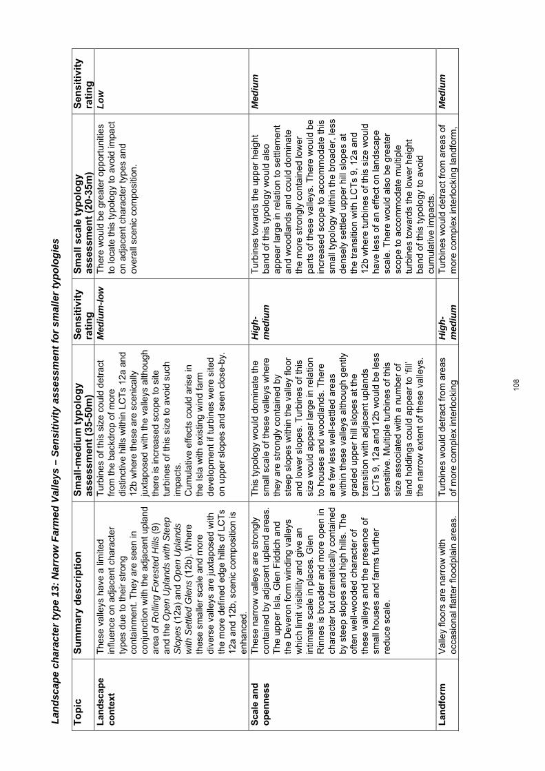
Land
scap
e ch
arac
ter t
ype
13: N
arro
w F
arm
ed V
alle
ys –
Sen
sitiv
ity a
sses
smen
t for
sm
alle
r typ
olog
ies
To
pic
S
um
mar
y d
escr
ipti
on
Sm
all-
med
ium
typ
olo
gy
asse
ssm
ent
(35-
50m
) S
ensi
tivi
ty
rati
ng
S
mal
l sc
ale
typ
olo
gy
asse
ssm
ent
(20-
35m
) S
ensi
tivi
ty
rati
ng
L
and
scap
e co
nte
xt
The
se v
alle
ys h
ave
a lim
ited
influ
ence
on
adja
cent
cha
ract
er
type
s du
e to
thei
r st
rong
co
ntai
nmen
t. T
hey
are
seen
in
conj
unct
ion
with
the
adja
cent
upl
and
area
of R
ollin
g F
ores
ted
Hill
s (9
) an
d th
e O
pen
Upl
ands
with
Ste
ep
Slo
pes
(12a
) an
d O
pen
Upl
ands
w
ith S
ettle
d G
lens
(12
b). W
here
th
ese
smal
ler
scal
e an
d m
ore
dive
rse
valle
ys a
re ju
xtap
osed
with
th
e m
ore
defin
ed e
dge
hills
of L
CT
s 12
a an
d 12
b, s
ceni
c co
mpo
sitio
n is
en
hanc
ed.
Tur
bine
s of
this
siz
e co
uld
detr
act
from
the
back
drop
of m
ore
dist
inct
ive
hills
with
in L
CT
s 12
a an
d 12
b w
here
thes
e ar
e sc
enic
ally
ju
xtap
osed
with
the
valle
ys a
lthou
gh
ther
e is
incr
ease
d sc
ope
to s
ite
turb
ines
of t
his
size
to a
void
suc
h im
pact
s.
Cum
ulat
ive
effe
cts
coul
d ar
ise
in
the
Isla
with
exi
stin
g w
ind
farm
de
velo
pmen
t if t
urbi
nes
wer
e si
ted
on u
pper
slo
pes
and
seen
clo
se-b
y.
Med
ium
-low
T
here
wou
ld b
e gr
eate
r op
port
uniti
es
to lo
cate
this
typo
logy
to a
void
impa
ct
on a
djac
ent c
hara
cter
type
s an
d ov
eral
l sce
nic
com
posi
tion.
Low
Sca
le a
nd
o
pen
nes
s
The
se n
arro
w v
alle
ys a
re s
tron
gly
cont
aine
d by
adj
acen
t upl
and
area
s.
The
upp
er Is
la, G
len
Fid
dich
and
th
e D
ever
on fo
rm w
indi
ng v
alle
ys
whi
ch li
mit
visi
bilit
y an
d gi
ve a
n in
timat
e sc
ale
in p
lace
s. G
len
Rin
nes
is b
road
er a
nd m
ore
open
in
char
acte
r bu
t dra
mat
ical
ly c
onta
ined
by
ste
ep s
lope
s an
d hi
gh h
ills.
The
of
ten
wel
l-woo
ded
char
acte
r of
th
ese
valle
ys a
nd th
e pr
esen
ce o
f sm
all h
ouse
s an
d fa
rms
furt
her
redu
ce s
cale
.
Thi
s ty
polo
gy w
ould
dom
inat
e th
e sm
all s
cale
of t
hese
val
leys
whe
re
they
are
str
ongl
y co
ntai
ned
by
stee
p sl
opes
with
in th
e va
lley
floor
an
d lo
wer
slo
pes.
Tur
bine
s of
this
si
ze w
ould
app
ear
larg
e in
rel
atio
n to
hou
ses
and
woo
dlan
ds. T
here
ar
e fe
w le
ss w
ell-s
ettle
d ar
eas
with
in th
ese
valle
ys a
lthou
gh g
ently
gr
aded
upp
er h
ill s
lope
s at
the
tran
sitio
n w
ith a
djac
ent u
plan
ds
LCT
s 9,
12a
and
12b
wou
ld b
e le
ss
sens
itive
. Mul
tiple
turb
ines
of t
his
size
ass
ocia
ted
with
a n
umbe
r of
la
nd h
oldi
ngs
coul
d ap
pear
to ‘f
ill’
the
narr
ow e
xten
t of t
hese
val
leys
.
Hig
h-m
ediu
m
Tur
bine
s to
war
ds th
e up
per
heig
ht
band
of t
his
typo
logy
wou
ld a
lso
appe
ar la
rge
in r
elat
ion
to s
ettle
men
t an
d w
oodl
ands
and
cou
ld d
omin
ate
the
mor
e st
rong
ly c
onta
ined
low
er
part
s of
thes
e va
lleys
. The
re w
ould
be
incr
ease
d sc
ope
to a
ccom
mod
ate
this
sm
all t
ypol
ogy
with
in th
e br
oade
r, le
ss
dens
ely
settl
ed u
pper
hill
slo
pes
at
the
tran
sitio
n w
ith L
CT
s 9,
12a
and
12
b w
here
turb
ines
of t
his
size
wou
ld
have
less
of a
n ef
fect
on
land
scap
e sc
ale.
The
re w
ould
als
o be
gre
ater
sc
ope
to a
ccom
mod
ate
mul
tiple
tu
rbin
es to
war
ds th
e lo
wer
hei
ght
band
of t
his
typo
logy
to a
void
cu
mul
ativ
e im
pact
s.
Med
ium
Lan
dfo
rm
V
alle
y flo
ors
are
narr
ow w
ith
occa
sion
al fl
atte
r flo
odpl
ain
area
s.
Tur
bine
s w
ould
det
ract
from
are
as
of m
ore
com
plex
inte
rlock
ing
Hig
h-m
ediu
m
Tur
bine
s w
ould
det
ract
from
are
as o
f m
ore
com
plex
inte
rlock
ing
land
form
, M
ediu
m
108
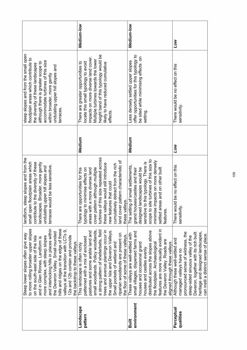
Ste
ep lo
wer
slo
pes
ofte
n gi
ve w
ay
to m
ore
rolli
ng b
road
er u
pper
slo
pes
on th
e so
uth-
east
sid
e of
the
Isla
an
d in
Gle
n R
inne
s. L
andf
orm
is
mor
e co
mpl
ex, w
ith s
teep
slo
pes
and
inte
rlock
ing
hills
in p
lace
s w
ithin
th
e D
ever
on V
alle
y. S
mal
l rou
nded
hi
lls a
nd r
idge
s on
the
edge
of t
hese
va
lleys
at t
he tr
ansi
tion
with
LC
Ts
9,
12a
and
12b
cont
ain
and
prov
ide
the
back
drop
to th
ese
valle
ys.
land
form
, ste
ep s
lope
s an
d fr
om th
e sm
all o
pen
flood
plai
n ar
eas
whi
ch
cont
ribut
e to
the
dive
rsity
of t
hese
la
ndsc
apes
. Bro
ader
, mor
e ge
ntly
un
dula
ting
uppe
r hi
ll sl
opes
and
te
rrac
es w
ould
be
less
sen
sitiv
e.
stee
p sl
opes
and
from
the
smal
l ope
n flo
odpl
ain
area
s w
hich
con
trib
ute
to
the
dive
rsity
of t
hese
land
scap
es
alth
ough
ther
e is
gre
ater
sco
pe to
ac
com
mod
ate
turb
ines
of t
his
size
w
ithin
bro
ader
, mor
e ge
ntly
un
dula
ting
uppe
r hi
ll sl
opes
and
te
rrac
es.
Lan
dsc
ape
pat
tern
Thi
s la
ndsc
ape
is o
ften
richl
y pa
ttern
ed w
ith a
mix
of e
nclo
sed
past
ures
and
som
e ar
able
land
and
sm
all w
oodl
ands
. Pol
icy
woo
dlan
ds,
a st
rong
pat
tern
of s
helte
rbel
ts, f
ield
tr
ees
and
aven
ue p
lant
ings
occ
ur in
th
e up
per
Isla
and
Dev
eron
Val
leys
. S
mal
l poc
kets
of w
etla
nd a
nd
ripar
ian
woo
dlan
ds a
re p
rese
nt o
n th
e flo
or o
f som
e of
thes
e va
lleys
.
The
re a
re o
ppor
tuni
ties
for
this
ty
polo
gy to
min
imis
e ef
fect
s on
ar
eas
with
a m
ore
dive
rse
land
co
ver
patte
rn a
lthou
gh m
ultip
le
turb
ines
of t
his
size
rep
eate
d ac
ross
th
ese
valle
ys w
ould
stil
l int
rodu
ce
new
feat
ures
that
cou
ld
cum
ulat
ivel
y de
trac
t fro
m th
e ric
h la
nd c
over
pat
tern
cha
ract
eris
tic o
f th
ese
valle
ys.
Med
ium
T
here
are
gre
ater
opp
ortu
nitie
s to
lo
cate
this
sm
all t
ypol
ogy
to a
void
im
pact
s on
mor
e di
vers
e la
nd c
over
. M
ultip
le tu
rbin
es to
war
ds th
e lo
wer
he
ight
ban
d of
this
typo
logy
wou
ld b
e lik
ely
to h
ave
redu
ced
cum
ulat
ive
effe
cts.
Med
ium
-low
Bu
ilt
envi
ron
men
t
The
se v
alle
ys a
re w
ell-s
ettle
d w
ith
smal
l vill
ages
, dis
pers
ed fa
rms
and
hous
es a
nd o
ccas
iona
l gra
nd
hous
es a
nd c
astle
s ev
enly
di
strib
uted
acr
oss
the
slop
es a
bove
th
e flo
odpl
ain.
Arc
haeo
logi
cal
feat
ures
are
mor
e vi
sual
ly e
vide
nt in
th
e D
ever
on V
alle
y. R
oads
are
al
igne
d th
roug
h th
ese
valle
ys.
The
set
ting
of s
mal
l set
tlem
ents
, gr
and
hous
es/c
astle
s an
d th
eir
desi
gned
land
scap
es w
ould
be
sens
itive
to th
is ty
polo
gy. T
here
is
scop
e to
site
turb
ines
of t
his
size
to
min
imis
e im
pact
s on
mor
e de
nsel
y se
ttled
are
as a
nd o
n ot
her
built
fe
atur
es.
Med
ium
Le
ss d
ense
ly s
ettle
d up
per
slop
es
offe
r op
port
uniti
es fo
r th
is ty
polo
gy to
be
site
d w
hile
min
imis
ing
effe
cts
on
setti
ng.
Med
ium
-low
Per
cep
tual
q
ual
itie
s
Alth
ough
thes
e w
ell-s
ettle
d an
d m
anag
ed v
alle
ys h
ave
no
pron
ounc
ed s
ense
of w
ildne
ss, t
he
stee
p-si
ded
sinu
ous
valle
y of
the
Dev
eron
, tog
ethe
r w
ith it
s ric
h bu
ilt
herit
age
and
desi
gned
land
scap
es,
can
inst
il a
dist
inct
sen
se o
f pla
ce.
The
re w
ould
be
no e
ffect
on
this
se
nsiti
vity
. Lo
w
The
re w
ould
be
no e
ffect
on
this
se
nsiti
vity
. Lo
w
109
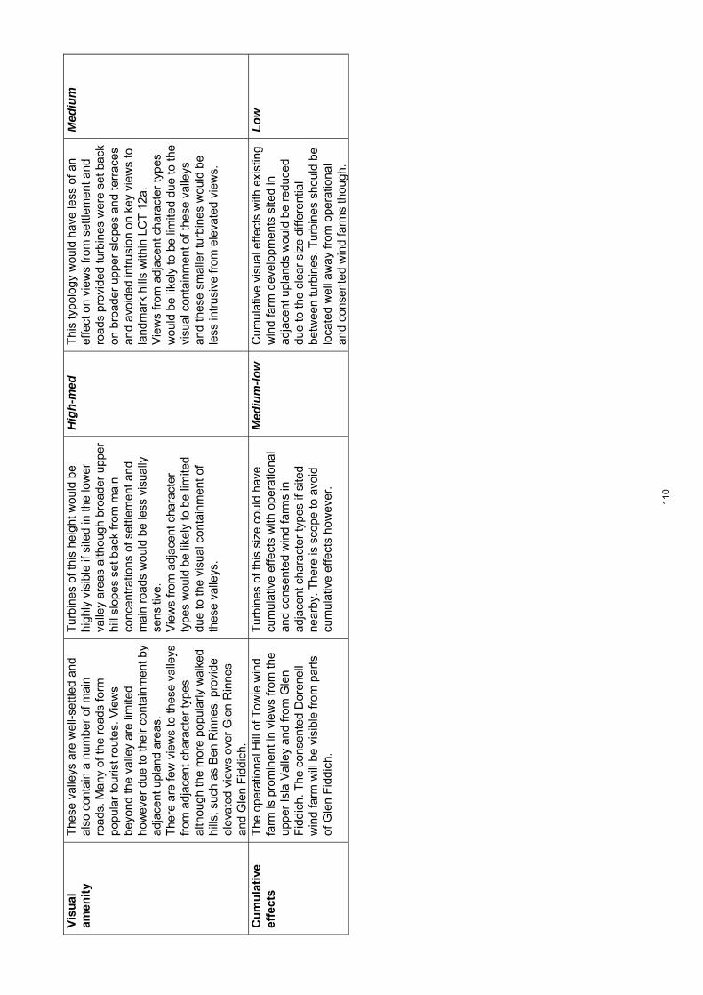
Vis
ual
am
enit
y
The
se v
alle
ys a
re w
ell-s
ettle
d an
d al
so c
onta
in a
num
ber
of m
ain
road
s. M
any
of th
e ro
ads
form
po
pula
r to
uris
t rou
tes.
Vie
ws
beyo
nd th
e va
lley
are
limite
d ho
wev
er d
ue to
thei
r co
ntai
nmen
t by
adja
cent
upl
and
area
s.
The
re a
re fe
w v
iew
s to
thes
e va
lleys
fr
om a
djac
ent c
hara
cter
type
s al
thou
gh th
e m
ore
popu
larly
wal
ked
hills
, suc
h as
Ben
Rin
nes,
pro
vide
el
evat
ed v
iew
s ov
er G
len
Rin
nes
and
Gle
n F
iddi
ch.
Tur
bine
s of
this
hei
ght w
ould
be
high
ly v
isib
le if
site
d in
the
low
er
valle
y ar
eas
alth
ough
bro
ader
upp
er
hill
slop
es s
et b
ack
from
mai
n co
ncen
trat
ions
of s
ettle
men
t and
m
ain
road
s w
ould
be
less
vis
ually
se
nsiti
ve.
V
iew
s fr
om a
djac
ent c
hara
cter
ty
pes
wou
ld b
e lik
ely
to b
e lim
ited
due
to th
e vi
sual
con
tain
men
t of
thes
e va
lleys
.
Hig
h-m
ed
Thi
s ty
polo
gy w
ould
hav
e le
ss o
f an
effe
ct o
n vi
ews
from
set
tlem
ent a
nd
road
s pr
ovid
ed tu
rbin
es w
ere
set b
ack
on b
road
er u
pper
slo
pes
and
terr
aces
an
d av
oide
d in
trus
ion
on k
ey v
iew
s to
la
ndm
ark
hills
with
in L
CT
12a
. V
iew
s fr
om a
djac
ent c
hara
cter
type
s w
ould
be
likel
y to
be
limite
d du
e to
the
visu
al c
onta
inm
ent o
f the
se v
alle
ys
and
thes
e sm
alle
r tu
rbin
es w
ould
be
less
intr
usiv
e fr
om e
leva
ted
view
s.
Med
ium
Cu
mu
lati
ve
effe
cts
The
ope
ratio
nal H
ill o
f Tow
ie w
ind
farm
is p
rom
inen
t in
view
s fr
om th
e up
per
Isla
Val
ley
and
from
Gle
n F
iddi
ch. T
he c
onse
nted
Dor
enel
l w
ind
farm
will
be
visi
ble
from
par
ts
of G
len
Fid
dich
.
Tur
bine
s of
this
siz
e co
uld
have
cu
mul
ativ
e ef
fect
s w
ith o
pera
tiona
l an
d co
nsen
ted
win
d fa
rms
in
adja
cent
cha
ract
er ty
pes
if si
ted
near
by. T
here
is s
cope
to a
void
cu
mul
ativ
e ef
fect
s ho
wev
er.
Med
ium
-low
C
umul
ativ
e vi
sual
effe
cts
with
exi
stin
g w
ind
farm
dev
elop
men
ts s
ited
in
adja
cent
upl
ands
wou
ld b
e re
duce
d du
e to
the
clea
r si
ze d
iffer
entia
l be
twee
n tu
rbin
es. T
urbi
nes
shou
ld b
e lo
cate
d w
ell a
way
from
ope
ratio
nal
and
cons
ente
d w
ind
farm
s th
ough
.
Low
110

1
Appendix D: Guidance on the micro-siting of smaller turbines
Introduction The height of turbines relative to other structures in the landscape is a key consideration in terms of landscape ‘fit’. With this in mind, five types of ‘small’ turbines were initially considered when developing the methodology for this landscape capacity assessment. These are:
Domestic systems Roof/wall mounted systems Micro wind Freestanding up to 12m to blade tip Micro-small wind turbines 12m – 20m to blade tip Small wind turbine 20m – 35m to blade tip Small-medium wind turbine 35m – 50m to blade tip
Domestic systems Domestic roof/wall mounted systems are most likely to have an impact on townscape and add to cumulative effects especially in urban areas. They have not been included in this landscape capacity assessment, as it is difficult to identify a robust list of sensitivities for this size of development which can be properly assessed at the strategic scale required for this locational guidance. Micro wind developments Freestanding turbines up to 12m high relate well to the size of existing buildings in the landscape, including farm buildings. These turbines are just over twice the height of a single storey house, while a two storey house is about 9m high to roof pitch. This height of turbine is also similar to small telephone masts and tall telegraph poles1. This size of turbine has not been included in the landscape sensitivity assessments. A single turbine of this height is most likely to be used to contribute to the energy needs of a residential house, farm or other rural based small business. The size means that it is relatively easy to accommodate in a settled landscape, if sited to be associated with such a building cluster. It is therefore likely that any assessment of landscape sensitivity will conclude that this size of turbine could be readily accommodated – perhaps, at the most, subject to siting considerations to encourage the turbines to be located where they can be visually seen to be part of a group of buildings, or clearly linked to an individual house. Therefore, while it is recognised that the free standing turbines of up to 12m may have cumulative effects on the landscape, they have been excluded from the landscape sensitivity assessments.
1 Telegraph poles are available in heights from 6m to 25m, although based on site observations most appear to be 10m or less in height.
111

2
Guidance for micro-small turbines (12m – 20m in height to blade tip) Freestanding turbines between 12m and around 20m in height to blade tip can be, at its highest, over twice the height of a two storey house. This size of turbine is therefore likely to be prominent and may appear above buildings. However, a well grown, mature forest, broadleaved or conifer tree is also about 15-20m in height. Turbines are likely to be similar in height to these trees, even more so in fertile lowland landscapes where trees often achieve good growth. Other structures of a similar height include taller communications masts and small pylons. It is likely that proposals for this height of turbine will only come forward in settled lowland landscapes or hill fringes, and in these locations, trees and other structures will provide an appropriate scale reference. Specific landscape sensitivity assessments for this size of turbine were therefore not carried out within each of the landscape character types. Nevertheless, this size of turbine has been considered within the guidance offered in the lowland landscape sensitivity assessments carried out for this study. Generic guidance for this height of turbine is provided below. Background Within the Moray landscape, the following issues have been identified as being particularly influential in terms of detailed siting of this typology within character types identified as being appropriate for this typology:
Association with existing built development
Turbine height in relation to the scale of the landscape
Landform shape
Settlement and land use pattern and features
Visibility
Potential cumulative issues
Association with existing built development Wherever possible, a turbine of less than 20m high will ‘fit’ into the landscape more successfully if it forms part of a ‘cluster’ of development and is visually associated with other built structures in the landscape. This is best achieved if the size of the turbine is in proportion to the size of individual features, such as buildings, trees and even pylons and other structures.
112
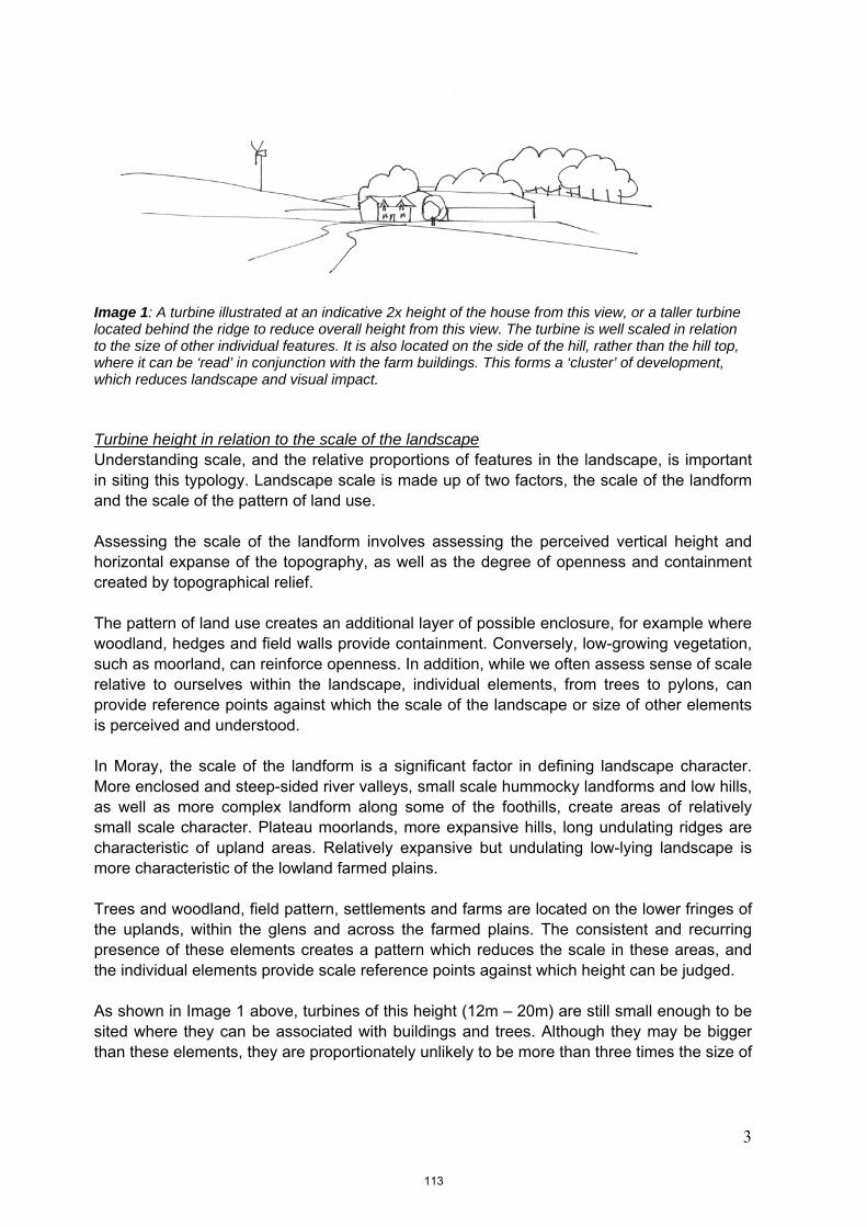
3
Image 1: A turbine illustrated at an indicative 2x height of the house from this view, or a taller turbine located behind the ridge to reduce overall height from this view. The turbine is well scaled in relation to the size of other individual features. It is also located on the side of the hill, rather than the hill top, where it can be ‘read’ in conjunction with the farm buildings. This forms a ‘cluster’ of development, which reduces landscape and visual impact. Turbine height in relation to the scale of the landscape Understanding scale, and the relative proportions of features in the landscape, is important in siting this typology. Landscape scale is made up of two factors, the scale of the landform and the scale of the pattern of land use. Assessing the scale of the landform involves assessing the perceived vertical height and horizontal expanse of the topography, as well as the degree of openness and containment created by topographical relief. The pattern of land use creates an additional layer of possible enclosure, for example where woodland, hedges and field walls provide containment. Conversely, low-growing vegetation, such as moorland, can reinforce openness. In addition, while we often assess sense of scale relative to ourselves within the landscape, individual elements, from trees to pylons, can provide reference points against which the scale of the landscape or size of other elements is perceived and understood. In Moray, the scale of the landform is a significant factor in defining landscape character. More enclosed and steep-sided river valleys, small scale hummocky landforms and low hills, as well as more complex landform along some of the foothills, create areas of relatively small scale character. Plateau moorlands, more expansive hills, long undulating ridges are characteristic of upland areas. Relatively expansive but undulating low-lying landscape is more characteristic of the lowland farmed plains. Trees and woodland, field pattern, settlements and farms are located on the lower fringes of the uplands, within the glens and across the farmed plains. The consistent and recurring presence of these elements creates a pattern which reduces the scale in these areas, and the individual elements provide scale reference points against which height can be judged. As shown in Image 1 above, turbines of this height (12m – 20m) are still small enough to be sited where they can be associated with buildings and trees. Although they may be bigger than these elements, they are proportionately unlikely to be more than three times the size of
113

4
any building or tree, and within a wider landscape setting, this size relationship can usually be accommodated unless there are site-specific scale sensitivities. On the coastal fringe, landform relief tends to be very low, with raised beaches or sand dunes, some of which are forested, forming a backdrop to the beach. Even where cliffs and more pronounced landform is present, the scale is sensitive, and a turbine can easily diminish the sense of height. As a result, the landscape sensitivity assessment for the Coastal Fringe (1-3), concludes that turbines of no more than 20m high to blade tip are appropriate for this area. Turbines should be set back from the crest of a raised beach, promontory, cliff or other key landform feature. Wherever possible, they should be sited where they can be associated with existing development. Buildings along the coast are often small, and even trees can be ‘wind shorn’ and struggle to reach full height in exposed locations. This further emphasises the need to use only small turbines in the coastal landscape, to reflect the relative size of these features.
Image 2 – Coastal landscapes: This turbine is perched on top of the raised beach and although it is quite small, instantly dominates the view and overlooks, or appears to ‘hover above’, the coast.
Image 3 – Coastal landscapes: The same turbine set back from the immediate coastal edge and associated with buildings is a less intrusive impact on the coast. The buildings along the coast are often small and low, therefore smaller turbines are more acceptable in terms of relative scale.
114
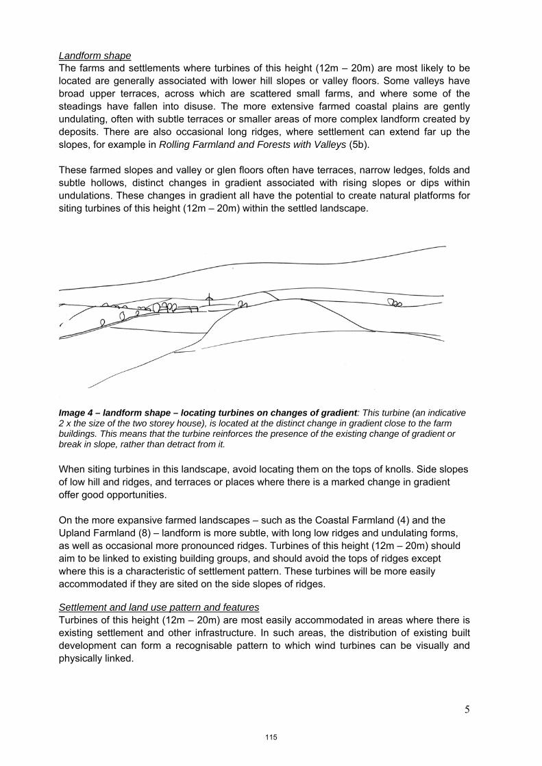
5
Landform shape The farms and settlements where turbines of this height (12m – 20m) are most likely to be located are generally associated with lower hill slopes or valley floors. Some valleys have broad upper terraces, across which are scattered small farms, and where some of the steadings have fallen into disuse. The more extensive farmed coastal plains are gently undulating, often with subtle terraces or smaller areas of more complex landform created by deposits. There are also occasional long ridges, where settlement can extend far up the slopes, for example in Rolling Farmland and Forests with Valleys (5b). These farmed slopes and valley or glen floors often have terraces, narrow ledges, folds and subtle hollows, distinct changes in gradient associated with rising slopes or dips within undulations. These changes in gradient all have the potential to create natural platforms for siting turbines of this height (12m – 20m) within the settled landscape.
Image 4 – landform shape – locating turbines on changes of gradient: This turbine (an indicative 2 x the size of the two storey house), is located at the distinct change in gradient close to the farm buildings. This means that the turbine reinforces the presence of the existing change of gradient or break in slope, rather than detract from it. When siting turbines in this landscape, avoid locating them on the tops of knolls. Side slopes of low hill and ridges, and terraces or places where there is a marked change in gradient offer good opportunities. On the more expansive farmed landscapes – such as the Coastal Farmland (4) and the Upland Farmland (8) – landform is more subtle, with long low ridges and undulating forms, as well as occasional more pronounced ridges. Turbines of this height (12m – 20m) should aim to be linked to existing building groups, and should avoid the tops of ridges except where this is a characteristic of settlement pattern. These turbines will be more easily accommodated if they are sited on the side slopes of ridges. Settlement and land use pattern and features Turbines of this height (12m – 20m) are most easily accommodated in areas where there is existing settlement and other infrastructure. In such areas, the distribution of existing built development can form a recognisable pattern to which wind turbines can be visually and physically linked.
115

6
In Moray, there is frequently a clear link between settlement and landform, for example, buildings may be located at a natural break in slope, the side slopes of the glens or associated with watercourses. In more extensive farmed areas, farm buildings may be relatively evenly dispersed across the landscape. Along the coast, settlement is located on harder rocky terrain, near the mouths of rivers and sheltered coastal locations. Larger farm buildings, industrial buildings and distilleries are also to be found in Moray, and these building groups can even include tall stacks or other masts. While even turbines of this height (12m – 20m) may be larger than most domestic and farm buildings, it is likely to still be appropriate to establish a visual relationship between a turbine and a farm or other group of buildings in this type of landscape. It is desirable to support the existing pattern of built development, where turbines of a similar size are consistently associated with a commonly occurring detailed landform or built features associated with the farms or small settlements in an area. Note that proximity to ‘regularly occupied’ buildings will also need to be balanced with a noise buffer zone.
Image 5 – Poor relationship with settlement pattern. Here a turbine is located in between two farms, and is not associated with either. It appears to ‘drift’ unattached in the landscape as it does not reflect the existing pattern of built development. Instead, the turbine is setting up a new pattern of development which conflicts with the existing well-established pattern.
Image 6 – Strong relationship with settlement pattern. The same landscape, with a turbine sited to each of the farms, close to the buildings, each of which now form ‘building clusters’. Here the turbines reflect the existing pattern of settlement, emphasising this, rather than starting a new built pattern which conflicts with the existing pattern. Micro-siting will need to balance creating a development cluster with the need to apply a recommended ‘noise buffer’ zone.
116
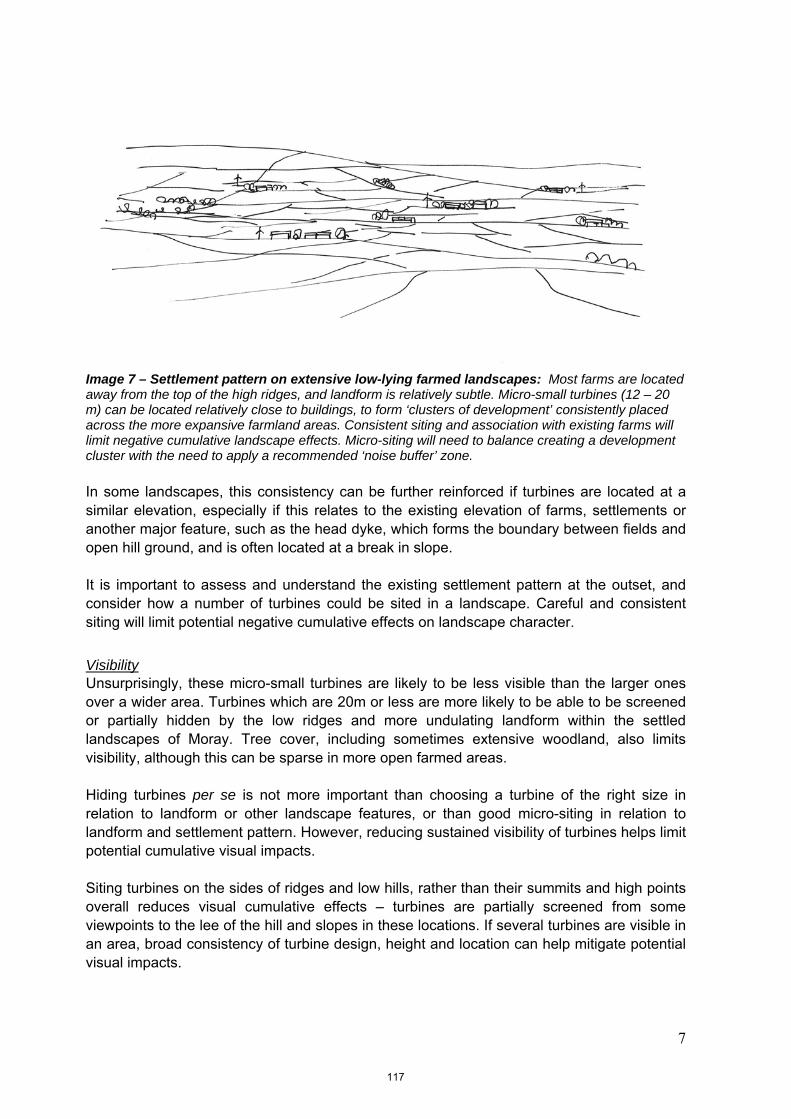
7
Image 7 – Settlement pattern on extensive low-lying farmed landscapes: Most farms are located away from the top of the high ridges, and landform is relatively subtle. Micro-small turbines (12 – 20 m) can be located relatively close to buildings, to form ‘clusters of development’ consistently placed across the more expansive farmland areas. Consistent siting and association with existing farms will limit negative cumulative landscape effects. Micro-siting will need to balance creating a development cluster with the need to apply a recommended ‘noise buffer’ zone. In some landscapes, this consistency can be further reinforced if turbines are located at a similar elevation, especially if this relates to the existing elevation of farms, settlements or another major feature, such as the head dyke, which forms the boundary between fields and open hill ground, and is often located at a break in slope. It is important to assess and understand the existing settlement pattern at the outset, and consider how a number of turbines could be sited in a landscape. Careful and consistent siting will limit potential negative cumulative effects on landscape character.
Visibility Unsurprisingly, these micro-small turbines are likely to be less visible than the larger ones over a wider area. Turbines which are 20m or less are more likely to be able to be screened or partially hidden by the low ridges and more undulating landform within the settled landscapes of Moray. Tree cover, including sometimes extensive woodland, also limits visibility, although this can be sparse in more open farmed areas. Hiding turbines per se is not more important than choosing a turbine of the right size in relation to landform or other landscape features, or than good micro-siting in relation to landform and settlement pattern. However, reducing sustained visibility of turbines helps limit potential cumulative visual impacts. Siting turbines on the sides of ridges and low hills, rather than their summits and high points overall reduces visual cumulative effects – turbines are partially screened from some viewpoints to the lee of the hill and slopes in these locations. If several turbines are visible in an area, broad consistency of turbine design, height and location can help mitigate potential visual impacts.
117

8
Potential cumulative issues Micro-small turbines may become a frequent and common occurrence in farmed landscapes. Key cumulative issues for small turbines are likely to relate strongly to potential clutter in the landscape. Issues may include:
Several individual, or small groups of turbines, could begin to
dominate local character;
The landscape could appear ‘cluttered’ if single or groups of
turbines were associated with the majority of land holdings,
especially where holdings are small and therefore closer
together;
Lack of a clear siting strategy could lead to fragmentation of
an existing robust, recognisable, consistent and characteristic
pattern of settlement, especially if turbines do not relate well to
existing buildings and established pattern of built
development;
While one turbine breaching a skyline may be a focal point, a
number of diverse structures, all spinning at different speeds –
or even several of the same type of turbine – or appearing at
irregular intervals along a prominent or important skyline will
become a visual distraction from other landscape features or
from perceived visual amenity, especially from key viewpoints;
The variety of potential different types of wind turbines within
the landscape could lead to clutter with different styles, sizes
of structures and speeds of blade movement dotted across a
landscape;
There may be the added complication of increased visual
clutter created by a wide range of different heights of turbine
within a farmed landscape with micro-, small and
small/medium sized turbines;
Potential clutter may also be exacerbated if there are other
masts, such as telecoms masts, overhead wires and pylons
within the same vicinity
The sensitivity assessment has assumed that single turbines and some groups of up to 3 micro-small (below 20m to blade tip) turbines are most likely to be associated with this typology and will have the most potential to be accommodated in the landscape. The assessment has also assumed that this size of turbine is most likely to be associated with farmed and settled landscapes. Proposals for ‘wind farms/crofts’ of micro-small turbines over 3 in number are likely to have more significant adverse impacts on the landscape character, including on cumulative effects.
118

9
Guidance for small turbines (20m – 35m in height to blade tip) The sensitivity of the landscape to this development scenario has been included in all assessments carried out in settled and farmed lowland landscape and coastal character types. Less settled upland landscape character types were not assessed for this size of development, as this size of turbine is associated with more settled landscapes and applications are unlikely to come forward in areas where there are no farms or other settlement. Background Within the Moray landscape, the following issues have been identified as being particularly influential in terms of detailed siting of this typology within character types identified as being appropriate for this typology:
Turbine height in relation to the scale of the landscape
Landform shape
Settlement and land use pattern and features
Visibility
Potential cumulative issues
Turbine height in relation to the scale of the landscape Turbines of between 20m and 35m are going to be one of the tallest structures in any Moray landscape. They are going to be taller than most buildings and trees. They are still, however, similar in height to some taller pylons and communications masts. In addition, especially on the coastal farmland, there are taller communication masts and structures associated with military activity. Understanding scale, and the relative proportions of features in the landscape, is therefore important in siting this typology. Landscape scale is made up of two factors, the scale of the landform and the scale of the pattern of land use. Assessing the scale of the landform involves assessing the perceived vertical height and horizontal expanse of the topography, as well as the degree of openness and containment created by topographical relief. The pattern of land use creates an additional layer of possible enclosure, for example where woodland, hedges and field walls provide containment. Conversely, low-growing vegetation, such as moorland, can reinforce openness. In addition, while we often assess sense of scale relative to ourselves within the landscape, individual elements, from trees to pylons, can offer reference points against which the scale of the landscape or size of other elements is perceived and understood. In Moray, the scale of the landform is a significant factor in defining landscape character. More enclosed and steep-sided river valleys, small scale hummocky landforms and low hills, as well as more complex landform along some of the foothills, create areas of relatively small scale character. Plateau moorlands, more expansive hills and long undulating ridges are characteristic of upland areas. Relatively expansive but undulating low-lying landform is more characteristic of the lowland farmed plains.
119

10
Turbines of this size (20m – 35m), even in small groups of up to three turbines, may be able to take advantage of the degree of relief created by small and medium scaled landforms, for example the broad slopes of foothills and lower fringes of upland areas, lower side slopes of valleys or the sides of undulating ridges and more subtle landforms of Upland Farmland (8) and the Coastal Farmland (4).
Image 8 – Landscape scale and size of features: A ‘small typology’ (20m – 35m) turbine located on a low-lying ridgeline set back from but still associated with the pattern of settlement. In this location, the turbine is linked to the scale of the landform and there are no features in the immediate proximity against which to judge turbine height. It is sited at a slight dip in the ridge, and back-dropped in this view by higher ground. It is located away from the house, to avoid overwhelming the buildings in terms of scale. Trees and woodland, field pattern, settlements and farms are located on the lower fringes of the uplands, within the glens and across the farmed plains. The consistent and recurring presence of these elements creates a pattern which reduces the scale in these areas, and the individual elements provide scale reference points against which height can be judged. Care should be taken to site 20m – 35m high turbines where they do not dominate individual buildings, trees or other features, although some association with broad settlement pattern is still considered appropriate. On more marginal farmed landscapes characteristic of the settled areas of Moray, buildings and tree cover are likely to be sparse and often are smaller in size than more fertile lowland farmlands. Trees may also be limited in height by exposure or poor soils and buildings are often low, either due to exposure, or due to the poorer quality farmland, which is often reflected in the characteristically more modest building style. In these locations, the relationship between small turbines (20m – 35m) and landscape features is likely to be very sensitive, as this size of turbines could easily overwhelm the small stature and scale of individual elements which are key characteristics of these landscapes. Where larger farm buildings, and even industrial and distillery buildings are located in more expansive landscapes or broader valleys, there are increased opportunities to site this height of turbine (20m – 35m) closer to buildings.
120

11
Overall, turbines of this height (20m – 35m) can most readily be accommodated by micro-siting them to relate to the scale of landforms or where present, larger buildings and woodlands, rather than trying to link them to the size of small structures, buildings and small trees.
Image 9 – Landscape scale – larger buildings: A turbine of this height (20 – 35m), could be associated with larger buildings in more simple landscapes, for example where larger woodlands are also present. Turbines of this height are likely to be more difficult to accommodate within very small scale and complex topography, along the floor of very narrow glens and passes, on the coast, or where small landscape scale is created by small fields, diverse land use and dense settlement pattern. For this typology, if there is doubt about the potential impact of a turbine on the scale of the landscape, a photomontage or wireline of the turbine taken from a key viewpoint will help the assessment of potential impacts.
Landform shape This size of turbine is more likely to fit with the landscape if they are sited to clearly relate to a specific landform. Turbines of this size could be accommodated on low hills or ridgelines across the more expansive farmed areas, or in the wider and more extensive areas of farmed valleys. Other opportunities include the rising ground which provides the immediate backdrop to the farmed lowland areas and valley floors, especially if they are back-dropped by larger hills. Distinct changes in gradient associated with rising slopes, well defined dips within undulations or more expansive concave landforms, long ridges and interim hills along the lower edges of the foothills, as well as the edges of more expansive plateaux all provide potential opportunities for micro-siting turbines of this size.
121
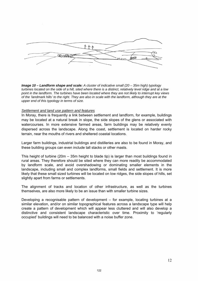
12
Image 10 – Landform shape and scale: A cluster of indicative small (20 – 35m high) typology turbines located on the side of a hill, sited where there is a distinct, relatively level ridge and at a low point in the landform. The turbines have been located where they are not likely to interrupt key views of the ‘landmark hills’ to the right. They are also in scale with the landform, although they are at the upper end of this typology in terms of size. Settlement and land use pattern and features In Moray, there is frequently a link between settlement and landform, for example, buildings may be located at a natural break in slope, the side slopes of the glens or associated with watercourses. In more extensive farmed areas, farm buildings may be relatively evenly dispersed across the landscape. Along the coast, settlement is located on harder rocky terrain, near the mouths of rivers and sheltered coastal locations. Larger farm buildings, industrial buildings and distilleries are also to be found in Moray, and these building groups can even include tall stacks or other masts. This height of turbine (20m – 35m height to blade tip) is larger than most buildings found in rural areas. They therefore should be sited where they can more readily be accommodated by landform scale, and avoid overshadowing or dominating smaller elements in the landscape, including small and complex landforms, small fields and settlement. It is more likely that these small sized turbines will be located on low ridges, the side slopes of hills, set slightly apart from farms or settlements. The alignment of tracks and location of other infrastructure, as well as the turbines themselves, are also more likely to be an issue than with smaller turbine sizes. Developing a recognisable pattern of development – for example, locating turbines at a similar elevation, and/or on similar topographical features across a landscape type will help create a pattern of development which will appear less cluttered and will also develop a distinctive and consistent landscape characteristic over time. Proximity to ‘regularly occupied’ buildings will need to be balanced with a noise buffer zone.
122

13
Image 11 – Developing a landscape pattern: These indicative 35m high turbines are located at a similar elevation on this hillside. They are also loosely associated with the location of the farms. This similarity in size, location and elevation helps to maintain the unity of the landscape pattern. Consistent association with watercourses, low hills or breaks in slope, head dykes or other features will help increase unity in the landscape and reduce negative cumulative landscape effects. Visibility Turbines which are more than 20m in height are taller than most trees and large farm buildings, and are therefore likely to have wider visibility than those turbines less than 20m in height. As applicants may own farms or larger land holdings, there may be the potential to screen turbines from viewpoints if required, for example to reduce cumulative visual impacts, by establishing trees adjacent to the viewpoint (for quicker, maximum screening affect).
Potential cumulative issues These small sized turbines may become a frequent and common occurrence, especially in farmed landscapes. Key cumulative issues are likely to relate strongly to potential clutter in the landscape and the visual relationship with other wind turbines. Issues are similar to those identified in the analysis of micro-small wind turbines, but because of the larger size of these turbines the issues are likely to occur more quickly and may include:
Several individual, or small groups of turbines, could begin to
dominate local character;
Lack of a clear siting strategy could lead to fragmentation of
an existing robust and recognisable landscape pattern –
where possible, it is important to site turbines on similar
landforms, at similar elevations and with a similar relationship
to the existing settlement pattern;
Diverse designs of turbine, all spinning at different speeds – or
even several turbines of the same type – strung along a
prominent or important skyline could become a visual
123

14
distraction from other landscape features or from perceived
visual amenity, especially from key viewpoints;
The larger the turbine, the harder it is likely to be to
accommodate a number of them in a single view or
recognisable tract of landscape without them becoming the
dominant feature. It is also harder to accommodate the
turbines in a sequence of views experienced, for example,
when travelling along a road;
The variety of potential different types of wind turbines within
the landscape could lead to clutter with different styles, sizes
of structures and speeds of blade movement dotted across a
landscape;
Potential clutter may also be easily created if there are other
masts, such as telecoms masts, overhead wires and pylons
within the same vicinity;
There may be the added complication of increased visual
clutter created by a wide range of different heights of turbine
within a farmed landscape with micro-, small and
small/medium sized turbines;
An additional complication may be the visual interrelationship
with larger wind farms of large and medium sized turbines,
especially along the upper edge of farmland adjacent to
upland character types.
Other landscape issues associated with this typology Undergrounding electricity cables to a suitable off-site location to connect with the grid should also be undertaken in order to avoid a clutter of disparate built elements in the landscape.
124

15
Guidance for small-medium turbines (35m – 50m in height to blade tip) The sensitivity of the landscape to this development scenario has been included in all assessments carried out in settled lowland landscape and coastal character types. Less settled upland landscape character types, however, were not assessed for this size of development, as this size of turbine is associated with more settled landscapes and applications are unlikely to come forward in areas where there are no farms or other settlements. Background Within the Moray landscape, the following issues have been identified as being particularly influential in terms of detailed siting of this typology within character types identified as being appropriate for this typology:
Turbine height in relation to the scale of the landscape
Landform shape
Settlement and land use pattern and features
Visibility
Cumulative issues
Turbine height in relation to the scale of the landscape Turbines of between 35m and 50m are going to often be the tallest structures in any Moray landscape. They are going to be taller than buildings and trees. They will also be taller than most communication masts and pylons, although there are some very tall masts associated with military installations on the Coastal Farmland (4) in Moray. Understanding scale, and the relative proportions of features in the landscape, is therefore important in siting this typology. Landscape scale is made up of two factors, the scale of the landform and the scale of the pattern of land use. Assessing the scale of the landform involves assessing the perceived vertical height and horizontal expanse of the topography, as well as the degree of openness and containment created by topographical relief. The pattern of land use creates an additional layer of possible enclosure, for example where woodland, hedges and field walls provide containment. Conversely, low-growing vegetation, such as moorland, can reinforce openness. In addition, while we often assess sense of scale relative to ourselves within the landscape, individual elements, from trees to pylons, can offer reference points against which the scale of the landscape or size of other elements is perceived and understood. In Moray, the scale of the landform is a significant factor in defining landscape character. More enclosed and steep-sided river valleys, small scale hummocky landforms and low hills, as well as more complex landform along some of the foothills, create areas of relatively small scale character. Plateau moorlands, more expansive hills and long undulating ridges are characteristic of upland areas. Relatively expansive but undulating low-lying landscape is more characteristic of the lowland plains.
125

16
Turbines of this height (35m – 50m) can therefore be accommodated most readily by relating the height of the turbines to the scale of the landform. If well sited, turbines of this size, even in small groups of up to three turbines, may be able to take advantage of the degree of relief created by medium scaled landforms. Examples include the broad slopes of larger scale foothills and fringes of extensive upland areas and plateaux or the transition between smaller scale farmed or settled landscapes and the edge of larger scale upland landscapes.
Image 12 – Landscape scale and size of features: A ‘medium-small’ (35 – 50m high) turbine located where it is readily associated with the scale of the landform rather than individual features within the low-lying farmland. This size of turbine is more easily accommodated if it is not located close to farms and trees, but can be seen in the context of landform and more simple landcover, such as moorland and larger woods, for example at the transition between upland and lowland landscapes. This turbine has also been placed where it avoids the hill top, and at a clear break in slope along the ridgeline. Trees and woodland, field pattern, settlements and farms are located on the lower fringes of the uplands, within the glens and across the farmed plains. The consistent and recurring presence of these elements creates a pattern which reduces the scale in these areas, and the individual elements provide scale reference points against which height can be judged. On more marginal farmed landscapes characteristic of the settled areas of Moray, buildings and tree cover are likely to be sparse and often are smaller in size than more fertile lowland farmlands. Trees may also be limited in height by exposure or poor soils and buildings are often low, either due to exposure, or due to the poorer quality farmland, which is often reflected in the characteristically more modest building style. In settled and farmed locations, the relationship between small-medium turbines (35m – 50m) and individual smaller scale elements is likely to be very sensitive, as this size of turbines could easily overwhelm the size of individual elements, such as farms, other buildings, trees, small woods and policy features which are key characteristics of these landscapes. Turbines of this height (35m – 50m) can therefore be accommodated most readily by relating the height of the turbines to the scale of the landform, and away from the setting of farms, other buildings, trees and woodland, as shown in image 12 above.
126
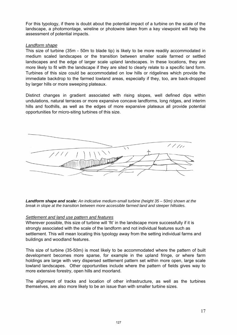
17
For this typology, if there is doubt about the potential impact of a turbine on the scale of the landscape, a photomontage, wireline or photowire taken from a key viewpoint will help the assessment of potential impacts.
Landform shape This size of turbine (35m - 50m to blade tip) is likely to be more readily accommodated in medium scaled landscapes or the transition between smaller scale farmed or settled landscapes and the edge of larger scale upland landscapes. In these locations, they are more likely to fit with the landscape if they are sited to clearly relate to a specific land form. Turbines of this size could be accommodated on low hills or ridgelines which provide the immediate backdrop to the farmed lowland areas, especially if they, too, are back-dropped by larger hills or more sweeping plateaux. Distinct changes in gradient associated with rising slopes, well defined dips within undulations, natural terraces or more expansive concave landforms, long ridges, and interim hills and foothills, as well as the edges of more expansive plateaux all provide potential opportunities for micro-siting turbines of this size.
Landform shape and scale: An indicative medium-small turbine (height 35 – 50m) shown at the break in slope at the transition between more accessible farmed land and steeper hillsides. Settlement and land use pattern and features Wherever possible, this size of turbine will ‘fit’ in the landscape more successfully if it is strongly associated with the scale of the landform and not individual features such as settlement. This will mean locating this typology away from the setting individual farms and buildings and woodland features. This size of turbine (35-50m) is most likely to be accommodated where the pattern of built development becomes more sparse, for example in the upland fringe, or where farm holdings are large with very dispersed settlement pattern set within more open, large scale lowland landscapes. Other opportunities include where the pattern of fields gives way to more extensive forestry, open hills and moorland. The alignment of tracks and location of other infrastructure, as well as the turbines themselves, are also more likely to be an issue than with smaller turbine sizes.
127

18
Developing a recognisable pattern of development – for example, locating turbines at a similar elevation, and/or on similar topographical features across a landscape type will help create a pattern of development which will appear less cluttered and will also develop a distinctive and consistent landscape characteristic over time.
Landscape pattern: These two indicative 35-50m high turbines are located at the break in slope, reinforced by the change from field pattern to open ground. They are also broadly linked to watercourses on this hillside, therefore a pattern is emerging. Visibility Turbines of this height are likely to be widely visible, as they are difficult to screen with smaller landform. Good siting is therefore very important, as the relationship with landform and wider landscape setting will be very visible.
Cumulative issues Small-medium sized turbines may become a more common occurrence. Key cumulative issues are likely to relate strongly to potential clutter in the landscape and the visual relationship with wind farms of larger turbines or individual and small groups of small turbines. Cumulative issues may include:
Several individual, or small groups of turbines, could begin to
dominate local character;
Diverse designs of turbine, all spinning at different speeds – or
even several turbines of the same type – strung along a
prominent or important skyline could become a visual
distraction from other landscape features or from perceived
visual amenity, especially from key viewpoints;
Lack of a clear siting strategy could lead to fragmentation of
an existing robust and recognisable landscape pattern –
where possible, it is important to site turbines on similar
landforms, at similar elevations and with a similar relationship
to the existing settlement pattern;
128

19
The larger the turbine, the harder it is likely to be to
accommodate a number of them in a single view or
recognisable tract of landscape without them becoming the
dominant feature. It is also harder to accommodate the
turbines in a sequence of views experienced, for example,
when travelling along a road;
The variety of potential different types of wind turbines within
the landscape could lead to clutter with different styles, sizes
of structures and speeds of blade movement dotted across a
landscape;
Potential clutter may also be easily created if there are other
masts, such as telecoms masts, overhead wires and pylons
within the same vicinity – this is likely to be a bigger problem
with these small turbines than larger ones;
There may be the added complication of increased visual
clutter created by a wide range of different heights of turbine
within a farmed landscape with micro-, small and
small/medium sized turbines;
Other complications may be the visual interrelationship with
larger wind farms of large and medium sized turbines,
especially along the upper edge of farmland adjacent to
upland character types.
Other landscape issues associated with this typology More complex landform, such as the areas of small-scale deposits and knolls will be particularly sensitive to the construction of access tracks for this size of wind turbine development. The construction of new access tracks should be minimised by careful siting of turbines to use existing tracks and to avoid more difficult or steep terrain. Care should also be taken in the alignment and design of any access tracks to ensure that sensitive landform and vegetation is not adversely affected and that intrusion on key views is avoided. Undergrounding electricity cables to a suitable off-site location to connect with the grid should also be undertaken in order to avoid a clutter of disparate built elements in the landscape.
129

Appendix E: Repowering appraisal ZTVs and visualisations
130

131

132
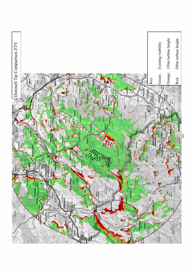
Do
renel
l T
ip C
om
par
ison
ZT
V
Key:
Gre
en:
Ex
isti
ng v
isib
ilit
y
Ora
nge:
1
50
m t
urb
ine
hei
gh
t
Red
:
20
0m
tu
rbin
e h
eigh
t
133

134
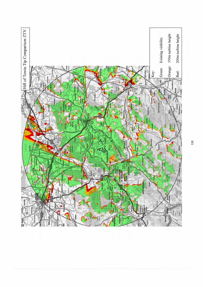
135

Pau
l’s
Hil
l T
ip C
om
par
ison
ZT
V
Key:
Gre
en:
Ex
isti
ng v
isib
ilit
y
Ora
nge:
1
50
m t
urb
ine
hei
gh
t
Red
:
20
0m
tu
rbin
e h
eigh
t
136
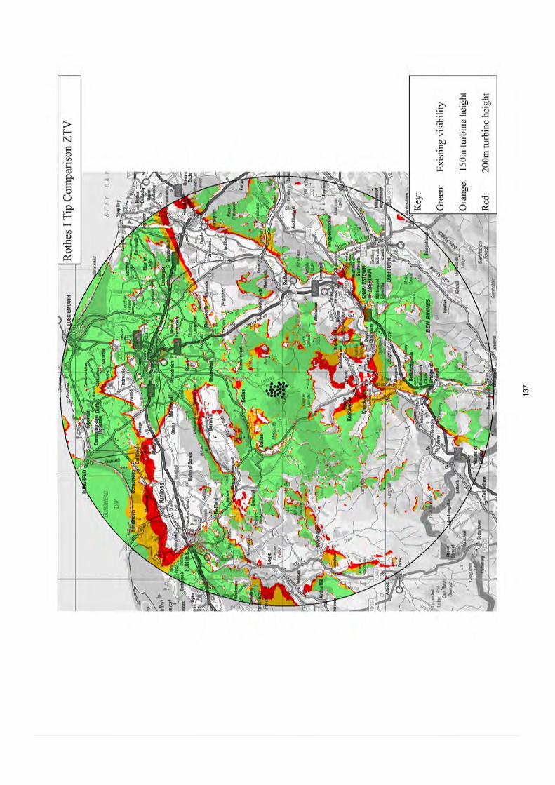
137

138

139

140
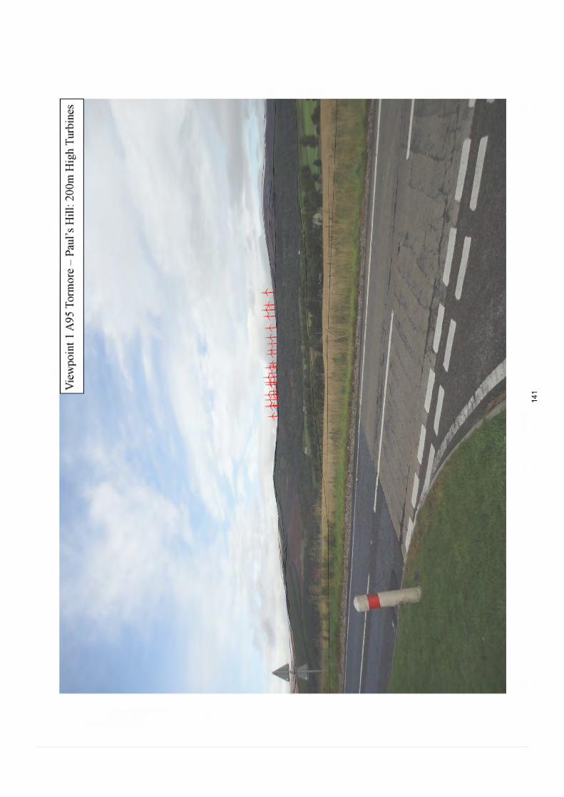
141

142

143

144

Vi e
wpo
int
3 B
9009
Gle
n R
inn
es –
Do
renel
l :
Curr
ent
Tu
rbin
es
145

Vi e
wpo
int
3 B
9009
Gle
n R
inn
es –
Do
renel
l :
150
m H
igh
Tu
rbin
es
146
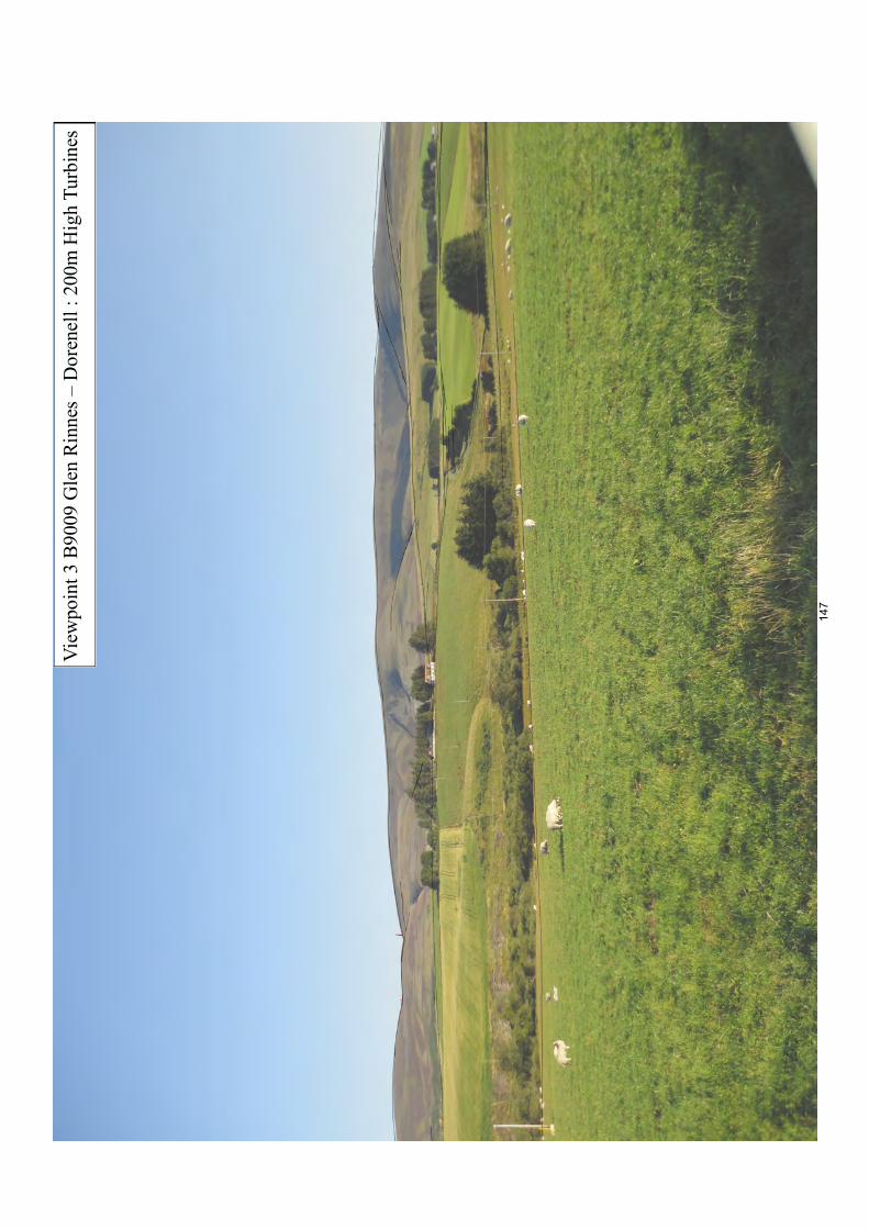
Vi e
wpo
int
3 B
9009
Gle
n R
inn
es –
Do
renel
l :
200
m H
igh
Tu
rbin
es
147

148

149
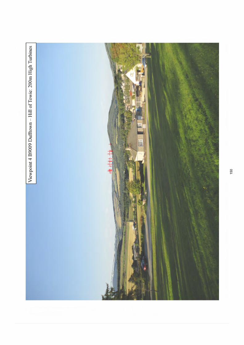
150

151

152
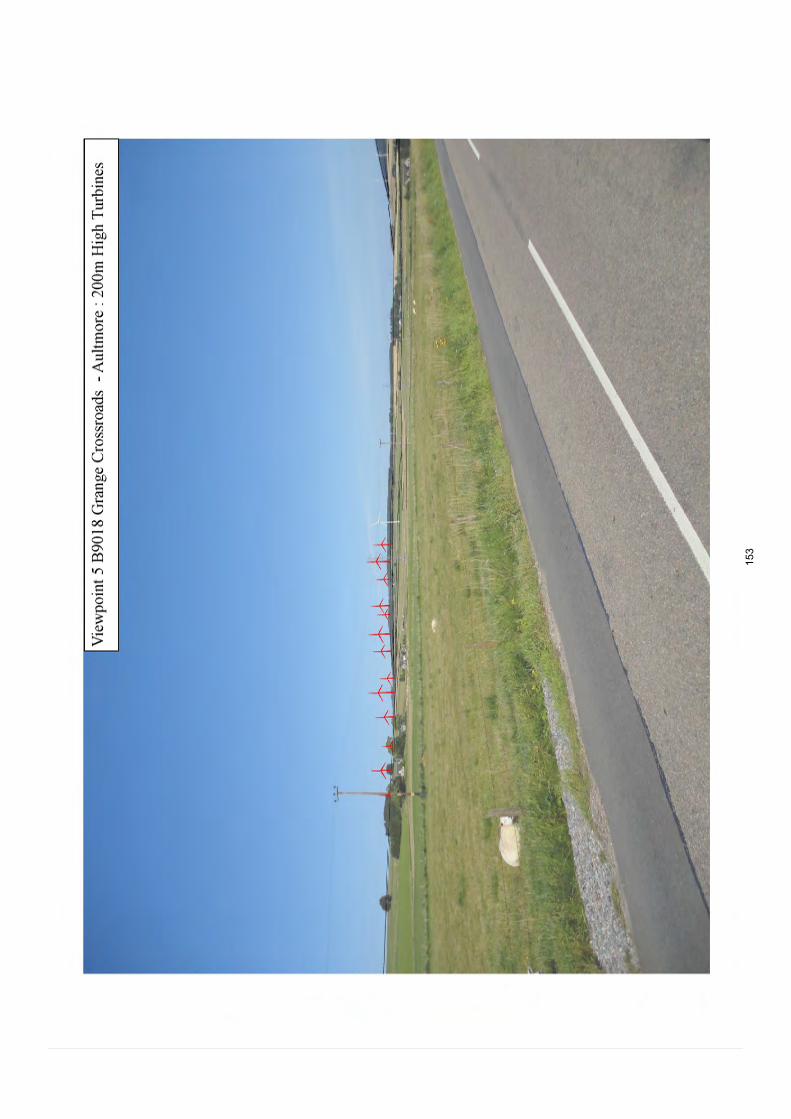
153

154
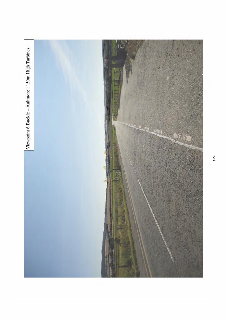
155

156

157

158

159

160
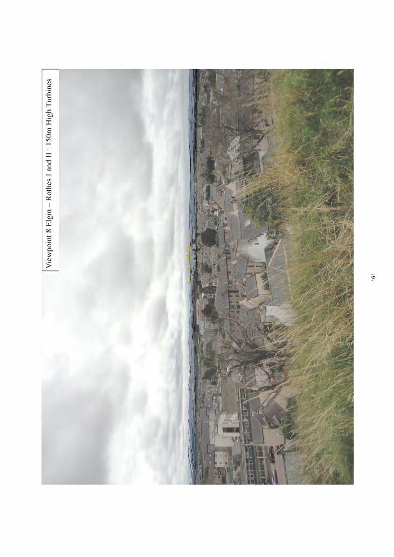
161

162

163
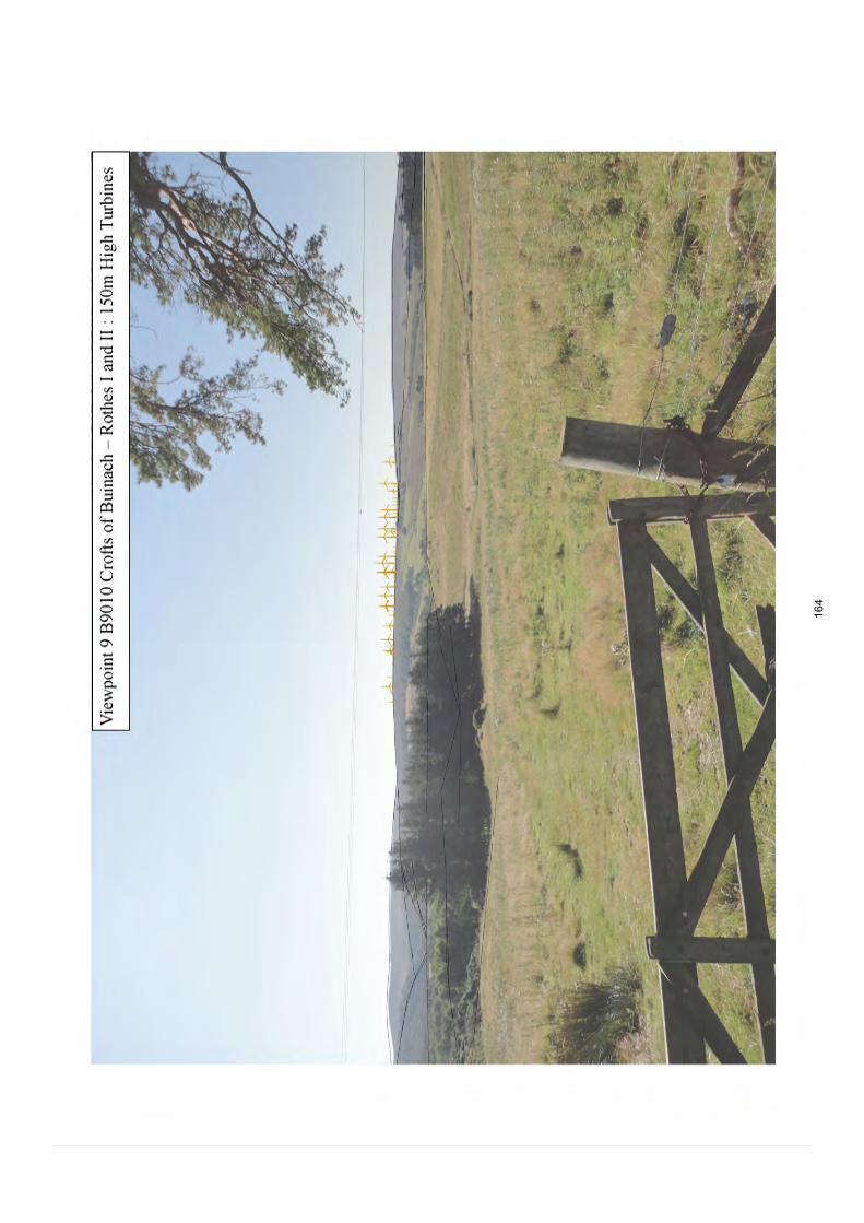
164

165

166

167

168

Appendix F: Detailed description of Landmark Hills
169

Knock Hill A distinctive conical and isolated hill which rises out of lower-lying farmland on the border of Moray and Aberdeenshire and is widely visible across both areas.
Bin of Cullen The shapely conical form of this hill forms a prominent feature seen widely across eastern Moray. It is important in forming an immediate backdrop to the Moray coast and to Cullen House and its designed landscape. This hill is popular with walkers and its open rocky summit (lower slopes are densely wooded) offers expansive views over the coast and the Moray Firth.
Meikle Balloch This rounded and largely forested hill lies close to Keith. The boundary between Moray and Aberdeenshire is aligned through the summit of this hill. Footpaths and tracks on the hill are well-used and the open summit offers extensive views.
Ben Rinnes The highest hill in Moray and classified as a ‘Corbett’ and thus very popular with walkers. The smaller hills of Little Conval and Meikle Conval extend from Ben Rinnes, forming a long heather-clad rolling ridge on the west side of Glen Rinnes. Ben Rinnes has a smooth and rounded form with steep slopes. A number of Tors form distinctive features on its curving ridge. This hill is important in forming the backdrop to Glen Rinnes and the Spey valley and especially dramatic views to it are possible when travelling south on the minor road from Dallas to Upper Knockando. It is particularly spectacular in August when heather is in flower and in snowy conditions.
The Buck The distinctive pointed profile of this hill together with its ‘stand-alone’ position amidst more rolling upland plateaux, contribute to the landmark status of this hill. The Buck lies on the border of Aberdeenshire and Moray and is popular with walkers, offering extensive views.
Ben Aigan Ben Aigan rises to 471m and forms a prominent feature seen across the coastal plain of Moray and from the Spey Valley. The hill is largely forested but has an open heathery summit offering extensive views. Mountain bike trails and footpaths are well-used and the Speyside Way is aligned on the western and northern slopes of the hill.
Romach Hill and Mill Buie These densely wooded rounded hills lie close to each other in the western part of Moray. They are most prominent when seen from longer views across the coastal plain of Moray near Findhorn and Forres where they form distinct high points along the upland backdrop.
Carn Kitty Not widely visible but forms distinct high point within the Open Rolling Uplands (11) and is glimpsed from the Upper Knockando to Dallas road. This hill is surrounded by the operational wind farms of Berry Burn and Paul’s Hill.
Roy’s Hill Prominent in views from the Spey Valley and tourist routes such as the A95 where its steep open heathery slopes form an immediate backdrop to the Spey and also Ballindalloch Castle designed landscape. This hill is additionally important in visually containing the Paul’s Hill wind farm. Wind farm access tracks appear to be used by mountain bikers and walkers. The summit of this hill has extensive views to the Cairngorms.
Carn na Cailliche This gently rounded hill lies on the southern edge of the Upland Moorland and Forestry (10) and is most prominent from the Upper Knockando area and in distant views from the A95 from the south. It is important in visually containing operational wind farm development lying at the core of this character type from the Spey Valley.
170

171