morley ca appraisal
TRANSCRIPT
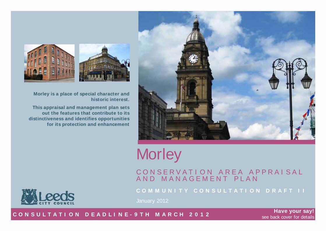
Morley C O N S E R V A T I O N A R E A A P P R A I S A L A N D M A N A G E M E N T P L A N C O M M U N I T Y C O N S U L T A T I O N D R A F T I I
Morley is a place of special character and historic interest.
This appraisal and management plan sets out the features that contribute to its
distinctiveness and identifies opportunities for its protection and enhancement
January 2012
C O N S U L T A T I O N D E A D L I N E - 9 T H M A R C H 2 0 1 2 Have your say!
see back cover for details
2
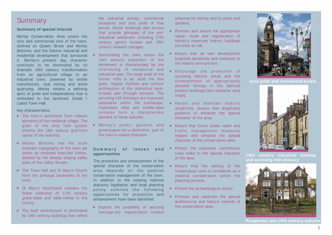
Summary Summary of special interest
Morley Conservation Area covers the civic and commercial core of the town, centred on Queen Street and Morley Bottoms, and the historic industrial and residential development that surrounds it. Morley’s present day character continues to be dominated by its dramatic 19th century transformation from an agricultural village to an industrial town, powered by textile manufacture, coal mining and stone quarrying. Morley retains a defining spirit of pride and independence that is embodied in the landmark Grade I Listed Town Hall.
Key characteristics: The town’s settlement form reflects
elements of the medieval village. The grain of the strip field system informs the 19th century grid-form layout of the suburbs.
Morley Bottoms has the most dramatic topography of the town set within an enclosed bowl-like hollow, defined by the steeply sloping valley sides of the Valley Stream.
The Town Hall and St Mary’s Church form the principal landmarks of the town.
St Mary’s churchyard contains the finest collection of 17th century grave-slabs and table-tombs in the county.
The built environment is dominated by 19th century buildings that reflect
the industrial activity, commercial prosperity and civic pride of that period. Earlier buildings also survive that provide glimpses of the pre-industrial settlement including 17th century gentry houses and 18th century weavers cottages.
Surrounding the town centre the 19th century expansion of the settlement is characterised by the intermixing of residential and industrial uses. The large scale of the former mills is set amid the fine grain, regular rhythms and uniform architecture of the distinctive back-to-back and through terraces. The surviving mill chimneys are important landmarks within the townscape. Impressive villas and middle-class terraces form a characteristic element of these suburbs.
Morley’s parks, gardens and greenscapes are a distinctive part of the town’s unique character.
S u m m a r y o f i s s u e s a n d opportunities
The protection and enhancement of the special character of the conservation area depends on the posit ive conservation management of the town. In addition to the existing national statutory legislation and local planning po l i c y con t ro l s the fo l l ow ing opportunities for protection and enhancement have been identified:
Explore the possibility of securing heritage-led regeneration funded
schemes for Morley and its parks and gardens.
Promote and secure the appropriate repair, reuse and regeneration of Morley’s important historic buildings currently at risk.
Ensure that all new development responds sensitively and creatively to the historic environment.
Encourage the protect ion of surviving historic detail and the reinstatement of appropriately detailed fittings in the defined positive buildings (see character area maps).
Retain and maintain historic shopfronts. Ensure new shopfronts preserve or enhance the special character of the area.
Ensure that future public realm and traffic management measures respect and enhance the special character of the conservation area.
Protect the important contribution trees make to the special character of the area.
Ensure that the setting of the conservation area is considered as a material consideration within the planning process.
Protect the archaeological record.
Promote and celebrate the special architectural and historic interest of the conservation area.
Civic pride and commercial bustle
Caption
Prosperous late 19th century suburbs
19th century industrial housing and surviving mill chimney
3
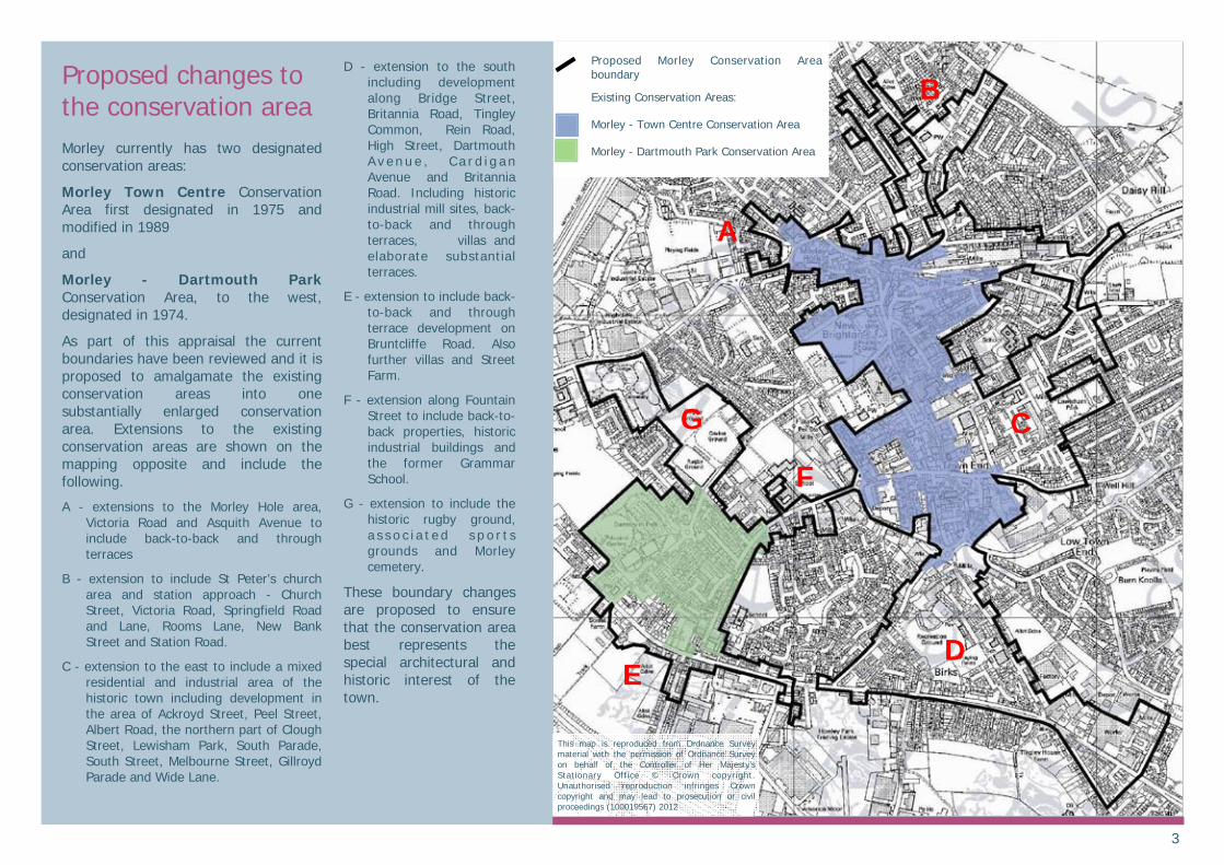
Proposed changes to the conservation area Morley currently has two designated conservation areas:
Morley Town Centre Conservation Area first designated in 1975 and modified in 1989
and
Morley - Dartmouth Park Conservation Area, to the west, designated in 1974.
As part of this appraisal the current boundaries have been reviewed and it is proposed to amalgamate the existing conservation areas into one substantially enlarged conservation area. Extensions to the existing conservation areas are shown on the mapping opposite and include the following.
A - extensions to the Morley Hole area, Victoria Road and Asquith Avenue to include back-to-back and through terraces
B - extension to include St Peter’s church area and station approach - Church Street, Victoria Road, Springfield Road and Lane, Rooms Lane, New Bank Street and Station Road.
C - extension to the east to include a mixed residential and industrial area of the historic town including development in the area of Ackroyd Street, Peel Street, Albert Road, the northern part of Clough Street, Lewisham Park, South Parade, South Street, Melbourne Street, Gillroyd Parade and Wide Lane.
D - extension to the south including development along Bridge Street, Britannia Road, Tingley Common, Rein Road, High Street, Dartmouth A v e n u e , C a r d i g a n Avenue and Britannia Road. Including historic industrial mill sites, back-to-back and through terraces, villas and elaborate substantial terraces.
E - extension to include back-to-back and through terrace development on Bruntcliffe Road. Also further villas and Street Farm.
F - extension along Fountain Street to include back-to-back properties, historic industrial buildings and the former Grammar School.
G - extension to include the historic rugby ground, a s s o c i a t e d s p o r t s grounds and Morley cemetery.
These boundary changes are proposed to ensure that the conservation area best represents the special architectural and historic interest of the town.
A
B
C
D E
F
G
This map is reproduced from Ordnance Survey material with the permission of Ordnance Survey on behalf of the Controller of Her Majesty’s Stationary Office © Crown copyright. Unauthorised reproduction infringes Crown copyright and may lead to prosecution or civil proceedings (100019567) 2012
Proposed Morley Conservation Area boundary
Existing Conservation Areas:
Morley - Town Centre Conservation Area
Morley - Dartmouth Park Conservation Area
4
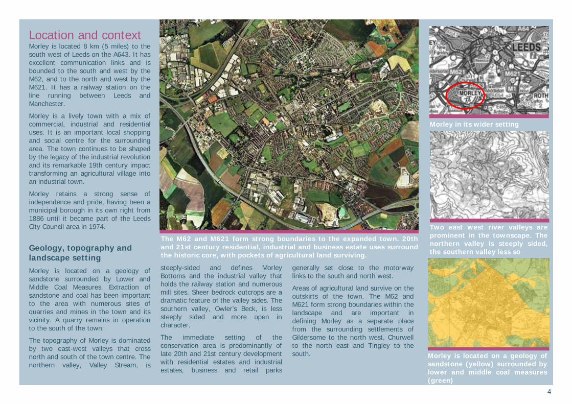
Location and context Morley is located 8 km (5 miles) to the south west of Leeds on the A643. It has excellent communication links and is bounded to the south and west by the M62, and to the north and west by the M621. It has a railway station on the line running between Leeds and Manchester.
Morley is a lively town with a mix of commercial, industrial and residential uses. It is an important local shopping and social centre for the surrounding area. The town continues to be shaped by the legacy of the industrial revolution and its remarkable 19th century impact transforming an agricultural village into an industrial town.
Morley retains a strong sense of independence and pride, having been a municipal borough in its own right from 1886 until it became part of the Leeds City Council area in 1974.
Geology, topography and landscape setting Morley is located on a geology of sandstone surrounded by Lower and Middle Coal Measures. Extraction of sandstone and coal has been important to the area with numerous sites of quarries and mines in the town and its vicinity. A quarry remains in operation to the south of the town.
The topography of Morley is dominated by two east-west valleys that cross north and south of the town centre. The northern valley, Valley Stream, is
steeply-sided and defines Morley Bottoms and the industrial valley that holds the railway station and numerous mill sites. Sheer bedrock outcrops are a dramatic feature of the valley sides. The southern valley, Owler’s Beck, is less steeply sided and more open in character.
The immediate setting of the conservation area is predominantly of late 20th and 21st century development with residential estates and industrial estates, business and retail parks
generally set close to the motorway links to the south and north west.
Areas of agricultural land survive on the outskirts of the town. The M62 and M621 form strong boundaries within the landscape and are important in defining Morley as a separate place from the surrounding settlements of Gildersome to the north west, Churwell to the north east and Tingley to the south.
Morley in its wider setting
Two east west river valleys are prominent in the townscape. The northern valley is steeply sided, the southern valley less so
Morley is located on a geology of sandstone (yellow) surrounded by lower and middle coal measures (green)
The M62 and M621 form strong boundaries to the expanded town. 20th and 21st century residential, industrial and business estate uses surround the historic core, with pockets of agricultural land surviving.
5
Historic development Early activity
Little evidence has been recovered of prehistoric activity in Morley. A Bronze Age stone implement known as an axe-hammer was discovered to the south of the M62 off Rein Road, suggesting some level of activity at this time.
The course of a probable Roman Road is roughly followed by today’s A650. The road forms an extension of the Roman route between Bradford, Keighley and Elslack (catalogued by Margary as Roman Road 721). The route is thought to continue south east to Wakefield.
Medieval Morley
During the early medieval period Morley appears to have been of some regional significance giving its name to a wider administrative area known as a wapontake. ‘Morelei’, as it is recorded in Domesday Book of 1086, includes the place-name element ‘ley’ which indicates its origins as an area of cleared land in a woodland setting.
The Domesday entry suggests a settlement the size of a small village and describes its condition as ‘waste’. This suggests that the area was still recovering from the ‘scorched earth’ policy of the ‘Harrying of the North’ of 1069-70 when the Normans brutally subdued northern resistance to the conquest. The entry for the manor also records a church, but this is believed to be a reference to St Mary’s at Woodkirk rather than St Mary’s,
Morley. Evidence, however, suggests that there was a place of worship in Morley from the 12th century as Norman masonry was recovered during the demolition of the Old Chapel on the site of the present St Mary’s, Morley. The early medieval importance of Morley in the surrounding area seems to have waned as this place of worship was a chapelry of Batley parish and not a parish church in its own right.
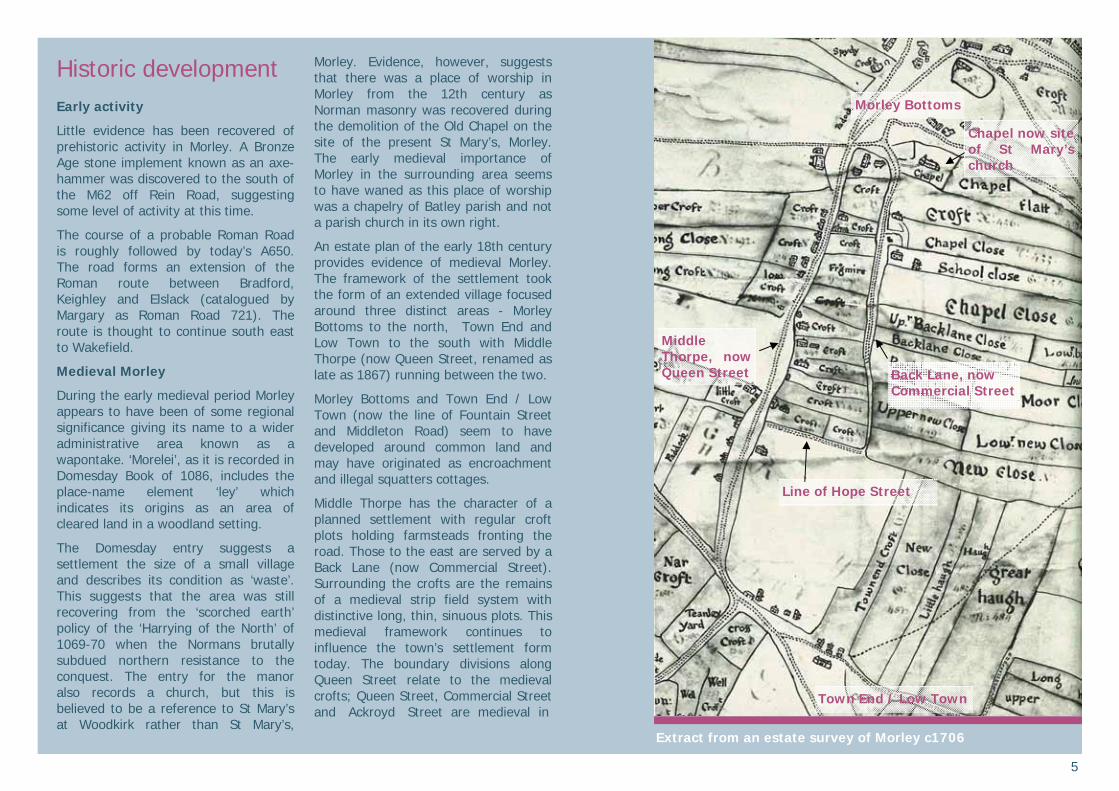
An estate plan of the early 18th century provides evidence of medieval Morley. The framework of the settlement took the form of an extended village focused around three distinct areas - Morley Bottoms to the north, Town End and Low Town to the south with Middle Thorpe (now Queen Street, renamed as late as 1867) running between the two.
Morley Bottoms and Town End / Low Town (now the line of Fountain Street and Middleton Road) seem to have developed around common land and may have originated as encroachment and illegal squatters cottages.
Middle Thorpe has the character of a planned settlement with regular croft plots holding farmsteads fronting the road. Those to the east are served by a Back Lane (now Commercial Street). Surrounding the crofts are the remains of a medieval strip field system with distinctive long, thin, sinuous plots. This medieval framework continues to influence the town’s settlement form today. The boundary divisions along Queen Street relate to the medieval crofts; Queen Street, Commercial Street and Ackroyd Street are medieval in
Extract from an estate survey of Morley c1706
Town End / Low Town
Line of Hope Street
Middle Thorpe, now Queen Street Back Lane, now
Commercial Street
Chapel now site of St Mary’s church
Morley Bottoms
6
origin and the line and grain of some of the medieval strip fields have been fossilised within patterns of later development such as at Zoar Street and the adjacent allotment gardens. Morley’s origins as a medieval agricultural settlement still shape the town today.
Development of the Textile Town - 16th—18th century Morley
From the 16th century the production of handloom woven cloth formed a staple of the area’s economy and by the 18th century Morley was already an important centre of the woollen industry. For the majority of the 18th century the wool trade continued to be organised on a domestic scale with spinning and weaving carried out in the home. Middle-men, known as clothiers, controlled the system, providing raw materials to the spinners and weavers and selling the finished product at local markets such as Leeds.
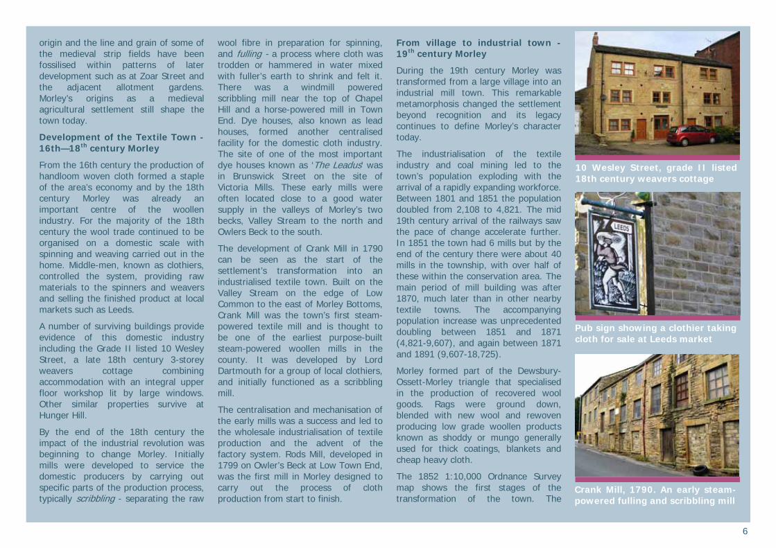
A number of surviving buildings provide evidence of this domestic industry including the Grade II listed 10 Wesley Street, a late 18th century 3-storey weavers cottage combining accommodation with an integral upper floor workshop lit by large windows. Other similar properties survive at Hunger Hill.
By the end of the 18th century the impact of the industrial revolution was beginning to change Morley. Initially mills were developed to service the domestic producers by carrying out specific parts of the production process, typically scribbling - separating the raw
wool fibre in preparation for spinning, and fulling - a process where cloth was trodden or hammered in water mixed with fuller’s earth to shrink and felt it. There was a windmill powered scribbling mill near the top of Chapel Hill and a horse-powered mill in Town End. Dye houses, also known as lead houses, formed another centralised facility for the domestic cloth industry. The site of one of the most important dye houses known as ‘The Leadus’ was in Brunswick Street on the site of Victoria Mills. These early mills were often located close to a good water supply in the valleys of Morley’s two becks, Valley Stream to the north and Owlers Beck to the south.
The development of Crank Mill in 1790 can be seen as the start of the settlement’s transformation into an industrialised textile town. Built on the Valley Stream on the edge of Low Common to the east of Morley Bottoms, Crank Mill was the town’s first steam-powered textile mill and is thought to be one of the earliest purpose-built steam-powered woollen mills in the county. It was developed by Lord Dartmouth for a group of local clothiers, and initially functioned as a scribbling mill.
The centralisation and mechanisation of the early mills was a success and led to the wholesale industrialisation of textile production and the advent of the factory system. Rods Mill, developed in 1799 on Owler’s Beck at Low Town End, was the first mill in Morley designed to carry out the process of cloth production from start to finish.
From village to industrial town - 19th century Morley
During the 19th century Morley was transformed from a large village into an industrial mill town. This remarkable metamorphosis changed the settlement beyond recognition and its legacy continues to define Morley’s character today.
The industrialisation of the textile industry and coal mining led to the town’s population exploding with the arrival of a rapidly expanding workforce. Between 1801 and 1851 the population doubled from 2,108 to 4,821. The mid 19th century arrival of the railways saw the pace of change accelerate further. In 1851 the town had 6 mills but by the end of the century there were about 40 mills in the township, with over half of these within the conservation area. The main period of mill building was after 1870, much later than in other nearby textile towns. The accompanying population increase was unprecedented doubling between 1851 and 1871 (4,821-9,607), and again between 1871 and 1891 (9,607-18,725).
Morley formed part of the Dewsbury-Ossett-Morley triangle that specialised in the production of recovered wool goods. Rags were ground down, blended with new wool and rewoven producing low grade woollen products known as shoddy or mungo generally used for thick coatings, blankets and cheap heavy cloth.
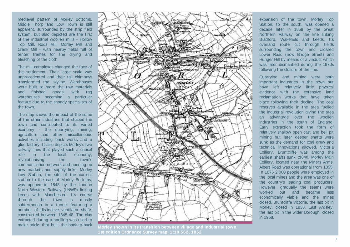
The 1852 1:10,000 Ordnance Survey map shows the first stages of the transformation of the town. The
10 Wesley Street, grade II listed 18th century weavers cottage
Pub sign showing a clothier taking cloth for sale at Leeds market
Crank Mill, 1790. An early steam-powered fulling and scribbling mill
7
medieval pattern of Morley Bottoms, Middle Thorp and Low Town is still apparent, surrounded by the strip field system, but also depicted are the first of the industrial woollen mills - Hollow Top Mill, Rods Mill, Morley Mill and Crank Mill - with nearby fields full of tenter frames for the drying and bleaching of the cloth.
The mill complexes changed the face of the settlement. Their large scale was unprecedented and their tall chimneys transformed the skyline. Warehouses were built to store the raw materials and finished goods, with rag warehouses becoming a particular feature due to the shoddy specialism of the town.
The map shows the impact of the some of the other industries that shaped the town and contributed to its varied economy - the quarrying, mining, agriculture and other miscellaneous activities including brick works and a glue factory. It also depicts Morley’s two railway lines that played such a critical role in the local economy, revolutionising the town’s communication network and opening up new markets and supply links. Morley Low Station, the site of the current station to the east of Morley Bottoms, was opened in 1848 by the London North Western Railway (LNWR) linking Leeds with Manchester. Its course through the town is mostly subterranean in a tunnel featuring a number of distinctive ventilator shafts constructed between 1845-48. The clay extracted during tunnelling was used to make bricks that built the back-to-back
expansion of the town. Morley Top Station, to the south, was opened a decade later in 1858 by the Great Northern Railway on the line linking Bradford, Wakefield and Leeds. Its overland route cut through fields surrounding the town and crossed Lower Road (now Bridge Street) and Hunger Hill by means of a viaduct which was later dismantled during the 1970s following the closure of the line.
Quarrying and mining were both important industries in the town but have left relatively little physical evidence with the extensive land reclamation works that have taken place following their decline. The coal reserves available in the area fuelled the industrial revolution giving the area an advantage over the woollen industries in the south of England. Early extraction took the form of relatively shallow open cast and bell pit mining but later deeper shafts were sunk as the demand for coal grew and technical innovations allowed. Victoria Colliery, Bruntcliffe was among the earliest shafts sunk c1848. Morley Main Colliery, located near the Miners Arms, Albert Road was operational from 1855. In 1876 2,000 people were employed in the local mines and the area was one of the country’s leading coal producers. However, gradually the seams were worked out and became less economically viable and the mines closed. Bruntcliffe Victoria, the last pit in Morley, closed in 1938. East Ardsley, the last pit in the wider Borough, closed in 1968.
Morley shown in its transition between village and industrial town. 1st edition Ordnance Survey map, 1:10,562, 1852
8
Extensive quarrying activity for sandstone and ironstone is recorded in the historic map sequence. Prominent quarries include Hembrigg Quarry between Bridge Street and High Street, remembered in the street name Quarry Lane, and Robin Hood Quarry set to the west of Queen Street, now the site of Morrison’s car park, Leisure Centre and Queen Elizabeth Playing Fields.
Britannia Quarry continues to operate to the south of the conservation area.
Agriculture remained an important element of the local economy forming part of the ‘Rhubarb Triangle’. This area between Leeds, Bradford and Wakefield held a concentration of forced rhubarb growers. The technique was pioneered in Yorkshire from 1877 and used mill waste from the production of shoddy as
a fertiliser providing an important source of nitrogen to promote good yields.
Residential expansion, civic pride and Borough status
The growth of the industrial town included a massive expansion of Morley’s residential provision. As well as industrial buildings, the mill complexes
often incorporated prestigious houses for their owners and managers. Initially these were set close to the mills, but later middle-class areas of the town were developed such as Dartmouth Park, laid out by the Dartmouth Estate from the 1880s.
For the vast workforce extensive areas of back-to-back and through terraces were built close to the mills, dramatically expanding the town in all directions. Intermixed with this new development were the necessary civic, religious and commercial services required by the ever-growing population. New schools, churches, chapels, shops, pubs, hotels, banks and public baths were all required. Improved sanitation and utility provision of water, gas and later electricity were also part of the urbanisation.
In 1829 St Peter’s church was built on land donated by the Earl of Dartmouth. Up to this point Morley had lacked a Church of England place of worship, as St Mary’s had remained non conformist after the Restoration. A greatly enlarged church at St Mary’s was built in 1878 to accommodate its swelling congregation. A particularly defining feature of 19th century industrial Morley is the impressive group of non conformist chapels seen throughout the town. In 1886 Morley achieved Borough status. The Town Hall, such an assertive symbol of the town’s independence, was built between 1892 and 1895 and embodies the pride, strong sense of identity and ambition that defined the town during this period.
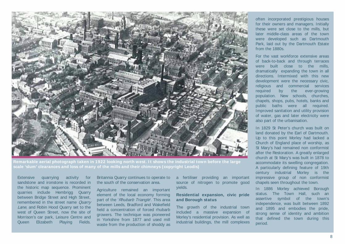
Remarkable aerial photograph taken in 1922 looking north west. It shows the industrial town before the large scale ‘slum’ clearances and loss of many of the mills and their chimneys (copyright Leodis)
9
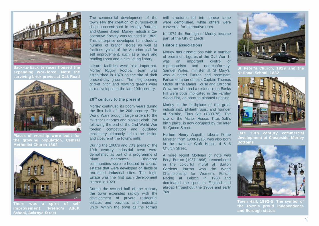
The commercial development of the town saw the creation of purpose-built shops concentrated in Morley Bottoms and Queen Street. Morley Industrial Co-operative Society was founded in 1869. This enterprise developed to include a number of branch stores as well as facilities typical of the Victorian zeal for self improvement, such as a news and reading room and a circulating library.
Leisure facilities were also important. Morley Rugby Football team was established in 1878 on the site of their present-day ground. The neighbouring cricket pitch and bowling greens were also developed in the late 19th century.
20th century to the present
Morley continued its boom years during the first half of the 20th century. The World Wars brought large orders to the mills for uniforms and blanket cloth. But following the end of the 2nd World War foreign competition and outdated machinery ultimately led to the decline and closure of the town’s mills.
During the 1960’s and 70’s areas of the 19th century industrial town were demolished as part of a programme of ‘slum’ clearances. Displaced communities were re-housed in council estates that were developed on fields or reclaimed industrial sites. The Ingle Estate was the first such development started in 1920.
During the second half of the century the town expanded rapidly with the development of private residential estates and business and industrial units. Within the town as the former
mill structures fell into disuse some were demolished, while others were converted for alternative uses.
In 1974 the Borough of Morley became part of the City of Leeds.
Historic associations
Morley has associations with a number of prominent figures of the Civil War. It was an important centre of republicanism and non-conformity. Samuel Wales, minister at St Mary’s, was a noted Puritan and prominent Parliamentarian officers Captain Thomas Oates, of the Manor House and Corporal Crowther who had a residence on Banks Hill were both implicated in the Farnley Wood Plot, an aborted planned uprising.
Morley is the birthplace of the great industrialist, philanthropist and founder of Saltaire, Titus Salt (1803-76). The site of the Manor House, Titus Salt’s birth place, is now occupied by the later 91 Queen Street.
Herbert Henry Asquith, Liberal Prime Minister from 1908-1916, was also born in the town, at Croft House, 4 & 6 Church Street.
A more recent Morleian of note was Beryl Burton (1937-1996), remembered in the colourful mural at Burton Gardens. Burton won the World Championship for Women’s Pursuit Racing at Leipzig in 1960 and dominated the sport in England and abroad throughout the 1960s and early 70s.
Back-to-back terraces housed the expanding workforce. Note the surviving brick privies at Oak Road
There was a spirit of self improvement. ‘Friend’s Adult School, Ackroyd Street
Places of worship were built for the growing population. Central Methodist Church 1862
St Peter’s Church, 1829 and the National School, 1832
Town Hall, 1892-5. The symbol of the town’s proud independence and Borough status
Late 19th century commercial development at Cheapside, Morley Bottoms
10
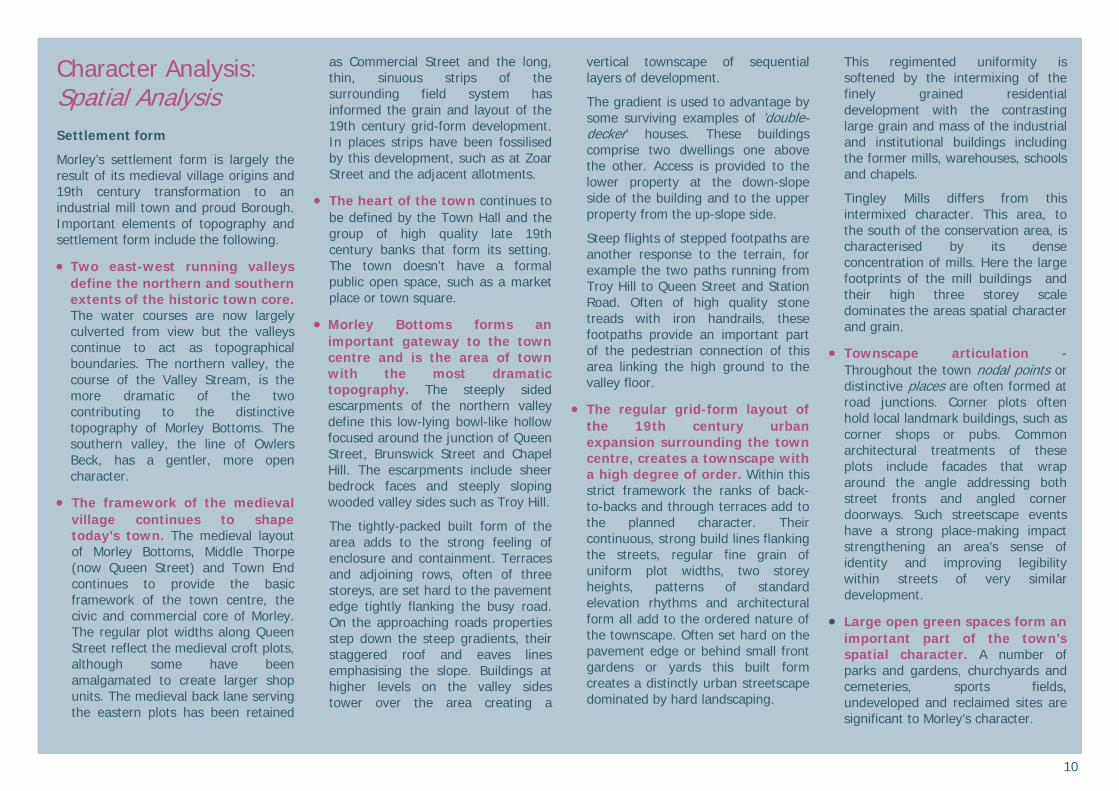
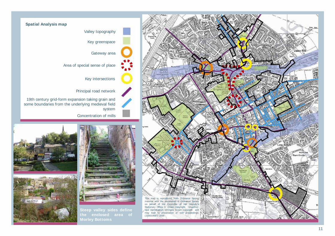
Character Analysis: Spatial Analysis Settlement form
Morley’s settlement form is largely the result of its medieval village origins and 19th century transformation to an industrial mill town and proud Borough. Important elements of topography and settlement form include the following.
Two east-west running valleys define the northern and southern extents of the historic town core. The water courses are now largely culverted from view but the valleys continue to act as topographical boundaries. The northern valley, the course of the Valley Stream, is the more dramatic of the two contributing to the distinctive topography of Morley Bottoms. The southern valley, the line of Owlers Beck, has a gentler, more open character.
The framework of the medieval village continues to shape today’s town. The medieval layout of Morley Bottoms, Middle Thorpe (now Queen Street) and Town End continues to provide the basic framework of the town centre, the civic and commercial core of Morley. The regular plot widths along Queen Street reflect the medieval croft plots, although some have been amalgamated to create larger shop units. The medieval back lane serving the eastern plots has been retained
as Commercial Street and the long, thin, sinuous strips of the surrounding field system has informed the grain and layout of the 19th century grid-form development. In places strips have been fossilised by this development, such as at Zoar Street and the adjacent allotments.
The heart of the town continues to be defined by the Town Hall and the group of high quality late 19th century banks that form its setting. The town doesn’t have a formal public open space, such as a market place or town square.
Morley Bottoms forms an important gateway to the town centre and is the area of town with the most dramatic topography. The steeply sided escarpments of the northern valley define this low-lying bowl-like hollow focused around the junction of Queen Street, Brunswick Street and Chapel Hill. The escarpments include sheer bedrock faces and steeply sloping wooded valley sides such as Troy Hill.
The tightly-packed built form of the area adds to the strong feeling of enclosure and containment. Terraces and adjoining rows, often of three storeys, are set hard to the pavement edge tightly flanking the busy road. On the approaching roads properties step down the steep gradients, their staggered roof and eaves lines emphasising the slope. Buildings at higher levels on the valley sides tower over the area creating a
vertical townscape of sequential layers of development.
The gradient is used to advantage by some surviving examples of ’double-decker’ houses. These buildings comprise two dwellings one above the other. Access is provided to the lower property at the down-slope side of the building and to the upper property from the up-slope side.
Steep flights of stepped footpaths are another response to the terrain, for example the two paths running from Troy Hill to Queen Street and Station Road. Often of high quality stone treads with iron handrails, these footpaths provide an important part of the pedestrian connection of this area linking the high ground to the valley floor.
The regular grid-form layout of the 19th century urban expansion surrounding the town centre, creates a townscape with a high degree of order. Within this strict framework the ranks of back-to-backs and through terraces add to the planned character. Their continuous, strong build lines flanking the streets, regular fine grain of uniform plot widths, two storey heights, patterns of standard elevation rhythms and architectural form all add to the ordered nature of the townscape. Often set hard on the pavement edge or behind small front gardens or yards this built form creates a distinctly urban streetscape dominated by hard landscaping.
This regimented uniformity is softened by the intermixing of the finely grained residential development with the contrasting large grain and mass of the industrial and institutional buildings including the former mills, warehouses, schools and chapels.
Tingley Mills differs from this intermixed character. This area, to the south of the conservation area, is characterised by its dense concentration of mills. Here the large footprints of the mill buildings and their high three storey scale dominates the areas spatial character and grain.
Townscape articulation - Throughout the town nodal points or distinctive places are often formed at road junctions. Corner plots often hold local landmark buildings, such as corner shops or pubs. Common architectural treatments of these plots include facades that wrap around the angle addressing both street fronts and angled corner doorways. Such streetscape events have a strong place-making impact strengthening an area’s sense of identity and improving legibility within streets of very similar development.
Large open green spaces form an important part of the town’s spatial character. A number of parks and gardens, churchyards and cemeteries, sports fields, undeveloped and reclaimed sites are significant to Morley’s character.
11
Valley topography
Key greenspace
Gateway area
Area of special sense of place
Spatial Analysis map
This map is reproduced from Ordnance Survey material with the permission of Ordnance Survey on behalf of the Controller of Her Majesty’s Stationary Office © Crown copyright. Unauthor-ised reproduction infringes Crown copyright and may lead to prosecution or civil proceedings. (100019567) 2009
Key intersections
Principal road network
19th century grid-form expansion taking grain and some boundaries from the underlying medieval field
system
Concentration of mills
Steep valley sides define the enclosed area of Morley Bottoms
12
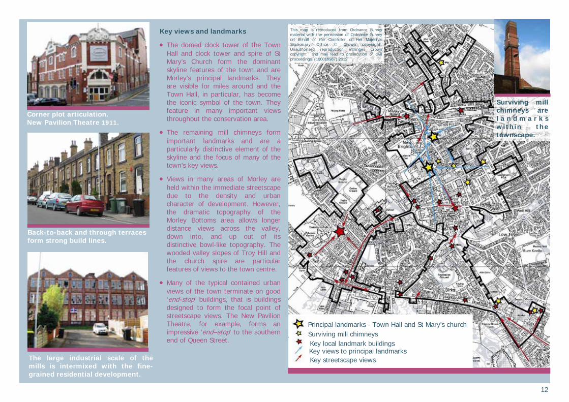
Key views and landmarks
The domed clock tower of the Town Hall and clock tower and spire of St Mary’s Church form the dominant skyline features of the town and are Morley’s principal landmarks. They are visible for miles around and the Town Hall, in particular, has become the iconic symbol of the town. They feature in many important views throughout the conservation area.
The remaining mill chimneys form important landmarks and are a particularly distinctive element of the skyline and the focus of many of the town’s key views.
Views in many areas of Morley are held within the immediate streetscape due to the density and urban character of development. However, the dramatic topography of the Morley Bottoms area allows longer distance views across the valley, down into, and up out of its distinctive bowl-like topography. The wooded valley slopes of Troy Hill and the church spire are particular features of views to the town centre.
Many of the typical contained urban views of the town terminate on good ‘end-stop’ buildings, that is buildings designed to form the focal point of streetscape views. The New Pavilion Theatre, for example, forms an impressive ‘end–stop’ to the southern end of Queen Street.
The large industrial scale of the mills is intermixed with the fine-grained residential development.
Corner plot articulation. New Pavilion Theatre 1911.
This map is reproduced from Ordnance Survey material with the permission of Ordnance Survey on behalf of the Controller of Her Majesty’s Stationary Office © Crown copyright. Unauthorised reproduction infringes Crown copyright and may lead to prosecution or civil proceedings. (100019567) 2012
Back-to-back and through terraces form strong build lines.
Surviving mill chimneys are l a n d m a r k s within the townscape.
Principal landmarks - Town Hall and St Mary’s church Surviving mill chimneys Key local landmark buildings
Key streetscape views Key views to principal landmarks
13
Built environment Architectural characteristics
Morley’s built environment is dominated by 19th century buildings that reflect the industrial activity, commercial prosperity and civic pride of that period. Earlier buildings survive that provide glimpses of the pre-industrial settlement including 17th century gentry houses and 18th century weavers cottages.
Generally good levels of historic survival produce a coherent townscape with a high degree of completeness and integrity. However, there have been significant losses including Morley House, the Manor House on Queen Street, a number of mills and their chimneys and large areas of ‘slum’ back-to-back and through terrace clearance.
There are 42 nationally important listed building entries within the conservation area. Many of these entries refer to more than one property and may also include curtilage structures and boundary treatments in the designation. The Town Hall is of Grade I status denoting its ‘exceptional interest’, the remainder are Grade II structures of ‘special architectural or historic interest’. The listings include mill buildings, civic structures, large houses, schools, a number of 17th and 18th century properties, a group of late 19th century commercial and bank properties, religious buildings and a significant group of 17th and 18th grave memorials in St Mary’s churchyard.
In addition there are many unlisted properties that make a positive contribution to the character of the settlement. These buildings are mapped in the Character Areas section of this appraisal.
Morley’s historic built environment includes a wide range of building types and forms. The impressive civic, religious and commercial buildings that dominate the town centre are often of a large scale, of high quality materials and with high levels of generally classically inspired architectural detail. In the surrounding areas of 19th century expansion the built environment is dominated by the regular rhythms and uniformity of the two storey back-to-back and through terraces, intermixed with the large massed mill complexes, places of worship and schools.
Groups of buildings work together to create particular townscape places and focal points. For example, the group of impressive buildings on Commercial Street forms a place of very high quality and includes the Public Library and a number of large and elaborate chapels. Architecture is skilfully used to strengthen and articulate the townscape, such as in the treatment of corner plots and the design of ’end-stop’ buildings. The former Morley Co-operative store, now Barclay’s Bank, at the junction of Queen Street and Albion Street is a particularly good example of this with its three storey scale, corner turret and wrap-around façade playing an important part in the character of the area.
Distinctive architectural groups include the following.
Civic buildings - The magnificent Town Hall, designed by GA Fox and built between 1892-5 is the town’s principal building. Deliberately reminiscent of Leeds Town Hall, it was a symbol of the confidence and ambition of Morley Borough Council and an expression of the town’s pride and independence. It remains the main landmark of the town with its central Baroque domed clock tower visible for miles around. The library, Commercial Street dates to 1905-6 and is another impressive civic building.
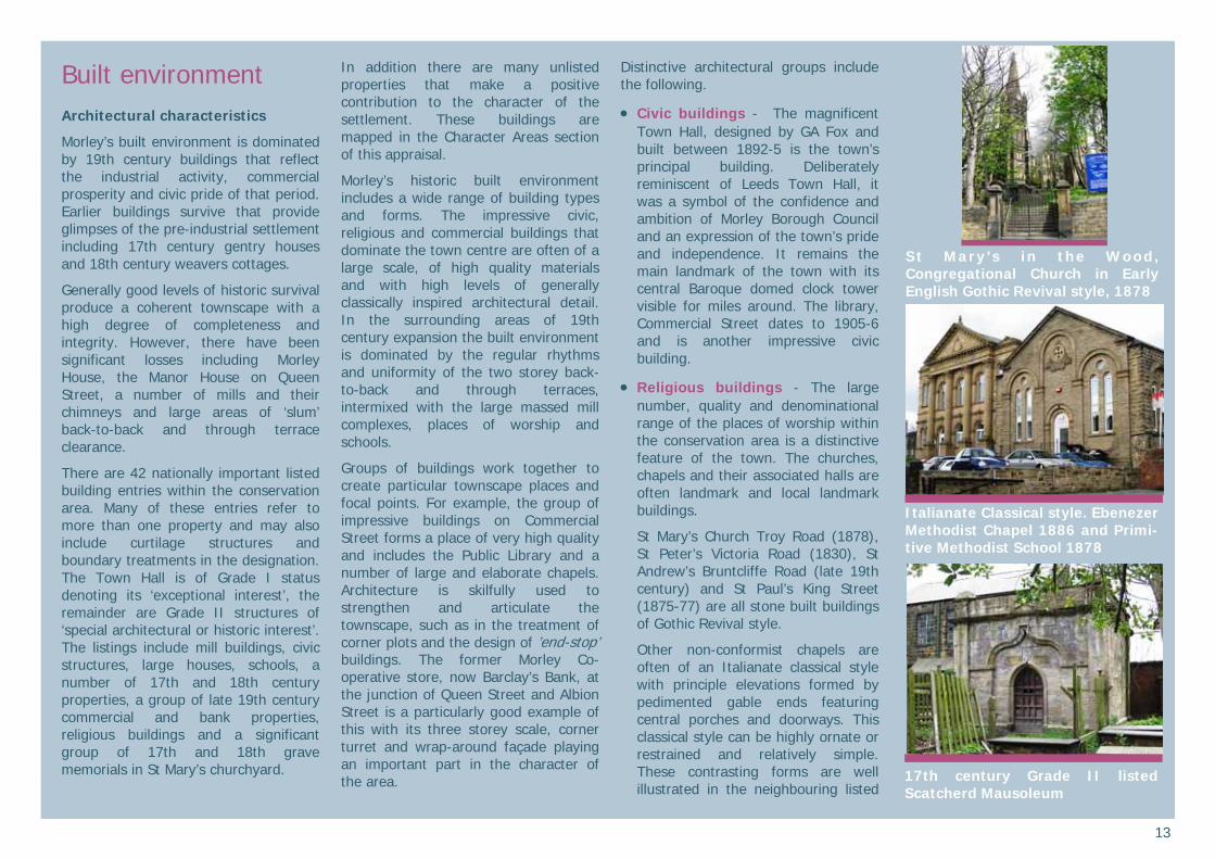
Religious buildings - The large number, quality and denominational range of the places of worship within the conservation area is a distinctive feature of the town. The churches, chapels and their associated halls are often landmark and local landmark buildings.
St Mary’s Church Troy Road (1878), St Peter’s Victoria Road (1830), St Andrew’s Bruntcliffe Road (late 19th century) and St Paul’s King Street (1875-77) are all stone built buildings of Gothic Revival style.
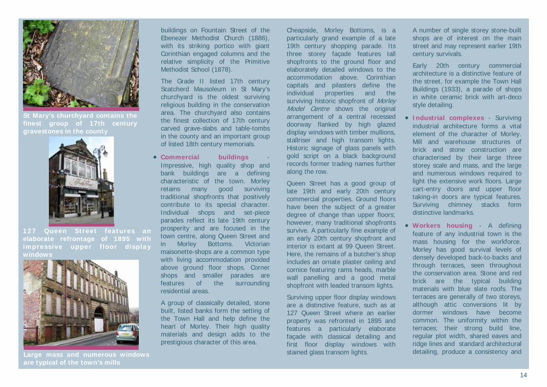
Other non-conformist chapels are often of an Italianate classical style with principle elevations formed by pedimented gable ends featuring central porches and doorways. This classical style can be highly ornate or restrained and relatively simple. These contrasting forms are well illustrated in the neighbouring listed
St Mary’s in the Wood, Congregational Church in Early English Gothic Revival style, 1878
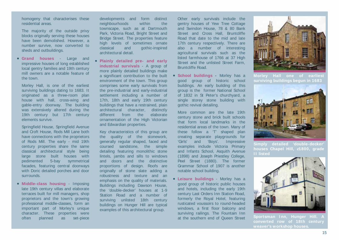
17th century Grade II listed Scatcherd Mausoleum
Italianate Classical style. Ebenezer Methodist Chapel 1886 and Primi-tive Methodist School 1878
14
buildings on Fountain Street of the Ebenezer Methodist Church (1886), with its striking portico with giant Corinthian engaged columns and the relative simplicity of the Primitive Methodist School (1878).
The Grade II listed 17th century Scatcherd Mausoleum in St Mary’s churchyard is the oldest surviving religious building in the conservation area. The churchyard also contains the finest collection of 17th century carved grave-slabs and table-tombs in the county and an important group of listed 18th century memorials.
Commercial buildings - Impressive, high quality shop and bank buildings are a defining characteristic of the town. Morley retains many good surviving traditional shopfronts that positively contribute to its special character. Individual shops and set-piece parades reflect its late 19th century prosperity and are focused in the town centre, along Queen Street and in Morley Bottoms. Victorian maisonette-shops are a common type with living accommodation provided above ground floor shops. Corner shops and smaller parades are features of the surrounding residential areas.
A group of classically detailed, stone built, listed banks form the setting of the Town Hall and help define the heart of Morley. Their high quality materials and design adds to the prestigious character of this area.
Cheapside, Morley Bottoms, is a particularly grand example of a late 19th century shopping parade. Its three storey façade features tall shopfronts to the ground floor and elaborately detailed windows to the accommodation above. Corinthian capitals and pilasters define the individual properties and the surviving historic shopfront of Morley Model Centre shows the original arrangement of a central recessed doorway flanked by high glazed display windows with timber mullions, stallriser and high transom lights. Historic signage of glass panels with gold script on a black background records former trading names further along the row.
Queen Street has a good group of late 19th and early 20th century commercial properties. Ground floors have been the subject of a greater degree of change than upper floors; however, many traditional shopfronts survive. A particularly fine example of an early 20th century shopfront and interior is extant at 99 Queen Street. Here, the remains of a butcher’s shop includes an ornate plaster ceiling and cornice featuring rams heads, marble wall panelling and a good metal shopfront with leaded transom lights.
Surviving upper floor display windows are a distinctive feature, such as at 127 Queen Street where an earlier property was refronted in 1895 and features a particularly elaborate façade with classical detailing and first floor display windows with stained glass transom lights.
A number of single storey stone-built shops are of interest on the main street and may represent earlier 19th century survivals.
Early 20th century commercial architecture is a distinctive feature of the street, for example the Town Hall Buildings (1933), a parade of shops in white ceramic brick with art-deco style detailing.
Industrial complexes - Surviving industrial architecture forms a vital element of the character of Morley. Mill and warehouse structures of brick and stone construction are characterised by their large three storey scale and mass, and the large and numerous windows required to light the extensive work floors. Large cart-entry doors and upper floor taking-in doors are typical features. Surviving chimney stacks form distinctive landmarks.
Workers housing - A defining feature of any industrial town is the mass housing for the workforce. Morley has good survival levels of densely developed back-to-backs and through terraces, seen throughout the conservation area. Stone and red brick are the typical building materials with blue slate roofs. The terraces are generally of two storeys, although attic conversions lit by dormer windows have become common. The uniformity within the terraces; their strong build line, regular plot width, shared eaves and ridge lines and standard architectural detailing, produce a consistency and
St Mary’s churchyard contains the finest group of 17th century gravestones in the county
Large mass and numerous windows are typical of the town’s mills
127 Queen Street features an elaborate refrontage of 1895 with impressive upper floor display windows
15
homogeny that characterises these residential areas.
The majority of the outside privy blocks originally serving these houses have been demolished. However, a number survive, now converted to sheds and outbuildings.
Grand houses - Large and impressive houses of long established local gentry families and 19th century mill owners are a notable feature of the town.
Morley Hall, is one of the earliest surviving buildings dating to 1683. It originated as a three-room plan house with hall, cross-wing and gable-entry doorway. The building was extensively altered during the 19th century but 17th century elements survive.
Springfield House, Springfield Avenue and Croft House, Rods Mill Lane both have connections with the proprietors of Rods Mill. The early - mid 19th century properties share the same classical architectural style being large stone built houses with pedimented 5-bay symmetrical facades, featuring central doorways with Doric detailed porches and door surrounds.
Middle-class housing - Imposing late 19th century villas and elaborate terraces built for mill managers, shop proprietors and the town’s growing professional middle-classes, form an important part of Morley’s unique character. These properties were often planned as set-piece
developments and form distinct neighbourhoods within the townscape, such as at Dartmouth Park, Victoria Road, Bright Street and Bridge Street. The properties feature high levels of sometimes ornate classical and gothic-inspired architectural detail.
Plainly detailed pre- and early industrial survivals - A group of more plainly detailed buildings make a significant contribution to the built environment of the town. This group comprises some early survivals from the pre-industrial and early-industrial settlement including a number of 17th, 18th and early 19th century buildings that have a restrained, plain architectural character, distinctly different from the elaborate ornamentation of the High Victorian and Edwardian properties.
Key characteristics of this group are the quality of the stonework, generally regular shaped, faced and coursed sandstone, the simple detailing featuring monolithic stone lintels, jambs and sills to windows and doors and the distinctive proportions of design. Roofs are originally of stone slate adding a robustness and texture and an emphasis on the quality of materials. Buildings including Dawson House, the ‘double-decker’ houses at 1-9 Station Road and a number of surviving unlisted 18th century buildings on Hunger Hill are typical examples of this architectural group.
Other early survivals include the gentry houses of Yew Tree Cottage and Swindon House, 78 & 80 Bank Street and Cross Hall, Bruntcliffe Road that date to the mid and late 17th century respectively. There are also a number of interesting agricultural survivals such as the listed farmhouse of 1766 at 37 High Street and the unlisted Street Farm, Bruntcliffe Road.
School buildings - Morley has a good group of historic school buildings. An early building of this group is the former National School of 1832 in St Peter’s churchyard, a single storey stone building with gothic revival detailing.
More common are the late 19th century stone and brick built schools that form local landmarks in the residential areas of the town. Many of these follow a ‘T’ shaped plan creating separate playgrounds for ‘Girls’ and ‘Boys’. Impressive examples include Victoria Primary and Infants School, Asquith Avenue (1898) and Joseph Priestley College, Peel Street (1880). The former Grammar School of 1907 is another notable school building.
Leisure buildings - Morley has a good group of historic public houses and hotels, including the early 19th century Last Orders Inn Station Road, formerly the Royal Hotel, featuring rusticated voussoirs to round-headed windows, a first floor balcony and surviving railings. The Fountain Inn at the southern end of Queen Street
Morley Hall one of earliest surviving buildings begun in 1683
Sportsman Inn, Hunger Hill. A converted row of 18th century weaver’s workshop houses.
Simply detailed ‘double-decker’ houses Chapel Hill, c1800, grade II listed
16
is of a plainer architectural style and the Sportsman Inn at Hunger Hill is a converted row of 18th century weavers workshop houses.
The New Pavilion Theatre of 1911 is a significant building recalling the continued prosperity of the town in the early 20th century.
Late 20th century and 21st century buildings - Recent architecture within the conservation area has been of mixed success. Good additions match the quality of materials, scale, proportions and dominant build lines of their surroundings while being distinctly of their time and adding a vitality to the townscape. Less successful examples are of poorer quality materials and design, with little reference to their setting and are often of a more suburban ’anywhere’ character.
Conversions of mill buildings and chapels have secured new uses for important historic buildings. The best schemes have retained the essential character of the original building and have injected something of their own period into the structure mixing the old and the new in exciting ways. Less successful schemes have compromised the character and form of original buildings with insensitive use of space and inappropriate materials and fittings.
Materials
The predominant materials of Morley are local sandstone and red brick.
Local Morley sandstone is commonly used in coursed, regular, shaped and faced blocks. Thinner rough-faced pieces and rock-faced, shaped blocks are also present. Dressings, lintels, jambs and sills are generally of monolithic stone.
Red brick is commonly used for industrial buildings from the second half of the 19th century as it offered a more affordable building material for these large structures. Mill buildings, their chimneys and industrial warehouses of this date are often of red brick with stone dressings.
Stone is the dominant building material of the town’s residential architecture with red brick generally restricted as a secondary material for side and rear elevations of stone-fronted properties. Exceptions to this include the brick-built early-mid 19th century grade II listed Park House, 51b Queen Street. From the late 19th century it became more common to build wholly in brick.
Historic roof coverings are of heavy stone slate and, from the late 19th century, lighter Welsh or blue slate.
Local details
There has been a considerable loss of traditional fenestration and architectural detail, including door and window fittings. However, much historic detail survives and contributes to the unique character of the settlement. Some of the late 19th century buildings that dominate the town feature elaborate stone carving and ornate architectural detailing. Earlier buildings tend to have a plainer character.
Doorways and windows are used as the opportunity for architectural enrichment with varying degrees of carving to stone lintels and jambs. These dressings are often painted black in the terraces further adding to the strong unity of the street elevations.
Buildings of the 18th century and early 19th century often feature flat-faced stone mullioned windows arranged in groups of three lights. Windows of later buildings, both residential and industrial, are typically vertically hung sashes. Bay windows and stained glass are common details of the villas and ornately detailed middle-class terraces.
Common historic doorway details include panelled and painted timber doors, with varying levels of carving to their stone surround. Fanlights and doorsteps are typical details.
Gutters are supported on stone brackets used decoratively as eaves cornices. This distinctive detail is seen on all types of residential architecture.
Roof forms vary, as does the character of the richly textured stone-slate roofs compared to the smooth, thin Welsh slate coverings. Some early buildings feature coped gables with kneeler stones. Chimneys are common and generally of stone and later brick, with tall red ceramic pots. Inappropriate flat-roofed dormer windows mar some of the terraces. Existing historic smaller gabled dormers suggest a more sensitive alternative.
Where permitted, dormer windows can be sensitively designed.
Successful conversions retain the essential character of the original structure and add something of their own time. Melbourne Mills.
T e r r a c e s s h a r e u n i f o r m detailing. Stone gutter brackets are an important local detail.
The roofscape of this terrace retains its unity with no dormer window additions.
17
Streetscape Historic streetscape features contribute to Morley’s special character.
Boundary treatments are important in some residential areas - stone boundary walls with copings and stone gateposts with capstone details are a feature of the back-to-backs and through terraces that have front gardens or yards. The villas and middle-class terraces have particularly impressive boundary treatments sometimes incorporating hedges and iron railings with the boundary walls. Gates are of painted timber or decorative wrought iron. There is evidence that iron railings were traditionally more prevalent and were likely removed as part of the war effort.
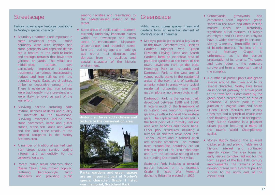
Surviving historic surfacing adds texture, richness of detail and quality of materials to the townscape. Surviving examples include York stone pavements, kerbs and gutter stones, stone sett lanes and yards and the York stone treads of the stepped footpaths in the Morley Bottoms area.
A number of traditional painted cast iron street signs survive adding interest and authenticity to the conservation area.
Recent public realm schemes along Queen Street have proved popular, featuring heritage-style lamp standards and providing public
seating facilities and resurfacing to the pedestrianised extent of the street.
Some areas of public realm treatment currently underplay important places within the townscape and offers scope for enhancement. Disparate, uncoordinated and redundant street furniture, road signage and markings add clutter that disguises and detracts from the qualities and special character of the historic environment.
Greenscape Public parks, green spaces, trees and gardens form an essential element of Morley’s special character.
Morley’s public parks are a key asset of the town. Scatcherd Park, Hopkins Gardens together with Queen Elizabeth Playing Fields and Scarth Gardens form an extensive area of park and gardens at the heart of the town. Lewisham Park to the east, Hembrigg Park to the south and Dartmouth Park to the west are all valued public parks in the residential areas of the town, and of particular amenity value in areas where typical residential properties have small garden plots or no garden plots at all.
Dartmouth Park is the earliest park developed between 1888 and 1890. It retains much of the framework of its historic plan, featuring impressive gateways with a lodge at the eastern gate. The replacement bandstand is the focal point of a formally laid out area with benches and flower beds. Other park structures including a number of shelters have been lost. Tennis courts and a football pitch are popular amenities. The mature trees around the boundary are an essential part of the area’s character and form the attractive setting of the surrounding Dartmouth Park villas.
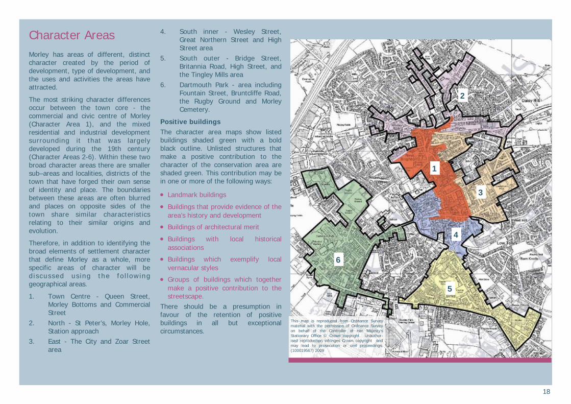
Scatcherd Park includes a terraced garden focused on the dramatic Grade II listed War Memorial depicting Britannia erected in 1922.
Churchyards, graveyards and cemeteries form important green spaces in the town and often include mature trees and historically significant burial markers. St Mary’s churchyard and St Peter’s churchyard have a wider townscape importance. Morley Cemetery, Bruntcliffe Lane is of historic interest. The loss of the central Mortuary Chapel is unfortunate, as is the current presentation of its remains. The gates and gate lodge to the cemetery survive and form an important part of the complex.
A number of pocket parks and green spaces around the town add to its special character. Morley Hole forms an important gateway or arrival point to the town and is dominated by the green space created from an area of clearance. A pocket park at the junction of Magpie Lane and South Queen Street features two cherry trees that add a splash of colour with their flowering blossom in springtime. Beryl Burton Gardens is a pleasant urban garden featuring a mural of the town’s World Championship cyclist.
Morley Rugby Ground, the adjacent cricket pitch and playing fields are of historic interest and continued amenity value. The area forms an early leisure complex laid out for the town as part of the late 19th century improvements. The remains of two bowling greens with a central pavilion survive to the north east of the cricket field.
Historic surfaces add richness and texture to the conservation area
Parks, gardens and green spaces are an important part of Morley’s special character. Grade II listed war memorial, Scatcherd Park
18
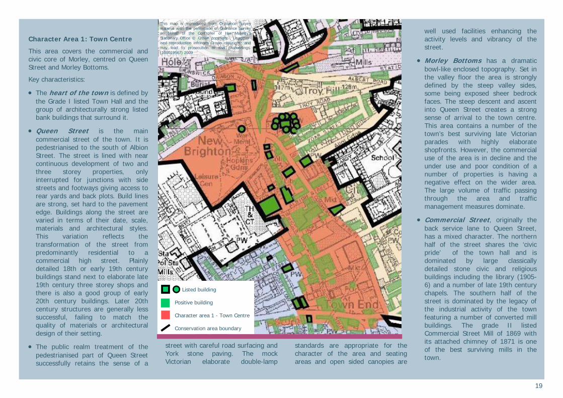
Character Areas Morley has areas of different, distinct character created by the period of development, type of development, and the uses and activities the areas have attracted.
The most striking character differences occur between the town core - the commercial and civic centre of Morley (Character Area 1), and the mixed residential and industrial development surrounding it that was largely developed during the 19th century (Character Areas 2-6). Within these two broad character areas there are smaller sub–areas and localities, districts of the town that have forged their own sense of identity and place. The boundaries between these areas are often blurred and places on opposite sides of the town share similar characteristics relating to their similar origins and evolution.
Therefore, in addition to identifying the broad elements of settlement character that define Morley as a whole, more specific areas of character will be d iscussed us ing the fo l lowing geographical areas.
1. Town Centre - Queen Street, Morley Bottoms and Commercial Street
2. North - St Peter’s, Morley Hole, Station approach
3. East - The City and Zoar Street area
4. South inner - Wesley Street, Great Northern Street and High Street area
5. South outer - Bridge Street, Britannia Road, High Street, and the Tingley Mills area
6. Dartmouth Park - area including Fountain Street, Bruntcliffe Road, the Rugby Ground and Morley Cemetery.
Positive buildings The character area maps show listed buildings shaded green with a bold black outline. Unlisted structures that make a positive contribution to the character of the conservation area are shaded green. This contribution may be in one or more of the following ways:
Landmark buildings
Buildings that provide evidence of the area’s history and development
Buildings of architectural merit
Buildings with local historical associations
Buildings which exemplify local vernacular styles
Groups of buildings which together make a positive contribution to the streetscape.
There should be a presumption in favour of the retention of positive buildings in all but exceptional circumstances.
1
2
3
4
5
6
This map is reproduced from Ordnance Survey material with the permission of Ordnance Survey on behalf of the Controller of Her Majesty’s Stationary Office © Crown copyright. Unauthor-ised reproduction infringes Crown copyright and may lead to prosecution or civil proceedings. (100019567) 2009
19
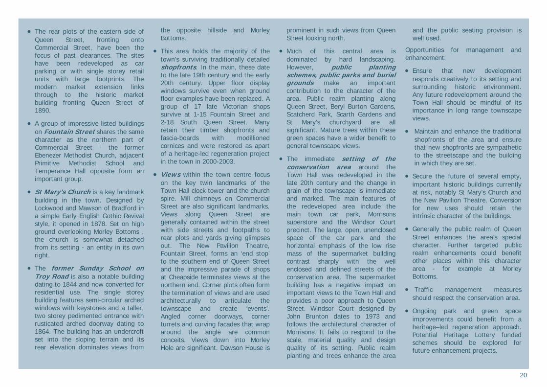
Character Area 1: Town Centre
This area covers the commercial and civic core of Morley, centred on Queen Street and Morley Bottoms.
Key characteristics:
The heart of the town is defined by the Grade I listed Town Hall and the group of architecturally strong listed bank buildings that surround it.
Queen Street is the main commercial street of the town. It is pedestrianised to the south of Albion Street. The street is lined with near continuous development of two and three storey properties, only interrupted for junctions with side streets and footways giving access to rear yards and back plots. Build lines are strong, set hard to the pavement edge. Buildings along the street are varied in terms of their date, scale, materials and architectural styles. This variation reflects the transformation of the street from predominantly residential to a commercial high street. Plainly detailed 18th or early 19th century buildings stand next to elaborate late 19th century three storey shops and there is also a good group of early 20th century buildings. Later 20th century structures are generally less successful, failing to match the quality of materials or architectural design of their setting.
The public realm treatment of the pedestrianised part of Queen Street successfully retains the sense of a
street with careful road surfacing and York stone paving. The mock Victorian elaborate double-lamp
standards are appropriate for the character of the area and seating areas and open sided canopies are
well used facilities enhancing the activity levels and vibrancy of the street.
Morley Bottoms has a dramatic bowl-like enclosed topography. Set in the valley floor the area is strongly defined by the steep valley sides, some being exposed sheer bedrock faces. The steep descent and ascent into Queen Street creates a strong sense of arrival to the town centre. This area contains a number of the town’s best surviving late Victorian parades with highly elaborate shopfronts. However, the commercial use of the area is in decline and the under use and poor condition of a number of properties is having a negative effect on the wider area. The large volume of traffic passing through the area and traffic management measures dominate.
Commercial Street, originally the back service lane to Queen Street, has a mixed character. The northern half of the street shares the ‘civic pride’ of the town hall and is dominated by large classically detailed stone civic and religious buildings including the library (1905-6) and a number of late 19th century chapels. The southern half of the street is dominated by the legacy of the industrial activity of the town featuring a number of converted mill buildings. The grade II listed Commercial Street Mill of 1869 with its attached chimney of 1871 is one of the best surviving mills in the town.
This map is reproduced from Ordnance Survey material with the permission of Ordnance Survey on behalf of the Controller of Her Majesty’s Stationary Office © Crown copyright. Unauthor-ised reproduction infringes Crown copyright and may lead to prosecution or civil proceedings. (100019567) 2009
Listed building
Positive building Character area 1 - Town Centre Conservation area boundary
20
The rear plots of the eastern side of
Queen Street, fronting onto Commercial Street, have been the focus of past clearances. The sites have been redeveloped as car parking or with single storey retail units with large footprints. The modern market extension links through to the historic market building fronting Queen Street of 1890.
A group of impressive listed buildings on Fountain Street shares the same character as the northern part of Commercial Street - the former Ebenezer Methodist Church, adjacent Primitive Methodist School and Temperance Hall opposite form an important group.
St Mary’s Church is a key landmark building in the town. Designed by Lockwood and Mawson of Bradford in a simple Early English Gothic Revival style, it opened in 1878. Set on high ground overlooking Morley Bottoms , the church is somewhat detached from its setting - an entity in its own right.
The former Sunday School on Troy Road is also a notable building dating to 1844 and now converted for residential use. The single storey building features semi-circular arched windows with keystones and a taller, two storey pedimented entrance with rusticated arched doorway dating to 1864. The building has an undercroft set into the sloping terrain and its rear elevation dominates views from
the opposite hillside and Morley Bottoms.
This area holds the majority of the town’s surviving traditionally detailed shopfronts. In the main, these date to the late 19th century and the early 20th century. Upper floor display windows survive even when ground floor examples have been replaced. A group of 17 late Victorian shops survive at 1-15 Fountain Street and 2-18 South Queen Street. Many retain their timber shopfronts and fascia-boards with modillioned cornices and were restored as apart of a heritage-led regeneration project in the town in 2000-2003.
Views within the town centre focus on the key twin landmarks of the Town Hall clock tower and the church spire. Mill chimneys on Commercial Street are also significant landmarks. Views along Queen Street are generally contained within the street with side streets and footpaths to rear plots and yards giving glimpses out. The New Pavilion Theatre, Fountain Street, forms an ‘end stop’ to the southern end of Queen Street and the impressive parade of shops at Cheapside terminates views at the northern end. Corner plots often form the termination of views and are used architecturally to articulate the townscape and create ‘events’. Angled corner doorways, corner turrets and curving facades that wrap around the angle are common conceits. Views down into Morley Hole are significant. Dawson House is
prominent in such views from Queen Street looking north.
Much of this central area is dominated by hard landscaping. However, public planting schemes, public parks and burial grounds make an important contribution to the character of the area. Public realm planting along Queen Street, Beryl Burton Gardens, Scatcherd Park, Scarth Gardens and St Mary’s churchyard are all significant. Mature trees within these green spaces have a wider benefit to general townscape views.
The immediate setting of the conservation area around the Town Hall was redeveloped in the late 20th century and the change in grain of the townscape is immediate and marked. The main features of the redeveloped area include the main town car park, Morrisons superstore and the Windsor Court precinct. The large, open, unenclosed space of the car park and the horizontal emphasis of the low rise mass of the supermarket building contrast sharply with the well enclosed and defined streets of the conservation area. The supermarket building has a negative impact on important views to the Town Hall and provides a poor approach to Queen Street. Windsor Court designed by John Brunton dates to 1973 and follows the architectural character of Morrisons. It fails to respond to the scale, material quality and design quality of its setting. Public realm planting and trees enhance the area
and the public seating provision is well used.
Opportunities for management and enhancement:
Ensure that new development responds creatively to its setting and surrounding historic environment. Any future redevelopment around the Town Hall should be mindful of its importance in long range townscape views.
Maintain and enhance the traditional shopfronts of the area and ensure that new shopfronts are sympathetic to the streetscape and the building in which they are set.
Secure the future of several empty, important historic buildings currently at risk, notably St Mary’s Church and the New Pavilion Theatre. Conversion for new uses should retain the intrinsic character of the buildings.
Generally the public realm of Queen Street enhances the area’s special character. Further targeted public realm enhancements could benefit other places within this character area - for example at Morley Bottoms.
Traffic management measures should respect the conservation area.
Ongoing park and green space improvements could benefit from a heritage–led regeneration approach. Potential Heritage Lottery funded schemes should be explored for future enhancement projects.
21
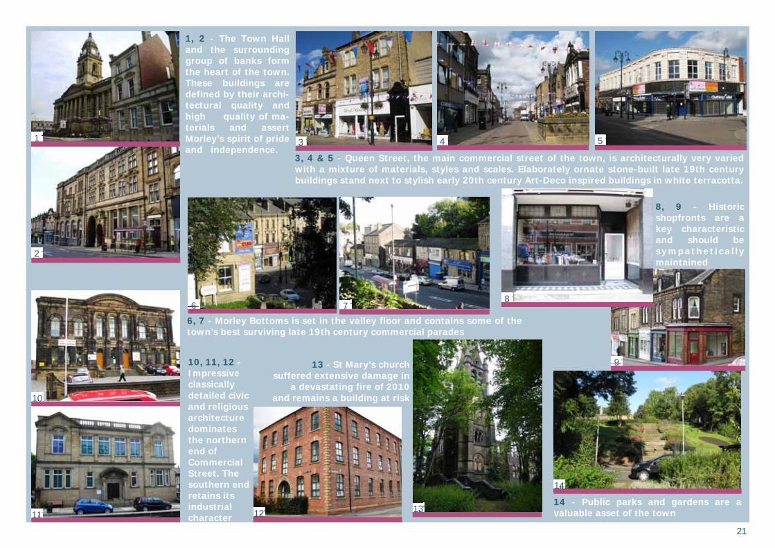
1, 2 - The Town Hall and the surrounding group of banks form the heart of the town. These buildings are defined by their archi-tectural quality and high quality of ma-terials and assert Morley’s spirit of pride and independence.
3, 4 & 5 - Queen Street, the main commercial street of the town, is architecturally very varied with a mixture of materials, styles and scales. Elaborately ornate stone-built late 19th century buildings stand next to stylish early 20th century Art-Deco inspired buildings in white terracotta.
10, 11, 12 - Impressive classically detailed civic and religious architecture dominates the northern end of Commercial Street. The southern end retains its industrial character
8, 9 - Historic shopfronts are a key characteristic and should be sympathetical ly maintained
14 - Public parks and gardens are a valuable asset of the town
13 - St Mary’s church suffered extensive damage in
a devastating fire of 2010 and remains a building at risk
6, 7 - Morley Bottoms is set in the valley floor and contains some of the town’s best surviving late 19th century commercial parades
1
2
3 4 5
6 7 8
9
10
11 12 13
14
22
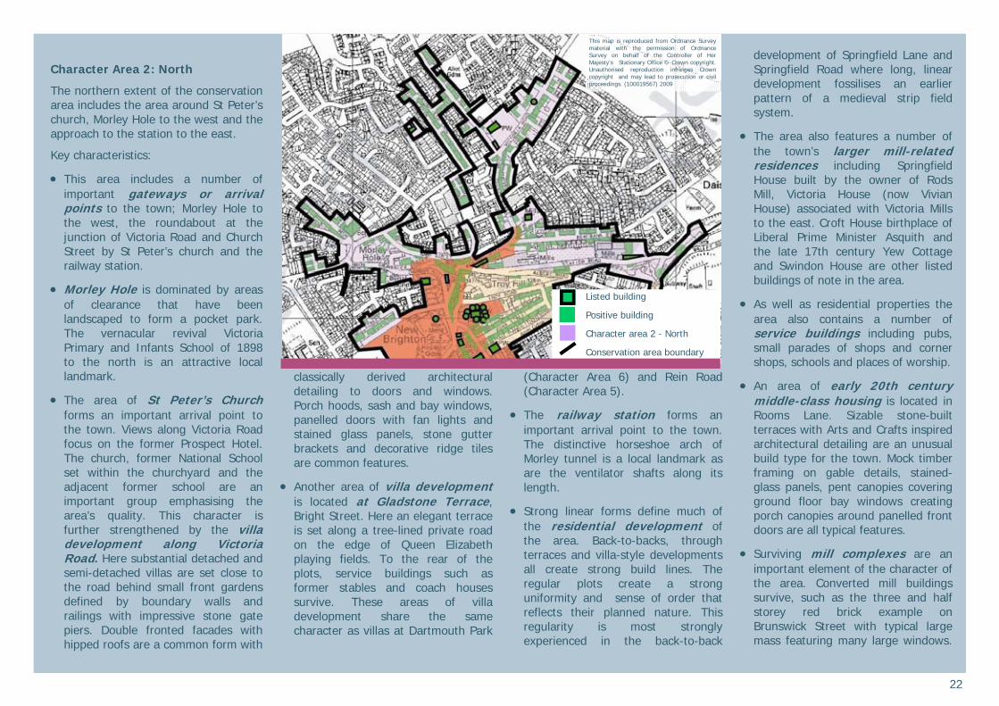
Character Area 2: North
The northern extent of the conservation area includes the area around St Peter’s church, Morley Hole to the west and the approach to the station to the east.
Key characteristics:
This area includes a number of important gateways or arrival points to the town; Morley Hole to the west, the roundabout at the junction of Victoria Road and Church Street by St Peter’s church and the railway station.
Morley Hole is dominated by areas of clearance that have been landscaped to form a pocket park. The vernacular revival Victoria Primary and Infants School of 1898 to the north is an attractive local landmark.
The area of St Peter’s Church forms an important arrival point to the town. Views along Victoria Road focus on the former Prospect Hotel. The church, former National School set within the churchyard and the adjacent former school are an important group emphasising the area’s quality. This character is further strengthened by the villa development along Victoria Road. Here substantial detached and semi-detached villas are set close to the road behind small front gardens defined by boundary walls and railings with impressive stone gate piers. Double fronted facades with hipped roofs are a common form with
classically derived architectural detailing to doors and windows. Porch hoods, sash and bay windows, panelled doors with fan lights and stained glass panels, stone gutter brackets and decorative ridge tiles are common features.
Another area of villa development is located at Gladstone Terrace, Bright Street. Here an elegant terrace is set along a tree-lined private road on the edge of Queen Elizabeth playing fields. To the rear of the plots, service buildings such as former stables and coach houses survive. These areas of villa development share the same character as villas at Dartmouth Park
(Character Area 6) and Rein Road (Character Area 5).
The railway station forms an important arrival point to the town. The distinctive horseshoe arch of Morley tunnel is a local landmark as are the ventilator shafts along its length.
Strong linear forms define much of the residential development of the area. Back-to-backs, through terraces and villa-style developments all create strong build lines. The regular plots create a strong uniformity and sense of order that reflects their planned nature. This regularity is most strongly experienced in the back-to-back
development of Springfield Lane and Springfield Road where long, linear development fossilises an earlier pattern of a medieval strip field system.
The area also features a number of the town’s larger mill-related residences including Springfield House built by the owner of Rods Mill, Victoria House (now Vivian House) associated with Victoria Mills to the east. Croft House birthplace of Liberal Prime Minister Asquith and the late 17th century Yew Cottage and Swindon House are other listed buildings of note in the area.
As well as residential properties the area also contains a number of service buildings including pubs, small parades of shops and corner shops, schools and places of worship.
An area of early 20th century middle-class housing is located in Rooms Lane. Sizable stone-built terraces with Arts and Crafts inspired architectural detailing are an unusual build type for the town. Mock timber framing on gable details, stained-glass panels, pent canopies covering ground floor bay windows creating porch canopies around panelled front doors are all typical features.
Surviving mill complexes are an important element of the character of the area. Converted mill buildings survive, such as the three and half storey red brick example on Brunswick Street with typical large mass featuring many large windows.
This map is reproduced from Ordnance Survey material with the permission of Ordnance Survey on behalf of the Controller of Her Majesty’s Stationary Office © Crown copyright. Unauthorised reproduction infringes Crown copyright and may lead to prosecution or civil proceedings. (100019567) 2009
Listed building
Positive building
Character area 2 - North
Conservation area boundary
23
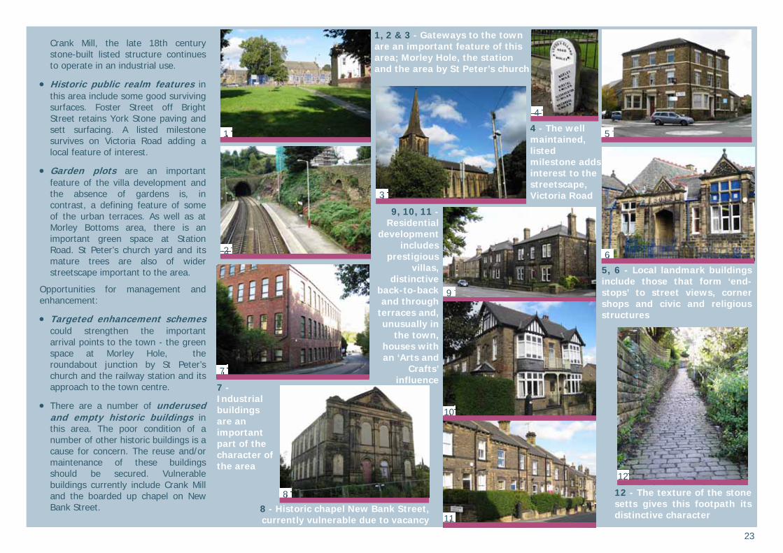
Crank Mill, the late 18th century stone-built listed structure continues to operate in an industrial use.
Historic public realm features in this area include some good surviving surfaces. Foster Street off Bright Street retains York Stone paving and sett surfacing. A listed milestone survives on Victoria Road adding a local feature of interest.
Garden plots are an important feature of the villa development and the absence of gardens is, in contrast, a defining feature of some of the urban terraces. As well as at Morley Bottoms area, there is an important green space at Station Road. St Peter’s church yard and its mature trees are also of wider streetscape important to the area.
Opportunities for management and enhancement:
Targeted enhancement schemes could strengthen the important arrival points to the town - the green space at Morley Hole, the roundabout junction by St Peter’s church and the railway station and its approach to the town centre.
There are a number of underused and empty historic buildings in this area. The poor condition of a number of other historic buildings is a cause for concern. The reuse and/or maintenance of these buildings should be secured. Vulnerable buildings currently include Crank Mill and the boarded up chapel on New Bank Street.
4 - The well maintained, listed milestone adds interest to the streetscape, Victoria Road
1, 2 & 3 - Gateways to the town are an important feature of this area; Morley Hole, the station and the area by St Peter’s church
12 - The texture of the stone setts gives this footpath its distinctive character
5, 6 - Local landmark buildings include those that form ‘end-stops’ to street views, corner shops and civic and religious structures
8 - Historic chapel New Bank Street, currently vulnerable due to vacancy
7 - Industrial buildings are an important part of the character of the area
1
2
3
4
5
6
12
7
8
9
10
11
9, 10, 11 -Residential
development includes
prestigious villas,
distinctive back-to-back and through
terraces and, unusually in
the town, houses with an ‘Arts and
Crafts’ influence
24
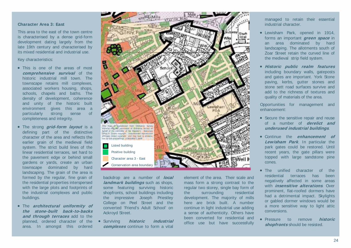
Character Area 3: East
This area to the east of the town centre is characterised by a dense grid-form development dating largely from the late 19th century and characterised by its mixed residential and industrial use.
Key characteristics:
This is one of the areas of most comprehensive survival of the historic industrial mill town. The townscape retains mill complexes, associated workers housing, shops, schools, chapels and baths. The density of development, coherence and unity of the historic built environment gives this area a particularly strong sense of completeness and integrity.
The strong grid-form layout is a defining part of the distinctive character of the area and reflects the earlier grain of the medieval field system. The strict build lines of the linear residential terraces, set hard to the pavement edge or behind small gardens or yards, create an urban townscape dominated by hard landscaping. The grain of the area is formed by the regular, fine grain of the residential properties interspersed with the large plots and footprints of the industrial complexes and public buildings.
The architectural uniformity of the stone-built back-to-backs and through terraces add to the planned, ordered character of the area. In amongst this ordered
backdrop are a number of local landmark buildings such as shops, some featuring surviving historic shopfronts, school buildings including the impressive Joseph Priestley College on Peel Street and the converted ’Friend’s Adult School’ on Ackroyd Street.
Surviving historic industrial complexes continue to form a vital
element of the area. Their scale and mass form a strong contrast to the regular two storey, single bay form of the surrounding residential development. The majority of mills here are brick built. A number continue in light industrial use adding a sense of authenticity. Others have been converted for residential and office use but have successfully
managed to retain their essential industrial character.
Lewisham Park, opened in 1914, forms an important green space in an area dominated by hard landscaping. The allotments south of Zoar Street retain the curved line of the medieval strip field system.
Historic public realm features including boundary walls, gateposts and gates are important. York Stone paving, kerbs, gutter stones and stone sett road surfaces survive and add to the richness of textures and quality of materials of the area.
Opportunities for management and enhancement:
Secure the sensitive repair and reuse of a number of derelict and underused industrial buildings.
Continue the enhancement of Lewisham Park. In particular the park gates could be restored. Until recent years, the gate pillars were topped with large sandstone pine cones.
The unified character of the residential terraces has been negatively affected in some areas with insensitive alterations. Over prominent, flat-roofed dormers have had a detrimental impact. Skylights or gabled dormer windows would be a more sensitive way to light attic conversions.
Pressure to remove historic shopfronts should be resisted.
This map is reproduced from Ordnance Survey material with the permission of Ordnance Survey on behalf of the Controller of Her Majesty’s Stationary Office © Crown copyright. Unauthorised reproduction infringes Crown copyright and may lead to prosecu-tion or civil proceedings. (100019567) 2009
Listed building
Positive building
Character area 3 - East
Conservation area boundary
25
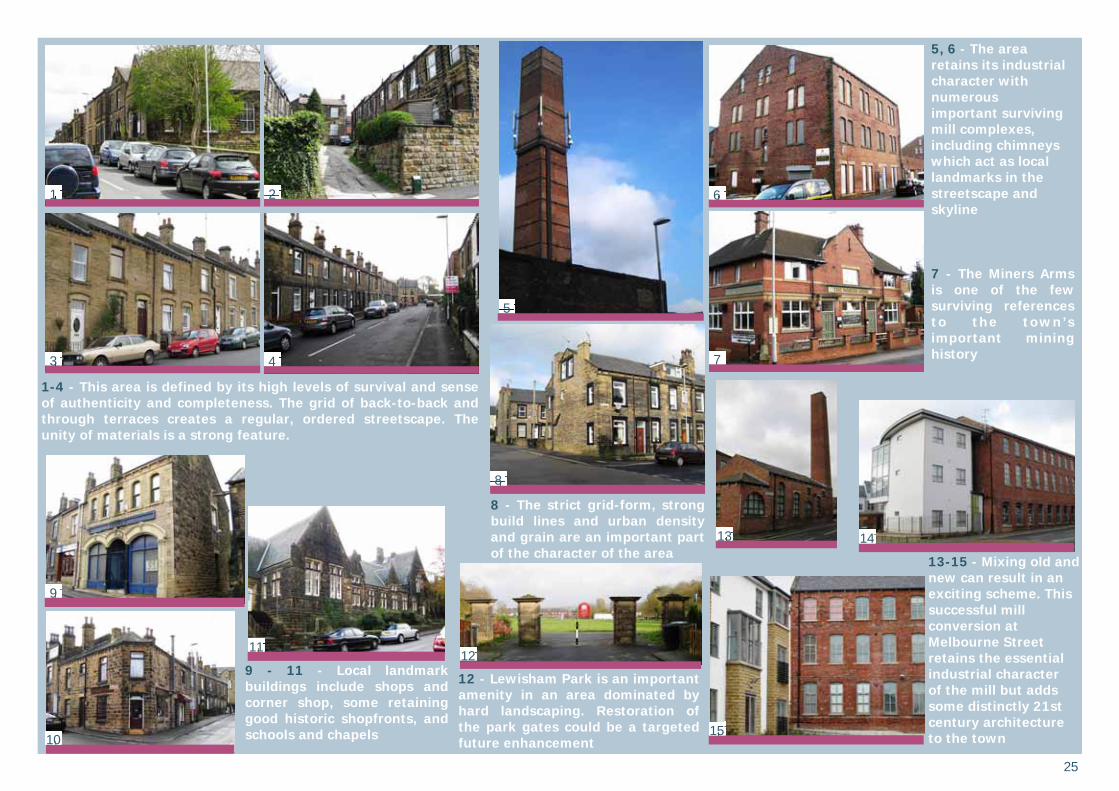
1-4 - This area is defined by its high levels of survival and sense of authenticity and completeness. The grid of back-to-back and through terraces creates a regular, ordered streetscape. The unity of materials is a strong feature.
5, 6 - The area retains its industrial character with numerous important surviving mill complexes, including chimneys which act as local landmarks in the streetscape and skyline 7 - The Miners Arms is one of the few surviving references to the town’s important mining history
9 - 11 - Local landmark buildings include shops and corner shop, some retaining good historic shopfronts, and schools and chapels
12 - Lewisham Park is an important amenity in an area dominated by hard landscaping. Restoration of the park gates could be a targeted future enhancement
13-15 - Mixing old and new can result in an exciting scheme. This successful mill conversion at Melbourne Street retains the essential industrial character of the mill but adds some distinctly 21st century architecture to the town
8 - The strict grid-form, strong build lines and urban density and grain are an important part of the character of the area
1 2
3 4
5
6
7
8
9
11
10
12
13 14
15
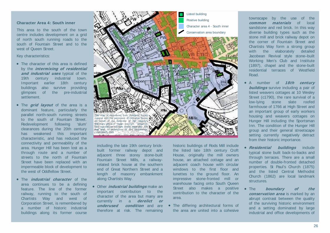
26
Character Area 4: South inner
This area to the south of the town centre includes development on a grid of north south running roads to the south of Fountain Street and to the west of Queen Street.
Key characteristics:
The character of this area is defined by the intermixing of residential and industrial uses typical of the 19th century industrial town. Important earlier 18th century buildings also survive providing glimpses of the pre-industrial settlement.
The grid layout of the area is a dominant feature, particularly the parallel north-south running streets to the south of Fountain Street. Redevelopment following ‘slum’ clearances during the 20th century has weakened this important characteristic, and has reduced the connectivity and permeability of the area. Hunger Hill has been lost as a through route and a number of streets to the north of Fountain Street have been replaced with an impermeable block of development to the west of Oddfellow Street.
The industrial character of the area continues to be a defining feature. The line of the former railway, running to the south of Chartists Way and west of Corporation Street, is remembered by a number of historic industrial buildings along its former course
including the late 19th century brick-built former railway depot and adjacent three storey stone-built Fountain Street Mills, a railway-related brick house at the southern end of Great Northern Street and a length of masonry embankment along Chartists Way.
Other industrial buildings make an important contribution to the character of the area but many are currently in a derelict or underused condition and are therefore at risk. The remaining
historic buildings of Rods Mill include the listed late 18th century Croft House, originally the mill owners house, an attached cottage and an adjacent coach house with circular windows to the first floor and lunettes to the ground floor. An impressive stone-fronted mill or warehouse facing onto South Queen Street also makes a positive contribution to the character of the area.
The differing architectural forms of the area are united into a cohesive
townscape by the use of the common materials of local sandstone and red brick. In this way diverse building types such as the stone mill and brick railway depot on the corner of Fountain Street and Chartists Way form a strong group with the elaborately detailed Jacobean Revival style stone–built Working Men’s Club and Institute (1897), chapel and the stone-built residential terraces of Westfield Road.
A number of 18th century buildings survive including a pair of listed weavers cottages at 10 Wesley Street (c1790), the rare survival of a low-lying stone slate roofed farmhouse of 1766 at High Street and an important group of early workers housing and weavers cottages on Hunger Hill including the Sportsman Inn. The condition of the Hunger Hill group and their general streetscape setting currently negatively detract from their historic importance.
Residential buildings include typical stone built back-to-backs and through terraces. There are a small number of double-fronted detached properties. St Paul’s Church (1875)and the listed Central Methodist Church (1862) are local landmark structures.
The boundary of the conservation area is marked by an abrupt contrast between the quality of the surviving historic environment and a setting dominated by large industrial and office developments of
This map is reproduced from Ordnance Survey material with the permission of Ordnance Survey on behalf of the Controller of Her Majesty’s Stationary Office © Crown copyright. Unauthor-ised reproduction infringes Crown copyright and may lead to prosecution or civil proceedings. (100019567) 2009
Listed building
Positive building
Character area 4 - South inner
Conservation area boundary
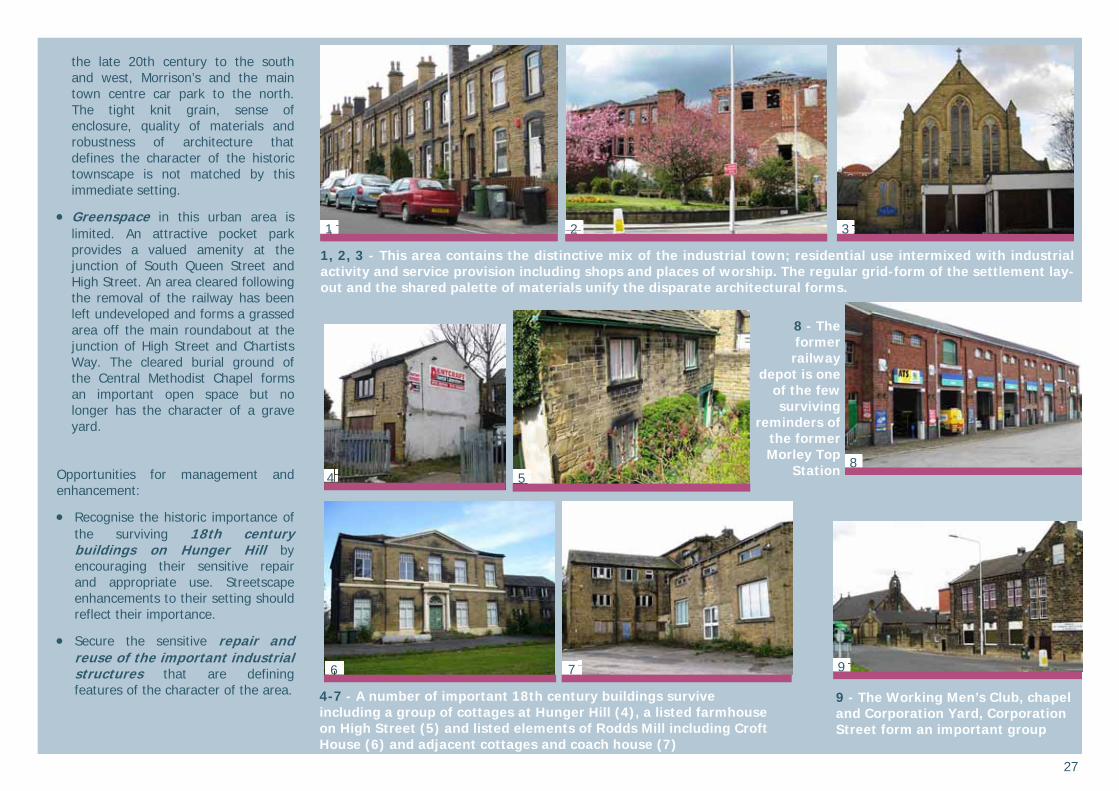
27
the late 20th century to the south and west, Morrison’s and the main town centre car park to the north. The tight knit grain, sense of enclosure, quality of materials and robustness of architecture that defines the character of the historic townscape is not matched by this immediate setting.
Greenspace in this urban area is limited. An attractive pocket park provides a valued amenity at the junction of South Queen Street and High Street. An area cleared following the removal of the railway has been left undeveloped and forms a grassed area off the main roundabout at the junction of High Street and Chartists Way. The cleared burial ground of the Central Methodist Chapel forms an important open space but no longer has the character of a grave yard.
Opportunities for management and enhancement:
Recognise the historic importance of the surviving 18th century buildings on Hunger Hill by encouraging their sensitive repair and appropriate use. Streetscape enhancements to their setting should reflect their importance.
Secure the sensitive repair and reuse of the important industrial structures that are defining features of the character of the area.
1, 2, 3 - This area contains the distinctive mix of the industrial town; residential use intermixed with industrial activity and service provision including shops and places of worship. The regular grid-form of the settlement lay-out and the shared palette of materials unify the disparate architectural forms.
4-7 - A number of important 18th century buildings survive including a group of cottages at Hunger Hill (4), a listed farmhouse on High Street (5) and listed elements of Rodds Mill including Croft House (6) and adjacent cottages and coach house (7)
8 - The former railway
depot is one of the few surviving
reminders of the former Morley Top
Station
9 - The Working Men’s Club, chapel and Corporation Yard, Corporation Street form an important group
1 2 3
8 4 5
6 9 7
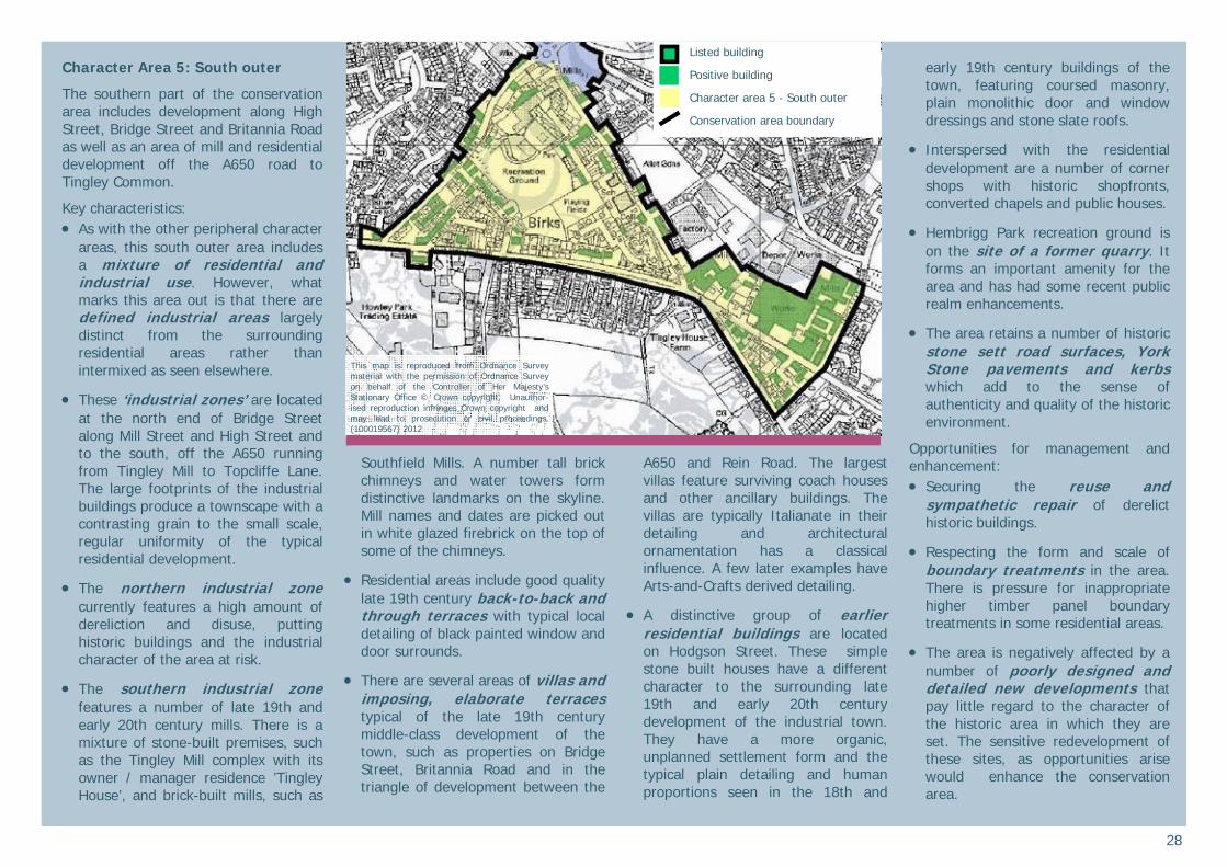
28
Character Area 5: South outer
The southern part of the conservation area includes development along High Street, Bridge Street and Britannia Road as well as an area of mill and residential development off the A650 road to Tingley Common.
Key characteristics: As with the other peripheral character
areas, this south outer area includes a mixture of residential and industrial use. However, what marks this area out is that there are defined industrial areas largely distinct from the surrounding residential areas rather than intermixed as seen elsewhere.
These ‘industrial zones’ are located at the north end of Bridge Street along Mill Street and High Street and to the south, off the A650 running from Tingley Mill to Topcliffe Lane. The large footprints of the industrial buildings produce a townscape with a contrasting grain to the small scale, regular uniformity of the typical residential development.
The northern industrial zone currently features a high amount of dereliction and disuse, putting historic buildings and the industrial character of the area at risk.
The southern industrial zone features a number of late 19th and early 20th century mills. There is a mixture of stone-built premises, such as the Tingley Mill complex with its owner / manager residence ’Tingley House’, and brick-built mills, such as
Southfield Mills. A number tall brick chimneys and water towers form distinctive landmarks on the skyline. Mill names and dates are picked out in white glazed firebrick on the top of some of the chimneys.
Residential areas include good quality late 19th century back-to-back and through terraces with typical local detailing of black painted window and door surrounds.
There are several areas of villas and imposing, elaborate terraces typical of the late 19th century middle-class development of the town, such as properties on Bridge Street, Britannia Road and in the triangle of development between the
A650 and Rein Road. The largest villas feature surviving coach houses and other ancillary buildings. The villas are typically Italianate in their detailing and architectural ornamentation has a classical influence. A few later examples have Arts-and-Crafts derived detailing.
A distinctive group of earlier residential buildings are located on Hodgson Street. These simple stone built houses have a different character to the surrounding late 19th and early 20th century development of the industrial town. They have a more organic, unplanned settlement form and the typical plain detailing and human proportions seen in the 18th and
early 19th century buildings of the town, featuring coursed masonry, plain monolithic door and window dressings and stone slate roofs.
Interspersed with the residential development are a number of corner shops with historic shopfronts, converted chapels and public houses.
Hembrigg Park recreation ground is on the site of a former quarry. It forms an important amenity for the area and has had some recent public realm enhancements.
The area retains a number of historic stone sett road surfaces, York Stone pavements and kerbs which add to the sense of authenticity and quality of the historic environment.
Opportunities for management and enhancement: Securing the reuse and
sympathetic repair of derelict historic buildings.
Respecting the form and scale of boundary treatments in the area. There is pressure for inappropriate higher timber panel boundary treatments in some residential areas.
The area is negatively affected by a number of poorly designed and detailed new developments that pay little regard to the character of the historic area in which they are set. The sensitive redevelopment of these sites, as opportunities arise would enhance the conservation area.
This map is reproduced from Ordnance Survey material with the permission of Ordnance Survey on behalf of the Controller of Her Majesty’s Stationary Office © Crown copyright. Unauthor-ised reproduction infringes Crown copyright and may lead to prosecution or civil proceedings. (100019567) 2012
Listed building
Positive building
Character area 5 - South outer
Conservation area boundary
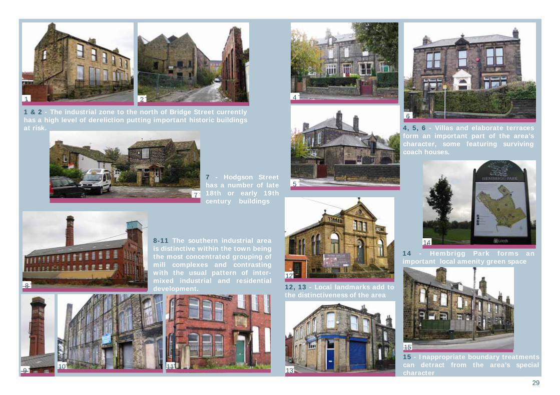
29
1 & 2 - The industrial zone to the north of Bridge Street currently has a high level of dereliction putting important historic buildings at risk.
8-11 The southern industrial area is distinctive within the town being the most concentrated grouping of mill complexes and contrasting with the usual pattern of inter-mixed industrial and residential development.
4, 5, 6 - Villas and elaborate terraces form an important part of the area’s character, some featuring surviving coach houses.
7 - Hodgson Street has a number of late 18th or early 19th century buildings
12, 13 - Local landmarks add to the distinctiveness of the area
14 - Hembrigg Park forms an important local amenity green space
15 - Inappropriate boundary treatments can detract from the area’s special character
1 2 4
5
6
7
8
9 10 11
12
13
14
15
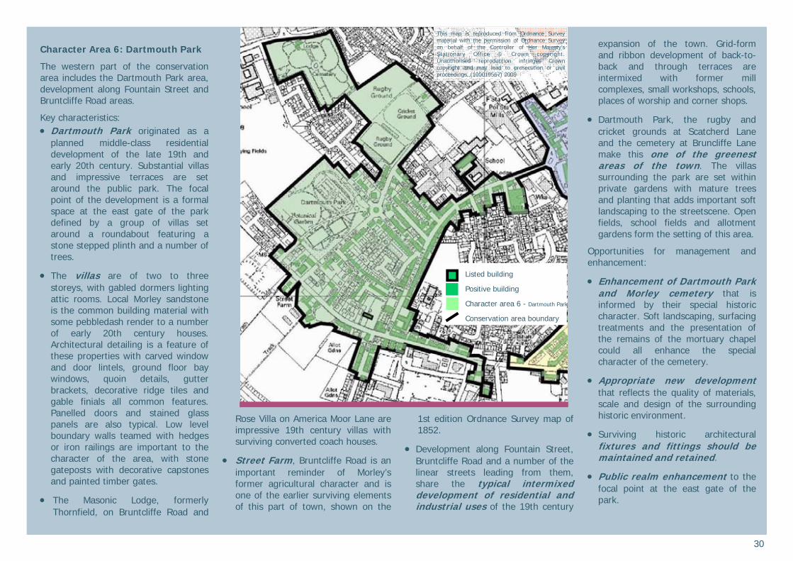
30
Character Area 6: Dartmouth Park
The western part of the conservation area includes the Dartmouth Park area, development along Fountain Street and Bruntcliffe Road areas.
Key characteristics: Dartmouth Park originated as a
planned middle-class residential development of the late 19th and early 20th century. Substantial villas and impressive terraces are set around the public park. The focal point of the development is a formal space at the east gate of the park defined by a group of villas set around a roundabout featuring a stone stepped plinth and a number of trees.
The villas are of two to three storeys, with gabled dormers lighting attic rooms. Local Morley sandstone is the common building material with some pebbledash render to a number of early 20th century houses. Architectural detailing is a feature of these properties with carved window and door lintels, ground floor bay windows, quoin details, gutter brackets, decorative ridge tiles and gable finials all common features. Panelled doors and stained glass panels are also typical. Low level boundary walls teamed with hedges or iron railings are important to the character of the area, with stone gateposts with decorative capstones and painted timber gates.
The Masonic Lodge, formerly Thornfield, on Bruntcliffe Road and
Rose Villa on America Moor Lane are impressive 19th century villas with surviving converted coach houses.
Street Farm, Bruntcliffe Road is an important reminder of Morley’s former agricultural character and is one of the earlier surviving elements of this part of town, shown on the
1st edition Ordnance Survey map of 1852.
Development along Fountain Street, Bruntcliffe Road and a number of the linear streets leading from them, share the typical intermixed development of residential and industrial uses of the 19th century
expansion of the town. Grid-form and ribbon development of back-to-back and through terraces are intermixed with former mill complexes, small workshops, schools, places of worship and corner shops.
Dartmouth Park, the rugby and cricket grounds at Scatcherd Lane and the cemetery at Bruncliffe Lane make this one of the greenest areas of the town. The villas surrounding the park are set within private gardens with mature trees and planting that adds important soft landscaping to the streetscene. Open fields, school fields and allotment gardens form the setting of this area.
Opportunities for management and enhancement:
Enhancement of Dartmouth Park and Morley cemetery that is informed by their special historic character. Soft landscaping, surfacing treatments and the presentation of the remains of the mortuary chapel could all enhance the special character of the cemetery.
Appropriate new development that reflects the quality of materials, scale and design of the surrounding historic environment.
Surviving historic architectural fixtures and fittings should be maintained and retained.
Public realm enhancement to the focal point at the east gate of the park.
This map is reproduced from Ordnance Survey material with the permission of Ordnance Survey on behalf of the Controller of Her Majesty’s Stationary Office © Crown copyright. Unauthorised reproduction infringes Crown copyright and may lead to prosecution or civil proceedings. (100019567) 2009
Listed building
Positive building
Character area 6 - Dartmouth Park
Conservation area boundary
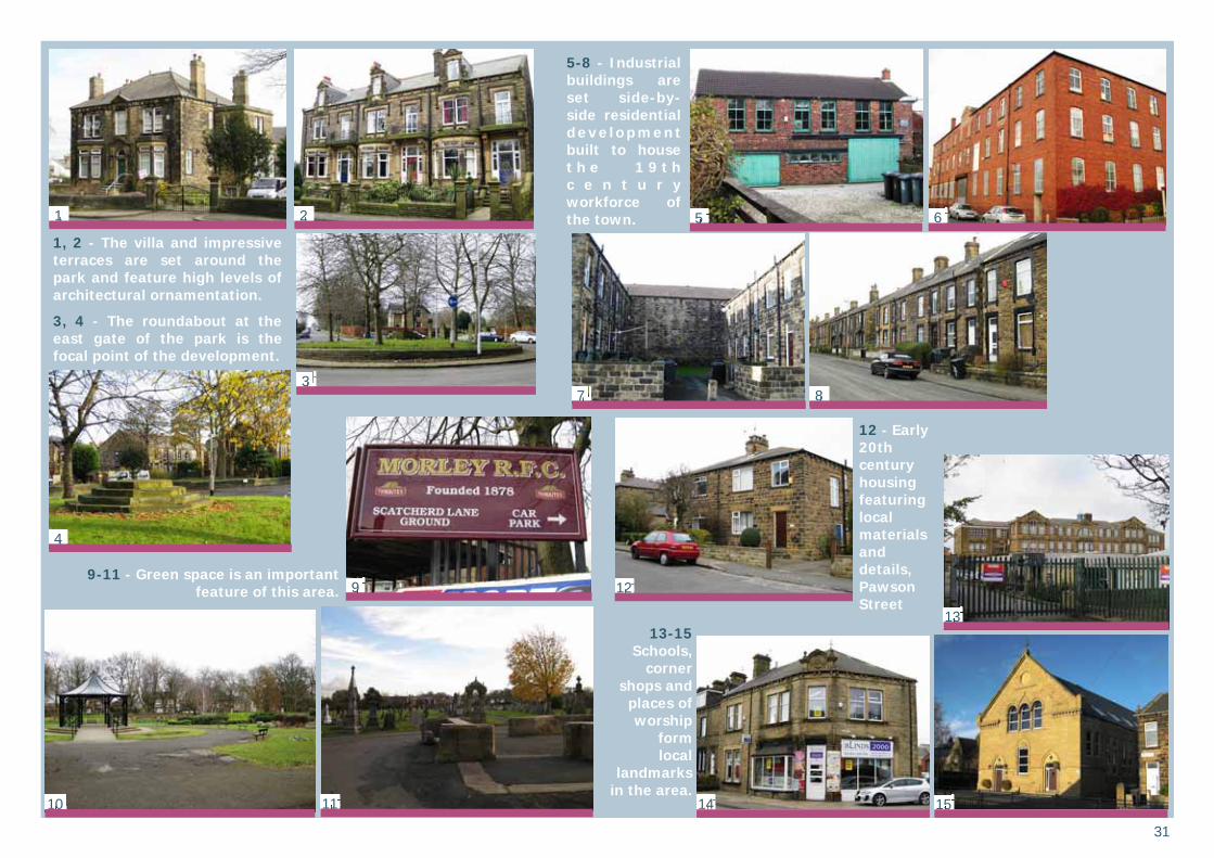
31
5-8 - Industrial buildings are set side-by-side residential deve lopment built to house t h e 1 9 t h c e n t u r y workforce of the town.
9-11 - Green space is an important feature of this area.
13-15 Schools,
corner shops and
places of worship
form local
landmarks in the area.
1, 2 - The villa and impressive terraces are set around the park and feature high levels of architectural ornamentation.
3, 4 - The roundabout at the east gate of the park is the focal point of the development.
12 - Early 20th century housing featuring local materials and details, Pawson Street
1 2
3
4
5 6
7 8
10 11
9 12
13
14 15
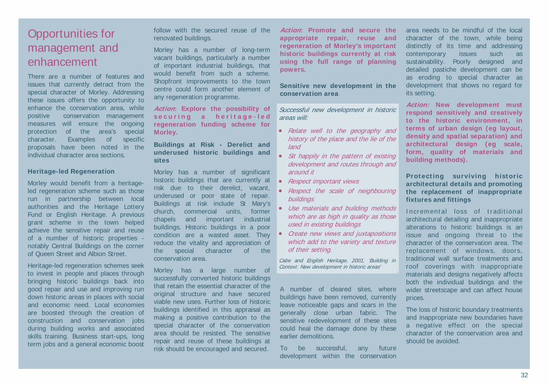
32
Opportunities for management and enhancement There are a number of features and issues that currently detract from the special character of Morley. Addressing these issues offers the opportunity to enhance the conservation area, while positive conservation management measures will ensure the ongoing protection of the area’s special character. Examples of specific proposals have been noted in the individual character area sections.
Heritage-led Regeneration
Morley would benefit from a heritage-led regeneration scheme such as those run in partnership between local authorities and the Heritage Lottery Fund or English Heritage. A previous grant scheme in the town helped achieve the sensitive repair and reuse of a number of historic properties - notably Central Buildings on the corner of Queen Street and Albion Street.
Heritage-led regeneration schemes seek to invest in people and places through bringing historic buildings back into good repair and use and improving run down historic areas in places with social and economic need. Local economies are boosted through the creation of construction and conservation jobs during building works and associated skills training. Business start-ups, long term jobs and a general economic boost
follow with the secured reuse of the renovated buildings.
Morley has a number of long-term vacant buildings, particularly a number of important industrial buildings, that would benefit from such a scheme. Shopfront improvements to the town centre could form another element of any regeneration programme.
Action: Explore the possibility of s e c u r i n g a h e r i t a g e - l e d regeneration funding scheme for Morley.
Buildings at Risk - Derelict and underused historic buildings and sites
Morley has a number of significant historic buildings that are currently at risk due to their derelict, vacant, underused or poor state of repair. Buildings at risk include St Mary’s church, commercial units, former chapels and important industrial buildings. Historic buildings in a poor condition are a wasted asset. They reduce the vitality and appreciation of the special character of the conservation area.
Morley has a large number of successfully converted historic buildings that retain the essential character of the original structure and have secured viable new uses. Further loss of historic buildings identified in this appraisal as making a positive contribution to the special character of the conservation area should be resisted. The sensitive repair and reuse of these buildings at risk should be encouraged and secured.
Action: Promote and secure the appropriate repair, reuse and regeneration of Morley’s important historic buildings currently at risk using the full range of planning powers.
Sensitive new development in the conservation area
A number of cleared sites, where buildings have been removed, currently leave noticeable gaps and scars in the generally close urban fabric. The sensitive redevelopment of these sites could heal the damage done by these earlier demolitions.
To be successful, any future development within the conservation
area needs to be mindful of the local character of the town, while being distinctly of its time and addressing contemporary issues such as sustainability. Poorly designed and detailed pastiche development can be as eroding to special character as development that shows no regard for its setting.
Action: New development must respond sensitively and creatively to the historic environment, in terms of urban design (eg layout, density and spatial separation) and architectural design (eg scale, form, quality of materials and building methods).
Protecting surviving historic architectural details and promoting the replacement of inappropriate fixtures and fittings
Incremental loss of tradit ional architectural detailing and inappropriate alterations to historic buildings is an issue and ongoing threat to the character of the conservation area. The replacement of windows, doors, traditional wall surface treatments and roof coverings with inappropriate materials and designs negatively affects both the individual buildings and the wider streetscape and can affect house prices.
The loss of historic boundary treatments and inappropriate new boundaries have a negative effect on the special character of the conservation area and should be avoided.
Successful new development in historic areas will:
Relate well to the geography and history of the place and the lie of the land
Sit happily in the pattern of existing development and routes through and around it
Respect important views Respect the scale of neighbouring
buildings Use materials and building methods
which are as high in quality as those used in existing buildings
Create new views and juxtapositions which add to the variety and texture of their setting.
Cabe and English Heritage, 2001, ‘Building in Context: New development in historic areas’
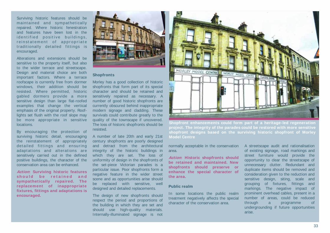
33
Surviving historic features should be maintained and sympathetical ly repaired. Where historic fenestration and features have been lost in the i d en t i f i e d po s i t i v e b u i l d i n g s , r e i n s t a t emen t o f a pp r op r i a t e traditionally detailed fitt ings is encouraged.
Alterations and extensions should be sensitive to the property itself, but also to the wider terrace and streetscape. Design and material choice are both important factors. Where a terrace roofscape is currently free from dormer windows, their addition should be resisted. Where permitted, historic gabled dormers provide a more sensitive design than large flat-roofed examples that change the vertical emphasis of the original property. Roof-lights set flush with the roof slope may be more appropriate in sensitive locations.
By encouraging the protection of surviving historic detail, encouraging the reinstatement of appropriately deta i led f i t t ings and ensur ing adaptations and alterations are sensitively carried out in the defined positive buildings, the character of the conservation area can be enhanced.
Action: Surviving historic features s h o u l d b e r e t a i n e d a n d sympathetically repaired. The replacement of inappropriate fixtures, fittings and adaptations is encouraged.
Shopfronts
Morley has a good collection of historic shopfronts that form part of its special character and should be retained and sensitively repaired as necessary. A number of good historic shopfronts are currently obscured behind inappropriate modern signage and cladding. These survivals could contribute greatly to the quality of the townscape if uncovered. The loss of historic shopfronts should be resisted.
A number of late 20th and early 21st century shopfronts are poorly designed and detract from the architectural integrity of the historic buildings in which they are set. The loss of uniformity of design in the shopfronts of the set-piece Victorian parades is a particular issue. Poor shopfronts form a negative feature in the wider street scene and as opportunities arise should be replaced with sensitive, well designed and detailed replacements.
The design of new shopfronts should respect the period and proportions of the building in which they are set and should use high-quality materials. Internally-illuminated signage is not
normally acceptable in the conservation area.
Action: Historic shopfronts should be retained and maintained. New shopfronts should preserve or enhance the special character of the area.
Public realm
In some locations the public realm treatment negatively affects the special character of the conservation area.
A streetscape audit and rationalisation of existing signage, road markings and street furniture would provide the opportunity to clear the streetscape of unnecessary clutter. Redundant and duplicate items should be removed and consideration given to the reduction and sensitive design, siting, scale and grouping of fixtures, fittings and markings. The negative impact of prominent overhead cables, present in a number of areas, could be reduced through a programme of undergrounding if future opportunities arise.
Shopfront enhancements could form part of a heritage-led regeneration project. The integrity of the parades could be restored with more sensitive shopfront designs based on the surviving historic shopfront of Morley Model Centre
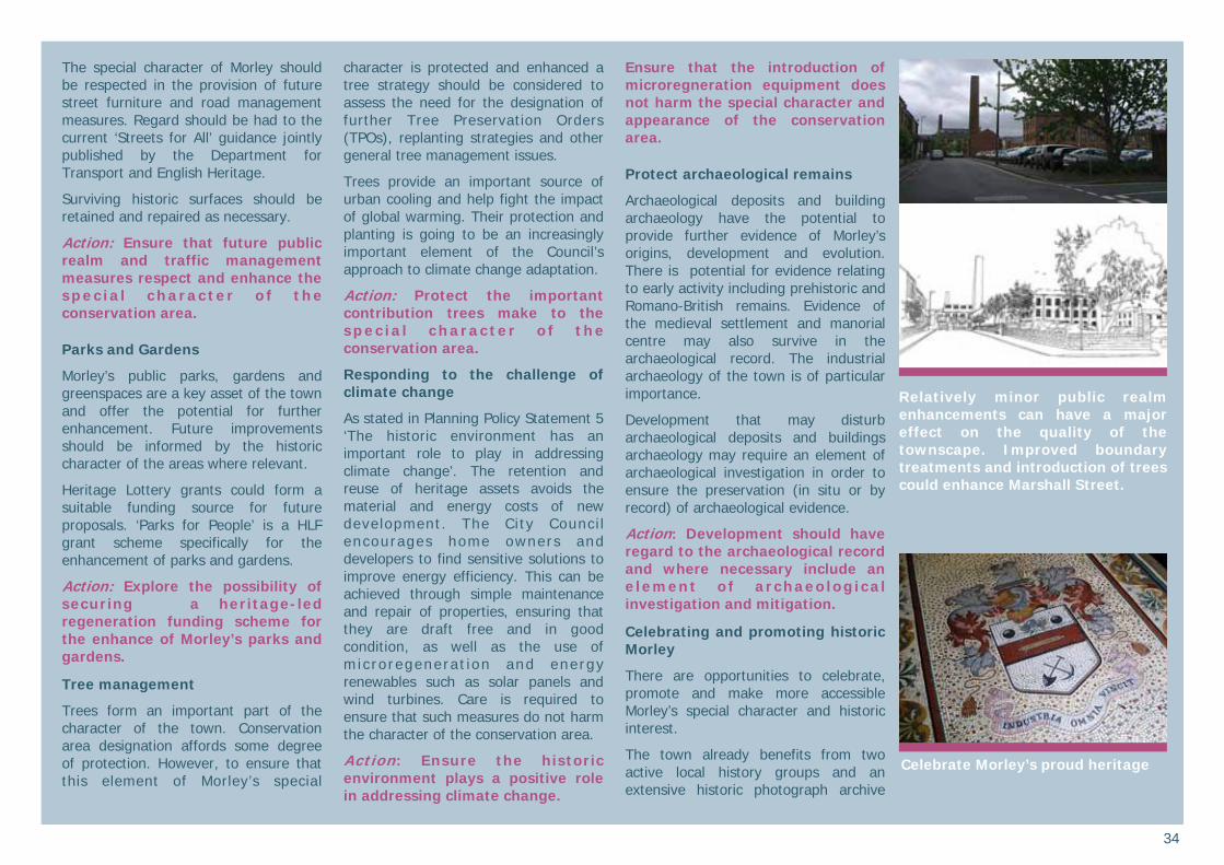
34
The special character of Morley should be respected in the provision of future street furniture and road management measures. Regard should be had to the current ‘Streets for All’ guidance jointly published by the Department for Transport and English Heritage.
Surviving historic surfaces should be retained and repaired as necessary.
Action: Ensure that future public realm and traffic management measures respect and enhance the spec ia l characte r o f the conservation area.
Parks and Gardens
Morley’s public parks, gardens and greenspaces are a key asset of the town and offer the potential for further enhancement. Future improvements should be informed by the historic character of the areas where relevant.
Heritage Lottery grants could form a suitable funding source for future proposals. ‘Parks for People’ is a HLF grant scheme specifically for the enhancement of parks and gardens.
Action: Explore the possibility of securing a heritage-led regeneration funding scheme for the enhance of Morley’s parks and gardens.
Tree management
Trees form an important part of the character of the town. Conservation area designation affords some degree of protection. However, to ensure that this element of Morley’s special
character is protected and enhanced a tree strategy should be considered to assess the need for the designation of further Tree Preservation Orders (TPOs), replanting strategies and other general tree management issues.
Trees provide an important source of urban cooling and help fight the impact of global warming. Their protection and planting is going to be an increasingly important element of the Council’s approach to climate change adaptation.
Action: Protect the important contribution trees make to the spec ia l characte r o f the conservation area.
Responding to the challenge of climate change
As stated in Planning Policy Statement 5 ‘The historic environment has an important role to play in addressing climate change’. The retention and reuse of heritage assets avoids the material and energy costs of new development. The City Counci l encourages home owners and developers to find sensitive solutions to improve energy efficiency. This can be achieved through simple maintenance and repair of properties, ensuring that they are draft free and in good condition, as well as the use of m ic ro regenera t ion and energy renewables such as solar panels and wind turbines. Care is required to ensure that such measures do not harm the character of the conservation area.
Action: Ensure the historic environment plays a positive role in addressing climate change.
Ensure that the introduction of microregneration equipment does not harm the special character and appearance of the conservation area.
Protect archaeological remains
Archaeological deposits and building archaeology have the potential to provide further evidence of Morley’s origins, development and evolution. There is potential for evidence relating to early activity including prehistoric and Romano-British remains. Evidence of the medieval settlement and manorial centre may also survive in the archaeological record. The industrial archaeology of the town is of particular importance.
Development that may disturb archaeological deposits and buildings archaeology may require an element of archaeological investigation in order to ensure the preservation (in situ or by record) of archaeological evidence.
Action: Development should have regard to the archaeological record and where necessary include an e lement of archaeological investigation and mitigation.
Celebrating and promoting historic Morley
There are opportunities to celebrate, promote and make more accessible Morley’s special character and historic interest.
The town already benefits from two active local history groups and an extensive historic photograph archive
Relatively minor public realm enhancements can have a major effect on the quality of the townscape. Improved boundary treatments and introduction of trees could enhance Marshall Street.
Celebrate Morley’s proud heritage

35
created by David Atkinson held at the local library. There is also a Heritage Trail and regular walks, talks and Heritage Open Days relating to the fascinating history of the town. There is scope to develop this further. Morley’s heritage and parks and gardens can be used to positively promote the town for residents and visitors alike.
Action: Promote and celebrate the special architectural and historic interest of the conservation area.
Setting of the conservation area
‘The desirability of preserving or enhancing the area should also, in the Secretary of State’s view, be a material consideration in the planning authority’s handling of development proposals which are outside the conservation area but would affect its setting, or views into or out of the area’. Planning Policy Guidance Note 15, 4.14
The conservation area is tightly drawn to ensure that the designation is not devalued. It does not mean that features outside the defined area are of no historic interest or special character.
Action: Ensure that the setting of the conservation area is considered as a material consideration within the planning process.
36
References Published sources
Atkinson DK, 1973, Morley Borough 1886-1974 A pictorial history
Atkinson DK, 1992, Morley in old picture postcards, European Library, Zaltbommel, Netherlands
Giles C & Goodall IH, 1992, Yorkshire textile mills 1770-1930, Royal Commission on the Historic Monuments of England and West Yorkshire Archaeology Service, HMSO, London
Margary ID, 1973 (3rd ed), Roman Roads in Britain, John Baker, London
Scatcherd N, 1830, The history of Morley, J Heaton, Leeds
Sharpe DJS, 1968, A brief history of the Morley textile industry 1750-1900. Morley Local History Society
Smith W, 1866, Rambles around Morley
Smith W, 1876, The history and antiquities of Morley, Longmans, London
Ward N, 1973, There’s no place like …..Morley, The Ridings Publishing Company, Driffield
Waterson E & Meadows P, 1998, Lost houses of the West Riding
Policy and strategy documents Cabe and English Heritage, 2001, Building in context
Department of Culture, Media and Sport, 2007, Heritage Protection for the 21st century
Department for Communities and Local Government, 2010, Planning Policy Statement 5: Planning for the Historic Environement
Department for Communities and Local Government, English Heritage and the Department for Culture, Media and Sport, 2010, PPS5 Planning for the H is to r i c Env i ronment : H is to r i c Environment Planning Practice Guide
English Heritage, February 2006 (a), Guidance on conservation area appraisals
English Heritage, February 2006 (b), Guidance on the management of conservation areas
Land Use Consultants, 1994, Leeds Landscape Assessment.
Leeds City Council, 2006, Leeds Unitary Development Plan (Review 2006), Vol 1:Written Statement, Vol 2: Appendices
West Yorkshire Archaeological Service, 2000, Morley Conservation Area Assessment, Draft report to Leeds City Council
Map sources
1850 – Ordnance Survey 1:10, 000 1892 – Ordnance Survey 1: 2,500 1893 – Ordnance Survey 1:10, 000 1908 – Ordnance Survey 1: 2,500 1938 – Ordnance Survey 1:10, 000 1956 – Ordnance Survey 1:10, 000
Internet sources
Access to archives - www.a2a.org.uk
English Heritage Images of England, listed building photographs and descriptions - www.imagesofengland.org.uk
E Oldroyd and Sons Yorkshire Rhubarb - www.yorkshirerhubarb.co.uk
Historic Ordnance Survey maps -www.old-maps.co.uk
Leeds City Council online historic photograph archive - www.leodis.net
Secret Leeds - www.secretleeds.com
Sources of further information Central Library (Local & Family History Section), The Headrow, Leeds LS1. Tel 0113 247 8290 emai l : [email protected] website: www.leeds.gov.uk/library
Leeds Civic Trust, Leeds Heritage & Design Centre, 17-19 Wharf Street, Leeds LS2 7EQ Tel: 0113 243 9594 Email: [email protected] website: www.leedscivictrust.org.uk
Victorian Society (West Yorkshire Group), Claremont, 23 Clarendon Road Leeds LS2 9NZ (postal address only)
West Yorkshire Archaeology Service, Newstead Road, Wakefield WF1 2DE T e l 0 1 9 2 4 3 0 6 8 1 0 e m a i l : w y s m r @ w y j s . o r g . u k w e b s i t e : www.arch.wyjs.org.uk
West Yorkshire Archive Service, Chapeltown Road, Sheepscar, Leeds
LS7 3AP. Tel 0113 214 5814 email: l e e d s @ w y j s . o r g . u k w e b s i t e : www.archives.wyjs.org.uk
Acknowledgements The preparation of this report was made possible through funding by the South (Outer) Local Area Committee of Leeds City Council. The Well-Being Fund grant was awarded by the local Ward Members through the South (Outer) Area Committee.
West Yorkshire Archive Service and West Yorkshire Archaeological Advisory Service provided information and assistance during the production of this appraisal.
Local guidance during the preparation of the appraisal was provided by the local counci l lors, the planning committee of Morley Town Council, the Town Centre Manager and members of Morley Community Archives and Morley Local History Society.
Copyright The maps are based on Ordnance Survey material with the permission of the Ordnance Survey on behalf of the Controller of Her Majesty’s Stationery Office © Crown copyright. Unauthorised reproduction infringes Crown copyright and may lead to prosecution and/or civil proceedings. The map data, derived from Ordnance Survey mapping, included within this publication is provided by Leeds City Council under licence from the Ordnance Survey in order to fulfil its public function to publicise local public services. Leeds City Council Licence No. (100019567) 2012. © Leeds City Council 2012
37
What is a conservation area?
A conservation area is ‘an area of special architectural or historic interest the character or appearance of which it is desirable to preserve or enhance’.
Section 69 of the Planning (Listed Buidlings and Conservation Areas) Act 1990.
What does conservation area status mean?
Conservation area status provides the opportunity to promote the protection and enhancement of the special character of the defined area. Designation confers a general control over development that could damage the area’s character. The details are complex but can be summarised as:
Most demolition requires permission and will be resisted if the building makes a positive contribution to the area.
Some minor works to houses is no longer "permitted development" and will require planning permission. Examples are rear dormer windows, external cladding and most satellite dishes on front elevations.
Advertisement controls are tighter Most work to trees has to be notified
to the Council who has six weeks in which to decide to impose restrictions.
Generally, higher standards of design apply for new buildings and alterations to existing ones.
Change is inev i tab le in most conservation areas and it is not the intention of the designation to prevent
the continued evolution of places. The challenge within conservation areas is to manage change in a way that maintains, reinforces and enhances the special qualities of the area. What is the purpose of this appraisal?
This appraisal provides the basis for making informed, sustainable decisions in the positive management, protection and enhancement of the conservation area.
It provides a clear understanding of the special interest of Morley by:
assessing how the settlement has developed
analysing its present day character and
ident i fy ing opportuni t ies for enhancement
This appraisal follows the current guidance set out by English Heritage in the 2006 publication ‘Guidance on conservation area appraisals’.
The appraisal is not intended to be comprehensive and the omission of any particular building, feature or space should not be taken to imply that it is of no interest.
Planning policy context
This appraisal should be read in conjunction with the wider national, regional and local planning policy and guidance. Relevant documents include: Planning (Listed Buildings and
Conservation Areas) Act 1990
Planning Policy Statement 5: Planning for the Historic Environment and the supporting Practice Guide
Leeds C i ty Counc i l , Un i tary Development Plan Review 2006, particularly Chapter 5 Environment and Appendices A3 Building Design, Conservation and Landscape Design and A4 Archaeological Policies
L e e d s C i t y C o u n c i l , L o c a l Development Framework, emerging framework that will ultimately replace the Unitary Development Plan.
Community involvement and adoption
This is the second consultation draft version of the appraisal and proposed boundary review. The first draft went through a public consultation process in 2009.
The production of the draft version of the appraisal was informed by meetings and discussions with ward members, M o r l e y T o w n C o u n c i l a n d representatives from the town’s local history groups.
The 2009 public consultation ran for an eight week period (20 July—14 September 2009) and included:
Two public ‘drop-in’ meeting opportunities on Wednesday 2 September 2009 3-7pm and Saturday 5 September 2009 10am-2pm at the library.
An eight week exhibition at the library, with access to a paper copy of the draft appraisal, information leaflets and response forms.
Direct mailing to all properties affected by the proposed changes to the boundary.
Direct mailing to all identified stakeholders and interested parties including internal consultation within the City Council, with officers and councillors, and with Morley Town Council.
Internet access via the Council’s webpage to the appraisal and response forms
Local publicity to advertise the consultation.
All consultation responses were evaluated and the appraisal was amended in light of comments received as appropriate.
This second consultation draft provides an updated version of the appraisal and p roposed bounda r y w i t h t he amendments made following the 2009 consultation process.
This second public consultation runs for a six week period from 30 January 2012 to 9 March 2012 and includes:
A formal public meeting at Morley Town Hall on Thursday 16 February 2012 at 7pm.
An exhibition at the library, with access to a paper copy of the draft appraisal, information leaflets and response forms.
Direct mailing to all properties affected by the proposed changes to the boundary.
Direct mailing to all identified stakeholders and interested parties including internal consultation within
38
the City Council, with officers and councillors, and with Morley Town Council.
Internet access via the Council’s webpage to the appraisal and response forms
Local publicity to advertise the consultation.
All consultation responses will be evaluated and the appraisal will be amended in light of comments received as appropriate. The final version of the appraisal and boundary modification will then be formally adopted and will become a material consideration when application s for cnahge within the conservation area and its setting are considered by the Council. This document is available to view and download on the Council’s website - www.leeds.gov.uk/conservation
Published in January 2012 by the Sustainable Development Unit, Leeds City Council, The Leonardo Building, 2 Rossington Street, Leeds LS2 8HD Tel 0113 222 44 09 email: [email protected] website www.leeds.gov.uk/conservation